Embed Size (px)
Citation preview
HILL ARCHITECTURE ALONG
BEAS RIVER
SUBMITTED BY -SAHIL KAUNDAL 11613AMAN KUMAR 11617SHIVDAYAL 11644SAHIL ATRI 11645
SUBMITTED TO-DR. MINAKSHI JAINNIT HAMIRPUR
REPORT
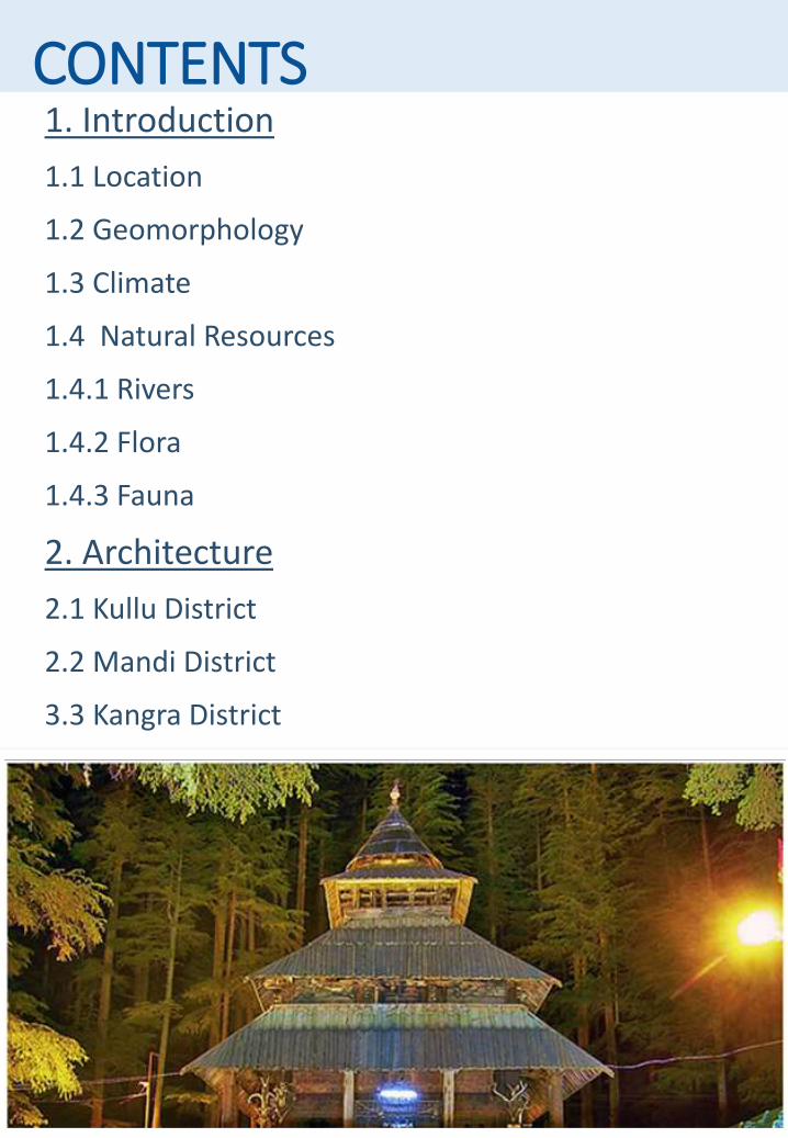
CONTENTS1. Introduction
1.1 Location
1.2 Geomorphology
1.3 Climate
1.4 Natural Resources
1.4.1 Rivers
1.4.2 Flora
1.4.3 Fauna
2. Architecture
2.1 Kullu District
2.2 Mandi District
3.3 Kangra District
3.
2.3 Kangra District
3. References
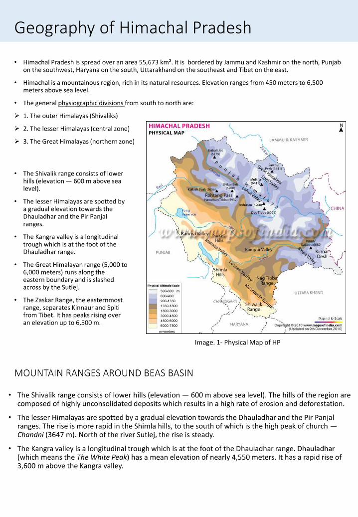
Geography of Himachal Pradesh
• Himachal Pradesh is spread over an area 55,673 km². It is bordered by Jammu and Kashmir on the north, Punjab on the southwest, Haryana on the south, Uttarakhand on the southeast and Tibet on the east.
• Himachal is a mountainous region, rich in its natural resources. Elevation ranges from 450 meters to 6,500 meters above sea level.
• The general physiographic divisions from south to north are:
1. The outer Himalayas (Shivaliks)
2. The lesser Himalayas (central zone)
3. The Great Himalayas (northern zone)
• The Shivalik range consists of lower hills (elevation — 600 m above sea level).
• The lesser Himalayas are spotted by a gradual elevation towards the Dhauladhar and the Pir Panjal ranges.
• The Kangra valley is a longitudinal trough which is at the foot of the Dhauladhar range.
• The Great Himalayan range (5,000 to 6,000 meters) runs along the eastern boundary and is slashed across by the Sutlej.
• The Zaskar Range, the easternmost range, separates Kinnaur and Spiti from Tibet. It has peaks rising over an elevation up to 6,500 m.
MOUNTAIN RANGES AROUND BEAS BASIN
• The Shivalik range consists of lower hills (elevation — 600 m above sea level). The hills of the region are composed of highly unconsolidated deposits which results in a high rate of erosion and deforestation.
• The lesser Himalayas are spotted by a gradual elevation towards the Dhauladhar and the Pir Panjal ranges. The rise is more rapid in the Shimla hills, to the south of which is the high peak of church —Chandni (3647 m). North of the river Sutlej, the rise is steady.
• The Kangra valley is a longitudinal trough which is at the foot of the Dhauladhar range. Dhauladhar (which means the The White Peak) has a mean elevation of nearly 4,550 meters. It has a rapid rise of 3,600 m above the Kangra valley.
Image. 1- Physical Map of HP
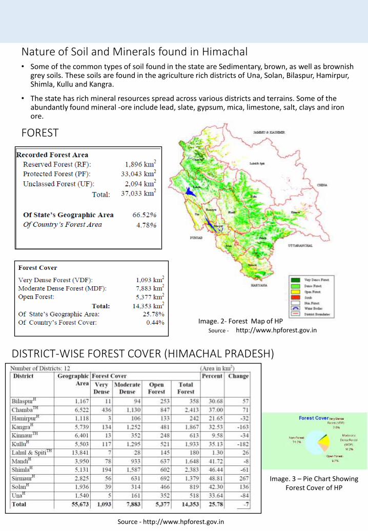
Nature of Soil and Minerals found in Himachal• Some of the common types of soil found in the state are Sedimentary, brown, as well as brownish
grey soils. These soils are found in the agriculture rich districts of Una, Solan, Bilaspur, Hamirpur, Shimla, Kullu and Kangra.
• The state has rich mineral resources spread across various districts and terrains. Some of the abundantly found mineral -ore include lead, slate, gypsum, mica, limestone, salt, clays and iron ore.
FOREST
DISTRICT-WISE FOREST COVER (HIMACHAL PRADESH)
Image. 2- Forest Map of HPSource - http://www.hpforest.gov.in
Source - http://www.hpforest.gov.in
Image. 3 – Pie Chart Showing Forest Cover of HP
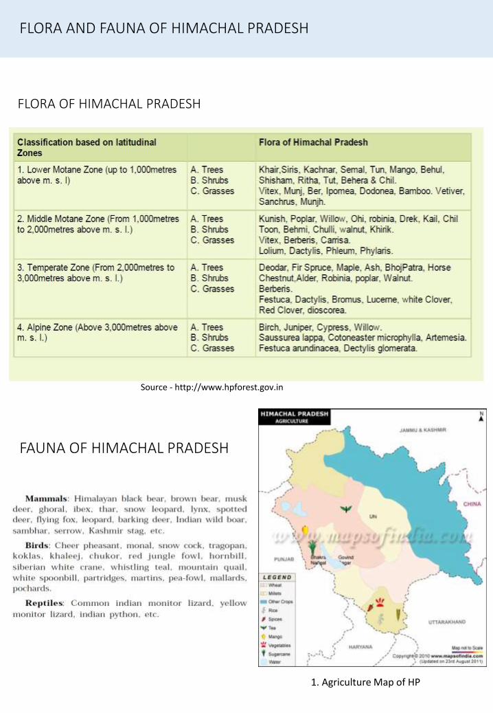
FLORA OF HIMACHAL PRADESH
FAUNA OF HIMACHAL PRADESH
FLORA AND FAUNA OF HIMACHAL PRADESH
Source - http://www.hpforest.gov.in
1. Agriculture Map of HP
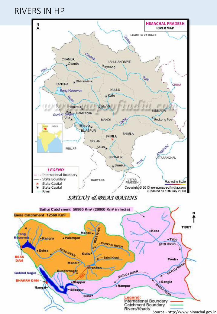
RIVERS IN HP
Source - http://www.himachal.gov.in
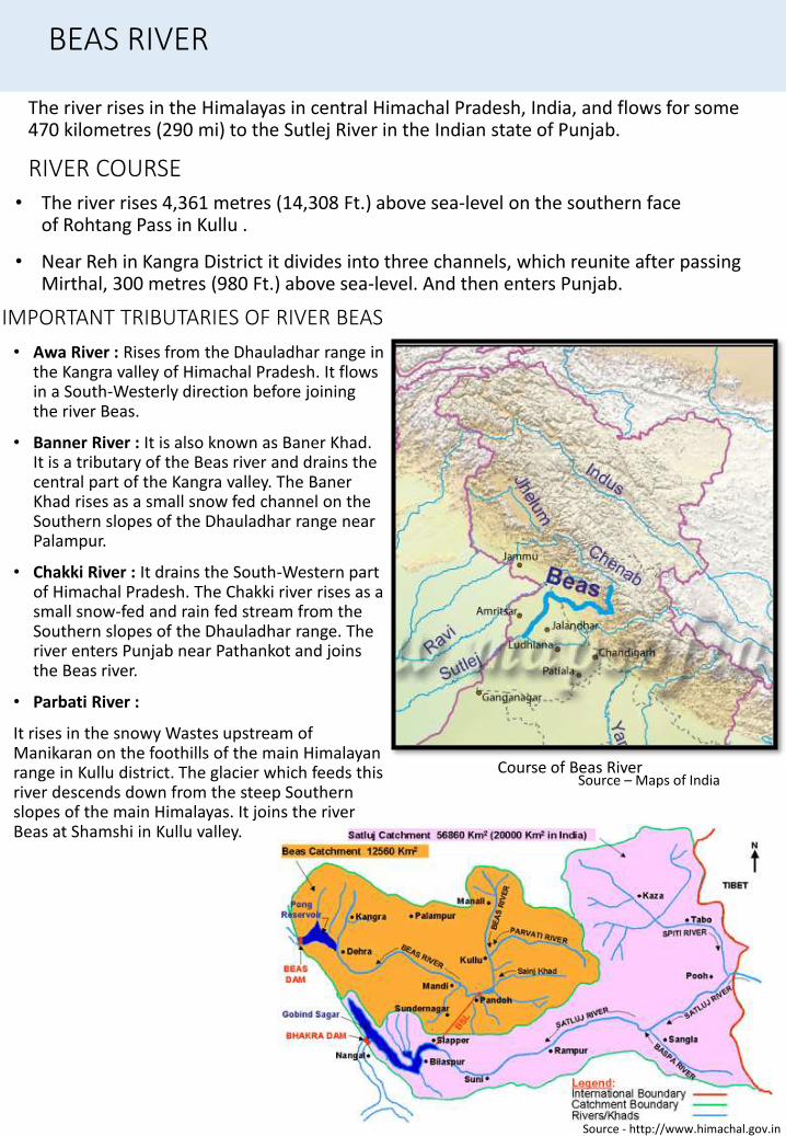
RIVER COURSE
The river rises in the Himalayas in central Himachal Pradesh, India, and flows for some 470 kilometres (290 mi) to the Sutlej River in the Indian state of Punjab.
• The river rises 4,361 metres (14,308 Ft.) above sea-level on the southern face of Rohtang Pass in Kullu .
• Near Reh in Kangra District it divides into three channels, which reunite after passing Mirthal, 300 metres (980 Ft.) above sea-level. And then enters Punjab.
BEAS RIVER
IMPORTANT TRIBUTARIES OF RIVER BEAS
• Awa River : Rises from the Dhauladhar range in the Kangra valley of Himachal Pradesh. It flows in a South-Westerly direction before joining the river Beas.
• Banner River : It is also known as Baner Khad. It is a tributary of the Beas river and drains the central part of the Kangra valley. The Baner Khad rises as a small snow fed channel on the Southern slopes of the Dhauladhar range near Palampur.
• Chakki River : It drains the South-Western part of Himachal Pradesh. The Chakki river rises as a small snow-fed and rain fed stream from the Southern slopes of the Dhauladhar range. The river enters Punjab near Pathankot and joins the Beas river.
• Parbati River :
It rises in the snowy Wastes upstream of Manikaran on the foothills of the main Himalayan range in Kullu district. The glacier which feeds this river descends down from the steep Southern slopes of the main Himalayas. It joins the river Beas at Shamshi in Kullu valley.
Source - http://www.himachal.gov.in
Course of Beas RiverSource – Maps of India
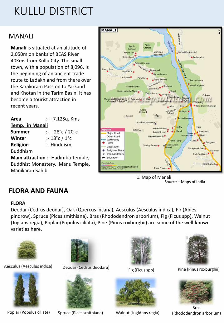
MANALI
Manali is situated at an altitude of 2,050m on banks of BEAS River 40Kms from Kullu City. The small town, with a population of 8,096, is the beginning of an ancient trade route to Ladakh and from there over the Karakoram Pass on to Yarkandand Khotan in the Tarim Basin. It has become a tourist attraction in recent years.
Area : - 7.12Sq. KmsTemp. in Manali Summer :- 28°c / 20°cWinter :- 18°c / 1°c Religion :- Hinduism, BuddhismMain attraction :- Hadimba Temple, Buddhist Monastery, Manu Temple, Manikaran Sahib
FLORADeodar (Cedrus deodar), Oak (Quercus incana), Aesculus (Aesculus indica), Fir (Abies pindrow), Spruce (Pices smithiana), Bras (Rhododendron arborium), Fig (Ficus spp), Walnut (Juglans regia), Poplar (Populus ciliata), Pine (Pinus roxburghii) are some of the well-known varieties here.
Aesculus (Aesculus indica) Deodar (Cedrus deodara)Fig (Ficus spp) Pine (Pinus roxburghii)
Poplar (Populus ciliate) Spruce (Pices smithiana) Walnut (JuglAans regia)Bras
(Rhododendron arborium)
FLORA AND FAUNA
KULLU DISTRICT
Source – Maps of India1. Map of Manali

FLORA AND FAUNA
Himalayan ibex Barking deer Black bear Musk deer
KingfisherKoklas Eurasian Sparrow hawk
Black Stork Western Tragopan
Porcupine
FAUNADeodar (Cedrus deodar), Oak (Quercus incana), Aesculus (Aesculus indica), Fir (Abies pindrow), Spruce (Pices smithiana), Bras (Rhododendron arborium), Fig (Ficus spp), Walnut (Juglans regia), Poplar (Populus ciliata), Pine (Pinus roxburghii) are some of the well-known varieties here.
CULTURE & LIFESTYLE
2. OLD LADY BRINGING HER COWS BACK HOME 1. Local Dance by Natives
Source - http://www.kullumanali.net Source - http://www.kullumanali.net
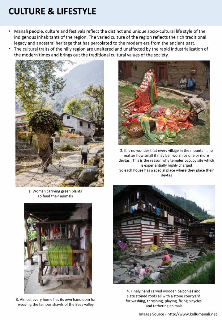
2. It is no wonder that every village in the mountain, no matter how small it may be , worships one or more
devtas . This is the reason why temples occupy site which is experientially highly charged
So each house has a special place where they place their devtas
1. Woman carrying green plantsTo feed their animals
CULTURE & LIFESTYLE
• Manali people, culture and festivals reflect the distinct and unique socio-cultural life style of the indigenous inhabitants of the region. The varied culture of the region reflects the rich traditional legacy and ancestral heritage that has percolated to the modern era from the ancient past.
• The cultural traits of the hilly region are unaltered and unaffected by the rapid industrialization of the modern times and brings out the traditional cultural values of the society.
3. Almost every home has its own handloom for weaving the famous shawls of the Beas valley
4. Finely hand carved wooden balconies and slate stoned roofs all with a stone courtyard
for washing, threshing, playing, fixing bicycles and tethering animals
Images Source - http://www.kullumanali.net
HISTORY OF MANALI
Manali is an ancient territory of North India. The history of Manali goes back to the first century when it is believed to have been founded by Behangamani Pal of Tripura. The legendary tale says that the Thakurs (chiefs) of Spiti were harassing the residents who were anxious to avenge them.
• Behangamani Pal initiated the revolt from Jagatsukh. With the help of a local astrologer and by the blessings of Goddess Hadimba they won the fight.
• Since then the Goddess is called the `grandmother and the patron-deity' of the Kullu rulers. This led to the establishment of the Pal dynasty with Jagatsukh as its capital. The dynasty ruled over Kullu district for the next ten generations.
• The capital was later shifted to Naggar and finally Kullu. Later the Thakurs and the Ranas slowly gained powers defeating the Pals.
• Raja Jagat Singh captured the area from 1637-1672. A deep follower of Lord Rama, the Raja moved the famous idol of Raghunathji (Lord Rama) to a temple at Sultanpur (Kullu). The strange thing during his reign was that the king placed the God's idol on his throne and continued his rule. Since then, the kings of Kullu ruled the state in the name of Raghunathji.
• Manali was ruled by Raja Sidh Singh in the 17th century. The Sikh rule continued until the 18th century, when the entire area was taken over by the British in 1846.
• The residents of the area participated in the freedom struggle though not very aggressively. It was only post-independence that Manali was accessible easily by people of other cities. This long isolation actually helped the place to conserve its tradition and purity.
• Manali has great mythological importance as the place was believed to be the abode of the Saptarishi (the seven renowned Sages).
• It is said that the valley was inhabited by a tribe of hunters called the "Rakshas".
• Later a few shepherds came from the Kangra Valley and started cultivation here.
• The "naur" or the "nar" also lived in the valley. Mythological evidences say that the Pandavas also lived her during their secret exile.
• Rishi Vyas also meditated in these valleys and the site is called the "Vyas Kund" It was this meditation that gave the Vipasha River the name `Seas River".
• The Icing of Kalut (Kullu) fought against Arjuna in the battle of Mahabharata and was killed. Coins have been found from the area belonging to the king.
Kullu and Manali were made a sub-division of Kangra District and Lahaul-Spiti was attached to Kullu for administration. In 1960 Lahaul-Spiti was a separate district.
In 1963 Kullu was declared as a district of Punjab up to October 1966. On 1st November 1966, Kullu was moved from Punjab to Himachal Pradesh as a separate district with Kullu City as its district headquarters and Manali as a city.
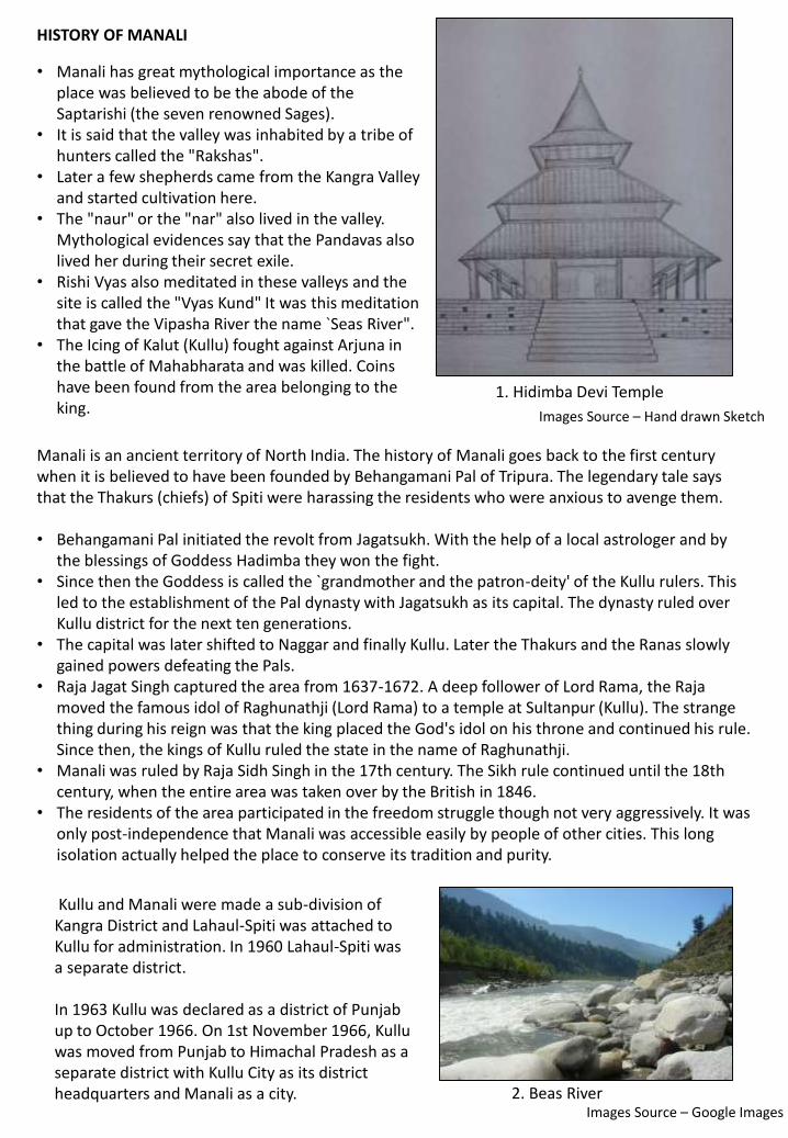
1. Hidimba Devi Temple
2. Beas River
Images Source – Hand drawn Sketch
Images Source – Google Images
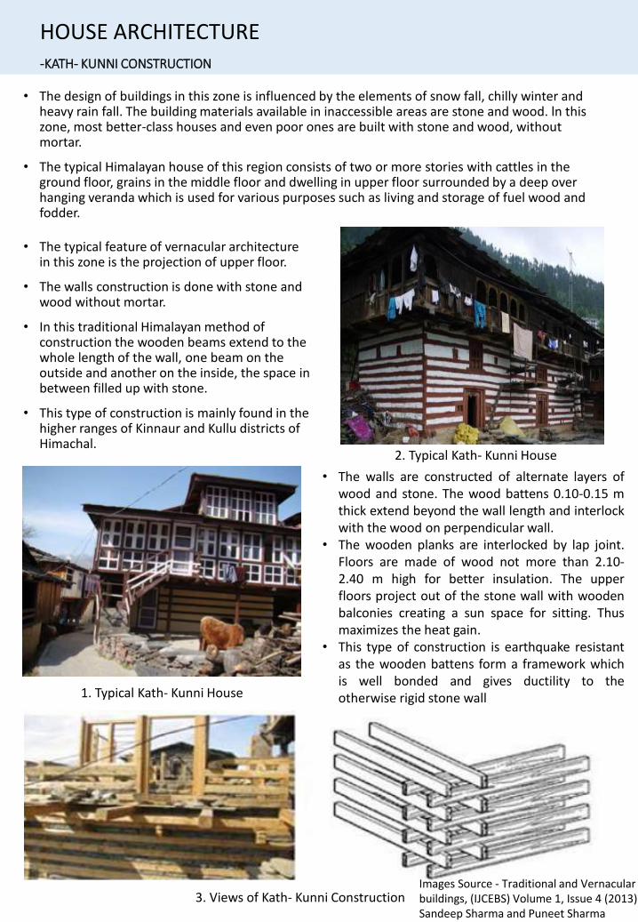
-KATH- KUNNI CONSTRUCTION
• The design of buildings in this zone is influenced by the elements of snow fall, chilly winter and heavy rain fall. The building materials available in inaccessible areas are stone and wood. ln this zone, most better-class houses and even poor ones are built with stone and wood, without mortar.
• The typical Himalayan house of this region consists of two or more stories with cattles in the ground floor, grains in the middle floor and dwelling in upper floor surrounded by a deep over hanging veranda which is used for various purposes such as living and storage of fuel wood and fodder.
• The typical feature of vernacular architecture in this zone is the projection of upper floor.
• The walls construction is done with stone and wood without mortar.
• In this traditional Himalayan method of construction the wooden beams extend to the whole length of the wall, one beam on the outside and another on the inside, the space in between filled up with stone.
• This type of construction is mainly found in the higher ranges of Kinnaur and Kullu districts of Himachal.
3. Views of Kath- Kunni Construction
1. Typical Kath- Kunni House
• The walls are constructed of alternate layers ofwood and stone. The wood battens 0.10-0.15 mthick extend beyond the wall length and interlockwith the wood on perpendicular wall.
• The wooden planks are interlocked by lap joint.Floors are made of wood not more than 2.10-2.40 m high for better insulation. The upperfloors project out of the stone wall with woodenbalconies creating a sun space for sitting. Thusmaximizes the heat gain.
• This type of construction is earthquake resistantas the wooden battens form a framework whichis well bonded and gives ductility to theotherwise rigid stone wall
HOUSE ARCHITECTURE
Images Source - Traditional and Vernacular buildings, (IJCEBS) Volume 1, Issue 4 (2013) , Sandeep Sharma and Puneet Sharma
2. Typical Kath- Kunni House

-KATH- KUNNI CONSTRUCTION
HOUSE ARCHITECTURE
2. Vernacular House
2. Vernacular House
3. Vernacular House4. Vernacular House
5. Vernacular House6. Settlement along the
River
Images Source - http://www.kullumanali.net
MATERIALS
WOODS SLATESSTONES
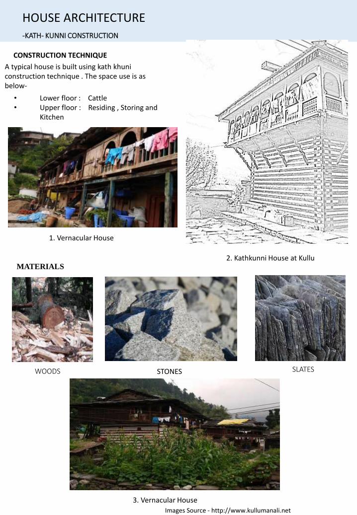
CONSTRUCTION TECHNIQUE
A typical house is built using kath khuniconstruction technique . The space use is as below-
• Lower floor : Cattle• Upper floor : Residing , Storing and
Kitchen
-KATH- KUNNI CONSTRUCTION
HOUSE ARCHITECTURE
1. Vernacular House
2. Kathkunni House at Kullu
3. Vernacular House
Images Source - http://www.kullumanali.net
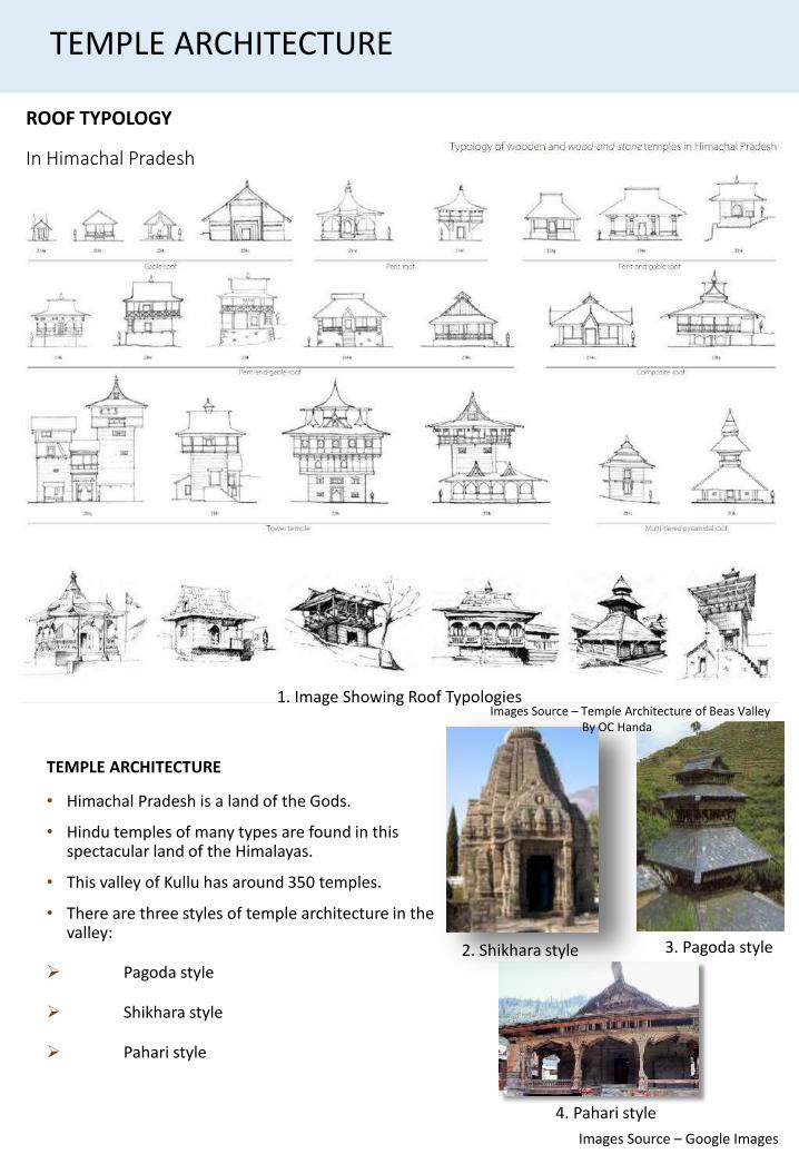
In Himachal Pradesh
ROOF TYPOLOGY
TEMPLE ARCHITECTURE
• Himachal Pradesh is a land of the Gods.
• Hindu temples of many types are found in this spectacular land of the Himalayas.
• This valley of Kullu has around 350 temples.
• There are three styles of temple architecture in the valley:
Pagoda style
Shikhara style
Pahari style
TEMPLE ARCHITECTURE
1. Image Showing Roof TypologiesImages Source – Temple Architecture of Beas Valley
By OC Handa
Images Source – Google Images
3. Pagoda style2. Shikhara style
4. Pahari style
1. PAGODA STYLE
These are rectangular stone and wood structures with successive roofs, placed one over the othermaking them in some cases look like multi-storey edifices.
• Hadimba Temple (Manali) , Tripura Sundri Temple (Naggar) and Adi Brahma Temple (Khokhan) areexamples of such architecture.
3. PAHARI STYLE
• Pahari style is a mixture of all other temple forms.
• Bhuvneshwari Temple and Bijli Mahadev Temple in Kullu are excellent examples of this form of temple architecture.
2. SHIKHARA STYLE
It refers to the rising tower over the sanctum where the presiding deity is enshrined and is the mostprominent and visible part of a Hindu temple of North India.
• Bishweshwar temple (Bajaura), Shiv Temple (Naggar), Gauri Shankar Temple (Dashal), ShivTemple (Jagatsukh) are built in this style.
• Of these Bishweshwar temple, Bajaura is the largest stone temple in the valley.
TEMPLE ARCHITECTURE
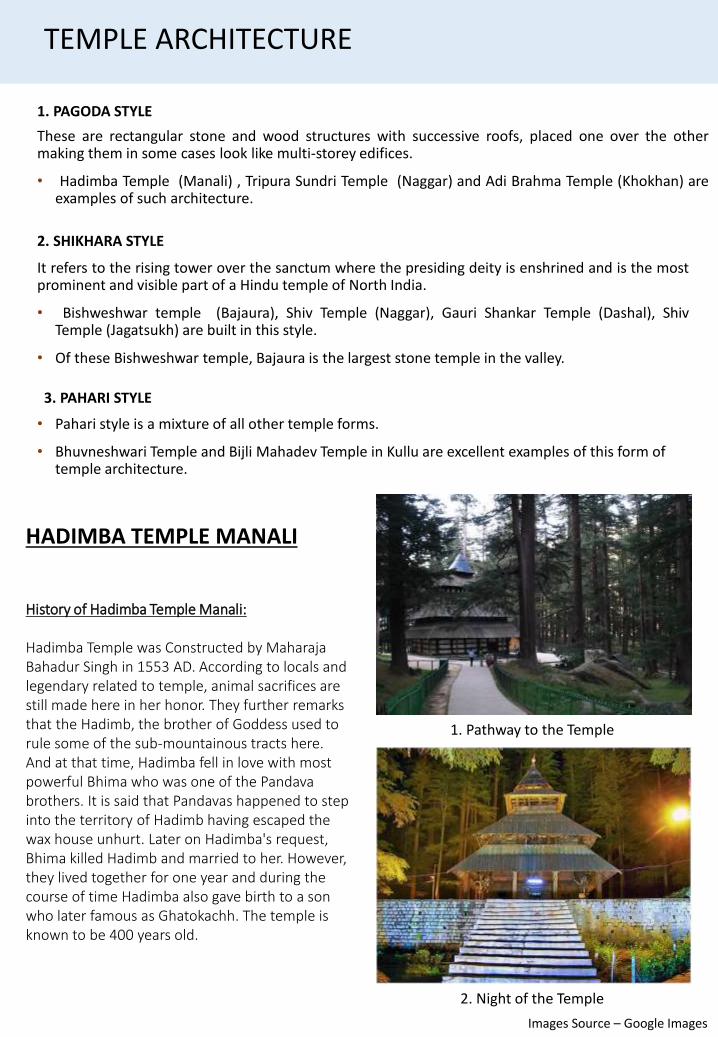
History of Hadimba Temple Manali:
Hadimba Temple was Constructed by Maharaja Bahadur Singh in 1553 AD. According to locals and legendary related to temple, animal sacrifices are still made here in her honor. They further remarks that the Hadimb, the brother of Goddess used to rule some of the sub-mountainous tracts here. And at that time, Hadimba fell in love with most powerful Bhima who was one of the Pandavabrothers. It is said that Pandavas happened to step into the territory of Hadimb having escaped the wax house unhurt. Later on Hadimba's request, Bhima killed Hadimb and married to her. However, they lived together for one year and during the course of time Hadimba also gave birth to a son who later famous as Ghatokachh. The temple is known to be 400 years old.
HADIMBA TEMPLE MANALI
1. Pathway to the Temple
2. Night of the Temple
Images Source – Google Images
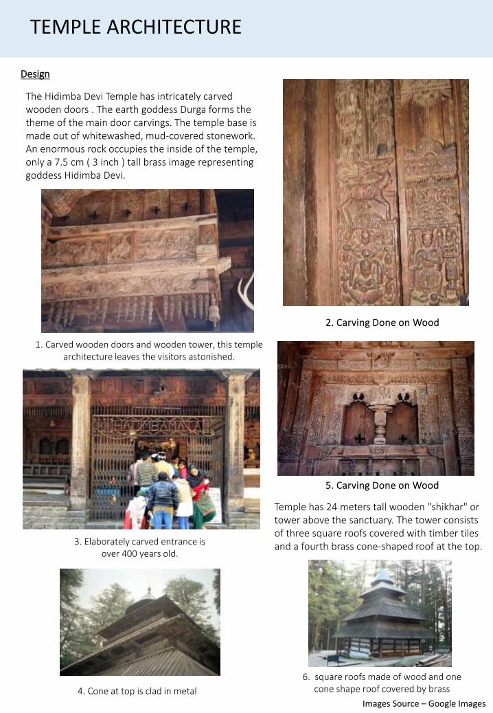
The Hidimba Devi Temple has intricately carved wooden doors . The earth goddess Durga forms the theme of the main door carvings. The temple base is made out of whitewashed, mud-covered stonework. An enormous rock occupies the inside of the temple, only a 7.5 cm ( 3 inch ) tall brass image representing goddess Hidimba Devi.
3. Elaborately carved entrance is over 400 years old.
Design
1. Carved wooden doors and wooden tower, this temple architecture leaves the visitors astonished.
TEMPLE ARCHITECTURE
Temple has 24 meters tall wooden "shikhar" or tower above the sanctuary. The tower consists of three square roofs covered with timber tiles and a fourth brass cone-shaped roof at the top.
4. Cone at top is clad in metal
6. square roofs made of wood and one cone shape roof covered by brass
2. Carving Done on Wood
5. Carving Done on Wood
Images Source – Google Images
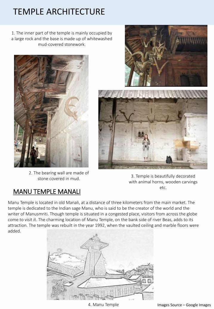
2. The bearing wall are made of stone covered in mud.
3. Temple is beautifully decorated with animal horns, wooden carvings
etc.
1. The inner part of the temple is mainly occupied by a large rock and the base is made up of whitewashed
mud-covered stonework.
TEMPLE ARCHITECTURE
Manu Temple is located in old Manali, at a distance of three kilometers from the main market. The temple is dedicated to the Indian sage Manu, who is said to be the creator of the world and the writer of Manusmriti. Though temple is situated in a congested place, visitors from across the globe come to visit it. The charming location of Manu Temple, on the bank side of river Beas, adds to its attraction. The temple was rebuilt in the year 1992, when the vaulted ceiling and marble floors were added.
MANU TEMPLE MANALI
4. Manu Temple Images Source – Google Images
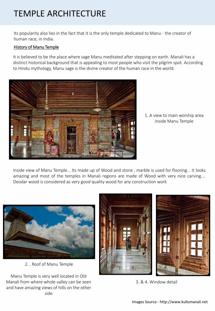
Its popularity also lies in the fact that it is the only temple dedicated to Manu - the creator of human race, in India.
It is believed to be the place where sage Manu meditated after stepping on earth. Manali has a distinct historical background that is appealing to most people who visit the pilgrim spot. According to Hindu mythology, Manu sage is the divine creator of the human race in the world.
History of Manu Temple
1. A view to main worship area inside Manu Temple
TEMPLE ARCHITECTURE
Manu Temple is very well located in Old Manali from where whole valley can be seen and have amazing views of hills on the other
side
Inside view of Manu Temple... Its made up of Wood and stone , marble is used for flooring... It looksamazing and most of the temples in Manali regions are made of Wood with very nice carving....Deodar wood is considered as very good quality wood for any construction work
3. & 4. Window detail
2. . Roof of Manu Temple
Images Source - http://www.kullumanali.net
2. Temple has many doors on two sides from where fresh air and light passes inside the temple to keep it
glowing every time
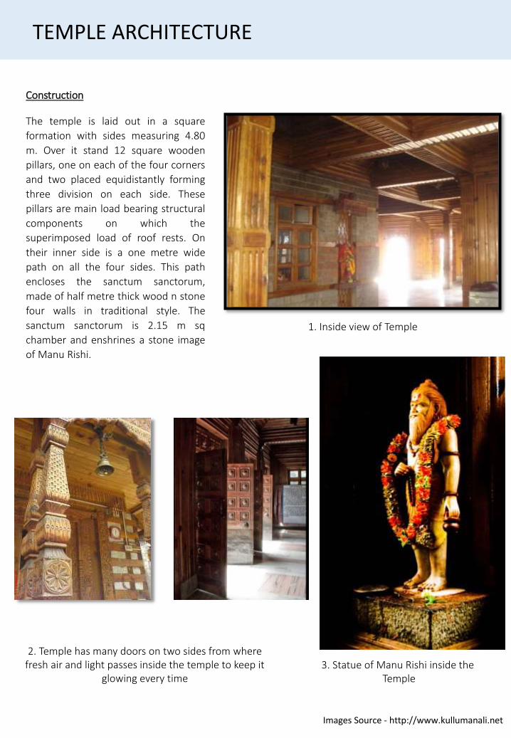
Construction
The temple is laid out in a square
formation with sides measuring 4.80
m. Over it stand 12 square wooden
pillars, one on each of the four corners
and two placed equidistantly forming
three division on each side. These
pillars are main load bearing structural
components on which the
superimposed load of roof rests. On
their inner side is a one metre wide
path on all the four sides. This path
encloses the sanctum sanctorum,
made of half metre thick wood n stone
four walls in traditional style. The
sanctum sanctorum is 2.15 m sq
chamber and enshrines a stone image
of Manu Rishi.
3. Statue of Manu Rishi inside the Temple
TEMPLE ARCHITECTURE
Images Source - http://www.kullumanali.net
1. Inside view of Temple
KULLU
DEMOGRAPHIC
Kullu has an average elevation of 1,278 m or4,193 ft). It lies on the bank of Beas RiverAs of 2011 India census Kullu had a population of18306.• Males constitute 54% of the population and
females 46%.• Kullu has an average literacy rate of 81%,
higher than the national average of 59.5%:male literacy is 84%, and female literacy is77%.
CLIMATE
December and January during winter observelowest temperatures ranging from 4°C to 20°C, withsome snowfall. Annual highest temperature insummer ranges from 25°C to 37°C during May toAugust.• Months of July and August are rainy because
of Monsoon, having around 15 cm rainfallmonthly.
• Climate is pleasant in October andNovember.
CULTURE
The people of Kullu believe in simple living
The people of Kullu are primarily farmers,but now the population has also scattered into emerging occupations as tourism and other skillful fields.
• More than 70% of the people here are literate. This includes an equal ratio of men and women.
• well known for the seven day festival of Kullu Dussehra
NATURE CONSERVATION
Kullu is famous for its varied biodiversity. Ithas some of the rarest of animals likeHimalayan Tahr, Western Tragopan, Monaland Himalayan Brown Bear (also known asthe Himalayan Red Bear).
• The Great Himalayan National Park (GHNP)is also located here.
• The park was built in 1984. It spreads overan area of 1,171 km2 which lies betweenan altitude of 1500 to 6000 meters.
Source – Maps of India
1. Map of Kullu
HISTORY OF KULLU
• Kullu (1,220 m or 4,000 ft) was once known as Kulanthpitha - `the end of the habitable world`.
• Beyond rose the forbidding heights of the Greater Himalayas and, by the banks of the shining river Beas, lay the fabled `Silver Valley`.
• The Chinese pilgrim monk Xuanzang visited the Kullu Valley in 634 or 635 CE.
• He described it as a fertile region completely surrounded by mountains.
• It contained a stupa (tope) built by Ashoka, which is said to mark the place where the Buddha preached to the local people and made conversions.
• Stupa was taken away by a mughal ruler and put in feroz shah kotla maidan in Delhi. There were some twenty Buddhist monasteries, with about 1,000 monks, most of whom were Mahayanist.
• There were also some fifteen Hindu temples, and people of both faiths lived mixed together.
• There were meditation caves near the mountain passes inhabited by both Buddhist and Hindu practitioners.
• The country is said to have produced gold, silver, red copper, crystal lenses and bell-metal.
• Kullu got its first motor able access only after Indian Independence.
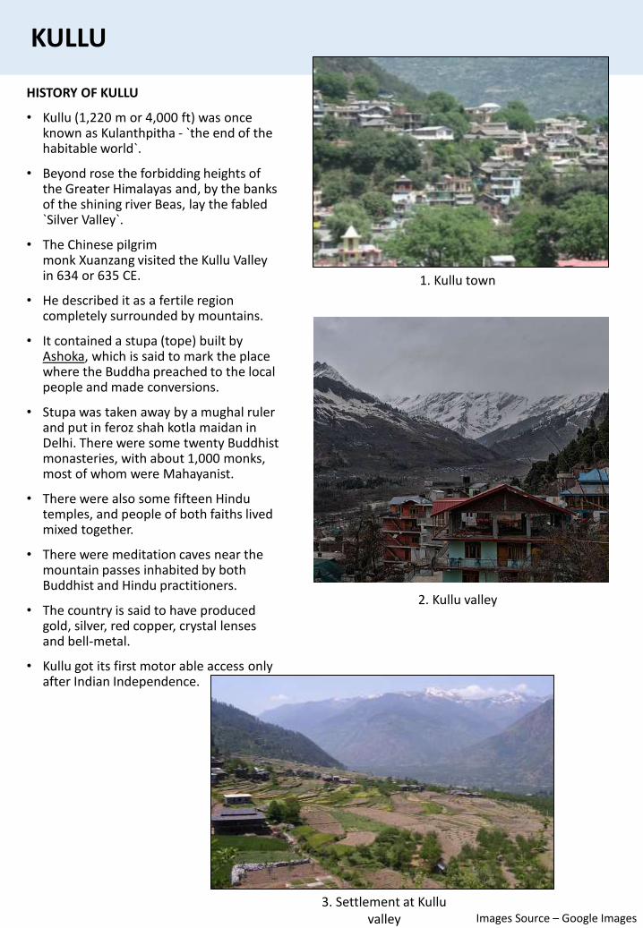
1. Kullu town
2. Kullu valley
KULLU
3. Settlement at Kullu valley Images Source – Google Images
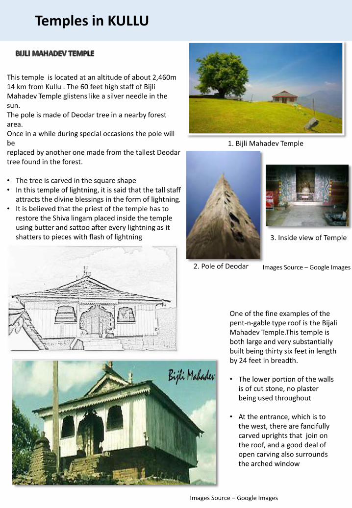
This temple is located at an altitude of about 2,460m14 km from Kullu . The 60 feet high staff of Bijli Mahadev Temple glistens like a silver needle in the sun.The pole is made of Deodar tree in a nearby forest area.Once in a while during special occasions the pole will bereplaced by another one made from the tallest Deodar tree found in the forest.
• The tree is carved in the square shape• In this temple of lightning, it is said that the tall staff
attracts the divine blessings in the form of lightning.• It is believed that the priest of the temple has to
restore the Shiva lingam placed inside the temple using butter and sattoo after every lightning as it shatters to pieces with flash of lightning
One of the fine examples of the pent-n-gable type roof is the BijaliMahadev Temple.This temple is both large and very substantially built being thirty six feet in length by 24 feet in breadth.
• The lower portion of the walls is of cut stone, no plaster being used throughout
• At the entrance, which is to the west, there are fancifully carved uprights that join on the roof, and a good deal of open carving also surrounds the arched window
Temples in KULLU
1. Bijli Mahadev Temple
3. Inside view of Temple
2. Pole of Deodar Images Source – Google Images
Images Source – Google Images
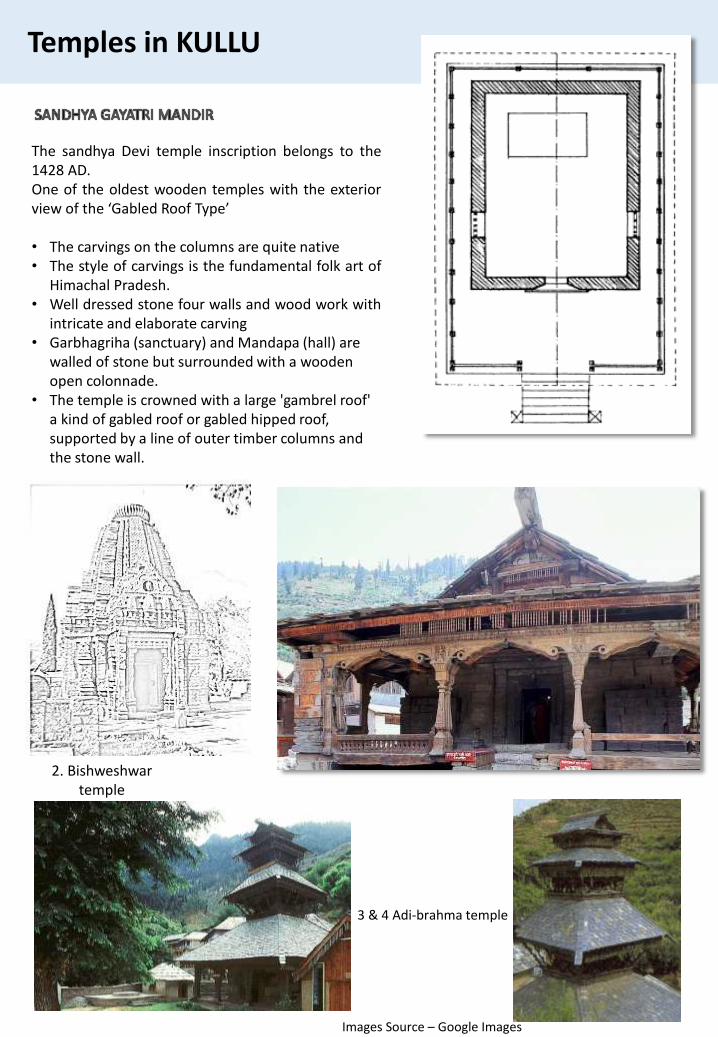
The sandhya Devi temple inscription belongs to the1428 AD.One of the oldest wooden temples with the exteriorview of the ‘Gabled Roof Type’
• The carvings on the columns are quite native• The style of carvings is the fundamental folk art of
Himachal Pradesh.• Well dressed stone four walls and wood work with
intricate and elaborate carving• Garbhagriha (sanctuary) and Mandapa (hall) are
walled of stone but surrounded with a wooden open colonnade.
• The temple is crowned with a large 'gambrel roof' a kind of gabled roof or gabled hipped roof, supported by a line of outer timber columns and the stone wall.
Temples in KULLU
3 & 4 Adi-brahma temple
2. Bishweshwartemple
Images Source – Google Images
MANDI
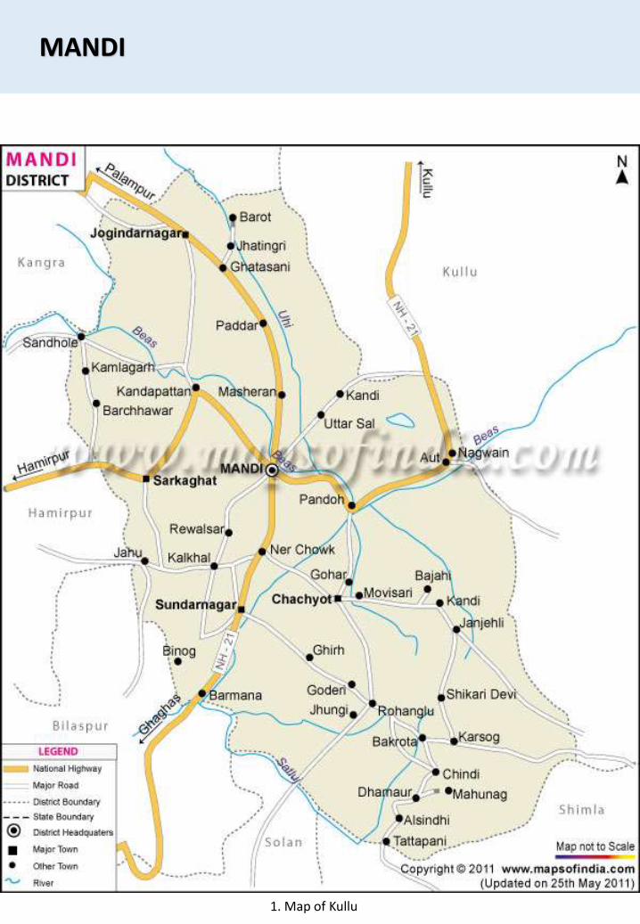
1. Map of Kullu
MANDI
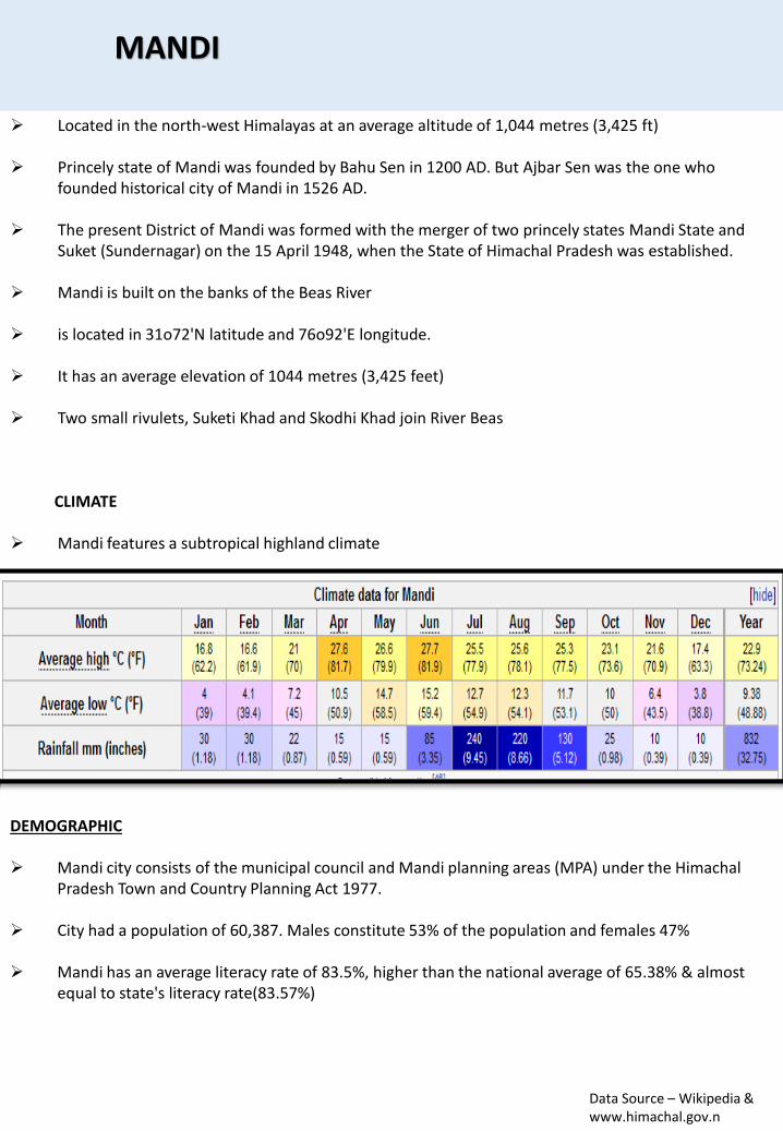
Located in the north-west Himalayas at an average altitude of 1,044 metres (3,425 ft)
Princely state of Mandi was founded by Bahu Sen in 1200 AD. But Ajbar Sen was the one who founded historical city of Mandi in 1526 AD.
The present District of Mandi was formed with the merger of two princely states Mandi State and Suket (Sundernagar) on the 15 April 1948, when the State of Himachal Pradesh was established.
Mandi is built on the banks of the Beas River
is located in 31o72'N latitude and 76o92'E longitude.
It has an average elevation of 1044 metres (3,425 feet)
Two small rivulets, Suketi Khad and Skodhi Khad join River Beas
CLIMATE
Mandi features a subtropical highland climate
DEMOGRAPHIC
Mandi city consists of the municipal council and Mandi planning areas (MPA) under the Himachal Pradesh Town and Country Planning Act 1977.
City had a population of 60,387. Males constitute 53% of the population and females 47%
Mandi has an average literacy rate of 83.5%, higher than the national average of 65.38% & almost equal to state's literacy rate(83.57%)
Data Source – Wikipedia & www.himachal.gov.n
HISTORY OF MANDI
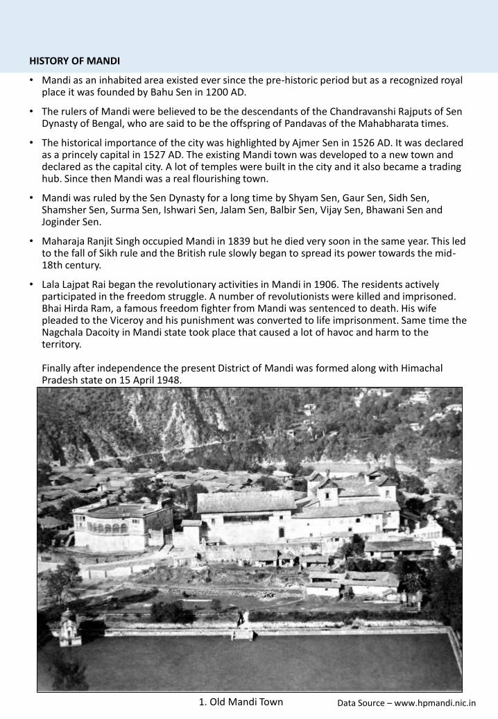
• Mandi as an inhabited area existed ever since the pre-historic period but as a recognized royal place it was founded by Bahu Sen in 1200 AD.
• The rulers of Mandi were believed to be the descendants of the Chandravanshi Rajputs of SenDynasty of Bengal, who are said to be the offspring of Pandavas of the Mahabharata times.
• The historical importance of the city was highlighted by Ajmer Sen in 1526 AD. It was declared as a princely capital in 1527 AD. The existing Mandi town was developed to a new town and declared as the capital city. A lot of temples were built in the city and it also became a trading hub. Since then Mandi was a real flourishing town.
• Mandi was ruled by the Sen Dynasty for a long time by Shyam Sen, Gaur Sen, Sidh Sen, Shamsher Sen, Surma Sen, Ishwari Sen, Jalam Sen, Balbir Sen, Vijay Sen, Bhawani Sen and Joginder Sen.
• Maharaja Ranjit Singh occupied Mandi in 1839 but he died very soon in the same year. This led to the fall of Sikh rule and the British rule slowly began to spread its power towards the mid-18th century.
• Lala Lajpat Rai began the revolutionary activities in Mandi in 1906. The residents actively participated in the freedom struggle. A number of revolutionists were killed and imprisoned. Bhai Hirda Ram, a famous freedom fighter from Mandi was sentenced to death. His wife pleaded to the Viceroy and his punishment was converted to life imprisonment. Same time the Nagchala Dacoity in Mandi state took place that caused a lot of havoc and harm to the territory.
Finally after independence the present District of Mandi was formed along with Himachal Pradesh state on 15 April 1948.
1. Old Mandi Town Data Source – www.hpmandi.nic.in
MANDI
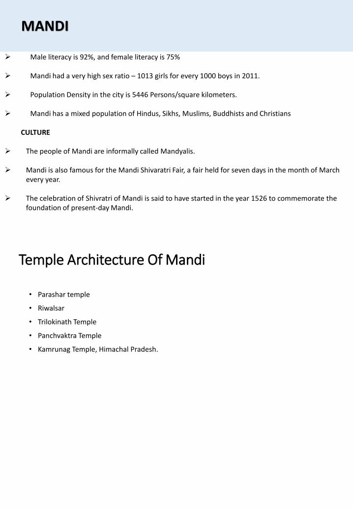
Male literacy is 92%, and female literacy is 75%
Mandi had a very high sex ratio – 1013 girls for every 1000 boys in 2011.
Population Density in the city is 5446 Persons/square kilometers.
Mandi has a mixed population of Hindus, Sikhs, Muslims, Buddhists and Christians
CULTURE
The people of Mandi are informally called Mandyalis.
Mandi is also famous for the Mandi Shivaratri Fair, a fair held for seven days in the month of March every year.
The celebration of Shivratri of Mandi is said to have started in the year 1526 to commemorate the foundation of present-day Mandi.
Temple Architecture Of Mandi
• Parashar temple
• Riwalsar
• Trilokinath Temple
• Panchvaktra Temple
• Kamrunag Temple, Himachal Pradesh.
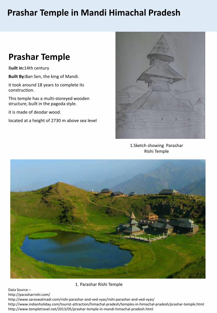
Prashar Temple in Mandi Himachal Pradesh
Data Source –http://parasharrishi.com/http://www.saraswatinadi.com/rishi-parashar-and-ved-vyas/rishi-parashar-and-ved-vyas/http://www.indianholiday.com/tourist-attraction/himachal-pradesh/temples-in-himachal-pradesh/prashar-temple.htmlhttp://www.templetravel.net/2013/05/prashar-temple-in-mandi-himachal-pradesh.html
1. Parashar Rishi Temple
Prashar TempleBuilt in:14th century
Built By:Ban Sen, the king of Mandi.
it took around 18 years to complete its construction.
This temple has a multi-storeyed wooden structure, built in the pagoda style.
it is made of deodar wood.
located at a height of 2730 m above sea level
1.Sketch showing Parashar Rishi Temple
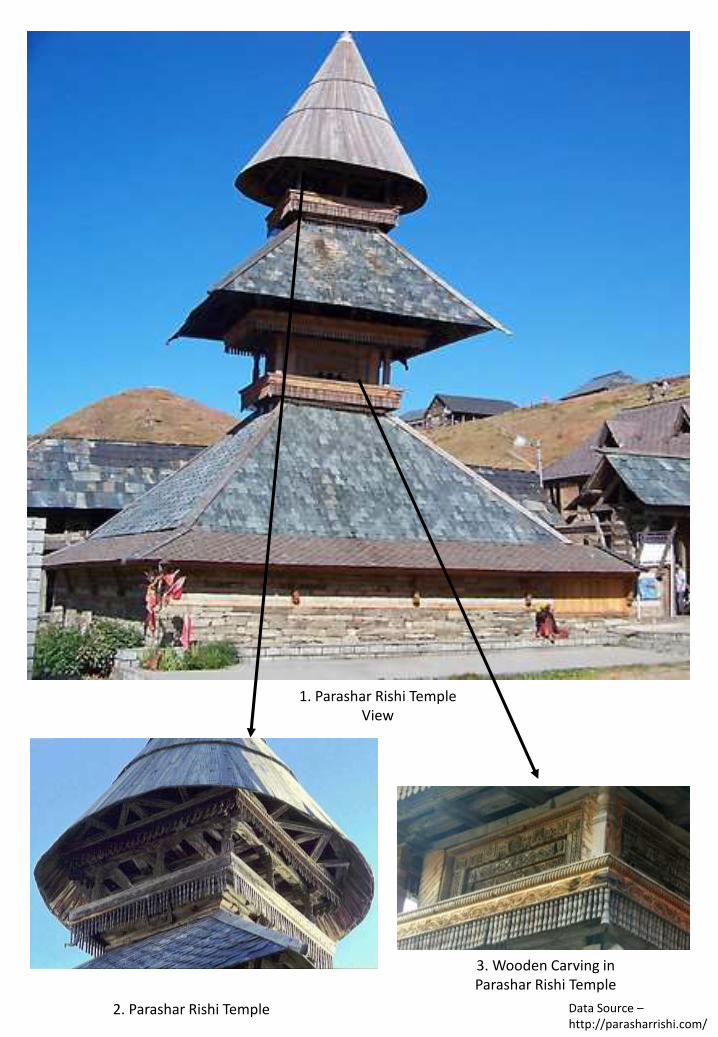
1. Parashar Rishi Temple View
2. Parashar Rishi Temple
3. Wooden Carving in Parashar Rishi Temple
Data Source –http://parasharrishi.com/
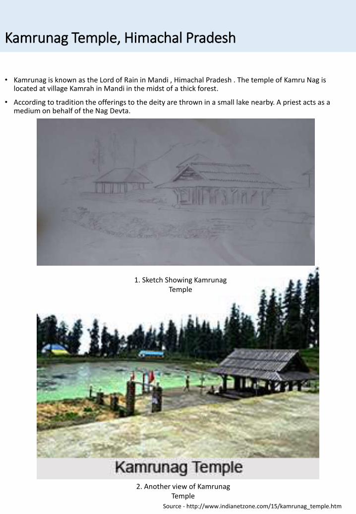
Kamrunag Temple, Himachal Pradesh
• Kamrunag is known as the Lord of Rain in Mandi , Himachal Pradesh . The temple of Kamru Nag is located at village Kamrah in Mandi in the midst of a thick forest.
• According to tradition the offerings to the deity are thrown in a small lake nearby. A priest acts as a medium on behalf of the Nag Devta.
Source - http://www.indianetzone.com/15/kamrunag_temple.htm
1. Sketch Showing KamrunagTemple
2. Another view of KamrunagTemple
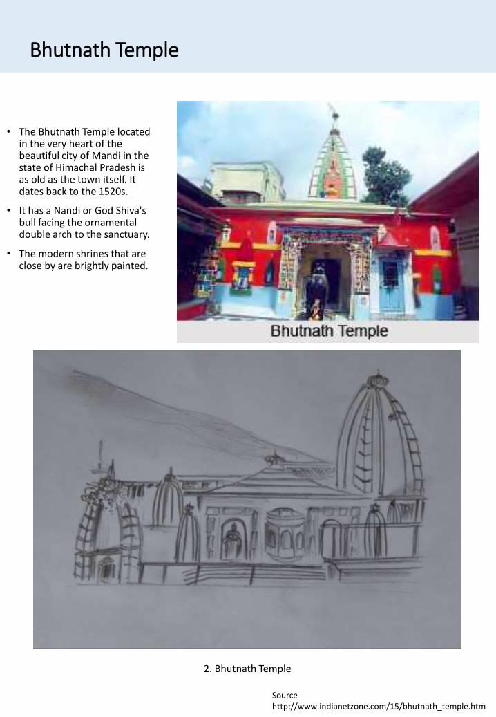
Bhutnath Temple
• The Bhutnath Temple located in the very heart of the beautiful city of Mandi in the state of Himachal Pradesh is as old as the town itself. It dates back to the 1520s.
• It has a Nandi or God Shiva's bull facing the ornamental double arch to the sanctuary.
• The modern shrines that are close by are brightly painted.
2. Bhutnath Temple
Source -http://www.indianetzone.com/15/bhutnath_temple.htm
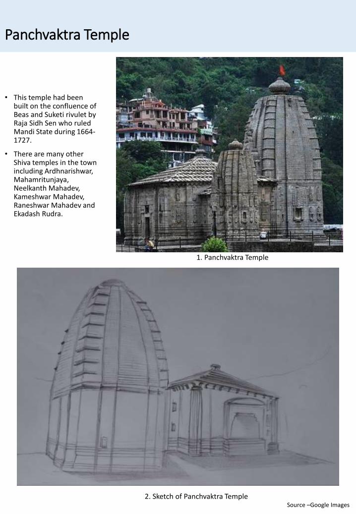
Panchvaktra Temple
• This temple had been built on the confluence of Beas and Suketi rivulet by Raja Sidh Sen who ruled Mandi State during 1664-1727.
• There are many other Shiva temples in the town including Ardhnarishwar, Mahamritunjaya, Neelkanth Mahadev, Kameshwar Mahadev, Raneshwar Mahadev and Ekadash Rudra.
1. Panchvaktra Temple
2. Sketch of Panchvaktra TempleSource –Google Images
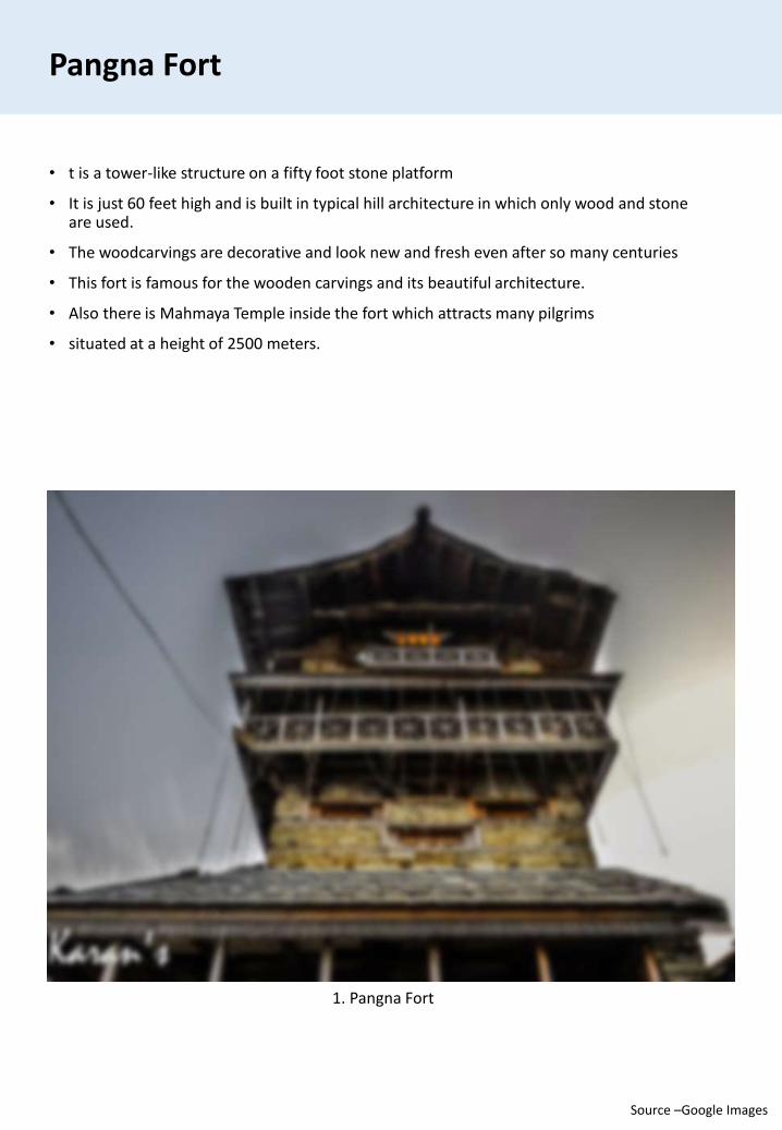
Pangna Fort
• t is a tower-like structure on a fifty foot stone platform
• It is just 60 feet high and is built in typical hill architecture in which only wood and stone are used.
• The woodcarvings are decorative and look new and fresh even after so many centuries
• This fort is famous for the wooden carvings and its beautiful architecture.
• Also there is Mahmaya Temple inside the fort which attracts many pilgrims
• situated at a height of 2500 meters.
1. Pangna Fort
Source –Google Images
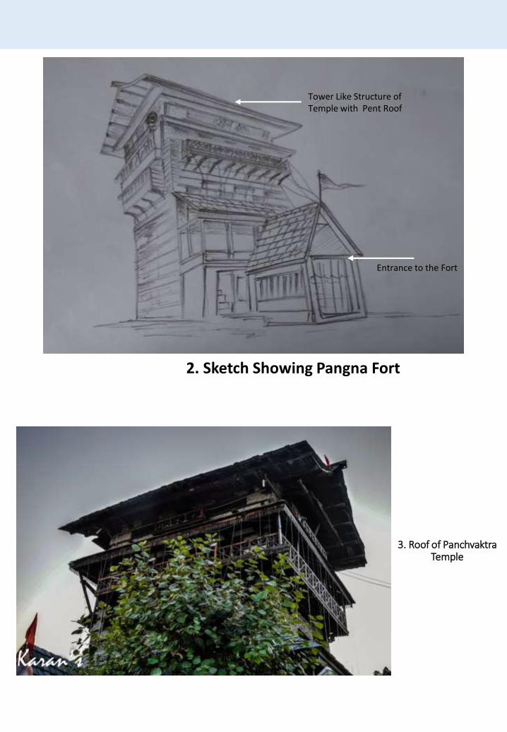
3. Roof of Panchvaktra Temple
2. Sketch Showing Pangna Fort
Entrance to the Fort
Tower Like Structure of Temple with Pent Roof
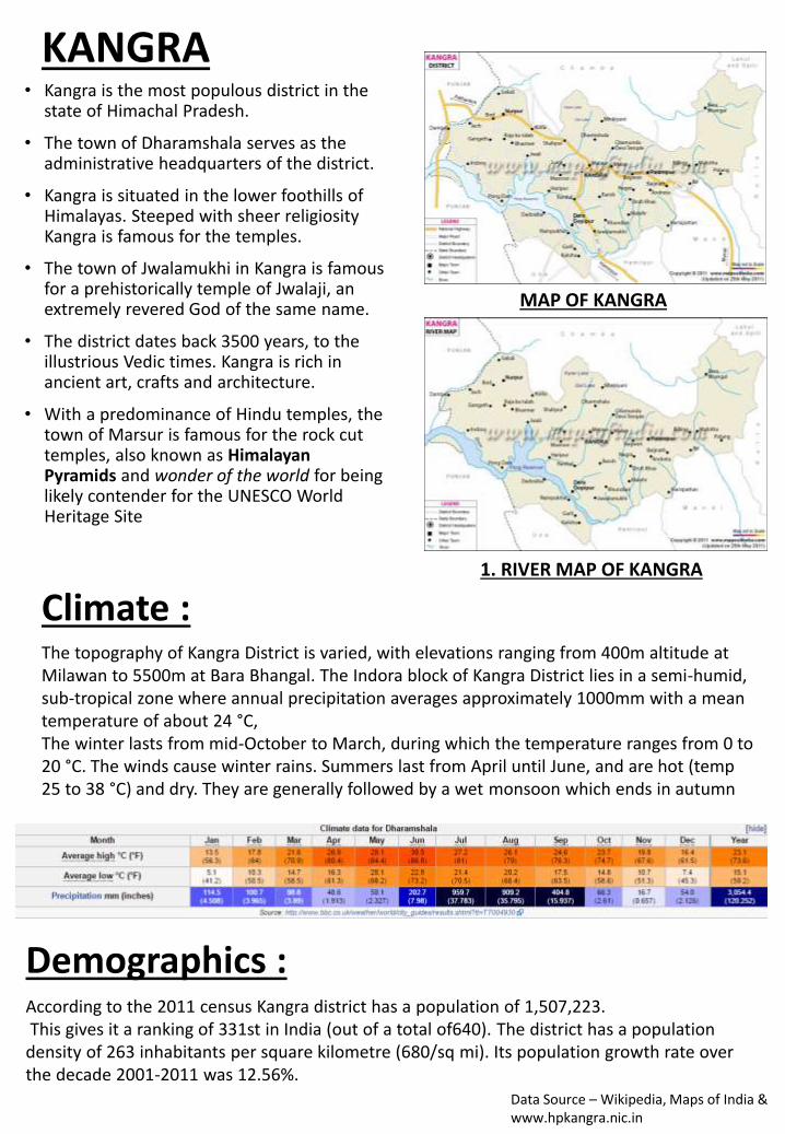
KANGRA• Kangra is the most populous district in the
state of Himachal Pradesh.
• The town of Dharamshala serves as the administrative headquarters of the district.
• Kangra is situated in the lower foothills of Himalayas. Steeped with sheer religiosity Kangra is famous for the temples.
• The town of Jwalamukhi in Kangra is famous for a prehistorically temple of Jwalaji, an extremely revered God of the same name.
• The district dates back 3500 years, to the illustrious Vedic times. Kangra is rich in ancient art, crafts and architecture.
• With a predominance of Hindu temples, the town of Marsur is famous for the rock cut temples, also known as Himalayan Pyramids and wonder of the world for being likely contender for the UNESCO World Heritage Site
MAP OF KANGRA
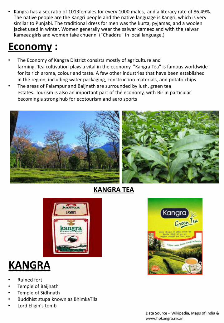
1. RIVER MAP OF KANGRA
Climate :The topography of Kangra District is varied, with elevations ranging from 400m altitude at Milawan to 5500m at Bara Bhangal. The Indora block of Kangra District lies in a semi-humid, sub-tropical zone where annual precipitation averages approximately 1000mm with a mean temperature of about 24 °C,The winter lasts from mid-October to March, during which the temperature ranges from 0 to 20 °C. The winds cause winter rains. Summers last from April until June, and are hot (temp 25 to 38 °C) and dry. They are generally followed by a wet monsoon which ends in autumn
Demographics :According to the 2011 census Kangra district has a population of 1,507,223.This gives it a ranking of 331st in India (out of a total of640). The district has a population
density of 263 inhabitants per square kilometre (680/sq mi). Its population growth rate over the decade 2001-2011 was 12.56%.
Data Source – Wikipedia, Maps of India & www.hpkangra.nic.in
• Kangra has a sex ratio of 1013females for every 1000 males, and a literacy rate of 86.49%.The native people are the Kangri people and the native language is Kangri, which is very similar to Punjabi. The traditional dress for men was the kurta, pyjamas, and a woolen jacket used in winter. Women generally wear the salwar kameez and with the salwar Kameez girls and women take chuenni ("Chaddru" in local language.)
Economy :• The Economy of Kangra District consists mostly of agriculture and
farming. Tea cultivation plays a vital in the economy. "Kangra Tea" is famous worldwide for its rich aroma, colour and taste. A few other industries that have been established in the region, including water packaging, construction materials, and potato chips.
• The areas of Palampur and Baijnath are surrounded by lush, green tea estates. Tourism is also an important part of the economy, with Bir in particular becoming a strong hub for ecotourism and aero sports
KANGRA TEA
KANGRA• Ruined fort• Temple of Baijnath• Temple of Sidhnath• Buddhist stupa known as BhimkaTila• Lord Eligin's tomb
Data Source – Wikipedia, Maps of India & www.hpkangra.nic.in
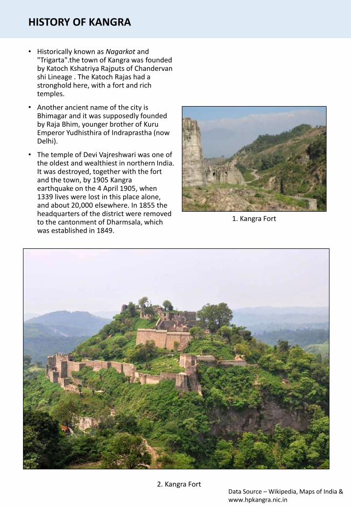
HISTORY OF KANGRA
• Historically known as Nagarkot and "Trigarta".the town of Kangra was founded by Katoch Kshatriya Rajputs of Chandervanshi Lineage . The Katoch Rajas had a stronghold here, with a fort and rich temples.
• Another ancient name of the city is Bhimagar and it was supposedly founded by Raja Bhim, younger brother of KuruEmperor Yudhisthira of Indraprastha (now Delhi).
• The temple of Devi Vajreshwari was one of the oldest and wealthiest in northern India. It was destroyed, together with the fort and the town, by 1905 Kangraearthquake on the 4 April 1905, when 1339 lives were lost in this place alone, and about 20,000 elsewhere. In 1855 the headquarters of the district were removed to the cantonment of Dharmsala, which was established in 1849.
2. Kangra Fort
1. Kangra Fort
Data Source – Wikipedia, Maps of India & www.hpkangra.nic.in
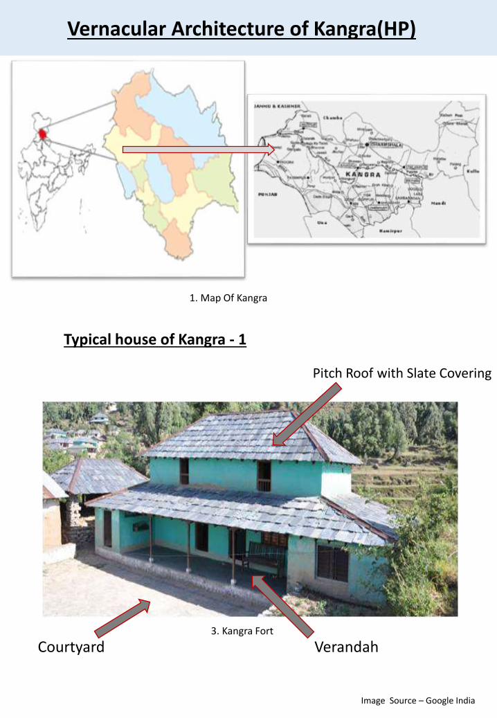
Vernacular Architecture of Kangra(HP)
Typical house of Kangra - 1
Verandah
Pitch Roof with Slate Covering
Courtyard3. Kangra Fort
1. Map Of Kangra
Image Source – Google India
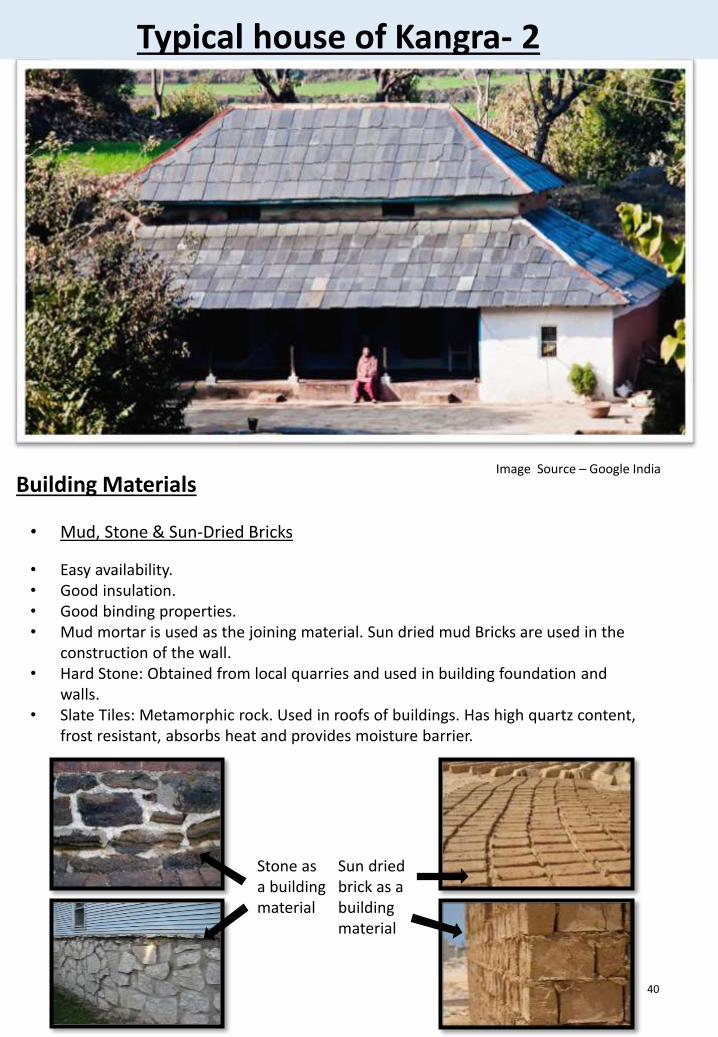
Typical house of Kangra- 2
40
Building Materials
• Mud, Stone & Sun-Dried Bricks
• Easy availability.• Good insulation.• Good binding properties.• Mud mortar is used as the joining material. Sun dried mud Bricks are used in the
construction of the wall.• Hard Stone: Obtained from local quarries and used in building foundation and
walls.• Slate Tiles: Metamorphic rock. Used in roofs of buildings. Has high quartz content,
frost resistant, absorbs heat and provides moisture barrier.
Stone as a building material
Sun dried brick as a building material
Image Source – Google India
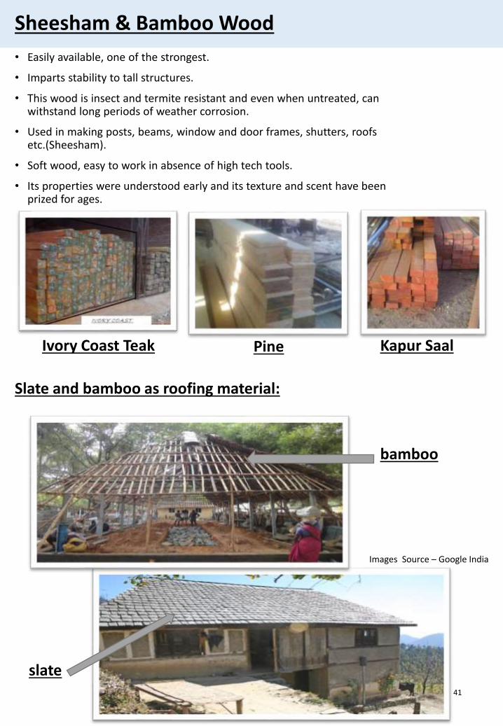
Sheesham & Bamboo Wood
• Easily available, one of the strongest.
• Imparts stability to tall structures.
• This wood is insect and termite resistant and even when untreated, can withstand long periods of weather corrosion.
• Used in making posts, beams, window and door frames, shutters, roofs etc.(Sheesham).
• Soft wood, easy to work in absence of high tech tools.
• Its properties were understood early and its texture and scent have been prized for ages.
41
Ivory Coast Teak Kapur SaalPine
Slate and bamboo as roofing material:
bamboo
slate
Images Source – Google India
CONSTRUCTION MATERIALs & METHODs IN KANGRA
• The orientation of the buildings in this zone is mostly East and South. The slope of the land is from 0 to 30* approximately.
• Materials available for construction are stone slabs for flooring and roofing, stone and earth for walls and wooden plank supports on wooden joists for intermediate floors.
• A typical innovative technique for construction of earthen walls is use of a bottomless wooden box 0.60X0.90 m, with a height of 0.23 m in which earth is filled and rammed thus creating 0.23 m layer of rammed earth at every stage for the construction of a wall which is 0.60 m thick.
• The another innovative techniques is the use of locally available slate stone which are used for sloping roof and are placed on heavy wooden supports with overlapping of 0.0254 -0.0308 m.
• These slates are not fixed to wooden supports but remain in place by weight only or sometimes they nailed to the wooden joists/rafters. The slope of roof is confined to maximum 22.5 degree.
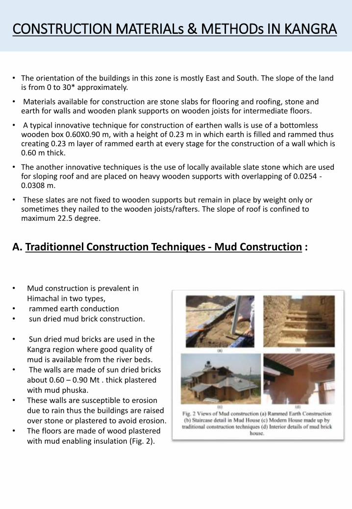
A. Traditionnel Construction Techniques - Mud Construction :
• Mud construction is prevalent in Himachal in two types,
• rammed earth conduction • sun dried mud brick construction.
• Sun dried mud bricks are used in the Kangra region where good quality of mud is available from the river beds.
• The walls are made of sun dried bricks about 0.60 – 0.90 Mt . thick plastered with mud phuska.
• These walls are susceptible to erosion due to rain thus the buildings are raised over stone or plastered to avoid erosion.
• The floors are made of wood plastered with mud enabling insulation (Fig. 2).
Mud Construction :
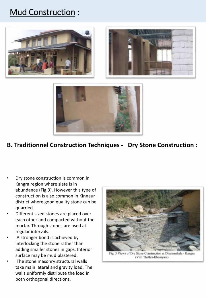
B. Traditionnel Construction Techniques - Dry Stone Construction :
• Dry stone construction is common in Kangra region where slate is in abundance (Fig.3). However this type of construction is also common in Kinnaurdistrict where good quality stone can be quarried.
• Different sized stones are placed over each other and compacted without the mortar. Through stones are used at regular intervals.
• A stronger bond is achieved by interlocking the stone rather than adding smaller stones in gaps. Interior surface may be mud plastered.
• The stone masonry structural walls take main lateral and gravity load. The walls uniformly distribute the load in both orthogonal directions.
Traditional Builders
• Traditional Artisans are employed. There knowledge is transferred orally from master artisan to apprentice. Mostly people procure materials from their surroundings and build houses with the help of relatives and neighbors. This has fostered an empirical knowledge of construction material, tools and technology and all of these are reflected in traditional building techniques.
44
Planning Techniques
• Factors that govern the planning are- climatic conditions,- cultural influences,- topography(heights),
• More: orientation, traffic movement, available usable spaces, sources of water supply, natural drains and paths.
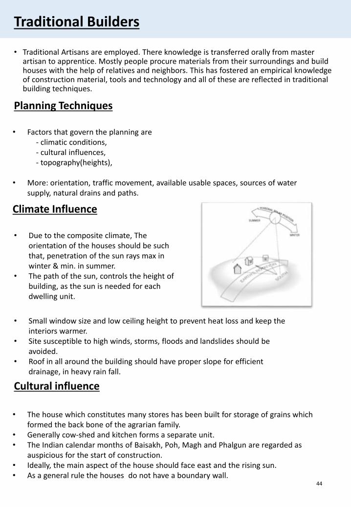
Climate Influence
• Due to the composite climate, The orientation of the houses should be such that, penetration of the sun rays max in winter & min. in summer.
• The path of the sun, controls the height of building, as the sun is needed for each dwelling unit.
• Small window size and low ceiling height to prevent heat loss and keep the interiors warmer.
• Site susceptible to high winds, storms, floods and landslides should be avoided.
• Roof in all around the building should have proper slope for efficient drainage, in heavy rain fall.
Cultural influence
• The house which constitutes many stores has been built for storage of grains which formed the back bone of the agrarian family.
• Generally cow-shed and kitchen forms a separate unit.• The Indian calendar months of Baisakh, Poh, Magh and Phalgun are regarded as
auspicious for the start of construction.• Ideally, the main aspect of the house should face east and the rising sun.• As a general rule the houses do not have a boundary wall.
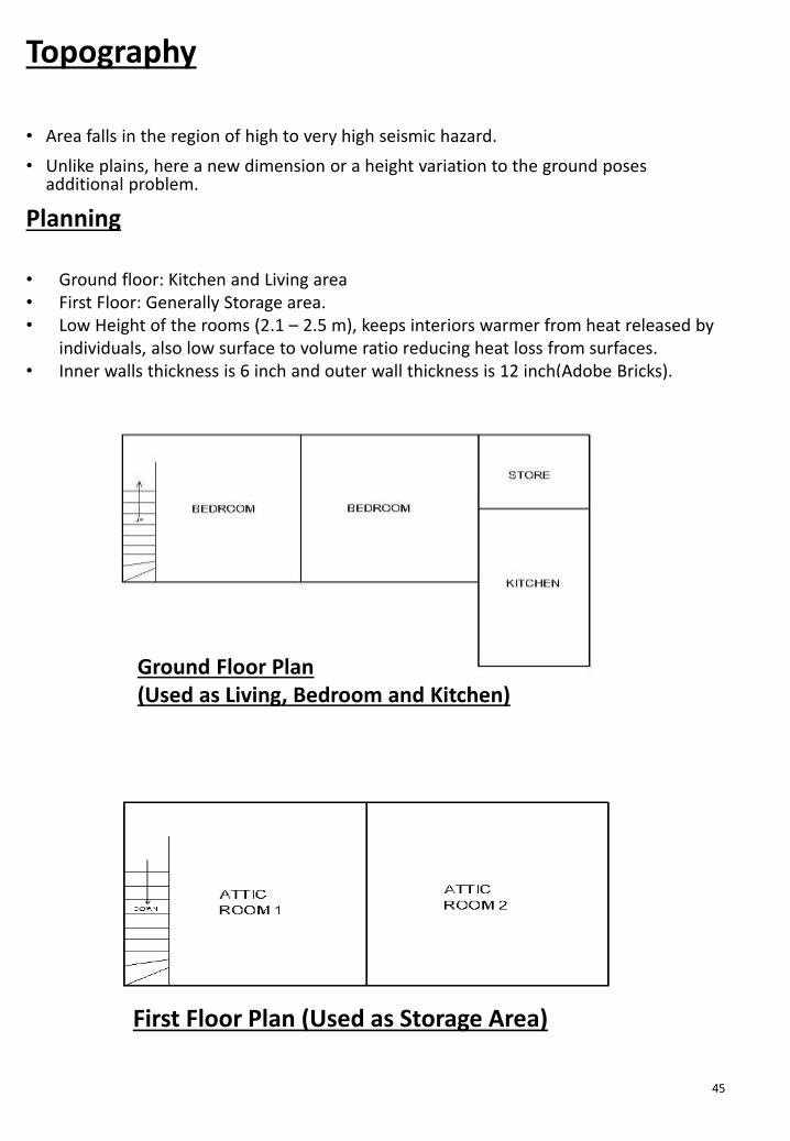
Topography
• Area falls in the region of high to very high seismic hazard.
• Unlike plains, here a new dimension or a height variation to the ground poses additional problem.
45
Planning
• Ground floor: Kitchen and Living area• First Floor: Generally Storage area.• Low Height of the rooms (2.1 – 2.5 m), keeps interiors warmer from heat released by
individuals, also low surface to volume ratio reducing heat loss from surfaces.• Inner walls thickness is 6 inch and outer wall thickness is 12 inch(Adobe Bricks).
Ground Floor Plan(Used as Living, Bedroom and Kitchen)
First Floor Plan (Used as Storage Area)
Flooring
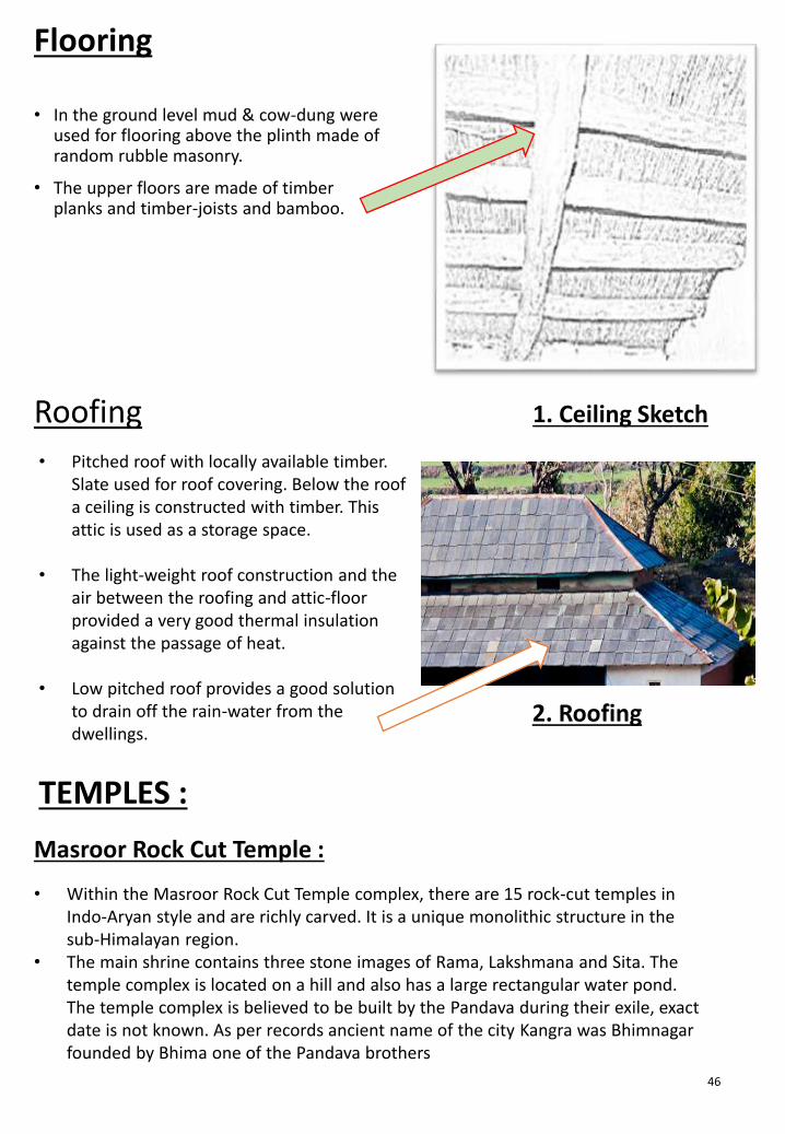
• In the ground level mud & cow-dung were used for flooring above the plinth made of random rubble masonry.
• The upper floors are made of timber planks and timber-joists and bamboo.
46
Roofing
• Pitched roof with locally available timber. Slate used for roof covering. Below the roof a ceiling is constructed with timber. This attic is used as a storage space.
• The light-weight roof construction and the air between the roofing and attic-floor provided a very good thermal insulation against the passage of heat.
• Low pitched roof provides a good solution to drain off the rain-water from the dwellings.
Masroor Rock Cut Temple :
TEMPLES :
• Within the Masroor Rock Cut Temple complex, there are 15 rock-cut temples in Indo-Aryan style and are richly carved. It is a unique monolithic structure in the sub-Himalayan region.
• The main shrine contains three stone images of Rama, Lakshmana and Sita. The temple complex is located on a hill and also has a large rectangular water pond. The temple complex is believed to be built by the Pandava during their exile, exact date is not known. As per records ancient name of the city Kangra was Bhimnagarfounded by Bhima one of the Pandava brothers
1. Ceiling Sketch
2. Roofing
1. Masroor Rock Cut Temple :
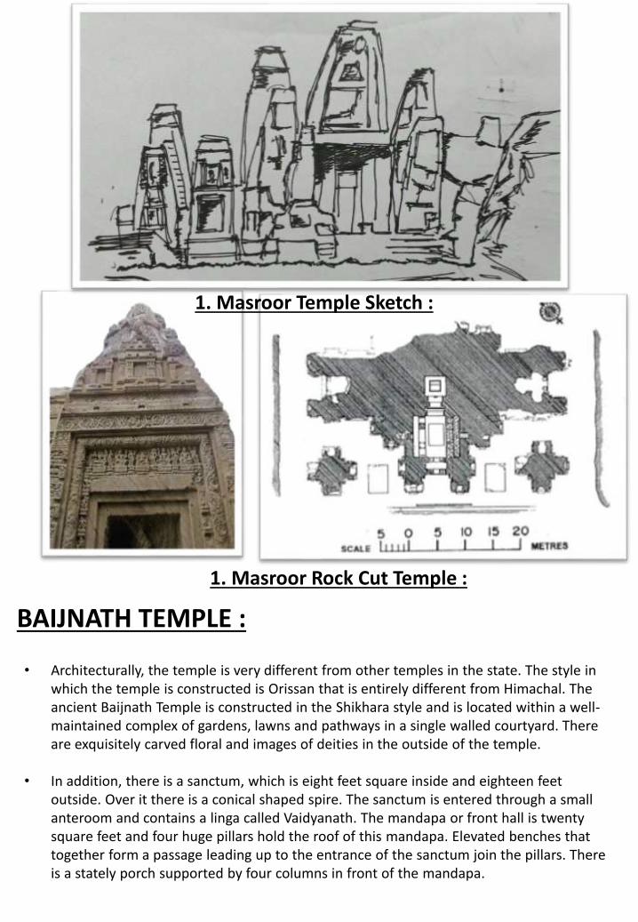
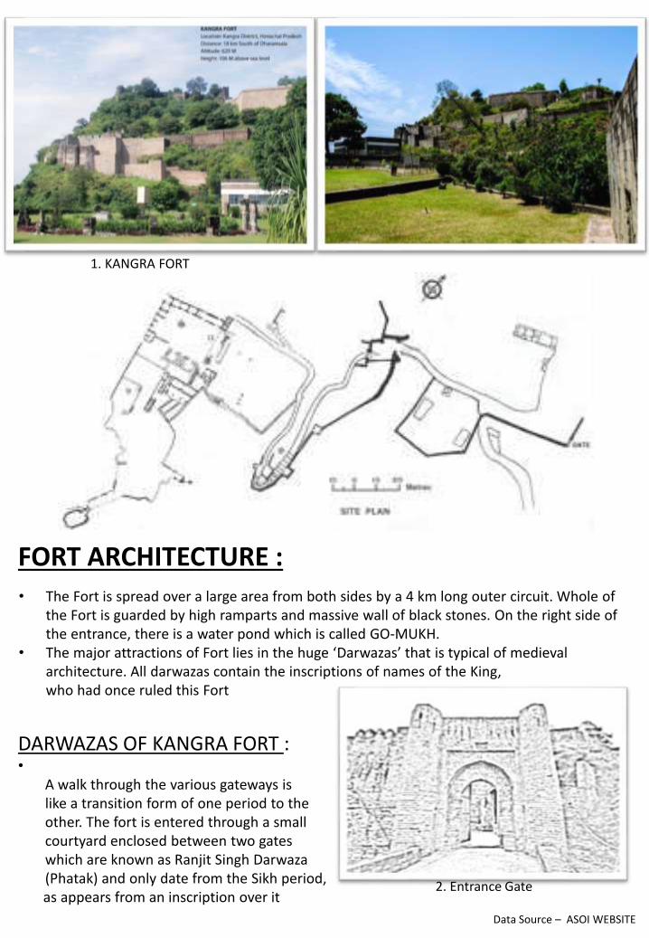
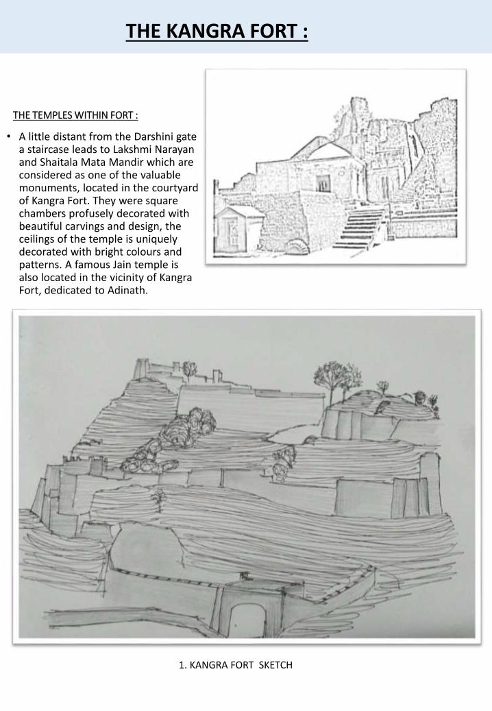
BAIJNATH TEMPLE :
• Architecturally, the temple is very different from other temples in the state. The style in which the temple is constructed is Orissan that is entirely different from Himachal. The ancient Baijnath Temple is constructed in the Shikhara style and is located within a well-maintained complex of gardens, lawns and pathways in a single walled courtyard. There are exquisitely carved floral and images of deities in the outside of the temple.
• In addition, there is a sanctum, which is eight feet square inside and eighteen feet outside. Over it there is a conical shaped spire. The sanctum is entered through a small anteroom and contains a linga called Vaidyanath. The mandapa or front hall is twenty square feet and four huge pillars hold the roof of this mandapa. Elevated benches that together form a passage leading up to the entrance of the sanctum join the pillars. There is a stately porch supported by four columns in front of the mandapa.
1. Masroor Temple Sketch :
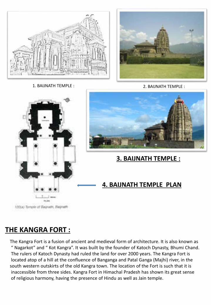
3. BAIJNATH TEMPLE :
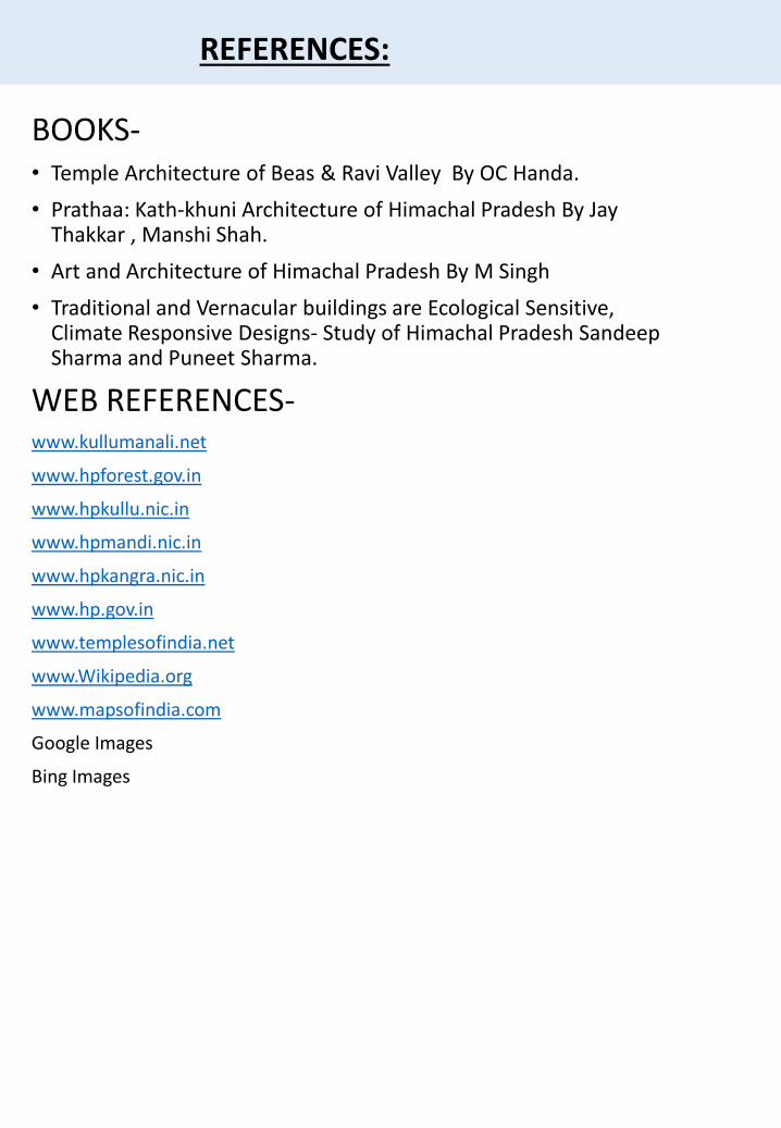
4. BAIJNATH TEMPLE PLAN
THE KANGRA FORT :
The Kangra Fort is a fusion of ancient and medieval form of architecture. It is also known as“ Nagarkot” and “ Kot Kangra”. It was built by the founder of Katoch Dynasty, Bhumi Chand.The rulers of Katoch Dynasty had ruled the land for over 2000 years. The Kangra Fort islocated atop of a hill at the confluence of Banganga and Patal Ganga (Majhi) river, in the
south western outskirts of the old Kangra town. The location of the Fort is such that it isinaccessible from three sides. Kangra Fort in Himachal Pradesh has shown its great senseof religious harmony, having the presence of Hindu as well as Jain temple.
1. BAIJNATH TEMPLE : 2. BAIJNATH TEMPLE :
FORT ARCHITECTURE :• The Fort is spread over a large area from both sides by a 4 km long outer circuit. Whole of
the Fort is guarded by high ramparts and massive wall of black stones. On the right side of the entrance, there is a water pond which is called GO-MUKH.
• The major attractions of Fort lies in the huge ‘Darwazas’ that is typical of medieval architecture. All darwazas contain the inscriptions of names of the King,who had once ruled this Fort
DARWAZAS OF KANGRA FORT :•
A walk through the various gateways islike a transition form of one period to theother. The fort is entered through a smallcourtyard enclosed between two gateswhich are known as Ranjit Singh Darwaza(Phatak) and only date from the Sikh period, as appears from an inscription over it
1. KANGRA FORT
2. Entrance Gate
Data Source – ASOI WEBSITE
THE TEMPLES WITHIN FORT :
• A little distant from the Darshini gatea staircase leads to Lakshmi Narayanand Shaitala Mata Mandir which areconsidered as one of the valuablemonuments, located in the courtyardof Kangra Fort. They were squarechambers profusely decorated withbeautiful carvings and design, theceilings of the temple is uniquelydecorated with bright colours andpatterns. A famous Jain temple isalso located in the vicinity of KangraFort, dedicated to Adinath.
THE KANGRA FORT :
1. KANGRA FORT SKETCH
BOOKS-• Temple Architecture of Beas & Ravi Valley By OC Handa.
• Prathaa: Kath-khuni Architecture of Himachal Pradesh By Jay Thakkar , Manshi Shah.
• Art and Architecture of Himachal Pradesh By M Singh
• Traditional and Vernacular buildings are Ecological Sensitive, Climate Responsive Designs- Study of Himachal Pradesh Sandeep Sharma and Puneet Sharma.
WEB REFERENCES-www.kullumanali.net
www.hpforest.gov.in
www.hpkullu.nic.in
www.hpmandi.nic.in
www.hpkangra.nic.in
www.hp.gov.in
www.templesofindia.net
www.Wikipedia.org
www.mapsofindia.com
Google Images
Bing Images
REFERENCES: