Embed Size (px)
Citation preview
EXECUTIVE SUMMARY
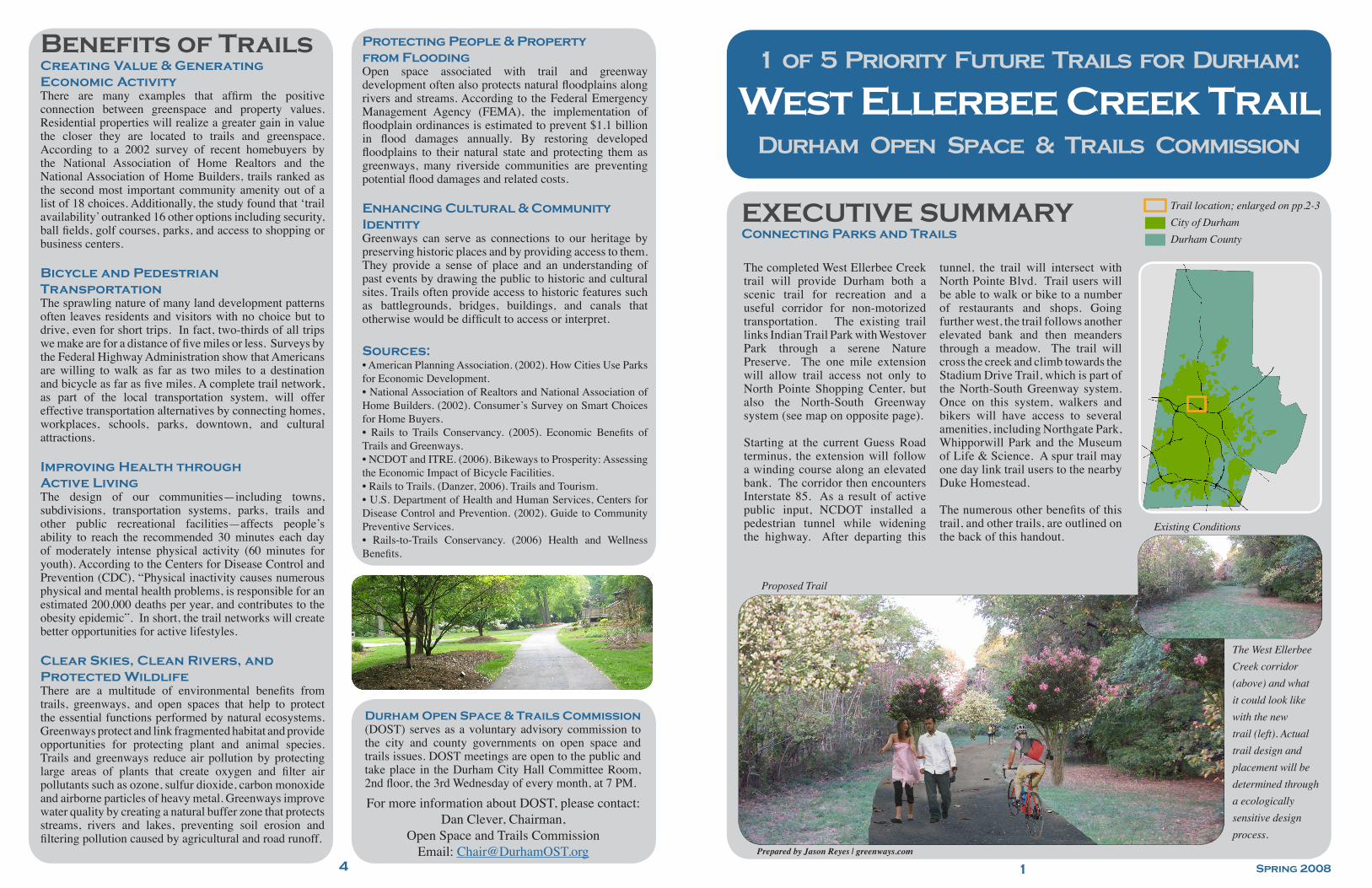
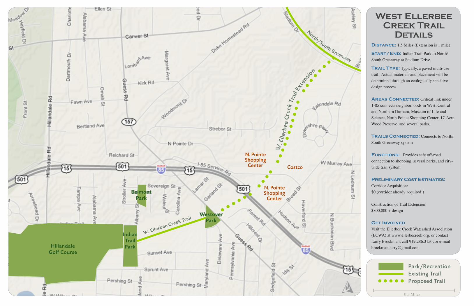
The completed West Ellerbee Creek trail will provide Durham both a scenic trail for recreation and a useful corridor for non-motorized transportation. The existing trail links Indian Trail Park with Westover Park through a serene Nature Preserve. The one mile extension will allow trail access not only to North Pointe Shopping Center, but also the North-South Greenway system (see map on opposite page). Starting at the current Guess Road terminus, the extension will follow a winding course along an elevated bank. The corridor then encounters Interstate 85. As a result of active public input, NCDOT installed a pedestrian tunnel while widening the highway. After departing this
tunnel, the trail will intersect with North Pointe Blvd. Trail users will be able to walk or bike to a number of restaurants and shops. Going further west, the trail follows another elevated bank and then meanders through a meadow. The trail will cross the creek and climb towards the Stadium Drive Trail, which is part of the North-South Greenway system. Once on this system, walkers and bikers will have access to several amenities, including Northgate Park, Whipporwill Park and the Museum of Life & Science. A spur trail may one day link trail users to the nearby Duke Homestead. The numerous other benefits of this trail, and other trails, are outlined on the back of this handout.
Connecting Parks and Trails
West Ellerbee Creek Trail
Benefits of Trails
Durham Open Space & Trails Commission
For more information about DOST, please contact:Dan Clever, Chairman,
Open Space and Trails CommissionEmail: [email protected]
Creating Value & Generating Economic ActivityThere are many examples that affirm the positive connection between greenspace and property values. Residential properties will realize a greater gain in value the closer they are located to trails and greenspace. According to a 2002 survey of recent homebuyers by the National Association of Home Realtors and the National Association of Home Builders, trails ranked as the second most important community amenity out of a list of 18 choices. Additionally, the study found that ‘trail availability’ outranked 16 other options including security, ball fields, golf courses, parks, and access to shopping or business centers.
Bicycle and Pedestrian TransportationThe sprawling nature of many land development patterns often leaves residents and visitors with no choice but to drive, even for short trips. In fact, two-thirds of all trips we make are for a distance of five miles or less. Surveys by the Federal Highway Administration show that Americans are willing to walk as far as two miles to a destination and bicycle as far as five miles. A complete trail network, as part of the local transportation system, will offer effective transportation alternatives by connecting homes, workplaces, schools, parks, downtown, and cultural attractions.
Improving Health through Active LivingThe design of our communities—including towns, subdivisions, transportation systems, parks, trails and other public recreational facilities—affects people’s ability to reach the recommended 30 minutes each day of moderately intense physical activity (60 minutes for youth). According to the Centers for Disease Control and Prevention (CDC), “Physical inactivity causes numerous physical and mental health problems, is responsible for an estimated 200,000 deaths per year, and contributes to the obesity epidemic”. In short, the trail networks will create better opportunities for active lifestyles.
Clear Skies, Clean Rivers, and Protected WildlifeThere are a multitude of environmental benefits from trails, greenways, and open spaces that help to protect the essential functions performed by natural ecosystems. Greenways protect and link fragmented habitat and provide opportunities for protecting plant and animal species. Trails and greenways reduce air pollution by protecting large areas of plants that create oxygen and filter air pollutants such as ozone, sulfur dioxide, carbon monoxide and airborne particles of heavy metal. Greenways improve water quality by creating a natural buffer zone that protects streams, rivers and lakes, preventing soil erosion and filtering pollution caused by agricultural and road runoff.
Protecting People & Property from FloodingOpen space associated with trail and greenway development often also protects natural floodplains along rivers and streams. According to the Federal Emergency Management Agency (FEMA), the implementation of floodplain ordinances is estimated to prevent $1.1 billion in flood damages annually. By restoring developed floodplains to their natural state and protecting them as greenways, many riverside communities are preventing potential flood damages and related costs.
Enhancing Cultural & Community IdentityGreenways can serve as connections to our heritage by preserving historic places and by providing access to them. They provide a sense of place and an understanding of past events by drawing the public to historic and cultural sites. Trails often provide access to historic features such as battlegrounds, bridges, buildings, and canals that otherwise would be difficult to access or interpret.
Sources:• American Planning Association. (2002). How Cities Use Parks for Economic Development. • National Association of Realtors and National Association of Home Builders. (2002). Consumer’s Survey on Smart Choices for Home Buyers.• Rails to Trails Conservancy. (2005). Economic Benefits of Trails and Greenways.• NCDOT and ITRE. (2006). Bikeways to Prosperity: Assessing the Economic Impact of Bicycle Facilities.• Rails to Trails. (Danzer, 2006). Trails and Tourism.• U.S. Department of Health and Human Services, Centers for Disease Control and Prevention. (2002). Guide to Community Preventive Services.• Rails-to-Trails Conservancy. (2006) Health and Wellness Benefits.
August 2007
1 of 5 Priority Future Trails for Durham:
Trail location; enlarged on pp.2-3City of DurhamDurham County
The West Ellerbee Creek corridor (above) and what it could look like with the new trail (left). Actual trail design and placement will be determined through a ecologically sensitive design process.
14
Durham Open Space & Trails Commission(DOST) serves as a voluntary advisory commission to the city and county governments on open space and trails issues. DOST meetings are open to the public and take place in the Durham City Hall Committee Room, 2nd floor, the 3rd Wednesday of every month, at 7 PM.
Existing Conditions
Proposed Trail
Spring 2008
Prepared by Jason Reyes | greenways.com
West Ellerbee Creek Trail
DetailsDistance: 1.5 Miles (Extension is 1 mile)
Start/End: Indian Trail Park to North/South Greenway at Stadium Drive
Trail Type: Typically, a paved multi-use trail. Actual materials and placement will be determined through an ecologically sensitive design process
Areas Connected: Critical link under 1-85 connects neighborhoods in West, Central and Northern Durham, Museum of Life and Science, North Pointe Shopping Center, 17-Acre Wood Preserve, and several parks.
Trails Connected: Connects to North/South Greenway system
Functions: Provides safe off-road connection to shopping, several parks, and city-wide trail system
Preliminary Cost Estimates: Corridor Acquisition: $0 (corridor already acquired!)
Construction of Trail Extension: $800,000 + design
Get InvolvedVisit the Ellerbee Creek Watershed Association (ECWA) at www.ellerbecreek.org, or contact Larry Brockman: call 919.286.3150, or e-mail [email protected]
Park/RecreationExisting TrailProposed Trail
Indian TrailPark
N. PointeShopping
Center
Costco
W. Ellerbee Creek Trail
North/South Greenway
WestoverPark
W. E
llerb
ee C
reek
Tra
il Ex
tensio
n
N. PointeShopping
Center
BelmontPark
0.5 Miles
HillandaleGolf Course