Embed Size (px)
Citation preview
1.0 Project Description and Environmental Setting
Lake Jennings Market Place 1-1 South Coast Development Draft EIR November 2015
1.0 PROJECT DESCRIPTION, LOCATION, AND ENVIRONMENTAL SETTING
1.1 Project Objectives
The project objectives are to:
1. Expand an existing commercial node to further enhance and support the economic development of the Lakeside Village regional category which will assist in the implementation of the Community Development Model.
2. Develop a new commercial center compatible with the character of the Lakeside community that will serve the retail shopping needs of the southwest corner of the Lakeside Community Plan area from Blossom Valley to Lake Jennings Park Road.
3. Develop commercial uses adjacent to a major freeway and close to existing residential uses.
4. Provide Los Coches Creek with a buffer from developed urban uses and provide for the long-term maintenance of the open space area at no cost to the public.
5. Provide needed infrastructure improvements including roadway/intersection improvements, sidewalks which will correct existing public infrastructure deficiencies, and an improved public multi-purpose trail.
6. Preserve biological and cultural resources in dedicated open space easements.
1.2 Project Description
1.2.1 Project’s Component Parts The project application consists of the following five discretionary permit applications:
1. Amend the General Plan to change the existing Residential Land Use Designation from Village Residential (VR-15) to General Commercial (C-1).
2. Rezone to reclassify the existing use regulation from Urban Residential (RU-15) to General Commercial (C36).
3. Tentative Map to subdivide the project site.
4. Site Plan to demonstrate compliance with the Lakeside Design Guidelines.
5. Major Use Permit for a car wash, and, a Boundary Adjustment to convey a small portion of the northeast corner of the site to an adjacent offsite property.
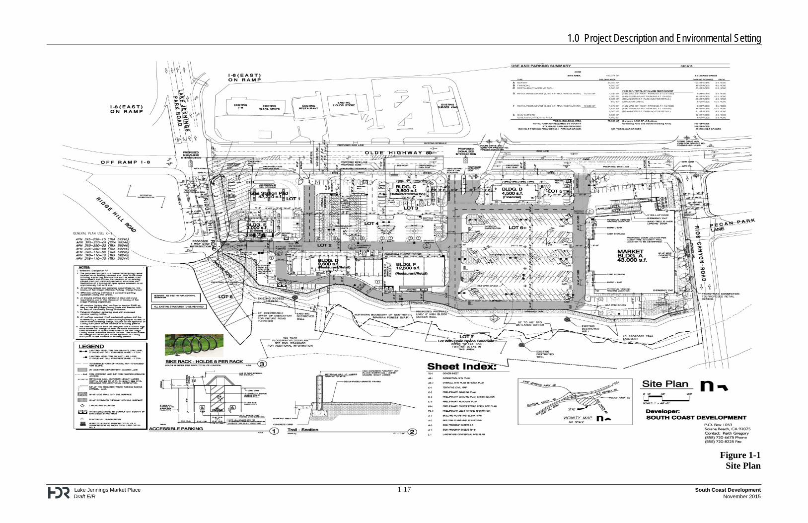
A Matrix of Project Approvals listing additional permits required for the implementation of the project is provided in subchapter 1.5.1. The applicant proposes the development of a commercial shopping center project on an approximately 13 acre site that would include six new buildings totaling 76,100 square feet (sq. ft.), a gasoline station with car wash, and parking for 389 vehicles. The tentative map proposes to subdivide the site into eight lots. Lots 1 through 6 would contain the proposed commercial development. Lot 7 in the southern portion of the site would contain an open space easement for
1.0 Project Description and Environmental Setting
Lake Jennings Market Place 1-2 South Coast Development Draft EIR November 2015
Southern Riparian Forest habitat along Los Coches Creek and its associated wetland buffer. Lot 8 would accommodate a 60-foot wide irrevocable offer of dedication for road purposes. A 20-foot wide trail easement including a 10-foot-wide trail is proposed along the southern edge of the developed portion of the site on Lots 7 and 8. Ten-foot-wide pathways are also proposed within the right-of-way for Rios Canyon Road on the east side of the project site and Ridge Hill Road on the west side of the site. These project component parts are described further below. The proposed project site would be cleared and graded over the course of approximately eight months (240 days). The proposed project would not be constructed in multiple phases. 1.2.1.1 Commercial Shopping Center
The project proposes to construct a commercial shopping center with 76,100 sq. ft. of building area. The project would include six structures, all of which would be located on individual lots (Figure 1-1). The development would include the following:
1. Market Building (Building A – 43,000 sq. ft. or approximately 0.99 acres, Lot 6) located along the entire east side of the project site and Rios Canyon Road.
2. Financial Building (Building B – 4,500 sq. ft. or approximately 0.10 acres, Lot 5) located in the northeast portion of the site along Olde Highway 80 and east of the proposed signalized project entrance on Olde Highway 80.
3. Restaurant with drive through (Building C – 3,500 sq. ft. or approximately 0.08 acres, Lot 3) located in the north-central portion of the site west of the intersection of Olde Highway 80 and the proposed signalized project entrance.
4. Restaurant-Retail Building (Building D – 9,600 sq. ft. or approximately 0.22 acres, Lot 2) located in the southwest portion of the site.
5. Gas Station with car wash (42,210 sq. ft. pad1 or approximately 0.97 acres, Lot 1) and Commercial building (Building E – 3,000 sq. ft. or approximately 0.07 acres, Lot 1) in the northwest portion of the site at the intersection of Olde Highway 80 and Lake Jennings Park Road.
6. Major Building (Building F – 12,500 sq. ft. or approximately 0.29 acres, Lot 4) in the south-central portion of the site.
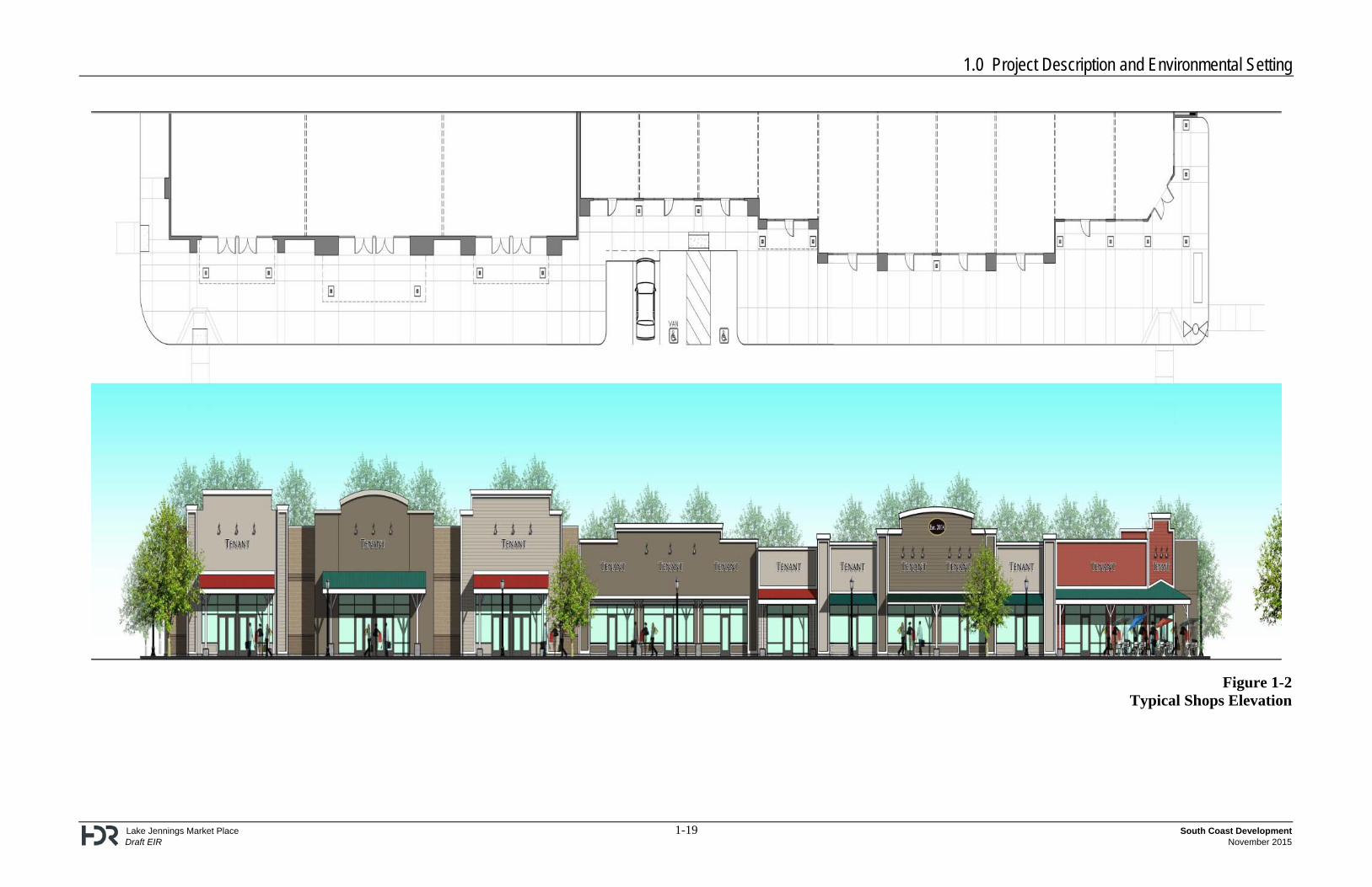
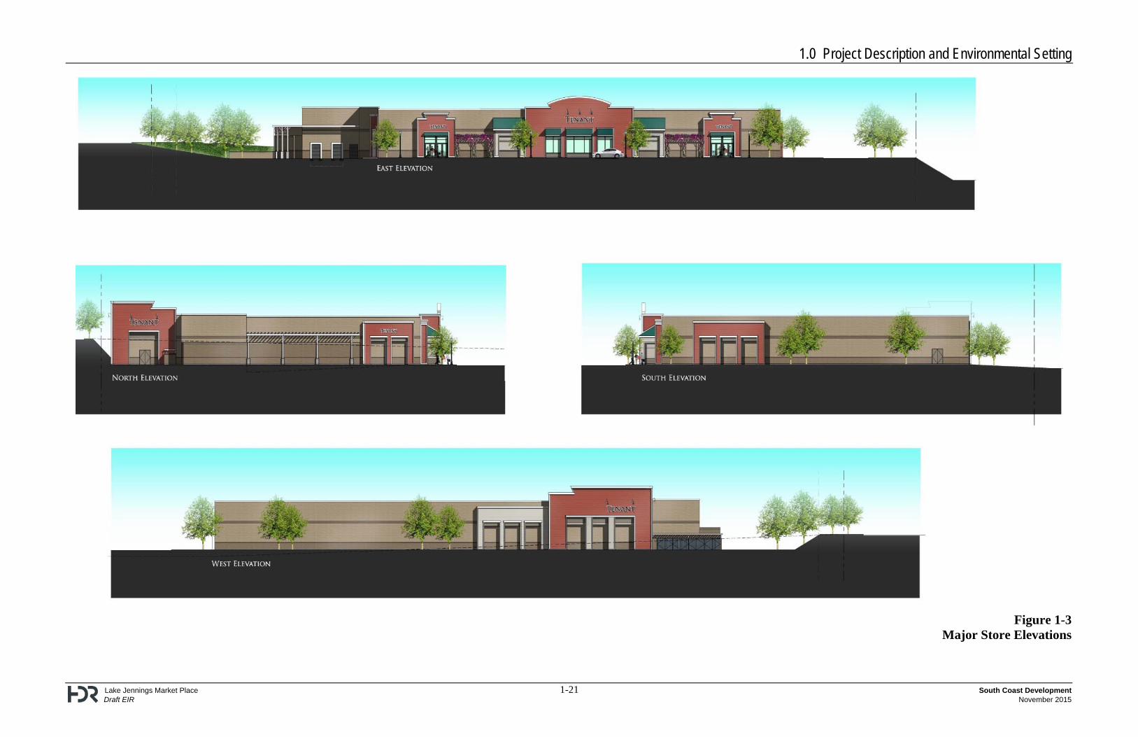
Figures 1-2 and 1-3 depict the architectural elevations for the proposed commercial buildings.
1.2.1.2 Trail Component
The project would construct a multi-use trail suitable for pedestrians and equestrian users. The trail would be 10 feet wide and constructed of decomposed granite material. The trail segments adjacent to the two public streets would be standard trail pathways per the County’s Community Trails Master Plan (CTMP). The trail segment within the open space lot would run along the southern edge of the development area (immediately north of the proposed open space area) within a 20-foot wide trail easement and would include a 10-foot-wide treadway. A connection pathway would be provided on 1 The 42,210 sq. ft. pad for the gas station is not included in the project’s total building square footage (76,100 sq.
ft.).
1.0 Project Description and Environmental Setting
Lake Jennings Market Place 1-3 South Coast Development Draft EIR November 2015
the trail located on Rios Canyon Road to provide pedestrian access from the trail to the proposed commercial shopping center. 1.2.1.3 Access
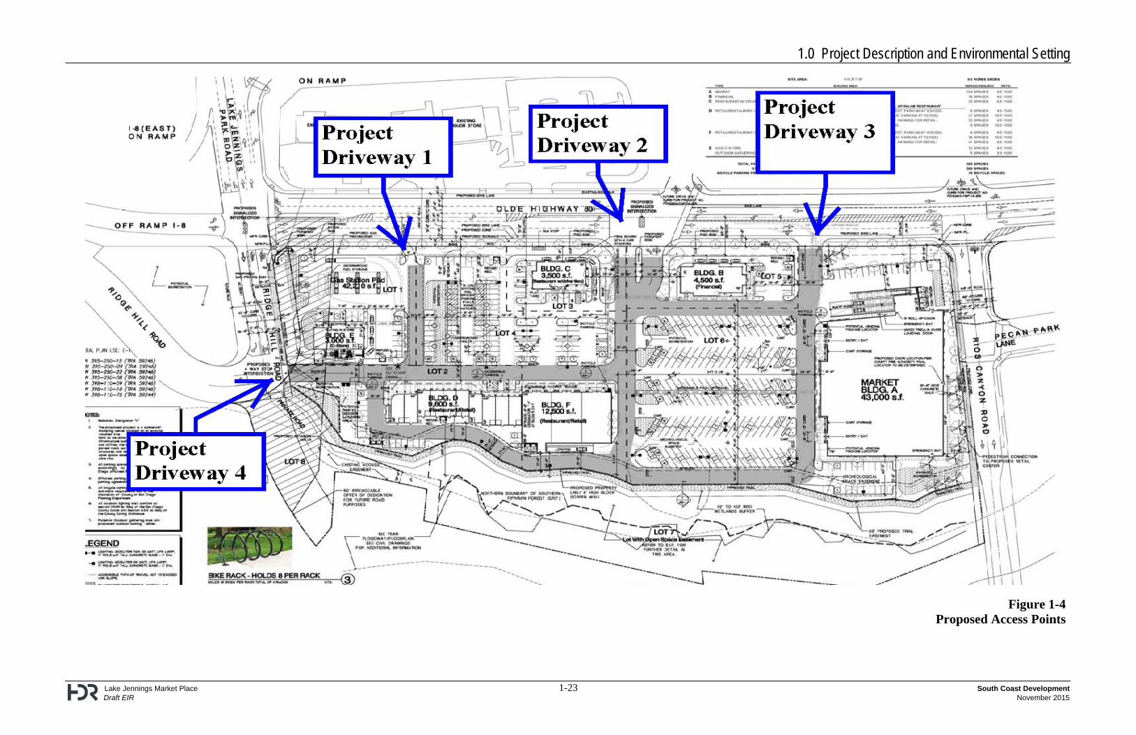
As shown in Figure 1-4, the project would have a total of four access points with three access points on Olde Highway 80 and one access point on Ridge Hill Road as described below:
Project Driveway 1 – A right-in only access located on Olde Highway 80 approximately 200 feet east of Lake Jennings Park Road.
Project Driveway 2 – The main access to the project site would be a signalized full access, and it is located on Olde Highway 80 approximately 550 feet east of Lake Jennings Park Road.
Project Driveway 3 – A right-in/right-out only access located on Olde Highway 80 approximately 750 feet east of Lake Jennings Park Road.
Project Driveway 4 – A stop-controlled full access driveway located on Ridge Hill Road, located on the west side of the project site and approximately 200 feet south of Olde Highway 80.
Transit service in the project area is offered by the San Diego County Metropolitan Transit System (MTS). MTS provides service via Route 864 along Olde Highway 80, Pecan Park Lane and Lake Jennings Park Road. This route services the Lakeside Community. The west end of Route 864 is the El Cajon Transit Center and the east end of Route 864 is the Viejas Outlet Center and Viejas Casino.
The westerly segment of Pecan Park Lane between Rios Canyon Road and Olde Highway 80 would be eliminated with the development of the project. This portion of Pecan Park Lane contains an MTS bus stop (Bus Stop ID: 40234) associated with the east-bound leg of Route 864. The vacation of Pecan Park Lane would result in the relocation of the existing MTS bus stop. The proposed project would include a new (relocated) bus stop along the project frontage along Olde Highway 80, between Project Driveways 1 and 2.
1.2.1.4 Walls and Signage
Four retaining walls are proposed on the project site. The first would be located along the north side of the project entrance off of Ridge Hill Road and would be approximately 93 feet long with a maximum height of six feet. The second would be located along the south side of Lot 2 and would be approximately 340 feet long with a maximum height of 10 feet. The third retaining wall would be located just south of the second wall and would be approximately 150 feet long with a maximum height of eight feet. The fourth retaining wall would be located at the northeast corner of the site where Rios Canyon Road would be extended to intersect with Olde Highway 80. This wall would be approximately 85 feet long with a maximum height of 8.5 feet at the northeast corner. There would be a comprehensive coordinated sign program designed for the project. The sign program includes a Freeway Pylon Display, Monument Center ID Displays, Monument Signage at the signalized entrance on Olde Highway 80, and a state required Gas Pricing Sign for the gas
1.0 Project Description and Environmental Setting
Lake Jennings Market Place 1-4 South Coast Development Draft EIR November 2015
station, convenience store and car wash pad. All project signage will comply with the Lakeside Design Guidelines and the County of San Diego Zoning Ordinance Sections 6250 through 6299. 1.2.1.5 Parking
The project proposes 389 parking spaces. The project parking is almost entirely located within the central portion of the site and would largely be out of the casual view of traffic on Lake Jennings Park Road and Olde Highway 80. Some parking would be located near the northern property boundary (i.e., west of gas station, west of Building C, and north of Building A) and may be partially seen from Lake Jennings Park Road and Olde Highway 80. However, canopy trees, street trees, and ornamental shrubs would be planted along the northern property boundary providing a visual buffer between the roadways and these parking areas. The County of San Diego Zoning Ordinance requires a total of 389 parking spaces to be provided by the proposed project based on the size and uses proposed in the buildings. Therefore, the project meets the parking requirements of the County of San Diego Zoning Ordinance. 1.2.1.6 Landscaping Plan
A landscape plan has been prepared for the commercial part of the project (Lots 1 through 6). The landscape plan incorporates a variety of species that are intended to provide a visual buffer from Interstate 8 (I-8) and be compatible with the riparian zone associated with Los Coches Creek. The plant palette reflects a selection of native plant material which can naturally be found in riparian zones of Southern California. The entries to the project are proposed to reflect the proximity to the riparian zone with the use of grasses along with ornamental flowering plants and trees for accent. Broad canopy trees would be planted to provide shade to open parking areas. The proposed project would use efficient irrigation practices and low-water use plant selections to minimize water use. All landscape and irrigation will be required to conform to Lakeside Planning Group and County of San Diego’s Landscape Standards, Lakeside Fire Protection District requirements and San Diego Gas & Electric (SDG&E) height restrictions under utility lines. 1.2.1.7 Car Wash
A car wash is proposed on Lot 1, in the northwest portion of the project site. A Rezone is proposed to reclassify the existing RU-15 to C36. Car washes are permitted by the C36 Use Regulations upon issuance of a Major Use Permit. Therefore, pursuant to C36 Use Regulations, the project would require approval of a Major Use Permit for the proposed car wash. The project applicant anticipates serving approximately 40 vehicles per day at the proposed car wash. Assuming water use of 40 gallons per vehicle, the car wash would use 1,600 gallons per day, or 584,000 gallons per year. However, the project architect indicates that the car wash system proposed for the project could use as little as seven gallons of water per wash with the proposed water recycling system. At seven gallons per wash, the project would use approximately 102,000 gallons per year, or about 280 gallons per day.
1.0 Project Description and Environmental Setting
Lake Jennings Market Place 1-5 South Coast Development Draft EIR November 2015
An underground storage tank would be required to recycle and filter the water from the car wash before it is discharged into the sanitary sewer system. Wash wastewater would not be discharged to the storm drain system. 1.2.1.8 Water Usage
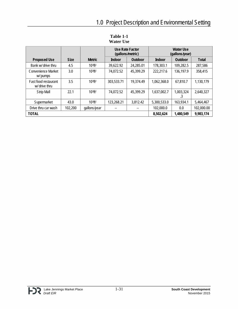
The project site is located within the Padre Dam Municipal Water District (PDMWD) service area. On August 17, 2015, the District provided a Service Availability Letter indicating adequate water resources and entitlements are available to serve the proposed project. The proposed project will be required to implement and comply with PDMWD’s mandatory water use efficiency measures and Level 2 Drought Alert conservation measures to ensure that potable water use is reduced by 20 percent. See Section 3.1.7, Utilities and Service Systems for a detailed discussion of PDMWD’s mandatory water use efficiency measures. Construction The project site’s earthwork is approximately 100,000 cubic yards. It would take approximately 15 gallons of water per cubic yard of earthwork. Therefore, earthwork activities would require approximately 1.5 million gallons of water (100,000 cubic yards x 15 gallons per cubic yard). General site dust control would be four loads by a single water truck per day. A water truck has a carrying capacity of 2,000 gallons of water; therefore, 8,000 gallons per day would be required. Using a 9.5 month construction schedule equates to 38 weeks or 190 working days (5-day work week). The proposed project would use approximately 1.52 million gallons of water (190 days x 8,000 gallons per day) for dust control. The total estimated construction water use is 3.02 million gallons of water. Operation Operational water use rates for commercial land uses were obtained from the Pacific Institute’s “Waste Not Want Not” report and included in the project’s Greenhouse Gas Report (Appendix K). Total gallons of water used per day per metric were reported but the total daily water use was converted to annual water use based on the number of days of operation for proposed land uses. The water use rates for the individual components of the proposed project are presented in Table 1-1. As shown in Table 1-1, the proposed project’s indoor water use would be approximately 8,502,624 gallons of water per year and approximately 1,480,549 gallons of water per year for outdoor uses, for a total of 9,983,173 gallons annually.
1.2.2 Technical, Economic, Environmental Characteristics
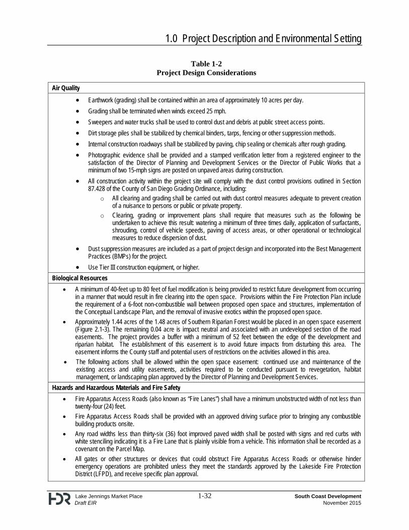
The project incorporates several design measures which would minimize project impacts. Specifically, design measures are provided for air quality, biological resources, hazards and hazardous materials and fire safety, aesthetics, geology and soils, noise, traffic, and water quality. These design measures will be implemented as conditions of project approval. A complete list of the design considerations for the project is presented in Table 1-2.
1.0 Project Description and Environmental Setting
Lake Jennings Market Place 1-6 South Coast Development Draft EIR November 2015
1.2.2.1 Proposed General Plan Amendment, Rezone, Tentative Map, Site Plan, and Major Use Permit
The project proposes a General Plan Amendment to change the existing Residential Land Use Designation from Village Residential (VR-15) to the General Commercial (C-1) Land Use Designation. A Rezone is proposed to reclassify the existing Urban Residential (RU-15) to General Commercial (C36) (including a B Special Area Regulator). A Tentative Map, Site Plan, and Major Use Permit are also proposed for the project. 1.2.2.2 Biological Buffer and Revegetation Plan
The project has been designed so individual project components (buildings, parking areas) are not located in the southern riparian forest habitat. This habitat is a Tier I habitat within the Biological Mitigation Ordinance and Sensitive Habitat Land within the County’s Resources Protection Ordinance (RPO). Tier I habitats are the most sensitive habitats within the region. The project provides a wetland buffer ranging from 52 to 102 feet wide, consistent with the requirements of the San Diego County RPO. The buffer includes all of the oak trees associated with the southern riparian forest as required by the RPO. Approximately 1.44 acres of the 1.48 acres of Southern Riparian Forest would be placed in an open space easement. An additional 0.04 acres is located within undeveloped sections of existing road easements to the east and west of the proposed open space and are impact neutral. This area would not be included in the open space easement. The project provides an undulating buffer with a minimum of 52 feet and a maximum of 102 feet between the edge of the development and the riparian habitat. The establishment of this easement is to avoid future impacts from disturbing this area. The easement informs the County staff and potential users of restrictions on the activities allowed in this area. Permanent signage shall be placed along the open space boundary. The sole exceptions to the prohibitions are: continued use and maintenance of the existing access and utility easements; activities required to be conducted pursuant to revegetation, habitat management, or landscaping plan approved by the Director of Planning & Development Services (PDS). No development would occur within the southern riparian forest habitat area or the easements as a result of this project. After construction, the riparian buffer would be restored according to the revegetation plan for the project. The project’s revegetation plan applies only to the RPO wetland buffer located on Lot 7. The revegetation plan includes returning the disturbed area to a native habitat with low-fuel native plants. Revegetation efforts would be monitored for five years, or until success criteria have been met to the satisfaction of PDS, and would include the continual removal of invasive exotic species. See Section 2.1, Biological Resources, and Appendix C of the Draft Environmental Impact Report (EIR) for additional information on the revegetation plan. 1.2.2.3 Fire Protection Plan
Fuel modification is provided north of the six foot non-combustible wall ranging in width from 40 feet to 80 feet long. The non-combustible wall would be constructed 10 feet north of the open space
1.0 Project Description and Environmental Setting
Lake Jennings Market Place 1-7 South Coast Development Draft EIR November 2015
area and would be constructed of 8-inch block and finished with stucco. The 10 feet south of the wall and north of the open space would be an equestrian trail that would not contain any fuel management and would result in a minimum of 40 feet and up to 80 feet in the fuel management zone. The use of fire resistive construction, the non-combustible wall and fire sprinklers would reduce the potential for the structures to burn in the event of a fire. The complete Fire Protection Plan is discussed in further detail in Section 2.3, Hazards and Hazardous Materials, and Appendix G of the Draft EIR. 1.2.2.4 Archaeological Resources Capping Program
The project has also been designed to avoid subsurface archaeological resources within the central portion of the project site. Known archaeological resources would be capped under the proposed parking area and within the biological buffer area. Capping would be performed as outlined in the Historic Properties Treatment Plan (HPTP) prepared for the project. An easement would be granted to the County of San Diego PDS Department. The complete HPTP is discussed in Section 2.2, Cultural Resources, and Appendix D2 of the Draft EIR. 1.2.2.5 Earthwork Activities
The project proposes grading quantities in the amount of 43,700 cubic yards of excavation with a maximum cut slope of 15 feet and 45,900 cubic yards of fill with a maximum fill slope height of 11 feet. The grading and fill would be balanced on site. The project would require import of approximately 300 cubic yards. The proposed project site would be cleared and graded over the course of approximately eight months (240 days). The project applicant will be required to implement the dust control measures listed in San Diego Air Pollution Control District (SDAPCD) Rule 55. In addition, all construction activity within the project site will comply with the dust control provisions outlined in Section 87.428 of the County of San Diego Grading Ordinance, including:
All clearing and grading shall be carried out with dust control measures adequate to prevent creation of a nuisance to persons or public or private property.
Clearing, grading or improvement plans shall require that measures such as the following be undertaken to achieve this result: watering, application of surfactants, shrouding, control of vehicle speeds, paving of access areas, or other operational or technological measures to reduce dispersion of dust.
1.2.2.6 Visual Quality
The area of Lakeside in which the project site is located consists of a variety of land uses, including single and multi-family residential, commercial, and industrial. The proposed project site is in the area of the interchange of I-8 and Lake Jennings Park Road. The proposed project includes a Site Plan which has been prepared to be consistent with the unique commercial siting and design objectives of the Lakeside Community Design Guidelines. The project is for the most part adjacent to commercial uses on the west, north and east and separated from the existing residential neighborhood to the south by the onsite open space area which includes the Los Coches Creek.
1.0 Project Description and Environmental Setting
Lake Jennings Market Place 1-8 South Coast Development Draft EIR November 2015
The implementing Site Plan includes the “Western Style” of architectural design for all of the commercial structures within the project. As shown in Figures 1-2 and 1-3, the proposed project’s building form would meet the Lakeside Design Guidelines, as the building façades would be relieved with a change of plane and architectural treatment to avoid continuous wall planes. The proposed buildings would also provide visual contrast of light and shadow with offsets and recesses. Project lighting would include lights similar to other developed areas in the County. All light fixtures would have full cutoff illumination shields and full cutoff back shields to avoid light spillage onto adjacent properties. The landscape plan incorporates a variety of species that are intended to provide a visual buffer from I-8 and be compatible with the riparian zone associated with Los Coches Creek. The plant palette reflects a selection of native plant material which can naturally be found in riparian zones of Southern California. 1.2.2.7 Infrastructure and Utility Improvements
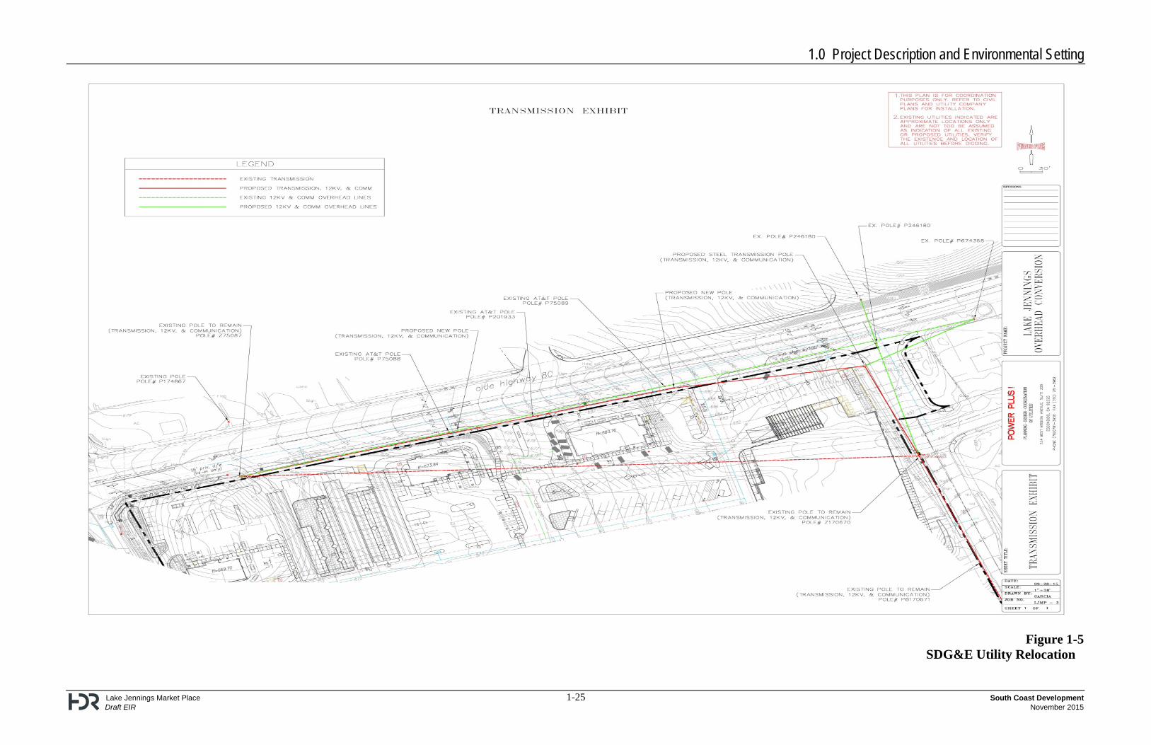
The project includes a vacation of Pecan Park Lane, west of Rios Canyon Road, and widening and improving of Ridge Hill Road, and extension of the existing Rios Canyon Road to form an intersection with Olde Highway 80. The proposed project required a formal annexation process with the Local Agency Formation Commission (LAFCO) of the County of San Diego to annex a small portion of the project site from the Helix Water District in to the PDMWD. On December 1, 2014, the LAFCO approved: (1) the detachment of “territory” (approximately 1.165 acres of the project site) from the Helix Water District; and (2) the annexation of this territory to the Padre Dam Municipal Water District. As part of PDMWD’s Eastern Service Area Secondary Connection Project, a water discharge pipeline approximately 5,600 feet in total length would be constructed from a PDMWD pump station located to the west of the project site, traversing southeast under I-8 and ultimately within the existing Pecan Park Lane right of way. Because the proposed project involves the vacation of Pecan Park Lane, the Applicant is currently coordinating with PDMWD on an alternative alignment that would extend along Olde Highway 80 immediately north of the project site, rather than through the project site within Pecan Park Lane. If the Eastern Service Area Secondary Project is approved, the proposed project would connect to the PDMWD’s 20-inch pipeline located at the intersection of Pecan Park Lane/Rios Canyon Road. An existing SDG&E overhead 69-kV line runs along Olde Highway 80, Pecan Park Lane, and south of Rios Canyon Road. Due to the proposed Pecan Park Lane road vacation, the project would involve the relocation of the portion of the 69-kV SDG&E line and poles located along Pecan Park Lane. The existing overhead 69-kV line and poles would be relocated along the project frontage on Olde Highway 80, then southeast where it bisects the northeast corner of the project site, and finally south to connect to the existing line on Rios Canyon Road. These improvements are all located within the impact footprint of the proposed development project (Figure 1-5).
1.0 Project Description and Environmental Setting
Lake Jennings Market Place 1-9 South Coast Development Draft EIR November 2015
1.2.2.8 Offsite Improvements – Sewer Service
The project proposes to receive sewer service from the Lakeside Sanitation District. The project would connect to an existing sewer connection within the western portion of the project site. From that connection, 8-inch sewer lines would serve the project. 1.2.2.9 Offsite Improvements – Storm Water Discharge
The project would use an onsite storage system (53,000 cubic feet in size to accommodate Hydromodification requirements) to hold the 100-year storm volume of 21,917 cubic feet and slowly discharge the retained 100-year storm volume at the same rate that complies with Hydromodification Management Plan standards. The project proposes an off-site extension of a storm drain from the western edge of the project site. The drain would extend approximately 125 feet and would discharge into an existing County-owned detention basin. The County currently maintains this detention basin, and would continue to maintain it. 1.3 Project Location
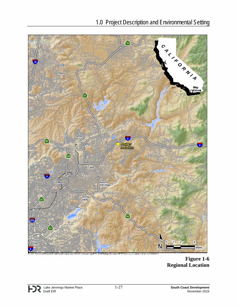
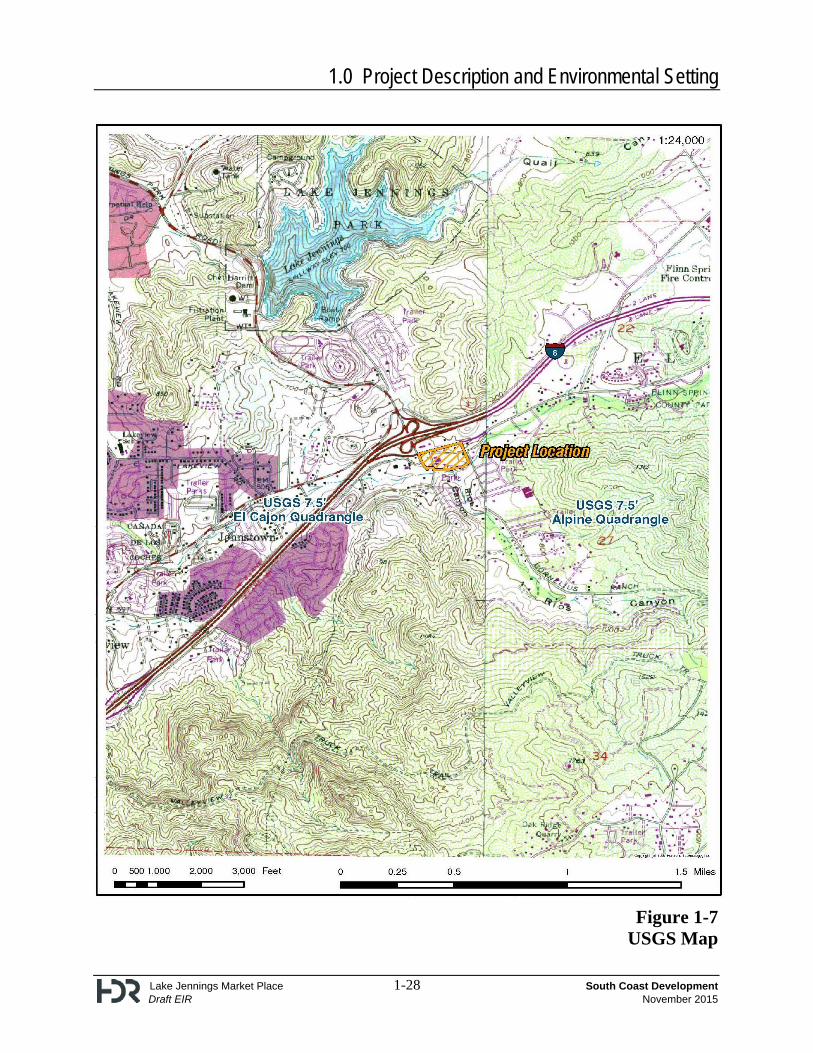
The project site is in the community of Lakeside in unincorporated eastern San Diego County approximately 21 miles northeast of downtown San Diego (Figure 1-6). The project boundaries are irregular, but primarily follow parcel lines and roadways. Specifically, the project site is located in the Lakeside Community Planning Area on the south side of Olde Highway 80, between Lake Jennings Park Road and Rios Canyon Road. Los Coches Creek forms the southern boundary of the project site. The proposed project is located within the U. S. Geological Survey (USGS) 7.5’ El Cajon quad, Township 15 south, range 1 east (Figure 1-7). The project site is located inside the urban limit line. 1.4 Environmental Setting
The project area consists of seven adjacent parcels (APNs: 395-250-08, 395-250-09, 395-250-15, 395-250-22, 398-110-09, 398-110-10, 398-110-75), with a total of approximately 13 acres, along Los Coches Creek including an associated riparian oak woodland. Much of the property was formerly cultivated, but these fields are now covered with dense primarily non-native grasses. Two abandoned residential structures previously located on the project site, one south of Pecan Park Lane and one north of Pecan Park Lane, were demolished in the summer of 2015. Demolition activities complied with San Diego Air Pollution Control District (SDAPCD) Rules 361.140-361.156. Prior to demolition of the two residences, a Hazardous Materials Assessment was performed to determine the presence or absence of asbestos containing materials (ACMs)/lead based paint (LBP) located in the buildings to be demolished. The ACM survey was conducted by a person certified by California Division of Occupational Safety and Health (Cal/OSHA). The LBP survey was conducted by a person certified by the California Department of Health Services. Copies of the surveys were provided to the County Department of Environmental Health and SDAPCD. The SDAPCD reviewed and approved the surveys for ACMs and LBP prior to issuance of the demolition permit. The SDAPCD was also notified in writing at least 10 days in advance of any demolition.
1.0 Project Description and Environmental Setting
Lake Jennings Market Place 1-10 South Coast Development Draft EIR November 2015
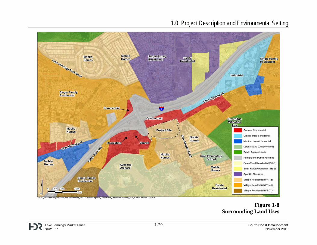
The project area is generally flat, with elevations ranging onsite from 654 feet above mean sea level (AMSL) within Los Coches Creek in the southern portion of the creek, to 693 feet AMSL near the western portion of the property. Pecan Park Lane bisects the site from west to east, but would be vacated as part of the project. The site is bounded by Olde Highway 80 to the north, Rios Canyon Road to the east, Los Coches Creek to the south, and Lake Jennings Park Road to the west. Southern riparian forest habitat is found onsite along the southern boundary encompassing Los Coches Creek. Approximately 1.48 acres of this habitat occurs onsite. Black willow, arroyo willow, and California sycamore dominate this habitat. The presence of several exotics such as California pepper, pecan trees, and olive trees indicate the disturbed nature of this habitat. In addition, individual coast live oak trees occur toward the upper portions of the bank and above the top of the bank. This area would be included in the open space easement associated with the project. Surrounding land uses in the project vicinity are shown in Figure 1-8. The project site is surrounded by a variety of uses. East of the project site are two commercial lots and a mobile home park. Development further east on Olde Highway 80 includes industrial uses (Freeway Industrial Park) and single family residential. The Freeway Industrial Park is on Bond Avenue between Olde Highway 80 and I-8. To the east/northeast of the proposed project, northeast of I-8, are open space areas and lower-density tract homes, including the equestrian-focused community of Blossom Valley which consists of larger estate homes on large lots. This neighborhood, as well as the eastern portion of the Flinn Springs neighborhood lies outside the urban limit line. Flinn Springs Park, a 40-acre day-use park owned and operated by the County of San Diego, is located approximately one mile east of the proposed project on Olde Highway 80. The Flinn Springs neighborhood also contains commercial and residential development. To the south are riparian oak woodlands associated with Los Coches Creek, single-family residences along Kelli Lane, a 128-unit mobile home community, and open space. The areas to the south/ southeast of the project site include open space and orchards on steeply rising topography, with the communities of Crest, Dehesa, and Harbison Canyon several miles away on the other side of the ridge. These communities, which are not visible from the project site, are primarily lower-density residential areas that are equestrian-focused. To the west of the site is a church (East Valley Christian Fellowship) located on commercially zoned land and vacant land. The area to the northwest includes the communities of Lakeview, central Lakeside, Winter Gardens, and portions of the City of Santee. The area, bounded by Lake Jennings Park Road, I-8, and State Route 67 (SR-67), is urbanized, with a blend of single-family residences, mobile-home parks, and commercial uses. The area to the west/southwest of the project area includes commercial and residential portions of the City of El Cajon. El Cajon is primarily developed to its eastern boundary with a blend of lower-density residential, mobile homes, open space, and commercial centers adjacent to I-8, which typify the area between the City of El Cajon jurisdictional line and the proposed project site. I-8 and some commercial development along Olde Highway 80 are located to the north of Pecan Park Lane. This commercial development includes a 7-11 convenience store, a travel agency, a taco shop, an Italian restaurant, a liquor store, and a Burger King fast-food restaurant. Heading north from this intersection on Lake Jennings Park Road leads under the interchange, passing the properties
1.0 Project Description and Environmental Setting
Lake Jennings Market Place 1-11 South Coast Development Draft EIR November 2015
developed with an ARCO gasoline station and a Jack-in-the-Box fast-food restaurant. The area to the north is central Lakeside, and includes over 100 single-family residences and approximately 400 mobile homes on rising topography. Farther north is Lake Jennings County Park and additional open space areas. 1.5 Intended Use of the EIR
The Lake Jennings Market Place EIR is an informational document which will inform public agency decision-makers and the public of significant environmental effects of a project, identify possible ways to minimize the significant effects, and describe a range of reasonable alternatives to the project [California Environmental Quality Act (CEQA) Guidelines Section 15121(a)]. The EIR prepared for this project is a project EIR, because the discretionary actions are for site-specific approvals, as compared to a Program or Master Program approval. As indicated under State CEQA Guidelines, Section 15161, the analysis for a project EIR shall focus primarily on the changes in the environment that would result from the development within the project area, including planning, construction, and operation. 1.5.1 Matrix of Project Approvals/Permits
This EIR will be used for the following approvals: Discretionary Approvals Agency/Agencies
Boundary Adjustment County of San Diego
General Plan Amendment County of San Diego
Landscape Plans County of San Diego
Major Use Permit County of San Diego
Rezone County of San Diego
Road Opening County of San Diego
Road Vacation County of San Diego
Site Plan County of San Diego
Tentative Map County of San Diego
County Right-of-Way Permits Construction Permits Encroachment Permit
County of San Diego
Grading Permit County of San Diego
Improvement Plans County of San Diego
Remandment of Relinquished Access Rights County of San Diego
Exploratory Borings, Direct-push Samplers and Cone Penetrometers Permits
County of San Diego
Underground Storage Tank Permit County of San Diego
State Highway Encroachment Permit CalTrans
401 Permit – Water Quality Certification Regional Water Quality Control Board (RWQCB)
404 Permit – Dredge and Fill U.S. Army Corps of Engineers (USACOE)
1603 – Streambed Alteration Agreement California Department of Fish and Wildlife (CDFW)
Section 7 – Consultation or Section 10a Permit – Incidental Take U.S. Fish and Wildlife Service (USFWS)

1.0 Project Description and Environmental Setting
Lake Jennings Market Place 1-12 South Coast Development Draft EIR November 2015
Discretionary Approvals Agency/Agencies
Air Quality Permit to Construct Air Pollution Control District (APCD)
Air Quality Permit to Operate – Title V Permit APCD
National Pollutant Discharge Elimination System (NPDES) Permit RWQCB
General Construction Storm Water Permit RWQCB
Water District Approval Padre Dam Municipal Water District
Sewer District Approval Lakeside Sanitation District
Fire District Approval County Fire Authority/Lakeside Fire Protection District
1.5.2 Related Environmental Review & Consultation Requirements
No additional environmental review or consultation requirements have been identified for the project that is not listed in the Matrix of Project Approvals/Permits. 1.6 Project Inconsistencies with Applicable Regional and General Plans
A number of general and regional plans apply to the project and were considered during the applicant’s design of the project. This review includes the San Diego County General Plan and Zoning Ordinance, as well as other plans and regulations including: federal Endangered Species Act, the federal Clean Water Act, the State Implementation Plan (SIP), the San Diego Air Pollution Control District (APCD) Regional Air Quality Strategy (RAQS), the Regional Water Quality Control Board (RWQCB) Basin Plan, and the San Diego Association of Government’s (SANDAG) Congestion Management Plan. Specific County regulations including the Resource Protection Ordinance and the Biological Mitigation Ordinance were considered during the design of the project. The project’s compliance with these plans and ordinances is evaluated throughout the EIR, with discussion in Chapters 3.0 and 4.0. Issue areas that were deemed to be inconsistent are discussed below. The project complies with all of the above-named plans and ordinances with the exception of the Land Use Element of the General Plan and the Zoning Ordinance. The General Plan currently designates the project site as Village Residential (VR-15). Therefore, the project is inconsistent with the current designation and a General Plan Amendment is required. The project proposes a General Plan Amendment to change the designation to General Commercial (C-1). The General Plan Amendment, if approved, would result in project compliance with the General Plan. The project site is currently zoned Urban Residential (RU-15). The project proposes a designation of General Commercial (C36). Therefore, the project is inconsistent with the current zoning designation, and a rezone is required to eliminate this inconsistency. However, the project applicant is proposing a rezone that, if approved, would result in project compliance with the amended zoning designation. 1.7 List of Past, Present, and Reasonably Anticipated Future Projects in the Project Area
Section 15130(a) of the State CEQA Guidelines state that an EIR shall discuss cumulative impacts of a project when the project’s impacts, even though individually limited, are cumulatively considerable. Cumulatively considerable means that the incremental effects of an individual project
1.0 Project Description and Environmental Setting
Lake Jennings Market Place 1-13 South Coast Development Draft EIR November 2015
are considerable when viewed in connection with the effects of past projects, the effects of other current projects, and the effects of probable future projects. Cumulative impacts involve individual effects which may increase in scope or intensity when considered together. Such impacts typically involve a number of local projects, and can result from individually incremental effects when these collectively increase in magnitude over time. Section 15130(b) of the State CEQA Guidelines states in part:
The discussion of cumulative impacts shall reflect the severity of the impacts and their likelihood of occurrence, but the discussion need not provide as great detail as is provided for the effects attributable to the project alone. The discussion should be guided by the standards of practicality and reasonableness, and should focus on the cumulative impact to which the identified other projects contribute rather than the attributes of other projects which do not contribute to the cumulative impact. . . .
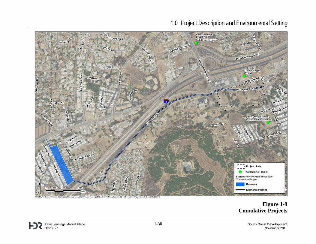
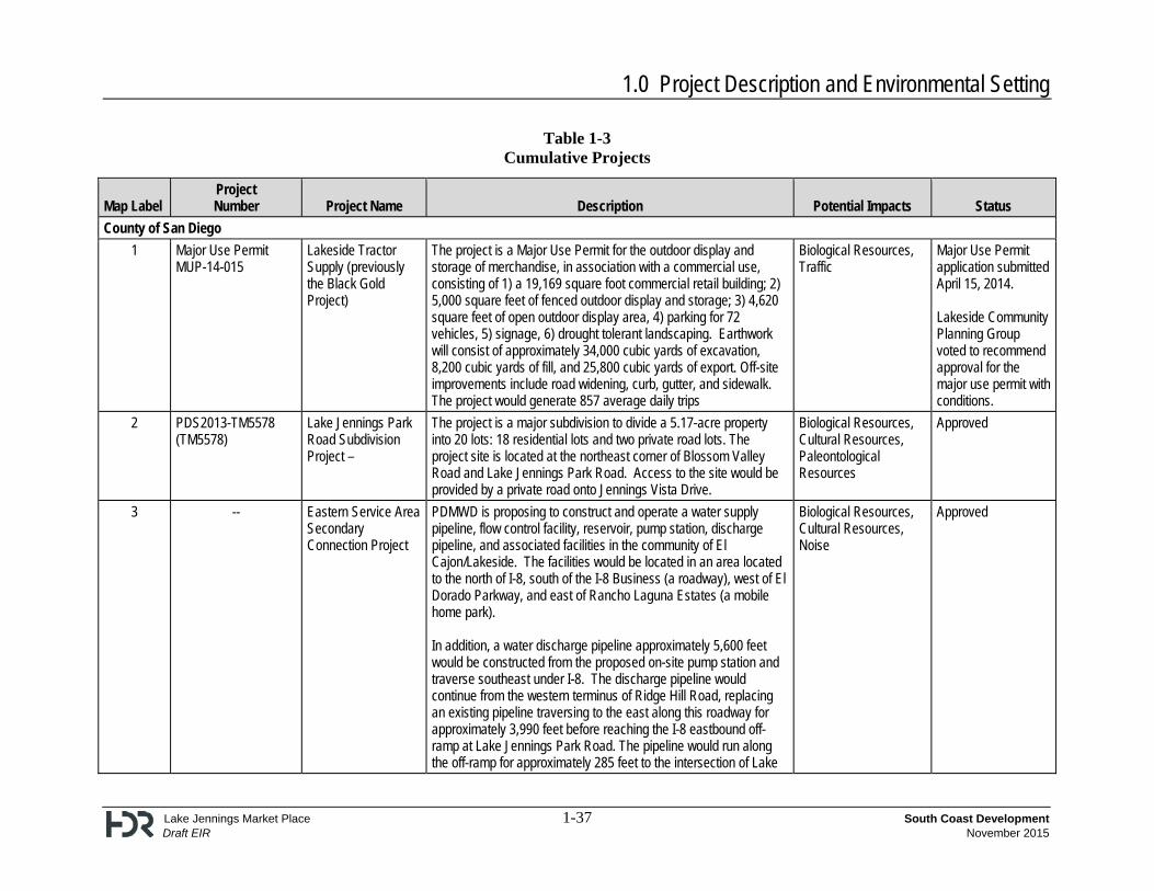
CEQA Guidelines Section 15130 allows for the use of two alternative methods to determine the scope of projects to analyze cumulative impacts. The evaluation of cumulative effects may be based on a list of past, present, and probable future projects producing related or cumulative impacts. It can also be based upon a summary of projections contained in the adopted general plan or related planning documents. The cumulative analysis conducted for this EIR is based on the list method. Cumulative projects were researched at the County of San Diego Planning and Development Services Department. The identification of a suitable cumulative project area is dependent on the specific environmental issue areas that need to be addressed. For the purposes of this EIR, the environmental issue areas that would be addressed include: aesthetics, air quality, biological resources, cultural resources, geology/soils, greenhouse gas emissions, hazards and hazardous materials, hydrology/water quality, land use and planning, noise, paleontological resources, traffic/transportation, utilities and service systems, and energy use and conservation. Cumulative analysis is included in each environmental issue analysis in Chapters 2 and 3 of this EIR. Within each analysis section, the cumulative projects considered for that specific issue area analysis are identified. Table 1-3 identifies the cumulative projects considered in the EIR. 1.8 Growth-Inducing Impacts
Section 15126.2(d) of the State CEQA Guidelines requires that an EIR evaluate the growth-inducing impacts of a project. A growth-inducing impact is defined by the State CEQA Guidelines as “the ways in which the project could foster economic or population growth, or the construction of additional housing, either directly or indirectly, in the surrounding environment.” Included are projects that would remove obstacles to population growth. Examples of these types of actions are cited – including: (1) a “major expansion of waste water treatment plant,’ that would allow for more construction in service areas covered by the plant, and (2) actions that could encourage and facilitate “other activities” that could significantly affect the environment. This EIR therefore evaluates the project’s influence on growth in the region as a result of a general plan amendment and rezone application for a new commercial center, improvements to road circulation, and extension of service and utility lines.
1.0 Project Description and Environmental Setting
Lake Jennings Market Place 1-14 South Coast Development Draft EIR November 2015
For purposes of understanding the project setting and the potential to induce growth in the project vicinity, the following description of the surrounding land uses is provided. Existing residential uses in the project vicinity include mobile homes and single-family residential. Due to existing uses in the project vicinity and the various ownerships, it is unlikely that the project would result in further growth. The property to the east of the project site includes a mobile-home park. Because the site includes the private ownership of each mobile home, it is unlikely that one entity could acquire those properties and redevelop this area in a higher intensity. An interested buyer would have to acquire the underlying property and terminate existing leases associated with the park. The underlying property is subject to a cooperative agreement; thus, to purchase the mobile-home park, a majority of the co-op members would have to agree. Property to the south consists of individually owned single-family residential units and mobile homes to the southwest. A church is located on the property to the west. This property has an established use and is unlikely to be redeveloped for residential use. A small vacant area lies between the church and the project area. It currently is designated as Public/Semi-Public (P/SP) Lands under the General Plan and is owned by the County of San Diego. This parcel would serve as a retention basin for runoff during storm events. Therefore, development is unlikely. The properties adjacent to the north of I-8 already contain commercial uses, including a Jack-in-the-Box restaurant and a gas station, as well as a single-family residence. The Crestridge Ecological Reserve, an approximately 2,300-acre open space preserve and mitigation bank owned by the California Department of Fish and Wildlife (CDFW), is located to the south of the project site. Development in this area is prohibited because it is dedicated open space, thereby excluding it from any potential development. Less than one-half a mile southwest of the site off of Rios Canyon Road is a grouping of parcels totaling approximately 595 acres of undeveloped land, which currently supports a working avocado ranch and native vegetation. The project does not remove any barriers to growth in the surrounding area. The question arises as to whether the General Plan Amendment and a Rezone associated with the proposed project would encourage an associated similar pattern of growth in the surrounding area. As described above, substantial growth surrounding the project site is not anticipated due to the lack of developable land in the surrounding area. The proposed project land use would be zoned for commercial uses. The proposed project does not include a major employment center or employment opportunities that could spur growth. Approval of the proposed project would not render it more, or less, likely that additional development in the surrounding area would take place. In regards to improvements to road circulation, the project includes a vacation of Pecan Park Lane, west of Rios Canyon Road, and widening and improving of Ridge Hill Road, and extension of the existing Rios Canyon Road to the north to form an intersection with Olde Highway 80. Lake Jennings Park Road (SA 810) is shown on the County of San Diego Circulation Element and the ultimate alignment of the roadway at Buildout would connect Lakeside with the community of Crest to the south. The extension of this roadway would require the bisection of private property, as well as the Crestridge Ecological Reserve, an approximately 2,300 acre open space reserve and mitigation bank owned by the CDFW. It is highly unlikely that Lake Jennings Park Road (SA 810) would be extended to the south beyond the private property into the Crestridge Ecological Reserve. However, the project would not preclude the future extension of SA 810 to the south.
1.0 Project Description and Environmental Setting
Lake Jennings Market Place 1-15 South Coast Development Draft EIR November 2015
PDMWD’s Eastern Service Area Secondary Project would require approximately 3,990 feet of existing 16-inch diameter PVC pipeline to be removed and replaced with 20-inch-diameter pipeline, between the intersections of Ridge Hill Road/Cordial Road and Pecan Park Lane/Rios Canyon Road. If the Eastern Service Area Secondary Project is approved, the proposed project would connect to the PDMWD’s 20-inch pipeline located at the intersection of Pecan Park Lane/Rios Canyon Road via the new 20-inch water line under Pecan Park Lane. Existing sewer lines would continue to be used in conjunction with new sewer alignments. These utility lines are not proposed to extend beyond the project boundaries. Furthermore, there are no new roads, utilities, or other infrastructure being extended that would encourage growth to occur outside of the property boundaries beyond what is discussed above, nor would there be an expansion of capacity. The one extension of utilities proposed offsite is for a 125-foot storm drain that would connect the project to an existing County-owned detention basin. This extension would not be characterized as growth inducing because it is an extension of an existing facility rather than a creation of new facilities to a site not currently served.
1.0 Project Description and Environmental Setting
Lake Jennings Market Place 1-16 South Coast Development Draft EIR November 2015
This page intentionally left blank.
1.0 Project Description and Environmental Setting
Lake Jennings Market Place 1-17 South Coast Development Draft EIR November 2015
Figure 1-1
Site Plan

1.0 Project Description and Environmental Setting
Lake Jennings Market Place 1-18 South Coast Development Draft EIR November 2015
This page intentionally left blank.
1.0 Project Description and Environmental Setting
Lake Jennings Market Place 1-19 South Coast Development Draft EIR November 2015
Figure 1-2 Typical Shops Elevation

1.0 Project Description and Environmental Setting
Lake Jennings Market Place 1-20 South Coast Development Draft EIR November 2015
This page intentionally left blank.
1.0 Project Description and Environmental Setting
Lake Jennings Market Place 1-21 South Coast Development Draft EIR November 2015
Figure 1-3 Major Store Elevations

1.0 Project Description and Environmental Setting
Lake Jennings Market Place 1-22 South Coast Development Draft EIR November 2015
This page intentionally left blank.
1.0 Project Description and Environmental Setting
Lake Jennings Market Place 1-23 South Coast Development Draft EIR November 2015
Figure 1-4 Proposed Access Points
1.0 Project Description and Environmental Setting
Lake Jennings Market Place 1-24 South Coast Development Draft EIR November 2015
This page intentionally left blank.
1.0 Project Description and Environmental Setting
Lake Jennings Market Place 1-25 South Coast Development Draft EIR November 2015
Figure 1-5 SDG&E Utility Relocation

1.0 Project Description and Environmental Setting
Lake Jennings Market Place 1-26 South Coast Development Draft EIR November 2015
This page intentionally left blank.
1.0 Project Description and Environmental Setting
Lake Jennings Market Place 1-27 South Coast Development Draft EIR November 2015
Figure 1-6
Regional Location
1.0 Project Description and Environmental Setting
Lake Jennings Market Place 1-28 South Coast Development Draft EIR November 2015
Figure 1-7 USGS Map
1.0 Project Description and Environmental Setting
Lake Jennings Market Place 1-29 South Coast Development Draft EIR November 2015
Figure 1-8
Surrounding Land Uses
1.0 Project Description and Environmental Setting
Lake Jennings Market Place 1-30 South Coast Development Draft EIR November 2015
Figure 1-9
Cumulative Projects
1.0 Project Description and Environmental Setting
Lake Jennings Market Place 1-31 South Coast Development Draft EIR November 2015
Table 1-1 Water Use
Proposed Use Size Metric
Use Rate Factor (gallons/metric)
Water Use (gallons/year)
Indoor Outdoor Indoor Outdoor Total
Bank w/ drive thru 4.5 103ft2 39,622.92 24,285.01 178,303.1 109,282.5 287,586
Convenience Market w/ pumps
3.0 103ft2 74,072.52 45,399.29 222,217.6 136,197.9 358,415
Fast food restaurant w/ drive thru
3.5 103ft2 303,533.71 19,374.49 1,062,368.0 67,810.7 1,130,179
Strip Mall 22.1 103ft2 74,072.52 45,399.29 1,637,002.7 1,003,324.3
2,640,327
Supermarket 43.0 103ft2 123,268.21 3,812.42 5,300,533.0 163,934.1 5,464,467
Drive thru car wash 102,200 gallons/year -- -- 102,000.0 0.0 102,000.00
TOTAL 8,502,624 1,480,549 9,983,174
1.0 Project Description and Environmental Setting
Lake Jennings Market Place 1-32 South Coast Development Draft EIR November 2015
Table 1-2 Project Design Considerations
Air Quality
Earthwork (grading) shall be contained within an area of approximately 10 acres per day.
Grading shall be terminated when winds exceed 25 mph.
Sweepers and water trucks shall be used to control dust and debris at public street access points.
Dirt storage piles shall be stabilized by chemical binders, tarps, fencing or other suppression methods.
Internal construction roadways shall be stabilized by paving, chip sealing or chemicals after rough grading.
Photographic evidence shall be provided and a stamped verification letter from a registered engineer to the satisfaction of the Director of Planning and Development Services or the Director of Public Works that a minimum of two 15-mph signs are posted on unpaved areas during construction.
All construction activity within the project site will comply with the dust control provisions outlined in Section 87.428 of the County of San Diego Grading Ordinance, including:
o All clearing and grading shall be carried out with dust control measures adequate to prevent creation of a nuisance to persons or public or private property.
o Clearing, grading or improvement plans shall require that measures such as the following be undertaken to achieve this result: watering a minimum of three times daily, application of surfactants, shrouding, control of vehicle speeds, paving of access areas, or other operational or technological measures to reduce dispersion of dust.
Dust suppression measures are included as a part of project design and incorporated into the Best Management Practices (BMPs) for the project.
Use Tier III construction equipment, or higher.
Biological Resources
A minimum of 40-feet up to 80 feet of fuel modification is being provided to restrict future development from occurring in a manner that would result in fire clearing into the open space. Provisions within the Fire Protection Plan include the requirement of a 6-foot non-combustible wall between proposed open space and structures, implementation of the Conceptual Landscape Plan, and the removal of invasive exotics within the proposed open space.
Approximately 1.44 acres of the 1.48 acres of Southern Riparian Forest would be placed in an open space easement (Figure 2.1-3). The remaining 0.04 acre is impact neutral and associated with an undeveloped section of the road easements. The project provides a buffer with a minimum of 52 feet between the edge of the development and riparian habitat. The establishment of this easement is to avoid future impacts from disturbing this area. The easement informs the County staff and potential users of restrictions on the activities allowed in this area.
The following actions shall be allowed within the open space easement: continued use and maintenance of the existing access and utility easements, activities required to be conducted pursuant to revegetation, habitat management, or landscaping plan approved by the Director of Planning and Development Services.
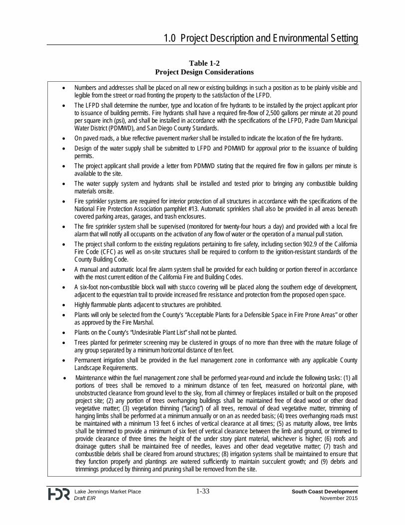
Hazards and Hazardous Materials and Fire Safety
Fire Apparatus Access Roads (also known as “Fire Lanes”) shall have a minimum unobstructed width of not less than twenty-four (24) feet.
Fire Apparatus Access Roads shall be provided with an approved driving surface prior to bringing any combustible building products onsite.
Any road widths less than thirty-six (36) foot improved paved width shall be posted with signs and red curbs with white stenciling indicating it is a Fire Lane that is plainly visible from a vehicle. This information shall be recorded as a covenant on the Parcel Map.
All gates or other structures or devices that could obstruct Fire Apparatus Access Roads or otherwise hinder emergency operations are prohibited unless they meet the standards approved by the Lakeside Fire Protection District (LFPD), and receive specific plan approval.
1.0 Project Description and Environmental Setting
Lake Jennings Market Place 1-33 South Coast Development Draft EIR November 2015
Table 1-2 Project Design Considerations
Numbers and addresses shall be placed on all new or existing buildings in such a position as to be plainly visible and legible from the street or road fronting the property to the satisfaction of the LFPD.
The LFPD shall determine the number, type and location of fire hydrants to be installed by the project applicant prior to issuance of building permits. Fire hydrants shall have a required fire-flow of 2,500 gallons per minute at 20 pound per square inch (psi), and shall be installed in accordance with the specifications of the LFPD, Padre Dam Municipal Water District (PDMWD), and San Diego County Standards.
On paved roads, a blue reflective pavement marker shall be installed to indicate the location of the fire hydrants.
Design of the water supply shall be submitted to LFPD and PDMWD for approval prior to the issuance of building permits.
The project applicant shall provide a letter from PDMWD stating that the required fire flow in gallons per minute is available to the site.
The water supply system and hydrants shall be installed and tested prior to bringing any combustible building materials onsite.
Fire sprinkler systems are required for interior protection of all structures in accordance with the specifications of the National Fire Protection Association pamphlet #13. Automatic sprinklers shall also be provided in all areas beneath covered parking areas, garages, and trash enclosures.
The fire sprinkler system shall be supervised (monitored for twenty-four hours a day) and provided with a local fire alarm that will notify all occupants on the activation of any flow of water or the operation of a manual pull station.
The project shall conform to the existing regulations pertaining to fire safety, including section 902.9 of the California Fire Code (CFC) as well as on-site structures shall be required to conform to the ignition-resistant standards of the County Building Code.
A manual and automatic local fire alarm system shall be provided for each building or portion thereof in accordance with the most current edition of the California Fire and Building Codes.
A six-foot non-combustible block wall with stucco covering will be placed along the southern edge of development, adjacent to the equestrian trail to provide increased fire resistance and protection from the proposed open space.
Highly flammable plants adjacent to structures are prohibited.
Plants will only be selected from the County‘s “Acceptable Plants for a Defensible Space in Fire Prone Areas” or other as approved by the Fire Marshal.
Plants on the County’s “Undesirable Plant List” shall not be planted.
Trees planted for perimeter screening may be clustered in groups of no more than three with the mature foliage of any group separated by a minimum horizontal distance of ten feet.
Permanent irrigation shall be provided in the fuel management zone in conformance with any applicable County Landscape Requirements.
Maintenance within the fuel management zone shall be performed year-round and include the following tasks: (1) all portions of trees shall be removed to a minimum distance of ten feet, measured on horizontal plane, with unobstructed clearance from ground level to the sky, from all chimney or fireplaces installed or built on the proposed project site; (2) any portion of trees overhanging buildings shall be maintained free of dead wood or other dead vegetative matter; (3) vegetation thinning (“lacing”) of all trees, removal of dead vegetative matter, trimming of hanging limbs shall be performed at a minimum annually or on an as needed basis; (4) trees overhanging roads must be maintained with a minimum 13 feet 6 inches of vertical clearance at all times; (5) as maturity allows, tree limbs shall be trimmed to provide a minimum of six feet of vertical clearance between the limb and ground, or trimmed to provide clearance of three times the height of the under story plant material, whichever is higher; (6) roofs and drainage gutters shall be maintained free of needles, leaves and other dead vegetative matter; (7) trash and combustible debris shall be cleared from around structures; (8) irrigation systems shall be maintained to ensure that they function properly and plantings are watered sufficiently to maintain succulent growth; and (9) debris and trimmings produced by thinning and pruning shall be removed from the site.
1.0 Project Description and Environmental Setting
Lake Jennings Market Place 1-34 South Coast Development Draft EIR November 2015
Table 1-2 Project Design Considerations
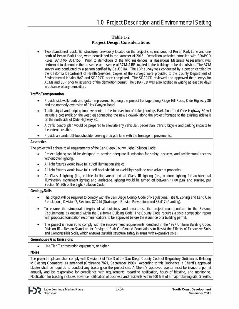
Two abandoned residential structures previously located on the project site, one south of Pecan Park Lane and one north of Pecan Park Lane, were demolished in the summer of 2015. Demolition activities complied with SDAPCD Rules 361.140- 361.156. Prior to demolition of the two residences, a Hazardous Materials Assessment was performed to determine the presence or absence of ACMs/LBP located in the buildings to be demolished. The ACM survey was conducted by a person certified by Cal/OSHA. The LBP survey was conducted by a person certified by the California Department of Health Services. Copies of the surveys were provided to the County Department of Environmental Health HAZ and SDAPCD once completed. The SDAPCD reviewed and approved the surveys for ACMs and LBP prior to issuance of the demolition permit. The SDAPCD was also notified in writing at least 10 days in advance of any demolition.
Traffic/Transportation
Provide sidewalk, curb and gutter improvements along the project frontage along Ridge Hill Road, Olde Highway 80 and the northerly extension of Rios Canyon Road.
Traffic signal and striping improvements at the intersection of Lake Jennings Park Road and Olde Highway 80 will include a crosswalk on the west leg connecting the new sidewalk along the project frontage to the existing sidewalk on the north side of Olde Highway 80.
A traffic control plan would be prepared to alleviate any vehicular, pedestrian, transit, bicycle and parking impacts to the extent possible.
Provide a standard 8-foot shoulder serving a bicycle lane with the frontage improvements.
Aesthetics
The project will adhere to all requirements of the San Diego County Light Pollution Code:
Project lighting would be designed to provide adequate illumination for safety, security, and architectural accents without over lighting.
All light fixtures would have full cutoff illumination shields.
All light fixtures would have full cutoff back shields to avoid light spillage onto adjacent properties.
All Class I lighting (i.e., vehicle fueling area) and all Class III lighting (i.e., outdoor lighting for architectural illumination, monument lighting and landscape lighting) would be turned off between 11:00 p.m. and sunrise, per Section 51.206 of the Light Pollution Code.
Geology/Soils
The project will be required to comply with the San Diego County Code of Regulations, Title 8, Zoning and Land Use Regulations, Division 7, Sections 87.414 (Drainage – Erosion Prevention) and 87.417 (Planting).
To ensure the structural integrity of all buildings and structures, the project must conform to the Seismic Requirements as outlined within the California Building Code. The County Code requires a soils compaction report with proposed foundation recommendations to be approved before the issuance of a building permit.
The project is required to comply with the improvement requirements identified in the 1997 Uniform Building Code, Division III – Design Standard for Design of Slab-On-Ground Foundations to Resist the Effects of Expansive Soils and Compressible Soils, which ensures suitable structure safety in areas with expansive soils.
Greenhouse Gas Emissions
Use Tier III construction equipment, or higher.
Noise
The project applicant shall comply with Division 5 of Title 3 of the San Diego County Code of Regulatory Ordinances Relating to Blasting Operations, as amended (Ordinance 7821, September 1990). According to this Ordinance, a Sheriff’s approved blaster shall be required to conduct any blasting on the project site. A Sheriff’s approved blaster must be issued a permit annually and be responsible for compliance with requirements regarding notification, hours of blasting, and monitoring. Notification for blasting includes advance notification of business and residents within 600 feet of a major blasting site, Sheriff’s
1.0 Project Description and Environmental Setting
Lake Jennings Market Place 1-35 South Coast Development Draft EIR November 2015
Table 1-2 Project Design Considerations
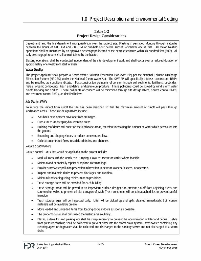
Department, and the fire department with jurisdiction over the project site. Blasting is permitted Monday through Saturday between the hours of 6:00 AM and 7:00 PM or one-half hour before sunset, whichever occurs first. All major blasting operations shall be monitored by an approved seismograph located at the nearest structure within six hundred feet (600’). All daily seismograph reports shall be maintained by the blaster.
Blasting operations shall be conducted independent of the site development work and shall occur over a reduced duration of approximately one week from start to finish.
Water Quality
The project applicant shall prepare a Storm Water Pollution Prevention Plan (SWPPP) per the National Pollution Discharge Elimination System (NPDES) under the National Clean Water Act. The SWPPP will specifically address construction BMPs and be modified as conditions dictate. Post-construction pollutants of concern include soil sediments, fertilizers, pesticides, metals, organic compounds, trash and debris, and petroleum products. These pollutants could be spread by wind, storm water runoff, tracking and spilling. These pollutants of concern will be minimized through site design BMPs, source control BMPs, and treatment control BMPs, as detailed below. Site Design BMPs
To reduce the impact from runoff the site has been designed so that the maximum amount of runoff will pass through landscaped areas. These site design BMPs include:
Set-back development envelope from drainages.
Curb-cuts to landscaping/bio-retention areas.
Building roof drains will outlet on the landscape areas, therefore increasing the amount of water which percolates into the ground.
Rounding and shaping slopes to reduce concentrated flow.
Collect concentrated flows in stabilized drains and channels.
Source Control BMPs
Source control BMPs that would be applicable to the project include:
Mark all inlets with the words “No Dumping! Flows to Ocean” or similar where feasible.
Maintain and periodically repaint or replace inlet markings.
Provide stormwater pollution prevention information to new site owners, lessees, or operators.
Inspect and maintain drains to prevent blockages and overflow.
Maintain landscaping using minimum or no pesticides.
Trash storage areas will be provided for each building.
Trash storage areas will be paved in an impervious surface designed to prevent run-off from adjoining areas and screened or walled to prevent off-site transport of trash. Trash containers will contain attached lids to prevent rainfall intrusion.
Trash storage ages will be inspected daily. Litter will be picked up and spills cleaned immediately. Spill control materials will be available on-site.
Move loaded and unloaded items from loading docks indoors as soon as possible.
The property owner shall dry sweep the fueling area routinely.
Plazas, sidewalks, and parking lots shall be swept regularly to prevent the accumulation of litter and debris. Debris from pressure washing shall be collected to prevent entry into the storm drain system. Washwater containing any cleaning agent or degreaser shall be collected and discharged to the sanitary sewer and not discharged to a storm drain.
1.0 Project Description and Environmental Setting
Lake Jennings Market Place 1-36 South Coast Development Draft EIR November 2015
Table 1-2 Project Design Considerations
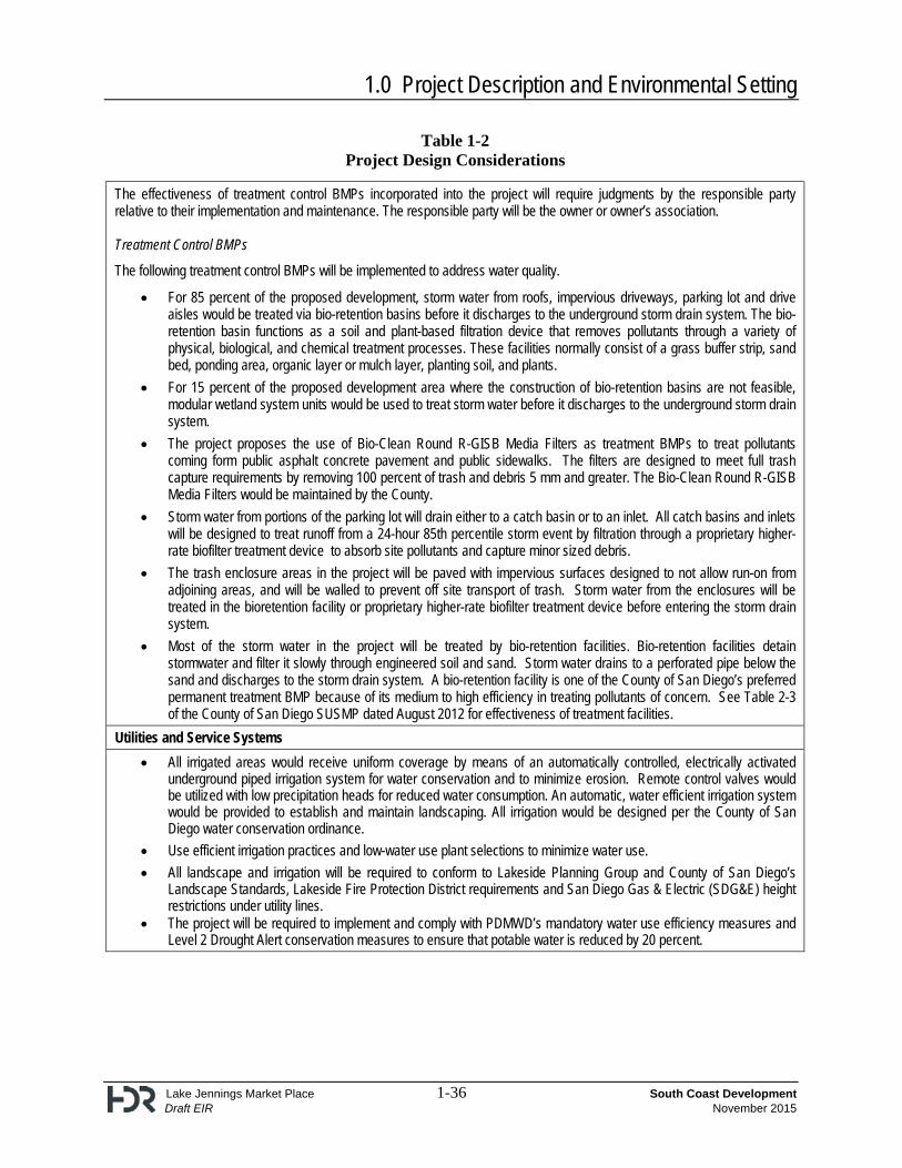
The effectiveness of treatment control BMPs incorporated into the project will require judgments by the responsible party relative to their implementation and maintenance. The responsible party will be the owner or owner’s association. Treatment Control BMPs
The following treatment control BMPs will be implemented to address water quality.
For 85 percent of the proposed development, storm water from roofs, impervious driveways, parking lot and drive aisles would be treated via bio-retention basins before it discharges to the underground storm drain system. The bio-retention basin functions as a soil and plant-based filtration device that removes pollutants through a variety of physical, biological, and chemical treatment processes. These facilities normally consist of a grass buffer strip, sand bed, ponding area, organic layer or mulch layer, planting soil, and plants.
For 15 percent of the proposed development area where the construction of bio-retention basins are not feasible, modular wetland system units would be used to treat storm water before it discharges to the underground storm drain system.
The project proposes the use of Bio-Clean Round R-GISB Media Filters as treatment BMPs to treat pollutants coming form public asphalt concrete pavement and public sidewalks. The filters are designed to meet full trash capture requirements by removing 100 percent of trash and debris 5 mm and greater. The Bio-Clean Round R-GISB Media Filters would be maintained by the County.
Storm water from portions of the parking lot will drain either to a catch basin or to an inlet. All catch basins and inlets will be designed to treat runoff from a 24-hour 85th percentile storm event by filtration through a proprietary higher-rate biofilter treatment device to absorb site pollutants and capture minor sized debris.
The trash enclosure areas in the project will be paved with impervious surfaces designed to not allow run-on from adjoining areas, and will be walled to prevent off site transport of trash. Storm water from the enclosures will be treated in the bioretention facility or proprietary higher-rate biofilter treatment device before entering the storm drain system.
Most of the storm water in the project will be treated by bio-retention facilities. Bio-retention facilities detain stormwater and filter it slowly through engineered soil and sand. Storm water drains to a perforated pipe below the sand and discharges to the storm drain system. A bio-retention facility is one of the County of San Diego’s preferred permanent treatment BMP because of its medium to high efficiency in treating pollutants of concern. See Table 2-3 of the County of San Diego SUSMP dated August 2012 for effectiveness of treatment facilities.
Utilities and Service Systems
All irrigated areas would receive uniform coverage by means of an automatically controlled, electrically activated underground piped irrigation system for water conservation and to minimize erosion. Remote control valves would be utilized with low precipitation heads for reduced water consumption. An automatic, water efficient irrigation system would be provided to establish and maintain landscaping. All irrigation would be designed per the County of San Diego water conservation ordinance.
Use efficient irrigation practices and low-water use plant selections to minimize water use.
All landscape and irrigation will be required to conform to Lakeside Planning Group and County of San Diego’s Landscape Standards, Lakeside Fire Protection District requirements and San Diego Gas & Electric (SDG&E) height restrictions under utility lines.
The project will be required to implement and comply with PDMWD’s mandatory water use efficiency measures and Level 2 Drought Alert conservation measures to ensure that potable water is reduced by 20 percent.
1.0 Project Description and Environmental Setting
Lake Jennings Market Place 1-37 South Coast Development Draft EIR November 2015
Table 1-3 Cumulative Projects
Map Label Project Number Project Name Description Potential Impacts Status
County of San Diego
1 Major Use Permit MUP-14-015
Lakeside Tractor Supply (previously the Black Gold Project)
The project is a Major Use Permit for the outdoor display and storage of merchandise, in association with a commercial use, consisting of 1) a 19,169 square foot commercial retail building; 2) 5,000 square feet of fenced outdoor display and storage; 3) 4,620 square feet of open outdoor display area, 4) parking for 72 vehicles, 5) signage, 6) drought tolerant landscaping. Earthwork will consist of approximately 34,000 cubic yards of excavation, 8,200 cubic yards of fill, and 25,800 cubic yards of export. Off-site improvements include road widening, curb, gutter, and sidewalk. The project would generate 857 average daily trips
Biological Resources, Traffic
Major Use Permit application submitted April 15, 2014. Lakeside Community Planning Group voted to recommend approval for the major use permit with conditions.
2 PDS2013-TM5578 (TM5578)
Lake Jennings Park Road Subdivision Project –
The project is a major subdivision to divide a 5.17-acre property into 20 lots: 18 residential lots and two private road lots. The project site is located at the northeast corner of Blossom Valley Road and Lake Jennings Park Road. Access to the site would be provided by a private road onto Jennings Vista Drive.
Biological Resources, Cultural Resources, Paleontological Resources
Approved
3 -- Eastern Service Area Secondary Connection Project
PDMWD is proposing to construct and operate a water supply pipeline, flow control facility, reservoir, pump station, discharge pipeline, and associated facilities in the community of El Cajon/Lakeside. The facilities would be located in an area located to the north of I-8, south of the I-8 Business (a roadway), west of El Dorado Parkway, and east of Rancho Laguna Estates (a mobile home park). In addition, a water discharge pipeline approximately 5,600 feet would be constructed from the proposed on-site pump station and traverse southeast under I-8. The discharge pipeline would continue from the western terminus of Ridge Hill Road, replacing an existing pipeline traversing to the east along this roadway for approximately 3,990 feet before reaching the I-8 eastbound off-ramp at Lake Jennings Park Road. The pipeline would run along the off-ramp for approximately 285 feet to the intersection of Lake
Biological Resources, Cultural Resources, Noise
Approved
1.0 Project Description and Environmental Setting
Lake Jennings Market Place 1-38 South Coast Development Draft EIR November 2015
Table 1-3 Cumulative Projects
Map Label Project Number Project Name Description Potential Impacts Status
Jennings Park Road/Ridge Hill Road/Olde Highway 80. From this intersection, the pipeline would continue along Olde Highway 80, and then run east along Pecan Park Lane, where it would terminate at the intersection of Pecan Park Lane/Rios Canyon Road, connecting to an existing PDMWD 20-inch pipeline.
4 PDS2014-STP-14-022 Peter Rios Estates Apartment Complex
The project is a Site Plan to construct an apartment complex. The project consists of eight separate apartment buildings totaling 32 units, a pool and spa, and a recreation building. The site is located at 14265 Rios Canyon Road. Access would be provided by a driveway connecting to Rios Canyon Road.
Cultural Resources Approved