Embed Size (px)
Citation preview

10-1
10.0 WATER QUALITY AND ENVIRONMENTAL ISSUES
10.1 SRA Water Quality Monitoring Program
SRA has been involved with water quality issues since 1954, when operational activities
were initiated. During the 1960's SRA compiled all available water quality data for the Basin to
aid the Texas Water Quality Board, the predecessor to the Texas Natural Resource Conservation
Commission (TNRCC), in the establishment of the first water quality standards criteria in Texas.
In 1972 the program was expanded to include Basin-wide ambient monitoring. Building on
years of experience and detailed knowledge of the watershed, the SRA has successfully
integrated its mission and existing watershed monitoring program with the watershed
management process put forth by the Texas Clean Rivers Program (CRP). SRA utilized the CRP
to enhance its existing program and developed the subwatershed approach to water quality
monitoring in the Basin, which has received statewide recognition. In September of 1998, the
SRA received an exemplary rating by the TNRCC for its performance under the CRP. This
section summarizes the SRA basin–wide monitoring plan with respect to its effectiveness in 1)
addressing state and federal mandates and 2) identifying and addressing local water quality
issues.
10.1.1 SRA Monitoring Program
In order to meet the CRP requirements for water quality assessments within the Sabine
River Basin, SRA has developed a comprehensive Basin-wide monitoring plan consisting of
three major components: Water Quality Monitoring Program (WQMP), Subwatershed
Monitoring Program, and Special Studies. Technical decisions and activities associated with
water quality monitoring are carried out within the framework provided by the SRA Basin-wide
monitoring plan. SRA managers using input from the SRA steering committee and CRP
guidance documents make decisions regarding technical issues such as site selection and
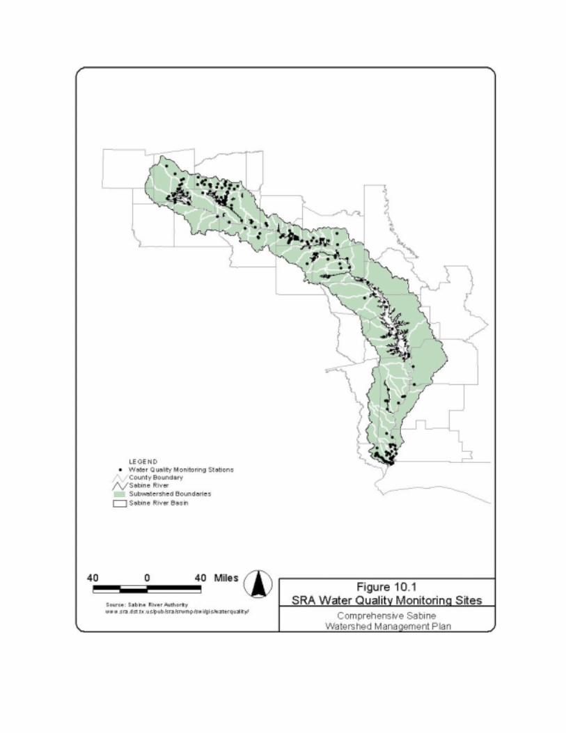
sampling regime. Figure 10.1 illustrates water quality monitoring sites located in the Sabine
River watershed.
The TNRCC’s surface water classifications, designated uses, and identification of
threatened and impaired water bodies were used to evaluate the SRA monitoring plan and its
effectiveness in addressing water resource management issues. The TNRCC divides streams,
10-2
reservoirs, and lakes into geographic units called segments that are classified by the agency
according to their quality, functions, and uses. The classifications assigned to each segment
afford various levels of protection for water bodies through regulatory requirements and specific
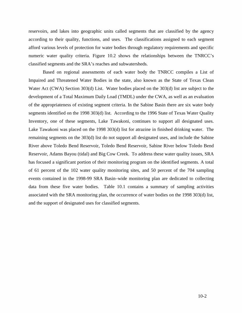
numeric water quality criteria. Figure 10.2 shows the relationships between the TNRCC’s
classified segments and the SRA’s reaches and subwatersheds.
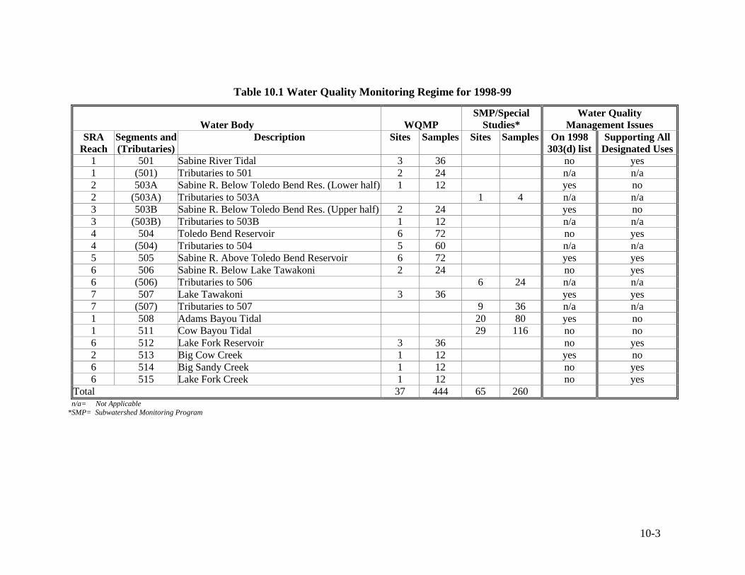
Based on regional assessments of each water body the TNRCC compiles a List of
Impaired and Threatened Water Bodies in the state, also known as the State of Texas Clean
Water Act (CWA) Section 303(d) List. Water bodies placed on the 303(d) list are subject to the
development of a Total Maximum Daily Load (TMDL) under the CWA, as well as an evaluation
of the appropriateness of existing segment criteria. In the Sabine Basin there are six water body
segments identified on the 1998 303(d) list. According to the 1996 State of Texas Water Quality
Inventory, one of these segments, Lake Tawakoni, continues to support all designated uses.
Lake Tawakoni was placed on the 1998 303(d) list for atrazine in finished drinking water. The
remaining segments on the 303(d) list do not support all designated uses, and include the Sabine
River above Toledo Bend Reservoir, Toledo Bend Reservoir, Sabine River below Toledo Bend
Reservoir, Adams Bayou (tidal) and Big Cow Creek. To address these water quality issues, SRA
has focused a significant portion of their monitoring program on the identified segments. A total
of 61 percent of the 102 water quality monitoring sites, and 50 percent of the 704 sampling
events contained in the 1998-99 SRA Basin–wide monitoring plan are dedicated to collecting
data from these five water bodies. Table 10.1 contains a summary of sampling activities
associated with the SRA monitoring plan, the occurrence of water bodies on the 1998 303(d) list,
and the support of designated uses for classified segments.
10-3
Table 10.1 Water Quality Monitoring Regime for 1998-99
Water Body WQMP SMP/Special
Studies* Water Quality
Management Issues SRA
Reach Segments and (Tributaries)
Description Sites Samples Sites Samples On 1998 303(d) list
Supporting All Designated Uses
1 501 Sabine River Tidal 3 36 no yes 1 (501) Tributaries to 501 2 24 n/a n/a 2 503A Sabine R. Below Toledo Bend Res. (Lower half) 1 12 yes no 2 (503A) Tributaries to 503A 1 4 n/a n/a 3 503B Sabine R. Below Toledo Bend Res. (Upper half) 2 24 yes no 3 (503B) Tributaries to 503B 1 12 n/a n/a 4 504 Toledo Bend Reservoir 6 72 no yes 4 (504) Tributaries to 504 5 60 n/a n/a 5 505 Sabine R. Above Toledo Bend Reservoir 6 72 yes yes 6 506 Sabine R. Below Lake Tawakoni 2 24 no yes 6 (506) Tributaries to 506 6 24 n/a n/a 7 507 Lake Tawakoni 3 36 yes yes 7 (507) Tributaries to 507 9 36 n/a n/a 1 508 Adams Bayou Tidal 20 80 yes no 1 511 Cow Bayou Tidal 29 116 no no 6 512 Lake Fork Reservoir 3 36 no yes 2 513 Big Cow Creek 1 12 yes no 6 514 Big Sandy Creek 1 12 no yes 6 515 Lake Fork Creek 1 12 no yes
Total 37 444 65 260 n/a= Not Applicable *SMP= Subwatershed Monitoring Program
10-4
10.1.2 Watershed Influences on Water Quality
The monitoring program used in the subwatershed approach designed by SRA,
characterizes water quality at the smallest practical drainage areas within the Basin. Water
quality data at this level are compared to land use and other watershed information to determine
potential sources of contamination to water bodies.
SRA’s subwatershed approach takes into consideration the factors that place certain
segments at risk for water quality concerns. These risk factors are determined from inventories
of watershed activities and used to determine the overall risk of water quality impairment for
each subwatershed. This information is then used in the decision making process for the
allocation of future monitoring resources. The risk factors considered in the development of the
subwatershed approach are: water quality, ambient toxicity, biological condition, superfund
sites, permitted dischargers, cities with populations greater than 5,000, and landfills.
Effects of Land Use
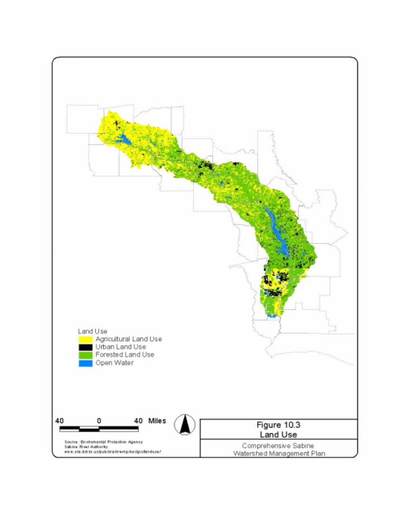
To assess the effects of land use on water quality, a simple geographic information
system (GIS) analysis was performed. Quantitative determinations of the percent cover by major
land use categories (agricultural, forest, urban, water, and other) shown on Figure 10.3 were
performed for each subwatershed. The land use data shown on Figure 10.3 was obtained from
the Sabine River Authority’s current GIS database. SRA originally obtained the data from the
Environmental Protection Agency (EPA). Note that the sudden discontinuities of land use south
of Toledo Bend appear to represent problems with the data rather than actual changes in land
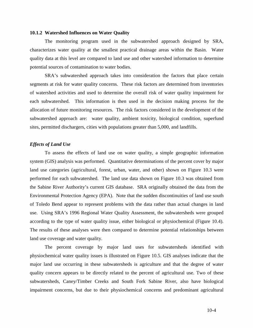
use. Using SRA’s 1996 Regional Water Quality Assessment, the subwatersheds were grouped
according to the type of water quality issue, either biological or physiochemical (Figure 10.4).
The results of these analyses were then compared to determine potential relationships between
land use coverage and water quality.
The percent coverage by major land uses for subwatersheds identified with
physiochemical water quality issues is illustrated on Figure 10.5. GIS analyses indicate that the
major land use occurring in these subwatersheds is agriculture and that the degree of water
quality concern appears to be directly related to the percent of agricultural use. Two of these
subwatersheds, Caney/Timber Creeks and South Fork Sabine River, also have biological
impairment concerns, but due to their physiochemical concerns and predominant agricultural
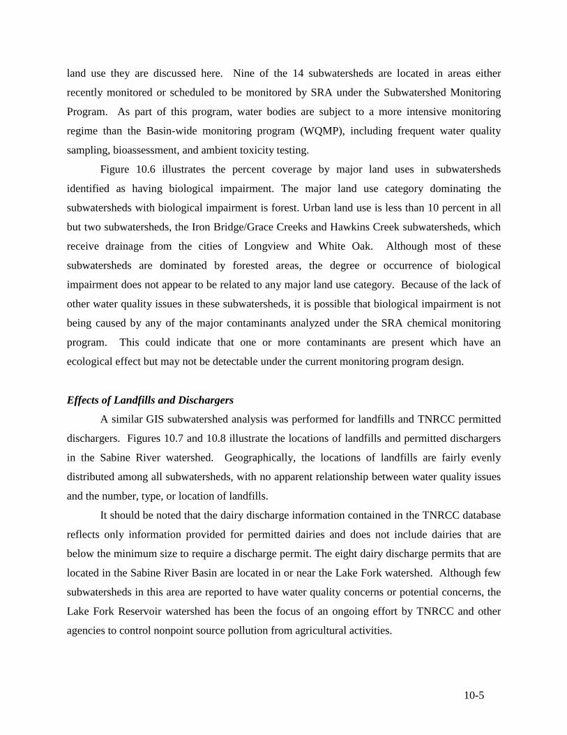
10-5
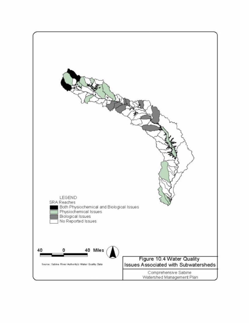
land use they are discussed here. Nine of the 14 subwatersheds are located in areas either
recently monitored or scheduled to be monitored by SRA under the Subwatershed Monitoring
Program. As part of this program, water bodies are subject to a more intensive monitoring
regime than the Basin-wide monitoring program (WQMP), including frequent water quality
sampling, bioassessment, and ambient toxicity testing.
Figure 10.6 illustrates the percent coverage by major land uses in subwatersheds
identified as having biological impairment. The major land use category dominating the
subwatersheds with biological impairment is forest. Urban land use is less than 10 percent in all
but two subwatersheds, the Iron Bridge/Grace Creeks and Hawkins Creek subwatersheds, which
receive drainage from the cities of Longview and White Oak. Although most of these
subwatersheds are dominated by forested areas, the degree or occurrence of biological
impairment does not appear to be related to any major land use category. Because of the lack of
other water quality issues in these subwatersheds, it is possible that biological impairment is not
being caused by any of the major contaminants analyzed under the SRA chemical monitoring
program. This could indicate that one or more contaminants are present which have an
ecological effect but may not be detectable under the current monitoring program design.
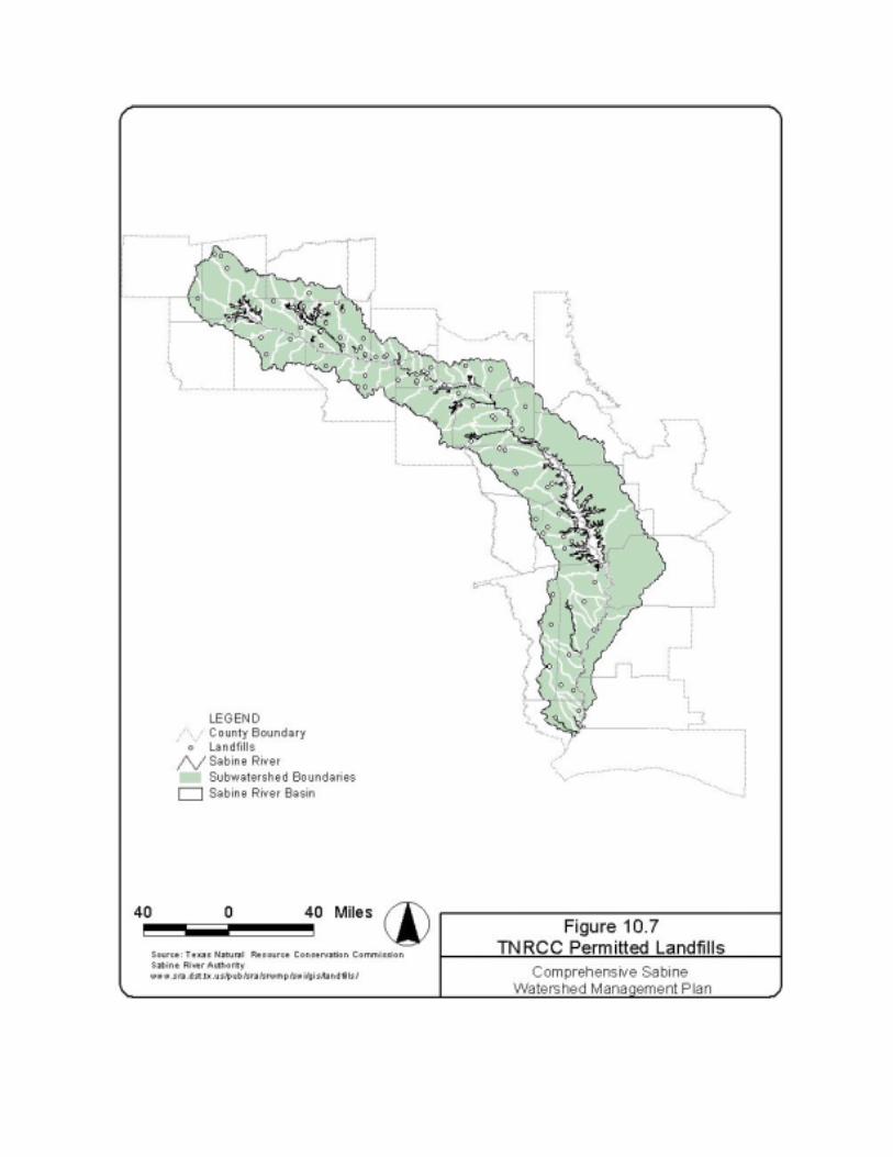
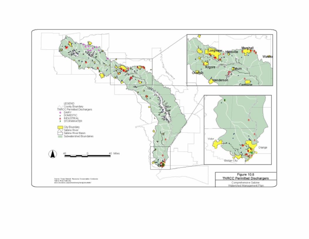
Effects of Landfills and Dischargers
A similar GIS subwatershed analysis was performed for landfills and TNRCC permitted
dischargers. Figures 10.7 and 10.8 illustrate the locations of landfills and permitted dischargers
in the Sabine River watershed. Geographically, the locations of landfills are fairly evenly
distributed among all subwatersheds, with no apparent relationship between water quality issues
and the number, type, or location of landfills.
It should be noted that the dairy discharge information contained in the TNRCC database
reflects only information provided for permitted dairies and does not include dairies that are
below the minimum size to require a discharge permit. The eight dairy discharge permits that are
located in the Sabine River Basin are located in or near the Lake Fork watershed. Although few
subwatersheds in this area are reported to have water quality concerns or potential concerns, the
Lake Fork Reservoir watershed has been the focus of an ongoing effort by TNRCC and other
agencies to control nonpoint source pollution from agricultural activities.
10-6
Figure 10.5 Land Use of Subwatersheds with Physiochemical Water Quality Issues
Subwatersheds are presented in order of decreasing water quality concerns.
Figure 10.6 Land Use of Subwatersheds with Biological Water Quality Issues
Subwatersheds are presented in order of decreasing biological impairment concern.
-
20
40
60
80
100
* Can
ey/T
imbe
r... C
reek
s
Ced
ar/B
ull/D
unn
Cre
eks
Cad
do C
reek
* Sou
th F
ork
Sabi
ne R
iver
Birc
h C
reek
Wat
ersh
ed
Adam
s Ba
you
Tole
do B
end
Res
ervo
ir
Lake
For
k C
reek
Bayo
u An
acoc
o
Lake
For
k C
reek
Big
Cow
Cre
ek
Big
Sand
y C
reek
Gra
nd S
alin
e C
reek
Cow
Bay
ou
Perc
ent o
f Sub
wat
ersh
ed A
rea
UrbanForestAgricultural
*site also has biological impairment ** landuse not available
** ** ** ** **
-
2 0
4 0
6 0
8 0
1 0 0
Littl
e C
ypre
ssBa
you
Six
Mile
Crk
/Hog
gsBa
you
Iron
Brid
ge/G
race
Cre
eks
Rab
bit C
reek
Prai
rie C
reek
Har
ris C
reek
Dem
psey
Cre
ek
Flat
For
k C
reek
Soca
gee
Cre
ek
Potte
rs C
reek
Haw
kins
Cre
ek
Perc
ent o
f Sub
wat
ersh
ed A
rea
U rb a nF o re s tA g r ic u ltu ra l
** la n d u s e n o t a v a ila b le
* * * *
10-7
10.1.3 Recommendations for the SRA Water Quality Monitoring Program
The priorities associated with the SRA Water Quality Monitoring Program (WQMP)
appear to be compatible with the priorities and assessment requirements of regional water
planning districts, such as those formed by Senate Bill 1, and Clean Water Act mandates such as
the TMDL program. Integration of these programs at the local level will provide the most
efficient use of SRA resources for water quality protection.
Continued development of the SRA’s subwatershed approach, including the integration
of water quality data with land use and point source information, will continue to provide the
tools to make informed decisions about the quality of Sabine River watershed water resources.
The local and regional processes that are in place should continue to actively support the Clean
Rivers Program.
Watershed influences on water quality should continue to be a high priority in monitoring
program design decisions. SRA should continue to use GIS technology to identify high priority
areas as well as potential sources of water quality contamination. Existing Basin–wide land use
databases are adequate for gross analyses but are inadequate at the subwatershed level. An effort
to compile databases from all available sources that contain subwatershed-level information
pertinent to the Sabine Basin would be a useful tool in the program design for future monitoring.
The current SRA monitoring program adequately characterizes baseline water quality
conditions in the watershed, particularly in those areas included in the Subwatershed Monitoring
Program. This approach identifies major contaminants and probable contaminant sources at the
subwatershed level. Special Studies, the third major component of the program, are a useful
addition to the monitoring program and can be used to incorporate high flow or storm sampling
studies into the subwatershed studies where contaminants have been characterized and potential
sources have been identified using the Subwatershed Monitoring Program. As an example, in
rural areas sampling of storm runoff could be used to identify loadings from various parcels of
land. This type of data could also be used by other agencies such as the Natural Resource
Conservation Service in local non-point source demonstration projects within high priority
watersheds. In urban areas, stormwater runoff data could be used by municipalities and
industries to identify management practices or previously unknown problem areas that, if
corrected, could improve the quality of the Sabine River. SRA could coordinate voluntary
source identification surveys to better characterize unidentified water quality contaminants.
10-8
Characterization of stormwater quality and watershed runoff is an essential part of the TMDL
concept. Any special studies that may be developed to address local contaminant issues should
be designed if appropriate to be of use in modeling efforts associated with future studies such as
TMDLs or Source Water Protection Programs.
As evidenced by the analyses presented in this report, the use of bioassessments in the
SRA monitoring program complements the routine chemical monitoring procedures. It is
possible, however, that existing bioassessment data from the Sabine River watershed may
provide more useful information at the subwatershed level if a more regional approach was used.
For example, the existing biological data may provide more distinction between levels of water
quality impacts if regional tolerance values or analytical methods developed for local eco-regions
were employed. The use of bioassessment data in regional assessments will become more crucial
as the TNRCC develops biocriteria and implements them in the water quality standards.
Another ecological concern related to water quality in the Sabine River watershed is the
increase in aquatic vegetation in reservoirs and the introduction of exotic aquatic vegetation.
Three species, water hyacinth, hydrilla and salvinia, are aggressive invaders which have also
caused water use problems in other parts of the state and country. The TPWD is currently
revising its Aquatic Vegetation Management Plan for Texas based on input from aquatic
vegetation scientists and other experts from around the state, including SRA staff members. The
plan will include recommendations to control excessive increases of exotic and endemic aquatic
vegetation. SRA is addressing the problem by continuing to identify and reduce sources of
contaminant loading to the Sabine Basin that affect natural balances. By reducing the
disturbance of natural aquatic communities, the likelihood of excessive aquatic plant growth of
any kind is reduced. SRA should continue to implement appropriate control measures for streams
and reservoirs in accordance with the TPWD Aquatic Vegetation Management Plan.
10.2 Environmental Considerations and New Reservoir Development
Environmental considerations that have the potential to alter planned reservoir
development in the Sabine Basin include issues relating to:
• = state and federally protected plant and animal species;
• = bottomland hardwood forests;
• = “waters of the United States”, including wetlands and other special aquatic sites;
10-9
• = cultural resources; and
• = other protected areas. Protected areas include wildlife refuges, wetland mitigation banks,
and conservation easements.
Complying with pertinent regulations requires extensive consultations and negotiations
with state and federal regulatory agencies before a reservoir project would be approved. As part
of the permitting process, issues such as threatened and endangered species, habitat protection,
wetlands, and cultural resources would have to be addressed. An acceptable mitigation plan
would have to be developed to compensate for unavoidable impacts. Major environmental issues
that may affect proposed reservoirs in the Sabine Basin are discussed in the following sections.
10.2.1 Environmental Regulations
Due to the potential impacts of reservoir construction on the environment, water resource
projects are regulated by a multitude of environmental laws. This section lists environmental
rules that may apply to potential water resource projects in the Sabine Basin, including dams,
reservoirs, canals, pump stations, aqueducts, wastewater re-use and aquifer recharge.
U.S. Army Corps of Engineers (COE)
Clean Water Act of 1972, Section 404 Permit The Clean Water Act applies to any action
that adds dredge or fill material to Waters of the United States, including wetlands and non-
navigable waters. New reservoirs in the Sabine Basin will require a 404 permit since they place
a dam in waters of the United States. Canals, aqueducts or pipelines and levees may require 404
permits if they cross jurisdictional waters or wetlands.
Rivers and Harbors Act of 1899, Section 10 Permit Sections 9 and 10 of the Rivers and
Harbors Act of 1899 affects all actions that may affect navigation in navigable waters of the
United States, including dams, bridges, bulkheads, piers and docks. New reservoirs on major
rivers in the Sabine Basin will require a Section 10 permit. This is usually applied for at the same
time as the Section 404 permit. Navigable waters are subject to the Rivers and Harbors Act of
1899, which does not allow the construction of an obstruction within the waterway without
Congressional approval. The main stem of the Sabine River below the confluence of Big Sandy
Creek is considered navigable waters of the U.S.
10-10
U.S. Department of the Interior, Fish & Wildlife Service (USFWS)
Fish and Wildlife Coordination Act of 1966 The USFWS has the duty of reviewing and
commenting on any action by another federal agency that affects natural resources such as
fisheries, wildlife, and special habitats like wetlands. This is in addition to their specific
regulatory requirements for endangered species, discussed below. Water resource projects in the
Sabine Basin that affect wildlife habitats such as wetlands, bottomland hardwoods, free-flowing
streams and mature forests would be subject to this Act.
Endangered Species Act of 1973, Section 7 Consultation and Section 10 Permit During
coordination with the Fish & Wildlife Service, the agency may require a biological assessment
under the Section 7 provisions of the Endangered Species Act. This report assesses the potential
effects of a project on endangered or threatened species. If a project will affect, but not
jeopardize, the existence of an endangered or threatened species, the project’s sponsor is required
to obtain a Section 10 permit for incidental taking of endangered or threatened species before
construction. Mitigation for the remaining population and habitat is often required as a condition
of this permit. Coordination with the Fish and Wildlife Service for major water projects in the
Sabine Basin would generally include a Section 7 biological assessment of endangered species
and possibly mitigation.
U.S. Department of the Interior, Bureau of Reclamation
The U.S. Bureau of Reclamation is not a permitting agency but a sponsor of water
resource projects, especially in the western states, that benefit agriculture and industry. Bureau of
Reclamation-sponsored projects must comply with all federal, state and local permit
requirements. They are generally authorized by specific appropriation from the U.S. Congress.
Federal Energy Regulatory Commission, Federal Power Act, License for Electric
Generating Stations
The Federal Energy Regulatory Commission issues licenses to entities wishing to build
power generating facilities that benefit the public. These projects often require an environmental
impact statement and other approvals. Water resources projects in the Sabine Basin that include
hydropower generation will require a license from the Federal Energy Regulatory Commission.
10-11
All Agencies, National Environmental Policy Act of 1969, Environmental Impact
Assessment
Each federal agency has its own rules for implementing the National Environmental
Policy Act, which requires major federal actions that significantly affect the environment to
prepare an environmental impact statement describing the action and alternative actions,
detailing the environmental impacts, and proposing mitigation measures to reduce or eliminate
impacts. Federal actions may include direct construction, funding and approval of permits.
Water resource projects in the Sabine Basin will involve federal actions such as permitting and
may involve federal funding.
Texas Natural Resource Conservation Commission (TNRCC)
Water Rights Permit Chapter 11 of the Texas Water Code and Section 30 of the Texas
Administrative Code require anyone wishing to divert, use, or store surface water, or to transfer
surface water between Basins, to obtain a permit from the TNRCC. The permit application
includes environmental, hydrologic and conservation assessments. Water resource projects in
the Sabine Basin may involve modification of existing permits or creation of new permits which
are subject to TNRCC’s assessment. The agency requires water conservation and drought
contingency planning with all permit actions and may impose conditions for instream flow and
water conservation. All applications for water rights that lie within 200 river miles of the coast
must include an assessment of the right’s affect on bays and estuaries.
Clean Water Act of 1972, Section 401 Certification The Texas Natural Resource
Conservation Commission must certify that each project that obtains a Section 404 permit by the
Corps of Engineers will not degrade water quality below state standards. The agency has recently
issued draft guidance for implementing Section 401 certification. The guidance requires
demonstrations from the applicant that the project has no practical alternative that would not
affect the waters, and that losses of wetlands and waters have been avoided, minimized and
mitigated in that order.
Clean Water Act of 1972, TPDES Discharge Permit The Texas Natural Resource
Conservation Commission has recently been delegated authority to permit wastewater discharges
under Section 402 of the Clean Water Act of 1972 from the United States Environmental
10-12
Protection Agency. Anyone who discharges wastewater into the Sabine Basin requires a Texas
Pollutant Discharge Elimination System permit from the TNRCC.
Texas Water Development Board (TWDB), Texas Water Plan Consistency
The TWDB provides funding assistance to water resource projects that are part of the
Texas Water Plan, developed under Senate Bill 1, and are consistent with the plan’s goals.
Water resources projects in the Sabine River Basin that are not in the plan or are inconsistent
with the State Water Plan are unlikely to receive state funding.
Texas Parks & Wildlife Department (TPWD), Sand, Gravel and Marl Extraction
Permit
All projects that involve excavation or removal of sand, gravel, or marl from state owned
streambeds must have a permit from the Texas Parks & Wildlife Department. Water resources
projects in the Sabine Basin will require a permit from the Texas Parks and Wildlife Department
prior to start of construction once the Texas General Land Office (GLO) has determined that the
impacted water course is state owned.
Texas General Land Office
Coastal Management Plan Consistency Determination All projects involving state and
local permits or funding in the coastal counties of Texas must also be consistent with the Texas
Coastal Management Plan. Water resources projects in Orange County in the Sabine Basin
should also be reviewed for consistency with the Texas Coastal Management Plan as part of
obtaining other permits to ensure that this process will go smoothly.
Grant of Easement All projects that cross or otherwise impact state owned waterways
must obtain a Grant of Easement from the Texas General Land Office prior to start of
construction.
Aquifer Recharge Rules Permitting authority for aquifer recharge resides with TNRCC.
A Class V injection well permit would be required. If surface water is the source, a new or
amended water right permit may also be required.
10-13
Municipal Zoning and Land Use Codes
Many cities in Texas have zoning and land use regulations that require project approval
or permitting. Some water resources projects may not be initially consistent with local
regulations and may require local approval of variances to local zoning or land use plans.
10.2.2 Existing Conditions
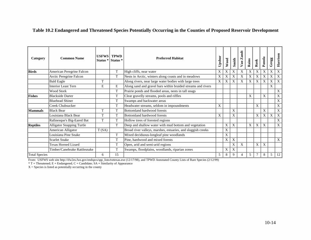
Threatened and Endangered Species
Federal and state lists of endangered and threatened species that are likely to occur in the
counties where reservoir development is proposed are presented in this section. The locations of
the six reservoirs analyzed in detail in Section 7 include portions of Rusk County (State Highway
322), Panola County (Carthage), Smith County (Waters Bluff and Prairie Creek), Upshur County
(Big Sandy and Waters Bluff), Wood County (Big Sandy, Carl L. Estes, and Waters Bluff), Van
Zandt County (Carl L. Estes), Rains County (Carl L. Estes), Gregg County (Prairie Creek and
Carthage), and Harrison County (Carthage). Table 10.2 contains the names, protection status,
and preferred habitats for each species according to the county lists published by the USFWS
(USFWS, 1998) and the TPWD (TPWD, 1999). The county lists are not specific to individual
reservoir sites, and a field survey to determine the presence or absence of species or habitats
would be necessary if any of the recommended sites are selected for reservoir development.
Direct impacts of reservoir development on endangered and threatened species include
flooding and removal of vegetation, and the potential for habitat fragmentation or isolation.
Inundation of existing floodplains and the creation of open water habitat would decrease the
habitat available for mammals, terrestrial snakes, and stream fishes, but would increase or
enhance the habitat and forage area for other species such as birds, reptiles, and lake species of
fish.
10-14
Table 10.2 Endangered and Threatened Species Potentially Occurring in the Counties of Proposed Reservoir Development
Category Common Name USFWS Status *
TPWD Status * Preferred Habitat
Ups
hur
Woo
d
Smith
Van
Zan
dt
Rai
ns
Rus
k
Pano
la
Gre
gg
Har
riso
n
Birds American Peregrine Falcon T High cliffs, near water X X X X X X X X X Arctic Peregrine Falcon T Nests in Arctic, winters along coasts and in meadows X X X X X X X X X Bald Eagle T Along rivers, near large water bodies with large trees X X X X X X X X X Interior Least Tern E E Along sand and gravel bars within braided streams and rivers X Wood Stork T Prairie ponds and flooded areas, nests in tall snags X
Fishes Blackside Darter T Clear gravelly streams, pools and riffles X X X Bluehead Shiner T Swamps and backwater areas X Creek Chubsucker T Headwater streams, seldom in impoundments X X X
Mammals Black Bear T T Bottomland hardwood forests X X X Louisiana Black Bear T T Bottomland hardwood forests X X X X X X Rafinesque's Big-Eared Bat T T Hollow trees of forested regions X
Reptiles Alligator Snapping Turtle T Deep and shallow water with mud bottom and vegetation X X X X X X American Alligator T (SA) Broad river valleys, marshes, estuaries, and sluggish creeks X Louisiana Pine Snake T Mixed deciduous-longleaf pine woodlands X Scarlet Snake T Pine, hardwood and mixed forests X X X Texas Horned Lizard T Open, arid and semi-arid regions X X X X Timber/Canebrake Rattlesnake T Swamps, floodplains, woodlands, riparian zones X X
Total Species 6 15 5 8 9 4 5 7 8 5 12From: USFWS web site http://ifw2es.fws.gov/endspcs/spp_lists/txttexas.exe (12/17/98), and TPWD Annotated County Lists of Rare Species (2/12/99) * T = Threatened; E = Endangered; C = Candidate; SA = Similarity of Appearance X = Species is listed as potentially occurring in the county

10-15
10.2.3 Priority and Protected Areas
Wetland Mitigation Banks and Conservation Easements
Mitigation banks and conservation easements are two tools used to protect and preserve
wetland and other natural resources. These areas are considered protected properties and are
used in the screening of proposed reservoir sites in this report.
Wetland mitigation banking involves the creation, restoration, or increased protection of
a functioning wetland to offset anticipated wetland impacts of the same habitat type, and was
developed to expedite the regulatory approval process for mitigating wetland impacts.
Mitigation banks were originally developed for entities, e.g. departments of transportation,
repeatedly involved in projects resulting in wetland impacts. The mitigated impacts are
generally for projects within the same watershed as the mitigation bank for cases where on-site
or off-site in-kind compensation cannot be achieved or would not be as environmentally
beneficial. Mitigation banks may be owned by either an agency or an individual and may be
operated either for profit or as a not for profit endeavor.
Conservation easements are similar to mitigation banks in that they may be used as a
conservation or preservation tool to preserve, protect, or enhance wetland and other natural
resource areas. Conservation easements differ from mitigation banks in that the property owner
legally (and voluntarily) restricts the type and amount of activity that may take place on their
property. These easements may be managed by private land trusts, state entities such as the
TPWD, or federal entities such as the USFWS or U.S. Department of Agriculture’s Natural
Resource Conservation Service (NRCS). The restrictions of each easement are unique to the
property and to the interests of the land owner, and are limiting to the degree that is necessary to
protect the significant values of the property. The entity holding the easement is responsible for
enforcing the easement restrictions.
Five wetland mitigation banks were identified in the Sabine Basin, encompassing a total
of 10,189 acres of bottomland hardwood habitat. Two banks, the Anderson Tract Mitigation
Bank and the Blue Elbow Swamp Mitigation Project, were established to compensate for future
impacts to wetlands by Texas Department of Transportation construction activities. Others in the
Sabine Basin include the Byrd Tract Mitigation Bank established by Enron Oil and Gas
Company, the Klamm Mitigation Bank, and the Hawkins Mitigation Bank. One conservation
10-16
easement was identified in the Sabine Basin and is owned by the Little Sandy Hunting and
Fishing Club.
The Sabine Basin contains 12,675 acres protected by conservation easements. These
easements are held by two conservation organizations - the Archeological Conservancy and the
Texas Nature Conservancy (TNC), and two government agencies - the USFWS and NRCS.
Evaluation of Three Potential Mitigation Banking Sites
The five wetland mitigation banks located in the Sabine River watershed cover 10,189
acres of bottomland hardwood habitat and comprise 54 percent of the statewide acreage of
mitigation banks. These banks have shown, with varying degrees of success, that mitigation
banks can be a useful tool for individuals, private industry, and agencies in the mitigation of
impacts due to different types of development.
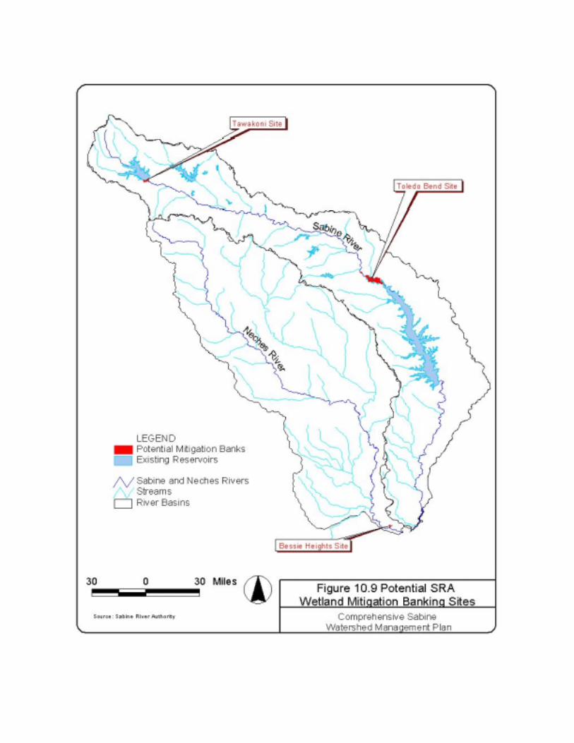
A screening study was performed to evaluate two areas in the Sabine Basin and one area
in the Neches Basin regarding the suitability for development as wetland mitigation banks. Data
were used to determine potential environmental and physical constraints to development of the
three sites as wetland mitigation banks. Site locations are shown on Figure 10.9. These banks
could be used by SRA to mitigate impacts of its actions to wetlands in the Sabine Basin.
The Toledo Bend Site is located upstream (north) of the northern reaches of Toledo Bend
Reservoir in Panola County and contains approximately 8,063 acres. The Tawakoni Site is
located downstream (south) of the Lake Tawakoni Dam in Rains and Van Zandt Counties and
contains approximately 1,140 acres. The Bessie Heights Site is located on the northeast side of
the Neches River in Orange County and contains approximately 400 acres. The SRA owns all
three sites.
Factors used in the screening of these sites included the quality and quantity of existing
wetlands, soil surveys and hydric soils list, degree of prior disturbance, frequency and duration
of flooding, vegetation cover type, size of the area, proximity to other wetlands or water bodies.
The Toledo Bend and Tawakoni sites are located primarily in the floodplain and
bottomlands of the Sabine River and are occupied by jurisdictional wetlands. Existing wetlands
at these sites are high quality wetlands that could not be improved easily and would not generate
substantial amounts of wetland credits above what they currently provide. For this reason, the
10-17
Sabine River Authority would not receive many wetland credits while incurring substantial costs
to develop most of these areas.
The Bessie Heights Site includes upland areas (and associated freshwater wetlands) that
developed when dredge spoil from the Neches River was deposited in diked disposal areas,
brackish wetlands along the estuary, and open water. The open water area is now part of the
estuary to the east of the site and is associated with the Bessie Heights Oil and Gas Field.
Construction of a mitigation bank on the spoil disposal areas of the Bessie Heights Site is
feasible only on the areas that are close to the elevation of the surrounding water. This may not
be desirable due to the difficulty of acquiring and permitting new spoil disposal areas. A
mitigation bank at the Bessie Heights Site would be suitable for mitigating impacts to brackish
marshes in the area, but not for mitigating impacts to bottomland hardwood forests elsewhere in
the Sabine River Basin. Mitigation bank credits must generally be used for similar habitats in the
same river Basin. Therefore, a wetland mitigation bank at Bessie Heights may not be very useful
to SRA.
Bottomland Hardwood Habitat (Floodplain)
Bottomland hardwood areas identified in the USFWS Bottomland Hardwood
Preservation Program (USFWS, 1984) were used as a screening tool for potential environmental
concerns at each proposed reservoir site. Other types of wildlife habitat may exist in the vicinity
of the proposed reservoirs, but these were not specifically addressed. Figure 10.10 illustrates the
proximity of the proposed reservoir sites to the USFWS-designated Priority 1 and Priority 2
bottomland hardwood areas.
Estimates of mitigation acreage and ratios for wildlife habitat losses were taken from
intensive studies of the Waters Bluff site (TPWD, 1998) and the Big Sandy and Carl L. Estes
sites (Frye & Curtis, 1990). Assessments of land cover and vegetation at these sites were
performed using remotely sensed data (thematic mapping imagery and aerial photography)
followed by agency field surveys. The quality of wildlife habitat at the Waters Bluff and the
Carl L. Estes sites was evaluated using the Wildlife Habitat Appraisal Procedure (WHAP) (Frye,
1986), while the Big Sandy site was evaluated using the Habitat Evaluation Procedure (HEP)
(USFWS, 1980). Habitat data for the remaining three reservoir sites (Carthage, Prairie Creek,
and State Highway 322) were not available at the time of this report. More detailed analyses
10-18
would be necessary to quantify available habitat and determine the extent of mitigation required
for site development.
Table 10.3 includes a summary of each of the recommended reservoir sites with respect
to the location of bottomland hardwood areas, wetland mitigation banks, known conservation
easements, and estimated acreage of similar habitat that may be required for mitigation of
impacts due to site development.
As evidenced by available information, four of the six proposed reservoir sites intersect
with at least one USFWS priority bottomland hardwood area. Detailed habitat assessments of
three of these sites (Waters Bluff, Big Sandy, and Carl L. Estes) have provided estimates of
mitigation requirements under different management regimes. Mitigation requirements for the
Carthage site were not available at the time of this report. Data identifying habitat at the Big
Sandy and Carl L. Estes sites were collected in 1980 and may not reflect current conditions.
Development of the Prairie Creek and State Highway 322 sites would not intersect any areas
identified in the USFWS program, but could potentially impact other important areas of wildlife
habitat. For specific sites targeted for development, updated habitat assessments should be
performed to determine mitigation requirements for current habitat conditions.
Based on USFWS priority areas, current mitigation banks, and known conservation
easements, development of the Waters Bluff site would impact the largest area and the greatest
number of sites. Thirty nine percent of the proposed site (20,350 acres) would impact seven
separate areas of concern, including two USFWS priority areas, four wetland mitigation banks,
and one USFWS National Wildlife Refuge protected through a conservation easement. The
extent of the proposed reservoir site and the high habitat quality assessed in 1997 (TPWD, 1998),
combine to influence the mitigation requirements. The TPWD determined that between 141,575
and 566,039 acres of similar habitat would be required to mitigate the entire reservoir, depending
on the intensity of the habitat management employed at the mitigation site. This acreage
corresponds to mitigation ratios of between 4.5:1 and 18:1. According to the TPWD report, it is
uncertain whether one or even several tracts could be found that could satisfactorily meet the
mitigation requirements set forth for development of the Waters Bluff site. The significant
mitigation requirement and a relatively great number of protected and priority areas would
provide significant obstacles to development of the Waters Bluff site.
10-19
Table 10.3 Priority and Protected Areas Located at Proposed Reservoir Sites and Estimated Mitigation
Proposed Reservoirs USFWS Priority Areas, Mitigation Banks, and Protected Areas Located in the Proposed Reservoir Site
Estimated Acreage Required for Mitigation of Site Development
Name of Reservoir
Total Area (acres)
Name of Priority/Protected Areas Acres Impacted
Percent of Proposed Reservoir
Site
Minimum Management
Moderate Management
Maximum Management
Big Sandy 5,460 Upper Big Sandy Creek & Glade (P2) Lower Big Sandy Creek (P2)
640 2,168
52 21,344 (M1) 10,716 (M1) 5,359 (M1)
Waters Bluff 29,598 Lower Big Sandy Creek (P2) Middle Sabine Bottom (P1) Little Sandy National Wildlife Refuge Anderson Tract Mitigation Project Hawkins Mitigation Bank Klamm Mitigation Bank Byrd Tract Mitigation Bank
817 8,885 3,802 4,937 175
1,251 483
39 566,039 (M2) 283,150 (M2) 141,575 (M2)
Carthage 37,781 Lower Sabine Bottom (P1) 10,371 27 undetermined undetermined undetermined
Carl L. Estes 29,824 Upper Sabine Bottom (P2) 4,659 16 146,705 (M1) 73,363 (M1) 36,681 (M1)
Prairie Creek 2,280 none n/a n/a undetermined undetermined undetermined
State Highway 322
6,510 none n/a n/a undetermined undetermined undetermined
P1 = USFWS Priority 1 Bottomland Hardwood Area M1 = Mitigation requirements from Frye & Curtis, 1990
P2 = USFWS Priority 2 Bottomland Hardwood Area M2 = Mitigation requirements from TPWD, 1998
n/a = not applicable
10-20
Approximately 16 percent of the Carl L. Estes site is located on 4,659 acres of the Upper
Sabine Bottom. A 1986 assessment of the Carl L. Estes site (TPWD, 1990) indicates that
between 36,681 acres and 146,705 acres of similar habitat would be required to mitigate for the
entire reservoir, depending on the level of management employed at the mitigation site. This
corresponds to mitigation ratios ranging from 1.7:1 to 6.9:1. The same report used a 1980
assessment of the Big Sandy site to determine that between 5,359 and 21,344 acres would be
required for mitigation of the entire reservoir (corresponding to a mitigation ratio range of 1.2:1
to 4.8:1). Approximately 52 percent of the Big Sandy site is located on 2,808 acres of the Upper
Big Sandy Creek & Glade and the Lower Big Sandy Creek, USFWS priority bottomland
hardwood areas.
The Carthage site is also located in an area identified in the USFWS program, with
approximately 27 percent of the site located in the Lower Sabine Bottom. No previous
assessments of the extent or quality of wildlife habitat have been performed for this site,
therefore no estimates of mitigation requirements have been established.
Available data indicate that the Prairie Creek and State Highway 322 sites would not
impact any USFWS priority areas, wetland mitigation banks, or known conservation easements.
In the absence of habitat assessment data, it is not possible to estimate potential mitigation
requirements for development of either of these sites.
Floodplain Hydrology
Reservoir construction results in the replacement of terrestrial and stream habitat with
deep water habitat. Shallow water habitat area is increased along the perimeter of the reservoir
and by the backwater effects along rivers and other tributaries. As an example, Toledo Bend
Reservoir created approximately 1,200 miles of shoreline habitat. The effects of reservoirs on
downstream floodplain hydrology and habitat are not as easily stated. Changes in the frequency
and duration of downstream flood events may be expected after reservoir development. The
degree of impact to floodplain hydrology and corresponding changes in vegetation, including
bottomland hardwood forests, are determined by the magnitude and timing of releases from
upstream reservoirs and the contribution of uncontrolled runoff from portions of the watershed
below the reservoir.
10-21
10.2.4 Recommendations for New Reservoir Development
Development of a new reservoir takes considerable time and effort to avoid, minimize,
and/or mitigate adverse environmental impacts so that the required permits and regulatory
approvals are obtained. Therefore, a reservoir site with as few environmental concerns as
practical should be selected.
Important environmental issues identified for the proposed reservoir sites include the
following:
• = actual or potential presence of threatened or endangered species, and
• = presence of high value or protected lands such as wetlands, riparian bottomland
hardwood forests, conservation easements, and mitigation banks.
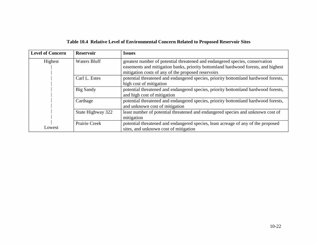
These factors were used to rank the six proposed reservoir sites on a relative scale to
provide an indication of environmental acceptability. Table 10.4 shows the relative level of
environmental concern and the issues behind these concerns. Development of the Prairie Creek
or State Highway 322 sites would provide the least impact to threatened and endangered species,
existing mitigation banks and conservation easements, and identified bottomland hardwood
forests. Although mitigation requirements have not been established for these sites, they would
potentially incur less mitigation costs because of their relatively small acreage and fewer
environmental concerns.
In addition to considerations for construction and permitting issues, plans for
development of new reservoirs should include a strategy for reducing impacts to downstream
hydrology and floodplain vegetation due to reservoir operations. To determine these potential
impacts, data about the quality and quantity of existing communities and corresponding
hydrologic requirements would need to be collected.
It is strongly recommended that new studies of floodplain vegetation and wildlife within
the Sabine Basin be conducted. More current estimates of the quality, extent, and economic
value of bottomland hardwood areas and threatened and endangered species, would play an
important role in future planning activities of SRA.
10-22
Table 10.4 Relative Level of Environmental Concern Related to Proposed Reservoir Sites
Level of Concern Reservoir Issues
Waters Bluff greatest number of potential threatened and endangered species, conservation easements and mitigation banks, priority bottomland hardwood forests, and highest mitigation costs of any of the proposed reservoirs
Carl L. Estes potential threatened and endangered species, priority bottomland hardwood forests, high cost of mitigation
Big Sandy potential threatened and endangered species, priority bottomland hardwood forests, and high cost of mitigation
Carthage potential threatened and endangered species, priority bottomland hardwood forests, and unknown cost of mitigation
State Highway 322 least number of potential threatened and endangered species and unknown cost of mitigation
Highest | | | | | | | | | | |
Lowest Prairie Creek potential threatened and endangered species, least acreage of any of the proposed
sites, and unknown cost of mitigation