Embed Size (px)
Citation preview
11
Processing Data
Dr. Miguel A. Labrador
Department of Computer Science & Engineering
http://www.csee.usf.edu/~labrador
2Copyright© Dr. Miguel A. Labrador
2Copyright© Dr. Miguel A. Labrador
2
Outline
• Mobile Device-side Processing• Server-side Processing
3Copyright© Dr. Miguel A. Labrador
3Copyright© Dr. Miguel A. Labrador
3
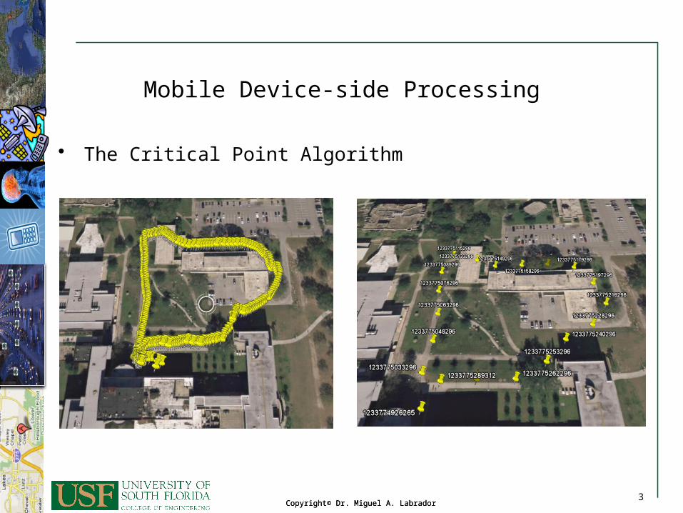
Mobile Device-side Processing
• The Critical Point Algorithm
4Copyright© Dr. Miguel A. Labrador
4Copyright© Dr. Miguel A. Labrador
4
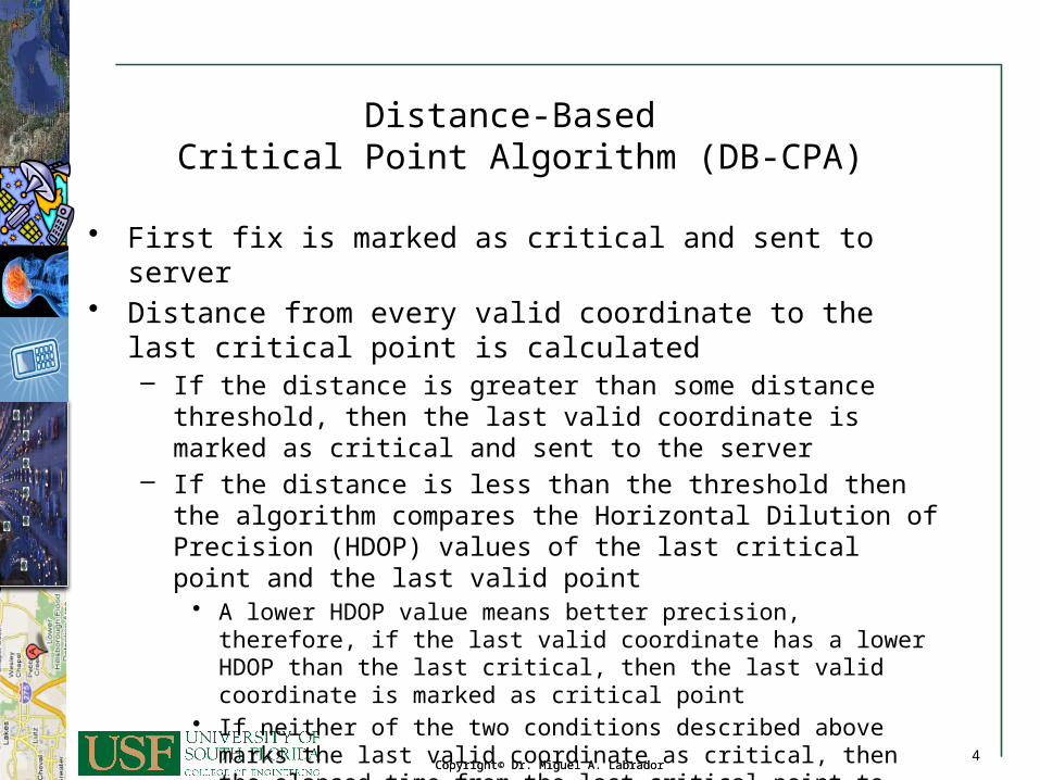
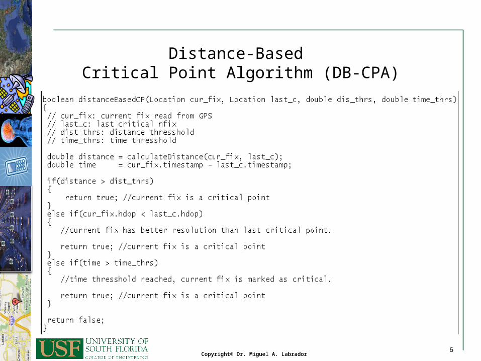
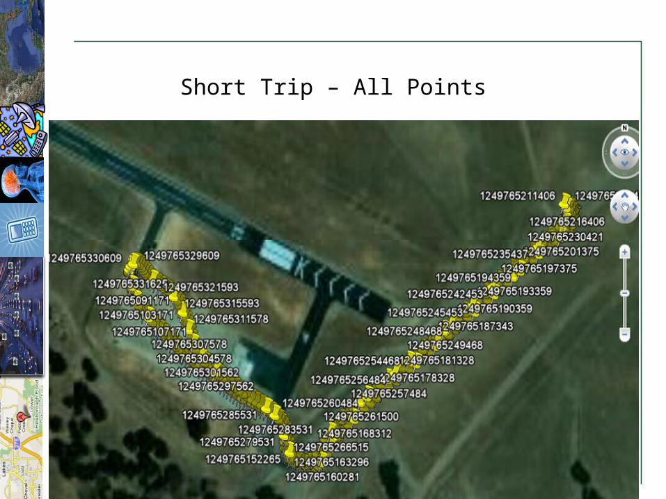
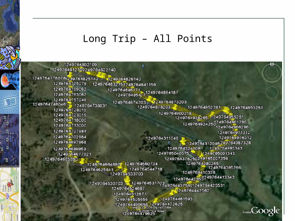
Distance-Based Critical Point Algorithm (DB-CPA)
• First fix is marked as critical and sent to server• Distance from every valid coordinate to the last critical point is
calculated– If the distance is greater than some distance threshold, then the
last valid coordinate is marked as critical and sent to the server– If the distance is less than the threshold then the algorithm
compares the Horizontal Dilution of Precision (HDOP) values of the last critical point and the last valid point
• A lower HDOP value means better precision, therefore, if the last valid coordinate has a lower HDOP than the last critical, then the last valid coordinate is marked as critical point
• If neither of the two conditions described above marks the last valid coordinate as critical, then the elapsed time from the last critical point to this last valid coordinate is calculated. If the elapsed time is greater than a time threshold, then the last valid coordinate is marked as critical
5Copyright© Dr. Miguel A. Labrador
5Copyright© Dr. Miguel A. Labrador
5
Distance-Based Critical Point Algorithm (DB-CPA)
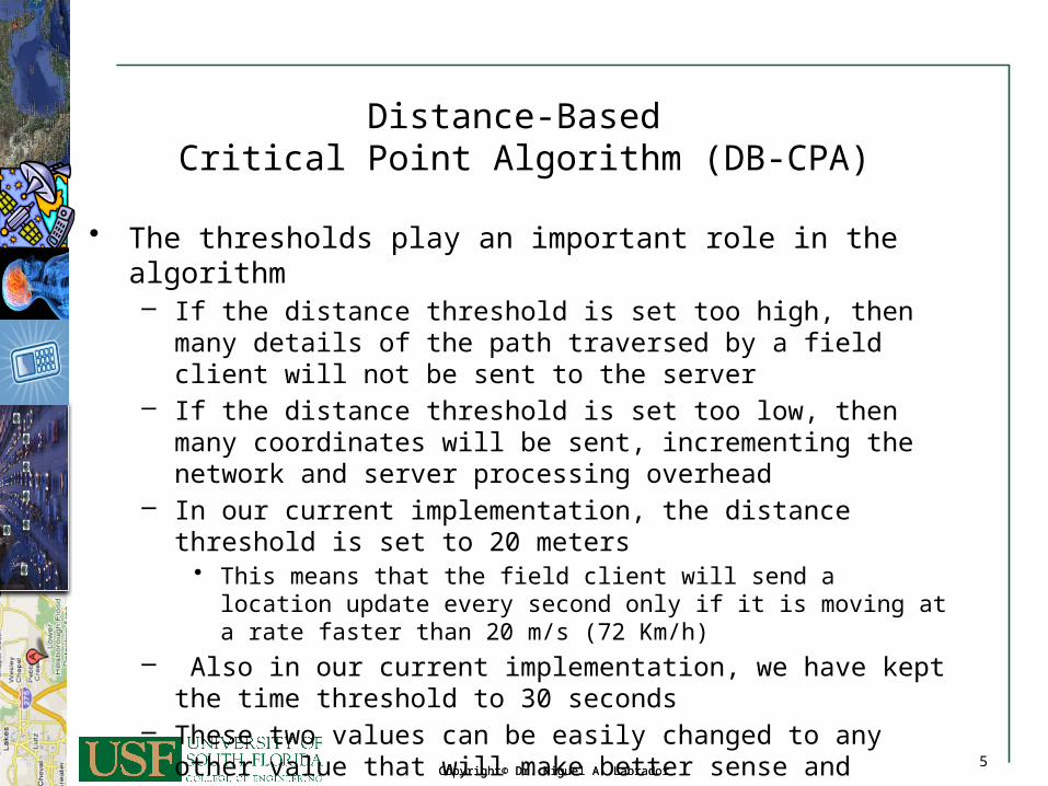
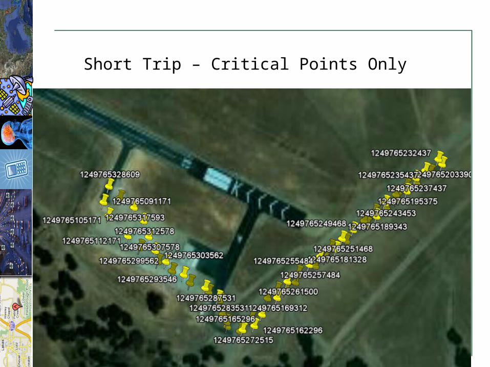
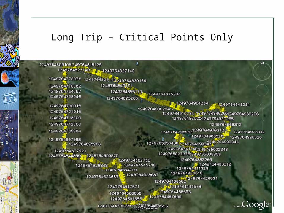
• The thresholds play an important role in the algorithm– If the distance threshold is set too high, then many details of the
path traversed by a field client will not be sent to the server– If the distance threshold is set too low, then many coordinates will
be sent, incrementing the network and server processing overhead– In our current implementation, the distance threshold is set to 20
meters• This means that the field client will send a location update every
second only if it is moving at a rate faster than 20 m/s (72 Km/h)– Also in our current implementation, we have kept the time
threshold to 30 seconds– These two values can be easily changed to any other value that will
make better sense and provide better performance to the system according to the tracking application.
6Copyright© Dr. Miguel A. Labrador
6Copyright© Dr. Miguel A. Labrador
6
Distance-Based Critical Point Algorithm (DB-CPA)
7Copyright© Dr. Miguel A. Labrador
7Copyright© Dr. Miguel A. Labrador
7
Short Trip – All Points
8Copyright© Dr. Miguel A. Labrador
8Copyright© Dr. Miguel A. Labrador
8
Short Trip – Critical Points Only
9Copyright© Dr. Miguel A. Labrador
9Copyright© Dr. Miguel A. Labrador
9
Long Trip – All Points
10Copyright© Dr. Miguel A. Labrador
10Copyright© Dr. Miguel A. Labrador
10
Long Trip – Critical Points Only
11Copyright© Dr. Miguel A. Labrador
11Copyright© Dr. Miguel A. Labrador
11
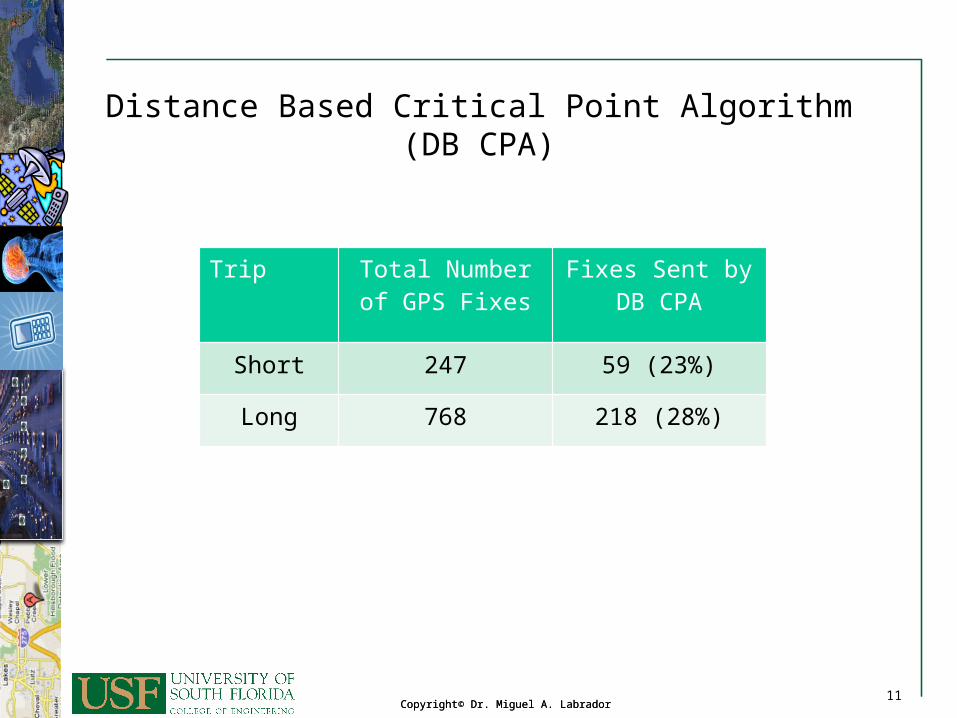
Distance Based Critical Point Algorithm(DB CPA)
Trip Total Number of GPS Fixes
Fixes Sent by DB CPA
Short 247 59 (23%)
Long 768 218 (28%)
12Copyright© Dr. Miguel A. Labrador
12Copyright© Dr. Miguel A. Labrador
12
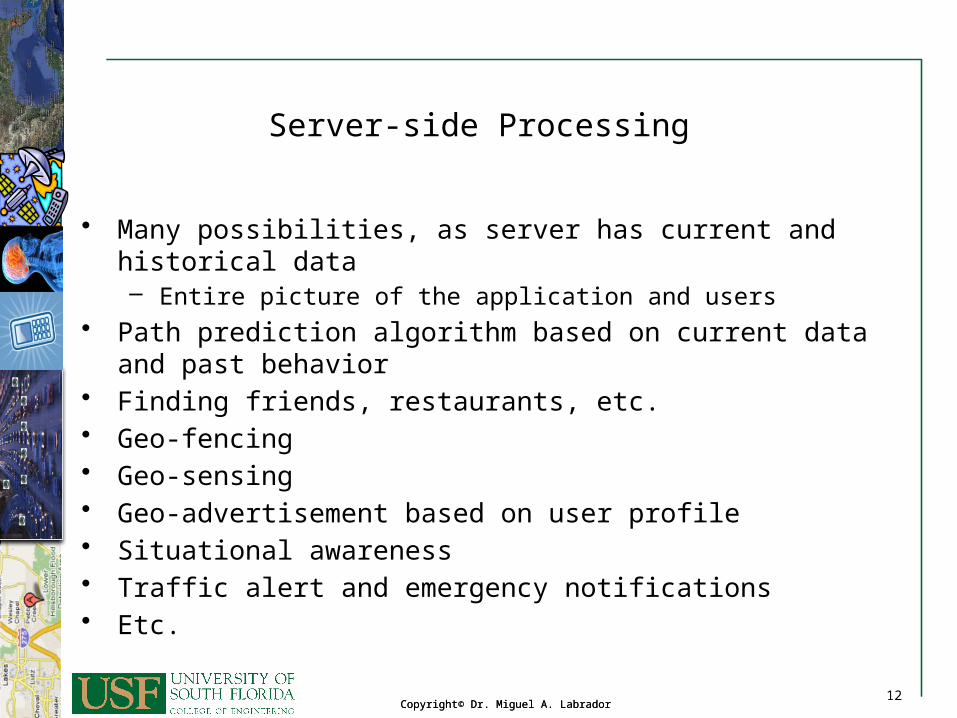
Server-side Processing
• Many possibilities, as server has current and historical data– Entire picture of the application and users
• Path prediction algorithm based on current data and past behavior
• Finding friends, restaurants, etc. • Geo-fencing• Geo-sensing• Geo-advertisement based on user profile• Situational awareness• Traffic alert and emergency notifications• Etc.
13Copyright© Dr. Miguel A. Labrador
13Copyright© Dr. Miguel A. Labrador
13
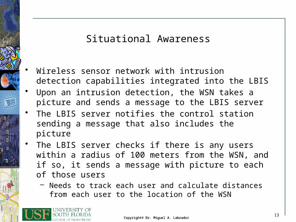
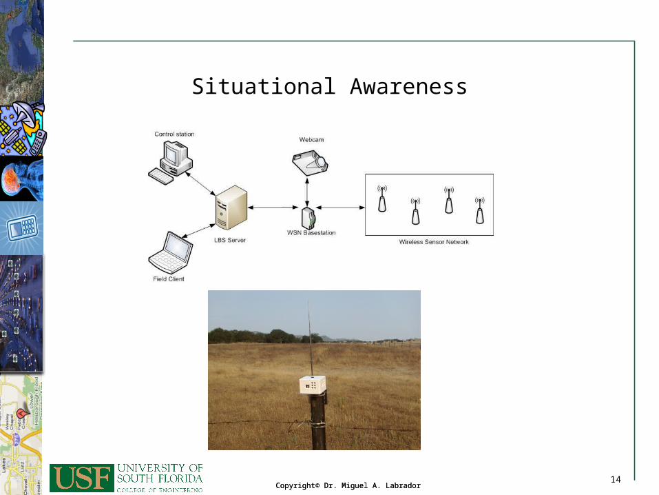
Situational Awareness
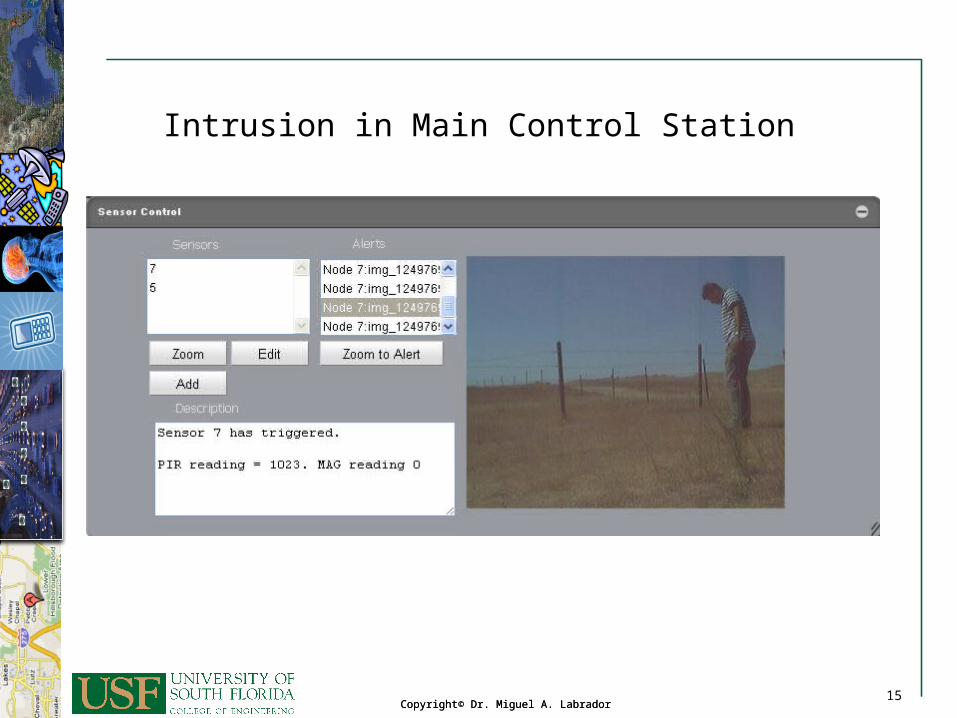
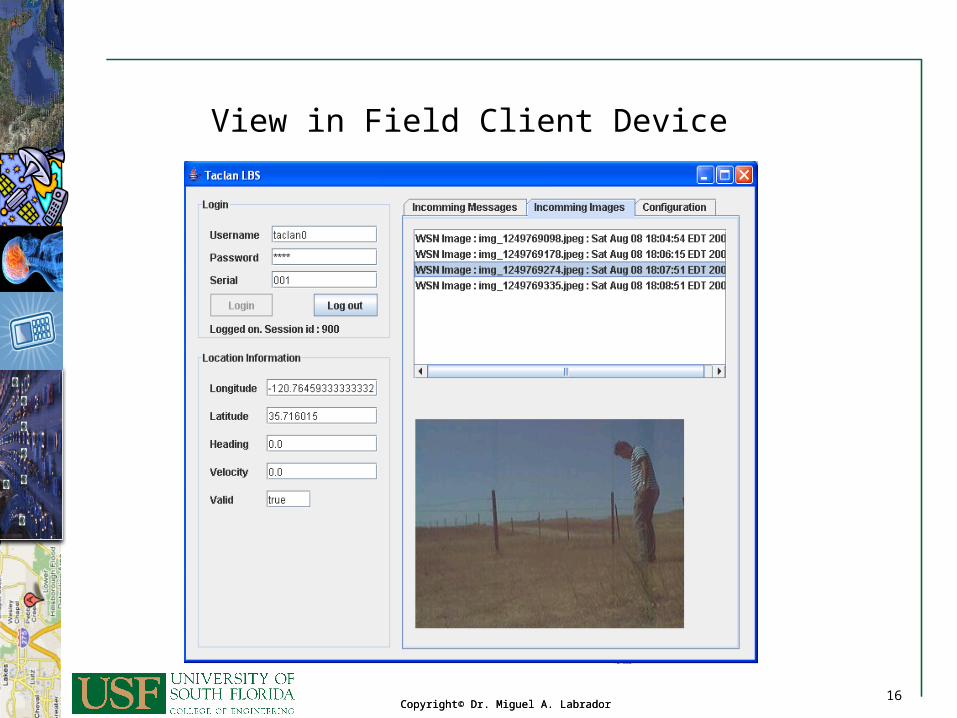
• Wireless sensor network with intrusion detection capabilities integrated into the LBIS
• Upon an intrusion detection, the WSN takes a picture and sends a message to the LBIS server
• The LBIS server notifies the control station sending a message that also includes the picture
• The LBIS server checks if there is any users within a radius of 100 meters from the WSN, and if so, it sends a message with picture to each of those users– Needs to track each user and calculate distances from each user to
the location of the WSN
14Copyright© Dr. Miguel A. Labrador
14Copyright© Dr. Miguel A. Labrador
14
Situational Awareness
15Copyright© Dr. Miguel A. Labrador
15Copyright© Dr. Miguel A. Labrador
15
Intrusion in Main Control Station
16Copyright© Dr. Miguel A. Labrador
16Copyright© Dr. Miguel A. Labrador
16
View in Field Client Device
17Copyright© Dr. Miguel A. Labrador
17Copyright© Dr. Miguel A. Labrador
17
Calculating the Distance Between Two Users
• In order to send notifications, the server needs to calculate the distance between the WSN and the individual active users
• If distance is less than threshold (100 meters), then server sends a notification message to the user– Otherwise, the user is not notified
• PostGIS has functions that make those calculations for you– ST_distance_sphere returns minimum distance in meters between
two lon/lat geometries• This function currently does not look at the SRID of a geometry and will
always assume its in WGS 84
18Copyright© Dr. Miguel A. Labrador
18Copyright© Dr. Miguel A. Labrador
18
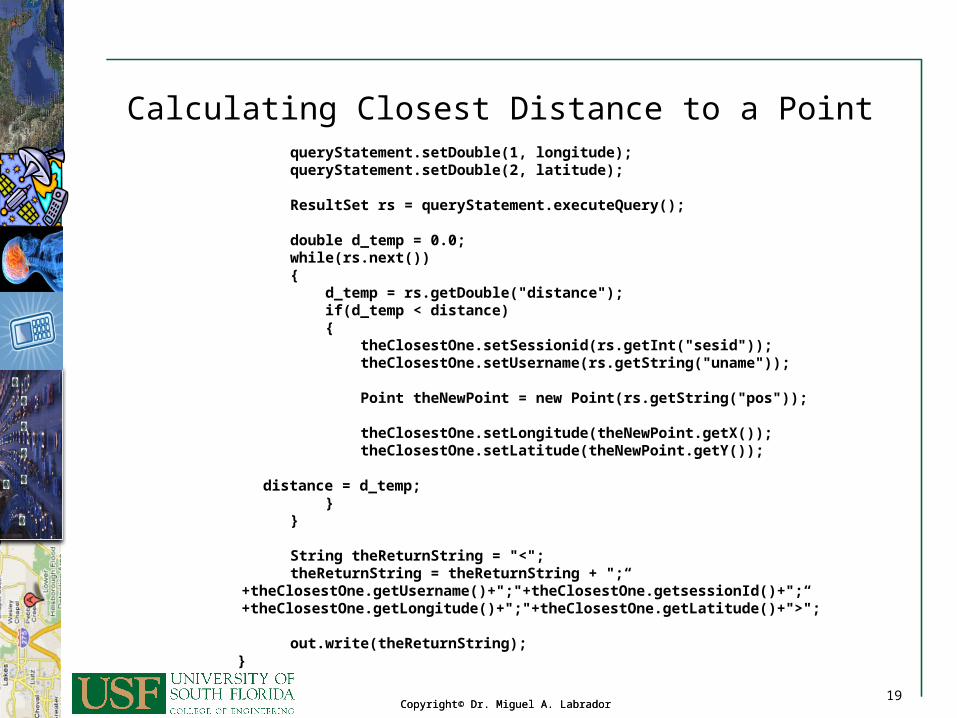
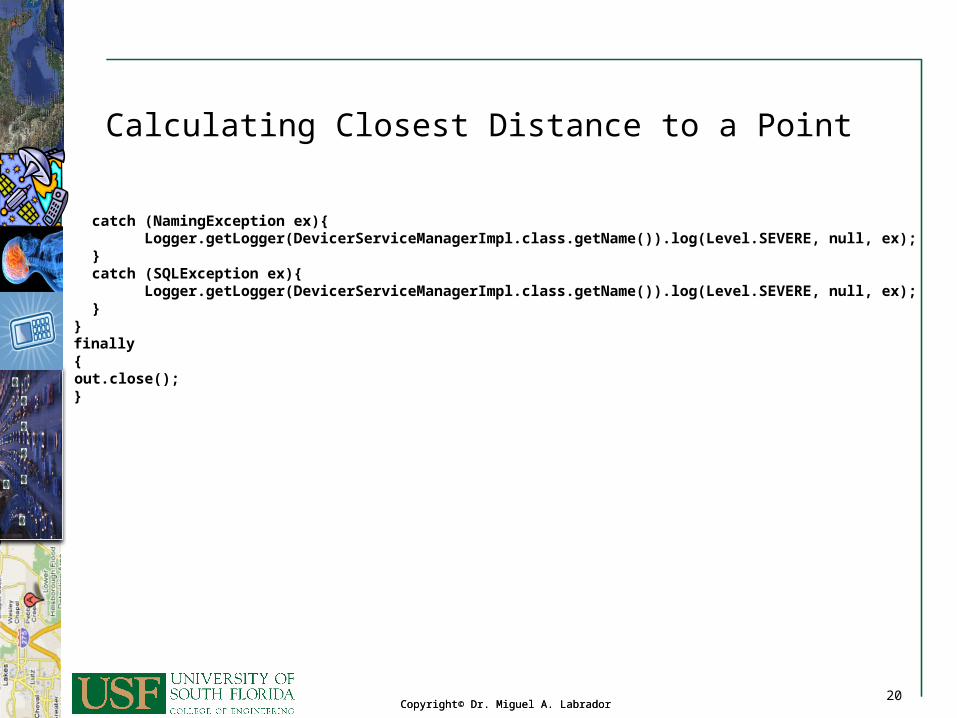
Calculating Closest Distance to a Point
double distance = Double.MAX_VALUE; TrackingUpdate theClosestOne = new TrackingUpdate(); try { try{ javax.naming.InitialContext ic = new javax.naming.InitialContext(); javax.sql.DataSource dataSource = (javax.sql.DataSource)ic.lookup("jdbc/lbsbook"); Connection theConnection = dataSource.getConnection(); double latitude = Double.parseDouble(request.getParameter("lat")); double longitude = Double.parseDouble(request.getParameter("lng")); PreparedStatement queryStatement =
theConnection.prepareStatement("select fieldsession.sessionid as sesid, fielduser.username as uname, ST_AsText(tracking.position) as pos,
ST_distance_sphere(tracking.position, ST_GeomFromText('POINT(? ?)', 32661)) as distance"+“ from fieldsession, tracking,fielduser, select max(idtracking) as idtrack"+"from fieldsession, tracking"+"where fieldsession.datestop is NULL and fieldsession.sessionid = tracking.sessionid“+"group by fieldsession.sessionid) as s2“+"where fieldsession.datestop is NULL and“+"fieldsession.sessionid = tracking.sessionid and“+"tracking.idtracking = s2.idtrack and“+"fieldsession.iduser = fielduser.iduser”);
19Copyright© Dr. Miguel A. Labrador
19Copyright© Dr. Miguel A. Labrador
19
Calculating Closest Distance to a Point queryStatement.setDouble(1, longitude); queryStatement.setDouble(2, latitude); ResultSet rs = queryStatement.executeQuery(); double d_temp = 0.0; while(rs.next()) { d_temp = rs.getDouble("distance"); if(d_temp < distance) { theClosestOne.setSessionid(rs.getInt("sesid")); theClosestOne.setUsername(rs.getString("uname")); Point theNewPoint = new Point(rs.getString("pos")); theClosestOne.setLongitude(theNewPoint.getX()); theClosestOne.setLatitude(theNewPoint.getY());
distance = d_temp;
} } String theReturnString = "<"; theReturnString = theReturnString + ";“
+theClosestOne.getUsername()+";"+theClosestOne.getsessionId()+";“ +theClosestOne.getLongitude()+";"+theClosestOne.getLatitude()+">";
out.write(theReturnString); }
20Copyright© Dr. Miguel A. Labrador
20Copyright© Dr. Miguel A. Labrador
20
Calculating Closest Distance to a Point
catch (NamingException ex){ Logger.getLogger(DevicerServiceManagerImpl.class.getName()).log(Level.SEVERE, null, ex); } catch (SQLException ex){ Logger.getLogger(DevicerServiceManagerImpl.class.getName()).log(Level.SEVERE, null, ex); } } finally { out.close(); }