Embed Size (px)
Citation preview
2008 Burning Man Stipulation Monitoring Report
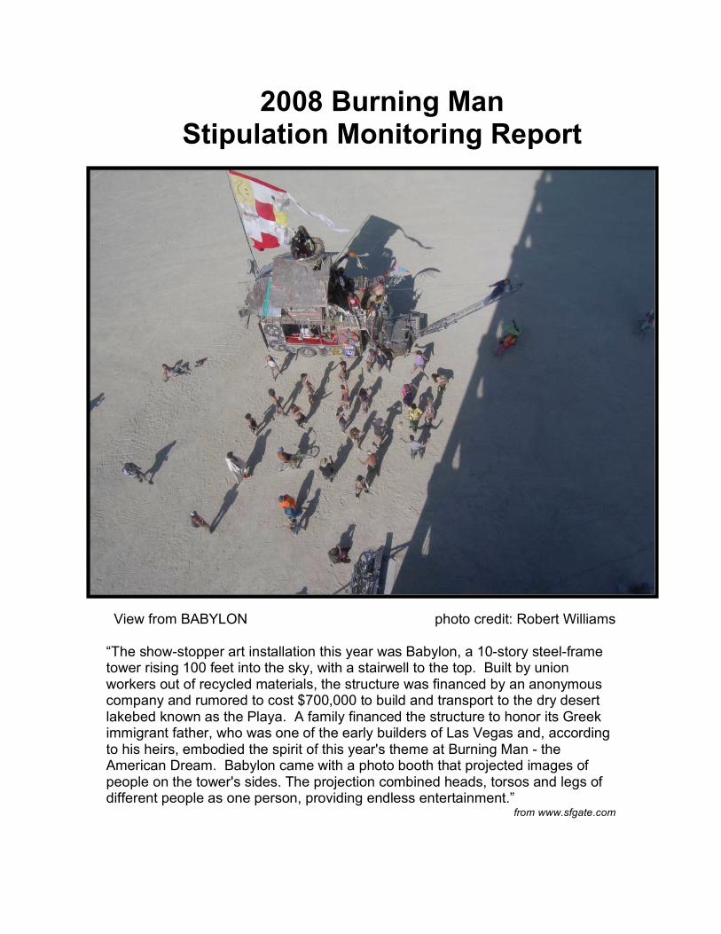
View from BABYLON photo credit: Robert Williams “The show-stopper art installation this year was Babylon, a 10-story steel-frame tower rising 100 feet into the sky, with a stairwell to the top. Built by union workers out of recycled materials, the structure was financed by an anonymous company and rumored to cost $700,000 to build and transport to the dry desert lakebed known as the Playa. A family financed the structure to honor its Greek immigrant father, who was one of the early builders of Las Vegas and, according to his heirs, embodied the spirit of this year's theme at Burning Man - the American Dream. Babylon came with a photo booth that projected images of people on the tower's sides. The projection combined heads, torsos and legs of different people as one person, providing endless entertainment.”
from www.sfgate.com


Report prepared for
Bureau of Land Management Winnemucca District Office 5100 E. Winnemucca Boulevard Winnemucca, Nevada 89445 775-623-1500
Report prepared by
Laura M. Levy Integrated Mapping Strategies
Winnemucca, Nevada 89445 [email protected]
PAGE 4 OF 113 BM08 STIPULATION MONITORING REPORT
CONTENTS
I. Executive Summary………………………..…………..……..5
A. Introduction
B. Results for BM 2008
C. Recommendations for Monitoring BM 2009
D. Completed Studies
II. The Studies..………..……………………….….…………..10
For each -
A. Goal
B. Stipulation
C. Method
D. Data
E. Results
F. Recommendations
III. Exploring Cumulative Effects………..……………….…...85
A. Observations
B. Discussion
C. Recommendations
IV. Technical Note..……………………………………….….101
V. The Monitoring Team…………………………..…………111
PAGE 5 OF 113 BM08 STIPULATION MONITORING REPORT
I. EXECUTIVE SUMMARY
A. INTRODUCTION
Background
The Burning Man event was first held on the Black Rock Desert in 1990 and has
continued since annually. The combination art festival, social event, and
experiment in community living starts on Monday before Labor Day and runs for 8
days. Burning Man is the largest permitted event on public lands for any US
federal agency. Since 1990, the event participation has increased from a few
hundred participants to almost 50,000. The Winnemucca BLM Field Office
received a Special Recreation Permit application from Black Rock City LLC for the
Burning Man event for 2006 through 2010. The potential impacts of the event
were analyzed and an Environmental Assessment (EA) was issued with stipulated
terms to ensure both visitor safety and resource protection. In recent years,
permit fees paid to BLM approached $1,000,000. Given the nature of event
activities and the fees involved, Burning Man commands much public visibility. It is
critical that BLM closely monitor and document compliance with the event permit.
Project scope
• Monitor stipulations during the event
• Communicate team data and results of efforts at BM08
• Make recommendations for monitoring at BM09
Report goals
Provide managers with knowledge necessary to:
• Determine if permit stipulations were adequately met
• Modify stipulations as needed for next year’s event
• Incorporate similar stipulations for other permitted events
• Adopt these monitoring methodologies for other permitted events
PAGE 6 OF 113 BM08 STIPULATION MONITORING REPORT
B. RESULTS FOR BM08
During the event
Black Rock citizens are a self-patrolling community not shy about pointing out to
their neighbor behaviors that might challenge or bend accepted policies. All wish
to be welcomed back next year by the Burning Man LLC and BLM alike. During
the event most violations were minimal and easily resolved. Most concerns
involved greywater. These were usually minor leaks in evaporative pools rather
than outright violations.
Nearing the end of event
As the event neared Exodus, the most common violation was the trash left behind
by many camps. These violations were resolved by the Burning Man Department
of Public Works (DPW) clean-up crews, who spend almost a full month on the
playa cleaning up after the week-long party.
Six-weeks after event
In October, members of the Team returned to revisit concern areas of concern.
It was good to see that:
• All sites were cleaned to high standard.
• A repeat occurrence of the orange discoloration left from the gravel used in
burn pads in 2007 was not seen this year.
• Most stipulations appeared to have been met.
Most violations and concerns were resolved six weeks after the event. Noted
concerns were:
• Gravel was found beneath the burn pad of every art project and community
burn barrels.
• The orange discolorations at every burn pad documented in the 2007
Monitoring Report still remain on the playa with no evidence of fading.
PAGE 7 OF 113 BM08 STIPULATION MONITORING REPORT
C. RECOMMENDATIONS FOR BM09
The Monitoring Team recommends:
• Continuing the majority of the studies completed in 2008
• Continuing to improve methodologies based on the lessons learned
and emerging technologies
• Shifting focus of future efforts on exploring cumulative impacts
PAGE 8 OF 113 BM08 STIPULATION MONITORING REPORT
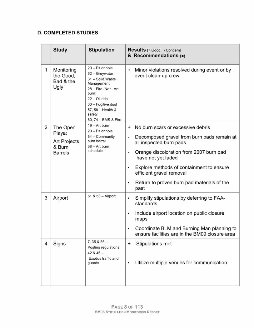
D. COMPLETED STUDIES
Study Stipulation
Results [+ Good, - Concern]
& Recommendations (
)
1 Monitoring the Good, Bad & the Ugly
20 – Pit or hole
62 – Greywater
31 – Solid Waste Management
28 – Fire (Non- Art burn)
22 – Oil drip
30 – Fugitive dust
57, 58 – Health & safety
60, 74 – EMS & Fire
+ Minor violations resolved during event or by event clean-up crew
2 The Open Playa:
Art Projects & Burn Barrels
19 – Art burn
20 – Pit or hole
64 – Community burn barrel
68 – Art burn schedule
+ No burn scars or excessive debris
- Decomposed gravel from burn pads remain at all inspected burn pads
- Orange discoloration from 2007 burn pad have not yet faded
• Explore methods of containment to ensure efficient gravel removal
• Return to proven burn pad materials of the past
3 Airport 51 & 53 – Airport • Simplify stipulations by deferring to FAA-
standards
• Include airport location on public closure maps
• Coordinate BLM and Burning Man planning to ensure facilities are in the BM09 closure area
4 Signs 7, 35 & 56 –
Posting regulations
42 & 46 –
Exodus traffic and guards
+ Stipulations met
• Utilize multiple venues for communication
PAGE 9 OF 113 BM08 STIPULATION MONITORING REPORT
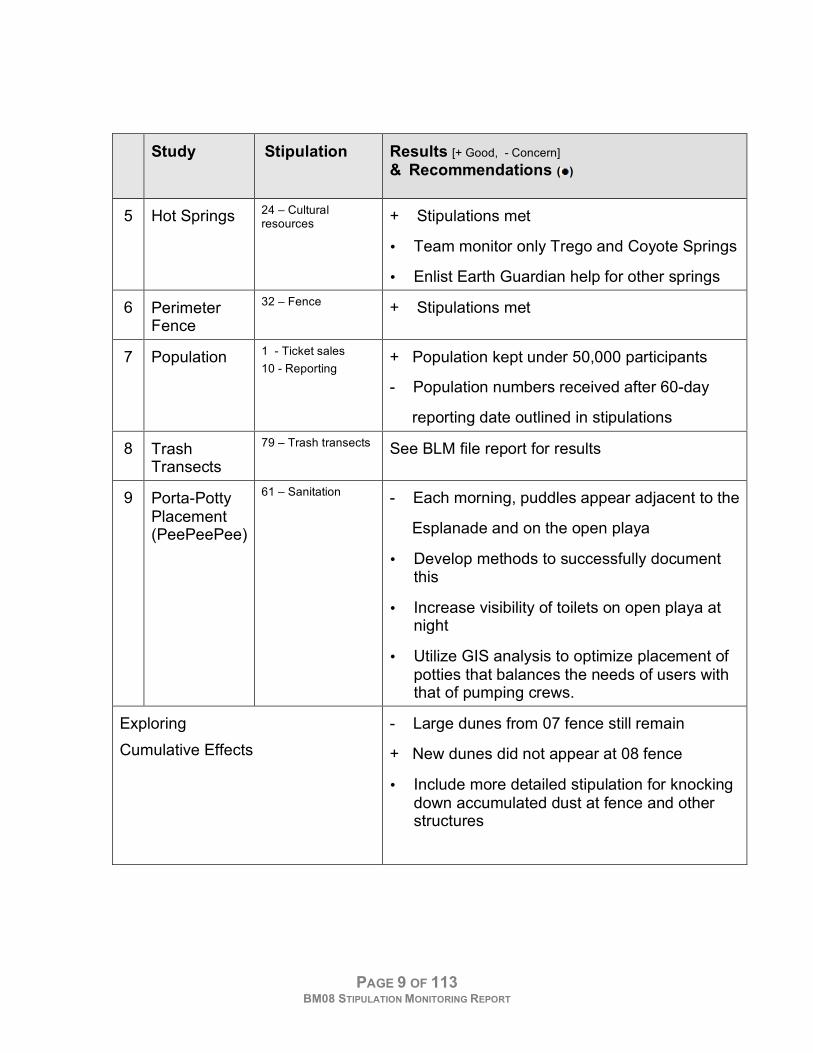
Study Stipulation
Results [+ Good, - Concern]
& Recommendations (
)
5 Hot Springs 24 – Cultural resources
+ Stipulations met
• Team monitor only Trego and Coyote Springs
• Enlist Earth Guardian help for other springs
6 Perimeter Fence
32 – Fence + Stipulations met
7 Population 1 - Ticket sales
10 - Reporting + Population kept under 50,000 participants
- Population numbers received after 60-day
reporting date outlined in stipulations
8 Trash Transects
79 – Trash transects See BLM file report for results
9 Porta-Potty Placement (PeePeePee)
61 – Sanitation - Each morning, puddles appear adjacent to the
Esplanade and on the open playa
• Develop methods to successfully document this
• Increase visibility of toilets on open playa at night
• Utilize GIS analysis to optimize placement of potties that balances the needs of users with that of pumping crews.
Exploring
Cumulative Effects
- Large dunes from 07 fence still remain
+ New dunes did not appear at 08 fence
• Include more detailed stipulation for knocking down accumulated dust at fence and other structures
PAGE 10 OF 113 BM08 STIPULATION MONITORING REPORT
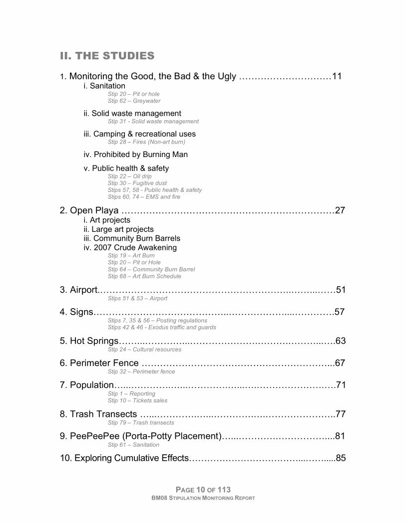
II. THE STUDIES
1. Monitoring the Good, the Bad & the Ugly …………………………11 i. Sanitation
Stip 20 – Pit or hole Stip 62 – Greywater
ii. Solid waste management Stip 31 - Solid waste management
iii. Camping & recreational uses
Stip 28 – Fires (Non-art burn)
iv. Prohibited by Burning Man
v. Public health & safety
Stip 22 – Oil drip Stip 30 – Fugitive dust Stips 57, 58 - Public health & safety Stips 60, 74 – EMS and fire
2. Open Playa ……………………………………………………………27 i. Art projects ii. Large art projects iii. Community Burn Barrels iv. 2007 Crude Awakening
Stip 19 – Art Burn Stip 20 – Pit or Hole
Stip 64 – Community Burn Barrel Stip 68 – Art Burn Schedule
3. Airport.……………………………………………………..……...……51 Stips 51 & 53 – Airport
4. Signs……………………………………..………………....………….57 Stips 7, 35 & 56 – Posting regulations Stips 42 & 46 - Exodus traffic and guards
5. Hot Springs……...…………...………………….……….………...….63 Stip 24 – Cultural resources
6. Perimeter Fence ……………………………………………………...67 Stip 32 – Perimeter fence
7. Population…...………….…...………….…...….………………….….71 Stip 1 – Reporting Stip 10 – Tickets sales
8. Trash Transects …...………….…...………….….…………………..77 Stip 79 – Trash transects
9. PeePeePee (Porta-Potty Placement)…...………….……………....81 Stip 61 – Sanitation
10. Exploring Cumulative Effects………………………………...…….....85
PAGE 11 OF 113 BM08 STIPULATION MONITORING REPORT
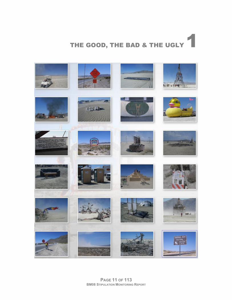
THE GOOD, THE BAD & THE UGLY 1
STUDY 1
THE GOOD, THE BAD & THE UGLY
PAGE 12 OF 113 BM08 STIPULATION MONITORING REPORT
A. GOAL
Survey the residential blocks for ‘Good, Bad and Ugly’ incidents of various
stipulations. To resolve any outstanding issues as needed during the event, maps
and photos were distributed to team members for re-inspection.
B. STIPULATIONS
These are listed in results sections i - v.
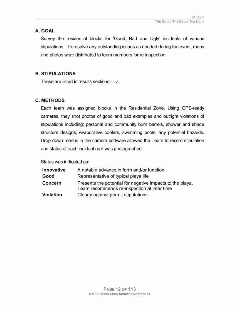
C. METHODS
Each team was assigned blocks in the Residential Zone. Using GPS-ready
cameras, they shot photos of good and bad examples and outright violations of
stipulations including: personal and community burn barrels, shower and shade
structure designs, evaporative coolers, swimming pools, any potential hazards.
Drop down menus in the camera software allowed the Team to record stipulation
and status of each incident as it was photographed.
Status was indicated as:
Innovative A notable advance in form and/or function
Good Representative of typical playa life
Concern Presents the potential for negative impacts to the playa. Team recommends re-inspection at later time
Violation Clearly against permit stipulations
STUDY 1
THE GOOD, THE BAD & THE UGLY
PAGE 13 OF 113 BM08 STIPULATION MONITORING REPORT
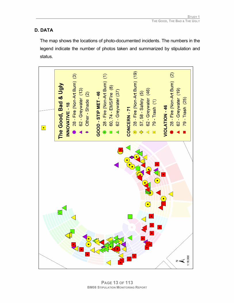
D. DATA
The map shows the locations of photo-documented incidents. The numbers in the
legend indicate the number of photos taken and summarized by stipulation and
status.
STUDY 1
THE GOOD, THE BAD & THE UGLY
PAGE 14 OF 113 BM08 STIPULATION MONITORING REPORT
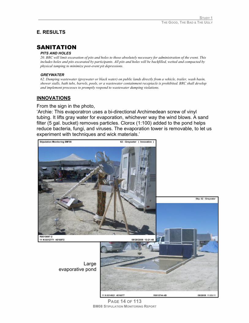
E. RESULTS
SANITATION
PITS AND HOLES
20. BRC will limit excavation of pits and holes to those absolutely necessary for administration of the event. This
includes holes and pits excavated by participants. All pits and holes will be backfilled, wetted and compacted by
physical tamping to minimize post-event pit depressions.
GREYWATER
62. Dumping wastewater (greywater or black water) on public lands directly from a vehicle, trailer, wash basin,
shower stalls, bath tubs, barrels, pools, or a wastewater containment receptacle is prohibited. BRC shall develop
and implement processes to promptly respond to wastewater dumping violations. INNOVATIONS
From the sign in the photo, ‘Archie: This evaporatron uses a bi-directional Archimedean screw of vinyl tubing. It lifts gray water for evaporation, whichever way the wind blows. A sand filter (5 gal. bucket) removes particles. Clorox (1:100) added to the pond helps reduce bacteria, fungi, and viruses. The evaporation tower is removable, to let us experiment with techniques and wick materials.’
Large evaporative pond
STUDY 1
THE GOOD, THE BAD & THE UGLY
PAGE 15 OF 113 BM08 STIPULATION MONITORING REPORT
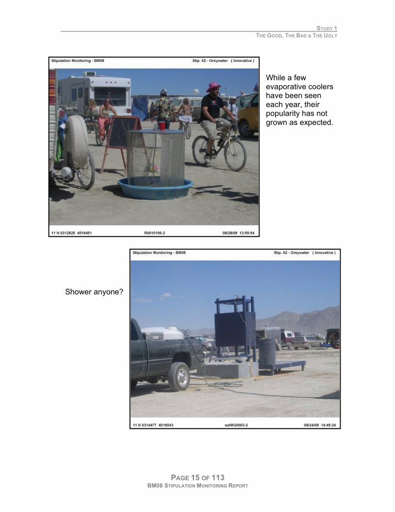
While a few evaporative coolers have been seen each year, their popularity has not grown as expected.
Shower anyone?
STUDY 1
THE GOOD, THE BAD & THE UGLY
PAGE 16 OF 113 BM08 STIPULATION MONITORING REPORT
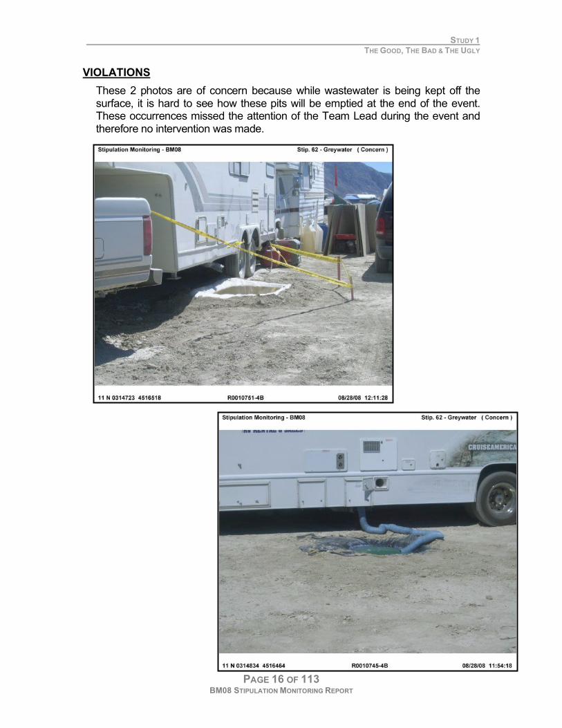
VIOLATIONS
These 2 photos are of concern because while wastewater is being kept off the surface, it is hard to see how these pits will be emptied at the end of the event. These occurrences missed the attention of the Team Lead during the event and therefore no intervention was made.
STUDY 1
THE GOOD, THE BAD & THE UGLY
PAGE 17 OF 113 BM08 STIPULATION MONITORING REPORT
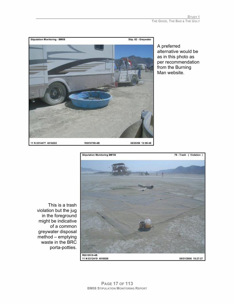
A preferred alternative would be as in this photo as per recommendation from the Burning Man website.
This is a trash violation but the jug
in the foreground might be indicative
of a common greywater disposal method – emptying
waste in the BRC porta-potties.
STUDY 1
THE GOOD, THE BAD & THE UGLY
PAGE 18 OF 113 BM08 STIPULATION MONITORING REPORT
SOLID WASTE MANAGEMENT
31. BRC is responsible for all trash removal and cleanup. Trash will be transported to an appropriate landfill and
deposited accordingly. Specifically BRC will:
a. Provide dumpsters of a size and number sufficient to accommodate the event.
b. Dumpsters will be hauled when full to ensure proper disposal and timely rotation of full versus empty containers.
c. Burying of waste material, of any kind, is prohibited on public land.
VIOLATIONS
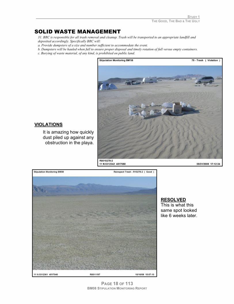
It is amazing how quickly dust piled up against any obstruction in the playa.
RESOLVED This is what this same spot looked like 6 weeks later.
STUDY 1
THE GOOD, THE BAD & THE UGLY
PAGE 19 OF 113 BM08 STIPULATION MONITORING REPORT
CAMPING AND RECREATIONAL USES
PLAYA SURFACE PROTECTION
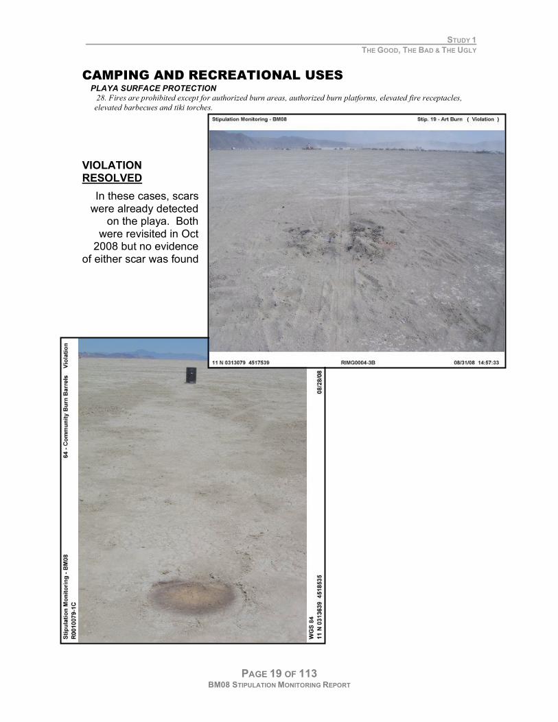
28. Fires are prohibited except for authorized burn areas, authorized burn platforms, elevated fire receptacles,
elevated barbecues and tiki torches.
VIOLATION RESOLVED
In these cases, scars were already detected
on the playa. Both were revisited in Oct
2008 but no evidence of either scar was found
STUDY 1
THE GOOD, THE BAD & THE UGLY
PAGE 20 OF 113 BM08 STIPULATION MONITORING REPORT
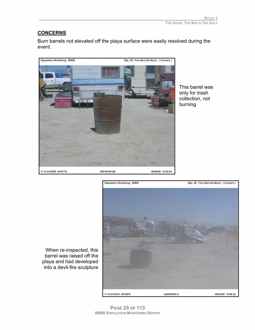
CONCERNS
Burn barrels not elevated off the playa surface were easily resolved during the event.
This barrel was only for trash collection, not burning
When re-inspected, this barrel was raised off the
playa and had developed into a devil-fire sculpture
STUDY 1
THE GOOD, THE BAD & THE UGLY
PAGE 21 OF 113 BM08 STIPULATION MONITORING REPORT
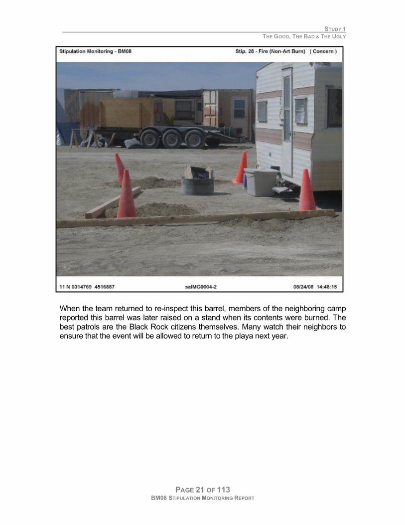
When the team returned to re-inspect this barrel, members of the neighboring camp reported this barrel was later raised on a stand when its contents were burned. The best patrols are the Black Rock citizens themselves. Many watch their neighbors to ensure that the event will be allowed to return to the playa next year.

STUDY 1
THE GOOD, THE BAD & THE UGLY
PAGE 22 OF 113 BM08 STIPULATION MONITORING REPORT
PROHIBITED BY BURNING MAN
VIOLATIONS
Duck Pond Camp hosted this slip and slide. The primary concern was the greywater to which the participants exposed themselves and leaks onto the playa. Participants were on their own for bruises or worse. While a map and photos were passed onto BLM personnel, the matter was not addressed during the event.
STUDY 1
THE GOOD, THE BAD & THE UGLY
PAGE 23 OF 113 BM08 STIPULATION MONITORING REPORT
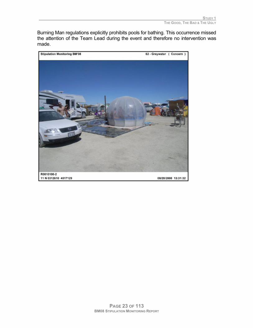
Burning Man regulations explicitly prohibits pools for bathing. This occurrence missed the attention of the Team Lead during the event and therefore no intervention was made.
STUDY 1
THE GOOD, THE BAD & THE UGLY
PAGE 24 OF 113 BM08 STIPULATION MONITORING REPORT
PUBLIC HEALTH & SAFETY OIL DRIPS
22. BRC will make educational materials available to participants prior to the event that explain the need to inspect
vehicles and repair or modify those with drips of oil or other fluids. BRC will also train staff involved with greeting
participants to identify vehicles likely to have an increased risk of oil or fluid drips, inspect suspect vehicles and take
appropriate actions to minimize contamination from leaking vehicles. Black Rock LLC will advise participants on
the use of materials, such as cardboard, hazmat pads, or drip pans to minimize impacts.
FUGITIVE DUST
30. The following stipulations are required to manage for air quality and surface erosion: […]
b. Fugitive dust suppression efforts on roads will be performed at a minimum of once daily by watering to keep
fugitive road dust at a minimum during event operation and during and after event closure.
c. Water trucks used for dust control will carry prominent signs stating 'Non-Potable Water--Avoid Contact" as
required by state regulations. Signs must remain visible at all times
STRUCTURES
57. BRC will make the builders of any structures open to participants aware of applicable requirements for public
safety. BRC will inspect structures and any structures that they judge are not safe for participants will be
reconstructed to be made safe or closed. The BLM authorized officer reserves the right to determine that a structure
poses an unreasonable risk to the public and must be immediately modified, closed, or removed.
58. BRC will make an effort to ensure that extension cords that cross main access roads or travel corridors are
armored or buried to prevent damage and possible electrocution.
EMS SERVICES
60. BRC shall assume responsibility for public safety and health during all phases of the event, including, but not
limited, to the following:
a. BRC shall provide state-certified emergency services at the event. At a minimum, EMS services will be
available at the paramedic level consistent with current Nevada practices.
b. Inspecting the permitted area for any existing or new hazardous conditions, e.g., changing weather conditions
or other hazards that present risks to employees and/or participants.
FIRE PROTECTION
74. BRC shall provide a minimum of two structural/brush-type fire engines, National Wildfire Coordinating Group
(NWCG) type 3-6. Engines and staff must meet NWCG or NWSA (National Wildfire Suppression Association)
standards for personnel and equipment. These fire engines will be strategically placed within BRC as determined
necessary by the BRC fire contractor.
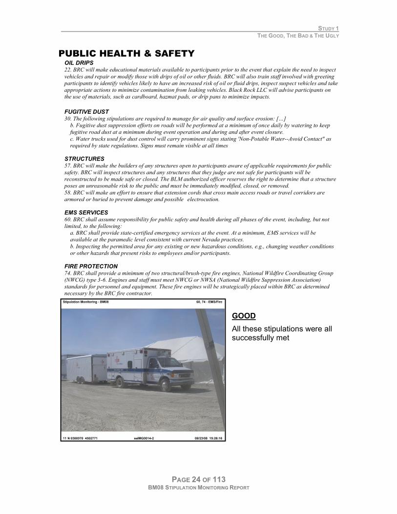
GOOD
All these stipulations were all successfully met

STUDY 1
THE GOOD, THE BAD & THE UGLY
PAGE 25 OF 113 BM08 STIPULATION MONITORING REPORT
F. RECOMMENDATIONS
The current stipulations are being met and serve their purposes adequately
.

PAGE 26 OF 113 BM08 STIPULATION MONITORING REPORT
PAGE 27 OF 113 BM08 STIPULATION MONITORING REPORT
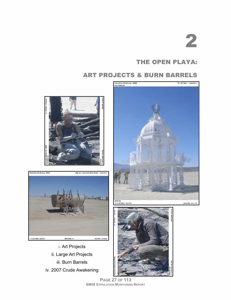
2 THE OPEN PLAYA:
ART PROJECTS & BURN BARRELS
i. Art Projects
ii. Large Art Projects
iii. Burn Barrels
iv. 2007 Crude Awakening
STUDY 2 THE OPEN PLAYA: ART PROJECTS & BURN BARRELS
PAGE 28 OF 113 BM08 STIPULATION MONITORING REPORT
A. GOAL
Photo document art projects on the open playa and record any areas requiring
monitoring for potential burn scars, excessive debris, deep pits and other long-
term impacts on the playa.
B. STIPULATIONS
AUTHORIZED FIRES 19. Organizers of each “Art Burn” and BRC are responsible for implementing procedures for the complete cleanup
of each burn site consistent with stipulation #79, including, but not limited to:
a. Removal of ash.
b. Removal of unburned material such as nails, screws, and glass.
c. Grading and raking to eliminate burn scars.
PITS AND HOLES
20. BRC will limit excavation of pits and holes to those absolutely necessary for administration of the event. This
includes holes and pits excavated by participants. All pits and holes will be backfilled, wetted and compacted by
physical tamping to minimize post-event pit depressions.
ART BURNS & COMMUNITY BURN BARRELS
64. BRC/Burning Man shall abide by fire restriction orders, except for the following as officially approved by BRC
in coordination with BLM: official art burns, fireworks events, and open fires within the Burning Man event area
that are to be contained on supplied fire pans and fire barrels. Fires not contained by authorized raised platforms,
fire pans, barbeques, or barrels are prohibited. The fire pans and fire resistant platforms or other protective
materials designed to protect the playa surface can be used by event participants for spontaneous burns in the same
manner as the fire pans or fire barrels after the initial art project has been burned.
68. BRC and “art burn” organizers will coordinate with the event fire contractor and law enforcement points-of-
contact. BRC shall prepare a detailed schedule of sanctioned fireworks and art burn events for review at the daily
cooperators coordination meeting, prior to the event/burn. The schedule will include a detailed description of the
event/burn, name of responsible person, map location, and approximate time of each event/burn.
C. METHODS
Sub-meter accuracy GPS was used to record larger burn pad polygons and
support points dug into the playa. Most monitoring of art on the open playa used
the GPS cameras for documentation. Each team was armed with a GPS camera
and assigned a portion of the open playa. Photographs were assigned attributes
based on their potential for leaving an impact on the playa. Status was indicated
as:
Good Does not present the potential for impacts to the playa
Concern Presents the potential for impacts to the playa Team recommends re-inspection at later time
Violation Clearly against permit stipulations i.e. burn pad absent or inadequate
STUDY 2 THE OPEN PLAYA: ART PROJECTS & BURN BARRELS
PAGE 29 OF 113 BM08 STIPULATION MONITORING REPORT
In no way was the status meant to convey the artistic quality of installation. After
all, art is always a matter of opinion.
Six weeks after Black Rock City was dismantled, Trimble GPS units were used to
navigate back to the GPS polygons, points and geo-tagged photo locations to re-
inspect for excessive debris, burn scars or other impacts. The goal of the October
2008 inspection was to get a general idea of the conditions at each site – it was
not the intended to be systematic or quantitative. The trash transects that were
completed by the BLM staff in early October and will be repeated again in Spring
2009 serve that purpose.
STUDY 2 THE OPEN PLAYA: ART PROJECTS & BURN BARRELS
PAGE 30 OF 113 BM08 STIPULATION MONITORING REPORT
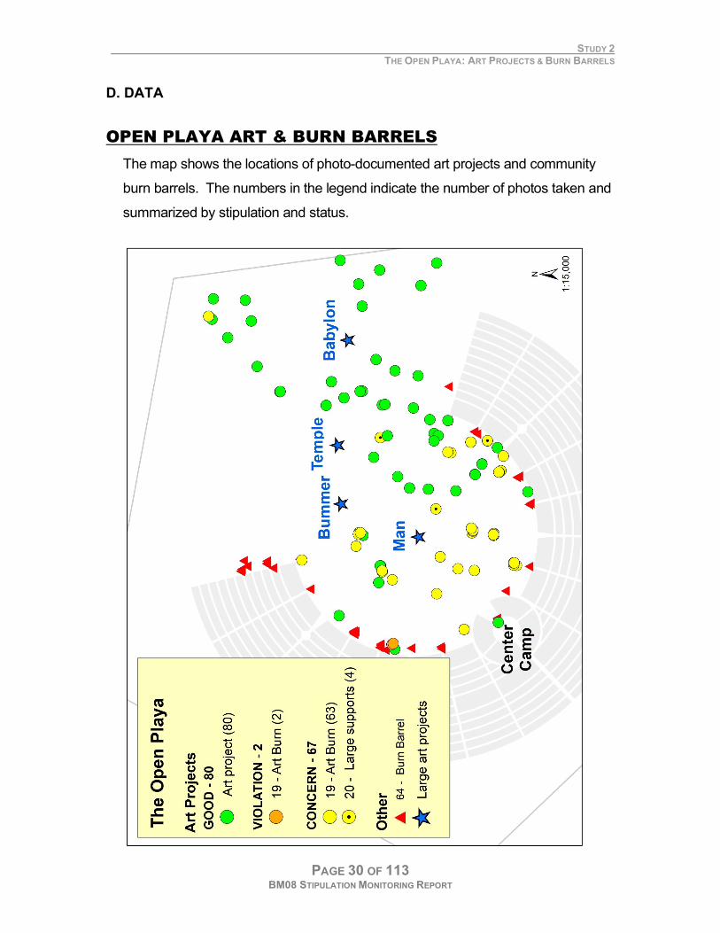
D. DATA
OPEN PLAYA ART & BURN BARRELS
The map shows the locations of photo-documented art projects and community
burn barrels. The numbers in the legend indicate the number of photos taken and
summarized by stipulation and status.
STUDY 2 THE OPEN PLAYA: ART PROJECTS & BURN BARRELS
PAGE 31 OF 113 BM08 STIPULATION MONITORING REPORT
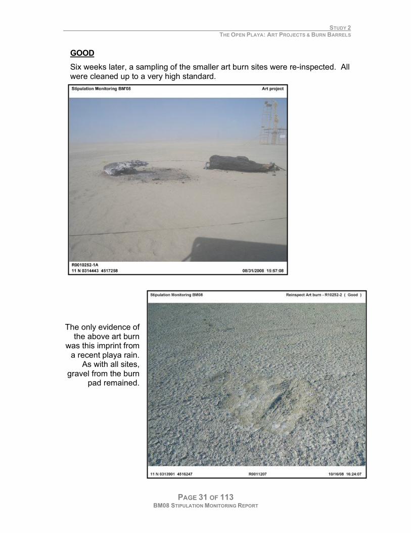
GOOD
Six weeks later, a sampling of the smaller art burn sites were re-inspected. All were cleaned up to a very high standard.
The only evidence of the above art burn
was this imprint from a recent playa rain.
As with all sites, gravel from the burn
pad remained.
STUDY 2 THE OPEN PLAYA: ART PROJECTS & BURN BARRELS
PAGE 32 OF 113 BM08 STIPULATION MONITORING REPORT
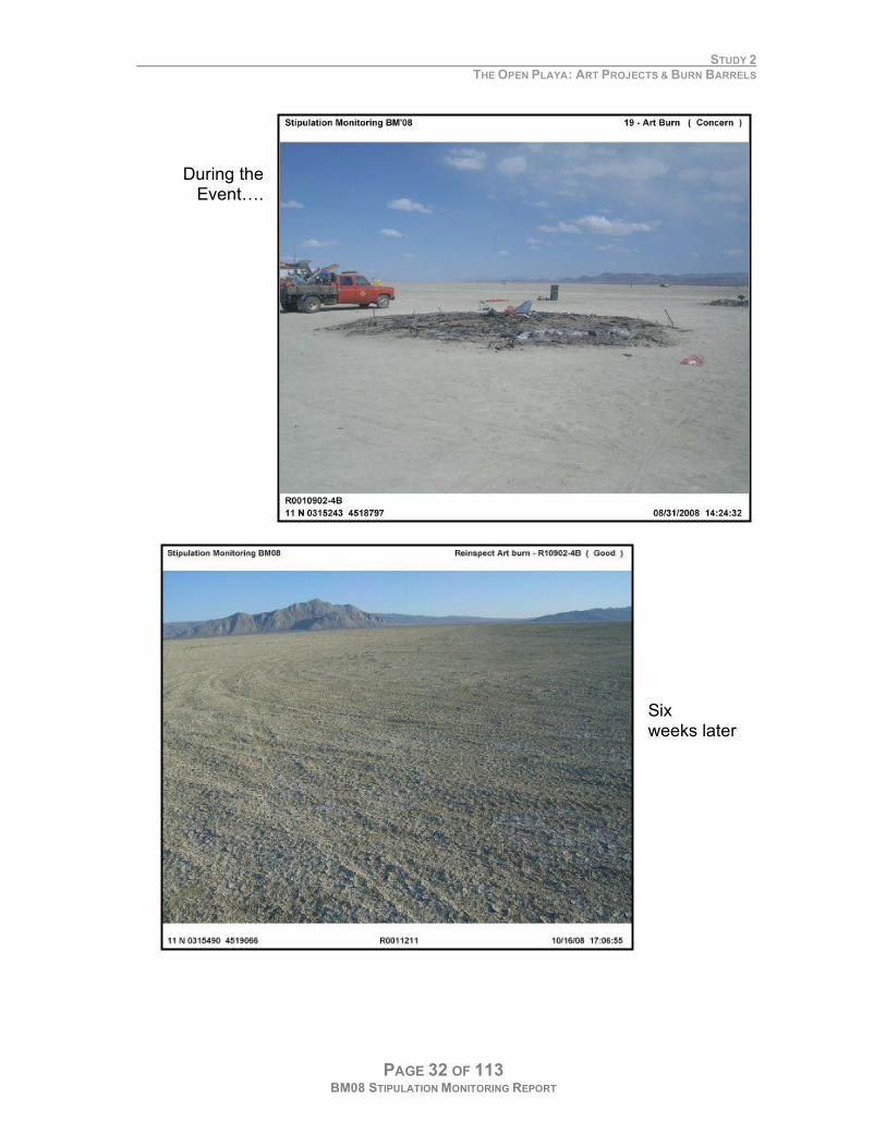
During the Event….
Six weeks later
STUDY 2 THE OPEN PLAYA: ART PROJECTS & BURN BARRELS
PAGE 33 OF 113 BM08 STIPULATION MONITORING REPORT
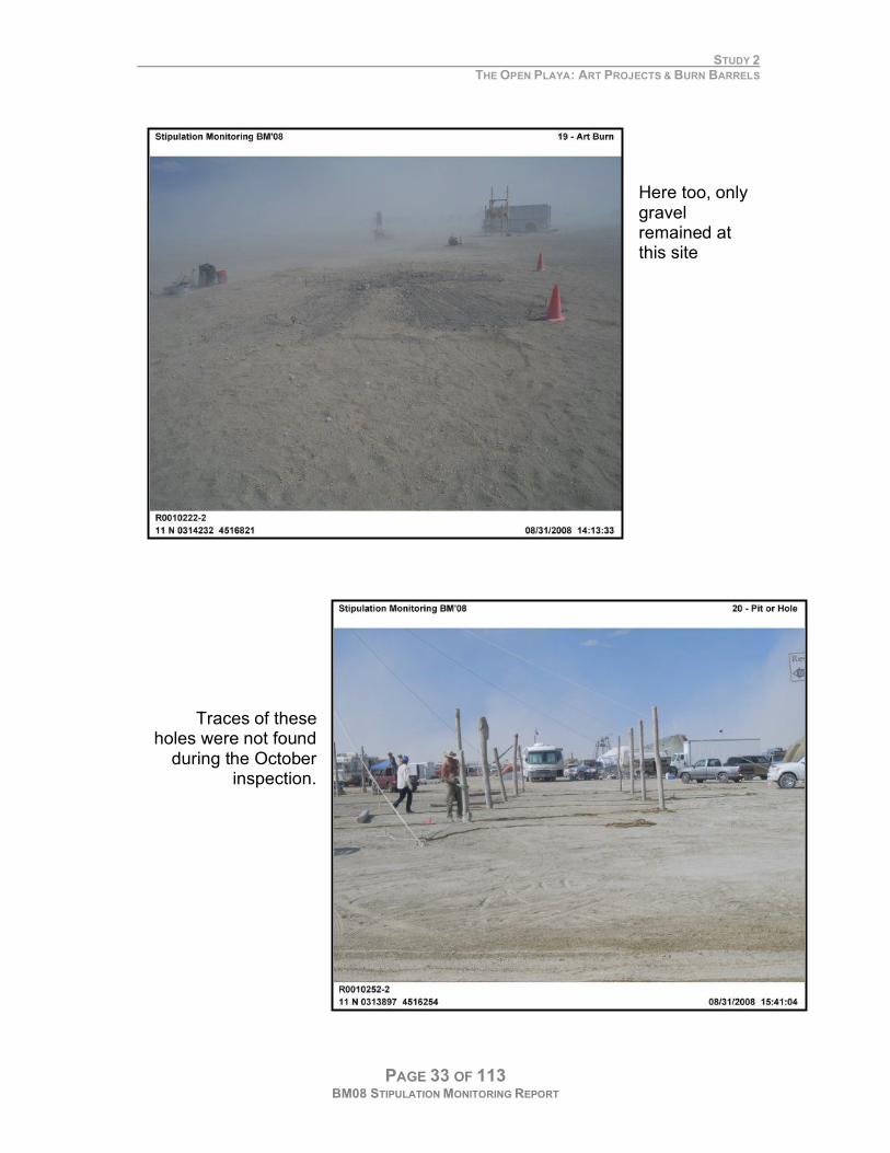
Here too, only gravel remained at this site
Traces of these holes were not found
during the October inspection.
STUDY 2 THE OPEN PLAYA: ART PROJECTS & BURN BARRELS
PAGE 34 OF 113 BM08 STIPULATION MONITORING REPORT
D. DATA
LARGE ART PROJECTS & BURN BARRELS
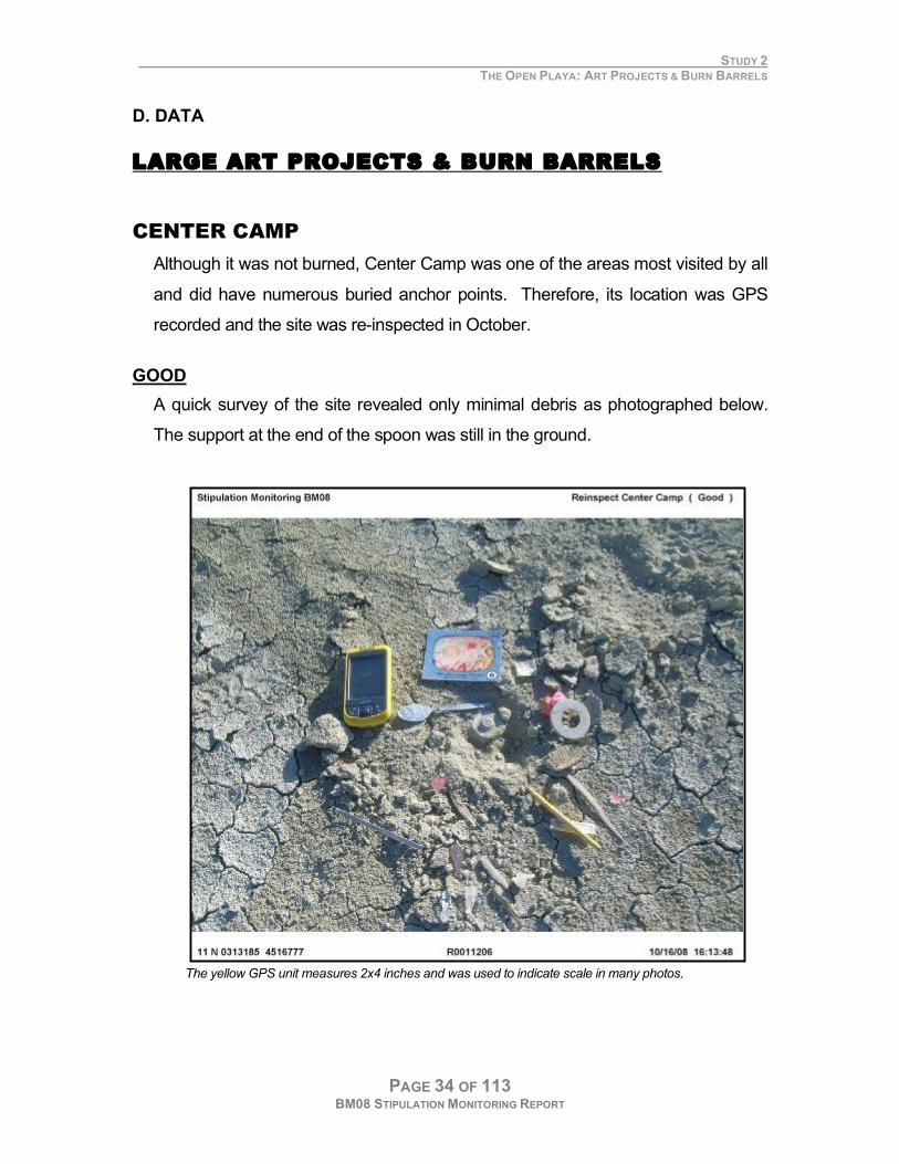
CENTER CAMP
Although it was not burned, Center Camp was one of the areas most visited by all
and did have numerous buried anchor points. Therefore, its location was GPS
recorded and the site was re-inspected in October.
GOOD
A quick survey of the site revealed only minimal debris as photographed below.
The support at the end of the spoon was still in the ground.
The yellow GPS unit measures 2x4 inches and was used to indicate scale in many photos.
STUDY 2 THE OPEN PLAYA: ART PROJECTS & BURN BARRELS
PAGE 35 OF 113 BM08 STIPULATION MONITORING REPORT
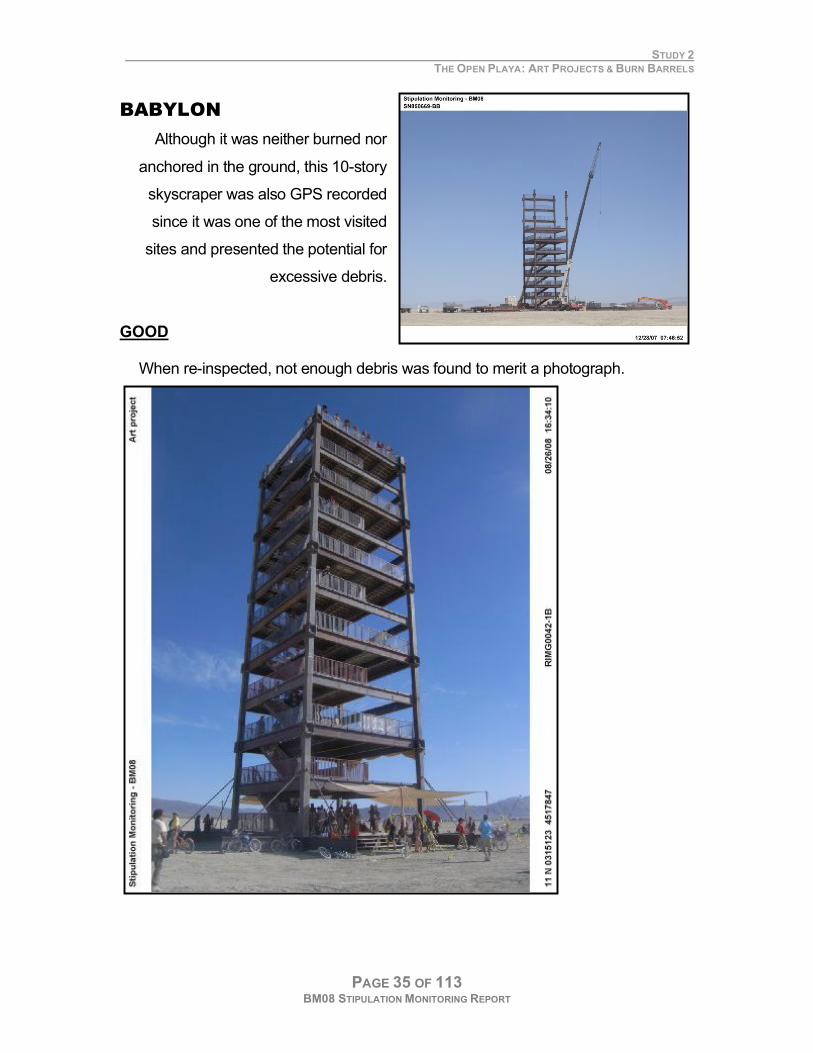
BABYLON
Although it was neither burned nor
anchored in the ground, this 10-story
skyscraper was also GPS recorded
since it was one of the most visited
sites and presented the potential for
excessive debris.
GOOD
When re-inspected, not enough debris was found to merit a photograph.
STUDY 2 THE OPEN PLAYA: ART PROJECTS & BURN BARRELS
PAGE 36 OF 113 BM08 STIPULATION MONITORING REPORT
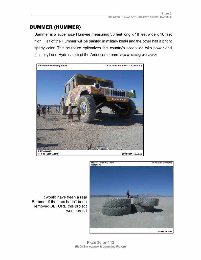
BUMMER (HUMMER)
Bummer is a super size Humvee measuring 38 feet long x 18 feet wide x 16 feet
high. Half of the Hummer will be painted in military khaki and the other half a bright
sporty color. This sculpture epitomizes this country's obsession with power and
the Jekyll and Hyde nature of the American dream. from the Burning Man website
It would have been a real Bummer if the tires hadn’t been removed BEFORE this project
was burned
STUDY 2 THE OPEN PLAYA: ART PROJECTS & BURN BARRELS
PAGE 37 OF 113 BM08 STIPULATION MONITORING REPORT
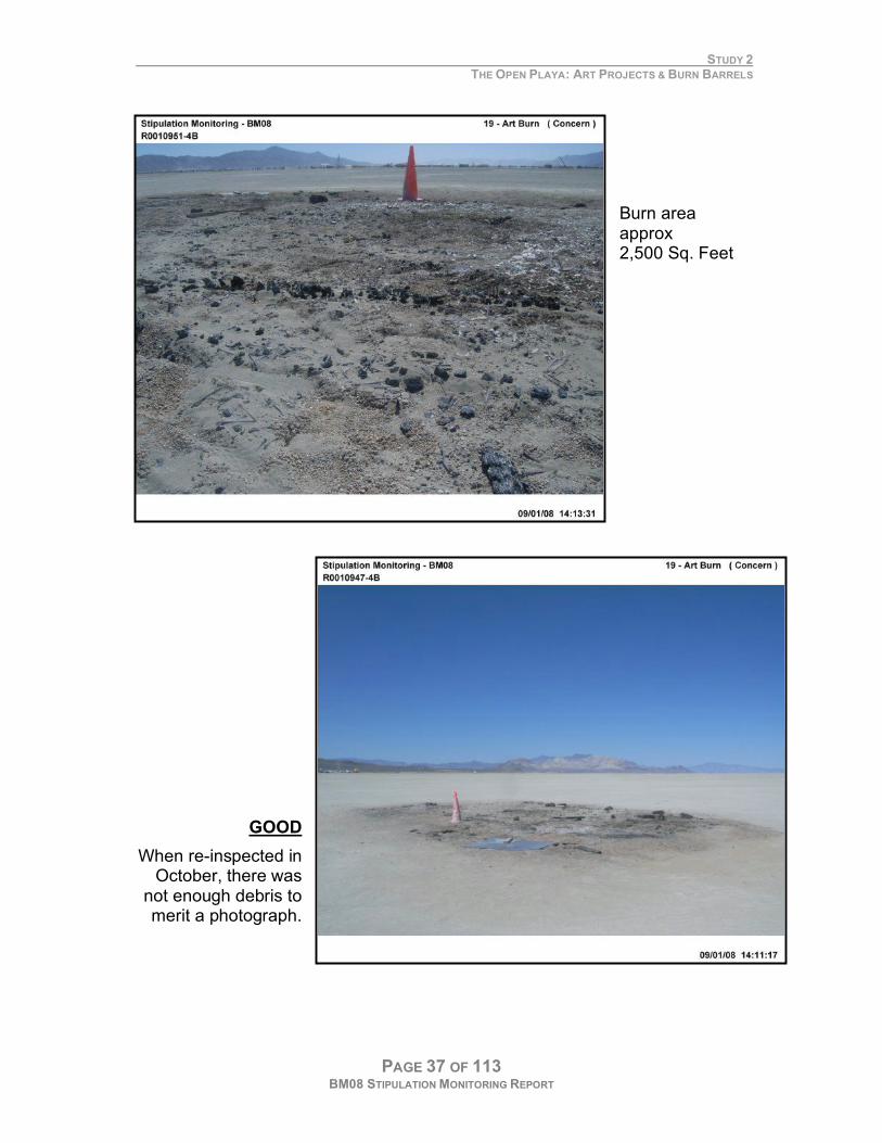
Burn area approx 2,500 Sq. Feet
GOOD
When re-inspected in October, there was
not enough debris to merit a photograph.
STUDY 2 THE OPEN PLAYA: ART PROJECTS & BURN BARRELS
PAGE 38 OF 113 BM08 STIPULATION MONITORING REPORT
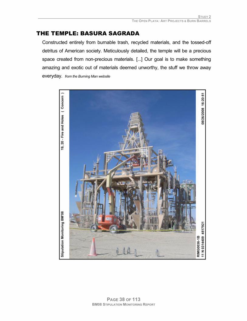
THE TEMPLE: BASURA SAGRADA
Constructed entirely from burnable trash, recycled materials, and the tossed-off
detritus of American society. Meticulously detailed, the temple will be a precious
space created from non-precious materials. [...] Our goal is to make something
amazing and exotic out of materials deemed unworthy, the stuff we throw away
everyday. from the Burning Man website
STUDY 2 THE OPEN PLAYA: ART PROJECTS & BURN BARRELS
PAGE 39 OF 113 BM08 STIPULATION MONITORING REPORT
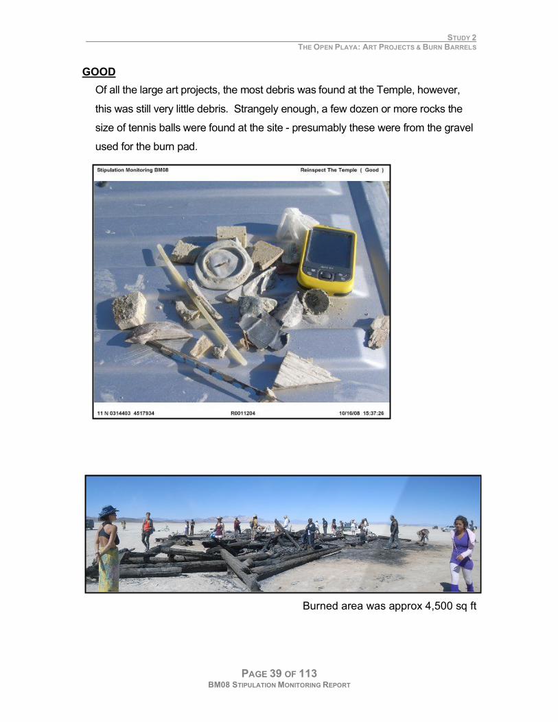
GOOD
Of all the large art projects, the most debris was found at the Temple, however,
this was still very little debris. Strangely enough, a few dozen or more rocks the
size of tennis balls were found at the site - presumably these were from the gravel
used for the burn pad.
Burned area was approx 4,500 sq ft
STUDY 2 THE OPEN PLAYA: ART PROJECTS & BURN BARRELS
PAGE 40 OF 113 BM08 STIPULATION MONITORING REPORT
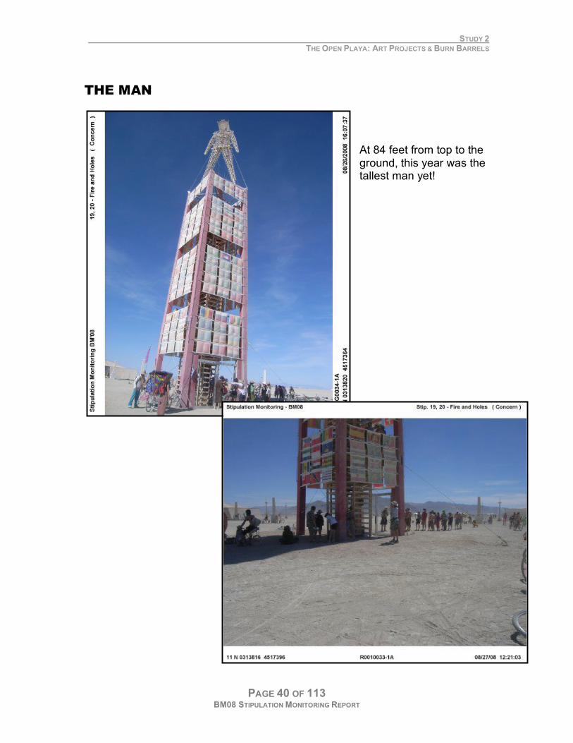
THE MAN
At 84 feet from top to the ground, this year was the tallest man yet!
STUDY 2 THE OPEN PLAYA: ART PROJECTS & BURN BARRELS
PAGE 41 OF 113 BM08 STIPULATION MONITORING REPORT
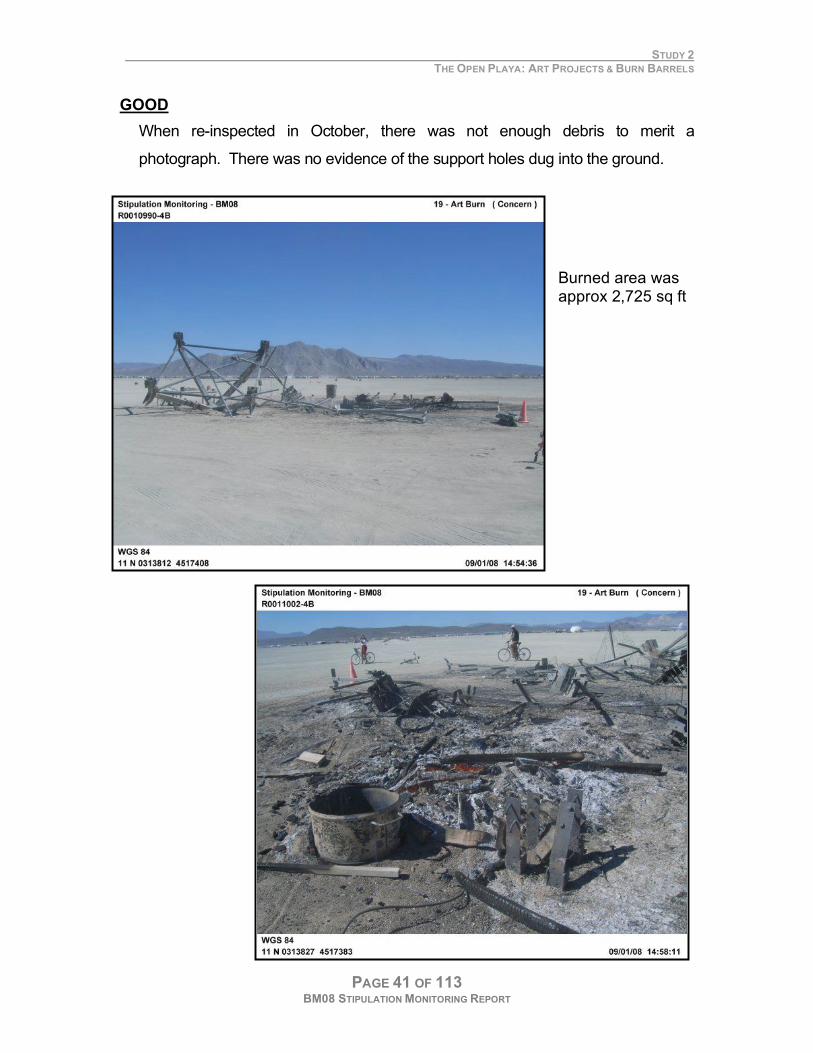
GOOD
When re-inspected in October, there was not enough debris to merit a
photograph. There was no evidence of the support holes dug into the ground.
Burned area was approx 2,725 sq ft
STUDY 2 THE OPEN PLAYA: ART PROJECTS & BURN BARRELS
PAGE 42 OF 113 BM08 STIPULATION MONITORING REPORT
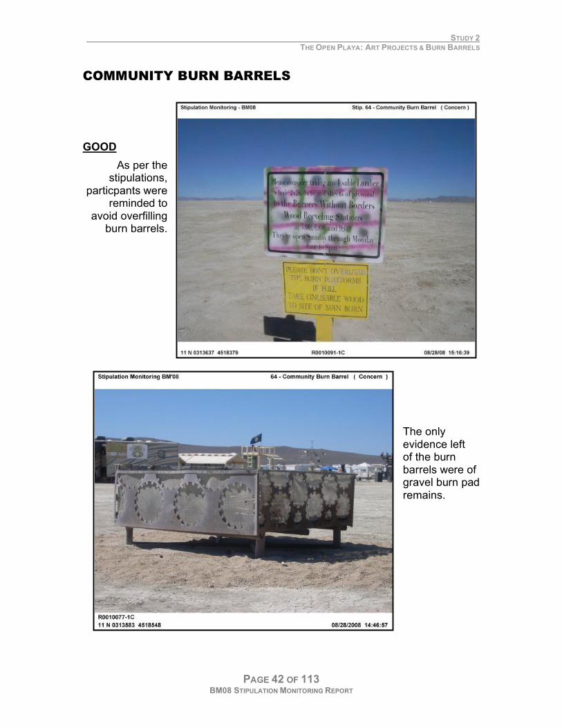
COMMUNITY BURN BARRELS
GOOD
As per the stipulations,
particpants were reminded to
avoid overfilling burn barrels.
The only evidence left of the burn barrels were of gravel burn pad remains.
STUDY 2 THE OPEN PLAYA: ART PROJECTS & BURN BARRELS
PAGE 43 OF 113 BM08 STIPULATION MONITORING REPORT
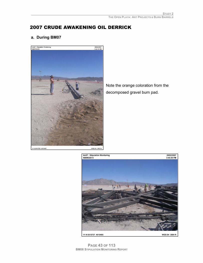
2007 CRUDE AWAKENING OIL DERRICK
a. During BM07
Note the orange coloration from the
decomposed gravel burn pad.
STUDY 2 THE OPEN PLAYA: ART PROJECTS & BURN BARRELS
PAGE 44 OF 113 BM08 STIPULATION MONITORING REPORT
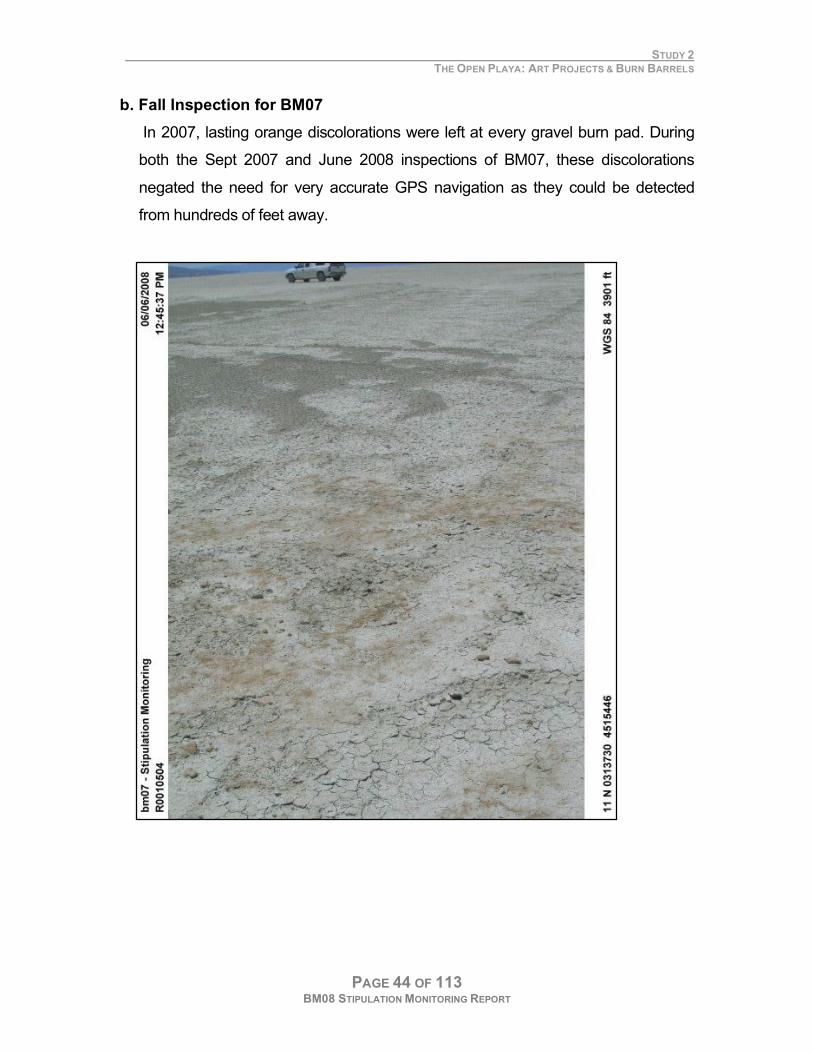
b. Fall Inspection for BM07
In 2007, lasting orange discolorations were left at every gravel burn pad. During
both the Sept 2007 and June 2008 inspections of BM07, these discolorations
negated the need for very accurate GPS navigation as they could be detected
from hundreds of feet away.
STUDY 2 THE OPEN PLAYA: ART PROJECTS & BURN BARRELS
PAGE 45 OF 113 BM08 STIPULATION MONITORING REPORT
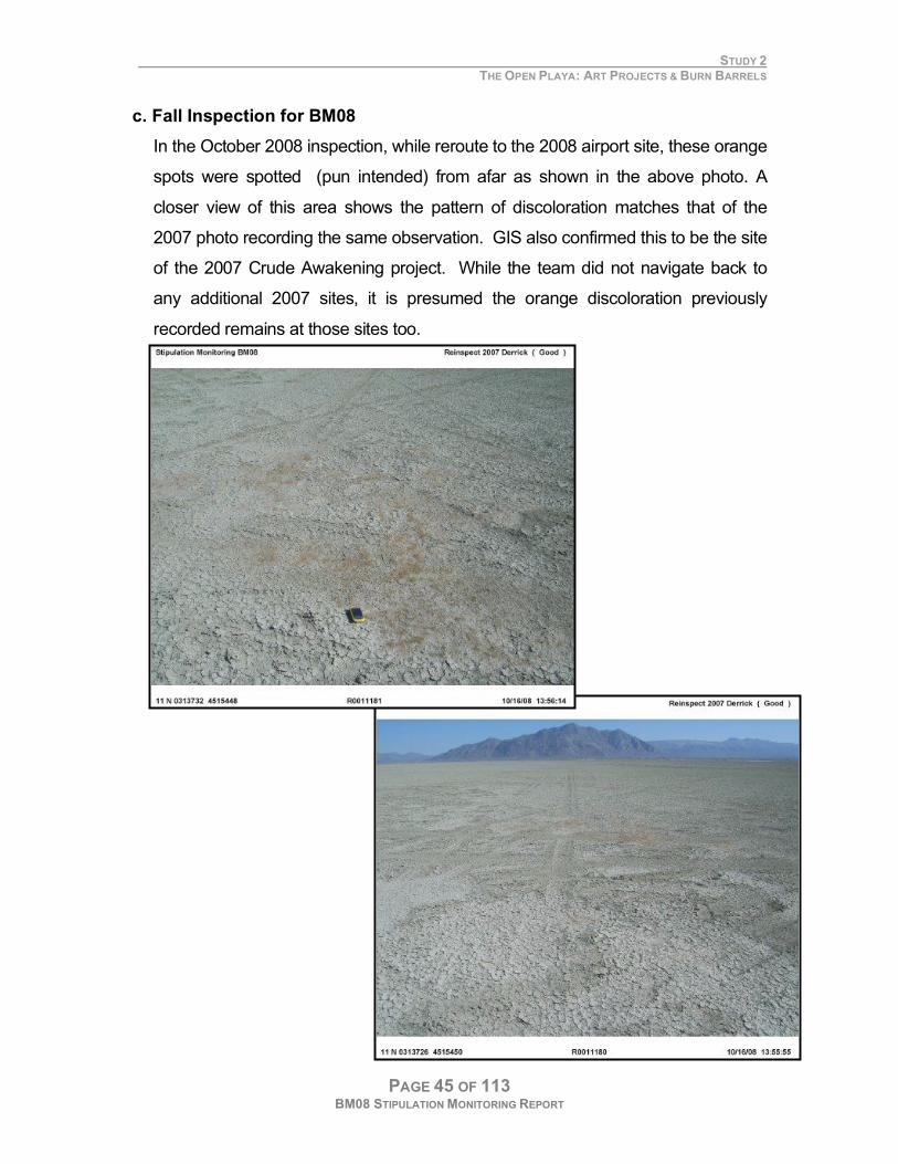
c. Fall Inspection for BM08
In the October 2008 inspection, while reroute to the 2008 airport site, these orange
spots were spotted (pun intended) from afar as shown in the above photo. A
closer view of this area shows the pattern of discoloration matches that of the
2007 photo recording the same observation. GIS also confirmed this to be the site
of the 2007 Crude Awakening project. While the team did not navigate back to
any additional 2007 sites, it is presumed the orange discoloration previously
recorded remains at those sites too.
STUDY 2 THE OPEN PLAYA: ART PROJECTS & BURN BARRELS
PAGE 46 OF 113 BM08 STIPULATION MONITORING REPORT
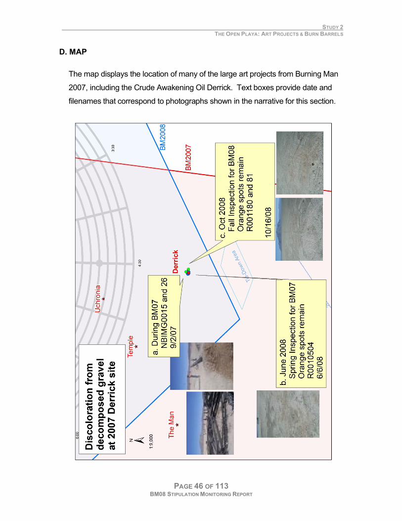
D. MAP
The map displays the location of many of the large art projects from Burning Man
2007, including the Crude Awakening Oil Derrick. Text boxes provide date and
filenames that correspond to photographs shown in the narrative for this section.
STUDY 2 THE OPEN PLAYA: ART PROJECTS & BURN BARRELS
PAGE 47 OF 113 BM08 STIPULATION MONITORING REPORT
E. RESULTS FOR ALL ART PROJECTS & BURN BARRELS
GOOD
Art burns were cleaned up adequately
The Team was duly impressed with how well the clean-up crews removed
debris from the playa compared to the 2006 and 2007 events.
No discoloration at 2008 gravel sites
These same orange discolorations were not seen at any of the 2008 burn pads.
It is assumed whatever material caused the discoloration in 2007 was not
present in the gravel used this year.
CONCERN
Remaining gravel at all gravel burn pads in 2008
In October 2008, bits of gravel remained at every gravel burn pad site
inspected. At the Temple site, many rocks were inches in diameter. This is at
odds with Burning Man’s highly touted Leave No Trace (LNT) policy.
STUDY 2 THE OPEN PLAYA: ART PROJECTS & BURN BARRELS
PAGE 48 OF 113 BM08 STIPULATION MONITORING REPORT
F. RECOMMENDATIONS
Confirm gravel meets EA requirements
from 2.2.6. Fire Management Art Burns, the burning of larger art structures including “The Man”, would be permitted by BRC. Permitted burns
would use corrugated metal sheets or fire blankets overlain with sand under the burning objects to eliminate surface
scarring.
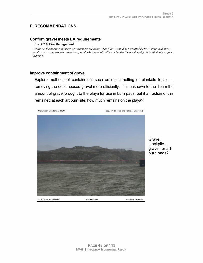
Improve containment of gravel
Explore methods of containment such as mesh netting or blankets to aid in
removing the decomposed gravel more efficiently. It is unknown to the Team the
amount of gravel brought to the playa for use in burn pads, but if a fraction of this
remained at each art burn site, how much remains on the playa?
Gravel stockpile -gravel for art burn pads?
STUDY 2 THE OPEN PLAYA: ART PROJECTS & BURN BARRELS
PAGE 49 OF 113 BM08 STIPULATION MONITORING REPORT
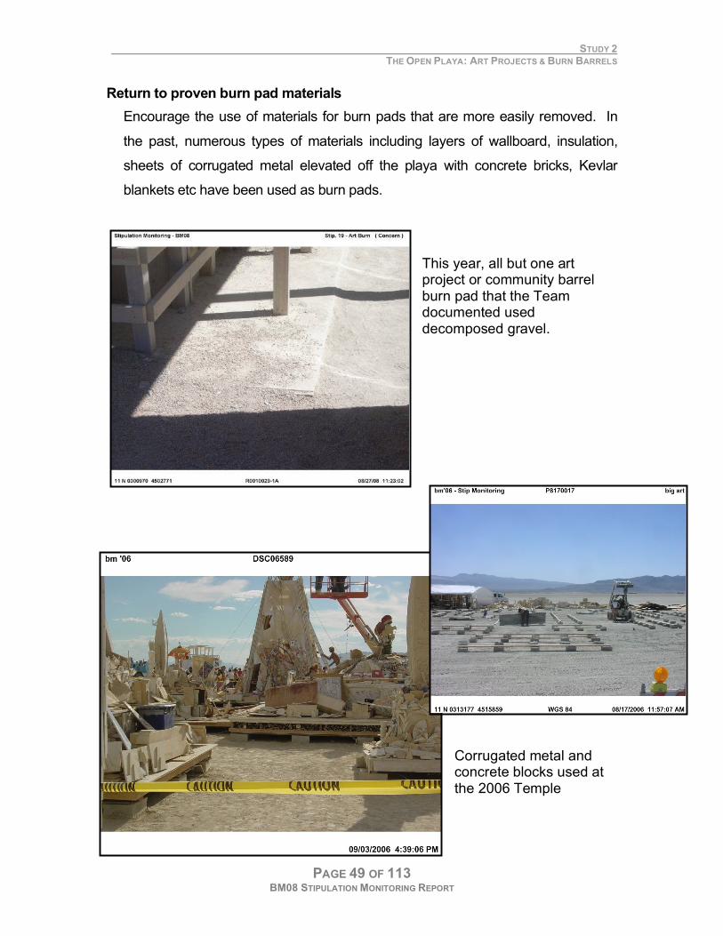
Return to proven burn pad materials
Encourage the use of materials for burn pads that are more easily removed. In
the past, numerous types of materials including layers of wallboard, insulation,
sheets of corrugated metal elevated off the playa with concrete bricks, Kevlar
blankets etc have been used as burn pads.
This year, all but one art project or community barrel burn pad that the Team documented used decomposed gravel.
Corrugated metal and concrete blocks used at the 2006 Temple

STUDY 2 THE OPEN PLAYA: ART PROJECTS & BURN BARRELS
PAGE 50 OF 113 BM08 STIPULATION MONITORING REPORT
PAGE 51 OF 113 BM08 STIPULATION MONITORING REPORT
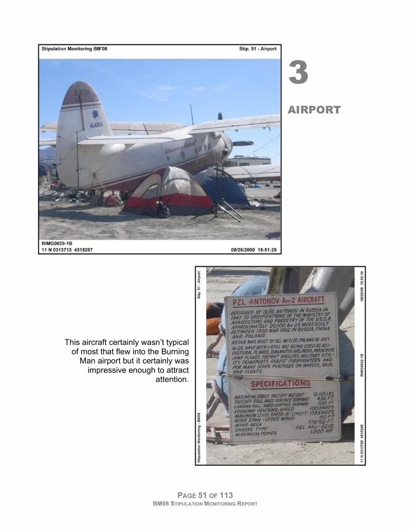
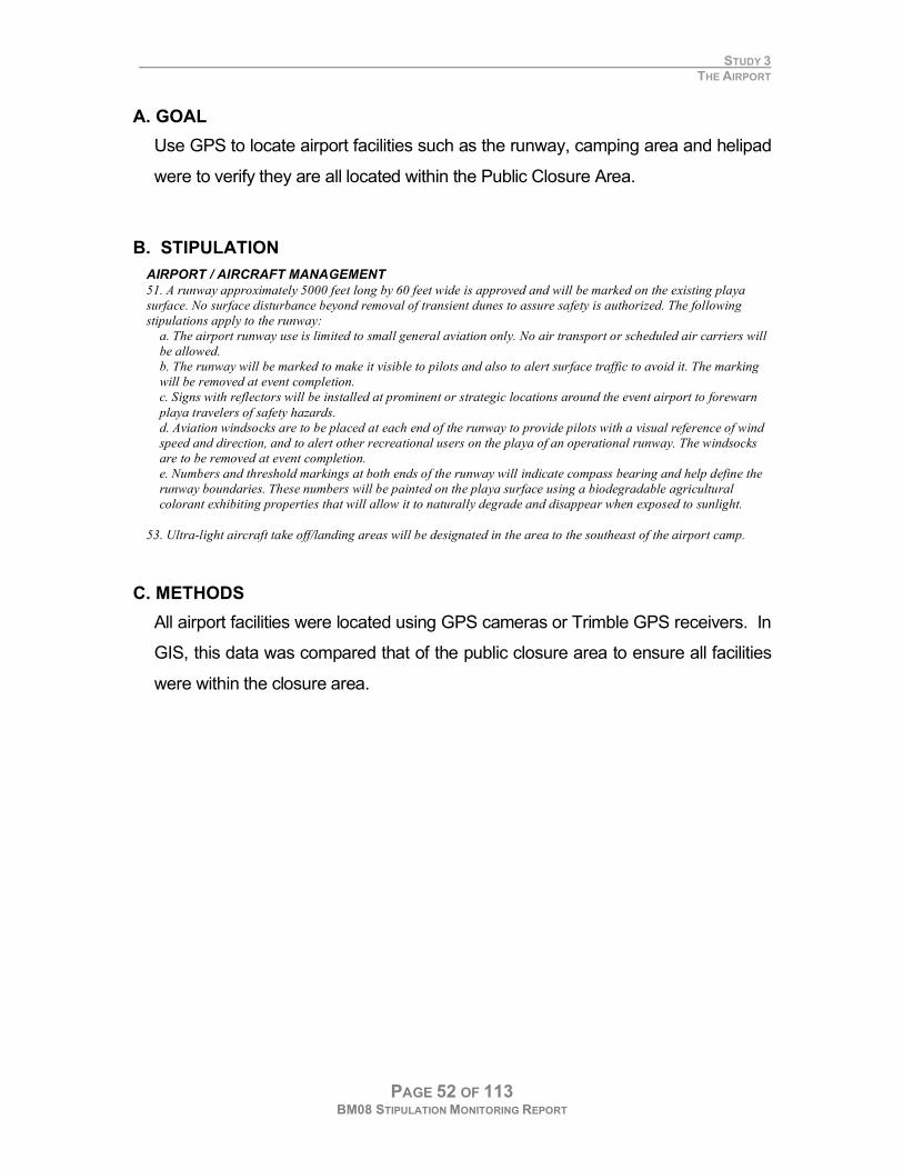
3 AIRPORT
This aircraft certainly wasn’t typical
of most that flew into the Burning Man airport but it certainly was
impressive enough to attract attention.
STUDY 3 THE AIRPORT
PAGE 52 OF 113 BM08 STIPULATION MONITORING REPORT
A. GOAL
Use GPS to locate airport facilities such as the runway, camping area and helipad
were to verify they are all located within the Public Closure Area.
B. STIPULATION
AIRPORT / AIRCRAFT MANAGEMENT
51. A runway approximately 5000 feet long by 60 feet wide is approved and will be marked on the existing playa
surface. No surface disturbance beyond removal of transient dunes to assure safety is authorized. The following
stipulations apply to the runway:
a. The airport runway use is limited to small general aviation only. No air transport or scheduled air carriers will
be allowed.
b. The runway will be marked to make it visible to pilots and also to alert surface traffic to avoid it. The marking
will be removed at event completion.
c. Signs with reflectors will be installed at prominent or strategic locations around the event airport to forewarn
playa travelers of safety hazards.
d. Aviation windsocks are to be placed at each end of the runway to provide pilots with a visual reference of wind
speed and direction, and to alert other recreational users on the playa of an operational runway. The windsocks
are to be removed at event completion.
e. Numbers and threshold markings at both ends of the runway will indicate compass bearing and help define the
runway boundaries. These numbers will be painted on the playa surface using a biodegradable agricultural
colorant exhibiting properties that will allow it to naturally degrade and disappear when exposed to sunlight.
53. Ultra-light aircraft take off/landing areas will be designated in the area to the southeast of the airport camp. C. METHODS
All airport facilities were located using GPS cameras or Trimble GPS receivers. In
GIS, this data was compared that of the public closure area to ensure all facilities
were within the closure area.
STUDY 3 THE AIRPORT
PAGE 53 OF 113 BM08 STIPULATION MONITORING REPORT
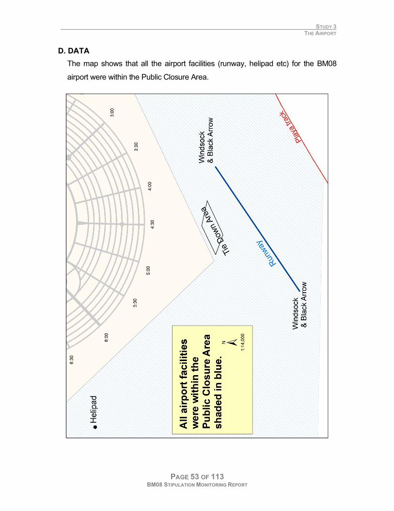
D. DATA
The map shows that all the airport facilities (runway, helipad etc) for the BM08
airport were within the Public Closure Area.
STUDY 3 THE AIRPORT
PAGE 54 OF 113 BM08 STIPULATION MONITORING REPORT
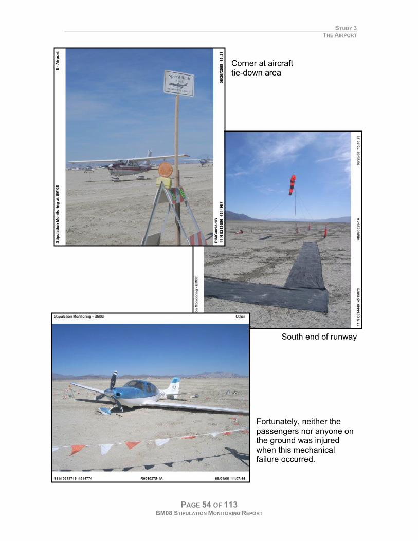
Corner at aircraft tie-down area
South end of runway Fortunately, neither the passengers nor anyone on the ground was injured when this mechanical failure occurred.
STUDY 3 THE AIRPORT
PAGE 55 OF 113 BM08 STIPULATION MONITORING REPORT
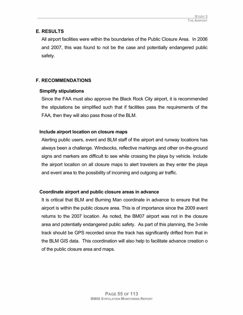
E. RESULTS
All airport facilities were within the boundaries of the Public Closure Area. In 2006
and 2007, this was found to not be the case and potentially endangered public
safety.
F. RECOMMENDATIONS
Simplify stipulations
Since the FAA must also approve the Black Rock City airport, it is recommended
the stipulations be simplified such that if facilities pass the requirements of the
FAA, then they will also pass those of the BLM.
Include airport location on closure maps
Alerting public users, event and BLM staff of the airport and runway locations has
always been a challenge. Windsocks, reflective markings and other on-the-ground
signs and markers are difficult to see while crossing the playa by vehicle. Include
the airport location on all closure maps to alert travelers as they enter the playa
and event area to the possibility of incoming and outgoing air traffic.
Coordinate airport and public closure areas in advance
It is critical that BLM and Burning Man coordinate in advance to ensure that the
airport is within the public closure area. This is of importance since the 2009 event
returns to the 2007 location. As noted, the BM07 airport was not in the closure
area and potentially endangered public safety. As part of this planning, the 3-mile
track should be GPS recorded since the track has significantly drifted from that in
the BLM GIS data. This coordination will also help to facilitate advance creation o
of the public closure area and maps.

STUDY 3 THE AIRPORT
PAGE 56 OF 113 BM08 STIPULATION MONITORING REPORT
PAGE 57 OF 113 BM08 STIPULATION MONITORING REPORT
4 SIGNS
STUDY 4 SIGNS
PAGE 58 OF 113 BM08 STIPULATION MONITORING REPORT
A. GOAL
The Team photographed and mapped each posted sign to ensure that
participants were aware of all playa rules and regulations.
B. STIPULATIONS
GENERAL
7. The permittee shall post a copy of the Special Recreation Permit (Form 2930-1); these permit stipulations and
the Federal Register Closure Orders in prominent view at Center Camp Playa Info where cooperators and
participants have an opportunity to read them. Additionally the documents referenced above shall also be
available for participants and staff on the Burning Man website within 15 days of the permit being issued.
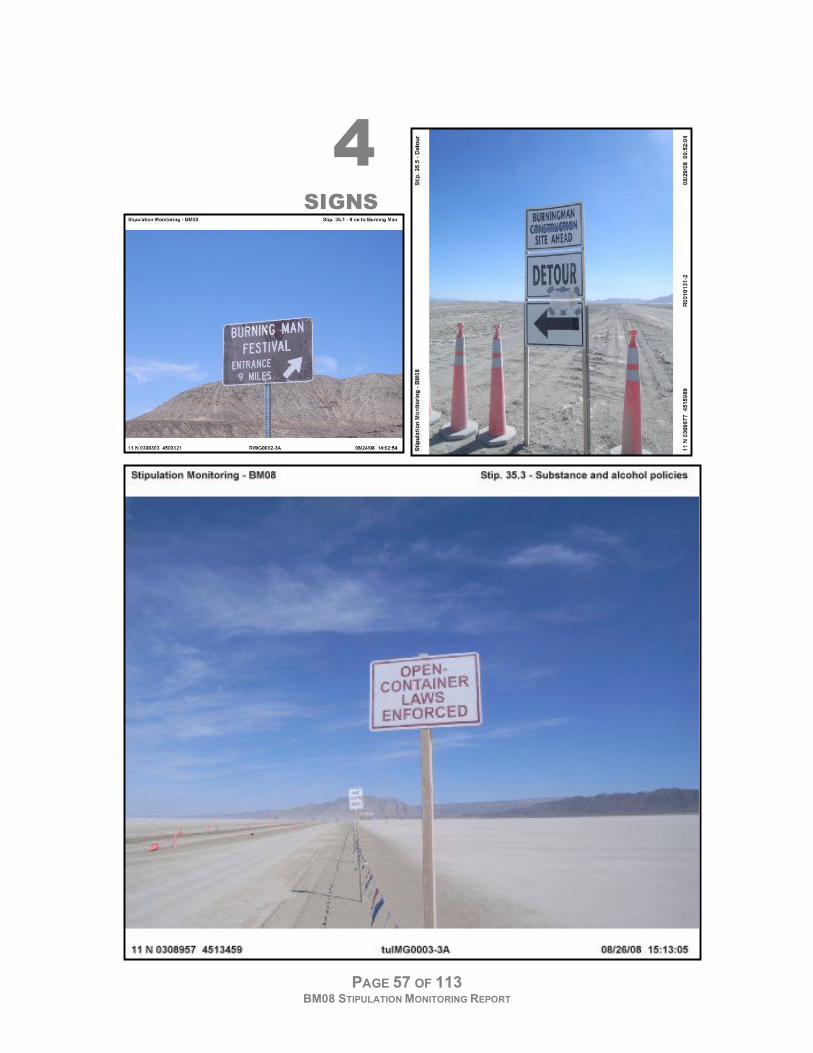
SIGNAGE
35. The following signs and other traffic control items will be in place no later than 5 days prior to the event:
a. DOT approved, large reflective signs will be placed along County Rd 34 warning participants that the entrance
is just ahead from both the north and the south.
b. A prominent, well lit sign posted at the event entrance on County Rd 34 that clearly identifies the entrance
location.
c. The following must be posted on a large sign or signs along the 8-Mile access road into the event:
i. “Possession of personal fireworks prohibited”
ii. “Possession of weapons prohibited”
iii. “Possession of alcohol by minors is prohibited”
iv. “Drivers: open container of alcohol prohibited.”
This sign(s) must be posted not later than five days before the start of the event. Starting at sunset on the evening
of August 21, 2008, and continuing until sunrise on the morning of September 1, 2008, this sign or signs must be
lighted during hours of darkness. BRC LLC may, in lieu of lighting, have these restrictions posted on a sign or
signs prepared and installed on a reflective road sign that meets the standards in the U.S. Department of
Transportation/Federal Highway Administration Manual of Uniform Traffic Control Devices.
d. Orange trash fences, construction cones, signs or other structures should be placed on the closed roads that
cross the event site. Signs should say that the road is closed and provide alternate access information.
e. Signs identifying the public closure area should be posted appropriately around the perimeter of the event to
warn non-participants of how to legally travel around the event perimeter.
f. Signs to provide the public with information concerning closures and available playa access points during the
event should be located along County Road 34 to the north and south of the event.
g. Maps depicting public closures should be located at all playa entrances.
h. Caution signs will be placed along County Road 34 in both directions out from the event access and at other
prominent or strategic locations around the event to forewarn travelers of traffic safety hazards and the event
ahead.
TRAFFIC CONTROL 42. Coordination with County and State Highway Traffic Management Agencies
a. BRC shall coordinate with the Nevada Department of Transportation for traffic control at County Road 34
entrances/exits to BRC, the “Y” intersection of State Road 447 and County Road 34, and the towns of Gerlach
and Empire during heavy traffic periods (prior to, during exit and after the event) to keep traffic moving steadily.
BRC shall provide flaggers at the entrance at any time during the event when traffic conditions are likely to lead
to a backup of vehicles on County Rd 34.
b. BRC will coordinate efforts with Nevada Highway Patrol, Nevada Department of Transportation and private
business owners in Gerlach and Empire to minimize traffic congestion and vehicle back-up on State Route 447
and County Road 34. Their plan to address traffic congestion in these areas must be approved by NHP, NDOT,
and BLM at least 30 days prior to the event.
c. BRC will monitor and address the number of vehicles that arrive in the event area prior to the start of the event.
This plan should minimize the number of vehicles in Gerlach and Empire and on the roadway or shoulders of NV
447 and County Road 34. Copies of the plan shall be provided to the BLM and appropriate law enforcement
agencies no later than 30 days prior to the event.
d. No access roads or trails will be constructed.
STUDY 4 SIGNS
PAGE 59 OF 113 BM08 STIPULATION MONITORING REPORT
46. BRC shall provide staffing at each gate in the perimeter fence during the exodus period to require participants
to leave the event through the main gate unless authorized to use another gate. At a minimum all gates must be
staffed from 7 AM to 11 PM during the entire exodus period. BLM may request additional staffing of perimeter
gates by BRC if necessary.
PUBLIC HEALTH & SAFETY
56. BRC shall implement a controlled substance and alcohol use policy. This policy will be posted and maintained
on all public information boards and relayed to participants through other available means. The illegal substance
policy as identified in the “Burning Man Operating Plan” will be observed.
C. METHODS
GPS cameras were used to photo-document the appearance and location of all
required signs. During one of the dust storms, there was a duct tape failure and
the Rules & Regulations sign at Center Camp fell down. The sign was quickly
replaced and its location was photographed again to show that it was still in place.
STUDY 4 SIGNS
PAGE 60 OF 113 BM08 STIPULATION MONITORING REPORT
D. DATA
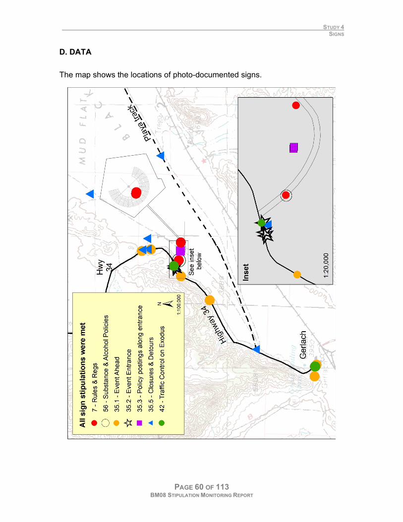
The map shows the locations of photo-documented signs.
STUDY 4 SIGNS
PAGE 61 OF 113 BM08 STIPULATION MONITORING REPORT
E. RESULTS
All signs were posted as per stipulations.
F. RECOMMENDATIONS
Document signs
It should be sufficient to document signs once during the event. There is no
excuse for participants to be ignorant of the laws.
Exploit multiple venues for communication
Signs are only one of many venues for communicating information to participants.
Before the event, the Burning Man Survival Guide and website postings are used
to communicate the expectations and rules of behavior at Burning Man. The
Federal Register is another publication upon which the government relies.
Upon entry to the event, information is given to everyone at the Greeter’s Station.
During the event, Playa Info and the BLM trailer at Center Camp are visited by
many and contain similar information and postings of the rules and special
recreation permit. The daily newspaper and the 3 Burning Man radio stations are
constantly updated and can be used to inform citizens of critical information as
needed. It is probably harder to keep a secret on the playa than not get
information out fast enough.
Soon after the event, the BLM posted large, permanent signs at most playa
entrances. This will greatly facilitate the distribution of information to all on the
playa during the event and year-round.

PAGE 62 OF 113 BM08 STIPULATION MONITORING REPORT
STUDY 5 HOT SPRINGS
PAGE 63 OF 113 BM08 STIPULATION MONITORING REPORT
5
HOT SPRINGS
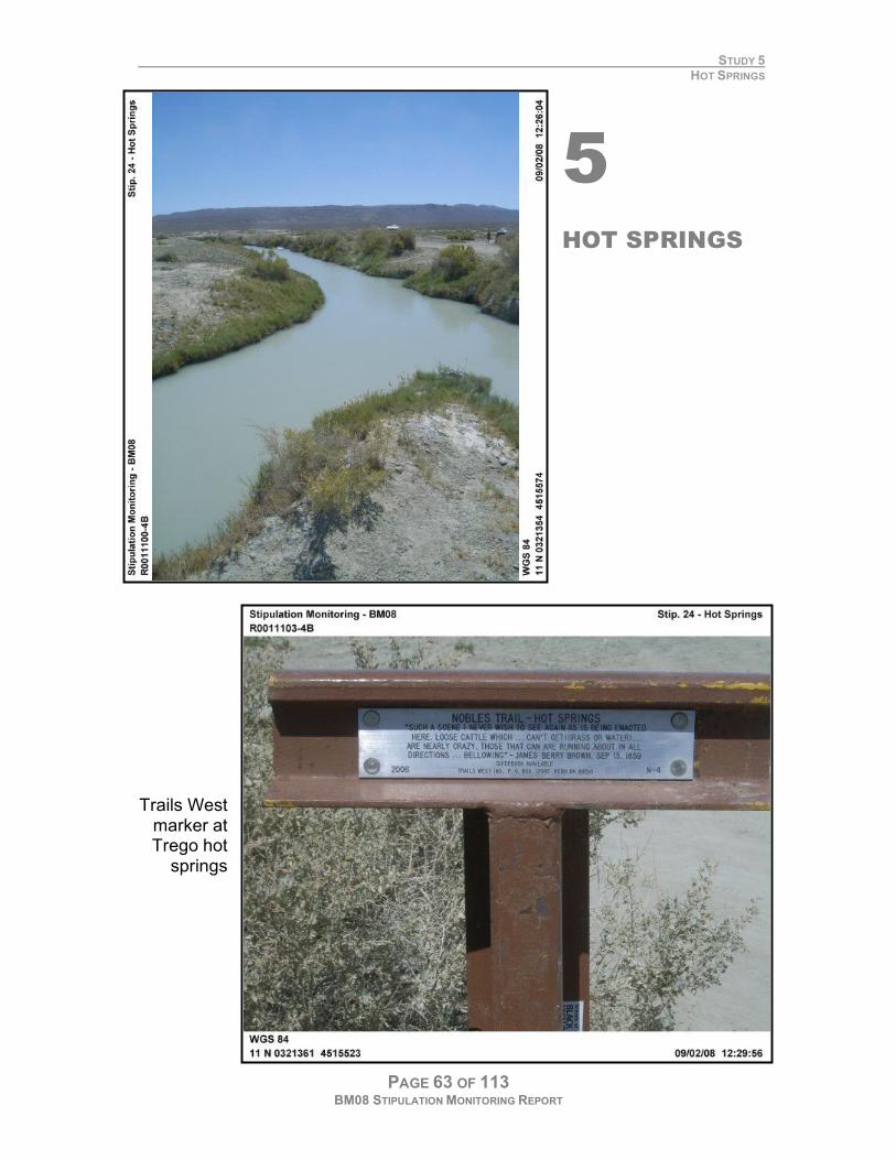
Trails West marker at Trego hot
springs
STUDY 5 HOT SPRINGS
PAGE 64 OF 113 BM08 STIPULATION MONITORING REPORT
A. GOAL
Burning Man participants understand that they are not to be used en route to or
from the event. Even a fraction of 50,000 participants would make a sizeable
impact. This ensures hot springs remain in good condition and their value as a
cultural resource is preserved.
B. STIPULATION
24. BRC personnel will discourage travel, including travel by aircraft, to other historical, cultural, recreational or
geographical resources in the Black Rock Desert area during the event. BRC will discourage participant use of hot
springs for the purpose of bathing, or extracting mud or water. C. METHODS
The team hoped to make one baseline inspection prior to event start and a
second inspection after the event ended. Due to limited staff and the distances
involved, the only areas checked by the Monitoring Team were Trego and Coyote
Springs. The Earth Guardians, Burning Man’s BLM volunteer group, did regularly
patrol the springs. They reported little use by event participants.
D. DATA
While users are highly discouraged from using the springs during the event
window, a team member came across 3 vehicles camped at Trego near the end
of the event. These were clearly Burning Man participants based on their
conversation about that year’s event. This, however, appeared to be an isolated
case.
E. RESULTS
This stipulation is being met.
STUDY 5 HOT SPRINGS
PAGE 65 OF 113 BM08 STIPULATION MONITORING REPORT
F. RECOMMENDATIONS
Enlist Earth Guardians help
A simple form could be created for patrols to report the amount of use seen by
participants and non-participants and the general condition of the springs. With
Earth Guardians and the BLM Contact Station adjacent in Center Camp,
coordinating logistics should be feasible.
Minimize scope of this study
Due to limited playa access over the years and participant cooperation, the
springs have been less of a concern. The Monitoring Team should only monitor
Trego and Coyote Springs, if any, due to the distances involved in traveling to the
other springs.

PAGE 66 OF 113 BM08 STIPULATION MONITORING REPORT
STUDY 6 PERIMETER FENCE
PAGE 67 OF 113 BM08 STIPULATION MONITORING REPORT
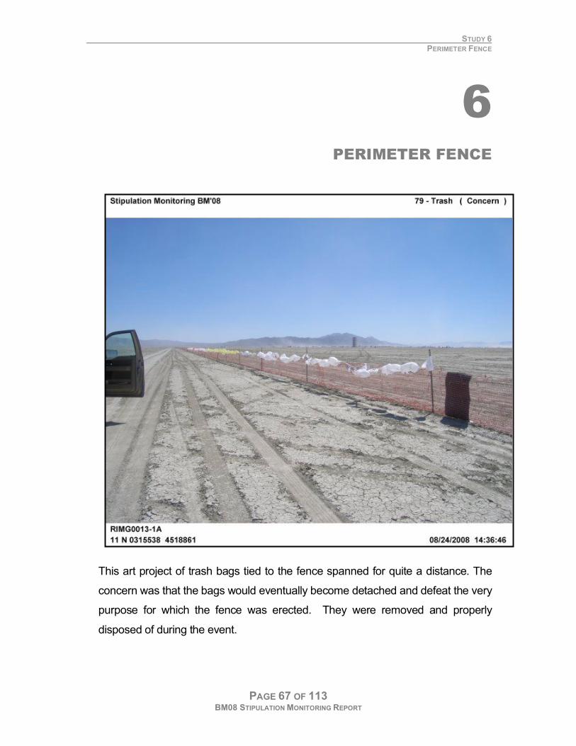
6 PERIMETER FENCE
This art project of trash bags tied to the fence spanned for quite a distance. The
concern was that the bags would eventually become detached and defeat the very
purpose for which the fence was erected. They were removed and properly
disposed of during the event.
STUDY 6 PERIMETER FENCE
PAGE 68 OF 113 BM08 STIPULATION MONITORING REPORT
A. GOAL
The perimeter fence not only defines the boundary of Black Rock City but it
prevents wind-blown debris from bowing across the rest of the playa. Motivated
by a) a sense of civic duty, b) opportunities for solitude, and c) urban myths of
discovered treasures, Black Rock citizens volunteer to pick up debris
accumulating along the fence. The Monitoring Team patrolled each day to check
for breaks in the fence and to see it is adequately cleared of debris.
B. STIPULATION
SOLID WASTE MANAGEMENT
32. Permittee shall install a 360° event perimeter/boundary trash fence. Any accumulation of trash that appears to
be spilling over the fence or passing through a fence break will be collected. Fence breaks will be repaired
immediately upon discovery. Permittee shall construct the southwest and southeast flanks of the perimeter fence
prior to installation of other facilities to safely direct vehicular traffic around the site.
C. METHODS
Team members started at the fence corner closest to the 12-mile playa access
and drove clockwise around the event outside the fence line. At each fence corner
and approximately halfway between each corner, the number of pieces of debris,
trash collectors and breaks in the fence were noted. The Team also shot
photographs in 2 opposing directions along the fence line to record dust piling up
along the fence. The reasons for this are detailed in the dune study.
This year, the Team aimed to make rough population estimates and compare
those figures with those of Burning Man’s counts, which are based on tickets in
and out of the gate. This differs from the previous 2 years when a more exact
count was sought. The reasons for this are two-fold: 1) BLM and BM numbers
have been comparable despite different methods of calculating the daily
population, and 2) implemented in 2007, the new cost-recovery based fees are no
longer tied to population.
STUDY 6 PERIMETER FENCE
PAGE 69 OF 113 BM08 STIPULATION MONITORING REPORT
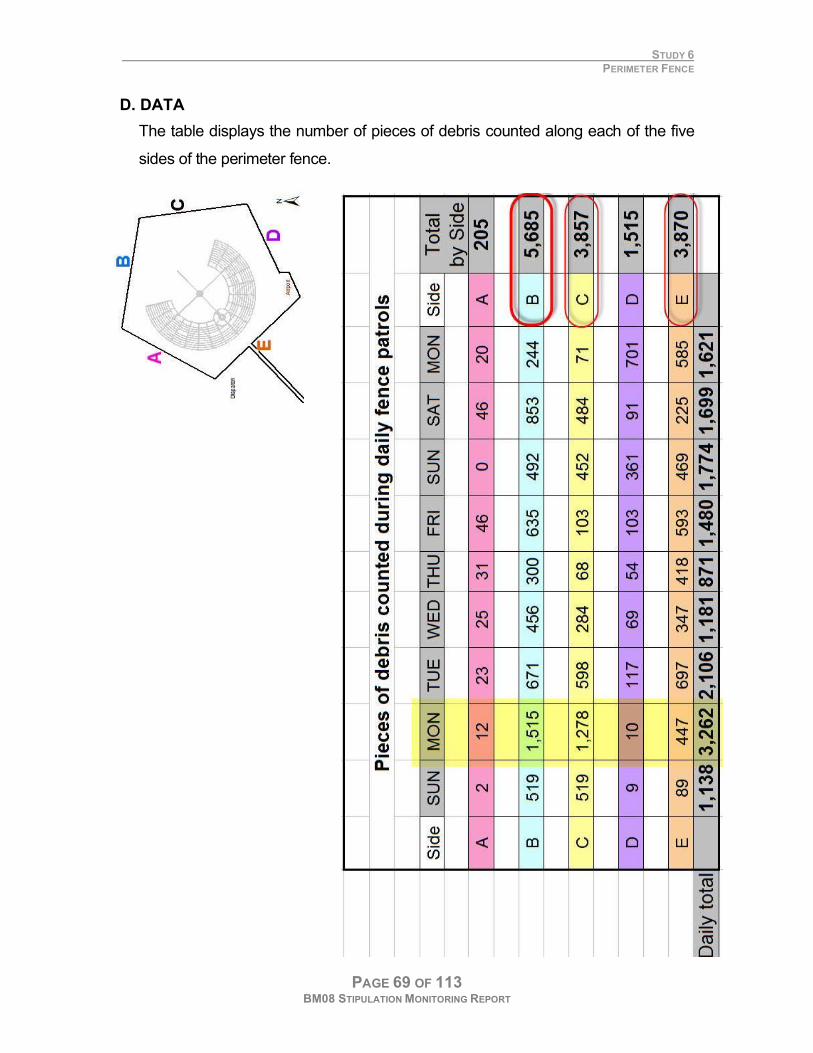
D. DATA
The table displays the number of pieces of debris counted along each of the five
sides of the perimeter fence.
STUDY 6 PERIMETER FENCE
PAGE 70 OF 113 BM08 STIPULATION MONITORING REPORT
E. RESULTS
The fence was well maintained and patrolled as outlined by the stipulations. The
largest amounts of debris were found on the ‘B’ and ‘E’’ sides of the fence as
identified on the map. This is consistent with the prevailing winds, which originate
at the south end of the playa and continue northward, blowing trash against these
sides. The most trash was found on Monday. This is not surprising since dust
storms were strong enough that day to close the event gate.
F. RECOMMENDATIONS
The perimeter fence and the current stipulations serve their purposes adequately.

PAGE 71 OF 113 BM08 STIPULATION MONITORING REPORT
7 POPULATION
STUDY 7 POPULATION
PAGE 72 OF 113 BM08 STIPULATION MONITORING REPORT
A. GOAL
It is critical to ensure that it does not grow beyond the limits of being manageable.
In the 5-year EA, Burning Man LLC suggested a population cap of 50,000
participants. This year, the Team aimed to make rough population estimates and
compare those figures with those of Burning Man’s counts, which are based on
tickets in and out of the gate. This differs from the previous 2 years when the
Team a more exact count. The reasons for requiring a less exact Team count are
two-fold: a) BLM and BM numbers have been comparable despite different
methods of calculating the daily population, and b) implemented in 2007, new
cost-recovery fees are no longer tied to population.
B. STIPULATION
GENERAL 1. Black Rock City LLC (BRC) is required to manage its advance ticket sales in a manner to keep the maximum
population of the event from exceeding 50,000 participants.
10. BRC shall provide BLM with the number of participants within the event site at noon each day and the peak
number of participants for each day during the period of site occupancy (August 8th through September 15th). BLM
can request population data any time during the event. BRC shall also provide BLM with detailed information of the
number of staff and participants on the event site for the August 8 through September 15th period within 60 days
after the event. This information shall include daily counts for the non-event period and six-hour counts during the
duration of the event. C. METHODS
Block counts
Each team was given a paper map showing which blocks they were to count.
The Team counts vehicles in which participants could have transported to the
event (art cars, golf carts etc did not count). Counts began daily before noon and
took about an hour or two to complete. Representative blocks were counted and
the population calculated accordingly. For logistic reasons, vehicles on the open
playa and at the airport were not counted.
Person per vehicle determination
Upon event entry, every participant must get out of the vehicle while Burning Man
staff search for hidden people and other concerns. This provided the Team the
ideal opportunity to count the number of people per vehicle.
STUDY 7 POPULATION
PAGE 73 OF 113 BM08 STIPULATION MONITORING REPORT
D. DATA
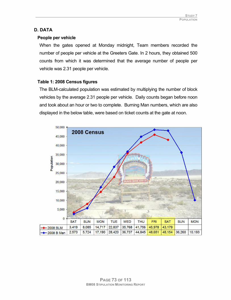
People per vehicle
When the gates opened at Monday midnight, Team members recorded the
number of people per vehicle at the Greeters Gate. In 2 hours, they obtained 500
counts from which it was determined that the average number of people per
vehicle was 2.31 people per vehicle.
Table 1: 2008 Census figures
The BLM-calculated population was estimated by multiplying the number of block
vehicles by the average 2.31 people per vehicle. Daily counts began before noon
and took about an hour or two to complete. Burning Man numbers, which are also
displayed in the below table, were based on ticket counts at the gate at noon.
STUDY 7 POPULATION
PAGE 74 OF 113 BM08 STIPULATION MONITORING REPORT
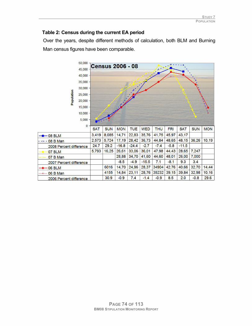
Table 2: Census during the current EA period
Over the years, despite different methods of calculation, both BLM and Burning
Man census figures have been comparable.
STUDY 7 POPULATION
PAGE 75 OF 113 BM08 STIPULATION MONITORING REPORT
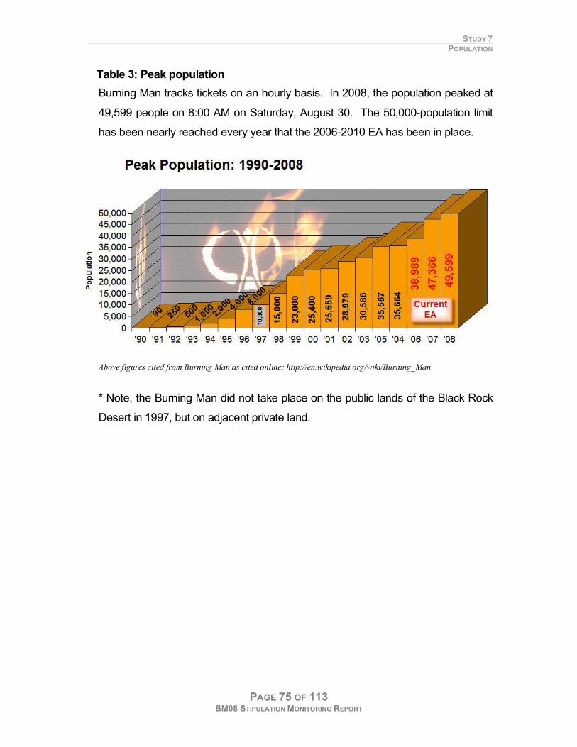
Table 3: Peak population
Burning Man tracks tickets on an hourly basis. In 2008, the population peaked at
49,599 people on 8:00 AM on Saturday, August 30. The 50,000-population limit
has been nearly reached every year that the 2006-2010 EA has been in place.
Above figures cited from Burning Man as cited online: http://en.wikipedia.org/wiki/Burning_Man
* Note, the Burning Man did not take place on the public lands of the Black Rock
Desert in 1997, but on adjacent private land.
STUDY 7 POPULATION
PAGE 76 OF 113 BM08 STIPULATION MONITORING REPORT
E. RESULTS
GOOD
Population cap of 50,000 was not exceeded.
VIOLATION
Daily population numbers were received after the 60-day reporting period as per
Stipulation #10.
F. RECOMMENDATIONS
Prepare a population contingency plan
With the arrival of only 400 more participants would have reached the population
limit of 50,000. Burning Man sold 55,000 tickets. This assumes a 5% non-
show/donation only rate. As notes, event attendance has increased every year
since the event first came to the Black Rock Desert in 1990. It is reasonable to
expect this upward growth will continue for the two remaining years the EA
remains in place. Given these facts, it is not unreasonable anticipate that this limit
may be reached during the life of the 2006-2010 EA.
A contingency plan is needed to provide for a) reporting procedures should
Burning Man tickets exceed 50,000 people, and b) a corresponding action plan for
the Burning Man and BLM. This plan should address the potential for large
camps of any turned away at the gates camping in large groups on the open playa
outside of the Public Closure Area on the open desert or at the hot springs as well
as congregating in areas such as Gerlach or Empire where they might impede the
traffic flow to and from the event.
Compare cost-recovery and population based fees
Since both BLM and BM numbers have been shown to be comparable, the
Burning Man population figures could be used to compare cost recovery-based
fees and population based fees.
PAGE 77 OF 113 BM08 STIPULATION MONITORING REPORT
TRASH TRANSECTS 8
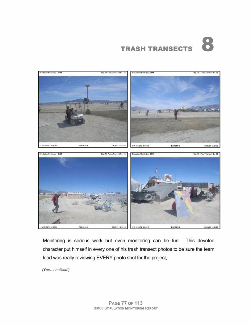
Monitoring is serious work but even monitoring can be fun. This devoted
character put himself in every one of his trash transect photos to be sure the team
lead was really reviewing EVERY photo shot for the project,
(Yes…I noticed!)
STUDY 8 TRASH TRANSECTS
PAGE 78 OF 113 BM08 STIPULATION MONITORING REPORT
A. GOAL
During the event, the Team photographed each trash transect location on the
chance that if an excessive amount of trash is found during later inspections, a
record exists of that area’s appearance in August.
B. STIPULATION
79. Inspections of the event site in the fall after the event, will be coordinated by BLM using randomly placed
transects on the site and a measurable cleaning standard. The inspecting party will intensively collect debris found
on the ground within each transect. A follow-up spring inspection will be conducted only when deemed necessary by
BLM. Post-Event Cleanup Standard: The average total surface area of debris collected from either the fall or spring
transects
C. METHODS
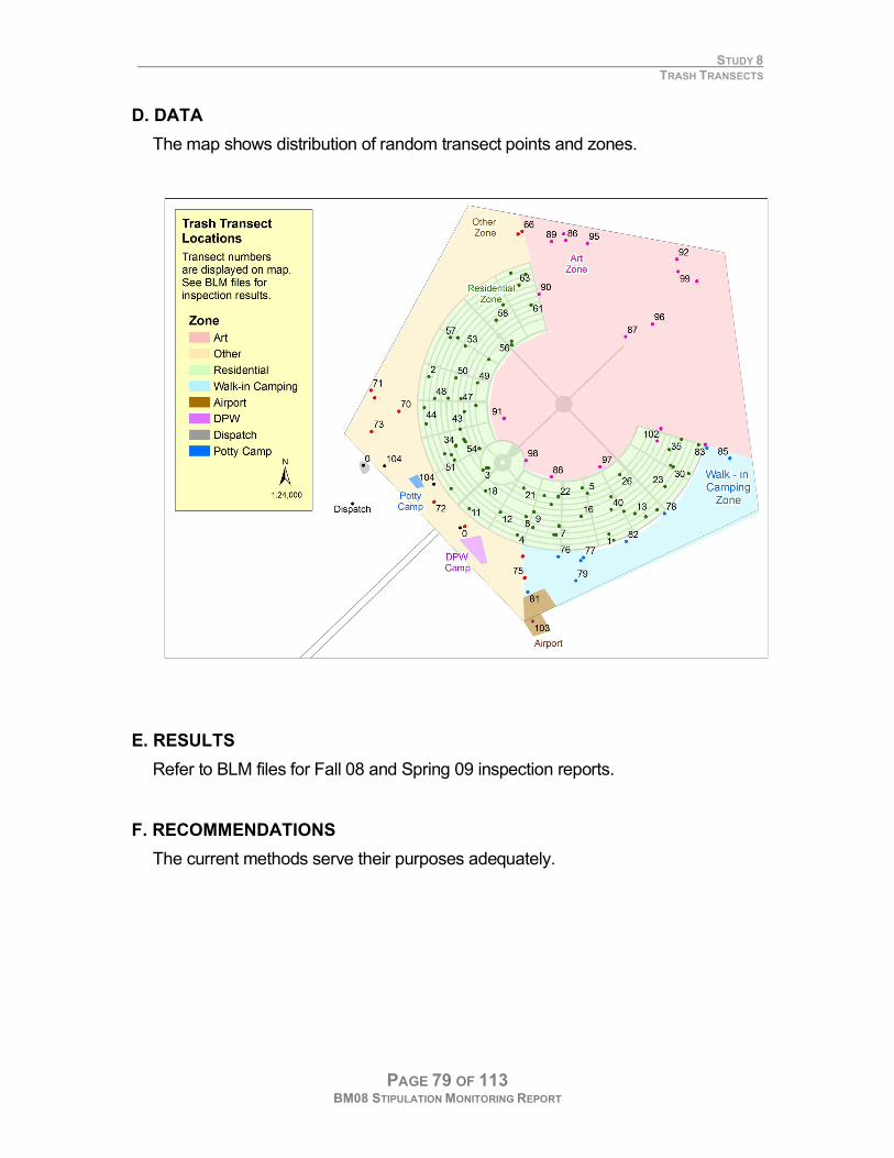
In ArcGIS, Hawth’s tools were used to generate random points through 5 main
zones in Black Rock City (Art, Residential, Walk-in Camping, Airport and Other) as
shown on the map. During the event, the Team navigated to the approximate
location plotted on the paper map. Upon arrival they shot 4 different photos, the
first is facing towards the Man, and 3 others each rotated 90 degrees for a
complete 360 view. The location of these photo points was recorded at the click of
the shutter by the GPS camera. Single points were also generated for the Airport,
ICP, DPW and Potty Camp locations for later inspections. It is these locations that
will be used for later BLM inspections.
STUDY 8 TRASH TRANSECTS
PAGE 79 OF 113 BM08 STIPULATION MONITORING REPORT
D. DATA
The map shows distribution of random transect points and zones.
E. RESULTS
Refer to BLM files for Fall 08 and Spring 09 inspection reports.
F. RECOMMENDATIONS
The current methods serve their purposes adequately.

PAGE 80 OF 113 BM08 STIPULATION MONITORING REPORT
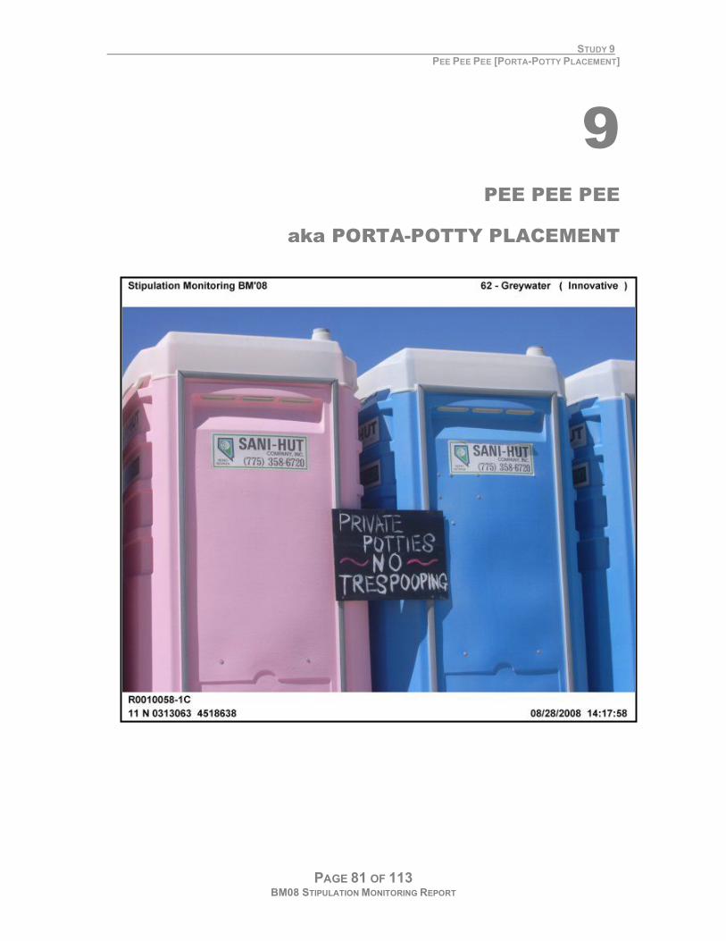
STUDY 9 PEE PEE PEE [PORTA-POTTY PLACEMENT]
PAGE 81 OF 113 BM08 STIPULATION MONITORING REPORT
9 PEE PEE PEE
aka PORTA-POTTY PLACEMENT
STUDY 9 PEE PEE PEE [PORTA-POTTY PLACEMENT]
PAGE 82 OF 113 BM08 STIPULATION MONITORING REPORT
A. GOAL
Minimize ‘playa puddles’ (particularly the many found every morning near the
Esplanade) to create a more sanitary and pleasant environment.
B. STIPULATION
61. BRC will coordinate with the NV State Health Division, and the toilet contractor(s) to provide the proper number of
toilets and hand sanitizers for the peak anticipated population and adequate resources for toilet pumping and
maintenance consistent with the requirements of the health department. The following additional requirements apply:
a. A minimum of two toilets with hand sanitizers each will be located in the communities of Gerlach and Empire to
reduce impacts on local sewer systems. Toilet locations will be coordinated with the communities involved.
b. Banks of toilets will be placed in the Art area and will be prominently identified at night.
c. Banks of toilets will be placed at regular intervals along the exit road during the peak exodus periods. d. Banks of
toilets will be placed near large structures at the 2:00 and 10:00 and Esplanade locations associated with large
gatherings.
C. METHODS
During the Team’s survey of the city they made note of any unsanitary toilets
(none found), puddles (many!). Attempts to note the number of rented porta-
potties participants installed in participants camps were met with limited success.
STUDY 9 PEE PEE PEE [PORTA-POTTY PLACEMENT]
PAGE 83 OF 113 BM08 STIPULATION MONITORING REPORT
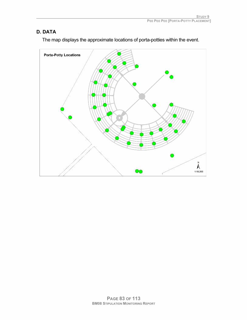
D. DATA
The map displays the approximate locations of porta-potties within the event.
STUDY 9 PEE PEE PEE [PORTA-POTTY PLACEMENT]
PAGE 84 OF 113 BM08 STIPULATION MONITORING REPORT
E. RESULTS & RECOMMENDATIONS
Ensure large camps are adjacent to facilities
Suggest adding a stipulation for large camps and areas attracting many
participants to provide their own porta-potties. Alternatively, through Burning
Man’s theme camp registration process, camps expecting large numbers of
visitors could preferentially be located near banks of toilets.
Add more facilities on the open playa and increase their visibility at night
Suggest placing more porta-potty banks in the art area and near the esplanade.
Despite current lighting, these banks are too easily lost in the dazzling array of
lights during the typical Burning Man night.
Use GIS to optimize placement of facilities
Inside BRC, consider a placement plan to balance both the needs of the
participants in locating facilities and the needs of the pump truck staff for efficient
access routes throughout the city. This can be used to analyze the minimum,
maximum and average distances to the potties and assist in future planning.
Minimize puddles on the open playa and Esplanade
Attempts to quantify and – more importantly, minimize the ongoing issue of still
remain elusive. Perhaps better placement of facilities. Suggest more banks of
toilets adjacent to the larger art projects, Center Camp and the Esplanade.
Familiarity may help over come visibility issues by placing these in places that are
consistent, easy to remember and easy to find. Marking them on Black Rock City
maps and other media will help reach this goal.
PAGE 85 OF 113 BM08 STIPULATION MONITORING REPORT
10 EXPLORING
CUMULATIVE EFFECTS
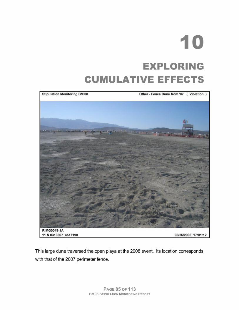
This large dune traversed the open playa at the 2008 event. Its location corresponds
with that of the 2007 perimeter fence.

STUDY 10 EXPLORING CUMULATIVE EFFECTS
PAGE 86 OF 113 BM08 STIPULATION MONITORING REPORT
A. INTRODUCTION
This final study documents the formation of dunes at the 2007 perimeter and their
noted impact on the 2008 event. While there is not a stipulation per se against
the formation of dunes on the playa, these observations serve as a talking point to
initiate discussions about the possible long-term effects of the event.
STUDY 10 EXPLORING CUMULATIVE EFFECTS
PAGE 87 OF 113 BM08 STIPULATION MONITORING REPORT
B. OBSERVATIONS
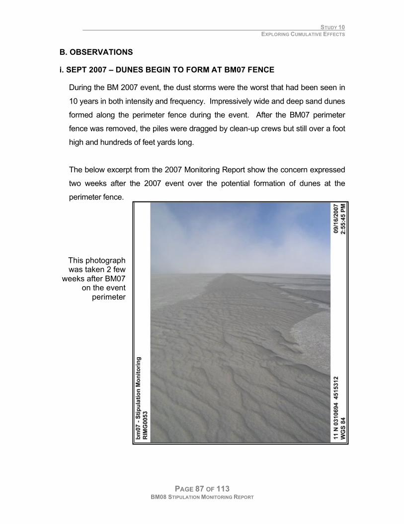
i. SEPT 2007 – DUNES BEGIN TO FORM AT BM07 FENCE
During the BM 2007 event, the dust storms were the worst that had been seen in
10 years in both intensity and frequency. Impressively wide and deep sand dunes
formed along the perimeter fence during the event. After the BM07 perimeter
fence was removed, the piles were dragged by clean-up crews but still over a foot
high and hundreds of feet yards long.
The below excerpt from the 2007 Monitoring Report show the concern expressed
two weeks after the 2007 event over the potential formation of dunes at the
perimeter fence.
This photograph was taken 2 few
weeks after BM07 on the event
perimeter
STUDY 10 EXPLORING CUMULATIVE EFFECTS
PAGE 88 OF 113 BM08 STIPULATION MONITORING REPORT
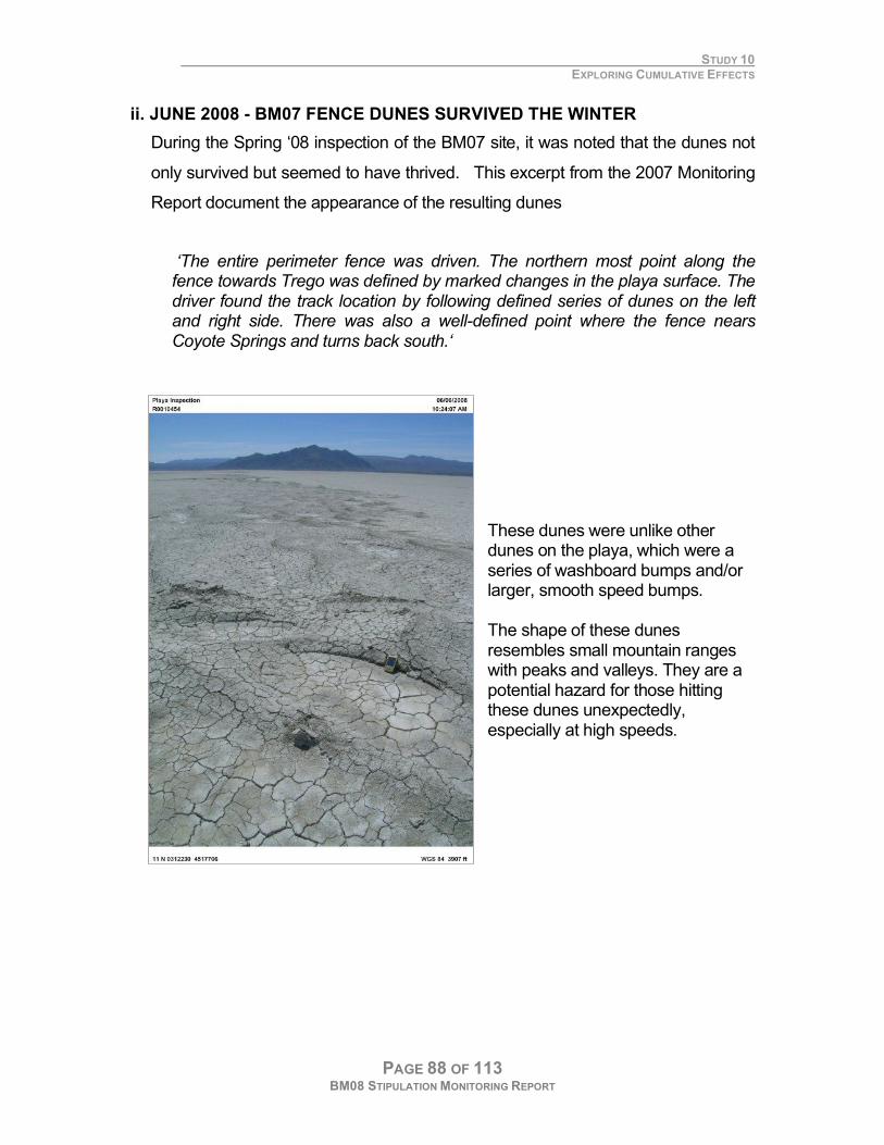
ii. JUNE 2008 - BM07 FENCE DUNES SURVIVED THE WINTER
During the Spring ‘08 inspection of the BM07 site, it was noted that the dunes not
only survived but seemed to have thrived. This excerpt from the 2007 Monitoring
Report document the appearance of the resulting dunes
‘The entire perimeter fence was driven. The northern most point along the fence towards Trego was defined by marked changes in the playa surface. The driver found the track location by following defined series of dunes on the left and right side. There was also a well-defined point where the fence nears Coyote Springs and turns back south.‘
These dunes were unlike other dunes on the playa, which were a series of washboard bumps and/or larger, smooth speed bumps. The shape of these dunes resembles small mountain ranges with peaks and valleys. They are a potential hazard for those hitting these dunes unexpectedly, especially at high speeds.
STUDY 10 EXPLORING CUMULATIVE EFFECTS
PAGE 89 OF 113 BM08 STIPULATION MONITORING REPORT
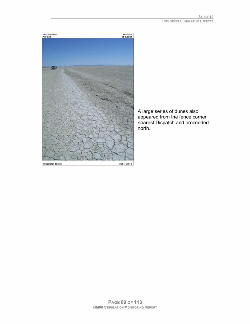
A large series of dunes also appeared from the fence corner nearest Dispatch and proceeded north.
STUDY 10 EXPLORING CUMULATIVE EFFECTS
PAGE 90 OF 113 BM08 STIPULATION MONITORING REPORT
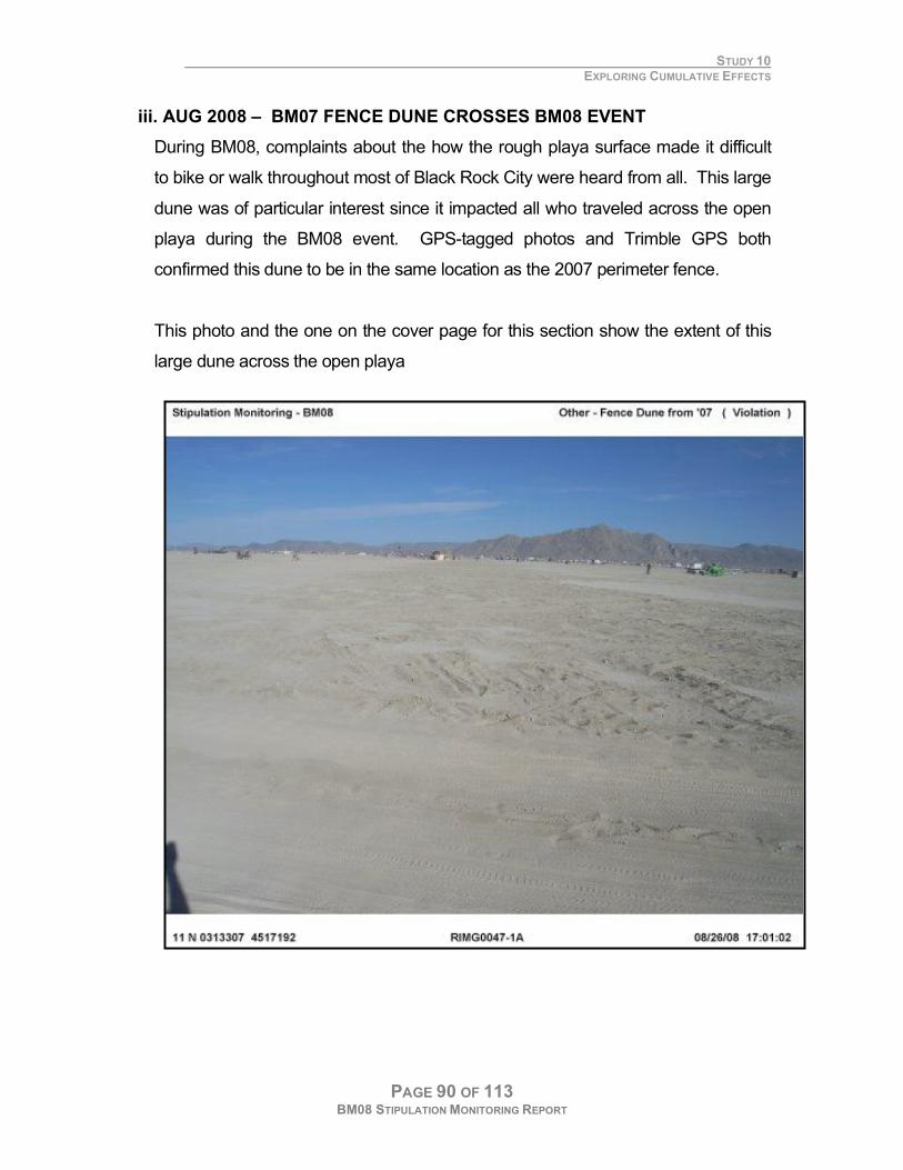
iii. AUG 2008 – BM07 FENCE DUNE CROSSES BM08 EVENT
During BM08, complaints about the how the rough playa surface made it difficult
to bike or walk throughout most of Black Rock City were heard from all. This large
dune was of particular interest since it impacted all who traveled across the open
playa during the BM08 event. GPS-tagged photos and Trimble GPS both
confirmed this dune to be in the same location as the 2007 perimeter fence.
This photo and the one on the cover page for this section show the extent of this
large dune across the open playa
STUDY 10 EXPLORING CUMULATIVE EFFECTS
PAGE 91 OF 113 BM08 STIPULATION MONITORING REPORT
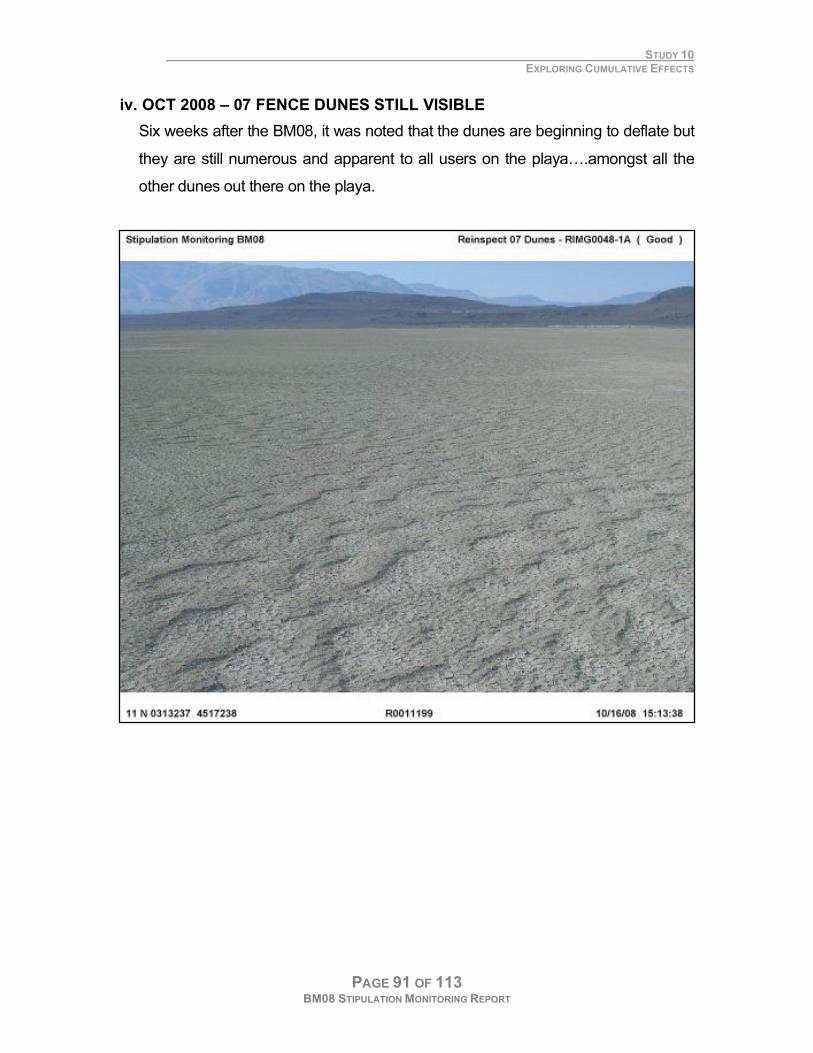
iv. OCT 2008 – 07 FENCE DUNES STILL VISIBLE
Six weeks after the BM08, it was noted that the dunes are beginning to deflate but
they are still numerous and apparent to all users on the playa….amongst all the
other dunes out there on the playa.
STUDY 10 EXPLORING CUMULATIVE EFFECTS
PAGE 92 OF 113 BM08 STIPULATION MONITORING REPORT
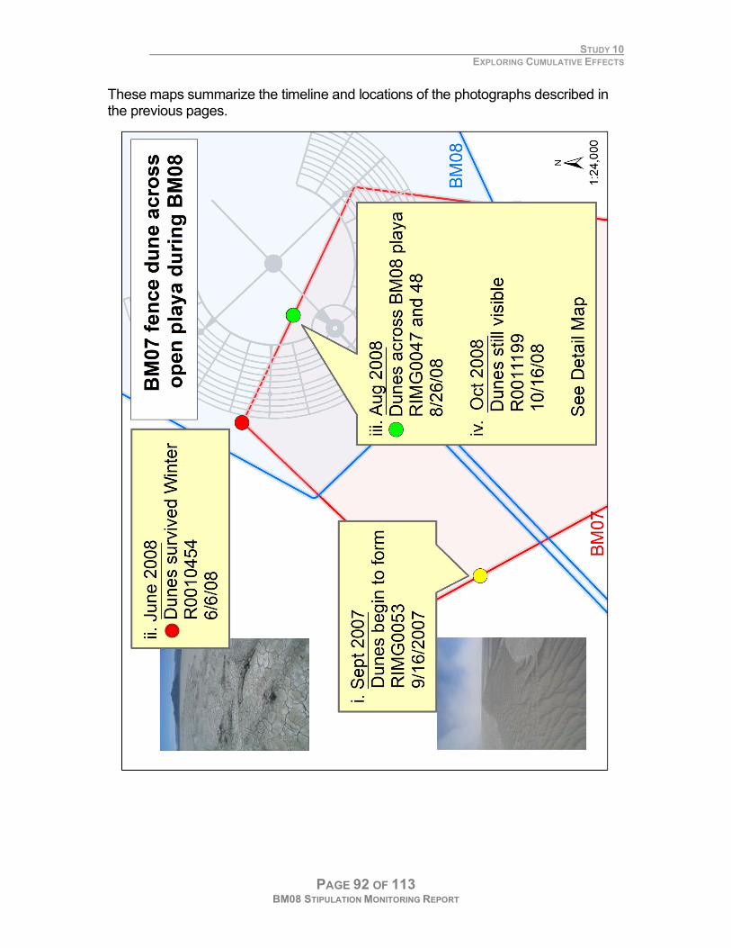
These maps summarize the timeline and locations of the photographs described in the previous pages.
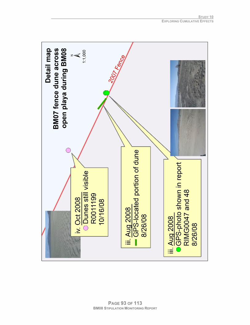
STUDY 10 EXPLORING CUMULATIVE EFFECTS
PAGE 93 OF 113 BM08 STIPULATION MONITORING REPORT
STUDY 10 EXPLORING CUMULATIVE EFFECTS
PAGE 94 OF 113 BM08 STIPULATION MONITORING REPORT
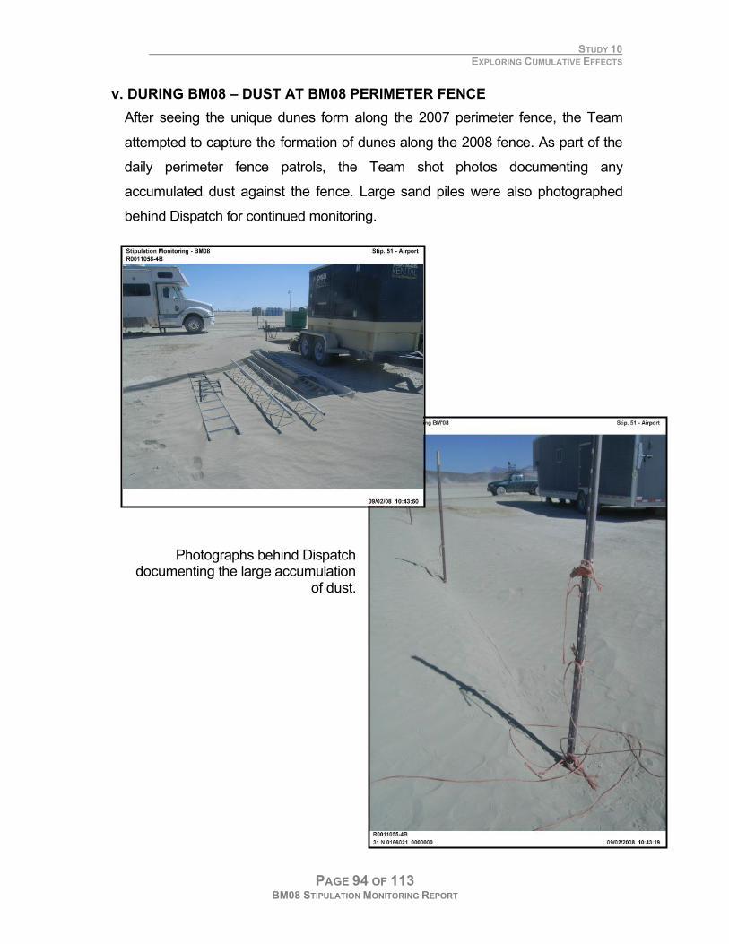
v. DURING BM08 – DUST AT BM08 PERIMETER FENCE
After seeing the unique dunes form along the 2007 perimeter fence, the Team
attempted to capture the formation of dunes along the 2008 fence. As part of the
daily perimeter fence patrols, the Team shot photos documenting any
accumulated dust against the fence. Large sand piles were also photographed
behind Dispatch for continued monitoring.
Photographs behind Dispatch documenting the large accumulation
of dust.
STUDY 10 EXPLORING CUMULATIVE EFFECTS
PAGE 95 OF 113 BM08 STIPULATION MONITORING REPORT
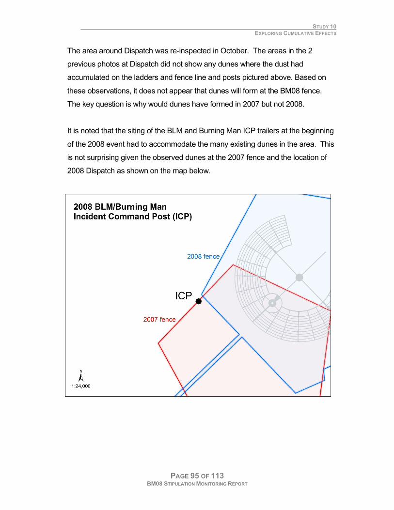
The area around Dispatch was re-inspected in October. The areas in the 2
previous photos at Dispatch did not show any dunes where the dust had
accumulated on the ladders and fence line and posts pictured above. Based on
these observations, it does not appear that dunes will form at the BM08 fence.
The key question is why would dunes have formed in 2007 but not 2008.
It is noted that the siting of the BLM and Burning Man ICP trailers at the beginning
of the 2008 event had to accommodate the many existing dunes in the area. This
is not surprising given the observed dunes at the 2007 fence and the location of
2008 Dispatch as shown on the map below.
STUDY 10 EXPLORING CUMULATIVE EFFECTS
PAGE 96 OF 113 BM08 STIPULATION MONITORING REPORT
C. RESULTS
Dunes along 2007 fence but not in 2008
The monitoring report from 2007 and this report document the formation of dunes
along the ’07 perimeter fence of the BM07 event and their impact on the 2008
event. Based on the Team’s observations along the ’08 perimeter fence, it
predicted that dunes would not form along the 2008 fence.
Cause of dune formation
Dunes are caused by the interaction of many factors. Including a) dust, b) wind, c)
moisture and d) time. From the Burning Man EA:
From 3.3.1. PLAYA SEDIMENTS AND VEGETATION The sediments of the playa are subject to displacement by winds when dry and disturbed. Winds that most
commonly move the surface materials are associated with frontal passage or thunderstorms. Wind movement of
sediment particles can cause the periodic formation of low, transient dunes. Wind erosion is a function of particle
erodibility, surface roughness and weather conditions. Vehicle use and other disturbances on the playa alter the
surface roughness. Increased roughness slows sediment particle movement across the surface, causing particles to
accumulate on the leeward side of low features forming transient dunes. The dunes are temporary features
generally less than a foot in height. The actions of wind and water over one or more winters lead to the removal of
the dunes. These dunes have become increasingly common over the past several years but have been documented
prior to periods of heavy human activity on the playa surface (Neal 1970).
Differences in BM07 and BM08
BM07 saw the worst dust storms that can be recalled during the event in the last
10 years. Presumably, this in combination of near drought conditions for the last 3
years are the main contributing factors to the large dunes seen along the 2007 but
not in 2008.
STUDY 10 EXPLORING CUMULATIVE EFFECTS
PAGE 97 OF 113 BM08 STIPULATION MONITORING REPORT
D. RECOMMENDATIONS
Continue to knock down accumulated dust piles after event
While Burning Man bladed the 2007 dunes after the event in order to reduce their
height, their presence is still clearly detectable. The EA currently prescribes that
as part of site clean-up accumulated dust at the perimeter fence be knocked
down. Team recommends a stipulation be added to knock down all dunes at the
perimeter fence, Dispatch and other significant finds. It should describe the
specifications to which the dunes should to be cleared.
From 2.2.10. EVENT TAKE DOWN AND CLEAN UP: ON-SITE ….The perimeter fence would be the last structure to be removed. Dunes formed as a result of dust blowing
into the perimeter fence would dragged or graded.
Continue academic studies
In a provision created to provide conditions to study the cumulative impacts of the
event, the city alternates between the “B site” of BM07 and the “C Site” of BM08.
from 2. DESCRIPTION OF PROPOSED ACTION & ALTERNATIVES b. Two sites—Rotating between two sites would potentially allow wind eroded areas additional time between
uses for recovery associated with transport of playa sediments by surface waters versus creation of a second
site with elevated levels of residual debris when compared to overall playa area. The use of two sites would
also facilitate the joint BLM/Desert Research Institute study to determine impacts to the playa surface from a
single event. This study will begin in 2006.
The research of Don Sade and Ken Adams at Desert Research Institute, Reno,
NV is titled Dynamics of the Black Rock Playa: Relationships between
Recreational Use, Physical Processes, and Biological Environments. These
collaborative efforts of DRI and BLM are scheduled from April 2006 to September
2009. It is presumed that the results will be published after this period.
Develop Team efforts to explore potential long-term effects
The Team’s efforts over the last 3 years have shown that most violations on the
playa are resolved soon after the event. The Team will continue monitoring short-
term impacts but hopes to shift efforts towards exploring the longer-term,
cumulative effects. The observed dunes at the ‘07 perimeter fence rekindled the
Team’s interest in long-term effects.
STUDY 10 EXPLORING CUMULATIVE EFFECTS
PAGE 98 OF 113 BM08 STIPULATION MONITORING REPORT
E. DISCUSSION
The human presence plays a part
While humans cannot affect forces of nature such as seasonal variation in the
rainfall and winds, they do affect the nature of the playa surface by their mere
presence by -
1) Increasing amounts of fugitive dust by breaking the playa surface via travel
across the playa surface,
2) Providing structures and barriers against which dust can accumulate and
form dunes.
The Burning Man EA describes the potential impact of the event on playa
sediments as such:
from 4.2.1. PLAYA SEDIMENTS & VEGETATION During the past several years transient dunes have become common adjacent to the primary playa “roads”
and also downwind of Black Rock City. No complete inventory of transient dunes has occurred but the
location of transient dunes downwind of the Burning Man Event suggests that some of the transient dunes
observed in the past several years are the result of disturbances associated with the event. The actual
formation of transient dunes following disturbance would depend upon the number of strong wind events that
occur following disturbances and prior to wetting rains.
It also addresses the above two points regarding increased vehicle travel and the
perimeter fence accordingly:
Continued from 4.2.1. PLAYA SEDIMENTS & VEGETATION
Dust storms during or immediately after the event would create sediment windrows along the perimeter
fence. Dragging or grading during the cleanup phase would eliminate these windrows. Event stipulations
require watering of dust areas thus reducing the amount of material potentially available for wind movement.
from 5.4.5. PLAYA SEDIMENTS AND VEGETATION Continuing to permit the Burning Man event at two alternating locations would be expected to result in cumulative
continuing wind erosion of the surface of the playa at the location of Black Rock City (1600 plus acres).… The
anticipated increase in number of visitors to the playa, including participants at permitted events, would lead to
increased surface disturbance. This would lead to the potential for additional formation of transient dunes. The
degree to which dune formation would actually occur is unknown but would be expected to be minor when compared
to that associated with the 115 miles of existing playa “roads”.
STUDY 10 EXPLORING CUMULATIVE EFFECTS
PAGE 99 OF 113 BM08 STIPULATION MONITORING REPORT
F. CONCLUSION
While adopting a Leave No Trace ethics, the goal of any event involving 50,000
participants – must be to minimize impact. There can be no such thing as LNT
with 50,000 people and their vehicles traveling on the only road to and from a 10-
square mile area. This perspective needs to be considered when modifying
stipulations or developing the next Environmental Assessment (EA) for this event.

PAGE 100 OF 113 BM08 STIPULATION MONITORING REPORT
TECHNICAL NOTE
PAGE 101 OF 113 BM08 STIPULATION MONITORING REPORT
IV. TECHNICAL NOTE
How do you monitor over 20 stipulations at the largest permitted event on the
US public lands in real-time with volunteer staff from an office trailer on the
Black Rock Desert?
This technical note demonstrates the combined power of the GPS-cameras, Trimble
GPS devices and ArcGIS to monitor permit stipulations in ‘real time’ at the Burning
Man event. The chosen tools facilitated the completion of 10 monitoring studies, the
results and recommendations of which were compiled in the 2008 Monitoring Report.
This suite of geospatial tools enabled the monitoring team to justify day-to-day
decision-making. Compiled written reports, as well as an accompanying CD of the
data and maps served as record for this year’s event as well as the basis for future
management decisions for this and other permitted events. This real-time knowledge
management is an extremely valuable tool for both short and long-term planning.
TECHNICAL NOTE
PAGE 102 OF 113 BM08 STIPULATION MONITORING REPORT
SUITE OF GPS/GIS TOOLS
Because everything in Black Rock City is temporary, using GPS technology and
photo-documentation is key to meeting resource protection goals and managing
future events on the desert. Tools were chosen to meet field conditions, staff needs
and availability. These included a) extreme temperatures and dust, b) a single
computer with supporting software but lacking of internet access, c) a staff of
primarily volunteers with minimal training time, and d) available equipment with no
new purchases.
A. GPS CAMERAS
Four Ricoh 500SE cameras were used to photo-documentation everything ‘good,
bad or ugly’ at the event. The cameras offered the following advantages that
made possible the documentation and management of over 1200 photos
compiled to complete the 10 studies detailed in the monitoring report.
1. Minimal training
Training for use of these cameras took less than 15 minutes. This was
ideal for our team of mostly volunteers.
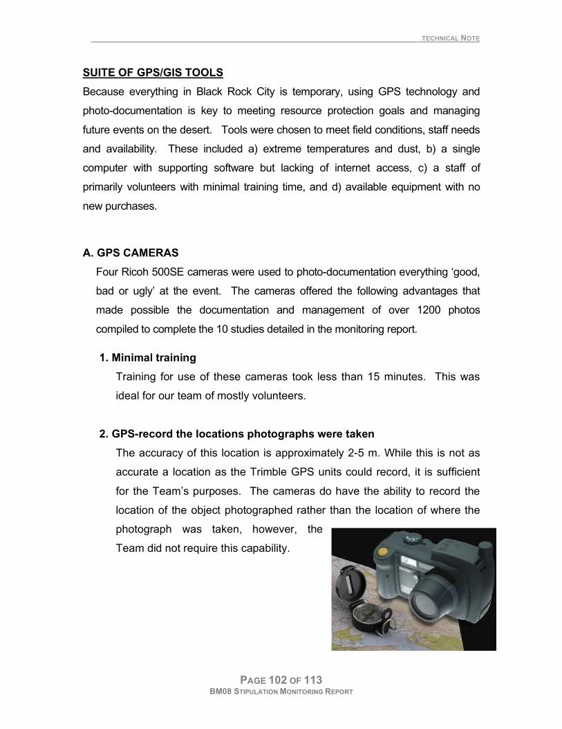
2. GPS-record the locations photographs were taken
The accuracy of this location is approximately 2-5 m. While this is not as
accurate a location as the Trimble GPS units could record, it is sufficient
for the Team’s purposes. The cameras do have the ability to record the
location of the object photographed rather than the location of where the
photograph was taken, however, the
Team did not require this capability.
TECHNICAL NOTE
PAGE 103 OF 113 BM08 STIPULATION MONITORING REPORT
3. Record information about each photograph
Caplio’s List Editor software (which ships free with the camera) was used
to create a data dictionary to ensure all information was collected in a
standard way. Outlined below are the possible entries accessed via drop-
down menus for each of the 5 data fields.
Field Representative attribute values
Study Art Project, Perimeter Fence, Trash transects
Stipulation 19 – Art Burn, 32 – Perimeter Fence, 79 – Trash
Status Good/Stip Met, Bad/Concern, Ugly/Violation, Other
First Digit 1st digit of trash transect number (0-9)
Second Digit 2nd
digit of trash transect number (0-9)
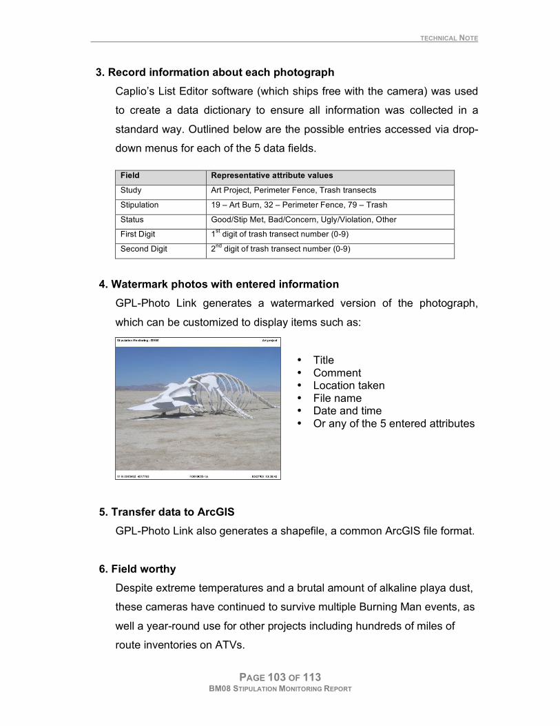
4. Watermark photos with entered information
GPL-Photo Link generates a watermarked version of the photograph,
which can be customized to display items such as:
• Title • Comment • Location taken • File name • Date and time • Or any of the 5 entered attributes
5. Transfer data to ArcGIS
GPL-Photo Link also generates a shapefile, a common ArcGIS file format.
6. Field worthy
Despite extreme temperatures and a brutal amount of alkaline playa dust,
these cameras have continued to survive multiple Burning Man events, as
well a year-round use for other projects including hundreds of miles of
route inventories on ATVs.
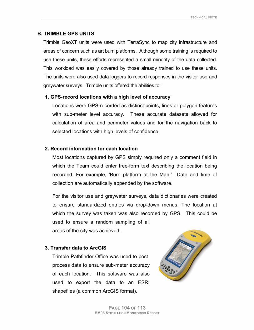
TECHNICAL NOTE
PAGE 104 OF 113 BM08 STIPULATION MONITORING REPORT
B. TRIMBLE GPS UNITS
Trimble GeoXT units were used with TerraSync to map city infrastructure and
areas of concern such as art burn platforms. Although some training is required to
use these units, these efforts represented a small minority of the data collected.
This workload was easily covered by those already trained to use these units.
The units were also used data loggers to record responses in the visitor use and
greywater surveys. Trimble units offered the abilities to:
1. GPS-record locations with a high level of accuracy
Locations were GPS-recorded as distinct points, lines or polygon features
with sub-meter level accuracy. These accurate datasets allowed for
calculation of area and perimeter values and for the navigation back to
selected locations with high levels of confidence.
2. Record information for each location
Most locations captured by GPS simply required only a comment field in
which the Team could enter free-form text describing the location being
recorded. For example, ‘Burn platform at the Man.’ Date and time of
collection are automatically appended by the software.
For the visitor use and greywater surveys, data dictionaries were created
to ensure standardized entries via drop-down menus. The location at
which the survey was taken was also recorded by GPS. This could be
used to ensure a random sampling of all
areas of the city was achieved.
3. Transfer data to ArcGIS
Trimble Pathfinder Office was used to post-
process data to ensure sub-meter accuracy
of each location. This software was also
used to export the data to an ESRI
shapefiles (a common ArcGIS format).
TECHNICAL NOTE
PAGE 105 OF 113 BM08 STIPULATION MONITORING REPORT
4. Navigate to collected features
Long after Black Rock City had been dismantled, the Team was able to
navigate the empty desert directly back to sites within the former city.
Art burn platforms and other areas of potential concern, the perimeter
fence, and other infrastructure were areas subject to for post-event
inspections. Shapefiles for either GPS collected data or the photo
locations from the camera could be copied back to the unit for navigation.
Coordinates from the watermarked photos could also be manually entered
into the Trimble units.
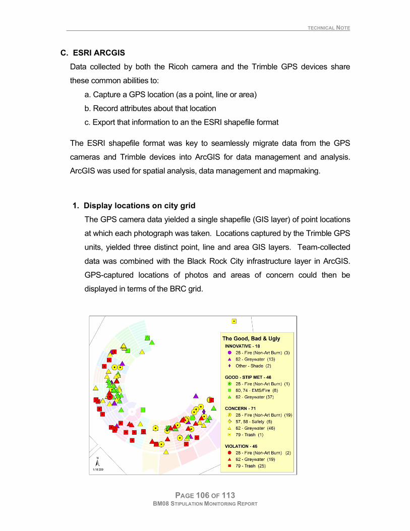
TECHNICAL NOTE
PAGE 106 OF 113 BM08 STIPULATION MONITORING REPORT
C. ESRI ARCGIS
Data collected by both the Ricoh camera and the Trimble GPS devices share
these common abilities to:
a. Capture a GPS location (as a point, line or area)
b. Record attributes about that location
c. Export that information to an the ESRI shapefile format
The ESRI shapefile format was key to seamlessly migrate data from the GPS
cameras and Trimble devices into ArcGIS for data management and analysis.
ArcGIS was used for spatial analysis, data management and mapmaking.
1. Display locations on city grid
The GPS camera data yielded a single shapefile (GIS layer) of point locations
at which each photograph was taken. Locations captured by the Trimble GPS
units, yielded three distinct point, line and area GIS layers. Team-collected
data was combined with the Black Rock City infrastructure layer in ArcGIS.
GPS-captured locations of photos and areas of concern could then be
displayed in terms of the BRC grid.

TECHNICAL NOTE
PAGE 107 OF 113 BM08 STIPULATION MONITORING REPORT
2. Query locations based on entered information
Data from the GPS-cameras and Trimble units contains not only location
but also the attributes that were entered upon capture. These 5 attributes
entered serve as the basis for symbology, queries and spatial analysis in
ArcGIS.
3. Perform spatial analysis
ArcGIS was used to summarize documented incidences by stipulation and
status and to determine fence lengths, burn platform areas and other city
infrastructure calculations.
4. Generate random locations for trash transects
Hawth’s tools was in ArcGIS, used to generate random points through 5 main
zones in Black Rock City (Art, Residential, Walk-in Camping, Airport and
Other) as shown on the map. During the event, the Monitoring Team
photographed the appearance at these locations on the chance that if an
excessive amount of trash was found during later inspections, a record exists
of that area’s appearance during the event.
TECHNICAL NOTE
PAGE 108 OF 113 BM08 STIPULATION MONITORING REPORT
KNOWLEDGE MANAGEMENT
This suite of geospatial tools provided for knowledge management in 3 time
frames:
A. Real-time monitoring
Teams patrolled the city with a GPS-camera. If a concern was found, it
was photographed and attributes entered such including stipulation and a
status of “concern” or “violation” depending on the severity. Data was
collected and processed daily. A GIS-query based on the ‘Status’ was
made to look for incidents of ‘Concern’ or ‘Violation’. A watermarked
image was printed with GPS coordinates and attributes. A GIS map was
also generated to show its location in on the Black Rock City grid. These
mapping products were distributed to the appropriate authorities for
resolution. When resolved, the incident would be re-photographed and its
status updated accordingly.
B. Short-term record of Team efforts during the week
The Team shot over 1,200 photographs during the event. Management of
such a volume of images would not have been possible without the ability
to view and query the photo files by attributes and/or location. This ability
was the basis for monitoring efforts while on the playa.
C. Long-term documentation of stipulation monitoring efforts
Team results and recommendations based on the collected data were
compiled in a stipulation monitoring report, which was accompanied by a
CD of data, maps and analyses. The stipulation monitoring report serves
as part of the permanent files for documenting permit compliance. It also
is the basis for managers to determine: a) if permit compliance and all
stipulations were adequately met for this years event, b) whether to re-
issue permit the next year, and if so, with what additional or modified

PAGE 109 OF 113 BM08 STIPULATION MONITORING REPORT
stipulations, and c) to base decisions for other types of future event
permits similar in nature and/or location.
PAGE 110 OF 113 BM08 STIPULATION MONITORING REPORT
V. MONITORING TEAM
Surprise BLM, Cedarville, CA
Roger Farschon, NCA Ecologist & Incident Commander Megan Farschon, Intern Nicole Kiecker, Intern
Winnemucca BLM Joey Carmosino, Outdoor Recreation Planner & Event Logistics Lead David Lefevre, NCA Outdoor Recreation Planner
Dave Martsch, Radio Tech Brooks Wilson
Great Basin Institute at Winnemucca BLM Justin Robbins, NCA Park Ranger Robert Williams, Recreation Technician Marla Kirschbaum, Recreation Technician
Nevada Outdoors School at Winnemucca BLM Holly Palmer Hayze Lindsay Megan Cupid, London, UK Jenny Deverson, Brighton, UK
Lorna Griffiths, Nottingham, UK Alexander Stross, Chichester, UK Stuart Watson, Leicester, UK Jessica Templeton, Plymouth, MI Louise Hart, NCA Transportation Specialist Burning Man participants “Arashi” “Yen” Other Dave Book, Friends of Black Rock High Rock, Reno, NV Dave, NV Dept of Health Martin, Reno, NV Bruce , Reno, NV Adam Jonathan McBride, Sun Valley, NV Seth Ames, Winnemucca, NV James, Radio Tech, Carson City BLM FO
PAGE 111 OF 113 BM08 STIPULATION MONITORING REPORT

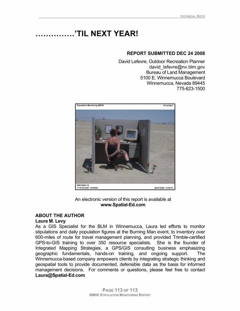
TECHNICAL NOTE
PAGE 113 OF 113 BM08 STIPULATION MONITORING REPORT
……………’TIL NEXT YEAR!
REPORT SUBMITTED DEC 24 2008
David Lefevre, Outdoor Recreation Planner [email protected]
Bureau of Land Management 5100 E. Winnemucca Boulevard
Winnemucca, Nevada 89445 775-623-1500
An electronic version of this report is available at www.Spatial-Ed.com
ABOUT THE AUTHOR Laura M. Levy As a GIS Specialist for the BLM in Winnemucca, Laura led efforts to monitor stipulations and daily population figures at the Burning Man event, to inventory over 600-miles of route for travel management planning, and provided Trimble-certified GPS-to-GIS training to over 350 resource specialists. She is the founder of Integrated Mapping Strategies, a GPS/GIS consulting business emphasizing geographic fundamentals, hands-on training, and ongoing support. The Winnemucca-based company empowers clients by integrating strategic thinking and geospatial tools to provide documented, defensible data as the basis for informed management decisions. For comments or questions, please feel free to contact [email protected]