Embed Size (px)
Citation preview
1
TABLE OF CONTENTS List of Figures and Tables Executive Summary
Part I – Planning for Climate Change Page
I. Introduction ........................................................................................................... ...11
II. California’s Climate Future ..................................................................................... 15
III. Comprehensive State Adaptation Strategies ………………………..…….....…..…22
Part II – Climate Change - Impacts, Risks and Strategies by Sector
IV. Public Health (Led by the Department of Public Health with assistance from the California Air Resources Board) ................................................................................ 30
V. Biodiversity and Habitat (Led by the Department of Parks and Recreation and the Department of Fish and Game) ................................................................................. 45
VI. Ocean and Coastal Resources (Led by the Ocean Protection Council) ................. 65
VII. Water Management (Led by the Department of Water Resources) ......................... 79
VIII. Agriculture (Led by the Department of Food and Agriculture and the Department of Conservation) ............................................................................................................ 92
IX. Forestry (Led by the Department of Forestry and Fire Protection and the Board of Forestry) .................................................................................................................. 107
X. Transportation and Energy Infrastructure (Led by the Department of Transportation and the California Energy Commission). ......................................... 122
Appendices
A. Acknowledgements………………………………………………………………………….135
B. Governor’s Executive Order S-13-08……………………………………………………...137
C. Glossary………………………………………………………………………………………140
D. Acronyms……………………………………………………………………………………..143
E. Table of Short Term Climate Adaptation Strategies……………………………………..146
References
2
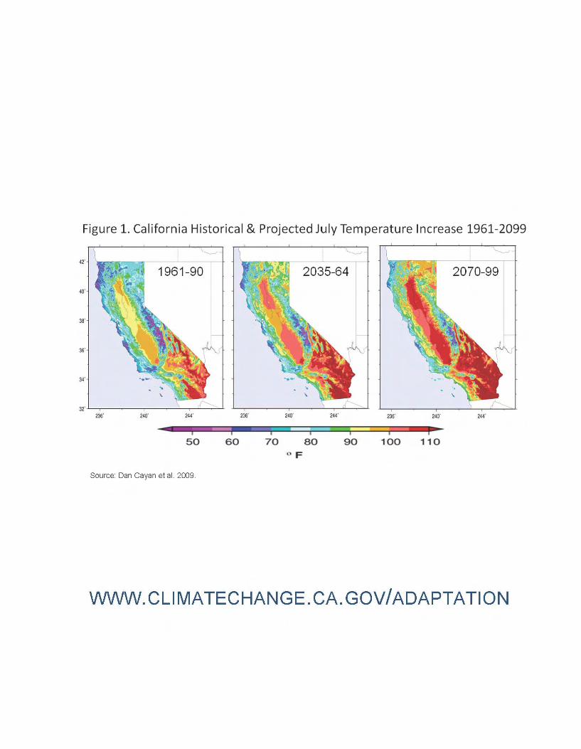
LIST OF FIGURES AND TABLES Figure 1: California Historical and Projected July Temperature Increase 1961-2099
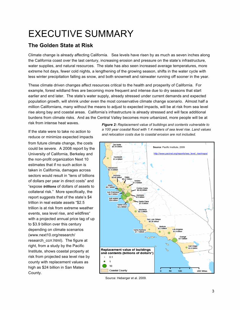
Figure 2: Replacement value of buildings and contents vulnerable to a 100-year coastal flood with a 1.4 meter sea level rise.
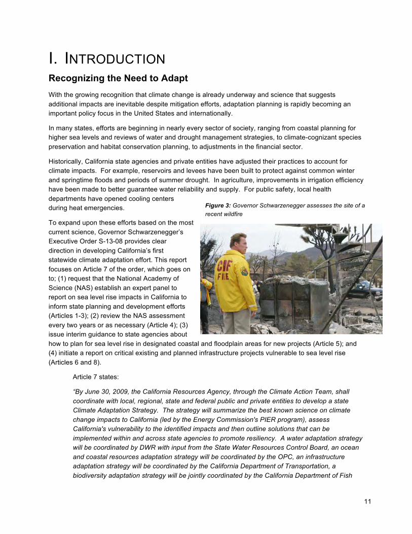
Figure 3: Governor Schwarzenegger assessing the site of a recent wildfire
Figure 4: Examples of complementary and conflicting actions between adaptation and mitigation efforts
Figure 5: Historical/projected annual average temperature for California
Figure 6: Predicted changes in Northern California precipitation levels show generally drier future
Figure 7: Projected changes in sea level rise over 21st Century
Figure 8: Extreme climate drivers and inter-sector interactions
Figure 9: Sample climate adaptation research needs (2009 CAT Report)
Figure 10: Flow diagram showing inter-relationships of climate impacts to public health
Figure 11: Increasing wildfire risk Figure 12: Vulnerability of California coastal areas to sea level rise Figure 13: Using mid-century climate projections to support water resources decision making in California Figure 14: California historical and projected decrease in April snowpack (1961-2099)
Figure 15: View of Lake Oroville in 2005 and November 2008
Figure 16: California perennial crops in a changing climate
Figure 17: Modeled crop yields by 2100, shown in 25 year increments Figures 18 and 19: Bark Beetle damage in California forests Figure 20: Projected increase in household electricity consumption Figure 21: Peak electricity demand June-September 2004 Figure 22: Trains can derail due to extreme heat warping railroad tracks
Figure 23: Projected sea level rise around San Francisco Airport (SFO)
3
Source: Pacific Institute, 2009
http://www.pacinst.org/reports/sea_level_rise/maps/
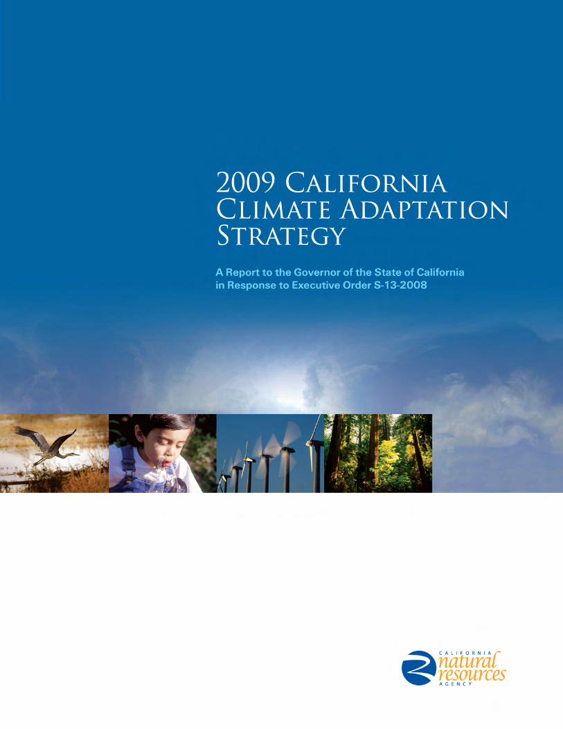
EXECUTIVE SUMMARY The Golden State at Risk
Climate change is already affecting California. Sea levels have risen by as much as seven inches along
the California coast over the last century, increasing erosion and pressure on the state’s infrastructure, water supplies, and natural resources. The state has also seen increased average temperatures, more
extreme hot days, fewer cold nights, a lengthening of the growing season, shifts in the water cycle with less winter precipitation falling as snow, and both snowmelt and rainwater running off sooner in the year.
These climate driven changes affect resources critical to the health and prosperity of California. For example, forest wildland fires are becoming more frequent and intense due to dry seasons that start
earlier and end later. The state’s water supply, already stressed under current demands and expected population growth, will shrink under even the most conservative climate change scenario. Almost half a
million Californians, many without the means to adjust to expected impacts, will be at risk from sea level rise along bay and coastal areas. California’s infrastructure is already stressed and will face additional
burdens from climate risks. And as the Central Valley becomes more urbanized, more people will be at risk from intense heat waves.
If the state were to take no action to
reduce or minimize expected impacts
from future climate change, the costs could be severe. A 2008 report by the
University of California, Berkeley and the non-profit organization Next 10
estimates that if no such action is taken in California, damages across
sectors would result in “tens of billions of dollars per year in direct costs” and
“expose trillions of dollars of assets to collateral risk.” More specifically, the
report suggests that of the state’s $4 trillion in real estate assets “$2.5
trillion is at risk from extreme weather events, sea level rise, and wildfires“
with a projected annual price tag of up to $3.9 billion over this century
depending on climate scenarios (www.next10.org/research/
research_ccrr.html). The figure at right, from a study by the Pacific
Institute, shows coastal property at risk from projected sea level rise by
county with replacement values as high as $24 billion in San Mateo
County.
Figure 2: Replacement value of buildings and contents vulnerable to a 100 year coastal flood with 1.4 meters of sea level rise. Land values
and relocation costs due to coastal erosion are not included.
Source: Heberger et al. 2009.
4
California understands the importance of addressing climate impacts today. The state strengthened its commitment to managing the impacts from sea level rise, increased temperatures, shifting precipitation
and extreme weather events when Governor Arnold Schwarzenegger signed Executive Order (EO) S-13-08 on November 14, 2008. The order called on state agencies to develop California’s first strategy
to identify and prepare for these expected climate impacts.
The 2009 California Climate Adaptation Strategy (CAS) report summarizes the best known science on climate change impacts in the state to assess vulnerability and outlines possible solutions that can be
implemented within and across state agencies to promote resiliency. This is the first step in an ongoing, evolving process to reduce California’s vulnerability to climate impacts.
The California Natural Resources Agency (CNRA) has taken the lead in developing this adaptation
strategy, working through the Climate Action Team (CAT). Seven sector-specific working groups led by 12 state agencies, boards and commissions, and numerous stakeholders were convened for this effort.
The strategy proposes a comprehensive set of recommendations designed to inform and guide California decision makers as they begin to develop policies that will protect the state, its residents and its
resources from a range of climate change impacts. Following a 45-day public comment period since its release as a Discussion Draft in August 2009, the CNRA and sector working groups have revised the
strategy incorporating public stakeholder input. All public comments can be seen on the adaptation Web site at www.climatechange.ca.gov. Not all material has been incorporated at this time, but will potentially
be added later to accommodate additional information and expand upon as strategies are implemented and more organizations and processes become involved. This document will be updated approximately
every two years to incorporate progress in strategies and changing climate science.
California’s Climate Adaptation Strategy
As the climate changes, so must California. To effectively address the challenges that a changing climate
will bring, climate adaptation and mitigation (i.e., reducing state greenhouse gas (GHG) emissions) policies must complement each other, and efforts within and across sectors must be coordinated. For
years, the two approaches have been viewed as alternatives, rather than as complementary and equally necessary approaches.
Adaptation is a relatively new concept in California policy. The term generally refers to efforts that
respond to the impacts of climate change – adjustments in natural or human systems to actual or expected climate changes to minimize harm or take advantage of beneficial opportunities.
California’s ability to manage its climate risks through adaptation depends on a number of critical factors
including its baseline and projected economic resources, technologies, infrastructure, institutional support and effective governance, public awareness, access to the best available scientific information, sustainably-managed natural resources, and equity in access to these resources.
As the 2009 California Climate Adaptation Strategy illustrates, the state has the ability to strengthen its
capacity in all of these areas. In December 2008, the California Air Resources Board released the state’s Climate Change Scoping Plan, which outlines a range of strategies necessary for the state to reduce its
GHG emissions to 1990 levels by 2020. Many climate mitigation strategies, like promoting water and energy efficiency, are also climate adaptation strategies. By building an adaptation strategy on existing
climate science and frameworks like the Scoping Plan, California has begun to effectively anticipate future challenges and change actions that will ultimately reduce the vulnerability of residents, resources
5
and industries to the consequences of a variable and changing climate. Now that the state has produced plans for climate mitigation and adaptation, closer coordination is needed to implement both approaches.
The strategies included in this report were approved by the CAT Team, which represents all of state government. Now, the CAT will lead in the coordination of measures and push to develop the necessary
tools to effect adaptation protocols. California’s mitigation (CAT) and adaptation (CAS) processes will be further integrated through extensive information exchange and consolidation of working groups from both
efforts.
To ensure a coordinated effort in adapting to the unavoidable impacts of climate change, the 2009 California Climate Adaptation Strategy was developed using a set of guiding principles:
• Use the best available science in identifying climate change risks and adaptation strategies.
• Understand that data continues to be collected and that knowledge about climate change is still evolving. As such, an effective adaptation strategy is “living” and will itself be adapted to account for
new science.
• Involve all relevant stakeholders in identifying, reviewing, and refining the state’s adaptation strategy.
• Establish and retain strong partnerships with federal, state, and local governments, tribes, private business and landowners, and non-governmental organizations to develop and implement adaptation
strategy recommendations over time.
• Give priority to adaptation strategies that initiate, foster, and enhance existing efforts that improve
economic and social well-being, public safety and security, public health, environmental justice, species and habitat protection, and ecological function.
• When possible, give priority to adaptation strategies that modify and enhance existing policies rather
than solutions that require new funding and new staffing.
• Understand the need for adaptation policies that are effective and flexible enough for circumstances that may not yet be fully predictable.
• Ensure that climate change adaptation strategies are coordinated with the California Air Resources Board’s AB 32 Scoping Plan process when appropriate, as well as with other local, state, national and
international efforts to reduce GHG emissions.
The 2009 California Climate Adaptation Strategy takes into account the long-term, complex, and uncertain nature of climate change and establishes a proactive foundation for an ongoing adaptation
process. Rather than address the detailed impacts, vulnerabilities, and adaptation needs of every sector, those determined to be at greatest risk are prioritized.
The development of the adaptation strategies presented within this report was spearheaded by the state’s
resource management agencies. CNRA staff worked with seven sector-based Climate Adaptation Working Groups (CAWGs) focused on the following areas: public health; ocean and coastal resources;
water supply and flood protection; agriculture; forestry; biodiversity and habitat; and transportation and energy infrastructure.
Working group experts have an intimate knowledge of California’s resources, environments, and communities, and also of the state’s existing policy framework and management capabilities. This
understanding informs the adaptation strategy and ensures a realistic assessment of adaptive capacities, current limitations, and future needs.
6
A Collaborative Approach
This adaptation strategy could not have been developed without the involvement of numerous stakeholders. Converging missions, common interests, inherent needs for cooperation, and the fact that
climate change impacts cut across jurisdictional boundaries will require governments, businesses, non-governmental organizations, and individuals to minimize risks and take advantage of potential planning
opportunities.
Throughout the development of this report, it became increasingly clear that overlapping missions and goals will require agencies and organizations at all levels to work together to develop close partnerships
with regard to climate adaptation. This is the only means by which the far reaching effects of climate impacts can be addressed efficiently and effectively while avoiding potential conflicts. The
Comprehensive State Adaptation Strategies chapter underscores the need for collaboration and identifies where cross-sector relationships are necessary.
To further enhance stakeholder participation the CAWGs initiated a process that allowed for consultation with stakeholders through public workshops and review opportunities. This input has considerably
shaped the content and refinement of this report. However, future updates of the adaptation strategy will require ongoing input through active stakeholder engagement and an even closer integration of state
agency efforts.
In order to best analyze climate change risks, the 2009 California Climate Adaptation Strategy draws on years of state-specific science and impacts research, largely funded through the California Energy
Commission’s Public Interest Energy Research (PIER) Program and an engaged research community. The research provides for an understanding of the climate-related risks California will face and has
significantly contributed to greater public awareness of climate change. As data continues to be developed and collected, the state’s adaptation strategy will be updated to reflect current findings.
All participating agencies prepared this report with existing resources amidst a serious state financial
crisis. It is clear that more funding will be needed to address all aspects of climate adaptation and that potential sources will need to be sought from agencies and organizations at all levels to address the full
scope of the problem. At this time CNRA is currently seeking additional funding for climate adaptation work.
Preliminary Recommendations
The preliminary recommendations outlined in the adaptation strategy were developed by CNRA staff,
CAWGs, the CAT, and from public comments. Public comments were sought beginning August 3, 2009 when the CAS was released as a discussion draft. During the ensuing 45-day public comment period 83
comments were received, totaling over 400 pages of suggested revisions to the strategy. These comments provided substantive feedback, drawing on the expertise of many organizations and countless
individuals offering different perspectives on effective approaches to climate adaptation. Stakeholder comments covered many topics, with the most common being the need for more coordination and
guidance, funding, and outreach. Many comments offered excellent ideas supported by the working groups and were incorporated into this report where possible; Others will be better addressed once
additional information comes in through the implementation of key strategies outlined in the report or
7
when supporting information, resources and funding issues change. All comments will be kept on record as consideration for future updates of this strategy, complemented by additional opportunities for public
input. All public input on the CAS Discussion Draft can be viewed on the web at: www.climatechange.ca.gov/adaptation/.
It is recognized that implementation of the following strategies will require significant collaboration among
multiple stakeholders to ensure they are carried out in a rational, yet progressive manner over the long term. These strategies distinguish between near-term actions that will be completed by the end of 2010
and long-term actions to be developed over time, and are covered in more detail in the sector chapters in Part II of this report as well as in initial efforts.i
Key recommendations include:
1. A Climate Adaptation Advisory Panel (CAAP) will be appointed to assess the greatest risks to California from climate change and recommend strategies to reduce those risks building on
California’s Climate Adaptation Strategy. This panel will be convened by the California Natural Resources Agency, in coordination with the Governor’s Climate Action Team, to complete a report by
December 2010. The state will partner with the Pacific Council on International Policy to assemble this panel. A list of panel members can be found on the California adaptation Web site. (CS-1).
2. California must change its water management and uses because climate change will likely create
greater competition for limited water supplies needed by the environment, agriculture, and cities. As directed by the recently signed water legislation (Senate Bill X71), state agencies must implement
strategies to achieve a statewide 20 percent reduction in per capita water use by 2020, expand surface and groundwater storage, implement efforts to fix Delta water supply, quality, and ecosystem
conditions, support agricultural water use efficiency, improve state-wide water quality, and improve Delta ecosystem conditions and stabilize water supplies as developed in the Bay Delta Conservation
Plan. (BH-2, W-3, 6, and 7; A-1; TEI-3).
3. Consider project alternatives that avoid significant new development in areas that cannot be adequately protected (planning, permitting, development, and building) from flooding, wildfire and
erosion due to climate change. The most risk-averse approach for minimizing the adverse effects of sea level rise and storm activities is to carefully consider new development within areas vulnerable to
inundation and erosion. State agencies should generally not plan, develop, or build any new significant structure in a place where that structure will require significant protection from sea level
rise, storm surges, or coastal erosion during the expected life of the structure. However, vulnerable shoreline areas containing existing development that have regionally significant economic, cultural, or
social value may have to be protected, and in-fill development in these areas may be accommodated. State agencies should incorporate this policy into their decisions and other levels of government are
also encouraged to do so. (CS-2; OCR-1 and 2; W-4 and 9; TEI -2 and 7).
i Each of the twelve Executive Summary strategies is drawn from multiple strategies within the subsequent sector specific and
cross-sector adaptation strategy chapters. The recommendations here may not reflect exact wording of individual sector recommendations but relate to their core message. Each Executive Summary recommendation here lists the sector and recommendation number using the following acronyms to identify the sector: Public Health (PH), Biodiversity and Habitat (BH), Ocean and Coastal Resources (OCR), Water Management (W), Agriculture (A), Forestry (F), Transportation and Energy Infrastructure (TEI), and Cross-Sector (CS).
8
4. All state agencies responsible for the management and regulation of public health, infrastructure or habitat subject to significant climate change should prepare as appropriate agency-specific
adaptation plans, guidance, or criteria by September 2010. (PH-3 and 5; BH-1, 2, and 6; OCR-3; F-1 and 2; TEI-2 and 5).
5. To the extent required by CEQA Guidelines Section 15126.2, all significant state projects, including
infrastructure projects, must consider the potential impacts of locating such projects in areas susceptible to hazards resulting from climate change. Section 15126.2 is currently being proposed
for revision by CNRA to direct lead agencies to evaluate the impacts of locating development in areas susceptible to hazardous conditions, including hazards potentially exacerbated by climate change.
Locating state projects in such areas may require additional guidance that in part depends on planning tools that the CAS recommendations call for (see key recommendations 3, 6, 8, 9, and 10;
BH-3; OCR-1; TEI-2).
6. The California Emergency Management Agency (Cal EMA) will collaborate with CNRA, the CAT, the Energy Commission, and the CAAP to assess California's vulnerability to climate change, identify
impacts to state assets, and promote climate adaptation/mitigation awareness through the Hazard Mitigation Web Portal and My Hazards Website as well as other appropriate sites. The transportation
sector CAWG, led by Caltrans, will specifically assess how transportation nodes are vulnerable and the type of information that will be necessary to assist response to district emergencies. Special
attention will be paid to the most vulnerable communities impacted by climate change in all studies. (CS-3 and 4; PH-4 and 5; OCR-5; W-4; F-2 and 3; TEI-2, 5, 6 and 8).
7. Using existing research the state should identify key California land and aquatic habitats that could change significantly during this century due to climate change. Based on this identification, the state
should develop a plan for expanding existing protected areas or altering land and water management practices to minimize adverse effects from climate change induced phenomena. (BH-1; W-5; F-5).
8. The best long-term strategy to avoid increased health impacts associated with climate change is to
ensure communities are healthy to build resilience to increased spread of disease and temperature increases. The California Department of Public Health will develop guidance by September 2010 for
use by local health departments and other agencies to assess mitigation and adaptation strategies, which include impacts on vulnerable populations and communities and assessment of cumulative
health impacts. This includes assessments of land use, housing and transportation proposals that could impact health, GHG emissions, and community resilience for climate change, such as in the
2008 Senate Bill 375 regarding Sustainable Communities. (PH-3).
9. The most effective adaptation strategies relate to short and long-term decisions. Most of these decisions are the responsibility of local community planning entities. As a result, communities with
General Plans and Local Coastal Plans should begin, when possible, to amend their plans to assess climate change impacts, identify areas most vulnerable to these impacts, and develop reasonable and rational risk reduction strategies using the CAS as guidance. Every effort will be made to provide
tools, such as interactive climate impact maps, to assist in these efforts. (BH-1; OCR– 2 and 4; CS-2).
9
10. State fire fighting agencies should begin immediately to include climate change impact information into fire program planning to inform future planning efforts. Enhanced wildfire risk from climate
change will likely increase public health and safety risks, property damage, fire suppression and emergency response costs to government, watershed and water quality impacts, and vegetation
conversions and habitat fragmentation. (PH-4 and 5; F-1; TEI-2).
11. State agencies should meet projected population growth and increased energy demand with greater energy conservation and an increased use of renewable energy. Renewable energy supplies should
be enhanced through the Desert Renewable Energy Conservation Plan that will protect sensitive habitat that will while helping to reach the state goal of having 33 percent of California’s energy
supply from renewable sources by 2020. (TEI-2).
12. Existing and planned climate change research can and should be used for state planning and public outreach purposes; new climate change impact research should be broadened and funded. By
September 2010, the California Energy Commission will develop the CalAdapt Web site that will synthesize existing California climate change scenarios and climate impact research and to
encourage its use in a way that is beneficial for local decision-makers. Every effort will be made to increase funding for climate change research, focusing on three areas: linkages with federal funding
resources, developing Energy Commission -led vulnerability studies, and synthesizing the latest climate information into useable information for local needs through the CalAdapt tool. (CS-4; PH-7;
BH-4; OCR-6; W-8, 9, and 10; A – 8; F-4 and 5; TEI-3 and 9).
10
PART I:
PLANNING FOR CLIMATE CHANGE
11
I. INTRODUCTION Recognizing the Need to Adapt
With the growing recognition that climate change is already underway and science that suggests
additional impacts are inevitable despite mitigation efforts, adaptation planning is rapidly becoming an important policy focus in the United States and internationally.
In many states, efforts are beginning in nearly every sector of society, ranging from coastal planning for higher sea levels and reviews of water and drought management strategies, to climate-cognizant species
preservation and habitat conservation planning, to adjustments in the financial sector.
Historically, California state agencies and private entities have adjusted their practices to account for climate impacts. For example, reservoirs and levees have been built to protect against common winter
and springtime floods and periods of summer drought. In agriculture, improvements in irrigation efficiency have been made to better guarantee water reliability and supply. For public safety, local health
departments have opened cooling centers during heat emergencies.
To expand upon these efforts based on the most
current science, Governor Schwarzenegger’s Executive Order S-13-08 provides clear
direction in developing California’s first statewide climate adaptation effort. This report
focuses on Article 7 of the order, which goes on to; (1) request that the National Academy of
Science (NAS) establish an expert panel to report on sea level rise impacts in California to
inform state planning and development efforts (Articles 1-3); (2) review the NAS assessment
every two years or as necessary (Article 4); (3) issue interim guidance to state agencies about
how to plan for sea level rise in designated coastal and floodplain areas for new projects (Article 5); and (4) initiate a report on critical existing and planned infrastructure projects vulnerable to sea level rise
(Articles 6 and 8).
Article 7 states:
“By June 30, 2009, the California Resources Agency, through the Climate Action Team, shall
coordinate with local, regional, state and federal public and private entities to develop a state Climate Adaptation Strategy. The strategy will summarize the best known science on climate
change impacts to California (led by the Energy Commission's PIER program), assess California's vulnerability to the identified impacts and then outline solutions that can be
implemented within and across state agencies to promote resiliency. A water adaptation strategy will be coordinated by DWR with input from the State Water Resources Control Board, an ocean
and coastal resources adaptation strategy will be coordinated by the OPC, an infrastructure adaptation strategy will be coordinated by the California Department of Transportation, a
biodiversity adaptation strategy will be jointly coordinated by the California Department of Fish
Figure 3: Governor Schwarzenegger assesses the site of a
recent wildfire
12
and Game and California State Parks, a working landscapes adaptation strategy will be jointly coordinated by the California Department of Forestry and Fire Protection and the California
Department of Food and Agriculture, and a public health adaptation strategy will be jointly coordinated by the California Department of Public Health and the California Air Resources
Board, all as part of the larger strategy. This strategy will be facilitated through the Climate Action Team and will be coordinated with California's climate change mitigation efforts.”
Climate Modeling
In order for California to ensure coping capacity and long-term resiliency, researchers have previously
developed two distinct approaches: (1) projecting the amount of climate change that may occur and (2) assessing the natural or human system’s ability to cope with and adapt to change. In recent years, these
approaches have been seen as complementary and as such, both are needed to understand climate risks, vulnerabilities, and interventions that can help society and ecosystems adapt successfully.
(1) Hazards-Based Approach
In the hazards-based approach, emissions scenarios are identified to allow scientists to evaluate the degree of climate change projected. Typically, these climate changes are projected for decades or
centuries using increasingly sophisticated, computer-based global climate models. These projections are used to assess the physical, ecological, or economic consequences for specific sectors and
environments.
In this approach, any changes identified outside of the historical norm would then require adaptation. For example, if the impact is estimated to be substantial, then substantial adaptation is required; if the impact
is determined to be gradual, there is time to engage in adaptation planning. In a hazards-based approach, various non-climatic factors are not addressed; nor are specific adaptation plans identified.
(2) Vulnerability-Based Approach
Conversely, the vulnerability-based approach is focused on the socioeconomic and ecological factors that determine a system’s vulnerability and ability to cope with and adapt to climate change. Typically, such
an assessment also explicitly examines past experience with climate variability and extremes to see how systems have responded. The conditions that influence vulnerability for a given area can provide a
baseline that, when combined with existing conditions, communities may use to determine what actions are needed to respond to climate impacts. It is also important to understand how existing conditions will
react to the additional influence of climate change. A good example is looking at how existing drought cycles could be exacerbated by changing weather patterns from climate change.
Both the hazards-based and the vulnerability-based approaches are ultimately needed for any long-term
and iterative process of climate change adaptation. They will allow California to identify the most important climate risks, establish priorities, assess options and barriers, and evaluate the effectiveness of
adaptive responses in a place-based context given the stresses and demands on resources. Adaptation planning requires an understanding of climate impacts and substantial input from the social, economic,
engineering, and ecological sciences on those factors that affect vulnerability and adaptation.
Drawing on currently available science, this report includes the most recent climate projections and
related impacts studies identified as part of a hazards-based approach. What are needed now are future vulnerability-based assessments.
13
Adaptation Strategy Vision, Objectives and Principles
The basic purpose and overarching goal of the 2009 California Climate Adaptation Strategy is to begin a statewide, ongoing, and committed process of adapting to a changing climate in the context of other
changes in the environment, the economy, and society.
To achieve this goal, the adaptation strategy pursues the following specific objectives:
Analyze climate change risks. Synthesize to the greatest extent possible how temperature rise,
extreme weather events, precipitation changes, seasonal shifts, and sea level rise will exacerbate existing fire, flood, water supply and quality, air quality, habitat loss, and human health risks. Assess how these
changes will impact the state’s economy, infrastructure, human populations, and environment.
Identify sector-specific, and to the extent possible, cross-sectoral adaptation strategies that help reduce vulnerabilities and build climate resilience. Attention should be given to strategies that help
(a) avoid, prevent, or minimize climate change impacts to public health, biodiversity, working landscapes, and infrastructure, (b) improve preparedness for climate change impacts and extreme events, (c)
enhance the state’s response capacity in case of extremes, and (d) facilitate recovery from impacts and extremes in order to enhance the state’s resilience.
Explore cross-cutting supportive strategies. Identify governance efforts (such as leadership, policy or
rule changes, procedural adjustments, etc.) and resources needed to enable the development and implementation of identified adaptation strategies.
Formalize criteria for prioritizing identified adaptation strategies. The applicability of these criteria may vary across sectors, and should ideally include but not be limited to social, environmental, equity,
technical, staffing, institutional, policy, and financial/economic considerations.
Specify future direction. Indicate areas where further work will be required to increase the existing understanding of climate risks (including the possibility of catastrophic climate change), environmental
and societal vulnerabilities, and adaptation options and barriers. Identify additional cross-cutting, supportive strategies such as public engagement, networking, decision support, monitoring, periodic
review of adaptation effectiveness, and fundamental policy changes. Establish feedback mechanisms that provide for the modification of strategies when needed.
Provide recommendations for immediate and near-term priorities for implementing identified adaptation strategies. This may include management actions and policy changes based on the information developed in other stated objectives.
Inform and engage the California public about climate risks and adaptation strategies. Californians must be informed of existing and future climate change risks and of the need for a comprehensive
approach to managing climate change risks through mitigation and adaptation. They must be provided with guidance about what actions they can initiate to adapt to climate change, or reduce their
consumption of energy and resources. This information is critical, and will serve as the foundation for residents to actively engage in discussion, refinement, and implementation of those actions needed to
build a climate-resilient California.
14
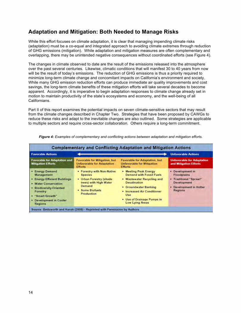
Adaptation and Mitigation: Both Needed to Manage Risks
While this effort focuses on climate adaptation, it is clear that managing impending climate risks (adaptation) must be a co-equal and integrated approach to avoiding climate extremes through reduction of GHG emissions (mitigation). While adaptation and mitigation measures are often complementary and overlapping, there may be unintended negative consequences without coordinated efforts (see Figure 4). The changes in climate observed to date are the result of the emissions released into the atmosphere over the past several centuries. Likewise, climatic conditions that will manifest 30 to 40 years from now will be the result of today’s emissions. The reduction of GHG emissions is thus a priority required to minimize long-term climate change and concomitant impacts on California’s environment and society. While many GHG emission reduction efforts can produce immediate air quality improvements and cost savings, the long-term climate benefits of these mitigation efforts will take several decades to become apparent. Accordingly, it is imperative to begin adaptation responses to climate change already set in motion to maintain productivity of the state’s ecosystems and economy, and the well-being of all Californians. Part II of this report examines the potential impacts on seven climate-sensitive sectors that may result from the climate changes described in Chapter Two. Strategies that have been proposed by CAWGs to reduce these risks and adapt to the inevitable changes are also outlined. Some strategies are applicable to multiple sectors and require cross-sector collaboration. Others require a long-term commitment.
Figure 4: Examples of complementary and conflicting actions between adaptation and mitigation efforts.
15
II. CALIFORNIA’S CLIMATE FUTURE The 2009 Climate Change Projection Emissions Scenarios To begin to assess the climate change risks that Californians may face, it is important to first examine the changes that have already occurred. California can draw on substantial scientific research conducted by experts at various state universities and research institutions. With more than a decade of concerted research, scientists have established that the early signs of climate change are already evident in the state – as shown, for example, in increased average temperatures, changes in temperature extremes, reduced snowpack in the Sierra Nevada, sea-level rise, and ecological shifts.1 Many of these changes are accelerating – locally, across the country, and around the globe. As a result of emissions already released into the atmosphere, California will face intensifying climate changes in coming decades. The state’s 2009 Climate Change Impacts Assessment (the 2009 Scenarios Project) provides the scientific basis from which statewide climate impacts were synthesized for this adaptation strategy. The 2009 Scenarios Project examined future projections for changes in average temperatures, precipitation patterns, sea-level rise, and extreme events, as well as resulting impacts on particularly climate-sensitive sectors.2 These scientific findings are summarized in resulting chapters to set the stage for expected impacts and California’s adaptation strategies. Generally, research indicates that California should expect overall hotter and drier conditions with a continued reduction in winter snow (with concurrent increases in winter rains), as well as increased average temperatures, and accelerating sea-level rise.3 In addition to changes in average temperatures, sea level, and precipitation patterns, the intensity of extreme weather events is also changing. The impacts assessment indicates that extreme weather events, such as heat waves, wildfires, droughts, and floods are likely to be some of the earliest climate impacts experienced.4 As a result, dealing with a growing number of extreme climatic events will be an important aspect of the state’s adaptation to climate change. For the 2009 Scenarios Project, a set of six global climate models were run using two emissions scenarios. These emissions scenarios are part of a family of common scenarios used by the Intergovernmental Panel on Climate Change (IPCC) in its 2007 assessment.5 The scenarios signify plausible pathways of how global emissions may change as a result of economic, technological, and population changes over the 21st century. One scenario depicts a higher-emissions scenario (A2), the other a lower-emissions scenario (B1).6 The A2 scenario represents a more competitive world that lacks cooperation in development and portrays a future in which economic growth is uneven, leading to a growing income gap between developed and developing parts of the world. The B1 scenario denotes a future that reflects a high level of environmental and social consciousness combined with global cooperation for sustainable development. It is important to note that these two scenarios do not bracket the entire range of possible future emissions and resulting climatic changes, as even higher emissions or lower emissions futures are possible. Moreover, it is impossible to say with scientific confidence which of the two scenarios is more likely. Thus, the IPCC has not offered probabilities (likelihood statements) attached to either of the emissions pathways. Since the IPCC’s release of these two scenarios, the world has followed a “business as usual” emissions pathway, which most closely resembles the A2 scenario.7
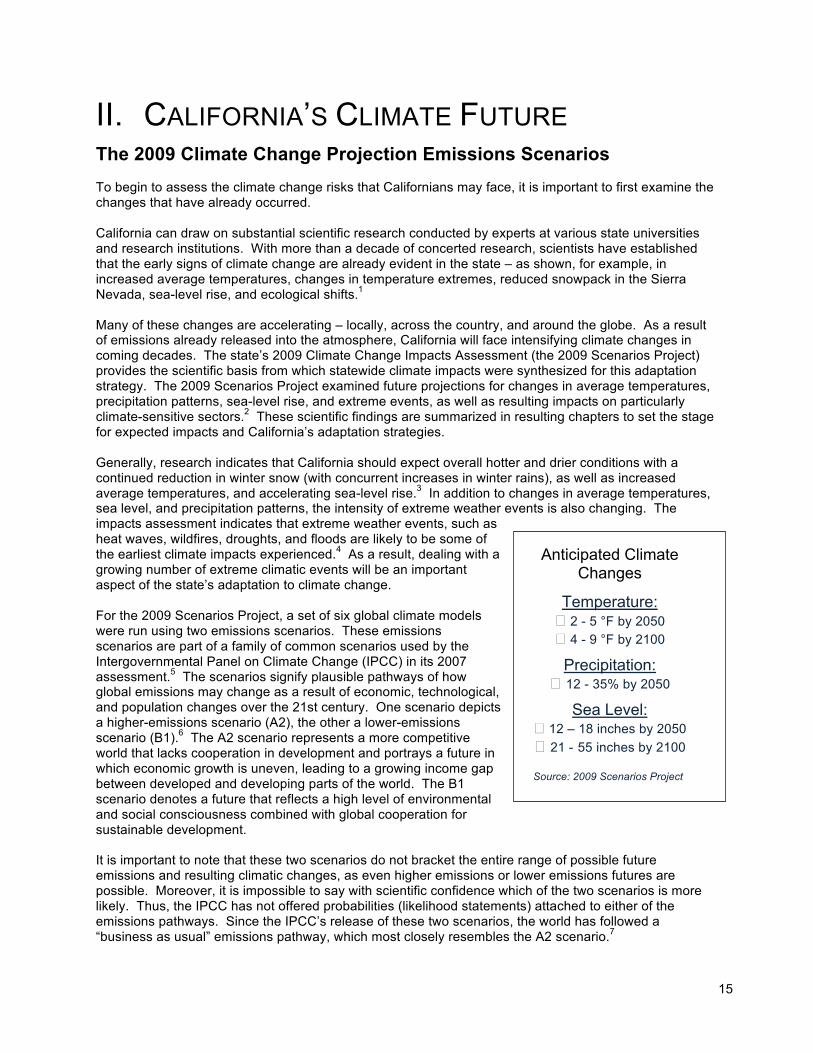
Anticipated Climate Changes
Temperature: � 2 - 5 °F by 2050 � 4 - 9 °F by 2100
Precipitation: � 12 - 35% by 2050
Sea Level: � 12 – 18 inches by 2050
� 21 - 55 inches by 2100
Source: 2009 Scenarios Project
16
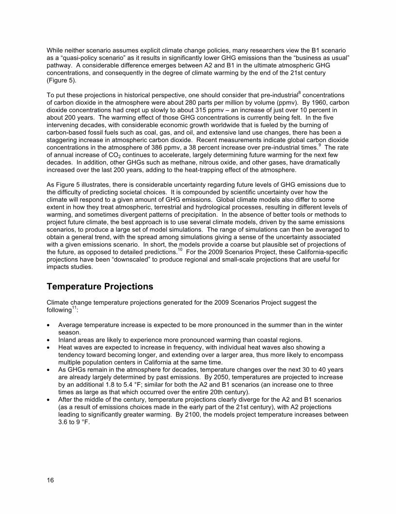
While neither scenario assumes explicit climate change policies, many researchers view the B1 scenario as a “quasi-policy scenario” as it results in significantly lower GHG emissions than the “business as usual” pathway. A considerable difference emerges between A2 and B1 in the ultimate atmospheric GHG concentrations, and consequently in the degree of climate warming by the end of the 21st century (Figure 5). To put these projections in historical perspective, one should consider that pre-industrial8 concentrations of carbon dioxide in the atmosphere were about 280 parts per million by volume (ppmv). By 1960, carbon dioxide concentrations had crept up slowly to about 315 ppmv – an increase of just over 10 percent in about 200 years. The warming effect of those GHG concentrations is currently being felt. In the five intervening decades, with considerable economic growth worldwide that is fueled by the burning of carbon-based fossil fuels such as coal, gas, and oil, and extensive land use changes, there has been a staggering increase in atmospheric carbon dioxide. Recent measurements indicate global carbon dioxide concentrations in the atmosphere of 386 ppmv, a 38 percent increase over pre-industrial times.9 The rate of annual increase of CO2 continues to accelerate, largely determining future warming for the next few decades. In addition, other GHGs such as methane, nitrous oxide, and other gases, have dramatically increased over the last 200 years, adding to the heat-trapping effect of the atmosphere. As Figure 5 illustrates, there is considerable uncertainty regarding future levels of GHG emissions due to the difficulty of predicting societal choices. It is compounded by scientific uncertainty over how the climate will respond to a given amount of GHG emissions. Global climate models also differ to some extent in how they treat atmospheric, terrestrial and hydrological processes, resulting in different levels of warming, and sometimes divergent patterns of precipitation. In the absence of better tools or methods to project future climate, the best approach is to use several climate models, driven by the same emissions scenarios, to produce a large set of model simulations. The range of simulations can then be averaged to obtain a general trend, with the spread among simulations giving a sense of the uncertainty associated with a given emissions scenario. In short, the models provide a coarse but plausible set of projections of the future, as opposed to detailed predictions.10 For the 2009 Scenarios Project, these California-specific projections have been “downscaled” to produce regional and small-scale projections that are useful for impacts studies.
Temperature Projections
Climate change temperature projections generated for the 2009 Scenarios Project suggest the following11:
• Average temperature increase is expected to be more pronounced in the summer than in the winter
season. • Inland areas are likely to experience more pronounced warming than coastal regions. • Heat waves are expected to increase in frequency, with individual heat waves also showing a
tendency toward becoming longer, and extending over a larger area, thus more likely to encompass multiple population centers in California at the same time.
• As GHGs remain in the atmosphere for decades, temperature changes over the next 30 to 40 years are already largely determined by past emissions. By 2050, temperatures are projected to increase by an additional 1.8 to 5.4 °F; similar for both the A2 and B1 scenarios (an increase one to three times as large as that which occurred over the entire 20th century).
• After the middle of the century, temperature projections clearly diverge for the A2 and B1 scenarios (as a result of emissions choices made in the early part of the 21st century), with A2 projections leading to significantly greater warming. By 2100, the models project temperature increases between 3.6 to 9 °F.
17
All model projections for California suggest increased temperatures, with the level of emissions representing the biggest uncertainty: temperature levels will rise faster and higher by the end of this century in the A2 scenario as compared with the B1 scenario (Figure 5). These graphs starkly illustrate the dual imperative to begin adaptation now to address the impacts already set in motion, and to achieve GHG emissions reductions through global cooperation to avoid the more dramatic impacts of climate change later in the century. Stringent emission reductions now could limit climate changes and therefore allow society and ecosystems to be able to adapt more easily at a future date.
Source: Moser, et al 2009.
Precipitation Projections
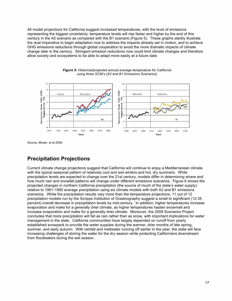
Current climate change projections suggest that California will continue to enjoy a Mediterranean climate with the typical seasonal pattern of relatively cool and wet winters and hot, dry summers. While precipitation levels are expected to change over the 21st century, models differ in determining where and how much rain and snowfall patterns will change under different emissions scenarios. Figure 6 shows the projected changes in northern California precipitation (the source of much of the state’s water supply) relative to 1961-1990 average precipitation using six climate models with both A2 and B1 emissions scenarios. While the precipitation results vary more than the temperature projections, 11 out of 12 precipitation models run by the Scripps Institution of Oceanography suggest a small to significant (12-35 percent) overall decrease in precipitation levels by mid-century. In addition, higher temperatures increase evaporation and make for a generally drier climate, as higher temperatures hasten snowmelt and increase evaporation and make for a generally drier climate. Moreover, the 2009 Scenarios Project concludes that more precipitation will fall as rain rather than as snow, with important implications for water management in the state. California communities have largely depended on runoff from yearly established snowpack to provide the water supplies during the warmer, drier months of late spring, summer, and early autumn. With rainfall and meltwater running off earlier in the year, the state will face increasing challenges of storing the water for the dry season while protecting Californians downstream from floodwaters during the wet season.
Figure 5: Historical/projected annual average temperature for California using three GCM’s (A2 and B1 Emissions Scenarios)
18
Figure 6: Predicted changes in Northern California precipitation levels show a generally drier future.
Models used: 1: CNRM CM3 – 2: GFDL CM2.1 – 3: MIROC3.2 (med)
4: MPI ECHAMS – 5: NCAR CCSM3 – 6: NCAR PCM1Source:
Cayan, et al. 2009.
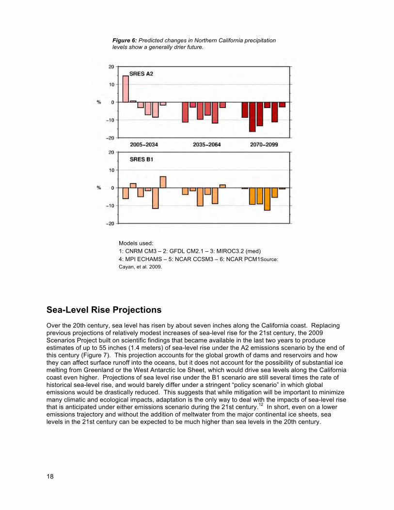
Sea-Level Rise Projections
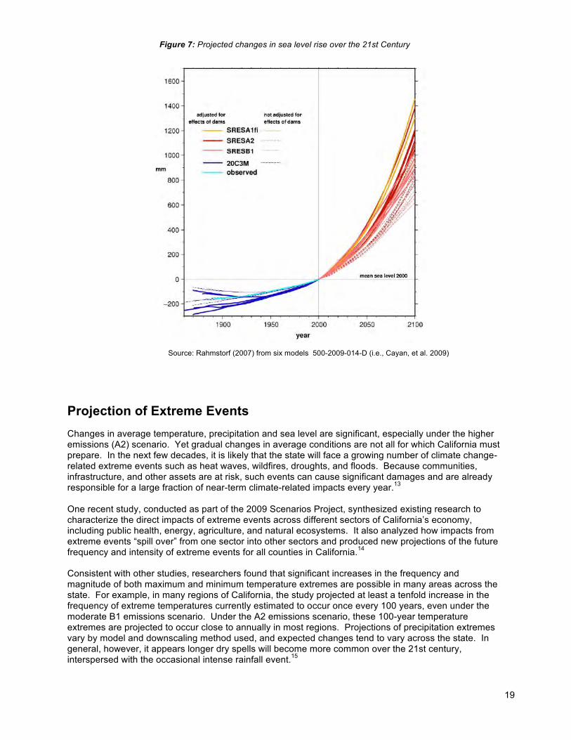
Over the 20th century, sea level has risen by about seven inches along the California coast. Replacing previous projections of relatively modest increases of sea-level rise for the 21st century, the 2009 Scenarios Project built on scientific findings that became available in the last two years to produce estimates of up to 55 inches (1.4 meters) of sea-level rise under the A2 emissions scenario by the end of this century (Figure 7). This projection accounts for the global growth of dams and reservoirs and how they can affect surface runoff into the oceans, but it does not account for the possibility of substantial ice melting from Greenland or the West Antarctic Ice Sheet, which would drive sea levels along the California coast even higher. Projections of sea level rise under the B1 scenario are still several times the rate of historical sea-level rise, and would barely differ under a stringent “policy scenario” in which global emissions would be drastically reduced. This suggests that while mitigation will be important to minimize many climatic and ecological impacts, adaptation is the only way to deal with the impacts of sea-level rise that is anticipated under either emissions scenario during the 21st century.12 In short, even on a lower emissions trajectory and without the addition of meltwater from the major continental ice sheets, sea levels in the 21st century can be expected to be much higher than sea levels in the 20th century.
19
Source: Rahmstorf (2007) from six models 500-2009-014-D (i.e., Cayan, et al. 2009)
Projection of Extreme Events
Changes in average temperature, precipitation and sea level are significant, especially under the higher emissions (A2) scenario. Yet gradual changes in average conditions are not all for which California must prepare. In the next few decades, it is likely that the state will face a growing number of climate change-related extreme events such as heat waves, wildfires, droughts, and floods. Because communities, infrastructure, and other assets are at risk, such events can cause significant damages and are already responsible for a large fraction of near-term climate-related impacts every year.13 One recent study, conducted as part of the 2009 Scenarios Project, synthesized existing research to characterize the direct impacts of extreme events across different sectors of California’s economy, including public health, energy, agriculture, and natural ecosystems. It also analyzed how impacts from extreme events “spill over” from one sector into other sectors and produced new projections of the future frequency and intensity of extreme events for all counties in California.14 Consistent with other studies, researchers found that significant increases in the frequency and magnitude of both maximum and minimum temperature extremes are possible in many areas across the state. For example, in many regions of California, the study projected at least a tenfold increase in the frequency of extreme temperatures currently estimated to occur once every 100 years, even under the moderate B1 emissions scenario. Under the A2 emissions scenario, these 100-year temperature extremes are projected to occur close to annually in most regions. Projections of precipitation extremes vary by model and downscaling method used, and expected changes tend to vary across the state. In general, however, it appears longer dry spells will become more common over the 21st century, interspersed with the occasional intense rainfall event.15
Figure 7: Projected changes in sea level rise over the 21st Century
20
The July 2006 heat wave and the December 1998 freezing spell represent rather memorable extreme events in recent California history. Researchers in the 2009 Scenarios Project asked how the frequency of similar events may change with climate warming. Not surprisingly, they found that heat waves similar in length and intensity to those experienced in 2006 may become more frequent all across the state in the 21st century, with some simulations using the higher emissions scenario suggesting that such events could become annual occurrences by the end of this century. In contrast, freezing spells such as that in 1998 are projected to become less frequent across the state even in locations where they are currently a yearly event. Over large portions of the state, freezing events may occur once every ten years or less by the end of the 21st century. According to the 2009 Scenarios Project, the frequency of large coastal storms and heavy precipitation events do not appear to change significantly over the 21st century.16 However, even if storm intensity or frequency were not to change, storms will impact the California coast more severely due to higher average sea levels that can result in higher storm surges, more extensive inland flooding, and increased erosion along the state’s coastline. Future research should improve our understanding of these extreme precipitation events and their potential impacts on coastal erosion and floods.
Abrupt Climate Changes
Most climate projections developed to date, including those used in this report, produce gradual if sometimes substantial changes for a given climate variable. In the past, rapid climate changes have been observed and scientists are increasingly concerned about additional abrupt changes that could push natural systems past thresholds beyond which they could not recover. Such events have been recorded in paleoclimatological records but current global climate models cannot predict when they may occur again. Such abrupt changes have been shown to occur over very short periods of time (a few years to decades) and thus represent the most challenging situations to which society and ecosystems would need to adapt.17 Short of being able to predict such abrupt changes, scientists are focusing their attention on aspects of the climate and Earth system called “tipping elements” that can rapidly bring about abrupt changes. Tipping elements refer to thresholds where increases in temperature cause a chain reaction of mutually reinforcing physical processes in the Earth’s dynamic cycles. The most dangerous of these include the following: • A reduction in Arctic sea ice, which allows the (darker) polar oceans to absorb more sunlight, thereby
increasing regional warming, accelerating sea ice melting even further, and enhancing Arctic warming over neighboring (currently frozen) land areas.
• The release of methane (a potent GHG), which is currently trapped in frozen ground (permafrost) in the Arctic tundra, will increase with regional warming and melting of the ground, leading to further and more rapid warming and resulting in increased permafrost melting.
• Continued warming in the Amazon could cause significant rainfall loss and large scale dying of forest vegetation, which will further release CO2.
• The accelerated melting of Greenland and West Antarctic Ice Sheets observed in recent times, together with regional warming over land and in the oceans, involves mechanisms that can reinforce the loss of ice and increase the rate of global sea-level rise.
21
The temperature increases that could trigger these chain reaction events are still the subject of research, but estimates range from 1 to 3 °F of additional warming for widespread, rapid (10 year) Arctic sea ice melt; 2 to 4 °F for irreversible melting of the Greenland Ice Sheet (over the next 300 years or more); 5 to 9 °F for the irreversible melting of the West Antarctic Ice Sheet (also over 300 or more years), and 5 to 7 °F for Amazon forest die-back. Should these thresholds be crossed in the coming decades, the Earth’s sea level would be on an irreversible course destined to rise 7-12 meters (as much as 23-40 feet) over the course of several centuries—a rate not seen in human history.18 Another tipping element that could have a significant effect on California’s long-term climate variability is the potential intensification of the El Niño Southern Oscillation (ENSO) cycles over the Pacific Ocean. ENSO is one key factor in California’s wet year and drought year cycles and intensification would mean stormier wet years and even drier (or extended periods of) drought years. It would also mean more severe coastal storms during the winter months and hence more erosion and coastal flooding. Current research indicates that a tipping point of 6 to 11 °F could trigger this intensification of ENSO cycles.19
22
III. COMPREHENSIVE STATE ADAPTATION
STRATEGIES Cross Sector Collaboration
Navigating the complex science and policy needs to reduce California’s vulnerability to future climate impacts will require an unprecedented level of collaboration and leadership. Most state sectors and departments leading climate adaptation strategy development share management responsibilities, have overlapping jurisdictions, and in many instances, depend upon one another to accomplish their organizational mandates. Through the development of the 2009 California Climate Adaptation Strategy the primary need identified by all sectors and most stakeholders is to improve coordination within and across state government.
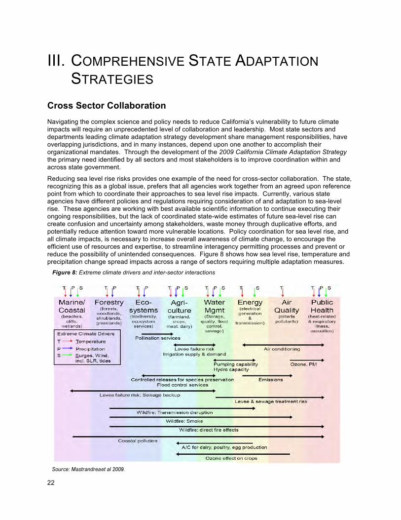
Reducing sea level rise risks provides one example of the need for cross-sector collaboration. The state, recognizing this as a global issue, prefers that all agencies work together from an agreed upon reference point from which to coordinate their approaches to sea level rise impacts. Currently, various state agencies have different policies and regulations requiring consideration of and adaptation to sea-level rise. These agencies are working with best available scientific information to continue executing their ongoing responsibilities, but the lack of coordinated state-wide estimates of future sea-level rise can create confusion and uncertainty among stakeholders, waste money through duplicative efforts, and potentially reduce attention toward more vulnerable locations. Policy coordination for sea level rise, and all climate impacts, is necessary to increase overall awareness of climate change, to encourage the efficient use of resources and expertise, to streamline interagency permitting processes and prevent or reduce the possibility of unintended consequences. Figure 8 shows how sea level rise, temperature and precipitation change spread impacts across a range of sectors requiring multiple adaptation measures.
Figure 8: Extreme climate drivers and inter-sector interactions
23
This chapter identifies comprehensive state adaptation planning strategies that were identified by all climate adaptation sectors in Section II. The four strategies identified here are expected to be in place or completed by the end of 2010 and will increase efficiencies across all climate adaptation strategies when complete. Subsequent chapters of this report focus on sector specific climate adaptation strategies.
Strategy 1) Promote Comprehensive State Agency Adaptation Planning
Adapting to climate change and reducing greenhouse gas emissions must be institutionalized into state planning processes, budgets, and policy development to ensure efficiencies are realized and impacts are minimized. This institutionalization requires state leadership and coordination with the climate science community to ensure the best research is utilized for policy making.
Many agencies have already made climate change a central focus of their policies and plans, while others have just begun to implement plans or actions. For example, water agencies are required to plan for climate variability inherent to California’s Mediterranean, semi-arid and drought-prone precipitation patterns. Coastal agencies consider sea level rise in their planning processes but are now grappling with ways to address the accelerating rates of climate change and uncertainty of future conditions that are now anticipated. All agencies responsible for the management of California’s natural resources have an opportunity to mainstream adaptation given current climate-related hazards and the sensitivities that they currently face. The state should eventually provide support and funding for comprehensive adaptation planning by all state agencies where significant vulnerabilities and hazards are identified.
Without new additional support, the state is promoting comprehensive adaptation planning and policy efforts through three efforts. The first is through the implementation and tracking of the sector-specific strategies outlined in Section II that require new climate adaptation planning in twelve state agencies responsible for completing these strategies. The second is coordination of strategy implementation across state agencies by CNRA and through the development of tools to promote collaboration. Finally, the CAT will be responsible for coordinating climate mitigation and adaptation policies to ensure all climate policies are coordinated to reduce inefficiencies and maximize success.
The Energy Commission’s Climate Change Center has provided, and will continue to provide, state agencies with world-class climate change science. Greater collaboration will occur between the Climate Change Center and the CAT through the CAT research group. There will also be a strong need for state agencies to increase collaboration with the growing number of adaptation centers beginning at Stanford University; the University of California, San Diego; and the University of California, Berkeley. Using the information and strategies identified in this report, these centers should coordinate to rapidly build the state’s scientific foundation to adapt to climate change.
The state of California is currently in a budget crisis, and therefore most of the strategies within the CAS are being implemented using existing resources. However, successful implementation of all measures will surely require additional funding in the future. Local communities will also be challenged in implementing many adaptation measures since many of the strategies can only be implemented at the local level such as updating general plans and incorporating new policies.
Near-Term Actions:
a. Establish a framework for promoting collaboration within and among state agencies to implement climate change adaptation strategies. Three different levels of coordination will be established to promote comprehensive state adaptation planning. First, individual agencies are responsible for implementing the short-term climate adaptation strategies identified in this report. Second, the CNRA will be responsible for monitoring overall progress on implementing adaptation measures in this report and to develop cross-sector strategies. Finally, the CAT will monitor progress on climate adaptation measures through the CNRA and will coordinate state integration of mitigation and adaptation measures within the CAT working groups.
24
b. Develop a Climate Adaptation Advisory Panel (CAAP) made up of world class science, business and government leaders to recommend improved opportunities for collaboration across state government on climate adaptation. The CAAP will also identify climate adaptation strategies outside the scope of California’s climate adaptation strategy that identify near term priority strategies that will reduce California’s vulnerability to climate change in the shortest time at the lowest long-term cost.
Strategy 2) Integrate Land Use Planning and Climate Adaptation Planning
Land use decisions are a central component of preparing for and minimizing climate change impacts. In order for California to succeed with its adaptation strategies, local and regional governments and planning efforts must be integral parts of the adaptation process.
Many, if not most, land use decisions in California are made at the local level and increasingly at the regional level. Decisions made by cities and counties through general plan and local planning processes direct local land uses. Given the long-range view of general plans, cities and counties should consider how a changing climate and environment will affect nearly all aspects of general plans and long-term development.
Through the implementation of Senate Bill 375 (Steinberg; Chapter 728, Statutes 2008) Metropolitan Planning Organizations (MPOs) will have greater influence on planning efforts and outcomes at the regional and local level. Regional Transportation Plans, due to SB 375, developed through a “Sustainable Communities Strategy” will have to take into account GHG reduction measures related to land use and transportation, identify the general location of uses, residential densities, and building intensities within the region, and identify areas within the region sufficient to house all the population of the region. The state plays a role in local development patterns through the development and funding of the state transportation system, the siting requirements for school facilities and other infrastructure projects and funding mechanisms.
Development decisions along the coast, in floodplains or at the wildland-urban interface will impact the ability of the state to adapt to climate change impacts. Decisions related to urban forestry, the connectivity of biological reserves, and the routing of roads and other infrastructure also play a role in implementing state adaptation strategies. Local land use planning should be cognizant of the growing risks from climate change as well as the land-use related needs to implement effective adaptation strategies. To the extent local land use is coordinated with regional, state and federal adaptation strategies, impacts from climate change are likely to be minimized, and in turn have less significant effects on local communities. The long-term vision and development goals of general plans should therefore address climate change as soon as possible. Coordination and consultation mechanisms need to be established or strengthened to ensure local, state, and other jurisdictions do not work at cross-purposes (see cross-jurisdictional coordination above).
In order to accurately address the vulnerability, resilience, and future growth of areas prone to climate change impacts, a city or county should take three distinct steps: First, cities and counties should use information provided by state and federal agencies about where climate change could impact the human and natural systems including risks affecting public safety and emergency response. The CalAdapt mapping tools will offer a preliminary review of impacts by specific location. This could be used to focus local planning on areas vulnerable to climate change impacts such as floodplains, coastal areas, and fire hazard areas. Critical infrastructure such as roads, power lines, and water/wastewater pipelines that may be affected by climate change should be identified. Second, planning organizations should recognize climate impacts that may affect federal, state or local parks, as these systems offer valuable recreational opportunities critical to the well being of all communities. Third, sources of water that may be reduced by increased temperatures and decreased Sierra snowpack-dependent reservoir storage should be identified.
Once these potential areas have been identified, cities and counties should focus, when appropriate, on areas that are particularly vulnerable to climate change. Using the best available resources, local governments should note which areas can or cannot withstand changes in sea level, water use, temperature, and other climate change impacts. Areas that cannot withstand changes can be prioritized
25
by potential safety risks, potential biological or natural impacts, or other factors. The local government should determine which areas will need the most attention to avert these risks. The 2009 California Climate Adaptation Strategy can be a valuable resource in making these determinations if effective adaptation planning tools are continually developed.
There are a number of ways to address climate change impacts. For future land use decisions, general plan amendments may be needed. Safety risks may be outlined and mitigated in a Local Hazard Mitigation Plan. To address public infrastructure, a public works plan may be needed. A climate action plan may be used to prioritize actions that are immediately needed and which actions can be implemented over time.
One tool that has been successful in helping to bring together many levels of government to look at long range planning on the regional and local scale is the California Regional Blueprints Program. Through the development of scenario-based integrated plans, regions and local governments can develop different planning scenarios that achieve a variety of objectives and goals, including GHG reduction and climate change adaptation. Further, the blueprint planning process can help identify areas vulnerable to climate change and identify ways to address those vulnerabilities in an integrated and comprehensive manner. Another tool that can regionally integrate different levels of government around climate adaptation is through the Department of Conservation’s Statewide Watershed Program.
As the state works to meet its GHG reduction goals, adapt and plan for climate change impacts, and restore the economy, the entire state, including all levels of government, non-profits, businesses, private property owners and the general population should, when appropriate, evaluate how and where critical infrastructure is developed, what types of structures are allowed to be built in certain locations, and how to best protect natural resources.
Finally, more and more infrastructure projects will need to account for climate change impacts to the project. Currently, to the extent required by CEQA Guidelines Section 15126.2, all significant state projects, including infrastructure projects, must consider the potential impacts of locating such projects in areas susceptible to hazards resulting from climate change. Section 15126.2 is currently being proposed for revision by CNRA to direct lead agencies to evaluate the impacts of locating development in areas susceptible to hazardous conditions, including hazards potentially exacerbated by climate change. Locating state projects in such areas may require additional guidance that in part depends on planning tools that the CAS recommendations call for.
Near-Term Actions:
a. Revise Section 15126.2 of the CEQA guidelines to direct lead agencies to evaluate the impacts of locating development in areas susceptible to hazardous conditions, including hazards potentially exacerbated by climate change.
b. Incorporate climate adaptation considerations into the Strategic Growth Council and Sustainable
Community Strategy processes to ensure incentives are provided to communities that are most vulnerable and are preparing for climate change impacts.
Strategy 3) Improve Emergency Preparedness and Response Capacity for Climate Change Impacts
Even with the best adaptation efforts, not all risks are preventable. As climate change is likely to increase the frequency and in some instances the intensity of extreme events (i.e. heat, drought, flooding, or fires), agencies must periodically review their changing capacity needs. As catastrophic events become more frequent and each draws heavily on private and public resources, every effort must be made to avoid or minimize exposure to these extremes, so as not to overwhelm emergency response capacity.
While it is more effective and less costly to engage in anticipatory planning (prevention and preparation), it is also important to limit the consequences of unforeseen yet inevitable extremes (response, hazard mitigation). Additionally, all sectors with resources or operational processes at risk from climatic extremes
26
will need to build their level of preparedness, emergency response capacity, and ability to facilitate rapid and climate-cognizant recovery.
Contingency and emergency planning provides an enhanced capacity to respond to the immediate impacts of extreme weather events at an accelerated rate. When coupled with long-term planning, enhanced emergency preparedness can build adaptive capacity. Further, a sustained hazard mitigation effort will reduce the impacts of these climate change impacts. This constitutes a proactive strategy for addressing impacts and forms a strong foundation for all phases of adaptation planning (mitigate, prepare, respond, recover).
Effective emergency response to climate impacts will require unprecedented coordination across all service levels. Strategic planning efforts will need to include contingencies for tiered responses to a given impact, depending on level of severity. A flood or heat wave with only local impacts, for example, would be handled by municipal emergency response services. Responses to more serious events would trigger county, state or even federal-level assistance. While emergency systems are already coordinated under the Standardized Emergency Management System (SEMS), there are no comprehensive emergency response planning efforts that consider the widespread and recurring nature of climate-driven impacts.
An equally important component needed to support this level of coordination during emergencies is access to easily accessible information required for inter-organizational real-time planning. With the potential scale of impacts resulting from climate change, informational tools and new technologies for immediate, accurate and accessible situational awareness will be essential. This requires improving information systems as well as developing planning tools to better manage the increased frequency of emergencies under climate change.
The need to plan for climate impacts before they happen is important; not only with effective and coordinated response, but also proactively when making land use planning decisions. Examples include avoiding development in potential flood zones, core habitat reserve areas, and areas prone to wildfires that will occur as a result of these climate changes. The increase in hazard areas due to climate change will put a strain on emergency services as the impacts become more commonplace in these expanded hazard areas.
Near-Term Actions:
a. CNRA will coordinate with OPR, Cal EMA, CEC, and Cal Poly SLO to update the State Emergency Plan, the State Hazard Mitigation Plan (SHMP), and to strengthen consideration of climate impacts to hazard assessment planning, implementation priorities, and emergency response. This effort will be directly linked with the Climate Change Center vulnerability report identified in Strategy Four and the Climate Change Advisory Panel identified in Strategy One of this Chapter.
Strategy 4) Expand California’s Climate Change Research and Science Programs and Expand Public Outreach of Research to Policy-Makers and General Public
California has, arguably, the world’s best downscaled climate change research program. The research funded over the last decade within Energy Commission’s Public Interest Energy Research (PIER) Program is the foundation for Chapter 2 in this report, and serves as the scientific foundation for this adaptation strategy and most climate change programs across the state. Despite the significant progress in climate research in California, the state will need significantly more research in the future funded and supported by a much broader list of partnerships. Figure 9 provides a list of climate adaptation research questions highlighted in the 2009 CAT report showing the depth of topics needing immediate research.
27
Future research will need to identify what, where, when, and how climate impacts either will, or are, increasing the state’s vulnerability to climate change. More importantly, researchers will need to better communicate this information in a way that is useful for policy-makers while having to make decisions in a world with increasing uncertainty regarding climate changes.
Vulnerability Assessment: A key research need is to develop a statewide climate impact vulnerability assessment. California’s adaptation strategy was developed using the “hazard-based assessment approach” (explained in Chapter 2), which is useful but limited in the information it can provide to inform policy direction. Now, California should move toward developing a “vulnerability assessment approach” that quantifies the probability that certain consequences under different future climate scenarios will occur, and identifies the resulting vulnerabilities. PIER is currently prepared to develop such research now through 2011.
A vulnerability assessment integrates the risk with the likely sensitivity and response capacity of natural and human systems that are at risk of experiencing these consequences. This requires several steps beyond what is presented in this report including: (1) further research to identify the probability and resulting risks of the existing climate scenarios and resulting consequences; (2) link policy-makers with climate scientists to identify adaptation policy options and barriers, along with costs and benefits, to best reduce and manage the identified risks; and (3) a broad public stakeholder process to communicate the options available to reduce climate risks and to work toward a prioritization of where the state should focus its limited resources in implementing priority strategies.
A key motivation for completing a vulnerability assessment is to identify and help the most vulnerable communities, populations, sectors, and natural systems. For example, Gleick et al. (2008) reports that up to 500,000 low–income individuals in “communities of color” are vulnerable to future sea level rise in the San Francisco Bay Area. This raises important political and economic questions regarding how the state plans to mitigate future climate change impacts. Answers will require difficult trade-offs and require significant input from stakeholders ensuring environmental justice concerns are adequately addressed.
All sectors engaged in the development of the 2009 California Climate Adaptation Strategy recognize their obligation to work closely with all stakeholders and that environmental justice concerns should be incorporated and mainstreamed into all strategies where it is possible. It is also necessary to ensure climate adaptation strategies can assist toward the greater goal of ensuring all California residents have the opportunity to live, learn, and work without regard to race, age, culture, income, or geographic locations. State agencies will also interact with California Indian Tribes respectfully and on a government-to-government basis. Because traditional knowledge will have a role in combating climate change, indigenous communities should be involved in climate change adaptation actions that will directly impact their people, waterways, cultural resources, or lands; all of which are intimately associated.
There is growing understanding that climate change is happening now and that human induced GHG emissions are to blame. Unfortunately, there is less public knowledge of current and projected climate impacts, who and what systems are at greatest risk, and the actions necessary to reduce these risks. This is partly due to the rapidly changing information, but also about the lack of a state-coordinated public outreach effort to inform the public about how to reduce climate-related risks. The CNRA has taken steps to increase public outreach and stakeholder participation with regard to climate adaptation strategies. The California Climate Change Portal (www.climatechange.ca.gov/adaptation) provides a readily accessible tool for communicating the state’s work to tackle climate change. California will increase use of this site as it develops this adaptation strategy so that stakeholders have the ability to track development and integration of climate policies. The ultimate success of an outreach campaign is based on providing information and tools to the public that can be used to reduce the state’s vulnerability to climate change.
The state will work towards improving public outreach of both climate impact research and adaptation strategies in the Beta version of the Caladapt website released with the state adaptation strategy. The Caladapt website will allow individuals to view climate change temperature, sea level and precipitation projections at a scale of seven by seven kilometers anywhere in the state of California. Ideally, this information will be linked with the state natural hazard interactive map (myhazards.calema.ca.gov) with the goal of localizing all natural hazard information.
28
Monitoring: Vulnerability assessments and PIER’s research efforts largely focus on modeling future changes. Monitoring existing climate changes is as important as modelling future changes. Unfortunately, California’s existing monitoring network was not established with climate change in mind. Temperature monitoring states are based on areas where people and resources exist instead of locations that could act as an “early warning system” of greater climate change to social, environmental and economic systems. For example, expanded surveillance of pests, invasive species, or disease vectors could identify where crops or populations that are most vulnerable and provide lead times to develop new pesticides or vaccines.
Near-Term Actions:
a. The State Climate Action Team Research Group will develop a strategic plan by September 2010 that will identify: priority state climate adaptation research and monitoring needs; proposed resources and timeframes to implement the plan; and potential for research co-funding and collaboration with local, state, and national agencies, universities and other research institutions. The CAT Sub-Group should develop a comprehensive research project catalog and continue to biannually publish key state sponsored climate research on the California Climate Change web-portal.
b. Develop a California Climate Vulnerability Assessment (CCVA) to ensure the best available
science informs climate adaptation decision making. State agencies will work through the CNRA to develop the state’s first CCVA focused on sharing information, providing opportunities for public discussion on climate risk research and policies, and developing cross-sector strategies. The development of a CCVA will include public outreach to prioritize risk reduction strategies and will be completed by January 1, 2011 (depending on contracting and funding this study by January 1, 2010). The final CCVA will allow policy-makers the ability to develop a more systematic approach to funding risk reduction efforts. Every effort will be paid to identify and assist those communities expected to be most at risk from future climate change.
c. Develop the “CalAdapt” web-based portal that uses Google Earth to show state supported
research (and other research) in a way most relevant and useful to policy-makers and local communities as a public outreach tool for the California climate adaptation strategy. The tool will show basic climate impact information at a scale that allows local communities to develop their own climate adaptation strategies based on this information. CNRA will coordinate with CEC and the State Chief Information Officer to develop the CalAdapt Tool and outreach in a way that ensures the portal will be used and developed over time and integrated with other state programs.

29
PART II:
CLIMATE CHANGE - IMPACTS, RISKS AND STRATEGIES BY SECTOR
In this first effort to develop an approach for statewide climate adaptation planning, state agencies were organized into resource-based sector working groups. These working groups were tasked with assessing climate impacts to their respective resource areas based on the PIER research-based statewide impacts (see “California’s Future Climate”), and identifying preliminary adaptation strategies organized by the necessity and/or ability to implement short term (by December 2010) and longer term. As these working groups stem from differing resource management issues, there is variability in the applied long-term climate adaptation planning horizon (50, 75, 100 years). The following sections focus on each sector, respectively:
• Public Health • Biodiversity and Habitat • Oceans and Coastal Resources • Water Supply • Agriculture • Forestry • Transportation and Energy Infrastructure
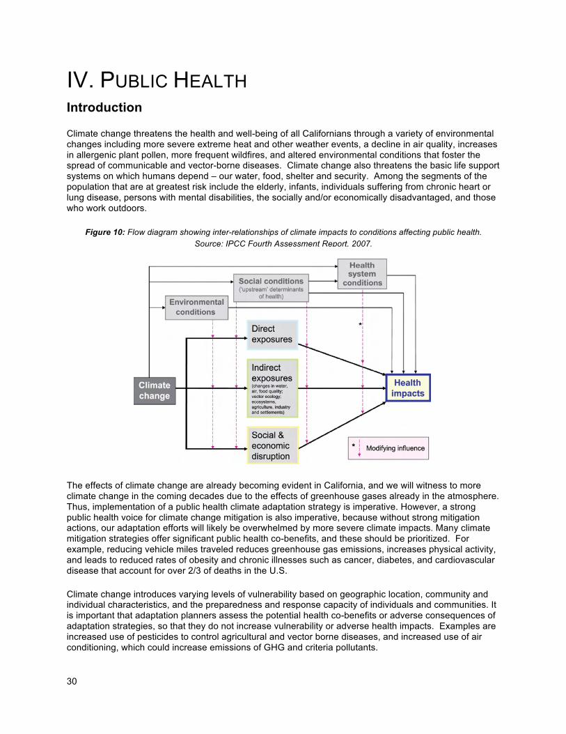
30
IV. PUBLIC HEALTH Introduction Climate change threatens the health and well-being of all Californians through a variety of environmental changes including more severe extreme heat and other weather events, a decline in air quality, increases in allergenic plant pollen, more frequent wildfires, and altered environmental conditions that foster the spread of communicable and vector-borne diseases. Climate change also threatens the basic life support systems on which humans depend – our water, food, shelter and security. Among the segments of the population that are at greatest risk include the elderly, infants, individuals suffering from chronic heart or lung disease, persons with mental disabilities, the socially and/or economically disadvantaged, and those who work outdoors. The effects of climate change are already becoming evident in California, and we will witness to more climate change in the coming decades due to the effects of greenhouse gases already in the atmosphere. Thus, implementation of a public health climate adaptation strategy is imperative. However, a strong public health voice for climate change mitigation is also imperative, because without strong mitigation actions, our adaptation efforts will likely be overwhelmed by more severe climate impacts. Many climate mitigation strategies offer significant public health co-benefits, and these should be prioritized. For example, reducing vehicle miles traveled reduces greenhouse gas emissions, increases physical activity, and leads to reduced rates of obesity and chronic illnesses such as cancer, diabetes, and cardiovascular disease that account for over 2/3 of deaths in the U.S.
Climate change introduces varying levels of vulnerability based on geographic location, community and individual characteristics, and the preparedness and response capacity of individuals and communities. It is important that adaptation planners assess the potential health co-benefits or adverse consequences of adaptation strategies, so that they do not increase vulnerability or adverse health impacts. Examples are increased use of pesticides to control agricultural and vector borne diseases, and increased use of air conditioning, which could increase emissions of GHG and criteria pollutants.
Figure 10: Flow diagram showing inter-relationships of climate impacts to conditions affecting public health.
Source: IPCC Fourth Assessment Report, 2007.
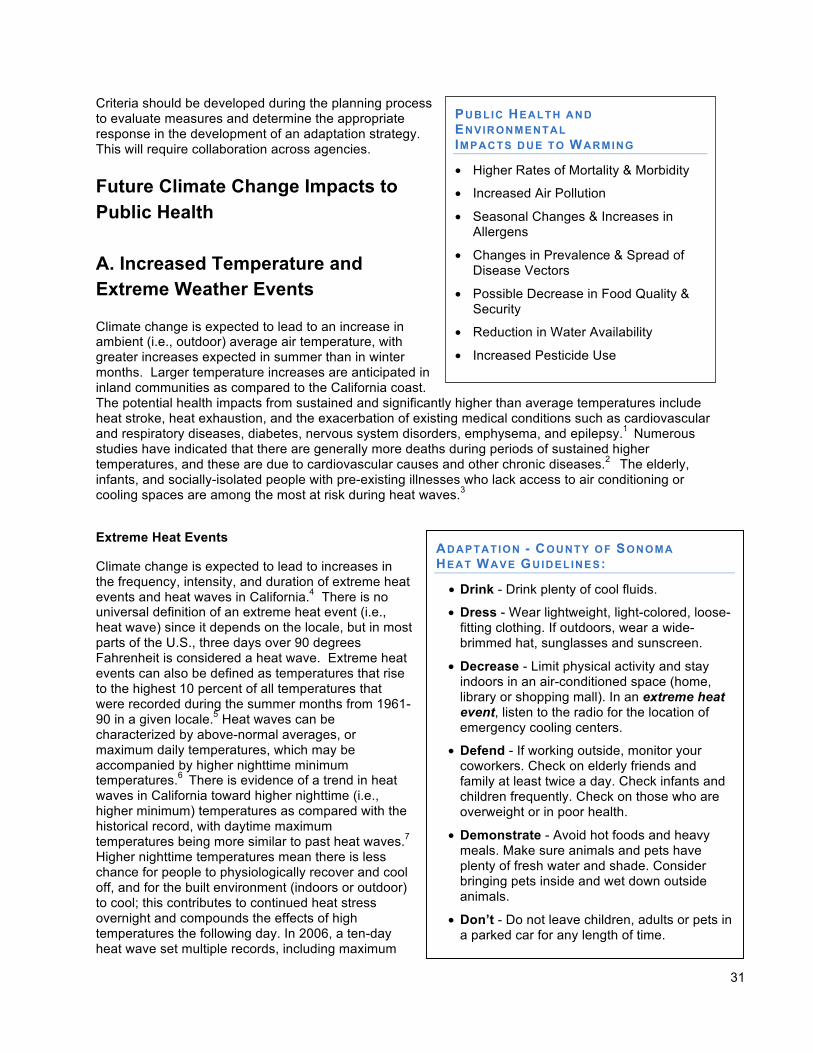
31
Criteria should be developed during the planning process to evaluate measures and determine the appropriate response in the development of an adaptation strategy. This will require collaboration across agencies.
Future Climate Change Impacts to Public Health A. Increased Temperature and Extreme Weather Events Climate change is expected to lead to an increase in ambient (i.e., outdoor) average air temperature, with greater increases expected in summer than in winter months. Larger temperature increases are anticipated in inland communities as compared to the California coast. The potential health impacts from sustained and significantly higher than average temperatures include heat stroke, heat exhaustion, and the exacerbation of existing medical conditions such as cardiovascular and respiratory diseases, diabetes, nervous system disorders, emphysema, and epilepsy.1 Numerous studies have indicated that there are generally more deaths during periods of sustained higher temperatures, and these are due to cardiovascular causes and other chronic diseases.2 The elderly, infants, and socially-isolated people with pre-existing illnesses who lack access to air conditioning or cooling spaces are among the most at risk during heat waves.3
Extreme Heat Events
Climate change is expected to lead to increases in the frequency, intensity, and duration of extreme heat events and heat waves in California.4 There is no universal definition of an extreme heat event (i.e., heat wave) since it depends on the locale, but in most parts of the U.S., three days over 90 degrees Fahrenheit is considered a heat wave. Extreme heat events can also be defined as temperatures that rise to the highest 10 percent of all temperatures that were recorded during the summer months from 1961-90 in a given locale.5 Heat waves can be characterized by above-normal averages, or maximum daily temperatures, which may be accompanied by higher nighttime minimum temperatures.6 There is evidence of a trend in heat waves in California toward higher nighttime (i.e., higher minimum) temperatures as compared with the historical record, with daytime maximum temperatures being more similar to past heat waves.7 Higher nighttime temperatures mean there is less chance for people to physiologically recover and cool off, and for the built environment (indoors or outdoor) to cool; this contributes to continued heat stress overnight and compounds the effects of high temperatures the following day. In 2006, a ten-day heat wave set multiple records, including maximum
PUBLIC HEALTH AND
ENVIRONMENTAL IMPACTS DUE TO WARMING
• Higher Rates of Mortality & Morbidity
• Increased Air Pollution
• Seasonal Changes & Increases in Allergens
• Changes in Prevalence & Spread of Disease Vectors
• Possible Decrease in Food Quality & Security
• Reduction in Water Availability
• Increased Pesticide Use
ADAPTATION - COUNTY OF SONOMA HEAT WAVE GUIDELINES:
• Drink - Drink plenty of cool fluids.
• Dress - Wear lightweight, light-colored, loose-fitting clothing. If outdoors, wear a wide-brimmed hat, sunglasses and sunscreen.
• Decrease - Limit physical activity and stay indoors in an air-conditioned space (home, library or shopping mall). In an extreme heat event, listen to the radio for the location of emergency cooling centers.
• Defend - If working outside, monitor your coworkers. Check on elderly friends and family at least twice a day. Check infants and children frequently. Check on those who are overweight or in poor health.
• Demonstrate - Avoid hot foods and heavy meals. Make sure animals and pets have plenty of fresh water and shade. Consider bringing pets inside and wet down outside animals.
• Don’t - Do not leave children, adults or pets in a parked car for any length of time.
32
daily and minimum overnight temperatures, leading to 140 deaths from heat exposure according to county coroners.8 A more accurate analysis estimated 655 excess deaths during the heat wave. More heat waves of similar length and intensity are expected to occur on an annual basis by the end of the century if the world follows a higher GHG emissions (A2) pathway.9 The anticipated increase in heat waves is expected to increase mortality in California, although further modeling is required to more accurately estimate the magnitude of likely increased deaths. Over the past 15 years, heat waves have claimed more lives in the state than all other declared disaster events combined.10 This trend is likely to continue as the number of heat waves increase, and thereby lead to potentially hundreds of climate-related fatalities every year. Even though coastal areas will not see the greatest increases in average temperature, the largest increases in mortality rates are expected to occur in coastal cities such as Los Angeles and San Francisco, since these populations are relatively unaccustomed to extreme heat and thus less acclimatized when such events occur (e.g., less adequate access to air conditioning).11 Increased heat waves can exacerbate higher occurrences of chronic disease or heat-related illness. Compared to baseline conditions, there were 16,166 excess emergency room visits and 1,182 extra hospitalizations linked to the July 2006 heat wave throughout California.12 As record-breaking heat waves occur more frequently in California, excess morbidity will also increase during the summer months. This will require greater preparedness by health care providers and facilities, and will place a strain on California’s health care system. Heat waves also necessitate an increase in energy use for cooling and air conditioning, which can lead to electricity shortages and blackouts. A reduction in energy availability can further impact public health by limiting access to air conditioning and refrigeration which can increase the risk of food-borne illnesses. Urban Heat Islands: The “Urban Heat Island” is due to the greater heat retention of buildings and paved surfaces compared to vegetated surfaces. During heat waves, urban heat islands are especially dangerous because they are both hotter during the day and do not cool down at night, increasing the risk of heat-related illness.
Adaptation - County of Fresno
How to Reduce the Effects of Heat
Seasonal Readiness: • Educate the public on the greatest risks of heat
• Identify and prepare cooling centers
• Identify resources to transport citizens to cooling centers
• Coordinate community resources
• Encourage residents to check on family and friends at risk
• Initiate data collection on heat related deaths and illnesses by the Community Health Department Epidemiologist
Heat Emergency Responses: • Open cooling centers
• Releasing heat response information to the media, local organizations and community groups
• Provide transportation resources for people unable to reach cooling centers
• Coordinate local heat-related resources, donations and volunteers
• Monitor the health of vulnerable populations by county agencies and community groups
• Monitor medical reports of heat-related illnesses and deaths; and
• Provide information to the public regarding available utility bill (air conditioning) assistance resources
33
Health Inequities Issues: Several factors could contribute to health inequities related to increased heat exposure:
a. Chronic illness co-morbidities: Low income and minority communities have an increased prevalence of chronic illnesses that place individuals at greater risk of heat-related illness.
b. Exposure to urban heat island effect: Low-income individuals and people of color are often concentrated in urban areas subject to the heat island effect.
c. Access to air-conditioning: Low income individuals and people of color are less likely to have air conditioning.
d. Occupation: Agricultural workers are especially at risk of heat illness due to the combination of outdoor work in hot climates (e.g. Central and Imperial valleys) and jobs demanding physical exertion.
e. Fear of crime: Low income and minority communities may be reluctant to open doors and windows for ventilation during heat waves for fear of crime.
Fewer Freezing Spells
Currently, freezing events occur on an annual basis in many areas of California. When temperatures drop below freezing, heat is lost from the body more rapidly and can lead to hypothermia. People without shelter, or who live in a poorly insulated home or lack a source of heat are at higher risk of cold-related health effects, as are children and the elderly. Freezing spells are likely to become less frequent in California as climate temperatures increase; if emissions follow higher pathways, freezing events could occur only once per decade in a sizable portion of the state by the second half of the 21st century.13 While fewer freezing spells would decrease cold-related health effects, too few freezes could lead to increased incidence of disease as vectors and pathogens do not die off.
Changes in Air Quality
Many Californians living in or near urban areas currently experience the worst air quality in the nation, with associated economic costs reaching tens of billions every year.14 Research indicates that climate change influences on atmospheric processes will promote formation of ground-level pollutants, such as ozone and secondary aerosols (particulate matter), and that these increases could offset much of the potential gains achieved through air pollution control measures, a phenomenon referred to as the “climate penalty”.15 Short-term effects of air pollution include irritation to the eyes, nose and throat, as well as increased incidence of upper respiratory inflammation. In addition, short-term air pollution tends to aggravate the medical conditions of individuals with asthma and emphysema. Similar to heat waves, public health impacts from particulate matter are highest among the elderly, followed by infants and young children.16 Recent evidence shows that ozone and particulate matter exposures can initiate cardiovascular and lung disease resulting in increased overall mortality.17 An increase of ground-level (tropospheric) ozone can cause decreases in lung function and increase airway reactivity and inflammation. Particulate matter can aggravate existing respiratory and cardiovascular disease and damage the lungs, leading to premature death; it may also contribute to increased risk of cancer. According to the California Air Resources Board (CARB), current exposures to just two common air pollutants – ozone and particulate matter (PM) cause around 8,800 deaths, 9,500 hospitalizations, 200,000 cases of asthma and lower respiratory symptoms, and nearly 5 million school absences in California each year (www.arb.ca.gov/research/health/qhe/qhe.htm). Other air pollutants – such as sulfur and nitrogen oxides – also affect the respiratory and cardiovascular systems. Aero-allergens: Both increased temperatures and increased carbon dioxide concentrations are expected to increase plant production of pollens, and may also increase fungal growth and spore release. Pollen and mold spores are allergens; they can induce and/or aggravate allergic rhinitis, asthma (already the
34
most common childhood chronic illness), and chronic obstructive pulmonary disease. Allergic diseases are the sixth leading cause of chronic disease in the U.S. and impose a substantial burden on the U.S. population. Some experts have suggested that the global rise in asthma is an early health effect of climate change. (http://www.cdc.gov/climatechange/effects/allergens.htm) Changes in temperature affect atmospheric chemistry and the amount of some pollutants like ozone that are in the air. The relationship between temperature change, air quality and human health is complex and synergistic. Four specific dimensions of the relationship have been studied to different degrees: 1) direct effects of temperature on health; 2) direct effects of air pollution on health; 3) temperature and geographic factors that modify pollution effects on health; and 4) pollution factors that modify temperature effects on health.
Climate change can affect exposure to air pollution in several ways:18
1. Increasing air temperatures increase ozone levels, which are formed by reactions between nitrogen oxides and hydrocarbons released from motor vehicle combustion of fuel.
2. Increasing temperatures can change human behavior in ways that increase air pollution – for example, through increased fuel combustion to meet electricity demand for increased air conditioner use
3. Climate change can effect patterns of air mixing and air flow that transport pollutants 4. Increased temperatures can increase the emission of pollutants called volatile organic
compounds from plants and vegetation. Knowledge of air pollution direct health effects has resulted in regulations for criteria air pollutants and hazardous air pollutants. Changes in air pollutant levels due to temperature changes will result in more non-attainment days and greater risks of disease to the involved populations. Recent research suggests that changes in temperature and geographic location will further modify the effect of air pollutants on respiratory and cardiovascular health and mortality. Conversely, it has been demonstrated that changes in ozone or particulate matter levels modify the effect of heat on cardio-vascular mortality.19 One recent study estimated that each one degree (Celsius) increase in temperature would cause about 1,000 additional deaths in the U.S. associated with air pollution.20 Health Equity Issues: Air pollution levels in poor urban neighborhoods are often substantially higher than those in other areas, due to closer proximity to freeways and other motor vehicle arterials, and industrial pollutant sources.21 Asthma rates are higher in low income and minority children in California. Increases in air pollutants and/or aero-allergens may exacerbate these existing health inequities, unless special care is taken to reduce pollution sources; recent action by the CARB to reduce diesel truck pollution is a good example of a policy that could reduce these health inequities.
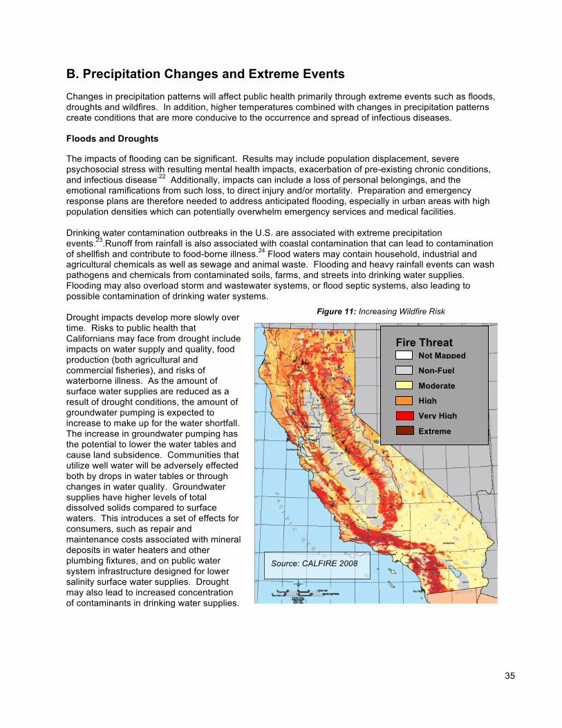
35
B. Precipitation Changes and Extreme Events
Changes in precipitation patterns will affect public health primarily through extreme events such as floods, droughts and wildfires. In addition, higher temperatures combined with changes in precipitation patterns create conditions that are more conducive to the occurrence and spread of infectious diseases. Floods and Droughts
The impacts of flooding can be significant. Results may include population displacement, severe psychosocial stress with resulting mental health impacts, exacerbation of pre-existing chronic conditions, and infectious disease.22 Additionally, impacts can include a loss of personal belongings, and the emotional ramifications from such loss, to direct injury and/or mortality. Preparation and emergency response plans are therefore needed to address anticipated flooding, especially in urban areas with high population densities which can potentially overwhelm emergency services and medical facilities. Drinking water contamination outbreaks in the U.S. are associated with extreme precipitation events.23.Runoff from rainfall is also associated with coastal contamination that can lead to contamination of shellfish and contribute to food-borne illness.24 Flood waters may contain household, industrial and agricultural chemicals as well as sewage and animal waste. Flooding and heavy rainfall events can wash pathogens and chemicals from contaminated soils, farms, and streets into drinking water supplies. Flooding may also overload storm and wastewater systems, or flood septic systems, also leading to possible contamination of drinking water systems. Drought impacts develop more slowly over time. Risks to public health that Californians may face from drought include impacts on water supply and quality, food production (both agricultural and commercial fisheries), and risks of waterborne illness. As the amount of surface water supplies are reduced as a result of drought conditions, the amount of groundwater pumping is expected to increase to make up for the water shortfall. The increase in groundwater pumping has the potential to lower the water tables and cause land subsidence. Communities that utilize well water will be adversely effected both by drops in water tables or through changes in water quality. Groundwater supplies have higher levels of total dissolved solids compared to surface waters. This introduces a set of effects for consumers, such as repair and maintenance costs associated with mineral deposits in water heaters and other plumbing fixtures, and on public water system infrastructure designed for lower salinity surface water supplies. Drought may also lead to increased concentration of contaminants in drinking water supplies.
Figure 11: Increasing Wildfire Risk
Source: CALFIRE 2008
Fire Threat Not Mapped
Non-Fuel
Moderate
High
Very High
Extreme
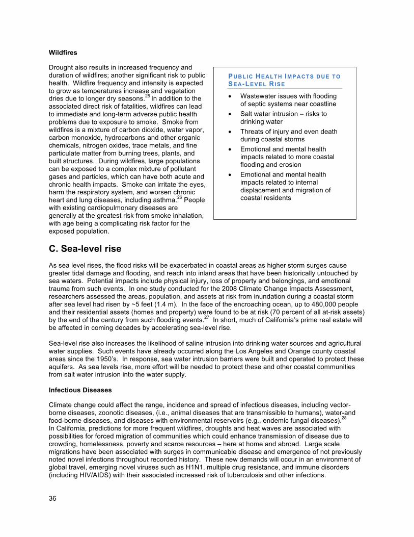
36
Wildfires
Drought also results in increased frequency and duration of wildfires; another significant risk to public health. Wildfire frequency and intensity is expected to grow as temperatures increase and vegetation dries due to longer dry seasons.25 In addition to the associated direct risk of fatalities, wildfires can lead to immediate and long-term adverse public health problems due to exposure to smoke. Smoke from wildfires is a mixture of carbon dioxide, water vapor, carbon monoxide, hydrocarbons and other organic chemicals, nitrogen oxides, trace metals, and fine particulate matter from burning trees, plants, and built structures. During wildfires, large populations can be exposed to a complex mixture of pollutant gases and particles, which can have both acute and chronic health impacts. Smoke can irritate the eyes, harm the respiratory system, and worsen chronic heart and lung diseases, including asthma.26 People with existing cardiopulmonary diseases are generally at the greatest risk from smoke inhalation, with age being a complicating risk factor for the exposed population.
C. Sea-level rise
As sea level rises, the flood risks will be exacerbated in coastal areas as higher storm surges cause greater tidal damage and flooding, and reach into inland areas that have been historically untouched by sea waters. Potential impacts include physical injury, loss of property and belongings, and emotional trauma from such events. In one study conducted for the 2008 Climate Change Impacts Assessment, researchers assessed the areas, population, and assets at risk from inundation during a coastal storm after sea level had risen by ~5 feet (1.4 m). In the face of the encroaching ocean, up to 480,000 people and their residential assets (homes and property) were found to be at risk (70 percent of all at-risk assets) by the end of the century from such flooding events.27 In short, much of California’s prime real estate will be affected in coming decades by accelerating sea-level rise. Sea-level rise also increases the likelihood of saline intrusion into drinking water sources and agricultural water supplies. Such events have already occurred along the Los Angeles and Orange county coastal areas since the 1950’s. In response, sea water intrusion barriers were built and operated to protect these aquifers. As sea levels rise, more effort will be needed to protect these and other coastal communities from salt water intrusion into the water supply. Infectious Diseases
Climate change could affect the range, incidence and spread of infectious diseases, including vector-borne diseases, zoonotic diseases, (i.e., animal diseases that are transmissible to humans), water-and food-borne diseases, and diseases with environmental reservoirs (e.g., endemic fungal diseases).28 In California, predictions for more frequent wildfires, droughts and heat waves are associated with possibilities for forced migration of communities which could enhance transmission of disease due to crowding, homelessness, poverty and scarce resources – here at home and abroad. Large scale migrations have been associated with surges in communicable disease and emergence of not previously noted novel infections throughout recorded history. These new demands will occur in an environment of global travel, emerging novel viruses such as H1N1, multiple drug resistance, and immune disorders (including HIV/AIDS) with their associated increased risk of tuberculosis and other infections.
PUBLIC HEALTH IMPACTS DUE TO
SEA-LEVEL RISE
• Wastewater issues with flooding of septic systems near coastline
• Salt water intrusion – risks to drinking water
• Threats of injury and even death during coastal storms
• Emotional and mental health impacts related to more coastal flooding and erosion
• Emotional and mental health impacts related to internal displacement and migration of coastal residents
37
Vector-Borne Diseases
Changes in temperature and precipitation are likely to cause changes both in the geographic distribution and the quantity of vectors (such as ticks and mosquitoes) that carry human disease. In California, three vector-borne diseases are of particular concern: human hantavirus cardiopulmonary syndrome, Lyme disease, and West Nile virus. These diseases vary in their response to climate-related factors such as temperature, humidity, and rainfall.29 The distribution of vectors may change as humid areas become drier and less suitable habitats, while other areas may become wetter, allowing for the vectors to exist where they previously did not. Abundance of small mammal reservoirs may similarly be affected. In California, the adult or sub-adult (nymph) western black-legged tick can transmit a Lyme disease agent to humans. Lyme disease-carrying ticks are found in patchy distribution patterns in moist, humid environments such as coastal redwood or hardwood forests, and the risk of Lyme disease is highly correlated with exposure to habitats where these ticks live.30 Exposure to the western black-legged tick in California is most often through recreation or occupation where ticks are prevalent, although exposure also occurs with increased development in previously wild areas. Though increased rainfall may temporarily provide increased mosquito breeding sites, in fact, rainfall has little effect on West Nile Virus (WNV) transmission since urban mosquitoes breeding in municipal water systems may benefit from below-normal rainfall. However, an increase in summer rainfall could make California more at risk for the introduction and establishment of exotic vectors such as the principle mosquito vectors of dengue and yellow fever. Each of these climate-related variables – along with unrelated changes in land use and land cover – can modify the geographic range of vectors, thereby raising the possibility that some of these vector-borne diseases may become more common in California. According to the CDC the first West Nile virus infection was detected in 2003 in California and the transmission appeared to increase and spread soon after.31 Climate change may affect rodent populations through the availability or increase in food supplies.32 Prolonged rainfall and/or flood can increase the food supply for rodents, thereby increasing the risk that human populations will become infected by diseases carried by rodents. Wild rodents can also act as hosts to ticks and fleas that can transmit diseases such as Lyme disease, plague, tularemia, and rickettsial infections. Humans can also contract hantavirus cardiopulmonary syndrome when they come into contact with infected rodents or their urine and droppings.
Water- and Food-Borne Diseases
The risk of water- and food-borne diseases such as mild gastrointestinal illnesses could increase as California’s drinking, irrigation, and recreational waters are impacted by climate change. Such infections and illnesses can become chronic and even fatal in infants, the elderly, pregnant women, and people with weakened immune systems.
Historically, outbreaks of water-borne diseases have been linked to heavy rainfall and subsequent runoff, which results in a decline in the quality of surface water arriving at water treatment plants.33 In California, the expected increase in the intensity of rainfall could result in periodic deterioration of the quality of drinking water, and require not only more careful monitoring, but also additional water treatment to maintain adequate water quality. People can contract water- and food-borne diseases by drinking contaminated water, eating seafood from contaminated water, and eating produce irrigated with contaminated water. They can also be exposed to water-borne infectious illnesses while fishing or swimming in affected waters. Higher water temperatures, as a result of warming, can accelerate the spread of water-borne diseases. Harmful algae blooms, which produce nerve and liver toxins, have been noted to be of longer duration and larger intensity, and are suspected to be tied both to increased temperatures due to climate change and nutrient runoff. Exposure to marine life has resulted in death and poisonings of California sea lions. Human exposure is of concern both through drinking water contamination and recreational exposure. Human exposure to these blooms can cause eye and skin irritation, vomiting and stomach cramps,
38
diarrhea, fever, headache, pains in muscles and joints, and weakness. Chronic exposure in drinking water supplies is suspected to have links with liver damage and cancer.34 The Food Supply Marine Biotoxins: Warming oceans and rising sea level may have a dramatic impact on both commercial and recreational shellfish harvesting. Increased water temperatures could lead to an increase in the frequency and distribution of naturally-occurring pathogens such as Vibrio parahaemolyticus, which has caused hundreds of illnesses linked to shellfish consumption. Likewise, increased temperatures, combined with decreased salinity from greater rainfall, could result in increases of the deadly V. vulnificus bacterium currently found predominantly in the Gulf of Mexico. Exceptionally clean water is necessary to ensure that filter feeding shellfish are safe for consumption. Rising sea level will inundate coastal structures, flooding septic systems and other low-lying sewage collection systems. As a result, coastal waters, particularly in bays and estuaries, will be too polluted for shellfish culture, harvesting and consumption. Marine biotoxins are naturally occurring neurotoxins produced by a small number of single-celled marine algae called phytoplankton. Phytoplankton populations are affected by a variety of physical processes (e.g., sea surface temperature, upwelling, nutrient flux, salinity) that could dramatically change due to global warming. Marine toxins are bioconcentrated by filter-feeding organisms such as bivalve shellfish (e.g., mussels, clams, oysters, scallops), omnivorous crustaceans (e.g., Dungeness crab, lobster), and small finfish (e.g., anchovy, sardines). The occurrence of these toxins in seafood presents serious health risks to human consumers as well as marine life such as sea lions and sea otters California has had illnesses and deaths associated with the paralytic shellfish poisoning (PSP) toxins documented in coastal tribes predating written history. Domoic acid, a new toxin which produced four deaths and hundreds of illnesses in 1987 in Canada, was identified just four years later in California, where it caused hundreds of deaths in marine birds in Monterey Bay. Crop yields: Climate change could present serious negative impacts to the crop yields of California’s agricultural system, including both annual and perennial crops. Crop yield is likely to be impacted by climate change effects on water supply, as well as by reduced freezes required for many crops such as stone-fruits. Not only is the food produced in California necessary to feed Californians, especially fresh fruits and vegetables that are a critical part of a healthy diet, but many of the crops are produced for export outside of the state and to other countries, and result in significant tourism (e.g., wine grapes). Any significant decrease in crop yields endangers food availability to Californians, the multibillion agricultural system, and also the employment of many low-paid migrant farm workers. Fisheries: Changes in ocean conditions will also substantially change the distribution and abundance of major fish stocks. Diminshed stream flows, warming ocean water temperatures, and ocean acidification could all contribute to fisheries declines. Impacts to fisheries related to El Nino/Southern Oscillation illustrate how climate directly impacts marine fisheries on short term scales. Higher sea surface temperatures in 1997-1998 during the El Nino had a great impact on market squid, California's largest fishery by volume. The California Regional Assessment reports that landings fell to less than 1,000 metric tons in that season, down from 110,000 tons in the 1996-1997 season. Other unusual events also occurred such as poor salmon returns, a series of plankton blooms, and seabird die-offs. As with agricultural crop yields, significant declines in fisheries will adversely affect the availability and price of fish (an important component of a healthy diet) and employment of workers in this industry. Additionally, food systems may be under stress due to disruptions in transportation systems (e.g. extreme weather conditions, heat buckling of roads or railways). Health inequities: Declines in crop yields and fisheries may contribute to substantial increases in food prices, which would disproportionately impact low income communities who already spend a higher percentage of their income on food. Reduced agricultural employment will impact low income farm workers and their families.
39
D. Risks to Public Health In summary, climate change brings significant public health risks. Climate change is expected to lead to increases in the frequency, intensity, and duration of extreme heat events and heat waves in California, which is likely to increase the risk of mortality and morbidity due to heat-related illness and exacerbation of existing chronic health conditions. Those most at risk and vulnerable to climate-related illness are the elderly, individuals with chronic conditions such as heart and lung disease, diabetes, and mental illnesses, infants, the socially or economically disadvantaged, and those who work outdoors. The expected increase in extremely high temperatures and increased ultraviolet radiation due to climate change is likely to exacerbate existing air quality problems unless measures are taken to reduce GHG as well as air pollutants and their precursors. Climate change can lead to an increase in the occurrence and severity of respiratory illnesses as a result of declining air quality combined with higher temperatures. It can also alter the timing and/or duration of seasonal allergies. Changes in precipitation patterns affect public health primarily through potential for altered water supplies, and extreme events such as floods, droughts, and wildfires. These extreme events are likely to increase, thereby exposing the population to the risk of direct injury and/or mortality, respiratory illness associated with wildfires, property loss, displacement, and associated emotional distress. Adequate preparation is needed to provide sufficient emergency services and access to medical facilities. The direct risk of injury and fatalities from a combination of wildfires, higher temperatures, and longer dry seasons will contribute to an increase in poor air quality and related respiratory illnesses. Wide ranging and unpredictable communicable disease impacts that are likely to result from climate change highlight the need to strengthen public health infrastructure related to electronic disease surveillance, food and water safety, control of insect vectors, control of animal reservoirs of diseases, and increasing the capacity of infectious disease outbreak response.35
Public Health Adaptation Strategies
Introduction
The goal of these Public Health Adaptation Strategies is to minimize the negative health impacts of climate change. This will require an increased awareness of potential climate change-related public health impacts, improved surveillance and monitoring of climate risks and related outcomes, maintenance of a robust public health infrastructure, expanded research, and most importantly, healthy, equitable, and resilient communities that are able to mitigate and respond to climate change and protect vulnerable populations. Failure to control greenhouse gas emissions will result in more extreme and possibly catastrophic climate change that will likely overwhelm our capacity to adapt; the Public Health climate change adaptation work group has thus incorporated climate mitigation strategies with health co-benefits in its strategy to increase community resilience to climate change. Implementation of a credible public health climate change adaptation strategy will require dedicated and sustained resources.
40
Adaptation Strategies and Actions
The Public Health Climate Change Adaptation Work Group, in concert with the Department of Public Health, has identified the following priorities for public health adaptation for climate change. The near-term actions referenced below are those identified actions which can be initiated by 2010 (contingent on available and sustained funding). The long-term actions include those recommended actions that will require support from the state and collaboration with multiple state agencies and are identified as cross-sector strategies.
Strategy 1: Promote Community Resilience to Reduce Vulnerability to Climate Change.
Near-Term Actions:
a. Promote Healthy Built Environments – CDPH should continue working in collaboration with local health departments, community based organizations (CBOs), and other state and local planning and transportation agencies to improve community planning and design to promote healthy living, and to balance integration of social, economic and environmental concerns. CDPH should identify mechanisms to institutionalize the consideration of health in local and regional land use and transportation decision-making in, for example, local general plans, regional transportation plans, or CEQA guidelines, and through the use of Health Impact. CDPH should develop guidelines for health impact assessment, for use by local health departments and other agencies.
b. Identify and Reduce Health Vulnerabilities -- CDPH should provide tools for use by local health departments, other agencies, and CBOs to identify and reduce climate-related health vulnerabilities For example, community wide assessments could identify the homes occupied by disabled persons and seniors, assess the safety, energy and water use efficiency of these homes, and modify or retrofit homes, for example weatherproofing, energy efficient appliances, and shade cover. Identification of urban heat islands could lead to targeted efforts to increase shading and reduce heat-reflecting pavement through,36 for example, expansion of parks and community gardens. Increased efforts to reduce air pollution in “toxic hot spots” would also decrease vulnerability to the health effects of increased air pollution with rising temperatures.
c. Food Security and Quality– CDPH should work in partnership with USDA, CDFA, and CDSS to maintain commitment to healthy foods and nutrition programs that improve access to healthy foods in low-income communities DPH should partner with Local Health Departments and CBOs to promote healthy sustainable local food systems through working for consideration of healthy food access in agricultural, land use, and other policies (e.g., zoning to allow farmers markets, incentives for farm to school/business/consumer, community and school gardens, and strong state support for programs such as Women, Infants and Children (WIC), SNAP-Ed, etc). CDPH should partner with CDFA and local health and environmental agencies to enhance capacity for surveillance and response for food-borne illness outbreaks.
Long -Term Actions:
d. Food Sustainability – CDPH should promote sustainable local food systems to reduce reliance on food that requires a high amount of “vehicle miles traveled”. This could be done through supporting projects with mutual partners and/or through media/outreach campaigns, such as school and community gardens, peri-urban “ring” agriculture, farmland preservation, etc. CDPH should consider working in conjunction with the Natural Resources Agency and the CDFA to discuss/to develop a work group on food and climate change to assure the implementation of sustainable food practices, and policies including promoting a wider range of organic and local foods to California residents and California programs
41
e. Reduce Heat Islands – CDPH should partner with academia, local, state and federal agencies, and other climate change experts to identify urban heat islands, and work with state and federal agencies such as CAL FIRE, USFS Urban Forestry Program and DPR (Department of Parks and Recreation), and community partners to increase ground cover and shading by expanding urban forests, community gardens, parks, and native vegetation-covered, as well as open spaces.
f. Support Social and Community Engagement – The experience of Hurricane Katrina suggests how important neighbors and local support networks can be in response to climate emergencies and in rebuilding after disasters. Community-based approaches will be more likely to result in meeting the needs of all communities, rather than top down approaches administered at the state level. CDPH should incorporate concepts of social and community engagement into its work with local health departments and CBOs, and develop climate change communication tools and messages that promote active community engagement, to build resilient communities, identify vulnerable populations, and promote social support networks.
g. Health Access – State departments and agencies that have a direct role in health access (e.g., Department of Health Care Services, MRMIB, Department of Managed Health Care, and CDPH) should promote increased access to health care, in order to ensure that at-risk populations are prepared for gradual and extreme climate change events. .
Strategy 2: Educate, Empower and Engage California Citizens, Organizations and Businesses to Take Actions to Reduce Individual and Community Vulnerability to Climate Changes through Mitigation and Adaptation.
Near -Term Actions:
a. Educational Outreach Campaign – Incorporate climate change and public health messages into
existing education and media outreach efforts. Develop diverse educational materials for diverse populations (e.g., vulnerable communities, school-age children, business, and labor) that focus on the health impacts of climate change. Conduct focused outreach to clinicians and the health sector about the health impacts of climate change, actions the health sector can take to mitigate and adapt to climate change, and prevention and management of climate-related illnesses (e.g., heat illness). Utilize existing resources to disseminate climate-related health information (e.g., bepreparedcalifornia.ca.gov., public health advisories).
b. Specific Outreach to Vulnerable Populations – Identify dissemination networks (e.g., CBOs,
local government, philanthropic organizations) that can reach vulnerable populations (e.g., outdoor workers and their employers, residents in urban heat islands, asthmatics, immigrants with literacy/language needs) and provide them with information on what they need to know about the risks of climate change, and what they can do to address them, both individually and at the community and state levels.
Long-Term Actions:
c. Proactive Social Marketing Campaign – CDPH should encourage and participate in partnerships with local, state and federal agencies, business, and NGOs to develop coordinated social marketing campaigns to reduce greenhouse gas emissions and implement climate adaptation strategies; these campaigns should support local efforts and empower communities to act on their own behalf to minimize the health impacts of climate change.
42
Strategy 3: Identify and Promote Mitigation and Adaptation Strategies with Public Health Co-benefits.
Near -Term Actions:
a. Identify and Prioritize Strategies with Co-benefits – CDPH should identify public health and climate change mitigation and adaptation strategies that offer health and climate co-benefits; strategies with co-benefits should be prioritized. For example, community design (“smart growth”) that promotes walking and bicycling to increase physical activity and decrease motor vehicle greenhouse gas and toxic pollutants. When possible, adaptation strategies that increase health risks and/or greenhouse gas emissions should be avoided. (e.g. promoting air conditioner use without changes in electricity production reliance on fossil fuel combustion). Strive to institutionalize the inclusion of public health considerations in all applicable climate change policies.
Strategy 4: Establish, Improve and Maintain Mechanisms for Robust Rapid Surveillance of Environmental Conditions, Climate-related Illness, Vulnerabilities, Protective factors and Adaptive Capacities.
Near -Term Actions: a. Monitor Outcomes at State and Local Level – CDPH should work with local health
departments and the health care services sector to increase capacity to monitor the climate related deaths and illnesses associated with heat-related and other events, as well as other climate related illnesses, environmental risks, vulnerabilities, protective factors, and adaptive capacities. Maintain operation of the California Environmental Health Tracking Program, and incorporate the climate health indicators recommended by the Council of State and Territorial Epidemiologists.
b. Environmental Contaminant Biomonitoring – CDPH and Cal/EPA (California Environmental
Protection Agency) should encourage the development of the existing California Environmental Contaminant Biomonitoring Program to determine the level of contaminants in California residents to help reduce baseline illness and increase community resiliency.
c. Water Accessibility Information – Maintain and upgrade the existing Safe Drinking Water
Information System, which provides information about public water systems and their violations of EPA's drinking water regulations regarding maximum contaminant levels, treatment techniques, and monitoring and reporting requirements, in order to ensure safe and reliable public water resources.
d. Heat Warning Systems – Work with the CDPH Emergency Preparedness Office EPO, CalEMA,
and local health and emergency response agencies to develop heat warning systems for regions of the State that have not yet adopted them. These systems should be coupled with existing heat emergency response plans.
Long -Term Actions: e. Electronic Surveillance Systems – The CDPH should continue actions to improve disease
reporting, management and surveillance by replacing the current paper based system with a secure electronic system, (CDC is exploring ways to develop rapid surveillance by coordinating with larger entities such as the Regional Health information Organizations (RHIOs) and Health
f. Information Exchanges (HIE). Expand the Electronic Death Reporting System for the continuous monitoring of abnormal death patterns, asthma, and heat deaths. Actions should be taken to consider mandatory reporting of climate-sensitive morbidity and mortality.
43
g. Emergency (Event) Monitoring – Build a real-time data collection system for the daily monitoring of emergencies based on daily hospitalizations data, emergency department care, and diagnostic, laboratory, and prescription information.
Strategy 5: Improve Public Health Preparedness and Emergency Response
Near -Term Actions:
a. Preparedness Response – CDPH and local health departments should refine existing
emergency preparedness plans and conduct exercises to augment preparedness for events likely to increase with climate change (e.g., heat waves, wildfires, floods), and should develop plans for anticipated impacts such as sea level rise, saline intrusion into drinking water, etc. Public health agencies should also be prepared for the more frequent occurrence of severe heat events in geographic areas where they have previously been very rare (e.g., coastal areas). Fomally request the Centers for Disease Control and Prevention to incorporate climate change response and preparedness as an acceptable use of federal funds for public health preparedness.
Strategy 6: Work in Partnership with Multiple Agencies (e.g., Environmental, Agricultural, Transportation, and Education at Local, State and Federal levels, as well as Business, Labor, Schools and Community-based Organizations).
Near -Term Actions:
a. Institutional Capacity – CDPH should work with appropriate state and local agencies to expand
training and education to build capacity to respond appropriately to the public health risks of climate change. Institutional capacity needs should be addressed in local health departments, health and social services providers, and mental health agencies (e.g. for post-disaster recovery).
Strategy 7: Conduct Research to Enable Enhanced Promotion and Protection of Human Health in Light of Climate Change.
Near -Term Actions:
a. Vulnerability Assessments – CDPH should conduct detailed vulnerability assessments for all
the leading climate-change health outcomes (e.g., heat morbidity, valley fever, flooding, wild fires) utilizing locally scaled-down emergency and environmental shift scenarios, including assessments of impacts on vulnerable populations and cumulative impacts, and risk and resilience factors.
b. Research Collaboration: – CDPH should encourage the California Energy Commission PIER
program to devote more substantial attention to a public health research agenda. CDPH should develop a closer working relationship with the University of California and other universities and NGO’s involved with climate change analysis and impacts, and provide greater input to federal agencies conducting climate change research to increase funding and focus on public health impacts.
44
Long -Term Actions:
c. Assess Local Impacts of Climate Change on Health – Apply downscaled climate change predictions and modeling to provide analysis of anticipated local impacts on health.
Strategy 8: Implement Policy Changes at Local, Regional and National Levels. Near -Term Actions:
a. Policy Collaboration: Work with stakeholders to develop federal and state policies to implement
adaptation strategies that reduce public health risks related to climate change.
b. Occupational Safety Standards – Advise and revise occupational health and safety standards to identify occupations at risk due to climate change.
Long -Term Actions:
c. Model Policies & Training – Identify model adaptation policies for local communities, and provide supportive training and technical assistance to facilitate implementation.
d. Public Engagement – Initiate the engagement of all sectors of government, thereby including
public health issues in all climate change policies they that offer possible co-benefits for climate change adaptation.
Strategy 9: Identify, Develop and Maintain Adequate Funding for Implementation of Public Health Climate Adaptation Strategy.
Near -Term Actions:
a. Funding Mechanisms – Develop a comprehensive funding strategy for public health adaptation
strategies that utilize a broad range of funding strategies including fees, taxes and grants. Funds should be allocated to both statewide and local efforts, and specifically to local health departments.
Long -Term Actions:
b. Funding Mechanisms/AB32 – Develop proportional funding proposals for public health
research, adaptation and climate resiliency education that addresses Environmental Justice, and is based upon market mechanisms such as carbon auctions and carbon trading.
45
V. BIODIVERSITY AND HABITAT Introduction California is one of the most biologically diverse regions of the world and its vast array of species and habitats make it one of the 25 biodiversity “hotspots” on earth.1 Hot spots are areas where at least 1,500 species of vascular plants (> 0.5 percent of the world’s total) are endemics and where at least 70 percent of the original habitat has been lost. Of all 50 states, California has the most unique plant and animal species, as well as the greatest number of endangered species.2 The state’s extensive biodiversity stems from its varied climate and assorted landscapes which have resulted in numerous habitats where species have evolved and adapted over time. The state’s ecological communities include coastal mountain ranges, coastal dunes, wetlands, rivers, lakes, streams, deserts, grasslands, chaparral, and inland forested mountains among others. The vast number of endemic species found in California, combined with the high level of threats to their persistence, makes California a ‘hotspot’ for biodiversity.3
California is one of only five regions in the world with a Mediterranean climate. Habitats in these climatic regions are considered to be more threatened by climate change than tropical forests, since over 40 percent of these lands worldwide have been converted to other uses and less than five percent are protected worldwide.4 According to some estimates, more than 20 percent of the naturally occurring species of amphibians, reptiles, birds, and mammals in California are classified as either endangered, threatened, or "of special concern" to state and federal agencies.5 Therefore, the preservation of California’s unique biological heritage is of ever-increasing importance given the forecasted impacts associated with climate change. The economy and the natural resources that sustain human life are dependent upon the state’s biodiversity. These species and ecosystems provide numerous goods and services, including provisioning services (e.g., food and timber production, medicines, water and fuels), regulating services (e.g., water purification and carbon sequestration), supporting services (e.g., climate regulation and nutrient cycling) and cultural services (e.g., aesthetic values, and sense of place).6 Not only do these goods and services support California’s economy but they support numerous recreational activities for residents.
Future Climate Change Impacts to Biodiversity and Habitat
A. Increased Temperature
Every species has a temperature range in which it thrives and can survive. Brief exposures to extreme temperature events or repeated occurrences of temperatures outside of the range will stress plants and animals, and will exacerbate environmental pressures exerted by competitors, predators, pests and invasive species, habitat change, varying food and water supplies, diseases, and anthropogenic stressors such as contaminants and habitat fragmentation. As average temperatures rise, plant and animal species will increasingly be confronted by thermal stress This kind of thermal stress will force terrestrial plant and animal species to either adapt to these changing conditions and/or shift their geographical range to more favorable conditions. Shifts in geographical range depend upon availability and accessibility of appropriate habitat, as well as the necessary behavioral and life history characteristics that promote rapid dispersal and establishment of new populations. If species are unable to adapt in situ or shift their ranges, local populations may be extirpated and species may face extinction. (Figure 5.2).
Species that cannot adapt in their existing communities may, over time, shift in their ranges if appropriate habitat is available, accessible, and if their behavioral characteristics allow. If they are unable to shift their ranges, they face the threat of local extirpation, if not extinction. The amount of future warming
46
expected in California may likely exceed the tolerance of endemic species (i.e., those that are native to a specific location and that occur only there) given their limited distribution and microclimate. Species that have the capacity to shift their ranges will require movement corridors that are not blocked by natural landscape features or human development. Planning to maintain natural corridors in anticipation of predicted climate changes should be factored into future local and regional habitat conservation planning efforts. Based on current research, we can assume that species occurring together in communities will move independently from each other, not as groups. As a result, communities will reorganize and look differently from what we are familiar with today. For example, cores of fossil pollen from dozens of sites around North America show that in the last Ice Age, boreal tree pollen, which today occurs in the boreal zone in Northern Canada, was common in the Corn Belt of the United States and in areas where mixed hardwood forests exist today. Pollen cores show us that different tree species that were living together then are no longer found together.7 Similar stresses and barriers apply to aquatic species whose migratory/movement limitations may be even more limited. Vernal pool and freshwater lake species are likely to be more susceptible to extirpation because their habitats may disappear entirely or if they are unable to emigrate to a new aquatic environment. For example, fish and amphibian species will experience increased stream and lake temperatures that will affect their food supply and fitness. Warmer air and water conditions could also influence the introduction and spread of undesirable species or diseases.
Invasive Species
As climate change related impacts increase, the ranges occupied by certain species will change. For example, grassland and desert habitats may expand in the future due to climate change, but these ecosystems’ temperature, precipitation and seasonal cycles will be altered by climate change. A changing climate would be expected to shift plant distribution, as well as animal distribution. Although desert plants and animals are adapted to live in extreme environments, even small changes in the components of an ecosystem like temperature, precipitation, seasonal variations can be amplified to cause large changes in ecosystem function8. In certain areas of the Sonoran and Mojave Deserts this could mean less species diversity. For example, a Conservation Policy Brief titled “Curbing Greenhouse Gas Emissions will Reduce Future California Bird Loss” published by Audubon California (Monahan, William B. and Gary Langham. “Curbing Greenhouse Gas Emissions will Reduce Future California Bird Loss.” Audubon California. February 2009.) predicts that under a high emissions scenario parts of the Sonoran and Mojave Desert will lose 25-50% of their bird species while other areas will lose 50-100% of their bird species. As a result, even species that are native to certain California regions may spread into other regions, creating a new category of 'native invasives' that may alter community structure and species interactions in native habitats.
Disturbance events or extreme weather events thought to increase due to climate change generally benefit invasive species given their tolerance to a wide range of environmental conditions. Invasive species often have greater flexibility and can survive under variable and extreme conditions, such as
BIODIVERSITY AND HABITAT IMPACTS DUE TO WARMING
• Barriers to Species Migration and Movement
• Temperature Rise - Lakes, Streams, and Oceans
• Increase in Invasive Species Potential
• Changes in Natural Community Structure
• Threats to Rare, Threatened, or Endangered Species
• Altered Timing of Phenological Events
• Timing Disruptions Between Predators and Prey and Pollinators and Plants
• Loss of Ecosystem Goods and Services
47
flood events or drought. Invasive species also tend to produce large numbers of seeds or young and are capable of long distance dispersal; or have the ability to outcompete native species (especially plants that require no pollination or seed development).
Californians have benefited from the introduction of plant and animal species necessary for food or other human pursuits; however, there are many other introduced species that can wreak havoc on the state’s environment and economy. Invasive species threaten the diversity or abundance of native species through competition for resources, predation, parasitism, interbreeding with native populations, transmitting diseases, or causing physical or chemical changes to the invaded habitat. Through their impacts on natural ecosystems, agricultural and other developed lands, water delivery and flood protection systems, invasive species may also negatively affect human health and/or the economy. Examples of direct impact to human activities include the clogging of navigable waterways and water delivery systems, weakening flood control structures, damaging crops, introducing diseases to animals that are raised or harvested commercially, and diminishing sport fish populations.
Changes to Community Composition and Interactions
Warming has already impacted the seasonal timing of biological events in California, including flowering times, leaf emergence, fall bird migration, and insect emergence9. In addition, interactions between climate change, habitat fragmentation and agricultural practices may have critical impacts on pollination services for crops and wild plants. A change in composition can disrupt biological interactions and impact ecosystem dynamics by displacing existing biological interactions and replacing it with another. For example, an earlier occurrence of flowering may result in futile reproduction efforts for pollinators if they are unable to adjust quickly to the change in availability of resources. Changes in pollinator activity will affect dependent species throughout the natural and human food chain.
It is important not to over generalize individual species responses to climate change as either adapting to warmer temperatures or moving to higher latitudes or altitudes10. Expected range shifts in response to precipitation and temperature changes may differ11, and responses to novel climates are difficult to predict. California’s complex topography will allow for small-scale changes in slope or aspect as a means of tracking a species preferred climate, and–due to the influence of the ocean–range shifts west and downhill, towards the coast, may occur for some taxa. Furthermore, the state of downscaling global climate model to meaningful ecological scales is still lacking in predictive ability at fine spatial scales.
Ecosystem Services:
Biodiversity in natural ecosystems and working landscapes supports a wide range of ecosystem services that sustain human well-being and the economy of California. Ecosystem services are simply defined as the benefits people obtain from ecosystems12. These include carbon sequestration, forage production, timber production, water storage and filtration, crop pollination, soil fertility, fish and game habitat, tourism, recreation and aesthetic values. Ecosystem services can be categorized as provisioning services (food, water, timber, and fiber), regulating services (the regulation of climate, floods, disease, wastes, and water quality), and cultural services such as recreation, aesthetic enjoyment, and spiritual fulfillment; and supporting services such as soil formation, photosynthesis, and nutrient cycling. (Millennium Ecosystem Assessment 2005).
Warming, changes in precipitation and increases in extreme events (drought, storms, heat waves, etc.) are expected to alter many ecosystem services, due to impacts on biodiversity and on the structure and functioning of ecosystems13. Changes in the geographic distribution of individual species and major habitats will alter the distribution of ecosystem services across the state. For example, potential conversion of conifer forest to evergreen woodlands, forecast for regions of the Sierra Nevada and northern Coast Ranges, would reduce and redistribute timber production. Reduced snowpack, changes in water flows, expansion of reservoirs, and warmer water temperatures will impact freshwater ecosystems, with likely negative effects on many native species. Conflicts between human water uses and management of game and non-game fish populations are expected to increase under future climates.
48
While demands for ecosystem services such as food and clean water are growing, climate change and other anthropogenic forcings are reducing the capacity of ecosystems to meet these demands (MEA 2005). “By the end of the twenty-first century, climate change and its impacts may be the dominant direct driver of biodiversity loss and changes in ecosystem services globally.” (MEA 2005). Managing natural resources within an ecosystems services framework that explicitly acknowledges linkages between ecosystem processes and consequent outcomes to human welfare may be the most effective and economically viable means for protecting people from unsafe drinking water, flooding, and climate change14 and maximizing conservation of biodiversity15.
Carbon sequestration is of special interest due to its importance as a tool to offset GHG emissions and contribute to mitigation of global climate change. Proper management of California's ecosystems, including forests, open spaces, and wetlands, may provide significant capture and sequestration of greenhouse gases while simultaneously providing habitats necessary for the long-term conservation of California's biodiversity. As an example, tidal marsh restoration provides protection against erosion, flood control, habitat for many endangered or threatened species, and carbon sequestration services. Hotter and drier climates are projected to cause significant declines in carbon storage in standing tree stocks, and reduced extent of productive conifer forest vegetation1. Increased wildfire is also likely to reduce above- and below-ground carbon storage by forests, though the effects will depend on forest management practices16. Carbon sequestration represents a critical interface of climate mitigation and adaptation strategy in relation to biodiversity conservation, forest management, and wildfire; the potential contribution of non-forest ecosystems (grasslands, shrublands rangelands, chaparral, and wetlands) is poorly understood and deserves greater attention. Adaptation strategies that simultaneously enhance biodiversity conservation and ecosystem services are critically important to promote sustainable natural ecosystems and human well-being.
B. Precipitation Changes and Extreme Events
Changes in Stream Flow
Flowing water is important because it moves organic material and energy17. This movement facilitates the exchange of nutrients between aquatic and terrestrial areas. In terrestrial areas, aquatically derived nutrients help support vegetation and wildlife18. Emerging aquatic insects are prey for birds and bats foraging and breeding in riparian areas19. Equally important, flowing water moves terrestrial organisms and detritus, which play an important role in aquatic food webs20.
Current projections for California suggest that precipitation and temperature events will be more extreme. For example, more frequent and intense heat waves can impact heat-sensitive species, reducing fitness and increasing mortality. With more precipitation falling as rain (less snow pack), river flows during the winter and spring seasons will be greater; while reduced snowfall in the winter will result in reduced snowmelt and subsequently lower stream flows during summer months. One of the first species groups impacted by stream flow change will be fish. Fish reproduction is affected by stream flows in several ways. Increases in winter runoff and earlier spring peak flows are likely to lead to increases in the number of flooding events during these seasons. Early-spring, high-runoff periods or flooding may occur during egg incubation periods for many fish species, thus impacting reproduction. High stream flow could additionally shift streambed gravel, and heighten the risk of damage to incubating eggs; while the emergence of juveniles can be displaced, undermining the reproductive success of species.21 Mosquitoes will proliferate in areas where flooding combines with higher springtime temperatures. If these areas are chemically treated to protect human health, non-target invertebrates that feed fish and other aquatic species will be affected. Introduced toxins will have unintended consequences for the entire food chain. (See also Public Health chapter for additional information on climate change impacts to public health.)
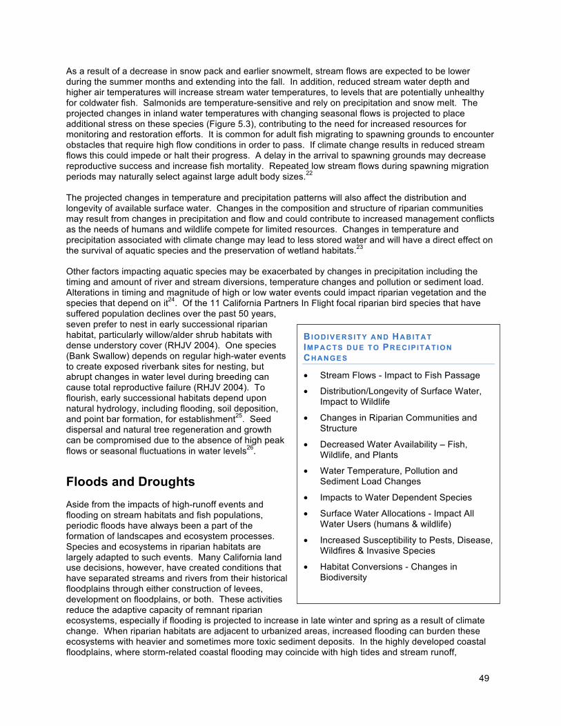
49
As a result of a decrease in snow pack and earlier snowmelt, stream flows are expected to be lower during the summer months and extending into the fall. In addition, reduced stream water depth and higher air temperatures will increase stream water temperatures, to levels that are potentially unhealthy for coldwater fish. Salmonids are temperature-sensitive and rely on precipitation and snow melt. The projected changes in inland water temperatures with changing seasonal flows is projected to place additional stress on these species (Figure 5.3), contributing to the need for increased resources for monitoring and restoration efforts. It is common for adult fish migrating to spawning grounds to encounter obstacles that require high flow conditions in order to pass. If climate change results in reduced stream flows this could impede or halt their progress. A delay in the arrival to spawning grounds may decrease reproductive success and increase fish mortality. Repeated low stream flows during spawning migration periods may naturally select against large adult body sizes.22 The projected changes in temperature and precipitation patterns will also affect the distribution and longevity of available surface water. Changes in the composition and structure of riparian communities may result from changes in precipitation and flow and could contribute to increased management conflicts as the needs of humans and wildlife compete for limited resources. Changes in temperature and precipitation associated with climate change may lead to less stored water and will have a direct effect on the survival of aquatic species and the preservation of wetland habitats.23 Other factors impacting aquatic species may be exacerbated by changes in precipitation including the timing and amount of river and stream diversions, temperature changes and pollution or sediment load. Alterations in timing and magnitude of high or low water events could impact riparian vegetation and the species that depend on it24. Of the 11 California Partners In Flight focal riparian bird species that have suffered population declines over the past 50 years, seven prefer to nest in early successional riparian habitat, particularly willow/alder shrub habitats with dense understory cover (RHJV 2004). One species (Bank Swallow) depends on regular high-water events to create exposed riverbank sites for nesting, but abrupt changes in water level during breeding can cause total reproductive failure (RHJV 2004). To flourish, early successional habitats depend upon natural hydrology, including flooding, soil deposition, and point bar formation, for establishment25. Seed dispersal and natural tree regeneration and growth can be compromised due to the absence of high peak flows or seasonal fluctuations in water levels26.
Floods and Droughts Aside from the impacts of high-runoff events and flooding on stream habitats and fish populations, periodic floods have always been a part of the formation of landscapes and ecosystem processes. Species and ecosystems in riparian habitats are largely adapted to such events. Many California land use decisions, however, have created conditions that have separated streams and rivers from their historical floodplains through either construction of levees, development on floodplains, or both. These activities reduce the adaptive capacity of remnant riparian ecosystems, especially if flooding is projected to increase in late winter and spring as a result of climate change. When riparian habitats are adjacent to urbanized areas, increased flooding can burden these ecosystems with heavier and sometimes more toxic sediment deposits. In the highly developed coastal floodplains, where storm-related coastal flooding may coincide with high tides and stream runoff,
BIODIVERSITY AND HABITAT IMPACTS DUE TO PRECIP ITATION
CHANGES
• Stream Flows - Impact to Fish Passage
• Distribution/Longevity of Surface Water, Impact to Wildlife
• Changes in Riparian Communities and Structure
• Decreased Water Availability – Fish, Wildlife, and Plants
• Water Temperature, Pollution and Sediment Load Changes
• Impacts to Water Dependent Species
• Surface Water Allocations - Impact All Water Users (humans & wildlife)
• Increased Susceptibility to Pests, Disease, Wildfires & Invasive Species
• Habitat Conversions - Changes in Biodiversity
50
ecosystems will face great challenges. Likewise, the projected increase in drought conditions will further impact stream and terrestrial habitat quality as well as the adaptive capacity of ecosystems to continue to provide their goods and services. Prolonged periods of drought can make ecosystems vulnerable to pests, non-native species invasions and frequent and intense wildfires. Moreover, reduced rainfall and snowmelt will lead to less water infiltrating the soil, stressing plants and animals. This reduced infiltration rate will also diminish groundwater recharge. Lowered levels of groundwater, combined in coastal areas with saltwater intrusion, will exacerbate dry conditions and further stress species and habitats. As an example, likely reductions in precipitation and higher variability in precipitation, both within and among years are likely to reduce survival of young seedlings, which are particularly susceptible to drought stress and has serious implications for the ability of ecosystems to recover from disturbance both natural and by active restoration (See also Forestry sector). Together, all these changes in water availability can cause landscape transformations as conditions select for species that require less water (see the Water chapter for more discussion on climate change impacts on freshwater ecosystems and species).
Wildfires
Fire plays an important role in the condition, function, and distribution of many of California’s natural habitats and has done prior to and since human settlement. Aspects of fire regime, frequency, intensity, severity, magnitude, and pattern, have fluctuated over time. Since the 1980s, the state has recognized apparent changes in the frequency, intensity, and duration of wildfire, especially in conifer-dominant ecosystems in the Sierra Nevada and chaparral ecosystems in coastal and interior southern California.. Land-use, land management, and fire suppression policies, particularly in conifer forest and chaparral communities, are thought to have affected attributes of fire regimes throughout human history. In recent years, researchers have determined that changes in climate have had an important role in altering fire regimes. Current information suggested an extension of the fire season and increasing the number of large wildfires, as well as wildfire intensity. Particularly, higher spring and summer temperatures and earlier spring snowmelt are thought to have contributed to these changes.27 Wildfire occurrence statewide could increase from 57 percent to 169 percent by 2085 under the A2 (higher) emissions scenario and by more than 100 percent in most northern California forest in all SRES A2 scenarios by 208528. In one climate change scenario, potential fire fuels can build up during wet years when plant production is high. Preconditions for catastrophic wildfires will occur if ensuing weather conditions include decreased precipitation or drought that dries out the accumulated fuel. Large scale and intense wildfires could result in vegetation and habitat alterations, resulting in displacement of local species for variable amounts of time, sometimes years or complete extirpation. In addition, the recruitment of invasive grass species in fire-disturbed areas can increase fine fuel loads, resulting in greater fuel continuity, frequency, and rate of spread.29 Most California vegetative communities experience fire on a regular basis, but it is essential to take note that historical fire regimes differ enormously between different vegetation types, and these differences lead to very different management challenges. Exclusion of fire or altering its regional fire regime attributes will alter the systems and both eliminate animal species and change, if not decrease, existing biodiversity. Some of the wildlife benefits of wildfire include the (1) recycling of dead and downed vegetation and creation of new deadwood and snags,ii (2) cycling of soil nutrients, (3) removal of excess, woody vegetation which provides for herbaceous plants and younger plants to grow and new and palatable vegetation for herbivores, (4) opening up of the under story for browsing for larger wildlife species, and (5) creation of tree holes utilized by cavity-nesting birds, bats, and arboreal mammals. These benefits are typically derived from low- to moderate intensity fires, and in some cases, depending on the vegetation community, infrequent, high-intensity fires. However, benefits are not derived from the
ii One of the most crucial habitat elements for woodland and forest invertebrates, vertebrates, and fungi.
51
more frequent, high intensity wildfires that California has experienced in recent years, especially in conifer systems in the western Sierra Nevada and chaparral systems in southern California.
More frequent fires help manage fuel loads in forested communities. However, some lands do not behave this way ecologically and will not survive the increase in fire frequency that has occurred and is likely to be exacerbated by climate change. For example, in southern California coastal and interior chaparral (including coastal sage scrub communities) increased fire frequency is the primary threat to maintaining ecological integrity and ecosystem services over time. These systems are adapted to a fire return interval of 60-150 years30 on average and too frequent fire has been shown to cause habitat type conversion in addition to increasing pathways for invasive occurrences. This altered frequency has resulted from an increase in the human presence at the wildlife urban interface and associated increase in the anthropogenic ignition combined with extreme wind events. Because of this, management strategies for fire in southern California chaparral and areas of similar circumstance might need to focus on ignition prevention. Vegetation and wildfire management, including mechanical vegetation reduction, prescribed fire, use of wildland fire, and restoring lands post-wildfire, have to consider the current fire regime operating in the vegetation type and ecological zone and the desired fire regime. The “right kind of fire” is the fire that will enable a vegetation community to sustain itself within all the other ecological considerations [soil dynamics, hydrology, biotic community, weather and climate, etc.). How vegetation fuels management is done and how fire prevention activities are carried out should always focus on being able to re-establish the landscape to support an appropriate, acceptable fire regime. Strategies related to fire must consider these differences, focusing on the idea of the 'right kind of fire' in different systems. For example, California State Parks burns under controlled conditions about five percent of what they deem necessary. Prescribed burning in many forested areas, including old growth, is not possible until heavy understory fuel accumulations have been reduced manually or by mechanical means before burning takes place. Regulatory requirements, e.g., air quality and listed species protection, can also impact or reduce prescribed burning activities. When it comes to current vegetation community and fuel condition versus desired vegetation and fuel conditions, land managers [fire, fuels, etc.] should have a plan that can be used over a period of time to alter conditions as appropriate within fiscal, time, management, and ecological constraints. This type of integrated fire and fuels management and planning are important given climate change concerns. Agency(ies) should have a land management plan that clearly articulates how and when vegetation will be altered in order to achieve a level of composition and structure that is both viable ecologically [including fire regime] and socio-politically. As an example, the Department of Fish and Game, includes a fire and fuels management section within land management plans for all properties owned or managed by the Department. Fire prevention and natural resource managers across the state must work together to support key fuels management measures to find a balance between protecting the public, existing infrastructure, and the essential ecological role that fires play in ecosystems (see the Forestry chapter for additional information on climate change impacts on forests and wildfire).
C. Sea-level rise
California’s coastal areas include a variety of habitats that range in their characteristics from purely aquatic, to semi-aquatic, to terrestrial. All habitats are influenced by periodic flooding by tidal waters, rainfall, or runoff. These wetlands, dunes, and rocky habitats are home to a vast number of organisms, including many endangered species. During certain periods, wetlands harbor juveniles of numerous aquatic species including fish and shellfish. Wetland habitats from the Sacramento Valley southward to

52
the Salton Sea and the tidal marshes of San Francisco Bay also provide essential wintering habitat for hundreds of thousands of birds as they migrate north and south along the Pacific Flyway. Humans additionally benefit from the ability of healthy wetlands to buffer storm impacts, reduce shoreline erosion, improve water quality, and provide beautiful areas for recreation.31
Located between sea and land, coastal habitats have developed as a result of dynamic changes over time. Accelerating sea-level rise may overwhelm their natural capacity to keep up and concurrent stresses and pressures due to development and land use decisions further threaten these habitats. Existing stresses include ongoing discharge of organic wastes fostering eutrophication, legacy of organic pollutants and other toxic substances, pathogen loading, sediment and freshwater delivery alteration, thermal pollution, direct wetland infill and destruction with subsequent habitat loss, bottom disturbance from fishing practices and recreational boating, extraction of living and non-living material and influx of invasive species.32 Thus, the biodiversity and habitats of coastal areas may be particularly impacted by sea-level rise and other climatic changes. Some coastal habitats, such as wetlands and dune habitats can become permanently inundated and eroded if sea level rises faster than these ecosystems can move inland. Moreover, inland migration is frequently hindered by development such as bulkheads, seawalls, roads, and buildings. Continued growth and development in coastal areas will only increase the direct pressure on remaining habitats and make inland migration more difficult. Sea-level rise, especially at the increasing rates projected for the 21st century, may result in the loss of substantial areas of critical habitat for a variety of coastal species.33 The degradation of sensitive ecosystems can be brought about not just by higher sea levels but also by other climate changes, including higher temperatures and changes in precipitation patterns, which together can facilitate the establishment of invasive species such as European beach grass. Both aquatic and terrestrial coastal ecosystems may thus see further increases in problems with invasive species.34 Sea-level rise will also result in salt water intrusion into fresh water resources near the coast, reducing the amount of fresh water available for plants, wildlife, and competing agricultural and metropolitan uses. Species with greater salt tolerances may have a selection advantage where habitats can naturally transform, without human interference. Sea-level rise, in conjunction with coastal storms, may also lead to coastal flooding that extends further inland, thus increasing the risk of pollution, runoff, and sedimentation in fresh water sources of previously unaffected areas. This degradation of fresh water in near-coastal areas may aggravate conflicts over water for human uses versus ecosystem and species needs. There will also be shifts in the type and location of agriculture as saltwater intrudes into coastal aquifers and natural recharge of groundwater resources decreases with the drying climate. Water transfer and management impacts may become increasingly complex, as there may be impacts to hydropower and hatchery project operations as well as water diversion projects. Changes to the timing and intensity of freshwater input may impact marine and near shore populations through increased runoff resulting in pollution and sedimentation contamination and shifts in urban growth and development will place new or increased pressure on existing coastal resources and available habitat. Inundation of coastal infrastructure could cause widespread pollution and contamination further jeopardizing marine and near-marine environments. Changes in ocean circulation and ocean warming will impact pelagic species distribution and community structure. In addition, ocean acidification could impact shellfish species as well as their prey base. Protected areas such as ecological reserves, wildlife areas, undesignated lands, mitigation sites and easements could also be affected, and require management decisions that protect California’s natural resources. These challenges and many more will require close coordination with those entities implementing the oceans and coastal adaptation strategies. Please refer to the Oceans and Coastal Resources chapter for additional information.
53
Monitoring and Adaptive Management
Adaptive management is a key element of implementing effective conservation programs especially in light of some of the uncertainties associated with climate change. Natural communities, ecosystems, species population dynamics, and the effects of stressors on the environment are inherently complex. Wildlife and resource managers often are called upon to implement conservation strategies or actions based upon limited scientific information and despite considerable uncertainties.
Adaptive management combines data from monitoring species and natural systems with new information from management and targeted studies to continually assess the effectiveness of, and adjust and improve, conservation actions. It is important to keep in mind that the outcomes of management interventions in the face of climate change differ markedly in their predictability and while some management strategies will be robust to different future climates, others will not. Successful management will require strategies in which management actions are coupled with monitoring to provide informative feedback loops however, despite uncertainties in future projections; managers can begin to actively address climate change now35. .California’s Wildlife Action Plan summarizes an approach to adaptive management and addresses the steps and considerations needed to design a monitoring program in an adaptive management context.36 California’s Wildlife Action Plan also provides a framework for establishing monitoring programs central to the implementation specific climate change adaptation strategies detailed in this document.
D. Risks for Biodiversity and Habitats
In summary, some of the current and future climate change impacts to biodiversity expected in California include: • Temperature-sensitive terrestrial plant and animal species must adapt to warmer temperatures within
their existing ranges and/or shift their geographical range in response to climate changes. These shifts may occur towards higher latitudes, higher elevations, cooler coastal environments, or local microclimatic refuges, depending upon interactions with precipitation, topography and soils, and species behavioral and life history characteristics.
• The amount of additional warming expected in California in the future may exceed the tolerance of
some species, particularly endemic ones. Where relocation access is blocked off by natural landscape features or human development, species will need corridors to establish habitat connectivity or face a growing risk of extinction.
• Similar stresses and barriers apply to aquatic species, but their migratory limitations may be greater. • The problem of invasive species is likely to become even more challenging in the future, as invasive
species are typically more competitive than native species especially in damaged/degraded environments.
• Species migration/movement and invasions, along with changes in behavior of climate-sensitive
species, will alter species interactions and community dynamics; these changes may have negative effects on critical ecosystem services.
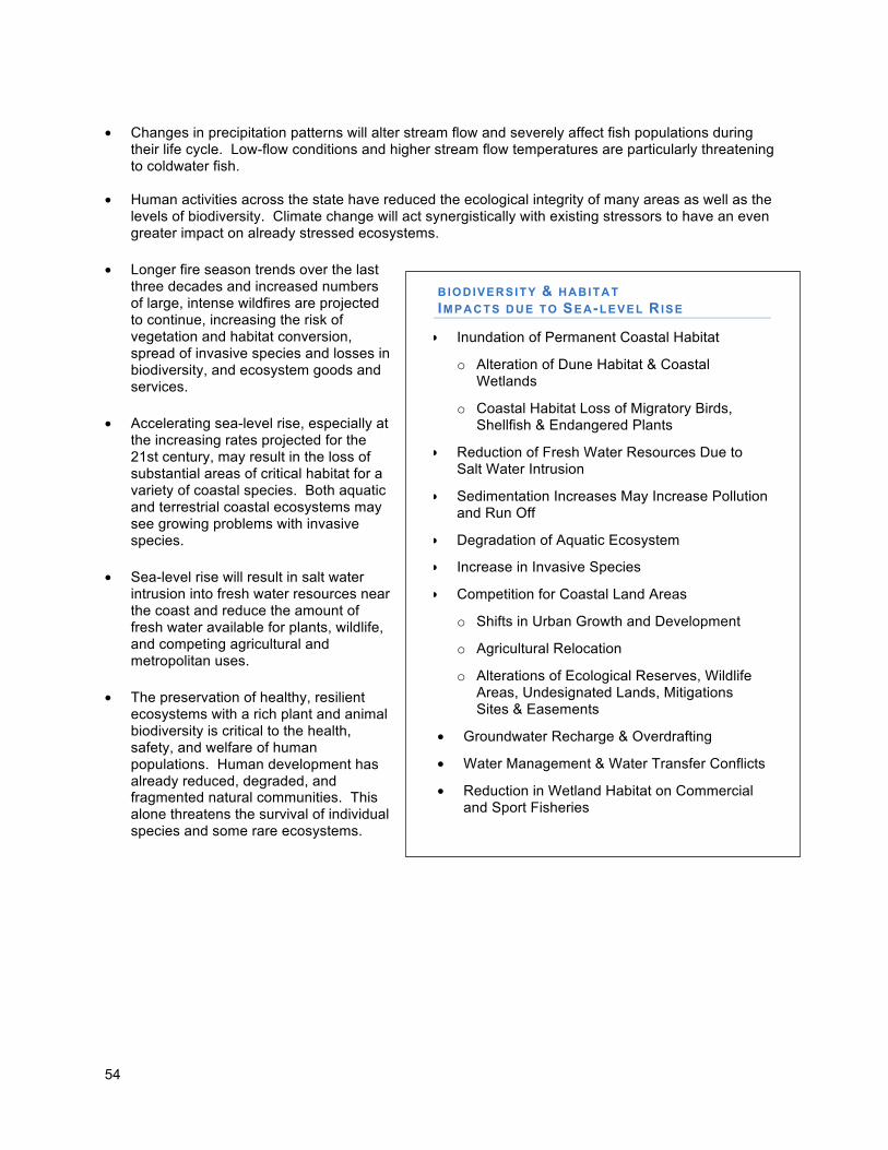
54
B IODIVERSITY & HABITAT IMPACTS DUE TO SEA-LEVEL RISE
• Inundation of Permanent Coastal Habitat
o Alteration of Dune Habitat & Coastal Wetlands
o Coastal Habitat Loss of Migratory Birds, Shellfish & Endangered Plants
• Reduction of Fresh Water Resources Due to Salt Water Intrusion
• Sedimentation Increases May Increase Pollution and Run Off
• Degradation of Aquatic Ecosystem
• Increase in Invasive Species
• Competition for Coastal Land Areas
o Shifts in Urban Growth and Development
o Agricultural Relocation
o Alterations of Ecological Reserves, Wildlife Areas, Undesignated Lands, Mitigations Sites & Easements
• Groundwater Recharge & Overdrafting
• Water Management & Water Transfer Conflicts
• Reduction in Wetland Habitat on Commercial and Sport Fisheries
• Changes in precipitation patterns will alter stream flow and severely affect fish populations during
their life cycle. Low-flow conditions and higher stream flow temperatures are particularly threatening to coldwater fish.
• Human activities across the state have reduced the ecological integrity of many areas as well as the levels of biodiversity. Climate change will act synergistically with existing stressors to have an even greater impact on already stressed ecosystems.
• Longer fire season trends over the last three decades and increased numbers of large, intense wildfires are projected to continue, increasing the risk of vegetation and habitat conversion, spread of invasive species and losses in biodiversity, and ecosystem goods and services.
• Accelerating sea-level rise, especially at
the increasing rates projected for the 21st century, may result in the loss of substantial areas of critical habitat for a variety of coastal species. Both aquatic and terrestrial coastal ecosystems may see growing problems with invasive species.
• Sea-level rise will result in salt water
intrusion into fresh water resources near the coast and reduce the amount of fresh water available for plants, wildlife, and competing agricultural and metropolitan uses.
• The preservation of healthy, resilient
ecosystems with a rich plant and animal biodiversity is critical to the health, safety, and welfare of human populations. Human development has already reduced, degraded, and fragmented natural communities. This alone threatens the survival of individual species and some rare ecosystems.
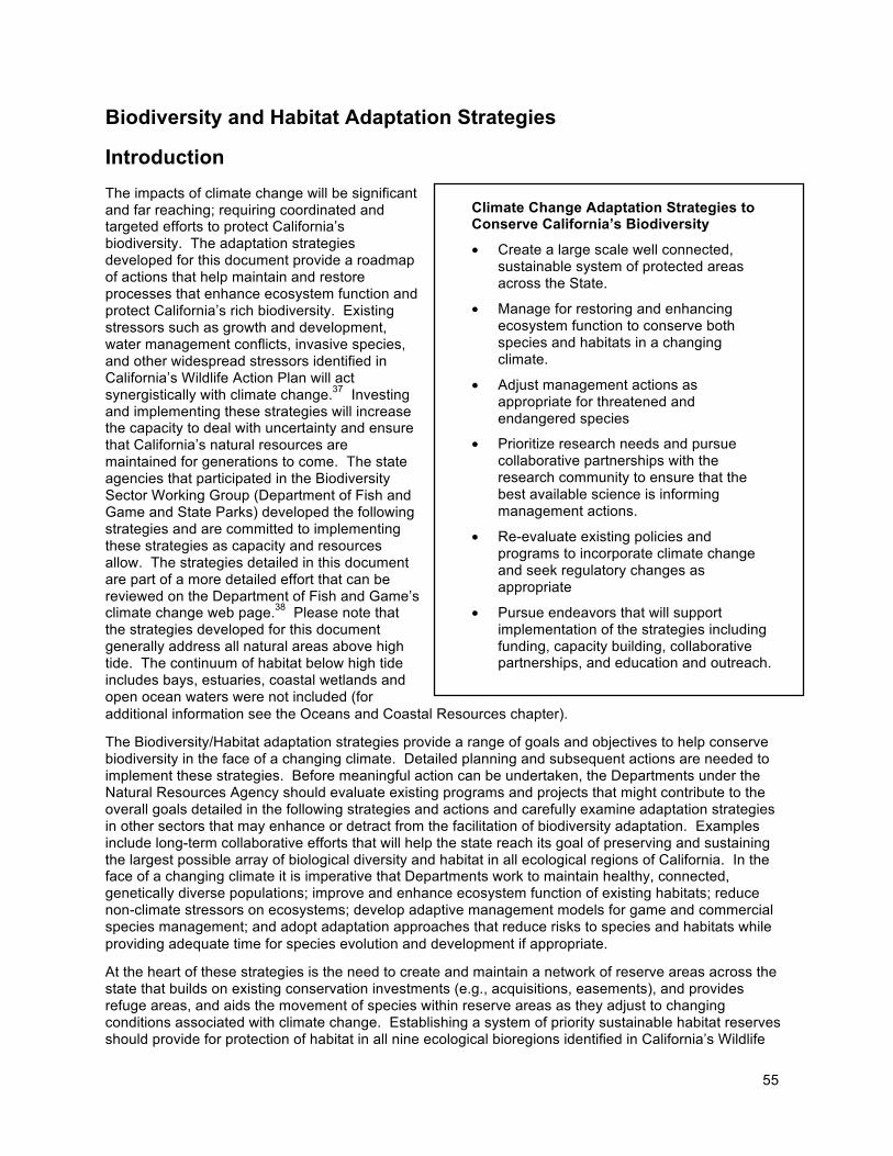
55
Climate Change Adaptation Strategies to Conserve California’s Biodiversity
• Create a large scale well connected, sustainable system of protected areas across the State.
• Manage for restoring and enhancing ecosystem function to conserve both species and habitats in a changing climate.
• Adjust management actions as appropriate for threatened and endangered species
• Prioritize research needs and pursue collaborative partnerships with the research community to ensure that the best available science is informing management actions.
• Re-evaluate existing policies and programs to incorporate climate change and seek regulatory changes as appropriate
• Pursue endeavors that will support implementation of the strategies including funding, capacity building, collaborative partnerships, and education and outreach.
Biodiversity and Habitat Adaptation Strategies
Introduction
The impacts of climate change will be significant and far reaching; requiring coordinated and targeted efforts to protect California’s biodiversity. The adaptation strategies developed for this document provide a roadmap of actions that help maintain and restore processes that enhance ecosystem function and protect California’s rich biodiversity. Existing stressors such as growth and development, water management conflicts, invasive species, and other widespread stressors identified in California’s Wildlife Action Plan will act synergistically with climate change.37 Investing and implementing these strategies will increase the capacity to deal with uncertainty and ensure that California’s natural resources are maintained for generations to come. The state agencies that participated in the Biodiversity Sector Working Group (Department of Fish and Game and State Parks) developed the following strategies and are committed to implementing these strategies as capacity and resources allow. The strategies detailed in this document are part of a more detailed effort that can be reviewed on the Department of Fish and Game’s climate change web page.38 Please note that the strategies developed for this document generally address all natural areas above high tide. The continuum of habitat below high tide includes bays, estuaries, coastal wetlands and open ocean waters were not included (for additional information see the Oceans and Coastal Resources chapter).
The Biodiversity/Habitat adaptation strategies provide a range of goals and objectives to help conserve biodiversity in the face of a changing climate. Detailed planning and subsequent actions are needed to implement these strategies. Before meaningful action can be undertaken, the Departments under the Natural Resources Agency should evaluate existing programs and projects that might contribute to the overall goals detailed in the following strategies and actions and carefully examine adaptation strategies in other sectors that may enhance or detract from the facilitation of biodiversity adaptation. Examples include long-term collaborative efforts that will help the state reach its goal of preserving and sustaining the largest possible array of biological diversity and habitat in all ecological regions of California. In the face of a changing climate it is imperative that Departments work to maintain healthy, connected, genetically diverse populations; improve and enhance ecosystem function of existing habitats; reduce non-climate stressors on ecosystems; develop adaptive management models for game and commercial species management; and adopt adaptation approaches that reduce risks to species and habitats while providing adequate time for species evolution and development if appropriate.
At the heart of these strategies is the need to create and maintain a network of reserve areas across the state that builds on existing conservation investments (e.g., acquisitions, easements), and provides refuge areas, and aids the movement of species within reserve areas as they adjust to changing conditions associated with climate change. Establishing a system of priority sustainable habitat reserves should provide for protection of habitat in all nine ecological bioregions identified in California’s Wildlife
56
Action Plan. Reserves should represent to the extent practical all aspects of ecosystem structure, composition, and function within aquatic, terrestrial, and near-shore marine habitats. In addition, any effort to establish a system of priority reserve areas should follow the basic principles of reserve design that will provide protection for species in the interim before species migration/movement due to climate change is wholly understood. In the future, a reexamination of the reserve system and species movement must take place and modifications for future protected areas identified. The reserve system is intended to provide connectivity for species movement between current and future suitable habitats (primarily within each identified reserve), while also accommodating range shifts of regionally-limited native plant species, and offering protection from catastrophic loss (e.g., through fire, flood, disease, invasive species). Climate change corridors should facilitate movement and incorporate temperature, soil and elevational gradients that benefit a suite of species. Management and restoration efforts on the network of reserve areas should be elevated in priority and focus on reducing the environmental stressors on plant and animal species and habitats.
Reserve system areas should be identified in the near-term for use in current and future land use planning efforts. It is important to acquire and protect habitat linkages found within and around designated reserve areas. Other important acquisitions may include acquiring fee title or conservation easements that focus on but are not limited to the following parameters: (1) increase soil, latitudinal and elevational gradients, (2) accommodate movement and migration of multiple endemic species, (3) reduce outside threats by improving reserve boundary configuration, and (4) protect evolutionary hotspots. Individually or collectively all these measures increase the overall protected area and provide for greater heterogeneity. Identifying, improving, and connecting these reserve areas will help maintain and increase ecological integrity and provide healthy, resilient habitat and refuge areas to help species persist in a changing climate. For some species these areas may allow them to adapt to new conditions associated with climate change. Adapting to climate change through evolutionary change is an important factor affecting the fate of many plant and animal species. The success of the strategies identified in this document will be in part driven by when and how species may adapt or adjust to their surroundings. A better understanding of natural rates of adaptation through evolutionary change may permit effective management strategies that will help species persist and guide future conservation activities and investments. Species are pushed more rapidly to change where strong natural selection is working in a single direction. However, it is unknown if a single climate change factor will be strong enough to push rapid adaptation. For example, higher temperatures and drought stress may not exert similar selection pressures. Rapid evolutionary change provides a greater chance of species survival and is an important factor in establishing strategies for adaptation of biodiversity and habitat.
Adaptation Strategies and Actions
Over the last year the Department of Fish and Game and California State Parks have made climate change a priority in addressing the complex and large scale challenges needed for conserving biodiversity and habitat. Both of these Departments are an important part of the climate change solution and are working collaboratively with stakeholders to create strategies for addressing climate change impacts while responding to public needs. Initial planning efforts will lay the ground work for achieving the goals of these strategies as efforts are made to help species persist in a changing environment. As a first step, the Department of Fish and Game and California State Parks are committed to building upon the existing frameworks and programs, addressing internal policies related to regulatory responsibilities, and communicating openly with our partners and the public.
To this end, the Department of Fish and Game has created a new climate change advisor position to coordinate the Department’s activities. Efforts are also underway at California State Parks (pending available funding) to develop a similar staff position. To meet the growing activities surrounding climate change, existing staff have been tasked with new climate change responsibilities and in some cases have been redirected to work on climate change issues.
57
The following climate adaptation strategies include both near-term actions which have been either identified, proposed, initiated, or can be completed by 2010. The long-term actions include those recommendations that will require additional collaborative efforts with multiple state agencies, as well as sustainable funding and long-term state support.
Adaptation Strategies and Actions
Strategy 1: Establish a System of Sustainable Habitat Reserves The intent of this strategy is to identify and improve a statewide landscape reserve system to protect the maximum number of representative plant and animal species in California. The system should include relatively large (e.g., 150,000 plus acres), if possible, reserves in all ecological regions. This size should be adequate to support the maintenance of ecological processes and entire ecosystem function and populations of target species. It is a fair assumption that larger reserves generally have greater carrying capacity and built-in connectivity between included habitats, however, the potential contribution of a mosaic of smaller interconnected reserves is significant, with increased attention to the biodiversity value of intervening working landscapes; in many places, such a network may be the only feasible alternative left due to habitat fragmentation. Reserves should include federal, state, local and nonprofit protected habitat areas and matrix lands consisting of working landscapes (i.e., industrial timberland, agricultural lands, and rangelands) conservation easements, and mitigation lands. Conservation priorities will need to consider sites that have landscape features that are better able to buffer the projected changes in climate. Examples of these types of landscape features include, but are not limited to climatic and elevational gradients; microclimates; groundwater resources; and low fragmentation. Each reserve should include a core area(s) of protected, heterogeneous habitat, including representative aquatic and terrestrial environments..
Near -Term Actions:
• Organization of Collaborating Entities – Initiate the development of a working structure that
would include a facilitator and key entities (including a scientific panel) that will work together to identify a statewide reserve system and provide scientific expertise. Participants should be from the major land management and acquisition entities around the state, and federal and multi-organizational partnerships including but not be limited to the State Department of Fish and Game, State Parks, State Coastal Conservancy, the National Park Service, U.S. Forest Service, U.S. Fish and Wildlife Service, US Geological Survey, Bureau of Land Management, academia including the University of California Natural Reserve System, representatives of working landscapes, and the Nature Conservancy and other conservation partners. In addition, multi-organizational partnerships provide important opportunities to engage and help achieve goals including the USGS Global Change Science Strategy, USFWS Climate Change Strategic Plan, and the Bay Area Ecosystem Climate Change Coalition.
a. (See Strategy 4.a)
i. Incorporate Latest Science – Participants identified in strategy 1a should establish policies, priorities, and actions based upon the best available science and incorporate new scientific information into adaptive strategies (iterative approach) when available. Give research priority to monitoring keystone species, selected species, species interactions and the influence of abiotic ecosystem components on species adaptation or movement relative to reserves and unprotected lands.. In addition pursue opportunities to centralize database management and increase information sharing.
ii. Incentives for Private Conservation – Participants identified in strategy 1a should provide, where feasible, incentives for the conservation of private lands and working
58
landscapes (including the creation and maintenance of habitat on private lands) and prioritize those at greatest risk.
b. Best use of California’s Wildlife Action Plan (Action Plan) – The Action Plan is already proving to be an important blueprint for how the Department of Fish and Game will address future and current climate change challenges and will play a significant role in identifying a course of action.
c. Setting Priorities for Conservation – The Department of Fish and Game’s Areas of
Conservation Emphasis (ACE) mapping effort involved a statewide prioritization of areas considered to be of highest conservation value. The ACE effort is still in its preliminary mapping phase but is intended as a tool to directly support efforts to create a system of priority sustainable habitat reserves across California. The ACE mapping effort will to the extent practical incorporate climate change projections and vulnerabilities. In addition, the ACE can be used in conjunction with other mapping efforts to identify areas overlooked within biological subregions to ensure representative examples of every ecotype have been accounted for. This effort will also help identify linkages and corridors that will help aid species movement and migration. The Department of Fish and Game is committed to continuing coordination with our conservation partners as the final ACE maps are developed and informing all levels of government to better build collaboration and focus resources to the highest priorities. Additional conservation priorities will include consideration of California State Parks reports identifying Key and Representation Parklands and Key Watersheds. These areas have been found to be the most significant habitat areas that are linked to other large blocks of protected habitat. TNC’s priority conservation areas should be included in the overall review of conservation strategies in all ecoregions.
Long -Term Actions:
d. Update Existing Statewide Priorities – Each entity in the above strategy should consider
updating existing statewide planning priorities as appropriate to contribute to the design of a state reserve system. Statewide planning efforts include California’s Wildlife Action Plan, Areas of Conservation Emphasis mapping effort (Department of Fish and Game), Natural Communities Conservation Planning (Department of Fish and Game), key and representative large natural parks (DPR), and statewide portfolio areas (The Nature Conservancy).
e. Reserve Design – Collaborating entities should use public ownership and other protected area maps and priority areas in efforts to design reserves in all ecological regions.
f. State Agency Review – Review of draft reserves and the connectivity corridors should take
place with key state agencies and their associated departments such as the California Natural Resources Agency, the Department of Transportation, the Department of Food and Agriculture, CAL FIRE, and the Department of Water Resources to ensure the adaptation plans from each department are complementary. Where synergies exist, focus would be on utilizing resources efficiently. Where potential conflicts in plans and their implementation exist, solutions should be negotiated to provide maximum flexibility for adaptive responses.
g. Regional Review – Review of draft plans for location of reserve areas should take place with
key regional conservation planning groups in all regions. In addition, for each reserve participants should assess risk of habitat conversion, general condition and integrity, methods for land protection, and public access.
h. Ratification – Final design should be adopted by state and federal land management and acquisition agencies of the California Biodiversity Council. In order to better facilitate improvement and focus of the reserves over time, lead agencies should be identified for each reserve.
59
i. Develop implementation incentives for participation by private landowners and local land use agencies – Pursue incentives to increase participation in implementation by private landowners and regional and local land use authorities. Private landowners are often able to effectively and efficiently provide critical habitat on working landscapes and are a key component of this strategy.
j. Improve Reserve System Functionality – Support research that indicates how to improve
ecological integrity in reserve areas through acquisition or other forms of land protection that do the following: provide internal and external connectivity, increase soil elevational or latitudinal gradients, protect private lands from habitat conversions, enlarge the reserve consistent with endemic species movement, improve configuration of protected lands, and protect evolutionary hot spots.
k. Adaptive Management-Review of Reserve System – Periodically the state will need to evaluate and review the long-term success of the Statewide Reserve System in conserving species and new habitat configurations associated with climate change. Determine degree of success of reserves and their improvements in light of keystone species movement as well as monitoring population numbers and viability. This kind of monitoring will be key to understanding what is and is not working to inform management actions and make decisions about whether to adopt new strategies, e.g., modifications to reserve system as appropriate.
l. Remove Federal Barriers – Pursue modifications to laws, regulations and practices that provide barriers to linking protected areas especially those that impede the National Park Service, U.S. Forest Service and U.S. Fish and Wildlife Service from land acquisition that creates important landscape linkages and improves the reserve system beyond Congressional boundaries and encourages federal assistance that would strengthen the landscape reserve system.
Strategy 2: Management of Watersheds, Habitat, and Vulnerable Species Maintaining and restoring ecosystem function is a cornerstone of natural resource adaptation. As appropriate the State will need to determine whether to pursue actions that increase the resistance to climate change, promoting resilience, enable ecosystem responses, or realign restoration and management activities to reflect changing conditions39. Actions intended to resist climate change forestall undesired effects of change and/or manage ecosystems so they are better able to resist changes resulting from climate change. Resilience focuses on managing for “viable” ecosystems to increase the likelihood that they will accommodate gradual changes related to climate and tend to return toward a prior condition after disturbance. Response is an intentional management action intended to accommodate change rather than resist it by actively or passively facilitating ecosystems to respond as environmental changes accrue. Realigning management activities focuses on the idea that rather than restoring habitats to historic conditions, or managing for historic range of variability the managing entity would realign “restoration” and management approaches to current and anticipated future conditions40. Since species will respond differently to climate change and strategies will need to evolve as research and monitoring produce new information the State will need to establish a clear process to identify priority species and systems for adaptation management projects as a short-term action and include an adaptive management response.
Near -Term Actions:
a. Integrate Climate Change into Field Management – Each land managing entity in the state
should commit to reviewing and modifying current land and resource management objectives and practices to reduce environmental stressors and improve watershed conditions and ecosystem services on major holdings.
60
b. California Wildlife Action Plan (Action Plan) – Local, regional, and state wide land use and conservation plans should incorporate important regional actions to improve habitat and animal populations identified in the Action Plan. These actions should be considered priorities for implementation of stewardship efforts.
c. Use and Improve Existing Conservation Efforts – Department of Fish and Game’s Natural Communities Conservation Program, Areas of Conservation Emphasis and mitigation banking should be continually supported as effective methods of identifying and protecting priority habitat areas. With appropriate resources these programs could use dynamic habitat-based models to improve identification of conservation areas.
d. Field Restoration and Improved Protection – Managers of conservation lands, including working landscapes, should continue restoration and other land stewardship practices. State and federal agencies should seek resources and expertise that will help them expand capacity to reduce environmental stressors, improve watershed conditions and restore ecosystem services on priority lands Reducing stressors includes but is not limited to:
i. Eliminating or controlling invasive species ii. Restoring natural processes as appropriate iii. Maintaining natural disturbance regimes iv. Reduce unnatural sediment flows by improving drainage and maintenance of unpaved
roads v. Remove barriers to terrestrial and aquatic species movement vi. Reduce risks of catastrophic wildfire vii. Reduce and/or control pollution from runoff and flooding.
e. Restore Aquatic Habitat – With appropriate resources prioritize conservation and management actions on aquatic systems (including but not limited to associated floodplains, riparian zones, springs, and marshes) for monitoring and restoration efforts that will reduce stress on species resulting from events associated with climate change (i.e., increased sedimentation from flooding events). Management actions to assist in the reduction of existing stressors include, but are not limited to:
i. Maintain and increase genetic diversity of all native anadromous spawning runs ii. Protect cold water resources iii. Maintain habitat complexity iv. Connect river/streams and floodplains v. Protect high elevation alpine meadows, springs, and riparian areas vi. To the extent possible limit interaction between wild and hatchery fish vii. Temper unusual high and low flows viii. Restore estuaries, sloughs and marshes
Long-Term Actions:
f. Managing Endemic and Other Priority Species – Identify movement patterns of key species, especially latitudinal and elevational movement patterns in order to inform restoration and other stewardship activities that will aid in the conservation and management of species and habitats.
i. Identify climate change impacts to declining and vulnerable species and integrate climate change adaptation strategies into their management.
ii. Develop and implement recovery plans that analyze, among other factors, the effects of climate change on declining and vulnerable species and outline conservation strategies for their persistence and recovery under changing climate conditions.
iii. Prioritize monitoring and research necessary to identify species threatened by climate change.
61
g. Restoration Cost/Benefit Assessment and Climate Change – Develop guidance for restoration practitioners to determine whether the objectives of large-scale restoration project take into account climate change scenarios and encourage the use of risk analysis to inform project planning and implementation.
h. Minimizing catastrophic events and habitat conversions – Develop management recommendations that minimize habitat conversions and other large scale losses from catastrophic events, including crown fire, flooding, invasive species, diseases, pests and pathogens.
i. Establishing Priorities – Develop criteria for determining where limited conservation resources should be placed in order to have the most benefit.
j. Water: Enhance and Sustain Ecosystems (see also Water Management Chapter)
i. Water management systems should protect and reestablish contiguous habitat and migration and movement corridors for plant and animal species related to rivers and riparian or wetland ecosystems.
ii. Flood management systems should seek to reestablish natural hydrologic connectivity between rivers and their historic floodplains.
iii. The state should work with dam owners and operators, federal resource management agencies, and other stakeholders to evaluate opportunities to introduce or reintroduce anadromous fish to upper watersheds.
iv. The state should identify and strategically prioritize for protection lands at the boundaries of the San Francisco Bay and Sacramento-San Joaquin Delta that will provide the habitat range for tidal wetlands to adapt to sea-level rise.
v. The state should prioritize and expand Delta island subsidence reversal and land accretion projects to create equilibrium between land and estuary elevations along select Delta fringes and islands.
vi. The state should consider actions to protect, enhance and restore upper watershed forests and meadow systems that act as natural water and snow storage.
vii. The state should consider whether there are other geographic regions where these assessments should also be applied.
Strategy 3 - Regulatory Requirements
Near-Term Actions:
a. CEQA Review/Wildlife – The Departments within the Natural Resources Agency will continue to use the California Environmental Quality Act (CEQA) process to address the climate change impacts from projects on wildlife, including cumulative impacts.
b. CEQA Review/Department Guidance – The Department of Fish and Game will initiate the
development of internal guidance for staff to help address climate adaptation and to ensure climate change impacts are appropriately addressed in CEQA documents
Long-Term Actions:
c. Adaptive Capacity/CEQA Thresholds – Based on climate change scenarios, the Department of Fish and Game should work to develop thresholds of significance for the adaptive capacity of species related to any direct, indirect and cumulative impacts of projects.
62
d. Local Government Collaboration – State Agencies that have regulatory authority and the Governor’s Office of Planning and Research (OPR) should work with local land use planners and encourage local governments to adopt climate change adaptation actions for conservation, land use, research and regulatory measures.
e. Sustainable Funding Mechanisms – Achieve consistency in state and local regulations, general
plans, and ordinances and develop sustainable funding mechanisms to support climate change planning efforts that focus on biodiversity conservation.
i. The Natural Resources Agency and appropriate Departments should review and make recommendations to amend regulations to achieve consistency. This could be done through the Strategic Growth Council (SGC).
ii. The state could work with local governments to develop consistency between state goals and local general plans and ordinances.
iii. The SGC could develop funding programs to institute sustainable funding mechanisms to support climate change planning. The SGC may need to propose legislation to institute those funding mechanisms.
f. Climate Change Models – The state should continue to support climate change research and
modeling efforts that support conservation and management of biodiversity in a changing climate. These kinds of modeling activities might include but are not limited to flow requirements for fish bearing streams that will help the Department of Fish and Game dedicate new instream flow requirements and develop new policies to address variances.
Strategy 4 - Research and Guidelines
Long-Term Actions:
Establish a Permanent Biodiversity Research Team – Appoint a permanent team of researchers and land managers to ensure that the best available science is used in management, restoration, and species protection. This team will be responsible for ensuring that state funded research is properly reviewed, annotated, and made publicly available to the conservation community and land use planners. In addition, the team will be responsible for identifying data gaps and research needs and coming up with a plan to deal with data management and finding ways to link ongoing and new monitoring and research efforts.
a. Team activities and associated deliverables shall incorporate an open and transparent process that encourages stakeholder participation.
i. Develop a technical Scientific Panel to facilitate credible use of climate, ecosystem and species data to inform planning – Developing a new approach to reserve design for adaptation to climate change will require increased sophistication of the use of data. A Science Panel should be formed to determine data and criteria for the use of data as inputs into the planning process. The Science Panel would be formed of scientists from academia, state and federal agencies and non-profit organizations. This team will determine selected plant and animal species for long-term monitoring and help identify and establish monitoring protocols with objectives of determining rapid evolution if appropriate, range shifts that will inform adaptation efforts, or other key information that will inform management actions.
b. Climate Change Monitoring – With appropriate resources, Department of Fish and Game along with other sister state agencies should work together to develop a statewide, long-term monitoring effort that evaluates climate related changes affecting indicator species, populations, communities and ecosystems. Short and long term data from climate change monitoring is essential to the identification, assessment, selection, evaluation, and adjustment of adaptation strategies. The structure and application of a monitoring program will need to be clearly articulated and incorporate the contributions of citizen scientists.
63
c. Climate Change Models – The state should continue to support climate change research, including priority modeling efforts that clearly support conservation and management of biodiversity in a changing climate.
d. Link Climate Change Science to Climate Adaptation – Baseline data and impacts should be studied. For example, Save the Redwoods League and the CA Natural Resources Agency should track and monitor old growth forest responses to climate change and use the information to establish baseline records for potential landscape-level impacts.
e. Prioritize Reserve System Related Research
i. Protected Area Planning ii. Species and community responses iii. Ecosystem services iv. Restoration efforts to increase connectivity and enhance ecosystem function v. Past effects of climate change
f. Evolutionary Development – While climate change and its impact on species are taking place rapidly, evolutionary change is generally unable to keep pace. However, recent research on genetics and evolution, illustrate examples where rapid change within generations is enabling species to adapt to new conditions. Research in the field of evolutionary biology will provide significant information to aid adaptation strategies in the future and should be integrated and funded to the extent possible.
Strategy 5 - Education and Outreach
Near-Term and Long-Term Actions:
a. Public Outreach – Given climate change and its associated impacts a commitment to ongoing
public communication and outreach is essential, and should articulate the role of organizations in the protection of biodiversity.
b. Citizen Scientists - In order to pursue efforts to engage the public, build support to reduce impacts and support adaptation and mitigation strategies, citizen scientists should be engaged to help collect important information including but not limited to phenology observations, stream monitoring, and weather data. This will result in data collected across many locations with limited costs.
c. Public Interpretation and Classroom Education – A public education campaign on interpretation and climate change, developed by California State Parks includes ten priority components, and will help the 85 million visitors each year understand climate change. Elementary schools will be offered three programs that teach climate change, given the availability of funding. The Department of Fish and Game should pursue similar outreach and education initiatives to inform the public regarding the effects of climate change on natural environments and species. In addition, the State should provide materials to the extensive environmental education community of California,
64
Strategy 6 – Implementation of Adaptation Strategies
Near-Term and Long-Term Actions:
a. Policy Development – All state agencies should review existing policies, criteria, and directives
to initiate adaptation measures in response to climate change impacts.
b. Capacity and Continuity – In order to accomplish and maintain actions associated with the adaptation strategies, new funding sources should be identified to support new full time permanent civil servant positions that are dedicated to climate change adaptation.
c. Success Measurements – Establish quantifiable and qualitative near-term targets, mid-term and
long-term milestones to measure success.
d. Implementation Timing – The Natural Resources Agency should convene a group of stakeholders and state agency staff to identify sustainable funding for climate change adaptation, prioritize recommendations and opportunities for securing funding.
e. Adaptive Management – Adaptive management is a key element of implementing effective
conservation programs especially in light of the uncertainties associated with climate change related impacts on natural resources. The State should establish a clear process to identify priority species and systems for adaptation management projects as a short-term action and include an adaptive management response. A statewide knowledge base should be pulled together as soon as possible with the assistance of the scientific community to support the State’s efforts to employ an adaptive management framework.
f. Cross Sector Cooperation – Interagency cooperation and collaboration are critical to the
implementation and long term success of the strategies particularly in regards to the overlap between biodiversity and habitat concerns and all other sectors of this report. In addition, this same spirit of collaboration needs to be extended to other partners and stakeholders that can provide the data, research, and support to help achieve these goals.
65
VI. OCEAN AND COASTAL RESOURCES Introduction Approximately 85 percent of California’s residents live and work in coastal counties; these populations will be at risk from a range of climate impacts that are specific to these regions.1 California’s coastal areas are home to unique and threatened ecosystems that offer unmatched recreation and tourism opportunities for people, provide invaluable habitat for rare species, and buffer coastal communities from flood and erosion. Yet, between 1980 and 2003, California’s coastal population grew more than any other state’s coastal population, increasing by a total of 9.9 million people, or 1,179 persons every day.2 By 2025, the coastal population is expected to grow – albeit at a slower rate – to over 32 million people.3 Along with people, infrastructure and assets are also concentrated along the coast. According to recent estimates developed for the 2009 California climate change impacts assessment, a 100-year flood event after a 1.4 meter (55 inches) sea-level rise will put 480,000 people at risk and nearly $100 billion in property.4 In addition, California residents and out-of-state visitors make well over 500 million visits to the state’s ocean beaches every year. People go to the coast to enjoy sun and sand, the vistas, and the unrivaled diversity of plants and animals that inhabit the region. All of these visits contribute greatly to California’s ocean-dependent economy, which is estimated to be $46 billion per year.5 In 2006, the California Climate Change Center reported a historic sea-level rise of 7 inches in the last century and projected an additional rise of 22–35 inches by the end of this century. Since that time numerous other studies have published projected ranges of 7–23 inches,6 20–55 inches,7 and 32–79 inches8 of sea-level rise for this same period, with the differences in these projections attributable to different methodologies used and how well or whether glacier ice melt is included in the calculations. This report uses the 20-55 inch projection, as it was the best available science at the time of the 2009 impacts assessment. Future sea-level rise estimates will vary based on future GHG emissions. Much of the damage from this accelerated sea-level rise will likely be caused by an increase in the frequency and intensity of coastal flooding and erosion associated with extreme weather events and storm surges. In addition to sea-level rise, California’s coastal and ocean resources are expected to experience additional dramatic changes. These include more severe atmospheric events (e.g., El Niño events); changes in ocean chemistry (e.g., temperature and pH) and estuarine chemistry (e.g., temperature, pH, and salinity); and changes in ecosystem processes (e.g., nutrient upwelling). While the exact future of the coast is uncertain, one thing is clear: we’re going to have to change the way we think about managing our natural assets and human development. Existing laws (such as the California Coastal Act) provide state and local governments with tools for addressing the effects of climate change, but also impose some significant limitations. Laws written in and designed for the 20th century will need to be updated to reflect new ideas about climate change in the 21st century. Californians will need to make tough decisions about which critical assets we want to protect, which ones can be relocated, which ones will have to be removed, and what is economically reasonable. Development and land-use is already putting stress on coastal ecosystems and resources, constraining their natural ability to adapt to a highly dynamic environment. New development along the coast should be designed and sited to anticipate expected sea-level rise, minimize future hazards, and maintain the biological productivity of the coastal environment. Yet, it will not always be possible to achieve the multiple goals of continued development, protection of critical infrastructure, sustained coastal recreation, and ecosystem protection. For example, shoreline protection structures negatively impact beach access, beach size, shoreline processes, recreation, tourism, and coastal habitats. Ultimately, when these goals are in conflict there will likely be winners and losers. We need to recognize this fact and develop priorities and the regulatory authorities that will allow decisions to be made in a reasonable manner that takes into account numerous factors and interests.
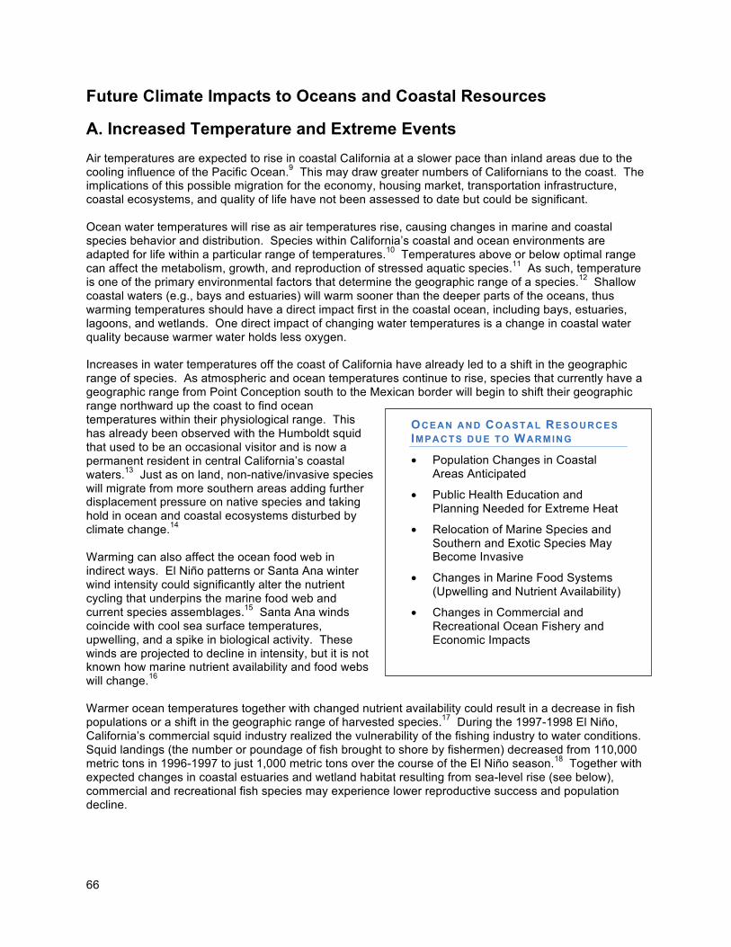
66
Future Climate Impacts to Oceans and Coastal Resources
A. Increased Temperature and Extreme Events
Air temperatures are expected to rise in coastal California at a slower pace than inland areas due to the cooling influence of the Pacific Ocean.9 This may draw greater numbers of Californians to the coast. The implications of this possible migration for the economy, housing market, transportation infrastructure, coastal ecosystems, and quality of life have not been assessed to date but could be significant. Ocean water temperatures will rise as air temperatures rise, causing changes in marine and coastal species behavior and distribution. Species within California’s coastal and ocean environments are adapted for life within a particular range of temperatures.10 Temperatures above or below optimal range can affect the metabolism, growth, and reproduction of stressed aquatic species.11 As such, temperature is one of the primary environmental factors that determine the geographic range of a species.12 Shallow coastal waters (e.g., bays and estuaries) will warm sooner than the deeper parts of the oceans, thus warming temperatures should have a direct impact first in the coastal ocean, including bays, estuaries, lagoons, and wetlands. One direct impact of changing water temperatures is a change in coastal water quality because warmer water holds less oxygen. Increases in water temperatures off the coast of California have already led to a shift in the geographic range of species. As atmospheric and ocean temperatures continue to rise, species that currently have a geographic range from Point Conception south to the Mexican border will begin to shift their geographic range northward up the coast to find ocean temperatures within their physiological range. This has already been observed with the Humboldt squid that used to be an occasional visitor and is now a permanent resident in central California’s coastal waters.13 Just as on land, non-native/invasive species will migrate from more southern areas adding further displacement pressure on native species and taking hold in ocean and coastal ecosystems disturbed by climate change.14 Warming can also affect the ocean food web in indirect ways. El Niño patterns or Santa Ana winter wind intensity could significantly alter the nutrient cycling that underpins the marine food web and current species assemblages.15 Santa Ana winds coincide with cool sea surface temperatures, upwelling, and a spike in biological activity. These winds are projected to decline in intensity, but it is not known how marine nutrient availability and food webs will change.16 Warmer ocean temperatures together with changed nutrient availability could result in a decrease in fish populations or a shift in the geographic range of harvested species.17 During the 1997-1998 El Niño, California’s commercial squid industry realized the vulnerability of the fishing industry to water conditions. Squid landings (the number or poundage of fish brought to shore by fishermen) decreased from 110,000 metric tons in 1996-1997 to just 1,000 metric tons over the course of the El Niño season.18 Together with expected changes in coastal estuaries and wetland habitat resulting from sea-level rise (see below), commercial and recreational fish species may experience lower reproductive success and population decline.
OCEAN AND COASTAL RESOURCES IMPACTS DUE TO WARMING
• Population Changes in Coastal Areas Anticipated
• Public Health Education and Planning Needed for Extreme Heat
• Relocation of Marine Species and Southern and Exotic Species May Become Invasive
• Changes in Marine Food Systems (Upwelling and Nutrient Availability)
• Changes in Commercial and Recreational Ocean Fishery and Economic Impacts
•
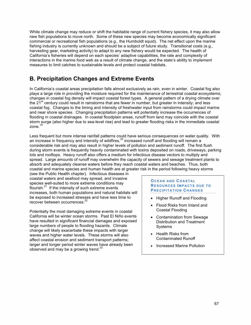
67
While climate change may reduce or shift the habitable range of current fishery species, it may also allow new fish populations to move north. Some of these new species may become economically significant commercial or recreational fish populations (e.g., the Humboldt squid). The net effect upon the marine fishing industry is currently unknown and should be a subject of future study. Transitional costs (e.g., harvesting gear, marketing activity) to adapt to any new fishery would be expected. The health of California’s fisheries will depend on each species’ adaptive capabilities, the rate and complexity of interactions in the marine food web as a result of climate change, and the state’s ability to implement measures to limit catches to sustainable levels and protect coastal habitats.
B. Precipitation Changes and Extreme Events
In California’s coastal areas precipitation falls almost exclusively as rain, even in winter. Coastal fog also plays a large role in providing the moisture required for the maintenance of terrestrial coastal ecosystems; changes in coastal fog density will impact coastal forest types. A general pattern of a drying climate over the 21st century could result in rainstorms that are fewer in number, but greater in intensity; and less coastal fog. Changes to the timing and intensity of freshwater input from rainstorms could impact marine and near shore species. Changing precipitation patterns will potentially increase the occurrences of flooding in coastal drainages. In coastal floodplain areas, runoff from land may coincide with the coastal storm surge (also higher due to sea-level rise) and lead to greater flooding risks in the immediate coastal zone.19 Less frequent but more intense rainfall patterns could have serious consequences on water quality. With an increase in frequency and intensity of wildfires,20 increased runoff and flooding will remain a considerable risk and may also result in higher levels of pollution and sediment runoff. The first flush during storm events is frequently heavily contaminated with toxins deposited on roads, driveways, parking lots and rooftops. Heavy runoff also offers a medium for infectious disease vectors to multiply and spread. Large amounts of runoff may overwhelm the capacity of sewers and sewage treatment plants to absorb and adequately cleanse waters before they reach coastal waters and beaches. Thus, both coastal and marine species and human health are at greater risk in the period following heavy storms (see the Public Health chapter). Infectious diseases in coastal waters and seafood may spread, and invasive species well-suited to more extreme conditions may flourish.21 If the intensity of such extreme events increases, both human populations and natural habitats will be exposed to increased stresses and have less time to recover between occurrences.22 Potentially the most damaging extreme events in coastal California will be winter ocean storms. Past El Niño events have resulted in significant financial damages and exposed large numbers of people to flooding hazards. Climate change will likely exacerbate these impacts with larger waves and higher water levels. These storms will also affect coastal erosion and sediment transport patterns; larger and longer period winter waves have already been observed and may be a growing trend.23
OCEAN AND COASTAL
RESOURCES IMPACTS DUE TO PRECIP ITATION CHANGES
• Higher Runoff and Flooding
• Flood Risks from Inland and Coastal Flooding
• Contamination from Sewage Distribution and Treatment Systems
• Health Risks from Contaminated Runoff
• Increased Marine Pollution
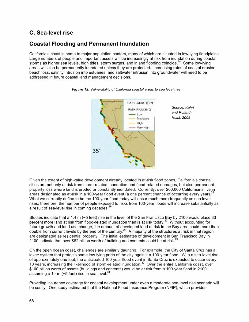
68
C. Sea-level rise
Coastal Flooding and Permanent Inundation
California’s coast is home to major population centers, many of which are situated in low-lying floodplains. Large numbers of people and important assets will be increasingly at risk from inundation during coastal storms as higher sea levels, high tides, storm surges, and inland flooding coincide.24 Some low-lying areas will also be permanently inundated unless they are protected. Increasing rates of coastal erosion, beach loss, salinity intrusion into estuaries, and saltwater intrusion into groundwater will need to be addressed in future coastal land management decisions. Given the extent of high-value development already located in at-risk flood zones, California’s coastal cities are not only at risk from storm-related inundation and flood-related damages, but also permanent property loss where land is eroded or constantly inundated. Currently, over 260,000 Californians live in areas designated as at-risk in a 100-year flood event (a one percent chance of occurring every year).25 What we currently define to be the 100-year flood today will occur much more frequently as sea level rises; therefore, the number of people exposed to risks from 100-year floods will increase substantially as a result of sea-level rise in coming decades.26 Studies indicate that a 1.4 m (~5 feet) rise in the level of the San Francisco Bay by 2100 would place 33 percent more land at risk from flood-related inundation than is at risk today.27 Without accounting for future growth and land use change, the amount of developed land at risk in the Bay area could more than double from current levels by the end of the century.28 A majority of the structures at risk in that region are designated as residential property. The initial estimates of development in San Francisco Bay in 2100 indicate that over $62 billion worth of building and contents could be at risk.29 On the open ocean coast, challenges are similarly daunting. For example, the City of Santa Cruz has a levee system that protects some low-lying parts of the city against a 100-year flood. With a sea-level rise of approximately one foot, the anticipated 100-year flood event in Santa Cruz is expected to occur every 10 years, increasing the likelihood of storm-related inundation.30 Over the entire California coast, over $100 billion worth of assets (buildings and contents) would be at risk from a 100-year flood in 2100 assuming a 1.4m (~5 feet) rise in sea level.31 Providing insurance coverage for coastal development under even a moderate sea-level rise scenario will be costly. One study estimated that the National Flood Insurance Program (NFIP), which provides
Figure 12: Vulnerability of California coastal areas to sea level rise
Source: Kahrl
and Roland-
Holst, 2008
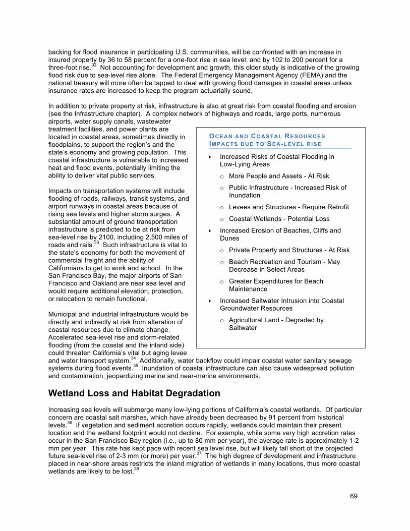
69
backing for flood insurance in participating U.S. communities, will be confronted with an increase in insured property by 36 to 58 percent for a one-foot rise in sea level; and by 102 to 200 percent for a three-foot rise.32 Not accounting for development and growth, this older study is indicative of the growing flood risk due to sea-level rise alone. The Federal Emergency Management Agency (FEMA) and the national treasury will more often be tapped to deal with growing flood damages in coastal areas unless insurance rates are increased to keep the program actuarially sound. In addition to private property at risk, infrastructure is also at great risk from coastal flooding and erosion (see the Infrastructure chapter). A complex network of highways and roads, large ports, numerous airports, water supply canals, wastewater treatment facilities, and power plants are located in coastal areas, sometimes directly in floodplains, to support the region’s and the state’s economy and growing population. This coastal infrastructure is vulnerable to increased heat and flood events, potentially limiting the ability to deliver vital public services. Impacts on transportation systems will include flooding of roads, railways, transit systems, and airport runways in coastal areas because of rising sea levels and higher storm surges. A substantial amount of ground transportation infrastructure is predicted to be at risk from sea-level rise by 2100, including 2,500 miles of roads and rails.33 Such infrastructure is vital to the state’s economy for both the movement of commercial freight and the ability of Californians to get to work and school. In the San Francisco Bay, the major airports of San Francisco and Oakland are near sea level and would require additional elevation, protection, or relocation to remain functional. Municipal and industrial infrastructure would be directly and indirectly at risk from alteration of coastal resources due to climate change. Accelerated sea-level rise and storm-related flooding (from the coastal and the inland side) could threaten California’s vital but aging levee and water transport system.34 Additionally, water backflow could impair coastal water sanitary sewage systems during flood events.35 Inundation of coastal infrastructure can also cause widespread pollution and contamination, jeopardizing marine and near-marine environments.
Wetland Loss and Habitat Degradation
Increasing sea levels will submerge many low-lying portions of California’s coastal wetlands. Of particular concern are coastal salt marshes, which have already been decreased by 91 percent from historical levels.36 If vegetation and sediment accretion occurs rapidly, wetlands could maintain their present location and the wetland footprint would not decline. For example, while some very high accretion rates occur in the San Francisco Bay region (i.e., up to 80 mm per year), the average rate is approximately 1-2 mm per year. This rate has kept pace with recent sea level rise, but will likely fall short of the projected future sea-level rise of 2-3 mm (or more) per year.37 The high degree of development and infrastructure placed in near-shore areas restricts the inland migration of wetlands in many locations, thus more coastal wetlands are likely to be lost.38
OCEAN AND COASTAL RESOURCES IMPACTS DUE TO SEA-LEVEL R ISE
• Increased Risks of Coastal Flooding in Low-Lying Areas
o More People and Assets - At Risk
o Public Infrastructure - Increased Risk of Inundation
o Levees and Structures - Require Retrofit
o Coastal Wetlands - Potential Loss
• Increased Erosion of Beaches, Cliffs and Dunes
o Private Property and Structures - At Risk
o Beach Recreation and Tourism - May Decrease in Select Areas
o Greater Expenditures for Beach Maintenance
• Increased Saltwater Intrusion into Coastal Groundwater Resources
o Agricultural Land - Degraded by Saltwater
70
If wetlands are submerged by rising water levels, one consequence would be that wave energy would be less attenuated and erosional forces against upland levees, such as within San Francisco Bay, would increase.39 Additional potential impacts to wetlands due to sea-level rise include: changes to estuarine mixing, water quality, and carbon cycling; changes to upland habitats and sediment loads into downstream wetlands; and changes to wetland biological habitat, diversity, and changes in biological distribution which will potentially impact foraging opportunities and rearing habitats for key ocean species.40 Furthermore, the degradation of sensitive ecosystems can be brought about not just by higher sea levels but also by other climate changes, including increased water and air temperatures and changes in precipitation patterns, which together can increase the abundance of invasive species. Changes in the abundance and distribution of critical native species can also have cascading, significant effects on sensitive coastal and ocean habitats.
Increased Coastal Erosion
In addition to coastal flooding, the rate of coastal erosion will also increase as a result of sea-level rise. Loss or movement of beach sand and increased cliff and bluff erosion would jeopardize the stability of many coastal developments and recreation areas. The extent of this impact on California’s coastline will vary by the type of coast, the width of the beach, and the presence or absence of protective structures. Damage to coastal infrastructure will be more severe where extreme wave conditions combine with elevated sea levels to impact unprotected and/or erodible coastal areas. The U.S. Geological Survey (USGS) has developed a preliminary map in 2000 classifying areas of the U.S. Pacific coast based on their physical vulnerability to coastal change due to sea-level rise. Areas classified as “very high” risk are those that have already experienced significant erosion problems, and are concentrated mainly around the state’s major bays including the Humboldt, San Francisco, and Monterey Bays as well as Los Angeles and San Diego.41 Increased coastal erosion will impact private property owners and beach-dependent sectors of the state’s economy. Beach recreation and tourism generate the largest economic value of all economic sectors in the California coastal zone.42 The economic value of beach recreation and tourism is of particular importance in southern California, as expenditures in just three counties in southern California accounted for 44 percent of the state’s total tourism-related spending in 2007.43 Many of the state’s intensively used beaches are backed by seawalls, bulkheads, roads, parking lots, or other infrastructure, which prevents landward migration. These beaches will gradually be inundated or will be reduced in width as sea level rises, translating into a reduction on beach area. These physical effects of climate change could significantly decrease the viability and attractiveness of coastal tourism locations, including a shift in tourist attendance patterns among local beaches.44 Such changes would generate either direct or transitional costs for the expanse of tourism-related businesses within the service economy of coastal California. The incidence of beach erosion and accretion at individual California beaches indicates a net negative effect from both gradual sea-level rise and extreme events on the order of an $8.6 million loss in total annual expenditures and a $36.7 million decline in consumer surplus. However, these impacts will vary regionally. In addition to economic impacts associated with the loss of beaches, the ecological impacts will be significant as California beaches support hundreds of organisms, act as buffers to interior habitat during storms, and are essential for the persistence of rare dune habitats. According to one recent study for southern California, erosion rates are expected to accelerate by 20 percent for a sea-level rise of 39.4 inches (100 cm).45 Several alternatives exist to deal with rising sea level and the issues of coastal erosion and inundation: armor, nourishment, and a planned retreat. Each will have tradeoffs in terms of impacts and costs, dictated by the magnitude of sea-level rise that is expected and the amount of property, infrastructure, or public resources threatened. Creating protective structures can limit or alter the functioning of natural habitats, which in turn can decrease the overall adaptive capacity of coastal ecosystems. Ten percent (or 110 miles) of the entire coast of California is now armored, and 33 percent of the shoreline of the four most southerly California counties has been hardened. We can expect more applications and pressure on permitting agencies (local governments as
71
well as the Coastal Commission) to approve additional hardened structures in the future as sea level continues to rise.
Saltwater Intrusion
Sea-level rise and changes in the intensity of storm events could impact low lying coastal areas and result in the loss or inundation of coastal wetlands and dune habitat resulting in salt water intrusion and loss of fresh water resources for fish and wildlife. Sea-level rise will also adversely affect coastal water supplies through saltwater intrusion into coastal aquifers, potentially increasing the need for other water sources (such as desalination) to address coastal water shortages and impact groundwater resources tapped for irrigation.46 Compounding the problem, low-lying farmland such as the Oxnard Plain and the Bay-Delta region may also be inundated with salt water.47
Ocean Acidification
Coastal ecosystems and the industries that depend upon them are being significantly impacted by increased acidification of the ocean due to increases in atmospheric CO2 concentrations. Globally, the ocean absorbs 30-50 percent of the annual emissions of CO2.
48 As CO2 is dissolved into ocean and estuarine waters, carbonic acid is formed lowering the pH of the water. This increased acidity can hamper the ability of a wide variety of marine organisms ranging from coral to abalone to form calcium carbonate shells and skeletal structures. Acidification limits the growth and survival of species such as crabs, sea urchins, abalones, oysters and significant plankton species that have calcium carbonate shells and skeletons. The decreased survival of these calcifying organisms has rippling impacts on species that feed upon them (e.g., the loss of key plankton species will negatively impact the salmonids, seabirds, and other species that feed on them). Commercially important shellfish species are likely to be negatively affected: under a moderate emissions scenario (750 ppm CO2 by 2100), calcification rates of mussel and oyster species are predicted to decline by 25 and 10 percent, respectively, by the end of the century.49 The declining pH levels also impact fertilization, development, and metabolic function of many marine species including kelp, which is an essential component of productive coastal ecosystems on the West Coast, and a commercially harvested species. Acidification also affects the toxicity of a variety of substances and the biological availability of important nutrients and other compounds.
D. Risks for Ocean and Coastal Resources
To summarize the changing risks that California’s ocean and coastal resources may be facing from climate change, the likelihood of occurrence of the projected consequences was qualitatively assessed. The resulting risk profile for California’s oceans and coastal areas can be characterized as follows:
• Sea-level rise will increase the risks of coastal flooding in low-lying areas, inundating private property more frequently and exposing more people and more assets to flooding risks. Infrastructure, public facilities and industrial sites will also experience growing flooding risks. Levees, protective structures, and development may need to be elevated and flood-proofed to maintain protection.
• Threats to coastal wetlands are increasing. If wetlands cannot migrate inland due to man-made or natural barriers, wetland habitat will be lost.
• Sea-level rise will increase erosion of beaches, cliffs, and bluffs, threatening public and private property and structures and causing social, economic, and resource losses to coastal recreation and tourism through reduction in or damage to beaches, access ways, parks, trails, and scenic vistas.
• Loss of wetland, beach, and other coastal habitat will negatively impact many fish, bird, and other species, and diminish biodiversity.
72
• Californians are likely to experience a more moderate increase in average temperatures in coastal areas than in inland areas due to the cooling effect of the ocean, yet may suffer disproportionately from extreme heat waves.
• Warmer water temperatures will cause shifts in the distribution of coastal and marine species; southern species may extend their range northward. Additionally, exotic species may become invasive in new areas and new pathogens may appear. Together with other climate-driven changes in wind patterns, upwelling, nutrient availability, and hard-to-predict changes in the marine food web, warmer water temperatures may cause recreational and commercial fishing species to decline in abundance or shift their range, leading to widespread economic impacts on these fisheries.
• Fewer, but possibly more intense, rainstorm events will produce high runoff and flooding. In the immediate coastal areas, such inland flooding may coincide with coastal flooding, posing particularly high risks to communities and structures in coastal floodplains.
• High runoff may overwhelm storm drains and sewage treatment plants, potentially contaminating coastal ecosystems and beaches.
• Sea-level rise will increase saltwater intrusion into coastal aquifers (groundwater resources), degrading agricultural land and coastal groundwater resources.
• Rising temperatures and ocean acidification have the potential to negatively impact ecosystems and fisheries.
Ocean and Coastal Resources Adaptation Strategies
Introduction
The state agencies in the Coastal and Ocean Working Group (Ocean Protection Council, California Coastal Conservancy, California Coastal Commission, State Lands Commission, Department of Fish and Game, State Parks, and the Bay Conservation and Development Commission) contributed to the development of the following strategies and each organization will be essential to the successful implementation of the strategies. Given the extent of the threats predicted by current climate models, sea level projections, and the considerable value of California’s coastal lands, resources, and development, coastal planning must adapt to prepare California for a variety of potentially significant outcomes of climate change. Preparing California’s coastal infrastructure, industries, and ecosystems for the impacts of climate changes will be an expensive endeavor. Decision-makers will need to make short- and long-term risk-management decisions to address future impacts that will include deciding which human developments should be maintained, retrofitted, and protected; where hazard avoidance is not possible; where planned retreat is appropriate; and where natural systems should be protected, rehabilitated, or enhanced. These decisions should be made using the following principles for guidance: • California must protect public health and safety and critical infrastructure. • California must protect, restore, and enhance ocean and coastal ecosystems, on which our economy
and well being depend. • California must ensure public access to coastal areas and protect beaches, natural shoreline, and
park and recreational resources. • New development and communities must be planned and designed for long-term sustainability in the
face of climate change. • California must look for ways to facilitate adaptation of existing development and communities to
reduce their vulnerability to climate change impacts over time. • California must begin now to adapt to the impacts of climate change. We can no longer act as if
nothing is changing.
Adaptation to sea-level rise drives most of the Ocean and Coastal Resources adaptation strategies presented in this report. The priority strategy is for state agencies to avoid establishing or permitting new
73
development inside future hazard zones in most cases if new protective structures would be necessary (strategy 1a). Additional strategies include (1) directives to promote innovative approaches to redesigning coastal structures, where feasible, that are resilient to the impacts of climate change and can serve to protect existing development in low-lying areas (strategy 1b), and (2) creation of statewide guidance and regional planning forums to help local governments update local plans and make planning decisions in light of sea-level rise (strategies 2a and 4c). All levels of government are encouraged to consider: • Incentive programs to encourage property owners in high-risk areas to relocate or limit future
development. • Clustering new development in areas considered to have a low vulnerability to sea-level rise. • Creating additional buffers and setbacks for new construction to minimize risks to people and
property and to protect coastal resources such as natural habitat and recreational areas (see strategy 4c).
Critical coastal and ocean habitats and recreational areas should be protected and maintained to the extent feasible. The state should identify priority conservation areas and recommend lands that should be considered for acquisition and preservation, especially vulnerable shoreline areas containing critical habitat or opportunities for habitat creation (strategy 1c). Future sea-level rise estimates should be considered during restoration efforts (i.e., grading levels for wetland restorations), and natural shoreline enhancements (e.g., species such as native oysters, eelgrass) should be designed to promote sedimentation and protect against shoreline erosion.
Adaptation Strategies and Actions
The Coastal Adaptation Working Group has identified the following priorities in addressing climate adaptation for California state agencies. The near-term actions referenced below are those actions that have been identified and which can be initiated or completed by 2010, if, in some cases, related statutory or regulatory changes are made. The long-term actions include those that will require support from that state and collaboration with multiple state agencies or that require significant legal or regulatory changes. Strategy 1: Establish State Policy to Avoid Future Hazards and Protect Critical Habitat.
Near -Term Actions:
a. Hazard Avoidance Policy – State agencies should consider project alternatives that avoid significant new development in areas that cannot be adequately protected (planning, permitting, development, and building) from flooding or erosion due to climate change. The most risk-averse approach for minimizing the adverse effects of sea level rise and storm activities is to carefully consider new development within areas vulnerable to inundation and erosion, and to consider prohibiting development of undeveloped, vulnerable shoreline areas containing critical habitat or opportunities for habitat creation. State agencies should generally not plan, develop, or build any new significant structure in a place where that structure will require significant protection from sea-level rise, storm surges, or coastal erosion during the expected life of the structure. However, vulnerable shoreline areas containing existing development or proposed for new development that has or will have regionally significant economic, cultural, or social value may have to be protected, and in-fill development in these areas should be closely scrutinized. State agencies should incorporate this policy into their decisions, and other levels of government are also encouraged to do so. Some state agencies already base decisions on hazard avoidance, for example Coastal Act provisions require that new development in the coastal zone be designed to minimize risks from current and future hazards, which would include
74
risks from expected sea-level rise, the Act restricts new development in hazardous areas, especially if it would require the construction of a protective device.
b. Innovative Designs – If agencies do plan, permit, develop or build any new structures in hazard zones, agencies should employ or encourage innovative engineering and design solutions so that the structures are resilient to potential flood or erosion events or can be easily relocated or removed to allow for progressive adaptation to sea level rise, flooding, and erosion.
c. Habitat Protection – The state should identify priority conservation areas and recommend lands that should be considered for acquisition and preservation. The state should consider prohibiting projects that would place development in undeveloped areas already containing critical habitat, and those containing opportunities for tidal wetland restoration, habitat migration, or buffer zones. The strategy should likewise encourage projects that protect critical habitats, fish, wildlife and other aquatic organisms and connections between coastal habitats. The state should pursue activities that can increase natural resiliency, such as restoring tidal wetlands, living shoreline, and related habitats; managing sediment for marsh accretion and natural flood protection; and maintaining upland buffer areas around tidal wetlands. For these priory conservation areas, impacts from nearby development should be minimized, such as secondary impacts from impaired water quality or hard protection devices.
Long -Term Actions:
d. Coordinate Policy Implementation – State agencies should use outreach and incentive
programs to promote hazard avoidance policies and sound management decisions for coastal habitat protection and development to all levels of government.
Strategy 2: Provide Statewide Guidance for Protecting Existing Critical Ecosystems, Existing Coastal Development, and Future Investments Significant and valuable development has been built along the California coast for over a century. Some of that development is currently threatened by sea-level rise or will be threatened in the near future. Similarly, the coastal zone is home to many threatened or endangered species and sensitive habitats. We must acknowledge that the high financial, ecological, social and cultural costs of protecting everything may prove to be impossible; in the long run, protection of everything may be both futile and environmentally destructive. Decision guidance strategies should frame cost-benefit analyses so that all public and private costs and benefits are appropriately considered.
Near -Term Actions:
a. Establish Decision Guidance – The OPC in close coordination with other state resource agencies should develop a statewide framework that can be used by state and local agencies as guidance in preparation of adaptation plans. This guidance should discuss current regulatory and legal frameworks and whether changes are necessary to pursue this approach to adaptation. In addition the OPC should incorporate this new guidance within existing decision-making processes as much as possible and tailor it, when necessary, to specific regional approaches (see strategy 4c)..
It should consider three key questions for helping to design and locate proposed or existing structures that may be threatened by sea-level rise:
1. Is the existing or proposed structure either necessary for the health, safety, or welfare of
an entire region, or is it located within a hazard area for which protection will be provided because of surrounding high-value development?
2. Is it infeasible to relocate an existing structure or site a new structure outside the hazard area and still provide this health, safety, or welfare function?
75
3. Will relocating an existing or proposed structure provide habitat protection or recreational opportunities that may be otherwise lost if that structure is built or is protected along the coast?
Additional questions that should be considered in the preparation of the framework include:
• Is there a feasible "soft" protection solution (i.e., can a barrier beach or wetland be used instead of a seawall)?
• Will the protection approach, retrofit, or new design:
i. Be necessary to protect an existing structure threatened by erosion? ii. Allow continuation of important natural processes, such as littoral drift, and avoid any
impacts to neighboring habitats or structures? iii. Result in the loss of state tidelands or beaches? iv. Provide a long-term solution to the threats caused by sea-level rise? v. Be resilient over a range of sea-level rise possibilities? vi. Provide broad protection to existing developed areas? vii. Protect structures of high cultural or social value? viii. Provide for a natural shoreline (i.e., can seawalls be designed to include habitat)? ix. Be coordinated with proposed actions for other infrastructure in the same flood
hazard area? x. Cost less than the value of the structure to be protected? xi. Provide mitigation for adverse impacts that cannot be avoided?
Long -Term Actions:
b. Pilot Studies – Develop pilot studies in cooperation with specific cities/state agencies that will
examine the efficacy and utility of the framework highlighted above.
Strategy 3: State Agencies Should Prepare Sea-Level Rise and Climate Adaptation Plans
Near -Term Actions:
a. Adaptation Planning – By September 2010 state agencies responsible for the management and
regulation of resources and infrastructure subject to potential sea-level rise should prepare agency-specific adaptation plans, guidance, and criteria, as appropriate. Agencies with overlapping jurisdictions in the coastal zone will coordinate when drafting these plans to reduce or eliminate conflicting approaches.
i. The Coastal Commission, the San Francisco Bay Conservation and Development Commission, the state and Regional Water Quality Control Boards, California State Parks, and the State Lands Commission should continue to develop adaptation strategies that can be implemented through their existing planning and regulatory programs.
ii. The Coastal Conservancy, the Ocean Protection Council, and the Wildlife Conservation Board should continue to develop criteria to guide their financial decisions and ensure that projects are designed to consider a range of climate change scenarios.
iii. The California Department of Transportation, State Parks, the Department of Water Resources, the Department of Fish and Game, the State Lands Commission, and other state agencies that own land and facilities along the coast should develop policies to guide them in land-use projects and the development of infrastructure in vulnerable areas in the future.
iv. The aforementioned agencies should: a. Consider requiring applicants to address how sea-level rise will affect their project,
include design features that will ensure that the project objectives are feasible and that the project will not be rendered unusable or inoperable over its lifespan, that critical habitat is protected, and that public access is provided, where appropriate.
76
b. Prepare climate strategies, indicators, and thresholds that respond to changing ocean temperatures, air temperatures, predator-prey interactions, and ocean acidification. These strategies should include alternative management strategies that could be employed, such as alternative fisheries management approaches dependent upon temperature regimes, alternative marine protected areas for stressed species, or changes to aquaculture and fishing practices under lower pH conditions.
c. Identify areas where their jurisdiction and authority should be clarified or extended to ensure effective management and regulation of resources and infrastructure subject to potential sea-level rise.
v. The Department of Insurance should develop regulatory policies to guide private insurers in dealing with properties in vulnerable areas.
Long -Term Actions: b. Adaptation Plan Updates – State agencies should regularly update, modify, and refine these
adaptation guidance documents and plans based on new information and lessons learned from previous implementation actions.
Strategy 4: Support Regional and Local Planning for Addressing Sea-Level Rise Impacts
Near -Term Actions:
a. Public Outreach – The Ocean Protection Council (OPC) in close coordination with other state ocean resource agencies should (beginning in 2010) conduct public meetings within coastal communities to examine adaptive strategies available to state and local agencies to prepare for potential sea-level rise impacts. Strategies, tools, and information will be compiled and made publically available for use by local governments when updating their local and general plans.
b. Funding Mechanisms – The OPC should collaborate with state agencies to identify potential
funding sources (i.e., AB32 or an amendment to Prop 218) for state agencies and local governments to undertake revisions to local plans.
c. Regional Coordination – The state should work with local governments and existing regional
organizations, such as the Los Angeles Regional Collaborative for Climate Action and Sustainability, associations of local governments, or SB 375 regional planning teams, to provide for regional adaptation planning. The state should continue to conduct, synthesize, and disseminate regionally relevant research and information with this purpose in mind.
Shoreline and land use planning should be informed by regional and sub-regional level considerations. Shoreline dynamics must be understood within the context of discrete littoral cells and other natural systems. In addition, geography, development patterns, and tectonic forces differ a great deal regionally; and the success of alternatives to respond to the challenges of sea level rise and coastal hazards will depend, in large part, on these regional differences. In addition, numerous strategies when implemented may have consequences for neighboring habitats or communities, and coastal communities should have the ability to jointly plan for impacts to the full region to reduce mutually unbeneficial approaches. Developing regional information and understanding regional consequences of various adaptation options will be useful to location governments as they update individual local coastal plans or general plans within a region.
77
d. Local Government Guidance – All relevant state agencies should collaborate with local jurisdictions to encourage them to consider the following strategies when updating plans:
i. Setbacks – Mandatory construction setbacks can be imposed to prohibit construction and significant redevelopment in areas that will likely be impacted by sea-level rise within the life of the structure.
ii. Additional Buffer Areas – Additional buffer areas can be established in some places to protect important cultural and natural resource assets.
iii. Clustered Coastal Development – Coastal development can be concentrated in areas of low vulnerability and may reduce carbon emissions from transportation.
iv. Rebuilding Restrictions – Rebuilding can be restricted when structures are damaged by sea-level rise and coastal storms.
v. New Development Techniques – Building codes can be amended to require that coastal development incorporate features that are resilient to sea-level rise (e.g., require that development begin on the second floor).
vi. Relocation Incentives – Federal, state and local funding or tax incentives to relocate out of hazard areas.
vii. Rolling Easements – Policies and funding to facilitate easements to a) relocate developments further inland, b) remove development as hazards encroach into developed areas, or c) facilitate landward movement of coastal ecosystems subject to dislocation by sea-level rise and other climate change impacts.
viii. Engineering Solutions – New engineering approaches will need to be applied to ports, marinas and other infrastructure that must be located on the shoreline to maintain their function as the sea level rises.
The Governor’s Office of Planning and Research will provide a guidance document in 2009 to address state land use planning.
e. Amend Local Coastal Plans and General Plans to Address Climate Change Adaptation: By
2011, or within one year after development of the tools or guidance necessary to support such amendments and if funding is secured, all coastal jurisdictions, in coordination with the Coastal Commission, should begin to develop amended LCPs that include climate change impacts; and local jurisdictions around San Francisco Bay should begin to update their general plans, in coordination with BCDC.
Strategy 5: Complete a Statewide Sea-Level Rise Vulnerability Assessment Every Five Years
Long -Term Actions:
a. Vulnerability Assessment – In coordination with all relevant state agencies, OPC should produce a coastal and ocean vulnerability assessment every five years that consolidates and builds upon existing efforts by the California Energy Commission and other agencies. Each new assessment will discuss the most recent knowledge about climate impacts to ocean and coastal resources, inventory coastal natural and man-made assets, and assess what is at risk (including an economic valuation). The data from these assessments should be periodically incorporated into state agency adaptation plan updates (discussed above, 3b).
78
Strategy 6: Support Essential Data Collection and Information Sharing Research and data are needed to perform and update vulnerability assessments. Agencies should work in cooperation with federal partners to seek funding for the collection of essential data. The state should continue to establish baseline climate change data and common modeling assumptions so that planning actions in the different agencies are based on common information to the greatest extent possible.
Near -Term Actions:
a. High-Resolution Mapping – The state, in cooperation with federal partners, should immediately fund the collection of high-resolution topography and bathymetry mapping (i.e., LiDAR) to provide elevation information needed as a baseline for monitoring change, for the modeling of flood hazards, and to help identify and document habitats and ecosystems.
b. Tidal Datum – Monitoring on tidal datums should be maintained and expanded, including
establishing additional tide gage stations. Tidal datums are used to measure local water levels and can project how global sea-level rise will be experienced at the local scale. These data are needed to determine the mean high tide and other reference points used in regulatory and legal settings.
c. Ecosystem Research – Research should be conducted on potential changes to ocean and
coastal ecosystems, and species ranges, which are already changing - resulting in divergence in breeding and feeding behavior. Understanding ecosystem changes will be essential to future management decisions related to fisheries, species protection, and restoration projects.
d. Coastal and Wetland Process Studies – Research should be conducted to understand and
model coastal, estuarine, and wetland circulation and sediment distribution and transport. This information is essential to successful wetland and beach maintenance, restoration, and nourishment projects.
Long -Term Actions:
e. Decision Support – The OPC should work with state ocean resource agencies and other
appropriate partners (such as academia and nongovernmental organizations) to help provide the necessary data and tools to state and local agencies for decision support to protect development and habitat from sea-level rise.
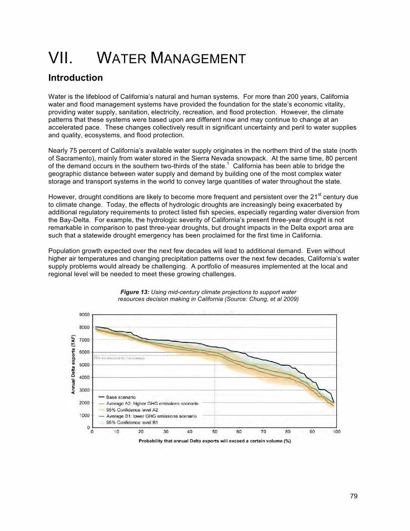
79
VII. WATER MANAGEMENT Introduction Water is the lifeblood of California’s natural and human systems. For more than 200 years, California water and flood management systems have provided the foundation for the state’s economic vitality, providing water supply, sanitation, electricity, recreation, and flood protection. However, the climate patterns that these systems were based upon are different now and may continue to change at an accelerated pace. These changes collectively result in significant uncertainty and peril to water supplies and quality, ecosystems, and flood protection. Nearly 75 percent of California’s available water supply originates in the northern third of the state (north of Sacramento), mainly from water stored in the Sierra Nevada snowpack. At the same time, 80 percent of the demand occurs in the southern two-thirds of the state.1 California has been able to bridge the geographic distance between water supply and demand by building one of the most complex water storage and transport systems in the world to convey large quantities of water throughout the state. However, drought conditions are likely to become more frequent and persistent over the 21st century due to climate change. Today, the effects of hydrologic droughts are increasingly being exacerbated by additional regulatory requirements to protect listed fish species, especially regarding water diversion from the Bay-Delta. For example, the hydrologic severity of California’s present three-year drought is not remarkable in comparison to past three-year droughts, but drought impacts in the Delta export area are such that a statewide drought emergency has been proclaimed for the first time in California. Population growth expected over the next few decades will lead to additional demand. Even without higher air temperatures and changing precipitation patterns over the next few decades, California’s water supply problems would already be challenging. A portfolio of measures implemented at the local and regional level will be needed to meet these growing challenges.
Figure 13: Using mid-century climate projections to support water resources decision making in California (Source: Chung, et al 2009)
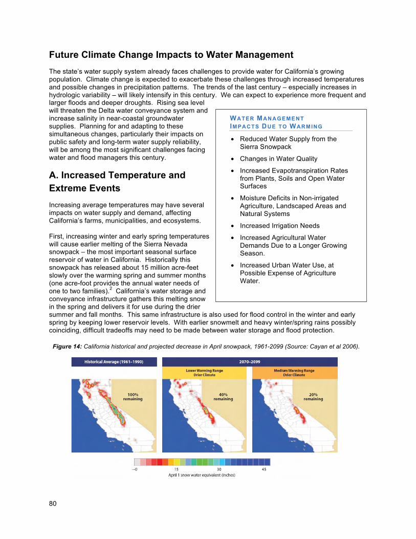
80
Future Climate Change Impacts to Water Management
The state’s water supply system already faces challenges to provide water for California’s growing population. Climate change is expected to exacerbate these challenges through increased temperatures and possible changes in precipitation patterns. The trends of the last century – especially increases in hydrologic variability – will likely intensify in this century. We can expect to experience more frequent and larger floods and deeper droughts. Rising sea level will threaten the Delta water conveyance system and increase salinity in near-coastal groundwater supplies. Planning for and adapting to these simultaneous changes, particularly their impacts on public safety and long-term water supply reliability, will be among the most significant challenges facing water and flood managers this century.
A. Increased Temperature and Extreme Events
Increasing average temperatures may have several impacts on water supply and demand, affecting California’s farms, municipalities, and ecosystems. First, increasing winter and early spring temperatures will cause earlier melting of the Sierra Nevada snowpack – the most important seasonal surface reservoir of water in California. Historically this snowpack has released about 15 million acre-feet slowly over the warming spring and summer months (one acre-foot provides the annual water needs of one to two families).2 California’s water storage and conveyance infrastructure gathers this melting snow in the spring and delivers it for use during the drier summer and fall months. This same infrastructure is also used for flood control in the winter and early spring by keeping lower reservoir levels. With earlier snowmelt and heavy winter/spring rains possibly coinciding, difficult tradeoffs may need to be made between water storage and flood protection.
WATER MANAGEMENT IMPACTS DUE TO WARMING
• Reduced Water Supply from the Sierra Snowpack
• Changes in Water Quality
• Increased Evapotranspiration Rates from Plants, Soils and Open Water Surfaces
• Moisture Deficits in Non-irrigated Agriculture, Landscaped Areas and Natural Systems
• Increased Irrigation Needs
• Increased Agricultural Water Demands Due to a Longer Growing Season.
• Increased Urban Water Use, at Possible Expense of Agriculture Water.
Figure 14: California historical and projected decrease in April snowpack, 1961-2099 (Source: Cayan et al 2006).
81
Increased underground storage of surface waters and increased groundwater withdrawal may potentially be used to ensure that future water supplies meet growing demands. However, groundwater balances in California are generally not well documented, with many aquifers contaminated, necessitating further study to assess the more widespread feasibility of groundwater storage. In addition, climate change may make preservation and restoration of habitat more difficult. The ecological requirements of cold-water fishes provide an example. Climate change may warm rivers and streams, with less water available for ecosystem flow and temperature needs in spring and summer. In many low- and middle-elevation streams today, summer temperatures often approach the upper tolerance limits for salmon and trout; higher air and water temperatures will exacerbate this problem. Thus, climate change might require dedication of more water, especially cold water stored behind reservoirs, to simply maintain existing fish habitat. Climate change is also expected to raise sea level. As this happens, the brackish and fresh aquatic habitats of the Sacramento-San Joaquin estuary that are critical to many at-risk species will shift upstream and inland. Growing urbanization on the eastern edge of the Delta will limit opportunities to acquire or restore lands that would provide suitable habitat. Threatened and endangered species could be increasingly squeezed between the inland sea and the encroaching cities. Higher water temperatures also can accelerate biological and chemical processes that increase growth of algae and microorganisms, thereby creating an additional demand for oxygen in the water.3 Higher temperatures – especially in the summer growing season – increase evapotranspiration rates from plants, soils and open water surfaces. In a study conducted for the 2008 California climate impacts assessment, net evaporation from reservoirs was projected to increase by 37 percent in a warmer-drier climate, but only by 15 percent in a warmer-only scenario, reducing available supplies accordingly.4 While higher temperatures increase the water demand and use by plants, soil moisture decreases and reservoirs and/or groundwater reserves are reduced. Non-irrigated agriculture and landscaped areas, as well as natural systems, will suffer moisture deficits if natural water supplies are limited, and the risk of wildfires will increase. Elsewhere, irrigation will need to be increased if crop losses are to be avoided.5 During extreme heat events livestock will require more water for drinking and cooling. Finally, higher average temperatures extending over longer periods of the year will lengthen the growing season, thereby increasing the amount of water needed for non-irrigated plant growth, environmental water needs, and for the irrigation of crops and landscaped areas.6 A recent study on water demand in California estimated agricultural and urban water demands under both a warmer-only and a warmer-drier climate change scenario using the CALVIN (California Value Integrated Network) model – a statewide model of the economic and engineering aspects of California’s interconnected water supply system. Using these scenarios, the study found that agricultural water use would decrease by nearly 15 percent (4,070 thousand acre feet [TAF]/year) between 2020 and 2050 as urban demand increases and overall supply decreases by 7 percent.7 Even assuming the implementation of water conservation and water efficiency measures to partially compensate for the expected reduction in supply, urban water demand is expected to increase by more than 10 percent (1,606 TAF/year) between 2020 and 2050.8 The study also concluded that the agricultural sector is more vulnerable to water shortages than the urban sector; thus, water supplies to agriculture may be 20 percent below demand targets under the warmer-only climate scenario and 23 percent below demand under the warmer-drier scenario.9
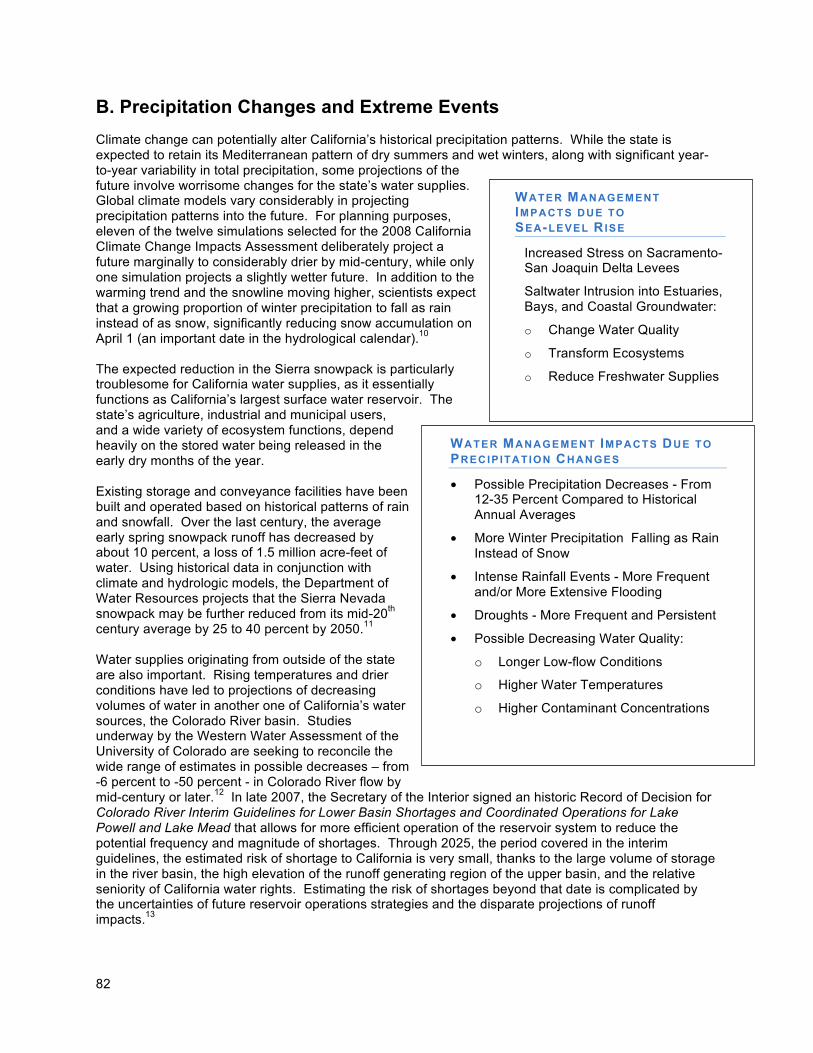
82
B. Precipitation Changes and Extreme Events
Climate change can potentially alter California’s historical precipitation patterns. While the state is expected to retain its Mediterranean pattern of dry summers and wet winters, along with significant year-to-year variability in total precipitation, some projections of the future involve worrisome changes for the state’s water supplies. Global climate models vary considerably in projecting precipitation patterns into the future. For planning purposes, eleven of the twelve simulations selected for the 2008 California Climate Change Impacts Assessment deliberately project a future marginally to considerably drier by mid-century, while only one simulation projects a slightly wetter future. In addition to the warming trend and the snowline moving higher, scientists expect that a growing proportion of winter precipitation to fall as rain instead of as snow, significantly reducing snow accumulation on April 1 (an important date in the hydrological calendar).10 The expected reduction in the Sierra snowpack is particularly troublesome for California water supplies, as it essentially functions as California’s largest surface water reservoir. The state’s agriculture, industrial and municipal users, and a wide variety of ecosystem functions, depend heavily on the stored water being released in the early dry months of the year. Existing storage and conveyance facilities have been built and operated based on historical patterns of rain and snowfall. Over the last century, the average early spring snowpack runoff has decreased by about 10 percent, a loss of 1.5 million acre-feet of water. Using historical data in conjunction with climate and hydrologic models, the Department of Water Resources projects that the Sierra Nevada snowpack may be further reduced from its mid-20th century average by 25 to 40 percent by 2050.11 Water supplies originating from outside of the state are also important. Rising temperatures and drier conditions have led to projections of decreasing volumes of water in another one of California’s water sources, the Colorado River basin. Studies underway by the Western Water Assessment of the University of Colorado are seeking to reconcile the wide range of estimates in possible decreases – from -6 percent to -50 percent - in Colorado River flow by mid-century or later.12 In late 2007, the Secretary of the Interior signed an historic Record of Decision for Colorado River Interim Guidelines for Lower Basin Shortages and Coordinated Operations for Lake Powell and Lake Mead that allows for more efficient operation of the reservoir system to reduce the potential frequency and magnitude of shortages. Through 2025, the period covered in the interim guidelines, the estimated risk of shortage to California is very small, thanks to the large volume of storage in the river basin, the high elevation of the runoff generating region of the upper basin, and the relative seniority of California water rights. Estimating the risk of shortages beyond that date is complicated by the uncertainties of future reservoir operations strategies and the disparate projections of runoff impacts.13
WATER MANAGEMENT IMPACTS DUE TO
PRECIP ITATION CHANGES
• Possible Precipitation Decreases - From 12-35 Percent Compared to Historical Annual Averages
• More Winter Precipitation Falling as Rain Instead of Snow
• Intense Rainfall Events - More Frequent and/or More Extensive Flooding
• Droughts - More Frequent and Persistent
• Possible Decreasing Water Quality:
o Longer Low-flow Conditions
o Higher Water Temperatures
o Higher Contaminant Concentrations
WATER MANAGEMENT IMPACTS DUE TO SEA-LEVEL RISE
• Increased Stress on Sacramento-San Joaquin Delta Levees
• Saltwater Intrusion into Estuaries, Bays, and Coastal Groundwater:
o Change Water Quality
o Transform Ecosystems
o Reduce Freshwater Supplies
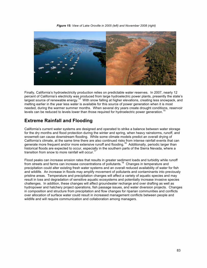
83
Finally, California’s hydroelectricity production relies on predictable water reserves. In 2007, nearly 12 percent of California’s electricity was produced from large hydroelectric power plants, presently the state’s largest source of renewable energy.14 With snow falling at higher elevations, creating less snowpack, and melting earlier in the year less water is available for this source of power generation when it is most needed, during the warmer summer months. When several dry years create drought conditions, reservoir levels can be reduced to levels lower than those required for hydroelectric power generation.15
Extreme Rainfall and Flooding
California’s current water systems are designed and operated to strike a balance between water storage for the dry months and flood protection during the winter and spring, when heavy rainstorms, runoff, and snowmelt can cause downstream flooding. While some climate models predict an overall drying of California’s climate, at the same time there are also continued risks from intense rainfall events that can generate more frequent and/or more extensive runoff and flooding.16 Additionally, periodic larger than historical floods are expected to occur, especially in the southern parts of the Sierra Nevada, where a transition from snow to more rainfall will occur.17 Flood peaks can increase erosion rates that results in greater sediment loads and turbidity while runoff from streets and farms can increase concentrations of pollutants.18 Changes in temperature and precipitation could alter existing fresh water systems and an overall reduced availability of water for fish and wildlife. An increase in floods may amplify movement of pollutants and contaminants into previously pristine areas. Temperature and precipitation changes will affect a variety of aquatic species and may result in loss and degradation of sensitive aquatic ecosystems and potentially increase invasive species challenges. In addition, these changes will affect groundwater recharge and over drafting as well as hydropower and hatchery project operations, fish passage issues, and water diversion projects. Changes in composition and structure from precipitation and flow changes for riparian communities and conflicts over allocation of surface water could result in increased management conflicts between people and wildlife and will require communication and collaboration among managers.
Figure 15: View of Lake Oroville in 2005 (left) and November 2008 (right)
84
C. Sea-Level Rise
The higher mean water levels from sea-level rise can exacerbate existing factors that threaten critical portions of the Sacramento and San Joaquin Delta levee system. This system extends over more than 700,000 acres and consists of a myriad of small natural and man-made channels bounded by levees to protect land and key infrastructure from floods.19 If levees fail, water from San Francisco Bay would inundate agricultural land and some communities, damage infrastructure, affect ecosystems, enter California’s freshwater supply, and change water quality. Warmer storms and snowmelt may coincide and produce higher winter runoff from the watersheds, while accelerating sea-level rise will produce higher storm surges during coastal storms. Together, they increase the probability of Delta levee failures, breaking a critical link between water supply in the north and water users in the southern portions of the state. Additionally, a drop in summer stream flows could affect the Sacramento-San Joaquin Delta water supply and ecosystems, both directly through low-flow conditions and higher stream water temperatures, and indirectly as saltwater intrudes further upstream from the Pacific Ocean. An increase in the penetration of seawater into the Delta will thus further degrade drinking and agricultural water quality and alter ecosystem conditions.20 Holding back this salinity intrusion will require more freshwater releases from upstream reservoirs to maintain fresh water levels for municipal, industrial and agricultural uses, which in turn will further increase pressure on already scarce water resources.
D. Risks for Water Management
Higher temperatures, changes in precipitation patterns and sea-level rise all combine to exacerbate California’s existing water supply challenges. Expected population growth alone would make it more difficult to meet growing water demands. With climate change the state’s water crisis will worsen, overall increasing the risk of water shortages and flooding. To summarize the changing risks that California’s water supply will face from climate change, the likelihood of occurrence of the projected consequences was qualitatively assessed. The resulting risk profile for California’s water supply can be characterized as follows:
• Higher temperatures will melt the Sierra snowpack earlier and drive the snowline higher, resulting in less snowpack to supply water to California users. In addition, a growing proportion of winter precipitation will fall as rain instead of as snow. Snow accumulation on April 1 will be significantly reduced, and snowmelt will run off earlier, leaving less water stored for the dry months.
• By mid-century, most climate simulations used by the 2009 CAT report project marginally to considerably drier conditions in California. Water supplies originating from outside of the state (e.g., the Colorado River Basin and the Klamath River Basin) are also decreasing.
• Intense rainfall events, periodically ones with larger than historical runoff, will continue to affect California with more frequent and/or more extensive flooding.
• Droughts are likely to become more frequent and persistent in the 21st century.
• Streams may experience longer low-flow conditions with higher temperatures and higher concentrations of contaminants.
• Higher temperatures – especially in the summer and over a longer growing season – increase evapotranspiration rates from plants, soils and open water surfaces, including water reservoirs.
• Non-irrigated agriculture and landscaped areas, as well as natural systems will suffer moisture deficits if natural water supplies are limited, and irrigation will need to be increased if crop losses are to be avoided. Even with conservation and efficiency measures, urban water use is expected to increase.
85
• Storms and snowmelt may coincide and produce higher winter runoff from the landward side, while accelerating sea-level rise will produce higher storm surges during coastal storms. Together, they increase the probability of levee failures in the Sacramento-San Joaquin Delta.
• Saltwater intrusion into estuaries, bays, and coastal groundwater resources will diminish water quality, transform ecosystems and reduce freshwater supplies.
Water Management Adaptation Strategies
Introduction
Concerns over the availability, quality, and distribution of water are not new to California, but these concerns are growing and solutions are becoming more complex as water managers navigate competing interests and regulations to reliably provide quality water to farms, businesses, and homes, while also protecting the environment and complying with legal and regulatory requirements. Water adaptation strategies are primarily driven by the possibility of reduced future water supplies and increased flood threat brought about by climate change. While we are unlikely to know the full scope of climate change for many decades, we do know enough now to begin taking action strategically to adapt California’s water management systems. The Department of Water Resources (DWR), in collaboration with the State Water Resources Control Board, other state agencies, and numerous stakeholders, has initiated a number of projects to begin climate change adaptation planning for the water sector. For instance, the recent incorporation of climate change impacts into the California Water Plan Update is an essential step in ensuring that all future decisions regarding water resources management address climate change. As part of the Update, in October 2009 DWR released the U.S.’s first state-level climate change adaptation strategy for water resources, and the first adaptation strategy for any sector in California. Entitled Managing an Uncertain Future: Climate Change Adaptation Strategies for California’s Water, the report details how climate change is already affecting the state’s water supplies and sets forth ten adaptation strategies to help avoid or reduce climate change impacts to water resources. Because of the large role of local and regional water management, central to these adaptation efforts will be the full implementation of Integrated Regional Water Management (IRWM) plans, which address regionally appropriate management practices that incorporate climate change adaptation. These plans will evaluate and provide a comprehensive, economical and sustainable water use strategy at the watershed level for California. Another key adaptation approach is to aggressively increase water use efficiency. Implementing this approach will require the adoption of urban best management practices and other measures. Agricultural entities will be encouraged to apply Efficient Water Management Practices (EWMPs) to reduce water demand and improve the quality of drainage and return flows. In regions where recycled water may represent a relatively energy efficient and drought-proof water management strategy, local water agencies will be encouraged to adopt policies that promote the use of recycled water for appropriate, cost-effective uses while still protecting public health. However, not all water use efficiency activities are
North Coast Integrated Regional
Water Management Plan (NCIRWMP):
Stakeholders on the North Coast are incorporating climate change into the NCIRWMP in many ways, including evaluating options for carbon sequestration, GHG emission reduction via large scale alternative energy generation and by reducing the risk of catastrophic wildfire, incorporating adaptation into local planning, water infrastructure and watershed restoration activities, and educating the public regarding the need for climate adaptation. In particular, there are substantial opportunities to incorporate climate adaptation into the NCIRWMP framework, many of which address multiple objectives of the IRWM program such as flood and stormwater management, water conservation, local planning, floodplain and habitat enhancement, and water supply reliability.
86
equally effective responses to climate change. For example, efficiencies that reduce evaporative (e.g., landscape and crop evapotranspiration), other consumptive uses, and flows to saline sinks (e.g., the ocean) are the most effective. Statewide, adaptation strategies aim to fundamentally improve water and flood management systems and enhance and sustain ecosystems. Reliable water supplies and resilient flood protection depend upon ecosystem sustainability. Building adaptive capacity for both public safety and ecosystems requires that water and flood management projects maintain and enhance biological diversity and natural ecosystem processes. Water supply and flood management systems are significantly more sustainable and economical over time when they preserve, enhance and restore ecosystem functions, thereby creating integrated systems that suffer less damage from, and recover more quickly after, severe natural disruptions. By reducing existing, non-climate stressors on the environment, ecosystems will have more capacity to adapt to new stressors and uncertainties brought by climate change. Flood management will be improved by increased coordination among existing water and flood management systems. Ecosystem enhancement will include actions to restore previous connections between rivers and their historical floodplains, creating seasonal aquatic habitats and facilitating the growth of native riparian forests. A strategy for improving management and decision-making capacity focuses on planning for and adapting to sea-level rise. This will require the establishment of an interim range of sea-level rise projections for short-term planning purposes for local, regional, and statewide projects and activities. A scientific panel of the National Research Council (NRC) will provide expert guidance regarding official long-range sea-level rise estimates and their application to specific California planning issues. The DWR, in collaboration with other state agencies and under guidance from the NRC, will develop long-range sea-level rise scenarios and response strategies for the California Water Plan Update 2013. As climate change continues to unfold in the coming decades, institutions, along with infrastructure, may need to also adapt, which may require reconsidering existing agency missions, policies, regulations, and other responsibilities, as well as changes to existing resources legislation. The California Water Plan Update is one example of where such adaptation has already occurred. Adaptation Strategies and Actions
Climate change is already affecting California’s water resources as evidenced by changes in snowpack, river flows and sea levels. Impacts and vulnerability will vary by region, as will the resources available to respond to climate change, necessitating regional solutions to adaptation rather than an easily administered but comparably ineffective “one-size-fits-all” approaches. An array of adaptive water management strategies must be implemented to better address the risks and uncertainties of changing climate patterns. Fortunately, as one water stakeholder has observed, California has far more knowledge, expertise, and financial capacity to adapt its water management systems to climate change than our society had in the 1850’s, when an east-coast American society abruptly found itself in a Mediterranean climate upon settlement in the West. The strategies listed below are from Managing an Uncertain Future: Climate Change Adaptation Strategies for California’s Water and the California Water Plan Update; they are cross-referenced with other sectors for contextual efficacy:21
Strategy 1: Provide Sustainable Funding for Statewide and Integrated Regional Water Management
Long-Term Actions:
a. Financing Mechanisms – A formal assessment of state and local financing mechanisms should be conducted by the state Legislature in order to provide a continuous and stable source of revenue to sustain proposed climate resiliency programs. Activities include regional water
87
planning, inspection, maintenance, repair, and rehabilitation of flood management facilities, observational networks and water-related climate change adaptation research.
Strategy 2: Fully Develop the Potential of Integrated Regional Water Management
Near-Term Actions:
a. Integrated Water Management Plans (IRWM) – By 2011, all IRWM plans should identify strategies that can improve the coordination of local groundwater storage and banking with local surface storage along with other water supplies including recycled municipal water, surface runoff, flood flows, urban runoff, storm water, imported water, water transfers and desalinated groundwater and seawater.
b. Adaptation Component – By 2011, all IRWM plans should include specific elements for climate
change adaptation.
Strategy 3: Aggressively Increase Water Use Efficiency
Near-Term Actions:
a. Statewide Reduction in Water Use – As directed by Governor Schwarzenegger and reinforced through legislation, Department of Water Resources (DWR) in collaboration with the Water Boards, the California Energy Commission, the California Public Utilities Commission, the California Department of Public Health (CDPH), and other agencies will implement strategies to achieve a statewide 20 percent reduction in per capita water use by 2020.
b. Water Efficiency – Agricultural entities should apply all feasible Efficient Water Management
Practices (EWMPs) to reduce water demand and improve the quality of drainage and return flows, and report on implementation in their water management plans.
c. Energy Efficiency – Recycled water is a drought-proof water management strategy that may
also be an energy efficient option in some regions.
d. Water Conservation – The State Water Resources Control Board (SWRCB) and the California Public Utilities Commission may impose water conservation measures in permitting and other proceedings to ensure water conservation efforts. It is recommended that the Legislature authorize and fund new incentive-based programs to promote the mainstream adoption of aggressive water conservation by urban and agricultural water systems and their users.
Strategy 4: Practice and Promote Integrated Flood Management
Near-Term Actions:
a. Flood Management Improvements – To reduce flood peaks, reduce sedimentation, temporarily store floodwaters, recharge aquifers and restore environmental flows, flood management should be integrated with watershed management on open space, agricultural, wildlife areas, and other low-density lands.
b. System Reoperation Task Force – The improved performance of existing water infrastructure
cannot be achieved by any single agency, and will require the explicit cooperation of many. Moreover, system-wide operational coordination and cooperation must be streamlined to respond to extreme events that may result from climate change. Successful system re-operation will also
88
require that the benefits of such actions are evident to federal and local partners. To achieve these goals, the State will establish a System Re-operation Task Force comprised of state personnel, federal agency representatives, and appropriate stakeholders.
c. Support Decision Making – To successfully meet the challenges posed by climate change, the
federal-state Joint Operations Center (JOC) capacity should be expanded to improve tools and observations that better support decision-making for individual events, seasonal and inter-annual operations and water transfers. The JOC should be enhanced to further improve communications and coordination during emergencies such as floods and droughts.
d. Central Valley Flood Protection Plan – By January 1, 2012, DWR will collaboratively develop a
Central Valley Flood Protection Plan that includes actions to improve integrated flood management and consider the potential impacts of climate change.
e. Emergency Flood Preparedness – All at-risk communities should develop, adopt, practice and
regularly evaluate formal flood emergency preparedness, response, evacuation and recovery plans.
f. Land Use Policies – Local governments should implement land use policies that decrease flood
risk.
Strategy 5: Enhance and Sustain Ecosystems
Long-Term and Near-Term Actions:
a. Species Migration and Movement Corridors – Water management systems should protect and reestablish contiguous habitat and migration and movement corridors for plant and animal species related to rivers and riparian or wetland ecosystems. IRWM and regional flood management plans should incorporate corridor connectivity and restoration of native aquatic and terrestrial habitats to support increased biodiversity and resilience for adapting to a changing climate.
b. Floodplain Corridors – Flood management systems should seek to reestablish natural
hydrologic connectivity between rivers and their historic floodplains. Setback levees and bypasses help to retain and slowly release floodwater, facilitate groundwater recharge, provide seasonal aquatic habitat, support corridors of native riparian forests and create shaded riverine and terrestrial habitats. Carbon sequestration within large, vegetated floodplain corridors may also assist the state in meeting GHG emissions reductions mandated by AB 32.
c. Anadromous Fish – The state should work with dam owners and operators, federal resource
management agencies, and other stakeholders to evaluate opportunities to introduce or reintroduce anadromous fish to upper watersheds. Reestablishing anadromous fish, such as salmon, upstream of dams may provide flexibility in providing cold water conditions downstream, and thereby help inform system reoperation. Candidate watersheds should have sufficient habitat to support spawning and rearing of self-sustaining populations.
d. Tidal Wetlands as Buffers – The state should identify and strategically prioritize for protection
lands at the boundaries of the San Francisco Bay and Sacramento-San Joaquin Delta that will provide the habitat range for tidal wetlands to adapt to sea-level rise. Such lands help maintain estuarine ecosystem functions and create natural land features that act as storm buffers, protecting people and property from flood damages related to sea-level rise and storm surges.
89
e. Reversal of Delta Island Subsidence – The state should prioritize and expand Delta island subsidence reversal and land accretion projects to create equilibrium between land and estuary elevations along select Delta fringes and islands. Sediment-soil accretion is a cost-effective, natural process that can help sustain the Delta ecosystem and protect Delta communities from inundation.
f. Upper Watershed Services – The state should consider actions to protect, enhance and restore
upper watershed forests and meadow systems that act as natural water and snow storage. This measure not only improves water supply reliability and protects water quality, but also safeguards significant high elevation habitats and migratory corridors.
Strategy 6: Expand Water Storage and Conjunctive Management of Surface and Groundwater Resources
Near-Term Actions:
a. Expand Water Storage – California should expand its available water storage for both surface and groundwater supplies. Funding for this is included in the proposed 2010 Water bond.
b. Surface Storage Feasibility Studies – DWR will incorporate climate change considerations as it
works with the U.S. Bureau of Reclamation (Reclamation) and local agencies to complete surface storage feasibility studies.
c. Conjunctive Use Management Plans – State, federal, and local agencies should develop
conjunctive use management plans that integrate floodplain management, groundwater banking and surface storage.
d. Groundwater Management Plans – Local agencies will be encouraged to develop and
implement AB 3030 Groundwater Management Plans as a fundamental component of their IRWM plans. In addition, recently passed legislation requires that local agencies monitor the elevation of their groundwater basins.
e. Local Ordinances – Cities and counties will be encouraged to adopt local ordinances that
protect the natural functioning of groundwater recharge areas. Strategy 7: Fix Delta Water Supply, Quality and Ecosystem Conditions
Near-Term Actions:
a. Delta Adaptation Planning – Recently passed legislation establishes the framework to achieve the co-equal goals of providing a more reliable water supply to California and enhancing the Delta ecosystem. It encourages the incorporation of adaptive responses to climate change in the development of the Bay-Delta Conservation Plan and other Delta-related efforts.
b. Sustainable Delta Goals – The Safe, Clean and Reliable Drinking Water Supply Act of 2010 is
an $11.14 billion general obligation bond proposal that would provide funding for California’s aging water infrastructure and for projects and programs to address the co-equal goals as well as statewide water projects and programs. It includes funding for drought relief, water supply reliability, Delta sustainability, statewide water system improvements, conservation and watershed protection, groundwater protection and water quality, and water recycling and conservation.
90
Strategy 8: Preserve, Upgrade and Increase Monitoring, Data Analysis and Management
Long-Term Actions:
a. Climate Monitoring – Critical for the projection of future water supply, climate change detection and consistent monitoring of critical variables such as temperature, precipitation, evapotranspiration, wind, snow level, vegetative cover, soil moisture and stream flow will be expanded at high elevations and wilderness areas to observe and track changes in the rain and snow transition zone.
b. Atmospheric Observations – To better project future rain and snow patterns on a regional
scale, atmospheric observations are needed to define and understand the mechanisms underlying atmospheric processes that lead to California’s seasonal and geographic distribution of precipitation.
c. Water Use Feasibility Study – The accurate measurement of water use can facilitate better
water planning and management. By 2009, DWR, the state and regional Water Boards, the Department of Public Health, and the California Bay-Delta Authority will complete a feasibility study for a water use measurement database and reporting system.
d. Water Use Accountability – Recently passed legislation improves accounting of the location and
amounts of water diverted from the Delta. Strategy 9: Plan for and Adapt to Sea-Level Rise
Long-Term Actions:
a. Sea-Level Rise Projections – The state will establish an interim range of sea-level rise projections for short-term planning purposes for local, regional and statewide projects and activities.
b. National Research Council study –The Resources Agency, in coordination with DWR and other
state agencies will convene and support a scientific panel from the National Research Council (NRC) to provide expert guidance regarding long-range sea-level rise estimates and their application to specific California planning issues.
c. California Water Plan Update – Based upon guidance from the NRC, DWR, in collaboration with
other state agencies will develop long-range sea-level rise scenarios and response strategies to be included in the California Water Plan Update 2013.
91
Strategy 10: Identify and Fund Focused Climate Change Impacts and Adaptation Research and Analysis
Long-Term Actions:
a. Research Planning and Partnerships – In association with research institutions such as the Regional Integrated Sciences and Assessment centers, Lawrence Livermore and Berkeley National Laboratories, and the University of California, state agencies will identify research needs that provide guidance on activities to reduce California’s vulnerability to climate change. The state will also explore partnerships with the federal government, other western states, and research institutions on climate change adaptation.
b. Sensitivity Analysis – The state’s water supply and flood management agencies will perform a
sensitivity analysis of preliminary planning studies, along with risk-based analyses for more advanced planning studies. For flooding, sensitivity and risk-based analyses an appropriate risk tolerance and planning horizon for each individual situation is under consideration. Selection of climate change scenarios for these analyses can be guided by recommendations of the Governor’s Climate Action Team.
c. Pilot Projects – The sponsorship of science-based pilot projects for watershed adaptation
research is needed to address climate change adaptation for water management and ecosystems. Funding for pilot projects should only be granted in those regions that have adopted IRWM plans that meet DWR’s plan standards and have broad stakeholder support.
d. California Water Plan Update – Every five years DWR will provide revised estimates of changes
to sea level, droughts, and flooding that can be expected over the following 25 years, this will be included in future versions of the California Water Plan Update.
92
VIII. AGRICULTURE
Introduction
“Conservation is ethically sound. It is rooted in our love of the land, our respect for the rights of others, and our devotion to the rule of law.” -Lyndon Baines Johnson California has been the most productive agricultural state in the union for more than 50 years.1 From 1974 to 2004, the value of California’s agricultural commodity gross cash receipts more than quadrupled while the total acreage devoted to agriculture declined by 15 percent. This growth in production gross sales value is due largely to technological improvements in crop production and more intensive use of farmland, including the shift to higher value crops. Today, with tens of thousands of family farms and ranches, California agriculture produces more than $37 billion in farm gate revenue.2 California has become the nation’s leading producer of nearly 80 different crop and livestock commodities. In fact, the state supplies more than half of all domestic fruit and vegetables and is responsible for more than 90 percent of the nation’s production of almonds, apricots, raisin grapes, olives, pistachios and walnuts. The diversity and size of California’s agricultural sector creates unique opportunities and challenges with regard to climate change. Climate change alters both average and extreme temperatures and precipitation patterns, which in turn influence crop yields, pest and weed ranges and introduction, and the length of the growing season. Extreme events, such as heat waves, floods, and droughts, may be among the most challenging impacts of climate change for agriculture since they can lead to large losses in crop yields and livestock productivity. Since California plays a critical role in feeding not only state residents, but those of the U.S. and other countries, these large production declines and losses would translate to not only food shortages but financial and economic shifts that could disrupt local, regional, and national commodities systems. In the Delta region, saltwater intrusion from sea level rise may make production of certain crops increasingly challenging. Traditional water delivery systems may face challenges due to generally drier conditions and the reduction of the Sierra snowpack concurrent with urban demand increases. Understanding the implications of climate change on the agricultural sector and the world’s food supply not only underscores the importance of California’s leadership in reducing GHG emissions, but can also provide invaluable guidance to growers and policymakers on how to prepare for and adapt to changes that may occur.
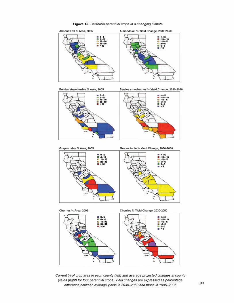
93
Almonds all % Area, 2005 Almonds all % Yield Change, 2030-2050
Berries strawberries % Area, 2005 Berries strawberries % Yield Change, 2030-2050
Grapes table % Area, 2005 Grapes table % Yield Change, 2030-2050
Cherries % Area, 2005 Cherries % Yield Change, 2030-2050
Figure 16: California perennial crops in a changing climate
Current % of crop area in each county (left) and average projected changes in county yields (right) for four perennial crops. Yield changes are expressed as percentage
difference between average yields in 2030–2050 and those in 1995–2005
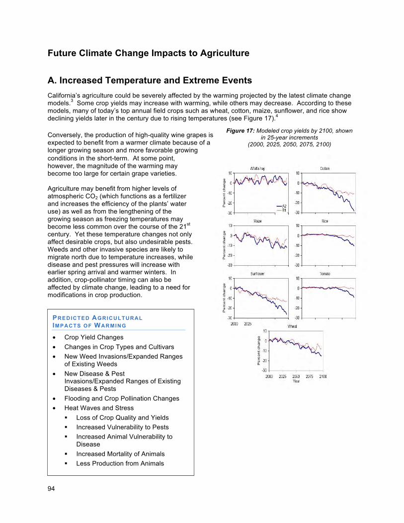
94
Figure 17: Modeled crop yields by 2100, shown in 25-year increments
(2000, 2025, 2050, 2075, 2100)
Future Climate Change Impacts to Agriculture
A. Increased Temperature and Extreme Events
California’s agriculture could be severely affected by the warming projected by the latest climate change models.3 Some crop yields may increase with warming, while others may decrease. According to these models, many of today’s top annual field crops such as wheat, cotton, maize, sunflower, and rice show declining yields later in the century due to rising temperatures (see Figure 17).4 Conversely, the production of high-quality wine grapes is expected to benefit from a warmer climate because of a longer growing season and more favorable growing conditions in the short-term. At some point, however, the magnitude of the warming may become too large for certain grape varieties. Agriculture may benefit from higher levels of atmospheric CO2 (which functions as a fertilizer and increases the efficiency of the plants’ water use) as well as from the lengthening of the growing season as freezing temperatures may become less common over the course of the 21st century. Yet these temperature changes not only affect desirable crops, but also undesirable pests. Weeds and other invasive species are likely to migrate north due to temperature increases, while disease and pest pressures will increase with earlier spring arrival and warmer winters. In addition, crop-pollinator timing can also be affected by climate change, leading to a need for modifications in crop production.
PREDICTED AGRICULTURAL IMPACTS OF WARMING
• Crop Yield Changes
• Changes in Crop Types and Cultivars
• New Weed Invasions/Expanded Ranges of Existing Weeds
• New Disease & Pest Invasions/Expanded Ranges of Existing Diseases & Pests
• Flooding and Crop Pollination Changes
• Heat Waves and Stress
Loss of Crop Quality and Yields
Increased Vulnerability to Pests
Increased Animal Vulnerability to Disease
Increased Mortality of Animals
Less Production from Animals
95
Higher average temperatures can cause increases in mortality and/or decreases in productivity of livestock, leading to decreases in meat, egg, and dairy production and reproductive success of cattle.5 Greater proliferation and survival of pathogens and pests will affect both crops and livestock.6 Temperature and precipitation changes can also disrupt the critical link between agriculture and biodiversity. In California a large number of wildlife species are dependent on privately owned agricultural lands for habitat and a reliable food source. As temperature and precipitation patterns change it is likely that there will be a shift in the intensity and location of agriculture that could impact fish and wildlife resources. Agricultural lands can provide significant habitat and connectivity between protected reserves, but can also compete with fish and wildlife for resources that may become limited due to climate change. Predictions of higher proportion of precipitation in the form of rain with concomitant loss of snow pack suggests more frequent summer droughts, thereby creating conflicts between beneficial uses of water. Further impact to fish and wildlife may result from the management of pests and pathogens that may proliferate within agricultural settings with warming temperatures. Reduction of Chill Hours
While many crops benefit from the increase in average temperatures and the lengthening of the growing season, not all do. Some of California’s most valuable crops, such as fruits, wine grapes, and nuts, require a certain number of chill hours in the winter. Chill hours are the number of hours below a certain temperature that a plant requires for dormancy before springtime growth. The temperature threshold and duration of dormancy needed are species-dependent, yet without the required period in dormancy, blooming, the setting of fruit, fruit quality, and therefore crop yields are negatively affected.7 The number of winter chill hours has already declined since 1950 with the greatest rates of change occurring in the Bay Delta region and the mid-Sacramento Valley. Grapes and almonds, which are grown in these regions, may need to be replaced with new cultivars that require fewer chill hours or alternative crops that do not require as many winter chill hours in order to avoid substantial losses. For many high-value crops, a reduction of chill hours could be harmful. In one study, researchers examined the effects of climate change on the 20 most valuable perennial crops grown in California. They found that cherries, the 18th most valuable perennial crop in the state, are likely to be the most negatively affected by warming in coming decades. This finding is likely related to a loss of chilling hours. A second robust finding of the study was that almonds, the most valuable perennial crop in California and the source of the world’s supply, will be harmed by increasing February temperatures. None of the crops studied showed any clear benefits from projected warming.8
Changing Temperature Extremes Understanding how climate change affects the occurrence of temperature extremes is crucial for California’s agriculture. The costliest acute event to California’s agriculture in recent years was the freeze of December 1998. Various crops, including oranges, lemons, olives and cotton, experienced major losses. The second costliest individual event was the heat wave of July 2006, which was especially damaging to the livestock industry.9 In recent decades, cold extremes have already become less frequent, and are projected to become even less frequent across the state in the future.10 Heat waves, by contrast, are very likely to become more frequent due to climate change.11,12 Climate scenarios using the higher emissions scenario suggest that heat waves similar in length and intensity to the one experienced in July 2006 may become as frequent as once a year in many parts of California by the end of the century.13
96
The heat stress caused by extremely high temperatures can increase livestock vulnerability to disease, infection, and mortality; and can decrease livestock production. For crops, heat stress can lead to losses in quality and yields; and can increase plant vulnerability to pests. Extreme heat can also indirectly affect irrigated agriculture by generating short-term disruptions of the water supply, as well as increased water needs due to higher rates of water loss from evapotranspiration.14
B. Precipitation Changes and Extreme Events
Most climate change projections show a general drying trend over California, resulting in reduced water deliveries from a decreasing Sierra Nevada snowpack. This would lead to a water supply and supply reliability risk for agriculture, with more competition among all water users. A decrease in water supply reliability will direct crop selection to crops, such as row/field crops, that are not dependent on a steady long-term supply of water. Also, with less reliability, comes greater risk, which affects the availability of operating credit from lending institutions. One study found that under any projected climate scenario, agriculture would consistently be most vulnerable to water shortages. Researchers also estimated that annual costs of approximately $200 million would be incurred by agriculture if water availability was more than 20 percent lower than demand. 15 Droughts and legal constraints on water delivery have in some years led to losses in excess of $1 billion annually to Central Valley agriculture, translating to tens of thousands of lost jobs, and a reduction in world food supply. Thus, short of significant adaptations, water supply reductions and intermittent disruptions will adversely affect agricultural crop yields. One modeling study combining future crop yield predictions with future water supply stresses indicated notable declines in overall crop acreage and production by 2050.16 This potential scenario is of particular concern because of the protected demand on food supply attributable to population growth world wide. Non-irrigated lands, despite their lack of dependence on water delivery systems, can also be impacted by altered precipitation patterns. For example, low or infrequent rainfall results in less forage on California rangelands, which can result in lower livestock productivity and increased soil erosion and water quality degradation. Agricultural impacts can differ geographically under Delta water system shortages. For example, water shortages may be more acutely felt in the western San Joaquin Valley and Tulare Basin.17 With projected climate change the San Joaquin Valley is projected to have potentially greater irrigation demand and evapotranspiration than the Sacramento Valley, leading to more risk for agriculture in the southern Central Valley counties by the end of the century.18 Some of these shortages may be managed by changes in technology and agricultural practices. For example, if additional water conservation measures and new technology becomes available in the next few decades in San Diego County, agricultural demand for water could actually decrease, shrinking from 13 percent of total county demand in 2005 to six percent in 2030.19 However, the prospects of achieving this level of efficiency increases without a reduction in acres or crop yields are improbable especially in light of the very high level of water efficiency that is currently being employed in other parts of the state.
AGRICULTURE- PREDICTED IMPACTS OF PRECIP ITATION
CHANGES
• Loss of Water Supply and Reliability
• Loss of Food Security as Water Supply Diminishes, is Less Reliable
• Loss of Irrigated Lands, Crop Production and Food Security
• Lack of Water for Agriculture and Livestock
• Drier Conditions May Affect Agricultural Crop Yields
• Increased Fire Risk to Rangeland
• Dry Steep Terrain - Increased soil erosion and sedimentation from Agricultural Lands
• Changes in Pests, Diseases and Invasive Species
• Changes in ozone and air quality - likely adverse affects on crop production
97
Drought can produce severe lack of water for crops and livestock, increase the risk of fire on rangeland, and ultimately reduce food security. Historically, irrigation has helped to minimize the impact of droughts, but climate projections suggest that long-lasting droughts may become more common under the higher emissions scenario later in the 21st century. Such severe decreases in water availability may well limit the types and amounts of crops grown in California.20 The ultimate impact of changing water supplies will depend on the degree to which farmers switch to crops and livestock that are better adapted to the new climate conditions as well as to potentially lower water supplies, market value changes in crops and livestock, and usage of water efficiency and conservation measures. According to DWR, most new water that derives from conservation will come from urban water use efficiency; most readily-adopted agricultural water conservation measures have already been implemented.21 The gains in water use efficiency by agriculture over the past forty years was documented in a recent preliminary draft paper, which documented a doubling in inflation-adjusted dollars of agricultural gross revenue between 1967 and 2007, while during the same period total crop applied water fell by 14 percent.22
Heavy Rainfall and Flooding Events The agricultural sector is also challenged in wet conditions. For example, some farmlands in or near floodplains could be inundated when winter and spring rainfall combine with rapid snow melt (due to higher temperatures over the Sierras) and generate larger runoff than streams and soils can absorb.23 Flooding during the planting season is known to be particularly damaging for crops. A study of the impacts of extreme events on California agriculture, using disaster and insurance loss data over the years 1993-2007, showed that excess moisture related to heavy rainfall events and subsequent flooding led to the greatest overall economic losses during these years.24 Specifically, heavy rainfall in the spring and winter months accounted for the 3rd, 4th and 5th costliest individual extreme events. While the number of storms is not expected to increase in the future, heavy rainfall events will continue to play a significant role in California’s future climate. Especially in the Delta region, increases in winter flooding can be expected due to the coincidence of rainfall events and earlier runoff with higher sea levels. This may necessitate additional levee maintenance to protect farmland. C. Sea Level Rise
Sea level rise impacts include saltwater intrusion onto farmlands and an increased risk of coastal flooding of low-land agriculture. Both will raise soil salinity to a point which most crops currently grown are not adapted. Increases in surface and groundwater salinity, as well as decreases in irrigation water quality near the coast, will negatively impact coastal agriculture. Sea level rise impacts may also constrain farmers’ abilities to adapt to changing water supplies and temperatures as some management practices, irrigation methods, and crop switching may not be possible in areas near sea level increases. Livestock operations and croplands may need to be relocated onto more productive lands. Investments in technology, plant breeding and cropping system research will help minimize some of the projected climate change-related agricultural impacts.25
AGRICULTURE I IMPACTS OF SEA LEVEL RISE
• Saltwater Intrusion onto Coastal Farmland Soils
• Seawater Flooding of Low-lying Farmland
• Increases in Soil, Surface Water, and Ground Water Salinity
• Increased Upstream Flooding
98
D. Risks for Agriculture To summarize the changing risks that California’s agricultural sector may be facing from climate change, the likelihood of occurrence of the projected consequences was qualitatively assessed. The emerging risk profile for the agricultural sector can be characterized as follows:
• Climate change is likely to alter:
• Precipitation amounts and patterns
• Average as well as maximums and minimum temperatures, resulting in growing season lengthening and chilling hours reductions
• Pest and weed ranges
The resulting critical changes in water availability, temperatures, sea level rise and extreme events will all affect crop and livestock productivity which in turn will have a direct impact on domestic and international food supply.
• Extreme events may be among the greatest challenges, as they can lead to large losses of crops, impose stress on livestock, and be most difficult to manage.
• Perennial crops such as grapes, fruits, and nuts will experience varying risks, with moderate warming potentially benefiting some crops such as table grapes and almonds, but mostly negatively impacting other perennial crops, such as cherries.
• Yields of some annual crops such as cotton, maize, sunflower, and wheat are expected to slightly decrease by mid-century, while rice and tomato yields remain more or less unchanged. By the end of the century there is a growing risk of declining yields of all examined crops except alfalfa; that risk is significantly higher under the higher emissions scenario.
• Livestock is particularly at risk from heat extremes, which can lead to increased risk of mortality, lower productivity, and lower reproductive success.
• Sea level rise and increased winter run-off together with meltwater will increase low-land flooding risks. Sea level rise together with higher moisture loss from soil and water table drawdown will increase the risk of high salinity in coastal soils, thereby negatively impacting salt-sensitive crops.
• Disruptions in temperature and precipitation patterns can disrupt the link between agriculture and biodiversity.
• Hydrologic changes will decrease agricultural water supply reliability and thus diminish food security.
• Hydrologic changes will increase both threat and risk of crop and soil damaging flood on agricultural lands.
99
Agriculture Adaptation Strategies
Introduction The state agencies that participated in the Climate Adaptation Working Groups (California Department of Food and Agriculture and California Department of Conservation) developed the following strategies and shall be responsible for and will spearhead strategy implementation. California’s family farms and ranches play a large role in the state’s economy, and rural culture; as a result, climate change will have countless impacts on the cultivation of crops and livestock. In addition, California agricultural productivity is of strategic importance to the state and nation, as a major producer of the nation’s food supply. California’s family farms and ranches have been successful in large part due to their ingenuity and capacity to adapt from year to year and over the long haul to changing growing conditions, such as pests and disease, labor availability, weather and market demands. To adapt to changes in temperature and precipitation, a number of approaches are proposed or in development to assist in increasing the diversity of California’s agricultural commodities, thereby fostering resilience within the industry. The identification and development of crops and animals found to be resistant or better suited to the myriad of climate change variables is central when planning for adaptation and will ultimately support California farmers and preserve their ongoing operations. Increased research into development of crops or cultivars which exhibit an increased tolerance to heat waves, high average temperatures, drought, pests and disease should be encouraged. Strategies are also being developed that support the research of crop rotations that maximize efficient water usage. Continued improvements in irrigation systems will further the reliability of water supplies through water conservation. Management practices that address adaptive flood control will also serve to benefit existing levees and adjacent floodplains; while incentives will allow for the cultivation of floodplain compatible crops introduced in the areas prone to regular flooding. To protect against agricultural weeds, pests and diseases, additional investments should be made in the detection, prevention and eradication of invasive species that originate from outside of the state or have relocated from other regions within the state. Further research is needed in the development of best management practices that enable adaptation, or can help predict and respond to the spreading of weeds, pests, and disease. Resilience to harmful pests and associated diseases may be optimized by providing growers with the most favorable management techniques possible, ones that will harmonize with planting, thinning, and harvest timing. In concert with adaptation, mitigation protocols favor low carbon emission strategies such as renewable energy production on farms, and the development of a carbon and carbon equivalent credit mechanism that can be utilized in concert with food and fiber production in the future. Research is also needed to develop low-carbon, non-petroleum based crop protection tools.
Local Government Example:
Yolo County is completing the update of its general plan. The update places a strong emphasis on responding to climate change, including policies to help agriculture adapt. Among the policies are those that aim to keep as much agricultural land free from the constraints of urbanization, thus broadening the landscape flexibility for adaptation; protect water supplies through such measures as protecting groundwater recharge basins and supporting improvements in water use efficiencies; assist farmers to anticipate and respond to opportunities and adversities resulting from climate change; promote practices that sequester carbon long-term to help growers qualify for carbon credits; support the production and use of agricultural bio-fuels for economic sustainability; and, promote local market outlets to reduce transportation energy costs.
100
Agriculture is part of the existing environment and to ensure that agriculture has room to adapt to a warming climate by moving onto lands in cooler climates further north or in higher altitudes, local general plans will need to zone for and protect such lands for future agricultural growth. Such zoning changes need to be coordinated with design and connectivity of landscape preserves for biodiversity conservation (see Biodiversity and Habitat chapter) and should contain right to farm protections to help ensure agricultural viability. Incorporating climate change model results in general plan updates that recognize the value of these lands will need to be encouraged through strategies that provide information as well as incentives to local governments.
Adaptation Strategies and Actions: California’s agricultural sector plays a large role in the state’s economy and culture and is thus vital to sustain. California’s family farms and ranches fulfill a key role by providing for one of the fundamental needs of society: a safe, secure, and affordable food supply. Moreover, export commodities produced by California’s agriculture sector feed consumers across the nation, and around the globe. This enhances the critical nature of the relationship between food security and the agricultural impacts of climate change. To adapt to the expected changes described earlier in this chapter, the sector has a wide range of options. Those which are consistent with the activities of DOC (Department of Conservation) and CDFA (California Department of Food and Agriculture) include, but are not limited to the following:
Strategy 1 - Water Supply and Conservation Support
Near Term Actions:
a. Water Conservation - Continue to enhance water conservation activities at the farm and district level by initiating incentives, distributing information and introducing other strategies that encourage the development of diverse farm and irrigation district water sources.
i. California Irrigation Management Information System - Expand the collection and dissemination of local weather information for irrigation planning and expand the California Irrigation Management Information System (CIMIS).
ii. Mobile Irrigation Labs - Increase support for water stewardship practices either through expanding the role of mobile irrigation labs or through other services provided by Resource Conservation Districts, Water or Irrigation Districts, and Cooperative Extension services.
iii. California Agricultural Water Management - Support expansion and development of voluntary district-level water conservation plans for all agricultural water districts; and encourage the implementation of approved district conservation plan actions (e.g., tailwater return ponds).
iv. Collaboration & Partnerships - DOC will collaborate with the USDA Natural Resources Conservation Service, DWR, CEC, and CDFA to prioritize and expand technical and financial cost-share assistance programs (e.g., water stewardship practices, farm conservation planning, water use efficiency, micro-irrigation, low energy precision application drip systems, and land-leveling) for growers.
v. Energy Efficient Water Recycling - Invest in new uses for saline drainage water, using renewable solar and on-farm bio-fuels energy sources to treat saline water. This is partially mitigation, but should focus on re-use of saline drainage on more salt tolerant crops, or to expand supplies through treatment.
vi. Water Incentives – Incentivize water pricing systems that reward conservation, accounting for regional differences in growing conditions, crops, and other agronomic needs. Create incentives and streamline regulatory requirements for agricultural water users to make more water available for other beneficial uses through voluntary water transfers.
101
vii. Urban Conservation Programs - Invest in urban water conservation programs that result in increased local sources of agricultural irrigation water available for future use.
viii. Water and Energy use Efficiency on Farms - DOC shall implement statewide expansion of the Watershed programs which support adaptive management through watershed stewardship and project implementation grant awards, including practices that increase water and energy use efficiency on farms.
ix. Dry Farming – Dry farming in higher rainfall coastal regions has traditionally produced high quality crops, such as wine grapes and apples. Through water conservation funding, develop incentives and marketing to support appropriate coastal zone dry farming recognizing that there will be a likely reduction in crop yields and/ or reliability of harvests and in turn available local food supplies.
b. Floodplain Easements - Work with willing sellers to identify voluntary floodplain corridor protection (flowage) easements on agricultural lands to maintain agricultural production that is compatible with flood conveyance. These actions will also enhance economic sustainability and protect urban residents from flooding, provide improved shallow water and seasonal wetland habitat, improved fish passage and nursery conditions, while protecting agricultural lands for the continued production of food and fiber.
Long Term Actions:
c. Drought Tolerant Research - Support research and development for more drought-tolerant cultivars, crop rotations, and crop mixtures.
d. Improve Water Reliability - Initiate reliability of irrigation water delivery to facilitate farm and district-scale crop and farm management to better adapt to climate change.
i. Water Projects - Continue to improve the coordination of the State Water Project, Central Valley Project, and Colorado River Project operation.
ii. Water Conveyance - Improve state and regional water conveyance systems to move more wet-year flows to off-stream and groundwater storage and to facilitate intra-regional water transfers.
iii. Increase Storage Capacity - Expand and improve the use of existing surface and groundwater storage capacity while developing new surface and groundwater storage. On-farm ponds and increased soil moisture storage are additional ways to provide operational flexibility and short term storage capacity.
iv. Integrated Regional Water Management Planning - Increase regional reliance of water supplies through continued support for integrated regional water management planning.
v. Increase Recycled Water Use - Consistent with state policy, supplement existing agricultural water supplies by encouraging the increased agricultural use of recycled urban water.
e. Reduce Flood Impacts - Initiate actions to reduce the harmful effects on agricultural lands from increased flooding likely from more intense storms and sea level rise.
i. Levee Improvements - Improve levees to protect the state’s most productive farmland and reduce damage to investments, such as agricultural infrastructure and irrigation systems (e.g., land leveling and irrigation ditches, etc).
ii. Enhance Water Capture - Promote measures that rainfall capture by improving groundwater infiltration and soil retention/capture.
f. Develop Severe Drought Response Strategies – Support research and development of emergency response plans for agriculture in severe drought.
102
g. Support research on practices to promote soil water-holding capacity-- California Department of Food and Agriculture, the University of California Cooperative Extension, and other interested entities should continue to support new and existing research on farm management practices that result in increased soil water retention, thus reducing irrigation needs and runoff. Research on these agricultural practices include, but are not limited to, cover cropping, conservation tillage, increasing the use of renewable inputs, increasing the carbon content of agricultural lands, improving soil fertility, and reducing evapotranspiration. These endeavors should be inclusive of conventional, organic, and other food production systems and shall do so with a focus on meeting a growing global food demand.
Strategy 2 – Preventing, Preparing for, and Responding to Agricultural Invaders, Pests, and Diseases
The California Invasive Species Council (CISC) will coordinate invasive species response for the State. The CISC mission is to provide policy level direction and planning for mitigating harmful invasive species infestations throughout the state and for preventing the introduction of others that may be potentially harmful; and to foster coordinated, streamlined approaches that support initiatives for the prevention and control of invasive species, avoiding program duplication by building upon the core competencies of member organizations. The CISC is chaired by Secretary of CDFA and vice-chaired by Secretary of CNRA. Also serving on the council will be Secretary of California’s Environmental Protection Agency; Secretary of Business, Transportation and Housing Agency; Secretary of California Health and Human Services Agency; and Secretary of California Emergency Management Agency.
Near Term Actions:
a. Inspection Stations – Increase vigilance and develop a long-term funding strategy at the state’s port-of-entry inspection stations to prevent entry of new diseases, pests and weeds.
b. Statewide Detection - Increase the effectiveness of statewide detection system in order to detect newly introduced pest species.
c. Risk Analysis of Potential Invasives – CDFA, UC Cooperative Extension, and CEMA should collaborate in developing risk analysis of foreign plant and animal pests that could invade California, to aid in better preventing introductions and better preparing for emergency eradication responses.
d. Pollinator Technical and Financial Assistance - Provide technical and financial assistance and incentives for the conservation of “bee pastures” and the use of on-farm planting beneficial to native and non-native pollinators, all with consideration given to crop compatibility (i.e. seedless crop varieties).
e. Information Distribution - Provide information to the agricultural community to enable growers to modify farm management practices and adapt to new pests and diseases.
Long Term Actions:
f. Prevention and Detection - Invest in the prevention, detection and eradication of noxious invaders due to climate change that come from outside California, and native California species that move into new regions of California.
i. Collaboration and Information Sharing - Increase interstate and statewide cooperation in the sharing of databases, modeling, detection, warning systems and eradication.
103
ii. Field Experiments - Initiate field experiments for climate gradients that represent the range of future climates (e.g., landscape surveys) providing data on predictors, potential invasions and expansions of pests, weeds and diseases.
iii. Identify Risks - Identify pests and pathogens that may potentially place California at risk. Conduct analysis of previously developed scenarios from regions with similar climatic conditions.
g. Sustained Research and Extension - Invest in research and development of control strategies and chemicals that add to the toolbox of Integrated Pest Management in anticipation of climate change. Distribute research results through University of California Cooperative Extension programs.
i. Adaptive Strategies - Support research into management strategies that assist grower adaptation to increased pest and disease pressures, such as changes in planting, thinning and harvesting timing, planting of crop mixtures, and crop diversification practices.
ii. Resiliency Development - Safeguard farm and regional crops and livestock against uncertain pests and disease exposure by developing more resilient cultivars and breeds (i.e., develop more stone fruit varieties with fewer chill hours required for good harvests); develop inter-cropping and soil enhancing practices which improve plant, field, and landscape scale resilience. Develop practices that improve resilience of field and landscape, through research, development, and support of diverse crop and livestock populations.
iii. Disease and Pest Resistance – Support research and development on the identification of plant cultivars and livestock breeds that are resistant to predicted disease and pest pressures. Reduce dependence on off-farm inputs through continued research, development, and support of Integrated Pest Management practices.
iv. Bee Colony Collapse - Support research on the causes of bee colony collapse and the effects of climate change and adaptation strategies on healthy native and non-native pollinator populations.
v. Modeling - Support research on impacts of climate change that improves our understanding through the development of better scientific models on temperature and precipitation patterns to predict the spread of disease, noxious weeds and pests.
Strategy 3 - Land Use Planning Practices
Near Term Actions:
a. Policy Integration – CDFA, in collaboration with the Strategic Growth Council and other agencies, should provide guidance for cities and counties to help develop and adopt sustainable agricultureiii policies, particularly in conjunction with smart growth planning initiatives.
i. Protection of Farmland - Under the leadership of the DOC, ensure the continuation of the Land Conservation Act (1965) and the California Land Conservancy Program, as well as other local and state agency programs to permanently protect farmland. Use the Land
iii Per the 1990 "Farm Bill," sustainable agricultural policies consist of an integrated system of plant and animal
production practices having a site-specific application that will, over the long term: satisfy human food and fiber needs; enhance environmental quality and the natural resource base upon which the agricultural economy depends; make the most efficient use of nonrenewable resources and on-farm resources and integrate, where appropriate, natural biological cycles and controls; sustain the economic viability of farm operations; and
enhance the quality of life for farmers and society as a whole.
104
Conservation Act in combination with the Farmland Mapping and Monitoring Program and the California Farmland Conservancy Program to identify and secure lands that offer future productivity potential against climate impacts (e.g., lacustrine and alluvial soils at higher elevations, or northern climates.)
ii. Adaptable Farmlands – Encourage the conservation of the most productive and adaptable farmland by supporting land conservation programs and smart growth (e.g., urban growth boundaries, in-fill, redirection and redevelopment of existing urban areas).
iii. Community Land Use – CDFA will encourage community land use planning to support sustainable agriculture at the urban interface, helping to give a level of certainty to growers of the future use of their lands for agriculture.
iv. Local and Regional Markets – Encourage and support the development of local and regional markets allowing smaller farms a niche to coexist on smaller parcels in near-urban environments. DOC Farmland Conservancy Program, utilizing data from the DOC Farmland Mapping and Monitoring Program, has developed a prototype foodshed map, starting with San Francisco, in response to the cities’ local food initiative. Such foodshed mapping products can facilitate sound regional planning to optimize farmland conservation.
v. Mapping Collaboration - Develop and employ methods to update existing soil classification maps based on climate change scenarios in collaboration with the Natural Resources Conservation Service.
b. Wetland Easements – Pursuant to DWR Water Plan 2009, continue purchase of wetland easements on marginal, flood-prone, agricultural lands to diversify grower income and buffer productive lands from flood events and improve the environmental services provided by these lands. These efforts may include DWR, DFG, NRCS (Natural Resource Conservation Service), WCB (Wildlife Conservation Board) or other funding sources and incentivize private investment in the establishment and preservation of wetlands.
Long Term Actions: - The near term actions, as they are comprehensive, are expected to continue long term. Additional long term land use actions for consideration include the following:
c. Farm Carbon Sequestration - CDFA and the Resources Agency will work with the Climate Action Team and the Air Resources Board to identify opportunities to include farm carbon sequestration as an offset credit. Examples include promotion of offset credits for GHG emissions trading that includes the carbon sequestration by soils and other GHG reduction measures, as well as supporting research and development of protocols for agricultural practices that can potentially reduce GHG emissions. CDFA shall have a major role in developing the mechanisms for offset credits.
i. Credits and Offsets - Promote the integration of carbon offset markets with environmental market credits (i.e., water quality and wildlife habitat improvements) to reduce greenhouse gases, and improve the economic and environmental sustainability of agricultural operations.
105
Strategy 4 – Promote Working Landscapes with Ecosystem Services to Improve Agrobiodiversity
Near Term Actions:
a. Technical Assistance and Outreach - Use new and existing technical and financial assistance programs, and informational outreach where appropriate to increase the diversification of the agricultural region from field to landscape scales. For example, inter-cropping with rotations, cover cropping, hedgerows, riparian restoration and wetlands can provide grower opportunities for diversification of income from carbon sequestration and other environmental services credits; create opportunities for pest predator and pollinator habitat; and enhance resilience against climate change.
b. Bio-Energy – The University of California Cooperative Extension (UCCE), along with the California Energy Commission (Energy Commission) and the California Department of Food and Agriculture (CDFA) should encourage the development of sustainable agricultural feedstocks for bio-energy that use marginal land and avoid competing with both plant and animal food production.
Long Term Actions:
c. Climate Adapted Crops and Crop Mixtures - Support identification, research, development, and breeding of crop varieties, cultivars, and mixes of crops capable of adapting to expected climate change (e.g. with respect to changes in temperature, precipitation, pest and disease resistance, air quality, salt tolerance and drought tolerance) in order to assist growers in the selection of crop and livestock most likely to succeed.
d. Crop Diversification – The University of California, in partnership with the Energy Commission and the CDFA should support the identification, agronomic and economic analysis of multiple crop types and second-generation (cellulosic) energy crops for use by growers to diversify their production options, improve their ability to adapt to climate change, and create long-term opportunities for recycled water reuse.
e. Economic Evaluation of Systems that Enhance Ecosystem Services – The University of California, in partnership with the Energy Commission, CDFA, and other agencies, should support the identification of new or evolving markets for systems that fulfill consumer demand for reduced “foodprint” agricultural products: methods that enhance, enrich, or regenerate soil; require reduced farm inputs; or reduce energy consumption or feedstock and product transportation needs (including conventional and organic farming); opportunities to fulfill consumer demand for agro-tourism; and other emerging consumer driven markets. Research on agronomic and economic efficiency of these new systems will support their continued adoption and expansion, where appropriate. .
106
Strategy 5 - Farm and Land Management Initiatives
Near Term Actions:
a. Permit Streamlining – The State Environmental Protection Agency (CalEPA) and CDFA will promote and facilitate permit streamlining coordination of dairy digester technologies and other initiatives (regulatory and voluntary) that have a net benefit to food supply, climate change, and the environment. CalEPA, CDFA, and other state agencies should promote technical and financial assistance for regional and on-farm sources of renewable energy and encourage the economic and environmental sustainability of California farms, dairies and rural lands.
Long Term Actions:
b. Technical Assistance & Funding - Complement federal financial and technical assistance such as those offered by the NRCS for farmers under the co-leadership of the Department of Conservation (DOC) and the CDFA to collaboratively encourage improved farm management practices involving tillage, rotations, manure management, fallowing, use of cover crops, inter-cropping, multi-cropping, and fertilizer-use efficiency, which result in net environmental benefits including reduction of soil erosion, increased soil fertility, water-holding capacity, and reduced on and off-site contamination of water resources.
c. Grower Outreach – State agencies should partner with existing information networks such as UCCE, RCDS, etc to provide information on the benefits of crop management (e.g., manipulation of planting, thinning and harvesting dates, crop mixtures, crop diversification from within-field to landscape scale, etc.) in order to adapt to climate change impacts resulting in the increase of crop pests and disease, as well as increases in temperature and changes in precipitation.
d. High-Carbon Crop Cultivation – State agencies should incentivize the use of crop options, encourage economic sustainability and the development of carbon credit protocols for the cultivation of woody plants in appropriate natural areas (e.g., riparian forests, hedgerows and windbreaks.) These endeavors shall be mindful of any potential reduction in food supply.
e. Research - State agencies should continue to invest in research and development to determine nitrous oxide generation from soil, irrigation, carbon and nitrogen input from various sources and application methods. Such research should explore relative benefits of organic and inorganic sources of nitrogen, with the aim of reducing the need for off-farm sources of nitrogen. Identify peer-reviewed scientific research that supports industry-wide practices that will reduce greenhouse gases. Develop protocols where appropriate and feasible that provide incentives to growers (e.g., GHG credits) to improve fertilizer and manure delivery technology, or reduce the need for off-farm sources of nitrogen fertilizer inputs.
Strategy 6 – Building and Sustaining Institutional Support
Near and Long Term Actions:
a. Information Clearinghouse - Establish information clearinghouse(s) for growers that provide information and guidance on adaptive management of crops and cultivars, air quality, precipitation, pests and diseases, climate change scenarios, annual planning, disease and pest invasions, control strategies, water conservation technology, technical and financial assistance, crop failure insurance and general information pertinent to climate change adaptation.
107
IX. FORESTRY
Introduction Forestlands and rangelands occupy over 80 percent of California’s 100 million acres. Forests and woodlands, which cover about 31 million acres, have at least 10 percent tree canopy and include coniferous and hardwood habitats. About half of this area consists of timberland, land capable of growing 20 cubic feet of wood per acre annually. The most recent timber yield data shows that over 1.6 billion board feet of timber, valued at about $474 million dollars, was harvested from private and public timberlands in 2007. Rangelands are native or naturalized grasslands, shrublands, deserts and open woodlands which have primarily been used for livestock grazing. They cover about 47 million acres of California’s wildlands. For the purposes of this chapter, climate impact discussion and adaptation strategies focus mostly on ecosystems supporting tree cover, i.e., forests and oak woodlands (hardwood range). In addition to traditional economic uses of these working landscapes, California’s forests and rangelands provide important environmental and economic benefits such as watershed protection, carbon sequestration and storage, biomass for energy production, recreation, and wildlife habitat for wildlife. Climate change in California forests may affect tree survival and growth, forest composition, forest health and productivity, and will likely increase the intensity of ecosystem disturbances from wildfire, insects and pathogens. Population growth and land use change may create additional stresses that increase vulnerability to impacts from climate change. The interaction of these forces may reduce or change the range of ecosystem goods and services available for wildlife and watersheds, citizens, communities, and businesses.
Future Climate Impacts to Forest and Rangeland Resources
A. Increased Temperature and Extreme Events
Temperature rise affects plant species behavior, including seed production, seedling establishment, growth and vigor. It also reduces moisture availability for plants, threatens seedling and plant survival, increases the risk of wildfire, and is likely to enhance the survival and spread of insects and possibly pathogens. These effects could change the survival, distribution and composition of rangeland and forest habitats. A recent analysis of tree mortality information collected over the last five decades in the Western United States, including older established Sierran forests, determined that trees have been dying at a faster rate in recent decades as a result of increasing regional temperatures and climate change.1 With warmer temperatures, tree species in California may respond by migrating both northward and to higher altitudes.2 Recent research concluded that upslope movement of pine forests and oak woodland conversions to grassland have already occurred due to climate change.3 As the rate of climate change increases some tree species may not be able to adapt to changed conditions. Species with currently restricted ranges will probably be most vulnerable, while species with broader climate tolerances may be able to adapt more easily. Alpine forests and associated plant species are particularly vulnerable, because they have little room to expand. Ecologists also no longer assume that plant communities will migrate intact, so forest and range communities may change in species composition as they move.
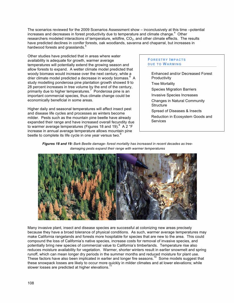
108
The scenarios reviewed for the 2009 Scenarios Assessment show – inconclusively at this time –potential increases and decreases in forest productivity due to temperature and climate change.4 Other researchers modeled interactions of temperature, wildfire, CO2, and other climate effects. The results have predicted declines in conifer forests, oak woodlands, savanna and chaparral, but increases in hardwood forests and grasslands.5 Other studies have predicted that in areas where water availability is adequate for growth, warmer average temperatures will potentially extend the growing season and allow forests to expand. A wetter climate model predicted that woody biomass would increase over the next century, while a drier climate model predicted a decrease in woody biomass.6 A study modelling ponderosa pine plantation growth showed 9 to 28 percent increases in tree volume by the end of the century, primarily due to higher temperatures.7 Ponderosa pine is an important commercial species, thus climate change could be economically beneficial in some areas. Higher daily and seasonal temperatures will affect insect pest and disease life cycles and processes as winters become milder. Pests such as the mountain pine beetle have already expanded their range and have increased overall fecundity due to warmer average temperatures (Figures 18 and 19).8 A 2 °F increase in annual average temperature allows mountain pine beetle to complete its life cycle in one year versus two.9 Many invasive plant, insect and disease species are successful at colonizing new areas precisely because they have a broad tolerance of physical conditions. As such, warmer average temperatures may make California rangelands and forests more hospitable for species that are new to the area. This could compound the loss of California’s native species, increase costs for removal of invasive species, and potentially bring new species of commercial value to California’s timberlands. Temperature rise also reduces moisture availability for vegetation. Warmer, shorter winters result in earlier snowmelt and spring runoff, which can mean longer dry periods in the summer months and reduced moisture for plant use. These factors have also been implicated in earlier and longer fire seasons.10 Some models suggest that these snowpack losses are likely to occur more quickly in milder climates and at lower elevations; while slower losses are predicted at higher elevations.11
FORESTRY IMPACTS DUE TO WARMING
• Enhanced and/or Decreased Forest Productivity
• Tree Mortality
• Species Migration Barriers
• Invasive Species Increases
• Changes in Natural Community Structure
• Spread of Diseases & Insects
• Reduction in Ecosystem Goods and Services
Figures 18 and 19: Bark Beetle damage- forest mortality has increased in recent decades as tree-
damaging pests expand their range with warmer temperatures
109
B. Precipitation Changes and Extreme Events Climate change may affect precipitation and hydrology, which are critical drivers in forest and range ecosystems, in several ways. Recent winters have been warmer and snowmelt has begun earlier.12 In addition, a greater percentage of precipitation is already falling, and will continue to fall, in the form of rain rather than snow.13 Less snowpack and the temporal changes in snowmelt and spring runoff can lead to longer dry periods in summer months, reducing available moisture for forest plants. Moisture deficits may, however, be somewhat offset by increases of atmospheric carbon dioxide which generally cause plants to increase their water use efficiency.14 Earlier snowmelt will also affect wildlife behavior, and this could affect forests. For example, the early emergence of denning bears could result in greater localized tree damage, tree stress and lower forest health.
While the results of precipitation models vary, recent models lean toward predictions of a drier future for California.15 Declines in precipitation and drier cycles will increase the risk of drought. The effects of a prolonged drought on forests will depend on the species present, their life stages, soil texture and depth, and the duration and severity of the drought.16 A lack of consistently available moisture can impact forest health, although some regions and forest types will be impacted more than others. For example, declines in precipitation may have significant impact on those inland forests that are drier as compared to coastal forests which receive moisture through coastal fog. Climate change may, however, also result in decreased fog regimes.17 In the short-term, forest trees will respond to increased drought by limiting growth and reducing water use. While adult trees, with their deeper root system and stored nutrients and carbohydrates, will be able to survive short-term droughts, new seedlings and saplings may be unable to establish. Under prolonged drought conditions trees and shrubs may weaken and become more susceptible to pests, disease and wildfires, and some plant communities may be more vulnerable to invasive species. Reforestation success may be improved by management practices that use more drought tolerant species or genotypes, by changes in stocking, and other silvicultural practices. Climate change may result in other precipitation extremes. While total average annual rainfall may decrease only slightly, rainfall is predicted to occur in fewer, more intense precipitation events. More intense weather events may result in high runoff and flooding, which can cause soil erosion and landslides. These events can impact watersheds, habitats, structures and public safety, integrity of road systems and other infrastructure and forest site productivity. Effects can be devastating when they follow wildfires that denude and destabilized slopes, as seen in “fire/flood” sequences in southern California.
FORESTRY IMPACTS DUE TO PRECIP ITATION CHANGES
• Longer Dry Periods and Moisture
Deficits
• Potential for Increased Growth from CO2
• Competitive Species Interaction
• Increased Flooding & Runoff - Increases Erosion and Nutrient Loss
• Drought Conditions
o Limits Seedling and Sapling Growth
o Increase Wildfire Risk o Economic Losses
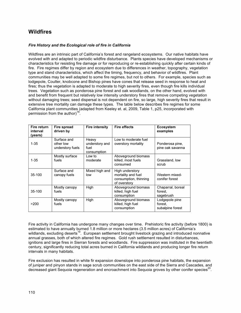
110
Wildfires
Fire History and the Ecological role of fire in California Wildfires are an intrinsic part of California’s forest and rangeland ecosystems. Our native habitats have evolved with and adapted to periodic wildfire disturbance. Plants species have developed mechanisms or characteristics for resisting fire damage or for reproducing or re-establishing quickly after certain kinds of fire. Fire regimes differ by region and ecosystem due to differences in weather, topography, vegetation type and stand characteristics, which affect the timing, frequency, and behavior of wildfires. Plant communities may be well adapted to some fire regimes, but not to others. For example, species such as lodgepole, Coulter, knobcone and Bishop pines have cones that release seed in response to heat and fires; thus the vegetation is adapted to moderate to high severity fires, even though fire kills individual trees. Vegetation such as ponderosa pine forest and oak woodlands, on the other hand, evolved with and benefit from frequent but relatively low intensity understory fires that remove competing vegetation without damaging trees; seed dispersal is not dependent on fire, so large, high severity fires that result in extensive tree mortality can damage these types. The table below describes fire regimes for some California plant communities (adapted from Keeley et. al, 2009, Table 1, p25, incorporated with permission from the author)18.
Fire activity in California has undergone many changes over time. Prehistoric fire activity (before 1800) is estimated to have annually burned 1.8 million or more hectares (3.5 million acres) of California’s wildlands, excluding deserts19. European settlement brought livestock grazing and introduced nonnative annual grasses, both of which altered fire regimes. Gold rush settlement resulted in disturbances, ignitions and large fires in Sierran forests and woodlands. Fire suppression was instituted in the twentieth century, significantly reducing total acres burned in California wildlands and producing longer fire return intervals in many habitats. Fire exclusion has resulted in white fir expansion downslope into ponderosa pine habitats, the expansion of juniper and pinyon stands in sage scrub communities on the east side of the Sierra and Cascades, and decreased giant Sequoia regeneration and encroachment into Sequoia groves by other conifer species20.
111
Fire frequencies have increased, however, in Southern California chaparral and coastal scrub vegetation (Keeley et al., 2009). This is due to dramatic increases in human ignitions, coupled with the invasion of exotic annual grasses that act as “flashy” fuels. Scrub species are being replaced by even more annual grasses as a consequence of these shortened fire return intervals, resulting in complete vegetation type conversions in some areas and the loss of critical habitat values. Predicted Effects of Climate Change on Wildfire Increased wildfire has been identified as one of the most potentially significant climate change impacts to forested ecosystems. Climate change research predicts increased numbers and acres of wildfire. Wildfire occurrence statewide could increase from 57 percent to 169 percent by 2085 under the A2 (higher) emissions scenario and by more than 100 percent in most northern California forests21. Fire severity is also predicted to increase as a result of more frequent severe fire weather.22 The wildfire season already appears to be starting sooner, lasting longer, and increasing in intensity.23 Burned wildland acreage has increased in the last several decades24. Over 48 million acres, or nearly half of the state, is at a high to extreme level of fire threat.25 Climate change will greatly influence the size, severity, duration, and frequency of fires. Rising temperatures will produce drier fuel conditions and increase moisture stress, likely impacting forest health and increasing susceptibility to pathogens and insects. These stressors, in turn, will further increase fire hazard. Fuel buildup from years of fire suppression and past management practices, in concert with changing climate, can contribute to increasing fire hazards, threatening life and property, air quality, watersheds and water quality, terrestrial and aquatic habitats, recreation and tourism, timber resources and other goods and services. Increases in the frequency and intensity of wildfires will make forests more susceptible to vegetation conversions from trees to brush or grasslands.26 In order for trees to reestablish after wildfires, patches of living trees must be left to provide seeds for the recruitment of new seedlings. As wildfires increase in size, they can result in “stand replacing” burns that are too big for natural regeneration. More frequent fires may also result in vegetation conversion by repeatedly killing regeneration. Increased frequency of fires in southern California interior and coastal chaparral ecosystems will aggravate already damaged habitats, replacing brush species with annual grasses until there’s no brushy fuel left to burn. Vegetation conversions of chaparral and forest vegetation will impact biodiversity, habitats, watershed conditions, timber resources and other goods and services. On rangelands, climate change induced wildfire increases are predicted to increase grassland acreage, while decreasing brush and oak woodlands.27 Wildfires may increase invasion by annual and brush nonnative species, which are generally less palatable to livestock and wildlife than native grass and brush species. Annual grasses also increase fire risk and hazard by producing “flashy fuels” that ignite easily and carry fire quickly across the landscape. Larger and more frequent wildfires will impact California’s economy by increasing fire suppression and emergency response costs, damages to homes and structures, interagency post-fire recovery costs, and damage to timber, water supplies, recreation use and tourism. The California Department of Forestry and Fire Protection (Cal/Fire) spent over $500 million on fire suppression during fiscal year 2007/2008. As climate change continues these costs are expected to increase. Fire Management Management options for adapting to the threat of increased fires must address public health, public safety and ecosystem protection. Fire protection measures, including suppression, prevention and building codes, can reduce the occurrence, extent and damage of wildfires. Fuel reduction by manual, mechanical and prescribed burning can reduce the size and severity of wildfires. Vegetation and wildfire
112
management may be used to reestablish conditions that support historic or more ecologically beneficial and socially acceptable fire regimes. In significantly altered ecosystems and developed areas, this may take many steps and treatments. In ecosystems where fuel loads have increased under fire suppression, such as northern California forests, proper fuel management, strategically placed, can effectively reduce hazard and risk and help restore vegetation conditions that are more resistant to wildfire damage. Fuel reduction also mitigates climate change by reducing GHG wildfire emissions and providing biomass for energy production as a fossil fuel alternative. Fuels management to restore more fire resistant forest conditions can be accomplished through prescribed fire, manual and mechanical treatments, or a combination of methods. Over 200,000 acres of fuel management is conducted annually by federal and state agencies with natural resource protection responsibilities (i.e., US Forest Service, BLM (Bureau of Land Management), BIA (Bureau of Indian Affairs), NPS (National Park Service), NFW (National Fish and Wildlife Foundation), CAL FIRE, DPR (Department of Parks and Recreation)). The USFS conducts fuel management and forest health improvement on about 100,000 acres of their lands per year.28 Prescribed fire is used on about 40 percent of the area and mechanical or other treatments on 60 percent. CAL FIRE has been treating about 16,500 acres per year on private lands (about 10,000 acres through prescribed burning and 6,500 with manual and mechanical treatments).29 Federal grants are also been provided for community fire hazard reduction through the California Fire Safe Council. These efforts typically treat only a fraction of the area now at risk for high intensity fire. Based on the area of ecosystems that historically supported frequent low-severity fire regimes, the potential need for prescribed burning or other treatments that restore fire resistant ecosystem conditions may be estimated at over a million acres per year. While prescribed burning treatments can be less expensive to conduct, in many cases reintroduction of fire is not prudent until heavy understory and ladder fuel hazards have been treated through alternative means (e.g., mechanical treatments). Additional research, monitoring and information sharing on the effectiveness of all treatments to re-establish desired conditions for supporting wildland fire will also be very important. Public health and safety concerns must also be taken into consideration. Air quality impacts, concerns about fire escapes and potential harm to people and property can also impact the feasibility and costs of using prescribed fire. (See the Biodiversity and Habitat chapter for more discussion of ecological concerns.)
C. Sea-Level Rise Sea-level rise poses minimal threats to forest stands. The convergence of sea-level rise and storm surges may, however, damage road systems in low lying forested areas right along the coast. This will impact residential access, timber management, recreation, and tourism uses of the landscape.
D. Risks for Forestry The changing risks faced by California’s forestry sector have been qualitatively assessed and the projected consequences for California’s forests and woodlands are characterized as follows:
• The most significant climate change risk facing California is associated with an increase in wildfire activity. Warmer weather, reduced snowpack and earlier snowmelt can be expected to increase fuel hazards and ignition risks. It can also increase plant moisture stress and insect populations, both of which impact forest health and reduce forest resilience to wildfires. An increase in wildfire intensity and extent will increase public safety risks, property damage, fire suppression and emergency response costs to government, watershed and water quality impacts, vegetation conversions and habitat fragmentation.
113
• Climate change may dramatically change forested and range landscapes, resulting in expansions of some forest and woodland types, contraction of others, and conversions to brush and grassland habitats. These will affect biodiversity and may impact habitat availability, quality and connectivity. It may also affect economic uses, such as timber harvest, though net interactions of growth, wildfire, lumber markets and other effects are hard to predict.
• Temperature rise may enhance and expand insect populations, resulting in increased mortality. This
would impact timber resources and reduce habitat quality for some species. It also increases fuel hazards and the likelihood for more intense, stand replacing fires that impact timber resources, fragment habitats, threaten life and property and damage watersheds.
• Climate change may result in increased establishment of non-native species, particularly in
rangelands where invasive species are already a problem. These species may be able to exploit temperature or precipitation changes, or to quickly occupy areas denuded by fire, insect mortality or other climate change effects on the vegetation.
Forestry Adaptation Strategies Introduction
The state agency that participated in the Climate Adaptation Working Group (CAL FIRE) developed the following strategies and shall be responsible for and will spearhead strategy implementation for the state. Developing a successful comprehensive forestry adaptation strategy will, however, require working across agencies and with public and private landowners. Collaboration among federal and state resource protection agencies, landowning agencies, industry and non-industrial forest landowners, and other stakeholders is essential. The U.S. Forest Service, which owns over 13 million acres of forests and woodlands, will be an important partner in this effort. Recent research has focused on the nature of successful adaptation strategies for minimizing the threats to forests resulting from climate change. Following the findings of some researchers, adaptation can be thought of in terms of three broad strategy constructs, from which a variety of specific actions can follow.30 Resistance refers to either forestalling or protecting key areas from harm, and is generally considered a near-term strategy to highlight high-vulnerability/high-value resources and to target actions that defend those resources against change. An example would be a particularly sensitive habitat that fires are expected to destroy. The resistance adaptation would be to put in place fire prevention and hazard reduction projects to reduce the risk from future wildfires by making fire in the habitat area less likely. Resilience strategies emphasize transforming currently vulnerable systems into less vulnerable ones, much like how preventative health care is designed to mitigate future medical problems. This is a more mid-term level approach that requires systematic understanding of how fires impact key assets, and how the fire environment can be modified to reduce damage. The classic example is treating high hazard mixed-confer forests through fuel modifications to make future fires in low-severity systems low severity events, rather than the high severity events that might be expected under current fuel conditions. This approach has the added benefit of also being a climate change mitigation strategy in that it promotes carbon sequestration and limits CO2 flux from future wildfires. Finally, a Response strategy refers to pushing system effects in a beneficial way, and is typically viewed as a long-term strategy, in that ecological response is required to be conducted through successional time. As such, this strategy does not avoid change, it accommodates it. Treatments in this strategy would try to mimic or expand on natural adaptive processes that allow natural systems to respond to changing environmental conditions as all systems have developed
114
over ecological time. Thus, treatments designed to improve dispersal, colonization, migration, etc. all can be viewed as promoting response. By encouraging gradual adaptation to a changing climate, the idea is to avoid rapid and often catastrophic conversions that might otherwise occur.
Adaptation Strategies and Actions
Assessment and planning
While forests inherently contain the ability to adapt to a changing climate, rapid climate change may result in significant disruptions of existing forest and range habitat structure and the goods and services we receive from them. Management actions, therefore, should enhance the resiliency of existing forests where possible, and facilitate the establishment of future stands that are more tolerant or able to exploit future climate conditions. Planning should include short and long term strategies, monitoring for unanticipated climate effects and for effectiveness of adaptation strategies, and flexibility to manage adaptively and make adjustments as we go. CAL FIRE will continue to refine its understanding of wildland vulnerability to climate change. The Fire and Resource Assessment Program (FRAP) is updating a chapter on climate change in its Forest and Rangeland Resources Assessment. The climate change chapter will incorporate information on Fire Hazard Severity Zone mapping, recent revisions to CAL FIRE’s Vegetation Management Program EIR, and climate research conducted by FRAP personnel. The assessment, which will be finished in 2010, will inform climate policy development, strategic planning, and implementation of the AB 32 Scoping Plan’s Sustainable Forests target by the Board of Forestry and Fire Protection (BOF). In order to meet the threat of increasing wildfires, CAL FIRE will focus adaptation activities on pre-fire management and fire suppression. It will work with the BOF to revise the State Fire Plan by January 2010. The plan will consider policies and programs for defensible space (fuels treatments and fire safe development standards), land use planning (timberland conversions, development projects, and fire protection responsibility), ignition resistant building standards, fire suppression deployment based on hazard/risk rating, and restoration and rehabilitation. By 2009, CAL FIRE will also have made recommendations for Very High Fire Hazard Severity Zone classification of over 200 cities in Local Responsibility Areas, which can be used to implement adaptation activities for increasing fuel reduction and improving structural resistance to wildfire. CAL FIRE will also encourage local entities to reduce fire risks and hazards and to enhance disaster readiness planning for escape routes and evacuation.
Fire Hazard Reduction and Fire Suppression CAL FIRE has several programs that support vegetation management and fuel hazard reduction activities (mechanical treatments and prescribed burning). These can be used to increase forest health and resilience to climate impacts. Although state funding for the Proposition 40 Sierra Nevada Fuels Reduction Program expires this year, CAL FIRE is anticipating a $13.5 million-dollar, one-time federal fuels management grant and is actively pursuing other potential funding sources.
In recent years, both state and federal fuel reduction priorities have focused on the wildland urban interface (WUI), the area where at-risk forests and rangelands meet structure and human development. The WUI’s proximity to communities makes mechanical treatments often more acceptable than prescribed fire, due to concerns about fire escape, life and property damage, and smoke impacts. In 2001, federal agencies and the Western Governors’ Association approved “A Collaborative Approach for Reducing Wildland Fire Risks to Communities and the Environment,” a 10-year strategy to improve fire suppression, prevention, fuels reduction and recovery, and to restore fire adapted ecosystems through collaboration among states, federal agencies and stakeholders. The plan includes the use of prescribed fire, mechanical treatments and wildland fire use, and seeks to reduce barriers to treatments through policies and incentives. 31
115
Biomass utilization can help offset the cost of vegetation management and fuels reduction activities to reduce fire risk and create healthier, more resilient forests. In addition to promoting healthy forests and defensible communities, biomass utilization of these materials reduces landfill waste, provides net air quality benefits over open slash burning, and contributes to economic and job development. Sustainable biomass utilization for energy production will reduce GHG emissions because emissions are carbon neutral. CAL FIRE will work with the California Energy Commission, the Air Resources Board, stakeholder organizations and the research community to develop definitions, practices and policies that ensure forest biomass utilization is sustainable and to enhance its use for environmental benefits. CAL FIRE is developing a plan for a small demonstration biomass-to-electricity plant in Mendocino County which will be completed by December 2010. It is also working with the California Biomass Collaborative (CBC) and the California Energy Commission to inventory available forest biomass and to evaluate the potential for “Biomass Management Zones” (report due December 2009). Ignition resistant building construction is also critical to reducing fire hazard and risk to life and property in wildland-urban interface (WUI) fires. These conflagrations, though not necessarily large (e.g., 1991 Oakland Tunnel Fire, at 1,600 acres), can overwhelm fire suppression and result in 80 to 90 percent destruction of ignited buildings. The State Fire Marshal has begun a revision of the California Building Code Chapter 7A, “Materials and Construction Methods for Exterior Wildfire Exposure” to develop more comprehensive hazard mitigation measures. The revision will be completed January 2010. CAL FIRE has already increased fire suppression readiness to meet changing climate conditions. A year round fire season was established and staffed in southern California, and recommendations from the Governor’s Blue Ribbon Commission are being implemented to replace aging fire engines and to provide a higher level of firefighter safety. Emerging remote sensing technologies are being tested on major fires to provide real time planning tools to incident commanders and fire managers, and new air tanker platforms, including the DC-10, are being evaluated for large and remote fires. Recent Governor Executive Orders have also provided increased staffing, additional aircraft availability and other support for periods of critical fuel and weather conditions.
Reforestation, Urban Forestry and Forestland Conservation Adaptive approaches to forest regeneration can increase resilience in the short and long-term by adjusting silvicultural practices to establish forests that are more tolerant of future climate conditions. This includes planting genetically appropriate species that will be better adapted to changed climate conditions than the genotypes currently on site. CAL FIRE’s L.A. Moran Reforestation Center seedbank catalogues and stores approximately 42,000 pounds of primarily native conifer seeds which are available for replanting forest stands after fires, insect or disease outbreaks, or other catastrophic events. Its greenhouse facilities have capacity for up to 400,000 container seedlings per year, but have gone unused for seven years due to inadequate funding. CAL FIRE’s Magalia Reforestation Center has the capacity to produce up to 2.5 million bare-root seedlings and 40-50,000 container seedlings per year. These facilities could be brought back on line relatively quickly and inexpensively if funds for operating and staffing were provided. Urban forestry has a significant role in adaptation to rising temperature and precipitation runoff events. Increased street tree cover provides shade relief to pedestrians and other residents, absorbs pollutants including ozone and CO2 which may increase with climate change, and reduces stormwater pollution and flooding. A ten percent increase in vegetation cover can reduce ambient temperatures by 1 to 2 degrees. Urban forests also provide significant co-benefits, reducing habitat fragmentation and mitigating GHG emissions through sequestration and by reducing energy use for buildings. CAL FIRE urban forestry activities, funded through state bonds authorized under Propositions 40 and 84, help plant trees and support local agencies and non-profits in planning, implementing and monitoring urban forestry programs. CAL FIRE helped develop urban forestry carbon protocols to provide incentives for increased urban forest development, and will continue to work with local and federal agencies, private and non-profit sector to expand and enhance urban forests.
116
Development pressures on forestlands are increasing due to declining profitability from timber management and demand for rural subdivisions and vineyards. Forestland conversion fragments forested ecosystems, reducing forest health and capacity for carbon sequestration, degrading and eliminating wildlife habitat and isolating populations of forest species, increasing wildfire risk, and complicating wildland fire suppression efforts. CAL FIRE is proposing revisions to the CEQA guidelines to incorporate more protection for forestland and will work with the Board of Forestry and Fire Protection over the next 18 months to improve review and permitting for forest, timberland and Timberland Production Zone (TPZ) conversions.
Strategies and Actions
The following list of strategies and actions by the Department of Fire and Forestry (CAL FIRE) elaborates on the discussion above and identifies additional activities for addressing climate adaptation. The strategies include both near term actions - those recommendations that have been identified, proposed, initiated, or can be completed by 2010. The long term actions identified include those recommendations that will require additional collaborative efforts with multiple state agencies, as well as sustainable funding and long-term state support.
Strategy 1: Incorporate Existing Climate Information into Policy Development and Program Planning.
Near-Term Actions:
a. Comprehensive Program Integration – Integrate climate risk information into existing CAL FIRE program planning to address forest and range adaptation. CAL FIRE program managers should identify key climate effects or uncertainties that may affect implementation of a broad range of programs including: Forestry Assistance, State Forests, Forest Practices Regulations, Fire Protection, Fire Prevention, Unit Fire Plans, and Capital Outlay.
b. Identify and Engage Stakeholders – CAL FIRE will fully engage Forest Sector and cross-sector
stakeholders in identifying key impact and adaptation concerns and questions as they relate to agency responsibilities and services. [e.g., U.S. Forest Service (USFS), Bureau of Land Management (BLM), National Park Service, National Marine Fisheries Service, U.S. Fish and Wildlife Service, State Department of Fish and Game (DFG), State Parks, regional air boards, regional water quality boards and other state agencies, local governments, private landowners, community groups and Non-Government Organizations (NGO)].
c. Forest and Rangeland Resource Assessment – CAL FIRE is required by statute to periodically
assess the condition and availability of the state’s forest and rangeland natural resources. The update will expand upon the previous climate change chapter to inform the Board of Forestry and Fire Protection’s (BOF) climate policy, strategic plan and climate change actions. The draft plan will be developed, reviewed by the public, and considered for BOF approval by the end of 2009, and finalized in 2010.
d. Timber harvest planning under the Forest Practices Act - Provide guidance for project
proponents and CAL FIRE staff to address climate impacts and adaptation actions within existing maximum sustained timber yield production plans required by the California Forest Practices Act.
Long-Term Actions:
e. Build Institutional Capacity - Update policies and CAL FIRE Handbook and activity guidelines.
117
Strategy 2: Improve Institutional Capacity for Data Development and Analysis, Assess Climate Effects and Forest Vulnerabilities, and Recommend Strategic and Tactical Responses.
Near-Term Actions:
a. Vulnerability & Risk Assessment – CAL FIRE will conduct strategic risk analyses and vulnerability assessments to identify and prioritize planning and tactical actions to address adaptation needs. Included in this is the deliberate development of quantitative risk modeling of fire impacts on key assets and resources in a spatially explicit framework. A major portion of this work involves projecting future fire probabilities and future vegetation/fuel conditions across the state.
b. Policy Actions – Begin to develop policy, management and funding recommendations for actions by Board of Forestry and Fire Protection, CAL FIRE, other agencies (including USFS) and private sector to increase resilience of forest lands and resources.
Long-Term Actions:
c. Improve Data and Modeling Capabilities – Fill major data gaps for strategic planning and
assessment by CAL FIRE and other programs.
d. Improve Scientific Knowledge Base – CAL FIRE programs, such as the Fire and Resource Assessment Program, will work with Scripps, UC, USFS, Energy Commission and others to refine climate models for CAL FIRE Fire Protection and Resource Management Programs. CAL FIRE’s Demonstration State Forest Program will also work with the USFS Pacific Southwest Research Station, the University of California and other landowners to establish research reserves, studies and demonstrations across geographic and elevation gradients that inform climate change forest management and protection needs.
Strategy 3 - Actions to Address Climate Vulnerabilities (Sector Preparedness Action Plan)
Near-Term Actions:
a. Management of Forest and Range Lands for Resilience – In cooperation with federal, state and local agencies, CAL FIRE plans to reduce the vulnerability of forests to disturbances from climate change impacts. Specific actions include:
i. Expand Landowner Assistance and Technology Transfer – CAL FIRE’s Forest Improvement Program will work with the US Forest Service, University of California Extension, Resource Conservation Districts (RCDs), Natural Resource Conservation Service and others to prevent and minimize catastrophic wildfire and restore fire resistant conditions in fire adapted vegetation types through mechanical and prescribed fire treatments, and to assist with post-fire recovery.
ii. Review Regulatory Framework – The Board of Forestry and CAL FIRE’s Forest Practices, Fire Protection and State Fire Marshal programs will review and consider the need for regulatory and related improvements, incentives for private investments, and revisions to CAL FIRE Handbook.
iii. Support Urban Forestry – Funded through Propositions 40 and 84, CAL FIRE’s Urban Forestry Program will continue to assist local entities with tree planting and urban forest management. This will help protect and expand urban forests that serve to buffer the impacts of local wildland forests, and provide sequestration, watershed, water quality and habitat co-benefits.
118
b. Department Established as “Trustee” Agency in CEQA – CAL FIRE will work with Board of Forestry to consider establishment of CAL FIRE as a Trustee agency in CEQA will provide assurance that new projects and development provide mitigation that is consistent with adaptation goals, including fire safety and forestland conservation and maintenance.
Long-Term Actions:
c. Reduce Fire Risk, Hazards and Emissions – CAL FIRE will work with state agencies such as Fish and Game, Parks and Recreation, Sierra Nevada Conservancy, Tahoe Conservancy and Dept. of Water Resources, with landowners and local government, and with federal agencies, including USFS and others, to identify high value and high risk natural resource areas (e.g., habitats and corridors, watersheds, parks, timberlands) and to increase fuels management and restore fire resistant forest conditions where appropriate through mechanical and prescribed fire fuel treatments.
d. Support Restoration Activities – CFIP and Nurseries will work with state agencies such as
DFG and DPR, USFS, landowners, and others to develop technical assistance and guidance materials.
e. Seedbank and Nursery Support – CAL FIRE will work with the USFS and private sector to
improve long-term seedbanks and nurseries in order to secure genetically appropriate varieties for future plantings and to preserve genetic legacies.
f. Rangeland Adaptation – CAL FIRE will cooperate with the Board of Forestry and Fire Protection
and its Range Management Advisory Committee, state agencies, the University, and the private sector to promote research on carbon cycling benefits and rangeland management climate benefits.
g. Promote Adaptation in Land Use, Public Safety and Economic Infrastructure – Promote an
active response by communities and other institutions to improve land use planning and implementation to reduce conversion and wildfire risks. Specific actions needed include:
i. Determine Regional Readiness to Respond to Disasters – CAL FIRE’s Fire Protection Program should work with governmental agencies and others to examine the climate impacts resulting from more frequent extreme natural events such as floods and wildfire and the ability of regional or statewide resources to respond.
ii. Improve Local Land Use Planning Support – CAL FIRE’s Fire Protection Program and State Fire Marshal (SFM) will work with local agencies and groups to decrease risk and hazards and increase public safety options, including revision of California Building Code Chapter 7A, “Materials and Construction Methods for Exterior Wildfire Exposure” to develop more comprehensive hazard mitigation measures.
iii. Factor Climate Change into Planning for Fire Protection Services – CAL FIRE will encourage other state agencies, cities, counties, special districts and community-based non-profits such as Fire Safe Councils to develop local fire management plans that explicitly evaluate climate change impacts as part of the planning process. Fire management plans should identify risks, vulnerabilities, and preventative measures to cope with climate change.
iv. Minimize Impacts of Development – CAL FIRE will work with other agencies to incorporate adaptation concerns into environmental review and permitting (e.g., timberland conversion, County General Plans, subdivision development review and individual development projects for forest impacts, wildfire hazard mitigation and structural fire resistance).
v. Improve Utilization of Forest Carbon Stocks –CAL FIRE and Board of Forestry and Fire Protection will work with state agencies, industry, the Legislature and others to
119
ensure adequate infrastructure for biomass utilization and traditional wood products. CAL FIRE will also work with the California Energy Commission, the Air Resources Board, federal agencies, stakeholder organizations and academia to develop definitions, practices and policies that ensure that forest biomass utilization is sustainable.
vi. Improve Opportunities for Rangeland Management Adaptation – CAL FIRE will cooperate with the Board of Forestry and Fire Protection, the Range Management Advisory Committee, and the Dept. of Food and Agriculture to support private sector efforts to identify economic opportunities for climate adaptation, including invasive weed control, fire hazard reduction, watershed restoration and livestock management.
vii. Post-Fire Vegetation Management - The Department will strengthen efforts following large damaging fires to guide and invest in vegetation management to change conditions under which the next fire will burn, including encouraging the establishment of new populations of native species that may be favored by climate change. Smaller investments of resources are needed to manage vegetation following a fire than when applied to dense pre-fire vegetation.
h. Identify Investment Options and Other Strategies to Address Climate Adaptation – The state, CAL FIRE and the Board of Forestry and Fire Protection will initiate efforts to build public support for long term investments in public and private forestlands and develop a robust set of options to address adaptation needs for the protection of forest and range land resources.
Near-Term Actions:
i. Explore Cross Agency and Sector Synergies – The state, though the Climate Action Team and the California Natural Resources Agency should promote coordination among state planning processes, grant and assistance programs, and management activities on climate actions with high co-benefits. CAL FIRE will collaborate with other agencies on their adaptation strategies and with programs that increase forest resilience (e.g., with ARB to explore funding opportunities from cap and trade markets for activities with both mitigation and adaptation benefits; with WCB on Prop 84 forest conservation; with DWR, DFG, and the California Department of Conservation (DOC) to implement upper watershed protection and riparian reforestation; with DFG to identify, protect and improve the resilience of critical habitats at wildfire risk; with Energy Commission and others on Renewable Portfolio Standard (RPS) implementation to increase funding for fuels reduction; with OPR on CEQA and land use planning tools; with the Department of Public Health and ARB to address fire and smoke issues; with DOC and Dept of Food and Agriculture to consider rangeland issues; with local governments, CalTrans and others to consider development effects on fire risks; working with Strategic Growth Council on urban greening; and with Sierra Nevada Conservancy Prop 84 fuels reduction and forest restoration).
ii. Demonstration Project – CAL FIRE will develop a biomass-to-electricity plant at Mendocino County Conservation Camp to demonstrate the value of small power plants. Planning and funding commitments will be completed by December 2010.
iii. Maintain Current Wood Product Utilization Capacity – The Board of Forestry and Fire Protection and CAL FIRE will work with other agencies and the private sector as appropriate to encourage policies and strategies that help maintain utilization infrastructure (sawmills, pulp mills, veneer plants, etc.) and that encourage modernization of existing facilities or development of new facilities.
iv. Provide Regulatory Certainty – The Board of Forestry and Fire Protection and CAL FIRE will consider the need for additional incentives, or the removal of disincentives, to encourage landowners to actively manage their lands for adaptation, e.g., cap and trade markets, protocols and RPS implementation.
120
Long-Term Actions:
v. Adequately Fund Programs – Consider development of stable funding sources such as carbon fees, Carbon Trust, and public goods charges.
vi. Encourage Market Development – The Board of Forestry and Fire Protection is collaborating with the U.S. Forest Service to encourage investment in bio-energy facilities. The Board will consider the role of biomass utilization in the California Fire Plan revision by January, 2010.
Strategy 4 - Implement Priority Research Agenda CAL FIRE will work with California Energy Commission’s PIER Program (Climate Action Team), Air Resources Board, University of California and other research entities to identify and fill knowledge gaps related to climate adaptation and evaluate the most effective strategies. Potential research options include:
Long-Term Actions:
a. Fill research gaps, including, but not restricted to, the following topics:
i. Urban Forests and Climate Change: Comprehensive Cost and Benefit Analysis
ii. Predictive Tree Biomass Model Evaluation and Improvement
iii. Wildfire GHG Emission Analysis: Standardized Estimation Methodologies
iv. Life-Cycle Characterization of Forest Carbon Pools and Wood Products in California
v. Forest Landowner Profile Development: Current and Projected Forest Conditions and Landowner Participation in Programs and Markets
vi. Improved Forest Research and Management Tools: Climate Smart Forest Projections and Risk Assessments for Pests and Fire
vii. Forest Bioenergy and Biofuel GHG Profile Characterization
viii. Climate Change and Forests Research and Monitoring Infrastructure Development: Joint Strategic Planning
ix. Quantification of managed fire versus wild fire GHG emissions in California forests.
x. Risk and prevention analysis of catastrophic tree mortality in California forests and woodlands from parasitic and exotic insects and disease.
xi. A comprehensive monitoring and adaptive management program to quantify the effects on climate change and the effectiveness of adaptation strategies.
xii. Improved analysis of timberland conversion trends and effects.
xiii. Economic analysis of cross sector effects of investments, e.g. looking at feed-in tariff for biomass based electricity on the cost of fire suppression.
121
Strategy 5 - Implement Forest Health Monitoring in an Adaptive Management Context Monitoring programs for detecting climate change, effects on vegetation and management results are needed to support adaptation planning and management. CAL FIRE will work with the California Natural Resources Agency and others to determine and implement key monitoring needs, including forest health trends, land use and management change, and effectiveness of adaptation actions.
Long Term Actions:
a. Define Indicators – Development of ecosystem and other climate related indicators that show or measure trends.
b. Establish Monitoring Criteria – Establish a network of long term monitoring plots that are implemented across both longitudinal and elevation gradients to detect climate change impacts
c. Continue and Expand Pest Detection – Support existing programs that can provide early detection of insects, disease, and drought in forest and range lands.
d. Establish Adaptive Management Criteria – Identify feedback process to inform and, as necessary, adjust policy, strategies, and regulatory approaches.
e. Monitor Changes in Land Use – Acres of growth and loss of forest cover as well as resulting carbon stock effects.
f. Interagency Cooperation – Collaborate with other state agencies to leverage limited monitoring resources.
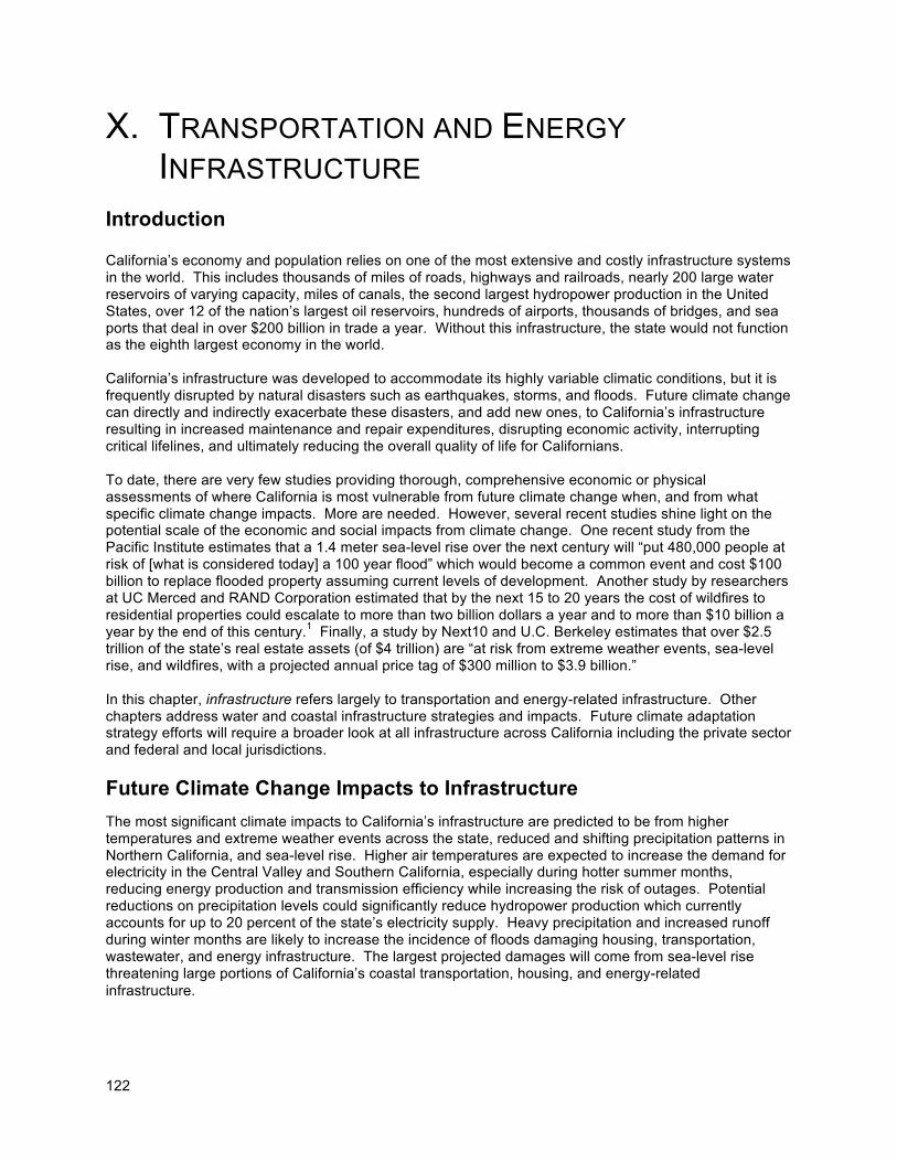
122
X. TRANSPORTATION AND ENERGY
INFRASTRUCTURE
Introduction California’s economy and population relies on one of the most extensive and costly infrastructure systems in the world. This includes thousands of miles of roads, highways and railroads, nearly 200 large water reservoirs of varying capacity, miles of canals, the second largest hydropower production in the United States, over 12 of the nation’s largest oil reservoirs, hundreds of airports, thousands of bridges, and sea ports that deal in over $200 billion in trade a year. Without this infrastructure, the state would not function as the eighth largest economy in the world. California’s infrastructure was developed to accommodate its highly variable climatic conditions, but it is frequently disrupted by natural disasters such as earthquakes, storms, and floods. Future climate change can directly and indirectly exacerbate these disasters, and add new ones, to California’s infrastructure resulting in increased maintenance and repair expenditures, disrupting economic activity, interrupting critical lifelines, and ultimately reducing the overall quality of life for Californians. To date, there are very few studies providing thorough, comprehensive economic or physical assessments of where California is most vulnerable from future climate change when, and from what specific climate change impacts. More are needed. However, several recent studies shine light on the potential scale of the economic and social impacts from climate change. One recent study from the Pacific Institute estimates that a 1.4 meter sea-level rise over the next century will “put 480,000 people at risk of [what is considered today] a 100 year flood” which would become a common event and cost $100 billion to replace flooded property assuming current levels of development. Another study by researchers at UC Merced and RAND Corporation estimated that by the next 15 to 20 years the cost of wildfires to residential properties could escalate to more than two billion dollars a year and to more than $10 billion a year by the end of this century.1 Finally, a study by Next10 and U.C. Berkeley estimates that over $2.5 trillion of the state’s real estate assets (of $4 trillion) are “at risk from extreme weather events, sea-level rise, and wildfires, with a projected annual price tag of $300 million to $3.9 billion.” In this chapter, infrastructure refers largely to transportation and energy-related infrastructure. Other chapters address water and coastal infrastructure strategies and impacts. Future climate adaptation strategy efforts will require a broader look at all infrastructure across California including the private sector and federal and local jurisdictions.
Future Climate Change Impacts to Infrastructure
The most significant climate impacts to California’s infrastructure are predicted to be from higher temperatures and extreme weather events across the state, reduced and shifting precipitation patterns in Northern California, and sea-level rise. Higher air temperatures are expected to increase the demand for electricity in the Central Valley and Southern California, especially during hotter summer months, reducing energy production and transmission efficiency while increasing the risk of outages. Potential reductions on precipitation levels could significantly reduce hydropower production which currently accounts for up to 20 percent of the state’s electricity supply. Heavy precipitation and increased runoff during winter months are likely to increase the incidence of floods damaging housing, transportation, wastewater, and energy infrastructure. The largest projected damages will come from sea-level rise threatening large portions of California’s coastal transportation, housing, and energy-related infrastructure.
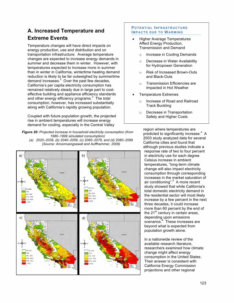
123
Figure 20: Projected increase in household electricity consumption (from 1980–1999 simulated consumption)
(a) 2020–2039, (b) 2040–2059, (c) 2060–2079, and (d) 2080–2099 (Source: Aroonruengsawat and Auffhammer, 2009)
A. Increased Temperature and Extreme Events Temperature changes will have direct impacts on energy production, use and distribution and on transportation infrastructure. Average temperature changes are expected to increase energy demands in summer and decrease them in winter. However, with temperatures expected to increase more in summer than in winter in California, wintertime heating demand reduction is likely to be far outweighed by summertime demand increases.2 Over the past few decades, California’s per capita electricity consumption has remained relatively steady due in large part to cost-effective building and appliance efficiency standards and other energy efficiency programs.3 The total consumption, however, has increased substantially along with California’s rapidly growing population. Coupled with future population growth, the projected rise in ambient temperatures will increase energy demand for cooling, especially in the Central Valley
region where temperatures are predicted to significantly increase.4 A 2003 study analyzed data for several California cities and found that although previous studies indicate a response rate of two to four percent in electricity use for each degree Celsius increase in ambient temperatures, “long-term climate change will also impact electricity consumption through corresponding increases in the market saturation of air conditioning”.5 A more recent study showed that while California's total domestic electricity demand in the residential sector will most likely increase by a few percent in the next three decades, it could increase more than 60 percent by the end of the 21st century in certain areas, depending upon emissions scenarios.6 These increases are beyond what is expected from population growth alone. In a nationwide review of the available research literature, researchers examined how climate change might affect energy consumption in the United States. Their answer is consistent with California Energy Commission projections and other regional
POTENTIAL INFRASTRUCTURE IMPACTS DUE TO WARMING
• Higher Average Temperatures Affect Energy Production, Transmission and Demand
o Increase in Cooling Demands
o Decrease in Water Availability for Hydropower Generation
o Risk of Increased Brown-Outs and Black-Outs
o Transmission Efficiencies are Impacted in Hot Weather
• Temperature Extremes
o Increase of Road and Railroad Track Buckling
o Decrease in Transportation Safety and Higher Costs
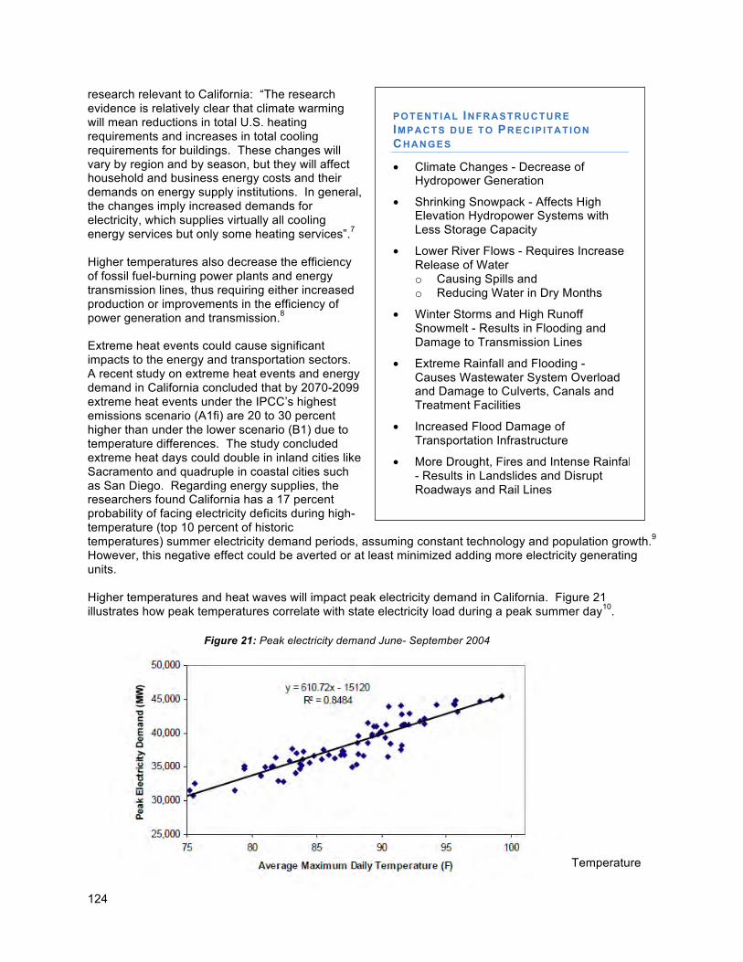
124
Figure 21: Peak electricity demand June- September 2004
research relevant to California: “The research evidence is relatively clear that climate warming will mean reductions in total U.S. heating requirements and increases in total cooling requirements for buildings. These changes will vary by region and by season, but they will affect household and business energy costs and their demands on energy supply institutions. In general, the changes imply increased demands for electricity, which supplies virtually all cooling energy services but only some heating services”.7 Higher temperatures also decrease the efficiency of fossil fuel-burning power plants and energy transmission lines, thus requiring either increased production or improvements in the efficiency of power generation and transmission.8 Extreme heat events could cause significant impacts to the energy and transportation sectors. A recent study on extreme heat events and energy demand in California concluded that by 2070-2099 extreme heat events under the IPCC’s highest emissions scenario (A1fi) are 20 to 30 percent higher than under the lower scenario (B1) due to temperature differences. The study concluded extreme heat days could double in inland cities like Sacramento and quadruple in coastal cities such as San Diego. Regarding energy supplies, the researchers found California has a 17 percent probability of facing electricity deficits during high-temperature (top 10 percent of historic temperatures) summer electricity demand periods, assuming constant technology and population growth.9 However, this negative effect could be averted or at least minimized adding more electricity generating units. Higher temperatures and heat waves will impact peak electricity demand in California. Figure 21 illustrates how peak temperatures correlate with state electricity load during a peak summer day10.
Temperature
POTENTIAL INFRASTRUCTURE
IMPACTS DUE TO PRECIP ITATION
CHANGES
• Climate Changes - Decrease of Hydropower Generation
• Shrinking Snowpack - Affects High Elevation Hydropower Systems with Less Storage Capacity
• Lower River Flows - Requires Increase Release of Water o Causing Spills and o Reducing Water in Dry Months
• Winter Storms and High Runoff Snowmelt - Results in Flooding and Damage to Transmission Lines
• Extreme Rainfall and Flooding - Causes Wastewater System Overload and Damage to Culverts, Canals and Treatment Facilities
• Increased Flood Damage of Transportation Infrastructure
• More Drought, Fires and Intense Rainfall - Results in Landslides and Disrupt Roadways and Rail Lines
125
extremes are also relevant to the transportation sector. It is expected less extreme cold days will reduce frost heave and road damage,11 but extreme hot days (including prolonged periods of very hot days), are likely to become more frequent, increasing the risk of buckling of highways and railroad tracks and premature deterioration or failure of transportation infrastructure (Figure 22).12
B. Precipitation Changes and Extreme Events Fluctuations, and possible total reductions, in California’s precipitation patterns will impact several key energy and transportation infrastructure components; primarily hydropower production and all manufacturing and processing operations requiring large volumes of readily available water. In addition, roads, tunnels, airport runways and railroad tracks are likely to be affected by changes in precipitation patterns. In the energy sector, changes in hydrological patterns will affect the reliability of the region’s hydropower generation, which accounts for 12 to 20 percent of the state’s total annual electricity generation. A warmer and drier future climate could reduce hydroelectric generation by 19 percent, whereas a wetter future climate could increase hydroelectric generation by 5 percent.13 Of the 12 climate projections used in the 2008 California Climate Impacts Assessment, only one simulation produced slightly wetter conditions by 2050, and none did so for the end of the century (see Water chapter). Hydropower production is a significant contributor of energy for electricity suppliers Pacific Gas and Electric Company (PG&E) and the Sacramento Municipal Utility District (SMUD) among many others. SMUD is particularly vulnerable, as hydropower can account for up to 50 percent of its annual power generation.14 The economic impact of climate change due to the loss in hydropower generation and the increase in electricity demand during late spring and summer is estimated to be approximately $2.7 billion annually in a lower-warming scenario and $6.3 billion annually in a high-warming scenario, with roughly $21 billion in energy assets at risk.15
Figure 22: Trains can derail due to extreme heat warping railroad tracks.
126
The extent to which climate change will actually affect hydropower generation in California depends both on how precipitation patterns and the amount of warming in different regions end up changing reservoir storage and the flexibility of the systems. Hydropower generation capacity in high-elevation systems peaks in the summer, whereas capacity in lower-elevation systems peaks in winter.16 A decreasing Sierra Nevada snowpack (due to a higher snowline and increased temperatures, making more precipitation fall as rain rather than as snow) will also reduce the amount of water available for hydropower generation during late spring and summer when energy demand is higher. The shrinking snowpack will particularly affect high-elevation hydropower systems (higher than 1,000 feet above sea level) that have less storage capacity. This type of system accounts for half of the state’s hydropower generation and relies on melting snowpack for operations.17 In addition, more winter precipitation falling as rain instead of snow will result in extreme flows that will require reservoir operators to release more water, causing undesired spills and retaining less water for the dry months.18
Winter storm activities, especially if coinciding with earlier snowmelt and high runoff, can cause flooding which, in turn, can cause damage to transmission lines and lead to power outages. Further research is needed in this area to determine the overall vulnerability of the power grid in coastal and delta areas subject to increased flooding in addition to what recommendations should be implemented. Lower-elevation hydropower units such as the Central Valley Project (CVP) and the State Water Project (SWP) are expected to generate less power under current climate scenarios, but also require less electricity to pump water to Central and Southern California. When the SWP and CVP power supply and power consumption estimates are combined, the water projects require more energy to operate than they generate. By the end of the century, the amount of supplemental power that the combined projects will need decreases by 500-600 GWh/yr.19 Both could see reductions in energy production of three percent by mid-century and 6 percent by end of the century.20 Changes in precipitation patterns can also be expected to affect other types of infrastructure. For example, sewers and wastewater treatment facilities could see growing strains as climate change proceeds. Expected changes in precipitation patterns include a continued risk of intense rainfall events and associated flooding, with the occasional greater-than-historical flooding events. Such extreme rainfall events and flooding can cause overloading of wastewater systems, as well as physical damage to culverts, canals, and water treatment facilities. Researchers and the California Department of Transportation also expect increased damage of transportation infrastructure as a result of flooding of tunnels, coastal highways, runways, and railways, and associated business interruptions. The combination of a generally drier climate in the future, which will increase the chance of drought and wildfires, and the occasional extreme downpour, is likely to cause more mud- and landslides which can disrupt major roadways and rail lines. The related debris impacts are historically well known to California, but if they become more frequent, will create greater costs for the state and require more frequent repair.21
C. Sea-Level Rise and Extreme Events
Accelerating sea-level rise is likely to cause some of the greatest impacts on California’s infrastructure, including vital lines of coastal transportation, possibly some of the power plants located along the coast, a densely developed urban landscape, wastewater treatment facilities, ports, airports, and any other lifelines. Port infrastructure and airports located near sea level are particularly vulnerable. The San Francisco Bay area for example, is home to three major airports – San Francisco, Oakland, and San Jose – which are all near sea level (Figure 23). Unless these exposed assets are raised and/or protected by seawalls, they will be inundated and will experience increasing flooding as storm surges reach higher and farther inland. Similarly vulnerable are California’s seaports, which account for 40 percent of total U.S. shipping volume22 and have extensive docking facilities at risk. The total value of at-risk air and seaport
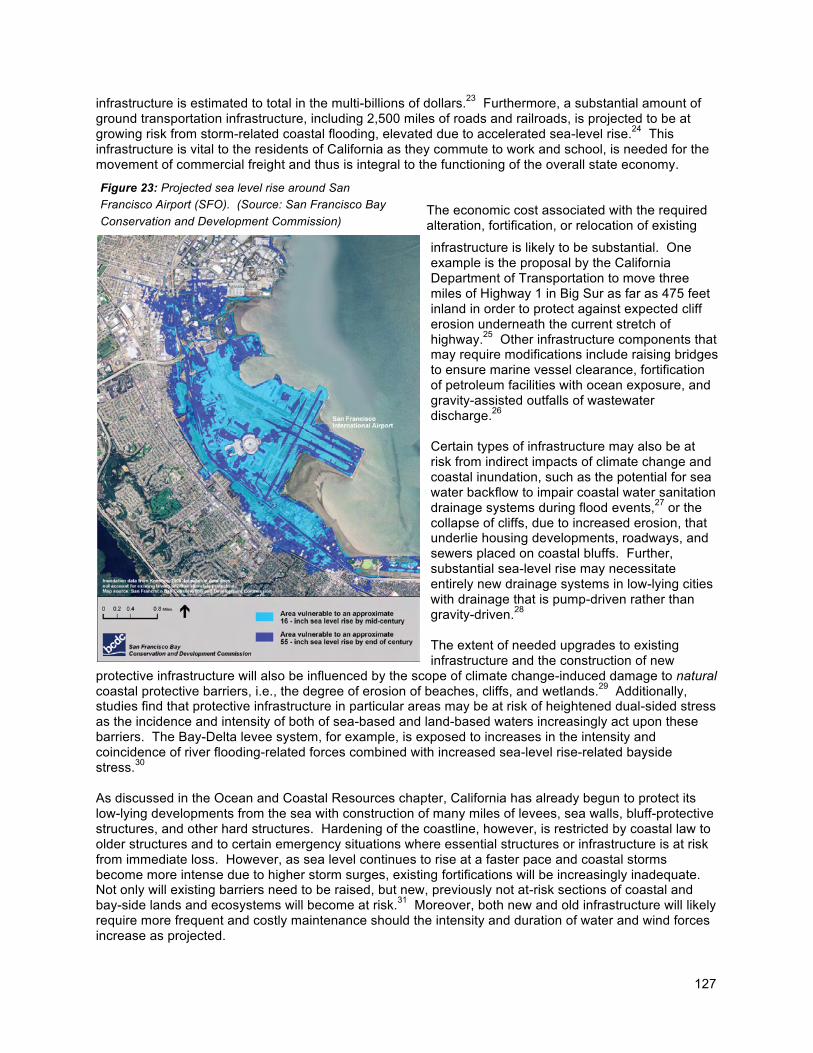
127
Figure 23: Projected sea level rise around San
Francisco Airport (SFO). (Source: San Francisco Bay
Conservation and Development Commission)
infrastructure is estimated to total in the multi-billions of dollars.23 Furthermore, a substantial amount of ground transportation infrastructure, including 2,500 miles of roads and railroads, is projected to be at growing risk from storm-related coastal flooding, elevated due to accelerated sea-level rise.24 This infrastructure is vital to the residents of California as they commute to work and school, is needed for the movement of commercial freight and thus is integral to the functioning of the overall state economy.
The economic cost associated with the required alteration, fortification, or relocation of existing
infrastructure is likely to be substantial. One example is the proposal by the California Department of Transportation to move three miles of Highway 1 in Big Sur as far as 475 feet inland in order to protect against expected cliff erosion underneath the current stretch of highway.25 Other infrastructure components that may require modifications include raising bridges to ensure marine vessel clearance, fortification of petroleum facilities with ocean exposure, and gravity-assisted outfalls of wastewater discharge.26 Certain types of infrastructure may also be at risk from indirect impacts of climate change and coastal inundation, such as the potential for sea water backflow to impair coastal water sanitation drainage systems during flood events,27 or the collapse of cliffs, due to increased erosion, that underlie housing developments, roadways, and sewers placed on coastal bluffs. Further, substantial sea-level rise may necessitate entirely new drainage systems in low-lying cities with drainage that is pump-driven rather than gravity-driven.28 The extent of needed upgrades to existing infrastructure and the construction of new
protective infrastructure will also be influenced by the scope of climate change-induced damage to natural coastal protective barriers, i.e., the degree of erosion of beaches, cliffs, and wetlands.29 Additionally, studies find that protective infrastructure in particular areas may be at risk of heightened dual-sided stress as the incidence and intensity of both of sea-based and land-based waters increasingly act upon these barriers. The Bay-Delta levee system, for example, is exposed to increases in the intensity and coincidence of river flooding-related forces combined with increased sea-level rise-related bayside stress.30 As discussed in the Ocean and Coastal Resources chapter, California has already begun to protect its low-lying developments from the sea with construction of many miles of levees, sea walls, bluff-protective structures, and other hard structures. Hardening of the coastline, however, is restricted by coastal law to older structures and to certain emergency situations where essential structures or infrastructure is at risk from immediate loss. However, as sea level continues to rise at a faster pace and coastal storms become more intense due to higher storm surges, existing fortifications will be increasingly inadequate. Not only will existing barriers need to be raised, but new, previously not at-risk sections of coastal and bay-side lands and ecosystems will become at risk.31 Moreover, both new and old infrastructure will likely require more frequent and costly maintenance should the intensity and duration of water and wind forces increase as projected.
128
One study conducted for the 2009 California Impacts Assessment found that about $100 billion in structures, contents, and infrastructure along the California coast and San Francisco Bay and Delta may be at risk of storm-related inundation by 2100 due to projected increases in mean sea level. This estimate may be conservative as population growth, development and any contribution to sea level from Greenland and West Antarctic ice sheet melting have not been included (see Chapter 3 on sea-level rise projections).32 Nearly 300,000 acres of Bay-Delta lands are already below sea level, sit upon continuously subsiding land and rely upon an aging levee system that was built upon soft peat soils.33 Furthermore, the amount of at-risk development in the Bay area, without accounting for any future development, could more than double from current levels by 2100.34 Costs associated with constructing the necessary fortifications of natural barriers and new protective infrastructures are likely to be substantial. A 2008 study estimating the cost of coastal protection structures necessary to safeguard existing development against rising sea levels found that 1,070 miles of new or upgraded protective levees and seawalls will be needed by 2100 to protect the Bay and open coastline against inundation under a scenario of ~5 feet (1.4 meter) sea-level rise.35 Such coastal protection could conservatively involve a capital cost of over $14 billion and will require ongoing maintenance, which may add an additional annual cost of 10 percent of the capital cost.36 These estimated costs, however, do not consider potential ecological impacts and unintended consequences or armoring coastal areas and legal restrictions for such actions. Therefore, actual adaptation costs could be much higher. The study also found that the burden of construction costs will be disproportionate along California’s coast, as Southern California will need the greatest investment, with 20 percent of the capital investment required in Los Angeles County alone.37 It would be necessary to fortify existing protective infrastructure by 0.1-0.2 feet per year for the next few decades in order to merely keep pace with rising waters and to maintain the same relative risk of flood-related inundation those lands have had in recent years.38
D. Changing Risks for Infrastructure
To summarize the changing risks that California’s transportation and energy infrastructure may be facing from climate change, the likelihood of occurrence of the projected consequences was qualitatively assessed. The resulting risk profile for California’s infrastructure can be characterized as follows:
• Higher average temperatures and higher summer peaks will greatly affect energy production, distribution (transmission), and demand with increased cooling demand likely to far outpace reductions in heating demand in the winter.
• Higher temperatures, together with a drying climate and less snowpack, will decrease the amount of water available for hydropower generation, especially high-elevation systems. In addition, transmission of electricity is less efficient during hotter periods, leading to electricity deficits especially during peak demand times. The risk of outages is likely to increase.
• Temperature extremes can increase the risk of road and railroad tracks buckling, decreasing transportation safety and creating higher maintenance costs.
POTENTIAL INFRASTRUCTURE IMPACTS DUE TO SEA-LEVEL R ISE
• Seaside Airports - Vulnerable to Storm-related Inundation
• Seaports and Docks - Inundation and Flooding (Impedes Business)
• Roads and Railroads - Risk of Storms and Coastal Flooding
• Sea-Level Rise and Coastal Surges Requires Increased Fortifications.
• Economic Costs of Fortifications or Relocation is Considerable
• Sea Water - Floods Can Damage Coastal Water Sanitation Systems Requiring Costly Upgrades
• Sea-Level Rise and river Flooding will Impact Bay-Delta Levee System
129
• More winter precipitation falling as rain instead of snow will result in extreme flows that will require reservoir operators to release more water, causing undesired spills and retaining less water for the dry months.
• Winter storms, especially if coinciding with earlier snowmelt and high runoff, can cause flooding and damage to transmission lines, overloading and damage of wastewater treatment facilities, as well as physical damage to culverts, canals, tunnels, coastal highways, runways, and railways, and associated business interruptions.
• More drought, fires and intense rainfall events will produce more mud- and landslides which can disrupt major roadways and rail lines.
Sea-level rise is likely to cause the greatest impacts on California’s infrastructure, including more frequent storm-related flooding of airports, seaports, roads, and railways in floodplains due to higher sea levels.
As sea level rises at a faster pace and coastal storm surges increase, existing fortifications will be increasingly inadequate and need to be raised, and areas previously not at-risk will become at risk.
• The economic cost associated with the required alteration, fortification, or relocation of existing infrastructure is likely to be in the tens of billions.
• Sea water backflow will impair coastal water sanitation drainage systems during flood events, requiring costly upgrades and alterations.
• The Bay-Delta levee system, for example, is exposed to increases in the intensity and coincidence of river flooding-related forces combined with increased sea-level rise-related bayside stress.
Infrastructure Adaptation Strategies
Introduction
The state agencies that participated in the Climate Adaptation Working Group (California Energy Commission and California Department of Transportation) developed the following strategies and are responsible for and will spearhead strategy implementation. Climate is already changing in California and its impacts are going to be felt in all sectors of the state’s economy. The impacts of climate change on infrastructure will vary at the local level, but it is certain they will be widespread and costly in human and economic terms, and will require significant changes in the planning, design, construction, operation, and maintenance of California’s infrastructure. Infrastructure adaptation strategies developed thus far pertain to two aspects of development: transportation and energy. Transportation routes and infrastructure will be dramatically affected by sea-level rise. Therefore, adaptation strategies focus on this effect of climate change. Adaptation plans will be developed for the long-term with estimations of future growth, demand, and vulnerability issues. A 50-year planning horizon will be used to parallel the time period of current model predictions. Predicted sea-level rise and storm surges will be guarded against by increasing the elevation of streets, bridges, and rail lines, while some at-risk sections of roads and rail lines will be relocated farther inland. Flood zones will be re-mapped to account for different sea-level rise projections. As a result of these updated maps, areas may be identified that will need to be returned to a natural state. Energy infrastructure will be tested by higher temperatures and intense storm events. Adaptation strategies reflect the “loading order,” a state energy policy which calls for meeting new electricity needs first with energy efficiency and demand response; second, with new generation from renewable energy

130
and distributed generation resources; and third, with clean fossil-fueled generation and transmission infrastructure improvements.. These programs will promote the use of more efficient air conditioning equipment and lighting systems. They will work to increase the level of insulation (ceiling, floor and walls) and window glazing used in new and existing homes. The planting of trees will be used to shade homes and buildings, and the use of roof materials that reflect the heat to reduce the “heat island effect” will be promoted in new construction. Energy strategies such as smart grid technologies also aim to improve the ability of the electricity system to respond to peak demands. Additionally, they will implement modern techniques for the integrated management of water reservoirs in Northern California to improve their management, and include information regarding changing hydrological patterns in that management. Encouraging the development of distributed and centralized renewable resources will also help the state meet increased energy demand due to climate change. Opportunities to expand renewable distributed generation resources include increased use of solar, biomass (including biomass that is currently being landfilled), and biogas from wastewater treatment plants. Further development of centralized renewable resources is also needed to help meet expected energy demand due to climate change and care will be needed to ensure that associated transmission is developed in the least environmentally sensitive areas. Renewable development needs to be advanced throughout California, including on state, federal, and tribal lands. Further work is needed to assess the impacts of climate change on existing and planned energy infrastructure and to identify the most vulnerable communities. In addition, the Energy Commission and other responsible planning authorities should assess potential impacts of climate change on species and habitat needs, including movement patterns, when developing natural community conservation plans and other mitigation measures for new power plants. The impacts of climate change on California’s infrastructure are varied and far-reaching. Infrastructure adaptations to climate change will be costly, but it will be more expensive if the state does not begin planning and adapting before the predicted changes alter the physical landscape. California’s infrastructure is the conduit through which economic activity flows. The production and movement of goods and services relies on existing infrastructure. Disruption of these deliveries will be detrimental to California’s economy. Protection of infrastructure will help ensure California’s future as a leading economic player.
Adaptation Strategies and Actions The California Energy Commission (Energy Commission) and the California Department of Transportation (CalTrans) have identified the following priorities in addressing climate adaptation for California state agencies. The near term actions referenced below are those actions that have been identified and which can be initiated or completed by 2010. The long term actions include those recommended actions that will require support from that state, and collaboration with multiple state agencies.
Climate is already changing in California and its impacts are going to be felt in all sectors of the state’s economy. The impacts of climate change on infrastructure will vary at the local level, but it is certain they will be widespread and costly in human and economic terms, and will require significant changes in the planning, design, construction, operation, and maintenance of California’s infrastructure. Infrastructure adaptation strategies developed thus far pertain to two aspects of development: energy and transportation.
131
Strategy 1 – ENERGY: Increase Energy Efficiency Efforts in Climate Vulnerable Areas
Near -Term and Long-Term Actions: a. Meet the Energy Efficiency Goals Outlined in AB32 Scoping Plan – The Air Resources
Board’s (ARB) Scoping Plan has identified 26.3 MMTCO2e that will be reduced by 2020 through increased use of building and appliance efficiency standards, increased combined heat and power generation and through increased solar water heating improvements (AB1470). Ensuring these measures are met, while increasing these efforts over time, will help ease projected energy demand increases and possible supply disruptions from climate change.
b. Facilitate Access to Local, Decentralized Renewable Resources – The Energy Commission should consider policies and incentives to maximize and to encourage de-centralized (local and near demand) generation and on-site renewable energy generation systems where feasible and appropriate. This deployment of additional renewable generation would reduce GHG emissions and help meet the expected increase in electrical demand due to climate change.
Strategy 2 – ENERGY: Assess environmental impacts from climate change in siting and re-licensing of new energy facilities.
Near -Term and Long-Term Actions:
a. Assess Power Plants Vulnerable to Climate Impacts, and Recommend Reasonable Adaptation Measures – The Energy Commission will assess GHG impacts for power plant siting cases through its Integrated Energy Policy Report, and consider the potential impact of sea-level rise, temperature increases, precipitation changes and extreme events, where relevant.
b. Encourage Expansion of Renewable Energy Resources – The Energy Commission should assess long-term benefits of renewable energy generation in reducing GHG emissions that also provide environmental co-benefits. The state shall encourage additional development of the most suitable and efficient renewable technologies to maximize the amount of electrical generation from renewable sources. The Energy Commission and DFG should encourage renewable energy generation in the least sensitive environmental areas to maintain natural habitats and healthy forests that will further buffer the environmental impacts of climate change.
c. Assess the Impacts of Climate Change on Energy Infrastructure – Use the Energy Commission’s PIER regional climate modeling and related study efforts to assess the potential impacts of climate change on energy infrastructure from sea-level rise, precipitation, and temperature changes and other impacts. The Energy Commission will determine additional actions on its siting and planning programs based on this work.
d. Identify the Most Vulnerable Communities – Develop an energy-use “hot-spot” map to identify areas in the state where increases in temperature, population, and energy-use will make communities most vulnerable to climate change impacts. The Energy Commission will include in this analysis how the lowest-income communities in hot spot areas will be impacted. Also, assess impacts of climate change on tribal lands and ability of tribes to adapt to changing conditions.
132
Strategy 3 – ENERGY: Develop Hydropower Decision-Support Tools to Better Assess and Manage Climate Change Variability
Near -Term and Long-Term Actions:
a. Expand Scientific Climate Research – The Energy Commission and the DWR will continue to support and develop enhancements and demonstration of modern decision support systems for the management of existing major water reservoirs in California to adapt to current levels of climate variability and increase our resilience to increased levels of climate variability and change in the future.
b. Public Interest Energy Research – The Energy Commission’s PIER program will sponsor research on climate change factors influencing hydropower generation – for example, how hydropower generation would be affected by requirements to release additional water to attenuate increased water temperatures in rivers and streams for environmental purposes.
c. Develop Partnerships –Partner with hydropower generators particularly vulnerable to climate change to identify how public-private partnerships could reduce long-term risks to hydropower generation.
Strategy 4 – ENERGY: Identify how state renewable energy goals could be impacted from future climate impacts.
Near -Term and Long-Term Actions:
a. Assess Climate Impacts on Energy – The Energy Commission’s PIER program will research how climate change impacts could influence the goals of AB32, AB118, and EO S-13-08 goals. For example, climate change will influence wind speeds and patterns, temperature density, etc. that will affect power levels from wind turbines, photovoltaics, etc. In addition, biomass feedstocks could be reduced due to decreased water levels and increased wildfire. It is unclear how this will impact long-term projections for meeting our 2020 and 2050 renewable energy goals.
The near term actions referenced below are those actions that have been identified and which can be initiated by 2010, subject to availability of necessary information to ensure credibility of the analysis and authority of the information, and will require collaboration with multiple state, regional and local agencies as well as adequate funding. The climate impact data serving as the basis of these actions will stem from ongoing research undertaken by the PIER program, and centralized through the CAT. The long term actions include those recommended actions that will require support from the state and collaboration with multiple state, regional, and local agencies. Strategy 5 – TRANSPORTATION: Develop a detailed climate vulnerability assessment and adaptation plan for California’s transportation infrastructure.
Near -Term and Long-Term Actions:
a. Vulnerability and Adaptation Planning – BTH (Business, Transportation and Housing Agency)
and CALTRANS will develop a climate vulnerability plan that will assess how California’s transportation infrastructure facilities are vulnerable to future climate impacts, assess climate adaptation options, prioritize for implementation, and select adaptation strategies to adopt in coordination with stakeholders. This plan will be coordinated with an updated climate mitigation plan that will act as BTH’s and Caltrans’ overall transportation climate policy.
133
i. Develop a transportation use “hot-spot” map – Caltrans will research and identify transportation “hot spots”, using updated NAS and other appropriate study efforts, to identify across the state where the mixture of climate change impacts, population increases, and transportation demand increases will make communities most vulnerable to climate change impacts. Caltrans will include in this analysis how the lowest-income communities in hot spot areas will be impacted.
b. Economic Impacts Assessment – Complete an overall economic assessment for projected climate impacts on the state’s transportation system and other related infrastructure along transportation corridors as appropriate under a ”do nothing” scenario and under climate policy scenarios identified by BTH/Caltrans.
i. Prepare a list of transportation adaptation strategies or measures based on the “hot spot” map and prepare an economic assessment and cost-benefit analysis for these strategies vs. a do nothing scenario.
Strategy 6 – TRANSPORTATION: Incorporate climate change vulnerability assessment planning tools, policies, and strategies into existing transportation and investment decisions.
Near -Term and Long-Term Actions:
a. Integrate Mitigation and Adaptation System-wide –Caltrans will develop and incorporate climate change mitigation and adaptation policies and strategies throughout state strategic, system and regional planning efforts. These will be included in key phases of the following planning and project development phases when appropriate:
i. Strategic Planning (Governor’s Strategic Growth Plan and California Transportation Plan)
ii. System Planning (i.e., District System Management Plan, Inter-regional Strategic Plan, Corridor System Management Plan, and Transportation Concept Report)
iii. Regional Transportation Planning (Regional Transportation Plan Guidelines and Regional Blueprint Planning)
iv. Project planning (Project Development Procedures Manual, Project Initiation Document, Project Report, Design and engineering standards, Environmental Guidelines)
v. Programming (State Transportation Improvement Program, State Highway Operations and Protection Program, California Transportation Commission State Transportation Improvement Program Guidelines)
Strategy 7 – TRANSPORTATION: Develop transportation design and engineering standards to minimize climate change risks to vulnerable transportation infrastructure.
Near-Term and Long Term Actions:
a. Transportation Infrastructure Assessment - Caltrans will assess existing transportation design standards as to their adequacy to withstand climate forces from sea level rise and extreme weather events beyond those considered.
b. Buffer Zone Guidelines - Develop guidelines to establish buffer areas and set backs to avoid risks to structures within projected “high” future sea level rise or flooding inundation zones.
c. Stormwater Quality - Assess how climate changes could alter size and design requirements for stormwater quality BMP’s.
134
Strategy 8 – TRANSPORTATION: Incorporate climate change impact considerations into disaster preparedness planning for all transportation modes.
Near -Term and Long Term Actions:
a. Emergency Preparedness – CALTRANS provides significant emergency preparedness abilities for all transportation modes across the state. The transportation system is sensitive to rapid increases in precipitation, storm severity, wave run-up and other extreme weather events. CALTRANS will assess the type of climate-induced impact information necessary to respond to district emergencies. Results will be incorporated into existing operations management plans.
b. Decision Support – CALTRANS will identify how climate impact information can be integrated
into existing Intelligent Transportation Systems and Transportation Management Center operations.
135
Appendix A: Acknowledgements This Strategy was prepared by the California Natural Resources Agency. Tony Brunello led the overall strategy development, and Kurt Malchow managed the completion of the overall report for CNRA. This
document was made possible by the hard work of numerous contributors. Below is a list of State agencies, organizations, individuals and events that directly provided input to this Strategy.
Climate Adaptation Working Group: • Public Health • Biodiversity and Habitat
• Oceans and Coastal Resources • Water Management
• Agriculture • Forestry
• Transportation and Energy Infrastructure
Climate Action Team
State Agencies: Governor’s Office of Planning and Research California Coastal Commission California Coastal Conservancy
California Environmental Protection Agency California Ocean Science Trust
Bay Conservation and Development Commission Business, Transportation and Housing Agency
Department of Food and Agriculture California Energy Commission
California Department of Conservation California Department of Forestry and Fire Protection (CalFIRE)
California Department of Fish and Game California Department of Parks and Recreation
California Department of Public Health California Department of Transportation
California Department of Water Resources NOAA Coastal Services Center
Ocean Protection Council State Lands Commission
State Water Resources Control Board
136
Organizations and individuals: Science Applications International Corporation: • Steven Messner
• Vanessa Emerzian • Jette Findsen
• Michael Mondshine Suzanne Moser, Independent consultant
ICLEI, Local Governments for Sustainability Sara S. Moore, UC Berkeley Goldman School of Public Policy
Science and Policy Review Panel: • Jay Lund, University of California, Davis
• Gary Rynearson, Green Diamond Resource Co. • Max Moritz, University of California, Berkeley
• Louise Bedsworth, Public Policy Institute of California • Steven Schneider, Stanford University
• Gary Griggs, University of California, Santa Cruz • Greg San Martin, Pacific Gas and Electric Co.
• Guido Franco, California Energy Commission • Louise Jackson, University of California, Davis
• Michael Mastrandrea, Stanford University • Samuel Johnson, U.S. Geological Survey
• Dan Cayan, Scripps Institute of Oceanography
Public Meetings: Stakeholder meetings on draft sector strategies: September – December, 2008 Sacramento public stakeholder meeting on CAS Discussion Draft: August 13, 2009 Los Angeles public stakeholder meeting on CAS Discussion Draft: August 31, 2009
137
Appendix B: Governor’s Executive Order
EXECUTIVE ORDER S-13-08
by the Governor of the State of California WHEREAS climate change in California during the next century is expected to shift precipitation patterns, accelerate sea level rise and increase temperatures, thereby posing a serious threat to California's economy, to the health and welfare of its population and to its natural resources; and WHEREAS California is a leader in mitigating and reducing its greenhouse gas emissions with the 2006 Global Warming Solutions Act (Assembly Bill 32), the Low Carbon Fuel Standard (Executive Order S-01-07), the 2008 Senate Bill 375 and the Renewable Portfolio Standard; and WHEREAS these efforts, coupled with others around the world, will slow, but not stop all long-term climate impacts to California; and WHEREAS California must begin now to adapt and build our resiliency to coming climate changes through a thoughtful and sensible approach with local, regional, state and federal government using the best available science; and WHEREAS there is a need for statewide consistency in planning for sea level rise; and WHEREAS California's water supply and coastal resources, including valuable natural habitat areas, are particularly vulnerable to sea level rise over the next century and could suffer devastating consequences if adaptive measures are not taken; and WHEREAS the country's longest continuously operating gauge of sea level, at Fort Point in San Francisco Bay, recorded a seven-inch rise in sea level over the 20th century thereby demonstrating the vulnerability of infrastructure and resources within the Bay; and WHEREAS global sea level rise for the next century is projected to rise faster than historical levels with the Intergovernmental Panel on Climate Change predicting that global sea levels will rise by between seven to 23 inches this century and some experts predicting even higher rises; and WHEREAS while climate models predicting global sea level rise are generally understood and improving, less information is available for sea level rise projections specific to California that accounts for California's topography, coastal erosion rates, varying land subsidence levels and tidal variations; and WHEREAS billions of dollars in state funding for infrastructure and resource management projects are currently being encumbered in areas that are potentially vulnerable to future sea level rise; and WHEREAS safety, maintenance and operational efforts on existing infrastructure projects are critical to public safety and the economy of the state; and WHEREAS the longer that California delays planning and adapting to sea level rise the more expensive and difficult adaptation will be; and WHEREAS the California Resources Agency is a member of the California Climate Action Team and is leading efforts to develop and implement policy solutions related to climate change adaptation regarding current and projected effects of climate change; and WHEREAS the Department of Water Resources (DWR) is responsible for managing the state's water resources to benefit the people of California, and to protect, restore and enhance the natural and human environments; and
138
WHEREAS California's coastal management agencies such as the California Coastal Commission, the California Ocean Protection Council (OPC) and California State Parks are charged with managing and protecting the ocean and coastal resources of the state; and WHEREAS the California Energy Commission's (CEC) Public Interest Energy Research Program has funded research on climate change since 2001 including funding the development of preliminary sea level rise projections for the San Francisco Bay area by the Scripps Institution of Oceanography/University of California at San Diego. NOW, THEREFORE, I, ARNOLD SCHWARZENEGGER, Governor of the State of California, by virtue of the power vested in me by the Constitution and statutes of the State of California, do hereby order effective immediately: 1. The California Resources Agency, in cooperation with DWR, CEC, California's coastal management agencies, and the OPC, shall request that the National Academy of Sciences (NAS) convene an independent panel to complete the first California Sea Level Rise Assessment Report and initiate, within 60 days after the signing of this Order, an independent sea level rise science and policy committee made up of state, national and international experts. 2. By March 31, 2009, the OPC, DWR and the CEC, in coordination with other state agencies, shall hold a public workshop to gather policy-relevant information specific to California for use in preparing the Sea Level Rise Assessment Report and to raise state awareness of sea level rise impacts. 3. The California Resources Agency shall request that the final Sea Level Rise Assessment Report be completed as soon as possible but no later than December 1, 2010. The final Sea Level Rise Assessment Report will advise how California should plan for future sea level rise. The report should include: (1) relative sea level rise projections specific to California, taking into account issues such as coastal erosion rates, tidal impacts, El Niño and La Niña events, storm surge and land subsidence rates; (2) the range of uncertainty in selected sea level rise projections; (3) a synthesis of existing information on projected sea level rise impacts to state infrastructure (such as roads, public facilities and beaches), natural areas, and coastal and marine ecosystems; and (4) a discussion of future research needs regarding sea level rise for California. 4. The OPC shall work with DWR, the CEC, California's coastal management agencies and the State Water Resources Control Board to conduct a review of the NAS assessment every two years or as necessary. 5. I direct that, prior to release of the final Sea Level Rise Assessment Report from the NAS, all state agencies within my administration that are planning construction projects in areas vulnerable to future sea level rise shall, for the purposes of planning, consider a range of sea level rise scenarios for the years 2050 and 2100 in order to assess project vulnerability and, to the extent feasible, reduce expected risks and increase resiliency to sea level rise. However, all projects that have filed a Notice of Preparation, and/or are programmed for construction funding the next five years, or are routine maintenance projects as of the date of this Order may, but are not required to, account for these planning guidelines. Sea level rise estimates should also be used in conjunction with appropriate local information regarding local uplift and subsidence, coastal erosion rates, predicted higher high water levels, storm surge and storm wave data. 6. The Business, Transportation, and Housing Agency shall work with the California Resources Agency and the Governor's Office of Planning and Research (OPR) to prepare a report within 90 days of release of this Order to assess vulnerability of transportation systems to sea level rise that will include provisions for investment critical to safety, maintenance and operational improvements of the system and economy of the state.
139
7. By June 30, 2009, the California Resources Agency, through the Climate Action Team, shall coordinate with local, regional, state and federal public and private entities to develop a state Climate Adaptation Strategy. The strategy will summarize the best known science on climate change impacts to California (led by CEC's PIER program), assess California's vulnerability to the identified impacts and then outline solutions that can be implemented within and across state agencies to promote resiliency. A water adaptation strategy will be coordinated by DWR with input from the State Water Resources Control Board, an ocean and coastal resources adaptation strategy will be coordinated by the OPC, an infrastructure adaptation strategy will be coordinated by the California Department of Transportation, a biodiversity adaptation strategy will be jointly coordinated by the California Department of Fish and Game and California State Parks, a working landscapes adaptation strategy will be jointly coordinated by the California Department of Forestry and Fire Protection and the California Department of Food and Agriculture, and a public health adaptation strategy will be jointly coordinated by the California Department of Public Health and the California Air Resources Board, all as part of the larger strategy. This strategy will be facilitated through the Climate Action Team and will be coordinated with California's climate change mitigation efforts. 8. By May 30, 2009, OPR, in cooperation with the California Resources Agency, shall provide state land-use planning guidance related to sea level rise and other climate change impacts. This Order is not intended to, and does not, create any rights or benefits, substantive or procedural, enforceable at law or in equity, against the State of California, its agencies, departments, entities, officers, employees, or any other person. I FURTHER DIRECT that as soon as hereafter possible, this Order shall be filed with the Office of the Secretary of State and that widespread publicity and notice be given to this Order. IN WITNESS WHEREOF I have hereunto set my hand and caused the Great Seal of the State of California to be affixed this 14th day of November 2008. ARNOLD SCHWARZENEGGER Governor of California
140
Appendix C: Glossary Key Climate Change Adaptation Concepts and Terms
The following terms were collected from the Intergovernmental Panel on Climate Change Third Assessment Report (2001), unless otherwise noted.
Adaptation – Adjustment in natural or human systems in response to actual or expected climatic stimuli
or their effects, which minimizes harm or takes advantage of beneficial opportunities.
Adaptation Assessment – The practice of identifying options to adapt to climate change and evaluating
them in terms of criteria such as availability, benefits, costs, effectiveness, efficiency, and feasibility.
Adaptation Benefits – The avoided damages (measured in monetary terms or otherwise) or the accrued benefits following the adoption and implementation of adaptation measures.
Adaptation Costs – Costs of planning, preparing for, facilitating, and implementing adaptation measures,
including transition costs and unavoidable negative side effects.
Adaptive Capacity – The ability of a system to respond to climate change (including climate variability
and extremes), to moderate potential damages, to take advantage of opportunities, and to cope with the consequences.3
Adaptation Policy Framework – is a structural process for developing adaptation strategies, policies,
and measures to enhance and ensure human development in the face of climate change, including climate variability. It consists of five basic components: assessing current vulnerability, characterizing
future climate risks, developing an adaptation strategy, scoping and designing individual adaptation projects to implement the strategy, monitoring results, adjustments, and continuing the adaptation
process.4
Baseline/Reference – The baseline (or reference) is any datum against which change is measured. It
might be a “current baseline,” in which case it represents observable, present-day conditions. It might also be a “future baseline”, which is a projected future set of conditions excluding the driving factor of
interest (e.g., how would a sector evolve without climate warming). It is critical to be aware of what change is measured against which baseline to ensure proper interpretation. Alternative interpretations of
the reference conditions can give rise to multiple baselines.6
Climate Change – Climate change refers to any long-term change in average climate conditions in a place or region, whether due to natural causes or as a result of human activity.
(Climate) Impacts Assessment – The practice of identifying and evaluating the detrimental and
beneficial consequences of climate change on natural and human systems.
(Climate Change) Impacts – Consequences of climate change on natural and human systems.
Depending on the consideration of adaptation, one can distinguish between potential impacts and residual impacts.
Climate Variability – Climate variability refers to variations in the mean state of the climate and other
statistics (such as standard deviations, the occurrence of extremes, etc.) on all temporal and spatial scales beyond that of individual weather events.
141
Co-benefits – The benefits of policies that are implemented for various reasons at the same time—including climate change mitigation—acknowledging that most policies designed to address greenhouse
gas mitigation also have other, often at least equally important, rationales (e.g., related to objectives of development, sustainability, and equity).
Impact – An effect of climate change on the structure or function of a system.2
Integrated Assessment – A method of analysis that combines results and models from the physical,
biological, economic, and social sciences, and the interactions between these components, in a consistent framework to evaluate the status and the consequences of environmental change and the
policy responses to it.
Mitigation – A human intervention to reduce the sources or improve the uptake (sinks) of greenhouse
gases.
No-regrets policy – A policy that would generate net social benefits whether or not there is climate change.
Policies and Measures – Usually addressed together, respond to the need for climate adaptation in
distinct, but sometimes overlapping ways. Policies, generally speaking, refer to objectives, together with the means of implementation. Measures can be individual interventions or they consist of packages of
related measures.4
Potential Impacts – All impacts that may occur given a projected change in climate, without considering
adaptation.
Residual Impacts –The impacts of climate change that would occur after adaptation.
Resilience – The ability of a system to absorb some amount of change, including shocks from extreme events, bounce back and recover from them, and, if necessary, transform itself in order to continue to be
able to function and provide essential services and amenities that it has evolved or been designed to provide.*
*It is important to note that resilience, as the term applies to ecosystems, is being used as a way to measure a systems ability to recover from stress or disturbance without undergoing a fundamental
change in process or structure with the recognition that climate change will likely not allow for the return to a pre-existing equilibrium as the definition of resilience implies7.
Risk (climate-related) – is the possibility of interaction of physically defined hazards with the exposed
systems. Risk is commonly considered to be the combination of the likelihood of an event and its consequences – i.e., risk equals the probability of climate hazard occurring multiplied the consequences a
given system may experience.4
Sensitivity – The degree to which a system is affected, either adversely or beneficially, by climate-related stimuli. The effect may be direct (e.g., a change in crop yield in response to a change in the mean, range,
or variability of temperature) or indirect (e.g., climatic or non-climatic stressors may cause people to be more sensitive to additional extreme conditions from climate change than they would be in the absence of these stressors).
System – A human population or ecosystem; or a group of natural resources, species, infrastructure, or
other assets.
142
Vulnerability – In the most general sense, a susceptibility to harm or change. More specifically, the degree to which a system is exposed to, susceptible to, and unable to cope with, the adverse effects of
climate change, including climate variability and extremes. Vulnerability is a function of the character, magnitude, and rate of climate variation to which a system is exposed, as well as of non-climatic
characteristics of the system, including its sensitivity, and its coping and adaptive capacity.
Vulnerability Assessment – A practice that identifies who and what is exposed and sensitive to change and how able a given system is to cope with extremes and change. A vulnerability assessment considers
the factors that expose and make people or the environment susceptible to harm and accesses to natural and financial resources available to cope and adapt, including the ability to self-protect, external coping
mechanisms, support networks, and so on.5
References:
1. IPCC. 2001. Glossary of Terms. In: Climate Change 2001: Impacts, Adaptation and Vulnerability. IPCC Third Assessment Report, Cambridge University Press, Cambridge, United Kingdom and New York, NY, USA.
2. Pew Center on Global Climate Change. Glossary of Terms. 2007. In: Climate Change 101: Understanding and Responding to Global Climate Change, published by the Pew Center on Global Climate Change and the Pew Center on the States.
3. UK CIP (2003). Climate Adaptation: Risk, Uncertainty and Decision-making. UKCIP Technical Report, Oxford, Willows, R. I. and R. K. Cornell (eds.)
4. UNDP (2005). Adaptation Policy Frameworks for Climate Change. Developing Strategies, Policies and Measures, Ed. Bo Lim, Erika Spanger-Siegfried, Co-authors Ian Burton, Elizabeth Malone, Saleemul Huq
5. E.Tompkins et al. (2005). Surviving Climate Change in Small Islands – A Guidebook, Tyndall center for Climate Change Research, UK
6. Moser, Susanne C. (2008). Resilience in the Face of Global Environmental Change. CARRI Research Paper No. 2, prepared for Oak Ridge National Laboratory, Community and Regional Resilience Initiative (CARRI), Oak Ridge, TN.
7. Stuart L. Pimm, The Balance of Nature, Ecological Issues in the Conservation of Species and Communities, 1991.
143
Appendix D: Acronyms Acronyms used in the California Climate Adaptation Strategy
ACE - Areas of Conservation Emphasis (defined by the Department of Fish and Game)
ARB - Air Resources Board
BLM - Bureau of Land Management
BIA - Bureau of Indian Affairs
BMPs - Best Management Practices
BOF - Board of Forestry and Fire Protection
BTH - Business, Transportation and Housing Agency
CalEMA - California Emergency Management Agency
Cal/EPA - California Environmental Protection Agency
Cal/Fire, CAL FIRE - California Department of Forestry and Fire Protection
Cal-REDIE - California Reportable Disease Information Exchange
CalTrans - California Department of Transportation
CALVIN - California Value Integrated Network
CAS - California Climate Adaptation Strategy
CAT - Climate Action Team
CAWGS - Climate Adaptation Working Groups
CBC - California Biomass Collaborative
CCAPA - California Chapter of the American Planning Association CCVA- California Climate Vulnerability Assessment
CCVA - California Climate Vulnerability Assessment
CDFA - California Department of Food and Agriculture
CDPH - California Department of Public Health
CEC - California Energy Commission
CERES - California Environmental Resources Evaluation System
CEQA - California Environmental Quality Act
CFIP - California Forest Improvement Program
CIMIS - California Irrigation Management Information System
CISC - California Invasive Species Council
CNRA - California Natural Resources Agency
COGs - Councils of Government
144
CSMP - Corridor System Management Plan
CTC STIP guidelines - California Transportation Commission State Transportation Improvement Program guidelines
CVP - Central Valley Project
DFG - Department of Fish and Game
DOC - Department of Conservation
DPR - Department of Parks and Recreation
DSMP - District System Management Plan
DWR - Department of Water Resources
EIR - Environmental Impact Report
ENSO - El Niño Southern Oscillation
EO - Executive Order
EPA - Environmental Protection Agency
EWMPs - Efficient Water Management Practices
FEMA - Federal Emergency Management Agency
FRAP - Fire and Resource Assessment Program
GHG - Green House Gases
ICLEI - Local Governments for Sustainability
IPCC - Intergovernmental Panel on Climate Change
IRWM - Integrated Regional Water Management
ITSP - Interregional Transportation Strategic Plan
JOC - Joint Operations Center
LCP - Local Coastal Plan
MPOs - Metropolitan Planning Organizations
NAS - National Academy of Science
NFIP - National Flood Insurance Program
NFW - National Fish and Wildlife Foundation
NGO - Non-Governmental Organizations
NPS - National Park Service
NRC - National Research Council
NRCS - Natural Resource Conservation Service
OPC - Ocean Protection Council
OPR - Governor’s Office of Planning and Research
PDPM - Project Development Procedures Manual
145
PID - Project Initiation Document
PIER - Public Interest Environmental Research Program (run through the California Energy Commission)
PR - Project Report
RCD - Resource Conservation District
RPS - Renewable Portfolio Standard
SEMS - Standardized Emergency Management System
SFM - State Fire Marshall
SG - Strategic Growth Council
SHOPP - State Highway Operations and Protection Program
SMUD - Sacramento Municipal Utility District
STIP - State Transportation Improvement Program
SWRCB - State Water Resources Control Board
SWP - State Water Project
TCR - Transportation Concept Report
TNC - The Nature Conservancy
TPZ - Timberland Production Zone, UC- University of California
UCCE - University of California Cooperative Extension
USDA - United States Department of Agriculture
USFS - United States Forest Service
USGS - United States Geological Survey
WCB - Wildlife Conservation Board
WebCMR - Web Portal for the Confidential Morbidity Report
WIC - Women, Infants, and Children Nutrition Program
WNV - West Nile Virus
WUI - Wildland Urban Interface

146
APPENDIX E: TABLE OF SHORT TERM CLIMATE
ADAPTATION STRATEGIES
Adaptation Sectors
Strategy Short-term strategies to complete by November
2010 Responsible
Agencies
a. Establish a framework for promoting collaboration within and among state agencies to implement climate change adaptation strategies. Three different levels of coordination will be established to promote comprehensive state adaptation planning. First, individual agencies are responsible for implementing the short-term climate adaptation strategies identified in this report. Second, the CNRA will be responsible for monitoring overall progress on implementing adaptation measures in this report and to develop cross-sector strategies. Finally, the CAT will monitor progress on climate adaptation measures through the CNRA and will coordinate state integration of mitigation and adaptation measures within the CAT working groups.
Cross- Sector
Strategy 1) Promote Comprehensive State Agency Adaptation Planning
b. Develop a Climate Adaptation Advisory Panel (CAAP) made up of world class science, business and government leaders to recommend improved opportunities for collaboration across state government on climate adaptation. The CAAP will also identify climate adaptation strategies outside the scope of California’s climate adaptation strategy that identify near term priority strategies that will reduce California’s vulnerability to climate change in the shortest time at the lowest long-term cost.
CNRA, CAT
a. Revise Section 15126.2 of the CEQA guidelines to direct lead agencies to evaluate the impacts of locating development in areas susceptible to hazardous conditions, including hazards potentially exacerbated by climate change.
Cross- Sector
Strategy 2) Integrate Land Use Planning and Climate Adaptation Planning
b. Incorporate climate adaptation considerations into the Strategic Growth Council and Sustainable Community Strategy processes to ensure incentives are provided to communities that are most vulnerable and are preparing for climate change impacts.
CNRA, CAT
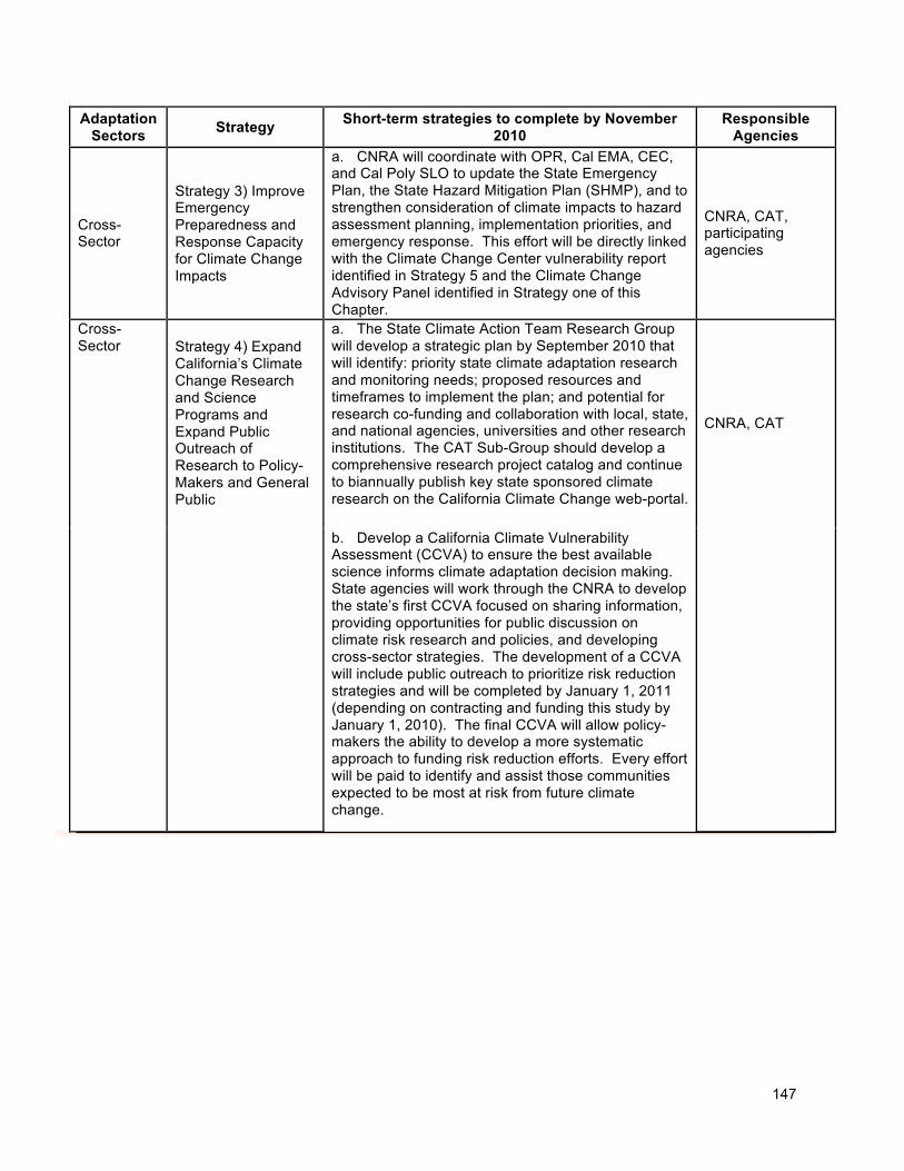
147
Adaptation Sectors
Strategy Short-term strategies to complete by November
2010 Responsible
Agencies
Cross- Sector
Strategy 3) Improve Emergency Preparedness and Response Capacity for Climate Change Impacts
a. CNRA will coordinate with OPR, Cal EMA, CEC, and Cal Poly SLO to update the State Emergency Plan, the State Hazard Mitigation Plan (SHMP), and to strengthen consideration of climate impacts to hazard assessment planning, implementation priorities, and emergency response. This effort will be directly linked with the Climate Change Center vulnerability report identified in Strategy 5 and the Climate Change Advisory Panel identified in Strategy one of this Chapter.
CNRA, CAT, participating agencies
a. The State Climate Action Team Research Group will develop a strategic plan by September 2010 that will identify: priority state climate adaptation research and monitoring needs; proposed resources and timeframes to implement the plan; and potential for research co-funding and collaboration with local, state, and national agencies, universities and other research institutions. The CAT Sub-Group should develop a comprehensive research project catalog and continue to biannually publish key state sponsored climate research on the California Climate Change web-portal.
Cross- Sector Strategy 4) Expand
California’s Climate Change Research and Science Programs and Expand Public Outreach of Research to Policy-Makers and General Public
b. Develop a California Climate Vulnerability Assessment (CCVA) to ensure the best available science informs climate adaptation decision making. State agencies will work through the CNRA to develop the state’s first CCVA focused on sharing information, providing opportunities for public discussion on climate risk research and policies, and developing cross-sector strategies. The development of a CCVA will include public outreach to prioritize risk reduction strategies and will be completed by January 1, 2011 (depending on contracting and funding this study by January 1, 2010). The final CCVA will allow policy-makers the ability to develop a more systematic approach to funding risk reduction efforts. Every effort will be paid to identify and assist those communities expected to be most at risk from future climate change.
CNRA, CAT
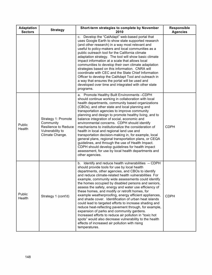
148
Adaptation Sectors
Strategy Short-term strategies to complete by November
2010 Responsible
Agencies
c. Develop the “CalAdapt” web-based portal that uses Google Earth to show state supported research (and other research) in a way most relevant and useful to policy-makers and local communities as a public outreach tool for the California climate adaptation strategy. The tool will show basic climate impact information at a scale that allows local communities to develop their own climate adaptation strategies based on this information. CNRA will coordinate with CEC and the State Chief Information Officer to develop the CalAdapt Tool and outreach in a way that ensures the portal will be used and developed over time and integrated with other state programs.
Public Health
Strategy 1: Promote Community Resilience to Reduce Vulnerability to Climate Change.
a. Promote Healthy Built Environments –CDPH should continue working in collaboration with local health departments, community based organizations (CBOs), and other state and local planning and transportation agencies to improve community planning and design to promote healthy living, and to balance integration of social, economic and environmental concerns. CDPH should identify mechanisms to institutionalize the consideration of health in local and regional land use and transportation decision-making in, for example, local general plans, regional transportation plans, or CEQA guidelines, and through the use of Health Impact. CDPH should develop guidelines for health impact assessment, for use by local health departments and other agencies.
CDPH
Public Health
Strategy 1 (cont'd)
b. Identify and reduce health vulnerabilities -- CDPH should provide tools for use by local health departments, other agencies, and CBOs to identify and reduce climate-related health vulnerabilities For example, community wide assessments could identify the homes occupied by disabled persons and seniors, assess the safety, energy and water use efficiency of these homes, and modify or retrofit homes, for example weatherproofing, energy efficient appliances, and shade cover. Identification of urban heat islands could lead to targeted efforts to increase shading and reduce heat-reflecting pavement through, for example, expansion of parks and community gardens. Increased efforts to reduce air pollution in “toxic hot spots” would also decrease vulnerability to the health effects of increased air pollution with rising temperatures.
CDPH
149
Adaptation Sectors
Strategy Short-term strategies to complete by November
2010 Responsible
Agencies
Public Health Strategy 1 (cont'd)
c. Food Security and Quality– CDPH should work in partnership with USDA, CDFA, and CDSS to maintain commitment to healthy foods and nutrition programs that improve access to healthy foods in low-income communities DPH should partner with Local Health Departments and CBOs to promote healthy sustainable local food systems through working for consideration of healthy food access in agricultural, land use, and other policies (e.g., zoning to allow farmers markets, incentives for farm to school/business/consumer, community and school gardens, and strong state support for programs such as Women, Infants and Children (WIC), SNAP-Ed, etc). CDPH should partner with CDFA and local health and environmental agencies to enhance capacity for surveillance and response for food-borne illness outbreaks.
CDPH
Public Health
Strategy 2: Educate, Empower and Engage California Citizens, Organizations and Businesses to Take Actions to Reduce Individual and Community Vulnerability to Climate Changes through Mitigation and Adaptation.
a. Educational Outreach Campaign – Incorporate climate change and public health messages into existing education and media outreach efforts. Develop diverse educational materials for diverse populations (e.g., vulnerable communities, school-age children, business, and labor) that focus on the health impacts of climate change. Conduct focused outreach to clinicians and the health sector about the health impacts of climate change, actions the health sector can take to mitigate and adapt to climate change, and prevention and management of climate-related illnesses (e.g., heat illness). Utilize existing resources to disseminate climate-related health information (e.g., bepreparedcalifornia.ca.gov., public health advisories).
CDPH
Public Health Strategy 2 (cont'd)
b. Specific Outreach to Vulnerable Populations – Identify dissemination networks (e.g., CBOs, local government, philanthropic organizations) that can reach vulnerable populations (e.g., outdoor workers and their employers, residents in urban heat islands, asthmatics, immigrants with literacy/language needs) and provide them with information on what they need to know about the risks of climate change, and what they can do to address them, both individually and at the community and state levels.
CDPH
150
Adaptation Sectors
Strategy Short-term strategies to complete by November
2010 Responsible
Agencies
Public Health
Strategy 3: Identify and Promote Mitigation and Adaptation Strategies with Public Health Co-benefits.
a. Identify and prioritize strategies with co-benefits – CDPH should identify public health and climate change mitigation and adaptation strategies that offer health and climate co-benefits; strategies with co-benefits should be prioritized. For example, community design (“smart growth”) that promotes walking and bicycling to increase physical activity and decrease motor vehicle greenhouse gas and toxic pollutants. When possible, adaptation strategies that increase health risks and/or greenhouse gas emissions should be avoided. (e.g. promoting air conditioner use without changes in electricity production reliance on fossil fuel combustion). Strive to institutionalize the inclusion of public health considerations in all applicable climate change policies.
CDPH
Public Health
Strategy 4: Establish, Improve and Maintain Mechanisms for Robust Rapid Surveillance of Environmental Conditions, Climate-related Illness, Vulnerabilities, Protective factors and Adaptive Capacities.
a. Monitor Outcomes at state and local level – CDPH should work with local health departments and the health care services sector to increase capacity to monitor the climate related deaths and illnesses associated with heat-related and other events, as well as other climate related illnesses, environmental risks, vulnerabilities, protective factors, and adaptive capacities. Maintain operation of the California Environmental Health Tracking Program, and incorporate the climate health indicators recommended by the Council of State and Territorial Epidemiologists.
CDPH
Public Health
Strategy 4 (cont'd)
b. Environmental Contaminant Biomonitoring – CDPH and Cal/EPA (California Environmental Protection Agency) should encourage the development of the existing California Environmental Contaminant Biomonitoring Program to determine the level of contaminants in California residents to help reduce baseline illness and increase community resiliency.
CDPH
Public Health Strategy 4 (cont'd)
c. Water Accessibility Information – Maintain and upgrade the existing Safe Drinking Water Information System, which provides information about public water systems and their violations of EPA's drinking water regulations regarding maximum contaminant levels, treatment techniques, and monitoring and reporting requirements, in order to ensure safe and reliable public water resources.
CDPH
Public Health
Strategy 4 (cont'd)
d. Heat Warning Systems – Work with the CDPH Emergency Preparedness Office EPO, CalEMA, and local health and emergency response agencies to develop heat warning systems for regions of the State that have not yet adopted them. These systems should be coupled with existing heat emergency
CDPH
151
Adaptation Sectors
Strategy Short-term strategies to complete by November
2010 Responsible
Agencies
response plans.
Public Health
Strategy 5: Improve Public Health Preparedness and Emergency Response
a. Preparedness Response – CDPH and local health departments should refine existing emergency preparedness plans and conduct exercises to augment preparedness for events likely to increase with climate change (e.g., heat waves, wildfires, floods), and should develop plans for anticipated impacts such as sea level rise, saline intrusion into drinking water, etc. Public health agencies should also be prepared for the more frequent occurrence of severe heat events in geographic areas where they have previously been very rare (e.g., coastal areas). Fomally request the Centers for Disease Control and Prevention to incorporate climate change response and preparedness as an acceptable use of federal funds for public health preparedness.
CDPH
Public Health
Strategy 6: Work in Partnership with Multiple Agencies (e.g., Environmental, Agricultural, Transportation, and Education at Local, State and Federal levels, as well as Business, Labor, Schools and Community-based Organizations).
a. Institutional Capacity – CDPH should work with appropriate state and local agencies to expand training and education to build capacity to respond appropriately to the public health risks of climate change. Institutional capacity needs should be addressed in local health departments, health and social services providers, and mental health agencies (e.g. for post-disaster recovery).
CDPH
Public Health
Strategy 7: Conduct Research to Enable Enhanced Promotion and Protection of Human Health in Light of Climate Change.
a. Vulnerability Assessments – CDPH should conduct detailed vulnerability assessments for all the leading climate-change health outcomes (e.g., heat morbidity, valley fever, flooding, wild fires) utilizing locally scaled-down emergency and environmental shift scenarios, including assessments of impacts on vulnerable populations and cumulative impacts, and risk and resilience factors.
CDPH
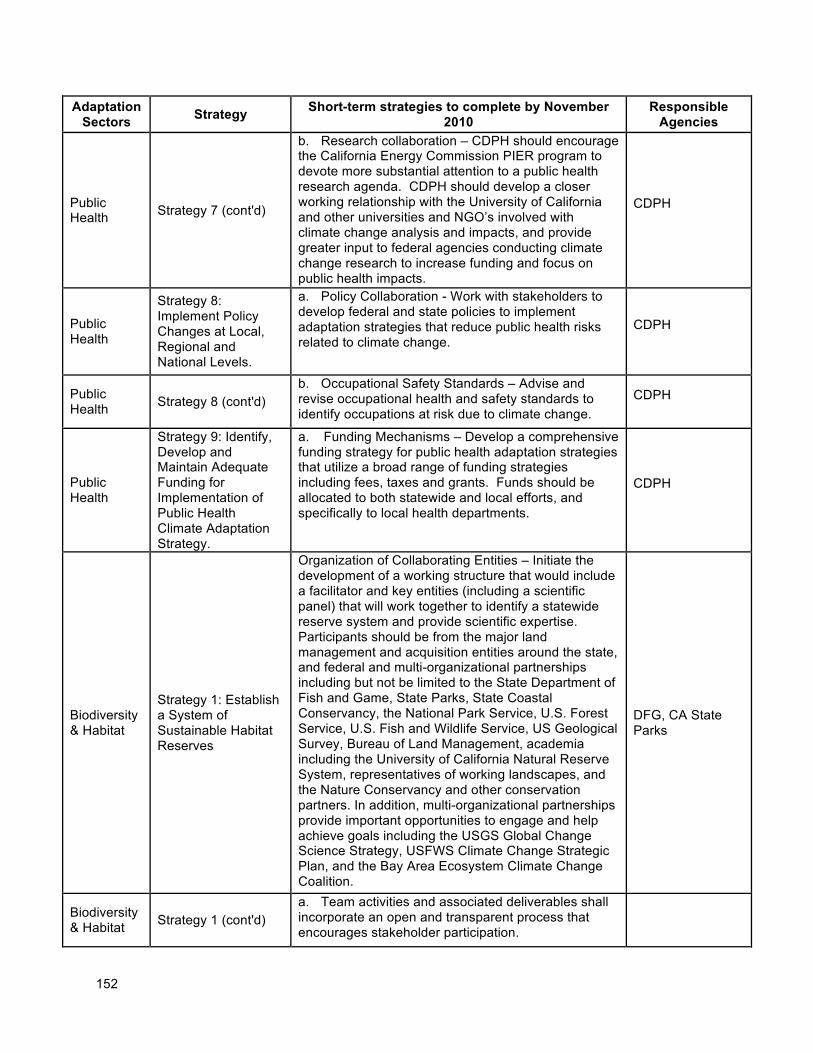
152
Adaptation Sectors
Strategy Short-term strategies to complete by November
2010 Responsible
Agencies
Public Health Strategy 7 (cont'd)
b. Research collaboration – CDPH should encourage the California Energy Commission PIER program to devote more substantial attention to a public health research agenda. CDPH should develop a closer working relationship with the University of California and other universities and NGO’s involved with climate change analysis and impacts, and provide greater input to federal agencies conducting climate change research to increase funding and focus on public health impacts.
CDPH
Public Health
Strategy 8: Implement Policy Changes at Local, Regional and National Levels.
a. Policy Collaboration - Work with stakeholders to develop federal and state policies to implement adaptation strategies that reduce public health risks related to climate change.
CDPH
Public Health
Strategy 8 (cont'd) b. Occupational Safety Standards – Advise and revise occupational health and safety standards to identify occupations at risk due to climate change.
CDPH
Public Health
Strategy 9: Identify, Develop and Maintain Adequate Funding for Implementation of Public Health Climate Adaptation Strategy.
a. Funding Mechanisms – Develop a comprehensive funding strategy for public health adaptation strategies that utilize a broad range of funding strategies including fees, taxes and grants. Funds should be allocated to both statewide and local efforts, and specifically to local health departments.
CDPH
Biodiversity & Habitat
Strategy 1: Establish a System of Sustainable Habitat Reserves
Organization of Collaborating Entities – Initiate the development of a working structure that would include a facilitator and key entities (including a scientific panel) that will work together to identify a statewide reserve system and provide scientific expertise. Participants should be from the major land management and acquisition entities around the state, and federal and multi-organizational partnerships including but not be limited to the State Department of Fish and Game, State Parks, State Coastal Conservancy, the National Park Service, U.S. Forest Service, U.S. Fish and Wildlife Service, US Geological Survey, Bureau of Land Management, academia including the University of California Natural Reserve System, representatives of working landscapes, and the Nature Conservancy and other conservation partners. In addition, multi-organizational partnerships provide important opportunities to engage and help achieve goals including the USGS Global Change Science Strategy, USFWS Climate Change Strategic Plan, and the Bay Area Ecosystem Climate Change Coalition.
DFG, CA State Parks
Biodiversity & Habitat
Strategy 1 (cont'd) a. Team activities and associated deliverables shall incorporate an open and transparent process that encourages stakeholder participation.
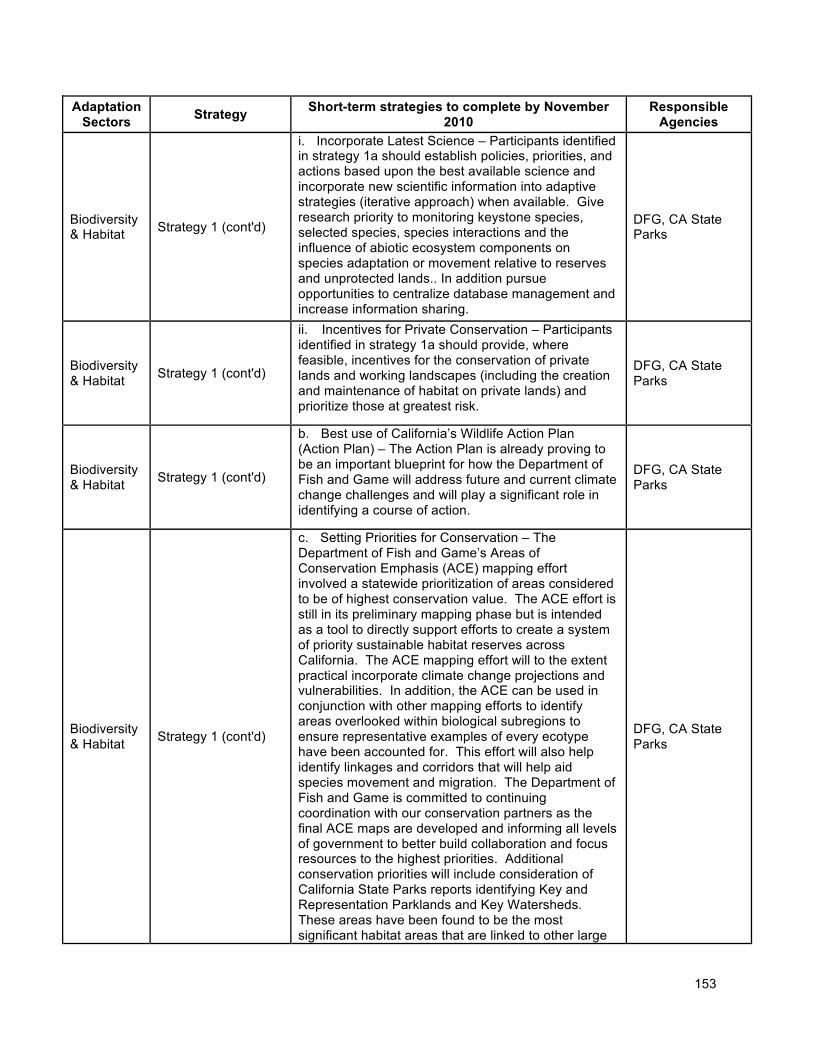
153
Adaptation Sectors
Strategy Short-term strategies to complete by November
2010 Responsible
Agencies
Biodiversity & Habitat Strategy 1 (cont'd)
i. Incorporate Latest Science – Participants identified in strategy 1a should establish policies, priorities, and actions based upon the best available science and incorporate new scientific information into adaptive strategies (iterative approach) when available. Give research priority to monitoring keystone species, selected species, species interactions and the influence of abiotic ecosystem components on species adaptation or movement relative to reserves and unprotected lands.. In addition pursue opportunities to centralize database management and increase information sharing.
DFG, CA State Parks
Biodiversity & Habitat
Strategy 1 (cont'd)
ii. Incentives for Private Conservation – Participants identified in strategy 1a should provide, where feasible, incentives for the conservation of private lands and working landscapes (including the creation and maintenance of habitat on private lands) and prioritize those at greatest risk.
DFG, CA State Parks
Biodiversity & Habitat
Strategy 1 (cont'd)
b. Best use of California’s Wildlife Action Plan (Action Plan) – The Action Plan is already proving to be an important blueprint for how the Department of Fish and Game will address future and current climate change challenges and will play a significant role in identifying a course of action.
DFG, CA State Parks
Biodiversity & Habitat
Strategy 1 (cont'd)
c. Setting Priorities for Conservation – The Department of Fish and Game’s Areas of Conservation Emphasis (ACE) mapping effort involved a statewide prioritization of areas considered to be of highest conservation value. The ACE effort is still in its preliminary mapping phase but is intended as a tool to directly support efforts to create a system of priority sustainable habitat reserves across California. The ACE mapping effort will to the extent practical incorporate climate change projections and vulnerabilities. In addition, the ACE can be used in conjunction with other mapping efforts to identify areas overlooked within biological subregions to ensure representative examples of every ecotype have been accounted for. This effort will also help identify linkages and corridors that will help aid species movement and migration. The Department of Fish and Game is committed to continuing coordination with our conservation partners as the final ACE maps are developed and informing all levels of government to better build collaboration and focus resources to the highest priorities. Additional conservation priorities will include consideration of California State Parks reports identifying Key and Representation Parklands and Key Watersheds. These areas have been found to be the most significant habitat areas that are linked to other large
DFG, CA State Parks
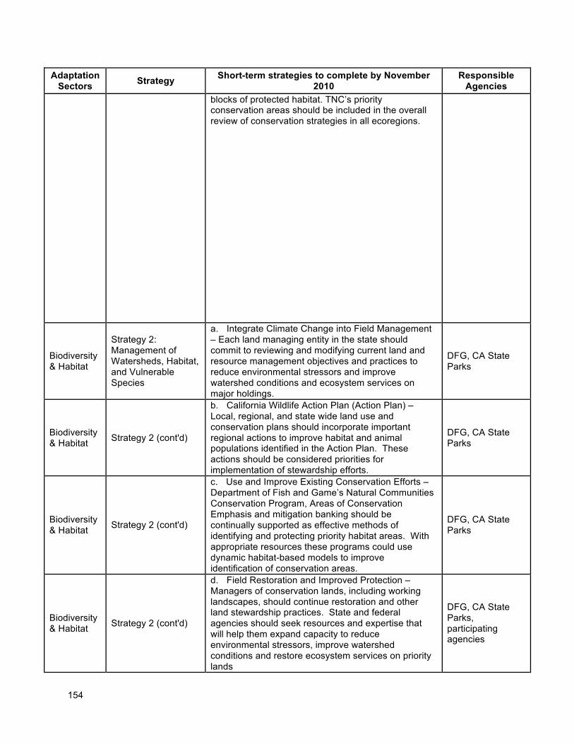
154
Adaptation Sectors
Strategy Short-term strategies to complete by November
2010 Responsible
Agencies
blocks of protected habitat. TNC’s priority conservation areas should be included in the overall review of conservation strategies in all ecoregions.
Biodiversity & Habitat
Strategy 2: Management of Watersheds, Habitat, and Vulnerable Species
a. Integrate Climate Change into Field Management – Each land managing entity in the state should commit to reviewing and modifying current land and resource management objectives and practices to reduce environmental stressors and improve watershed conditions and ecosystem services on major holdings.
DFG, CA State Parks
Biodiversity & Habitat
Strategy 2 (cont'd)
b. California Wildlife Action Plan (Action Plan) – Local, regional, and state wide land use and conservation plans should incorporate important regional actions to improve habitat and animal populations identified in the Action Plan. These actions should be considered priorities for implementation of stewardship efforts.
DFG, CA State Parks
Biodiversity & Habitat
Strategy 2 (cont'd)
c. Use and Improve Existing Conservation Efforts – Department of Fish and Game’s Natural Communities Conservation Program, Areas of Conservation Emphasis and mitigation banking should be continually supported as effective methods of identifying and protecting priority habitat areas. With appropriate resources these programs could use dynamic habitat-based models to improve identification of conservation areas.
DFG, CA State Parks
Biodiversity & Habitat
Strategy 2 (cont'd)
d. Field Restoration and Improved Protection – Managers of conservation lands, including working landscapes, should continue restoration and other land stewardship practices. State and federal agencies should seek resources and expertise that will help them expand capacity to reduce environmental stressors, improve watershed conditions and restore ecosystem services on priority lands
DFG, CA State Parks, participating agencies
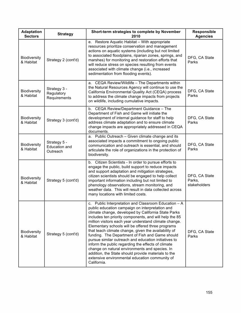
155
Adaptation Sectors
Strategy Short-term strategies to complete by November
2010 Responsible
Agencies
Biodiversity & Habitat Strategy 2 (cont'd)
e. Restore Aquatic Habitat – With appropriate resources prioritize conservation and management actions on aquatic systems (including but not limited to associated floodplains, riparian zones, springs, and marshes) for monitoring and restoration efforts that will reduce stress on species resulting from events associated with climate change (i.e., increased sedimentation from flooding events).
DFG, CA State Parks
Biodiversity & Habitat
Strategy 3 - Regulatory Requirements
a. CEQA Review/Wildlife – The Departments within the Natural Resources Agency will continue to use the California Environmental Quality Act (CEQA) process to address the climate change impacts from projects on wildlife, including cumulative impacts.
DFG, CA State Parks
Biodiversity & Habitat
Strategy 3 (cont'd)
b. CEQA Review/Department Guidance – The Department of Fish and Game will initiate the development of internal guidance for staff to help address climate adaptation and to ensure climate change impacts are appropriately addressed in CEQA documents.
DFG, CA State Parks
Biodiversity & Habitat
Strategy 5 - Education and Outreach
a. Public Outreach – Given climate change and its associated impacts a commitment to ongoing public communication and outreach is essential, and should articulate the role of organizations in the protection of biodiversity.
DFG, CA State Parks
Biodiversity & Habitat
Strategy 5 (cont'd)
b. Citizen Scientists - In order to pursue efforts to engage the public, build support to reduce impacts and support adaptation and mitigation strategies, citizen scientists should be engaged to help collect important information including but not limited to phenology observations, stream monitoring, and weather data. This will result in data collected across many locations with limited costs.
DFG, CA State Parks, stakeholders
Biodiversity & Habitat
Strategy 5 (cont'd)
c. Public Interpretation and Classroom Education – A public education campaign on interpretation and climate change, developed by California State Parks includes ten priority components, and will help the 85 million visitors each year understand climate change. Elementary schools will be offered three programs that teach climate change, given the availability of funding. The Department of Fish and Game should pursue similar outreach and education initiatives to inform the public regarding the effects of climate change on natural environments and species. In addition, the State should provide materials to the extensive environmental education community of California.
DFG, CA State Parks
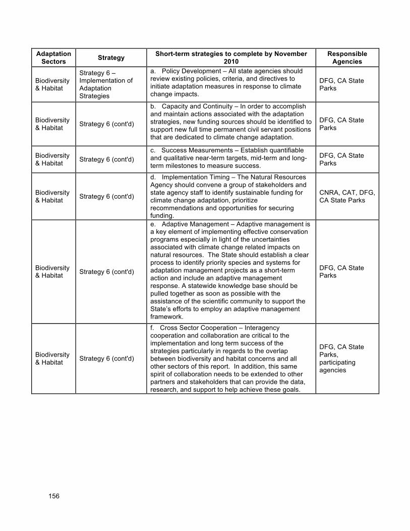
156
Adaptation Sectors
Strategy Short-term strategies to complete by November
2010 Responsible
Agencies
Biodiversity & Habitat
Strategy 6 – Implementation of Adaptation Strategies
a. Policy Development – All state agencies should review existing policies, criteria, and directives to initiate adaptation measures in response to climate change impacts.
DFG, CA State Parks
Biodiversity & Habitat
Strategy 6 (cont'd)
b. Capacity and Continuity – In order to accomplish and maintain actions associated with the adaptation strategies, new funding sources should be identified to support new full time permanent civil servant positions that are dedicated to climate change adaptation.
DFG, CA State Parks
Biodiversity & Habitat
Strategy 6 (cont'd) c. Success Measurements – Establish quantifiable and qualitative near-term targets, mid-term and long-term milestones to measure success.
DFG, CA State Parks
Biodiversity & Habitat
Strategy 6 (cont'd)
d. Implementation Timing – The Natural Resources Agency should convene a group of stakeholders and state agency staff to identify sustainable funding for climate change adaptation, prioritize recommendations and opportunities for securing funding.
CNRA, CAT, DFG, CA State Parks
Biodiversity & Habitat Strategy 6 (cont'd)
e. Adaptive Management – Adaptive management is a key element of implementing effective conservation programs especially in light of the uncertainties associated with climate change related impacts on natural resources. The State should establish a clear process to identify priority species and systems for adaptation management projects as a short-term action and include an adaptive management response. A statewide knowledge base should be pulled together as soon as possible with the assistance of the scientific community to support the State’s efforts to employ an adaptive management framework.
DFG, CA State Parks
Biodiversity & Habitat
Strategy 6 (cont'd)
f. Cross Sector Cooperation – Interagency cooperation and collaboration are critical to the implementation and long term success of the strategies particularly in regards to the overlap between biodiversity and habitat concerns and all other sectors of this report. In addition, this same spirit of collaboration needs to be extended to other partners and stakeholders that can provide the data, research, and support to help achieve these goals.
DFG, CA State Parks, participating agencies
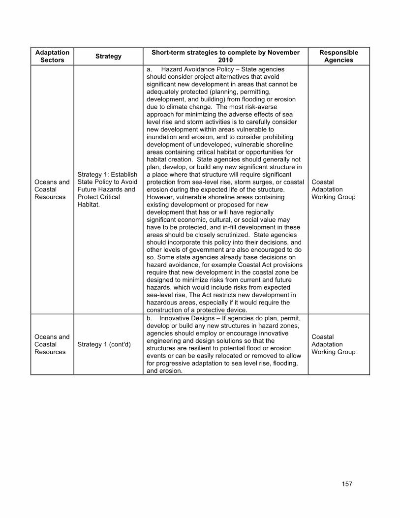
157
Adaptation Sectors
Strategy Short-term strategies to complete by November
2010 Responsible
Agencies
Oceans and Coastal Resources
Strategy 1: Establish State Policy to Avoid Future Hazards and Protect Critical Habitat.
a. Hazard Avoidance Policy – State agencies should consider project alternatives that avoid significant new development in areas that cannot be adequately protected (planning, permitting, development, and building) from flooding or erosion due to climate change. The most risk-averse approach for minimizing the adverse effects of sea level rise and storm activities is to carefully consider new development within areas vulnerable to inundation and erosion, and to consider prohibiting development of undeveloped, vulnerable shoreline areas containing critical habitat or opportunities for habitat creation. State agencies should generally not plan, develop, or build any new significant structure in a place where that structure will require significant protection from sea-level rise, storm surges, or coastal erosion during the expected life of the structure. However, vulnerable shoreline areas containing existing development or proposed for new development that has or will have regionally significant economic, cultural, or social value may have to be protected, and in-fill development in these areas should be closely scrutinized. State agencies should incorporate this policy into their decisions, and other levels of government are also encouraged to do so. Some state agencies already base decisions on hazard avoidance, for example Coastal Act provisions require that new development in the coastal zone be designed to minimize risks from current and future hazards, which would include risks from expected sea-level rise, The Act restricts new development in hazardous areas, especially if it would require the construction of a protective device.
Coastal Adaptation Working Group
Oceans and Coastal Resources
Strategy 1 (cont'd)
b. Innovative Designs – If agencies do plan, permit, develop or build any new structures in hazard zones, agencies should employ or encourage innovative engineering and design solutions so that the structures are resilient to potential flood or erosion events or can be easily relocated or removed to allow for progressive adaptation to sea level rise, flooding, and erosion.
Coastal Adaptation Working Group
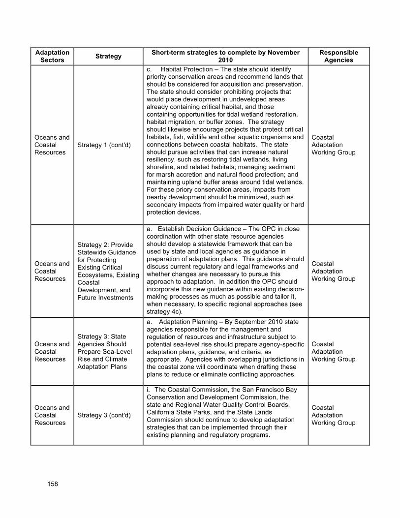
158
Adaptation Sectors
Strategy Short-term strategies to complete by November
2010 Responsible
Agencies
Oceans and Coastal Resources
Strategy 1 (cont'd)
c. Habitat Protection – The state should identify priority conservation areas and recommend lands that should be considered for acquisition and preservation. The state should consider prohibiting projects that would place development in undeveloped areas already containing critical habitat, and those containing opportunities for tidal wetland restoration, habitat migration, or buffer zones. The strategy should likewise encourage projects that protect critical habitats, fish, wildlife and other aquatic organisms and connections between coastal habitats. The state should pursue activities that can increase natural resiliency, such as restoring tidal wetlands, living shoreline, and related habitats; managing sediment for marsh accretion and natural flood protection; and maintaining upland buffer areas around tidal wetlands. For these priory conservation areas, impacts from nearby development should be minimized, such as secondary impacts from impaired water quality or hard protection devices.
Coastal Adaptation Working Group
Oceans and Coastal Resources
Strategy 2: Provide Statewide Guidance for Protecting Existing Critical Ecosystems, Existing Coastal Development, and Future Investments
a. Establish Decision Guidance – The OPC in close coordination with other state resource agencies should develop a statewide framework that can be used by state and local agencies as guidance in preparation of adaptation plans. This guidance should discuss current regulatory and legal frameworks and whether changes are necessary to pursue this approach to adaptation. In addition the OPC should incorporate this new guidance within existing decision-making processes as much as possible and tailor it, when necessary, to specific regional approaches (see strategy 4c).
Coastal Adaptation Working Group
Oceans and Coastal Resources
Strategy 3: State Agencies Should Prepare Sea-Level Rise and Climate Adaptation Plans
a. Adaptation Planning – By September 2010 state agencies responsible for the management and regulation of resources and infrastructure subject to potential sea-level rise should prepare agency-specific adaptation plans, guidance, and criteria, as appropriate. Agencies with overlapping jurisdictions in the coastal zone will coordinate when drafting these plans to reduce or eliminate conflicting approaches.
Coastal Adaptation Working Group
Oceans and Coastal Resources
Strategy 3 (cont'd)
i. The Coastal Commission, the San Francisco Bay Conservation and Development Commission, the state and Regional Water Quality Control Boards, California State Parks, and the State Lands Commission should continue to develop adaptation strategies that can be implemented through their existing planning and regulatory programs.
Coastal Adaptation Working Group
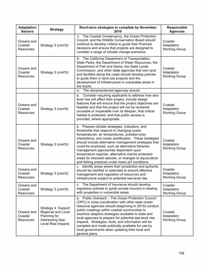
159
Adaptation Sectors
Strategy Short-term strategies to complete by November
2010 Responsible
Agencies
Oceans and Coastal Resources
Strategy 3 (cont'd)
ii. The Coastal Conservancy, the Ocean Protection Council, and the Wildlife Conservation Board should continue to develop criteria to guide their financial decisions and ensure that projects are designed to consider a range of climate change scenarios.
Coastal Adaptation Working Group
Oceans and Coastal Resources
Strategy 3 (cont'd)
iii. The California Department of Transportation, State Parks, the Department of Water Resources, the Department of Fish and Game, the State Lands Commission, and other state agencies that own land and facilities along the coast should develop policies to guide them in land-use projects and the development of infrastructure in vulnerable areas in the future.
Coastal Adaptation Working Group
iv. The aforementioned agencies should:
Oceans and Coastal Resources
Strategy 3 (cont'd)
a. Consider requiring applicants to address how sea-level rise will affect their project, include design features that will ensure that the project objectives are feasible and that the project will not be rendered unusable or inoperable over its lifespan, that critical habitat is protected, and that public access is provided, where appropriate.
Coastal Adaptation Working Group
Oceans and Coastal Resources
Strategy 3 (cont'd)
b. Prepare climate strategies, indicators, and thresholds that respond to changing ocean temperatures, air temperatures, predator-prey interactions, and ocean acidification. These strategies should include alternative management strategies that could be employed, such as alternative fisheries management approaches dependent upon temperature regimes, alternative marine protected areas for stressed species, or changes to aquaculture and fishing practices under lower pH conditions.
Coastal Adaptation Working Group
Oceans and Coastal Resources
Strategy 3 (cont'd)
c. Identify areas where their jurisdiction and authority should be clarified or extended to ensure effective management and regulation of resources and infrastructure subject to potential sea-level rise.
Coastal Adaptation Working Group
Oceans and Coastal Resources
Strategy 3 (cont'd) v. The Department of Insurance should develop regulatory policies to guide private insurers in dealing with properties in vulnerable areas.
Coastal Adaptation Working Group
Oceans and Coastal Resources
Strategy 4: Support Regional and Local Planning for Addressing Sea-Level Rise Impacts
a. Public Outreach – The Ocean Protection Council (OPC) in close coordination with other state ocean resource agencies should (beginning in 2010) conduct public meetings within coastal communities to examine adaptive strategies available to state and local agencies to prepare for potential sea-level rise impacts. Strategies, tools, and information will be compiled and made publically available for use by local governments when updating their local and general plans.
Coastal Adaptation Working Group
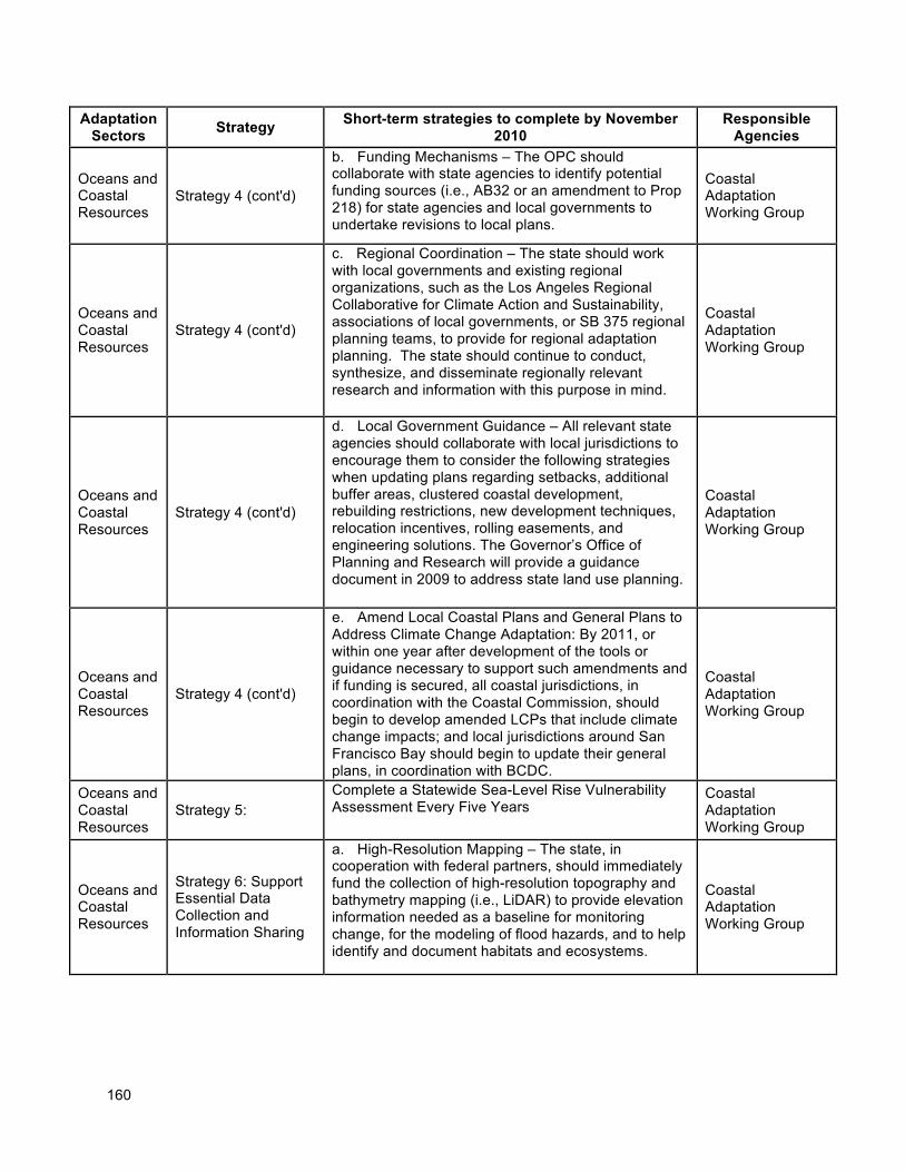
160
Adaptation Sectors
Strategy Short-term strategies to complete by November
2010 Responsible
Agencies
Oceans and Coastal Resources
Strategy 4 (cont'd)
b. Funding Mechanisms – The OPC should collaborate with state agencies to identify potential funding sources (i.e., AB32 or an amendment to Prop 218) for state agencies and local governments to undertake revisions to local plans.
Coastal Adaptation Working Group
Oceans and Coastal Resources
Strategy 4 (cont'd)
c. Regional Coordination – The state should work with local governments and existing regional organizations, such as the Los Angeles Regional Collaborative for Climate Action and Sustainability, associations of local governments, or SB 375 regional planning teams, to provide for regional adaptation planning. The state should continue to conduct, synthesize, and disseminate regionally relevant research and information with this purpose in mind.
Coastal Adaptation Working Group
Oceans and Coastal Resources
Strategy 4 (cont'd)
d. Local Government Guidance – All relevant state agencies should collaborate with local jurisdictions to encourage them to consider the following strategies when updating plans regarding setbacks, additional buffer areas, clustered coastal development, rebuilding restrictions, new development techniques, relocation incentives, rolling easements, and engineering solutions. The Governor’s Office of Planning and Research will provide a guidance document in 2009 to address state land use planning.
Coastal Adaptation Working Group
Oceans and Coastal Resources
Strategy 4 (cont'd)
e. Amend Local Coastal Plans and General Plans to Address Climate Change Adaptation: By 2011, or within one year after development of the tools or guidance necessary to support such amendments and if funding is secured, all coastal jurisdictions, in coordination with the Coastal Commission, should begin to develop amended LCPs that include climate change impacts; and local jurisdictions around San Francisco Bay should begin to update their general plans, in coordination with BCDC.
Coastal Adaptation Working Group
Oceans and Coastal Resources
Strategy 5: Complete a Statewide Sea-Level Rise Vulnerability Assessment Every Five Years
Coastal Adaptation Working Group
Oceans and Coastal Resources
Strategy 6: Support Essential Data Collection and Information Sharing
a. High-Resolution Mapping – The state, in cooperation with federal partners, should immediately fund the collection of high-resolution topography and bathymetry mapping (i.e., LiDAR) to provide elevation information needed as a baseline for monitoring change, for the modeling of flood hazards, and to help identify and document habitats and ecosystems.
Coastal Adaptation Working Group
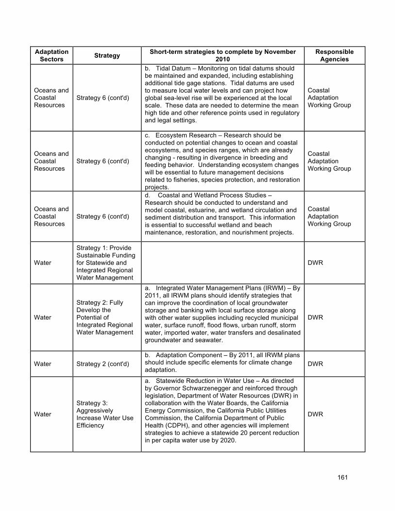
161
Adaptation Sectors
Strategy Short-term strategies to complete by November
2010 Responsible
Agencies
Oceans and Coastal Resources
Strategy 6 (cont'd)
b. Tidal Datum – Monitoring on tidal datums should be maintained and expanded, including establishing additional tide gage stations. Tidal datums are used to measure local water levels and can project how global sea-level rise will be experienced at the local scale. These data are needed to determine the mean high tide and other reference points used in regulatory and legal settings.
Coastal Adaptation Working Group
Oceans and Coastal Resources
Strategy 6 (cont'd)
c. Ecosystem Research – Research should be conducted on potential changes to ocean and coastal ecosystems, and species ranges, which are already changing - resulting in divergence in breeding and feeding behavior. Understanding ecosystem changes will be essential to future management decisions related to fisheries, species protection, and restoration projects.
Coastal Adaptation Working Group
Oceans and Coastal Resources
Strategy 6 (cont'd)
d. Coastal and Wetland Process Studies – Research should be conducted to understand and model coastal, estuarine, and wetland circulation and sediment distribution and transport. This information is essential to successful wetland and beach maintenance, restoration, and nourishment projects.
Coastal Adaptation Working Group
Water
Strategy 1: Provide Sustainable Funding for Statewide and Integrated Regional Water Management
DWR
Water
Strategy 2: Fully Develop the Potential of Integrated Regional Water Management
a. Integrated Water Management Plans (IRWM) – By 2011, all IRWM plans should identify strategies that can improve the coordination of local groundwater storage and banking with local surface storage along with other water supplies including recycled municipal water, surface runoff, flood flows, urban runoff, storm water, imported water, water transfers and desalinated groundwater and seawater.
DWR
Water Strategy 2 (cont'd) b. Adaptation Component – By 2011, all IRWM plans should include specific elements for climate change adaptation.
DWR
Water
Strategy 3: Aggressively Increase Water Use Efficiency
a. Statewide Reduction in Water Use – As directed by Governor Schwarzenegger and reinforced through legislation, Department of Water Resources (DWR) in collaboration with the Water Boards, the California Energy Commission, the California Public Utilities Commission, the California Department of Public Health (CDPH), and other agencies will implement strategies to achieve a statewide 20 percent reduction in per capita water use by 2020.
DWR
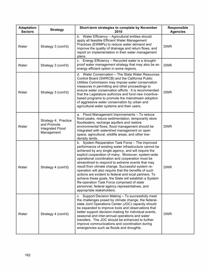
162
Adaptation Sectors
Strategy Short-term strategies to complete by November
2010 Responsible
Agencies
Water Strategy 3 (cont'd)
b. Water Efficiency – Agricultural entities should apply all feasible Efficient Water Management Practices (EWMPs) to reduce water demand and improve the quality of drainage and return flows, and report on implementation in their water management plans.
DWR
Water Strategy 3 (cont'd) c. Energy Efficiency – Recycled water is a drought-proof water management strategy that may also be an energy efficient option in some regions.
DWR
Water Strategy 3 (cont'd)
d. Water Conservation – The State Water Resources Control Board (SWRCB) and the California Public Utilities Commission may impose water conservation measures in permitting and other proceedings to ensure water conservation efforts. It is recommended that the Legislature authorize and fund new incentive-based programs to promote the mainstream adoption of aggressive water conservation by urban and agricultural water systems and their users.
DWR
Water
Strategy 4: Practice and Promote Integrated Flood Management
a. Flood Management Improvements – To reduce flood peaks, reduce sedimentation, temporarily store floodwaters, recharge aquifers and restore environmental flows, flood management should be integrated with watershed management on open space, agricultural, wildlife areas, and other low-density lands.
DWR
Water Strategy 4 (cont'd)
b. System Reoperation Task Force – The improved performance of existing water infrastructure cannot be achieved by any single agency, and will require the explicit cooperation of many. Moreover, system-wide operational coordination and cooperation must be streamlined to respond to extreme events that may result from climate change. Successful system re-operation will also require that the benefits of such actions are evident to federal and local partners. To achieve these goals, the State will establish a System Re-operation Task Force comprised of state personnel, federal agency representatives, and appropriate stakeholders.
DWR
Water Strategy 4 (cont'd)
c. Support Decision Making – To successfully meet the challenges posed by climate change, the federal-state Joint Operations Center (JOC) capacity should be expanded to improve tools and observations that better support decision-making for individual events, seasonal and inter-annual operations and water transfers. The JOC should be enhanced to further improve communications and coordination during emergencies such as floods and droughts.
DWR
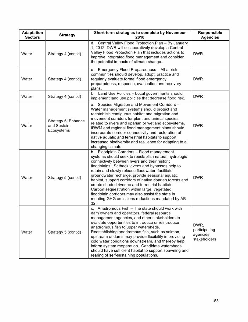
163
Adaptation Sectors
Strategy Short-term strategies to complete by November
2010 Responsible
Agencies
Water Strategy 4 (cont'd)
d. Central Valley Flood Protection Plan – By January 1, 2012, DWR will collaboratively develop a Central Valley Flood Protection Plan that includes actions to improve integrated flood management and consider the potential impacts of climate change.
DWR
Water Strategy 4 (cont'd)
e. Emergency Flood Preparedness – All at-risk communities should develop, adopt, practice and regularly evaluate formal flood emergency preparedness, response, evacuation and recovery plans.
DWR
Water Strategy 4 (cont'd) f. Land Use Policies – Local governments should implement land use policies that decrease flood risk. DWR
Water Strategy 5: Enhance and Sustain Ecosystems
a. Species Migration and Movement Corridors – Water management systems should protect and reestablish contiguous habitat and migration and movement corridors for plant and animal species related to rivers and riparian or wetland ecosystems. IRWM and regional flood management plans should incorporate corridor connectivity and restoration of native aquatic and terrestrial habitats to support increased biodiversity and resilience for adapting to a changing climate.
DWR
Water Strategy 5 (cont'd)
b. Floodplain Corridors – Flood management systems should seek to reestablish natural hydrologic connectivity between rivers and their historic floodplains. Setback levees and bypasses help to retain and slowly release floodwater, facilitate groundwater recharge, provide seasonal aquatic habitat, support corridors of native riparian forests and create shaded riverine and terrestrial habitats. Carbon sequestration within large, vegetated floodplain corridors may also assist the state in meeting GHG emissions reductions mandated by AB 32.
DWR
Water Strategy 5 (cont'd)
c. Anadromous Fish – The state should work with dam owners and operators, federal resource management agencies, and other stakeholders to evaluate opportunities to introduce or reintroduce anadromous fish to upper watersheds. Reestablishing anadromous fish, such as salmon, upstream of dams may provide flexibility in providing cold water conditions downstream, and thereby help inform system reoperation. Candidate watersheds should have sufficient habitat to support spawning and rearing of self-sustaining populations.
DWR, participating agencies, stakeholders
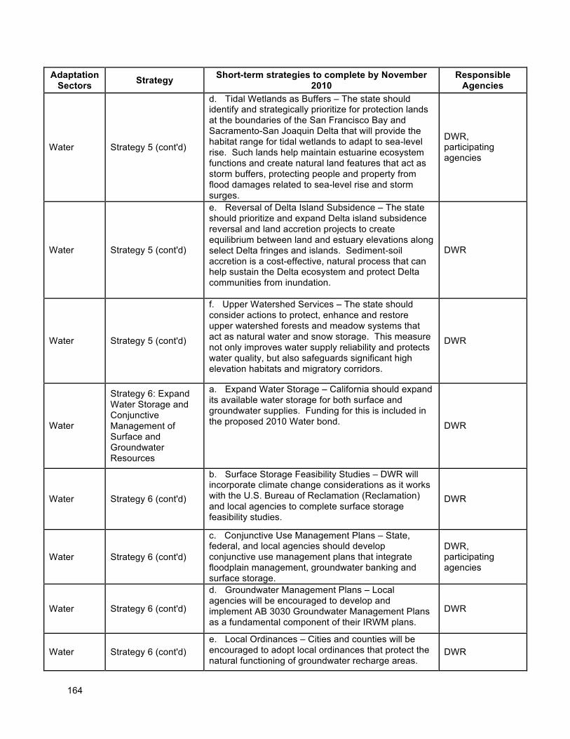
164
Adaptation Sectors
Strategy Short-term strategies to complete by November
2010 Responsible
Agencies
Water Strategy 5 (cont'd)
d. Tidal Wetlands as Buffers – The state should identify and strategically prioritize for protection lands at the boundaries of the San Francisco Bay and Sacramento-San Joaquin Delta that will provide the habitat range for tidal wetlands to adapt to sea-level rise. Such lands help maintain estuarine ecosystem functions and create natural land features that act as storm buffers, protecting people and property from flood damages related to sea-level rise and storm surges.
DWR, participating agencies
Water Strategy 5 (cont'd)
e. Reversal of Delta Island Subsidence – The state should prioritize and expand Delta island subsidence reversal and land accretion projects to create equilibrium between land and estuary elevations along select Delta fringes and islands. Sediment-soil accretion is a cost-effective, natural process that can help sustain the Delta ecosystem and protect Delta communities from inundation.
DWR
Water Strategy 5 (cont'd)
f. Upper Watershed Services – The state should consider actions to protect, enhance and restore upper watershed forests and meadow systems that act as natural water and snow storage. This measure not only improves water supply reliability and protects water quality, but also safeguards significant high elevation habitats and migratory corridors.
DWR
Water
Strategy 6: Expand Water Storage and Conjunctive Management of Surface and Groundwater Resources
a. Expand Water Storage – California should expand its available water storage for both surface and groundwater supplies. Funding for this is included in the proposed 2010 Water bond. DWR
Water Strategy 6 (cont'd)
b. Surface Storage Feasibility Studies – DWR will incorporate climate change considerations as it works with the U.S. Bureau of Reclamation (Reclamation) and local agencies to complete surface storage feasibility studies.
DWR
Water Strategy 6 (cont'd)
c. Conjunctive Use Management Plans – State, federal, and local agencies should develop conjunctive use management plans that integrate floodplain management, groundwater banking and surface storage.
DWR, participating agencies
Water Strategy 6 (cont'd)
d. Groundwater Management Plans – Local agencies will be encouraged to develop and implement AB 3030 Groundwater Management Plans as a fundamental component of their IRWM plans.
DWR
Water Strategy 6 (cont'd) e. Local Ordinances – Cities and counties will be encouraged to adopt local ordinances that protect the natural functioning of groundwater recharge areas.
DWR
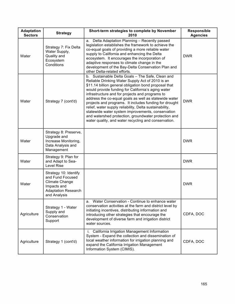
165
Adaptation Sectors
Strategy Short-term strategies to complete by November
2010 Responsible
Agencies
Water
Strategy 7: Fix Delta Water Supply, Quality and Ecosystem Conditions
a. Delta Adaptation Planning – Recently passed legislation establishes the framework to achieve the co-equal goals of providing a more reliable water supply to California and enhancing the Delta ecosystem. It encourages the incorporation of adaptive responses to climate change in the development of the Bay-Delta Conservation Plan and other Delta-related efforts.
DWR
Water Strategy 7 (cont'd)
b. Sustainable Delta Goals – The Safe, Clean and Reliable Drinking Water Supply Act of 2010 is an $11.14 billion general obligation bond proposal that would provide funding for California’s aging water infrastructure and for projects and programs to address the co-equal goals as well as statewide water projects and programs. It includes funding for drought relief, water supply reliability, Delta sustainability, statewide water system improvements, conservation and watershed protection, groundwater protection and water quality, and water recycling and conservation.
DWR
Water
Strategy 8: Preserve, Upgrade and Increase Monitoring, Data Analysis and Management
DWR
Water Strategy 9: Plan for and Adapt to Sea-Level Rise
DWR
Water
Strategy 10: Identify and Fund Focused Climate Change Impacts and Adaptation Research and Analysis
DWR
Agriculture
Strategy 1 - Water Supply and Conservation Support
a. Water Conservation - Continue to enhance water conservation activities at the farm and district level by initiating incentives, distributing information and introducing other strategies that encourage the development of diverse farm and irrigation district water sources.
CDFA, DOC
Agriculture Strategy 1 (cont'd)
i. California Irrigation Management Information System - Expand the collection and dissemination of local weather information for irrigation planning and expand the California Irrigation Management Information System (CIMIS).
CDFA, DOC
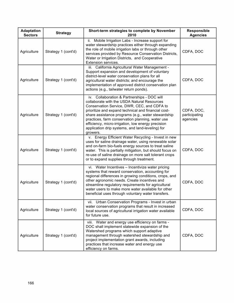
166
Adaptation Sectors
Strategy Short-term strategies to complete by November
2010 Responsible
Agencies
Agriculture Strategy 1 (cont'd)
ii. Mobile Irrigation Labs - Increase support for water stewardship practices either through expanding the role of mobile irrigation labs or through other services provided by Resource Conservation Districts, Water or Irrigation Districts, and Cooperative Extension services.
CDFA, DOC
Agriculture Strategy 1 (cont'd)
iii. California Agricultural Water Management - Support expansion and development of voluntary district-level water conservation plans for all agricultural water districts; and encourage the implementation of approved district conservation plan actions (e.g., tailwater return ponds).
CDFA, DOC
Agriculture Strategy 1 (cont'd)
iv. Collaboration & Partnerships - DOC will collaborate with the USDA Natural Resources Conservation Service, DWR, CEC, and CDFA to prioritize and expand technical and financial cost-share assistance programs (e.g., water stewardship practices, farm conservation planning, water use efficiency, micro-irrigation, low energy precision application drip systems, and land-leveling) for growers.
CDFA, DOC, participating agencies
Agriculture Strategy 1 (cont'd)
v. Energy Efficient Water Recycling - Invest in new uses for saline drainage water, using renewable solar and on-farm bio-fuels energy sources to treat saline water. This is partially mitigation, but should focus on re-use of saline drainage on more salt tolerant crops or to expand supplies through treatment.
CDFA, DOC
Agriculture Strategy 1 (cont'd)
vi. Water Incentives – Incentivize water pricing systems that reward conservation, accounting for regional differences in growing conditions, crops, and other agronomic needs. Create incentives and streamline regulatory requirements for agricultural water users to make more water available for other beneficial uses through voluntary water transfers.
CDFA, DOC
Agriculture Strategy 1 (cont'd)
vii. Urban Conservation Programs - Invest in urban water conservation programs that result in increased local sources of agricultural irrigation water available for future use.
CDFA, DOC
Agriculture Strategy 1 (cont'd)
viii. Water and energy use efficiency on farms - DOC shall implement statewide expansion of the Watershed programs which support adaptive management through watershed stewardship and project implementation grant awards, including practices that increase water and energy use efficiency on farms.
CDFA, DOC
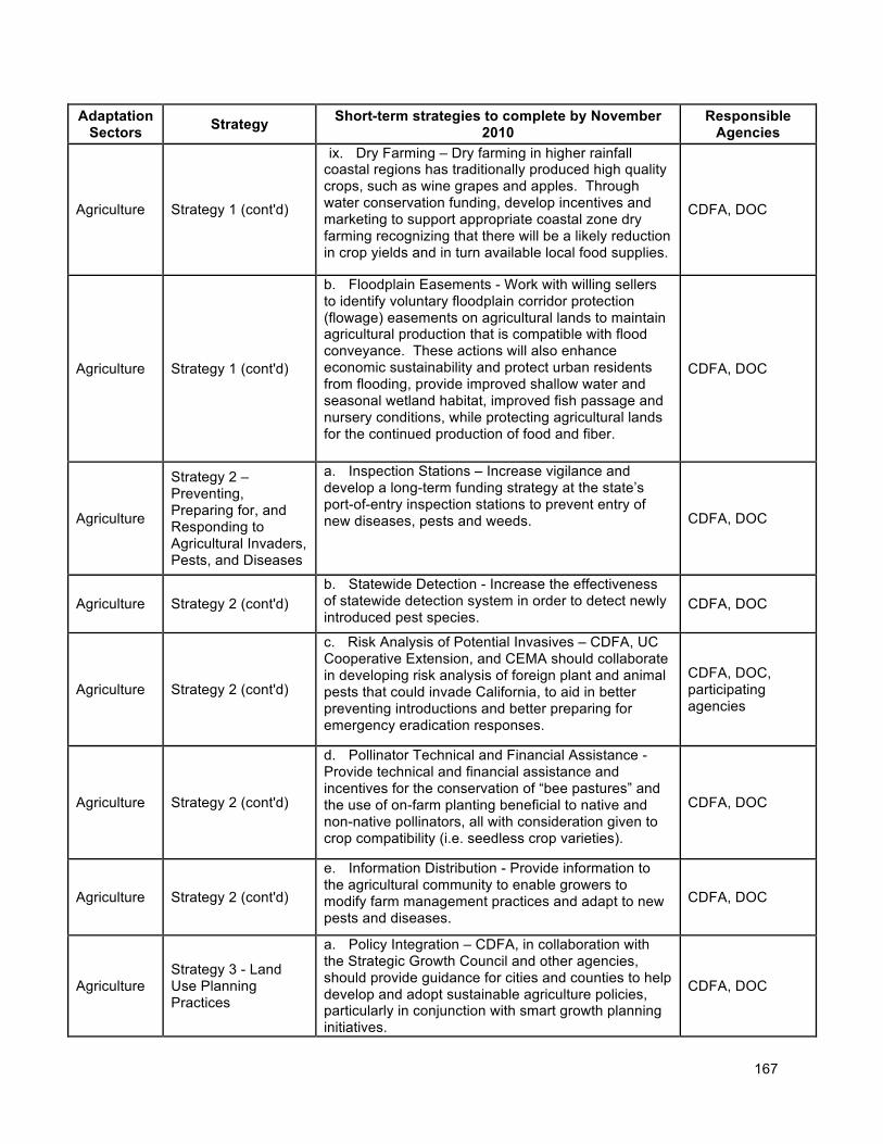
167
Adaptation Sectors
Strategy Short-term strategies to complete by November
2010 Responsible
Agencies
Agriculture Strategy 1 (cont'd)
ix. Dry Farming – Dry farming in higher rainfall coastal regions has traditionally produced high quality crops, such as wine grapes and apples. Through water conservation funding, develop incentives and marketing to support appropriate coastal zone dry farming recognizing that there will be a likely reduction in crop yields and in turn available local food supplies.
CDFA, DOC
Agriculture Strategy 1 (cont'd)
b. Floodplain Easements - Work with willing sellers to identify voluntary floodplain corridor protection (flowage) easements on agricultural lands to maintain agricultural production that is compatible with flood conveyance. These actions will also enhance economic sustainability and protect urban residents from flooding, provide improved shallow water and seasonal wetland habitat, improved fish passage and nursery conditions, while protecting agricultural lands for the continued production of food and fiber.
CDFA, DOC
Agriculture
Strategy 2 – Preventing, Preparing for, and Responding to Agricultural Invaders, Pests, and Diseases
a. Inspection Stations – Increase vigilance and develop a long-term funding strategy at the state’s port-of-entry inspection stations to prevent entry of new diseases, pests and weeds. CDFA, DOC
Agriculture Strategy 2 (cont'd) b. Statewide Detection - Increase the effectiveness of statewide detection system in order to detect newly introduced pest species.
CDFA, DOC
Agriculture Strategy 2 (cont'd)
c. Risk Analysis of Potential Invasives – CDFA, UC Cooperative Extension, and CEMA should collaborate in developing risk analysis of foreign plant and animal pests that could invade California, to aid in better preventing introductions and better preparing for emergency eradication responses.
CDFA, DOC, participating agencies
Agriculture Strategy 2 (cont'd)
d. Pollinator Technical and Financial Assistance - Provide technical and financial assistance and incentives for the conservation of “bee pastures” and the use of on-farm planting beneficial to native and non-native pollinators, all with consideration given to crop compatibility (i.e. seedless crop varieties).
CDFA, DOC
Agriculture Strategy 2 (cont'd)
e. Information Distribution - Provide information to the agricultural community to enable growers to modify farm management practices and adapt to new pests and diseases.
CDFA, DOC
Agriculture Strategy 3 - Land Use Planning Practices
a. Policy Integration – CDFA, in collaboration with the Strategic Growth Council and other agencies, should provide guidance for cities and counties to help develop and adopt sustainable agriculture policies, particularly in conjunction with smart growth planning initiatives.
CDFA, DOC
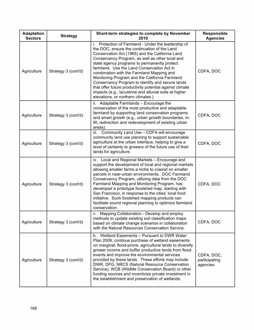
168
Adaptation Sectors
Strategy Short-term strategies to complete by November
2010 Responsible
Agencies
Agriculture Strategy 3 (cont'd)
i. Protection of Farmland - Under the leadership of the DOC, ensure the continuation of the Land Conservation Act (1965) and the California Land Conservancy Program, as well as other local and state agency programs to permanently protect farmland. Use the Land Conservation Act in combination with the Farmland Mapping and Monitoring Program and the California Farmland Conservancy Program to identify and secure lands that offer future productivity potential against climate impacts (e.g., lacustrine and alluvial soils at higher elevations, or northern climates.)
CDFA, DOC
Agriculture Strategy 3 (cont'd)
ii. Adaptable Farmlands – Encourage the conservation of the most productive and adaptable farmland by supporting land conservation programs and smart growth (e.g., urban growth boundaries, in-fill, redirection and redevelopment of existing urban areas).
CDFA, DOC
Agriculture Strategy 3 (cont'd)
iii. Community Land Use – CDFA will encourage community land use planning to support sustainable agriculture at the urban interface, helping to give a level of certainty to growers of the future use of their lands for agriculture.
CDFA, DOC
Agriculture Strategy 3 (cont'd)
iv. Local and Regional Markets – Encourage and support the development of local and regional markets allowing smaller farms a niche to coexist on smaller parcels in near-urban environments. DOC Farmland Conservancy Program, utilizing data from the DOC Farmland Mapping and Monitoring Program, has developed a prototype foodshed map, starting with San Francisco, in response to the cities’ local food initiative. Such foodshed mapping products can facilitate sound regional planning to optimize farmland conservation.
CDFA, DOC
Agriculture Strategy 3 (cont'd)
v. Mapping Collaboration - Develop and employ methods to update existing soil classification maps based on climate change scenarios in collaboration with the Natural Resources Conservation Service.
CDFA, DOC
Agriculture Strategy 3 (cont'd)
b. Wetland Easements – Pursuant to DWR Water Plan 2009, continue purchase of wetland easements on marginal, flood-prone, agricultural lands to diversify grower income and buffer productive lands from flood events and improve the environmental services provided by these lands. These efforts may include DWR, DFG, NRCS (Natural Resource Conservation Service), WCB (Wildlife Conservation Board) or other funding sources and incentivize private investment in the establishment and preservation of wetlands.
CDFA, DOC, participating agencies
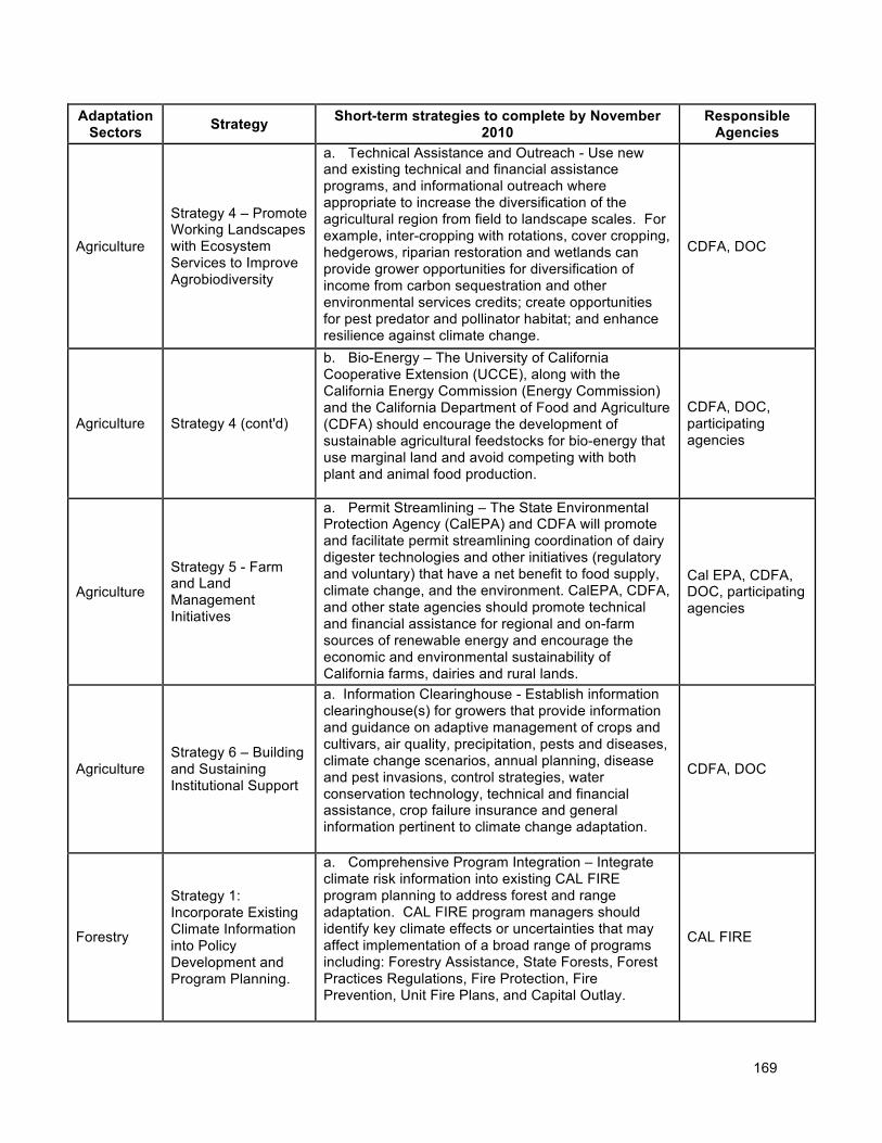
169
Adaptation Sectors
Strategy Short-term strategies to complete by November
2010 Responsible
Agencies
Agriculture
Strategy 4 – Promote Working Landscapes with Ecosystem Services to Improve Agrobiodiversity
a. Technical Assistance and Outreach - Use new and existing technical and financial assistance programs, and informational outreach where appropriate to increase the diversification of the agricultural region from field to landscape scales. For example, inter-cropping with rotations, cover cropping, hedgerows, riparian restoration and wetlands can provide grower opportunities for diversification of income from carbon sequestration and other environmental services credits; create opportunities for pest predator and pollinator habitat; and enhance resilience against climate change.
CDFA, DOC
Agriculture Strategy 4 (cont'd)
b. Bio-Energy – The University of California Cooperative Extension (UCCE), along with the California Energy Commission (Energy Commission) and the California Department of Food and Agriculture (CDFA) should encourage the development of sustainable agricultural feedstocks for bio-energy that use marginal land and avoid competing with both plant and animal food production.
CDFA, DOC, participating agencies
Agriculture
Strategy 5 - Farm and Land Management Initiatives
a. Permit Streamlining – The State Environmental Protection Agency (CalEPA) and CDFA will promote and facilitate permit streamlining coordination of dairy digester technologies and other initiatives (regulatory and voluntary) that have a net benefit to food supply, climate change, and the environment. CalEPA, CDFA, and other state agencies should promote technical and financial assistance for regional and on-farm sources of renewable energy and encourage the economic and environmental sustainability of California farms, dairies and rural lands.
Cal EPA, CDFA, DOC, participating agencies
Agriculture Strategy 6 – Building and Sustaining Institutional Support
a. Information Clearinghouse - Establish information clearinghouse(s) for growers that provide information and guidance on adaptive management of crops and cultivars, air quality, precipitation, pests and diseases, climate change scenarios, annual planning, disease and pest invasions, control strategies, water conservation technology, technical and financial assistance, crop failure insurance and general information pertinent to climate change adaptation.
CDFA, DOC
Forestry
Strategy 1: Incorporate Existing Climate Information into Policy Development and Program Planning.
a. Comprehensive Program Integration – Integrate climate risk information into existing CAL FIRE program planning to address forest and range adaptation. CAL FIRE program managers should identify key climate effects or uncertainties that may affect implementation of a broad range of programs including: Forestry Assistance, State Forests, Forest Practices Regulations, Fire Protection, Fire Prevention, Unit Fire Plans, and Capital Outlay.
CAL FIRE
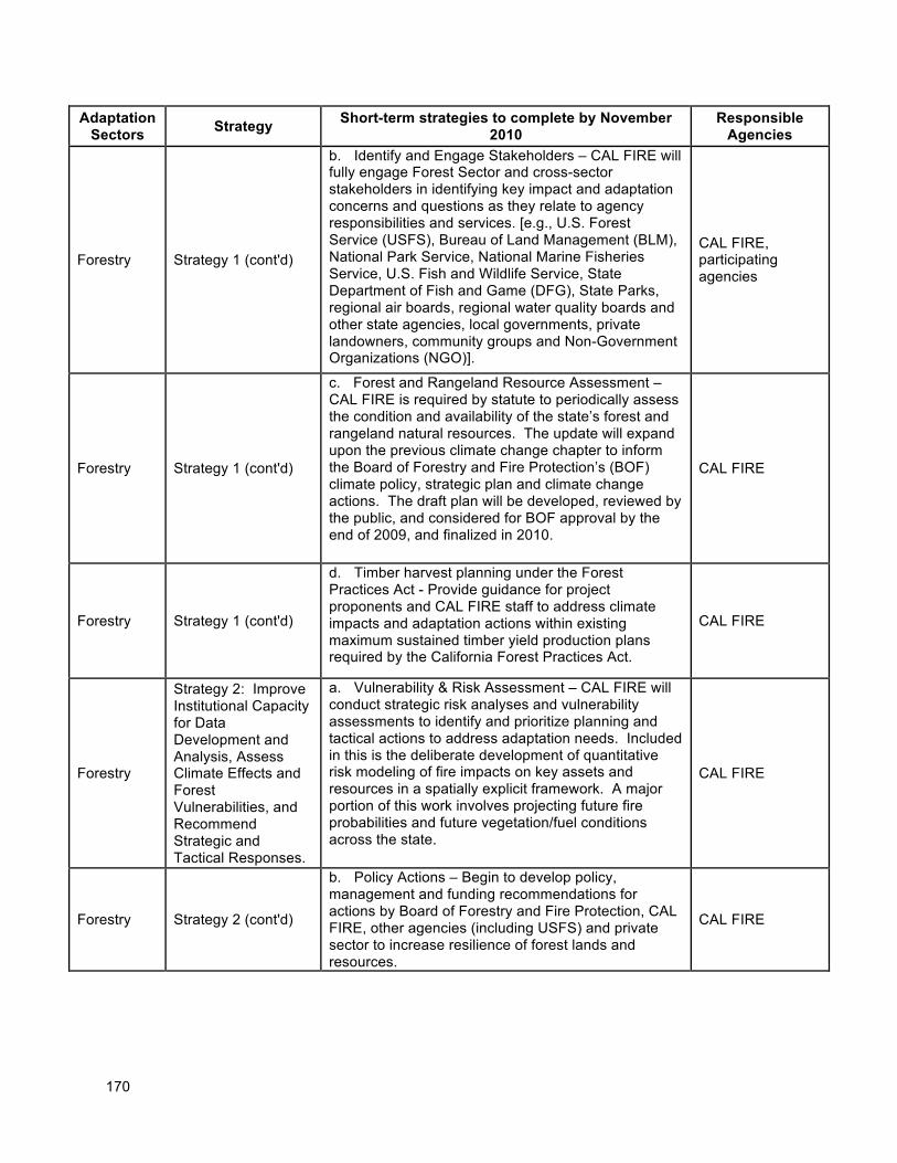
170
Adaptation Sectors
Strategy Short-term strategies to complete by November
2010 Responsible
Agencies
Forestry Strategy 1 (cont'd)
b. Identify and Engage Stakeholders – CAL FIRE will fully engage Forest Sector and cross-sector stakeholders in identifying key impact and adaptation concerns and questions as they relate to agency responsibilities and services. [e.g., U.S. Forest Service (USFS), Bureau of Land Management (BLM), National Park Service, National Marine Fisheries Service, U.S. Fish and Wildlife Service, State Department of Fish and Game (DFG), State Parks, regional air boards, regional water quality boards and other state agencies, local governments, private landowners, community groups and Non-Government Organizations (NGO)].
CAL FIRE, participating agencies
Forestry Strategy 1 (cont'd)
c. Forest and Rangeland Resource Assessment – CAL FIRE is required by statute to periodically assess the condition and availability of the state’s forest and rangeland natural resources. The update will expand upon the previous climate change chapter to inform the Board of Forestry and Fire Protection’s (BOF) climate policy, strategic plan and climate change actions. The draft plan will be developed, reviewed by the public, and considered for BOF approval by the end of 2009, and finalized in 2010.
CAL FIRE
Forestry Strategy 1 (cont'd)
d. Timber harvest planning under the Forest Practices Act - Provide guidance for project proponents and CAL FIRE staff to address climate impacts and adaptation actions within existing maximum sustained timber yield production plans required by the California Forest Practices Act.
CAL FIRE
Forestry
Strategy 2: Improve Institutional Capacity for Data Development and Analysis, Assess Climate Effects and Forest Vulnerabilities, and Recommend Strategic and Tactical Responses.
a. Vulnerability & Risk Assessment – CAL FIRE will conduct strategic risk analyses and vulnerability assessments to identify and prioritize planning and tactical actions to address adaptation needs. Included in this is the deliberate development of quantitative risk modeling of fire impacts on key assets and resources in a spatially explicit framework. A major portion of this work involves projecting future fire probabilities and future vegetation/fuel conditions across the state.
CAL FIRE
Forestry Strategy 2 (cont'd)
b. Policy Actions – Begin to develop policy, management and funding recommendations for actions by Board of Forestry and Fire Protection, CAL FIRE, other agencies (including USFS) and private sector to increase resilience of forest lands and resources.
CAL FIRE
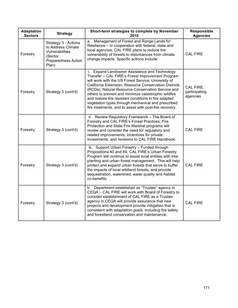
171
Adaptation Sectors
Strategy Short-term strategies to complete by November
2010 Responsible
Agencies
Forestry
Strategy 3 - Actions to Address Climate Vulnerabilities (Sector Preparedness Action Plan)
a. Management of Forest and Range Lands for Resilience – In cooperation with federal, state and local agencies, CAL FIRE plans to reduce the vulnerability of forests to disturbances from climate change impacts. Specific actions include:
CAL FIRE
Forestry Strategy 3 (cont'd)
i. Expand Landowner Assistance and Technology Transfer – CAL FIRE’s Forest Improvement Program will work with the US Forest Service, University of California Extension, Resource Conservation Districts (RCDs), Natural Resource Conservation Service and others to prevent and minimize catastrophic wildfire and restore fire resistant conditions in fire adapted vegetation types through mechanical and prescribed fire treatments, and to assist with post-fire recovery.
CAL FIRE, participating agencies
Forestry Strategy 3 (cont'd)
ii. Review Regulatory Framework – The Board of Forestry and CAL FIRE’s Forest Practices, Fire Protection and State Fire Marshal programs will review and consider the need for regulatory and related improvements, incentives for private investments, and revisions to CAL FIRE Handbook.
CAL FIRE
Forestry Strategy 3 (cont'd)
iii. Support Urban Forestry – Funded through Propositions 40 and 84, CAL FIRE’s Urban Forestry Program will continue to assist local entities with tree planting and urban forest management. This will help protect and expand urban forests that serve to buffer the impacts of local wildland forests, and provide sequestration, watershed, water quality and habitat co-benefits.
CAL FIRE
Forestry Strategy 3 (cont'd)
b. Department established as “Trustee” agency in CEQA – CAL FIRE will work with Board of Forestry to consider establishment of CAL FIRE as a Trustee agency in CEQA will provide assurance that new projects and development provide mitigation that is consistent with adaptation goals, including fire safety and forestland conservation and maintenance.
CAL FIRE
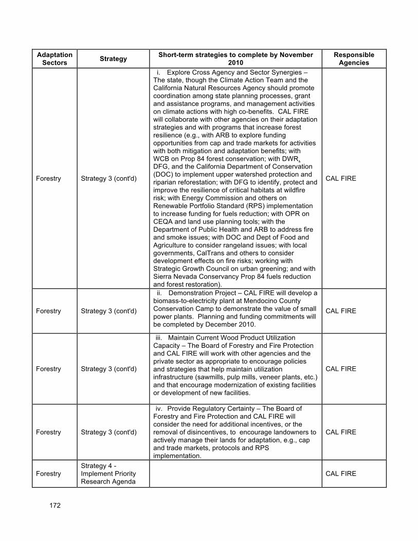
172
Adaptation Sectors
Strategy Short-term strategies to complete by November
2010 Responsible
Agencies
Forestry Strategy 3 (cont'd)
i. Explore Cross Agency and Sector Synergies – The state, though the Climate Action Team and the California Natural Resources Agency should promote coordination among state planning processes, grant and assistance programs, and management activities on climate actions with high co-benefits. CAL FIRE will collaborate with other agencies on their adaptation strategies and with programs that increase forest resilience (e.g., with ARB to explore funding opportunities from cap and trade markets for activities with both mitigation and adaptation benefits; with WCB on Prop 84 forest conservation; with DWR, DFG, and the California Department of Conservation (DOC) to implement upper watershed protection and riparian reforestation; with DFG to identify, protect and improve the resilience of critical habitats at wildfire risk; with Energy Commission and others on Renewable Portfolio Standard (RPS) implementation to increase funding for fuels reduction; with OPR on CEQA and land use planning tools; with the Department of Public Health and ARB to address fire and smoke issues; with DOC and Dept of Food and Agriculture to consider rangeland issues; with local governments, CalTrans and others to consider development effects on fire risks; working with Strategic Growth Council on urban greening; and with Sierra Nevada Conservancy Prop 84 fuels reduction and forest restoration).
CAL FIRE
Forestry Strategy 3 (cont'd)
ii. Demonstration Project – CAL FIRE will develop a biomass-to-electricity plant at Mendocino County Conservation Camp to demonstrate the value of small power plants. Planning and funding commitments will be completed by December 2010.
CAL FIRE
Forestry Strategy 3 (cont'd)
iii. Maintain Current Wood Product Utilization Capacity – The Board of Forestry and Fire Protection and CAL FIRE will work with other agencies and the private sector as appropriate to encourage policies and strategies that help maintain utilization infrastructure (sawmills, pulp mills, veneer plants, etc.) and that encourage modernization of existing facilities or development of new facilities.
CAL FIRE
Forestry Strategy 3 (cont'd)
iv. Provide Regulatory Certainty – The Board of Forestry and Fire Protection and CAL FIRE will consider the need for additional incentives, or the removal of disincentives, to encourage landowners to actively manage their lands for adaptation, e.g., cap and trade markets, protocols and RPS implementation.
CAL FIRE
Forestry Strategy 4 - Implement Priority Research Agenda
CAL FIRE
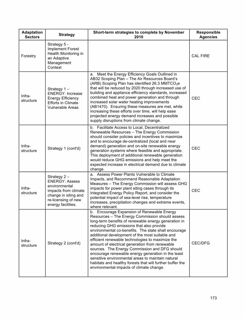
173
Adaptation Sectors
Strategy Short-term strategies to complete by November
2010 Responsible
Agencies
Forestry
Strategy 5 - Implement Forest Health Monitoring in an Adaptive Management Context
CAL FIRE
Infra-structure
Strategy 1 – ENERGY: Increase Energy Efficiency Efforts in Climate Vulnerable Areas
a. Meet the Energy Efficiency Goals Outlined in AB32 Scoping Plan – The Air Resources Board’s (ARB) Scoping Plan has identified 26.3 MMTCO2e that will be reduced by 2020 through increased use of building and appliance efficiency standards, increased combined heat and power generation and through increased solar water heating improvements (AB1470). Ensuring these measures are met, while increasing these efforts over time, will help ease projected energy demand increases and possible supply disruptions from climate change.
CEC
Infra-structure
Strategy 1 (cont'd)
b. Facilitate Access to Local, Decentralized Renewable Resources – The Energy Commission should consider policies and incentives to maximize and to encourage de-centralized (local and near demand) generation and on-site renewable energy generation systems where feasible and appropriate. This deployment of additional renewable generation would reduce GHG emissions and help meet the expected increase in electrical demand due to climate change.
CEC
Infra-structure
Strategy 2 – ENERGY: Assess environmental impacts from climate change in siting and re-licensing of new energy facilities.
a. Assess Power Plants Vulnerable to Climate Impacts, and Recommend Reasonable Adaptation Measures – The Energy Commission will assess GHG impacts for power plant siting cases through its Integrated Energy Policy Report, and consider the potential impact of sea-level rise, temperature increases, precipitation changes and extreme events, where relevant.
CEC
Infra-structure Strategy 2 (cont'd)
b. Encourage Expansion of Renewable Energy Resources – The Energy Commission should assess long-term benefits of renewable energy generation in reducing GHG emissions that also provide environmental co-benefits. The state shall encourage additional development of the most suitable and efficient renewable technologies to maximize the amount of electrical generation from renewable sources. The Energy Commission and DFG should encourage renewable energy generation in the least sensitive environmental areas to maintain natural habitats and healthy forests that will further buffer the environmental impacts of climate change.
CEC/DFG
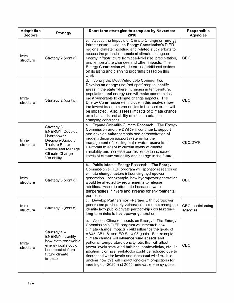
174
Adaptation Sectors
Strategy Short-term strategies to complete by November
2010 Responsible
Agencies
Infra-structure Strategy 2 (cont'd)
c. Assess the Impacts of Climate Change on Energy Infrastructure – Use the Energy Commission’s PIER regional climate modeling and related study efforts to assess the potential impacts of climate change on energy infrastructure from sea-level rise, precipitation, and temperature changes and other impacts. The Energy Commission will determine additional actions on its siting and planning programs based on this work.
CEC
Infra-structure
Strategy 2 (cont'd)
d. Identify the Most Vulnerable Communities – Develop an energy-use “hot-spot” map to identify areas in the state where increases in temperature, population, and energy-use will make communities most vulnerable to climate change impacts. The Energy Commission will include in this analysis how the lowest-income communities in hot spot areas will be impacted. Also, assess impacts of climate change on tribal lands and ability of tribes to adapt to changing conditions.
CEC
Infra-structure
Strategy 3 – ENERGY: Develop Hydropower Decision-Support Tools to Better Assess and Manage Climate Change Variability
a. Expand Scientific Climate Research – The Energy Commission and the DWR will continue to support and develop enhancements and demonstration of modern decision support systems for the management of existing major water reservoirs in California to adapt to current levels of climate variability and increase our resilience to increased levels of climate variability and change in the future.
CEC/DWR
Infra-structure
Strategy 3 (cont'd)
b. Public Interest Energy Research – The Energy Commission’s PIER program will sponsor research on climate change factors influencing hydropower generation – for example, how hydropower generation would be affected by requirements to release additional water to attenuate increased water temperatures in rivers and streams for environmental purposes.
CEC
Infra-structure
Strategy 3 (cont'd)
c. Develop Partnerships –Partner with hydropower generators particularly vulnerable to climate change to identify how public-private partnerships could reduce long-term risks to hydropower generation.
CEC, participating agencies
Infra-structure
Strategy 4 – ENERGY: Identify how state renewable energy goals could be impacted from future climate impacts.
a. Assess Climate Impacts on Energy – The Energy Commission’s PIER program will research how climate change impacts could influence the goals of AB32, AB118, and EO S-13-08 goals. For example, climate change will influence wind speeds and patterns, temperature density, etc. that will affect power levels from wind turbines, photovoltaics, etc. In addition, biomass feedstocks could be reduced due to decreased water levels and increased wildfire. It is unclear how this will impact long-term projections for meeting our 2020 and 2050 renewable energy goals.
CEC
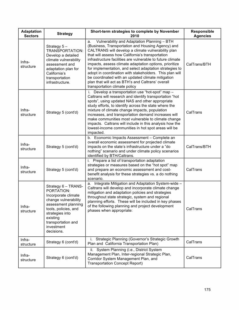
175
Adaptation Sectors
Strategy Short-term strategies to complete by November
2010 Responsible
Agencies
Infra-structure
Strategy 5 – TRANSPORTATION: Develop a detailed climate vulnerability assessment and adaptation plan for California’s transportation infrastructure.
a. Vulnerability and Adaptation Planning – BTH (Business, Transportation and Housing Agency) and CALTRANS will develop a climate vulnerability plan that will assess how California’s transportation infrastructure facilities are vulnerable to future climate impacts, assess climate adaptation options, prioritize for implementation, and select adaptation strategies to adopt in coordination with stakeholders. This plan will be coordinated with an updated climate mitigation plan that will act as BTH’s and Caltrans’ overall transportation climate policy
CalTrans/BTH
Infra-structure
Strategy 5 (cont'd)
i. Develop a transportation use “hot-spot” map – Caltrans will research and identify transportation “hot spots”, using updated NAS and other appropriate study efforts, to identify across the state where the mixture of climate change impacts, population increases, and transportation demand increases will make communities most vulnerable to climate change impacts. Caltrans will include in this analysis how the lowest-income communities in hot spot areas will be impacted.
CalTrans
Infra-structure Strategy 5 (cont'd)
b. Economic Impacts Assessment – Complete an overall economic assessment for projected climate impacts on the state’s infrastructure under a ”do nothing” scenario and under climate policy scenarios identified by BTH/Caltrans.
CalTrans/BTH
Infra-structure
Strategy 5 (cont'd)
i. Prepare a list of transportation adaptation strategies or measures based on the “hot spot” map and prepare an economic assessment and cost-benefit analysis for these strategies vs. a do nothing scenario.
CalTrans
Infra-structure
Strategy 6 – TRANS-PORTATION: Incorporate climate change vulnerability assessment planning tools, policies, and strategies into existing transportation and investment decisions.
a. Integrate Mitigation and Adaptation System-wide –Caltrans will develop and incorporate climate change mitigation and adaptation policies and strategies throughout state strategic, system and regional planning efforts. These will be included in key phases of the following planning and project development phases when appropriate: CalTrans
Infra-structure
Strategy 6 (cont'd) i. Strategic Planning (Governor’s Strategic Growth Plan and California Transportation Plan) CalTrans
Infra-structure
Strategy 6 (cont'd)
ii. System Planning (i.e., District System Management Plan, Inter-regional Strategic Plan, Corridor System Management Plan, and Transportation Concept Report)
CalTrans
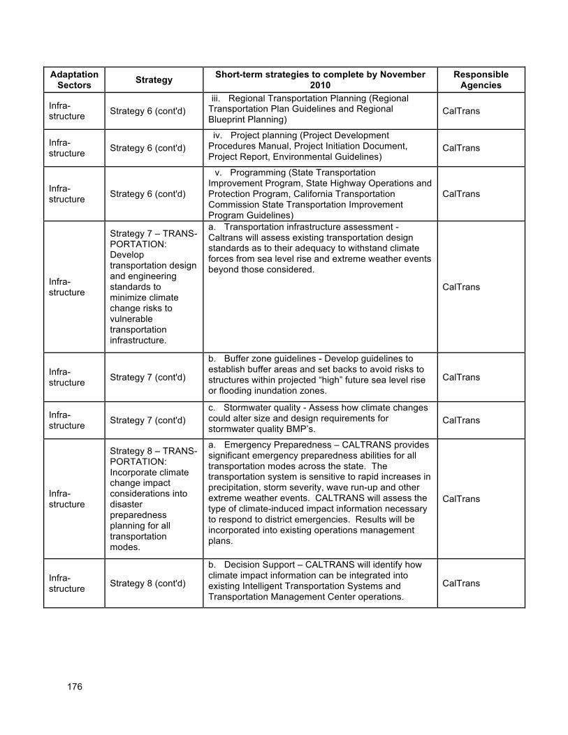
176
Adaptation Sectors
Strategy Short-term strategies to complete by November
2010 Responsible
Agencies
Infra-structure Strategy 6 (cont'd)
iii. Regional Transportation Planning (Regional Transportation Plan Guidelines and Regional Blueprint Planning)
CalTrans
Infra-structure
Strategy 6 (cont'd) iv. Project planning (Project Development Procedures Manual, Project Initiation Document, Project Report, Environmental Guidelines)
CalTrans
Infra-structure
Strategy 6 (cont'd)
v. Programming (State Transportation Improvement Program, State Highway Operations and Protection Program, California Transportation Commission State Transportation Improvement Program Guidelines)
CalTrans
Infra-structure
Strategy 7 – TRANS-PORTATION: Develop transportation design and engineering standards to minimize climate change risks to vulnerable transportation infrastructure.
a. Transportation infrastructure assessment - Caltrans will assess existing transportation design standards as to their adequacy to withstand climate forces from sea level rise and extreme weather events beyond those considered.
CalTrans
Infra-structure
Strategy 7 (cont'd)
b. Buffer zone guidelines - Develop guidelines to establish buffer areas and set backs to avoid risks to structures within projected “high” future sea level rise or flooding inundation zones.
CalTrans
Infra-structure
Strategy 7 (cont'd) c. Stormwater quality - Assess how climate changes could alter size and design requirements for stormwater quality BMP’s.
CalTrans
Infra-structure
Strategy 8 – TRANS-PORTATION: Incorporate climate change impact considerations into disaster preparedness planning for all transportation modes.
a. Emergency Preparedness – CALTRANS provides significant emergency preparedness abilities for all transportation modes across the state. The transportation system is sensitive to rapid increases in precipitation, storm severity, wave run-up and other extreme weather events. CALTRANS will assess the type of climate-induced impact information necessary to respond to district emergencies. Results will be incorporated into existing operations management plans.
CalTrans
Infra-structure
Strategy 8 (cont'd)
b. Decision Support – CALTRANS will identify how climate impact information can be integrated into existing Intelligent Transportation Systems and Transportation Management Center operations.
CalTrans

177
178
REFERENCES
Part I- Planning for Climate Change 1 See, for example, the following publications: Moser, Susanne, Guido Franco, Sarah Pittiglio, Wendy Chou and Dan Cayan (2008). The Future is Now: An Update on Climate Change Science Impacts and Response Options for California. 2008 Climate Change Impacts Assessment Project - Second Biennial Science Report to the California Climate Action Team, CEC-500-2008-071, Sacramento, CA. Pittiglio, S., G. Franco, and J. Gonzales (2008). Annual Minimum and Maximum Temperature Anomalies in California by Climatic Region, 1920-2003. California Energy Commission Report, CEC-500-2008-085, Sacramento, CA. Franco, Guido et al. (2008). Linking climate change science with policy in California. Climatic Change 87 (Suppl 1):S7–S20. Dettinger, N.Michael and Dan Cayan (2007). Trends in Snowfall Versus Rainfall for the Western United States, 1949-2001. California Energy Commission -PIER Research Report CEC-500-2007-032, Sacramento, CA. Luers, Amy L. et al. (2006). Our Changing Climate: Assessing the Risks to California. The 2006 Summary Report from the California Climate Change Center. CEC-PIER Report, CEC-500-2006-077, Sacramento, CA. 2 Cayan, Dan, Mary Tyree, Mike Dettinger, Hugo Hidalgo, Tapash Das, Ed Maurer, Peter Bromirski, Nicholas Graham, and Reinhard Flick (2009). Climate Change Scenarios and Sea Level Rise Estimates for the California 2008 Climate Change Scenarios Assessment. PIER Research Report, CEC-500-2009-014, Sacramento, CA: California Energy Commission. 3 Moser et al. (2008), see Endnote 1. 4 Mastrandrea, Michael D., Claudia Tebaldi, Carolyn P. Snyder, Stephen H. Schneider (2009). Current and Future Impacts of Extreme Events in California. PIER Research Report, CEC-500-2009-026-D, Sacramento, CA: California Energy Commission. 5 Solomon S. et al. (2007). Climate Change 2007: The Physical Science Basis. Contribution of Working Group I to the Fourth Assessment Report of the Intergovernmental Panel on Climate Change. Cambridge, UK: Cambridge University Press. 6 IPCC (2000). Special Report on Emissions Scenarios (SRES). Nature Publishing Group. 7 Raupach, M. R., G. Marland, P. Ciais, C. Le Quere, J. G. Canadell, G. Klepper, and C. B. Field (2007). Global and regional drivers of accelerating CO2 emissions. Proceedings of the National Academy of Sciences 104(24):10288-10293. Canadell, J. G., C. Le Quere, M. R. Raupach, C. B. Field, E. T. Buitenhuis, P. Ciais, T. J. Conway, N. P. Gillett, R. A. Houghton, and G. Marland (2007). Contributions to accelerating atmospheric CO2 growth from economic activity, carbon intensity, and efficiency of natural sinks. Proceedings of the National Academy of Sciences 104(47):18866-18870.
179
8 The reference to “pre-industrial” times typically refers to the period from AD 1000-1750 during which CO2 concentrations were relatively stable. See: Forster, P. and Ramaswamy, V. et al. (2007). Changes in atmospheric constituents and in radiative forcing. In: Climate Change 2007: The Physical Science Basis. Contribution of Working Group I to the Fourth Assessment Report of the Intergovernmental Panel on Climate Change, eds. Salomon, S. et al., pp.129-234, Cambridge, UK: Cambridge University Press. 9 See ongoing CO2 measurements at: http://www.esrl.noaa.gov/gmd/ccgg/trends/ [accessed January 2009]. See also Forster, P. and Ramaswamy, V. et al. (2007), in Endnote 8. 10 Cayan et al. (2009), in Endnote 2. 11 Temperature, precipitation, and sea-level rise projections in this and the following sections are all drawn from Cayan et al. (2009), in Endnote 2. 12 See Moser et al. (2008), in Endnote 1. 13 Mastrandrea et al. (2009), in Endnote 4. 14 Mastrandrea et al. (2009), in Endnote 4. 15 Mastrandrea et al. (2009), in Endnote 4; and Cayan et al. (2009), in Endnote 2. 16 Dettinger, Michael, Hugo Hidalgo, Tapash Das, Daniel Cayan, and Noah Knowles (2009). Projections of Potential Flood Regime Changes in California. PIER Research Report, CEC-500-2009-050-D, Sacramento, CA: California Energy Commission. 17 See, for example: Steffensen, J.P. et al. (2008). High-resolution Greenland ice core data show abrupt climate change happens in few years. Science 321: 680-684. Niemeyer, S., J. Petts, and K. Hobson (2005). Rapid climate change and society: Assessing responses and thresholds. Risk Analysis 25 (6):1443-1456. 18 See, for example: Lenton, T.M., H. Held, E. Kriegler, J. W. Hall, W. Lucht, S. Rahmstorf and H. J. Schellnhuber. (2008). Tipping elements in the Earth’s climate system. Proceedings of the National Academy of Sciences 105(6):1786–1793. Ramanathan, V., and Y. Feng (2008). On avoiding dangerous anthropogenic interference with the climate system: Formidable challenges ahead. Proceedings of the National Academy of Sciences 105:14245-14250. Overpeck, J.T. et al. (2006). Paleoclimatic evidence for future ice-sheet instability and rapid sea-level rise. Science 311: 1747-1750. Schneider, S. H. (2004). Abrupt non-linear climate change, irreversibility and surprise. Global Environmental Change 14(3):245-258. 19 Lenton et al. (2008), in Endnote 16.
180
Part lI: Climate Change – Impacts, Risks and Strategies by Sector
Public Health
1 McGeehin, M. A., and M. Mirabelli (2001). The potential impacts of climate variability and change on temperature-related morbidity and mortality in the United States. Environmental Health Perspectives 109:185–189. 2 Basu, R., and J. M. Samet (2002). Relation between elevated ambient temperature and mortality: A review of the epidemiologic evidence. Epidemiologic Reviews 24:190-202. 3 Semenza, J. C., C. H. Rubin, K. H. Falter, J. D. Selanikio, W. D. Flanders, H. L. Howe, and J. L. Wilhelm (1996). Heat-related deaths during the July 1995 heat wave in Chicago. New England Journal of Medicine 335(2):84–90. 4 Drechsler D. M., N. Motallebi, M. Kleeman, D. Cayan, K. Hayhoe, L. S. Kalkstein, N. Miller, S. Sheridan, J. Jin, and R. A. VanCuren (2006). Public health-related impacts of climate change in California. PIER Research Report, CEC-500-2005-197-SF, Sacramento, CA: California Energy Commission. 5 Drechsler,et.al (2006), See Endnote 4. 6 Kaiser, R., C. H. Rubin, A. K. Henderson, M. I. Wolfe, S. Kieszak, C. L. Parrott, and M. Adcock. (2001). Heat-related death and mental illness during the 1999 Cincinnati heat wave. American Journal of Forensic Medicine and Pathology 22(3):303–307; as cited in Ostro, Bart D., Lindsey A. Roth, Rochelle S. Green, and Rupa Basu (2009). Estimating the Mortality Effect of the July 2006 California Heat Wave. PIER Research Report, CEC-500-2009-036-D, Sacramento, CA: California Energy Commission. 7 Cershunov, A., and D. Cayan (2008). Recent Increase in California Heat Waves: July 2006 and the Last Six Decades. PIER Research Report, in press [as cited in 2009 CAT report]. 8 Kim, T. J., and R. B. Trent (2007). Heat-related deaths associated with a severe heat wave – California, July 2006. Presented at California Air Resources Board, July 30, 2007. As cited in Drechsler, D.M. (2009). Climate change and public health in California. PIER Research Report, CEC-500-2009-xxx, Sacramento, CA: California Energy Commission, in revision. [paper still in progress] 9 Mastrandrea, Michael D., Claudia Tebaldi, Carolyn P. Snyder, Stephen H. Schneider (2009). Current and Future Impacts of Extreme Events in California. PIER Research Report, CEC-500-2009-026-D, Sacramento, CA: California Energy Commission. 10 Messner, Steven, Sandra C. Miranda, Karen Green, Charles Phillips, Joseph Dudley, Dan Cayan, Emily Young (2009). Climate Change Related Impacts in the San Diego Region by 2050. PIER Research Report, CEC-500-2009-027-D, Sacramento, CA: California Energy Commission. 11 Hayhoe, K., P. Frumhoff, S. Schneider, A. Luers, and C. Field (2006). Regional assessment of climate impacts on California under alternative emission scenarios—key findings and implications for stabilisation. In: Avoiding Dangerous Climate Change, eds. H.-J. Schellnhuber, W. Cramer, N. nakicenovic, T. Wigley, and G. Yohe, 227-234, Cambridge, UK: Cambridge University Press. 12 Knowlton, K., M. Rotkin-Ellman, G. King, G., H. G. Margolis, D. Smith, G. Solomon, R. Trent, and P. English (2008), The 2006 California heat wave: Impacts on hospitalizations and emergency department visits. Environmental Health Perspectives 110(Supplement 2): 149-154. As cited in Mastrandrea et al. (2009), see Endnote 12.
181
13 Mastrandrea et al. (2009), see Endnote 9. 14 Messner et al. (2009), see Endnote 10. 15 See, for example: Steiner, A. L., S. Tonse, R. C. Cohen, A. H. Goldstein, and R. A. Harley (2006). Influence of future climate and emissions on regional air quality in California. Journal of Geophysical Research-Atmospheres 111: D18303, doi:10.1029/2005JD006935. Millstein, Dev E. and Robert A. Harley (2009). Impact of Climate Change on Photochemical Air Pollution in Southern California. PIER Research Report, CEC-500-2009-021-D, Sacramento, CA: California Energy Commission. 16 Drechsler et al. (2009), See Endnote 4. 17 Srebot V, et al. Ozone and cardiovascular injury. Cardio Ultrasound. 2009 Jun 24;7:30.
18 The National Assessment Sythesis Team. US Global Change Research Program. Climate Change Impacts on the United States The Potential Consequences of Climate Variability and Change Overview: Human Health. Updated 10/12/2009. Accessed Online: http://www.usgcrp.gov/usgcrp/Library/nationalassessment/overviewhealth.htm#Air%20Pollution-related%20Health%20Effects 10/27/2009.
19 Ebi KL, McGregor G. Climate Change, Tropospheric Ozone and Particulate Matter, and Health
Impacts. Env Health Persp (2008) 116:1459-1455. Accessed Online: http://www.ehponline.org/docs/2008/116-11/toc.html 10/27/2009.
20 Jacobson M. On the causal link between carbon dioxide and air pollution mortality. Geophy Res Let (2008).
21 Jerrett, M. Air Pollution, Environmental Equity and Health: a Spatiotemporal Analysis. Accessed Online:
http://www.hc-sc.gc.ca/sr-sr/finance/tsri-irst/proj/urb-air/tsri-223-eng.php 10/27/2009.
22 Morbidity and Mortality Weekly Report (MMWR) (2006). Injury and Illness Surveillance in Hospitals and Acute-Care Facilities After Hurricanes Katrina and Rita – New Orleans Area, Louisiana, September 25-October 15, 2005. MMWR 55(2): 35-38 (January 20); available at: http://www.policyholdersofamerica.org/newsletter/jan_2006/CDC_release2.pdf. Morbidity and Mortality Weekly Report (MMWR) (2006). Surveillance for illness and injury after Hurricane Katrina--three counties, Mississippi, September 5-October 11, 2005. MMWR 55(9): 231-234. Available at: http://www.cdc.gov/mmwr/preview/mmwrhtml/mm5509a2.htm.
23 Rose, J. B., P. R. Epstein, E. K. Lipp, B. H. Sherman, S. M. Bernard, and J. A. Patz (2001). Climate variability and change in the United States: Potential impacts on water- and foodborne diseases caused
by microbiologic agents. Environmental Health Perspectives 109: 211-221.
24 Rose et al. (2001), see Endnote 23
25 See, for example:
182
Westerling, A.L., B.P. Bryant, H.K. Preisler, H.G. Hidalgo, T. Das, and S.R. Shrestha (2009). Climate Change, Growth, and California Wildfire. PIER Research Report, CEC-500-2009-046-D, Sacramento, CA: California Energy Commission. Westerling, A. L., H. Hidalgo, D. R. Cayan, and T. Swetnam (2006). Warming and earlier spring increases in Western US forest wildfire activity. Science 313: 940-943. As cited in Westerling, A., and B. Bryant (2006). Climate change and wildfire in and around California: Fire modeling and loss modeling. PIER Research Report, CEC-500-2005-190-SF, Sacramento, CA: California Energy Commission.
26 “WildfireSmoke: A Guide For Public Officials” Revised July 2008.
http://www.oehha.org/air/risk_assess/wildfirev8.pdf
27 Heberger, Matthew, Heather Cooley, Pablo Herrera, Peter H. Gleick, and Eli Moore (2009). The Impacts of Sea Level Rise on the California Coast. PIER Research Report, CEC-500-2009-024-D, Sacramento, CA: California Energy Commission. 28 Greer, A, Ng, V and D. Fishman (2008). Climate change and infectious disease in North America: The road ahead. CMAJ 178 (6): 715-722. 29 Drechsler et al. (2009), see Endnote
30 Eisen, R. J., R. S. Lane, C. L. Fritz, and L. Eisen (2006). Spatial patterns of Lyme disease risk in California based on disease incidence data and modeling of vector-tick exposure. American Journal of Tropical Medical and Hygiene 75(4): 669–676. 31 Reisen W, Lothrop H, Chiles R, Madon M, Cossen C, Woods L, et al. West Nile virus in California.
Emerg Infect Dis [serial on the Internet]. 2004 Aug [date cited]. Available from: http://www.cdc.gov/ncidod/EID/vol10no8/04-0077.htm
32 Gubler, D. J., P. Reiter, K. L. Ebi, W. Yap, R. Nasci, and J. A. Patz (2001). Climate variability and change in the United States: Potential impacts on vector- and rodent-borne diseases. Environmental Health Perspectives 109: 223–233. 33 See, for example, Rose et al. (2001), Endnote 23, and also: Lydersen, K. (2008). Risk of disease rises with water temperature. The Washington Post, October 20. 34 Svircev Z, Krstic S, Miladinov-Mikov M, Baltic V, Vidovic M. (2009). Freshwater cyanobacterial blooms and primary liver cancer epidemiological studies in Serbia. J Environ Sci Health C Environ Carcinog Ecotoxicol Rev. 27(1): 36-55. 35 Greer et al. (2008), see Endnote 28.
36 Younger M, Morrow-Almeida HR, Vindigni SM, Dannenberg AL, The built environment, climate change, and health: opportunities for co-benefits; Am J Prev Med; 2008-Nov; vol 35 (issue 5) : pp 517-26.
183
Biodiversity and Habitats
1 Stein, Bruce A., Lynn S. Kutner, and Jonathan S. Adams (eds., 2000). Precious Heritage: The Status of Biodiversity in the United States. Oxford, UK: Oxford University Press. 2 Steinhart, P. (1990).California's Wild Heritage: Threatened and Endangered Animals in the Golden State. California Department of Fish and Game, California Academy of Sciences, and Sierra Club Books (excerpt available at: http://ceres.ca.gov/ceres/calweb/biodiversity/evolution.html, [last accessed January 2009]). 3 Wilson, E. O. (1992). The Diversity of Life. Cambridge, MA: Belknap Press of Harvard University Press. 4 Shaw, M. Rebecca, Linwood Pendleton, Dick Cameron, Belinda Morris, Greg Bratman, Dominique Bachelet, Kirk Klausmeyer, Jason MacKenzie, Dave Conklin, James Lenihan, Erik Haunreiter and Chris Daly (2009). The Impact of Climate Change on California's Ecosystem Services. PIER Research Report, CEC-500-2009-025-D, Sacramento, CA: California Energy Commission. 5 Steinhart (1990), see Endnote 2. 6 Millennium Ecosystem Assessment (MEA) (2005), as cited in Shaw et al. (2009), see Endnote 4. 7 Jonathan T. Overpeck, Robert S. Webb, and Thompson Webb , III Mapping eastern North American vegetation change of the past 18 ka: No-analogs and the future, Geology; December 1992; v. 20; no. 12;
p. 1071-1074
8 1.Brown et al. “Reorganization of an arid ecosystem in response to Recent Climate Change.” National
Academy of Sciences. Volume 94, pp. 9729-9733. September 1997.
2. Kelly, Ann and Michael L. Goulden. “Rapid shifts in plant distribution with recent climate change.” National Academy of Sciences of the United States of America. June 6, 2008.
9 1. Forister, M.L. & Shapiro, A.M. (2003) Climatic trends and advancing spring flight of butterflies in lowland California. Global Change Biology, 9, 1130-1135. 2. Macmynowski, D.P., Root, T.L., Ballard, G. & Geupel, G.R. (2007) Changes in spring arrival of Nearctic-Neotropical migrants attributed to multiscalar climate. Global Change Biology, 13, 2239-2251.
10 Stralberg, D., D. Jongsomjit, C. A. Howell, M. A. Snyder, J. D. Alexander, J. A. Wiens, and T. L. Root. 2009. Re-Shuffling of Species with Climate Disruption: A No-Analog Future for California Birds? PLoS ONE 4:e6825. doi:10.1371/journal.pone.0006825).
11 see Tingley, M.W., W.B. Monahan, S.R. Beissinger, and C. Moritz. 2009. Birds track their Grinnellian niche through a century of climate change. Proceedings of the National Academy of Sciences, early view. http://www.pnas.org/content/early/2009/09/14/0901562106
12 Millennium Ecosystem Assessment, 2005. Ecosystems and Human Well-being: Biodiversity Synthesis. World Resources Institute, Washington, DC.
13 Shaw CEC report on ecosystem services, already cited in Biodiversity chapter
184
14 Turner, R.K., and G.C. Daily. 2008. The Ecosystem Services Framework and Natural Capital Conservation. Environmental and Resource Economics 39, 1: 25-35.
15 Daily, G.C., S. Polasky, J. Goldstein, P. M. Kareiva, H. A. Mooney, L. Pejchar, T. H. Ricketts, J. Salzman, and R. Shallenberger. 2009. Eocystem services in decision making: time to deliver. Frontiers in Ecology and the Environment 7(1):21-28.
16 Hurteau, M. & North, M. (2009) Fuel treatment effects on tree-based forest carbon storage and emissions under modeled wildfire scenarios. FRONTIERS IN ECOLOGY AND THE ENVIRONMENT, 7, 409-414.
17 Ahearn, D.S., J.H. Viers, J.F. Mount and R.A. Dahlgren. 2006. Priming the productivity pump: Flood pulse driven trends in suspended algal biomass distribution across a restored floodplain. Freshwater Biology 51:1417–1433.
18 1. Merz, J.E. and P.B. Moyle. 2006. Salmon, wildlife, and wine: Marine-derived nutrients in human-dominated ecosystems of central California. Ecological Applications 16:999–1009. 2. Uesugi, A. and M. Murakami. 2007. Do seasonally fluctuating aquatic subsidies influence the distribution pattern of birds between riparian and upland forests? Ecological Research 22:274–281.
19 1. Grindal, S.D., J.L. Morissette and R.M. Brigham. 1999. Concentration of bat activity in riparian habitats over an elevational gradient. Canadian Journal of Zoology 77:972–977. 2. Knopf, F.L., R.R. Johnson, T. Rich, F.B. Samson and R.C. Szaro. 1988. Conservation of riparian ecosystems in the United States. Wilson Bulletin 100: 272–284.
20 Wipfli, M.S. 1997. Terrestrial invertebrates as salmonid prey and nitrogen sources in streams: Contrasting old-growth and young-growth riparian forests in southeastern Alaska, USA. Canadian Journal of Fisheries and Aquatic Sciences 54:1259–1269.
21 Shaw, R., Cameron, D., Morris, B., Bratman, G., Bachelet, D., Klausmeyer, K., MacKenzie, J., Conklin, D., Lenihan, J., Haunreiter, E., and C. Daly. 2009. The impact of climate change on California’s ecosystem services. California Energy Commission, PIER. CEC-500-2009-025. 22 Shaw et al. (2009), see Endnote 4. 23 Mastrandrea, Michael D., Claudia Tebaldi, Carolyn P. Snyder, Stephen H. Schneider (2009). Current and Future Impacts of Extreme Events in California. PIER Research Report, CEC-500-2009-026-D, Sacramento, CA: California Energy Commission. 24 RHJV (Riparian Habitat Joint Venture). 2004. Version 2.0. The riparian bird conservation plan: a strategy for reversing the decline of riparian associated birds in California. California Partners in Flight. http://www.prbo.org/calpif/pdfs/riparian.v-2.pdf.
25 Sacramento River Advisory Council. 1998. Draft Sacramento River Conservation Area Handbook. Red Bluff, CA.
185
26 1. Smith, D. S., A. B. Wellington, J. L Nachlinger, and C. A. Fox. 1991. Mortality and age of black cottonwood stands along diverted and undiverted streams in the eastern Sierra Nevada, California. Ecological Applications (1):89-97. 2. Stromberg, J. C. and D. T. Patten. 1992. Mortality and age of black cottonwood stands along diverted and undiverted streams in the eastern Sierra Nevada, California. Modroño 39(3):205-223. 27 See for example: Running, S.W. (2006). Is global warming causing more, larger wildfires? Science 313: 927-928. Westerling, A.L., H.G. Hidalgo, D.R. Cayan and T.W. Swetnam (2006). Warming and earlier spring increase in Western U.S. forest wildfire activity. Science 313: 940-943. Gedalof, Z., Peterson, D. L., Mantua, N. J. (2005). Atmospheric, climatic, and ecological controls on extreme wildfire years in the Northwestern United States. Ecological Applications 15:154-174. Keeley, J.E. (2004). Impact of antecedent climate on fire regimes in coastal California. International Journal of Wildland Fire 13:173-182. Westerling, A.L., D.R. Cayan, T.J. Brown, B.L. Hall and L.G. Riddle (2004). Climate, Santa Ana winds and autumn wildfires in Southern California. EOS 85(31): 289, 296. Westerling, A.L., T.J. Brown, A. Gershunov, D.R. Cayan, and M.D. Dettinger (2003). Climate and wildfire in the Western United States. Bulletin of the American Meteorological Society 84(5): 595-604. 28 Westerling, A.L., B. P. Bryant, H. K. Preisler, H. G. Hidalgo, T. Das, S. R. Shrestha. 2008. Climate Change, Growth and California Wildfire. California Energy Commission, Climate Change Center. Draft.
29 Keithley, C., and C. Bleier (2008). An adaptation plan for California’s forest sector and rangelands. Sacramento, CA: California Department of Forestry and Fire Protection. 30 J.E. Keeley, G.H. Aplet, N.L. Christensen, S.G. Conard, E.A. Johnson, P.N. Omi, D.L. Peterson, and T.W. Swetnam. 2009. Ecological Foundations for Fire Management in North American Forest and
Shrubland Ecosystems. United States Department of Agriculture Forest Service, Pacific Northwest Research Station General Technical Report PNW-GTR-779. 92 pp
31 California Coastal Commission (1987).California Coastal Resource Guide. University of California Press. (Excerpts available at: http://ceres.ca.gov/ceres/calweb/coastal/wetlands.html; last accessed January 24, 2009). 32 Peterson, C.H. et al (2008). National Estuaries. In: Preliminary Review of Adaptation Options for Climate-Sensitive Ecosystems and Resources. A Report by the U.S. Climate Change Science Program and the Subcommittee on Global Change Research, SAP 4.4, eds. Julius, S.H. and J.M. West, Washington, DC: EPA. 33 Cayan, D.B., P.D. Bromirski, K. Hayhoe, M. Tyree, M.D. Dettinger, R.E. Flick. (2008). Climate change projections of sea level extremes along the California coast. Climatic Change 87(Suppl. 1): 57-74. 34 See, for example, Peterson et al. (2008), in Endnote 18. 35 Resource management in a changing and uncertain climate.
186
Lawler, J.J.*, and T.H. Tear, , C. Pyke, M. R. Shaw, P.Gonzalez, P. Kareiva, L.Hansen, L. Hannah, K. Klausmeyer, A. Aldous, C. Bienz, and S.Pearsall, 2009. Front Ecol Environ 2009; 7, doi:10.1890/070146
36 California Wildlife: Conservation Challenges: California's Wildlife Action Plan. 2007. Prepared by the UC Davis Wildlife Health Center for the Department of Fish and Game. Available at: http://dfg.ca.gov/wildlife/wap/report.html ISBN: 0972229124. LCCN Permalink: http://lccn.loc.gov/2008379066 37 California Wildlife: Conservation Challenges: California's Wildlife Action Plan. 2007. See Endnote 21. 38 See: http://www.dfg.ca.gov/climatechange/
39 1. Millar, C. I., N. L. Stephenson, and S. L. Stephens. 2007. Climate change and forests of the future: Managing in the face of uncertainty. Ecological Applications 17:2145-2151. 2. USFS on-line Climate Change Resource Center at http://gis.fs.fed.us/ccrc/).
40 See reference 39.
Oceans and Coastal Resources
1 Ewing, L. (2007). Considering sea level rise as a coastal hazard. Proceedings of Coastal Zone ‘07. Portland, OR, July 22-26, 2007. 2 Crossett, K.M. et al. (2004). Population Trends Along the Coastal United States: 1980-2008. Coastal Trends Report Series. Silver Spring, MD: NOAA National Ocean Service. 3 NPA, as cited in Boesch, D.F., Fields, J.C. and D. Scavia (eds., 2000). The Potential Consequences of Climate Variability and Change on Coastal and Marine Resources. Report of the Coastal Areas and Marine Resources Sector Team, US National Assessment. Silver Spring, MD: NOAA. 4 Heberger, Matthew, Heather Cooley, Pablo Herrera, Peter H. Gleick, and Eli Moore (2009). The Impacts of Sea Level Rise on the California Coast. PIER Research Report, CEC-500-2009-024-D, Sacramento, CA: California Energy Commission. 5 See review of economic assessments of the value of beaches in Pendleton, Linwood, Philip King, Craig Mohn, D. G. Webster, Ryan K. Vaughn, and Peter Adams (2009). Estimating the Potential Economic Impacts of Climate Change on Southern California Beaches. PIER Research Report, CEC-500-2009-033-D, Sacramento, CA: California Energy Commission.
6 Solomon S. et al. (2007). Climate Change 2007: The Physical Science Basis. Contribution of Working Group I to the Fourth Assessment Report of the Intergovernmental Panel on Climate Change. Cambridge, UK: Cambridge University Press. 7 Rahmstorf, S. (2007). A semi-empirical approach to projecting future sea-level rise. Science 315 (5810): 368-370. 8 Pfeffer, W. T., J. T. Harper, and S. O’Neel (2008). Kinematic constraints on glacier contributions to 21st-century sea-level rise. Science 321:1340-1343.
187
9 Cayan, Dan, Mary Tyree, Mike Dettinger, Hugo Hidalgo, Tapash Das, Ed Maurer, Peter Bromirski, Nicholas Graham, and Reinhard Flick (2009). Climate Change Scenarios and Sea Level Rise Estimates for the California 2008 Climate Change Scenarios Assessment. PIER Research Report, CEC-500-2009-014, Sacramento, CA: California Energy Commission. 10 Conover, D. (2007). Effects of climate change on fisheries. Written testimony submitted to the Senate Committee on Commerce, Science, and Transportation - Oceans, Atmosphere, Fisheries, and Coast Guard Subcommittee at a hearing concerning “Effects of climate change and ocean acidification on living marine resources.” May 2007. 11 Julius, S.H. and J.M. West (eds.), Baron, J.S. et al. (authors) (2008). Preliminary Review of Adaptation Options for Climate-Sensitive Ecosystems and Resources. Final Report, Synthesis and Assessment Product 4.4, Climate Change Science Program, Environmental Protection Agency, Washington, DC. 12 Conover (2007), see Endnote 10. 13 Zeidberg, Louis D. and Bruce H. Robison (2007). Invasive range expansion by the Humboldt squid, Dosidicus gigas, in the eastern North Pacific. Proceedings of the National Academy of Sciences 104(31): 12948–12950. 14 Conover (2007), see Endnote 10. 15 Julius et al. (2008), see Endnote 11. 16 Hughes, Mimi, Alex Hall, and Jinwon Kim (2009). Anthropogenic Reduction of Santa Ana Winds. PIER Research Report, CEC-500-2009-015-D, Sacramento, CA: California Energy Commission. 17 Kahrl, F. and D. Roland-Holst (2008). California Climate Risk and Response. Berkeley, CA: University of California-Berkeley, Department of Agricultural and Resource Economics. 18 Kahrl and Roland-Holst (2008), as in Endnote 19. 19 Dettinger, Michael, Hugo Hidalgo, Tapash Das, Daniel Cayan, and Noah Knowles (2009). Projections of Potential Flood Regime Changes in California. PIER Research Report, CEC-500-2009-050-D, Sacramento, CA: California Energy Commission. 20 Westerling, A.L., B.P. Bryant, H.K. Preisler, H.G. Hidalgo, T. Das, and S.R. Shrestha (2009). Climate Change, Growth, and California Wildfire. PIER Research Report, CEC-500-2009-046-D, Sacramento, CA: California Energy Commission. 21 Julius et al. (2008), as in Endnote 11. 22 Moser, Susanne, Guido Franco, Sarah Pittiglio, Wendy Chou and Dan Cayan (2008). The Future is Now: An Update on Climate Change Science Impacts and Response Options for California. 2008 Climate Change Impacts Assessment Project - Second Biennial Science Report to the California Climate Action Team, CEC-500-2008-071, Sacramento, CA. 23 Bromirski, P. D., D. R. Cayan, and R. E. Flick (2005), Wave spectral energy variability in the northeast Pacific. J. Geophys. Res. 110: C03005, doi:10.1029/2004JC002398. 24 San Francisco Bay Conservation and Development Commission (BCDC). (2008). A Sea Level Rise Strategy for the San Francisco Bay Region. Revised 2008. San Francisco, CA: BCDC. 25 Heberger et al. (2009), see Endnote 4.
188
26 Knowles, Noah (2009). Potential Inundation Due to Rising Sea Levels in the San Francisco Bay Region. PIER Research Report, CEC-500-2009-023-D, Sacramento, CA: California Energy Commission. 27 Knowles (2009), see Endnote 29. 28 Knowles (2009), see Endnote 29. 29 Heberger et al. (2009), see Endnote 4. 30 Cayan, D. et al. (2009), see Endnote 9. 31 Gleick, et al (2009) see Endnote 4.
32 Federal Emergency Management Agency (FEMA) (1991). Projected impact of relative sea level rise on National Flood Insurance Program. Available at: http://www.epa.gov/climatechange/effects/downloads/flood_insurance.pdf 33 Heberger et al. (2009), see Endnote 4. 34 See for example: Mount J. and R. Twiss (2005). Subsidence, sea level rise, seismicity in the Sacramento-San Joaquin Delta. San Francisco Estuary and Watershed Science 3(1) (March 2005): Article 5; available at: http://repositories.cdlib.org/jmie/sfews/vol3/iss1/art5 California Department of Water Resources (2005). Sacramento-San Joaquin Delta Region. Chapter 12 in: California Water Plan Update 2005, DWR, Sacramento, CA. 35 Knowles (2009), see Endnote 29. 36 Dahl, T. E. (1990). Wetlands Losses in the United States 1780's to 1980's. Washington, DC: U.S. Department of the Interior, Fish and Wildlife Service and Jamestown, ND: Northern Prairie Wildlife Research Center Online. 37 Roos, M. (2008). Sea level rise: What is the water engineer to do with all those projections? California Department of Water Resources. Draft 7 October 2008. 38 Heberger et al. (2009), see Endnote 4, and Knowles (2009), see Endnote 29. 39 Knowles (2009), see Endnote 29. 40 Kennedy, V.S., R.R. Twilley, J.A. Kleypas, J.H. Cowan, and S.R. Hare (2002). Coastal and Marine Ecosystems & Global Climate Change: Potential Effects on U.S. Resources. Washington, DC: Pew Center on Global Climate Change. 41 The Coastal Vulnerability Index (C.V.I.) shows the relative physical vulnerability of the coast to changes due to future rise in sea level. Areas along the coast are assigned a ranking from low to very high risk, based on an analysis of physical variables that contribute to coastal change. The distribution of coastal risk, as classified by the USGS, varies along the California coastline, with peak risk concentrated around the state’s major bays, as well as the cities of the southern coast. Source; Hammar-Klose, E.S. and Thieler, E.R. (2001). Coastal Vulnerability to Sea-Level Rise: A Preliminary Database for the U.S. Atlantic, Pacific and Gulf of Mexico Coasts. USGS Digital Data Series 68, available at: http://pubs.usgs.gov/dds/dds68/htmldocs/project.htm.
189
See also: Thieler, E.R. and Hammar-Klose, E.S. (2000).National Assessment of Coastal Vulnerability to Future Sea-Level Rise: Preliminary Results for the U.S. Pacific Coast. U.S. Geological Survey, Open-File Report 00-178, available online at: http://pubs.usgs.gov/of/of00-178/ 42 King (1999), as cited in Kahrl and Roland-Holst (2008), see Endnote 19. 43 Dean Runyan Associates (2008), as cited in Kahrl and Roland-Holst (2008), see Endnote 19. 44 Pendleton et al. (2009), see Endnote 5. 45 Adams, Peter N. and Douglas L. Inman (2009). Climate Change and Potential Hotspots of Coastal Erosion Along the Southern California Coast. PIER Research Report, CEC-500-2009-022-D, Sacramento, CA: California Energy Commission. 46 Cayan, D., et al. (2006). Projecting Future Sea Level. California Energy Commission, PIER Program Report, CEC-2005-202-SF, Sacramento, CA. 47 Moser et al. (2008), see Endnote 24. 48 See: http://www.afsc.noaa.gov/HEPR/acidification.php, accessed on March 19, 2009. 49 Gazeau F., C. Quiblier, J. M. Jansen, J.-P. Gattuso, J. J. Middelburg and C. H. R. Heip (2007). Impact of elevated CO2 on shellfish calcification. Geophysical Research Letters 34: L07603.
Water Management 1 California Department of Water Resources (DWR) (2008). Managing an Uncertain Future: Climate Change Adaptation Strategies for California’s Water. DWR, Sacramento, CA. Available at: http://www.water.ca.gov/climatechange/docs/ClimateChangeWhitePaper.pdf 2 DWR (2008), see Endnote 1. 3 DWR (2008), see Endnote 1. 4 Medellín-Azuara, Josué, Christina R. Connell, Kaveh Madani, Jay R. Lund and Richard E. Howitt (2009). Water Management Adaptation with Climate Change. PIER Research Report, CEC-500-2009-049-D, Sacramento, CA: California Energy Commission. 5 DWR (2008), see Endnote 1. 6 DWR (2008), see Endnote 1. 7 Medellín-Azuara et al. (2009), see Endnote 4. 8 Medellín-Azuara et al. (2009), see Endnote 4. 9 Medellín-Azuara et al. (2009), see Endnote 4. 10 See, for example, Cayan, Dan, Mary Tyree, Mike Dettinger, Hugo Hidalgo, Tapash Das, Ed Maurer, Peter Bromirski, Nicholas Graham, and Reinhard Flick (2009). Climate Change Scenarios and Sea Level Rise Estimates
190
for the California 2008 Climate Change Scenarios Assessment. PIER Research Report, CEC-500-2009-014, Sacramento, CA: California Energy Commission. Kapnick, Sarah and Alex Hall (2009). Observed Changes in the Sierra Nevada Snowpack: Potential Causes and Concerns. PIER Research Report, CEC-500-2009-016-D, Sacramento, CA: California Energy Commission. 11 DWR (2008), see Endnote 1; see also Kapnick and Hall (2009), as in Endnote 10. 12 California Department of Water Resources (2008). California Drought, An Update. Sacramento, CA: DWR. See also ongoing updates at: http://meteora.ucsd.edu/cap/western_drought.html. 13 DWR (2008). California Drought, An Update, see Endnote 12. 14 California's Major Sources of Energy (2007); available at http://energyalmanac.ca.gov/overview/energy_sources.html. 15 DWR (2008), see Endnote 1. 16 Kim, J., R. Fovell, A. Hall, Q. Li, K. N. Liou, J. McWilliams, Y. Xue, X. Qu, and S. Kapnick D. Waliser, A. Eldering, Y. Chao, and R. Friedl (2009). A Projection of the Cold Season Hydroclimate in California in Mid-Twenty-First Century under the SRES-A1B Emission Scenario. PIER Research Report, CEC-500-2009-029-D, Sacramento, CA: California Energy Commission. 17 Dettinger, Michael, Hugo Hidalgo, Tapash Das, Daniel Cayan, and Noah Knowles (2009). Projections of Potential Flood Regime Changes in California. PIER Research Report, CEC-500-2009-050-D, Sacramento, CA: California Energy Commission. 18 DWR (2008), see Endnote 1. 19 DWR (2008), see Endnote 1. 20 DWR (2008), see Endnote 1.
21 More detail on each strategy is available in DWR (2008), see Endnote 1.
Agriculture
1 CDFA (2008), see Endnote 2.
2 California Department of Food and Agriculture (CDFA). (2008) California Department of Food and Agriculture website. Accessed November, 2008. Available at: http://www.cdfa.ca.gov.
3 Cayan D., M. Tyree, M. Dettinger, H. Hidalgo, T. Das, E. Maurer, P. Bromirski, N. Graham, and R. Flick. 2009. Climate Change Scenarios and Sea Level Rise Estimates for California 2008 Climate Change Scenarios Assessment. California Energy Commission PIER Program Report, CEC-500-2009-014. Sacramento, CA.
4 Lee, J., De Gryze, S., and J. Six. (2008). Effect of climate change on field crop production in the Central Valley of California. California Energy Commission, PIER Program Report, Draft of November 2008, Sacramento, CA.
5 Mastrandrea, M. D., C. Tebaldi, C. P. Snyder, and S. H. Schneider. 2009. Current and future impacts of extreme events in California. California Energy Commission, PIER. CEC-500-2009-026.
191
6 Jackson, L.E. et al. (2008). Potential for adaptation to climate change in an agricultural landscape in the Central Valley of California. California Energy Commission PIER Program Report, Draft of November 2008, Sacramento, CA.
7 Moser, S. C., G. Franco, S. Pitiglio, W. Chou, and D. Cayan (2008). The Future is Now: An Update on Climate Change Science, Impacts, and Response Options for California, California Climate Change Center and California Energy Commission, PIER Energy-Related Environmental Research Program, CEC-500-2008-077, Sacramento, CA.
8 Lobell, D.B. and C.B. Field (2008). California perennial crops in a changing climate. California Energy Commission PIER Program Report, Draft of November 2008, Sacramento, CA.
9 Lobell, D.B., A. Torney, and C.B. Field (2008). Climate extremes in California agriculture. California Energy Commission PIER Program Report, Draft of November 2008, Sacramento, CA.
10 Mastrandrea, M. D., C. Tebaldi, C. P. Snyder, and S. H. Schneider. 2009. Current and future impacts of extreme events in California. California Energy Commission, PIER. CEC-500-2009-026.
11 Tebaldi, C. et al. (2006) as cited in Lobell et al. (2008), see Endnote 9.
12 Mastrandrea, M. D., C. Tebaldi, C. P. Snyder, and S. H. Schneider. 2009. Current and future impacts of extreme events in California. California Energy Commission, PIER. CEC-500-2009-026.
13 Mastrandrea, M. D., C. Tebaldi, C. P. Snyder, and S. H. Schneider. 2009. Current and future impacts of extreme events in California. California Energy Commission, PIER. CEC-500-2009-026.
14 Anderson, J., Chung, F., Anderson, M., Brekke, L., Easton, D., Ejeta, M., Peterson, R., and R. Snyder. 2008. Progress on incorporating climate change into management of California’s water resources. Climatic Change 87(Suppl 1): S91–S108.
See also: Battisti, D.S. and R.L. Naylor (2009). Historical warnings of future food insecurity with unprecedented seasonal heat. Science 323: 240-244.
15 Medellín-Azuara, J., et al. (2008). Water management adaptation with climate change. California
Energy Commission PIER Program Report, Draft of November 2008, Sacramento, CA.
16 Howitt, R., J. Medellín-Azuara, and D. MacEwan (2008). Measuring economic impacts of agricultural yield related changes. California Energy Commission PIER Program Report, Draft of November 2008, Sacramento, CA.
17 Joyce, B.A. et al. (2008). Climate change impacts on water supply and agricultural water management in California’s Western San Joaquin Valley, and potential adaptation strategies. California Energy Commission PIER Program Report, Draft of November 2008, Sacramento, CA.
18 Lee et al. (2008), see Endnote 4.
19 Messner, S., S. Miranda, K. Green, C. Phillips, J. Dudley, D. Cayan, and Y. Emily. 2009. Climate change related impacts in the San Diego region by 2050. California Energy Commission, PIER. CEC-500-2009-027.
20 Lobell and Field (2008), see Endnote 8.
21 California Water Plan 2005 update, Department of Water Resources.
22 Rich, Jim (January 21, 2008) Comparing Changes in Applied Water Use and the Real Gross Value of
Output for California Agriculture: 1967 to 2007: A look at the Rising Economic Efficiency of California Agricultural Water Use. California Department of Water Resources
192
23 Mastrandrea, M. D., C. Tebaldi, C. P. Snyder, and S. H. Schneider. 2009. Current and future impacts of extreme events in California. California Energy Commission, PIER. CEC-500-2009-026.
24 Lobell et al. (2008), see Endnote 9.
25 Jackson et al. (2008), see Endnote 6.
Forestry 1 van Mantgem, P.J. et al. (2009). Widespread increase of tree mortality rates in the Western United States. Science 323: 521-524. 2 Shugart, H., Sedjo, R., and B. Sohngen (2003). Forests and Global Climate Change: Potential Impacts on U.S. Forest Resources. Washington, DC: Pew Center on Global Climate Change. 3 Thorne, J., Kelsey, T., Honig, J., and B. Morgan (2006). The Development of 70-Year-Old Wieslander Vegetation Type Maps and an Assessment of Landscape Change in the Central Sierra Nevada. PIER Research Report, CEC-500-2006-107, Sacramento, CA: California Energy Commission. 4 Battles, John, Timothy Robards, Adrian Das, and William Stewart (2009). Projecting Climate Change Impacts on Forest Growth and Yield for California's Sierran Mixed Conifer Forests. PIER Research Report, CEC-500-2009-047-D, Sacramento, CA: California Energy Commission. 5 Lenihan, J. M., Drapek, R., Neilson, R. P., and D. Bachelet (2006). The response of vegetation distribution, ecosystem productivity, and fire in California to future climate scenarios simulated by the MC1 Dynamic Vegetation Model - FINAL REPORT, California Energy Commission, Report # CEC-500-2005-191-SF. 6 Lenihan et al. (2006), see Endnote 5. 7 Battles et al. (2009), see Endnote 4. 8 Logan, J. A., and J. A. Powell (2001). Ghost forests, global warming, and the mountain pine beetle. Am. Entomol. 47: 160-173. See also more recent studies at: http://www.usu.edu/beetle/publications_bark_beetle.htm 9 Logan, J. A., and J. A. Powell (2001). Ghost forests, global warming, and the mountain pine beetle. Am. Entomol. 47: 160-173. 10 Westerling, A.L. et al. (2006). Warming and earlier spring increase in Western U.S. forest wildfire activity. Science 313: 940-943. 11 See, for example, Mote, P.W., et al. (2005). Declining mountain snowpack in Western North America. Bulletin American Meteorological Society. 86(1): 39-49. 12 Westerling, A.L. et al. (2006), see Endnote 10. Westerling, A.L., et al. (2003). Climate and wildfire in the Western United States. Bulletin of the American Meteorological Society 84(5): 595-604.
193
13 Knowles N, Dettinger M, and D. Cayan (2006). Trends in snowfall versus rainfall in the Western United States. Journal of Climate 19(18): 4545–4559. 14 Shaw, M. Rebecca, Linwood Pendleton, Dick Cameron, Belinda Morris, Greg Bratman, Dominique Bachelet, Kirk Klausmeyer, Jason MacKenzie, Dave Conklin, James Lenihan, Erik Haunreiter and Chris Daly (2009). The Impact of Climate Change on California's Ecosystem Services. PIER Research Report, CEC-500-2009-025-D, Sacramento, CA: California Energy Commission. 15 Cayan, Dan, Mary Tyree, Mike Dettinger, Hugo Hidalgo, Tapash Das, Ed Maurer, Peter Bromirski, Nicholas Graham, and Reinhard Flick (2009). Climate Change Scenarios and Sea Level Rise Estimates for the California 2008 Climate Change Scenarios Assessment. PIER Research Report, CEC-500-2009-014, Sacramento, CA: California Energy Commission. 16 Dale, V.H., et al. (2001). Climate change and forest disturbance. Bioscience 51(9): 723-734. 17 Michael R. Witiw, Jeffrey Baars (2003). Long term climatological changes in fog intensity and coverage, 14th Symposium on Global Change and Climate Variations, available at: http://ams.confex.com/ams/annual2003/techprogram/paper_54543.htm. 18 J.E. Keeley, G.H. Aplet, N.L. Christensen, S.G. Conard, E.A. Johnson, P.N. Omi, D.L. Peterson, and T.W. Swetnam. 2009. Ecological Foundations for Fire Management in North American Forest and Shrubland Ecosystems. United States Department of Agriculture Forest Service, Pacific Northwest Research Station General Technical Report PNW-GTR-779. 92 pp
19 Stephens, Scott L., Robert E. Martin, Nicholas E. Clinton. 2007. Prehistoric fire area and emissions from California’s forests, woodlands, shrublands, and grasslands. Forest Ecology and Management 251 (2007) 205–216. 20 Sugihara, Neil G., Jan Van Wagtendonk, Joann Fites Kaufman, Kevin E. Shaffer, and Andrea E. Thode. 1997. The Future of Fire in California’s Ecosystems. University of California Press. 612 pp.
Chapter 24.pp 538-543.
21 Westerling, A.L., B. P. Bryant, H. K. Preisler, H. G. Hidalgo, T. Holmes, T.P. Das, S. R. Shrestha. 2009. Climate Change, Growth and California Wildfire. California Energy Commission, Climate Change
Center. Draft. (CEC-500-2009-046-F)
22 Miller, J.D., and H.D. Safford (2009). Sierra Nevada Fire Severity Monitoring 1984-2004. USDA Forest Service R5-TP-027. 23 Keithley, C., and C. Bleier (2008). An adaptation plan for California’s forest sector and rangelands. Sacramento, CA: California Department of Forestry and Fire Protection. 24 See endnotes 19 and 23, this section.
25 California Department of Forestry and Fire Protection, Fire and Resources Assessment Program. (2003). The Changing California: Forest and Range 2003 Assessment. Sacramento, CA: CDFFP. 26 Keithley and Bleier (2008), as in Endnote 18. Miller, J.D., and H.D. Safford 2008. Sierra Nevada Fire Severity Monitoring 1984-2004. USDA Forest Service R5-TP-027. 27 Lenihan et al. (2006), see Endnote 5.
28 Goines, USFS, personal communication.
194
29 Stephens, CAL FIRE, personal communication.
30 Constance I. Millar, Robert D. Westfall, and Diane L. Delany Response of high-elevation limber pine (Pinus flexilis) to multiyear droughts and 20th-century warming, Sierra Nevada, California, USA, Can. J.
For. Res. 37: 2508–2520 (2007)
31 U.S. Department of the Interior and U.S. Department of Agriculture, in collaboration with the Governors. (2001). A Collaborative Approach for Reducing Wildland Fire Risks to Communities and the Environment. Available at: http://www.forestsandrangelands.gov/plan/documents/7-19-en.pdf.
Transportation and Energy Infrastructure 1 Bryant, Benjamin and Anthony Westerling (2009). Potential Effects of Climate Change on Residential Wildfire Risk in California. PIER Research Report, CEC-500-2009-048-D, Sacramento, CA: California Energy Commission. 2 Cayan, Dan, Mary Tyree, Mike Dettinger, Hugo Hidalgo, Tapash Das, Ed Maurer, Peter Bromirski, Nicholas Graham, and Reinhard Flick (2009). Climate Change Scenarios and Sea Level Rise Estimates for the California 2008 Climate Change Scenarios Assessment. PIER Research Report, CEC-500-2009-014, Sacramento, CA: California Energy Commission. See also: Hadley, S.W., et al. (2006). Responses of energy use to climate change: A climate modeling study. Geophys. Res. Lett., 33: L17703. 3 California Energy Commission (CEC) (2008). Potential Impacts of Climate Change on California’s Energy Infrastructure and Identification of Adaptation Measures. Staff white paper. Sacramento, CA: CEC 4 California Energy Commission (2008), see Endnote 3. 5 Sailor, D. J., and A. Pavlova (2003). Air conditioning market saturation and long term response of residential cooling energy demand to climate change. Energy – the International Journal 28(9): 941-951. 6 Aroonruengsawat, Anin and Maximilian Auffhammer (2009). Impact of Climate Change on Residential Electricity Consumption: Evidence From Billing Data. PIER Research Report, CEC-500-2009-018-D, Sacramento, CA: California Energy Commission. 7 Wilbanks, T.J. et al. (2007). Effects of Climate Change on Energy Production and Use in the United States. A Report by the U.S. Climate Change Science Program and the Subcommittee on Global Change Research. Synthesis and Assessment Product 4.5, Department of Energy, Office of Biological & Environmental Research, Washington, DC. 8 California Energy Commission (2008), see Endnote 4. 9 Miller, N. L., Jin, J., Hayhoe, K., and M. Auffhammer (2007). Climate change, extreme heat, and electricity demand in California. PIER Research Report, CEC-500-2007-023, Sacramento: CA: California Energy Commission. 10 Guido Franco and Alan H. Sanstad (2008), Climate Change and Electricity Demand in California. PIER Research Report, CEC-500-2005-201-SF, Sacramento, CA: California Energy Commission.
195
11 Mastrandrea, Michael D., Claudia Tebaldi, Carolyn P. Snyder, Stephen H. Schneider (2009). Current and Future Impacts of Extreme Events in California. PIER Research Report, CEC-500-2009-026-D, Sacramento, CA: California Energy Commission. 12 Mastrandrea et al. (2009), see Endnote 14. 13 Madani, K. J. Medellin�Azuara, C. Connell, and J. Lund (2008). “Statewide Impacts of Climate Change on Hydroelectric Generation and Revenues in California.” Presentation at the Fifth Annual California Climate Change Research Conference, Sacramento, California, September 8�10, 2008. 14 California Energy Commission (2008), see Endnote 4. 15 Kahrl and Roland-Holst (2008), see Endnote 2. 16 Kahrl and Roland-Holst (2008), see Endnote 2. 17 Vicuña, Sebastian, John A. Dracup, and Larry Dale. (2009). Climate Change Impacts on the Operation of Two High-Elevation Hydropower Systems in California. PIER Research Report, CEC-500-2009-019-D, Sacramento, CA: California Energy Commission. 18 Vicuña et al. (2009), as in Endnote 21. 19 Chung, Francis, Jamie Anderson, Sushil Arora, Messele Ejeta, Jeff Galef, Tariq Kadir, Kevin Kao, Al Olson, Chris Quan, Erik Reyes, Maury Roos, Sanjaya Seneviratne, Jianzhong Wang, Hongbing Yin, and Nikki Blomquist (2009). Using Future Climate Projections to Support Water Resources Decision Making in California. PIER Research Report, CEC-500-2009-052-D, Sacramento, CA: California Energy Commission. 20 California Energy Commission (2008), as in Endnote 4. 21 Navai, R. (2008). Climate Adaptation and California’s Transportation Infrastructure. Staff White Paper, California Department of Transportation. Sacramento, CA. 22 Kahrl and Roland-Holst (2008), see Endnote 2. 23 Kahrl and Roland-Holst (2008), see Endnote 2. 24 Heberger, Matthew, Heather Cooley, Pablo Herrera, Peter H. Gleick, and Eli Moore (2009). The Impacts of Sea Level Rise on the California Coast. PIER Research Report, CEC-500-2009-024-D, Sacramento, CA: California Energy Commission. 25 Bowman, Chris. (2008). California bulks up defenses against tide of global warming. The Sacramento Bee, 24 Nov., p.1A. 26 California Energy Commission (2008), see Endnote 4. 27 Knowles, Noah (2009). Potential Inundation Due to Rising Sea Levels in the San Francisco Bay Region. PIER Research Report, CEC-500-2009-023-D, Sacramento, CA: California Energy Commission. 28 Roos, M. (2008). Sea level rise: What is the water engineer to do with all those projections? Sacramento, CA: Department of Water Resources. Draft 7 October 2008. 29 See, for example: Knowles (2009), see Endnote 32, and Heberger et al. (2009), see Endnote 29.
196
30 See, for example: Dettinger, Michael, Hugo Hidalgo, Tapash Das, Daniel Cayan, and Noah Knowles (2009). Projections of Potential Flood Regime Changes in California. PIER Research Report, CEC-500-2009-050-D, Sacramento, CA: California Energy Commission. . Mastrandrea et al. (2009), see Endnote 14. 31 Knowles (2009), see Endnote 32. 32 Heberger et al. (2009), see Endnote 29. 33 Roos (2008), as in Endnote 33. 34 Knowles (2009), see Endnote 32. 35 Heberger et al. (2009), see Endnote 29. 36 Heberger et al. (2009), see Endnote 29. 37 Heberger et al. (2009), see Endnote 29. 38 Roos (2008), as in Endnote 33.
Figure References: Figure 1: Cayan, Dan, Mary Tyree, Mike Dettinger, Hugo Hidalgo, Tapash Das, Ed Maurer, Peter Bromirski, Nicholas Graham, and Reinhard Flick (2009). Climate Change Scenarios and Sea Level Rise Estimates for the California 2008 Climate Change Scenarios Assessment. PIER Research Report, CEC-500-2009-014, Sacramento, CA: California Energy Commission.
Figure 2: Heberger, Matthew, Heather Cooley, Pablo Herrera, Peter H. Gleick, and Eli Moore (2009). The Impacts of Sea Level Rise on the California Coast. PIER Research Report, CEC-500-2009-024-D, Sacramento, CA: California Energy Commission.
Figure 3: Photo courtesy of CalFIRE
Figure 4: Louise Bedsworth and Ellen Hanak. Preparing California for a Changing Climate, Public Policy Insititute of California, 2008.
Figure 5: Moser, Susan, Guido Franco, Sarah Pittiglio, Wendy Chou, Dan Cayac (2009). The Future is Now: An Update on Calimat Change Science, Impact, and Response Options for California. Prepared for the California Energy Commission, PIER. CEC-500-2008-071
Figure 6: Cayan, et al 2009 (see reference for Figure 1).
Figure 7: Cayan, et al 2009 (see reference for Figure 1).
Figure 8: Mastrandrea, Michael D., Claudia Tebaldi, Carolyn P. Snyder, Stephen H. Schneider (2009). Current and Future Impacts of Extreme Events in California. PIER Research Report, CEC-500-2009-026-D, Sacramento, CA: California Energy Commission.
197
Figure 9: Mastrandrea, et al 2009 (see reference for Figure 8). Figure 10: IPCC, 2007: Climate Change 2007: Impacts, Adaptation and Vulnerability. Contribution of Working Group II to the Fourth Assessment Report of the Intergovernmental Panel on Climate Change, M.L. Parry, O.F. Canziani, J.P. Palutikof, P.J. van der Linden and C.E. Hanson, Eds., Cambridge University Press, Cambridge, UK, 976pp. Figure 11: CAL FIRE (2008). Fire Threat Map, CAL FIRE Fire and Resource Assessment Program. (http://frap.cdf.ca.gov/data/frapgismaps/download.asp). Figure 12: Kahrl, F. and D. Roland-Holst (2008). California Climate Risk and Response. Berkeley, CA: University of California-Berkeley, Department of Agricultural and Resource Economics. Figure 13: Chung, Francis, Anderson, Jamie, Arora, Sushil, Ejeta, Messele, Galef, Jeff, Kadir, Tariq, Kao, Kevin, Olson, Al, Quan, Chris, Reyes, Eric, Roos, Maury, Seneviratne, Sanjaya, Wang, Jianzhong, Yin, Hongbing, and Bloomquist, Nikki (2009). Using Mid-Century Climate Projections to Support Water Resources Decision Making in California. PIER Research Report, CEC-500-2009-052-F, Sacramento, CA, California Energy Commission. Figure 14: Cayan, Dan, Amy Luers, Michael Hanneman, Guido Franco, Bart Cross (2006). Scenarios of Climate Change in California: an Overview. California Climate Change Center White Paper, CEC-500-2005-186-SF.
Figure 15: Photo courtesy of the Department of Water Resources.
Figure 16: Lobell, David, Christopher B. Field (2009). California Perennial Crops in a Changing Climate. California Climate Change Center. CEC-500-2009-039-D.
Figure 17: Lee, Juhwan, Steven De Gryze Johan Six (2009). Effect of Climate Change on Field Crop Production in the Central Valley of California. California Climate Change Center. CEC-500-2009-041-D. Figures 18 and 19: Photos courtesy of CALFIRE. Figure 20: Aroonruengsawat, Anin, Maximilian Auffhammer (2009). Impacts of Climate Change on Residential Electricity Consumption: Evidence from Billing Data. California Climate Change Center, CEC-500-2009-018-D. Figure 21: Guido Franco and Alan H. Sanstad (2008), Climate Change and Electricity Demand in California. PIER Research Report, CEC-500-2005-201-SF, Sacramento, CA: California Energy Commission. Figure 22: Photo courtesy of CALTRANS. Figure 23: San Francisco Bay Conservation and Development Commission, Shoreline Areas Vulnerable to Seal Level Rise, Central Bay West Shore index map, 16 and 55-inch sea level rise scenarios. www.bcdc.ca.gov/planning/climate_change/maps/16-55/cbay_west.pdf