Embed Size (px)
Citation preview
2010 CR-V
Navigation Manual(Unlinked)
This document does not contain hyperlinks and may be formatted for printing instead of
web use. This is due to changes in content and specifications of the vehicle that happen
throughout the model year. This manual will be replaced with a hyperlinked version at the
end of the model year.
© 2009 Honda Motor Co., Ltd. P/N 00X31-SWA-8300
Navigation System 1
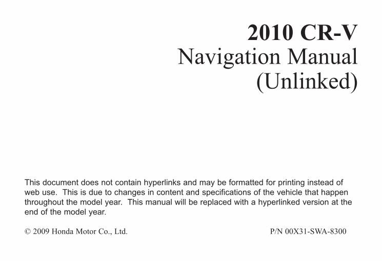
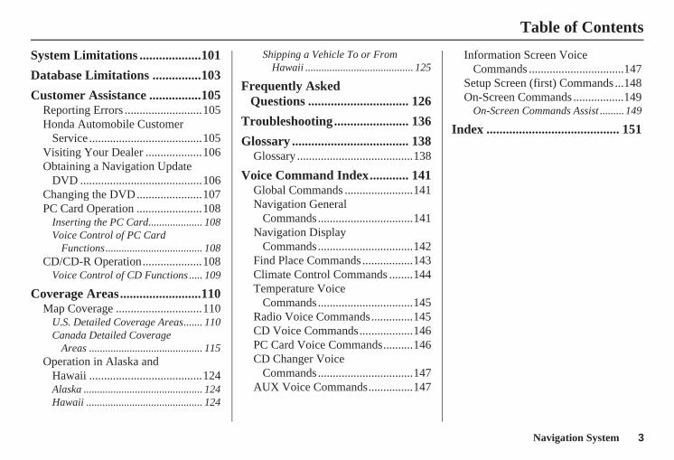
Table of Contents
Introduction ..................................4Manual Overview ............................4System Overview ............................4Accessories Precautions ..................5Important Safety Information ..........5Map Overview.................................6
Current Street .................................... 6Verified/Unverified Street.................. 6
User Agreement ............................8
Getting Started ...........................10System Controls ............................10Voice Control Basics.....................12
Using the Voice Control System ...... 13Improving Voice Recognition .......... 13
Selecting an Item (Button) on the Screen .........................................14
Selecting an Item in a List .............14Using the On-screen Keyboard .....15System Start-up .............................16Bluetooth® HandsFreeLink®........18Map Screen Legend.......................19Map Screen Description ................20
Zoom In/Out..................................... 20Map Scrolling .................................. 20
Displaying Current Location .........20System Function Diagram .............21
Entering a Destination .............. 22By Address ....................................23
Selecting the State or Province........ 23Selecting the City ............................. 23Selecting the Street .......................... 25Entering the Street Number ............. 27
By Intersection...............................27Selecting the State or Province........ 28Selecting the City ............................. 28Selecting the Street .......................... 30
By Places .......................................32Finding the Place by Category ........ 33Finding the Place by Name.............. 36Finding the Place by Phone
Number ......................................... 37By Map Input.................................37
Showing the Map of Current Position......................................... 37
Showing the Map of City.................. 39Showing the Map of State ................ 39Showing the Map of Continental
USA............................................... 40By Previous Destinations...............41By Today’s Destinations ...............42
Editing Today’s Destinations List ................................................ 42
Adding Destinations to the List........ 42
By Address Book...........................43Adding Addresses to the Personal
Address Book................................ 44By Go Home..................................44
Driving to Your Destination ..... 46Driving to Your Destination ..........46Calculate Route to Screen..............46
Changing the Routing Method......... 47Viewing the Routes........................... 48Viewing the Destination Map .......... 49
Map Screen ....................................49Route Line ........................................ 49Guidance Prompts ........................... 50Map Screen Legend ......................... 51
Guidance Screen ............................52Guidance Screen Legend ................. 52
Distance and Time to Destination..................................53
Direction List .................................53Exit Info.
(Freeway Exit Information).......... 54Guidance Mode..............................54Map Scale ......................................55Map Orientation.............................56Destination Icon.............................56
2 Navigation System
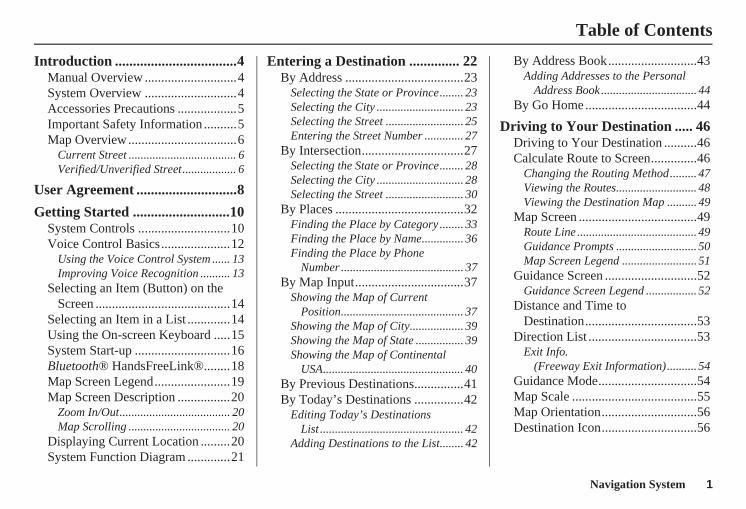
Table of Contents
Landmark Icons .............................57Showing Icons on the Map............... 59Icon Options .................................... 59
Going Off the Route ......................61Off-road Tracking..........................61Viewing/Saving the Current
Location......................................62Pop-Ups and Disclaimers ..............63Changing the Route .......................64
Change Route By Screen ................. 64Waypoints ........................................ 64Reroute: Avoid Streets ..................... 66Reroute: Detour............................... 66Reroute: Change Routing
Method.......................................... 66Cancel Current Route...................... 67Back to Current Route ..................... 67
Changing Your Destination...........67Find Nearest (Voice command)....... 67Go Home (Voice command) ............ 67Using Joystick to Change
Destination ................................... 67Entering a Destination from the Menu
Screen (while en route) ................ 69Continue Trip Screen.....................69
Information Features ................ 70Information Screen ........................70Cellular Phone ...............................70Voice Command Help ...................70Map Legend...................................71Calendar.........................................72
Entering Your Schedule ................... 72Calculator.......................................73
Unit Conversion............................... 74
System Setup .............................. 75Setup Mode....................................75Setup Screen (first) ........................75
Brightness ........................................ 75Volume ............................................. 75Display............................................. 76Guidance Prompts ........................... 77Contrast ........................................... 77
Setup Screen (second) ...................78Personal Information .....................78
Address Book ................................... 78Home Address.................................. 82PIN Number ..................................... 82User Name ....................................... 83Previous Destinations...................... 83
Routing & Guidance......................84Rerouting ......................................... 84Unverified Area Routing.................. 85
Edit Avoid Area................................ 89Edit Waypoint Search Area.............. 91Guidance Mode................................ 92
Vehicle...........................................92Off-road Tracking ............................ 92Correct Vehicle Position.................. 93
System Information .......................94Basic Settings.................................94
Keyboard Layout.............................. 94Units (mile or km) ............................ 94Voice Recognition Feedback ........... 94
Clock Settings................................95Clock Adjustment ............................. 95Clock Type ....................................... 96
Color ..............................................97Map Color........................................ 97Menu Color ...................................... 97
Rearview Camera...........................98Rearview Camera Brightness
Adjustment .................................... 98
System Initialization .................. 99System Initialization ......................99Entering the Security Code............99GPS Initialization.........................100Map Matching..............................100
Navigation System 3
Table of Contents
System Limitations ...................101
Database Limitations ...............103
Customer Assistance ................105Reporting Errors ..........................105Honda Automobile Customer
Service ......................................105Visiting Your Dealer ...................106Obtaining a Navigation Update
DVD .........................................106Changing the DVD......................107PC Card Operation ......................108
Inserting the PC Card.................... 108Voice Control of PC Card
Functions.................................... 108CD/CD-R Operation....................108
Voice Control of CD Functions ..... 109
Coverage Areas.........................110Map Coverage .............................110
U.S. Detailed Coverage Areas....... 110Canada Detailed Coverage
Areas .......................................... 115Operation in Alaska and
Hawaii ......................................124Alaska ............................................ 124Hawaii ........................................... 124
Shipping a Vehicle To or From Hawaii ........................................ 125
Frequently Asked Questions ............................... 126
Troubleshooting....................... 136
Glossary .................................... 138Glossary .......................................138
Voice Command Index............ 141Global Commands .......................141Navigation General
Commands................................141Navigation Display
Commands................................142Find Place Commands .................143Climate Control Commands ........144Temperature Voice
Commands................................145Radio Voice Commands..............145CD Voice Commands..................146PC Card Voice Commands..........146CD Changer Voice
Commands................................147AUX Voice Commands...............147
Information Screen Voice Commands ................................147
Setup Screen (first) Commands ...148On-Screen Commands .................149
On-Screen Commands Assist ......... 149
Index ......................................... 151
4 Navigation System
Introduction
Manual OverviewThe manual is divided into the following sections:• Getting Started - A basic introduction
that discusses the controls and how to communicate with the system.
• Entering a Destination - How to enter an address or locate a point of interest (POI).
• Driving to Your Destination - An explanation of the map features, guidance, and cautions.
• Information Features - Cellular Phone, Voice Command Help, Map Legend, Calendar, and Calculator.
• System Setup - How to set up and tailor the system for your personal use and use the Address Book.
The back of this manual contains:• Map Coverage (page 110)• Frequently Asked Questions (FAQs)
(page 126)• Troubleshooting Guide (page 136)• Glossary of Terms (page 138)• Voice Command List (page 141)• Operation Specific to Alaska and
Hawaii (page 124)
System OverviewYour navigation system is a highly sophisticated location system with voice control that uses satellites and a map database to show you where you are and to help guide you to a desired destination.
The navigation system receives signals from the global positioning system (GPS), a network of 24 satellites in orbit around the earth. By receiving signals from several of these satellites, the navigation system can determine the latitude, longitude, and elevation of your vehicle. In addition, a gyroscopic yaw sensor and a vehicle speed sensor in your vehicle keep track of the direction and speed of travel at all times.
Navigation System 5
Introduction
The navigation system applies location, direction, and speed information to the maps and calculates a route to the destination you enter. As you drive to that destination, the system provides map and voice guidance.
The navigation system is easy to use. The locations of many places of business and entertainment are already entered in the system. You can select any of them as a destination by using the touch screen, joystick, or voice control.
There are several ways to enter a destination, such as by point of interest (POI), by address, by phone number, and by selecting it from the map. The last 50 destinations are saved for reuse at a later date. The system also allows you to store a home address to simplify returning home from your destination.
Accessories PrecautionsIf you have front or side window tinting installed, be aware that if the tint has metallic properties, it can seriously degrade or prevent GPS reception. This is because the GPS antenna is located under the dashboard.
If you plan to install electronic components, such as radar detectors, vehicle tracking devices, remote starters, additional amplifiers, or other audio components, ensure that they are not located near the navigation control unit under the dashboard, near the navigation screen in the dash, or near the GPS antenna under the dashboard. Signal noise emanating from these devices can cause intermittent disruption of the navigation system.
Important Safety InformationThe navigation system can distract your attention from the road if you focus on the screen or operate the system’s controls while driving.
Enter as much information as possible into the system before you begin driving, or when the vehicle is stopped. Then, as you drive, listen to the audio instructions and use voice commands when possible.
6 Navigation System
While driving, do not look at the screen or operate the system controls for more than a second or so at a time, and only after deciding you can do so safely. Pull to the side of the road if you need more time to look at the screen or operate the controls.
The navigation system is designed to provide route information to help you reach your destination. However, this route guidance may sometimes conflict with current road conditions such as street closures, road construction, detours, and out-of-date map data.
Additionally, the system itself has certain limitations (see page 101). Therefore, you must verify the audio and visual route information provided by the system by carefully observing the roadway, signs and signals, etc. If you are unsure, proceed with caution. Always use your own good judgment, and obey traffic laws while driving.
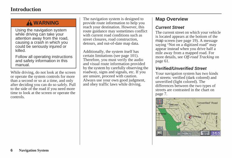
Map Overview
Current StreetThe current street on which your vehicle is located appears at the bottom of the map screen (see page 19). A message saying “Not on a digitized road” may appear instead when you drive half a mile away from a mapped road. For more details, see Off-road Tracking on page 61.
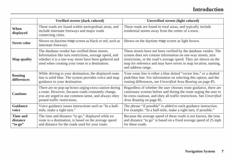
Verified/Unverified StreetYour navigation system has two kinds of streets: verified (dark colored) and unverified (light colored). The differences between the two types of streets are contrasted in the chart on page 7.
Using the navigation systemwhile driving can take yourattention away from the road,causing a crash in which youcould be seriously injured orkilled.
Follow all operating instructionsand safety information in thismanual.
WARNING
“Unverified” Road
“Verified” Road
Introduction
Navigation System 7
Introduction
Verified streets (dark colored) Unverified streets (light colored)
When displayed
These roads are found within metropolitan areas, and include interstate freeways and major roads connecting cities.
These roads are found in rural areas, and typically include residential streets away from the center of a town.
Street color Shown on daytime map screen as black or red, such as interstate freeways.
Shown on the daytime map screen as light brown.
Map quality
The database vendor has verified these streets.Information like turn restrictions, average speed, and whether it is a one-way street have been gathered and used when creating your route to a destination.
These streets have not been verified by the database vendor. The system does not contain information on one-way streets, turn restrictions, or the road’s average speed. They are shown on the map for reference and may have errors in map location, naming, and address range.
Routing differences
While driving to your destination, the displayed route line is solid blue. The system provides voice and map guidance to your destination.
Your route line is either a blue dotted “vector line,” or a dashed pink/blue line. For information on selecting this option, and the routing differences, see Unverified Area Routing on page 85.
Cautions
There are no pop-up boxes urging extra caution during a route. However, because roads constantly change, you are urged to use common sense, and always obey posted traffic restrictions.
Regardless of whether the user chooses route guidance, there are cautionary screens before and during the route urging the user to be extra cautious, and obey all traffic restrictions. See Unverified Area Routing on page 85.
Guidance voice
Voice guidance issues instructions such as “In a half-mile, make a right turn.”
The phrase “if possible” is added to each guidance instruction. For example: “In a half-mile, make a right turn, if possible.”
Time and distance “to go”
The time and distance “to go,” displayed while en route to a destination, is based on the average speed and distance for the roads used for your route.
Because the average speed of these roads is not known, the time and distance “to go” is based on a fixed average speed of 25 mph for these roads.
8 Navigation System
User Agreement
In using this DVD “Satellite Linked Navigation System” (the “DVD”), which includes HONDA MOTOR CO., LTD. software, ALPINE ELECTRONICS, INC. software, NAVTEQ database contents, INFO USA CORPORATION database, and ZENRIN CO. database contents (hereinafter referred to as “Licensors”), you are bound by the terms and conditions set forth below.By using your copy of the DVD, you have expressed your Agreement to the terms and conditions of this Agreement. You should, therefore, make sure that you read and understand the following provisions. If for any reason you do not wish to be bound by the terms of this Agreement, please return the DVD to your dealer.
• The DVD may not be copied, duplicated, or otherwise modified, in whole or in part, without the express written permission of the Licensors.
• The DVD may not be transferred or sublicensed to any third party for profit, rent or loan, or licensed for reuse in any manner.
• The DVD may not be decompiled, reverse engineered or otherwise disassembled, in whole or in part.
• The DVD may not be used in a network or by any other manner of simultaneous use in multiple systems.
• The DVD is intended solely for personal use (or internal use where the end-user is a business) by the consumer. The DVD is not to be used for commercial purposes.
• The Licensors do not guarantee to the customer that the functions included in the DVD meet the specific objectives of the user.
• Licensor shall not be responsible for any damages caused by the use of the DVD to the actual user or to any third party.
• The warranty on the DVD shall not extend to an exchange or refund due to misspelling, omission of letters, or any other cosmetic discrepancy in the contents of the DVD.
• The right to use the DVD shall expire either when the user destroys the DVD or software, or when any of the terms of this Agreement are violated and the Licensors exercise the option to revoke the license to use the DVD or software.
Navigation System 9
User Agreement
• The terms and conditions hereof apply to all subsequent users and owners as well as to the original purchaser.
• The logos of oil companies, hotels, convenience stores, and other businesses are displayed for your information and convenience, and in no way imply any sponsorship, approval or endorsement of these companies, or their products. The logos are trademarks of their respective owners.
The user shall indemnify and save harmless the Licensors, and their officers, employees and agents, from and against any claim, demand or action, irrespective of the nature of the cause of the claim, demand or action, alleging loss, costs, expense, damages or injuries (including injuries resulting in death) arising out of the use or possession of the DVD or software.
Use, duplication, or disclosure of this DVD by or on behalf of the United States government is subject to “Restricted Rights” as set forth at FAR 52.227-14, -19 or DFARS 252.227- 7013, as applicable. Manufacturers are the Licensors, including HONDA MOTOR CO., LTD., 2-1-1 Minami Aoyama Minato-Ku Tokyo 107-8556 JAPAN., Alpine Electronics, Inc., 20-1 Yoshima Kogyodanchi, Iwaki, Fukushima 970-1192 JAPAN., NAVTEQ Corporation, 222 Merchandise Mart, Suite 900, Chicago, IL, 60654, INFO USA CORPORATION, 5711 South 86th Circle, Omaha, NE 68127., and ZENRIN CO., LTD., 1-1-1 Muromachi, Kokurakita-ku, Kitakyushu, Fukuoka 803-8630, JAPAN.
10 Navigation System
Getting Started
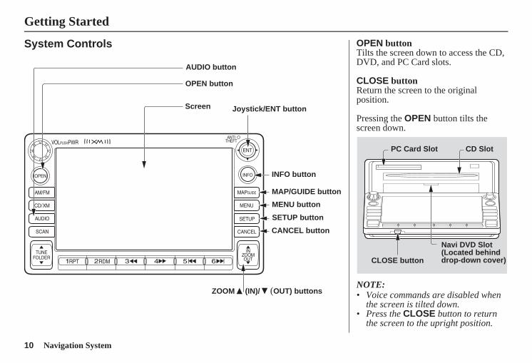
System Controls
Joystick/ENT button
MAP/GUIDE button
CANCEL button
Screen
MENU button
INFO button
AUDIO button
OPEN button
ZOOM (IN)/ (OUT) buttons
SETUP button
OPEN buttonTilts the screen down to access the CD, DVD, and PC Card slots.
CLOSE buttonReturn the screen to the original position.
Pressing the OPEN button tilts the screen down.
NOTE:• Voice commands are disabled when
the screen is tilted down.• Press the CLOSE button to return
the screen to the upright position.
CLOSE button
Navi DVD Slot (Located behind drop-down cover)
PC Card Slot CD Slot
Navigation System 11
Getting Started
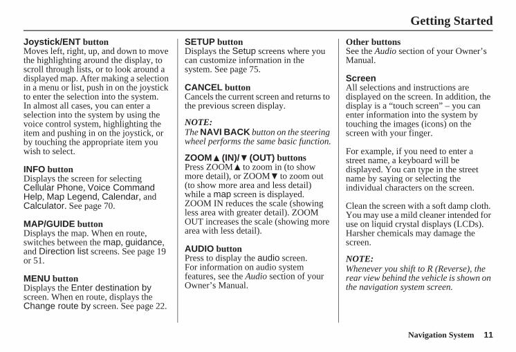
Joystick/ENT buttonMoves left, right, up, and down to move the highlighting around the display, to scroll through lists, or to look around a displayed map. After making a selection in a menu or list, push in on the joystick to enter the selection into the system.In almost all cases, you can enter a selection into the system by using the voice control system, highlighting the item and pushing in on the joystick, or by touching the appropriate item you wish to select.
INFO buttonDisplays the screen for selecting Cellular Phone, Voice Command Help, Map Legend, Calendar, and Calculator. See page 70.
MAP/GUIDE buttonDisplays the map. When en route, switches between the map, guidance, and Direction list screens. See page 19 or 51.
MENU buttonDisplays the Enter destination by screen. When en route, displays the Change route by screen. See page 22.
SETUP buttonDisplays the Setup screens where you can customize information in the system. See page 75.
CANCEL buttonCancels the current screen and returns to the previous screen display.
NOTE:The NAVI BACK button on the steering wheel performs the same basic function.
ZOOM (IN)/ (OUT) buttonsPress ZOOM to zoom in (to show more detail), or ZOOM to zoom out (to show more area and less detail) while a map screen is displayed. ZOOM IN reduces the scale (showing less area with greater detail). ZOOM OUT increases the scale (showing more area with less detail).
AUDIO buttonPress to display the audio screen.For information on audio system features, see the Audio section of your Owner’s Manual.
Other buttonsSee the Audio section of your Owner’s Manual.
ScreenAll selections and instructions are displayed on the screen. In addition, the display is a “touch screen” – you can enter information into the system by touching the images (icons) on the screen with your finger.
For example, if you need to enter a street name, a keyboard will be displayed. You can type in the street name by saying or selecting the individual characters on the screen.
Clean the screen with a soft damp cloth. You may use a mild cleaner intended for use on liquid crystal displays (LCDs). Harsher chemicals may damage the screen.
NOTE:Whenever you shift to R (Reverse), the rear view behind the vehicle is shown on the navigation system screen.
12 Navigation System
Getting Started
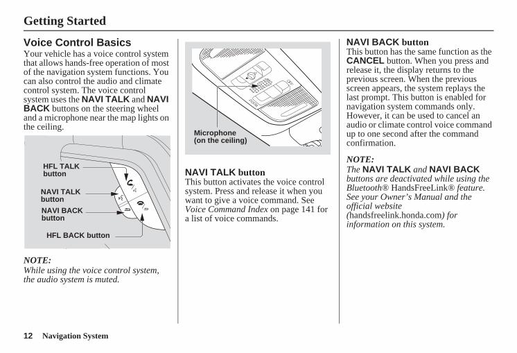
Voice Control BasicsYour vehicle has a voice control system that allows hands-free operation of most of the navigation system functions. You can also control the audio and climate control system. The voice control system uses the NAVI TALK and NAVI BACK buttons on the steering wheel and a microphone near the map lights on the ceiling.
NOTE:While using the voice control system, the audio system is muted.
NAVI TALK buttonThis button activates the voice control system. Press and release it when you want to give a voice command. See Voice Command Index on page 141 for a list of voice commands.
NAVI BACK buttonThis button has the same function as the CANCEL button. When you press and release it, the display returns to the previous screen. When the previous screen appears, the system replays the last prompt. This button is enabled for navigation system commands only. However, it can be used to cancel an audio or climate control voice command up to one second after the command confirmation.
NOTE:The NAVI TALK and NAVI BACK buttons are deactivated while using the Bluetooth® HandsFreeLink® feature. See your Owner’s Manual and the official website (handsfreelink.honda.com) for information on this system.
HFL BACK button
HFL TALK button
NAVI TALK button
NAVI BACK button
Microphone(on the ceiling)
Navigation System 13
Getting Started
Using the Voice Control SystemYou should use the voice control system as much as possible, and consider manual entry using the joystick as a backup method of entry.
Most of the system’s functions can be controlled by voice commands activated with the NAVI TALK button. To control the navigation system by voice:• Press and release the NAVI TALK
button.• Wait for the beep.• Give a voice command.
Once the microphone picks up your command, the system changes the display in response to the command and prompts you for the next command. Using the NAVI TALK button, answer the prompts as required.
If the system does not understand a command or you wait too long to give a command, it responds with “Pardon,” “Please repeat,” or “Would you say again.” If the system cannot perform a command or the command is not appropriate for the screen you are on, it sounds a beep.
Anytime you are unsure of what voice commands are available on a screen, you can always say “Help.” The system will then read the list of available commands to you.
When you give a command, the system generally either repeats the command as a confirmation or asks you for further information. If you do not wish to hear this feedback, you can turn it off. However, hearing the feedback will familiarize you with the way the system expects commands to be phrased. See the Voice Recognition Feedback setting in Setup.
If you hear a prompt such as “Please use the touch screen to...” or “Please choose an area with the joystick,” the system is asking for input that cannot be performed using the voice control system.
Improving Voice RecognitionTo achieve optimum voice recognition when using either the navigation or Bluetooth® HandsFreeLink® voice control system, the following guidelines should be followed:
NOTE:Make sure the correct screen is displayed for the voice command that you are using. See Voice Command Index on page 141.
• Adjust the dashboard and side vents so air does not blow against the microphone on the ceiling.
• Close the windows and the sunroof.
14 Navigation System
Getting Started
• If more than one person is speaking at the same time, the system may misinterpret your command.
• After pressing and releasing the NAVI TALK button, wait for the beep, then give a voice command.
• Give a voice command in a clear, natural speaking voice without pausing between words.
• If the system cannot recognize your command because of background noise, speak louder.
• If you are still having trouble with the voice control system, refer to Voice Command Help on the Information screen.
Selecting an Item (Button) on the ScreenOn most screens, there are items that can be selected (like buttons with titles such as OK or Return). To select an item on any screen, do one of the following:• Use the voice control system and say
the name of the desired item. Almost all selectable items on the screen, including some listed items, are recognized by the voice control system.
• Touch the desired item on the screen.• Move the highlighting to the desired
item with the joystick, then push in on the joystick.
Tip:If items are grayed out, this means that they cannot be selected.
Selecting an Item in a ListTo scroll through a list, do one of the following:• Use the joystick to scroll through the
list item by item.• Use the voice control system and say
“Next” or “Previous” or use the “on-screen” scroll up or down buttons, or the ZOOM buttons to scroll through the list page by page.
If you cannot find the desired name, or have made an error, return to the previous screen by pressing the CANCEL or the NAVI BACK button on the steering wheel.
To select the desired item in the list, do one of the following:• Use the voice control system, and say
the item number of the desired item.• Touch the item on the screen.• Use the joystick to move the
highlighting to the item, then push in on the joystick.
Navigation System 15
Getting Started
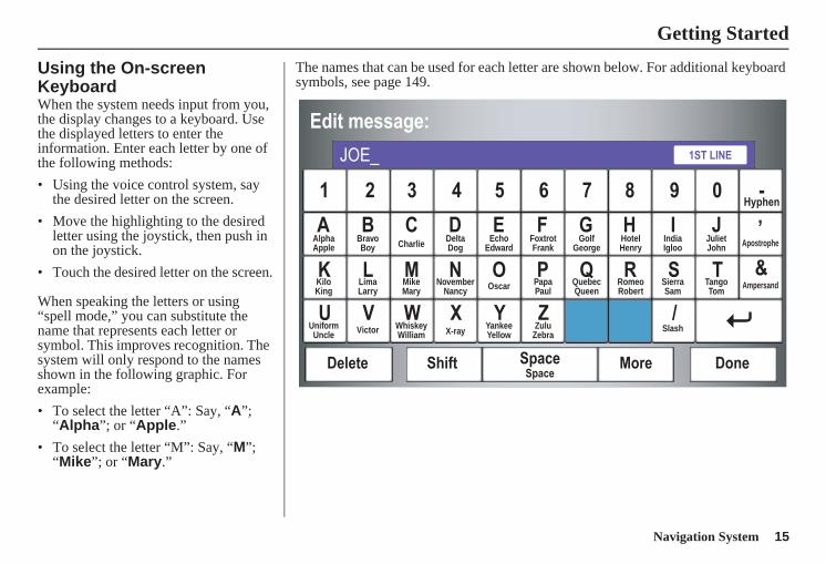
Using the On-screen KeyboardWhen the system needs input from you, the display changes to a keyboard. Use the displayed letters to enter the information. Enter each letter by one of the following methods:• Using the voice control system, say
the desired letter on the screen.• Move the highlighting to the desired
letter using the joystick, then push in on the joystick.
• Touch the desired letter on the screen.
When speaking the letters or using “spell mode,” you can substitute the name that represents each letter or symbol. This improves recognition. The system will only respond to the names shown in the following graphic. For example:• To select the letter “A”: Say, “A”;
“Alpha”; or “Apple.”• To select the letter “M”: Say, “M”;
“Mike”; or “Mary.”
The names that can be used for each letter are shown below. For additional keyboard symbols, see page 149.
AlphaApple
BravoBoy Charlie Delta
DogEcho
EdwardFoxtrotFrank
GolfGeorge
HotelHenry
JulietJohn Apostrophe
KiloKing
LimaLarry
MikeMary
NovemberNancy Oscar Papa
PaulQuebecQueen
RomeoRobert
SierraSam
TangoTom
Ampersand
UniformUncle Victor Whiskey
William X-ray YankeeYellow
ZuluZebra
Slash
IndiaIgloo
16 Navigation System
Getting Started
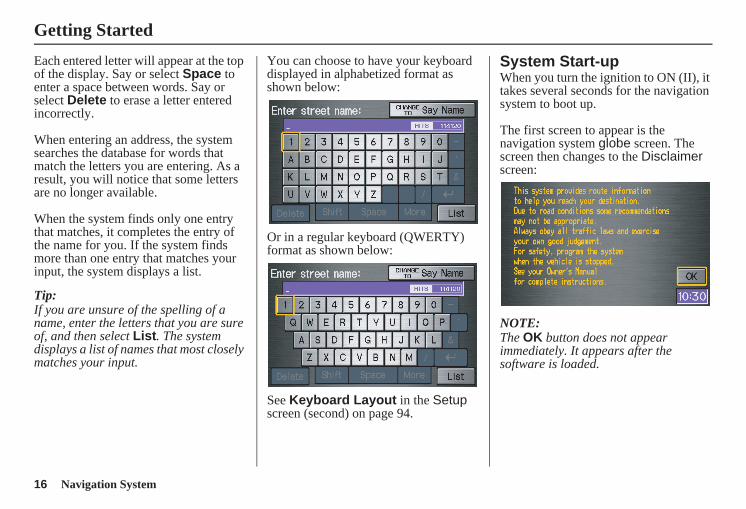
Each entered letter will appear at the top of the display. Say or select Space to enter a space between words. Say or select Delete to erase a letter entered incorrectly.
When entering an address, the system searches the database for words that match the letters you are entering. As a result, you will notice that some letters are no longer available.
When the system finds only one entry that matches, it completes the entry of the name for you. If the system finds more than one entry that matches your input, the system displays a list.
Tip:If you are unsure of the spelling of a name, enter the letters that you are sure of, and then select List. The system displays a list of names that most closely matches your input.
You can choose to have your keyboard displayed in alphabetized format as shown below:
Or in a regular keyboard (QWERTY) format as shown below:
See Keyboard Layout in the Setup screen (second) on page 94.
System Start-upWhen you turn the ignition to ON (II), it takes several seconds for the navigation system to boot up.
The first screen to appear is the navigation system globe screen. The screen then changes to the Disclaimer screen:
NOTE:The OK button does not appear immediately. It appears after the software is loaded.
Navigation System 17
Getting Started
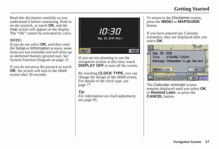
Read this disclaimer carefully so you understand it before continuing. Push in on the joystick, or touch OK, and the map screen will appear on the display. The “OK” cannot be activated by voice.
NOTE:If you do not select OK, and then enter the Setup or Information screens, some items are not available and will show up as darkened buttons (grayed out). See System Function Diagram on page 21.
If you do not press the joystick or touch OK, the screen will turn to the clock screen after 30 seconds.
If you are not planning to use the navigation system at this time, touch DISPLAY OFF to turn off the screen.
By touching CLOCK TYPE, you can change the design of the clock screen. For details of the clock type, see page 77.
Tip:For information on clock adjustment, see page 95.
To return to the Disclaimer screen, press the MENU or MAP/GUIDE button.
If you have entered any Calendar reminders, they are displayed after you select OK.
The Calendar reminder screen remains displayed until you select OK or Remind Later, or press the CANCEL button.
18 Navigation System
Getting Started
If you select OK, the reminder will not show up again. If you wish to have the reminder show up again later in the day, touch the Remind Later button.
If you press the CANCEL button, the message will be displayed the next time you start the vehicle.
NOTE:The system will display the current message and any older or previously unread messages, with the newest message listed first.
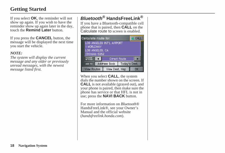
Bluetooth® HandsFreeLink®
If you have a Bluetooth-compatible cell phone that is paired, then CALL on the Calculate route to screen is enabled.
When you select CALL, the system dials the number shown on the screen. If CALL is not available (grayed out), and your phone is paired, then make sure the phone has service or that HFL is not in use; press the NAVI BACK button.
For more information on Bluetooth® HandsFreeLink®, see your Owner’s Manual and the official website (handsfreelink.honda.com).
Navigation System 19
Getting Started
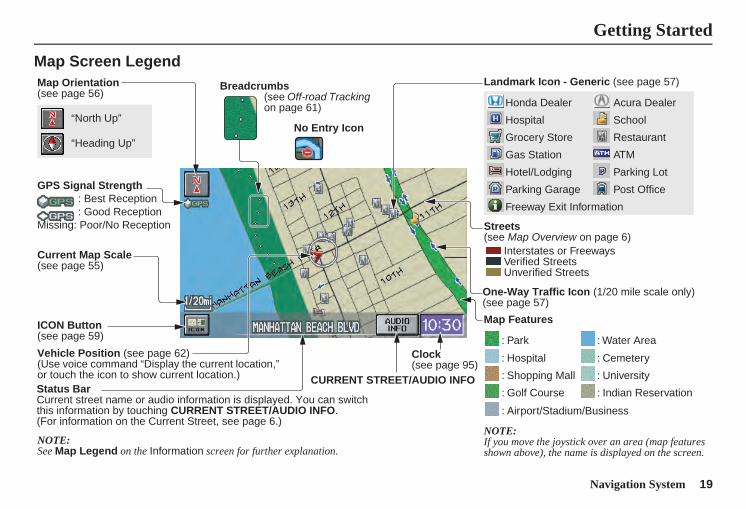
Map Screen LegendMap Orientation(see page 56)
GPS Signal Strength: Best Reception: Good Reception
Missing: Poor/No Reception
Current Map Scale(see page 55)
ICON Button (see page 59)
Vehicle Position (see page 62)(Use voice command “Display the current location,” or touch the icon to show current location.)
“North Up”
NOTE:See Map Legend on the Information screen for further explanation.
“Heading Up”
Breadcrumbs(see Off-road Tracking on page 61) Acura Dealer
School
Restaurant
ATM
Parking Lot
Post Office
Honda Dealer
Hospital
Grocery Store
Gas Station
Hotel/Lodging
Parking Garage
Freeway Exit Information
Streets(see Map Overview on page 6)
Interstates or FreewaysVerified StreetsUnverified Streets
Landmark Icon - Generic (see page 57)
Map Features
NOTE:If you move the joystick over an area (map features shown above), the name is displayed on the screen.
: Park
: Hospital
: Shopping Mall
: Golf Course
: Water Area
: Cemetery
: University
: Indian Reservation
: Airport/Stadium/Business
One-Way Traffic Icon (1/20 mile scale only)(see page 57)
Status BarCurrent street name or audio information is displayed. You can switch this information by touching CURRENT STREET/AUDIO INFO.(For information on the Current Street, see page 6.)
CURRENT STREET/AUDIO INFO
Clock(see page 95)
No Entry Icon
20 Navigation System
Getting Started
Map Screen Description
Zoom In/OutUse the ZOOM buttons to change the scale of the map. Zooming in increases the detail, while zooming out gives you a wide area view. After changing the scale, give the system a few moments to update the display.
Map ScrollingTo view other areas on the map, move the joystick left, right, up, or down. The map will shift in that direction. To return the map to your current location, press either the MAP/GUIDE, CANCEL, or NAVI BACK button on the steering wheel.
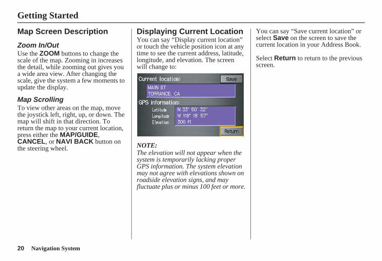
Displaying Current LocationYou can say “Display current location” or touch the vehicle position icon at any time to see the current address, latitude, longitude, and elevation. The screen will change to:
NOTE:The elevation will not appear when the system is temporarily lacking proper GPS information. The system elevation may not agree with elevations shown on roadside elevation signs, and may fluctuate plus or minus 100 feet or more.
You can say “Save current location” or select Save on the screen to save the current location in your Address Book.
Select Return to return to the previous screen.
Navigation System 21
Getting Started
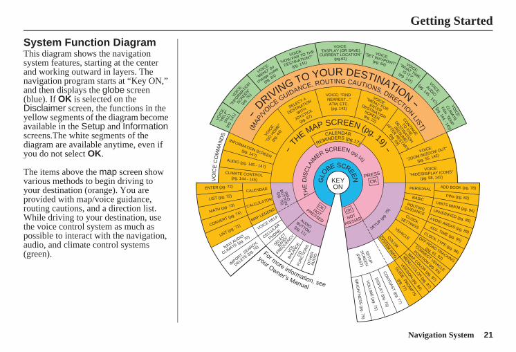
System Function DiagramThis diagram shows the navigation system features, starting at the center and working outward in layers. The navigation program starts at “Key ON,” and then displays the globe screen (blue). If OK is selected on the Disclaimer screen, the functions in the yellow segments of the diagram become available in the Setup and Information screens.The white segments of the diagram are available anytime, even if you do not select OK.
The items above the map screen show various methods to begin driving to your destination (orange). You are provided with map/voice guidance, routing cautions, and a direction list. While driving to your destination, use the voice control system as much as possible to interact with the navigation, audio, and climate control systems (green).
KEYON
GLO
BE SCREEN PRESS
OK
OKNOTPRESSED
THE
DIS
CLA
IMER SCREEN (pg.16)
CALENDAR
REMINDERS (pg.17)
-TH
E MAP SCREEN (pg. 19) -
AUDIOBUTTON
(pg. 11) IN
FO
BU
TTON
(pg. 70)
For more information, see
your Owner’s Manual
VO
ICE
CO
MM
AN
DS
NAVI AUDIO
CLIMATE (p
g. 70)
ENTER (pg. 72)
LIST (pg. 72)
MATH (pg. 73)
CONVERT (pg. 74)
LIST (pg. 71)
CALENDAR
CALCULATOR
MAP LEGEND
VOICE: "FIND NEAREST..."ATM, ETC.(pg. 143)SELECT A
DESTINATION
WITH
JOYSTICK
(pg. 67)
VOIC
E:
"GO
HO
ME"
(pg.
44)
VOICE:"MENU" FOR
ENTERDESTINATION
SCREEN(pg. 22)
CONTINUE
TO THE
DESTINATION
(RESUME)
AFTER RESTART
(pg. 69)
VOICE HELP
SELECT
BAND/
FREQUENCY
VOL
BALA
NC
EC
DFU
NC
TIO
NS
OT
HE
RA
UD
IO
VOICE:
"ZOOM IN/ZOOM OUT"
(pg. 55, 142)
VOICE:
"HIDE/DISPLAY ICONS"
(pg. 58, 142)
INFORMATION SCREEN
(pg. 147)AUDIO (pg. 145 - 147)
-DRIVING TO YOUR DESTINATION
-
(MAP
/V
OICE GUIDANCE, ROUTING CAUTIONS, DIRECTION
LIST)
VOIC
E:"H
ELP"
(ALL
)(p
g. 1
41)
VOIC
E:
"INFO
RMATI
ON
SCREEN"
(pg.
70)
VOICE:
"MENU" (t
o
change route)
(pg. 64)
VOICE:
"HOW FAR TO THE
DESTINATION?"
(pg. 141)
VOICE:"DISPLAY (OR SAVE)
CURRENT LOCATION"(pg.62)
VOICE:"SET WAYPOINT"
(pg. 64) VOICE:
"WHAT TIMEIS IT?"
(pg. 141) VOICE:
AUDIO
(pg. 145 - 147)
ADD BOOK (pg. 78)
PINs (pg. 82)UNITS MI/KM (pg. 94)
PERSONAL
BASIC
UNVERIFIED (pg. 85)AVOID AREAS (pg. 89)ADJ. TIME (pg. 95)
CLOCK TYPE (pg. 96)
ROUTINGGUIDANCECLOCK
SETTINGS
OFF-ROAD TRACKING
(pg. 61, 92)
CORRECT VEHICLE
POSITION (pg. 93)
MAP COLOR (pg. 97)
MENU CO
LOR (pg. 97)
VEHICLECOLO
RG
UID
E. PRO
MPTS
(pg. 77)
SE
TUP
SC
RE
EN
(FIRS
T)
OK
NOT
PRESSED
VERSION (pg. 94)
SYSTEM IN
FO.
BR
IGH
TN
ES
S (pg. 75)
VO
LUM
E (pg. 75)
DIS
PLA
Y (pg. 76)
CO
NTR
AS
T (pg. 77)
SETUP(p
g.75
)
BR
IGH
TN
ES
SZ
OO
M IN
/OU
TR
EA
R C
AM
ER
A(R
EV
ER
SE
)
IMPORT, S
EARCH,
DELETE (pg. 7
0)
CELLULAR
PHONE
CLIMATE CONTROL (pg. 144 - 145)
VOIC
E:
CLIM
ATE
FAN, TEM
P
(pg. 144 - 145)
22 Navigation System
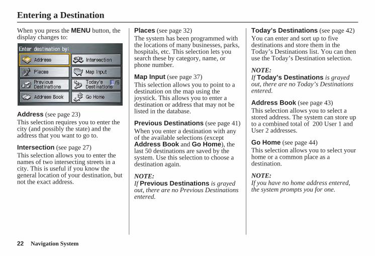
When you press the MENU button, the display changes to:
Address (see page 23)This selection requires you to enter the city (and possibly the state) and the address that you want to go to.
Intersection (see page 27)This selection allows you to enter the names of two intersecting streets in a city. This is useful if you know the general location of your destination, but not the exact address.
Places (see page 32)The system has been programmed with the locations of many businesses, parks, hospitals, etc. This selection lets you search these by category, name, or phone number.
Map Input (see page 37)This selection allows you to point to a destination on the map using the joystick. This allows you to enter a destination or address that may not be listed in the database.
Previous Destinations (see page 41)When you enter a destination with any of the available selections (except Address Book and Go Home), the last 50 destinations are saved by the system. Use this selection to choose a destination again.
NOTE:If Previous Destinations is grayed out, there are no Previous Destinations entered.
Today’s Destinations (see page 42)You can enter and sort up to five destinations and store them in the Today’s Destinations list. You can then use the Today’s Destination selection.
NOTE:If Today’s Destinations is grayed out, there are no Today’s Destinations entered.
Address Book (see page 43)This selection allows you to select a stored address. The system can store up to a combined total of 200 User 1 and User 2 addresses.
Go Home (see page 44)This selection allows you to select your home or a common place as a destination.
NOTE:If you have no home address entered, the system prompts you for one.
Entering a Destination
Navigation System 23
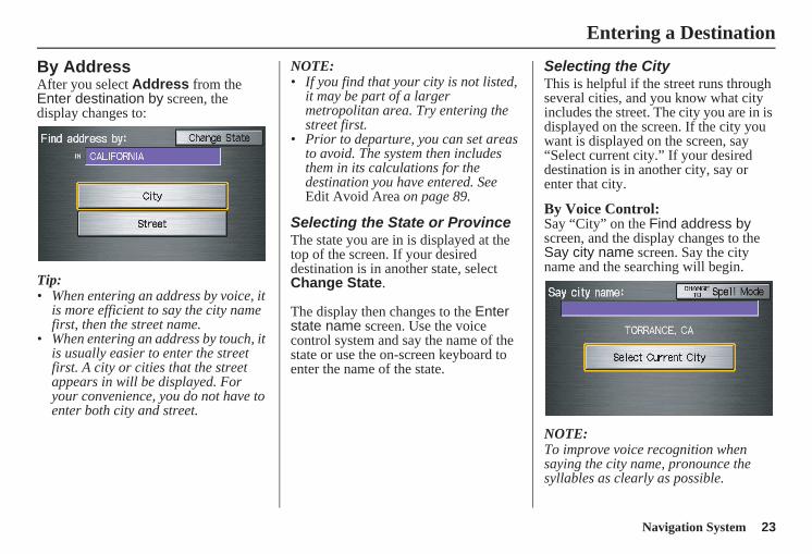
By AddressAfter you select Address from the Enter destination by screen, the display changes to:
Tip:• When entering an address by voice, it
is more efficient to say the city name first, then the street name.
• When entering an address by touch, it is usually easier to enter the street first. A city or cities that the street appears in will be displayed. For your convenience, you do not have to enter both city and street.
NOTE:• If you find that your city is not listed,
it may be part of a larger metropolitan area. Try entering the street first.
• Prior to departure, you can set areas to avoid. The system then includes them in its calculations for the destination you have entered. See Edit Avoid Area on page 89.
Selecting the State or ProvinceThe state you are in is displayed at the top of the screen. If your desired destination is in another state, select Change State.
The display then changes to the Enter state name screen. Use the voice control system and say the name of the state or use the on-screen keyboard to enter the name of the state.
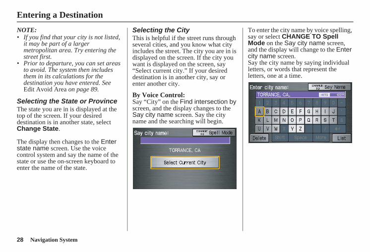
Selecting the CityThis is helpful if the street runs through several cities, and you know what city includes the street. The city you are in is displayed on the screen. If the city you want is displayed on the screen, say “Select current city.” If your desired destination is in another city, say or enter that city.
By Voice Control:Say “City” on the Find address by screen, and the display changes to the Say city name screen. Say the city name and the searching will begin.
NOTE:To improve voice recognition when saying the city name, pronounce the syllables as clearly as possible.
Entering a Destination
24 Navigation System
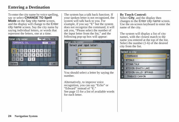
To enter the city name by voice spelling, say or select CHANGE TO Spell Mode on the Say city name screen, and the display will change to the Enter city name screen. Say the city name by saying individual letters, or words that represent the letters, one at a time.
The system has a talk back function. If your spoken letter is not recognized, the system will talk back to you. For example, if you say “E” but the system does not recognize the command, it will ask you, “Please select the number of the input letter from the list,” and the following pop-up box will appear:
You should select a letter by saying the number.
Alternatively, to improve voice recognition, you can say “Echo” or “Edward” instead of “E.”See page 15 for a list of available words for each letter.
By Touch Control:Select City, and the display then changes to the Enter city name screen. Use the on-screen keyboard to enter the name of the city.
The system will display a list of city names, with the closest match to the name you entered at the top of the list. Select the number (1-6) of the desired city from the list.
Entering a Destination
Navigation System 25
If the system does not find an exact match, select List when you finish entering the name of the city. Most of the cities and towns for that state are listed.
Listings of cities and towns in the non-detailed coverage area may have an asterisk “*” next to their names. If you select one, a pop-up box is displayed saying, “No detailed street data...”, and a street address cannot be entered (see Map Coverage on page 110). Try entering the street first, and then select the city if available.
Select View Dest. Map and use the joystick to select an icon, approximate area, or street you wish to choose as your destination. Otherwise, a central location of the city will be selected. If you select a point of interest (POI) or road in an unverified area, you may or may not have routing in these areas. See Map Overview on page 6.
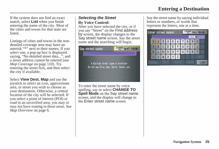
Selecting the StreetBy Voice Control:After you have selected the city, or if you say “Street” on the Find address by screen, the display changes to the Say street name screen. Say the street name and the searching will begin.
To enter the street name by voice spelling, say or select CHANGE TO Spell Mode on the Say street name screen, and the display will change to the Enter street name screen.
Say the street name by saying individual letters or numbers, or words that represent the letters, one at a time.
Entering a Destination
26 Navigation System
The system has a talk back function. If your spoken letter is not recognized, the system will talk back to you. For example, if you say “E” but the system does not recognize the command, it will ask you, “Please select the number of the input letter from the list,” and the following pop-up box will appear:
You should select a letter by saying the number.
Alternatively, to improve voice recognition, you can say “Echo” or “Edward” instead of “E.”See page 15 for a list of available words for each letter.
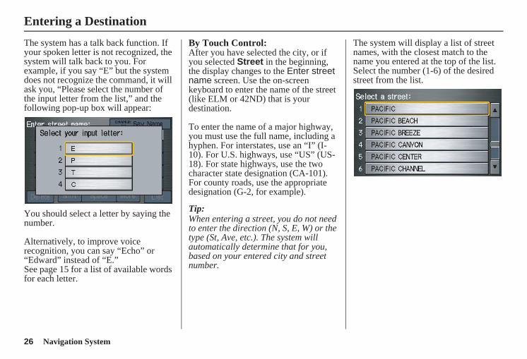
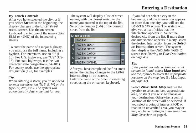
By Touch Control:After you have selected the city, or if you selected Street in the beginning, the display changes to the Enter street name screen. Use the on-screen keyboard to enter the name of the street (like ELM or 42ND) that is your destination.
To enter the name of a major highway, you must use the full name, including a hyphen. For interstates, use an “I” (I-10). For U.S. highways, use “US” (US-18). For state highways, use the two character state designation (CA-101). For county roads, use the appropriate designation (G-2, for example).
Tip:When entering a street, you do not need to enter the direction (N, S, E, W) or the type (St, Ave, etc.). The system will automatically determine that for you, based on your entered city and street number.
The system will display a list of street names, with the closest match to the name you entered at the top of the list. Select the number (1-6) of the desired street from the list.
Entering a Destination
Navigation System 27
Entering the Street NumberAfter you have completed the street name, the display changes to the Enter street number screen. Use the voice control system and say the address number as a continuous string of numbers. For example, the address 1527 should be spoken as “One, five, two, seven.” You can also use the on-screen keyboard to enter the street number.
Some address numbers may not be available on the selected street. For example, let’s say the individual address ranges for a selected street name are 1 - 20 and 9,000 - 10,000, with an overall range shown on the display of 1 to 10,000. If you try to enter a number outside the individual address ranges such as 500, the system will show this number as unavailable (grayed out).• When using the on-screen keyboard,
the system only allows you to choose available address numbers.
• When using voice control, the system beeps if you try to select an unavailable (grayed out) address number.
If you did not select a city in the beginning, the street name you selected might appear in more than one city. The system will give you a list of cities that the street appears in. Select the desired city from the list. The system then displays the Calculate route to screen (see Driving to Your Destination on page 46).
Tip:If the particular address you want cannot be found, select Map Input and use the joystick to select the appropriate location on the map (see By Map Input on page 37).
Select View Dest. Map and use the joystick to select an icon, approximate area, or street you wish to choose as your destination. Otherwise, a central location of the street will be selected. If you select a point of interest (POI) or road in an unverified area, you may or may not have routing in these areas. See Map Overview on page 6.
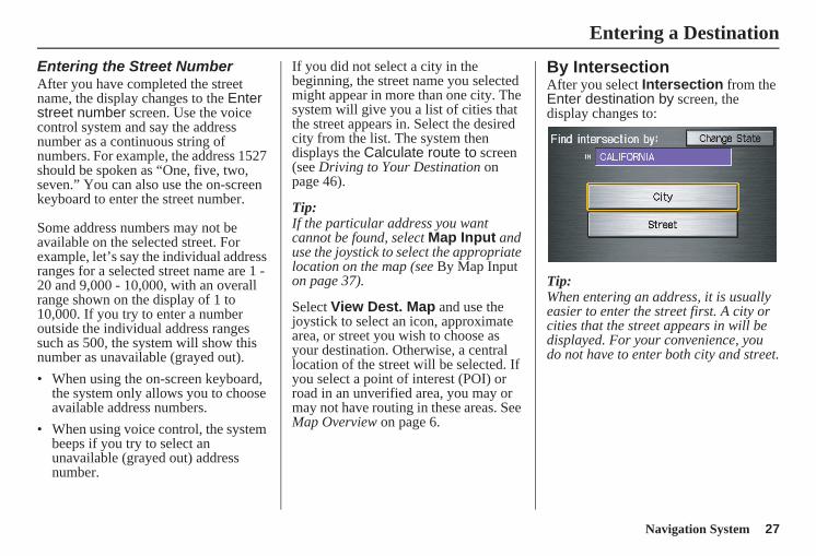
By IntersectionAfter you select Intersection from the Enter destination by screen, the display changes to:
Tip:When entering an address, it is usually easier to enter the street first. A city or cities that the street appears in will be displayed. For your convenience, you do not have to enter both city and street.
Entering a Destination
28 Navigation System
NOTE: • If you find that your city is not listed,
it may be part of a larger metropolitan area. Try entering the street first.
• Prior to departure, you can set areas to avoid. The system then includes them in its calculations for the destination you have entered. See Edit Avoid Area on page 89.
Selecting the State or ProvinceThe state you are in is displayed at the top of the screen. If your desired destination is in another state, select Change State.
The display then changes to the Enter state name screen. Use the voice control system and say the name of the state or use the on-screen keyboard to enter the name of the state.
Selecting the CityThis is helpful if the street runs through several cities, and you know what city includes the street. The city you are in is displayed on the screen. If the city you want is displayed on the screen, say “Select current city.” If your desired destination is in another city, say or enter another city.
By Voice Control:Say “City” on the Find intersection by screen, and the display changes to the Say city name screen. Say the city name and the searching will begin.
To enter the city name by voice spelling, say or select CHANGE TO Spell Mode on the Say city name screen, and the display will change to the Enter city name screen.Say the city name by saying individual letters, or words that represent the letters, one at a time.
Entering a Destination
Navigation System 29
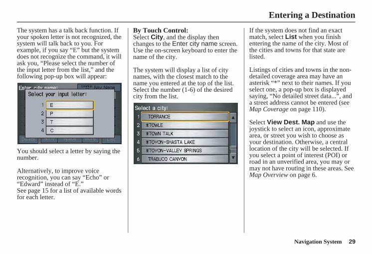
The system has a talk back function. If your spoken letter is not recognized, the system will talk back to you. For example, if you say “E” but the system does not recognize the command, it will ask you, “Please select the number of the input letter from the list,” and the following pop-up box will appear:
You should select a letter by saying the number.
Alternatively, to improve voice recognition, you can say “Echo” or “Edward” instead of “E.”See page 15 for a list of available words for each letter.
By Touch Control:Select City, and the display then changes to the Enter city name screen. Use the on-screen keyboard to enter the name of the city.
The system will display a list of city names, with the closest match to the name you entered at the top of the list. Select the number (1-6) of the desired city from the list.
If the system does not find an exact match, select List when you finish entering the name of the city. Most of the cities and towns for that state are listed.
Listings of cities and towns in the non-detailed coverage area may have an asterisk “*” next to their names. If you select one, a pop-up box is displayed saying, “No detailed street data...”, and a street address cannot be entered (see Map Coverage on page 110).
Select View Dest. Map and use the joystick to select an icon, approximate area, or street you wish to choose as your destination. Otherwise, a central location of the city will be selected. If you select a point of interest (POI) or road in an unverified area, you may or may not have routing in these areas. See Map Overview on page 6.
Entering a Destination
30 Navigation System
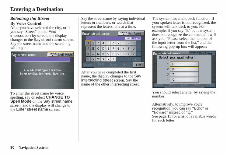
Selecting the StreetBy Voice Control:After you have selected the city, or if you say “Street” on the Find intersection by screen, the display changes to the Say street name screen. Say the street name and the searching will begin.
To enter the street name by voice spelling, say or select CHANGE TO Spell Mode on the Say street name screen, and the display will change to the Enter street name screen.
Say the street name by saying individual letters or numbers, or words that represent the letters, one at a time.
After you have completed the first name, the display changes to the Say intersecting street screen. Say the name of the other intersecting street.
The system has a talk back function. If your spoken letter is not recognized, the system will talk back to you. For example, if you say “E” but the system does not recognize the command, it will ask you, “Please select the number of the input letter from the list,” and the following pop-up box will appear:
You should select a letter by saying the number.
Alternatively, to improve voice recognition, you can say “Echo” or “Edward” instead of “E.”See page 15 for a list of available words for each letter.
Entering a Destination
Navigation System 31
By Touch Control:After you have selected the city, or if you select Street in the beginning, the display changes to the Enter street name screen. Use the on-screen keyboard to enter one of the names (like ELM or 42ND) of the intersecting streets.
To enter the name of a major highway, you must use the full name, including a hyphen. For interstates, use an “I” (I-10). For U.S. highways, use “US” (US-18). For state highways, use the two character state designation (CA-101). For county roads, use the appropriate designation (G-2, for example).
Tip:When entering a street, you do not need to enter the direction (N, S, E, W) or the type (St, Ave, etc.). The system will automatically determine that for you.
The system will display a list of street names, with the closest match to the name you entered at the top of the list. Select the number (1-6) of the desired street from the list.
After you have completed the first street name, the display changes to the Enter intersecting street screen.Enter the name of the other intersecting street using the on-screen keyboard.
If you did not select a city in the beginning, and the intersection appears in more than one city, you will see the Select a city screen. The system will give you a list of cities that the intersection appears in. Select the desired city from the list. If more than one intersection appears in a city, select the desired intersection from the Select an intersection screen. The system then displays the Calculate route to screen (see Driving to Your Destination on page 46).
Tip:If the particular intersection you want cannot be found, select Map Input and use the joystick to select the appropriate location on the map (see By Map Input on page 37).
Select View Dest. Map and use the joystick to select an icon, approximate area, or street you wish to choose as your destination. Otherwise, a central location of the street will be selected. If you select a point of interest (POI) or road in an unverified area, you may or may not have routing in these areas. See Map Overview on page 6.
Entering a Destination
32 Navigation System
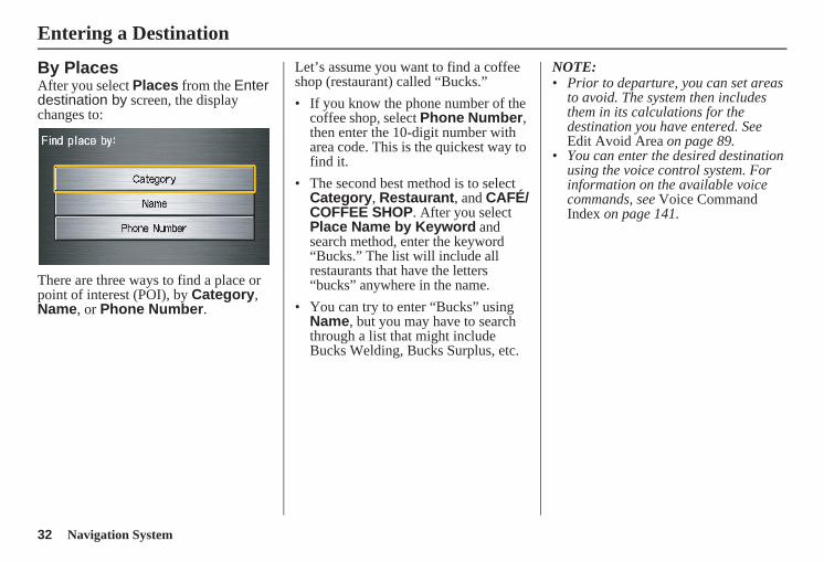
By PlacesAfter you select Places from the Enter destination by screen, the display changes to:
There are three ways to find a place or point of interest (POI), by Category, Name, or Phone Number.
Let’s assume you want to find a coffee shop (restaurant) called “Bucks.”• If you know the phone number of the
coffee shop, select Phone Number, then enter the 10-digit number with area code. This is the quickest way to find it.
• The second best method is to select Category, Restaurant, and CAFÉ/COFFEE SHOP. After you select Place Name by Keyword and search method, enter the keyword “Bucks.” The list will include all restaurants that have the letters “bucks” anywhere in the name.
• You can try to enter “Bucks” using Name, but you may have to search through a list that might include Bucks Welding, Bucks Surplus, etc.
NOTE: • Prior to departure, you can set areas
to avoid. The system then includes them in its calculations for the destination you have entered. See Edit Avoid Area on page 89.
• You can enter the desired destination using the voice control system. For information on the available voice commands, see Voice Command Index on page 141.
Entering a Destination
Navigation System 33
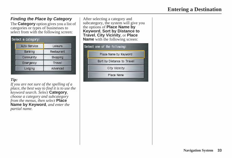
Finding the Place by CategoryThe Category option gives you a list of categories or types of businesses to select from with the following screen:
Tip:If you are not sure of the spelling of a place, the best way to find it is to use the keyword search. Select Category, choose a category and subcategory from the menus, then select Place Name by Keyword, and enter the partial name.
After selecting a category and subcategory, the system will give you the options of Place Name by Keyword, Sort by Distance to Travel, City Vicinity, or Place Name with the following screen:
Entering a Destination
34 Navigation System
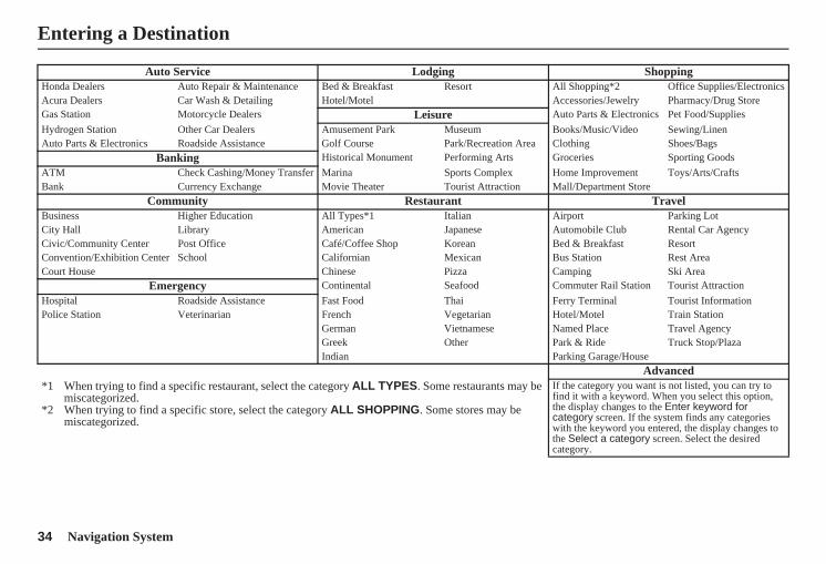
Auto Service Lodging ShoppingHonda Dealers Auto Repair & Maintenance Bed & Breakfast Resort All Shopping*2 Office Supplies/ElectronicsAcura Dealers Car Wash & Detailing Hotel/Motel Accessories/Jewelry Pharmacy/Drug StoreGas Station Motorcycle Dealers Leisure Auto Parts & Electronics Pet Food/SuppliesHydrogen Station Other Car Dealers Amusement Park Museum Books/Music/Video Sewing/LinenAuto Parts & Electronics Roadside Assistance Golf Course Park/Recreation Area Clothing Shoes/Bags
Banking Historical Monument Performing Arts Groceries Sporting GoodsATM Check Cashing/Money Transfer Marina Sports Complex Home Improvement Toys/Arts/CraftsBank Currency Exchange Movie Theater Tourist Attraction Mall/Department Store
Community Restaurant TravelBusiness Higher Education All Types*1 Italian Airport Parking LotCity Hall Library American Japanese Automobile Club Rental Car AgencyCivic/Community Center Post Office Café/Coffee Shop Korean Bed & Breakfast ResortConvention/Exhibition Center School Californian Mexican Bus Station Rest AreaCourt House Chinese Pizza Camping Ski Area
Emergency Continental Seafood Commuter Rail Station Tourist AttractionHospital Roadside Assistance Fast Food Thai Ferry Terminal Tourist InformationPolice Station Veterinarian French Vegetarian Hotel/Motel Train Station
German Vietnamese Named Place Travel AgencyGreek Other Park & Ride Truck Stop/PlazaIndian Parking Garage/House
Advanced*1 When trying to find a specific restaurant, select the category ALL TYPES. Some restaurants may be
miscategorized.*2 When trying to find a specific store, select the category ALL SHOPPING. Some stores may be
miscategorized.
If the category you want is not listed, you can try to find it with a keyword. When you select this option, the display changes to the Enter keyword for category screen. If the system finds any categories with the keyword you entered, the display changes to the Select a category screen. Select the desired category.
Entering a Destination
Navigation System 35
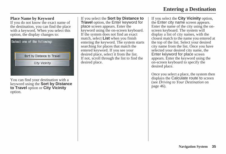
Place Name by KeywordIf you do not know the exact name of the destination, you can find the place with a keyword. When you select this option, the display changes to:
You can find your destination with a keyword using the Sort by Distance to Travel option or City Vicinity option.
If you select the Sort by Distance to Travel option, the Enter keyword for place screen appears. Enter the keyword using the on-screen keyboard. If the system does not find an exact match, select List when you finish entering the keyword. The system starts searching for places that match the entered keyword. If you see your desired place, select it from the list.If not, scroll through the list to find the desired place.
If you select the City Vicinity option, the Enter city name screen appears. Enter the name of the city using the on-screen keyboard. The system will display a list of city names, with the closest match to the name you entered at the top of the list. Select your desired city name from the list. Once you have selected your desired city name, the Enter keyword for place screen appears. Enter the keyword using the on-screen keyboard to specify the desired place.
Once you select a place, the system then displays the Calculate route to screen (see Driving to Your Destination on page 46).
Entering a Destination
36 Navigation System
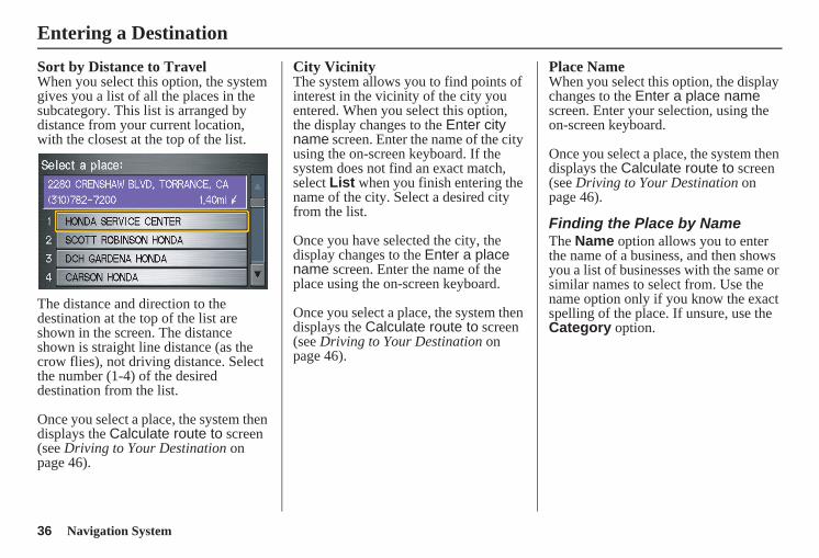
Sort by Distance to TravelWhen you select this option, the system gives you a list of all the places in the subcategory. This list is arranged by distance from your current location, with the closest at the top of the list.
The distance and direction to the destination at the top of the list are shown in the screen. The distance shown is straight line distance (as the crow flies), not driving distance. Select the number (1-4) of the desired destination from the list.
Once you select a place, the system then displays the Calculate route to screen (see Driving to Your Destination on page 46).
City VicinityThe system allows you to find points of interest in the vicinity of the city you entered. When you select this option, the display changes to the Enter city name screen. Enter the name of the city using the on-screen keyboard. If the system does not find an exact match, select List when you finish entering the name of the city. Select a desired city from the list.
Once you have selected the city, the display changes to the Enter a place name screen. Enter the name of the place using the on-screen keyboard.
Once you select a place, the system then displays the Calculate route to screen (see Driving to Your Destination on page 46).
Place NameWhen you select this option, the display changes to the Enter a place name screen. Enter your selection, using the on-screen keyboard.
Once you select a place, the system then displays the Calculate route to screen (see Driving to Your Destination on page 46).
Finding the Place by NameThe Name option allows you to enter the name of a business, and then shows you a list of businesses with the same or similar names to select from. Use the name option only if you know the exact spelling of the place. If unsure, use the Category option.
Entering a Destination
Navigation System 37
Finding the Place by Phone NumberThe Phone Number option allows you to select a destination by its telephone number. Only telephone numbers stored in the system under the Places (of business) option are recognized. The system does not contain residential telephone numbers, or numbers you may have entered in your personal Address Book.
Tip:If you know the phone number of a point of interest (POI), its uniqueness makes it the fastest entry method. When using the voice control system, the entry should be spoken as a continuous string of numbers. For example, the telephone number (310) 555-4000 should be spoken as “Three, one, zero, five, five, five, four, zero, zero, zero.”
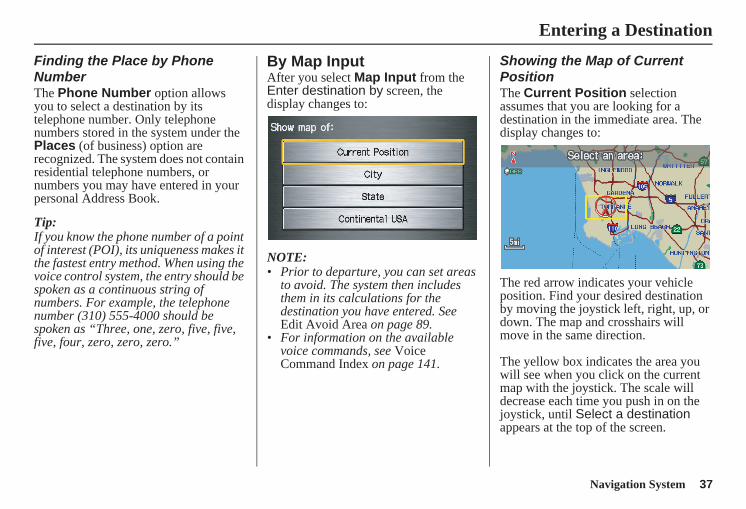
By Map InputAfter you select Map Input from the Enter destination by screen, the display changes to:
NOTE: • Prior to departure, you can set areas
to avoid. The system then includes them in its calculations for the destination you have entered. See Edit Avoid Area on page 89.
• For information on the available voice commands, see Voice Command Index on page 141.
Showing the Map of Current PositionThe Current Position selection assumes that you are looking for a destination in the immediate area. The display changes to:
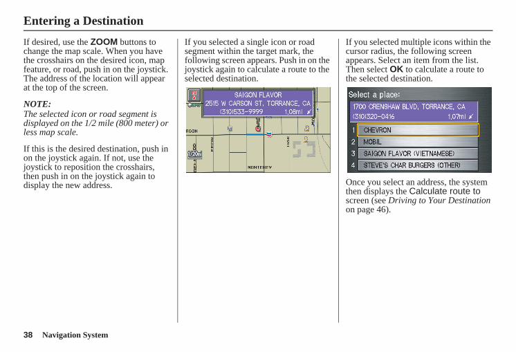
The red arrow indicates your vehicle position. Find your desired destination by moving the joystick left, right, up, or down. The map and crosshairs will move in the same direction.
The yellow box indicates the area you will see when you click on the current map with the joystick. The scale will decrease each time you push in on the joystick, until Select a destination appears at the top of the screen.
Entering a Destination
38 Navigation System
If desired, use the ZOOM buttons to change the map scale. When you have the crosshairs on the desired icon, map feature, or road, push in on the joystick. The address of the location will appear at the top of the screen.
NOTE:The selected icon or road segment is displayed on the 1/2 mile (800 meter) or less map scale.
If this is the desired destination, push in on the joystick again. If not, use the joystick to reposition the crosshairs, then push in on the joystick again to display the new address.
If you selected a single icon or road segment within the target mark, the following screen appears. Push in on the joystick again to calculate a route to the selected destination.
If you selected multiple icons within the cursor radius, the following screen appears. Select an item from the list. Then select OK to calculate a route to the selected destination.
Once you select an address, the system then displays the Calculate route to screen (see Driving to Your Destination on page 46).
Entering a Destination
Navigation System 39
Showing the Map of CityWith the City selection, the display changes to the Enter city name screen.
When you have entered the desired city, the display changes to a map. The starting location will be the central position in the selected city.
See Showing the Map of Current Position on page 37 for instructions on finding and entering your desired destination.
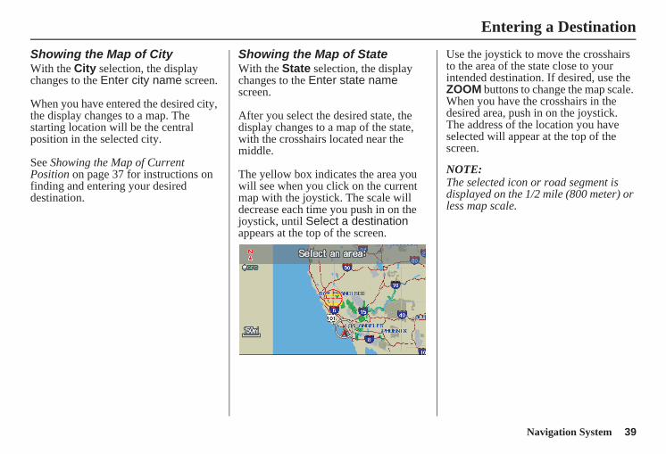
Showing the Map of StateWith the State selection, the display changes to the Enter state name screen.
After you select the desired state, the display changes to a map of the state, with the crosshairs located near the middle.
The yellow box indicates the area you will see when you click on the current map with the joystick. The scale will decrease each time you push in on the joystick, until Select a destination appears at the top of the screen.
Use the joystick to move the crosshairs to the area of the state close to your intended destination. If desired, use the ZOOM buttons to change the map scale. When you have the crosshairs in the desired area, push in on the joystick. The address of the location you have selected will appear at the top of the screen.
NOTE:The selected icon or road segment is displayed on the 1/2 mile (800 meter) or less map scale.
Entering a Destination
40 Navigation System
If this is the desired address, push in on the joystick again. If not, use the joystick to reposition the crosshairs, then push in on the joystick again to display the new address.
If you selected a single icon or road segment, push in on the joystick again to select the new address. If you selected multiple icons within the cursor radius, select an item from the list on the screen.
Once you select an address, the system then displays the Calculate route to screen (see Driving to Your Destination on page 46).
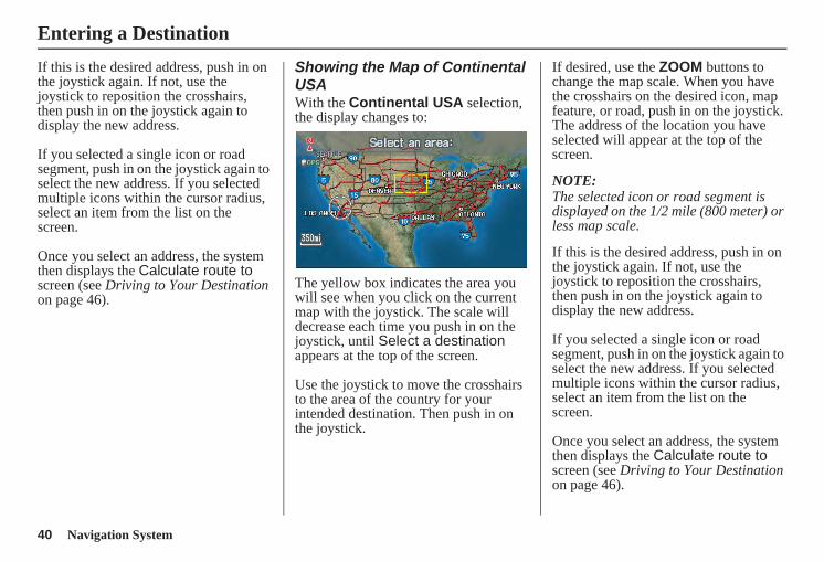
Showing the Map of Continental USAWith the Continental USA selection, the display changes to:
The yellow box indicates the area you will see when you click on the current map with the joystick. The scale will decrease each time you push in on the joystick, until Select a destination appears at the top of the screen.
Use the joystick to move the crosshairs to the area of the country for your intended destination. Then push in on the joystick.
If desired, use the ZOOM buttons to change the map scale. When you have the crosshairs on the desired icon, map feature, or road, push in on the joystick. The address of the location you have selected will appear at the top of the screen.
NOTE:The selected icon or road segment is displayed on the 1/2 mile (800 meter) or less map scale.
If this is the desired address, push in on the joystick again. If not, use the joystick to reposition the crosshairs, then push in on the joystick again to display the new address.
If you selected a single icon or road segment, push in on the joystick again to select the new address. If you selected multiple icons within the cursor radius, select an item from the list on the screen.
Once you select an address, the system then displays the Calculate route to screen (see Driving to Your Destination on page 46).
Entering a Destination
Navigation System 41
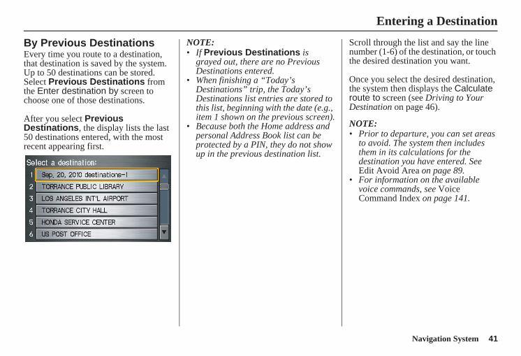
By Previous DestinationsEvery time you route to a destination, that destination is saved by the system. Up to 50 destinations can be stored. Select Previous Destinations from the Enter destination by screen to choose one of those destinations.
After you select Previous Destinations, the display lists the last 50 destinations entered, with the most recent appearing first.
NOTE:• If Previous Destinations is
grayed out, there are no Previous Destinations entered.
• When finishing a “Today’s Destinations” trip, the Today’s Destinations list entries are stored to this list, beginning with the date (e.g., item 1 shown on the previous screen).
• Because both the Home address and personal Address Book list can be protected by a PIN, they do not show up in the previous destination list.
Scroll through the list and say the line number (1-6) of the destination, or touch the desired destination you want.
Once you select the desired destination, the system then displays the Calculate route to screen (see Driving to Your Destination on page 46).
NOTE: • Prior to departure, you can set areas
to avoid. The system then includes them in its calculations for the destination you have entered. See Edit Avoid Area on page 89.
• For information on the available voice commands, see Voice Command Index on page 141.
Entering a Destination
42 Navigation System
Entering a Destination
By Today’s DestinationsYou can create a “trip” by combining up to five destinations previously selected on the Calculate route to screen.
Select Today’s Destinations from the Enter destination by screen and the display changes to:
NOTE:If Today’s Destinations is grayed out, there are no Today’s Destinations entered.
Editing Today’s Destinations ListIf you change your plans, you can modify the Today’s Destinations list order by distance or order of entry.
Say or select Entry to sort the list by the entry order, and say or select Distance to sort the list by the distance order. To delete a destination, say or select Delete and the display changes to the Select a destination to delete screen. Select the destination to delete. Say or select Done to perform the deletion, and the display returns to the previous screen. To cancel the deletion, press the CANCEL button.
NOTE:For information on the available voice commands, see Voice Command Index on page 141.
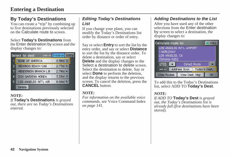
Adding Destinations to the ListAfter you have used any of the other selections from the Enter destination by screen to select a destination, the display changes to:
To add this to the Today’s Destinations list, select ADD TO Today’s Dest.
NOTE:If ADD TO Today’s Dest is grayed out, the Today’s Destinations list is already full (five destinations have been stored).
Navigation System 43
Entering a Destination
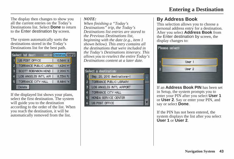
The display then changes to show you all the current entries on the Today’s Destinations list. Select Done to return to the Enter destination by screen.
The system automatically sorts the destinations stored in the Today’s Destinations list for the best path.
If the displayed list shows your plans, select the first destination. The system will guide you to the destination according to the order of the list. When you reach the destination, it will be automatically removed from the list.
NOTE:When finishing a “Today’s Destinations” trip, the Today’s Destinations list entries are stored to the Previous Destinations list, beginning with the date (e.g., item 1 shown below). This entry contains all the destinations that were included in the Today’s Destinations itinerary. This allows you to reselect the entire Today’s Destinations content at a later date.
By Address BookThis selection allows you to choose a personal address entry for a destination.After you select Address Book from the Enter destination by screen, the display changes to:
If an Address Book PIN has been set in Setup, the system prompts you to enter your PIN after you select User 1 or User 2. Say or enter your PIN, and say or select Done.
If the PIN has not been entered, the system displays the list after you select User 1 or User 2.
44 Navigation System
Entering a Destination
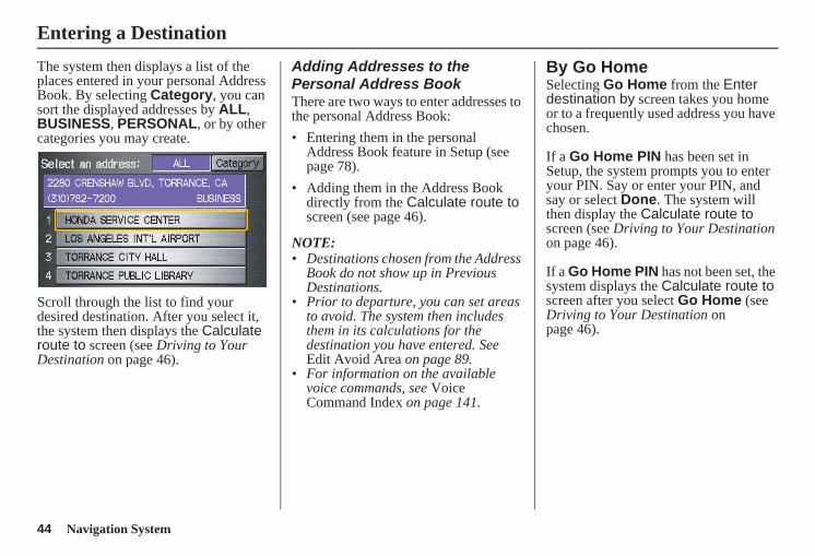
The system then displays a list of the places entered in your personal Address Book. By selecting Category, you can sort the displayed addresses by ALL, BUSINESS, PERSONAL, or by other categories you may create.
Scroll through the list to find your desired destination. After you select it, the system then displays the Calculate route to screen (see Driving to Your Destination on page 46).
Adding Addresses to the Personal Address BookThere are two ways to enter addresses to the personal Address Book:• Entering them in the personal
Address Book feature in Setup (see page 78).
• Adding them in the Address Book directly from the Calculate route to screen (see page 46).
NOTE:• Destinations chosen from the Address
Book do not show up in Previous Destinations.
• Prior to departure, you can set areas to avoid. The system then includes them in its calculations for the destination you have entered. See Edit Avoid Area on page 89.
• For information on the available voice commands, see Voice Command Index on page 141.
By Go HomeSelecting Go Home from the Enter destination by screen takes you home or to a frequently used address you have chosen.
If a Go Home PIN has been set in Setup, the system prompts you to enter your PIN. Say or enter your PIN, and say or select Done. The system will then display the Calculate route to screen (see Driving to Your Destination on page 46).
If a Go Home PIN has not been set, the system displays the Calculate route to screen after you select Go Home (see Driving to Your Destination on page 46).
Navigation System 45
Entering a Destination
NOTE:• To edit Home Address, see Home
Address in System Setup on page 82.• Prior to departure, you can set areas
to avoid. The system then includes them in its calculations for the destination you have entered. See Edit Avoid Area on page 89.
• PINs are optional. If you choose to use a PIN, make sure you remember it. If you forget your PIN, your dealer will have to reset it for you.
• If a PIN is desired, enter it using the Personal preference PIN number feature in Setup. See page 83 for information on entering your Go Home PIN.
46 Navigation System
Driving to Your Destination
Driving to Your DestinationA route typically has three phases.• Initial route calculation (Calculate
route to screen) (see page 46).• Change the route while en route (see
page 64).• Resume the route when restarting the
engine (see Continue Trip Screen on page 69).
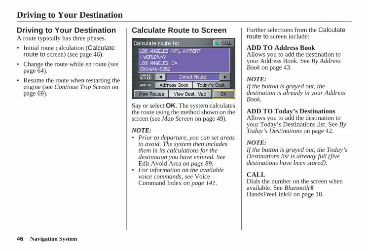
Calculate Route to Screen
Say or select OK. The system calculates the route using the method shown on the screen (see Map Screen on page 49).
NOTE:• Prior to departure, you can set areas
to avoid. The system then includes them in its calculations for the destination you have entered. See Edit Avoid Area on page 89.
• For information on the available voice commands, see Voice Command Index on page 141.
Further selections from the Calculate route to screen include:
ADD TO Address BookAllows you to add the destination to your Address Book. See By Address Book on page 43.
NOTE:If the button is grayed out, the destination is already in your Address Book.
ADD TO Today’s DestinationsAllows you to add the destination to your Today’s Destinations list. See By Today’s Destinations on page 42.
NOTE:If the button is grayed out, the Today’s Destinations list is already full (five destinations have been stored).
CALLDials the number on the screen when available. See Bluetooth® HandsFreeLink® on page 18.
Navigation System 47
Driving to Your Destination
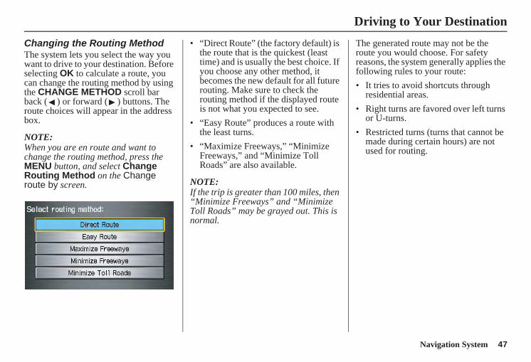
Changing the Routing MethodThe system lets you select the way you want to drive to your destination. Before selecting OK to calculate a route, you can change the routing method by using the CHANGE METHOD scroll bar back ( ) or forward ( ) buttons. The route choices will appear in the address box.
NOTE:When you are en route and want to change the routing method, press the MENU button, and select Change Routing Method on the Change route by screen.
• “Direct Route” (the factory default) is the route that is the quickest (least time) and is usually the best choice. If you choose any other method, it becomes the new default for all future routing. Make sure to check the routing method if the displayed route is not what you expected to see.
• “Easy Route” produces a route with the least turns.
• “Maximize Freeways,” “Minimize Freeways,” and “Minimize Toll Roads” are also available.
NOTE:If the trip is greater than 100 miles, then “Minimize Freeways” and “Minimize Toll Roads” may be grayed out. This is normal.
The generated route may not be the route you would choose. For safety reasons, the system generally applies the following rules to your route:• It tries to avoid shortcuts through
residential areas.• Right turns are favored over left turns
or U-turns.• Restricted turns (turns that cannot be
made during certain hours) are not used for routing.
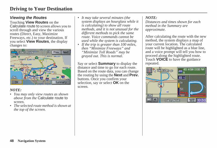
48 Navigation System
Viewing the RoutesTouching View Routes on the Calculate route to screen allows you to scroll through and view the various routes (Direct, Easy, Maximize Freeways, etc.) to your destination. If you select View Routes, the display changes to:
NOTE:• You may only view routes as shown
above from the Calculate route to screen.
• The selected route method is shown at the top of the screen.
• It may take several minutes (the system displays an hourglass while it is calculating) to show all route methods, and it is not unusual for the different methods to pick the same route. Voice commands cannot be used while the system is calculating.
• If the trip is greater than 100 miles, then “Minimize Freeways” and “Minimize Toll Roads” may be grayed out. This is normal.
Say or select Summary to display the distance and time to go for each route. Based on the route data, you can change the routing by using the Next and Prev. buttons. Once you confirm your selection, say or select OK on the screen.
NOTE:Distances and times shown for each method in the Summary are approximate.
After calculating the route with the new method, the system displays a map of your current location. The calculated route will be highlighted as a blue line, and a voice prompt will tell you how to proceed along the highlighted route. Touch VOICE to have the guidance repeated.
Driving to Your Destination
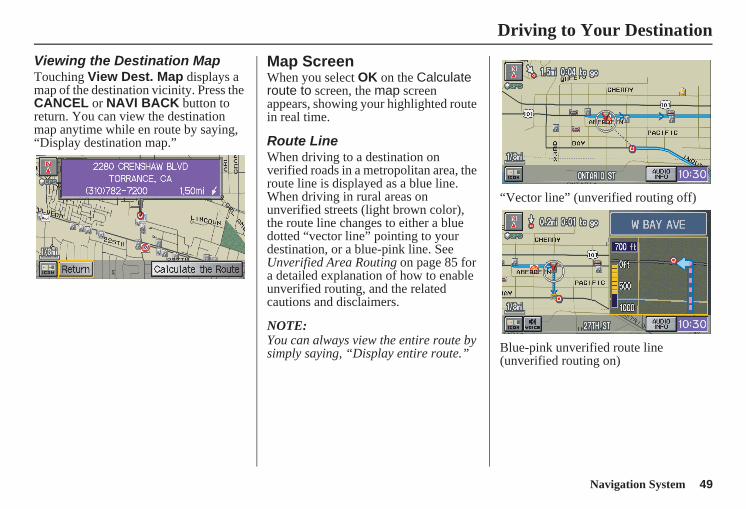
Navigation System 49
Driving to Your Destination
Viewing the Destination MapTouching View Dest. Map displays a map of the destination vicinity. Press the CANCEL or NAVI BACK button to return. You can view the destination map anytime while en route by saying, “Display destination map.”
Map ScreenWhen you select OK on the Calculate route to screen, the map screen appears, showing your highlighted route in real time.
Route LineWhen driving to a destination on verified roads in a metropolitan area, the route line is displayed as a blue line. When driving in rural areas on unverified streets (light brown color), the route line changes to either a blue dotted “vector line” pointing to your destination, or a blue-pink line. See Unverified Area Routing on page 85 for a detailed explanation of how to enable unverified routing, and the related cautions and disclaimers.
NOTE:You can always view the entire route by simply saying, “Display entire route.”
“Vector line” (unverified routing off)
Blue-pink unverified route line (unverified routing on)
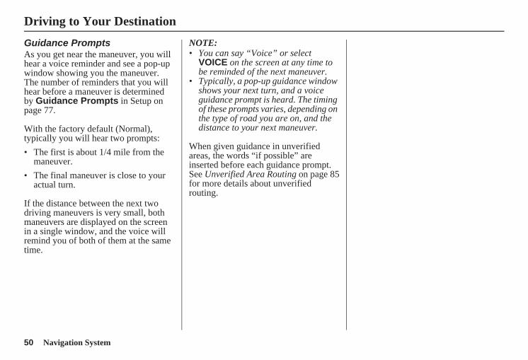
50 Navigation System
Guidance PromptsAs you get near the maneuver, you will hear a voice reminder and see a pop-up window showing you the maneuver. The number of reminders that you will hear before a maneuver is determined by Guidance Prompts in Setup on page 77.
With the factory default (Normal), typically you will hear two prompts:• The first is about 1/4 mile from the
maneuver.• The final maneuver is close to your
actual turn.
If the distance between the next two driving maneuvers is very small, both maneuvers are displayed on the screen in a single window, and the voice will remind you of both of them at the same time.
NOTE: • You can say “Voice” or select
VOICE on the screen at any time to be reminded of the next maneuver.
• Typically, a pop-up guidance window shows your next turn, and a voice guidance prompt is heard. The timing of these prompts varies, depending on the type of road you are on, and the distance to your next maneuver.
When given guidance in unverified areas, the words “if possible” are inserted before each guidance prompt. See Unverified Area Routing on page 85for more details about unverified routing.
Driving to Your Destination
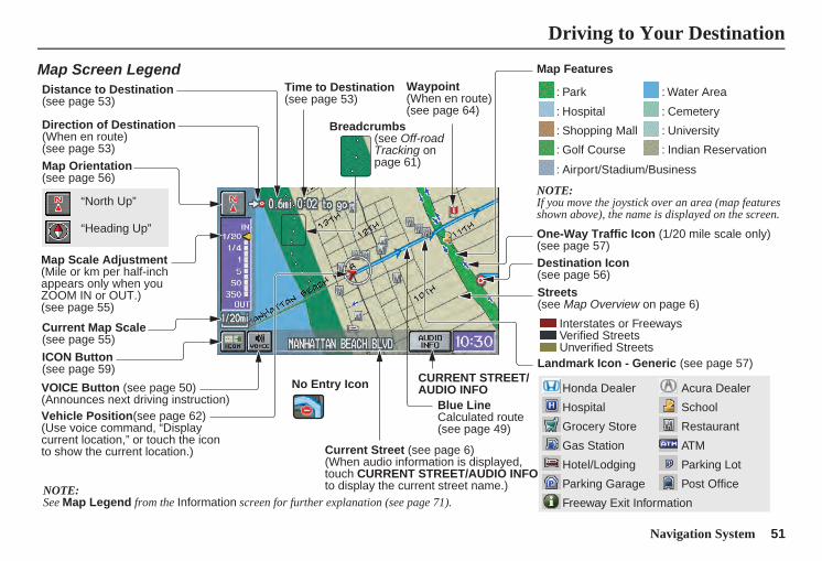
Navigation System 51
Driving to Your Destination
Acura Dealer
School
Restaurant
ATM
Parking Lot
Post Office
Honda Dealer
Hospital
Grocery Store
Gas Station
Hotel/Lodging
Parking Garage
Freeway Exit Information
Map Screen Legend
Map Orientation(see page 56)
Map Scale Adjustment(Mile or km per half-inch appears only when you ZOOM IN or OUT.)(see page 55)
Current Map Scale(see page 55)
ICON Button(see page 59)
Breadcrumbs(see Off-road Tracking on page 61)
Direction of Destination(When en route)(see page 53)
VOICE Button (see page 50)(Announces next driving instruction)
Distance to Destination(see page 53)
Time to Destination(see page 53)
Vehicle Position(see page 62)(Use voice command, “Display current location,” or touch the icon to show the current location.)
Blue LineCalculated route (see page 49)
Map Features
NOTE:If you move the joystick over an area (map features shown above), the name is displayed on the screen.
: Park
: Hospital
: Shopping Mall
: Golf Course
: Water Area
: Cemetery
: University
: Indian Reservation
: Airport/Stadium/Business
One-Way Traffic Icon (1/20 mile scale only)(see page 57)
Streets(see Map Overview on page 6)
Interstates or FreewaysVerified StreetsUnverified Streets
Landmark Icon - Generic (see page 57)
“North Up”
“Heading Up”
NOTE:See Map Legend from the Information screen for further explanation (see page 71).
Destination Icon (see page 56)
Waypoint(When en route)(see page 64)
CURRENT STREET/AUDIO INFO
Current Street (see page 6)(When audio information is displayed, touch CURRENT STREET/AUDIO INFO to display the current street name.)
No Entry Icon
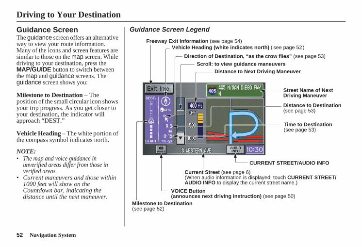
52 Navigation System
Guidance ScreenThe guidance screen offers an alternative way to view your route information. Many of the icons and screen features are similar to those on the map screen. While driving to your destination, press the MAP/GUIDE button to switch between the map and guidance screens. The guidance screen shows you:
Milestone to Destination – The position of the small circular icon shows your trip progress. As you get closer to your destination, the indicator will approach “DEST.”
Vehicle Heading – The white portion of the compass symbol indicates north.
NOTE:• The map and voice guidance in
unverified areas differ from those in verified areas.
• Current maneuvers and those within 1000 feet will show on the Countdown bar, indicating the distance until the next maneuver.
Guidance Screen Legend
Vehicle Heading (white indicates north) ( see page 52 )
Distance to Next Driving Maneuver
Street Name of Next Driving Maneuver
Distance to Destination (see page 53)
CURRENT STREET/AUDIO INFO
Current Street (see page 6) (When audio information is displayed, touch CURRENT STREET/ AUDIO INFO to display the current street name.)
VOICE Button (announces next driving instruction) (see page 50)
Milestone to Destination(see page 52)
Scroll: to view guidance maneuvers
Freeway Exit Information (see page 54)
Direction of Destination, “as the crow flies” (see page 53)
Time to Destination (see page 53)
Driving to Your Destination
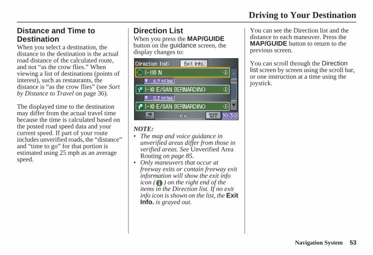
Navigation System 53
Driving to Your Destination
Distance and Time to DestinationWhen you select a destination, the distance to the destination is the actual road distance of the calculated route, and not “as the crow flies.” When viewing a list of destinations (points of interest), such as restaurants, the distance is “as the crow flies” (see Sort by Distance to Travel on page 36).
The displayed time to the destination may differ from the actual travel time because the time is calculated based on the posted road speed data and your current speed. If part of your route includes unverified roads, the “distance” and “time to go” for that portion is estimated using 25 mph as an average speed.
Direction ListWhen you press the MAP/GUIDE button on the guidance screen, the display changes to:
NOTE: • The map and voice guidance in
unverified areas differ from those in verified areas. See Unverified Area Routing on page 85.
• Only maneuvers that occur at freeway exits or contain freeway exit information will show the exit info icon ( ) on the right end of the items in the Direction list. If no exit info icon is shown on the list, the Exit Info. is grayed out.
You can see the Direction list and the distance to each maneuver. Press the MAP/GUIDE button to return to the previous screen.
You can scroll through the Direction list screen by screen using the scroll bar, or one instruction at a time using the joystick.
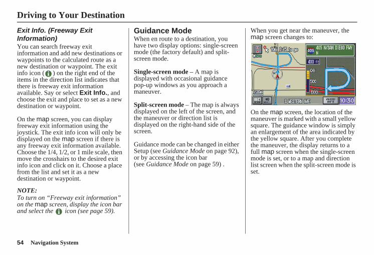
54 Navigation System
Exit Info. (Freeway Exit Information)You can search freeway exit information and add new destinations or waypoints to the calculated route as a new destination or waypoint. The exit info icon ( ) on the right end of the items in the direction list indicates that there is freeway exit information available. Say or select Exit Info., and choose the exit and place to set as a new destination or waypoint.
On the map screen, you can display freeway exit information using the joystick. The exit info icon will only be displayed on the map screen if there is any freeway exit information available. Choose the 1/4, 1/2, or 1 mile scale, then move the crosshairs to the desired exit info icon and click on it. Choose a place from the list and set it as a new destination or waypoint.
NOTE:To turn on “Freeway exit information” on the map screen, display the icon bar and select the icon (see page 59).
Guidance ModeWhen en route to a destination, you have two display options: single-screen mode (the factory default) and split-screen mode.
Single-screen mode – A map is displayed with occasional guidance pop-up windows as you approach a maneuver.
Split-screen mode – The map is always displayed on the left of the screen, and the maneuver or direction list is displayed on the right-hand side of the screen.
Guidance mode can be changed in either Setup (see Guidance Mode on page 92), or by accessing the icon bar (see Guidance Mode on page 59) .
When you get near the maneuver, the map screen changes to:
On the map screen, the location of the maneuver is marked with a small yellow square. The guidance window is simply an enlargement of the area indicated by the yellow square. After you complete the maneuver, the display returns to a full map screen when the single-screen mode is set, or to a map and direction list screen when the split-screen mode is set.
Driving to Your Destination
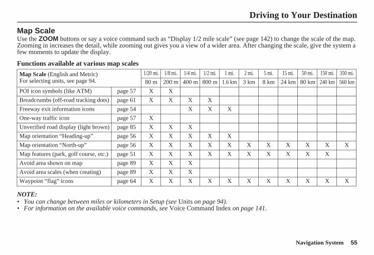
Navigation System 55
Driving to Your Destination
Map ScaleUse the ZOOM buttons or say a voice command such as “Display 1/2 mile scale” (see page 142) to change the scale of the map. Zooming in increases the detail, while zooming out gives you a view of a wider area. After changing the scale, give the system a few moments to update the display.
Functions available at various map scales
NOTE: • You can change between miles or kilometers in Setup (see Units on page 94).• For information on the available voice commands, see Voice Command Index on page 141.
Map Scale (English and Metric)For selecting units, see page 94.
1/20 mi. 1/8 mi. 1/4 mi. 1/2 mi. 1 mi. 2 mi. 5 mi. 15 mi. 50 mi. 150 mi. 350 mi.80 m 200 m 400 m 800 m 1.6 km 3 km 8 km 24 km 80 km 240 km 560 km
POI icon symbols (like ATM) page 57 X XBreadcrumbs (off-road tracking dots) page 61 X X X XFreeway exit information icons page 54 X X XOne-way traffic icon page 57 XUnverified road display (light brown) page 85 X X XMap orientation “Heading-up” page 56 X X X X XMap orientation “North-up” page 56 X X X X X X X X X X XMap features (park, golf course, etc.) page 51 X X X X X X X X X XAvoid area shown on map page 89 X X XAvoid area scales (when creating) page 89 X X XWaypoint “flag” icons page 64 X X X X X X X X X X X
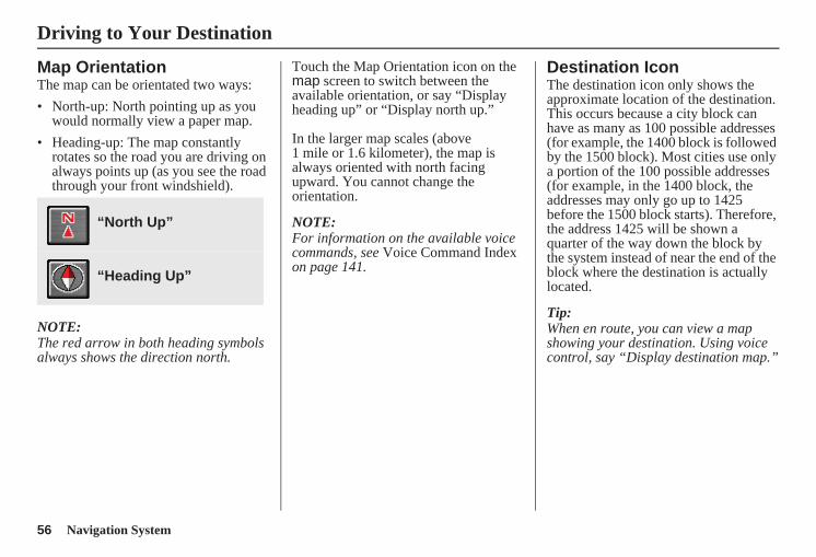
56 Navigation System
Map OrientationThe map can be orientated two ways:• North-up: North pointing up as you
would normally view a paper map.• Heading-up: The map constantly
rotates so the road you are driving on always points up (as you see the road through your front windshield).
NOTE:The red arrow in both heading symbols always shows the direction north.
Touch the Map Orientation icon on the map screen to switch between the available orientation, or say “Display heading up” or “Display north up.”
In the larger map scales (above 1 mile or 1.6 kilometer), the map is always oriented with north facing upward. You cannot change the orientation.
NOTE:For information on the available voice commands, see Voice Command Index on page 141.
Destination IconThe destination icon only shows the approximate location of the destination. This occurs because a city block can have as many as 100 possible addresses (for example, the 1400 block is followed by the 1500 block). Most cities use only a portion of the 100 possible addresses (for example, in the 1400 block, the addresses may only go up to 1425 before the 1500 block starts). Therefore, the address 1425 will be shown a quarter of the way down the block by the system instead of near the end of the block where the destination is actually located.
Tip:When en route, you can view a map showing your destination. Using voice control, say “Display destination map.”
“North Up”
“Heading Up”
Driving to Your Destination
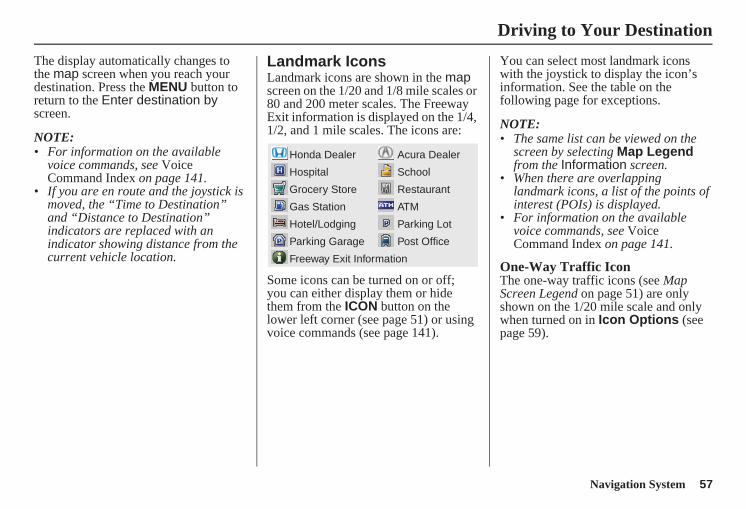
Navigation System 57
Driving to Your Destination
The display automatically changes to the map screen when you reach your destination. Press the MENU button to return to the Enter destination by screen.
NOTE:• For information on the available
voice commands, see Voice Command Index on page 141.
• If you are en route and the joystick is moved, the “Time to Destination” and “Distance to Destination” indicators are replaced with an indicator showing distance from the current vehicle location.
Landmark IconsLandmark icons are shown in the map screen on the 1/20 and 1/8 mile scales or 80 and 200 meter scales. The Freeway Exit information is displayed on the 1/4, 1/2, and 1 mile scales. The icons are:
Some icons can be turned on or off;you can either display them or hide them from the ICON button on the lower left corner (see page 51) or using voice commands (see page 141).
You can select most landmark icons with the joystick to display the icon’s information. See the table on the following page for exceptions.
NOTE: • The same list can be viewed on the
screen by selecting Map Legend from the Information screen.
• When there are overlapping landmark icons, a list of the points of interest (POIs) is displayed.
• For information on the available voice commands, see Voice Command Index on page 141.
One-Way Traffic IconThe one-way traffic icons (see Map Screen Legend on page 51) are only shown on the 1/20 mile scale and only when turned on in Icon Options (see page 59).
Acura Dealer
School
Restaurant
ATM
Parking Lot
Post Office
Honda Dealer
Hospital
Grocery Store
Gas Station
Hotel/Lodging
Parking Garage
Freeway Exit Information
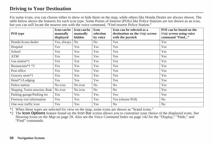
58 Navigation System
For some icons, you can choose either to show or hide them on the map, while others like Honda Dealer are always shown. The table below shows the features for each icon type. Some Points of Interest (POIs) like Police Stations are not shown as an icon, but you can still locate the nearest one with the voice command, “Find nearest Police Station.”
*1 When these types are selected for view on the map, some icons are shown as “brand icons.”*2 The Icon Options feature found on the Icon Bar screen allows you to customize your choice of the displayed icons. See
Showing Icons on the Map on page 59. Also see the Voice Command Index on page 142 for the “Display,” “Hide,” and “Find” commands.
POI typeIcon can be manually displayed
Icon can be manually hidden
Icon selection by voice
Icon can be selected as a destination on the map screen with the joystick
POI can be found on the map screen using voice command “Find...”
Honda/Acura dealer Yes, always No No Yes YesHospital Yes Yes Yes Yes YesSchool Yes Yes Yes Yes YesATM Yes Yes Yes Yes YesGas station*1 Yes Yes Yes Yes YesRestaurants*1 *2 Yes Yes Yes Yes YesPost office Yes Yes Yes Yes YesGrocery store*1 Yes Yes Yes Yes YesHotel*1/Lodging Yes Yes Yes Yes YesPolice station No icon No icon No No YesShopping, Tourist attraction, Bank No icon No icon No No YesParking garage/Parking lot Yes Yes Yes Yes YesFreeway exit information Yes Yes Yes Yes (choose POI) NoOne-way traffic icon Yes Yes Yes No No
Driving to Your Destination
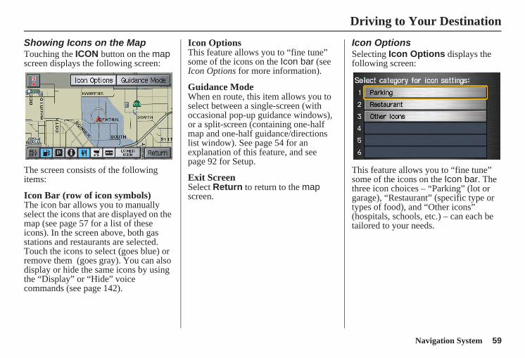
Navigation System 59
Driving to Your Destination
Showing Icons on the MapTouching the ICON button on the map screen displays the following screen:
The screen consists of the following items:
Icon Bar (row of icon symbols)The icon bar allows you to manually select the icons that are displayed on the map (see page 57 for a list of these icons). In the screen above, both gas stations and restaurants are selected. Touch the icons to select (goes blue) or remove them (goes gray). You can also display or hide the same icons by using the “Display” or “Hide” voice commands (see page 142).
Icon OptionsThis feature allows you to “fine tune” some of the icons on the Icon bar (see Icon Options for more information).
Guidance ModeWhen en route, this item allows you to select between a single-screen (with occasional pop-up guidance windows), or a split-screen (containing one-half map and one-half guidance/directions list window). See page 54 for an explanation of this feature, and see page 92 for Setup.
Exit ScreenSelect Return to return to the map screen.
Icon OptionsSelecting Icon Options displays the following screen:
This feature allows you to “fine tune” some of the icons on the Icon bar. The three icon choices – “Parking” (lot or garage), “Restaurant” (specific type or types of food), and “Other icons” (hospitals, schools, etc.) – can each be tailored to your needs.
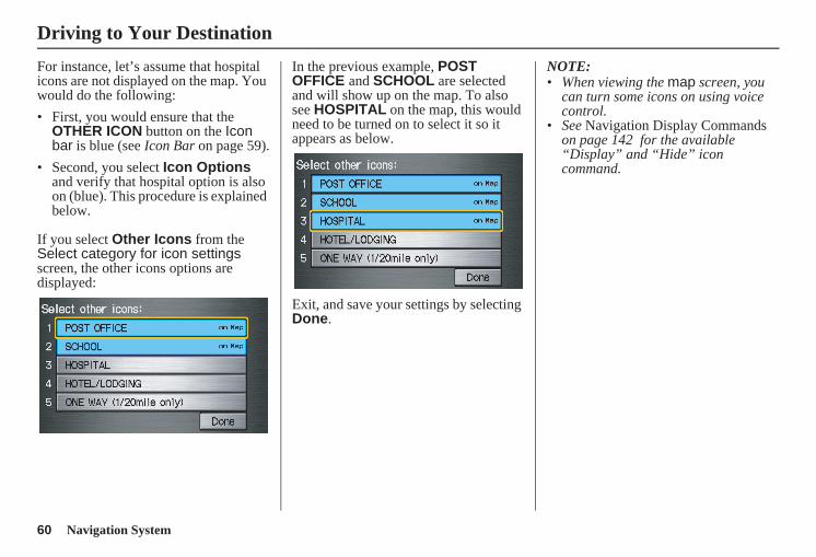
60 Navigation System
For instance, let’s assume that hospital icons are not displayed on the map. You would do the following:• First, you would ensure that the
OTHER ICON button on the Icon bar is blue (see Icon Bar on page 59).
• Second, you select Icon Options and verify that hospital option is also on (blue). This procedure is explained below.
If you select Other Icons from the Select category for icon settings screen, the other icons options are displayed:
In the previous example, POST OFFICE and SCHOOL are selected and will show up on the map. To also see HOSPITAL on the map, this would need to be turned on to select it so it appears as below.
Exit, and save your settings by selecting Done.
NOTE:• When viewing the map screen, you
can turn some icons on using voice control.
• See Navigation Display Commands on page 142 for the available “Display” and “Hide” icon command.
Driving to Your Destination
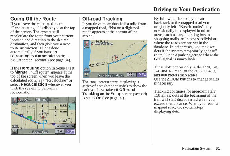
Navigation System 61
Driving to Your Destination
Going Off the RouteIf you leave the calculated route, “Recalculating...” is displayed at the top of the screen. The system will recalculate the route from your current location and direction to the desired destination, and then give you a new route instruction. This is done automatically if you have set Rerouting to Automatic on the Setup screen (second) (see page 84).
If the Rerouting option in Setup is set to Manual, “Off route” appears at the top of the screen when you leave the calculated route. Say “Recalculate” or select Recalculation whenever you wish the system to perform a recalculation.
Off-road TrackingIf you drive more than half a mile from a mapped road, “Not on a digitized road” appears at the bottom of the screen.
The map screen starts displaying a series of dots (breadcrumbs) to show the path you have taken if Off-road Tracking on the Setup screen (second) is set to On (see page 92).
By following the dots, you can backtrack to the mapped road you originally left. “Breadcrumbs” may occasionally be displayed in urban areas, such as large parking lots in shopping malls, or in new subdivisions where the roads are not yet in the database. In other cases, you may see dots if the system temporarily goes off route, like in a parking garage where the GPS signal is unavailable.
These dots appear only in the 1/20, 1/8, 1/4, and 1/2 mile (or the 80, 200, 400, and 800 meter) map scales.Use the ZOOM buttons to change scales if necessary.
Tracking continues for approximately 150 miles; dots at the beginning of the trail will start disappearing when you exceed that distance. When you reach a mapped road, the system stops displaying dots.
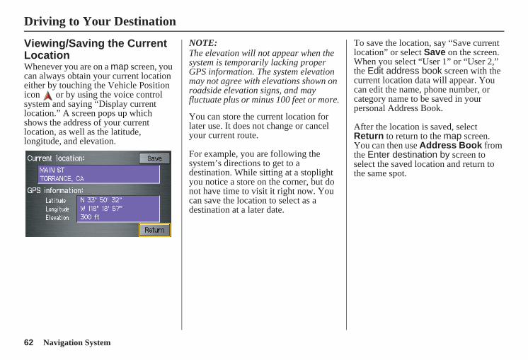
62 Navigation System
Viewing/Saving the Current LocationWhenever you are on a map screen, you can always obtain your current location either by touching the Vehicle Position icon or by using the voice control system and saying “Display current location.” A screen pops up which shows the address of your current location, as well as the latitude, longitude, and elevation.
NOTE:The elevation will not appear when the system is temporarily lacking proper GPS information. The system elevation may not agree with elevations shown on roadside elevation signs, and may fluctuate plus or minus 100 feet or more.
You can store the current location for later use. It does not change or cancel your current route.
For example, you are following the system’s directions to get to a destination. While sitting at a stoplight you notice a store on the corner, but do not have time to visit it right now. You can save the location to select as a destination at a later date.
To save the location, say “Save current location” or select Save on the screen. When you select “User 1” or “User 2,” the Edit address book screen with the current location data will appear. You can edit the name, phone number, or category name to be saved in your personal Address Book.
After the location is saved, select Return to return to the map screen. You can then use Address Book from the Enter destination by screen to select the saved location and return to the same spot.
Driving to Your Destination
Navigation System 63
Driving to Your Destination
Pop-Ups and DisclaimersWhen you say “OK” in the Calculate Route to screen, or if you change your route, the system checks your route and provides you with pop-up messages for the following situations:• Your route takes you into an area that
you previously set as an “Avoid Area” (see Edit Avoid Area on page 89).
• Your route passes near an unverified area (see Unverified Area Routing on page 85).
• Your route includes unverified areas (see Unverified Area Routing on page 85).
• You are about to enter an unverified area (see Unverified Area Routing on page 85).
• You actually entered an unverified area (see Unverified Area Routing on page 85).
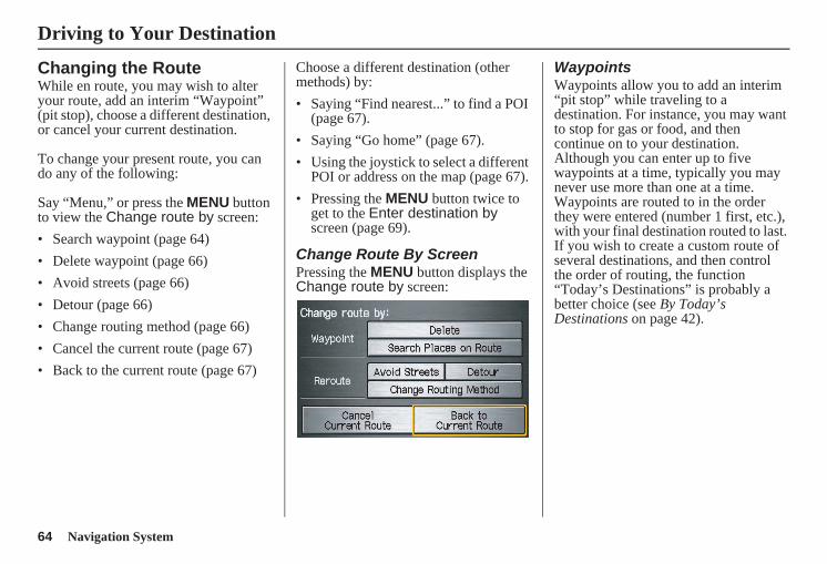
64 Navigation System
Changing the RouteWhile en route, you may wish to alter your route, add an interim “Waypoint” (pit stop), choose a different destination, or cancel your current destination.
To change your present route, you can do any of the following:
Say “Menu,” or press the MENU button to view the Change route by screen:• Search waypoint (page 64)• Delete waypoint (page 66)• Avoid streets (page 66)• Detour (page 66)• Change routing method (page 66)• Cancel the current route (page 67)• Back to the current route (page 67)
Choose a different destination (other methods) by:• Saying “Find nearest...” to find a POI
(page 67).• Saying “Go home” (page 67).• Using the joystick to select a different
POI or address on the map (page 67).• Pressing the MENU button twice to
get to the Enter destination by screen (page 69).
Change Route By ScreenPressing the MENU button displays the Change route by screen:
WaypointsWaypoints allow you to add an interim “pit stop” while traveling to a destination. For instance, you may want to stop for gas or food, and then continue on to your destination. Although you can enter up to five waypoints at a time, typically you may never use more than one at a time. Waypoints are routed to in the order they were entered (number 1 first, etc.), with your final destination routed to last. If you wish to create a custom route of several destinations, and then control the order of routing, the function “Today’s Destinations” is probably a better choice (see By Today’s Destinations on page 42).
Driving to Your Destination
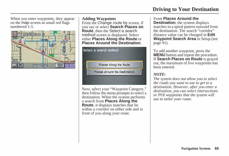
Navigation System 65
Driving to Your Destination
When you enter waypoints, they appear on the map screen as small red flags numbered 1-5.
Adding WaypointsFrom the Change route by screen, if you say or select Search Places on Route, then the Select a search method screen is displayed. Select either Places Along the Route or Places Around the Destination.
Next, select your “Waypoint Category,” then follow the menu prompts to select a destination. When the system performs a search from Places Along the Route, it displays matches that lie within a corridor on either side and in front of you along your route.
From Places Around the Destination, the system displays matches in a spiral pattern outward from the destination. The search “corridor” distance value can be changed in Edit Waypoint Search Area in Setup (see page 91).
To add another waypoint, press the MENU button and repeat the procedure. If Search Places on Route is grayed out, the maximum of five waypoints has been entered.
NOTE:The system does not allow you to select the roads you want to use to get to a destination. However, after you enter a destination, you can select intersections or POI waypoints that the system will use to tailor your route.
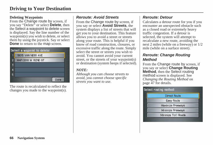
66 Navigation System
Deleting WaypointsFrom the Change route by screen, if you say “Delete” or select Delete, then the Select a waypoint to delete screen is displayed. Say the line number of the waypoint(s) you wish to delete, or select them by using the joystick. Say or select Done to return to the map screen.
The route is recalculated to reflect the changes you made to the waypoint(s).
Reroute: Avoid StreetsFrom the Change route by screen, if you say or select Avoid Streets, the system displays a list of streets that will get you to your destination. This feature allows you to avoid a street or streets along your route. This is helpful if you know of road construction, closures, or excessive traffic along the route. Simply select the street or streets you wish to avoid. You cannot avoid your current street, or the streets of your waypoint(s) or destination (system beeps if selected).
NOTE:Although you can choose streets to avoid, you cannot choose specific streets you want to use.
Reroute: DetourCalculates a detour route for you if you encounter an unexpected obstacle such as a closed road or extremely heavy traffic congestion. If a detour is selected, the system will attempt to recalculate a new route, avoiding the next 2 miles (while on a freeway) or 1/2 mile (while on a surface street).
Reroute: Change Routing MethodFrom the Change route by screen, if you say or select Change Routing Method, then the Select routing method screen is displayed. See Changing the Routing Method on page 47 for details.
Driving to Your Destination
Navigation System 67
Driving to Your Destination
Cancel Current RouteCancels the current route (and any waypoints) and returns you to the map screen.
Back to Current RouteReturns you to the original map screen.
Changing Your DestinationThere are four methods by which you can change or add a waypoint to your route. These are:
Find Nearest (Voice command)From the map screen, say one of the “Find Nearest...” voice commands to locate the nearest gas station, ATM, restaurant, or other point of interest. See the “Find Nearest” voice commands listing on page 143.
Go Home (Voice command)From the map screen, say “Go home.” If you have entered a “Go home” address, then the system will display a confirmation screen.
Using Joystick to Change DestinationWhile following a calculated route, you can select a new destination with the map screen and the joystick.
With the map screen displayed, use the joystick to move the position icon. It will change to crosshairs. Use the joystick to position the crosshairs on your desired new destination, street, or icon, then push in on the joystick. The Select a place screen or the address of the location will be displayed.
NOTE:The Select a place screen will be displayed when the crosshairs are positioned near multiple icons or locations. The address of the location will be displayed at the top of the screen when the crosshairs are positioned on a particular street, icon, or location.
If this is not your desired new destination, press the CANCEL button or the NAVI BACK button on the steering wheel to return to the map screen. Reposition the crosshairs with the joystick, then push in on the joystick again to see the new address.
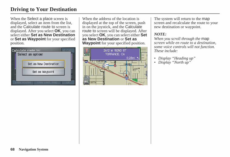
68 Navigation System
When the Select a place screen is displayed, select an item from the list, and the Calculate route to screen is displayed. After you select OK, you can select either Set as New Destination or Set as Waypoint for your specified position.
When the address of the location is displayed at the top of the screen, push in on the joystick, and the Calculate route to screen will be displayed. After you select OK, you can select either Set as New Destination or Set as Waypoint for your specified position.
The system will return to the map screen and recalculate the route to your new destination or waypoint.
NOTE:When you scroll through the map screen while en route to a destination, some voice controls will not function. These include:
• Display “Heading up”• Display “North up”
Driving to Your Destination
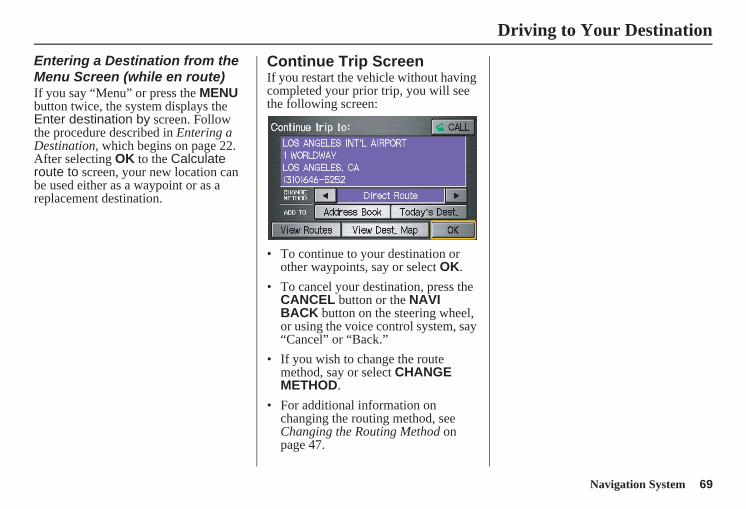
Navigation System 69
Driving to Your Destination
Entering a Destination from the Menu Screen (while en route)If you say “Menu” or press the MENU button twice, the system displays the Enter destination by screen. Follow the procedure described in Entering a Destination, which begins on page 22. After selecting OK to the Calculate route to screen, your new location can be used either as a waypoint or as a replacement destination.
Continue Trip ScreenIf you restart the vehicle without having completed your prior trip, you will see the following screen:
• To continue to your destination or other waypoints, say or select OK.
• To cancel your destination, press the CANCEL button or the NAVI BACK button on the steering wheel, or using the voice control system, say “Cancel” or “Back.”
• If you wish to change the route method, say or select CHANGE METHOD.
• For additional information on changing the routing method, see Changing the Routing Method on page 47.
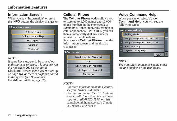
70 Navigation System
Information Features
Information ScreenWhen you say “Information” or press the INFO button, the display changes to:
NOTE:If some items appear to be grayed out and cannot be selected, it is because you did not select OK on the initial Disclaimer screen (see System Start-up on page 16), or there is no phone paired to the system (see Bluetooth® HandsFreeLink® on page 18).
Cellular PhoneThe Cellular Phone option allows you to store up to 1,000 names and 10,000 phone numbers in the phonebook of Bluetooth® HandsFreeLink® from your cellular phonebook. With HFL, you can then automatically dial any name or number in the phonebook.Say or select Cellular Phone from the Information screen, and the display changes to:
NOTE:• For more information on this feature,
see your Owner’s Manual.• For questions about the HFL Cellular
Phone, call HandsFreeLink customer support at (888) 528-7876, or visit handsfreelink.honda.com. In Canada, call (888) 9-HONDA-9.
Voice Command HelpWhen you say or select Voice Command Help, you will see the following screen:
NOTE:You can select an item by saying either the line number or the item name.
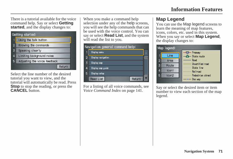
Navigation System 71
Information Features
There is a tutorial available for the voice command help. Say or select Getting started, and the display changes to:
Select the line number of the desired tutorial you want to view, and the tutorial will automatically be read. Press Stop to stop the reading, or press the CANCEL button.
When you make a command help selection under any of the help screens, you will see the help commands that can be used with the voice control. You can say or select Read List, and the system will read the list to you.
For a listing of all voice commands, see Voice Command Index on page 141.
Map LegendYou can use the Map legend screens to learn the meaning of map features, icons, colors, etc. used in this system. When you say or select Map Legend, the display changes to:
Say or select the desired item or item number to view each section of the map legend.
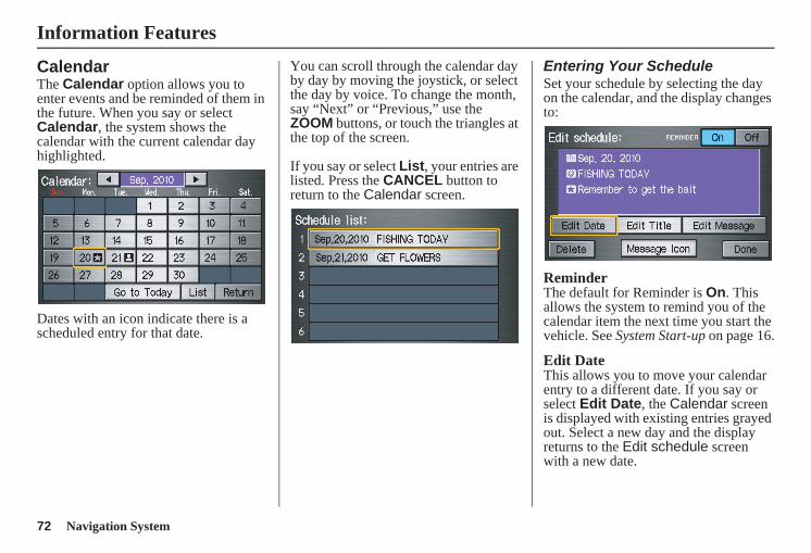
72 Navigation System
Information Features
CalendarThe Calendar option allows you to enter events and be reminded of them in the future. When you say or select Calendar, the system shows the calendar with the current calendar day highlighted.
Dates with an icon indicate there is a scheduled entry for that date.
You can scroll through the calendar day by day by moving the joystick, or select the day by voice. To change the month, say “Next” or “Previous,” use the ZOOM buttons, or touch the triangles at the top of the screen.
If you say or select List, your entries are listed. Press the CANCEL button to return to the Calendar screen.
Entering Your ScheduleSet your schedule by selecting the day on the calendar, and the display changes to:
ReminderThe default for Reminder is On. This allows the system to remind you of the calendar item the next time you start the vehicle. See System Start-up on page 16.
Edit DateThis allows you to move your calendar entry to a different date. If you say or select Edit Date, the Calendar screen is displayed with existing entries grayed out. Select a new day and the display returns to the Edit schedule screen with a new date.
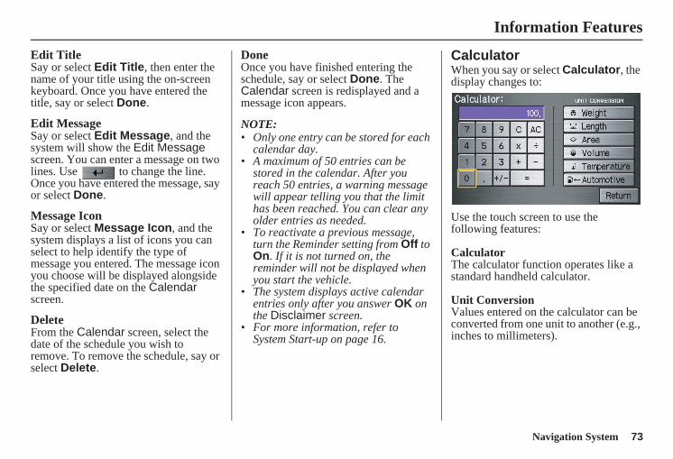
Navigation System 73
Information Features
Edit TitleSay or select Edit Title, then enter the name of your title using the on-screen keyboard. Once you have entered the title, say or select Done.
Edit MessageSay or select Edit Message, and the system will show the Edit Message screen. You can enter a message on two lines. Use to change the line. Once you have entered the message, say or select Done.
Message IconSay or select Message Icon, and the system displays a list of icons you can select to help identify the type of message you entered. The message icon you choose will be displayed alongside the specified date on the Calendar screen.
DeleteFrom the Calendar screen, select the date of the schedule you wish to remove. To remove the schedule, say or select Delete.
DoneOnce you have finished entering the schedule, say or select Done. The Calendar screen is redisplayed and a message icon appears.
NOTE: • Only one entry can be stored for each
calendar day.• A maximum of 50 entries can be
stored in the calendar. After you reach 50 entries, a warning message will appear telling you that the limit has been reached. You can clear any older entries as needed.
• To reactivate a previous message, turn the Reminder setting from Off to On. If it is not turned on, the reminder will not be displayed when you start the vehicle.
• The system displays active calendar entries only after you answer OK on the Disclaimer screen.
• For more information, refer to System Start-up on page 16.
CalculatorWhen you say or select Calculator, the display changes to:
Use the touch screen to use the following features:
CalculatorThe calculator function operates like a standard handheld calculator.
Unit ConversionValues entered on the calculator can be converted from one unit to another (e.g., inches to millimeters).
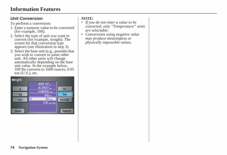
74 Navigation System
Information Features
Unit ConversionTo perform a conversion:1. Enter a numeric value to be converted
(for example, 100).2. Select the type of unit you want to
convert (for example, weight). The screen for that conversion type appears (see illustration in step 3).
3. Select the base unit (e.g., pounds) that you wish to convert to some other unit. All other units will change automatically depending on the base unit value. In the example below, 100 lbs converts to 1600 ounces, 0.05 ton (U.S.), etc.
NOTE:• If you do not enter a value to be
converted, only “Temperature” units are selectable.
• Conversions using negative value may produce meaningless or physically impossible values.
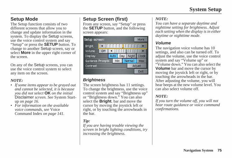
Navigation System 75
System Setup
Setup ModeThe Setup function consists of two different screens that allow you to change and update information in the system. To display the Setup screens, use the voice control system and say “Setup” or press the SETUP button. To change to another Setup screen, say or select More in the upper right corner of the screen.
On any of the Setup screens, you can use the voice control system to select any item on the screen.
NOTE: • If some items appear to be grayed out
and cannot be selected, it is because you did not select OK on the initial Disclaimer screen. See System Start-up on page 16.
• For information on the available voice commands, see Voice Command Index on page 141.
Setup Screen (first)From any screen, say “Setup” or press the SETUP button, and the following screen appears:
BrightnessThe screen brightness has 11 settings. To change the brightness, use the voice control system and say “Brightness up” or “Brightness down.” You can also select the Bright. bar and move the cursor by moving the joystick left or right, or by touching the arrowheads in the bar.
Tip:If you are having trouble viewing the screen in bright lighting conditions, try increasing the brightness.
NOTE:You can have a separate daytime and nighttime setting for brightness. Adjust each setting when the display is in either daytime or nighttime mode.
VolumeThe navigation voice volume has 10 settings, and also can be turned off. To adjust the volume, use the voice control system and say “Volume up” or “Volume down.” You can also select the Volume bar and move the cursor by moving the joystick left or right, or by touching the arrowheads in the bar. After adjusting the volume, you will hear beeps at the new volume level. You can also select volume off.
NOTE:If you turn the volume off, you will not hear route guidance or voice command confirmations.
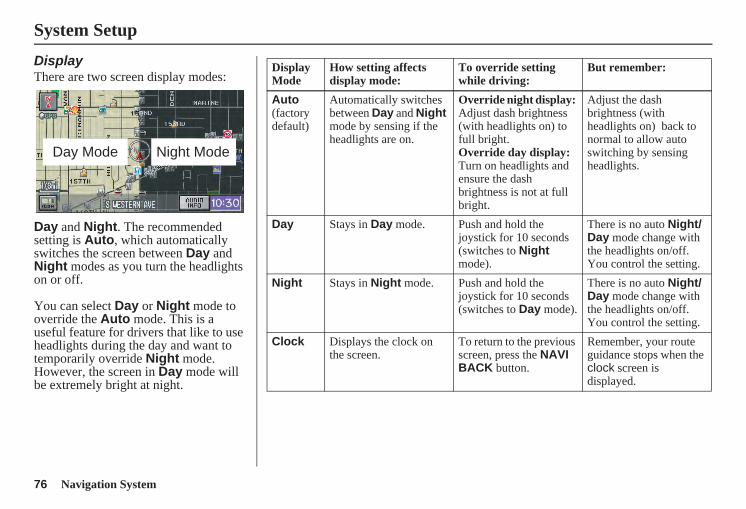
76 Navigation System
System Setup
DisplayThere are two screen display modes:
Day and Night. The recommended setting is Auto, which automatically switches the screen between Day and Night modes as you turn the headlights on or off.
You can select Day or Night mode to override the Auto mode. This is a useful feature for drivers that like to use headlights during the day and want to temporarily override Night mode. However, the screen in Day mode will be extremely bright at night.
Day Mode Night Mode
Display Mode
How setting affects display mode:
To override setting while driving:
But remember:
Auto(factory default)
Automatically switches between Day and Night mode by sensing if the headlights are on.
Override night display: Adjust dash brightness (with headlights on) to full bright.Override day display:Turn on headlights and ensure the dash brightness is not at full bright.
Adjust the dash brightness (with headlights on) back to normal to allow auto switching by sensing headlights.
Day Stays in Day mode. Push and hold the joystick for 10 seconds (switches to Night mode).
There is no auto Night/Day mode change with the headlights on/off. You control the setting.
Night Stays in Night mode. Push and hold the joystick for 10 seconds (switches to Day mode).
There is no auto Night/Day mode change with the headlights on/off. You control the setting.
Clock Displays the clock on the screen.
To return to the previous screen, press the NAVI BACK button.
Remember, your route guidance stops when the clock screen is displayed.
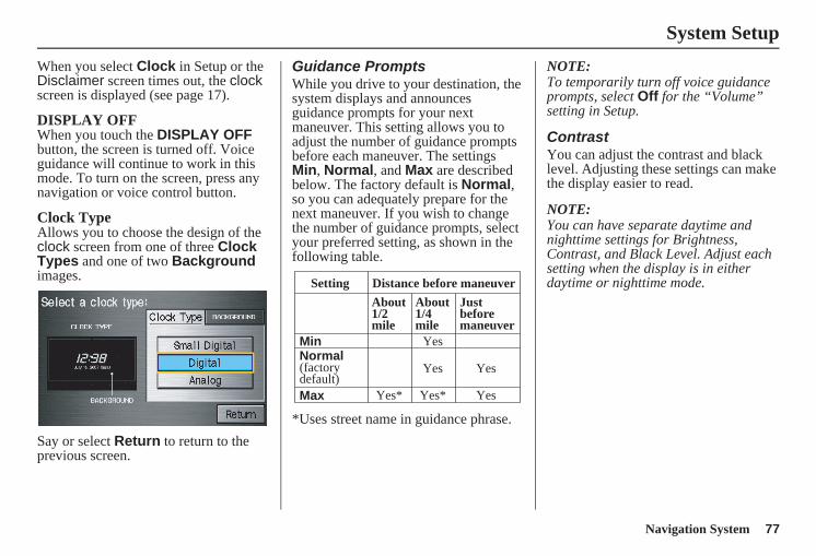
Navigation System 77
System Setup
When you select Clock in Setup or the Disclaimer screen times out, the clock screen is displayed (see page 17).
DISPLAY OFFWhen you touch the DISPLAY OFF button, the screen is turned off. Voice guidance will continue to work in this mode. To turn on the screen, press any navigation or voice control button.
Clock TypeAllows you to choose the design of the clock screen from one of three Clock Types and one of two Background images.
Say or select Return to return to the previous screen.
Guidance PromptsWhile you drive to your destination, the system displays and announces guidance prompts for your next maneuver. This setting allows you to adjust the number of guidance prompts before each maneuver. The settings Min, Normal, and Max are described below. The factory default is Normal, so you can adequately prepare for the next maneuver. If you wish to change the number of guidance prompts, select your preferred setting, as shown in the following table.
*Uses street name in guidance phrase.
NOTE:To temporarily turn off voice guidance prompts, select Off for the “Volume” setting in Setup.
ContrastYou can adjust the contrast and black level. Adjusting these settings can make the display easier to read.
NOTE:You can have separate daytime and nighttime settings for Brightness, Contrast, and Black Level. Adjust each setting when the display is in either daytime or nighttime mode.Setting Distance before maneuver
About1/2mile
Max
Normal(factorydefault)
Min
About1/4mile
Justbeforemaneuver
Yes* Yes* Yes
Yes Yes
Yes
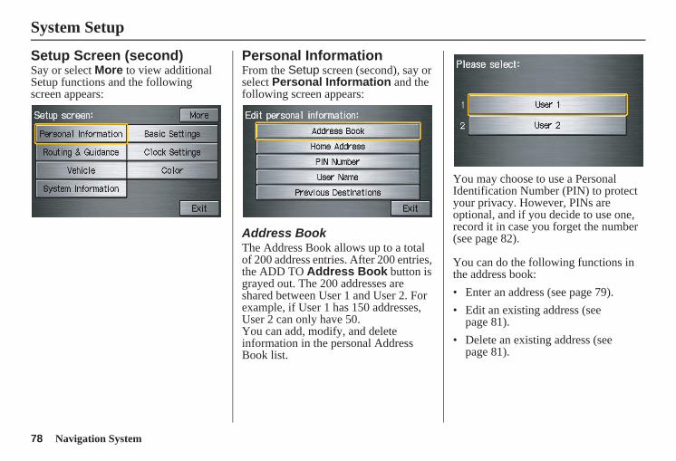
78 Navigation System
System Setup
Setup Screen (second)Say or select More to view additional Setup functions and the following screen appears:
Personal InformationFrom the Setup screen (second), say or select Personal Information and the following screen appears:
Address BookThe Address Book allows up to a total of 200 address entries. After 200 entries, the ADD TO Address Book button is grayed out. The 200 addresses are shared between User 1 and User 2. For example, if User 1 has 150 addresses, User 2 can only have 50.You can add, modify, and delete information in the personal Address Book list.
You may choose to use a Personal Identification Number (PIN) to protect your privacy. However, PINs are optional, and if you decide to use one, record it in case you forget the number (see page 82).
You can do the following functions in the address book:• Enter an address (see page 79).• Edit an existing address (see
page 81).• Delete an existing address (see
page 81).
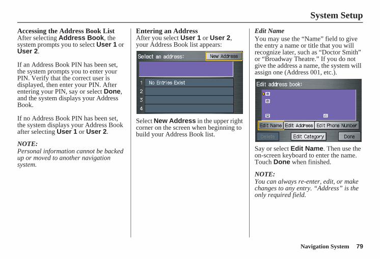
Navigation System 79
System Setup
Accessing the Address Book ListAfter selecting Address Book, the system prompts you to select User 1 or User 2.
If an Address Book PIN has been set, the system prompts you to enter your PIN. Verify that the correct user is displayed, then enter your PIN. After entering your PIN, say or select Done, and the system displays your Address Book.
If no Address Book PIN has been set, the system displays your Address Book after selecting User 1 or User 2.
NOTE:Personal information cannot be backed up or moved to another navigation system.
Entering an AddressAfter you select User 1 or User 2, your Address Book list appears:
Select New Address in the upper right corner on the screen when beginning to build your Address Book list.
Edit NameYou may use the “Name” field to give the entry a name or title that you will recognize later, such as “Doctor Smith” or “Broadway Theatre.” If you do not give the address a name, the system will assign one (Address 001, etc.).
Say or select Edit Name. Then use the on-screen keyboard to enter the name. Touch Done when finished.
NOTE:You can always re-enter, edit, or make changes to any entry. “Address” is the only required field.
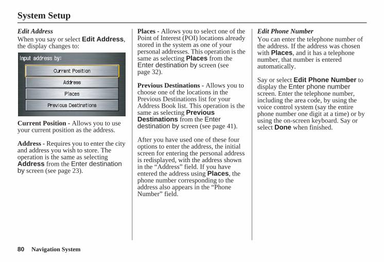
80 Navigation System
System Setup
Edit AddressWhen you say or select Edit Address, the display changes to:
Current Position - Allows you to use your current position as the address.
Address - Requires you to enter the city and address you wish to store. The operation is the same as selecting Address from the Enter destination by screen (see page 23).
Places - Allows you to select one of the Point of Interest (POI) locations already stored in the system as one of your personal addresses. This operation is the same as selecting Places from the Enter destination by screen (see page 32).
Previous Destinations - Allows you to choose one of the locations in the Previous Destinations list for your Address Book list. This operation is the same as selecting Previous Destinations from the Enter destination by screen (see page 41).
After you have used one of these four options to enter the address, the initial screen for entering the personal address is redisplayed, with the address shown in the “Address” field. If you have entered the address using Places, the phone number corresponding to the address also appears in the “Phone Number” field.
Edit Phone NumberYou can enter the telephone number of the address. If the address was chosen with Places, and it has a telephone number, that number is entered automatically.
Say or select Edit Phone Number to display the Enter phone number screen. Enter the telephone number, including the area code, by using the voice control system (say the entire phone number one digit at a time) or by using the on-screen keyboard. Say or select Done when finished.
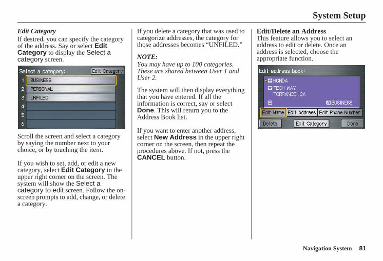
Navigation System 81
System Setup
Edit CategoryIf desired, you can specify the category of the address. Say or select Edit Category to display the Select a category screen.
Scroll the screen and select a category by saying the number next to your choice, or by touching the item.
If you wish to set, add, or edit a new category, select Edit Category in the upper right corner on the screen. The system will show the Select a category to edit screen. Follow the on-screen prompts to add, change, or delete a category.
If you delete a category that was used to categorize addresses, the category for those addresses becomes “UNFILED.”
NOTE:You may have up to 100 categories. These are shared between User 1 and User 2.
The system will then display everything that you have entered. If all the information is correct, say or select Done. This will return you to the Address Book list.
If you want to enter another address, select New Address in the upper right corner on the screen, then repeat the procedures above. If not, press the CANCEL button.
Edit/Delete an AddressThis feature allows you to select an address to edit or delete. Once an address is selected, choose the appropriate function.
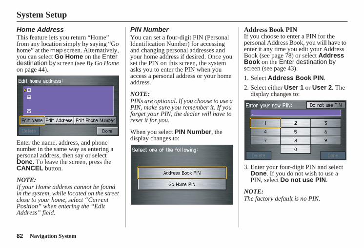
82 Navigation System
System Setup
Home AddressThis feature lets you return “Home” from any location simply by saying “Go home” at the map screen. Alternatively, you can select Go Home on the Enter destination by screen (see By Go Home on page 44).
Enter the name, address, and phone number in the same way as entering a personal address, then say or select Done. To leave the screen, press the CANCEL button.
NOTE:If your Home address cannot be found in the system, while located on the street close to your home, select “Current Position” when entering the “Edit Address” field.
PIN NumberYou can set a four-digit PIN (Personal Identification Number) for accessing and changing personal addresses and your home address if desired. Once you set the PIN on this screen, the system asks you to enter the PIN when you access a personal address or your home address.
NOTE:PINs are optional. If you choose to use a PIN, make sure you remember it. If you forget your PIN, the dealer will have to reset it for you.
When you select PIN Number, the display changes to:
Address Book PINIf you choose to enter a PIN for the personal Address Book, you will have to enter it any time you edit your Address Book (see page 78) or select Address Book on the Enter destination by screen (see page 43).1. Select Address Book PIN.2. Select either User 1 or User 2. The
display changes to:
3. Enter your four-digit PIN and select Done. If you do not wish to use a PIN, select Do not use PIN.
NOTE:The factory default is no PIN.
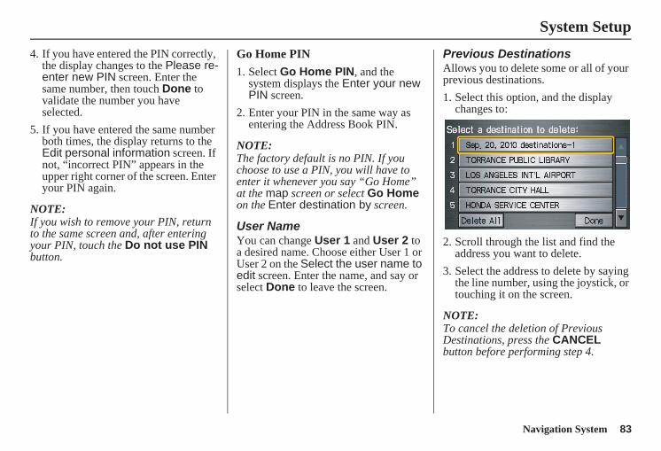
Navigation System 83
System Setup
4. If you have entered the PIN correctly, the display changes to the Please re-enter new PIN screen. Enter the same number, then touch Done to validate the number you have selected.
5. If you have entered the same number both times, the display returns to the Edit personal information screen. If not, “incorrect PIN” appears in the upper right corner of the screen. Enter your PIN again.
NOTE:If you wish to remove your PIN, return to the same screen and, after entering your PIN, touch the Do not use PIN button.
Go Home PIN
1. Select Go Home PIN, and the system displays the Enter your new PIN screen.
2. Enter your PIN in the same way as entering the Address Book PIN.
NOTE:The factory default is no PIN. If you choose to use a PIN, you will have to enter it whenever you say “Go Home” at the map screen or select Go Home on the Enter destination by screen.
User NameYou can change User 1 and User 2 to a desired name. Choose either User 1 or User 2 on the Select the user name to edit screen. Enter the name, and say or select Done to leave the screen.
Previous DestinationsAllows you to delete some or all of your previous destinations.1. Select this option, and the display
changes to:
2. Scroll through the list and find the address you want to delete.
3. Select the address to delete by saying the line number, using the joystick, or touching it on the screen.
NOTE:To cancel the deletion of Previous Destinations, press the CANCEL button before performing step 4.
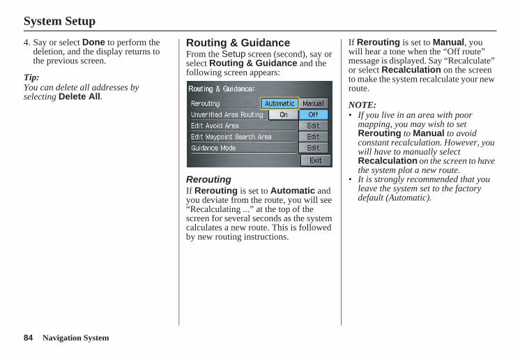
84 Navigation System
System Setup
4. Say or select Done to perform the deletion, and the display returns to the previous screen.
Tip:You can delete all addresses by selecting Delete All.
Routing & GuidanceFrom the Setup screen (second), say or select Routing & Guidance and the following screen appears:
ReroutingIf Rerouting is set to Automatic and you deviate from the route, you will see “Recalculating ...” at the top of the screen for several seconds as the system calculates a new route. This is followed by new routing instructions.
If Rerouting is set to Manual, you will hear a tone when the “Off route” message is displayed. Say “Recalculate” or select Recalculation on the screen to make the system recalculate your new route.
NOTE:• If you live in an area with poor
mapping, you may wish to set Rerouting to Manual to avoid constant recalculation. However, you will have to manually select Recalculation on the screen to have the system plot a new route.
• It is strongly recommended that you leave the system set to the factory default (Automatic).
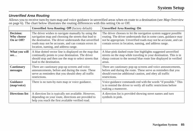
Navigation System 85
System Setup
Unverified Area RoutingAllows you to receive turn-by-turn map and voice guidance in unverified areas when en route to a destination (see Map Overview on page 6). The chart below illustrates the routing differences with this setting On or Off.
Unverified Area Routing: Off (factory default) Unverified Area Routing: On
Decision:Why choose On or Off?
The driver wishes to navigate manually by using the navigation map and choosing the streets that lead to the destination. The driver understands that unverified roads may not be accurate, and can contain errors in location, naming, and address range.
The driver chooses to let the navigation system suggest possible routing. The driver understands that in some cases, guidance may not be appropriate. Unverified roads may not be accurate, and can contain errors in location, naming, and address range.
What you will see…
A blue dotted vector line is displayed on the map that continually points to your destination. The driver should stop and then use the map to select streets that lead to the destination.
A blue-pink dashed route line highlights suggested unverified streets on the map while traveling to your destination. This is in sharp contrast to the normal blue route line displayed in verified areas.
Cautionary messages
There are cautionary pop-up screens and voice announcements, before and during the route. These serve as reminders that you should obey all traffic restrictions.
There are cautionary pop-up screens and voice announcements, before and during the route. These serve as reminders that you should exercise additional caution, and obey all traffic restrictions.
Guidance (map/voice)
There is no turn-by-turn map or voice guidance. Voice guidance commands end with the words “if possible.” This is to remind the driver to verify all traffic restrictions before making a maneuver.
Directions list A direction list is typically not available. However, depending on your route, directions are provided to help you reach the first available verified road.
A direction list is provided showing street names and turn symbols in pink.
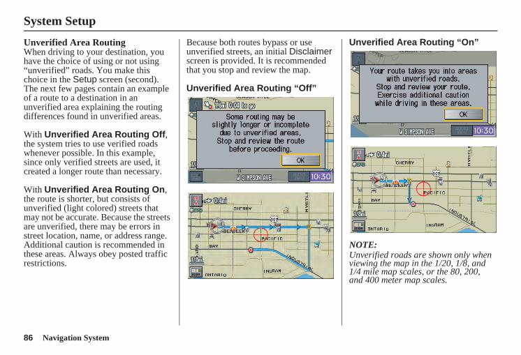
86 Navigation System
System Setup
Unverified Area RoutingWhen driving to your destination, you have the choice of using or not using “unverified” roads. You make this choice in the Setup screen (second). The next few pages contain an example of a route to a destination in an unverified area explaining the routing differences found in unverified areas.
With Unverified Area Routing Off, the system tries to use verified roads whenever possible. In this example, since only verified streets are used, it created a longer route than necessary.
With Unverified Area Routing On, the route is shorter, but consists of unverified (light colored) streets that may not be accurate. Because the streets are unverified, there may be errors in street location, name, or address range. Additional caution is recommended in these areas. Always obey posted traffic restrictions.
Because both routes bypass or use unverified streets, an initial Disclaimer screen is provided. It is recommended that you stop and review the map.
Unverified Area Routing “Off”
Unverified Area Routing “On”
NOTE:Unverified roads are shown only when viewing the map in the 1/20, 1/8, and 1/4 mile map scales, or the 80, 200, and 400 meter map scales.
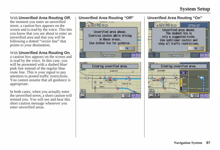
Navigation System 87
System Setup
With Unverified Area Routing Off, the moment you enter an unverified street, a caution box appears on the screen and is read by the voice. This lets you know that you are about to enter an unverified area and that you will be following a dotted “vector line” that points to your destination.
With Unverified Area Routing On, a caution box appears on the screen and is read by the voice. In this case, you will be presented with a dashed blue/pink line instead of the regular blue route line. This is your signal to pay attention to posted traffic restrictions. You cannot assume that all guidance is appropriate.
In both cases, when you actually enter the unverified street, a short caution will remind you. You will see and hear this short caution message whenever you enter unverified areas.
Unverified Area Routing “Off” Unverified Area Routing “On”
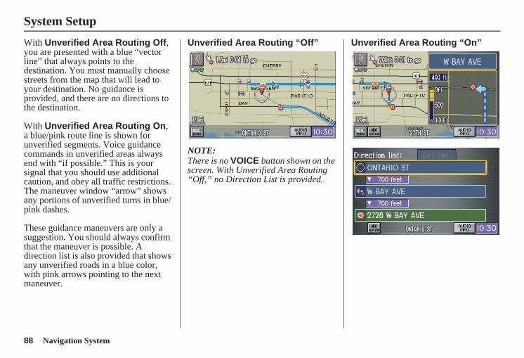
88 Navigation System
System Setup
With Unverified Area Routing Off, you are presented with a blue “vector line” that always points to the destination. You must manually choose streets from the map that will lead to your destination. No guidance is provided, and there are no directions to the destination.
With Unverified Area Routing On, a blue/pink route line is shown for unverified segments. Voice guidance commands in unverified areas always end with “if possible.” This is your signal that you should use additional caution, and obey all traffic restrictions. The maneuver window “arrow” shows any portions of unverified turns in blue/pink dashes.
These guidance maneuvers are only a suggestion. You should always confirm that the maneuver is possible. A direction list is also provided that shows any unverified roads in a blue color, with pink arrows pointing to the next maneuver.
Unverified Area Routing “Off”
NOTE:There is no VOICE button shown on the screen. With Unverified Area Routing “Off,” no Direction List is provided.
Unverified Area Routing “On”
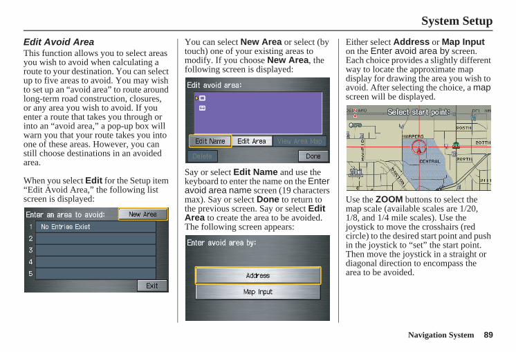
Navigation System 89
System Setup
Edit Avoid AreaThis function allows you to select areas you wish to avoid when calculating a route to your destination. You can select up to five areas to avoid. You may wish to set up an “avoid area” to route around long-term road construction, closures, or any area you wish to avoid. If you enter a route that takes you through or into an “avoid area,” a pop-up box will warn you that your route takes you into one of these areas. However, you can still choose destinations in an avoided area.
When you select Edit for the Setup item “Edit Avoid Area,” the following list screen is displayed:
You can select New Area or select (by touch) one of your existing areas to modify. If you choose New Area, the following screen is displayed:
Say or select Edit Name and use the keyboard to enter the name on the Enter avoid area name screen (19 characters max). Say or select Done to return to the previous screen. Say or select Edit Area to create the area to be avoided. The following screen appears:
Either select Address or Map Input on the Enter avoid area by screen. Each choice provides a slightly different way to locate the approximate map display for drawing the area you wish to avoid. After selecting the choice, a map screen will be displayed.
Use the ZOOM buttons to select the map scale (available scales are 1/20, 1/8, and 1/4 mile scales). Use the joystick to move the crosshairs (red circle) to the desired start point and push in the joystick to “set” the start point. Then move the joystick in a straight or diagonal direction to encompass the area to be avoided.
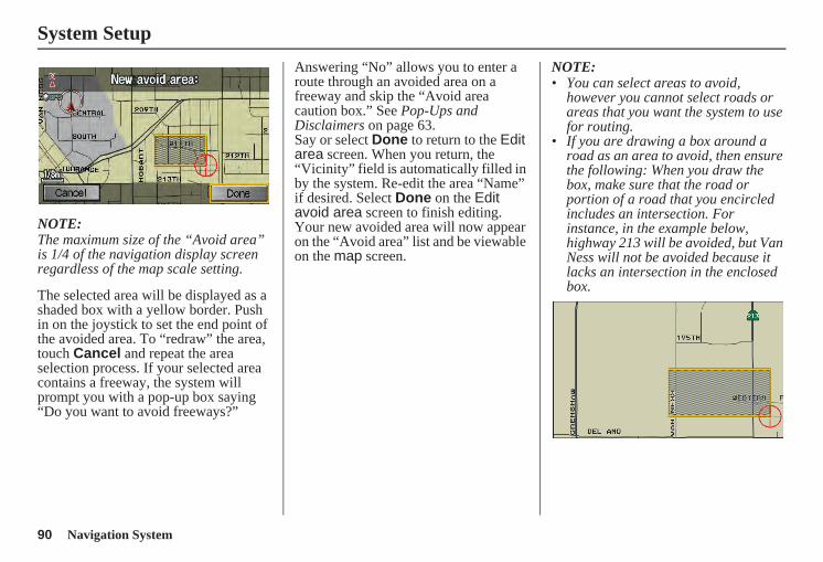
90 Navigation System
System Setup
NOTE:The maximum size of the “Avoid area” is 1/4 of the navigation display screen regardless of the map scale setting.
The selected area will be displayed as a shaded box with a yellow border. Push in on the joystick to set the end point of the avoided area. To “redraw” the area, touch Cancel and repeat the area selection process. If your selected area contains a freeway, the system will prompt you with a pop-up box saying “Do you want to avoid freeways?”
Answering “No” allows you to enter a route through an avoided area on a freeway and skip the “Avoid area caution box.” See Pop-Ups and Disclaimers on page 63.Say or select Done to return to the Edit area screen. When you return, the “Vicinity” field is automatically filled in by the system. Re-edit the area “Name” if desired. Select Done on the Edit avoid area screen to finish editing. Your new avoided area will now appear on the “Avoid area” list and be viewable on the map screen.
NOTE:• You can select areas to avoid,
however you cannot select roads or areas that you want the system to use for routing.
• If you are drawing a box around a road as an area to avoid, then ensure the following: When you draw the box, make sure that the road or portion of a road that you encircled includes an intersection. For instance, in the example below, highway 213 will be avoided, but Van Ness will not be avoided because it lacks an intersection in the enclosed box.
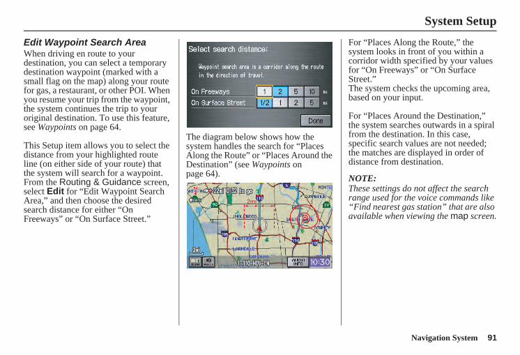
Navigation System 91
System Setup
Edit Waypoint Search AreaWhen driving en route to your destination, you can select a temporary destination waypoint (marked with a small flag on the map) along your route for gas, a restaurant, or other POI. When you resume your trip from the waypoint, the system continues the trip to your original destination. To use this feature, see Waypoints on page 64.
This Setup item allows you to select the distance from your highlighted route line (on either side of your route) that the system will search for a waypoint. From the Routing & Guidance screen, select Edit for “Edit Waypoint Search Area,” and then choose the desired search distance for either “On Freeways” or “On Surface Street.”
The diagram below shows how the system handles the search for “Places Along the Route” or “Places Around the Destination” (see Waypoints on page 64).
For “Places Along the Route,” the system looks in front of you within a corridor width specified by your values for “On Freeways” or “On Surface Street.”The system checks the upcoming area, based on your input.
For “Places Around the Destination,” the system searches outwards in a spiral from the destination. In this case, specific search values are not needed; the matches are displayed in order of distance from destination.
NOTE:These settings do not affect the search range used for the voice commands like “Find nearest gas station” that are also available when viewing the map screen.
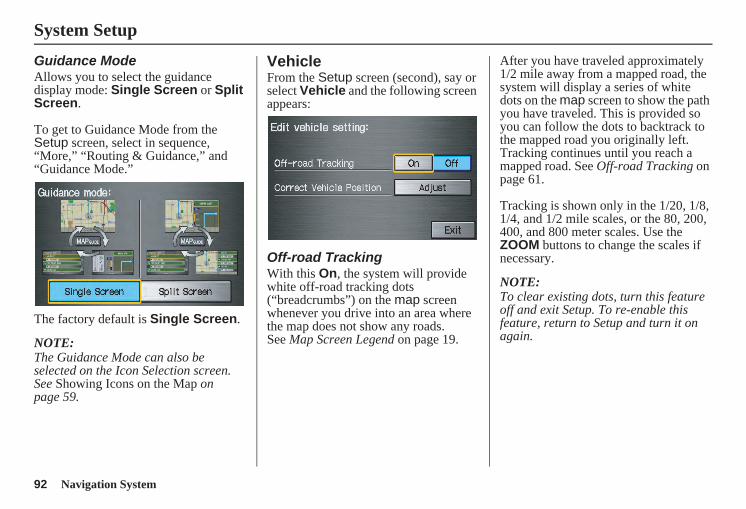
92 Navigation System
System Setup
Guidance ModeAllows you to select the guidance display mode: Single Screen or Split Screen.
To get to Guidance Mode from the Setup screen, select in sequence, “More,” “Routing & Guidance,” and “Guidance Mode.”
The factory default is Single Screen.
NOTE:The Guidance Mode can also be selected on the Icon Selection screen. See Showing Icons on the Map on page 59.
VehicleFrom the Setup screen (second), say or select Vehicle and the following screen appears:
Off-road TrackingWith this On, the system will provide white off-road tracking dots (“breadcrumbs”) on the map screen whenever you drive into an area where the map does not show any roads.See Map Screen Legend on page 19.
After you have traveled approximately 1/2 mile away from a mapped road, the system will display a series of white dots on the map screen to show the path you have traveled. This is provided so you can follow the dots to backtrack to the mapped road you originally left. Tracking continues until you reach a mapped road. See Off-road Tracking on page 61.
Tracking is shown only in the 1/20, 1/8, 1/4, and 1/2 mile scales, or the 80, 200, 400, and 800 meter scales. Use the ZOOM buttons to change the scales if necessary.
NOTE:To clear existing dots, turn this feature off and exit Setup. To re-enable this feature, return to Setup and turn it on again.
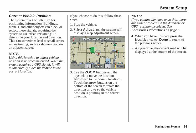
Navigation System 93
System Setup
Correct Vehicle PositionThe system relies on satellites for positioning information. Buildings, tunnels, and other objects can block or reflect these signals, requiring the system to use “dead reckoning” to determine your location and direction.This can sometimes lead to small errors in positioning, such as showing you on an adjacent street.
NOTE:Using this function to adjust vehicle position is not recommended. When the system acquires a GPS signal, it will automatically place the vehicle in the correct location.
If you choose to do this, follow these steps:1. Stop the vehicle.2. Select Adjust, and the system will
display a map adjustment screen.
3. Use the ZOOM buttons and the joystick to move the location arrowhead to the correct location. Touch the arrow buttons on the bottom of the screen to rotate the direction arrows so the vehicle position is pointing in the correct direction.
NOTE:If you continually have to do this, there are either problems in the database or GPS reception problems. See Accessories Precautions on page 5.
4. When you have finished, press the joystick or select Done to return to the previous screen.
5. As you drive, the current road will be displayed at the bottom of the screen.
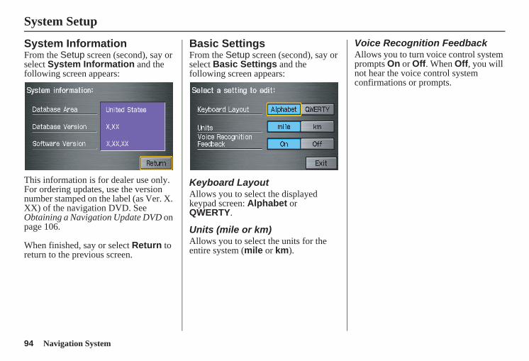
94 Navigation System
System Setup
System InformationFrom the Setup screen (second), say or select System Information and the following screen appears:
This information is for dealer use only. For ordering updates, use the version number stamped on the label (as Ver. X. XX) of the navigation DVD. See Obtaining a Navigation Update DVD on page 106.
When finished, say or select Return to return to the previous screen.
Basic SettingsFrom the Setup screen (second), say or select Basic Settings and the following screen appears:
Keyboard LayoutAllows you to select the displayed keypad screen: Alphabet or QWERTY.
Units (mile or km)Allows you to select the units for the entire system (mile or km).
Voice Recognition FeedbackAllows you to turn voice control system prompts On or Off. When Off, you will not hear the voice control system confirmations or prompts.
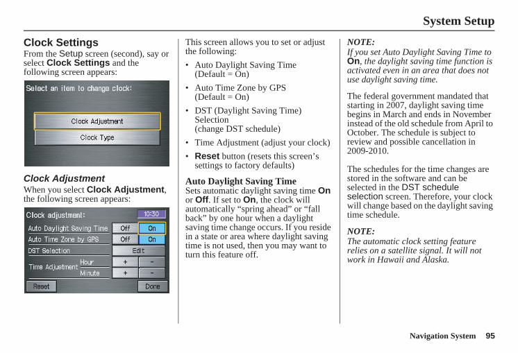
Navigation System 95
System Setup
Clock SettingsFrom the Setup screen (second), say or select Clock Settings and the following screen appears:
Clock AdjustmentWhen you select Clock Adjustment, the following screen appears:
This screen allows you to set or adjust the following:• Auto Daylight Saving Time
(Default = On)• Auto Time Zone by GPS
(Default = On)• DST (Daylight Saving Time)
Selection (change DST schedule)
• Time Adjustment (adjust your clock)• Reset button (resets this screen’s
settings to factory defaults)
Auto Daylight Saving TimeSets automatic daylight saving time On or Off. If set to On, the clock will automatically “spring ahead” or “fall back” by one hour when a daylight saving time change occurs. If you reside in a state or area where daylight saving time is not used, then you may want to turn this feature off.
NOTE:If you set Auto Daylight Saving Time to On, the daylight saving time function is activated even in an area that does not use daylight saving time.
The federal government mandated that starting in 2007, daylight saving time begins in March and ends in November instead of the old schedule from April to October. The schedule is subject to review and possible cancellation in 2009-2010.
The schedules for the time changes are stored in the software and can be selected in the DST schedule selection screen. Therefore, your clock will change based on the daylight saving time schedule.
NOTE:The automatic clock setting feature relies on a satellite signal. It will not work in Hawaii and Alaska.
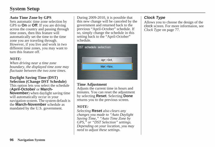
96 Navigation System
System Setup
Auto Time Zone by GPSSets automatic time zone selection by GPS to On or Off. If you are driving across the country and passing through time zones, then this feature will automatically set the time to the time zone you are traveling through. However, if you live and work in two different time zones, you may want to turn this feature off.
NOTE:When driving near a time zone boundary, the displayed time zone may fluctuate between the two zone times.
Daylight Saving Time (DST) Selection (Change DST Schedule)This option lets you select the schedule (April-October or March-November) when daylight saving time will automatically occur in your navigation system. The system default is the March-November schedule as mandated by the U.S. government.
During 2009-2010, it is possible that this new change will be canceled by the government and returned back to the previous “April-October” schedule. If so, simply change the schedule in this setting back to the “April-October” schedule.
Time AdjustmentAdjusts the current time in hours and minutes. You can reset the adjustment by selecting Reset. Selecting Done returns you to the previous screen.
NOTE:Selecting Reset also clears any changes you made to “Auto Daylight Saving Time,” “Auto Time Zone by GPS,” or “DST Selection” settings. Depending on your location, you may need to adjust these settings.
Clock TypeAllows you to choose the design of the clock screen. For more informaion, see Clock Type on page 77.
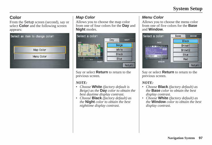
Navigation System 97
System Setup
ColorFrom the Setup screen (second), say or select Color and the following screen appears:
Map ColorAllows you to choose the map color from one of four colors for the Day and Night modes.
Say or select Return to return to the previous screen.
NOTE: • Choose White (factory default is
Beige) as the Day color to obtain the best daytime display contrast.
• Choose Black (factory default) as the Night color to obtain the best nighttime display contrast.
Menu ColorAllows you to choose the menu color from one of five colors for the Base and Window.
Say or select Return to return to the previous screen.
NOTE: • Choose Black (factory default) as
the Base color to obtain the best display contrast.
• Choose White (factory default) as the Window color to obtain the best display contrast.
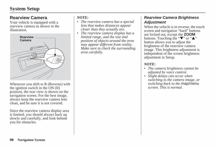
98 Navigation System
System Setup
Rearview CameraYour vehicle is equipped with a rearview camera as shown in the illustration.
Whenever you shift to R (Reverse) with the ignition switch in the ON (II) position, the rear view is shown on the navigation screen. For the best image, always keep the rearview camera lens clean, and be sure it is not covered.
Since the rearview camera display area is limited, you should always back up slowly and carefully, and look behind you for obstacles.
NOTE:• The rearview camera has a special
lens that makes distances appear closer than they actually are.
• The rearview camera display has a limited range, and the size and position of objects around the area may appear different from reality. Make sure to check the surrounding area carefully.
Rearview Camera Brightness AdjustmentWhen the vehicle is in reverse, the touch screen and navigation “hard” buttons are locked out, except the ZOOM buttons. Touching the “▼” or “▲” button allows you to adjust the brightness of the rearview camera image. This brightness adjustment is independent of the screen brightness adjustment in Setup.
NOTE:• The camera brightness cannot be
adjusted by voice control.• Slight delays can occur when
switching to the camera image, or switching back to the map/menu screen. This is normal.
RearviewCamera
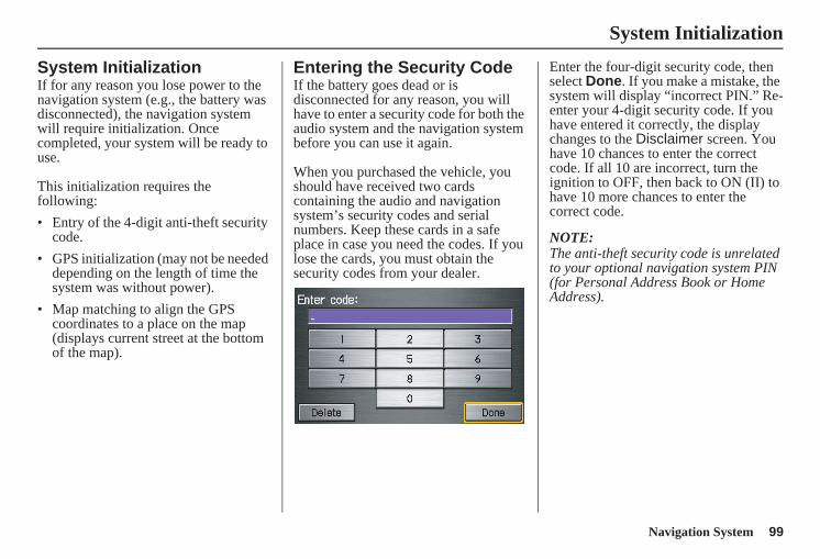
Navigation System 99
System Initialization
System InitializationIf for any reason you lose power to the navigation system (e.g., the battery was disconnected), the navigation system will require initialization. Once completed, your system will be ready to use.
This initialization requires the following:• Entry of the 4-digit anti-theft security
code.• GPS initialization (may not be needed
depending on the length of time the system was without power).
• Map matching to align the GPS coordinates to a place on the map (displays current street at the bottom of the map).
Entering the Security CodeIf the battery goes dead or is disconnected for any reason, you will have to enter a security code for both the audio system and the navigation system before you can use it again.
When you purchased the vehicle, you should have received two cards containing the audio and navigation system’s security codes and serial numbers. Keep these cards in a safe place in case you need the codes. If you lose the cards, you must obtain the security codes from your dealer.
Enter the four-digit security code, then select Done. If you make a mistake, the system will display “incorrect PIN.” Re-enter your 4-digit security code. If you have entered it correctly, the display changes to the Disclaimer screen. You have 10 chances to enter the correct code. If all 10 are incorrect, turn the ignition to OFF, then back to ON (II) to have 10 more chances to enter the correct code.
NOTE:The anti-theft security code is unrelated to your optional navigation system PIN (for Personal Address Book or Home Address).
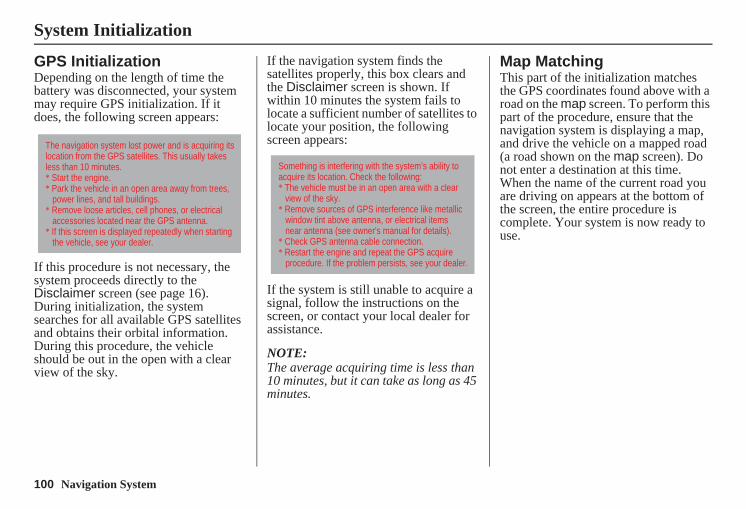
100 Navigation System
System Initialization
GPS InitializationDepending on the length of time the battery was disconnected, your system may require GPS initialization. If it does, the following screen appears:
If this procedure is not necessary, the system proceeds directly to the Disclaimer screen (see page 16). During initialization, the system searches for all available GPS satellites and obtains their orbital information. During this procedure, the vehicle should be out in the open with a clear view of the sky.
If the navigation system finds the satellites properly, this box clears and the Disclaimer screen is shown. If within 10 minutes the system fails to locate a sufficient number of satellites to locate your position, the following screen appears:
If the system is still unable to acquire a signal, follow the instructions on the screen, or contact your local dealer for assistance.
NOTE:The average acquiring time is less than 10 minutes, but it can take as long as 45 minutes.
Map MatchingThis part of the initialization matches the GPS coordinates found above with a road on the map screen. To perform this part of the procedure, ensure that the navigation system is displaying a map, and drive the vehicle on a mapped road (a road shown on the map screen). Do not enter a destination at this time. When the name of the current road you are driving on appears at the bottom of the screen, the entire procedure is complete. Your system is now ready to use.
The navigation system lost power and is acquiring its location from the GPS satellites. This usually takes less than 10 minutes.* Start the engine.* Park the vehicle in an open area away from trees, power lines, and tall buildings.* Remove loose articles, cell phones, or electrical accessories located near the GPS antenna.* If this screen is displayed repeatedly when starting the vehicle, see your dealer.
Something is interfering with the system’s ability to acquire its location. Check the following:* The vehicle must be in an open area with a clear view of the sky.* Remove sources of GPS interference like metallic window tint above antenna, or electrical items near antenna (see owner's manual for details).* Check GPS antenna cable connection.* Restart the engine and repeat the GPS acquire procedure. If the problem persists, see your dealer.
Navigation System 101
System Limitations
Although your navigation system is one of the most highly sophisticated pieces of equipment you will find in a modern automobile, you may find during its use that it has certain limitations.
The system uses GPS signals to aid in determining its current location. The GPS is operated by the U.S.Department of Defense. For security reasons, there are certain inaccuracies built into the GPS that the navigation system must constantly compensate for. This can cause occasional positioning errors of up to several hundred feet.
For example, in urban areas where streets are close together, this could cause the system to show that you are traveling on a street that parallels the street you are actually on. The system will, under most circumstances, correct itself while you drive.
Depending on your current view of the sky and the position of the satellites, the elevation may be shown incorrectly. You may also notice some delay of the vehicle position icon at intersections; this is normal.
GPS Reception IssuesThe signals received from the GPS satellites are extremely weak (less than a millionth of the strength of a local FM station) and require an unobstructed view of the sky. The signal can easily be interrupted or interfered with by the following:• Aftermarket metallic window tint
above or to the sides of the GPS antenna (located under the dashboard)
• Cell phones, PDAs, or other electronic devices docked in a cradle or lying loose on the dashboard
• Radar detectors mounted on the dashboard
• Remote starters, or “hidden” vehicle tracking systems mounted near the navigation unit
• Other aftermarket audio electronic devices mounted near the navigation unit
• Trees, tall buildings, freeway overpasses, tunnels, or overhead electrical power wires
Although the system will direct you to your desired destination, it may not always generate what you consider to be the most direct route. Try changing the method of routing. See Changing the Routing Method on page 47. You may also have Unverified Area Routing set to OFF. See Unverified Area Routing on page 85.
Additionally, the mapping database contains verified and unverified maps. See Map Overview on page 6. A Disclaimer screen will warn you if your route includes unverified streets.Unverified streets may be missing from the map, in the wrong location, or have an incorrect name or address range.Exercise additional caution when driving in these unverified areas.
102 Navigation System
System Limitations
The destination icon shows the approximate location of the destination.This occurs because a city block can have as many as 100 possible addresses (for example, the 1400 block is followed by the 1500 block). Since most cities use only a portion of the 100 possible addresses (for example, in the 1400 block, the addresses may only go up to 1425 before the 1500 block starts), the address 1425 will be shown a quarter of the way down the block by the system instead of at the end of the block where the destination is actually located.
You may find that the system occasionally reboots. This is indicated by the display returning to the globe screen. A reboot can be caused by a number of things, such as extreme temperatures or shock from bumpy roads. It does not necessarily indicate a problem that requires service. If this happens frequently, please see your dealer.
Navigation System 103
Database Limitations
You will find that some points of interest (POI) may be missing when you search the database. This can be caused if at the time the database was gathered, the name was misspelled, the place was improperly categorized, or the POI change is not yet in the database. This means you may not find places listed that you know exist. This is also true for police agencies and hospitals. In outlying areas, facilities listed may not be the closest. Always check with local information sources if you need law enforcement or hospital services.
Every effort has been made to verify that the system’s database was accurate at the time it was created. However, businesses do close or relocate, and new businesses start in the old locations. For this reason, you may occasionally find inaccurate information when you select and drive to a point of interest (for example, a restaurant is now a jewelry store). The number of these inaccuracies increases the longer you go without an update.
The digitized map database reflects conditions as they existed at various points in time before production. Accordingly, your DVD may contain inaccurate or incomplete data or information due to the passage of time, road construction, changing conditions, or other causes.
Due to ongoing software and database improvements, navigation disc versions may change in the middle of a production year. The version shipped with your vehicle was the most recent available at the time of production and is considered standard equipment for that vehicle. There is no free program to retrofit early production vehicles with the latest disc. For DVD ordering information, see page 106.
In addition, this database does not include, analyze, process, consider, or reflect any of the following categories of information:• Neighborhood quality or safety• Population density• Availability or proximity of law
enforcement• Emergency, rescue, medical, or other
assistance• Construction work, zones, or hazards• Road and lane closures• Legal restrictions (such as vehicular
type, weight, load, height, and speed restrictions)
• Road slope or grade• Bridge height, width, weight, or other
limits• Road traffic, safety, or conditions• Weather conditions• Special events• Pavement characteristics or conditions
104 Navigation System
Database Limitations
• Traffic congestion• Travel time
We assume no liability for any incident that may result from an error in the program, or from changed conditions not noted above.
Copyrights
• infoUSA-Data: Certain business data provided by infoUSA, Inc., Omaha, Nebraska, Copyright © 2008, All Rights Reserved.
• EXIT-Data: © ZENRIN CO., LTD. 2008. All Rights Reserved.
Navigation System 105
Customer Assistance
Reporting ErrorsOccasionally, you may encounter database errors.• If the error pertains to freeways and
main “verified” roads shown in black on the map, then report it either online athttp://update.navteq.com/, or to Honda Customer Service.
• If the error involves a light brown “unverified” road, then do not report it. These areas have not been verified, and are provided for reference only (see Map Overview on page 6).
• For errors in points of interest (POI), like a business that has changed its name, do not report them. Keep in mind that depending on when the data was collected and when your DVD was purchased, the database can be out of date. The business may have not reported the change(s), or not be in the database at all. Update Navigation DVDs are available for purchase, usually in the fall of each year.
• If the error does not involve the database, such as vehicle position icon errors, screen error messages, or other GPS-related errors, see Frequently Asked Questions on page 126, System Limitations on page 101, or Troubleshooting on page 136.
Honda Automobile Customer ServiceTelephone: (800) 999-1009Fax: (310) 783-3273
Mail:Honda NaviAmerica Honda Motor Co., Inc.Honda Customer ServiceMS 500-2N-7A1919 Torrance Blvd.Torrance, CA 90501-2746
106 Navigation System
Customer Assistance
Visiting Your DealerWe strive to make this manual as complete as possible and to answer all questions regarding operation of the system. Occasionally, you may run into a specific issue that you cannot find in the book. You may save yourself a trip to the dealer by first consulting the following resources:• The Troubleshooting section (see
page 136).• The Frequently Asked Questions
(FAQs) section (see page 126).• The FAQs found on the online DVD
order site (see “Obtaining a DVD”).• For detailed questions regarding
audio or other systems that interact with the navigation system, see your Owner’s Manual or the Technology Reference Guide.
• Call Honda Customer Relations (see “Honda Automobile Customer Service” on page 105).
• For database or POI issues, follow the guidelines in the “Reporting Errors” section (see page 105).
If your question is still unanswered and you wish to visit the dealer, please be prepared to demonstrate the issue to the service advisor. This way, the service advisor can document the issue for the factory to allow more efficient troubleshooting.
Some issues may at first seem random, but you may notice a pattern. For example, they only occur when you enter a specific address, or when driving on a certain road, or just when it is cold. This information is very useful to the service advisor. Be patient, the service advisor may be unfamiliar with your specific issue.
Obtaining a Navigation Update DVDHonda is continually expanding the scope of the navigation system. Upgraded software may be made available to navigation system owners periodically, usually in the fall of each year.
To purchase an updated DVD or a replacement DVD, call the Honda Navigation Disc Fulfillment Center at (888) 291-4675. You can also order online by going to www.hondanavi.com.
NOTE:• DVDs are not available at your
dealer. However, the dealer may order a DVD for you as a courtesy. There is no program for free DVD updates.
• The DVD order line staff cannot answer technical questions regarding navigation operation, coverage, or POIs.
• Purchasing used discs from alternate sources or online auctions may cause operational problems since they are likely to be incompatible with your current software.
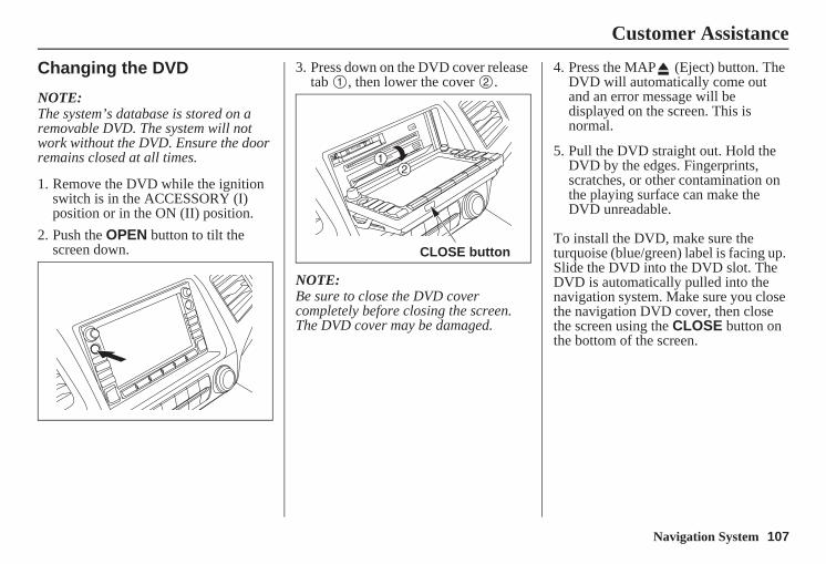
Navigation System 107
Customer Assistance
Changing the DVD
NOTE:The system’s database is stored on a removable DVD. The system will not work without the DVD. Ensure the door remains closed at all times.
1. Remove the DVD while the ignition switch is in the ACCESSORY (I) position or in the ON (II) position.
2. Push the OPEN button to tilt the screen down.
3. Press down on the DVD cover release tab , then lower the cover .
NOTE:Be sure to close the DVD cover completely before closing the screen. The DVD cover may be damaged.
4. Press the MAP (Eject) button. The DVD will automatically come out and an error message will be displayed on the screen. This is normal.
5. Pull the DVD straight out. Hold the DVD by the edges. Fingerprints, scratches, or other contamination on the playing surface can make the DVD unreadable.
To install the DVD, make sure the turquoise (blue/green) label is facing up. Slide the DVD into the DVD slot. The DVD is automatically pulled into the navigation system. Make sure you close the navigation DVD cover, then close the screen using the CLOSE button on the bottom of the screen.
CLOSE button
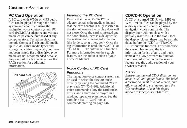
108 Navigation System
Customer Assistance
PC Card OperationA PC card with WMA or MP3 audio files can be played through the audio system and controlled using the navigation voice control system. PC card (PCMCIA) adaptors and various media chips can be purchased at any computer store. Tested media chips include Compact Flash and SD media, up to 2GB. Other media types and storage capacities may work, but have not been tested. Hard disc drive type media are not recommended because they can fail in a hot vehicle. See the FAQs section for additional information.
Inserting the PC CardEnsure that the PCMCIA PC card adaptor contains the media chip, and that the card adaptor is fully inserted in the slot, otherwise the display door will not close. Once the card is inserted and the door closed, there is a delay while the system reads the tag information (the folders, song titles, etc.). Once the tag information is read, the “CARD” or “TRACK LIST” buttons will function. For more information on the search feature, see the audio section of your Owner’s Manual.
Voice Control of PC Card FunctionsThe navigation voice control system can be used to select the first 30 tracks directly by using the command, “Card play track X” (X=1-30). Additional voice commands allow the card tracks, artists, and albums to be played in a random, repeat, or scan mode. See the complete list of “Card” voice commands starting on page 146.
CD/CD-R OperationA CD or a burned CD-R with MP3 or WMA media files can be played by the audio system and controlled using navigation voice commands. The display door will not close with a partially inserted CD in the slot. Once the display closes, there may be a slight delay before the “CD” or “TRACK LIST” buttons function. This is because the system has to read the tag information (artist, album, and track names) to allow searches to function. For more information on the search feature, see the audio section of your Owner’s Manual.
NOTE:Ensure that burned CD-R discs do not have “stick-on” paper labels. The label adhesive can melt in a hot vehicle, and allow the label to curl up and jam the CD mechanism. Use a felt-tipped marker to label your CD-R discs.
PC card slot
Navigation System 109
Customer Assistance
Voice Control of CD FunctionsThe navigation voice control system can be used to select the first 30 tracks directly by using the command, “CD play track X” (X=1-30). Additional voice commands allow CD tracks, and folders be played in a random, repeat, or scan mode. See the complete list of “CD” voice commands starting on page 147.
110 Navigation System
Coverage Areas
Map CoverageThe system provides map coverage for the lower 48 U.S. states, Hawaii, and southern Canada. The U.S. map coverage consists of accurately mapped (verified) metropolitan areas (in the following list) and a less accurate (unverified) rural database. Canada coverage consists of major metropolitan areas and major roads connecting the metropolitan areas within about 100 miles north of the U.S. border. If you need additional northern Canada coverage, you may purchase the Canadian DVD (see Obtaining a Navigation Update DVD on page 106). See Map Overview on page 6 for a discussion of map coverage.
The cities and metropolitan areas in the following list are fully mapped. Only major streets, roads, and freeways have been verified outside these areas. If your route passes through these areas, routing may be limited, depending on your routing choices. See Unverified Area Routing on page 85.
If you desire additional map coverage information, contact Honda Customer Services or go to www.hondanavi.com.
U.S. Detailed Coverage Areas
AlabamaAuburn-OpelikaBirmingham/TuscaloosaHuntsvilleMobileMontgomery
ArizonaPhoenix MetroPrescottSedonaTucsonYuma
ArkansasFayettevilleFort SmithHot SpringsLittle RockPine Bluff
CaliforniaCentral Valley - including Fresno,
Merced, Modesto, and StocktonHumboldtLos Angeles/San Diego Metro
Mammoth LakesSacramento MetroSan Francisco Bay (approximately
Monterey to Sonoma) – including Monterey County and Hollister
Southern California Area - including Bakersfield and San Luis Obispo
YubaColorado
Denver/Boulder/Colorado Springs/ Ski Resorts Metro area – including Ft. Collins
Grand JunctionConnecticut
BridgeportDanburyHartford MetroNew Haven MetroNorwalkStamford
DelawareEntire state – including Dover,
Wilmington Metro area, New Castle County
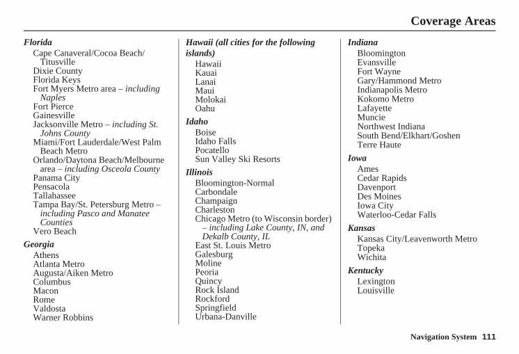
Navigation System 111
Coverage Areas
FloridaCape Canaveral/Cocoa Beach/
TitusvilleDixie CountyFlorida KeysFort Myers Metro area – including
NaplesFort PierceGainesvilleJacksonville Metro – including St.
Johns CountyMiami/Fort Lauderdale/West Palm
Beach MetroOrlando/Daytona Beach/Melbourne
area – including Osceola CountyPanama CityPensacolaTallahasseeTampa Bay/St. Petersburg Metro –
including Pasco and Manatee Counties
Vero BeachGeorgia
AthensAtlanta MetroAugusta/Aiken MetroColumbusMaconRomeValdostaWarner Robbins
Hawaii (all cities for the following islands)
HawaiiKauaiLanaiMauiMolokaiOahu
IdahoBoiseIdaho FallsPocatelloSun Valley Ski Resorts
IllinoisBloomington-NormalCarbondaleChampaignCharlestonChicago Metro (to Wisconsin border)
– including Lake County, IN, and Dekalb County, IL
East St. Louis MetroGalesburgMolinePeoriaQuincyRock IslandRockfordSpringfieldUrbana-Danville
IndianaBloomingtonEvansvilleFort WayneGary/Hammond MetroIndianapolis MetroKokomo MetroLafayetteMuncieNorthwest IndianaSouth Bend/Elkhart/GoshenTerre Haute
IowaAmesCedar RapidsDavenportDes MoinesIowa CityWaterloo-Cedar Falls
KansasKansas City/Leavenworth MetroTopekaWichita
KentuckyLexingtonLouisville
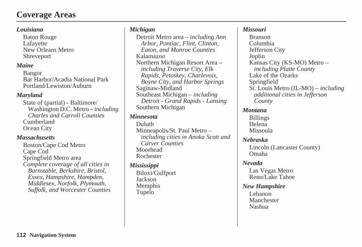
112 Navigation System
Coverage Areas
LouisianaBaton RougeLafayetteNew Orleans MetroShreveport
MaineBangorBar Harbor/Acadia National ParkPortland/Lewiston/Auburn
MarylandState of (partial) - Baltimore/
Washington D.C. Metro – including Charles and Carroll Counties
CumberlandOcean City
MassachusettsBoston/Cape Cod MetroCape CodSpringfield Metro area Complete coverage of all cities in
Barnstable, Berkshire, Bristol, Essex, Hampshire, Hampden, Middlesex, Norfolk, Plymouth, Suffolk, and Worcester Counties
MichiganDetroit Metro area – including Ann
Arbor, Pontiac, Flint, Clinton, Eaton, and Monroe Counties
KalamazooNorthern Michigan Resort Area –
including Traverse City, Elk Rapids, Petoskey, Charlevoix, Boyne City, and Harbor Springs
Saginaw-MidlandSoutheast Michigan – including
Detroit - Grand Rapids - LansingSouthern Michigan
MinnesotaDuluthMinneapolis/St. Paul Metro –
including cities in Anoka Scott and Carver Counties
MoorheadRochester
MississippiBiloxi/GulfportJacksonMemphisTupelo
MissouriBransonColumbiaJefferson CityJoplinKansas City (KS-MO) Metro –
including Platte CountyLake of the OzarksSpringfieldSt. Louis Metro (IL-MO) – including
additional cities in Jefferson County
MontanaBillingsHelenaMissoula
NebraskaLincoln (Lancaster County)Omaha
NevadaLas Vegas MetroReno/Lake Tahoe
New HampshireLebanonManchesterNashua
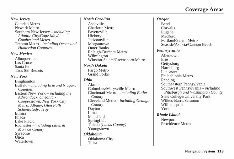
Navigation System 113
Coverage Areas
New JerseyCamden MetroNewark MetroSouthern New Jersey – including
Atlantic City/Cape May/Cumberland Metro
Trenton Metro – including Ocean and Hunterdon Counties
New MexicoAlbuquerqueLas CrucesSanta FeTaos Ski Resorts
New YorkBinghamtonBuffalo – including Erie and Niagara
CountiesEastern New York – including the
Adirondack, Oneonta - Cooperstown, New York City Metro, Albany, Glen Falls, Schenectady, Troy
ElmiraIthacaLake PlacidRochester – including cities in
Monroe CountySyracuseUticaWatertown
North CarolinaAshevilleCharlotte MetroFayettevilleHickoryJacksonvilleMorgantownOuter BanksRaleigh-Durham MetroWilmingtonWinston-Salem/Greensboro Metro
North DakotaFargo MetroGrand Forks
OhioAkronColumbus/Marysville MetroCincinnati Metro – including Butler
CountyCleveland Metro – including Geauga
CountyDaytonLimaMansfieldSpringfieldToledo (Lucas County)Youngstown
OklahomaOklahoma CityTulsa
OregonBendCorvalisEugeneMedfordPortland/Salem MetroSeaside/Astoria/Cannon Beach
PennsylvaniaAllentownErieGettysburgHarrisburgLancasterPhiladelphia MetroReadingSoutheastern PennsylvaniaSouthwest Pennsylvania - including
Pittsburgh and Washington CountyState College/University ParkWilkes-Barre/ScrantonWilliamsportYork
Rhode IslandNewportProvidence Metro
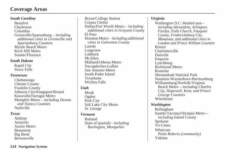
114 Navigation System
Coverage Areas
South CarolinaBeaufortCharlestonColumbiaGreenville/Spartanburg – including
additional cities in Greenville and Spartanburg Counties
Myrtle Beach MetroRock Hill MetroSumter/Florence
South DakotaRapid CitySioux Falls
TennesseeChattanoogaChester CountyFranklin CountyJohnson City/Kingsport/BristolKnoxville/Farragut MetroMemphis Metro – including Desoto
and Tunica CountiesNashville
TexasAbileneAmarilloAustin MetroBeaumontBig BendBrownsville
Bryan/College StationCorpus ChristiDallas/Fort Worth Metro – including
additional cities in Grayson CountyEl PasoHouston Metro – including additional
cities in Galveston CountyLaredoLongviewLubbockMcAllenMidland/Odessa MetroNacogdoches-LufkinSan Antonio MetroSouth Padre IslandTexarkanaWichita Falls
UtahMoabOgdenPark CitySalt Lake City MetroSt. George
VermontRutlandState of (partial) - including
Burlington, Montpelier
VirginiaWashington D.C. detailed area –
including Alexandria, Arlington, Fairfax, Falls Church, Fauquier County, Fredericksburg City, Manassas, and additional cities in Loudon and Prince William Counties
BristolCharlottesvilleDanvilleEmporiaLynchburgRichmond MetroRoanokeShenandoah National ParkStaunton-Waynesboro-HarrisonburgWilliamsburg/Norfolk/Virginia
Beach Metro – including Charles City, Hopewell, Kent, and Prince George Counties
WinchesterWashington
BellinghamSeattle/Tacoma/Olympia Metro –
including Island CountySpokaneTri-CitiesWhatcom
Point Roberts (community)Yakima
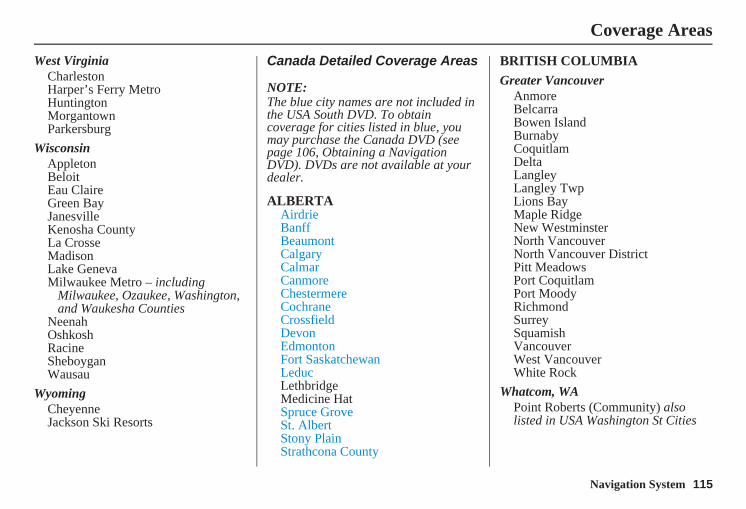
Navigation System 115
Coverage Areas
West VirginiaCharlestonHarper’s Ferry MetroHuntingtonMorgantownParkersburg
WisconsinAppletonBeloitEau ClaireGreen BayJanesvilleKenosha CountyLa CrosseMadisonLake GenevaMilwaukee Metro – including
Milwaukee, Ozaukee, Washington, and Waukesha Counties
NeenahOshkoshRacineSheboyganWausau
WyomingCheyenneJackson Ski Resorts
Canada Detailed Coverage Areas
NOTE: The blue city names are not included in the USA South DVD. To obtain coverage for cities listed in blue, you may purchase the Canada DVD (see page 106, Obtaining a Navigation DVD). DVDs are not available at your dealer.
ALBERTAAirdrieBanffBeaumontCalgaryCalmarCanmoreChestermereCochraneCrossfieldDevonEdmontonFort SaskatchewanLeducLethbridgeMedicine HatSpruce GroveSt. AlbertStony PlainStrathcona County
BRITISH COLUMBIAGreater Vancouver
AnmoreBelcarraBowen IslandBurnabyCoquitlamDeltaLangleyLangley TwpLions BayMaple RidgeNew WestminsterNorth VancouverNorth Vancouver DistrictPitt MeadowsPort CoquitlamPort MoodyRichmondSurreySquamishVancouverWest VancouverWhite Rock
Whatcom, WAPoint Roberts (Community) also listed in USA Washington St Cities
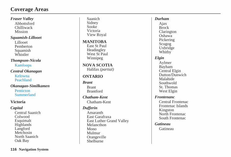
116 Navigation System
Coverage Areas
Fraser ValleyAbbottsfordChilliwackMission
Squamish-LillooetLillooetPembertonSquamishWhistler
Thompson-NicolaKamloops
Central OkanaganKelownaPeachland
Okanagan-SimilkamenPentictonSummerland
VictoriaCapital
Central SaanichColwoodEsquimaltHighlandsLangfordMetchosinNorth SaanichOak Bay
SaanichSidneySookeVictoriaView Royal
MANITOBAEast St Paul Headingley West St Paul Winnipeg
NOVA SCOTIAHalifax (partial)
ONTARIOBrant
BrantBrantford
Chatham-KentChatham-Kent
DufferinAmaranthEast GarafraxaEast Luther Grand ValleyMelancthonMonoMulmurOrangevilleShelburne
DurhamAjaxBrockClaringtonOshawaPickeringScugogUxbridgeWhitby
ElginAylmerBayhamCentral ElginDutton/DunwichMalahideSouthwoldSt. ThomasWest Elgin
FrontenancCentral FrontenacFrontenac IslandsKingstonNorth FrontenacSouth Frontenac
GatineauGatineau
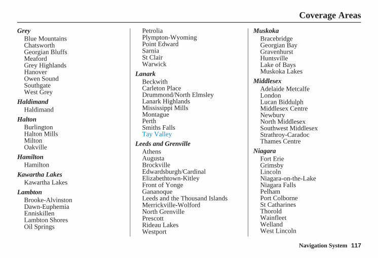
Navigation System 117
Coverage Areas
GreyBlue MountainsChatsworthGeorgian BluffsMeafordGrey HighlandsHanoverOwen SoundSouthgateWest Grey
HaldimandHaldimand
HaltonBurlingtonHalton MillsMiltonOakville
HamiltonHamilton
Kawartha LakesKawartha Lakes
LambtonBrooke-AlvinstonDawn-EuphemiaEnniskillenLambton ShoresOil Springs
PetroliaPlympton-WyomingPoint EdwardSarniaSt ClairWarwick
LanarkBeckwithCarleton PlaceDrummond/North ElmsleyLanark HighlandsMississippi MillsMontaguePerthSmiths FallsTay Valley
Leeds and GrenvilleAthensAugustaBrockvilleEdwardsburgh/CardinalElizabethtown-KitleyFront of YongeGananoqueLeeds and the Thousand IslandsMerrickville-WolfordNorth GrenvillePrescottRideau LakesWestport
MuskokaBracebridgeGeorgian BayGravenhurstHuntsvilleLake of BaysMuskoka Lakes
MiddlesexAdelaide MetcalfeLondonLucan BiddulphMiddlesex CentreNewburyNorth MiddlesexSouthwest MiddlesexStrathroy-CaradocThames Centre
NiagaraFort ErieGrimsbyLincolnNiagara-on-the-LakeNiagara FallsPelhamPort ColborneSt CatharinesThoroldWainfleetWellandWest Lincoln
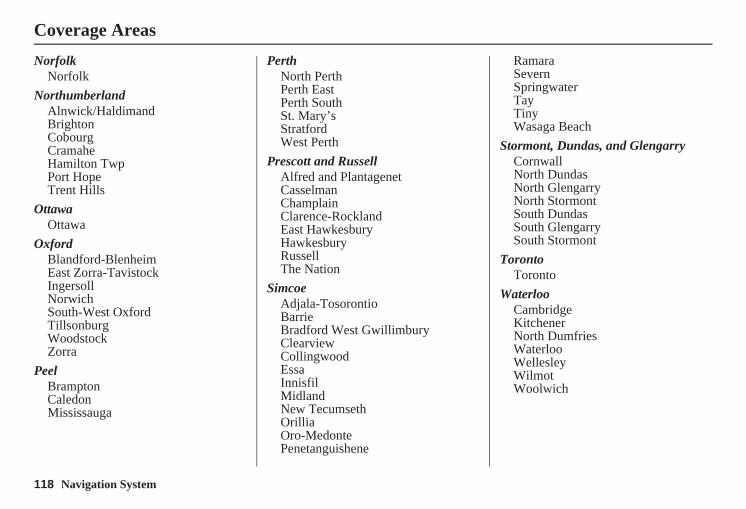
118 Navigation System
NorfolkNorfolk
NorthumberlandAlnwick/HaldimandBrightonCobourgCramaheHamilton TwpPort HopeTrent Hills
OttawaOttawa
OxfordBlandford-BlenheimEast Zorra-TavistockIngersollNorwichSouth-West OxfordTillsonburgWoodstockZorra
PeelBramptonCaledonMississauga
PerthNorth PerthPerth EastPerth SouthSt. Mary’sStratfordWest Perth
Prescott and RussellAlfred and PlantagenetCasselmanChamplainClarence-RocklandEast HawkesburyHawkesburyRussellThe Nation
SimcoeAdjala-TosorontioBarrieBradford West GwillimburyClearviewCollingwoodEssaInnisfilMidlandNew TecumsethOrilliaOro-MedontePenetanguishene
RamaraSevernSpringwaterTayTinyWasaga Beach
Stormont, Dundas, and GlengarryCornwallNorth DundasNorth GlengarryNorth StormontSouth DundasSouth GlengarrySouth Stormont
TorontoToronto
WaterlooCambridgeKitchenerNorth DumfriesWaterlooWellesleyWilmotWoolwich
Coverage Areas
Navigation System 119
Coverage Areas
WellingtonCentre WellingtonErinGuelphGuelph/EramosaMapletonMintoPuslinchWellington North
YorkAuroraEast GwillimburyGeorginaKingMarkhamNewmarketRichmond HillVaughanWhitchurch-Stouffville
WindsorEssex
AmherstburgEssexKingsvilleLakeshoreLasalleLeamingtonPeleeTecumsehWindsor
Inter-Town (partial) Coverage Counties/Districts/Regional Municipalities
BrantBruceChatham-KentDufferinElginEssexFrontenacGrayHaldimand-NorfolkHaliburtonHastingsHuronKawartha LakesLambtonLanark
Leeds and GranvilleLennox and AddingtonMiddlesexMuskokaNorthumberlandOxfordPerthPeterboroughPrescott and RussellPrince EdwardSimcoeStormont, Dundas, and GlengarryWaterlooWellington
120 Navigation System
QUÉBEC
Montreal-LaurentiansBeauharnois-Salaberry
BeauharnoisSalaberry-de-ValleyfieldSte-MartineSt-Étienne-de-BeauharnoisSt-Louis-de-GonzagueSt-Stanislas-de-KostkaSt-Urbain-Premier
Deux-MontagnesDeux-MontagnesOkaPointe-CalumetSt-EustacheSt-Joseph-du-LacSte-Marthe-sur-le-LacSt-Placide
L’AssomptionCharlemagneL’AssomptionL’ÈpiphanieL’Èpiphanie ParoisseRepentignySt-Sulpice
La Rivìere-du-NordPrévostSt-ColombanSt-HippolyteSt-JèrômeSte-Sophie
La Vallee-du-RichelieuBeloeilCaringnanChamblyMcMastervilleMont-St-HilaireOtterburn ParkSt-Antoine-sur-RichelieuSt-Basile-le-GrandSt-Charles-sur-RichelieuSt-Denis-sur-RichelieuSt-Jean-BaptisteSt-Marc-sur-RichelieuSt-Mathieu-de-Beloeil
LaJemmeraisCalixa-LavalléeContrecoeurSt-AmableSte-JulieVarennesVerchères
LavalLaval
Le-Haut-RichelieuHenryvilleLacolleMont-St-GrégoireNoyanSt-AlexandreSt-Blaise-sur-RichelieuSt-Georges-de-ClarencevilleSt-Jean-sur-RichelieuSt-Paul-de-L’Île-aux-NoixSt-SébastienSt-ValentinSte-Anne-de-SabrevioisSte-Brigide-D’IbervilleVenise-en-Québec
Le Haut-St-LaurentDundeeElginFranklinGodmanchesterHavelockHinchinbrookeHowickHuntingdonOrmstownSt-AnicetSt-ChrysostomeSte-BarbeTrés-St-Sacrement
Coverage Areas
Navigation System 121
Les-Jardins-De-NapiervilleHemmingfordHemmingford VillageNapiervilleSt-Bernard-de-LacolleSt-Cyprien-de-ChâteauguaySt-ÉdouardSt-Jacques-le-MineurSt-MichelSt-Patrice-de-SherringtonSt-Rémi
Les LaurentidesAmherstArundelBarkmereBrèbeufHuberdeauLa ConceptionLa MinerveLabelleLac-SupèrieurLantierMont-TremblantMontcalmSt-Faustin-Lac-CarrèSte-Agathe-des-MontsSte-Lucie-des-LaurentidesVal-DavidVal-des-LacsVal-Morin
Les MoulinsMascoucheTerrebonne
Les Pays-D’en-HautLac-des-Seize-ÎlesMorin-HeightsPiedmontSte-Adolphe-d’HowardSt-SauveurSte-AdèleSte-Anne-des-LacsSte-Marguerite-EstèrelWentworth-Nord
LongueuilBouchervilleBrossardLongueuilSt-Bruno-de-MontarvilleSt-Lambert
MirabelMirabel
MontcalmSt-AlexisSt-Alexis ParoisseSt-CalixteSte-JulienneSte-Marie-SaloméSt-Esprit
St-JacquesSt-LiguoriSt-Lin -- LaurentidesSt-Roche-de-l’AchiganSt-Roch-Ouest
MontrealBaie-D’UrféBeaconsfieldCôte-St-LucDollard-des-OrmeauxDorvalHampsteadKirklandL’Ïle -DorvalMontréalMontréal-EstMontréal-OuestMont-RoyalPointe-ClaireSennevilleSte-Anne-de-BellevueWestmount
RoussillonCandiacChateauguayDelsonLa PrairieLeryMercier
Coverage Areas
122 Navigation System
Coverage Areas
Ste-CatherineSt-ConstantSt-IsidoreSt-MathieuSt-Philippe
SherbrookeSherbrooke
Therese-de-BlainvilleBlainvilleBoisbriandBois-des-FilionLorraineRosemereSte-Therese
Vaudreuil-SoulangesCoteau-du-LacHudsonLes CèdresLes CoteauxL’Ile-CadieuxL’Ile-PerrotNotre-Dame-de-l’Ile-PerrotPincourtPointe-des-CascadesPointe-FortuneRigaudRiviere-BeaudetteSt-CletSte-Justine-de-Newton
St-LazareSte-MartheSt-PolycarpeSt-TelesphoreSt-ZotiqueTerrasse-VaudreuilTres-St-RedempteurVaudreuil-DorionVaudreuil-sur-le-Lac
QuebecLa Cote-de-Beaupré
BeaupréBoischatelChâteau-RicherL’Ange-GardienSt-Ferréol-les-NeigesSt-JoachimSt-Louis-de-Gonzague-du-Cap-
TourmenteSte-Anne-de-Beaupré
La Jacques-CartierFossambault-sur-le-LacLac-BeauportLac-DelageLac-St-JosephSte-Brigitte-de-LavalSte-Catherine-de-la-Jacques-CartierShannon
L’Île-d’OrléansSt-François- L’Île-d’OrléansSt-JeanSt-Laurent-de- L’Île-d’OrléansSt-Pierre-de- L’Île-d’OrléansSte-FamilleSte-Pétronille
LévisLévis
QuébecL’Ancienne-LoretteNotre-Dame-des-AngesQuébecSt-Augustin-de-Desmaures
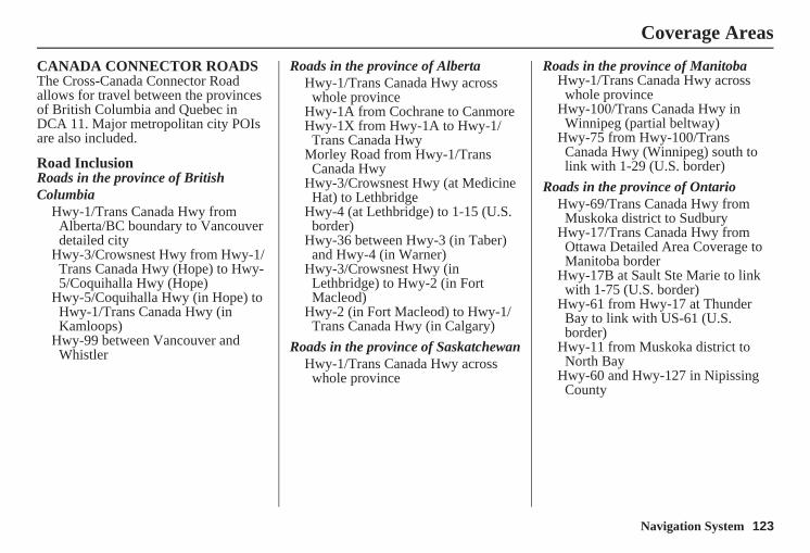
Navigation System 123
CANADA CONNECTOR ROADSThe Cross-Canada Connector Road allows for travel between the provinces of British Columbia and Quebec in DCA 11. Major metropolitan city POIs are also included.
Road InclusionRoads in the province of British Columbia
Hwy-1/Trans Canada Hwy from Alberta/BC boundary to Vancouver detailed city
Hwy-3/Crowsnest Hwy from Hwy-1/ Trans Canada Hwy (Hope) to Hwy-5/Coquihalla Hwy (Hope)
Hwy-5/Coquihalla Hwy (in Hope) to Hwy-1/Trans Canada Hwy (in Kamloops)
Hwy-99 between Vancouver and Whistler
Roads in the province of AlbertaHwy-1/Trans Canada Hwy across
whole provinceHwy-1A from Cochrane to CanmoreHwy-1X from Hwy-1A to Hwy-1/
Trans Canada HwyMorley Road from Hwy-1/Trans
Canada HwyHwy-3/Crowsnest Hwy (at Medicine
Hat) to LethbridgeHwy-4 (at Lethbridge) to 1-15 (U.S.
border)Hwy-36 between Hwy-3 (in Taber)
and Hwy-4 (in Warner)Hwy-3/Crowsnest Hwy (in
Lethbridge) to Hwy-2 (in Fort Macleod)
Hwy-2 (in Fort Macleod) to Hwy-1/ Trans Canada Hwy (in Calgary)
Roads in the province of SaskatchewanHwy-1/Trans Canada Hwy across
whole province
Roads in the province of ManitobaHwy-1/Trans Canada Hwy across
whole provinceHwy-100/Trans Canada Hwy in
Winnipeg (partial beltway)Hwy-75 from Hwy-100/Trans
Canada Hwy (Winnipeg) south to link with 1-29 (U.S. border)
Roads in the province of OntarioHwy-69/Trans Canada Hwy from
Muskoka district to SudburyHwy-17/Trans Canada Hwy from
Ottawa Detailed Area Coverage to Manitoba border
Hwy-17B at Sault Ste Marie to link with 1-75 (U.S. border)
Hwy-61 from Hwy-17 at Thunder Bay to link with US-61 (U.S. border)
Hwy-11 from Muskoka district to North Bay
Hwy-60 and Hwy-127 in Nipissing County
Coverage Areas
124 Navigation System
Coverage Areas
Operation in Alaska and HawaiiCertain functions that rely on a satellite signal will not work in Alaska and Hawaii. These functions include but are not limited to automatic clock updates and time zone adjustments.
AlaskaIf the vehicle was purchased in the lower 48 states and driven to Alaska, the system cannot display maps. The message “Vehicle is out of the database...” will be displayed.
HawaiiThis section describes the differences in navigation system operation for vehicles delivered in Hawaii.
XM RadioNavigation vehicles delivered to Hawaii are equipped with XM hardware, but XM broadcasting is not available; therefore sections of the manual that mention XM audio do not apply. Vehicles originally delivered to Hawaii also have XM, but will not function because the XM satellites (aimed toward the U.S. mainland) are too far away to obtain reception.
Map CoverageAll roads displayed on the Hawaii map screens are detailed coverage roads. Text related to “unverified” roads or areas are not applicable. The following topics do not apply in Hawaii:• Unverified road descriptions (see
page 6 and 85).• Cautions and pop-up windows related
to unverified roads (see page 63).
• Setup entries that relate to turning on or off unverified routing (see page 86).
• When zooming in and out, there is no 350-mile scale for Hawaii.
Other Map Issues
• See the coverage section for a list of islands with coverage (see page 110).
• Freeway Exit information does not exist in Hawaii, so the “Freeway Exit Info” icon is not shown on the icon bar.
Navigation System 125
Coverage Areas
Address and POI Entry ScreensWhen in Hawaii, the following differences occur for map, address, and POI selection:• It is not possible to enter U.S.
mainland addresses or scroll the map east to the U.S. mainland.
• Selection of the “State” is confined to the state of Hawaii only.
• Entry of a destination address or POI on an island other than your current island may result in a screen caution message. This is normal because there are no “ferry” routes between islands available in the database.
• If the “Guidance Prompts” setting on the Setup screen is set to normal or maximum, street names will not be spoken in voice guidance commands.
Setup Screen DifferencesThe Setup screen differences are minor and are listed below. See the Setup section (page 75) for additional information.
Routing and Guidance (Unverified Area Routing On/Off)This feature is unavailable. All roads displayed on the map are verified.
Clock Adjust ScreenThere is no daylight saving time for Hawaii. Auto Daylight Saving Time, Auto Time Zone by GPS, and DST Selection will not be shown on the Clock adjustment screen. To test your adjustment, use the voice control system, and say “What time is it?” (see page 95).
Bluetooth® HandsFreeLink® OperationWhen pairing a cell phone to use the Bluetooth® HandsFreeLink® feature, you may see a “Phone-Data Connection” screen. If so, do not complete this portion of the process.
Shipping a Vehicle To or From HawaiiAlthough the DVD in the vehicle contains maps for both U.S. mainland and Hawaii, the dealer must perform the selection of “U.S. mainland” or “Hawaii” for you. When the dealer makes the switch from U.S. mainland to Hawaii or vice versa, the system clears all user data. Make sure to record any personal information that you do not want to lose.
NOTE:Shipping a vehicle from Hawaii to the U.S. mainland• If you wish to receive XM audio you
must call XM and set up an account at (800) 852-9696.
Shipping a vehicle from the U.S. mainland to Hawaii• If a U.S. mainland-delivered vehicle
is shipped to Hawaii, there is no XM reception. See your Hawaii dealer to allow viewing of local Hawaii maps.
• The issues under “Operation in Hawaii” above apply.
126 Navigation System
Frequently Asked Questions
Map and Features, Voice Operation, Entering AddressesProblem Solution
Why does the Disclaimer screen need to be displayed every time I start the car? I am the only driver.
The Disclaimer screen reminds you and your guest drivers to always operate the navigation system in a safe manner.
The Setup or Information screen has “grayed out” items that I cannot select. Why?
You need to select OK on the Disclaimer screen to view these items. See System Function Diagram on page 21.
I tried entering an address, but the city or street could not be found. Is there any other way to route to the location?
Some cities are lumped in with a major metro area. Try entering the street first. In rural “unverified” areas or new subdivisions, streets may be missing or only partially numbered. Try selecting the destination directly from the map. See By Map Input on page 37.
When I enter an address, some letters become grayed out. Is this normal?
Yes. As you enter each letter in an address or a point of interest (POI), the system looks in the database to see what letters are possible and “grays out” letters that do not apply.
How do I delete Personal Addresses, Previous Destinations, or the Home Address?
This is done in the Setup screen (second) under “Personal Information.” See page 78.
I cannot hear the navigation system voice. 1) Ensure that Volume in the Setup screen (first) is not Off. See page 75.2) Go to “Basic Settings” in the Setup screen (second), and set Voice
Recognition Feedback to On. See page 94.The voice control system is having difficulty recognizing my voice commands.
Ensure that the vents are not blowing on the microphone on the ceiling, the vehicle is as quiet as possible, and you are using the correct command when speaking (see Improving Voice Recognition on page 13). Say “Help” at any screen to see a list of the applicable voice commands. If the system cannot recognize your command because of background noise, speak louder.
When the system pronounces the street name in the guidance command or reads the destination address, it sounds strange. What causes this?
The basic guidance phrase uses a studio-recorded voice, but the street name is pronounced by the system using a machine-generated voice. Consequently, the name may be mispronounced or sound strange at times.
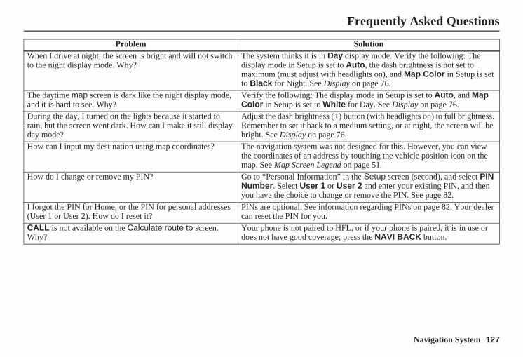
Navigation System 127
When I drive at night, the screen is bright and will not switch to the night display mode. Why?
The system thinks it is in Day display mode. Verify the following: The display mode in Setup is set to Auto, the dash brightness is not set to maximum (must adjust with headlights on), and Map Color in Setup is set to Black for Night. See Display on page 76.
The daytime map screen is dark like the night display mode, and it is hard to see. Why?
Verify the following: The display mode in Setup is set to Auto, and Map Color in Setup is set to White for Day. See Display on page 76.
During the day, I turned on the lights because it started to rain, but the screen went dark. How can I make it still display day mode?
Adjust the dash brightness (+) button (with headlights on) to full brightness. Remember to set it back to a medium setting, or at night, the screen will be bright. See Display on page 76.
How can I input my destination using map coordinates? The navigation system was not designed for this. However, you can view the coordinates of an address by touching the vehicle position icon on the map. See Map Screen Legend on page 51.
How do I change or remove my PIN? Go to “Personal Information” in the Setup screen (second), and select PIN Number. Select User 1 or User 2 and enter your existing PIN, and then you have the choice to change or remove the PIN. See page 82.
I forgot the PIN for Home, or the PIN for personal addresses (User 1 or User 2). How do I reset it?
PINs are optional. See information regarding PINs on page 82. Your dealer can reset the PIN for you.
CALL is not available on the Calculate route to screen. Why?
Your phone is not paired to HFL, or if your phone is paired, it is in use or does not have good coverage; press the NAVI BACK button.
Problem Solution
Frequently Asked Questions
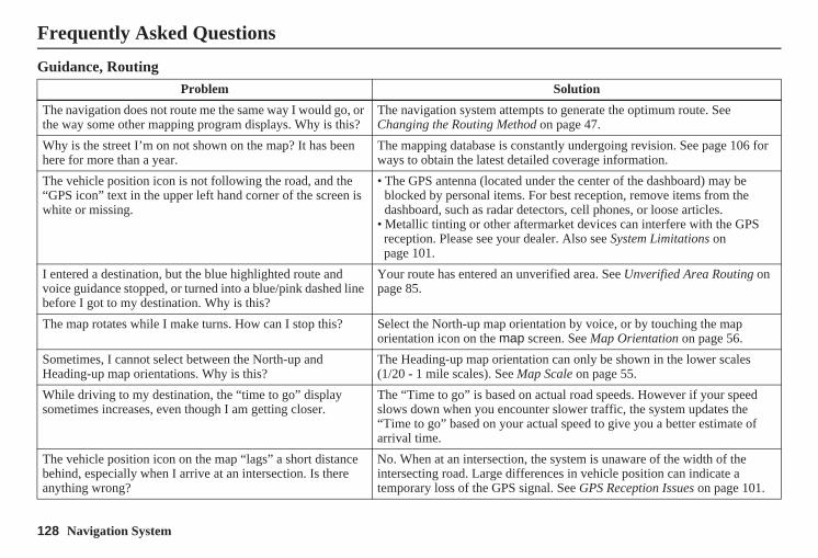
128 Navigation System
Frequently Asked Questions
Guidance, RoutingProblem Solution
The navigation does not route me the same way I would go, or the way some other mapping program displays. Why is this?
The navigation system attempts to generate the optimum route. See Changing the Routing Method on page 47.
Why is the street I’m on not shown on the map? It has been here for more than a year.
The mapping database is constantly undergoing revision. See page 106 for ways to obtain the latest detailed coverage information.
The vehicle position icon is not following the road, and the “GPS icon” text in the upper left hand corner of the screen is white or missing.
• The GPS antenna (located under the center of the dashboard) may be blocked by personal items. For best reception, remove items from the dashboard, such as radar detectors, cell phones, or loose articles.
• Metallic tinting or other aftermarket devices can interfere with the GPS reception. Please see your dealer. Also see System Limitations on page 101.
I entered a destination, but the blue highlighted route and voice guidance stopped, or turned into a blue/pink dashed line before I got to my destination. Why is this?
Your route has entered an unverified area. See Unverified Area Routing on page 85.
The map rotates while I make turns. How can I stop this? Select the North-up map orientation by voice, or by touching the map orientation icon on the map screen. See Map Orientation on page 56.
Sometimes, I cannot select between the North-up and Heading-up map orientations. Why is this?
The Heading-up map orientation can only be shown in the lower scales (1/20 - 1 mile scales). See Map Scale on page 55.
While driving to my destination, the “time to go” display sometimes increases, even though I am getting closer.
The “Time to go” is based on actual road speeds. However if your speed slows down when you encounter slower traffic, the system updates the “Time to go” based on your actual speed to give you a better estimate of arrival time.
The vehicle position icon on the map “lags” a short distance behind, especially when I arrive at an intersection. Is there anything wrong?
No. When at an intersection, the system is unaware of the width of the intersecting road. Large differences in vehicle position can indicate a temporary loss of the GPS signal. See GPS Reception Issues on page 101.
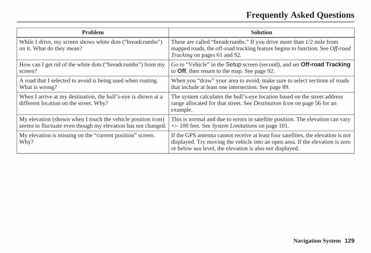
Navigation System 129
While I drive, my screen shows white dots (“breadcrumbs”) on it. What do they mean?
These are called “breadcrumbs.” If you drive more than 1/2 mile from mapped roads, the off-road tracking feature begins to function. See Off-road Tracking on pages 61 and 92.
How can I get rid of the white dots (“breadcrumbs”) from my screen?
Go to “Vehicle” in the Setup screen (second), and set Off-road Tracking to Off, then return to the map. See page 92.
A road that I selected to avoid is being used when routing.What is wrong?
When you “draw” your area to avoid, make sure to select sections of roads that include at least one intersection. See page 89.
When I arrive at my destination, the bull’s-eye is shown at a different location on the street. Why?
The system calculates the bull’s-eye location based on the street address range allocated for that street. See Destination Icon on page 56 for an example.
My elevation (shown when I touch the vehicle position icon) seems to fluctuate even though my elevation has not changed.
This is normal and due to errors in satellite position. The elevation can vary +/- 100 feet. See System Limitations on page 101.
My elevation is missing on the “current position” screen. Why?
If the GPS antenna cannot receive at least four satellites, the elevation is not displayed. Try moving the vehicle into an open area. If the elevation is zero or below sea level, the elevation is also not displayed.
Problem Solution
Frequently Asked Questions
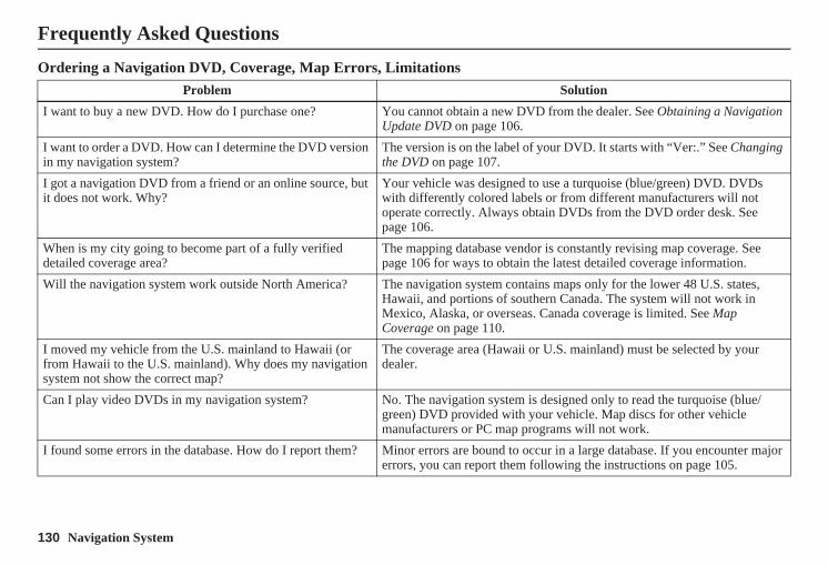
130 Navigation System
Frequently Asked Questions
Ordering a Navigation DVD, Coverage, Map Errors, LimitationsProblem Solution
I want to buy a new DVD. How do I purchase one? You cannot obtain a new DVD from the dealer. See Obtaining a Navigation Update DVD on page 106.
I want to order a DVD. How can I determine the DVD version in my navigation system?
The version is on the label of your DVD. It starts with “Ver:.” See Changing the DVD on page 107.
I got a navigation DVD from a friend or an online source, but it does not work. Why?
Your vehicle was designed to use a turquoise (blue/green) DVD. DVDs with differently colored labels or from different manufacturers will not operate correctly. Always obtain DVDs from the DVD order desk. See page 106.
When is my city going to become part of a fully verified detailed coverage area?
The mapping database vendor is constantly revising map coverage. See page 106 for ways to obtain the latest detailed coverage information.
Will the navigation system work outside North America? The navigation system contains maps only for the lower 48 U.S. states, Hawaii, and portions of southern Canada. The system will not work in Mexico, Alaska, or overseas. Canada coverage is limited. See Map Coverage on page 110.
I moved my vehicle from the U.S. mainland to Hawaii (or from Hawaii to the U.S. mainland). Why does my navigation system not show the correct map?
The coverage area (Hawaii or U.S. mainland) must be selected by your dealer.
Can I play video DVDs in my navigation system? No. The navigation system is designed only to read the turquoise (blue/green) DVD provided with your vehicle. Map discs for other vehicle manufacturers or PC map programs will not work.
I found some errors in the database. How do I report them? Minor errors are bound to occur in a large database. If you encounter major errors, you can report them following the instructions on page 105.
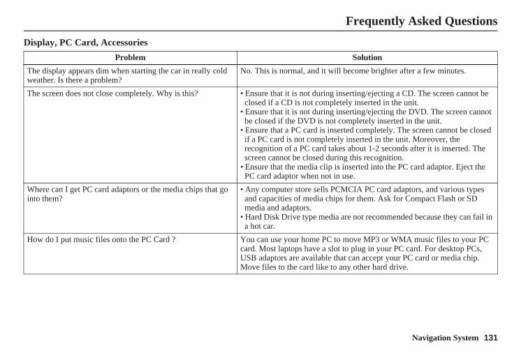
Navigation System 131
Display, PC Card, Accessories
Problem Solution
The display appears dim when starting the car in really cold weather. Is there a problem?
No. This is normal, and it will become brighter after a few minutes.
The screen does not close completely. Why is this? • Ensure that it is not during inserting/ejecting a CD. The screen cannot be closed if a CD is not completely inserted in the unit.
• Ensure that it is not during inserting/ejecting the DVD. The screen cannot be closed if the DVD is not completely inserted in the unit.
• Ensure that a PC card is inserted completely. The screen cannot be closed if a PC card is not completely inserted in the unit. Moreover, the recognition of a PC card takes about 1-2 seconds after it is inserted. The screen cannot be closed during this recognition.
• Ensure that the media clip is inserted into the PC card adaptor. Eject the PC card adaptor when not in use.
Where can I get PC card adaptors or the media chips that go into them?
• Any computer store sells PCMCIA PC card adaptors, and various types and capacities of media chips for them. Ask for Compact Flash or SD media and adaptors.
• Hard Disk Drive type media are not recommended because they can fail in a hot car.
How do I put music files onto the PC Card ? You can use your home PC to move MP3 or WMA music files to your PC card. Most laptops have a slot to plug in your PC card. For desktop PCs, USB adaptors are available that can accept your PC card or media chip. Move files to the card like to any other hard drive.
Frequently Asked Questions
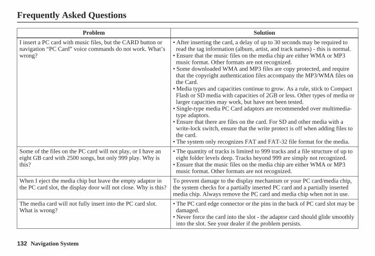
132 Navigation System
Frequently Asked Questions
I insert a PC card with music files, but the CARD button or navigation “PC Card” voice commands do not work. What’s wrong?
• After inserting the card, a delay of up to 30 seconds may be required to read the tag information (album, artist, and track names) - this is normal.
• Ensure that the music files on the media chip are either WMA or MP3 music format. Other formats are not recognized.
• Some downloaded WMA and MP3 files are copy protected, and require that the copyright authentication files accompany the MP3/WMA files on the Card.
• Media types and capacities continue to grow. As a rule, stick to Compact Flash or SD media with capacities of 2GB or less. Other types of media or larger capacities may work, but have not been tested.
• Single-type media PC Card adaptors are recommended over multimedia-type adaptors.
• Ensure that there are files on the card. For SD and other media with a write-lock switch, ensure that the write protect is off when adding files to the card.
• The system only recognizes FAT and FAT-32 file format for the media.Some of the files on the PC card will not play, or I have an eight GB card with 2500 songs, but only 999 play. Why is this?
• The quantity of tracks is limited to 999 tracks and a file structure of up to eight folder levels deep. Tracks beyond 999 are simply not recognized.
• Ensure that the music files on the media chip are either WMA or MP3 music format. Other formats are not recognized.
When I eject the media chip but leave the empty adaptor in the PC card slot, the display door will not close. Why is this?
To prevent damage to the display mechanism or your PC card/media chip, the system checks for a partially inserted PC card and a partially inserted media chip. Always remove the PC card and media chip when not in use.
The media card will not fully insert into the PC card slot. What is wrong?
• The PC card edge connector or the pins in the back of PC card slot may be damaged.
• Never force the card into the slot - the adaptor card should glide smoothly into the slot. See your dealer if the problem persists.
Problem Solution
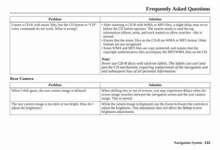
Navigation System 133
Frequently Asked Questions
Rear Camera
I insert a CD-R with music files, but the CD button or “CD” voice commands do not work. What is wrong?
• After inserting a CD-R with WMA or MP3 files, a slight delay may occur before the CD button operates. The system needs to read the tag information (album, artist, and track names) to allow searches - this is normal.
• Ensure that the music files on the CD-R are WMA or MP3 format. Other formats are not recognized.
• Some WMA and MP3 files are copy protected, and require that the copyright authentication files accompany the MP3/WMA files on the CD.
Note:Never use CD-R discs with stick-on labels. The labels can curl and jam the CD mechanism, requiring replacement of the navigation unit and subsequent loss of all personal information.
Problem Solution
When I shift gears, the rear camera image is delayed. When shifting into or out of reverse, you may experience delays when the screen image switches between the navigation screen and the rear camera image. This is normal.
The rear camera image is too dark or too bright. How do I adjust the brightness?
While the camera image is displayed, use the Zoom In/Zoom Out controls to adjust the brightness. This adjustment does not affect the Setup screen brightness adjustments.
Problem Solution
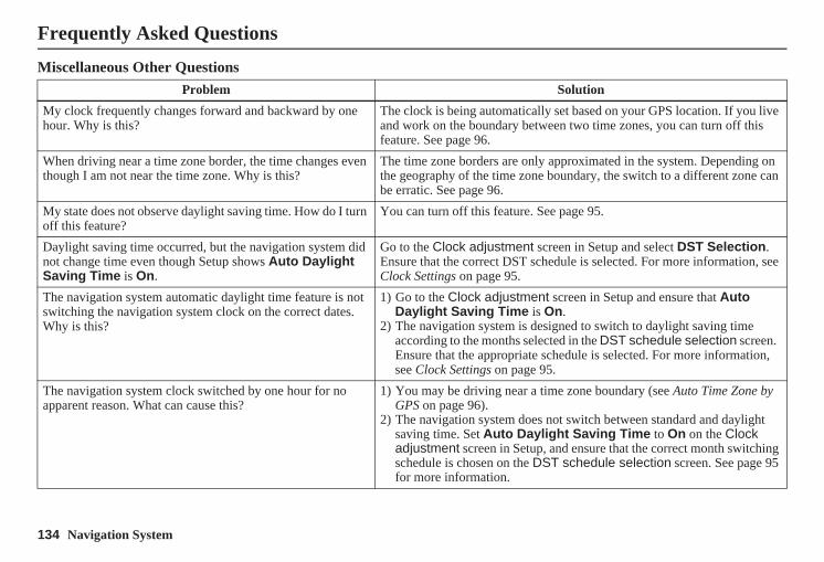
134 Navigation System
Miscellaneous Other QuestionsProblem Solution
My clock frequently changes forward and backward by one hour. Why is this?
The clock is being automatically set based on your GPS location. If you live and work on the boundary between two time zones, you can turn off this feature. See page 96.
When driving near a time zone border, the time changes even though I am not near the time zone. Why is this?
The time zone borders are only approximated in the system. Depending on the geography of the time zone boundary, the switch to a different zone can be erratic. See page 96.
My state does not observe daylight saving time. How do I turn off this feature?
You can turn off this feature. See page 95.
Daylight saving time occurred, but the navigation system did not change time even though Setup shows Auto Daylight Saving Time is On.
Go to the Clock adjustment screen in Setup and select DST Selection. Ensure that the correct DST schedule is selected. For more information, see Clock Settings on page 95.
The navigation system automatic daylight time feature is not switching the navigation system clock on the correct dates. Why is this?
1) Go to the Clock adjustment screen in Setup and ensure that Auto Daylight Saving Time is On.
2) The navigation system is designed to switch to daylight saving time according to the months selected in the DST schedule selection screen. Ensure that the appropriate schedule is selected. For more information, see Clock Settings on page 95.
The navigation system clock switched by one hour for no apparent reason. What can cause this?
1) You may be driving near a time zone boundary (see Auto Time Zone by GPS on page 96).
2) The navigation system does not switch between standard and daylight saving time. Set Auto Daylight Saving Time to On on the Clock adjustment screen in Setup, and ensure that the correct month switching schedule is chosen on the DST schedule selection screen. See page 95 for more information.
Frequently Asked Questions
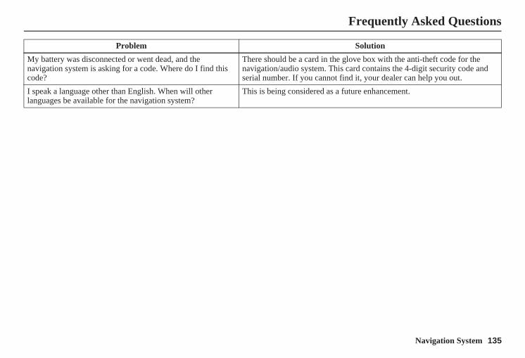
Navigation System 135
Frequently Asked Questions
My battery was disconnected or went dead, and the navigation system is asking for a code. Where do I find this code?
There should be a card in the glove box with the anti-theft code for the navigation/audio system. This card contains the 4-digit security code and serial number. If you cannot find it, your dealer can help you out.
I speak a language other than English. When will other languages be available for the navigation system?
This is being considered as a future enhancement.
Problem Solution
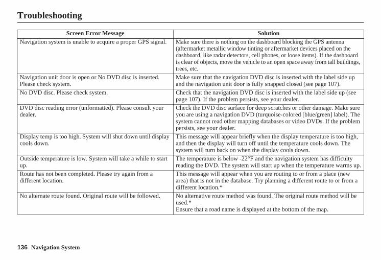
136 Navigation System
Troubleshooting
Screen Error Message SolutionNavigation system is unable to acquire a proper GPS signal. Make sure there is nothing on the dashboard blocking the GPS antenna
(aftermarket metallic window tinting or aftermarket devices placed on the dashboard, like radar detectors, cell phones, or loose items). If the dashboard is clear of objects, move the vehicle to an open space away from tall buildings, trees, etc.
Navigation unit door is open or No DVD disc is inserted. Please check system.
Make sure that the navigation DVD disc is inserted with the label side up and the navigation unit door is fully snapped closed (see page 107).
No DVD disc. Please check system. Check that the navigation DVD disc is inserted with the label side up (see page 107). If the problem persists, see your dealer.
DVD disc reading error (unformatted). Please consult your dealer.
Check the DVD disc surface for deep scratches or other damage. Make sure you are using a navigation DVD (turquoise-colored [blue/green] label). The system cannot read other mapping databases or video DVDs. If the problem persists, see your dealer.
Display temp is too high. System will shut down until display cools down.
This message will appear briefly when the display temperature is too high, and then the display will turn off until the temperature cools down. The system will turn back on when the display cools down.
Outside temperature is low. System will take a while to start up.
The temperature is below -22°F and the navigation system has difficulty reading the DVD. The system will start up when the temperature warms up.
Route has not been completed. Please try again from a different location.
This message will appear when you are routing to or from a place (new area) that is not in the database. Try planning a different route to or from a different location.*
No alternate route found. Original route will be followed. No alternative route method was found. The original route method will be used.*Ensure that a road name is displayed at the bottom of the map.
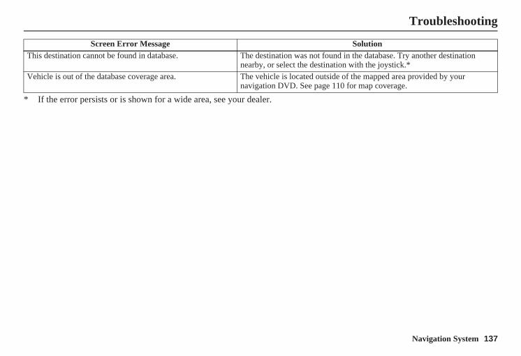
Navigation System 137
Troubleshooting
* If the error persists or is shown for a wide area, see your dealer.
This destination cannot be found in database. The destination was not found in the database. Try another destination nearby, or select the destination with the joystick.*
Vehicle is out of the database coverage area. The vehicle is located outside of the mapped area provided by your navigation DVD. See page 110 for map coverage.
Screen Error Message Solution
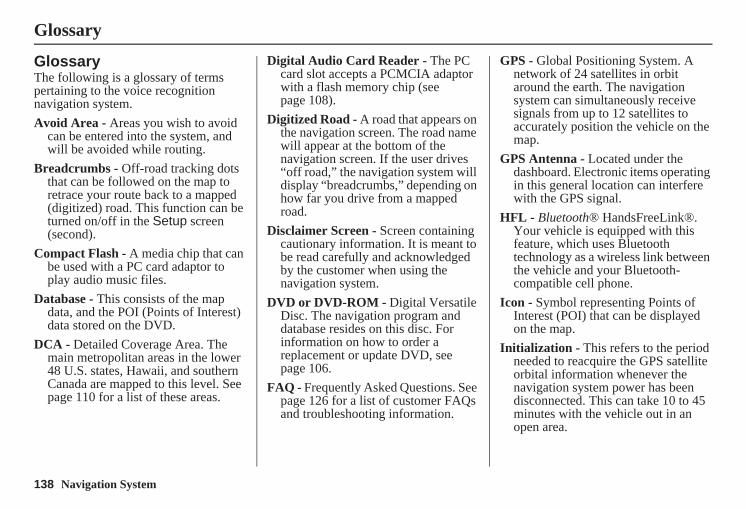
138 Navigation System
Glossary
GlossaryThe following is a glossary of terms pertaining to the voice recognition navigation system.Avoid Area - Areas you wish to avoid
can be entered into the system, and will be avoided while routing.
Breadcrumbs - Off-road tracking dots that can be followed on the map to retrace your route back to a mapped (digitized) road. This function can be turned on/off in the Setup screen (second).
Compact Flash - A media chip that can be used with a PC card adaptor to play audio music files.
Database - This consists of the map data, and the POI (Points of Interest) data stored on the DVD.
DCA - Detailed Coverage Area. The main metropolitan areas in the lower 48 U.S. states, Hawaii, and southern Canada are mapped to this level. See page 110 for a list of these areas.
Digital Audio Card Reader - The PC card slot accepts a PCMCIA adaptor with a flash memory chip (see page 108).
Digitized Road - A road that appears on the navigation screen. The road name will appear at the bottom of the navigation screen. If the user drives “off road,” the navigation system will display “breadcrumbs,” depending on how far you drive from a mapped road.
Disclaimer Screen - Screen containing cautionary information. It is meant to be read carefully and acknowledged by the customer when using the navigation system.
DVD or DVD-ROM - Digital Versatile Disc. The navigation program and database resides on this disc. For information on how to order a replacement or update DVD, see page 106.
FAQ - Frequently Asked Questions. See page 126 for a list of customer FAQs and troubleshooting information.
GPS - Global Positioning System. A network of 24 satellites in orbit around the earth. The navigation system can simultaneously receive signals from up to 12 satellites to accurately position the vehicle on the map.
GPS Antenna - Located under the dashboard. Electronic items operating in this general location can interfere with the GPS signal.
HFL - Bluetooth® HandsFreeLink®. Your vehicle is equipped with this feature, which uses Bluetooth technology as a wireless link between the vehicle and your Bluetooth-compatible cell phone.
Icon - Symbol representing Points of Interest (POI) that can be displayed on the map.
Initialization - This refers to the period needed to reacquire the GPS satellite orbital information whenever the navigation system power has been disconnected. This can take 10 to 45 minutes with the vehicle out in an open area.
Navigation System 139
Glossary
LCD - Liquid Crystal Display. The navigation screen.
Map Matching - The received GPS information allows the navigation system to position the vehicle on the map. Map matching has occurred if the map screen is displaying the current street name in the bottom-shaded area.
Mic - Abbreviation for the microphone used for receiving voice commands. It is located near the map light in the ceiling.
MP3 - A music file format that can be played from a CD-R, USB thumb drive, or PC card.
MW - Maneuver Window. While en route to a destination, this window displays information about the next maneuver.
Navi - Abbreviation for the navigation system.
North Pointer - The map symbol showing the map orientation. See page 56.
Off Route - This occurs when the user leaves mapped roads. Off-road tracking dots (“breadcrumbs”) are displayed if the option is enabled in the Setup screen. The user can use them to return to a mapped road. The bottom of the navigation screen will say, “Not on a digitized road.”
Outlying Areas - These are rural areas that typically have only their main roads mapped. All other roads are shown in light brown for reference only, since they have not been verified.
PC Card - An adaptor card (sometimes called a PCMCIA card) that can contain a compact flash, or SD media clip with MP3 or WMA music files.
PIN - Personal Identification Number. A 4-digit number created by the customer to protect personal information.
POI - Point of Interest. These are the businesses, schools, etc. found under the Places option on the Enter destination by screen. See page 32.
Polygon - Colored areas on the map screen denoting parks, schools, etc. See Map Screen Legend “Map Features” for a list of the assigned colors. See page 51.
QWERTY - Keyboard layout resembling the typewriter keys. The keyboard layout can be changed to an alphabetical layout in the Setup, Basic Settings screen.
Reminder - Automatic “pop-up” Calendar message. See Calendar on page 72.
Secure Digital (SD) Media - These can be installed into a PCMCIA adaptor to play MP3 or WMA music files.
Security Code - Code needed to activate the navigation system or audio unit. See Entering the Security Code on page 99.
Touch Sensor - The touch sensor on the front of the LCD consists of a touch sensitive resistive membrane with an infinite number of possible touch locations. The sensing locations are confined to a grid of 20 vertical and 10 horizontal touch locations.
140 Navigation System
Glossary
Unverified Streets - These streets have not been verified for turn restrictions, one-way, etc. They are shown in light brown on the map. Unverified streets may be missing from the map, shown in the wrong location, or have an incorrect name or address range.
USB - Universal Serial Bus. A computer hardware interface used to store and play audio files (MP3, WMA, AAC) from USB devices, such as thumb drives or iPods. See the Audio section in your Owner’s Manual for more information.
Vehicle Speed Sensor - Provides speed signal to the navigation system for moving the VP icon on the map.
Verified Streets - These streets consist of the detailed metropolitan coverage areas and all other inter-town connection roads. These roads are shown in black on the map.
Voice Control - See VR.
VP - Vehicle Position. When in map mode, this circular icon shows the vehicle position on the map. Touch this icon to show the latitude, longitude, and elevation of your current position.
VR - Voice Recognition. This allows voice control of many of the navigation functions. The hardware consists of the microphone, voice control switch (NAVI TALK/NAVI BACK buttons), and the front speakers.
Waypoint - A temporary destination you may enter while en route (e.g., a gas station, ATM, etc.). See page 64.
WMA - A Windows media audio file that can be played from a CD-R, USB thumb drive, or PC card.
Yaw Rate Sensor - Senses when the vehicle makes a turn, which makes the VP change direction on the map as you turn.
Navigation System 141
Voice Command Index
Global CommandsThe system accepts these commands on any screen.
Help (reads list of the commands for the displayed screen)
Setup (displays the Setup screen (first))
Display map (displays the map screen)
Display menu (displays the Enter destination by screen)
Display audio screenInformation (displays the
Information screen)Back (to previous screen, same as
CANCEL or NAVI BACK button)Cancel (cancels current activity)What time is it?
The “Voice Command Help” option on the Information screen lists many of the following controls. To avoid distraction while you are driving, the system can read the commands for you.
The commands are accessible at any time while driving and can be read to you so that you do not need to memorize all of them.
Navigation General CommandsThe system accepts these commands on a map/guidance screen.
Display menu (if en route, displays the Change route by screen)
Display navigation (if en route, displays the Change route by screen)
Display mapDisplay map guide (same function as
the MAP/GUIDE button)Display setup (or just Setup)Display information (or just
Information)Display audio screenCancelBackward (or just Back)What time is it?Repeat voice (repeats the screen
prompt for most screens)Help (displays the voice command
allowed for the screen you are viewing)
Voice command help How long to the destination? (when
en route, tells the time to destination)*
How far to the destination? (when en route, tells the distance to destination)*
Display destination map (when en route, shows the map of the destination)
Display entire route (when en route, adjusts the map scale so that the entire route is displayed)
Register the current location (puts current location in the personal Address Book)
* These commands are not available if you scroll through the map while en route to a destination.
142 Navigation System
Voice Command Index
Navigation Display CommandsThe system accepts these commands on a map/guidance screen.
Display current location (shows current latitude, longitude, and elevation)
Display north upDisplay heading upDisplay zoom inDisplay zoom outDisplay: (the selected scale)
1/20 mile (80 m) scale1/8 mile (200 m) scale1/4 mile (400 m) scale1/2 mile (800 m) scale1 mile (1600 m) scale2 mile (3 km) scale5 mile (8 km) scale15 mile (24 km) scale50 mile (80 km) scale150 mile (240 km) scale350 mile (560 km) scale
Display: (display the selected icon on the screen)
ATMgas stationrestaurantpost office*grocery storelodging (hotel, motel)*parking garage*parking lot*school*hospital*one way*freeway exit information
* These icons will not be displayed unless the “Parking” or “Other icon” is selected on the Icon Bar (see page 59).
Hide: (hide the selected icon from the screen)
ATMgas stationrestaurantpost officegrocery storelodging (hotel, motel)parking garageparking lotschoolhospitalone wayfreeway exit information
Max zoom inMax zoom outGo home
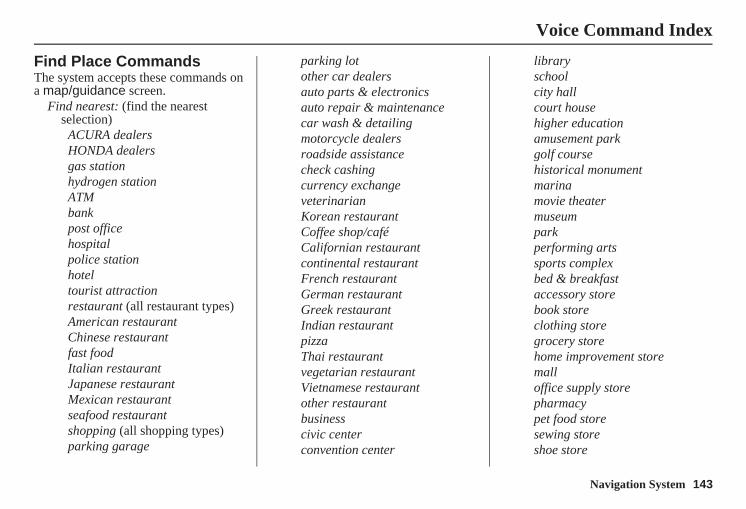
Navigation System 143
Voice Command Index
Find Place CommandsThe system accepts these commands on a map/guidance screen.
Find nearest: (find the nearest selection)
ACURA dealersHONDA dealersgas stationhydrogen stationATMbankpost officehospitalpolice stationhoteltourist attractionrestaurant (all restaurant types)American restaurantChinese restaurantfast foodItalian restaurantJapanese restaurantMexican restaurantseafood restaurantshopping (all shopping types)parking garage
parking lotother car dealersauto parts & electronicsauto repair & maintenancecar wash & detailingmotorcycle dealersroadside assistancecheck cashingcurrency exchangeveterinarianKorean restaurantCoffee shop/caféCalifornian restaurantcontinental restaurantFrench restaurantGerman restaurantGreek restaurantIndian restaurantpizzaThai restaurantvegetarian restaurantVietnamese restaurantother restaurantbusinesscivic centerconvention center
libraryschoolcity hallcourt househigher educationamusement parkgolf coursehistorical monumentmarinamovie theatermuseumparkperforming artssports complexbed & breakfastaccessory storebook storeclothing storegrocery storehome improvement storemalloffice supply storepharmacypet food storesewing storeshoe store
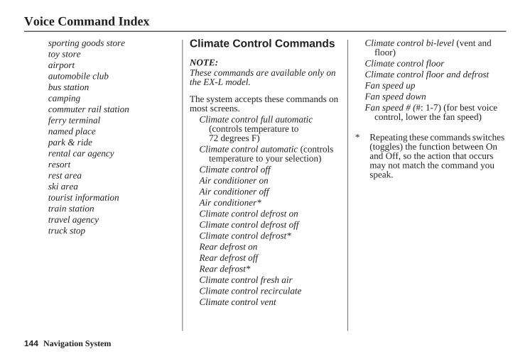
144 Navigation System
Voice Command Index
sporting goods storetoy storeairportautomobile clubbus stationcampingcommuter rail stationferry terminalnamed placepark & riderental car agencyresortrest areaski areatourist informationtrain stationtravel agencytruck stop
Climate Control Commands
NOTE:These commands are available only on the EX-L model.
The system accepts these commands on most screens.
Climate control full automatic (controls temperature to 72 degrees F)
Climate control automatic (controls temperature to your selection)
Climate control offAir conditioner onAir conditioner offAir conditioner*Climate control defrost onClimate control defrost offClimate control defrost*Rear defrost onRear defrost offRear defrost*Climate control fresh airClimate control recirculateClimate control vent
Climate control bi-level (vent and floor)
Climate control floorClimate control floor and defrostFan speed upFan speed downFan speed # (#: 1-7) (for best voice
control, lower the fan speed)
* Repeating these commands switches (toggles) the function between On and Off, so the action that occurs may not match the command you speak.

Navigation System 145
Voice Command Index
Temperature Voice Commands
NOTE:These commands are available only on the EX-L model.
The system accepts these commands on most screens.
Temperature # degrees (#: 57-87 degrees F)
Temperature upTemperature downDriver temperature # degrees
(#: 57-87 degrees F)Driver temperature upDriver temperature downPassenger temperature # degrees
(#: 57-87 degrees F)Passenger temperature upPassenger temperature downTemperature max hotTemperature max coldTemperature balanceTemperature dual mode onTemperature dual mode offTemperature dual mode*
* Repeating these commands switches (toggles) the function between On and Off, so the action that occurs may not match the command you speak.
Radio Voice CommandsThe system accepts these commands on most screens.
Audio on*Audio off*Radio on*Radio off*Radio select FM1Radio select FM2Radio select AMRadio tune to # FM (#: frequency.
Example Radio 95.5 FM)Radio tune to # AM (#:frequency.
Example Radio 1020 AM)Radio seek upRadio seek downRadio next station (same as Radio
seek)Radio preset # (#: 1-6)Radio FM preset # (#: 1-6)Radio FM1 preset # (#: 1-6)Radio FM2 preset # (#: 1-6)Radio AM preset # (#: 1-6)Radio auto select*Radio scan*Radio select XM1Radio select XM2
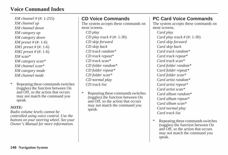
146 Navigation System
Voice Command Index
XM channel # (#: 1-255)XM channel upXM channel downXM category upXM category downXM preset # (#: 1-6)XM1 preset # (#: 1-6)XM2 preset # (#: 1-6)XM scan*XM category scan*XM channel scan*XM category modeXM channel mode
* Repeating these commands switches (toggles) the function between On and Off, so the action that occurs may not match the command you speak.
NOTE:Radio volume levels cannot be controlled using voice control. Use the buttons on your steering wheel. See your Owner’s Manual for more information.
CD Voice CommandsThe system accepts these commands on most screens.
CD playCD play track # (#: 1-30)CD skip forwardCD skip backCD track random*CD track repeat*CD track scan*CD folder random*CD folder repeat*CD folder scan*CD normal playCD track list
* Repeating these commands switches (toggles) the function between On and Off, so the action that occurs may not match the command you speak.
PC Card Voice CommandsThe system accepts these commands on most screens.
Card playCard play track # (#: 1-30)Card skip forwardCard skip backCard track random*Card track repeat*Card track scan*Card folder random*Card folder repeat*Card folder scan*Card artist random*Card artist repeat*Card artist scan*Card album random*Card album repeat*Card album scan*Card normal playCard track list
* Repeating these commands switches (toggles) the function between On and Off, so the action that occurs may not match the command you speak.
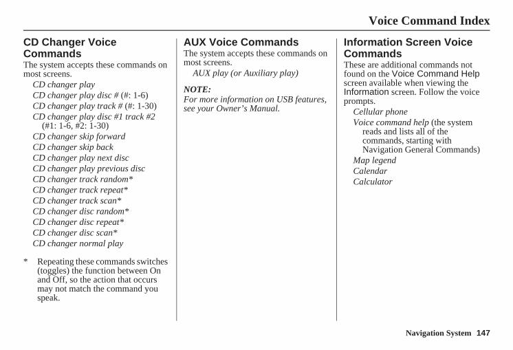
Navigation System 147
Voice Command Index
CD Changer Voice CommandsThe system accepts these commands on most screens.
CD changer playCD changer play disc # (#: 1-6)CD changer play track # (#: 1-30)CD changer play disc #1 track #2
(#1: 1-6, #2: 1-30)CD changer skip forwardCD changer skip backCD changer play next discCD changer play previous discCD changer track random*CD changer track repeat*CD changer track scan*CD changer disc random*CD changer disc repeat*CD changer disc scan*CD changer normal play
* Repeating these commands switches (toggles) the function between On and Off, so the action that occurs may not match the command you speak.
AUX Voice CommandsThe system accepts these commands on most screens.
AUX play (or Auxiliary play)
NOTE:For more information on USB features, see your Owner’s Manual.
Information Screen Voice CommandsThese are additional commands not found on the Voice Command Help screen available when viewing the Information screen. Follow the voice prompts.
Cellular phoneVoice command help (the system
reads and lists all of the commands, starting with Navigation General Commands)
Map legendCalendarCalculator
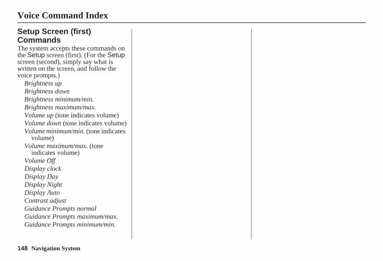
148 Navigation System
Voice Command Index
Setup Screen (first) CommandsThe system accepts these commands on the Setup screen (first). (For the Setup screen (second), simply say what is written on the screen, and follow the voice prompts.)
Brightness upBrightness downBrightness minimum/min.Brightness maximum/max.Volume up (tone indicates volume)Volume down (tone indicates volume)Volume minimum/min. (tone indicates
volume)Volume maximum/max. (tone
indicates volume)Volume OffDisplay clockDisplay DayDisplay NightDisplay AutoContrast adjustGuidance Prompts normalGuidance Prompts maximum/max.Guidance Prompts minimum/min.
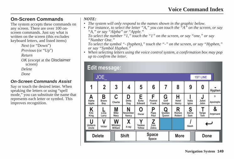
Navigation System 149
Voice Command Index
On-Screen CommandsThe system accepts these commands on any screen. There are over 100 on-screen commands. Just say what is written on the screen (this excludes keyboard letters, and listed items)
Next (or “Down”)Previous (or “Up”)ReturnOK (except at the Disclaimer
screen)DeleteDone
On-Screen Commands AssistSay or touch the desired letter. When speaking the letters or using “spell mode,” you can substitute the name that represents each letter or symbol. This improves recognition.
NOTE: • The system will only respond to the names shown in the graphic below.• For instance, to select the letter “A,” you can touch the “A” on the screen, or say
“A,” or say “Alpha” or “Apple.”To select the number “1,” touch the “1” on the screen, or say “one,” or say “Number One.”To select the symbol “- (hyphen),” touch the “-” on the screen, or say “Hyphen,” or say “Symbol Hyphen.”
• When selecting letters using the voice control system, a confirmation box may pop up to confirm the letter.
AlphaApple
BravoBoy Charlie Delta
DogEcho
EdwardFoxtrotFrank
GolfGeorge
HotelHenry
JulietJohn Apostrophe
KiloKing
LimaLarry
MikeMary
NovemberNancy Oscar Papa
PaulQuebecQueen
RomeoRobert
SierraSam
TangoTom
Ampersand
UniformUncle Victor Whiskey
William X-ray YankeeYellow
ZuluZebra
Slash
IndiaIgloo
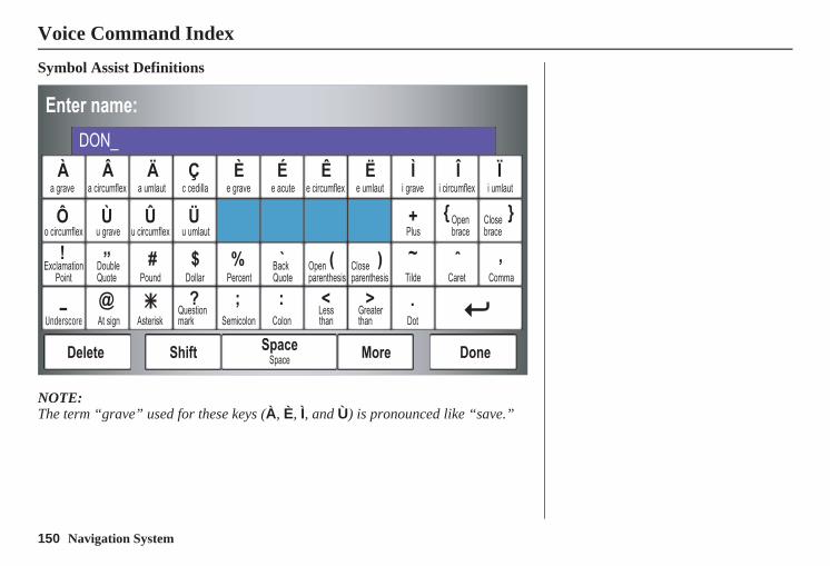
150 Navigation System
Voice Command Index
Symbol Assist Definitions
NOTE:The term “grave” used for these keys (À, È, Ì, and Ù) is pronounced like “save.”
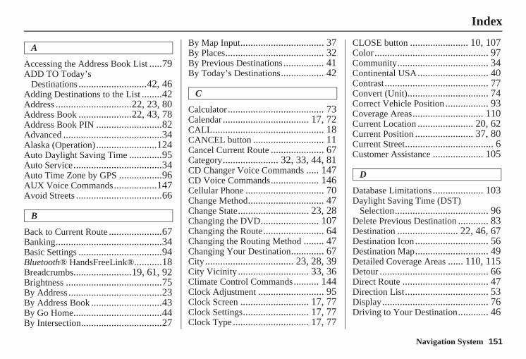
Navigation System 151
Index
A
Accessing the Address Book List .....79ADD TO Today’s
Destinations ...........................42, 46Adding Destinations to the List ........42Address ..............................22, 23, 80Address Book .....................22, 43, 78Address Book PIN ..........................82Advanced .......................................34Alaska (Operation)........................124Auto Daylight Saving Time .............95Auto Service...................................34Auto Time Zone by GPS .................96AUX Voice Commands.................147Avoid Streets ..................................66
B
Back to Current Route .....................67Banking..........................................34Basic Settings .................................94Bluetooth® HandsFreeLink®...........18Breadcrumbs.......................19, 61, 92Brightness ......................................75By Address.....................................23By Address Book ............................43By Go Home...................................44By Intersection................................27
By Map Input................................. 37By Places....................................... 32By Previous Destinations................ 41By Today’s Destinations................. 42
C
Calculator ...................................... 73Calendar .................................. 17, 72CALL............................................ 18CANCEL button ............................ 11Cancel Current Route ..................... 67Category...................... 32, 33, 44, 81CD Changer Voice Commands ..... 147CD Voice Commands................... 146Cellular Phone ............................... 70Change Method.............................. 47Change State............................ 23, 28Changing the DVD....................... 107Changing the Route........................ 64Changing the Routing Method ........ 47Changing Your Destination............. 67City................................... 23, 28, 39City Vicinity ............................ 33, 36Climate Control Commands.......... 144Clock Adjustment .......................... 95Clock Screen ........................... 17, 77Clock Settings.......................... 17, 77Clock Type .............................. 17, 77
CLOSE button ....................... 10, 107Color............................................. 97Community.................................... 34Continental USA............................ 40Contrast......................................... 77Convert (Unit)................................ 74Correct Vehicle Position ................. 93Coverage Areas............................ 110Current Location ...................... 20, 62Current Position ....................... 37, 80Current Street................................... 6Customer Assistance .................... 105
D
Database Limitations .................... 103Daylight Saving Time (DST)
Selection..................................... 96Delete Previous Destination ............ 83Destination ........................ 22, 46, 67Destination Icon............................. 56Destination Map............................. 49Detailed Coverage Areas ...... 110, 115Detour ........................................... 66Direct Route .................................. 47Direction List................................. 53Display.......................................... 76Driving to Your Destination............ 46
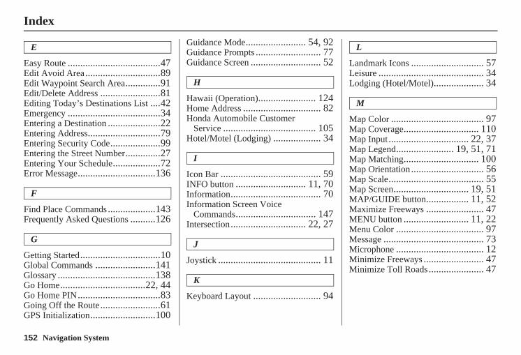
152 Navigation System
Index
E
Easy Route .....................................47Edit Avoid Area..............................89Edit Waypoint Search Area..............91Edit/Delete Address ........................81Editing Today’s Destinations List ....42Emergency .....................................34Entering a Destination .....................22Entering Address.............................79Entering Security Code....................99Entering the Street Number..............27Entering Your Schedule...................72Error Message...............................136
F
Find Place Commands...................143Frequently Asked Questions ..........126
G
Getting Started................................10Global Commands ........................141Glossary .......................................138Go Home..................................22, 44Go Home PIN.................................83Going Off the Route........................61GPS Initialization..........................100
Guidance Mode........................ 54, 92Guidance Prompts .......................... 77Guidance Screen ............................ 52
H
Hawaii (Operation)....................... 124Home Address ............................... 82Honda Automobile Customer
Service ..................................... 105Hotel/Motel (Lodging) ................... 34
I
Icon Bar ........................................ 59INFO button ............................ 11, 70Information.................................... 70Information Screen Voice
Commands................................ 147Intersection.............................. 22, 27
J
Joystick ......................................... 11
K
Keyboard Layout ........................... 94
L
Landmark Icons ............................. 57Leisure .......................................... 34Lodging (Hotel/Motel).................... 34
M
Map Color ..................................... 97Map Coverage.............................. 110Map Input................................ 22, 37Map Legend....................... 19, 51, 71Map Matching.............................. 100Map Orientation ............................. 56Map Scale...................................... 55Map Screen.............................. 19, 51MAP/GUIDE button................. 11, 52Maximize Freeways ....................... 47MENU button .......................... 11, 22Menu Color ................................... 97Message ........................................ 73Microphone ................................... 12Minimize Freeways ........................ 47Minimize Toll Roads...................... 47
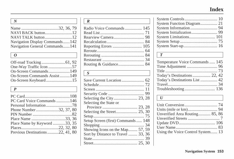
Navigation System 153
Index
N
Name .................................32, 36, 79NAVI BACK button........................12NAVI TALK button ........................12Navigation Display Commands......142Navigation General Commands......141
O
Off-road Tracking .....................61, 92One-Way Traffic Icon .....................57On-Screen Commands...................149On-Screen Commands Assist .........149On-Screen Keyboard .......................15
P
PC Card........................................108PC Card Voice Commands ............146Personal Information .......................78Phone Number ....................32, 37, 80PIN Number ...................................82Place Name ..............................33, 36Place Name by Keyword ...........33, 35Places.................................22, 32, 80Previous Destinations ..........22, 41, 80
R
Radio Voice Commands ............... 145Read List ....................................... 71Rearview Camera........................... 98Recalculation ................................. 84Reporting Errors .......................... 105Reroute.......................................... 64Rerouting ...................................... 84Restaurant ..................................... 34Routing & Guidance....................... 84
S
Save Current Location .................... 62Schedule........................................ 72Screen ........................................... 11Security Code ................................ 99Selecting the City..................... 23, 28Selecting the State or
Province ............................... 23, 28Selecting the Street................... 25, 30Setup............................................. 75Setup Screen (first) Commands ..... 148Shopping ....................................... 34Showing Icons on the Map........ 57, 59Sort by Distance to Travel ........ 33, 36State.............................................. 39Street....................................... 25, 30
System Controls ............................. 10System Function Diagram............... 21System Information ........................ 94System Initialization....................... 99System Limitations....................... 101System Setup ................................. 75System Start-up.............................. 16
T
Temperature Voice Commands ..... 145Time Adjustment ........................... 96Title .............................................. 73Today’s Destinations ................ 22, 42Today’s Destinations List ............... 42Travel............................................ 34Troubleshooting ........................... 136
U
Unit Conversion............................. 74Units (mile or km).......................... 94Unverified Area Routing........... 85, 86Unverified Streets ............................ 7Update DVD................................ 106User Name..................................... 83Using the Voice Control System...... 13
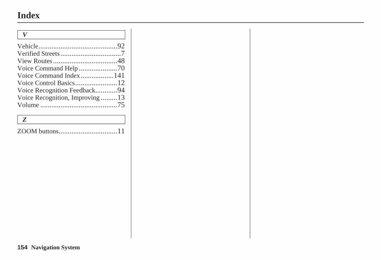
154 Navigation System
Index
V
Vehicle...........................................92Verified Streets .................................7View Routes ...................................48Voice Command Help .....................70Voice Command Index..................141Voice Control Basics.......................12Voice Recognition Feedback............94Voice Recognition, Improving .........13Volume ..........................................75
Z
ZOOM buttons................................11
Navigation System 155
License notice
You have acquired a device (“DEVICE”) that includes software licensed by ALPINE ELECTRONICS, INC., from an affiliate of Microsoft Corporation (collectively “MS”).Those installed software products of MS origin, as well as associated media, printed materials, and “online” or electronic documentation (“SOFTWARE”) are protected by international intellectual property laws and treaties. The SOFTWARE is licensed, not sold. All rights reserved.
IF YOU DO NOT AGREE TO THIS END USER LICENSE AGREEMENT (“EULA”), DO NOT USE THE DEVICE OR COPY THE SOFTWARE. INSTEAD, PROMPTLY CONTACT ALPINE ELECTRONICS,INC., FOR INSTRUCTIONS ON RETURN OF THE UNUSED DEVICE(S) FOR A REFUND. ANY USE OF THE SOFTWARE, INCLUDING BUT NOT LIMITED TO USE ON THE DEVICE, WILL CONSTITUTE YOUR AGREEMENT TO THIS EULA (OR RATIFICATION OF ANY PREVIOUS CONSENT).
GRANT OF SOFTWARE LICENSE. This EULA grants you the following license;
You may use the SOFTWARE only on the DEVICE.
NOT FAULT TOLERANT. THE SOFTWARE IS NOT FAULT TOLERANT. ALPINE ELECTRONICS, INC., HAS INDEPENDENTLY DETERMINED HOW TO USE THE SOFTWARE IN THE DEVICE, AND MS HAS RELIED UPON ALPINE ELECTRONICS, INC., TO CONDUCT SUFFICIENT TESTING TO DETERMINE THAT THE SOFTWARE IS SUITABLE FOR SUCH USE.
NO WARRANTIES FOR THE SOFTWARE. THE SOFTWARE is provided “AS IS” and with all faults. THE ENTIRE RISK AS TO SATISFACTORY QUALITY, PERFORMANCE, ACCURACY, AND EFFORT (INCLUDING LACK OF NEGLIGENCE) IS WITH YOU. ALSO, THERE IS NO WARRANTY AGAINST INTERFERENCE WITH YOUR ENJOYMENT OF THE SOFTWARE OR AGAINST INFRINGEMENT. IF YOU HAVE RECEIVED ANY WARRANTIES REGARDING THE DEVICE OR THE SOFTWARE, THOSE WARRANTIES DO
NOT ORIGINATE FROM, AND ARE NOT BINDING ON, MS.
No Liability for Certain Damages. EXCEPT AS PROHIBITED BY LAW, MS SHALL HAVE NO LIABILITY FOR ANY INDIRECT, SPECIAL, CONSEQUENTIAL OR INCIDENTAL DAMAGES ARISING FROM OR IN CONNECTION WITH THE USE OR PERFORMANCE OF THE SOFTWARE. THIS LIMITATION SHALL APPLY EVEN IF ANY REMEDY FAILS OF ITS ESSENTIAL PURPOSE. IN NO EVENT SHALL MS BE LIABLE FOR ANY AMOUNT IN EXCESS OF U.S.TWO HUNDRED FIFTY DOLLARS (U.S.$250.00).
Limitations on Reverse Engineering, Decompilation, and Disassembly. You may not reverse engineer, decompile, or disassemble the SOFTWARE, except and only to the extent that such activity is expressly permitted by applicable law notwithstanding this limitation.
Additional Software/Services. The SOFTWARE may permit ALPINE ELECTRONICS,INC.,, MS, Microsoft Corporation or their affiliates to provide or make available to you SOFTWARE updates, supplements, add-on components, or Internet-based services components of
156 Navigation System
the SOFTWARE after the date you obtain your initial copy of the SOFTWARE (“Supplemental Components”).
• If ALPINE ELECTRONICS,INC., provides or makes available to you Supplemental Components and no other EULA terms are provided along with the Supplemental Components, then the terms of this EULA shall apply.
• If MS, Microsoft Corporation or their affiliates make available Supplemental Components, and no other EULA terms are provided, then the terms of this EULA shall apply, except that the MS, Microsoft Corporation or affiliate entity providing the Supplemental Component(s) shall be the licensor of the Supplemental Component(s).
ALPINE ELECTRONICS,INC.,, MS, Microsoft Corporation and their affiliates reserve the right to discontinue any Internet-based services provided to you or made available to you through the use of the SOFTWARE.
RECOVERY MEDIA. If SOFTWARE is provided by ALPINE ELECTRONICS,INC., on separate media and labeled “Recovery Media” you may use the Recovery Media solely to restore or reinstall the SOFTWARE originally installed on the DEVICE.
SOFTWARE TRANSFER ALLOWED BUT WITH RESTRICTIONS. You may permanently transfer rights under this EULA only as part of a permanent sale or transfer of the Device, and only if the recipient agrees to this EULA. If the SOFTWARE is an upgrade, any transfer must also include all prior versions of the SOFTWARE.
EXPORT RESTRICTIONS. You acknowledge that SOFTWARE is of US-origin. You agree to comply with all applicable international and national laws that apply to the SOFTWARE, including the U.S. Export Administration Regulations, as well as end-user, end-use andcountry destination restrictions issued by U.S. and other governments.For additional information on exporting the SOFTWARE, see http://www.microsoft.com/exporting/.
As required by the FCC: This device complies with Part 15 of the FCC rules. Operation is subject to the following two conditions: (1) This device may not cause harmful interference, and (2) this device must accept any interference received, including interference that may cause undesired operation.
Changes or modifications not expressly approved by the party responsible for compliance could void the user’s authority to operate the equipment.
This device complies with Industry Canada Standard RSS-210.Operation is subject to the following two conditions: (1) this device may not cause interference, and (2) this device must accept any interference that may cause undesired operation of the device.