Embed Size (px)
Citation preview
3.0
The
Hist
oric
Dev
elop
men
t of R
edru
th
16 Redruth Conservation Area Appraisal and Management Strategy / March 2010 Alan Baxter
KEY:
Mining activity
Mining offices
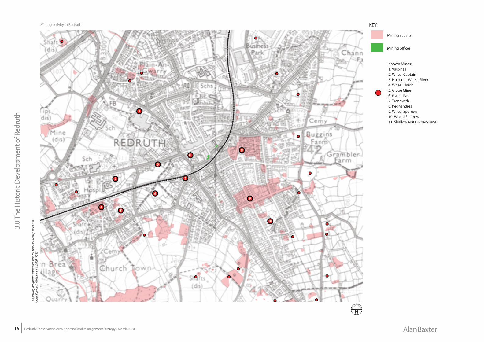
Mining activity in Redruth
Known Mines:1. Vauxhall2. Wheal Captain3. Hoskings Wheal Silver4. Wheal Union5. Globe Mine6. Gweal Paul7. Trengwith8. Pednandrea9. Wheal Sparrow10. Wheal Sparrow11. Shallow adits in back lane
This
dra
win
g in
corp
orat
es in
form
atio
n fro
m th
e Or
dnan
ce S
urve
y w
hich
is ©
Cr
own
Copy
right
. ABA
Lic
ence
: AL1
000
1754
7
17
3.0
The
Hist
oric
Dev
elop
men
t of R
edru
th
Redruth Conservation Area Appraisal and Management Strategy / March 2010Alan Baxter
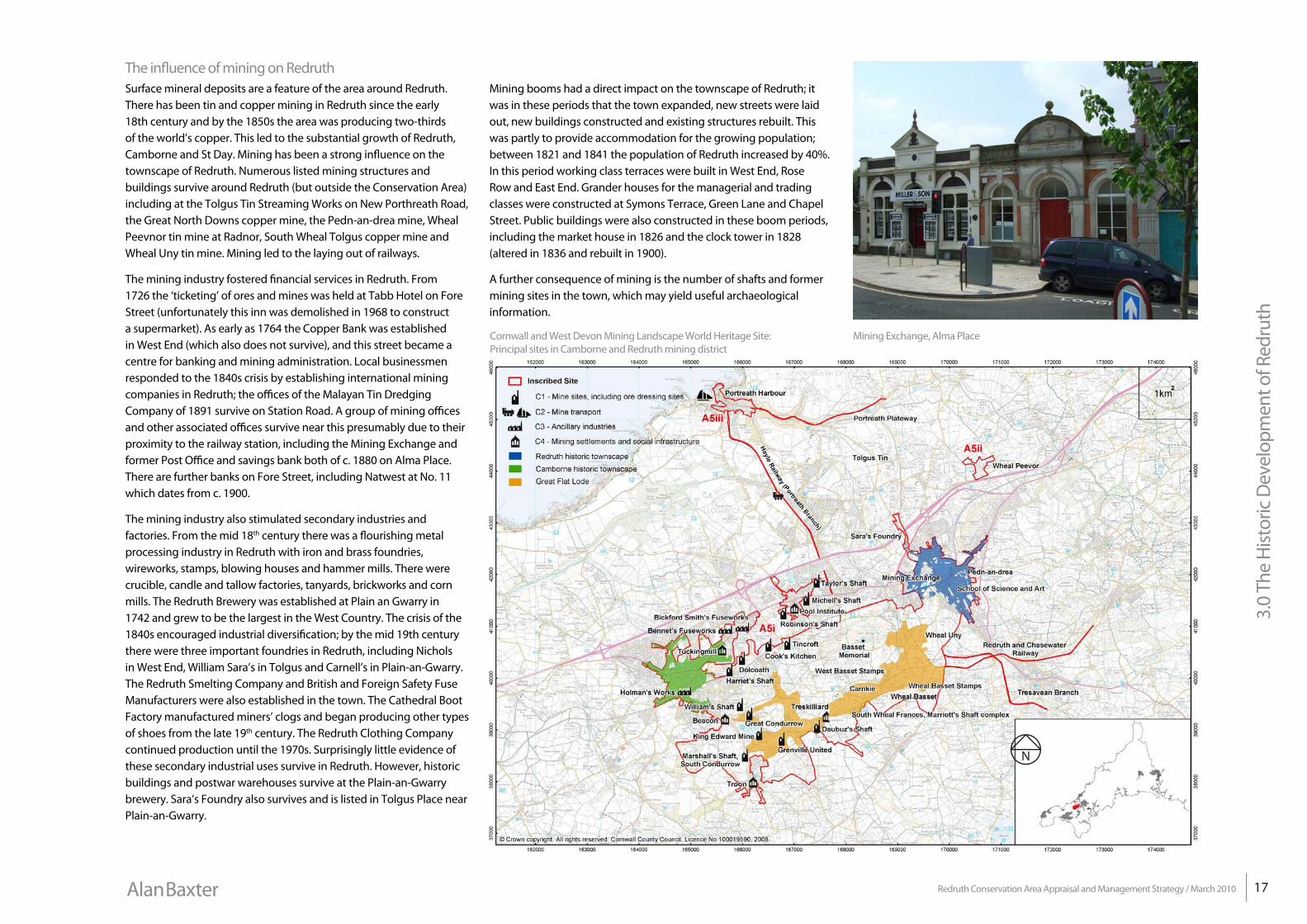
Cornwall and West Devon Mining Landscape World Heritage Site: Principal sites in Camborne and Redruth mining district
Mining booms had a direct impact on the townscape of Redruth; it was in these periods that the town expanded, new streets were laid out, new buildings constructed and existing structures rebuilt. This was partly to provide accommodation for the growing population; between 1821 and 1841 the population of Redruth increased by 40%. In this period working class terraces were built in West End, Rose Row and East End. Grander houses for the managerial and trading classes were constructed at Symons Terrace, Green Lane and Chapel Street. Public buildings were also constructed in these boom periods, including the market house in 1826 and the clock tower in 1828 (altered in 1836 and rebuilt in 1900).
A further consequence of mining is the number of shafts and former mining sites in the town, which may yield useful archaeological information.
The influence of mining on RedruthSurface mineral deposits are a feature of the area around Redruth. There has been tin and copper mining in Redruth since the early 18th century and by the 1850s the area was producing two-thirds of the world’s copper. This led to the substantial growth of Redruth, Camborne and St Day. Mining has been a strong influence on the townscape of Redruth. Numerous listed mining structures and buildings survive around Redruth (but outside the Conservation Area) including at the Tolgus Tin Streaming Works on New Porthreath Road, the Great North Downs copper mine, the Pedn-an-drea mine, Wheal Peevnor tin mine at Radnor, South Wheal Tolgus copper mine and Wheal Uny tin mine. Mining led to the laying out of railways.
The mining industry fostered financial services in Redruth. From 1726 the ‘ticketing’ of ores and mines was held at Tabb Hotel on Fore Street (unfortunately this inn was demolished in 1968 to construct a supermarket). As early as 1764 the Copper Bank was established in West End (which also does not survive), and this street became a centre for banking and mining administration. Local businessmen responded to the 1840s crisis by establishing international mining companies in Redruth; the offices of the Malayan Tin Dredging Company of 1891 survive on Station Road. A group of mining offices and other associated offices survive near this presumably due to their proximity to the railway station, including the Mining Exchange and former Post Office and savings bank both of c. 1880 on Alma Place. There are further banks on Fore Street, including Natwest at No. 11 which dates from c. 1900.
The mining industry also stimulated secondary industries and factories. From the mid 18th century there was a flourishing metal processing industry in Redruth with iron and brass foundries, wireworks, stamps, blowing houses and hammer mills. There were crucible, candle and tallow factories, tanyards, brickworks and corn mills. The Redruth Brewery was established at Plain an Gwarry in 1742 and grew to be the largest in the West Country. The crisis of the 1840s encouraged industrial diversification; by the mid 19th century there were three important foundries in Redruth, including Nichols in West End, William Sara’s in Tolgus and Carnell’s in Plain-an-Gwarry. The Redruth Smelting Company and British and Foreign Safety Fuse Manufacturers were also established in the town. The Cathedral Boot Factory manufactured miners’ clogs and began producing other types of shoes from the late 19th century. The Redruth Clothing Company continued production until the 1970s. Surprisingly little evidence of these secondary industrial uses survive in Redruth. However, historic buildings and postwar warehouses survive at the Plain-an-Gwarry brewery. Sara’s Foundry also survives and is listed in Tolgus Place near Plain-an-Gwarry.
Mining Exchange, Alma Place
3.0
The
Hist
oric
Dev
elop
men
t of R
edru
th
18 Redruth Conservation Area Appraisal and Management Strategy / March 2010 Alan Baxter
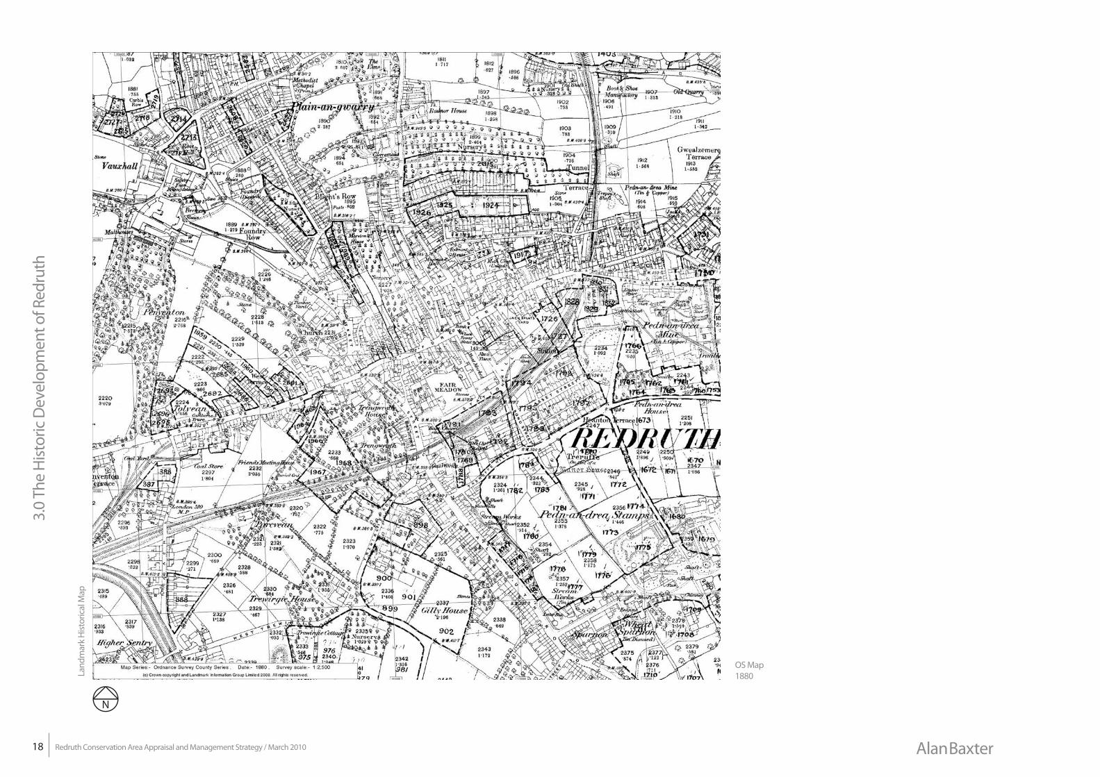
Landmark Historical MapPublished Date(s): 1880Originally plotted at: 1:2,500La
ndm
ark
Hist
oric
al M
ap
OS Map 1880
19
3.0
The
Hist
oric
Dev
elop
men
t of R
edru
th
Redruth Conservation Area Appraisal and Management Strategy / March 2010Alan Baxter
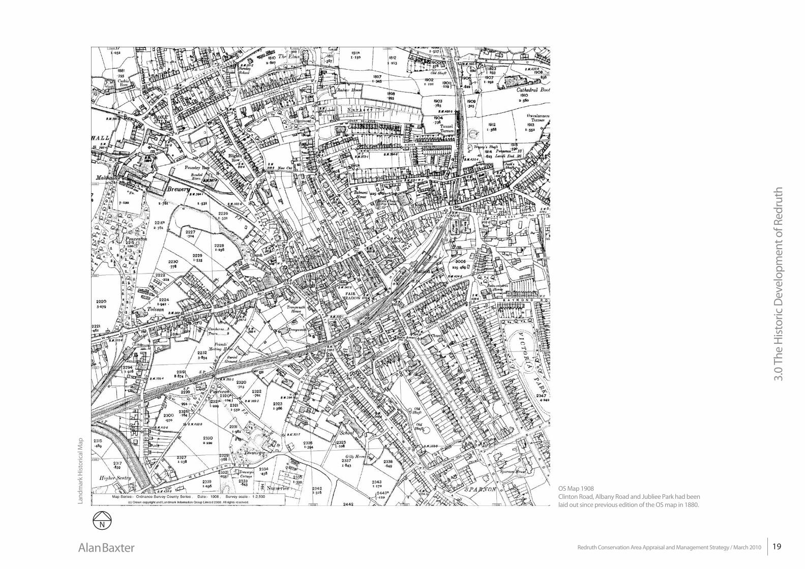
OS Map 1908Clinton Road, Albany Road and Jubliee Park had been laid out since previous edition of the OS map in 1880.La
ndm
ark
Hist
oric
al M
ap
Landmark Historical MapPublished Date(s): 1908Originally plotted at: 1:2,500
3.0
The
Hist
oric
Dev
elop
men
t of R
edru
th
20 Redruth Conservation Area Appraisal and Management Strategy / March 2010 Alan Baxter
Richard Trevithick (1771–1833)
Trevithick was born near Carn Brea, the son of a mine captain. His early career was spent building and modifying steam engines to avoid royalties on Watt’s separate condenser patent. Trevithick made an early demonstration of a moving steam engine in Fore Street, Camborne in 1801. He patented the
high-pressure steam engine in 1802. In 1803 he built the London Steam Carriage and drove it from Holborn to Paddington and back. Trevithick developed the use of his high-pressure steam engine on rails at the Pen-y-Darren ironworks in South Wales. This was showcased in London in 1808 with a locomotive called ‘Catch Me Who Can’ as part of a steam circus. In Cornwall Trevithick used his high-pressure steam engine to pump water from mines, for example at Wheal Prosper. Trevithick also took this technology to mines in Peru and Columbia.
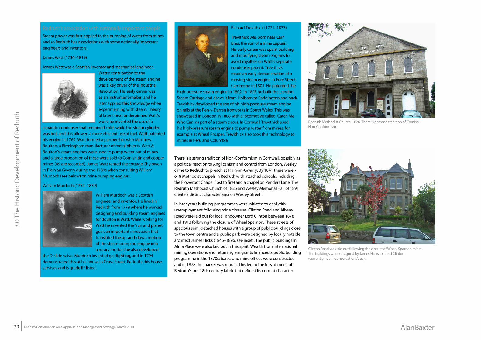
There is a strong tradition of Non-Conformism in Cornwall, possibly as a political reaction to Anglicanism and control from London. Wesley came to Redruth to preach at Plain-an-Gwarry. By 1841 there were 7 or 8 Methodist chapels in Redruth with attached schools, including the Flowerpot Chapel (lost to fire) and a chapel on Penders Lane. The Redruth Methodist Church of 1826 and Wesley Memorial Hall of 1891 create a distinct character area on Wesley Street.
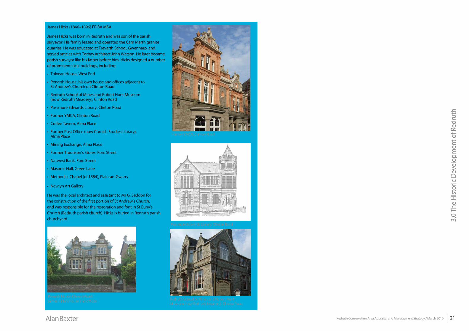
In later years building programmes were initiated to deal with unemployment following mine closures. Clinton Road and Albany Road were laid out for local landowner Lord Clinton between 1878 and 1913 following the closure of Wheal Sparnon. These streets of spacious semi-detached houses with a group of public buildings close to the town centre and a public park were designed by locally notable architect James Hicks (1846–1896, see inset). The public buildings in Alma Place were also laid out in this spirit. Wealth from international mining operations and returning emigrants financed a public building programme in the 1870s: banks and mine offices were constructed and in 1878 the market was rebuilt. This led to the loss of much of Redruth’s pre-18th century fabric but defined its current character.
Redruth’s association with nationally important peopleSteam power was first applied to the pumping of water from mines and so Redruth has associations with some nationally important engineers and inventors.
James Watt (1736–1819)
James Watt was a Scottish inventor and mechanical engineer. Watt’s contribution to the development of the steam engine was a key driver of the Industrial Revolution. His early career was as an instrument-maker, and he later applied this knowledge when experimenting with steam. Theory of latent heat underpinned Watt’s work: he invented the use of a
separate condenser that remained cold, while the steam cylinder was hot, and this allowed a more efficient use of fuel. Watt patented his engine in 1769. Watt formed a partnership with Matthew Boulton, a Birmingham manufacturer of metal objects. Watt & Boulton’s steam engines were used to pump water out of mines and a large proportion of these were sold to Cornish tin and copper mines (49 are recorded). James Watt rented the cottage Chylowen in Plain an Gwarry during the 1780s when consulting William Murdoch (see below) on mine pumping engines.
William Murdoch (1754–1839)
William Murdoch was a Scottish engineer and inventor. He lived in Redruth from 1779 where he worked designing and building steam engines for Boulton & Watt. While working for Watt he invented the ‘sun and planet’ gear, an important innovation that translated the up-and-down motion of the steam-pumping engine into a rotary motion; he also developed
the D-slide valve. Murdoch invented gas lighting, and in 1794 demonstrated this at his house in Cross Street, Redruth; this house survives and is grade II* listed.
Redruth Methodist Church, 1826. There is a strong tradition of Cornish Non-Conformism.
Clinton Road was laid out following the closure of Wheal Sparnon mine. The buildings were designed by James Hicks for Lord Clinton (currently not in Conservation Area).
21
3.0
The
Hist
oric
Dev
elop
men
t of R
edru
th
Redruth Conservation Area Appraisal and Management Strategy / March 2010Alan Baxter
James Hicks (1846–1896) FRIBA MSA
James Hicks was born in Redruth and was son of the parish surveyor. His family leased and operated the Carn Marth granite quarries. He was educated at Trevarth School, Gwennarp, and served articles with Torbay architect John Watson. He later became parish surveyor like his father before him. Hicks designed a number of prominent local buildings, including:
• Tolvean House, West End
• Penarth House, his own house and offices adjacent to St Andrew’s Church on Clinton Road
• Redruth School of Mines and Robert Hunt Museum (now Redruth Meadery), Clinton Road
• Passmore Edwards Library, Clinton Road
• Former YMCA, Clinton Road
• Coffee Tavern, Alma Place
• Former Post Office (now Cornish Studies Library), Alma Place
• Mining Exchange, Alma Place
• Former Trounson’s Stores, Fore Street
• Natwest Bank, Fore Street
• Masonic Hall, Green Lane
• Methodist Chapel (of 1884), Plain-an-Gwarry
• Newlyn Art Gallery
He was the local architect and assistant to Mr G. Seddon for the construction of the first portion of St Andrew’s Church, and was responsible for the restoration and font in St Euny’s Church (Redruth parish church). Hicks is buried in Redruth parish churchyard.
Penarth House, Clinton Road. James Hicks’s house and offices. Redruth School of Mines and Robert Hunt
Museum (now Redruth Meadery), Clinton Road
Passmore Edwards Library, Clinton Road
Former YMCA, Clinton Road
3.0
The
Hist
oric
Dev
elop
men
t of R
edru
th
22 Redruth Conservation Area Appraisal and Management Strategy / March 2010 Alan Baxter
Movement and the relationship with Portreath, Camborne and PoolAs has been explained, the dramatic topography of Redruth, formed by granite outcrops at Carn Brea and Carn Marth, has determined the location of historic roads and more recently of railways. The A3047 is a former turnpike of 1839 and the main east-west road through northern Cornwall. Penryn Street and Falmouth Road were also originally a turnpike road, as the names would suggest to Penryn and Falmouth, laid out in 1763. A bypass was constructed to the north of the town centre in 1939. The A30 was constructed later and acts as a bypass to Camborne, Pool and Redruth.
The railways around Redruth were originally developed to transport extracted ore and metal produced by the mining industry. The Porthreath Railway was the first to be laid out in 1809, between the copper mines around Redruth and Portreath harbour; this was extended to North Downs in 1812 and to Poldice in 1818. Local entrepreneur John Taylor was responsible for the construction of the Redruth Chasewater Railway in 1825, and this is evident on the tithe map of 1841. This was horsedrawn until 1855, after which two steam trains ‘Miner’ and ‘Smelter’ ran on the tracks; it closed in 1915.
In 1837 the Hayle Railway linked Hayle with Portreath via Redruth. The terminus and sidings of the Hayle Railway were on West End, and there were coal yards associated with this (outside the Conservation Area). The Hayle Railway was later acquired by the West Cornwall Railway in 1852, and then leased to the Great Western Railway from 1866.
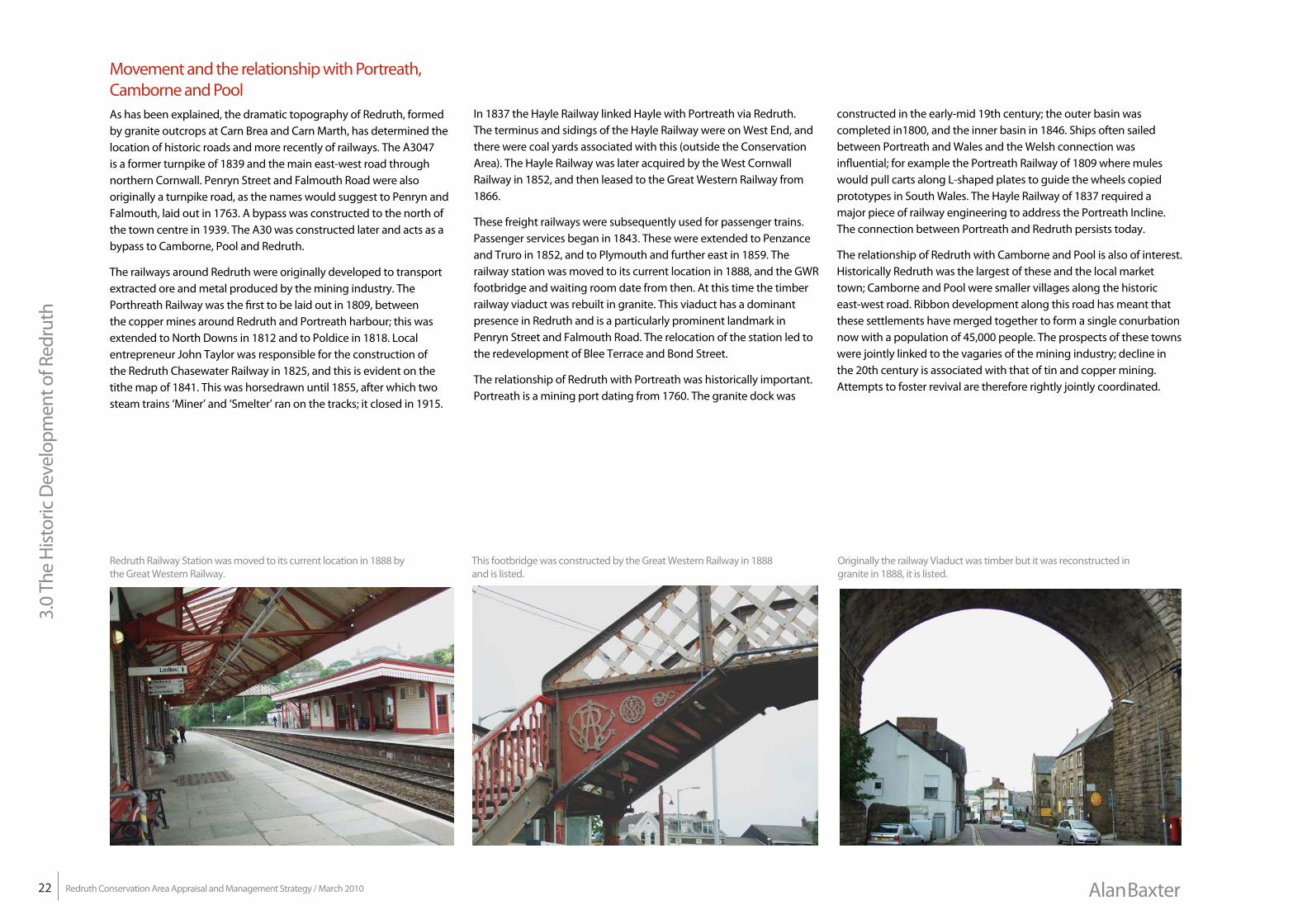
These freight railways were subsequently used for passenger trains. Passenger services began in 1843. These were extended to Penzance and Truro in 1852, and to Plymouth and further east in 1859. The railway station was moved to its current location in 1888, and the GWR footbridge and waiting room date from then. At this time the timber railway viaduct was rebuilt in granite. This viaduct has a dominant presence in Redruth and is a particularly prominent landmark in Penryn Street and Falmouth Road. The relocation of the station led to the redevelopment of Blee Terrace and Bond Street.
The relationship of Redruth with Portreath was historically important. Portreath is a mining port dating from 1760. The granite dock was
constructed in the early-mid 19th century; the outer basin was completed in1800, and the inner basin in 1846. Ships often sailed between Portreath and Wales and the Welsh connection was influential; for example the Portreath Railway of 1809 where mules would pull carts along L-shaped plates to guide the wheels copied prototypes in South Wales. The Hayle Railway of 1837 required a major piece of railway engineering to address the Portreath Incline. The connection between Portreath and Redruth persists today.
The relationship of Redruth with Camborne and Pool is also of interest. Historically Redruth was the largest of these and the local market town; Camborne and Pool were smaller villages along the historic east-west road. Ribbon development along this road has meant that these settlements have merged together to form a single conurbation now with a population of 45,000 people. The prospects of these towns were jointly linked to the vagaries of the mining industry; decline in the 20th century is associated with that of tin and copper mining. Attempts to foster revival are therefore rightly jointly coordinated.
Redruth Railway Station was moved to its current location in 1888 by the Great Western Railway.
This footbridge was constructed by the Great Western Railway in 1888 and is listed.
Originally the railway Viaduct was timber but it was reconstructed in granite in 1888, it is listed.