Embed Size (px)
Citation preview

Perjymon Compurers & Geosciences Vol. 22, No. 10, pp. 1123-I 131, 1996
Copyright 0 1996 Elsevier Science Ltd
PII: soo!M-3004(%)ooo56-8 Printed in Great Britain. All rights reserved
0098-3004/96 $15.00 + 0.00
A COMPUTATIONAL ENVIRONMENT FOR THE MANAGEMENT, PROCESSING, AND ANALYSIS OF
GEOLOGICAL DATA
MATTHEW 0. WARD,’ WILLIAM L. POWER,’ and PETER KETELAAR*
‘Computer Science Department, Worcester Polytechnic Institute, Worcester, MA 01609, and *Fractal Graphics, CSIRO Division of Exploration and Mining, P.O. Box 437, Nedlands,
Western Australia, 6009, Australia (e-mail: [email protected])
(Received I5 February 1996; revised 19 June 1996)
Abstract-The complexity and diversity of data and processing now being used in geoscientific data analysis are increasing at such a pace that it is difficult to maintain a single software package capable of performing all required tasks. A typical solution is to use a number of commercial software packages loosely linked via file format conversion routines or other customized communication paths. Creating and maintaining these paths is made difficult by both the number of distinct packages being used and the evolutionary changes taking place within each package. In this paper we attempt to create a generic model for a geological data processing task, identify some of the difficulties involved in performing these tasks using current technology, and outline a computational architecture that may correct many of the deficiencies of existing technology. Our goal is not to provide a detailed design but to present some key issues and possible solutions as a foundation for discussion and investigation. Copyright 0 1996 Elsevier Science Ltd
Key Words: Computational environments, Database management, Distributed processing, Meta-data.
Introduction
Geoscientists are becoming increasingly dependent on computational support for both the analysis of data and the simulation of geological processes. Accordingly, a plethora of computer programs for use in geoscientific data collection, storage, and analy- sis have been developed. Throughout this paper the term Application Software Package (ASP) refers to any software system designed to solve computational problems in one or more domains. Most ASPS are comprised of a set of smaller modules (functions or subroutines) that the user invokes in sequence on his or her datasets. We refer to these modules as Data Manipulation Operators, or simply operators. Additional terms frequently used include “experiment” or “procedure”, a sequence of oper- ators applied to one or more datasets to produce a clearly defined result. An example of an experiment might be to perform ore grade estimation on a par- ticular dataset using a specified sequence of operators.
The computational environment for an individual user can be defined as all ASPS and datasets that may be applied to solving a given set of problems. Our examination of the typical computational en- vironment in use today by geoscientists has resulted in the following observations.
l Geology and geophysics are information intensive; that is, many types of information
are needed to solve problems. Much of the data are file-based, creating difficulty in keep- ing track of specific data as the volume of data increases. Another significant problem is that the required data may be distributed over a number of computers. Geological and geophysical data analysis is growing in complexity. Effectively using all the ASPS available to accomplish a task (or even keeping track of those available for a particular task within a single organization) is difficult. Frequent changes in data and analysis methods create a significant problem in main- taining a computational environment that is sufficiently flexible to accommodate frequent modifications. Developing and maintaining a single software package to meet these rapidly evolving needs has become labor intensive. Frequently, users rely on a range of software products. More users rely on distributed, networked, nonhomogeneous computation facilities to perform routine tasks, because it is often diffi- cult to find the required ASPS on a single computer. Though many ASPS have been designed specifically for geological investigations, others have been adapted from other disciplines and
1123
1124 M. 0. Ward, W. L. Power, and P. Ketelaar
do not consider the special needs of the geos- ciences.
Computational support in geology consists predomi- nantly of an assortment of stand-alone ASPS for data analysis, collection, storage, visualization, and report generation, each with its own database and/ or data file formats (Bellotti and Dershowitz, 1991). Creation of a single ASP to support the changing needs of users has become impossible, and most users now realize the importance of interoperability among ASPS to accomplish distinct components of larger tasks. This need for interoperability often is managed through customized data transfer proto- cols, where special code is written to link each pair of application programs. The problems with this approach include the following:
Extensibility. The number of linkages needed may approach N2, where N is the number of ASPS being interfaced. This becomes a serious problem as N increases. While standardization of data formats reduces this problem, software developers have shown reluctance to adopt these standards. A simple method is needed to enhance incrementally the functionality of a system by integrating new ASPS and data sources.
Maintainability. Each time one of the application programs is modified, N - 1 modifications of the interfaces to the other applications may be required.
Usability. Effective use of each ASP generally requires user expertise. As N increases it becomes difficult for users to achieve the required level of knowledge for each ASP.
Consistency. Typically, each ASP works in differ- ent ways, providing different levels of sophistication in its user interface, different degrees of user assist- ance, and different methods of task invocation. Op- timal selection and use of an algorithm within an ASP may require assistance from an expert.
There is a research project under way at the CSIRO Divisions of Information Technology and Exploration and Mining (Ward and others, 1994) to design a computational environment for geological data analysis that alleviates some of the problems mentioned previously. Our goals in this paper are the following:
(1) To generalize the process of geological data processing using detailed scenarios.
(2) To present a framework for a cohesive,
(3)
extensible computation and information man- agement environment. This would consist of a central scheme for the description and rep- resentation of data and operators; an infor- mation management system (covering data, operators, data manipulation procedures, and auxiliary information); linkages to existing analysis, display, and report generation ASPS; and a visual interface for browsing available data, operators, procedures, and ex- periments, specifying and invoking queries and data analysis tasks, and interactively editing data and generating reports. To illustrate the usefulness of this framework by replaying the geological data analysis scenarios mentioned earlier assuming the existence of this framework.
EXAMPLES OF GEOLOGICAL DATA ANALYSIS TASKS
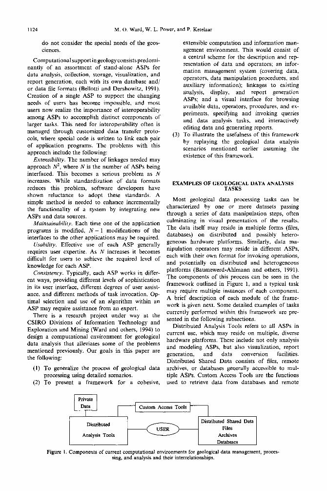
Most geological data processing tasks can be characterized by one or more datasets passing through a series of data manipulation steps, often culminating in visual presentation of the results. The data itself may reside in multiple forms (files, databases) on distributed and possibly hetero- geneous hardware platforms. Similarly, data ma- nipulation operators may reside in different ASPS, each with their own format for invoking operations, and potentially on distributed and heterogeneous platforms (Baumewerd-Ahlmann and others, 1991). The components of this process can be seen in the framework outlined in Figure 1, and a typical task may require multiple instances of each component. A brief description of each module of the frame- work is given next. Some detailed examples of tasks currently performed within this framework are pre- sented in the following subsections.
Distributed Analysis Tools refers to all ASPS in current use, which may reside on multiple, diverse hardware platforms. These include not only analysis and modeling ASPS, but also visualization, report generation, and data conversion facilities. Distributed Shared Data consists of files, remote archives, or databases generally accessible to mul- tiple ASPS. Custom Access Tools are the functions used to retrieve data from databases and remote
Private
Custom Access Tools
Distributed
Analysis Tools
Distributed Shared Data Files
Archives Databases
Figure 1. Components of current computational environments for geological data management, proces- sing, and analysis and their interrelationships.
Management, processing and analysis of geological data 1125
1 1 =Software (ASP)
( ) =Files or Data
2-D CAD SOFTWARE String/ 0 Point
Files
Hard-copy Input
etc.
3-D CAD SOFTWARE
CstringlpointFiles)
(Wireframes)
(x&Z-)
/
I Soft-copy Input
Geopbsics StringIPolyline Drilling Geochemistry
Data Disks or Tapes
(plots)( Triangulations Grid Meshes
Block Models
GENERIC VISUALIZATION SOFTWARE Screen
Dumps Postscript P
Printer
Film
Plotter
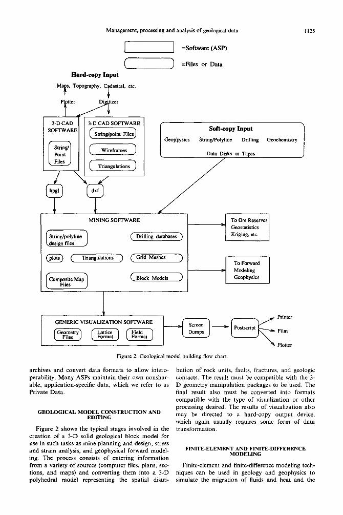
Figure 2. Geological model building flow chart
archives and convert data formats to allow intero- perability. Many ASPS maintain their own nonshar- able, application-specific data, which we refer to as Private Data.
GEOLOGICAL MODEL CONSTRUCTION AND EDITING
Figure 2 shows the typical stages involved in the creation of a 3-D solid geological block model for use in such tasks as mine planning and design, stress and strain analysis, and geophysical forward model- ing. The process consists of entering information from a variety of sources (computer files, plans, sec- tions, and maps) and converting them into a 3-D polyhedral model representing the spatial distri-
bution of rock units, faults, fractures, and geologic contacts. The result must be compatible with the 3- D geometry manipulation packages to be used. The final result also must be converted into formats compatible with the type of visualization or other processing desired. The results of visualization also may be directed to a hard-copy output device, which again usually requires some form of data transformation.
FINITE-ELEMENT AND FINITEDIFFERENCE MODELING
Finite-element and finite-difference modeling tech- niques can be used in geology and geophysics to simulate the migration of fluids and heat and the
1126 M. 0. Ward, W. L. Power, and P. Ketelaar
deformation of rock materials (including stresses
and strains in rock). A frequent requirement of all
finite-element or finite-difference techniques is dis-
cretization of the problem domain, usually into tet-
rahedral or hexahedral (brick-like) finite elements or finite-difference zones. In fluid flow and geotechnical
applications, it is common practice also to utilize
surface discretizations of fractures or frictional
interfaces. This discretization, however, is unlike
voxels or mine block models, because the orien-
tations and positions of the interfaces between the
different rock units can be of critical importance to
fluid flow, mechanical deformation, or frictional
sliding. The normal procedure involves using custo-
mized software to create the mesh, usually with sig-
nificant user input via mouse or keyboard. The
resulting mesh is usually an equivalent, although in
some cases simplified, version of the initial 3-D
solid geology. Simulations of transport or defor-
1 C 1
mation are performed, using the discretization.
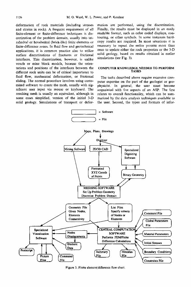
Finally, the results must be displayed in an easily readable format, such as color coded displays, con- touring, or other symbols. In some instances hard- copy results are required. In most situations it is necessary to repeat the entire process more than once to update either the rock properties or the 3-D solid geology, based on results obtained in earlier simulations (see Fig. 3).
COMPUTER KNOWLEDGE NEEDED TO PERFORM TASKS
The tasks described above require extensive com- puter expertise on the part of the geologist or geo- physicist. In general, the user must become
acquainted with five aspects of an ASP. The first relates to overall functionality, which can be sum- marized by the data analysis techniques available to the user. Second, the types and formats of infor-
= Software
= File
ps, Plans, Drawings
Specialized Digitizing Software
v Formatted XYZ Coords of Points
1 MESHING SOFIWARE Set Up Problem Geometry
Discretise Problem Domain
Geometry File List Files Specify subsets of Nodes or
Global Parameters
Visualization 4 SOFTWARE Performs F&Wink Difference Calculations
1 ““WM~p
I I& \ I Summary I ( Histories 1 \ \ Bou - (File J
Figure 3. Finite element/difference flow chart.
Management, processing and analysis of geological data 1127
mation that can be processed by the ASP are described by the geological data structures used and the geological interpretation of the data within these structures. We refer to this component as the Data Structure and Semantics (DSS). Third, the Operator Structure and Semantics (0%) specifies the protocol (e.g. input and output parameters) for invoking a Data Manipulation Operator and the contextual meaning of the operation. Fourth, the Human- Computer Interface specifies the communication possible between the user and the ASP, and permits the user to invoke operators, interact with executing operators, and examine results (generally in a graphical fashion). Finally, some form of infor- mation management is required, as the data to be used by the ASP may reside in many forms, includ- ing files, remote archives, and databases.
If we consider the ramifications of interoperability between ASPS, the characteristics of data being applied to solving problems (distributed, diverse for- mats), and the growing complexity of data analysis tasks, the demands on the user become formidable:
Data formats, and access methods. Current geos- cientific data analysis is performed predominantly in a file-driven mode; users are responsible for tracking the content, format, and location of potentially hun- dreds of data files. A single experiment may involve the creation and naming of several files for com- munication between operators. Some of these files are transient and need to be removed, others are useful as input to other tasks. Maintaining knowl- edge of what processes a given file has been sub- jected to usually is left to the user. Data also may be stored in remote archives or databases, which requires additional knowledge to retrieve data and store the results.
Data conversion techniques. Users must be fam- iliar with programs that convert data between differ- ent formats. Each format transformation may result in the loss or modification of information, a fact that often is lost in the life cycle of a dataset.
Functionality of data manipulation operators. Users must know what task each operator within an ASP can perform. Unfortunately, these operators often are identified solely by some cryptic, abbre- viated name, and it is the responsibility of the user to match this name with the task the operator per- forms via on-line or (more frequently) hard-copy manual pages.
Format for operator input and output parameters. Each operator accepts input and generates output of a certain format. The user must verify that input has been specified appropriately and that output is interpreted correctly for each operator invoked.
Procedures for using each operator. The structure of the command to invoke a given operator differs widely, both between ASPS and within a single ASP. Knowledge of parameter order, valid ranges for numeric parameters, and interdependencies between parameters is required of the user.
Procedure for using the ASP that contains each op- erator. Each ASP has its own user interface, includ- ing command-line task specification, simple menu structures, and elaborate graphical front-ends. Each interface assumes a certain level of knowledge and provides differing degrees of assistance/error hand- ling.
Procedure for using systems containing data and ASPS involved. Currently, geoscientists employ mul- tiple computer hardware (PCs, workstations, main- frames) and operating system (DOS, UNIX, Mac- OS, VMS) platforms in performing data analysis, requiring not only some level of proficiency in using these systems, but also knowledge about transfer- ring data between machines.
Reproducing complex sequences of operations. Often the user must remember a potentially compli- cated series of operations, creating and naming in- termediate data repositories along the way and hoping that no step has been forgotten. A frequent problem with complex tasks is reproducing exactly the steps taken to generate a result. Simple note taking is often the only documentation of a pro- cedure.
The term used to describe much of the infor- mation or knowledge above is metadata, or data about data or tasks (Bretherton and Singley, 1994). Metadata may be as simple as a file header indicat- ing characteristics of the data within the file, such as spatial extents, time of acquisition, method of ac- quisition, and so on. Other more complex metadata may include format information, instructions on using data or operators, or the sequence of proces- sing stages that produced a result. Most metadata in scientific data processing currently resides either in the minds of the users or as user-generated text files. This substantial burden on the user could be eased by introducing a computational framework such as the one outlined in the next section.
PROPOSED STRUCTURE FOR A COMPUTATIONAL ENVIRONMENT
The critical aspects of a software architecture that potentially could meet the needs of the various com- ponents of geological and geophysical data analysis and modeling include the following:
Extensible data structure and semantics (DSS). The type, structure, semantics, and interrelation- ships of data being used to solve problems is con- stantly evolving, thus necessitating extensibility.
Extensible operator structure and semantics (OSS). New ASPS and operators are appearing in the literature and on the market daily. A mechan- ism is needed to facilitate incorporation of these into a user’s work environment.
Context sensitivity. Tasks and information should be accessible in a manner natural to the geoscientist. The user should not be interacting with bits and bytes, but functional modules and geologically
1128 M. 0. Ward, W. L. Power, and P. Ketelaar
labeled information. The data and ASPS available to a particular user also can be limited based on the task at hand.
Intuitive user interface. The complexity and diver- sity of software (and hardware) indicate a need for an interface that frees users from low-level details. Visual point-and-click interfaces and graphical in- formation presentation have been shown to provide effective front-ends to complex analysis.
Experiment management. A mechanism is needed to provide high-level creation, execution, modifi- cation, and documentation of scientific procedures and the data to which they are being applied.
Metadata management. Metadata associated with data, operators, and experiments must be managed.
MODULE DESCRIPTIONS
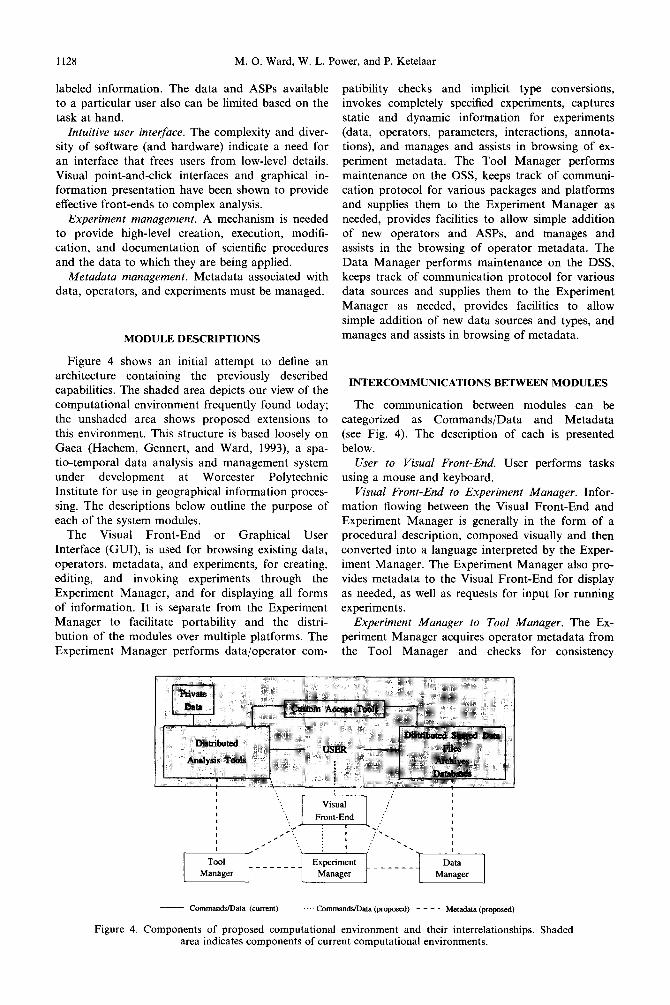
Figure 4 shows an initial attempt to define an architecture containing the previously described capabilities. The shaded area depicts our view of the computational environment frequently found today; the unshaded area shows proposed extensions to this environment. This structure is based loosely on Gaea (Hachem, Gennert, and Ward, 1993), a spa- tio-temporal data analysis and management system under development at Worcester Polytechnic Institute for use in geographical information proces- sing. The descriptions below outline the purpose of each of the system modules.
The Visual Front-End or Graphical User Interface (GUI), is used for browsing existing data, operators, metadata, and experiments, for creating, editing, and invoking experiments through the Experiment Manager, and for displaying all forms of information. It is separate from the Experiment Manager to facilitate portability and the distri- bution of the modules over multiple platforms. The Experiment Manager performs data/operator com-
patibility checks and implicit type conversions, invokes completely specified experiments, captures static and dynamic information for experiments (data, operators, parameters, interactions, annota- tions), and manages and assists in browsing of ex- periment metadata. The Tool Manager performs maintenance on the OSS, keeps track of communi- cation protocol for various packages and platforms and supplies them to the Experiment Manager as needed, provides facilities to allow simple addition of new operators and ASPS, and manages and assists in the browsing of operator metadata. The Data Manager performs maintenance on the DSS, keeps track of communication protocol for various data sources and supplies them to the Experiment Manager as needed, provides facilities to allow simple addition of new data sources and types, and manages and assists in browsing of metadata.
INTERCOMMUNICATIONS BETWEEN MODULES
The communication between modules can be categorized as Commands/Data and Metadata (see Fig. 4). The description of each is presented below.
User to Visual Front-End. User performs tasks using a mouse and keyboard.
Visual Front-End to Experiment Manager. Infor- mation flowing between the Visual Front-End and Experiment Manager is generally in the form of a procedural description, composed visually and then converted into a language interpreted by the Exper- iment Manager. The Experiment Manager also pro- vides metadata to the Visual Front-End for display as needed, as well as requests for input for running experiments.
Experiment Manager to Tool Manager. The Ex- periment Manager acquires operator metadata from the Tool Manager and checks for consistency
__ Commands/Data (current) -. -. CommandsfLhta (propod) - - - - Metadata (proposed)
Figure 4. Components of proposed computational environment and their interrelationships. Shaded area indicates components of current computational environments.

Management, processing and analysis of geological data 1129
between the selected operators and data. It also acquires the necessary communication protocol for
operator execution. Experiment Manager to Data Manager. The Ex-
periment Manager acquires metadata about data from the Data Manager and checks for consistency between the selected operators and data. It also acquires the necessary communication protocol for data retrieval and formatting.
Experiment Manager to Distributed Shared Data. The Experiment Manager retrieves and formats data as required by the specified experiment based on the protocol passed from the Data Manager.
Experiment Manager to Distributed Multi-Plat- form Analysis Tools. The selected operators are invoked by the Experiment Manager with the proto- col retrieved from the Tool Manager, passing requests for interaction from the operator to the Visual Front-End. Information from the user is passed to the operator requesting it.
Visual Front-End to Tool and Data Managers. It might be useful for the Visual Front-End to be able to access the Tool and Data Managers directly when performing browsing tasks, as the Experiment Manager is not needed for this.
Tool Manager to Distributed Multi-Platform Analysis Tools. The Tool Manager must track the availability of operators.
Data Manager to Distributed Shared Data. The Data Manager must track the availability of data.
PERFORMING GEOLOGICAL DATA ANALYSIS TASKS WITH THE PROPOSED COMPUTATIONAL
ENVIRONMENT
Returning to our examples of geological data analysis, and now assuming the existence of the pro- posed architecture, the first major difference the user would notice is the elimination of boundaries between ASPS. The appearance would be as if a single ASP had enveloped the functionality of all ASPS linked to the Tool Manager, even though each ASP could in fact be executing on a different computer. A procedure such as 3-D solid geology model creation might already exist as an experiment (which the user could execute with different data- sets), or the task may be interactively specified by functional components (vectorization, visualization, interactive specification of surfaces and volumes) and flow of data between operators.
Metadata associated with each operator would be presented to the user to verify the appropriateness of the operator for the desired task. Alternative op- erators might be queried and selected to replace any operator deemed suboptimal by the user. For example, in finite-element modeling different mesh generation operators could be substituted until the best results were obtained.
Input data for an experiment would be specified, not by a file name, but by attributes of the desired
information. The user could specify the geographi-
cal region of interest (e.g. a section of a particular
mine), a temporal constraint, if applicable, and the
data type (e.g. radiometrics, drill hole data, or geo- physical rock properties). The user could be totally
unaware of the location or format of the data.
Any data format conversion necessary to make
the retrieved data compatible with the selected oper- ator would be inserted into the procedure automati-
cally by the Experiment Manager (if conversion
operators didn’t exist, the user would be prompted
to modify the data or operator selected). Inputing a
mine block model into a forward modeling operator might invoke automatically a voxelation operator.
Intermediate data and final results would be stored
along with metadata describing the process that cre-
ated it. Users would have the option of discarding
them or storing them permanently. Stored data
would be classified by the user to facilitate future
retrieval.
Metadata associated with a dataset also could be browsed by the user to understand better what data are available as well as the origins and modification
history of the data. Understanding how a dataset
was created and processed is important both for
validation and for the generation of additional data
with similar characteristics.
With the proposed architecture much of the com-
puter knowledge required previously becomes
encapsulated into the computational environment in
the following fashion (referring to the list of the sec-
tion entitled “Computer Knowledge Needed to Perform Tasks”):
Data formats semantics and accessing methods. Data to be used or created is specified by its seman-
tics (meaning), not by its format or location. The Data Manager holds the metadata necessary to
acquire data. The user would request data by speci-
fying its spatial and temporal extents and data type. Data conversion techniques. When the format of a
dataset is incompatible with the selected operator,
the Experiment Manager will insert conversion op- erators, and tbc metadata associated with the result-
ing data object will be updated to reflect this stage.
Parameters to this conversion will be selected by the
Experiment Manager, although the user may wish to override some or all of the selections.
Functionality of data maniptdation operators. The Tool Manager presents the user with classes of op-
erators based on their abstract functionality and the
types of data they routinely operate upon. Oper- ators from ASPS with similar functionality will appear in the same class. For example, a class of functionally related operators would be 3-D interp- olation algorithms from one or more distinct ASPS.
Implementation details for specific algorithms are available as metadata through the Tool Manager to
help users select appropriate operators.
1130 M. 0. Ward, W. L. Power, and P. Ketelaar
Format for operator input and output parameters. Users are prompted for appropriate numbers of input data, which are further specified using the data browser. Low-level details of data formats are hidden from users. Output datasets are created by the operator and the metadata associated with them are inserted automatically.
Procedure for using each operator. Commands for invoking each operator are contained in the Tool Manager, so that the location of each operator and what ASP it is part of is hidden from the user. Ad- ditional user input is requested through context-sen- sitive prompts in a consistent fashion.
Procedure for using ASP containing each operator. The user does not require knowledge of the ASP in use, though he/she can specify a particular operator in a particular ASP if desired.
Procedure for using systems containing data and ASPS involved. The user has a single interface to the system, and thus does not require knowledge of oper- ating system calls, file system formats, and so on.
Reproducing complex sequences of operations. Details of the data and operators used in an exper- iment are captured automatically as metadata, per- mitting reproduction of the results as well as reuse of an experiment with modification in the data or operators used.
RELATED WORK
Besides the Gaea Project (Hachem, Gennert, and Ward, 1993), there are a number of efforts under way to improve the management of large volumes of distributed scientific data and integrate this data with existing ASPS. Some of the projects most perti- nent to our work are identified below.
l A design for an information management sys- tem for the mining industry is described in (Baumewerd-Ahlmann and others, 1991), that integrates diverse forms of mining data into a single database and provides conversion rou- tines to allow the processing and display of data using a variety of existing ASPS.
l Alexandria is a project under way at the University of California, Santa Barbara with the goal of developing a geographically dis- persed virtual library that attempts to elimin- ate the distinction between different types of stored data, allowing access to maps, images, and text with equal ease. The focus is mainly on data storage and access, and not on the processes that generate and manipulate the data (Dozier and others, 1994).
l The QUEST project (Mesrobian and others, 1994) is focused on providing content-based access to large Grand Challenge datasets. The main issues are permitting user queries at an appropriate level of abstraction, natural user interaction, and the application of massively
parallel processors. The approach employs statistical techniques to extract relevant fea- tures defined over a spatio-temporal extent and uses these features as database indices. Sequoia 2000 (Stonebraker, 1994) has a goal of furthering climate research by making large datasets more accessible. A large part of this work involves high-performance storage sys- tems and network design to improve the man- agement and access speed for distributed datasets. TSIMMIS (Chawathe and others, 1994) is a research project at Stanford University that is aimed primarily at developing language sup- port for heterogeneous systems, focusing on declarative and semi-declarative languages and query optimization techniques for these languages. Another related research area is in datasets that describe themselves.
SUMMARY
We have analyzed the computational and infor- mation management needs of geoscientists and com- pared these needs to available technology. We have identified key shortcomings in current geoscientific data analysis practices and have proposed an abstract design for a computational architecture which, we believe, is well suited to addressing these missing features. The key concepts of the proposed architecture include: (1) a consistent and intuitive user interface; (2) management of data, data analy- sis operators, and experiments; (3) maintenance of metadata for each of these components; and (4) interoperability among diverse data sources and Application Software Packages.
The trend is to rely on several application packages, data types, and storage mechanisms to solve increasingly complex problems. By encapsulat- ing the details of interoperability within the compu- tational system, the user is relieved of the need to maintain this knowledge. By capturing the essence of complicated experiments for later validation and modification, data analysis procedures are facili- tated. By incorporating within the system as much information as possible about the data and ASPS available to users, we hope to create a more power- ful architecture for solving geoscientific problems.
Acknowledgments-The authors wish to thank the large number of people within the CSIRO Divisions of Information Technology and Exploration and Mining who have contributed to the evolution of this paper.
REFERENCES
Baumewerd-Ahlmann, A., Cremers, A. B., Kruger, G., Leonhardt, J., Plumer, L., and Waschkowski, R., 1991,
Management, processing and analysis of geological data 1131
An information system for the mining industry, in Karagiannis, D., ed., Proc. Database and Expert Systems Applications (DEXA ‘91), September 1991, Berlin: Springer-Verlag, Berlin, p. 8691.
Bellotti, M. J., and Dershowitz, W., 1991, Hydrogeo- logical investigations: data and information manage- ment,: Computers & Geosciences, v. 17, no. 8 , p. 1119~1136.
Bretherton, F. P., and Singley, P. T., 1994, Metadata: a user’s view: Proc. 7th Intern. Working Conf. on Scientific and Statistical Database Management, September 1994, Charlottesville, VA, p. 166174.
Chawathe, S., Garcia-Molina, H., Ireland, K., Papakonstantinou, Y., Ullman, J., and Widom, J., 1994, The TSIMMIS project: integration of hetero- geneous information sources: Proc. Inform. Process. Sot. Japan, PSJ Conference, October 1994, Tokyo, Japan, p. 7-18.
Dozier, J., Goodchild, M. F., Ibarra, O., Mitra, S., Smith, T. M., Agrawal, D., El Abbadi, A., and Frew, J., 1994, Towards a distributed digital library with comprehen- sive services for images and spatially-referenced infor-
mation: Proposal to NSF Digital Libraries Initiative, available as http://alexandria.sdc.ucsb.edu/public-docu- ments/proposal/Omain.html.
Hachem, N., Gennert, M. and Ward, M., 1993, The Gaea system: a spatio-temporal database system for global change studies: Proc. Am. Assoc. Advan. Sci., Annual Meethrg, February 1993, Boston, p. S&89.
Mesrobian, E.. Muntz. R. R.. Shek, E. C., Mechoso, C. R., Farrara, J. D., and Stolorz, P., 1994, QUEST: con- tent-based access to geophysical databases: Proc. Am. Assoc. Artificial. Intel. Workshop, AI Techniques for Environmental Applications: July 1994, Seattle, Washington, 9 p.
Stonebraker, M., 1994, Sequoia 2000-a reflection on the first three years: 7th Intern. Working Conf. on Scientific and Statistical Database Management, September 1994, Charlottesville, VA, p. 108-l 16.
Ward, M., Lin, T., Kravis, S., and Lamb, P., 1994, A con- ceptual design for a computational environment for geological data analysis and management: CSIRO Division of Information Technology, Technical Report TR-HJ-94-06, 24 p.