Embed Size (px)
Citation preview
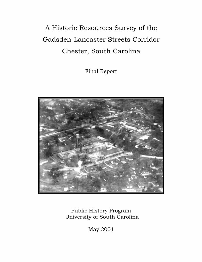
A Historic Resources Survey of the
Gadsden-Lancaster Streets Corridor
Chester, South Carolina
Final Report
Public History Program University of South Carolina
May 2001
A Historic Resources Survey of the
Gadsden-Lancaster Streets Corridor
Chester, South Carolina
Final Report
Prepared for
The City of Chester
Prepared by
Ginger Berni, Bryan Collars, Katie Eichler, Melissa Hess, Amanda Lee, and Wynne Overton
Public History Program University of South Carolina
Columbia, SC 29208
Acknowledgments
A successful architectural survey necessarily draws upon the support of many people.
This survey of the Gadsden-Lancaster Streets corridor has benefited from the help of many
individuals and organizations in both Chester and Columbia. We are delighted to acknowledge
the assistance of Mary Rose Adair, President of the Brainerd Institute Club; Nancy C. Anderson,
Chester Historic Review Commission; Glinda Coleman; Paul Gettys, Catawba Regional Council
of Governments; Russel B. Hawes, City Administrator; Tally Johnson, Chester County Library
System; Steven Jones, Geography Department of the University of South Carolina; Pastor
Samuel W. Moore, Carmel Presbyterian Church; Alec Oliphant IV; Carla Roof, City of Chester;
Susan Stabley, Rock Hill Herald; Jack and Susan Treveiler; and Gina Price White, Chester
County Historical Society and Chester Historic Review Commission. We would also like to
acknowledge the staff at the South Carolina Department of Archives and History, including
Andrew Chandler, Bradley Sauls, and especially Daniel Vivian for their generous help
throughout the project.
This project was supported by a matching grant from the City of Chester and the South
Carolina Department of Archives and History. The activity that is the subject of this report has
also been financed in part with Federal funds from the National Park Service, U.S. Department
of the Interior, and administered by the South Carolina Department of Archives and History.
However, the contents and opinions do not necessarily reflect the views or policies of the
Department of the Interior. This program receives Federal financial assistance for identification
and protection of historic properties. Under Title VI of the Civil Rights Act of 1964, Section 504
of the Rehabilitation Act of 1973, and the Age Discrimination Act of 1975, as amended, the U.S.
Department of the Interior prohibits discrimination on the basis of race, color, national origin,
disability or age in its federally assisted programs. If you believe you have been discriminated
against in any program, activity, or facility as described above, or if you desire further
information please write to: Office of Equal Opportunity, National Park Service, 1849 C Street
N.W., Washington DC 20240.
Portions of this report are also accessible through the website of the University of South
Carolina Public History Program: www.cla.sc.edu/hist/pubhist
Table of Contents
Page
Name of Project……………………………………………………………………………….…. 1
Boundaries of Project Area………………………………………………………………………. 1
Number of Properties………………………………………………………………………….…. 1
Geographical Area……………………………………………………………………………..… 1
Surveyors………………………………………………………………………………………… 5
Beginning and End Dates of the Survey……………………………………………………..…... 5
Objectives of the Survey…………………………………………………………………….…… 5
Methodology of the Survey……………………………………………………………………… 6
Historical Overview……………………………………………………………………………… 9
Introduction………………………………………………………………………………... 9
Overview to 1849………………………………………………………………………….. 9
Commercial Development: The Railroad…………………………………………………12
Industrial Development: Mills and Manufacturing……………………………………….15
Cultural Development: Schools, Churches, and Cemeteries……………………………..18
Residential Growth………………………………………………………………………..23
Chester From the 1920s to 1950……………...…………………………………………...27
Bibliography……………………………………………………………………………………..29
National Register Properties……………………………………………………………………..32
Evaluation of Recorded Properties……..………………………………………………………..32
Transportation……………………………………………………………………………..32
Commercial…………………………..……………………………………………………34
Manufacturing…………………….……………………………………………………….34
Institutional………………………………………………………………………………..34
Residential……………………………………………………………………………...…38
Determinations of Eligibility for the National Register of Historic Places…..………………….49
Data Gaps……………………………………………………………………………………...…52 Recommendations………………………………………………………………………………..52
Results of the Survey of the Gadsden-Lancaster Streets Corridor………………………..52
The Framework for Historic Preservation in Chester……………………………………..52
Local Preservation in General…………………………………………………………….54
Appendix A: Inventory of Recorded Properties…….…………..………………………………58
List of Figures
Page
Figure 1. Map showing boundaries of the Survey Area………..………………………….... 2
Figure 2. Map showing the names of the neighborhoods in the Survey Area………………. 3
Figure 3. Map of the sites recorded in the Survey Area…………………………………….. 4
Figure 4. Cotton gin located on Hinton Street, circa 1910…………………………….…... 12
Figure 5. Kumler Hall at Brainerd Institute, Site 093 0249………………………….....….. 19
Figure 6. Classroom building at Brainerd Institute that is no longer standing……….……. 20
Figure 7. Southern Railway Freight Depot on Gadsden Street, Site 093 0259……………. 33
Figure 8. Inside view of Southern Railway Freight Depot, Site 093 0259……………...…. 33
Figure 9. Gravesite at Mount Hebron Cemetery, Site 093 0274………….…....………….. 35
Figure 10. Map showing location of Mount Hebron Cemetery, Site 093 0274……...…...…. 36
Figure 11. Carmel Presbyterian Church, 134 Walnut St., Site 093 0217……………….…... 37
Figure 12. Knox Cottage, 167 East Lacy Street, Site 093 0081………………………….…. 39
Figure 13. Queen Anne style home, 129 College Street, Site 093 0134………………...….. 41
Figure 14. Queen Anne style home, 151 Lancaster Street, Site 093 0256……………...…... 41
Figure 15. Craftsman style home, 115 Lancaster Street, Site 093 0085………………...…... 42
Figure 16. Craftsman Bungalow style home, 149 Lancaster Street, Site 093 0073………… 43
Figure 17. Minimal Traditional style home, 129 Cemetery Street, Site 093 0254……..…… 44
Figure 18. Springsteen Mill Village home, 33 White Street, Site 093 0193……………..…. 45
Figure 19. 128 College Street, Site 093 0136…………………………………………..…… 47
Figure 20. 136 East Lacy Street, Site 093 0058………………………………………...…… 48
Name of Project
The name of the project is A Historic Resources Survey of the Gadsden-Lancaster Streets Corridor,
Chester, South Carolina.
Boundaries of Project Area
The project area follows along Gadsden-Lancaster Streets, beginning on the border of the existing
Chester Historic District. The streets along the perimeter of the survey boundary are roughly Columbia-
College Streets, Gadsden Street, to Elliott Street in the mill village, crossing over to Graham Street in East
Chester, up Loomis Street and cutting across to Marquis Street to Cemetery Street and back to Lancaster
Street. It encompasses the Child-Edwards Quarter, the College Street School area, the Lancaster-East Lacy
Streets area, the Springsteen Mill Village, and East Chester. The area also includes the Brainerd Institute site
(the only remaining building at Brainerd, Kumler Hall, is listed individually on the National Register of
Historic Places). Other important resources in the project area include Carmel Presbyterian Church, a circa
1850 railroad depot, and a small section of commercial buildings along Gadsden Street. One site outside the
boundaries of the survey area, Mount Hebron Cemetery, was recorded after research determined it to have
been historically associated with the African-American community in Chester.
Number of Properties
The intensive level survey of the project area recorded 229 properties. These are all properties which
were built before 1950 and which retain sufficient integrity to be included in the Statewide Survey of Historic
Places. The criteria used to determine eligibility for intensive survey are discussed below.
Geographical Area
The project area contains approximately four miles of public roads.


Surveyors
The project research, survey forms, and final report were conducted and prepared by Ginger Berni,
Bryan Collars, Katie Eichler, Melissa Hess, Amanda Lee, and Wynne Overton.
All are graduate students in the Public History Program at the University of South Carolina, who enrolled in
History 712, “Historic Preservation Practicum,” in the Spring 2001 semester. This survey was coordinated by
Dr. Robert Weyeneth, Professor of History and Co-Director of the Public History Program, and Daniel Vivian,
Survey Coordinator for the South Carolina State Historic Preservation Office.
Beginning and End Dates of the Survey
The project began on 22 January 2001 with a planning and informational meeting conducted by the
coordinators of the project. Background research was performed during January and February 2001, and
intensive survey fieldwork began in February 2001. Final survey results were submitted in May 2001.
Objectives of the Survey
The objective of the project was to compile a comprehensive inventory of historic properties in the
Gadsden-Lancaster Streets area. The recognition of the historic resources in this area has been a long-term
goal of the City of Chester and its Historic Review Commission. The City has an ongoing plan to enhance
this corridor, which serves as a gateway to the city of Chester from I-77. The planned improvements include
entrance signs, landscaping, lighting, and street and sidewalk enhancements. In addition, if the long-term
plans for establishment of an Amtrak route are successful, the passenger depot would be located in the project
area. The materials compiled by this survey will serve as a documentary record of the historic resources
within the Gadsden-Lancaster Streets area at the time of the survey. This report includes a narrative history of
the survey area, an evaluation of the properties recorded during the survey, and an inventory of recorded sites.
The project will benefit the City of Chester by increasing public awareness of historic preservation and
by encouraging the restoration and reuse of structures within the survey area. The historical overview
included in this report should add to the public’s appreciation and understanding of these valued resources.
Recently this area has suffered from vandalism, and a historic rail depot has been lost to arson. Future threats
to the area include a general decline of buildings due to lack of maintenance. Historic preservation programs
offer several potential tools for providing a measure of recognition and protection for the area’s resources.
This project is part of the Statewide Survey of Historic Places, a program coordinated by the South
Carolina State Historic Preservation Office (SHPO). The purpose of this program is to identify all cultural
resources in the state and to determine if the surveyed properties meet the criteria for listing in the National
Register of Historic Places (NRHP) and for local designation. The Federal government has recommended this
process of documentation through the National Historic Preservation Act of 1966 as amended. The Statewide
Survey of Historic Places provides the SHPO with information that enables it to review the impact of Federal
undertakings on resources eligible for the NRHP. Federal projects require environmental and cultural review
permits to proceed, which in turn requires review by the SHPO. In addition, some Federal grants for cultural
resources and certain Federal tax incentives for rehabilitation of historic buildings requires a determination of
NRHP status. The information developed through the Historic Resources Survey of the Gadsden-Lancaster
Streets Corridor gives the SHPO a basis for making these determinations.
Methodology of the Survey
This intensive survey of the Gadsden-Lancaster Streets corridor of Chester followed guidelines
established by the State Historic Preservation Office. The project consisted of several parts, which are
outlined below.
The project began with background research regarding the historical development of Chester. This
research helped to identify, assess, and interpret the above-ground historical resources within the Gadsden-
Lancaster Streets area, and it developed the various historic contexts for the survey area. The background
research consisted of both archival research and oral interviews with individuals who have demonstrated
knowledge of the project area, its history, and its cultural resources. The surveyors placed particular emphasis
on sources that documented the physical growth of Chester, such as maps and plats, as well as previously
conducted research on Chester’s historic buildings.
This background research led to completion of a historical overview that identified important themes
and patterns in Chester’s development. The overview serves two important purposes. First, it is an
introduction to Chester’s history for the general reader. Second, it provides a context within which to identify
and assess the significance of the historic resources within the survey area. Eligibility for inclusion in the
NRHP and for local designation rests to a large extent on the relationship between a historic property and its
historical context. This historical context also allowed the field surveyors to anticipate the presence of certain
types of historic resources and to understand their significance while in the field.
The field survey began once the draft historical overview had been developed. The objective was to
locate and document all historic resources that were built before approximately 1950. We documented each
property that was eligible for survey through the completion of an intensive statewide survey form. We
photographed each property using black and white film. The location of all properties in the survey was
plotted on Chester County tax parcel maps.
The principal criterion used in identifying historic properties within the project area for intensive survey
was the fifty-year minimum age necessary for inclusion on the NRHP and the South Carolina Statewide
Survey Program. In addition, the SHPO has determined certain other classes of properties are eligible for
intensive survey:
• Buildings, sites, structures, and objects that were constructed after 1950 and have architectural
significance or historical associations.
• Natural landscape features that have cultural associations (mountains, rock formations, rivers, river
crossings/fords, trees, springs, and caves), man-made landscape features (rice fields, designed
landscapes such as parks and gardens, landings, railroad rights-of-way, oak allees, roads, and Indian
mounds).
• Properties already listed on the National Register of Historic Places.
The integrity of a historic property is a primary eligibility consideration for intensive survey as well as
for the NRHP. In order to have integrity, the SHPO maintains that “the resource must have retained,
essentially intact, the physical character from its historic period of significance. It will either have few
alterations or will have been maintained with the use of construction materials and methods that are consistent
with the original.”1
Copies of this final report were distributed to the City of Chester, the SHPO, and the National Park
Service. Both the City and the SHPO also received a full set of the completed survey cards, containing
photographs and architectural descriptions of each of the 229 properties. The survey cards and a copy of this
report are available to researchers at the South Carolina Archives and History Center, 8301 Parklane Road,
Columbia, SC, 29223. Telephone: 803-896-6100.
1 South Carolina Department of Archives and History, Survey Manual: South Carolina Statewide Survey of Historic Places (Columbia: South Carolina Department of Archives and History, 1990), 4-5.
Historical Overview
Introduction Economic forces played a dominant role in shaping the historical growth and
development of Chester and the surrounding area. Agriculture was a key factor in the county’s early history.
The spread of cotton into the upstate in the early nineteenth century brought profound changes to the region.
Increased farming revenues and closer ties to regional markets contributed to the rise of plantation agriculture,
and with it a substantial population of African-American slaves to the upstate. The early development of the
town was closely tied to its role as a center of agricultural trade and commerce for the surrounding hinterland.
Agriculture would remain the foundation of Chester’s economy and society well into the twentieth
century, but other forces had a powerful influence on the development of the community during the second
half of the nineteenth century. Chester was incorporated as a town in 1849, and the following year the arrival
of the railroad sparked commercial and industrial growth. Then, after the Civil War, the establishment of
textile mills in Chester brought another engine of economic change to the community. With their strong
demand for labor, the mills provided jobs for local residents and drew people to the town in substantial
numbers. The combined influence of textile mill development and Chester’s excellent railroad connections
made the period between about 1880 and 1920 an era of unparalleled growth. Development increased
markedly in areas on the east and southeast side of the community and along the Gadsden-Lancaster Streets
corridor. Cultural institutions such as schools and churches developed, and residential neighborhoods began
to take shape on lands that had previously been used for farming on the eastern edge of town. Today, signs of
the town’s agricultural heritage and the influence of the railroad and the mills are present in the urban
landscape of modern Chester.
Overview to 1849 Chester County is located in what the Lords Proprietors of Carolina designated
Craven County in 1664. The European settlers were then concentrated in Charles Town and traded with
Native Americans to the west. Before being settled by Scotch-Irish in the eighteenth century, the area that
would become Chester County served as hunting and fishing ground for two major tribes of Native
Americans. The Cherokee lived east of the Broad River, and the Catawba settled west of the Catawba River
after migrating south from Canada. The tribes fought bitterly for possession of the land in between the rivers,
now Chester County, but eventually came to an agreement that the land would be shared for the procurement
of food and would also serve as a buffer zone between the two tribes.2
A trading post was established in the area by 1732 and Native Americans began to barter with whites.
White settlement did not begin in the area until around 1745 when settlers began to move south from
Pennsylvania and Virginia and up from Charleston. The primary settlers in the area were Scotch-Irish
Presbyterians, but many Huguenots and Germans settled here as well. Two of the earliest churches were
Presbyterian, and the counties of Chester, Lancaster, and York were named for three counties in Pennsylvania.
After 1745, settlement began to take off in Chester County. Many people were given land grants or purchased
land. Ships arrived in Charleston with passengers from Northern Ireland who made their way up to Chester
County. The Scotch-Irish were resentful of British interference and fought for independence in the
Revolution. Four Revolutionary War battles were fought in the county and it was believed that General
Cornwallis camped throughout the area.3
South Carolina’s economy was devastated after the war, particularly since the English market was lost.
Rice and indigo exportation began to decline temporarily, but they soon increased again along with tobacco
exports. As the economy began to regain strength in the 1790s, cotton replaced indigo as a major crop. By
the turn of the century, cotton had become the cash crop of the interior, replacing tobacco and indigo. South
Carolina experienced a cotton boom between 1794 and 1819 that caused both yeomen and planters alike to
prosper. By 1808, cotton had become the major crop for two-thirds of the state. The Chester district had
become one of the state’s top producers before 1810. Cotton production also increased dramatically with the
development of the gin in 1793. The soil and climate were perfect for the crop, and cotton required very little
capital investment. Farmers needed land, a few tools, a gin, and a baler. Often, groups of farmers in an area
were willing to share a gin. 4 Cotton transformed Chester County, along with the rest of the South. Planters
amassed considerable wealth, many yeomen gained enough purchasing power to buy slaves of their own, and
often tenant farmers were able to acquire land as well.
As a result of the new economic opportunities, population began to boom as development increased in
Chester. In 1795, a state commission chose land along the hill as the site for a courthouse. Soon after, stores
and houses began to develop in the area. Chester’s population tripled in the period between the first census in
2 Anne Pickens Collins, A Goodly Heritage: History of Chester County, South Carolina (Columbia, SC: Collins Publications, 1986), 5. 3 Ann P. Collins and Louise Gill Knox, Heritage History of Chester County, South Carolina (Chester, SC: n.p., 1982).
1790 and 1830. The number of slaves increased dramatically, rising from 14 percent of Chester’s total
population in 1790 to 42 percent in 1830. The expansion of the plantation economy also had significant
demographic effects. With the increased slave population, the white population either leveled off or
declined.5 As cotton became king in the upcountry following the development of the cotton gin, large
plantations began to appear in the area. Some belonged to low-country planters who moved west, others to
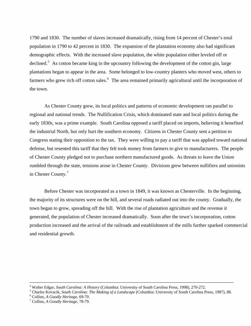
farmers who grew rich off cotton sales.6 The area remained primarily agricultural until the incorporation of
the town.
As Chester County grew, its local politics and patterns of economic development ran parallel to
regional and national trends. The Nullification Crisis, which dominated state and local politics during the
early 1830s, was a prime example. South Carolina opposed a tariff placed on imports, believing it benefited
the industrial North, but only hurt the southern economy. Citizens in Chester County sent a petition to
Congress stating their opposition to the tax. They were willing to pay a tariff that was applied toward national
defense, but resented this tariff that they felt took money from farmers to give to manufacturers. The people
of Chester County pledged not to purchase northern manufactured goods. As threats to leave the Union
rumbled through the state, tensions arose in Chester County. Divisions grew between nullifiers and unionists
in Chester County.7
Before Chester was incorporated as a town in 1849, it was known as Chesterville. In the beginning,
the majority of its structures were on the hill, and several roads radiated out into the county. Gradually, the
town began to grow, spreading off the hill. With the rise of plantation agriculture and the revenue it
generated, the population of Chester increased dramatically. Soon after the town’s incorporation, cotton
production increased and the arrival of the railroads and establishment of the mills further sparked commercial
and residential growth.
4 Walter Edgar, South Carolina: A History (Columbia: University of South Carolina Press, 1998), 270-272. 5 Charles Kovacik, South Carolina: The Making of a Landscape (Columbia: University of South Carolina Press, 1987), 88. 6 Collins, A Goodly Heritage, 69-70. 7 Collins, A Goodly Heritage, 78-79.
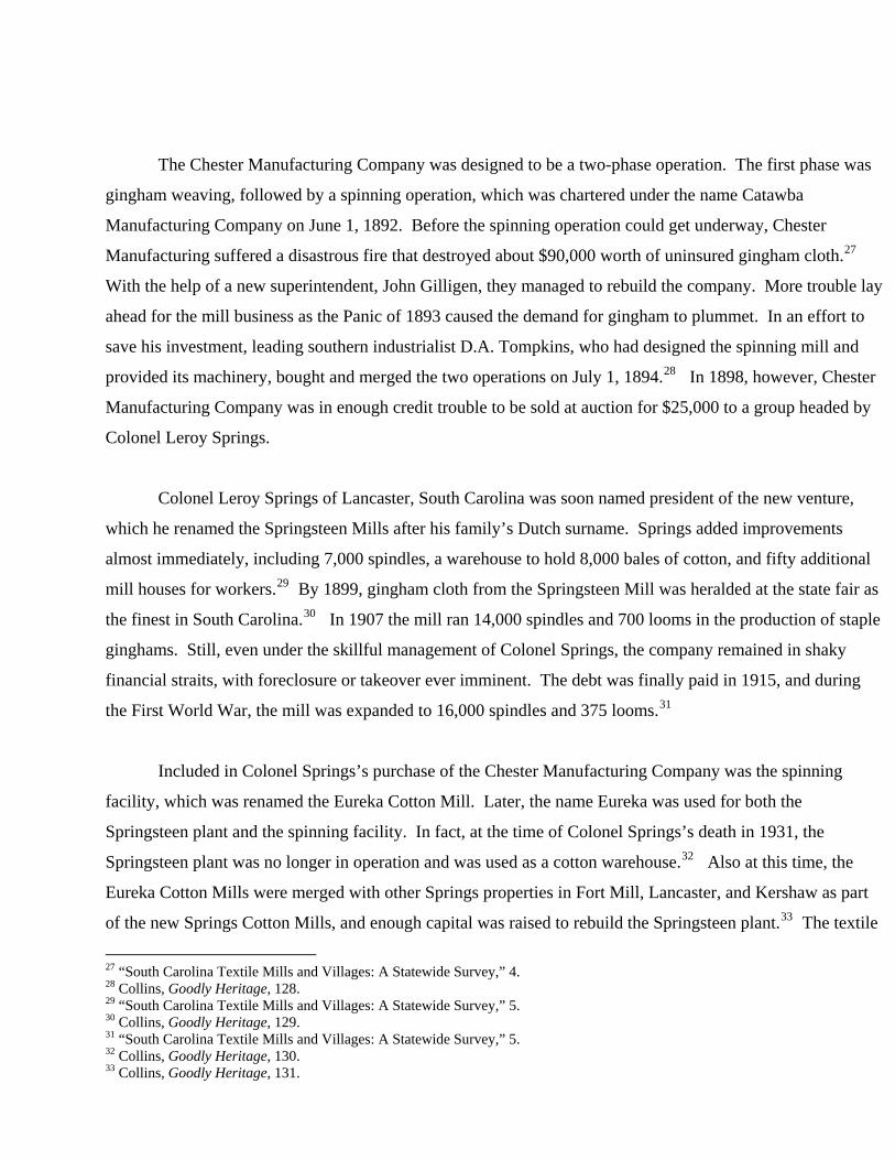
Figure 4. Cotton gin located on Hinton Street, circa 1910.
Photograph courtesy of Images of America: Chester County.
Commercial Development: The Railroad By enabling the spread of cotton culture and the growth of
interior southern cities, the locomotive helped to expand the newly incorporated town of Chester. It offered
economic opportunity to southern towns that before the railway had few links to the national market. In the
postbellum era the railroad had its largest development in the southern states as it also brought the promise of
a New South.8 As with the rest of the region, the arrival of the railroad in Chester stimulated population
growth and industrial development. By connecting Chester to other southern cities, it offered new
employment, economic and travel opportunities, and later facilitated the growth of industry.
Chester became a part of the railroad system in 1851 when the Charlotte-South Carolina Railroad,
which eventually became the Charlotte-Columbia Railroad, first ran through the new city. The first station in
Chester stood at the corner of Lancaster and Walnut streets.9 The original freight depot dates to circa 1850
and still exists within the survey area. The early years of the railroad industry in the South were dominated by
small companies that owned limited amounts of track. This was also the case for Chester’s first rail system.
Although the system was small, Chester became an important stop along the line. In 1854 Chester was second
only to Charlotte in its total amount of loaded freight. In the same year Chester led in the transportation of
8 Edward L. Ayers, Southern Crossing: A History of the American South (Cambridge: Oxford University Press, 1995). 9 Collins, Goodly Heritage,159-160.

cotton throughout the line, marking the importance of the rail system to the new town.10 This early system
evolved as smaller lines were absorbed by larger, more inclusive rail systems. One of the largest of these in
the South was the Southern Railway System that eventually absorbed the Charlotte-Columbia Railroad.
During these early years of the railroad in the United States, the station often became an attraction.11
This was also the case in Chester. Many accounts have been made about the festivities that surrounded
Chester’s first railway experience, all of which echo the country’s excitement over this new form of
transportation. Chester’s stop on the Charlotte-Columbia Railroad had historical significance beyond the
history of southern railways. Chester was a hub for Confederate activity during the final stages of the Civil
War. In 1865 soldiers as well as other Confederate leaders found Chester to be the last rail stop. The
Confederate Constitution even made its way to the Chester depots, narrowly escaping Union capture in April
of 1865.12
After the Civil War railroad growth in the South increased tremendously. Between 1865 and 1880
railroad mileage in the South doubled, and between 1880 and 1890 growth tripled, nearly doubling the
national average. In 1873 the completion of the Chester and Lancaster Railroad made Chester a junction
town.13 The new railway was taken over in 1882 by the Charlotte, Columbia, and Augusta Railroad. The
entire railroad system was then sold to the Richmond and Danville and eventually became Southern Railway
in 1895. The Southern Railway was by 1895 the largest rail system in the South, and eventually the primary
railway in Chester. Backed by the Pennsylvania Railroad, the company operated 4,500 miles of line in seven
southern states.14 Chester’s connection to this major rail system provided access to commercial hubs that
were previously not available to Chester. The Richmond and Danville and later the Southern Railway
provided commercial access to Richmond, Atlanta, and Washington, D.C., by 1900, helping to link the
Chester economy with the national economy.15 Chester was, during this time of growth, considered a South
Carolina transportation hub with four major lines.16
10 Charlotte and South Carolina Railroad, Annual Report, 1854, Miscellaneous Communication 19, General Assembly Papers, South Carolina Department of Archives and History, Columbia, S.C.11 Ayers, Southern Crossing, 24. 12 Collins, Goodly Heritage, 162. 13 William J. Cooper Jr. and Thomas E. Terrill, The American South: A History (New York: Alfred A. Knopf, 1991), 474-476. 14 Burke Davis, The Southern Railway: Road of the Innovators (Chapel Hill: University of North Carolina Press, 1985), 29. 15 Ralph Watson Ford, “The Changing Geographic Pattern of South Carolina’s Railroad System: 1860-1902” (MA Thesis, University of South Carolina Department of Geography, 1986), 83. 16 Collins, Goodly Heritage, 162-167.
The emergence of the textile industry and the growth of the railroads during the same era affected
development in the areas surrounding Chester’s burgeoning commercial center. The town petitioned in 1852
to charter a bank in the city and cited growth directly related to the coming of the railroad as the cause for such
a need.17 In 1889 there was evidence of a passenger as well as the freight depot at the original depot location,
and commercial buildings also appeared. Several general stores stood at the corner of Gadsden Street.
Throughout the South the emergence of general stores was directly tied to the growth of the railroad system.
The railroad made the development of general stores possible by opening up commercial markets that had not
previously been available. Between 1889 and 1894 many more tracks were built near the mill. Construction
of new railroad offices, repair shops, and industrial buildings took place in the area along the railroad tracks in
the years after 1900. By 1917 the old passenger depot had been replaced by a new Union Station.18
Residential areas surrounding the railroad also saw its effects. As the East Lacy area developed, the
railway employed a growing number of its residents. In 1908 the East Lacy neighborhood was home for
electricians, car builders, engineers, conductors, linemen, and many more railway specific workers. Most of
these workers were employed by the larger railroads like the Southern Railway.19
The commercial area around the depot and adjacent residential areas experienced growth between the
years 1898 and 1904. During this time period more rails led to the Springsteen Mill, revealing the connection
between railroad and industrial growth in the South. The existence of both wide and narrow gauge tracks in
Chester was clear. Therefore Chester along with the rest of the South had to conform to the railroads gauge
standardization of 1885. The effects of a standard gauge were enormous; it helped catapult the South into the
national market.20
The twentieth century saw a decline in the southern railroad boom and revealed flaws in the
developing economy of the New South. The dominance of agriculture in the South hurt the southern railroad
system because of the seasonal demands that resulted from this lifestyle. The declining agricultural economy
in Chester after World War I had the harshest effect on the rail system. The effects of this decline in railroad
17 Petition of the Citizens of Chester on the Incorporation of a Bank, 1852, Petitions 1776-1883, 14, General Assembly Papers, South Carolina Department of Archives and History, Columbia, S.C.18 Sanborn Fire Insurance Map of Chester, SC (New York: Sanborn Map and Publishing Co., 1884…1926). 19 Chester, SC, City Directory 1908 Volume I (Asheville, N.C.: Piedmont Directory Co., 1908). 20 Sanborn Fire Insurance Maps of Chester, SC.
construction could be seen in Chester through the limited growth of its main rail depot after 1917.21
Economic growth faltered in Chester, as well as a large part of the South, as cotton prices plummeted and
crops began to suffer. In 1922 Chester saw production heavily decrease due to low cotton prices, soil erosion,
and the devastation of the cotton industry by the boll weevil.22 The close link between the railroad and the
cotton industry could be seen in the ties between economic and industrial growth and decline in Chester and
throughout the South. These correlations pointed to Chester’s dependence on its agricultural economy,
primarily cotton.
Industrial Development: Mills and Manufacturing The way of life for the majority of South
Carolinians, from the beginnings of the colony until the turn of the twentieth century, was centered around
agriculture. As a major cultivator of cotton, it was appropriate that the state’s first significant attempt at
manufacturing was the production of cotton cloth. Large mills with their accompanying villages were built
throughout the state in the 1880s and 1890s. The impact of the mills was felt in each town as a new class of
primarily white workers developed that did not previously exist in the agricultural communities. With the
increase in population, the mills also did a great deal to facilitate economic development for their respective
towns.
Chester, as the county seat with four major railroads, was ideal for the location of a new mill. A group
of businessmen that included J.L. Agurs, J.H. Smith, S.M. Jones, George D. Heath, J.J. Hemphill, G.W. Gage,
and W.H. Hendrix wanted to duplicate the success of the nearby Fort Mill Manufacturing Company.23 Thus,
in response to this new drive for industry in South Carolina, the Chester Manufacturing Company was created
on July 10, 1888. The company charter established the capital stock at $100,000 with shares valued at $100
each, and W.H. Hardin was named as the president.24 The mill was a two-story brick structure measuring 300
x 80 feet with a drying room 40 x 70 feet.25 Fourteen cottages were also built in close proximity to the mill
for the workers. Progress in the construction was slow, and the mill did not begin operations until 1890 when
19 looms were put into use.26 Soon, 100 more looms arrived, and the first textile mill of Chester went into full
production, including a dye works to color yarn.
21 Cooper and Terrill, American South, 474-476. 22 Collins, Goodly Heritage, 254-256. 23 Louise Pettus, The Springs Story: Our First 100 Years (Fort Mill, SC: Springs Industries Inc, 1987), 67. 24 Collins, Goodly Heritage, 127. 25 “South Carolina Textile Mills and Villages: A Statewide Survey,” State Historic Preservation Office, South Carolina Department of Achieves and History, Columbia, S.C., 4. 26 “South Carolina Textile Mills and Villages: A Statewide Survey,” 4.
The Chester Manufacturing Company was designed to be a two-phase operation. The first phase was
gingham weaving, followed by a spinning operation, which was chartered under the name Catawba
Manufacturing Company on June 1, 1892. Before the spinning operation could get underway, Chester
Manufacturing suffered a disastrous fire that destroyed about $90,000 worth of uninsured gingham cloth.27
With the help of a new superintendent, John Gilligen, they managed to rebuild the company. More trouble lay
ahead for the mill business as the Panic of 1893 caused the demand for gingham to plummet. In an effort to
save his investment, leading southern industrialist D.A. Tompkins, who had designed the spinning mill and
provided its machinery, bought and merged the two operations on July 1, 1894.28 In 1898, however, Chester
Manufacturing Company was in enough credit trouble to be sold at auction for $25,000 to a group headed by
Colonel Leroy Springs.
Colonel Leroy Springs of Lancaster, South Carolina was soon named president of the new venture,
which he renamed the Springsteen Mills after his family’s Dutch surname. Springs added improvements
almost immediately, including 7,000 spindles, a warehouse to hold 8,000 bales of cotton, and fifty additional
mill houses for workers.29 By 1899, gingham cloth from the Springsteen Mill was heralded at the state fair as
the finest in South Carolina.30 In 1907 the mill ran 14,000 spindles and 700 looms in the production of staple
ginghams. Still, even under the skillful management of Colonel Springs, the company remained in shaky
financial straits, with foreclosure or takeover ever imminent. The debt was finally paid in 1915, and during
the First World War, the mill was expanded to 16,000 spindles and 375 looms.31
Included in Colonel Springs’s purchase of the Chester Manufacturing Company was the spinning
facility, which was renamed the Eureka Cotton Mill. Later, the name Eureka was used for both the
Springsteen plant and the spinning facility. In fact, at the time of Colonel Springs’s death in 1931, the
Springsteen plant was no longer in operation and was used as a cotton warehouse.32 Also at this time, the
Eureka Cotton Mills were merged with other Springs properties in Fort Mill, Lancaster, and Kershaw as part
of the new Springs Cotton Mills, and enough capital was raised to rebuild the Springsteen plant.33 The textile
27 “South Carolina Textile Mills and Villages: A Statewide Survey,” 4. 28 Collins, Goodly Heritage, 128. 29 “South Carolina Textile Mills and Villages: A Statewide Survey,” 5. 30 Collins, Goodly Heritage, 129. 31 “South Carolina Textile Mills and Villages: A Statewide Survey,” 5. 32 Collins, Goodly Heritage, 130. 33 Collins, Goodly Heritage, 131.
business that had been amassed by Colonel Leroy Springs passed into the hands of his son, Colonel Elliott
White Springs, in 1931.
In the late 1930s, the Springsteen Mill was equipped with new looms, long draft spinning, and
automatic spooling and warping. After the late 1940s the mill was periodically modernized for efficiency in
the production of consumer textiles. Colonel Elliott Springs even turned over the production of his textile
mills to the military from 1943 to 1945 to aid the war effort for which they were awarded the Army-Navy “E”
award for excellence of production achievement.34 By 1952 the Springsteen plant produced combed and
carded broadcloth with 38,592 spindles, 608 looms, and between 500 to 750 employees. They also began
producing the new Springmaid brand name sheets and pillowcases. During the 1950s, Springs Mills began to
sell its mill houses to the workers. In preparation for this sale, the mill village at Springsteen was platted and
subdivided beginning in 1959. 35 Even though Springs Industries continues to thrive today, the Springsteen
Mill facility is no longer in operation. However, the mill houses are still used as residences by many of
Chester’s citizens.
The structure of the mill villages influenced social conditions of the workers as well as their way of
life. Management was forced to provide schools for mill workers’ children after the South Carolina Child
Labor Law was passed in 1907.36 They also built churches and supplied preachers, and set aside land for
gardens and recreation as well as cow pastures and chicken yards. Many of the mill villages organized
baseball teams that challenged neighboring mills. In fact, the Springsteen mill houses built after 1898 were
erected on its baseball diamond.37 The schools, churches, and recreation areas were the centers of social
activity for the mill workers.
The Springsteen Mill was established during a time of keen interest in cotton mills in South Carolina.
With the expansion of the railroad system in the 1870s and 1880s, Chester was more than adequately equipped
to support a new industry. Because the Springsteen Mill is within the survey area, its history has been the
focus of this project. However, it was not the only textile mill in Chester. J.L. Agurs and T.H. White, two of
the original investors in the Chester Manufacturing Company, also chartered the Wylie Mill, which opened in
34 Collins, Goodly Heritage, 135. 35 “South Carolina Textile Mills and Villages: A Statewide Survey,” 5. 36 Collins, Goodly Heritage, 125. 37 Collins, Goodly Heritage, 125.
1900.38 This mill changed ownership and names many times, and finally, while known as the Gayle Mill, it
was closed in 1975. Clearly, the growth of Chester had been closely associated with the rise and fall of the
textile industry. This fluctuation had a major impact on the economy of Chester and influenced the lives of
its residents.
Cultural Development: Schools, Churches, and Cemeteries After the Civil War the South had to
face many new challenges, including rebuilding both industry and society. Chester needed to find a way to
incorporate the newly freed black population into society. Many efforts of Reconstruction were aimed at
educating these freedmen and integrating them into southern society. The postbellum South traditionally
relied upon the church and philanthropists to provide their education needs until the turn of the century; this
was also the case for southern blacks.39 The emphasis of freedman’s aid after the war shifted from general
relief to education of blacks. Education was used to help prepare blacks for life as free men and women.40
Black education before 1900 was not usually paid for by the public dollar; therefore private and church run
black schools were the predominant tool for this education.
In the aftermath of the Civil War, northern churches sent missionaries to the South to educate the
freedmen. A strong impact was made by the Methodist, Presbyterian, Baptist, and Congregational churches.
The Congregational Churches working through the American Missionary Association had the greatest effect
throughout the South, but in Chester the United Methodist Church Board of Missions to the Freedmen took the
lead in black education.41 The evangelical education movement dealt with an issue often overlooked by its
secular counterparts, namely religion. The northern Protestants used the education of blacks to instill a sense
of Christian duty and perhaps loyalty to a particular type of Protestantism.42 The existence of the traditionally
black Carmel Presbyterian Church in the survey area reflected this spirit of Christian renewal.
Brainerd Institute, one of the earliest and finest of the many private schools established for freedmen in
South Carolina in the years just after the Civil War, was located in Chester. Brainerd was operated from 1868
to 1940 by the Board of Missions of the Presbyterian Church, USA and offered vocational, industrial,
38 Collins, Goodly Heritage, 131. 39 Cooper and Terrill, American South, 580. 40 Ronald E. Butchart, Northern Schools, Southern Blacks, and Reconstruction: Freedmen’s Education, 1862-1875 (Westport, CT: Greenwood Press, 1980), 3. 41 Butchart, Northern Schools, 4. 42 Butchart, Northern Schools, 34.
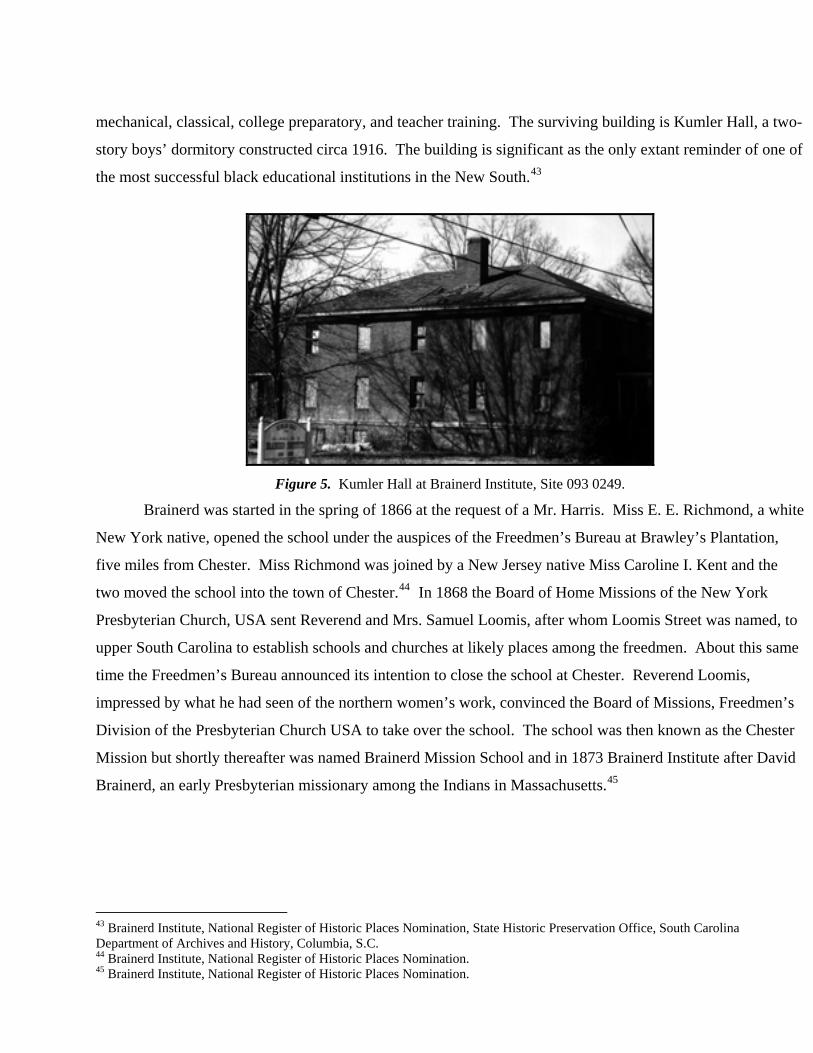
mechanical, classical, college preparatory, and teacher training. The surviving building is Kumler Hall, a two-
story boys’ dormitory constructed circa 1916. The building is significant as the only extant reminder of one of
the most successful black educational institutions in the New South.43
Figure 5. Kumler Hall at Brainerd Institute, Site 093 0249.
Brainerd was started in the spring of 1866 at the request of a Mr. Harris. Miss E. E. Richmond, a white
New York native, opened the school under the auspices of the Freedmen’s Bureau at Brawley’s Plantation,
five miles from Chester. Miss Richmond was joined by a New Jersey native Miss Caroline I. Kent and the
two moved the school into the town of Chester.44 In 1868 the Board of Home Missions of the New York
Presbyterian Church, USA sent Reverend and Mrs. Samuel Loomis, after whom Loomis Street was named, to
upper South Carolina to establish schools and churches at likely places among the freedmen. About this same
time the Freedmen’s Bureau announced its intention to close the school at Chester. Reverend Loomis,
impressed by what he had seen of the northern women’s work, convinced the Board of Missions, Freedmen’s
Division of the Presbyterian Church USA to take over the school. The school was then known as the Chester
Mission but shortly thereafter was named Brainerd Mission School and in 1873 Brainerd Institute after David
Brainerd, an early Presbyterian missionary among the Indians in Massachusetts.45
43 Brainerd Institute, National Register of Historic Places Nomination, State Historic Preservation Office, South Carolina Department of Archives and History, Columbia, S.C. 44 Brainerd Institute, National Register of Historic Places Nomination. 45 Brainerd Institute, National Register of Historic Places Nomination.

Figure 6. Classroom building at Brainerd Institute that is no longer standing. Photograph courtesy of Images of America: Chester County.
Brainerd occupied several locations before finally settling on the present site, the old DeGraggenreid
land, where the mansion house was used as the main building. Other buildings constructed included boys’ and
girls’ dormitories. Brainerd Institute was committed to high standards in its academic program and in the
conduct of its pupils. In addition to basic academic courses, each student fulfilled the requirements for one of
the major courses of study. Students also attended classes in food conduct and Bible study and were required
to attend the Presbyterian Church each Sunday. There were several religious organizations on campus and
every student was a member of each one. The young ladies were required to wear sedate uniforms and all
students lived by a strict set of regulations.46
Perhaps the most important contribution of Brainerd was its role in providing public school teachers
for the black community. From 1868 until the turn of the century, Brainerd provided the only schooling
available for black children in Chester, and it provided the only high school until the 1920s. Brainerd did
attempt to obtain junior college status in the early twentieth century, apparently in an effort to increase
enrollment cut by the advent of more and better public schools for blacks. In actuality Brainerd was never
really more than a high school, but because it was accredited by the state and its standards were so much
higher than any of the public schools, most of its graduates were certified to teach public school.47
46 Brainerd Institute, National Register of Historic Places Nomination. 47 Brainerd Institute, National Register of Historic Places Nomination.

With the growing educational awareness of the turn of the century, however, Brainerd’s usefulness
began to diminish and the institute faltered. Public education came to the forefront of southern minds at the
end of the nineteenth century and gradually the development of uniform public school systems began to be
applied to black education. This period of educational reform increased the number of public schools and
resulted in the growth of secular education in Chester. One result of this growth was the Withrew Manual
Training School, a traditionally white vocational school located on College Street dating to 1916. During the
1920s black public education also began to become more common in the South, gradually replacing their
religious counterparts.48 It was during this time of change that new black public schools began to emerge in
Chester, such as Finley High School. In later years as Brainerd ceased to be as necessary to the education of
blacks in the area, funds were increasingly hard to obtain. Brainerd closed between 1939 and 1941. The
campus was cut up into parcels and sold; the City of Chester bought the Martha Tweed Administrative
Building and used it as an elementary school for some years.49
With the emergence of Brainerd in Chester came a renewed interest by the New York Presbyterian
Home Mission Board in the South Carolina town. In cooperation with Brainerd Institute the Church opened
Carmel United Presbyterian church in 1869 on Walnut Street.50 The structure, which is still standing today,
was completed in 1924, and services were held in Brainerd Institute Chapel while the church was being
built.51 In addition to Samuel Loomis, there have been several important and influential pastors of Carmel
Church including Thomas H. Ayers, who served for twenty-five years. Throughout its history, Carmel Church
has sponsored numerous charitable programs and celebratory events such as Project Bridge, Meals on Wheels,
and Family Day that have had a positive impact on the community. The historically black church was
associated with the new black educational institute and provided spiritual guidance for the black students.
Carmel Church stands beside another historically African-American institution, Calvary Baptist Church,
which was founded in October 1867. The congregation met at locations on Loomis Street and a site on
Walnut Street near the Southern Railway turntable before erecting the present building in 1908.
The divisions between black and white cultures in Chester are reflected in the cemeteries in the survey
area. A traditionally black cemetery called Mount Hebron Cemetery exists behind Evergreen Cemetery on
48 James D. Anderson, The Education of Blacks in the South 1860-1935 (Chapel Hill: University of North Carolina Press, 1988), 187-198. 49 Brainerd Institute, National Register of Historic Places Nomination. 50 Collins, Goodly Heritage, 180. 51 Mary Rose Adair, Carmel Presbyterian Church History (York, S.C.: Song Shakir Davis Publishers, 1991), 2.
Cemetery Street in the northeastern part of Chester. The Chester Development Company first sold a half-acre
of land to the elders of the Chester Associate Reformed Presbyterian Church in June 1893. Then the Hebron
Cemetery Association was incorporated in 1894 and the Chester Development Company sold it four acres on
an adjoining property in 1897. Almost a century later, in 1979 the two properties were merged as the Chester
Associate Reformed Presbyterian Church sold its property to the Hebron Cemetery Association. This
cemetery was used by blacks while the white cemetery was still segregated. Today, although the area is
covered by thick brush, Mount Hebron Cemetery has visible characteristics that are typical of other African-
American cemeteries in the South. The site is scattered with a few traditional headstones; other markers
throughout the area indicate the location of burial sites. Items known as grave goods have been used to mark
graves; dishes, vases, broken glass and bottles are all examples of this African-American tradition. 52
Educational and religious institutions were at the core of cultural life in Chester, and a number of
important historic structures survive in the survey area as reminders of this rich heritage. In addition to the
Withrew Manual Training School are four properties of special significance in Chester's African-American
history: Kumler Hall on the former Brainerd Institute campus, Carmel Presbyterian Church, Calvary Baptist
Church, and the Mount Hebron Cemetery.
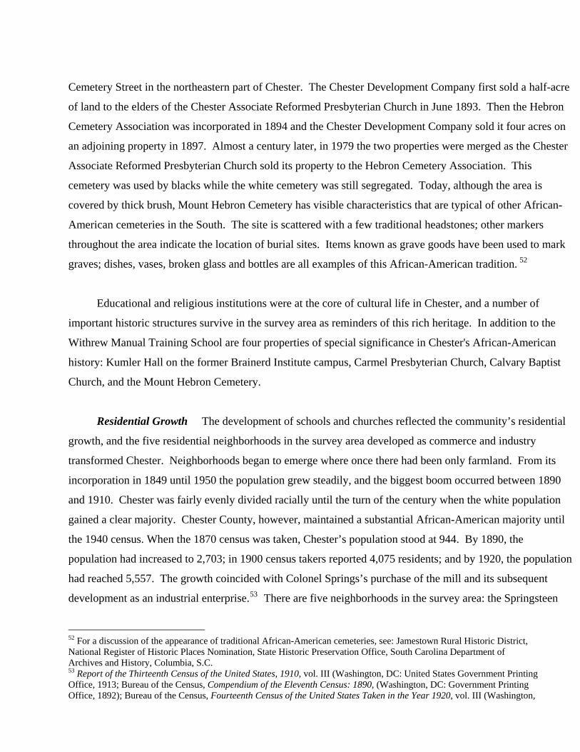
Residential Growth The development of schools and churches reflected the community’s residential
growth, and the five residential neighborhoods in the survey area developed as commerce and industry
transformed Chester. Neighborhoods began to emerge where once there had been only farmland. From its
incorporation in 1849 until 1950 the population grew steadily, and the biggest boom occurred between 1890
and 1910. Chester was fairly evenly divided racially until the turn of the century when the white population
gained a clear majority. Chester County, however, maintained a substantial African-American majority until
the 1940 census. When the 1870 census was taken, Chester’s population stood at 944. By 1890, the
population had increased to 2,703; in 1900 census takers reported 4,075 residents; and by 1920, the population
had reached 5,557. The growth coincided with Colonel Springs’s purchase of the mill and its subsequent
development as an industrial enterprise.53 There are five neighborhoods in the survey area: the Springsteen
52 For a discussion of the appearance of traditional African-American cemeteries, see: Jamestown Rural Historic District, National Register of Historic Places Nomination, State Historic Preservation Office, South Carolina Department of Archives and History, Columbia, S.C. 53 Report of the Thirteenth Census of the United States, 1910, vol. III (Washington, DC: United States Government Printing Office, 1913; Bureau of the Census, Compendium of the Eleventh Census: 1890, (Washington, DC: Government Printing Office, 1892); Bureau of the Census, Fourteenth Census of the United States Taken in the Year 1920, vol. III (Washington,
Mill Village, the Childs-Edwards Quarter, the College Street School Area, the Lancaster-East Lacy Streets
Area, and East Chester.
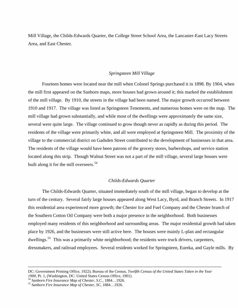
Springsteen Mill Village
Fourteen homes were located near the mill when Colonel Springs purchased it in 1898. By 1904, when
the mill first appeared on the Sanborn maps, more houses had grown around it; this marked the establishment
of the mill village. By 1910, the streets in the village had been named. The major growth occurred between
1910 and 1917. The village was listed as Springsteen Tenements, and numerous homes were on the map. The
mill village had grown substantially, and while most of the dwellings were approximately the same size,
several were quite large. The village continued to grow though never as rapidly as during this period. The
residents of the village were primarily white, and all were employed at Springsteen Mill. The proximity of the
village to the commercial district on Gadsden Street contributed to the development of businesses in that area.
The residents of the village would have been patrons of the grocery stores, barbershops, and service station
located along this strip. Though Walnut Street was not a part of the mill village, several large houses were
built along it for the mill overseers.54
Childs-Edwards Quarter
The Childs-Edwards Quarter, situated immediately south of the mill village, began to develop at the
turn of the century. Several fairly large houses appeared along West Lacy, Byrd, and Branch Streets. In 1917
this residential area experienced more growth; the Chester Ice and Fuel Company and the Chester branch of
the Southern Cotton Oil Company were both a major presence in the neighborhood. Both businesses
employed many residents of this neighborhood and surrounding areas. The major residential growth had taken
place by 1926, and the businesses were still active here. The houses were mainly L-plan and rectangular
dwellings.55 This was a primarily white neighborhood; the residents were truck drivers, carpenters,
dressmakers, and railroad employees. Several residents worked for Springsteen, Eureka, and Gayle mills. By
DC: Government Printing Office, 1922); Bureau of the Census, Twelfth Census of the United States Taken in the Year 1900, Pt. 1, (Washington, DC: United States Census Office, 1901). 54 Sanborn Fire Insurance Map of Chester, S.C., 1884…1926. 55 Sanborn Fire Insurance Map of Chester, SC, 1884…1926.
1940, the neighborhood had at least two African-American residents, one of whom was a teacher at Finley
High School.56
College Street School Area
While Chester Public School appeared on maps as early as 1896, the College Street School area did not
thrive until several years later. The earliest homes in this district dated from 1894, and by 1917 the area was
very heavily populated. Like the Childs-Edwards Quarter, this too was a largely white neighborhood. Many
of the residents taught at the high school or were employed at the nearby Ice and Fuel Company and Southern
Cotton Oil Company. Several insurance agents also lived in this area. The College Street School area was a
fairly small residential neighborhood but the high school was an important educational institution.57
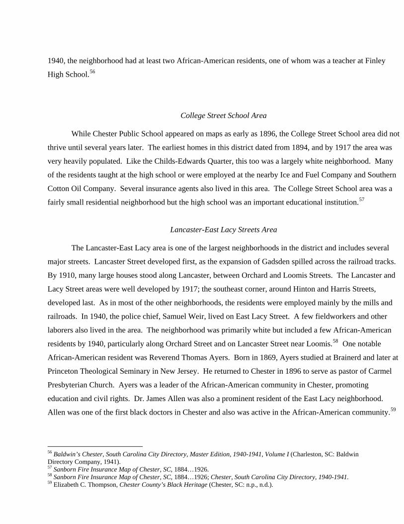
Lancaster-East Lacy Streets Area
The Lancaster-East Lacy area is one of the largest neighborhoods in the district and includes several
major streets. Lancaster Street developed first, as the expansion of Gadsden spilled across the railroad tracks.
By 1910, many large houses stood along Lancaster, between Orchard and Loomis Streets. The Lancaster and
Lacy Street areas were well developed by 1917; the southeast corner, around Hinton and Harris Streets,
developed last. As in most of the other neighborhoods, the residents were employed mainly by the mills and
railroads. In 1940, the police chief, Samuel Weir, lived on East Lacy Street. A few fieldworkers and other
laborers also lived in the area. The neighborhood was primarily white but included a few African-American
residents by 1940, particularly along Orchard Street and on Lancaster Street near Loomis.58 One notable
African-American resident was Reverend Thomas Ayers. Born in 1869, Ayers studied at Brainerd and later at
Princeton Theological Seminary in New Jersey. He returned to Chester in 1896 to serve as pastor of Carmel
Presbyterian Church. Ayers was a leader of the African-American community in Chester, promoting
education and civil rights. Dr. James Allen was also a prominent resident of the East Lacy neighborhood.
Allen was one of the first black doctors in Chester and also was active in the African-American community.59
56 Baldwin’s Chester, South Carolina City Directory, Master Edition, 1940-1941, Volume I (Charleston, SC: Baldwin Directory Company, 1941). 57 Sanborn Fire Insurance Map of Chester, SC, 1884…1926. 58 Sanborn Fire Insurance Map of Chester, SC, 1884…1926; Chester, South Carolina City Directory, 1940-1941. 59 Elizabeth C. Thompson, Chester County’s Black Heritage (Chester, SC: n.p., n.d.).
East Chester
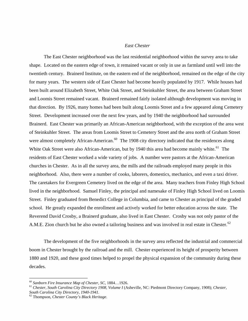
The East Chester neighborhood was the last residential neighborhood within the survey area to take
shape. Located on the eastern edge of town, it remained vacant or only in use as farmland until well into the
twentieth century. Brainerd Institute, on the eastern end of the neighborhood, remained on the edge of the city
for many years. The western side of East Chester had become heavily populated by 1917. While houses had
been built around Elizabeth Street, White Oak Street, and Steinkuhler Street, the area between Graham Street
and Loomis Street remained vacant. Brainerd remained fairly isolated although development was moving in
that direction. By 1926, many homes had been built along Loomis Street and a few appeared along Cemetery
Street. Development increased over the next few years, and by 1940 the neighborhood had surrounded
Brainerd. East Chester was primarily an African-American neighborhood, with the exception of the area west
of Steinkuhler Street. The areas from Loomis Street to Cemetery Street and the area north of Graham Street
were almost completely African-American.60 The 1908 city directory indicated that the residences along
White Oak Street were also African-American, but by 1940 this area had become mainly white.61 The
residents of East Chester worked a wide variety of jobs. A number were pastors at the African-American
churches in Chester. As in all the survey area, the mills and the railroads employed many people in this
neighborhood. Also, there were a number of cooks, laborers, domestics, mechanics, and even a taxi driver.
The caretakers for Evergreen Cemetery lived on the edge of the area. Many teachers from Finley High School
lived in the neighborhood. Samuel Finley, the principal and namesake of Finley High School lived on Loomis
Street. Finley graduated from Benedict College in Columbia, and came to Chester as principal of the graded
school. He greatly expanded the enrollment and actively worked for better education across the state. The
Reverend David Crosby, a Brainerd graduate, also lived in East Chester. Crosby was not only pastor of the
A.M.E. Zion church but he also owned a tailoring business and was involved in real estate in Chester.62
The development of the five neighborhoods in the survey area reflected the industrial and commercial
boom in Chester brought by the railroad and the mill. Chester experienced its height of prosperity between
1880 and 1920, and these good times helped to propel the physical expansion of the community during these
decades.
60 Sanborn Fire Insurance Map of Chester, SC, 1884…1926. 61 Chester, South Carolina City Directory 1908, Volume I (Asheville, NC: Piedmont Directory Company, 1908); Chester, South Carolina City Directory, 1940-1941. 62 Thompson, Chester County’s Black Heritage.
Chester From the 1920s to 1950 Development throughout the South began to slow after World War
I. The war brought prosperity to the region that failed to continue through the following decades. High cotton
prices during the war years and the lack of foreign market competition helped the agrarian South to prosper,
but when these conditions began to change the southern farming economy was greatly affected. The return to
pre-war conditions drastically dropped cotton prices. This economic upheaval was worsened by the boll
weevil that plagued cotton crops during the same era. Insecticides ultimately neutralized the threat of this
epidemic but resulted in the return of cotton surpluses throughout the South.63 The effects of this economic
hardship could be seen in Chester through the lack of significant growth during these times.
The 1930s saw even less economic prosperity in Chester and throughout the South. Disease and crime
rates during this era increased dramatically, and the overproduction of cotton continued to hinder economic
development. Although South Carolina passed reduction laws trying to combat the cotton surplus, the narrow
scope of these laws limited their effectiveness nationally.64 The Depression was experienced in Chester on
many levels. Chester suffered from not only the national employment crisis but also the effects of falling
cotton prices. Chester’s main industries rested on the production of cotton, and although the development of
hydroelectric power initially helped the textile industry to boom, the lack of a market for cotton goods that
existed in the 1930s severely hindered Chester’s economy.
The increasing economic problems of the 1930s resulted in the election of Franklin D. Roosevelt and
the creation and implementation of the New Deal. Roosevelt attempted to alleviate the problems brought
about by the Depression through government intervention. The most beneficial of these acts in Chester was
the creation of the Civilian Conservation Corps (CCC) that was enacted under the Unemployment Relief Act
of 1933.65 Set up for unemployed men from the ages of 18-25, the act enabled men to work for six months at
a time for the government doing a variety of conservation acts.66 Seventeen camps were set up in South
Carolina to house men involved with the CCC. Many of these sites were later integrated into the state park
system after the Depression, including Chester’s site, which was turned into Chester State Park.67
63 Roger Biles, The South and the New Deal (Lexington: University of Kentucky Press, 1994), 2. 64 Biles, New Deal, 19. 65 Collins, Goodly Heritage, 263. 66 Biles, New Deal, 70. 67 Collins, Goodly Heritage, 263.
Chester, along with the rest of the nation, emerged from the Depression as a result of the
economic boom sparked by the Second World War. The need for war goods increased production all
over the country creating a rapidly expanding economy. The war also resulted in the dissolution of
many of the New Deal agencies that provided aid to the poor. Many of the agencies that helped
Chester through the Depression years were dismantled, including the Works Progress Administration
and the Civilian Conservation Corps.68 With the economic prosperity that World War II created, these
organizations were seen as unnecessary. In Chester, as well as the nation, the work force was also
broadened as a result of the war effort. As more white men were sent to the front, women and
minorities got more of an opportunity in the work force. Ultimately the Second World War brought
Chester out of the economic hardship of the 1930s, but Chester’s growth was undeniably affected by
the Depression. Chester saw limited growth during the 1940s. The 1930s and 1940s were not
Chester’s most prosperous times, as reflected by the lack of any significant new building in the
Gadsden-Lancaster Streets corridor. Although a railroad hub and industrial center, Chester’s ultimate
dependence on cotton hindered the city’s development throughout these decades, in contrast to the
boom times of the late nineteenth and early twentieth centuries.
Bibliography
Primary Sources Baldwin’s Chester, SC City Directory, Master Edition 1940-41, Volume I. Charleston, SC: Baldwin Directory Co., 1941. Bureau of the Census. Compendium of the Eleventh Census: 1890. Washington, DC: Government Printing Office, 1892. Bureau of the Census. Twelfth Census of the United States Taken in the Year 1900. Pt. 1. Washington, DC: United States Census Office, 1901.
68 John M. Murrin, Paul E. Johnson, James M. McPherson, Gary Gerstle, Emily S. Rosenberg, and Norman L. Rosenberg, Liberty, Equality, Power: A History of the American People (Fort Worth: Harcourt Brace College Publishers, 1999), 901-902.
Bureau of the Census. Report of the Thirteenth Census of the United States: 1910. Vol. III. Washington, DC: Government Printing Office, 1913. Bureau of the Census. Fourteenth Census of the United States Taken in the Year 1900. Pt. 1. Washington, DC: Government Printing Office, 1922. Charlotte and South Carolina Railroad, Annual Report, 1854. Miscellaneous Communication
19. General Assembly Papers. South Carolina Department of Archives and History, Columbia, SC. Chester, South Carolina City Directory 1908 Volume I. Asheville, NC: Piedmont Directory Co., 1908. McMillan, Lewis K. Negro Higher Education and Students, Brainerd Institute, Chester, SC. N.p.: n.p., 1929…1931. Petition of the Citizens of Chester on the Incorporation of a Bank, 1852. Petitions 1776-1883,
14. General Assembly Papers. South Carolina Department of Archives and History, Columbia, SC.
Sanborn Fire Insurance Map of Chester, SC. New York: Sanborn Map and Publishing Co., 1884…1926. Sanborn Fire Insurance Map of Chester, SC. 1926; revised, New York: Sanborn Map and Publishing Co., 1953. Secondary Sources Adair, Mary Rose. Carmel Presbyterian Church History. York, S. C.: Song Shakir Davis Publishers, 1991. Anderson, James D. Education of Blacks in the South, 1860-1935. Chapel Hill: University of North Carolina Press, 1988. Ayers, Edward L. Southern Crossing: A History of the American South, 1877-1906. New York: Oxford University Press, 1995. Biles, Roger. The South and the New Deal. Lexington: University of Kentucky Press, 1994. Butchart, Ronald E. Northern Schools, Southern Blacks, and Reconstruction: Freedmen's Education, 1862-1875. Westport, CT: Greenwood Press, 1980. Coleman, Glinda Price and Gina Price White. Images of America: Chester County. Charleston: Arcadia Publishing, 2000. Collins, Anne P. A Goodly Heritage: History of Chester County, South Carolina. Columbia: Collins Publications. 1986.
Collins, Anne P. and Louise Gill Knox (eds.). Heritage History of Chester County, South Carolina. 2 vols. Chester: n.p., 1982, 1995. Cooper, William J. Jr. and Thomas E. Terrill. The American South: A History. New York: Knopf, 1991. Davis, Burke. The Southern Railway: Road of the Innovators. Chapel Hill: University of North Carolina Press, 1985. Edgar, Walter. South Carolina: A History. Columbia: University of South Carolina Press, 1998. Ford, Ralph Watson. “The Changing Geographic Pattern of South Carolina’s Railroad System: 1860-1902.” MA Thesis, University of South Carolina Department of Geography, 1986. Kovacik, Charles. South Carolina: The Making of a Landscape. Columbia: University of South Carolina Press, 1987. McAlester, Lee, and Virginia McAlester. A Field Guide to American Houses. New York: Alfred A. Knopf, Inc., 1984. Murrin, John M., Paul E. Johnson, James M. McPherson, Gary Gerstle, Emily S. Rosenberg, and Norman L. Rosenberg. Liberty, Equality, Power: A History of the American People. Fort Worth: Harcourt Brace College Publishers, 1999. National Register of Historic Places Nomination. Brainerd Institute. State Historic Preservation Office. South Carolina Department of Archives and History, Columbia, S.C. National Register of Historic Places Nomination. Jamestown Rural Historic District. State Historic Preservation Office. South Carolina Department of Archives and History, Columbia, S.C. Pettus, Louise. The Springs Story: Our First 100 Years. Fort Mill, SC: Springs Industries Inc, 1987. South Carolina Department of Archives and History. Survey Manual: South Carolina Statewide Survey of Historic Places. Columbia, SC: South Carolina Department of Archives and History, 1990. “South Carolina Textile Mills and Villages: A Statewide Survey.” State Historic Preservation Office. South Carolina Department of Archives and History, Columbia, S.C. Stabley, Susan J. “Brainerd goes Big Apple.” Rock Hill Herald, 20 September 2000, 1A. Thompson, Elizabeth C. Chester County’s Black Heritage. Chester, SC.: n.p., n.d.
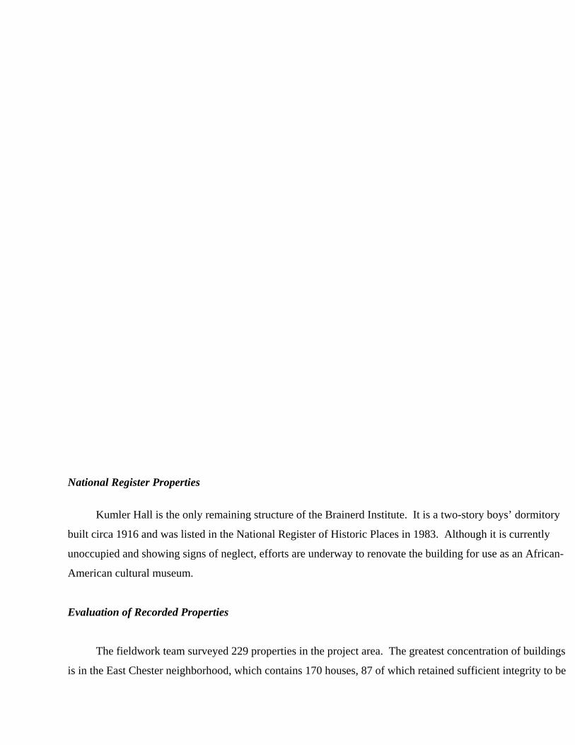
National Register Properties
Kumler Hall is the only remaining structure of the Brainerd Institute. It is a two-story boys’ dormitory
built circa 1916 and was listed in the National Register of Historic Places in 1983. Although it is currently
unoccupied and showing signs of neglect, efforts are underway to renovate the building for use as an African-
American cultural museum.
Evaluation of Recorded Properties
The fieldwork team surveyed 229 properties in the project area. The greatest concentration of buildings
is in the East Chester neighborhood, which contains 170 houses, 87 of which retained sufficient integrity to be
included in this survey. Houses are the dominant building type; of the 229 buildings surveyed, 203 (88
percent) are either single or multiple family residences. Nine commercial buildings were surveyed,
representing 4 percent of the survey. The remaining properties include two churches, a cotton gin, a cotton
mill complex (not recorded due to lack of historic integrity), six warehouses, two schools, and a cemetery.
During the course of the survey we assessed all of the historic buildings for eligibility for inclusion in
the National Register of Historic Places (NRHP) and for inclusion in a local historic district. Evaluations of
significance, in terms of eligibility for the NRHP and for local designation, must be based on several criteria.
Age, integrity, and condition are significant baseline factors in determining the significance of a historic
resource. These factors must then be assessed within a historic context. The different categories within which
the buildings were considered for eligibility are discussed below. The following discussion assesses five
general categories of historic structures: transportation, commercial, manufacturing, institutional, and
residential.
Transportation The city of Chester emerged as a transportation center for the upcountry with the
arrival of the Charlotte-South Carolina Railroad in 1851. This connection put Chester in touch with the rest of
the state, region, and country, and with the various economic and social forces that swept the nation in the late
nineteenth and early twentieth century. The coming of the railroad contributed directly to the organization and
construction of the commercial, manufacturing, and residential areas in the survey area. Buildings and
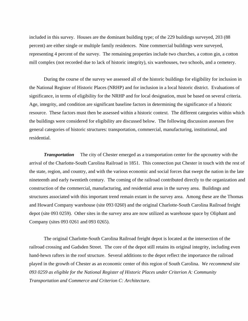
structures associated with this important trend remain extant in the survey area. Among these are the Thomas
and Howard Company warehouse (site 093 0260) and the original Charlotte-South Carolina Railroad freight
depot (site 093 0259). Other sites in the survey area are now utilized as warehouse space by Oliphant and
Company (sites 093 0261 and 093 0265).
The original Charlotte-South Carolina Railroad freight depot is located at the intersection of the
railroad crossing and Gadsden Street. The core of the depot still retains its original integrity, including even
hand-hewn rafters in the roof structure. Several additions to the depot reflect the importance the railroad
played in the growth of Chester as an economic center of this region of South Carolina. We recommend site
093 0259 as eligible for the National Register of Historic Places under Criterion A: Community
Transportation and Commerce and Criterion C: Architecture.
Figure 7. Southern Railway Freight Depot on Gadsden Street, Site 093 0259.
Figure 8. Inside view of Southern Railway Freight Depot, Site 093 0259.
Commercial Access to the outside world provided by the railroad enabled entrepreneurs to see
opportunities for commercial development. One of the first of these in the survey area was James Pagan who
acquired property along Lancaster Street in the early 1850’s and owned a residence in the survey area. None
of James Pagan’s commercial properties survive, as residences now occupy the portion of Lancaster Street
where those properties stood. The survey of the Gadsden-Lancaster Streets corridor identified nine
commercial properties. The bulk of these are concentrated near the end of Gadsden Street adjacent to
Chester’s present downtown historic district in the “Valley.” The remaining commercial properties are
located near the railway depot and are associated with the cotton industry. Among these are Chappel’s Cotton
and Coal Brokerage (site 093 0258), the Gullet Cotton Gin (site 093 0126), the Southern Cotton Oil Company
complex, (site 093 0263), and the Chester Ice and Fuel Company (site 093 0262). Due to the lack of
architectural integrity we do not recommend the commercial structures in the Gadsden-Lancaster Streets
corridor for local designation.
Manufacturing While Chester was first a transportation and commercial center, it gained regional
importance in the late nineteenth century as a manufacturing center. The Springsteen Mill is the best known
of Chester’s manufacturing sites in the survey area. The mill itself has lost a great deal of its historical
integrity and was not included in the present survey. The houses of the Springsteen Mill village, as discussed
below, have been recommended eligible for local designation as a historic district. The only other
manufacturing complex in the survey area is the Moffat Manufacturing Company (site 093 0267), which
remains only as a shell of the original structures. The facades retain a measure of their historic character but
due to their lack of sufficient architectural integrity we do not recommend the manufacturing structures in the
Gadsden-Lancaster Streets corridor for local designation.
Institutional Institutional buildings, including churches, government buildings, and libraries, are
vital to the health of a community. They represent lasting, systemic features of a community which often
survive the passage of time and generations of residents. Architecturally, institutional buildings in rural areas
sometimes represent the closest approximation to national, academic styles since more money and effort are
put into their design and construction as compared to other buildings.
Four institutional buildings and one site were identified in the survey of the Gadsden-Lancaster Streets
corridor. Of the four buildings, two are churches and two are schools. The churches were built in 1908 and
1924; the earliest is the Calvary Baptist Church (site 093 0216), which is located at the intersection of Walnut
and Springs Streets. Extensive alterations to Calvary Baptist Church include a 1970s-era rear addition,
replacement stained glass windows, and a remodeled porch. These alterations dramatically reduce the
architectural integrity of this church. Carmel Presbyterian Church (site 093 0217) was erected in 1924 to
replace an older structure. The two schools represented in the survey area are the Withrew Manual Training
School (site 093 0150) built in 1916, and Kumler Hall at Brainerd Institute (site 093 0249), which was also
built about 1916. Both churches and the Withrew School have been altered to some extent. Withrew Manual
Training School is recommended for inclusion in the College Street School area historic district, which is
discussed below. The single site included in the survey is Mount Hebron Cemetery (site 093 274), located
northeast of the main survey area. This historically black cemetery was officially organized in the 1890s.
However, a number of graves at the site appear to date from earlier decades. We recommend the City of
Chester consider the Mount Hebron Cemetery (site 093 0274) for local designation due to its value as a
historically significant African-American site in Chester.
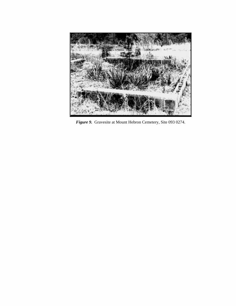
Figure 9. Gravesite at Mount Hebron Cemetery, Site 093 0274.
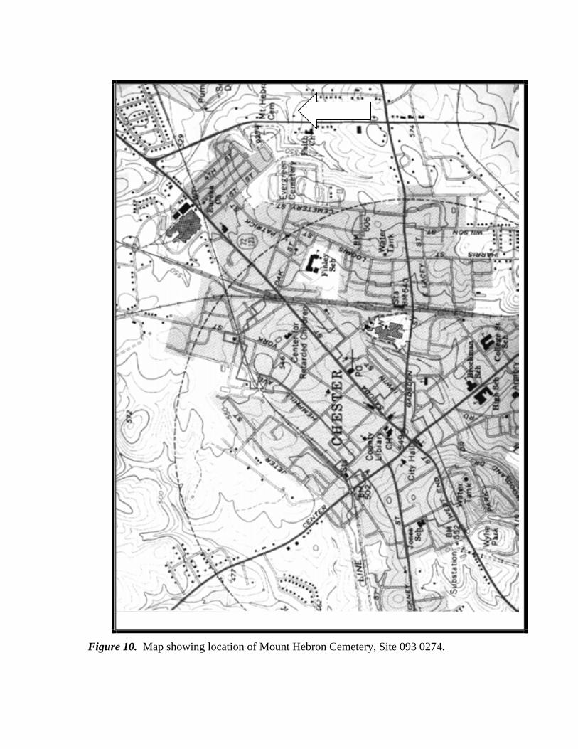
Figure 10. Map showing location of Mount Hebron Cemetery, Site 093 0274.
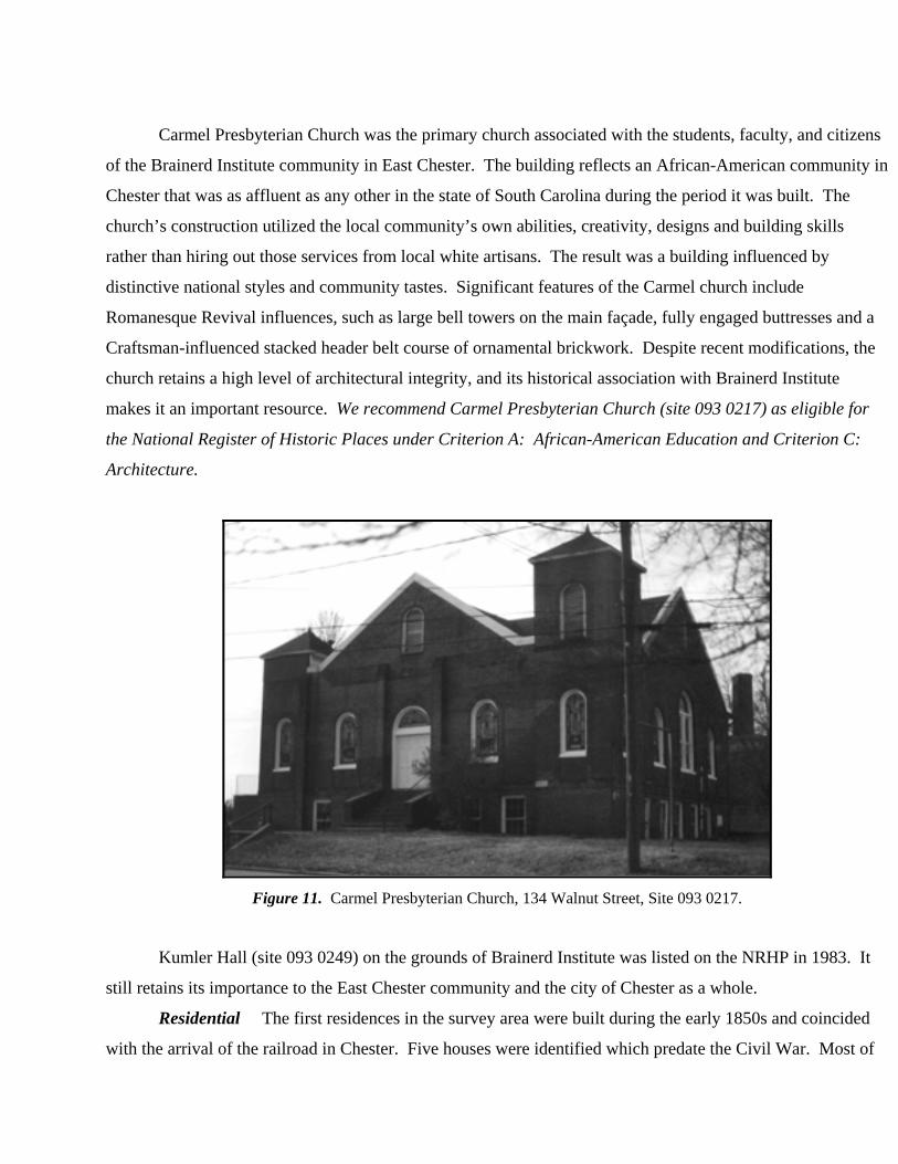
Carmel Presbyterian Church was the primary church associated with the students, faculty, and citizens
of the Brainerd Institute community in East Chester. The building reflects an African-American community in
Chester that was as affluent as any other in the state of South Carolina during the period it was built. The
church’s construction utilized the local community’s own abilities, creativity, designs and building skills
rather than hiring out those services from local white artisans. The result was a building influenced by
distinctive national styles and community tastes. Significant features of the Carmel church include
Romanesque Revival influences, such as large bell towers on the main façade, fully engaged buttresses and a
Craftsman-influenced stacked header belt course of ornamental brickwork. Despite recent modifications, the
church retains a high level of architectural integrity, and its historical association with Brainerd Institute
makes it an important resource. We recommend Carmel Presbyterian Church (site 093 0217) as eligible for
the National Register of Historic Places under Criterion A: African-American Education and Criterion C:
Architecture.
Figure 11. Carmel Presbyterian Church, 134 Walnut Street, Site 093 0217.
Kumler Hall (site 093 0249) on the grounds of Brainerd Institute was listed on the NRHP in 1983. It
still retains its importance to the East Chester community and the city of Chester as a whole.
Residential The first residences in the survey area were built during the early 1850s and coincided
with the arrival of the railroad in Chester. Five houses were identified which predate the Civil War. Most of
the historic houses in the survey area were built in the early to mid-twentieth century. Of the 203 single and
multiple family dwellings identified in the survey, 127 (55 percent) were built in or after 1900. Twenty-nine
were built between 1860 and 1890 and forty-two were built in association with the rise of the mill.
Of the five antebellum homes identified in the survey area, four reflect Greek Revival elements in their
construction. Greek Revival houses often have a wide band of trim beneath the eaves, mimicking the
entablature of Greek temples. Full-facade or full-height entry porches with columns are common, although
more subtle examples have small entry porches or no porch and columns at all. Many have side-gabled or
hipped roofs. In some instances, houses in this style are oriented so that the gable end becomes the front
facade; these most closely resemble their prototype Greek temples.69
The Pagan House (site 093 0066), built in 1854, is an example of a raised Greek Revival cottage. The
Wrenn House (site 093 0095.00), built circa 1854, the Knox Cottage (site 093 0081), built in 1857, and the
Fayssoux Cottage (site 093 0093), built in 1857, all have a central pedimented portico as is typical of the
Greek Revival style although these residences are not of the raised cottage form. The Wrenn House is the
only Greek Revival style brick home in the survey area and the date of construction is based on a date
imprinted on a window frame. All four of these homes have been altered to some extent. The Pagan House
has lost much of its architectural integrity due to the infill of the piers supporting the house, and the addition
of storm windows and vinyl siding. The Fayssoux Cottage has had similar alterations. Both the Pagan House
and Fayssoux Cottage lack sufficient architectural integrity to be individually eligible for the National Register
but are recommended as contributing resources to a potential National Register historic district. Despite loss
of integrity, both of the foregoing properties are among the most architecturally sophisticated in the survey
area. These properties might qualify for individual listing if their historic appearance were restored through
the removal of siding and other character altering elements. The extensive alterations to the Wrenn House, the
reworked porch and rear addition, have permanently compromised its historic architectural integrity.
The Knox Cottage (site 093 0081) is an excellent example of Greek Revival style cottage. The house
retains its original clapboard siding, six over six windows, main door with transom and sidelights, and
substantial exterior chimneys. Its date of construction in 1857 relates it to the period of growth in Chester that
was brought on by the arrival of the railroad. The porch was altered sometime in the late nineteenth century
69 Lee McAlester and Virginia McAlester, A Field Guide to American Houses (New York: Alfred A. Knopf, Inc., 1984), 6.
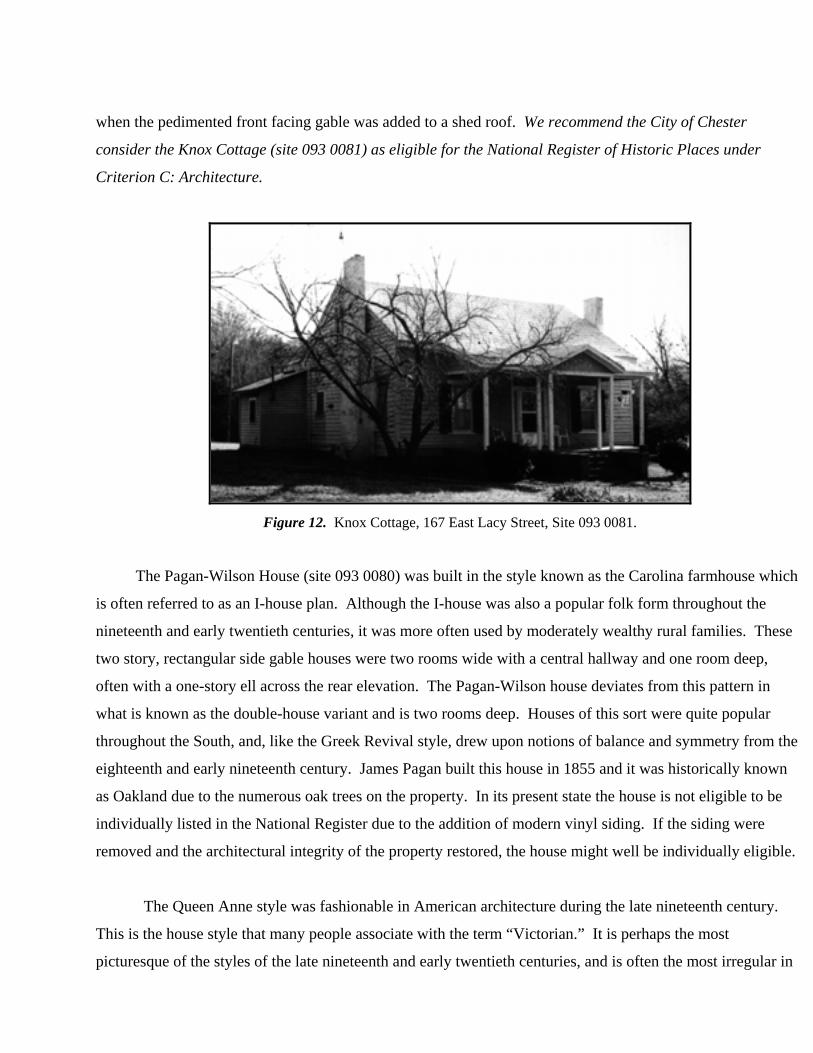
when the pedimented front facing gable was added to a shed roof. We recommend the City of Chester
consider the Knox Cottage (site 093 0081) as eligible for the National Register of Historic Places under
Criterion C: Architecture.
Figure 12. Knox Cottage, 167 East Lacy Street, Site 093 0081.
The Pagan-Wilson House (site 093 0080) was built in the style known as the Carolina farmhouse which
is often referred to as an I-house plan. Although the I-house was also a popular folk form throughout the
nineteenth and early twentieth centuries, it was more often used by moderately wealthy rural families. These
two story, rectangular side gable houses were two rooms wide with a central hallway and one room deep,
often with a one-story ell across the rear elevation. The Pagan-Wilson house deviates from this pattern in
what is known as the double-house variant and is two rooms deep. Houses of this sort were quite popular
throughout the South, and, like the Greek Revival style, drew upon notions of balance and symmetry from the
eighteenth and early nineteenth century. James Pagan built this house in 1855 and it was historically known
as Oakland due to the numerous oak trees on the property. In its present state the house is not eligible to be
individually listed in the National Register due to the addition of modern vinyl siding. If the siding were
removed and the architectural integrity of the property restored, the house might well be individually eligible.
The Queen Anne style was fashionable in American architecture during the late nineteenth century.
This is the house style that many people associate with the term “Victorian.” It is perhaps the most
picturesque of the styles of the late nineteenth and early twentieth centuries, and is often the most irregular in
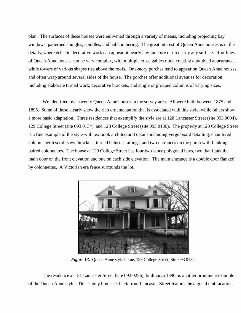
plan. The surfaces of these houses were enlivened through a variety of means, including projecting bay
windows, patterned shingles, spindles, and half-timbering. The great interest of Queen Anne houses is in the
details, where eclectic decorative work can appear at nearly any juncture or on nearly any surface. Rooflines
of Queen Anne houses can be very complex, with multiple cross gables often creating a jumbled appearance,
while towers of various shapes rise above the roofs. One-story porches tend to appear on Queen Anne houses,
and often wrap around several sides of the house. The porches offer additional avenues for decoration,
including elaborate turned work, decorative brackets, and single or grouped columns of varying sizes.
We identified over twenty Queen Anne houses in the survey area. All were built between 1875 and
1895. Some of these clearly show the rich ornamentation that is associated with this style, while others show
a more basic adaptation. Three residences that exemplify the style are at 120 Lancaster Street (site 093 0094),
129 College Street (site 093 0134), and 128 College Street (site 093 0136). The property at 128 College Street
is a fine example of the style with textbook architectural details including verge board detailing, chamfered
columns with scroll sawn brackets, turned baluster railings, and two entrances on the porch with flanking
paired colonnettes. The house at 129 College Street has four two-story polygonal bays, two that flank the
main door on the front elevation and one on each side elevation. The main entrance is a double door flanked
by colonnettes. A Victorian era fence surrounds the lot.
Figure 13. Queen Anne style home, 129 College Street, Site 093 0134.
The residence at 151 Lancaster Street (site 093 0256), built circa 1890, is another prominent example
of the Queen Anne style. This stately home set back from Lancaster Street features hexagonal embracation,
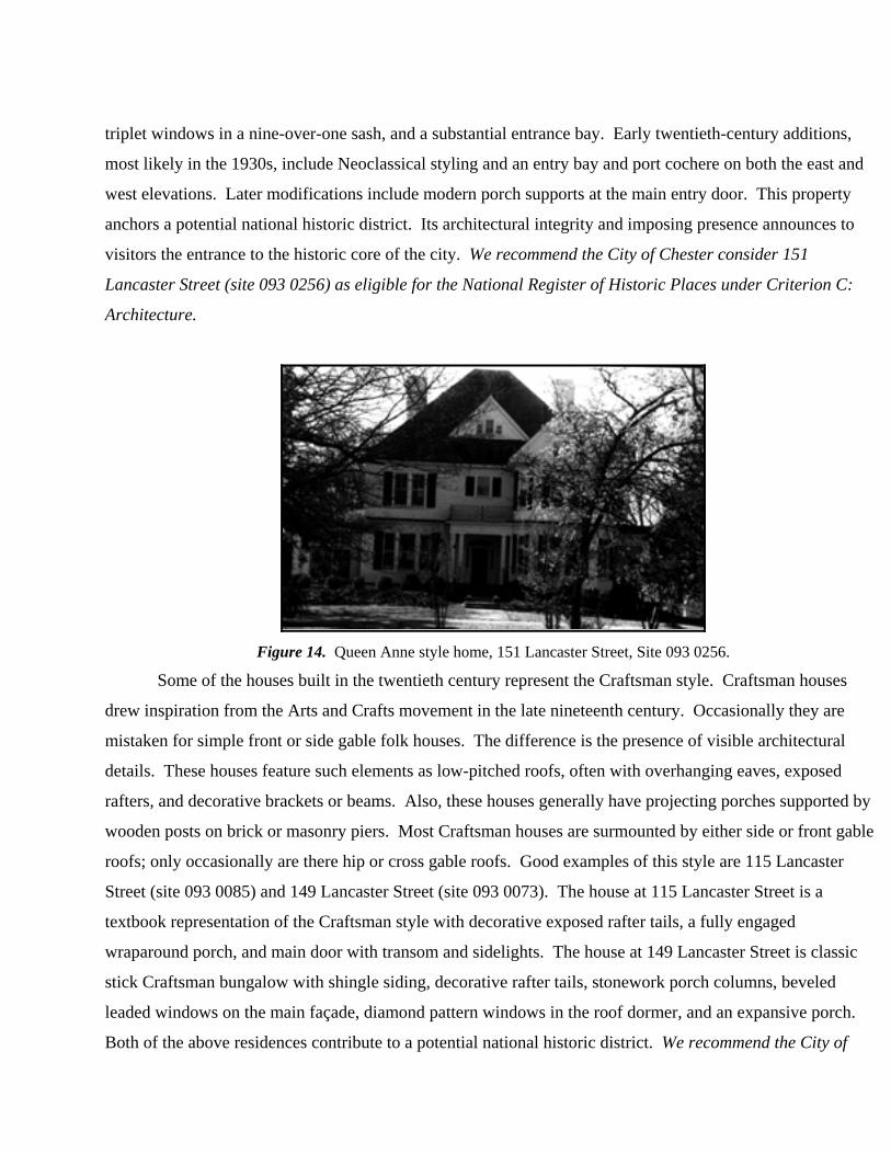
triplet windows in a nine-over-one sash, and a substantial entrance bay. Early twentieth-century additions,
most likely in the 1930s, include Neoclassical styling and an entry bay and port cochere on both the east and
west elevations. Later modifications include modern porch supports at the main entry door. This property
anchors a potential national historic district. Its architectural integrity and imposing presence announces to
visitors the entrance to the historic core of the city. We recommend the City of Chester consider 151
Lancaster Street (site 093 0256) as eligible for the National Register of Historic Places under Criterion C:
Architecture.
Figure 14. Queen Anne style home, 151 Lancaster Street, Site 093 0256.
Some of the houses built in the twentieth century represent the Craftsman style. Craftsman houses
drew inspiration from the Arts and Crafts movement in the late nineteenth century. Occasionally they are
mistaken for simple front or side gable folk houses. The difference is the presence of visible architectural
details. These houses feature such elements as low-pitched roofs, often with overhanging eaves, exposed
rafters, and decorative brackets or beams. Also, these houses generally have projecting porches supported by
wooden posts on brick or masonry piers. Most Craftsman houses are surmounted by either side or front gable
roofs; only occasionally are there hip or cross gable roofs. Good examples of this style are 115 Lancaster
Street (site 093 0085) and 149 Lancaster Street (site 093 0073). The house at 115 Lancaster Street is a
textbook representation of the Craftsman style with decorative exposed rafter tails, a fully engaged
wraparound porch, and main door with transom and sidelights. The house at 149 Lancaster Street is classic
stick Craftsman bungalow with shingle siding, decorative rafter tails, stonework porch columns, beveled
leaded windows on the main façade, diamond pattern windows in the roof dormer, and an expansive porch.
Both of the above residences contribute to a potential national historic district. We recommend the City of
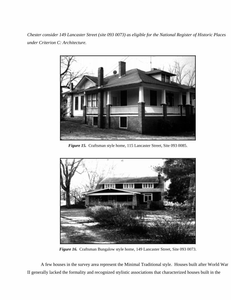
Chester consider 149 Lancaster Street (site 093 0073) as eligible for the National Register of Historic Places
under Criterion C: Architecture.
Figure 15. Craftsman style home, 115 Lancaster Street, Site 093 0085.
Figure 16. Craftsman Bungalow style home, 149 Lancaster Street, Site 093 0073.
A few houses in the survey area represent the Minimal Traditional style. Houses built after World War
II generally lacked the formality and recognized stylistic associations that characterized houses built in the
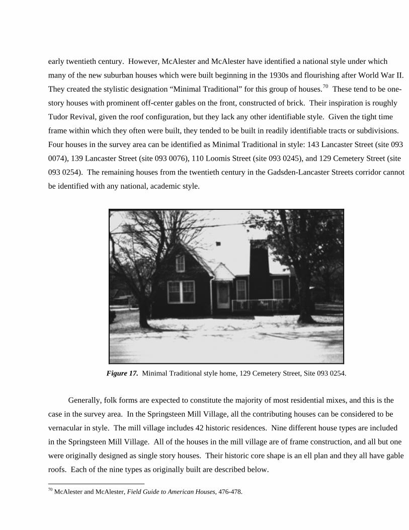
early twentieth century. However, McAlester and McAlester have identified a national style under which
many of the new suburban houses which were built beginning in the 1930s and flourishing after World War II.
They created the stylistic designation “Minimal Traditional” for this group of houses.70 These tend to be one-
story houses with prominent off-center gables on the front, constructed of brick. Their inspiration is roughly
Tudor Revival, given the roof configuration, but they lack any other identifiable style. Given the tight time
frame within which they often were built, they tended to be built in readily identifiable tracts or subdivisions.
Four houses in the survey area can be identified as Minimal Traditional in style: 143 Lancaster Street (site 093
0074), 139 Lancaster Street (site 093 0076), 110 Loomis Street (site 093 0245), and 129 Cemetery Street (site
093 0254). The remaining houses from the twentieth century in the Gadsden-Lancaster Streets corridor cannot
be identified with any national, academic style.
Figure 17. Minimal Traditional style home, 129 Cemetery Street, Site 093 0254.
Generally, folk forms are expected to constitute the majority of most residential mixes, and this is the
case in the survey area. In the Springsteen Mill Village, all the contributing houses can be considered to be
vernacular in style. The mill village includes 42 historic residences. Nine different house types are included
in the Springsteen Mill Village. All of the houses in the mill village are of frame construction, and all but one
were originally designed as single story houses. Their historic core shape is an ell plan and they all have gable
roofs. Each of the nine types as originally built are described below.
70 McAlester and McAlester, Field Guide to American Houses, 476-478.
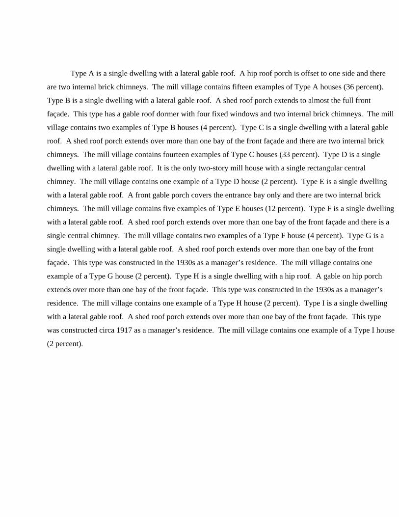
Type A is a single dwelling with a lateral gable roof. A hip roof porch is offset to one side and there
are two internal brick chimneys. The mill village contains fifteen examples of Type A houses (36 percent).
Type B is a single dwelling with a lateral gable roof. A shed roof porch extends to almost the full front
façade. This type has a gable roof dormer with four fixed windows and two internal brick chimneys. The mill
village contains two examples of Type B houses (4 percent). Type C is a single dwelling with a lateral gable
roof. A shed roof porch extends over more than one bay of the front façade and there are two internal brick
chimneys. The mill village contains fourteen examples of Type C houses (33 percent). Type D is a single
dwelling with a lateral gable roof. It is the only two-story mill house with a single rectangular central
chimney. The mill village contains one example of a Type D house (2 percent). Type E is a single dwelling
with a lateral gable roof. A front gable porch covers the entrance bay only and there are two internal brick
chimneys. The mill village contains five examples of Type E houses (12 percent). Type F is a single dwelling
with a lateral gable roof. A shed roof porch extends over more than one bay of the front façade and there is a
single central chimney. The mill village contains two examples of a Type F house (4 percent). Type G is a
single dwelling with a lateral gable roof. A shed roof porch extends over more than one bay of the front
façade. This type was constructed in the 1930s as a manager’s residence. The mill village contains one
example of a Type G house (2 percent). Type H is a single dwelling with a hip roof. A gable on hip porch
extends over more than one bay of the front façade. This type was constructed in the 1930s as a manager’s
residence. The mill village contains one example of a Type H house (2 percent). Type I is a single dwelling
with a lateral gable roof. A shed roof porch extends over more than one bay of the front façade. This type
was constructed circa 1917 as a manager’s residence. The mill village contains one example of a Type I house
(2 percent).
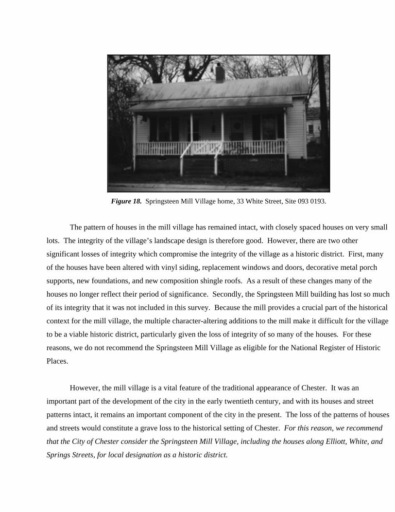
Figure 18. Springsteen Mill Village home, 33 White Street, Site 093 0193.
The pattern of houses in the mill village has remained intact, with closely spaced houses on very small
lots. The integrity of the village’s landscape design is therefore good. However, there are two other
significant losses of integrity which compromise the integrity of the village as a historic district. First, many
of the houses have been altered with vinyl siding, replacement windows and doors, decorative metal porch
supports, new foundations, and new composition shingle roofs. As a result of these changes many of the
houses no longer reflect their period of significance. Secondly, the Springsteen Mill building has lost so much
of its integrity that it was not included in this survey. Because the mill provides a crucial part of the historical
context for the mill village, the multiple character-altering additions to the mill make it difficult for the village
to be a viable historic district, particularly given the loss of integrity of so many of the houses. For these
reasons, we do not recommend the Springsteen Mill Village as eligible for the National Register of Historic
Places.
However, the mill village is a vital feature of the traditional appearance of Chester. It was an
important part of the development of the city in the early twentieth century, and with its houses and street
patterns intact, it remains an important component of the city in the present. The loss of the patterns of houses
and streets would constitute a grave loss to the historical setting of Chester. For this reason, we recommend
that the City of Chester consider the Springsteen Mill Village, including the houses along Elliott, White, and
Springs Streets, for local designation as a historic district.

The field team identified four other residential sections elsewhere in the survey area: the Childs-
Edwards Quarter, East Chester, College Street School area, and the Lancaster-East Lacy Streets area. Similar
issues of integrity exist in the Childs-Edwards Quarter and East Chester as in the mill village. While the
houses lie on their original lots, with few intrusions, many have been clad in vinyl siding. Synthetic vinyl
siding poses a particular problem for several reasons. The application of synthetic siding alters the visual
characteristics of a building and often necessitates the removal of significant architectural details. While
scattered examples of buildings to which siding has been applied may not have a negative impact on the
eligibility of a property or district, a larger concentration is more problematical. The houses that have been
clad in vinyl siding are spread more or less evenly throughout the survey area. Due to this loss of historic
architectural integrity we do not recommend the residential areas of the Childs-Edwards Quarter and East
Chester for the National Register of Historic Places as a district. However, there is a sufficient concentration
of historic buildings in East Chester, but not in the Childs-Edwards Quarter, to warrant a locally designated
historic district there. The pattern and type of houses in East Chester are vital to the historical appearance of
Chester, and their alteration would be a significant loss to the community. For this reason, we recommend
that the City of Chester consider the East Chester residential district for local designation.
The College Street School area and the Lancaster-East Lacy Streets area both convey a strong visual
impression of their historic settings. The College Street School area has a significant concentration of historic
properties that represent a potential National Register historic district. Some of the resources lack individual
distinction but contribute to the historic character of the neighborhood, such as 116 College Street (site 093
0148). As discussed above, 128 College Street (site 093 0136) and the Withrew Manual Training School (site
093 0150) are individually distinctive and serve as focal points for the neighborhood. The potential district’s
architectural character is rooted in the Queen Anne style with well over 80 percent of the properties in the
style. The remaining styles are of early Craftsman types. The proposed district should also include properties
on the western side of Columbia Street that the project did not include in the survey. The district as a whole
possesses a high level of architectural integrity and we recommend the residential area of the College Street
School area as eligible for the National Register of Historic Places as a historic district. We also recommend
that the City of Chester consider the College Street School area for local designation as a historic district.
Figure 19. 128 College Street, Site 093 0136.
The Lancaster-East Lacy Streets area also has a significant concentration of historic properties that
contribute to the historic character of the neighborhood. The resources such as 136 East Lacy (site 093 0058)
and 127 Lancaster Street (site 093 0089), while not individually eligible, are distinctive in their own way. As
discussed above, 149 Lancaster Street (site 093 0073), 115 Lancaster Street (site 093 0085) and 151 Lancaster
Street (site 093 0256) are all individually distinctive. The diverse architectural forms found in the district
convey the historic character of the neighborhood. The types of architecture found in this potential district
include antebellum Greek Revival, Carolina farmhouses, Queen Anne, Craftsman-Bungalow, and Minimal
Traditional. The many different forms give evidence of the architectural growth of the neighborhood and the
city of Chester. The area additionally presents an aesthetic of a traditional residential setting with its tree-lined
streetscape. This district possesses a high level of architectural integrity and we recommend the residential
area of the Lancaster-East Lacy Streets area as eligible for the National Register of Historic Places as a
district. We also recommend that the City of Chester consider the Lancaster-East Lacy Streets area for local
designation as a historic district.
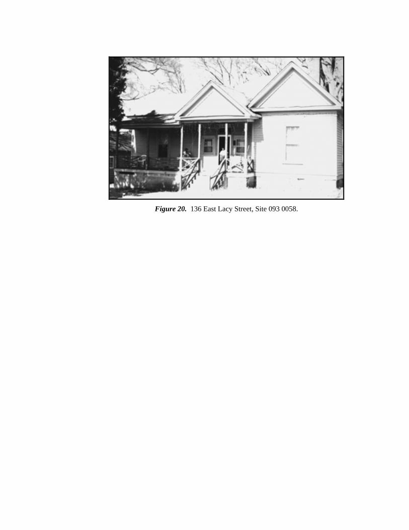
Figure 20. 136 East Lacy Street, Site 093 0058.
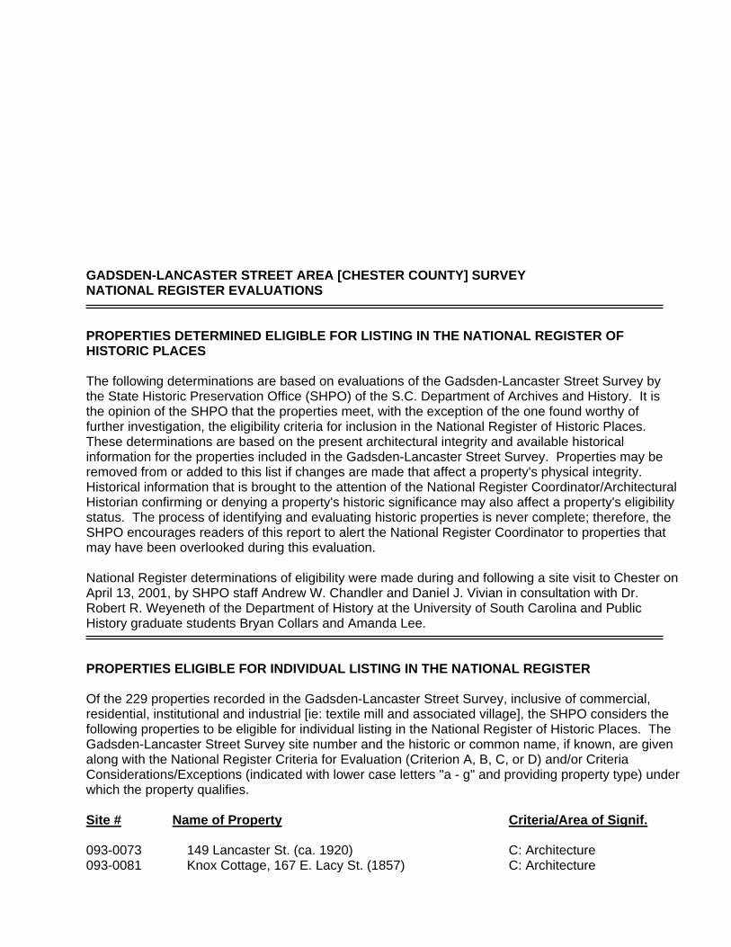
GADSDEN-LANCASTER STREET AREA [CHESTER COUNTY] SURVEY NATIONAL REGISTER EVALUATIONS PROPERTIES DETERMINED ELIGIBLE FOR LISTING IN THE NATIONAL REGISTER OF HISTORIC PLACES The following determinations are based on evaluations of the Gadsden-Lancaster Street Survey by the State Historic Preservation Office (SHPO) of the S.C. Department of Archives and History. It is the opinion of the SHPO that the properties meet, with the exception of the one found worthy of further investigation, the eligibility criteria for inclusion in the National Register of Historic Places. These determinations are based on the present architectural integrity and available historical information for the properties included in the Gadsden-Lancaster Street Survey. Properties may be removed from or added to this list if changes are made that affect a property's physical integrity. Historical information that is brought to the attention of the National Register Coordinator/Architectural Historian confirming or denying a property's historic significance may also affect a property's eligibility status. The process of identifying and evaluating historic properties is never complete; therefore, the SHPO encourages readers of this report to alert the National Register Coordinator to properties that may have been overlooked during this evaluation. National Register determinations of eligibility were made during and following a site visit to Chester on April 13, 2001, by SHPO staff Andrew W. Chandler and Daniel J. Vivian in consultation with Dr. Robert R. Weyeneth of the Department of History at the University of South Carolina and Public History graduate students Bryan Collars and Amanda Lee. PROPERTIES ELIGIBLE FOR INDIVIDUAL LISTING IN THE NATIONAL REGISTER Of the 229 properties recorded in the Gadsden-Lancaster Street Survey, inclusive of commercial, residential, institutional and industrial [ie: textile mill and associated village], the SHPO considers the following properties to be eligible for individual listing in the National Register of Historic Places. The Gadsden-Lancaster Street Survey site number and the historic or common name, if known, are given along with the National Register Criteria for Evaluation (Criterion A, B, C, or D) and/or Criteria Considerations/Exceptions (indicated with lower case letters "a - g" and providing property type) under which the property qualifies. Site # Name of Property Criteria/Area of Signif. 093-0073 149 Lancaster St. (ca. 1920) C: Architecture 093-0081 Knox Cottage, 167 E. Lacy St. (1857) C: Architecture
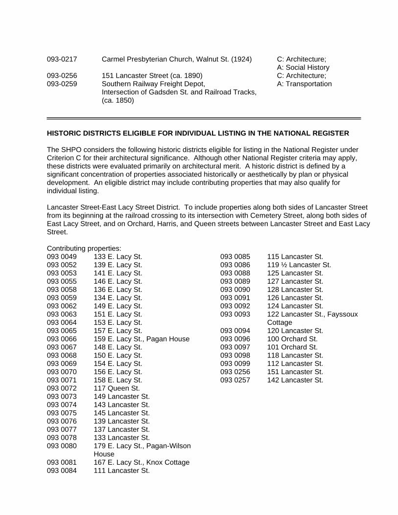
093-0217 Carmel Presbyterian Church, Walnut St. (1924) C: Architecture; A: Social History 093-0256 151 Lancaster Street (ca. 1890) C: Architecture; 093-0259 Southern Railway Freight Depot, A: Transportation Intersection of Gadsden St. and Railroad Tracks, (ca. 1850) HISTORIC DISTRICTS ELIGIBLE FOR INDIVIDUAL LISTING IN THE NATIONAL REGISTER The SHPO considers the following historic districts eligible for listing in the National Register under Criterion C for their architectural significance. Although other National Register criteria may apply, these districts were evaluated primarily on architectural merit. A historic district is defined by a significant concentration of properties associated historically or aesthetically by plan or physical development. An eligible district may include contributing properties that may also qualify for individual listing. Lancaster Street-East Lacy Street District. To include properties along both sides of Lancaster Street from its beginning at the railroad crossing to its intersection with Cemetery Street, along both sides of East Lacy Street, and on Orchard, Harris, and Queen streets between Lancaster Street and East Lacy Street. Contributing properties: 093 0049 133 E. Lacy St. 093 0052 139 E. Lacy St. 093 0053 141 E. Lacy St. 093 0055 146 E. Lacy St. 093 0058 136 E. Lacy St. 093 0059 134 E. Lacy St. 093 0062 149 E. Lacy St. 093 0063 151 E. Lacy St. 093 0064 153 E. Lacy St. 093 0065 157 E. Lacy St. 093 0066 159 E. Lacy St., Pagan House 093 0067 148 E. Lacy St. 093 0068 150 E. Lacy St. 093 0069 154 E. Lacy St. 093 0070 156 E. Lacy St. 093 0071 158 E. Lacy St. 093 0072 117 Queen St. 093 0073 149 Lancaster St. 093 0074 143 Lancaster St. 093 0075 145 Lancaster St. 093 0076 139 Lancaster St. 093 0077 137 Lancaster St. 093 0078 133 Lancaster St. 093 0080 179 E. Lacy St., Pagan-Wilson
House 093 0081 167 E. Lacy St., Knox Cottage 093 0084 111 Lancaster St.
093 0085 115 Lancaster St. 093 0086 119 ½ Lancaster St. 093 0088 125 Lancaster St. 093 0089 127 Lancaster St. 093 0090 128 Lancaster St. 093 0091 126 Lancaster St. 093 0092 124 Lancaster St. 093 0093 122 Lancaster St., Fayssoux
Cottage 093 0094 120 Lancaster St. 093 0096 100 Orchard St. 093 0097 101 Orchard St. 093 0098 118 Lancaster St. 093 0099 112 Lancaster St. 093 0256 151 Lancaster St. 093 0257 142 Lancaster St.
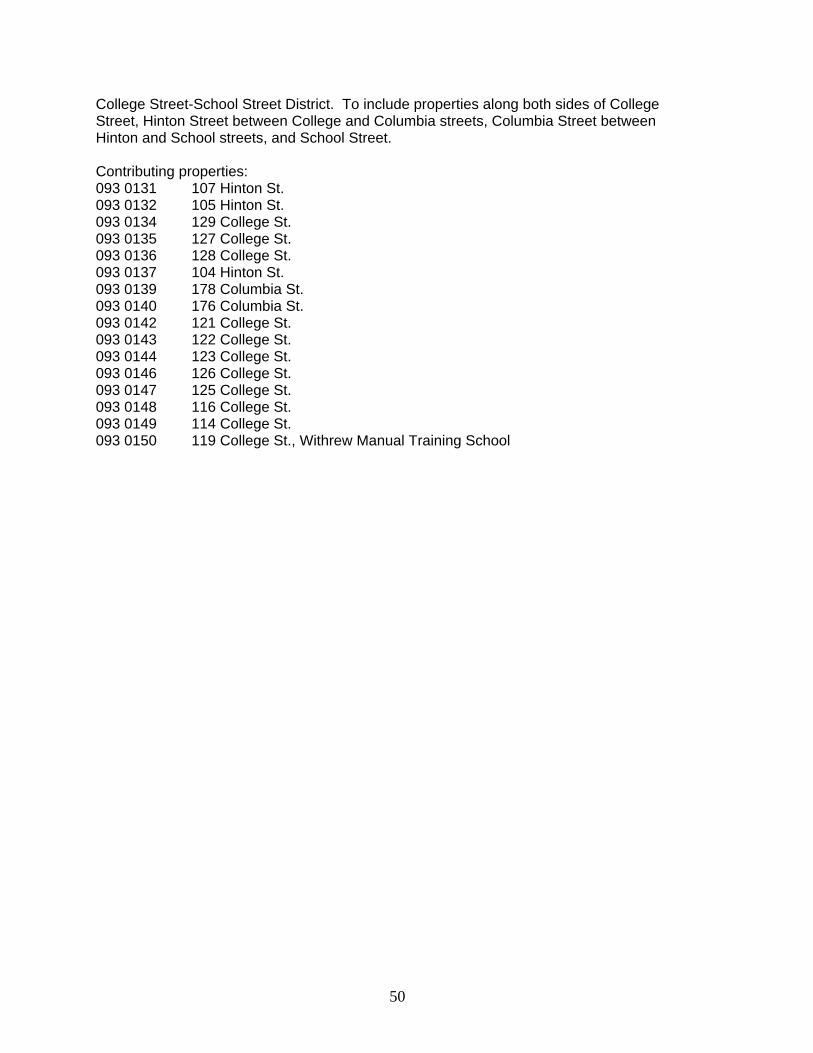
College Street-School Street District. To include properties along both sides of College Street, Hinton Street between College and Columbia streets, Columbia Street between Hinton and School streets, and School Street. Contributing properties: 093 0131 107 Hinton St. 093 0132 105 Hinton St. 093 0134 129 College St. 093 0135 127 College St. 093 0136 128 College St. 093 0137 104 Hinton St. 093 0139 178 Columbia St. 093 0140 176 Columbia St. 093 0142 121 College St. 093 0143 122 College St. 093 0144 123 College St. 093 0146 126 College St. 093 0147 125 College St. 093 0148 116 College St. 093 0149 114 College St. 093 0150 119 College St., Withrew Manual Training School
50
Data Gaps
All portions of the survey area were accessible to the surveyors. There were no data gaps in
the survey.
Recommendations
Results of the Survey of the Gadsden-Lancaster Streets Corridor Based on the
findings of this survey we recommend five properties be individually nominated to the
National Register of Historic Places (sites 093 0256, 093 0073, 093 0081, 093 0217, and 093
0259). We also recommend one individual site for local designation by the City of Chester
(site 093 0274). Two districts, the College Street School Area and the Lancaster-East Lacy
Streets Area are recommended for nomination to the NRHP. We recommend four districts ---
the Springsteen Mill Village, East Chester, the College Street School Area, and the Lancaster-
East Lacy Streets Area --- for local designation by the City of Chester.
The survey identified the development of the Gadsden-Lancaster Streets corridor as a potential
threat to preservation efforts in Chester as well as a tremendous opportunity. This corridor is the
main entryway from I-77 into Chester and is thus experiencing a significant amount of growth. As
discussed in the “Objectives of the Survey” section of this report (see pp. 5-6), the City already has a
number of planned improvements for the area. While these changes, such as the building of a new
passenger depot for an Amtrak route, will bring greater economic opportunity to Chester, steps to
maintain and protect the historic and aesthetic character of this entry corridor are also recommended.
A beautification program, if conducted in an appropriate manner that does not compromise the
historic setting and character of this area, could enhance the visual appeal of the corridor. Possible
sources of funding for such efforts include the Transportation Enhancement Grants Program
administered by the South Carolina Department of Transportation.
The Framework for Historic Preservation in Chester Chester is fortunate to have one of the
strongest and oldest local preservation programs in the state of South Carolina. The town’s charming
character is a direct reflection of the ability of historic preservation to serve as a tool for maintaining
community character, property values, and the vitality of traditional neighborhoods. The Chester
51
Historic District was listed in the National Register in 1972 and expanded in 1988. The City Hall and
Opera House was listed in 1973. In 1988 Chester became a participant in the Certified Local
Government (CLG) program, which offers local governments the opportunity to work closely with
State Historic Preservation Offices and the National Park Service in administering local preservation
programs.
The Chester Historic Review Commission plays a central role in administering the local
preservation program. The Commission operates under the authority of the City of Chester Zoning
Ordinance as amended by Ordinance No. 51, adopted April 14, 1986. The Commission reviews
proposals to alter, relocate, demolish, or partially demolish buildings within the boundaries of the
locally designated Chester Historic District. The Commission also reviews proposals for new
construction within the district. As stated in Article XIV, Section 1206 of the above-referenced
ordinance, the general purposes of the Commission are “to promote the educational, cultural, and
general welfare of the public through the preservation, protection and enhancement of the old,
historic or architecturally important structures and areas of the City of Chester.” More specifically, in
carrying out its assigned duties, the Commission seeks to use preservation as a means to stabilize and
improve property values, strengthen the local economy, encourage the investment of private capital in
historic buildings in the historic district, and encourage new buildings and developments that will be
harmonious with the character of the Chester Historic District.
An excellent example of ongoing preservation activities in Chester are the efforts currently
underway to save Kumler Hall, the only extant building of the Brainerd Institute. The building was
recently purchased by actress Phylicia Rashad in the hopes of restoring it for use as an African-
American cultural museum that would also celebrate the history of Brainerd. Her mother, Vivian
Ayers Allen, a playwright and publisher, is a graduate of Brainerd and a Chester native. A high-
profile fundraising event, which included Mrs. Rashad’s sister, choreographer Debbie Allen, was
held in October 2000 in New York City to raise money for the project.71 The family wishes to bring
the unique and significant history of Brainerd and the need to preserve Kumler Hall to national
attention. It is our hope that this survey, which includes the residential area surrounding Brainerd
71 Susan J. Stabley, “Brainerd goes Big Apple,” Rock Hill Herald, 20 September 2000, 1A.
52
Institute, will aid the family’s effort and will encourage future investment in the preservation and
beautification of East Chester.
Local Preservation in General In broad terms, the success of preservation in Chester, as in
any other city, depends on three key factors: public awareness, leadership from both private citizens
and public officials, and complete and accurate information on historic resources. Ideally these
factors work together to foster circumstances that allow historic preservation to complement the
growth and physical development of a community. The present survey furthers this process in
Chester by compiling information about the history of the Gadsden-Lancaster Streets area and
identifying significant properties that deserve recognition and preservation, thereby raising public
awareness and directing the attention of community leaders to the opportunities for preservation that
enhance the quality of life.
Any successful local preservation program depends upon a broad public understanding of the
value of historic structures and neighborhoods. A great deal of the activity carried out under the
name of historic preservation relies on the initiative and interest of individual house and business
owners, who are responsible for the maintenance and upkeep of their property. Many residents are
unaware that they have historic properties in their care or do not recognize the value that collections
of historic buildings can have to a community in terms of esthetic pleasure, property values, and the
economic climate of a city. Surveys such as this project and future preservation planning activities
inspired by it can help stimulate a broad-based appreciation for, and awareness of, historic buildings
in the city.
Most communities with historic resources face a number of general preservation threats. The
slow accumulation of piecemeal changes to historic buildings is a particularly serious concern.
Alterations and additions can adversely affect the architectural integrity of individual buildings.
Individual changes, if considered as an isolated case, may seem modest, but if they in fact constitute a
broader trend, the cumulative effect on a historic district can be devastating. What may appear to be
minor modifications to a single building within a neighborhood or the construction of a single
inappropriate building in an adjacent area can, over time and in conjunction with similar events,
destroy the integrity of the entire neighborhood. Changes to a historic district rarely come through
53
the wholesale destruction of buildings; rather, an ongoing series of small changes gradually reduces
the prevalence of distinctive architectural styles, results in the removal of significant amounts of
historic building materials, or compromises the neighborhood’s historic setting and layout. These are
problems faced by all communities with significant historic resources.
The purpose of this project was to establish an inventory of historic buildings that contribute to
the traditional character of the Gadsden-Lancaster Streets corridor and to begin the process of
determining, at the local level, what is significant and deserving of protection. The overriding goal of
this process, particularly the consideration of giving local designation to specific buildings or
districts, is not to stifle future development through government regulation but to encourage the
recognition of Chester’s historical fabric as an important factor in the comprehensive community
planning process. Although historic buildings are sometimes seen as hindrances to development,
they can also serve to attract new residents and new businesses, especially if incorporated into the
planning process. The experiences of communities nationwide demonstrate that historic preservation
can be a powerful force in preserving traditional community character and maintaining the integrity
of historic business districts and residential neighborhoods, particularly if municipal governments
establish an effective means for protecting the character and integrity of historic buildings. The
Historic Review Commission plays exactly this role in Chester, and ongoing community participation
in promoting and providing support for its activities is essential for the protection of historically
significant buildings.
The Historic Review Commission may wish to undertake educational and outreach efforts to
make property owners in the Gadsden-Lancaster Streets survey area aware of the potential benefits of
preservation. If the City chooses to designate any of the recommended properties or districts in the
survey area, the Commission may wish to develop design guidelines as a means of informing
property owners about appropriate maintenance and repair procedures for historic buildings. The
Commission may also wish to consider publishing educational materials, creating a “preservation
resource room” for the use of Chester’s citizens and public officials, or holding a series of workshops
on preservation issues as a means of encouraging public involvement in preservation activities. A
possible funding source for such projects is the Federal Survey and Planning Grants Program
administered by the SHPO.
54
Because of the central role played by the Historic Review Commission in local preservation
activities, it should maintain its formal and active ties to other history and preservation-related
organizations. These include the South Carolina Department of Archives and History in Columbia,
the Southern Regional Office of the National Trust for Historic Preservation in Charleston, the
National Park Service, and the Public History Program at the University of South Carolina. These
organizations can provide advice and published information regarding the protection of cultural
resources and can recommend methods of rehabilitation that are in keeping with the Secretary of the
Interior’s Standard for the Treatment of Historic Properties (available on the internet at
www2.cr.nps.gov/tps). The practice of preservation is often a complex process, and the Commission
can increase its effectiveness by maintaining close working relationships with partner organizations.
Access to such information and resources will allow the Commission to explore all relevant issues
involved in considering applications to alter or demolish buildings within historic districts.
Property owners may ask the Commission questions such as:
• If restoration is contemplated, or if the request is to “return” a property to a particular style,
what was the original appearance of the building in question?
• If features such as windows or doors need to be replaced, have the applicants searched all the
available sources for replacement-in-kind?
• If accessibility or energy efficiency is an issue, have the applicants considered the alternatives
that will not affect the character-defining features of the building?
• How does one determine the character-defining features of a building?
Professionals in the fields of history, architecture, and historic preservation have generated a
large body of literature that can help the Historic Review Commission carry out its duties. Several
periodicals, particularly Preservation Briefs (www2.cr.nps.gov/tps/briefs/presbhom.htm) and
Preservation Tech Notes, both published by the National Park Service, offer useful technical advice
in making plans for preserving historic buildings and structures. Staff members at the South Carolina
Department of Archives and History can also provide technical assistance.
Protecting the historic resources that we have already identified through the National Register
of Historic Places evaluation process or through local designation is an important component of
55
preservation activities in Chester. At the same time, it is important to realize that preservation
activities should not end with the present survey of historic resources. The City may wish to pursue
other preservation planning projects at a later date, and the staff of the SHPO stands ready to explore
opportunities for additional projects. This process likely will identify additional strategies for
protecting the community’s historic resources and will also promote a greater public awareness of the
value of historic buildings and historic preservation in Chester. This public awareness and
participation will be vital for the maintenance of Chester’s rich historical resources.
56
Appendix A: Inventory of Recorded Properties
Survey of the Gadsden-Lancaster Streets Corridor
Chester, South Carolina
57
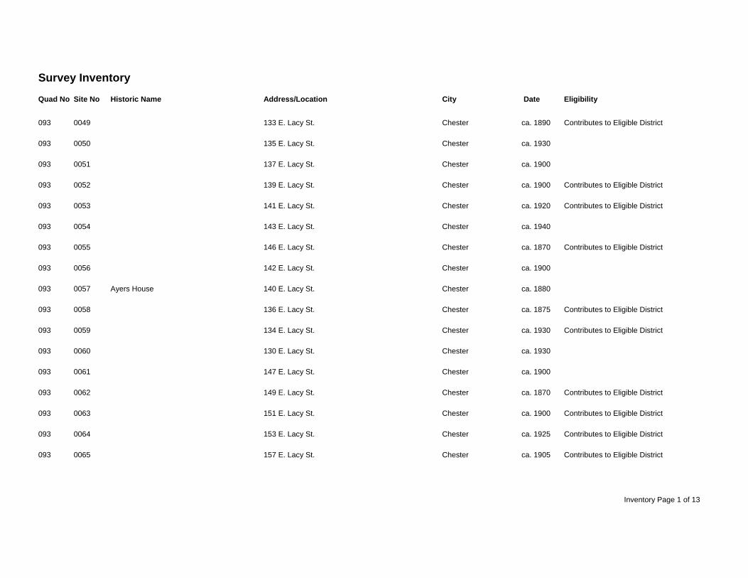
Survey Inventory Quad No Site No Historic Name Address/Location City Date Eligibility
093 0049 133 E. Lacy St. Chester ca. 1890 Contributes to Eligible District
093 0050 135 E. Lacy St. Chester ca. 1930
093 0051 137 E. Lacy St. Chester ca. 1900
093 0052 139 E. Lacy St. Chester ca. 1900 Contributes to Eligible District
093 0053 141 E. Lacy St. Chester ca. 1920 Contributes to Eligible District
093 0054 143 E. Lacy St. Chester ca. 1940
093 0055 146 E. Lacy St. Chester ca. 1870 Contributes to Eligible District
093 0056 142 E. Lacy St. Chester ca. 1900
093 0057 Ayers House 140 E. Lacy St. Chester ca. 1880
093 0058 136 E. Lacy St. Chester ca. 1875 Contributes to Eligible District
093 0059 134 E. Lacy St. Chester ca. 1930 Contributes to Eligible District
093 0060 130 E. Lacy St. Chester ca. 1930
093 0061 147 E. Lacy St. Chester ca. 1900
093 0062 149 E. Lacy St. Chester ca. 1870 Contributes to Eligible District
093 0063 151 E. Lacy St. Chester ca. 1900 Contributes to Eligible District
093 0064 153 E. Lacy St. Chester ca. 1925 Contributes to Eligible District
093 0065 157 E. Lacy St. Chester ca. 1905 Contributes to Eligible District
Inventory Page 1 of 13
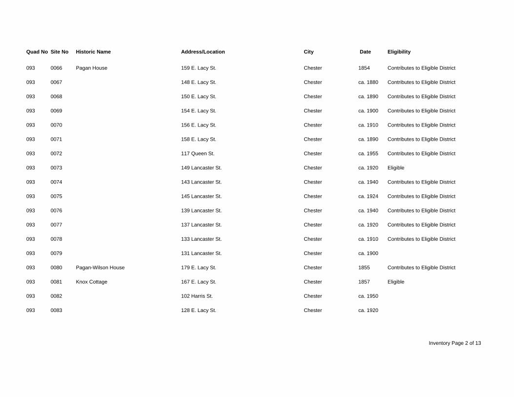
Quad No Site No Historic Name Address/Location City Date Eligibility
093 0066 Pagan House 159 E. Lacy St. Chester 1854 Contributes to Eligible District
093 0067 148 E. Lacy St. Chester ca. 1880 Contributes to Eligible District
093 0068 150 E. Lacy St. Chester ca. 1890 Contributes to Eligible District
093 0069 154 E. Lacy St. Chester ca. 1900 Contributes to Eligible District
093 0070 156 E. Lacy St. Chester ca. 1910 Contributes to Eligible District
093 0071 158 E. Lacy St. Chester ca. 1890 Contributes to Eligible District
093 0072 117 Queen St. Chester ca. 1955 Contributes to Eligible District
093 0073 149 Lancaster St. Chester ca. 1920 Eligible
093 0074 143 Lancaster St. Chester ca. 1940 Contributes to Eligible District
093 0075 145 Lancaster St. Chester ca. 1924 Contributes to Eligible District
093 0076 139 Lancaster St. Chester ca. 1940 Contributes to Eligible District
093 0077 137 Lancaster St. Chester ca. 1920 Contributes to Eligible District
093 0078 133 Lancaster St. Chester ca. 1910 Contributes to Eligible District
093 0079 131 Lancaster St. Chester ca. 1900
093 0080 Pagan-Wilson House 179 E. Lacy St. Chester 1855 Contributes to Eligible District
093 0081 Knox Cottage 167 E. Lacy St. Chester 1857 Eligible
093 0082 102 Harris St. Chester ca. 1950
093 0083 128 E. Lacy St. Chester ca. 1920
Inventory Page 2 of 13
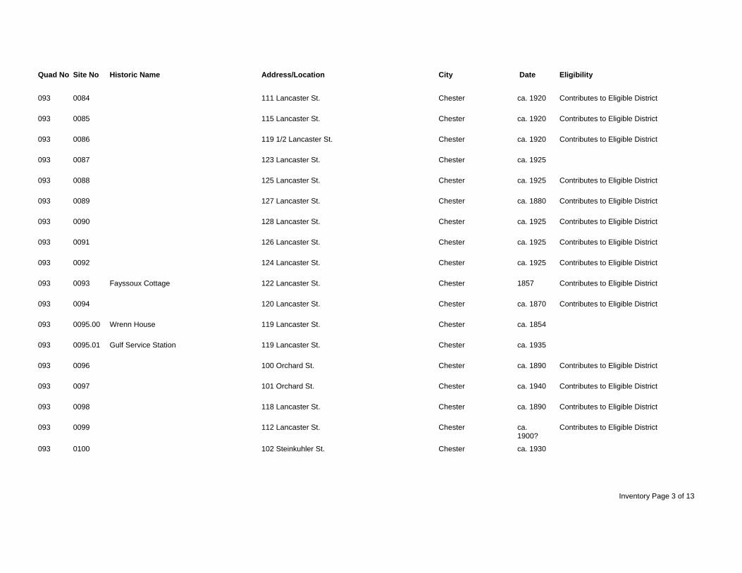
Quad No Site No Historic Name Address/Location City Date Eligibility
093 0084 111 Lancaster St. Chester ca. 1920 Contributes to Eligible District
093 0085 115 Lancaster St. Chester ca. 1920 Contributes to Eligible District
093 0086 119 1/2 Lancaster St. Chester ca. 1920 Contributes to Eligible District
093 0087 123 Lancaster St. Chester ca. 1925
093 0088 125 Lancaster St. Chester ca. 1925 Contributes to Eligible District
093 0089 127 Lancaster St. Chester ca. 1880 Contributes to Eligible District
093 0090 128 Lancaster St. Chester ca. 1925 Contributes to Eligible District
093 0091 126 Lancaster St. Chester ca. 1925 Contributes to Eligible District
093 0092 124 Lancaster St. Chester ca. 1925 Contributes to Eligible District
093 0093 Fayssoux Cottage 122 Lancaster St. Chester 1857 Contributes to Eligible District
093 0094 120 Lancaster St. Chester ca. 1870 Contributes to Eligible District
093 0095.00 Wrenn House 119 Lancaster St. Chester ca. 1854
093 0095.01 Gulf Service Station 119 Lancaster St. Chester ca. 1935
093 0096 100 Orchard St. Chester ca. 1890 Contributes to Eligible District
093 0097 101 Orchard St. Chester ca. 1940 Contributes to Eligible District
093 0098 118 Lancaster St. Chester ca. 1890 Contributes to Eligible District
093 0099 112 Lancaster St. Chester ca. Contributes to Eligible District 1900? 093 0100 102 Steinkuhler St. Chester ca. 1930
Inventory Page 3 of 13
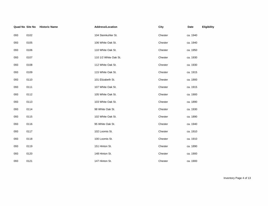
Quad No Site No Historic Name Address/Location City Date Eligibility
093 0102 104 Steinkuhler St. Chester ca. 1940
093 0105 106 White Oak St. Chester ca. 1940
093 0106 110 White Oak St. Chester ca. 1950
093 0107 110 1/2 White Oak St. Chester ca. 1930
093 0108 112 White Oak St. Chester ca. 1930
093 0109 115 White Oak St. Chester ca. 1915
093 0110 101 Elizabeth St. Chester ca. 1900
093 0111 107 White Oak St. Chester ca. 1915
093 0112 105 White Oak St. Chester ca. 1900
093 0113 103 White Oak St. Chester ca. 1890
093 0114 98 White Oak St. Chester ca. 1930
093 0115 102 White Oak St. Chester ca. 1890
093 0116 95 White Oak St. Chester ca. 1940
093 0117 102 Loomis St. Chester ca. 1910
093 0118 100 Loomis St. Chester ca. 1910
093 0119 151 Hinton St. Chester ca. 1890
093 0120 148 Hinton St. Chester ca. 1900
093 0121 147 Hinton St. Chester ca. 1900
Inventory Page 4 of 13
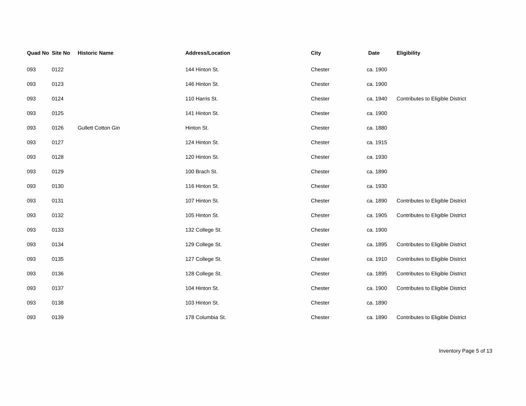
Quad No Site No Historic Name Address/Location City Date Eligibility
093 0122 144 Hinton St. Chester ca. 1900
093 0123 146 Hinton St. Chester ca. 1900
093 0124 110 Harris St. Chester ca. 1940 Contributes to Eligible District
093 0125 141 Hinton St. Chester ca. 1900
093 0126 Gullett Cotton Gin Hinton St. Chester ca. 1880
093 0127 124 Hinton St. Chester ca. 1915
093 0128 120 Hinton St. Chester ca. 1930
093 0129 100 Brach St. Chester ca. 1890
093 0130 116 Hinton St. Chester ca. 1930
093 0131 107 Hinton St. Chester ca. 1890 Contributes to Eligible District
093 0132 105 Hinton St. Chester ca. 1905 Contributes to Eligible District
093 0133 132 College St. Chester ca. 1900
093 0134 129 College St. Chester ca. 1895 Contributes to Eligible District
093 0135 127 College St. Chester ca. 1910 Contributes to Eligible District
093 0136 128 College St. Chester ca. 1895 Contributes to Eligible District
093 0137 104 Hinton St. Chester ca. 1900 Contributes to Eligible District
093 0138 103 Hinton St. Chester ca. 1890
093 0139 178 Columbia St. Chester ca. 1890 Contributes to Eligible District
Inventory Page 5 of 13
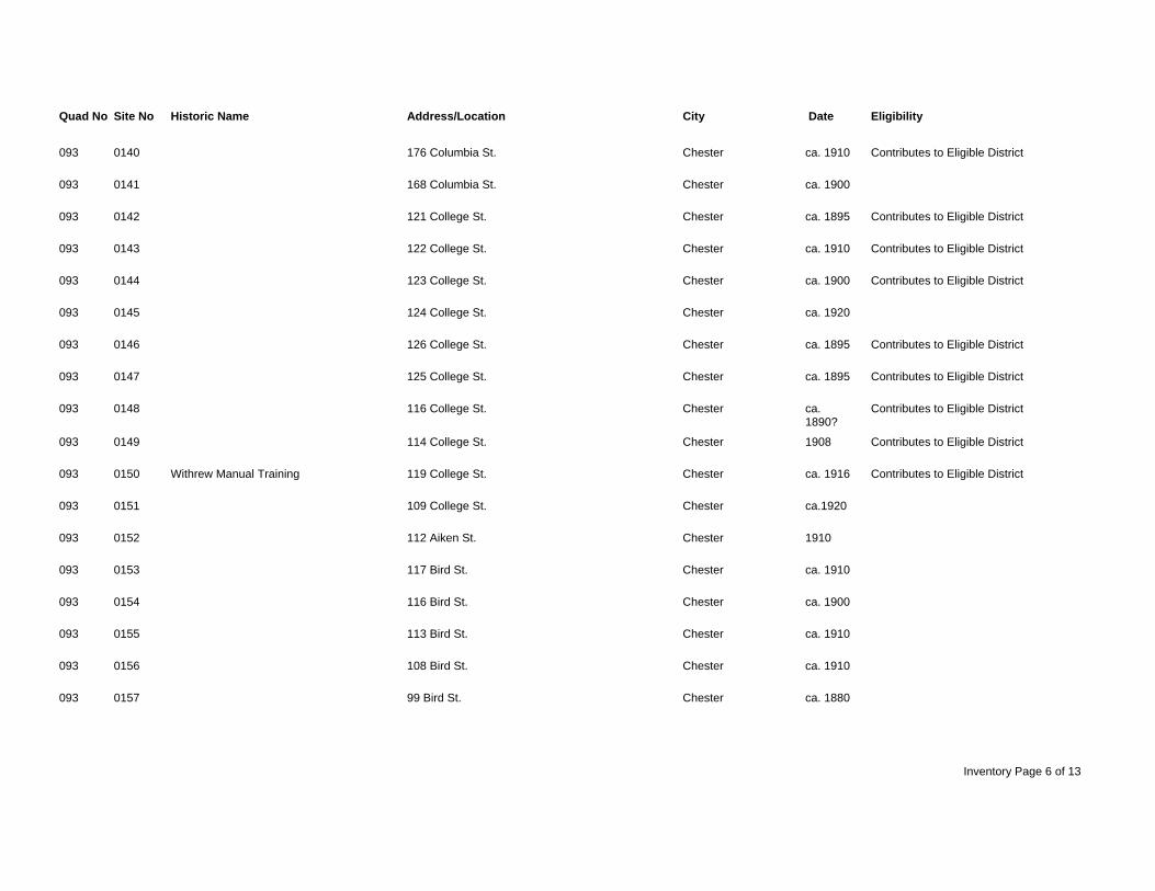
Quad No Site No Historic Name Address/Location City Date Eligibility
093 0140 176 Columbia St. Chester ca. 1910 Contributes to Eligible District
093 0141 168 Columbia St. Chester ca. 1900
093 0142 121 College St. Chester ca. 1895 Contributes to Eligible District
093 0143 122 College St. Chester ca. 1910 Contributes to Eligible District
093 0144 123 College St. Chester ca. 1900 Contributes to Eligible District
093 0145 124 College St. Chester ca. 1920
093 0146 126 College St. Chester ca. 1895 Contributes to Eligible District
093 0147 125 College St. Chester ca. 1895 Contributes to Eligible District
093 0148 116 College St. Chester ca. Contributes to Eligible District 1890? 093 0149 114 College St. Chester 1908 Contributes to Eligible District
093 0150 Withrew Manual Training 119 College St. Chester ca. 1916 Contributes to Eligible District
093 0151 109 College St. Chester ca.1920
093 0152 112 Aiken St. Chester 1910
093 0153 117 Bird St. Chester ca. 1910
093 0154 116 Bird St. Chester ca. 1900
093 0155 113 Bird St. Chester ca. 1910
093 0156 108 Bird St. Chester ca. 1910
093 0157 99 Bird St. Chester ca. 1880
Inventory Page 6 of 13
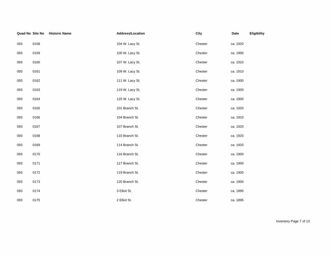
Quad No Site No Historic Name Address/Location City Date Eligibility
093 0158 104 W. Lacy St. Chester ca. 1920
093 0159 100 W. Lacy St. Chester ca. 1900
093 0160 107 W. Lacy St. Chester ca. 1910
093 0161 109 W. Lacy St. Chester ca. 1910
093 0162 111 W. Lacy St. Chester ca. 1900
093 0163 119 W. Lacy St. Chester ca. 1900
093 0164 125 W. Lacy St. Chester ca. 1900
093 0165 101 Branch St. Chester ca. 1920
093 0166 104 Branch St. Chester ca. 1910
093 0167 107 Branch St. Chester ca. 1920
093 0168 110 Branch St. Chester ca. 1920
093 0169 114 Branch St. Chester ca. 1920
093 0170 116 Branch St. Chester ca. 1900
093 0171 117 Branch St. Chester ca. 1900
093 0172 119 Branch St. Chester ca. 1900
093 0173 120 Branch St. Chester ca. 1900
093 0174 3 Elliot St. Chester ca. 1895
093 0175 2 Elliot St. Chester ca. 1895
Inventory Page 7 of 13
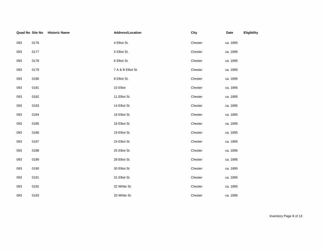
Quad No Site No Historic Name Address/Location City Date Eligibility
093 0176 4 Elliot St. Chester ca. 1895
093 0177 5 Elliot St. Chester ca. 1895
093 0178 6 Elliot St. Chester ca. 1895
093 0179 7 A & B Elliot St. Chester ca. 1895
093 0180 8 Elliot St. Chester ca. 1895
093 0181 10 Elliot Chester ca. 1895
093 0182 11 Elliot St. Chester ca. 1895
093 0183 14 Elliot St. Chester ca. 1895
093 0184 16 Elliot St. Chester ca. 1895
093 0185 18 Elliot St. Chester ca. 1895
093 0186 19 Elliot St. Chester ca. 1895
093 0187 24 Elliot St. Chester ca. 1895
093 0188 25 Elliot St. Chester ca. 1895
093 0189 28 Elliot St. Chester ca. 1895
093 0190 30 Elliot St. Chester ca. 1895
093 0191 31 Elliot St. Chester ca. 1895
093 0192 32 White St. Chester ca. 1895
093 0193 33 White St. Chester ca. 1895
Inventory Page 8 of 13

Quad No Site No Historic Name Address/Location City Date Eligibility
093 0194 35 White St. Chester ca. 1895
093 0195 36 White St. Chester ca. 1895
093 0196 39 White St. Chester ca. 1895
093 0197 40 White St. Chester ca. 1895
093 0198 41 White St. Chester ca. 1895
093 0199 42 White St. Chester ca. 1895
093 0200 43 White St. Chester ca. 1895
093 0201 44 White St. Chester ca. 1895
093 0202 45 White St. Chester ca. 1895
093 0203 46 White St. Chester ca. 1895
093 0204 47 White St. Chester ca. 1895
093 0205 48 White St. Chester ca. 1895
093 0206 49 White St. Chester ca. 1895
093 0207 50 White St. Chester ca. 1895
093 0208 51 White St. Chester ca. 1895
093 0209 52 White St. Chester ca. 1895
093 0210 53 White St. Chester ca. 1895
093 0211 96 Springs St. Chester ca. 1934
Inventory Page 9 of 13
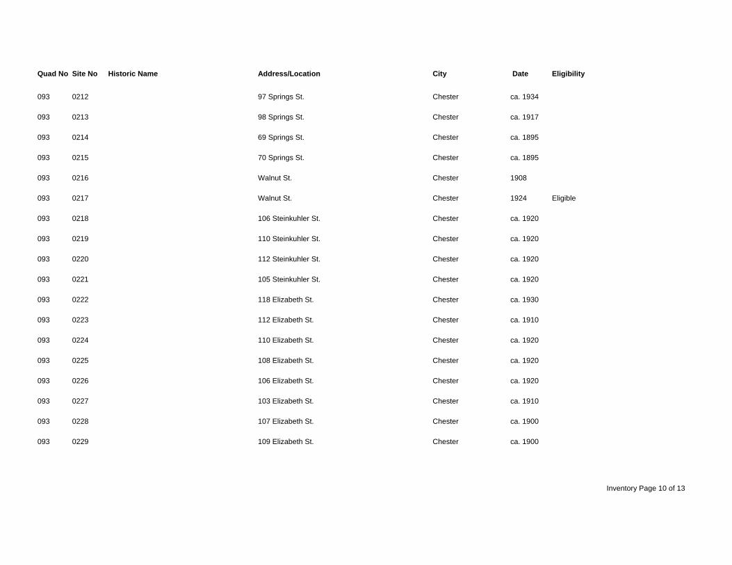
Quad No Site No Historic Name Address/Location City Date Eligibility
093 0212 97 Springs St. Chester ca. 1934
093 0213 98 Springs St. Chester ca. 1917
093 0214 69 Springs St. Chester ca. 1895
093 0215 70 Springs St. Chester ca. 1895
093 0216 Walnut St. Chester 1908
093 0217 Walnut St. Chester 1924 Eligible
093 0218 106 Steinkuhler St. Chester ca. 1920
093 0219 110 Steinkuhler St. Chester ca. 1920
093 0220 112 Steinkuhler St. Chester ca. 1920
093 0221 105 Steinkuhler St. Chester ca. 1920
093 0222 118 Elizabeth St. Chester ca. 1930
093 0223 112 Elizabeth St. Chester ca. 1910
093 0224 110 Elizabeth St. Chester ca. 1920
093 0225 108 Elizabeth St. Chester ca. 1920
093 0226 106 Elizabeth St. Chester ca. 1920
093 0227 103 Elizabeth St. Chester ca. 1910
093 0228 107 Elizabeth St. Chester ca. 1900
093 0229 109 Elizabeth St. Chester ca. 1900
Inventory Page 10 of 13
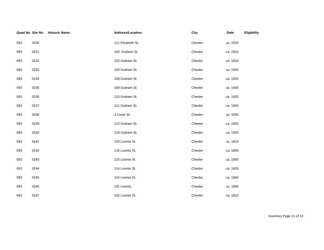
Quad No Site No Historic Name Address/Location City Date Eligibility
093 0230 111 Elizabeth St. Chester ca. 1920
093 0231 100 Graham St. Chester ca. 1910
093 0232 102 Graham St. Chester ca. 1910
093 0233 105 Graham St. Chester ca. 1920
093 0234 108 Graham St. Chester ca. 1920
093 0235 109 Graham St. Chester ca. 1930
093 0236 110 Graham St. Chester ca. 1920
093 0237 111 Graham St. Chester ca. 1920
093 0238 3 Cross St. Chester ca. 1920
093 0239 113 Graham St. Chester ca. 1920
093 0240 118 Graham St. Chester ca. 1920
093 0241 120 Loomis St. Chester ca. 1910
093 0242 116 Loomis St. Chester ca. 1900
093 0243 115 Loomis St. Chester ca. 1900
093 0244 114 Loomis St. Chester ca. 1920
093 0245 110 Loomis St. Chester ca. 1940
093 0246 131 Loomis Chester ca. 1900
093 0247 132 Loomis St. Chester ca. 1910
Inventory Page 11 of 13
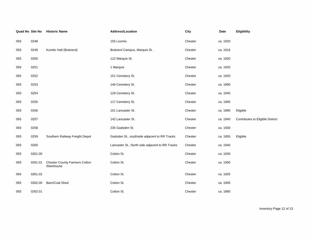
Quad No Site No Historic Name Address/Location City Date Eligibility
093 0248 155 Loomis Chester ca. 1920
093 0249 Kumler Hall (Brainerd) Brainerd Campus, Marquis St. Chester ca. 1916
093 0250 112 Marquis St. Chester ca. 1920
093 0251 1 Marquis Chester ca. 1920
093 0252 151 Cemetery St. Chester ca. 1920
093 0253 146 Cemetery St. Chester ca. 1890
093 0254 129 Cemetery St. Chester ca. 1940
093 0255 117 Cemetery St. Chester ca. 1900
093 0256 151 Lancaster St. Chester ca. 1890 Eligible
093 0257 142 Lancaster St. Chester ca. 1940 Contributes to Eligible District
093 0258 235 Gadsden St. Chester ca. 1930
093 0259 Southern Railway Freight Depot Gadsden St., southside adjacent to RR Tracks Chester ca. 1855 Eligible
093 0260 Lancaster St., North side adjacent to RR Tracks Chester ca. 1940
093 0261.00 Cotton St. Chester ca. 1930
093 0261.01 Chester County Farmers Cotton Cotton St. Chester ca. 1900 Warehouse
093 0261.02 Cotton St. Chester ca. 1925
093 0262.00 Barn/Coal Shed Cotton St. Chester ca. 1900
093 0262.01 Cotton St. Chester ca. 1890
Inventory Page 12 of 13
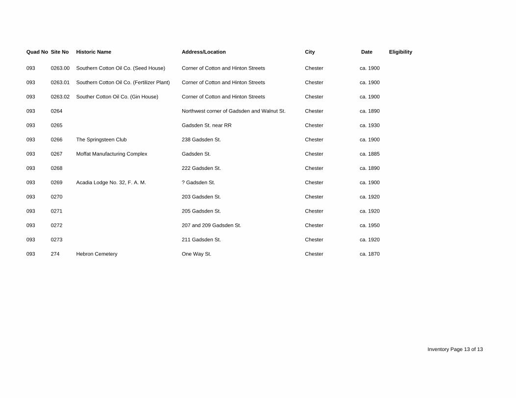
Quad No Site No Historic Name Address/Location City Date Eligibility
093 0263.00 Southern Cotton Oil Co. (Seed House) Corner of Cotton and Hinton Streets Chester ca. 1900
093 0263.01 Southern Cotton Oil Co. (Fertilizer Plant) Corner of Cotton and Hinton Streets Chester ca. 1900
093 0263.02 Souther Cotton Oil Co. (Gin House) Corner of Cotton and Hinton Streets Chester ca. 1900
093 0264 Northwest corner of Gadsden and Walnut St. Chester ca. 1890
093 0265 Gadsden St. near RR Chester ca. 1930
093 0266 The Springsteen Club 238 Gadsden St. Chester ca. 1900
093 0267 Moffat Manufacturing Complex Gadsden St. Chester ca. 1885
093 0268 222 Gadsden St. Chester ca. 1890
093 0269 Acadia Lodge No. 32, F. A. M. ? Gadsden St. Chester ca. 1900
093 0270 203 Gadsden St. Chester ca. 1920
093 0271 205 Gadsden St. Chester ca. 1920
093 0272 207 and 209 Gadsden St. Chester ca. 1950
093 0273 211 Gadsden St. Chester ca. 1920
093 274 Hebron Cemetery One Way St. Chester ca. 1870
Inventory Page 13 of 13