Embed Size (px)
Citation preview
- (1904) On dead water. Scientific results of the Norwegian North Polar Expedition, 1893-18%, 5,
- (1905) On thc influence of the earth’s rotation on ocean-currents. Ark. Mat. Astron. Fys., 2,
__ (1923) Ubcr Horizontalzirkulation bei windelzeugtcn Mccresstromungcn. Ark. Mat. Astron.
Ichiye, T. (1965) Diffusion experiments in coasts[ waters using dye techniques. Proc. Symp. Diffusion in Oceans and Fresh Waters, 1964, Lamont Gcol. Obsy., Palisades, New York, pp.54-67
Nanscn, F. (1897) “Farthest north”: being the record of a voyage of exploration of theship Fram 1893-96 and of a fifteen months’ sleigh journey by Dr Nansen and Lieut. Johansen with an Appendix by Otto Sverdrup, Captain of the Fram. Archibald Constable and Company, Vol. 1, SlOpp., Vol. 2, 671pp.
__ (1902) The oceanography of the North Polar Basin. Scientific resulls of the Norwegian North Polar Expedition, 1893-1896, 3, pp. 1-427
Walker, J. M. (1991) Farthest north, dead water and thc Ekman spiral. Part 1: An audacious vcnturc. Weather, 46, pp. 103-107
Wclandcr, P. (1968) Theorctical occanography in Swcdcn: 1900-1910. Bull. Inst. Ockanogr. Monaco, No. spkial2, pp. 169-174
Zijppritz, K. (1878) Hydrodynamischc Problemc in Bczichung zur Thcoric dcr Mccresstromungcn. Wicd. Ann., 3, pp.582407
pp. 1-152
PP.1-52 _ _ FYS., 17, pp. 1-74
A RARE SUMMER THUNDERSTORM
By R. J. PRICHARD Loughton, Essex
OLLOWING the very interesting article by Keith Mortimore (1990) in Weuther about F the history and development of the Thunderstorm Census Organisation (KO), I thought it would be worthwhile putting together a descriptive account of one of the sum- mer’s outbreak of thunderstorms. In the event, it was not until 24 and 25 August 1990 that one came along that seemed of sufficient interest; for the third consecutive summer, thunderstorms of any severity were a comparatively rare event. Indeed, for some of the normally thundery areas of the country, such as Berkshire, the summer passed with scar- cely a clap of thunder. The most thundery month was June, when parts of the north Midlands reported thunder on six days during a dull, chilly, unsettled month. But once the weather turned hot in mid-July, thunder largely disappeared.
THUNDERSTORM CLIMATOLOGY
As described in Mortimore’s article, the TCO and the Tornado and Storm Research Organisation (TORRO) have a huge data bank of thunderstorm records. I have contributed to these records over many years, and have my own data bank of over 800 personally observcd storms.
Hot weather and thunderstorms tend to go together in the public’s perception, but in fact these records show that the vast majority of this country’s summer thunderstorms occur during cool, unsettled weather - partly because this is much the more normal fare of a British summer anyway. This type of storm can be quite sharp, but is normally short-lived, and not likely to linger in anyone’s memory (unless one of its lightning strikes lands near you!). The thunderstorms we remember tend to be those much rarer ones on a summer’s night after a hot day. Even these are much more likely to occur during brief heatwaves in an unsettled summer; in such summers, cold fronts moving in from the west tend to be driven by fairly sharp upper troughs which can draw in hot continental air into a zone where there is sufficient moisture of maritime origin to fuel the storm. We often think of these storms as moving north from France, whereas it is quite often the case that they actually develop over
164
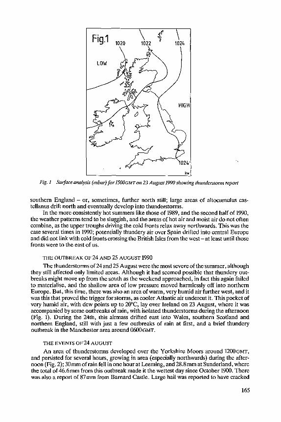
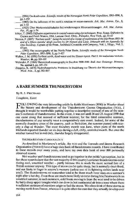
Fig. I Surface analysis (mbar) for 1500GMT on 23 August I990 showing tliunderstorm report
southern England - or, sometimes, further north still; large areas of altocumulus cas- tellanus drift north and eventually develop into thunderstorms.
In the more consistcntly hot summers like those of 1989, and the second half of 1990, the weather patterns tend to be sluggish, and the areas of hot air and moist air d o not often combine, as the upper troughs driving the cold fronts relax away northwards. This was the case several times in 1990; potentially thundery air over Spain drifted into central Europe and did not link with cold fronts crossing the British Isles from the west - at least until those fronts were to the east of us.
THE OUTBREAK OF 24 AND 25 AUGUST 1990 The thunderstorms of 24 and 25 August were the most severe of the summer, although
they still affected only limited areas. Although it had seemed possible that thundery out- breaks might move up from the south as the weekend approached, in fact this again failed to materialise, and the shallow area of low pressure moved harmlessly off into northern Europe. But, this time, there was also an area of warm, very humid air further west, and it was this that proved the trigger for storms, as cooler Atlantic air undercut it. This pocket of very humid air, with dew points up to 20°C, lay over Ireland on 23 August, where it was accompanied by some outbreaks of rain, with isolated thunderstorms during the afternoon (Fig. 1). During the 24th, this airmass drifted east into Wales, southern Scotland and northern England, still with just a few outbreaks of rain at first, and a brief thundery outbreak in the Manchester area around 0 6 0 0 ~ ~ ~ .
THE EVENTS OF 24 AUGUST
An area of thunderstorms developed over the Yorkshire Moors around E ~ ~ G M T , and persisted for several hours, growing in area (especially northwards) during the after- noon (Fig. 2); 30mm of rain fell in one hour at Leeming, and28.8mm at Sunderland, where the total of 46.6mm from this outbreak made it the wettest day since October 1900. There was also a report of 87mm from Barnard Castle. Large hail was reported to have cracked
165
Fig. 2 Surface analysis (mbar) for 1 8 0 0 ~ M ~ on 24 August 1990; shading shows areas affected by thunderstorms
windows at Dishforth and the emergency services were at full stretch dealing with ‘flash floods’ over a wide area of north-east England. It was late evening before these storms drifted away from north-east England into the North Sea. Meanwhile there were other thundery outbreaks during the afternoon and evening over various parts of the country that lay under this humid airmass. South-eastern Britain remained unaffected.
SElTING THE SCENE FOR 25 AUGUST
Most of south-east England, East Anglia and the east Midlands had a sunny Saturday morning on 25 August, and it became hot and humid. Although thc very high dew points of a couple of days earlier were no longer in evidence, they were still around 1647°C over much of England and Wales and, whilst pressure was relatively high in the west, a weak area of low pressure developed over East Anglia in response to the high temperatures and the residue of a minor upper trough, whose axis was now just to the east of the country (and moving away). It was not quite the classic set-up for a severe thunderstorm, but it is often the more marginal situations that can initiate these, if all the ingredients combine co- herently. Sometimes when instability is at its greatest, too many showers and storms develop too quickly for the energy to be concentrated in any particularly severe thunder- storms. Observers can sometimes see this effect for themselves on the most unstable days. The sky may be full of cumulonimbus clouds, two or more of which may give thunder, but none of the individual storms last for long, probably because of interference bctween the various downdraughts and updraughts. Conversely, some of the most spectacular thunder- storms can arise on a day with only one cumulonimbus cloud in the sky. (That is not to say of course that large areas of severe thunderstorms do not also occur on some days.)
THE AFTERNOON OF 25 AUGUST
There were isolated pockets of thundery activity over East Anglia and Kent in the early afternoon. By 134.5 GMT, two main storms had become established in the Ipswich and
166
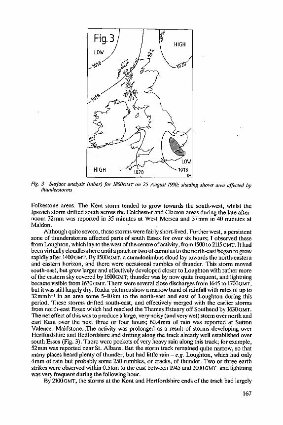
Fig. 3 Surface analysis (mbar) for I800GMT on 25 August 1990; shading shows area affected by thunderstorms
Folkestone areas. The Kent storm tended to grow towards the south-west, whilst the Ipswich storm drifted south across the Colchester and Clacton areas during the late after- noon; 32mm was reported in 35 minutes at West Mersea and 37mm in 40 minutes at Maldon.
Although quite severe, these storms were fairly short-lived. Further west, a persistent zone of thunderstorms affected parts of south Essex for over six hours; I observed these from Loughton, which lay to the west of the centre of activity, from 1500 to 2115 GMT. It had been virtually cloudless here until a patch or two of cumulus to the north-east began to grow rapidly after 14oOGMT. By 1 5 0 0 ~ ~ ~ ~ a cumulonimbus cloud lay towards the north-eastern and eastern horizon, and there were occasional rumbles of thunder. This storm moved south-east, but grew larger and effectively developed closer to Loughton with rather more of the eastern sky covered by 1 6 0 0 ~ ~ ~ ; thunder was by now quite frequent, and lightning became visible from 1630GMT. There were several close discharges from 1645 to 17oc)GMT, but it was still largely dry. Radar pictures show a narrow band of rainfall with rates of up to 32mmh-1 in an area some 5-10km to the north-east and east of Loughton during this period. These storms drifted south-east, and effectively merged with the earlier storms from north-east Essex which had reached the Thames Estuary off Southend by 1630GMT. The net effect of this was to produce a large, very noisy (and very wet) storm over north and east Kent over the next three or four hours; 60.4mm of rain was reported at Sutton Valence, Maidstone. The activity was prolonged as a result of stonris developing over Hertfordshire and Bedfordshire and drifting along the track already well established over south Essex (Fig. 3). There were pockets of very heavy rain along this track; for example, 52mm was reported near St. Albans. But the storm track remained quite narrow, so that many places heard plenty of thunder, but had little rain - e.g. Loughton, which had only 4mm of rain but probably some 250 rumbles, or cracks, of thunder. Two or three earth strikes were observed within 0.5km to the east between 1945 and 2000GMT and lightning was very frequent during the following hour.
By 21WGMT, the storms at the Kent and Hertfordshire ends of the track had largely
167
dissipated, but radar pictures still showed intensities of over 8mm-1 over mid-Essex. Most of the thundery activity had ceased by 213oCMT, and the residual rain areas slowly decayed during the next hour or so.
EFFECTS OF THE STORM
The Brentwood (Essex) and Maidstone areas appear to have been worst hit, although there was serious flooding and lightning damage in several other districts, including Maldon and Folkestone. The Brentwood Gazette reported that people in parts of the town “. . . fought for hours against a cascade of stinking mud (sweeping off surrounding high ground), which finally overpowered their efforts, and they watched helplessly as it swept into their homes on a wave of water which, in places, reached more than two feet deep”. As seems to be the usual pattern after such events, “there was nothing but praise for the fire brigade”, but accusations of “nothing but vague promises” by the local council after previous flash floods. A fire, started by lightning, at a farm in the area caused flOOOOO worth of damage, destroying two barns, a combine harvester, 400 tons of hay, and a car and caravan; fire tenders from a large area attended the blaze, which took hours to bring under control.
ARERMATH
The pocket of very humid air (now much less obvious as an entity) was pushed back west over southern England overnight, with somewhat cooler, less humid air over East Anglia during the 26th. Drier air was also moving in from the south-west. The result was a convergence zone just west of London on the afternoon of the 26th, out of which isolated showers developed to give a little more distant thunder and lightning at Loughton in mid- evening.
CONCLUSION AND ACKNOWLEDGEMENTS
This has been a descriptive account of virtually the only outbreak of severe ‘summer type’ thunderstorms in 1990. Synoptic and radar data, and some of the rainfall figures, were supplied by the Meteorological Office, and the assistance of Chris Clarke and Dick Brookes is appreciated. I am also grateful to those who, routinely, supply data to the long- established Thunderstorm Census Organisation (KO), now under the auspices of the Tornado and Storm Research Organisation and ably co-ordinated by Keith Mortimore. There are still areas of the country where such observers are thin on the ground and anyone with an interest in thunderstorms would find their reports welcomed; the TCO’S head- quarters is at 77 Dicketts Road, Corsham, Wiltshire, ~ ~ 1 3 9JS. Finally, some rainfall data have come from the monthly bulletin of the Climatological Observers Link, another valu- able vehicle for all who are interested in day-to-day weather.
REFERENCE Mortimorc, K. 0. (1990) Thunderstorm climatological rcscarch in Great Britain and Ireland: A
progrcss rcport and aims for futurc study. Weather, 45, pp.21-27
PHOTOGRAPHS REQUIRED for possible use in the METEOROLOGICAL CALENDAR 1993
Once again we invite readers to submit photographs and slides for possible use in the Meteorological Calendar for 1993. Authors of pictures submitted for 1992, not used but held for other purposes, can indicate that they may be considered for 1993 and can also submit new pictures if they wish. The closing date for this year is 1 September 1991.
Ken Woodley, Photo. Ed.
168