Embed Size (px)
Citation preview
A Total Water ResourceA division of Hayes, Seay, Mattern & Mattern, Inc.
North Carolina Floodplain MappingState of North Carolina
North Carolina
Floodplain Mapping
State of North Carolina
A Total Water ResourceA division of Hayes, Seay, Mattern & Mattern, Inc.
North Carolina Floodplain MappingState of North Carolina
Web-Based
Survey
A Total Water ResourceA division of Hayes, Seay, Mattern & Mattern, Inc.
North Carolina Floodplain MappingState of North Carolina
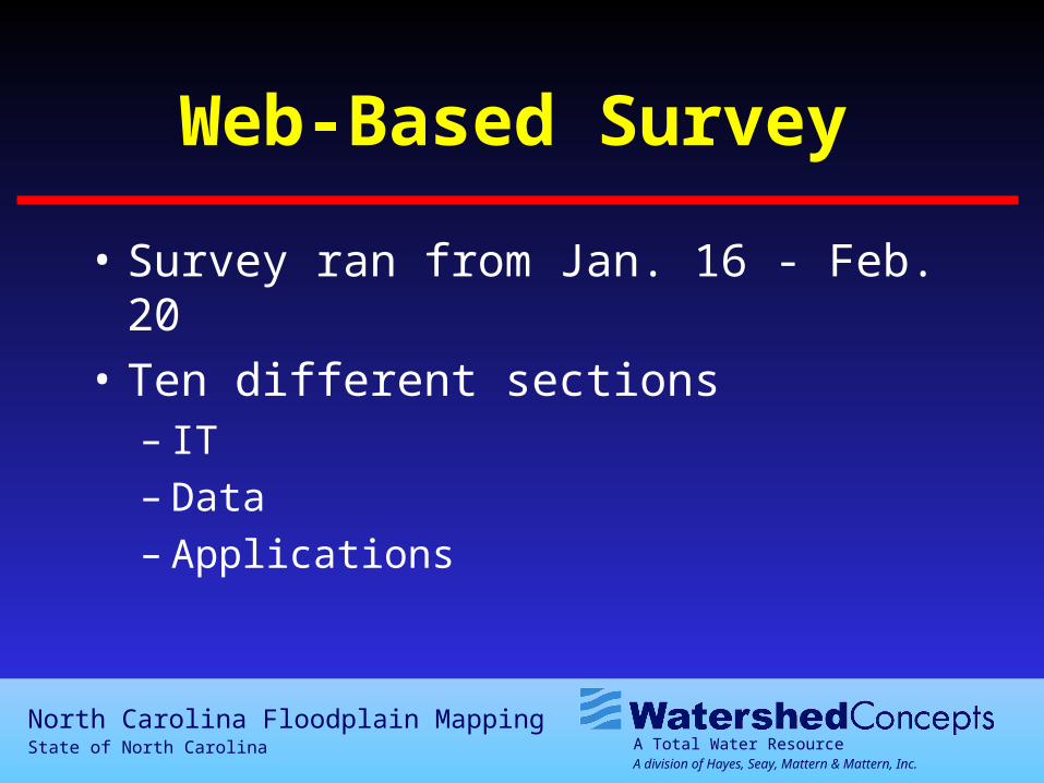
Web-Based Survey
• Survey ran from Jan. 16 - Feb. 20
• Ten different sections– IT– Data– Applications
A Total Water ResourceA division of Hayes, Seay, Mattern & Mattern, Inc.
North Carolina Floodplain MappingState of North Carolina
Web-Based Survey

A Total Water ResourceA division of Hayes, Seay, Mattern & Mattern, Inc.
North Carolina Floodplain MappingState of North Carolina
Responses
01020304050607080
No.
Res
pons
es
Gen
eral
Info
rmat
ion IT
Floo
d D
ata
Elev
atio
nD
ata
DFI
RM
Res
ults
Engi
neer
ing
Dat
a
Surv
eyD
ata
Bas
e D
ata
Pote
ntia
lA
pplic
atio
n
Add
ition
alIs
sues
As of Feb. 5, 2001
A Total Water ResourceA division of Hayes, Seay, Mattern & Mattern, Inc.
North Carolina Floodplain MappingState of North Carolina
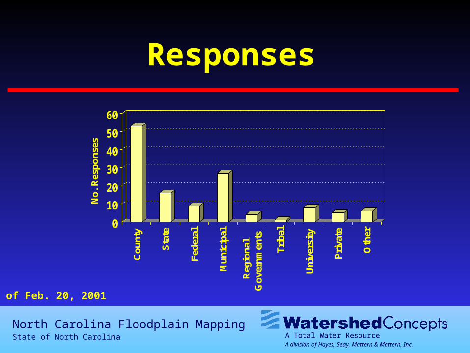
Responses
0
10
20
30
40
50
60
No.
Res
pons
es
Cou
nty
Sta
te
Fede
ral
Mun
icip
al
Reg
iona
lG
over
nmen
ts
Trib
al
Uni
vers
ity
Pri
vate
Oth
er
As of Feb. 20, 2001
A Total Water ResourceA division of Hayes, Seay, Mattern & Mattern, Inc.
North Carolina Floodplain MappingState of North Carolina
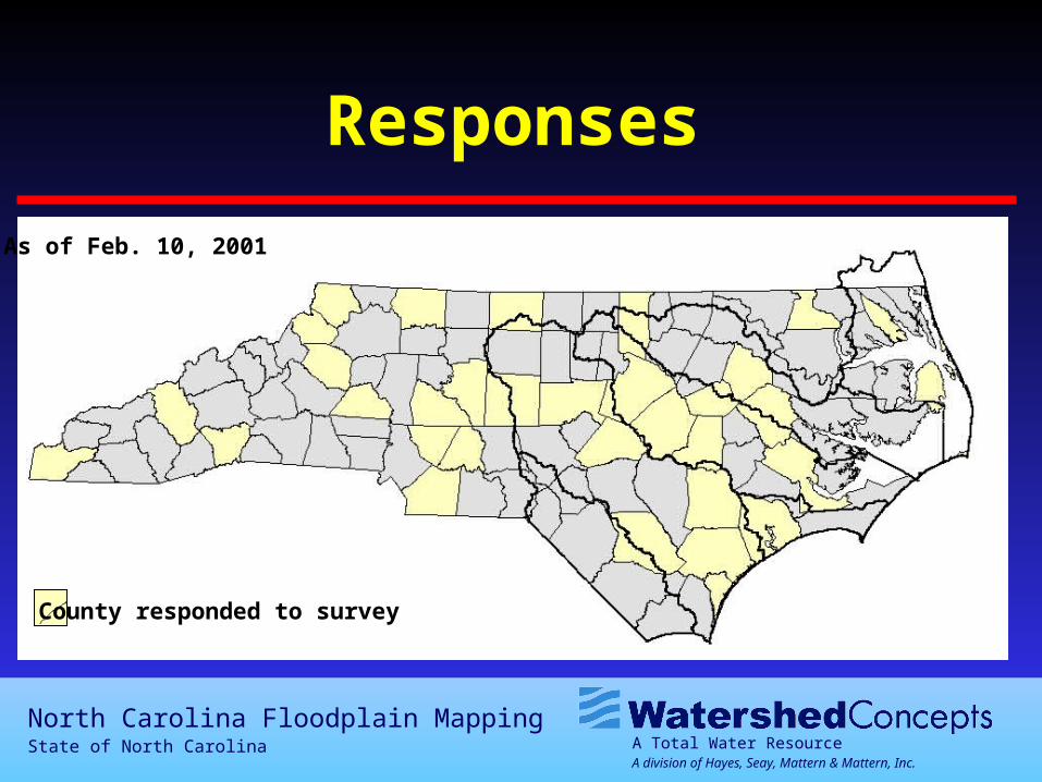
Responses
County responded to survey
As of Feb. 10, 2001
A Total Water ResourceA division of Hayes, Seay, Mattern & Mattern, Inc.
North Carolina Floodplain MappingState of North Carolina
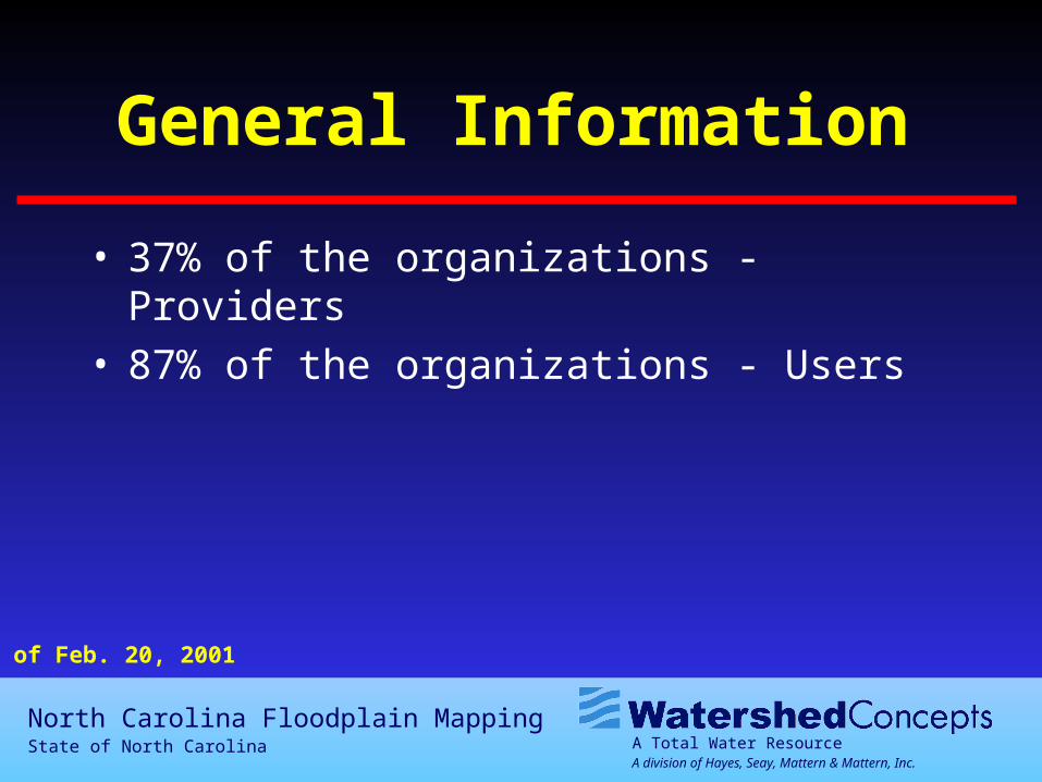
General Information
• 37% of the organizations - Providers• 87% of the organizations - Users
As of Feb. 20, 2001
A Total Water ResourceA division of Hayes, Seay, Mattern & Mattern, Inc.
North Carolina Floodplain MappingState of North Carolina
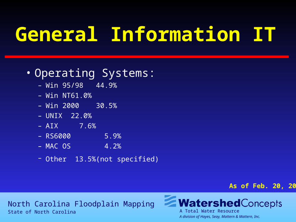
General Information IT
• Operating Systems:– Win 95/98 44.9%
– Win NT 61.0%
– Win 2000 30.5%
– UNIX 22.0%
– AIX 7.6%
– RS6000 5.9%
– MAC OS 4.2%
– Other 13.5% (not specified)
As of Feb. 20, 2001
A Total Water ResourceA division of Hayes, Seay, Mattern & Mattern, Inc.
North Carolina Floodplain MappingState of North Carolina
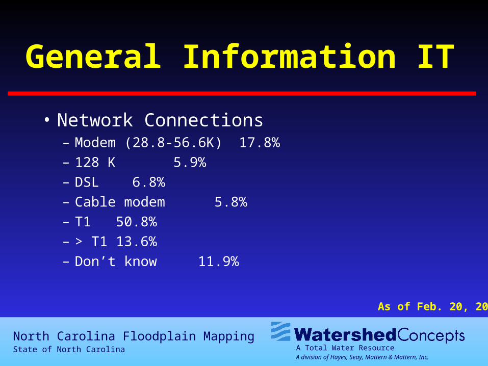
General Information IT
• Network Connections– Modem (28.8-56.6K) 17.8%
– 128 K 5.9%
– DSL 6.8%
– Cable modem 5.8%
– T1 50.8%
– > T1 13.6%
– Don’t know 11.9%
As of Feb. 20, 2001
A Total Water ResourceA division of Hayes, Seay, Mattern & Mattern, Inc.
North Carolina Floodplain MappingState of North Carolina
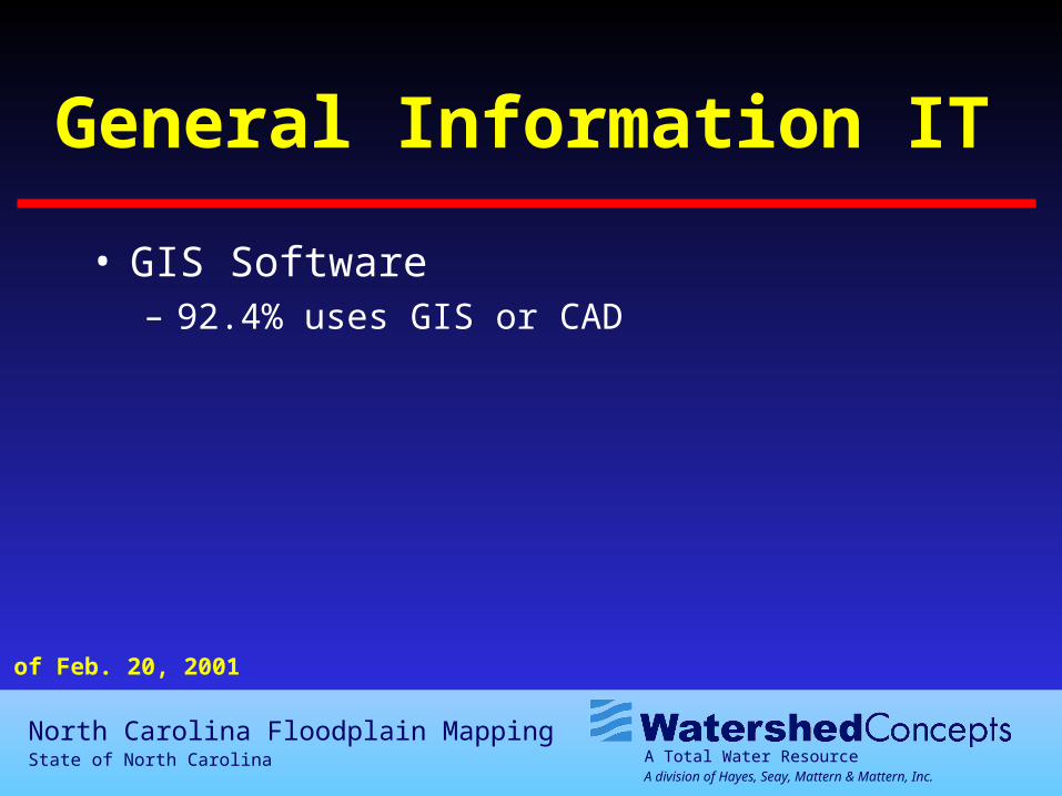
General Information IT
• GIS Software– 92.4% uses GIS or CAD
As of Feb. 20, 2001
A Total Water ResourceA division of Hayes, Seay, Mattern & Mattern, Inc.
North Carolina Floodplain MappingState of North Carolina
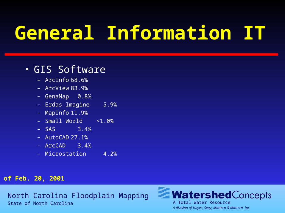
General Information IT
• GIS Software– ArcInfo 68.6%– ArcView 83.9%– GenaMap 0.8%– Erdas Imagine 5.9%– MapInfo 11.9%– Small World <1.0%– SAS 3.4%– AutoCAD 27.1%– ArcCAD 3.4%– Microstation 4.2%
As of Feb. 20, 2001
A Total Water ResourceA division of Hayes, Seay, Mattern & Mattern, Inc.
North Carolina Floodplain MappingState of North Carolina
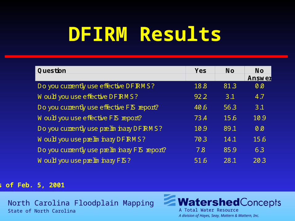
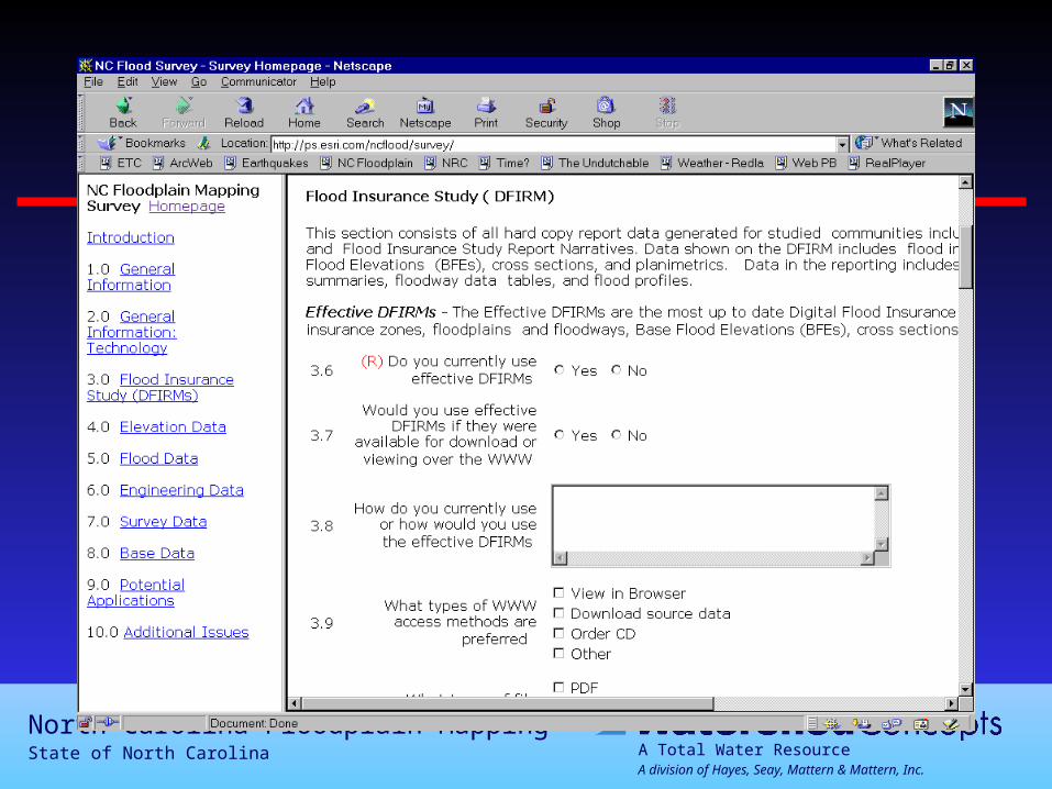
DFIRM Results
Question Yes No NoAnswer
Do you currently use effective DFIRMS? 18.8 81.3 0.0
Would you use effective DFIRMS? 92.2 3.1 4.7
Do you currently use effective FIS report? 40.6 56.3 3.1
Would you use effective FIS report? 73.4 15.6 10.9
Do you currently use preliminary DFIRMS? 10.9 89.1 0.0
Would you use preliminary DFIRMS? 70.3 14.1 15.6
Do you currently use preliminary FIS report? 7.8 85.9 6.3
Would you use preliminary FIS? 51.6 28.1 20.3
As of Feb. 5, 2001
A Total Water ResourceA division of Hayes, Seay, Mattern & Mattern, Inc.
North Carolina Floodplain MappingState of North Carolina
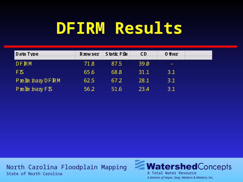
DFIRM ResultsData Type Browser Static File CD Other
DFIRM 71.8 87.5 39.0 -
FIS 65.6 68.8 31.1 3.1
Preliminary DFIRM 62.5 67.2 28.1 3.1
Preliminary FIS 56.2 51.6 23.4 3.1
A Total Water ResourceA division of Hayes, Seay, Mattern & Mattern, Inc.
North Carolina Floodplain MappingState of North Carolina
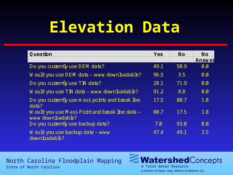
Elevation Data
Question Yes No NoAnswer
Do you currently use DEM data? 49.1 50.9 0.0
Would you use DEM data – www downloadable? 96.5 3.5 0.0
Do you currently use TIN data? 28.1 71.9 0.0
Would you use TIN data – www downloadable? 91.2 8.8 0.0
Do you currently use mass points and break linedata?
17.5 80.7 1.8
Would you use Mass Point and break line data –www downloadable?
80.7 17.5 1.8
Do you currently use backup data? 7.0 93.0 0.0
Would you use backup data – wwwdownloadable?
47.4 49.1 3.5
A Total Water ResourceA division of Hayes, Seay, Mattern & Mattern, Inc.
North Carolina Floodplain MappingState of North Carolina
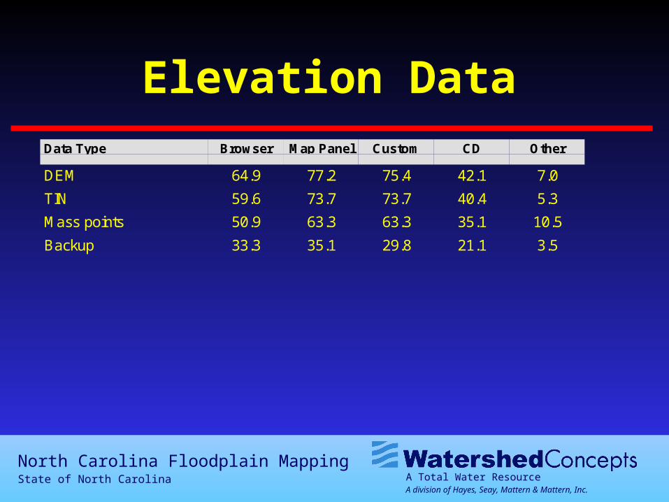
Elevation DataData Type Browser Map Panel Custom CD Other
DEM 64.9 77.2 75.4 42.1 7.0
TIN 59.6 73.7 73.7 40.4 5.3
Mass points 50.9 63.3 63.3 35.1 10.5
Backup 33.3 35.1 29.8 21.1 3.5
A Total Water ResourceA division of Hayes, Seay, Mattern & Mattern, Inc.
North Carolina Floodplain MappingState of North Carolina
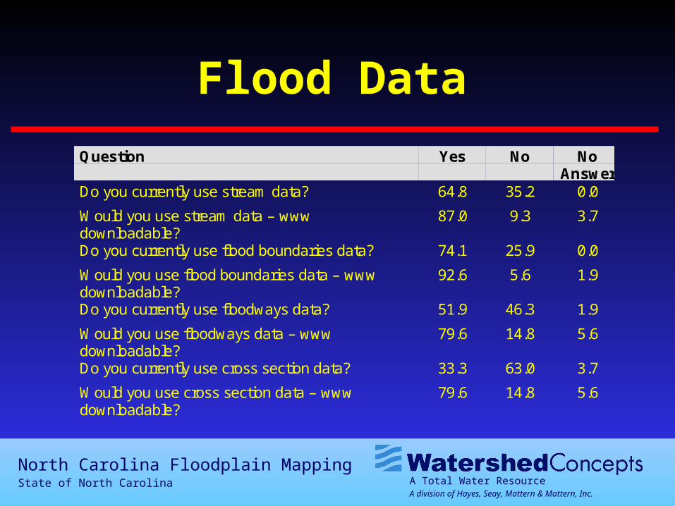
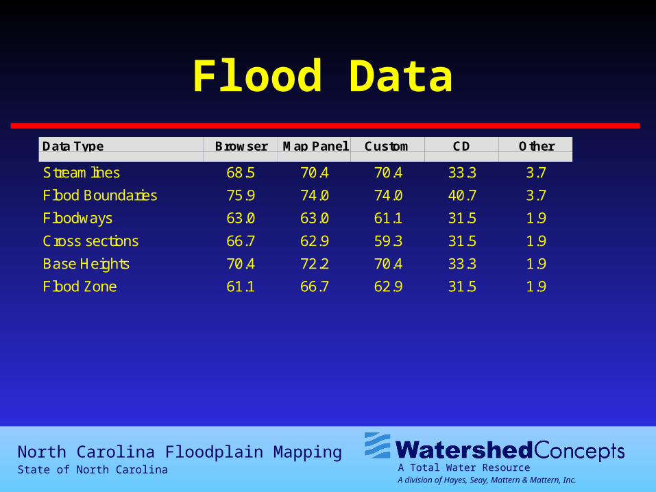
Flood Data
Question Yes No NoAnswer
Do you currently use stream data? 64.8 35.2 0.0
Would you use stream data – wwwdownloadable?
87.0 9.3 3.7
Do you currently use flood boundaries data? 74.1 25.9 0.0
Would you use flood boundaries data – wwwdownloadable?
92.6 5.6 1.9
Do you currently use floodways data? 51.9 46.3 1.9
Would you use floodways data – wwwdownloadable?
79.6 14.8 5.6
Do you currently use cross section data? 33.3 63.0 3.7
Would you use cross section data – wwwdownloadable?
79.6 14.8 5.6
A Total Water ResourceA division of Hayes, Seay, Mattern & Mattern, Inc.
North Carolina Floodplain MappingState of North Carolina
Flood Data
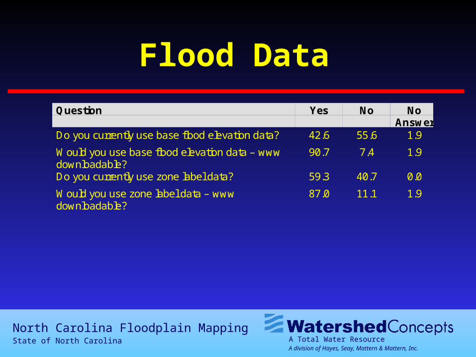
Question Yes No NoAnswer
Do you currently use base flood elevation data? 42.6 55.6 1.9
Would you use base flood elevation data – wwwdownloadable?
90.7 7.4 1.9
Do you currently use zone label data? 59.3 40.7 0.0
Would you use zone label data – wwwdownloadable?
87.0 11.1 1.9
A Total Water ResourceA division of Hayes, Seay, Mattern & Mattern, Inc.
North Carolina Floodplain MappingState of North Carolina
Flood DataData Type Browser Map Panel Custom CD Other
Streamlines 68.5 70.4 70.4 33.3 3.7
Flood Boundaries 75.9 74.0 74.0 40.7 3.7
Floodways 63.0 63.0 61.1 31.5 1.9
Cross sections 66.7 62.9 59.3 31.5 1.9
Base Heights 70.4 72.2 70.4 33.3 1.9
Flood Zone 61.1 66.7 62.9 31.5 1.9
A Total Water ResourceA division of Hayes, Seay, Mattern & Mattern, Inc.
North Carolina Floodplain MappingState of North Carolina
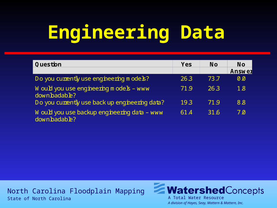
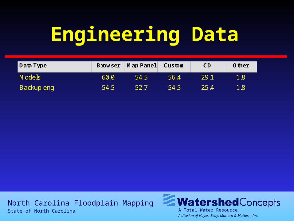
Engineering Data
Question Yes No NoAnswer
Do you currently use engineering models? 26.3 73.7 0.0
Would you use engineering models – wwwdownloadable?
71.9 26.3 1.8
Do you currently use back up engineering data? 19.3 71.9 8.8
Would you use backup engineering data – wwwdownloadable?
61.4 31.6 7.0
A Total Water ResourceA division of Hayes, Seay, Mattern & Mattern, Inc.
North Carolina Floodplain MappingState of North Carolina
Engineering DataData Type Browser Map Panel Custom CD Other
Models 60.0 54.5 56.4 29.1 1.8
Backup eng 54.5 52.7 54.5 25.4 1.8
A Total Water ResourceA division of Hayes, Seay, Mattern & Mattern, Inc.
North Carolina Floodplain MappingState of North Carolina
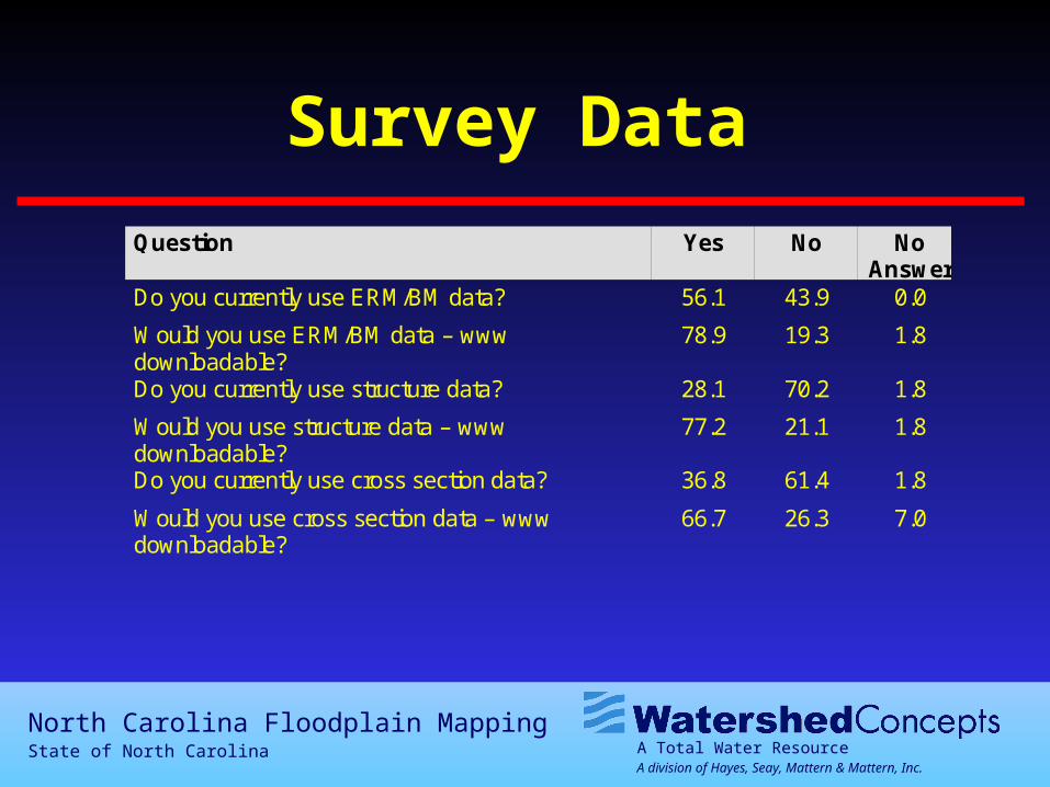
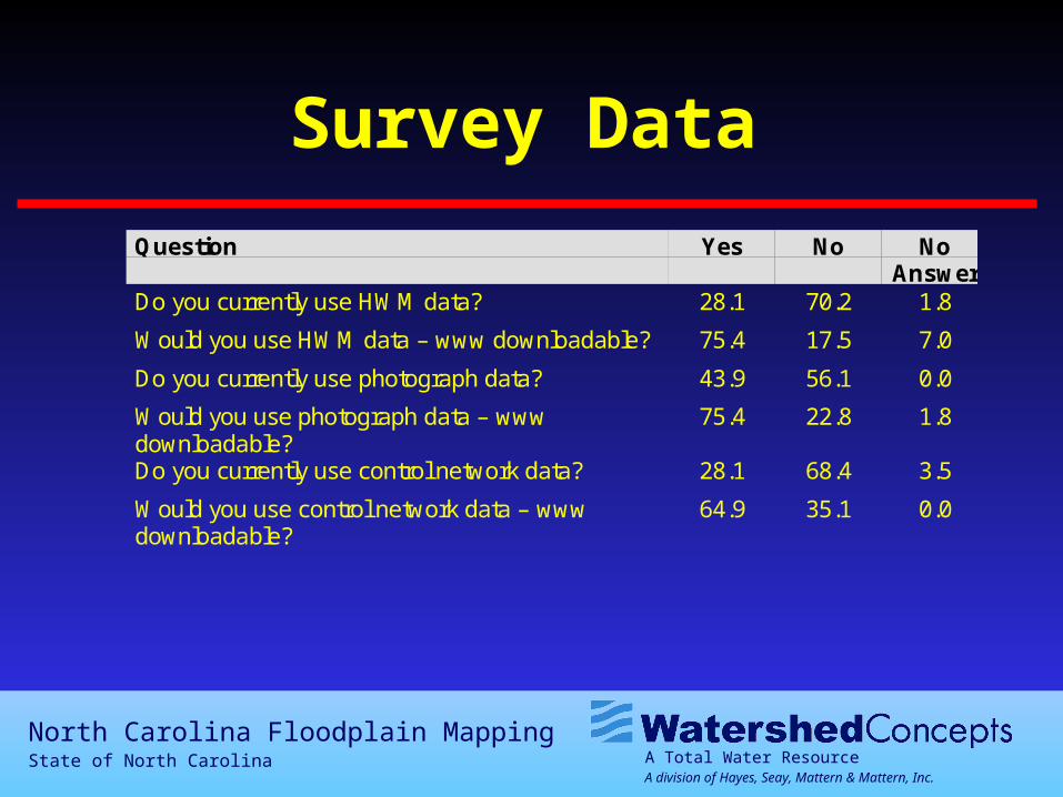
Survey Data
Question Yes No NoAnswer
Do you currently use ERM/BM data? 56.1 43.9 0.0
Would you use ERM/BM data – wwwdownloadable?
78.9 19.3 1.8
Do you currently use structure data? 28.1 70.2 1.8
Would you use structure data – wwwdownloadable?
77.2 21.1 1.8
Do you currently use cross section data? 36.8 61.4 1.8
Would you use cross section data – wwwdownloadable?
66.7 26.3 7.0
A Total Water ResourceA division of Hayes, Seay, Mattern & Mattern, Inc.
North Carolina Floodplain MappingState of North Carolina
Survey Data
Question Yes No NoAnswer
Do you currently use HWM data? 28.1 70.2 1.8
Would you use HWM data – www downloadable? 75.4 17.5 7.0
Do you currently use photograph data? 43.9 56.1 0.0
Would you use photograph data – wwwdownloadable?
75.4 22.8 1.8
Do you currently use control network data? 28.1 68.4 3.5
Would you use control network data – wwwdownloadable?
64.9 35.1 0.0
A Total Water ResourceA division of Hayes, Seay, Mattern & Mattern, Inc.
North Carolina Floodplain MappingState of North Carolina
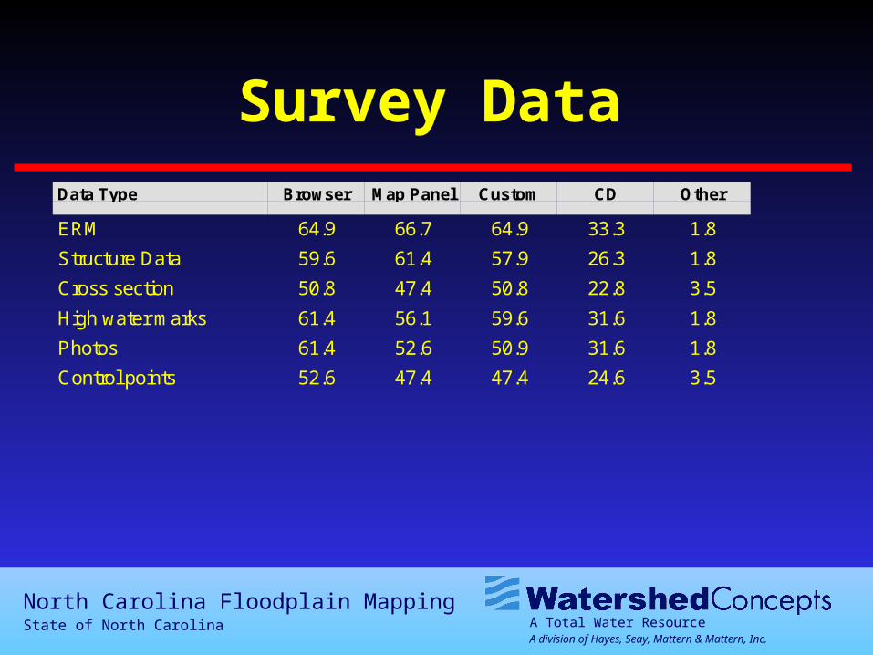
Survey DataData Type Browser Map Panel Custom CD Other
ERM 64.9 66.7 64.9 33.3 1.8
Structure Data 59.6 61.4 57.9 26.3 1.8
Cross section 50.8 47.4 50.8 22.8 3.5
High water marks 61.4 56.1 59.6 31.6 1.8
Photos 61.4 52.6 50.9 31.6 1.8
Control points 52.6 47.4 47.4 24.6 3.5
A Total Water ResourceA division of Hayes, Seay, Mattern & Mattern, Inc.
North Carolina Floodplain MappingState of North Carolina
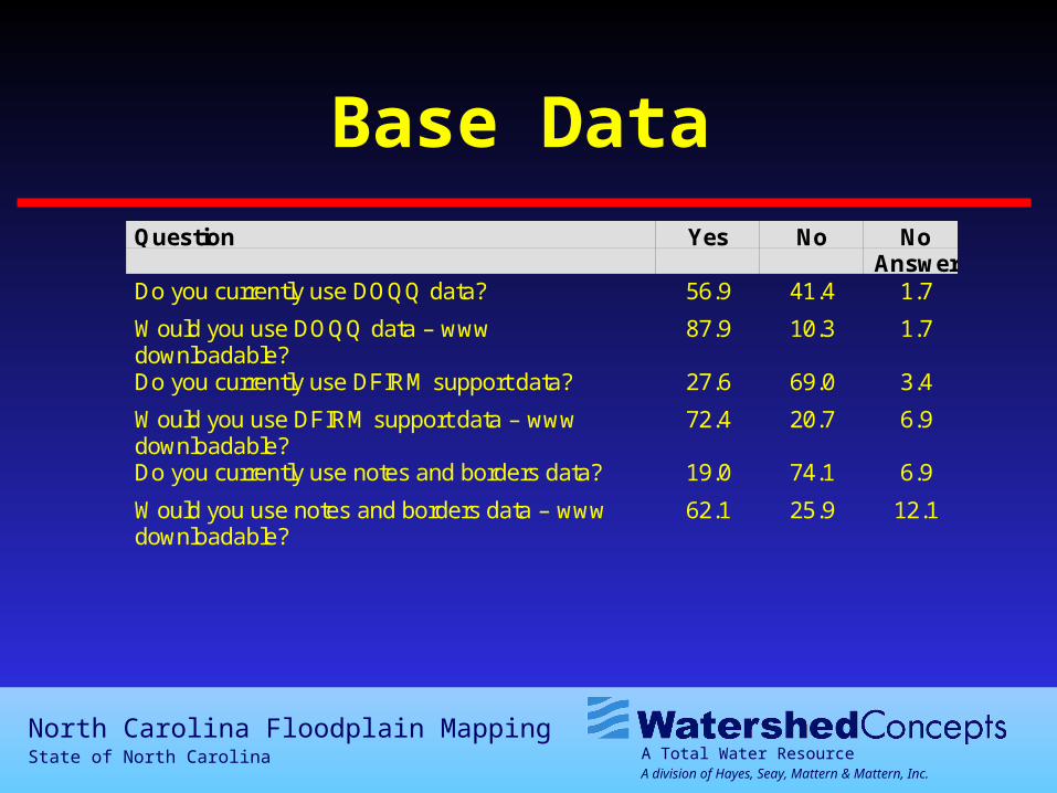
Base DataQuestion Yes No No
AnswerDo you currently use DOQQ data? 56.9 41.4 1.7
Would you use DOQQ data – wwwdownloadable?
87.9 10.3 1.7
Do you currently use DFIRM support data? 27.6 69.0 3.4
Would you use DFIRM support data – wwwdownloadable?
72.4 20.7 6.9
Do you currently use notes and borders data? 19.0 74.1 6.9
Would you use notes and borders data – wwwdownloadable?
62.1 25.9 12.1
A Total Water ResourceA division of Hayes, Seay, Mattern & Mattern, Inc.
North Carolina Floodplain MappingState of North Carolina
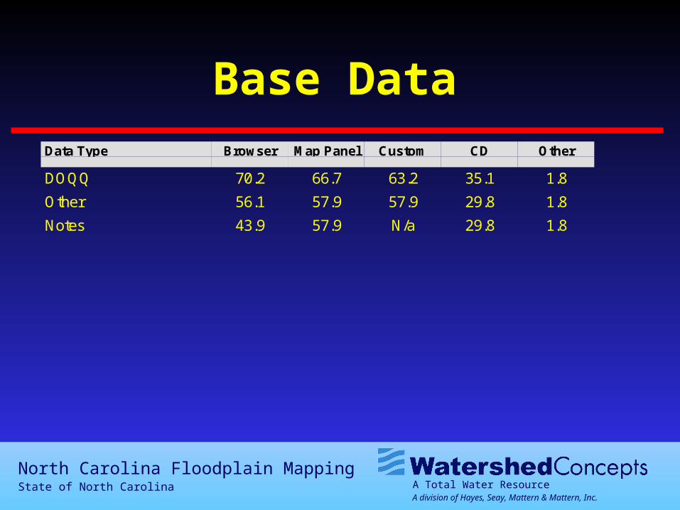
Base DataData Type Browser Map Panel Custom CD Other
DOQQ 70.2 66.7 63.2 35.1 1.8
Other 56.1 57.9 57.9 29.8 1.8
Notes 43.9 57.9 N/a 29.8 1.8
A Total Water ResourceA division of Hayes, Seay, Mattern & Mattern, Inc.
North Carolina Floodplain MappingState of North Carolina
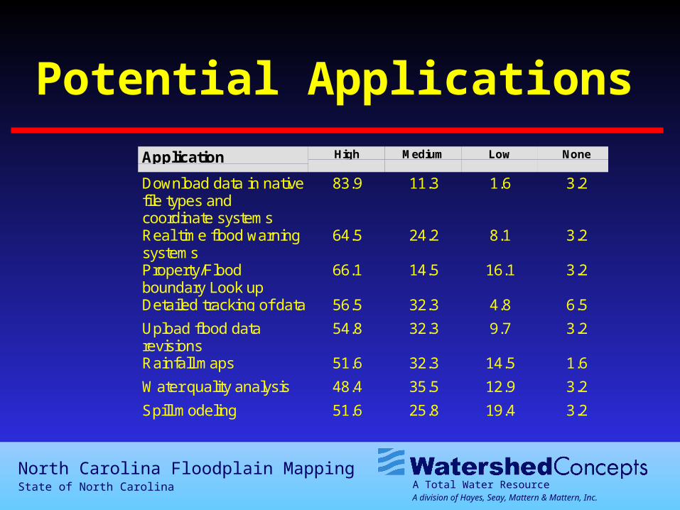
Potential Applications
Application High Medium Low None
Download data in nativefile types andcoordinate systems
83.9 11.3 1.6 3.2
Real time flood warningsystems
64.5 24.2 8.1 3.2
Property/Floodboundary Look up
66.1 14.5 16.1 3.2
Detailed tracking of data 56.5 32.3 4.8 6.5
Upload flood datarevisions
54.8 32.3 9.7 3.2
Rainfall maps 51.6 32.3 14.5 1.6
Water quality analysis 48.4 35.5 12.9 3.2
Spill modeling 51.6 25.8 19.4 3.2
A Total Water ResourceA division of Hayes, Seay, Mattern & Mattern, Inc.
North Carolina Floodplain MappingState of North Carolina
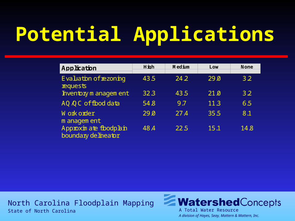
Potential Applications
Application High Medium Low None
Evaluation of rezoningrequests
43.5 24.2 29.0 3.2
Inventory management 32.3 43.5 21.0 3.2
AQ/QC of flood data 54.8 9.7 11.3 6.5
Work ordermanagement
29.0 27.4 35.5 8.1
Approximate floodplainboundary delineator
48.4 22.5 15.1 14.8
A Total Water ResourceA division of Hayes, Seay, Mattern & Mattern, Inc.
North Carolina Floodplain MappingState of North Carolina
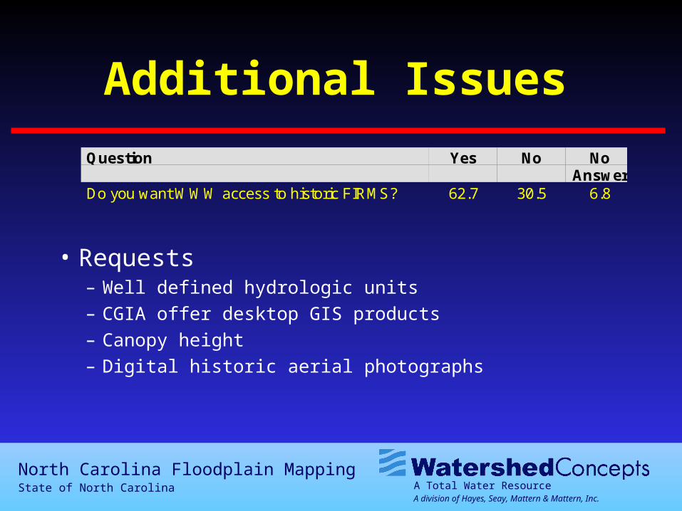
Question Yes No NoAnswer
Do you want WWW access to historic FIRMS? 62.7 30.5 6.8
Additional Issues
• Requests– Well defined hydrologic units– CGIA offer desktop GIS products– Canopy height– Digital historic aerial photographs
A Total Water ResourceA division of Hayes, Seay, Mattern & Mattern, Inc.
North Carolina Floodplain MappingState of North Carolina
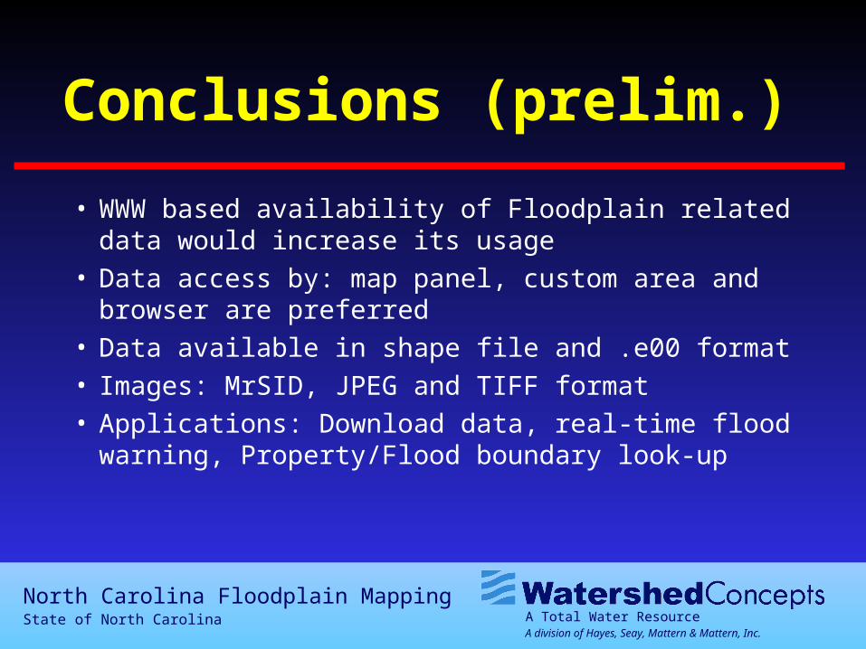
Conclusions (prelim.)
• WWW based availability of Floodplain related data would increase its usage
• Data access by: map panel, custom area and browser are preferred
• Data available in shape file and .e00 format• Images: MrSID, JPEG and TIFF format• Applications: Download data, real-time flood warning,
Property/Flood boundary look-up
A Total Water ResourceA division of Hayes, Seay, Mattern & Mattern, Inc.
North Carolina Floodplain MappingState of North Carolina
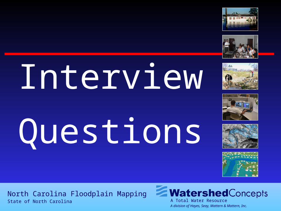
Interview
Questions
A Total Water ResourceA division of Hayes, Seay, Mattern & Mattern, Inc.
North Carolina Floodplain MappingState of North Carolina
Interview
• Who do you represent?
• How do you anticipate you will interact with the system?
• What is the most important aspect of this project to you?
A Total Water ResourceA division of Hayes, Seay, Mattern & Mattern, Inc.
North Carolina Floodplain MappingState of North Carolina
Applications
• Download data in native file types and coordinate systems– This would allow users to download floodplain data in a GIS format for use in spatial
analysis and overlay mapping.
• Property / flood boundary lookup– The user will enter an address or parcel number and the system will zoom to the area
and show a map with the flood boundary and the address. This will assist local communities in complying with existing flood ordinances. Example uses would include identifying homes in the 100-year floodplain or locating properties in the FEMA Floodway.
• Approximate floodplain mapping delineator– This would determine an approximate flood elevation at any location where
the stream is not studied by FEMA or the upcoming NC Floodplain Project.
A Total Water ResourceA division of Hayes, Seay, Mattern & Mattern, Inc.
North Carolina Floodplain MappingState of North Carolina
Applications
• Real time flood warning and forecasting– View in real-time streams that are at or approaching flood stage and have the ability to predict when
a river will reach its peak and the predicted stage at peak. Using these predicted stages - view
a map of the floodplain resulting in this flood stage. View which roads are closed or overtopped. • Spill modeling
– A live application which would allow emergency response centers to respond to a hazardous waste spill and direct clean up crews to a particular location. The application will trace to spill to the extents of the State line and will give estimated times of arrival at various locations.
• Evaluation of rezoning requests– The impacts of rezoning requests could be evaluated using the GIS and modeling tools to
determine the impacts to flood elevations based on rezoning requests and the following development.
A Total Water ResourceA division of Hayes, Seay, Mattern & Mattern, Inc.
North Carolina Floodplain MappingState of North Carolina
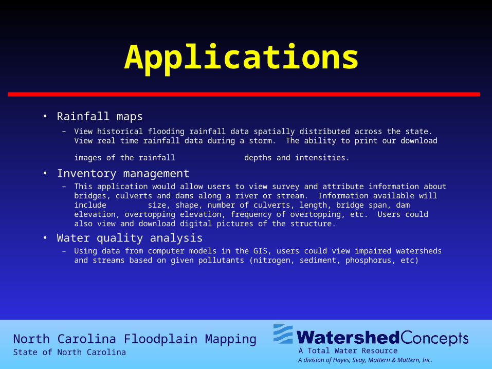
Applications
• Rainfall maps– View historical flooding rainfall data spatially distributed across the state. View real time
rainfall data during a storm. The ability to print our download images of the rainfall
depths and intensities. • Inventory management
– This application would allow users to view survey and attribute information about bridges, culverts and dams along a river or stream. Information available will include size, shape, number of culverts, length, bridge span, dam elevation, overtopping elevation, frequency of overtopping, etc. Users could also view and download digital pictures of the structure.
• Water quality analysis– Using data from computer models in the GIS, users could view impaired watersheds and
streams based on given pollutants (nitrogen, sediment, phosphorus, etc)
A Total Water ResourceA division of Hayes, Seay, Mattern & Mattern, Inc.
North Carolina Floodplain MappingState of North Carolina
Applications
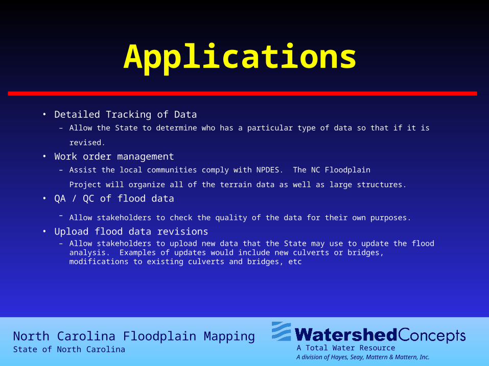
• Detailed Tracking of Data
– Allow the State to determine who has a particular type of data so that if it is revised. • Work order management
– Assist the local communities comply with NPDES. The NC Floodplain Project will organize
all of the terrain data as well as large structures. • QA / QC of flood data
– Allow stakeholders to check the quality of the data for their own purposes. • Upload flood data revisions
– Allow stakeholders to upload new data that the State may use to update the flood analysis. Examples of updates would include new culverts or bridges, modifications to existing culverts and bridges, etc
A Total Water ResourceA division of Hayes, Seay, Mattern & Mattern, Inc.
North Carolina Floodplain MappingState of North Carolina
North Carolina Floodplain MappingState of North Carolina
Baker
A Total Water ResourceA division of Hayes, Seay, Mattern & Mattern, Inc.
North Carolina Floodplain MappingState of North Carolina
Agenda
• Welcome and Introduction
• Overview Web-Based Survey
• Interviews
• Wrap-up
A Total Water ResourceA division of Hayes, Seay, Mattern & Mattern, Inc.
North Carolina Floodplain MappingState of North Carolina
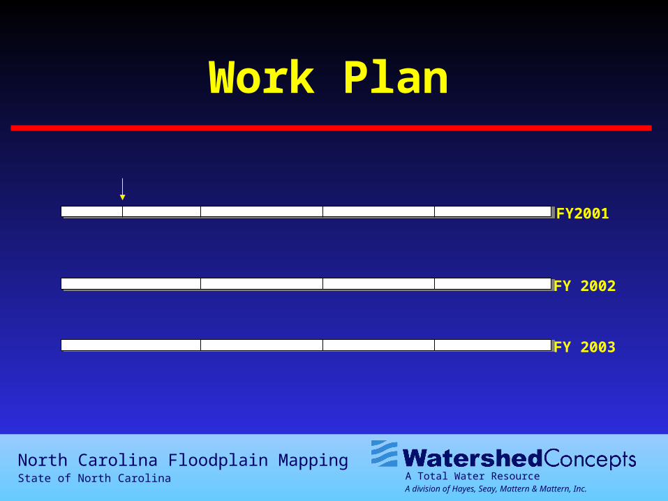
Work Plan
FY 2003
FY2001
FY 2002
A Total Water ResourceA division of Hayes, Seay, Mattern & Mattern, Inc.
North Carolina Floodplain MappingState of North Carolina
Contents
• Responses to the Survey
• Results of the Survey
• Questions and Answers
A Total Water ResourceA division of Hayes, Seay, Mattern & Mattern, Inc.
North Carolina Floodplain MappingState of North Carolina
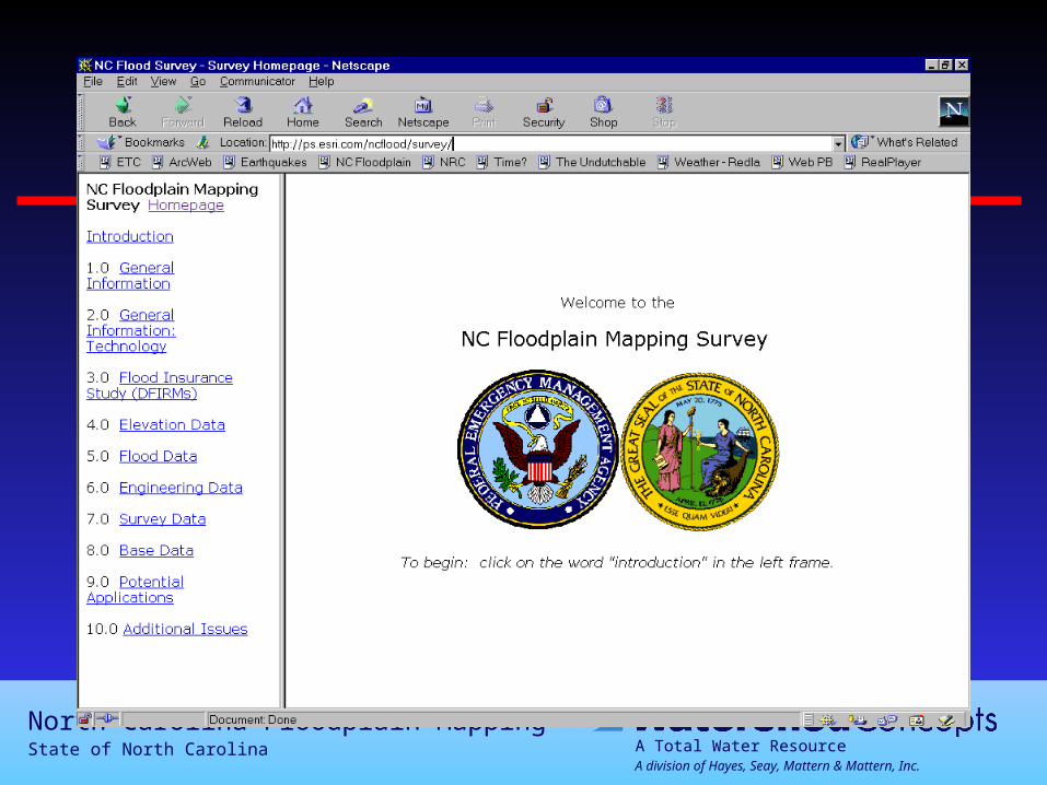
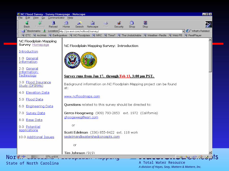
Survey Link
• ps.esri.com/ncflood/survey/
A Total Water ResourceA division of Hayes, Seay, Mattern & Mattern, Inc.
North Carolina Floodplain MappingState of North Carolina
Web-Based Survey
A Total Water ResourceA division of Hayes, Seay, Mattern & Mattern, Inc.
North Carolina Floodplain MappingState of North Carolina
Web-Based Survey
A Total Water ResourceA division of Hayes, Seay, Mattern & Mattern, Inc.
North Carolina Floodplain MappingState of North Carolina
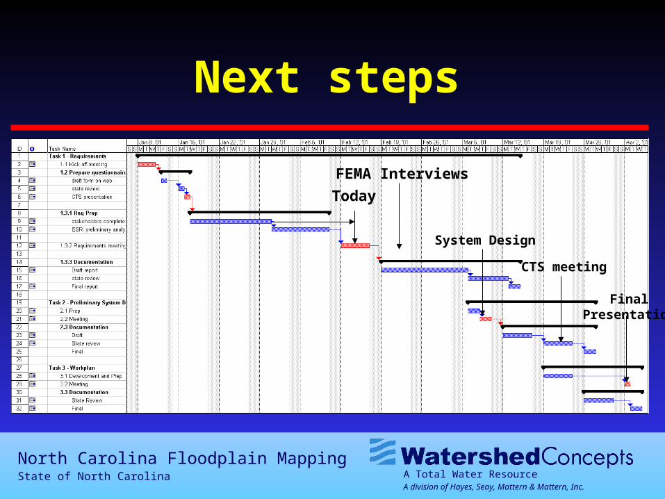
Next steps
Today
System Design
CTS meeting
FinalPresentation
FEMA Interviews
A Total Water ResourceA division of Hayes, Seay, Mattern & Mattern, Inc.
North Carolina Floodplain MappingState of North Carolina
Thank you for participating in the
interviews
A Total Water ResourceA division of Hayes, Seay, Mattern & Mattern, Inc.
North Carolina Floodplain MappingState of North Carolina
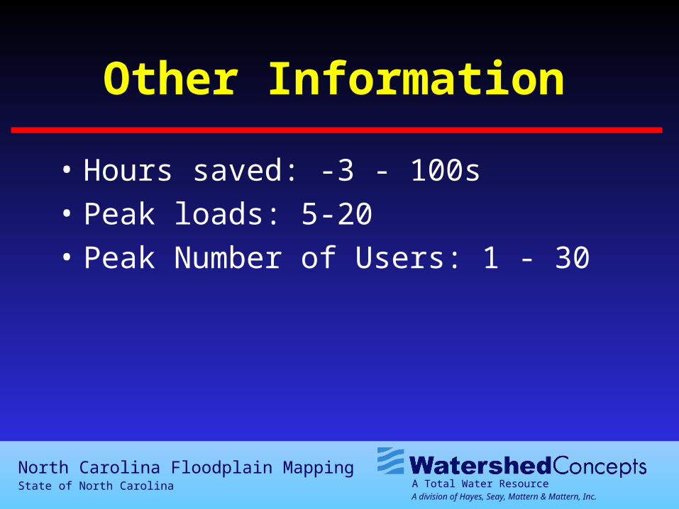
Other Information
• Hours saved: -3 - 100s
• Peak loads: 5-20
• Peak Number of Users: 1 - 30
A Total Water ResourceA division of Hayes, Seay, Mattern & Mattern, Inc.
North Carolina Floodplain MappingState of North Carolina
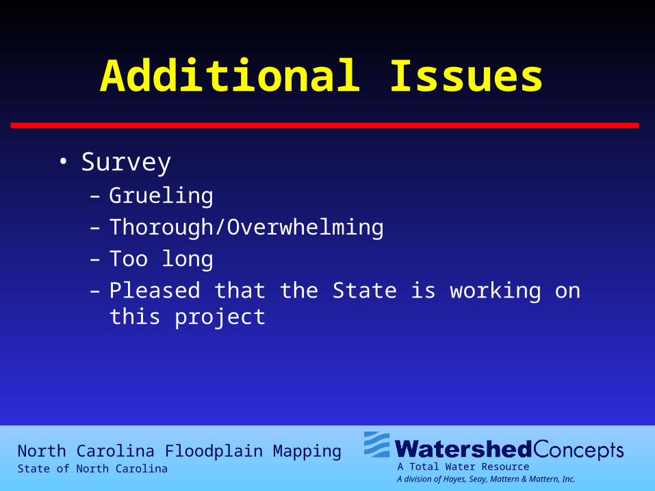
Additional Issues
• Survey– Grueling– Thorough/Overwhelming– Too long– Pleased that the State is working on this project