Embed Size (px)
Citation preview
February 2015
A27 CORRIDOR FEASIBILITY STUDY
REPORT 2 OF 3: OPTION
ASSESSMENT REPORT
Highways Agency
[Job number: 3511134AFJ]

A27 Corridor Feasibility Study
Report 2 of 3: Option Assessment Report
3511134AFJ-PTG
Prepared for Highways Agency Federated House
Dorking
Prepared by Parsons Brinckerhoff
Godalming
www.pbworld.com

AUTHORISATION SHEET
Client: Highways Agency
Project: A27 Corridor Feasibility Study
Address:
PREPARED BY
Name: Claudia Di Loreto
Position: Assistant Transportation Planner – Parsons Brinckerhoff
Name: Thomas Pettyt
Position: Assistant Transportation Planner – Parsons Brinckerhoff
Name: Rohan McGinn
Position: Regional Associate – Parsons Brinckerhoff
Date: October 2014
AGREED BY
Name: Colin McKenna
Position: Technical Director – Parsons Brinckerhoff
Date: February 2015
AUTHORISED FOR ISSUE
Name: Theo Genis
Position: Regional Associate – Parsons Brinckerhoff
Date: February 2015
DISTRIBUTION
ACCEPTED BY
Name:
Position:
Date:
ACCEPTED BY
Name:
Position:
Date:
A27 Corridor Feasibility Study Report 2 of 3: Option Assessment Report
CONTENTS Page
1 Executive Summary 8 1.1 Introduction to A27 Corridor Feasibility Study Reports 8 1.2 Stakeholder Engagement during Study 8 1.3 Generating Options 9 1.4 Sifting Options 9 1.5 Options prioritised for further assessment 10
2 Introduction to Study Stage 2 11 2.1 Overview of A27 Corridor Feasibility Study 11 2.2 Purpose of Report and Approach to Study Stage 2 11 2.3 Structure of This Report 13
3 Summary of Findings of Study Stage 1 14 3.1 Overview 14 3.2 Background 14 3.3 Overview of Current situation 15 3.4 Future Situation 16 3.5 The Need for Intervention 16 3.6 Geographic Area of Interest for A27 Corridor Feasibility Study 17 3.7 Intervention Specific Objectives 17
4 Generating Options 18 4.1 Generating a long list of options 18 4.2 Options Generated 18
5 Sifting Of Options 20 5.1 Approach to Sifting Options 20 5.2 Initial Sift of Options (prior to EAST) 20 5.3 Sifting using the Early Assessment and Sifting Tool (EAST) 26
6 Further Assessment Of Potential Options 28 6.1 Approach to Further Assessment 28 6.2 Strategic Fit 28 6.3 Economic Impact of Options 32 6.4 Outline Cost Estimates of Options 42 6.5 Distributional Impacts of Options 43 6.6 Indicative Benefit Cost Ratio (BCR) of Options 43 6.7 Financial and Commercial Considerations 44 6.8 Deliverability of Options 44
7 Conclusions – Identification of Better Performing Options 48 7.1 Summary of Study Stage 2 48 7.2 Options taken forward to Study Stage 3 49
8 Glossary 51
Appendix A: Conceptual Plans of Better Performing Options 1
A27 Corridor Feasibility Study Prepared by Parsons Brinckerhoff November 2014 for the Highways Agency - 6 -
A27 Corridor Feasibility Study Report 2 of 3: Option Assessment Report
Appendix B: Summary of Options Sifting 5
List of Figures
FIGURE 2-1: STEPS OF STUDY STAGE 2 AND OVERALL STUDY STRUCTURE 11 FIGURE 2-2: REPRESENTATION OF APPROACH TO STUDY STAGE 2 12 FIGURE A-1: ARUNDEL OPTIONS 2 FIGURE A-2: WORTHING AND LANCING OPTIONS 3 FIGURE A-3: EAST OF LEWES OPTIONS 4 FIGURE B-1: ARUNDEL - OPTIONS SIFTING OVERVIEW 6 FIGURE B-2: AREA OF WORTHING - OPTIONS SIFTING OVERVIEW 7 FIGURE B-3: EAST OF LEWES – OPTIONS SIFTING OVERVIEW 8
List of Tables
TABLE 2-1: A27 STUDY STAKEHOLDER REFERENCE GROUP MEETINGS 8 TABLE 4-1: OPTION GENERATION SOURCES 19 TABLE 5-1: WEBTAG INITIAL SIFT CRITERIA 20 TABLE 5-2: SCORING SYSTEM (INITIAL SIFT) – FIT AGAINST OBJECTIVES 21 TABLE 5-3: SCORING SYSTEM (INITIAL SIFT) – DELIVERABILITY AND FEASIBILITY 21 TABLE 5-4: DELIVERABILITY CONSIDERATIONS 21 TABLE 5-5: FEASIBILITY CONSIDERATIONS 22 TABLE 5-6: LONG LIST OF OPTIONS FOR ARUNDEL 23 TABLE 5-7: LONG LIST OF OPTIONS FOR WORTHING AND LANCING 24 TABLE 5-8: LONG LIST OF OPTIONS FOR EAST OF LEWES 25 TABLE 5-9: DISCARDED OPTIONS FROM EAST ASSESSMENT 27 TABLE 6-1: FIVE POINT SCALE UTILISED IN THE OPTION ASSESSMENT 28 TABLE 6-2: SUMMARY OF STRATEGIC FIT FOR ARUNDEL OPTIONS 29 TABLE 6-3: SUMMARY OF STRATEGIC FIT FOR WORTHING OPTIONS 30 TABLE 6-4: SUMMARY OF STRATEGIC FIT FOR EAST OF LEWES OPTIONS 31 TABLE 6-5: SUMMARY OF ARUNDEL OPTIONS (IMPACT ON ECONOMY) 33 TABLE 6-6: SUMMARY OF WORTHING OPTIONS (IMPACT ON ECONOMY) 33 TABLE 6-7: SUMMARY OF EAST OF LEWES OPTIONS (IMPACT ON ECONOMY) 34 TABLE 6-8: SUMMARY OF ARUNDEL OPTIONS (IMPACT ON ENVIRONMENT) 35 TABLE 6-9: SUMMARY OF WORTHING OPTIONS (IMPACT ON ENVIRONMENT) 37 TABLE 6-10: SUMMARY OF EAST OF LEWES OPTIONS (IMPACT ON ENVIRONMENT) 38 TABLE 6-11: SUMMARY OF ARUNDEL OPTIONS (IMPACT ON SOCIETY) 39 TABLE 6-12: SUMMARY OF WORTHING OPTIONS (IMPACT ON SOCIETY) 40 TABLE 6-13: SUMMARY OF EAST OF LEWES OPTIONS (IMPACT ON SOCIETY) 41 TABLE 6-14: INITIAL COST ESTIMATES FOR OPTIONS AT ARUNDEL 42 TABLE 6-15: INITIAL COST ESTIMATES FOR OPTIONS AT WORTHING AND LANCING 42 TABLE 6-16: INITIAL COST ESTIMATES FOR OPTIONS AT EAST OF LEWES 42 TABLE 6-17: INDICATIVE BENEFIT COST RATIO - OPTIONS AT ARUNDEL 44 TABLE 6-18: INDICATIVE BENEFIT COST RATIO - OPTIONS AT WORTHING AND LANCING 44 TABLE 6-19: INDICATIVE BENEFIT COST RATIO - OPTIONS AT EAST OF LEWES 44 TABLE 6-20: DELIVERABILITY - OPTIONS AT ARUNDEL 45 TABLE 6-21: DELIVERABILITY - OPTIONS AT WORTHING AND LANCING 45 TABLE 6-22: DELIVERABILITY - OPTIONS AT EAST OF LEWES 46 TABLE 7-1: RESULTS OF STAGE 2 - ARUNDEL 49 TABLE 7-2: RESULTS OF STAGE 2 - EAST OF LEWES 50 TABLE 7-3: RESULTS OF STAGE 2 - EAST OF LEWES 50
A27 Corridor Feasibility Study Prepared by Parsons Brinckerhoff November 2014 for the Highways Agency - 7 -
A27 Corridor Feasibility Study Report 2 of 3: Option Assessment Report
1 EXECUTIVE SUMMARY
1.1 Introduction to A27 Corridor Feasibility Study Reports
1.1.1 This report is the second of a suite of documents setting out the analysis and findings of the A27 Corridor Feasibility Study:
• Study Stage 1 Report: Evidence Report, describing the review of evidence and identification of problems along the A27 corridor;
• Study Stage 2 Report: Option Assessment Report, describing work to finalise the range of infrastructure proposals that could address the problems along the corridor at the priority locations identified; and
• Study Stage 3 Report: Investment Cases Report, describing the work to assess the affordability, value for money and deliverability of prioritised infrastructure proposals.
1.1.2 Study Stage 2 assesses the range of infrastructure proposals that could address the challenges at the priority problem locations identified. This stage considers whether the various options generated are likely to achieve the intervention-specific objectives identified in Study Stage 1 and would be deliverable, affordable and offer value for money.
1.1.3 The study is conducted in accordance with the Department for Transport’s (DfT) Transport Appraisal Process (WebTAG)1, and – as set out in the Feasibility Scope Document2.
1.2 Stakeholder Engagement during Study
1.2.1 Stakeholder engagement has been a key aspect of the study process, for the verification of the evidence base and the agreement of the intervention-specific objectives. This engagement has been managed largely by means of an A27 Study Stakeholder Reference Group (SSRG). The main role of the SSRG is to ensure stakeholders’ views are captured and considered during the study process, particularly at key points in the study’s work and at times of the development of key outputs. The establishment of the SSRG enabled the views of a wider community of stakeholder organisations to be considered and fed into the work of the A27 study.
1.2.2 In total, 4 separate Group meetings have been held throughout the duration of the study. Meetings have been held on the following dates and locations, as detailed within Table 2-1 below.
Table 2-1: A27 Study Stakeholder Reference Group meetings Meeting agenda Date Location
Detailing scope of study Wednesday, 22nd January 2014 Brighton
Agreeing the intervention specific objectives Tuesday, 3rd June 2014 Worthing
Initial sift of options Wednesday, 27th August 2014 Eastbourne
Overview of emerging study outcomes Tuesday, 4th February 2015 Brighton
1 Department of Transport, Transport Analysis Guidance (WebTAG), January 2014: The Transport Appraisal Process. 2 A27 Corridor Feasibility Study Scope Document, DfT, 23 April 2014, https://www.gov.uk/government/uploads/system/uploads/attachment_data/file/345568/a27-feasibility-study-scope.pdf
A27 Corridor Feasibility Study Prepared by Parsons Brinckerhoff November 2014 for the Highways Agency - 8 -
A27 Corridor Feasibility Study Report 2 of 3: Option Assessment Report
1.3 Generating Options
1.3.1 Once the Study Stage 1 had established the need for intervention, defined the geographic scope of intervention (priority hotspots) and set out intervention specific objectives to be met, a review was undertaken of previous work conducted by the Highways Agency for Worthing and Arundel, and by East and West Sussex County Councils, and local district councils, to identify infrastructure proposals that could satisfy the objectives. This approach looked to build on work done to date and considered a range of individual investment proposals, as well as combinations of investment propositions.
1.3.2 The option generation process identified an initial long list of discrete interventions at each of the three prioritised locations. 46 interventions - comprising a variety of online and offline solutions - were considered at a high level. Only those which met most of the intervention objectives and appeared deliverable and feasible were taken forward. These were:
1.3.3 At Arundel:
• three new bypass options - (a) partly through the National Park, (b) avoiding the National Park or (c) closer to the town limits through the National Park;
• online dualling of the existing road including a 250 metre tunnel and a short stretch of bypass; and
• online improvements.
1.3.4 At Worthing and Lancing:
• tunnels throughout; • combinations of tunnel, bypass and dualling; • online dualling throughout; • online junction improvements; and • travel demand management and public transport.
1.3.5 East of Lewes:
• two versions of a new offline route: (a) single carriageway and (b) dual carriageway; • bypasses at (a) Selmeston and (b) Wilmington; • online improvements at Selmeston; • new link road at Folkington; • Polegate junction improvements; and • low cost online improvements.
1.4 Sifting Options
1.4.1 The identified options were initially considered using a structured qualitative assessment. Within this, the scale of impact of each option was assessed against the route problems and objectives and also against a set deliverability and feasibility criteria assessed. The analysis was at a high level of their fit with key strategic criteria, in order to remove any options at that stage which failed to make a significant contribution to the intervention specific objectives. Those options which were retained were then assessed using the Department’s Early Assessment and Sifting Tool (EAST). These were prioritised in terms of initial benefit cost ratios calculated, which represented an early indication of value for money.
A27 Corridor Feasibility Study Prepared by Parsons Brinckerhoff November 2014 for the Highways Agency - 9 -
A27 Corridor Feasibility Study Report 2 of 3: Option Assessment Report
1.4.2 Following the EAST assessment, the online improvement option at Arundel and travel demand management/public transport option at Worthing were not assessed further as these did not sufficiently address the intervention specific objectives of the study - in particular, the objective of "reducing travel time and improving journey time reliability in the key hotspot area"3. Instead, the study made an assumption that sustainable transport measures would be pursued and could make a limited contribution towards the transport in the wider area.
1.4.3 Five of the options considered for East of Lewes section were prioritised for further assessment. The Selmeston online improvements, Polegate junction improvements and online improvements were not considered further because any benefits were expected to be too localised. In addition, it is expected that the Polegate junction improvements will be brought forward as part of local development planning.
1.4.4 The prioritised options were then further assessed using the DfT's Option Assessment Framework, with evidence presented against two of the Treasury's five-case model (which assesses the strategic, economic, financial, management/delivery and commercial cases). As this was an early stage of assessing possible solutions, the study focussed on the strategic and economic cases.
1.4.5 The strategic case was considered in terms of strategic fit with national and local policy and the intervention specific objectives. The economic case considered economic, environmental and social impacts as well as a high level assessment of potential value for money (VfM) based on information from previous studies.
1.5 Options prioritised for further assessment
1.5.1 Options which indicated strategic fit, potential for deliverability and potential VfM were prioritised for further consideration. Against these considerations, this stage of the study prioritised:
• two of the Arundel bypass options; • three markedly different tunnel and online improvement options for
Worthing/Lancing; • combined option for Arundel Option A and Worthing Option F - due to the close
links between the Arundel and Worthing schemes; and • all five options for the section east of Lewes.
1.5.2 The following options were not prioritised for further assessment:
• At Arundel: bypass option (c) was not prioritised because it was considered too similar to bypass options (a) and (b) for the purpose of investment case development. In addition the online/tunnelling option was not prioritised because the relatively high cost of tunnelling indicated the likelihood of poor value for money; and
• Worthing: options comprising various combinations of tunnelling and online or bypass improvements were not prioritised as they indicated the likelihood of value for money similar to that for a full tunnelling option.
3 As referenced in the Study Stage 1 Report.
A27 Corridor Feasibility Study Prepared by Parsons Brinckerhoff November 2014 for the Highways Agency - 10 -
A27 Corridor Feasibility Study Report 2 of 3: Option Assessment Report
2 INTRODUCTION TO STUDY STAGE 2
This chapter outlines how this report fits with Study Stage 1 and 3, as well as its purpose, tasks and structure.
2.1 Overview of A27 Corridor Feasibility Study
2.1.1 Parsons Brinckerhoff (PB) was commissioned by the Highways Agency (HA) to undertake a feasibility study on the A27 Corridor on behalf of the Department for Transport (DfT) in November 2013.
2.1.2 The purpose, scope and approach used for the A27 Corridor Feasibility Study are set out in a Scope Document issued by the Department of Transport and the Highways Agency4. This required the study to take a proportionate approach and to be completed in accordance with DfT’s Transport Analysis Guidance (January 2014) and in three stages which are set out below.
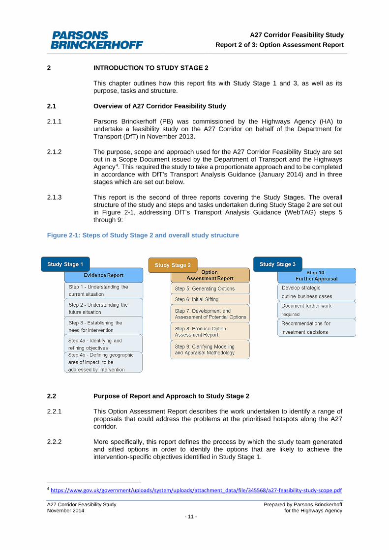
2.1.3 This report is the second of three reports covering the Study Stages. The overall structure of the study and steps and tasks undertaken during Study Stage 2 are set out in Figure 2-1, addressing DfT’s Transport Analysis Guidance (WebTAG) steps 5 through 9:
Figure 2-1: Steps of Study Stage 2 and overall study structure
2.2 Purpose of Report and Approach to Study Stage 2
2.2.1 This Option Assessment Report describes the work undertaken to identify a range of proposals that could address the problems at the prioritised hotspots along the A27 corridor.
2.2.2 More specifically, this report defines the process by which the study team generated and sifted options in order to identify the options that are likely to achieve the intervention-specific objectives identified in Study Stage 1.
4 https://www.gov.uk/government/uploads/system/uploads/attachment_data/file/345568/a27-feasibility-study-scope.pdf
A27 Corridor Feasibility Study Prepared by Parsons Brinckerhoff November 2014 for the Highways Agency - 11 -
A27 Corridor Feasibility Study Report 2 of 3: Option Assessment Report
2.2.3 The technical content and conclusions set out in this report were completed prior to and formed part of the input to the Road Investment Strategy (RIS) announced in December 2014.
2.2.4 This report therefore includes the following:
• a reminder of the problem areas and intervention specific objectives as identified in Study Stage 1;
• an explanation of how the options are generated and sifted in order to identify prioritised options. This followed 2 steps: o WebTAG Step 5 – Generating Options o WebTAG Step 6 – Initial Sifting (which includes an initial sift and the EAST
appraisal of options)
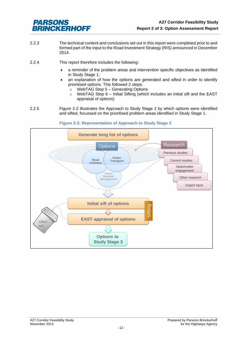
2.2.5 Figure 2-2 illustrates the Approach to Study Stage 2 by which options were identified and sifted, focussed on the prioritised problem areas identified in Study Stage 1.
Figure 2-2: Representation of Approach to Study Stage 2
Long List of Options
Travel Demand
Management
Road schemes
Public Transport
Previous studies
Generate long list of options
Options to Study Stage 3
Current studies
Stakeholderengagement
Other research
Expert input
Initial sift of options
EAST appraisal of optionsSifted out
Options ResearchSi
fting
A27 Corridor Feasibility Study Prepared by Parsons Brinckerhoff November 2014 for the Highways Agency - 12 -
A27 Corridor Feasibility Study Report 2 of 3: Option Assessment Report
2.3 Structure of This Report
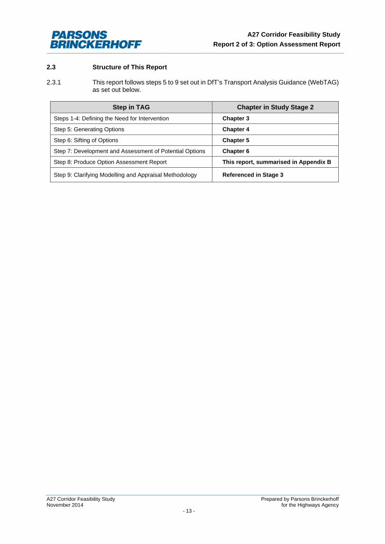
2.3.1 This report follows steps 5 to 9 set out in DfT’s Transport Analysis Guidance (WebTAG) as set out below.
Step in TAG Chapter in Study Stage 2 Steps 1-4: Defining the Need for Intervention Chapter 3
Step 5: Generating Options Chapter 4
Step 6: Sifting of Options Chapter 5
Step 7: Development and Assessment of Potential Options Chapter 6
Step 8: Produce Option Assessment Report This report, summarised in Appendix B
Step 9: Clarifying Modelling and Appraisal Methodology Referenced in Stage 3
A27 Corridor Feasibility Study Prepared by Parsons Brinckerhoff November 2014 for the Highways Agency - 13 -
A27 Corridor Feasibility Study Report 2 of 3: Option Assessment Report
3 SUMMARY OF FINDINGS OF STUDY STAGE 1
This chapter provides an overview of the first report in the A27 Corridor Feasibility Study: Study Stage 1. This provides the basis and background to Study Stage 2.
3.1 Overview
3.1.1 The Study Stage 1 Report set out the analysis which was undertaken in order to establish the need for and scope for intervention on the A27. This followed the four steps in line with DfT’s Transport Analysis Guidance (WebTAG):
• Step 1: Understanding the current situation • Step 2: Understanding the future scenario • Step 3: Establishing the need for intervention • Step 4a: Identifying and refining objectives • Step 4b: Defining geographic area of impact to be addressed by the intervention
3.2 Background
3.2.1 The A27 is the only east-west trunk road south of the M25. It links various cities and towns along the south coast, accommodating over three quarters of a million people, including Portsmouth, Havant, Chichester, Arundel, Worthing, Brighton and Hove, Lewes and Eastbourne. The A27 provides access to Bognor Regis and the ports of Portsmouth, Shoreham, and Newhaven, and provides businesses and residents in this corridor with access to the rest of the strategic road network (SRN). The A27 is located in the southern part of the sub-regional economic area referred to as the Gatwick Diamond.
3.2.2 The local economy has strengths in advanced engineering, tourism and other sectors and has accommodated substantial population and household growth over the past decade, particularly in the urban areas. The A27 corridor runs alongside and across the South Downs National Park (SDNP) and the corridor is constrained by the urban areas along the route and the sea to the south.
3.2.3 There have been long-standing calls to improve the A27 corridor. Infrastructure enhancements along the A27 and beyond were previously considered as part of the South Coast Multi Modal Study (SoCoMMS) which reported in 2002. The study concluded that there was little justification for a long distance strategic south coast route between Southampton and Margate. It did, however, identify the need for a number of investments along the A27. Only some of these were progressed at the time, owing to concern about potential difficulties of delivering major road schemes in environmentally sensitive locations.
3.2.4 Further studies have since been undertaken by the Highways Agency and local authorities respectively. Transport improvements have been developed by the Highways Agency (for example, at Beddingham and Southerham) and the affected local planning authorities for Worthing and Chichester, and by East Sussex County Council in the form of the Bexhill to Hastings link road.
3.2.5 As part of the outcomes of the 2013 Spending Review, the Government committed to investment for major improvements to the A27 Chichester bypass as part of its pipeline of future major road schemes, subject to value for money (VfM) and deliverability.
A27 Corridor Feasibility Study Prepared by Parsons Brinckerhoff November 2014 for the Highways Agency - 14 -
A27 Corridor Feasibility Study Report 2 of 3: Option Assessment Report
3.3 Overview of Current situation
3.3.1 This stage of the A27 Corridor Feasibility Study reviewed the current situation along the A27, and identified problems along the route.
Travel Demand
3.3.2 Analysis of Census Journey to Work and historic roadside interview data shows the following:
• there are a variety of short and long distance trips made across the districts along the A27, with little change in travel patterns between 2001 and 2011;
• Over 60% of trips along the coastal area were estimated to be journeys made entirely within the respective counties of West and East Sussex;
• Between 1.5 and 2% of commuter journeys in Arun, Worthing and Wealden are made using bus, and between 3 and 4% using rail.
• A high proportion of work-related journeys in the coastal area are made by road.
• Goods vehicles represent more than 15% of the daily traffic volumes along A27 and a third of this is heavy goods traffic.
Transport Provision
3.3.3 Rail Provision: The coastal area is served by a number of rail routes, including the provision of frequent services between Havant and London Waterloo, and separate services between Bognor Regis, Littlehampton, Brighton, Eastbourne and London Victoria.) . These routes run parallel, for part of their route, with the A27 and provide links between the south coast, intervening towns, Gatwick and London. They also do provide an alternative mode for journeys along the A27 between stations served by London trains. However, Coastway services which provide a close parallel link to the A27 cater for local stopping stations, providing good rail accessibility for shorter journeys but lengthy journey times for longer distance journeys. Consultation with Network Rail has found that the rail network is close to capacity with no significant improvements planned although additional carriages on certain peak period services could alleviate overcrowding
3.3.4 Bus Provision: There are various bus routes serving the communities within the A27 corridor. Consultation with the various Local Authorities along the corridor indicates that no major road-based public transport investment is anticipated.
3.3.5 Highway Provision: For most of its 67 mile length, the A27 is dual carriageway. Four stretches of road remain single carriageway, namely at Arundel, Worthing, and along two stretches to the east of Lewes. Such sections of road tend to experience peak hour congestion and poor time reliability.
3.3.6 Issues identified and performance along the Highway Network are as follows:
• Capacity: Annual Average Daily Traffic Volumes (AADT) on specific single carriageway links were close to or above the theoretical capacity of the road at Arundel, Worthing and on the stretch between Lewes and Polegate. AADT volumes on most sections of the dual carriageway along the A27 are within the theoretical road capacity.
• Reliability: sections of single carriageway and at-grade junctions result in congestion and delays which impact on the efficient and safe movement of people
A27 Corridor Feasibility Study Prepared by Parsons Brinckerhoff November 2014 for the Highways Agency - 15 -
A27 Corridor Feasibility Study Report 2 of 3: Option Assessment Report
and goods. Congestion is a problem at a number of locations including Chichester, Arundel, Worthing and between Lewes and Polegate.
• Severance: The route runs through and close to settlements causing severance issues at Arundel, Worthing and Lancing and villages east of Lewes.
• Air Quality: Traffic and congestion affect air quality, in particular at locations such as Worthing and Storrington where Air Quality Management Areas (AQMAs) have been declared due to high volumes of traffic.
• Road Safety: Accidents are a significant challenge along certain links, with incidents leading to further impacts on journey-time reliability.
Environmental Constraints
3.3.7 The study identified a range of environmental constraints, most significantly the SDNP alongside and through which the A27 is aligned. Various other locations protected by environmental designations have been identified, as well as the coastal floodplains of the River Arun and River Adur.
3.4 Future Situation
3.4.1 The area is planning for significant growth. Over 60,000 new homes and substantial employment development are expected within the coastal study area (West and East Sussex).
3.4.2 The ability of the transport system to support such growth will, however, be constrained by: • the capacity of the A27, the capacity of the local road network and the junctions
linking the routes; and • limitations on rail and other public transport modes to significantly improve their
offer of an alternative choice of travel, other than in the larger urban areas.
3.4.3 High level traffic modelling, undertaken as part of this study, indicates that congestion is expected to worsen in future, particularly along the single carriageway and narrow lane sections with reduced capacity.
3.5 The Need for Intervention
3.5.1 The evidence demonstrates that whilst bus/rail network or alternative methods such as Light Rail and demand management measures may provide opportunities for modal transfer, these measures are unlikely to be able to adequately address the study objectives of reducing travel time, improving journey time reliability and enabling local planning authorities to manage the impact of planned growth.
3.5.2 The Government’s policy on the SRN is to ensure that it operates effectively and efficiently, and that it supports and facilitates economic growth. A more efficient network would enable firms reliant on the A27 for access to operate more efficiently, and encourage investment in existing and new businesses. With greater certainty over journey times, businesses would be better positioned to compete internationally.
3.5.3 In light of current capacity constraints, the planned growth in housing and employment will likely result in the worsening of congestion and delays. There are clear limitations to alternative public transport solutions, and hence there is a need to invest in road-based solutions.
A27 Corridor Feasibility Study Prepared by Parsons Brinckerhoff November 2014 for the Highways Agency - 16 -
A27 Corridor Feasibility Study Report 2 of 3: Option Assessment Report
3.6 Geographic Area of Interest for A27 Corridor Feasibility Study
3.6.1 The analysis was used to prioritise three locations or 'hotspot areas' for targeting interventions: • Arundel; • Worthing and Lancing; and • East of Lewes - specifically the stretch of road between Lewes and Polegate.
3.7 Intervention Specific Objectives
3.7.1 Based on the analysis of available evidence and discussion with the SSRG, the study team defined a number of intervention specific objectives:
• Reducing travel time and improving journey time reliability in the key hotspot areas; • Reducing severance and pollution impacts; • Enabling local planning authorities to manage the impact of planned growth and in
doing so support the wider economy; • Providing safer roads which are resilient to delay and which are able to adequately
cater for the impacts of adverse weather; • Minimising impacts on the natural environment and optimising environmental
opportunities and mitigation; and • Providing opportunities for improved accessibility for all users.
.
A27 Corridor Feasibility Study Prepared by Parsons Brinckerhoff November 2014 for the Highways Agency - 17 -
A27 Corridor Feasibility Study Report 2 of 3: Option Assessment Report
4 GENERATING OPTIONS
This chapter outlines how the study team generated potential options for addressing the prioritised hotspots along the A27 corridor.
4.1 Generating a long list of options
4.1.1 The aim of the option generation process for the corridor was to develop a range of potential solutions to address the need for intervention, identified in Study Stage 1.
4.1.2 A wide range of options were considered including, public transport, infrastructure, traffic management, pricing and behavioural change.
4.1.3 Currently planned transport infrastructure was taken into consideration:
• Highway Network: For the purposes of this study the following schemes have been assumed to form part of any “Do Minimum” considerations:
o Chichester: A27 improvements – upgrading of junctions along the A27 to grade-separated (HA major scheme)
o Polegate/Eastbourne: A27 Cophall Roundabout improvements (TR3 recommendations as part of Wealden Local Plan, now SELEP scheme)
o Polegate/Eastbourne: A27 / A2270 Signalised junction (TR3 recommendations as part of Wealden Local Plan, now SELEP scheme)
o Polegate/Eastbourne: Quality Bus Corridor (SELEP scheme proposal)
• Rail Network: Network Rail has been consulted and has no plans to significantly increase the capacity of the rail network in the area.
• Bus Network: Consultation with the various Local Authorities along the corridor indicates that they do not expect major roads based public transport investment.
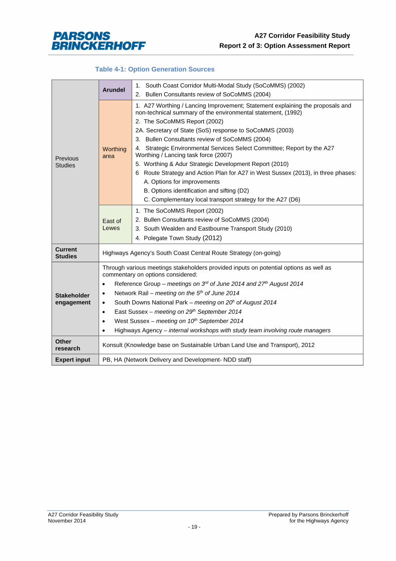
4.1.4 These options were generated through the review of previous and current studies, stakeholder engagement, expert input and research.
4.1.5 Table 4-1 lists the sources referred to in generating the list of options for the three “hotspots” identified in Study Stage 1.
4.2 Options Generated
4.2.1 In total, 46 options were evaluated. The long lists of options generated for the three prioritised hotspots and taken through the sifting process are listed in tables in Chapter 5 wherein the sifting of options is described.
A27 Corridor Feasibility Study Prepared by Parsons Brinckerhoff November 2014 for the Highways Agency - 18 -
A27 Corridor Feasibility Study Report 2 of 3: Option Assessment Report
Table 4-1: Option Generation Sources
Previous Studies
Arundel 1. South Coast Corridor Multi-Modal Study (SoCoMMS) (2002) 2. Bullen Consultants review of SoCoMMS (2004)
Worthing area
1. A27 Worthing / Lancing Improvement; Statement explaining the proposals and non-technical summary of the environmental statement, (1992) 2. The SoCoMMS Report (2002) 2A. Secretary of State (SoS) response to SoCoMMS (2003) 3. Bullen Consultants review of SoCoMMS (2004) 4. Strategic Environmental Services Select Committee; Report by the A27 Worthing / Lancing task force (2007) 5. Worthing & Adur Strategic Development Report (2010) 6 Route Strategy and Action Plan for A27 in West Sussex (2013), in three phases: A. Options for improvements B. Options identification and sifting (D2) C. Complementary local transport strategy for the A27 (D6)
East of Lewes
1. The SoCoMMS Report (2002) 2. Bullen Consultants review of SoCoMMS (2004) 3. South Wealden and Eastbourne Transport Study (2010) 4. Polegate Town Study (2012)
Current Studies Highways Agency’s South Coast Central Route Strategy (on-going)
Stakeholder engagement
Through various meetings stakeholders provided inputs on potential options as well as commentary on options considered: • Reference Group – meetings on 3rd of June 2014 and 27th August 2014 • Network Rail – meeting on the 5th of June 2014 • South Downs National Park – meeting on 20h of August 2014 • East Sussex – meeting on 29th September 2014 • West Sussex – meeting on 10th September 2014 • Highways Agency – internal workshops with study team involving route managers
Other research Konsult (Knowledge base on Sustainable Urban Land Use and Transport), 2012
Expert input PB, HA (Network Delivery and Development- NDD staff)
A27 Corridor Feasibility Study Prepared by Parsons Brinckerhoff November 2014 for the Highways Agency - 19 -
A27 Corridor Feasibility Study Report 2 of 3: Option Assessment Report
5 SIFTING OF OPTIONS
This chapter sets out the approach and outcomes of the process of sifting options.
5.1 Approach to Sifting Options
5.1.1 After options were generated, some options were identified which do not represent sensible solutions. An ‘initial sift’ was therefore undertaken to identify any ‘showstoppers’ which are likely to prevent an option progressing at a subsequent stage in the process.
5.1.2 Following the initial sift, options were assessed using the Early Assessment and Sifting Tool (EAST)5. EAST has been developed in order to support decision making, enabling the user to quickly summarise and present evidence on options in a clear and consistent format whilst, at the same time, ensuring that a robust audit trail for the option sifting process is maintained.
5.1.3 In sifting options, the key principle of Department for Transport’s (DfT’s) guidance is that potential improvements are driven by identified problems and defined objectives, therefore ensuring that the need for investment can be clearly justified and evidenced.
5.2 Initial Sift of Options (prior to EAST)
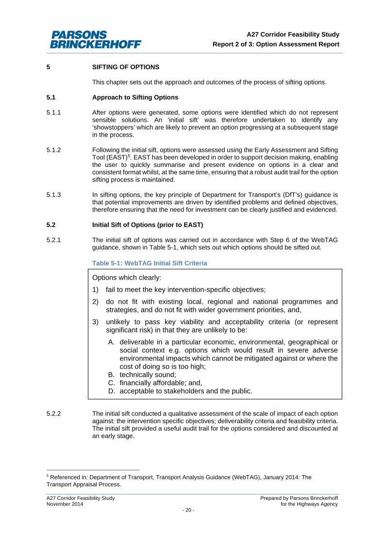
5.2.1 The initial sift of options was carried out in accordance with Step 6 of the WebTAG guidance, shown in Table 5-1, which sets out which options should be sifted out.
Table 5-1: WebTAG Initial Sift Criteria
Options which clearly:
1) fail to meet the key intervention-specific objectives;
2) do not fit with existing local, regional and national programmes and strategies, and do not fit with wider government priorities, and,
3) unlikely to pass key viability and acceptability criteria (or represent significant risk) in that they are unlikely to be:
A. deliverable in a particular economic, environmental, geographical or social context e.g. options which would result in severe adverse environmental impacts which cannot be mitigated against or where the cost of doing so is too high;
B. technically sound; C. financially affordable; and, D. acceptable to stakeholders and the public.
5.2.2 The initial sift conducted a qualitative assessment of the scale of impact of each option against: the intervention specific objectives; deliverability criteria and feasibility criteria. The initial sift provided a useful audit trail for the options considered and discounted at an early stage.
5 Referenced in: Department of Transport, Transport Analysis Guidance (WebTAG), January 2014: The Transport Appraisal Process.
A27 Corridor Feasibility Study Prepared by Parsons Brinckerhoff November 2014 for the Highways Agency - 20 -
A27 Corridor Feasibility Study Report 2 of 3: Option Assessment Report
5.2.3 Options which, on their own, did not address the identified problems and objectives (or were deemed not to be feasible or deliverable), were packaged together and reconsidered as package options in the next stage of sifting (EAST assessment).
Initial Sift Methodology
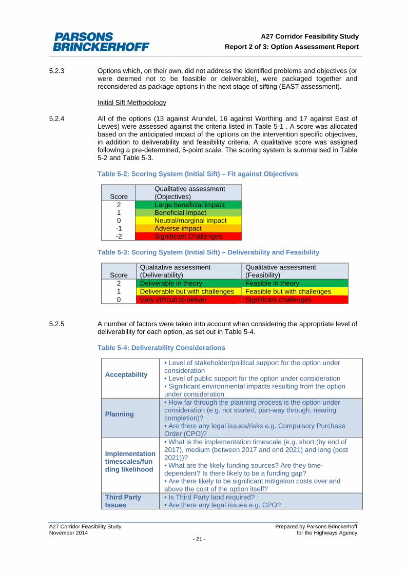
5.2.4 All of the options (13 against Arundel, 16 against Worthing and 17 against East of Lewes) were assessed against the criteria listed in Table 5-1 . A score was allocated based on the anticipated impact of the options on the intervention specific objectives, in addition to deliverability and feasibility criteria. A qualitative score was assigned following a pre-determined, 5-point scale. The scoring system is summarised in Table 5-2 and Table 5-3.
Table 5-2: Scoring System (Initial Sift) – Fit against Objectives
Score Qualitative assessment (Objectives)
2 Large beneficial impact 1 Beneficial impact 0 Neutral/marginal impact -1 Adverse impact -2 Significant Challenges
Table 5-3: Scoring System (Initial Sift) – Deliverability and Feasibility
Score Qualitative assessment (Deliverability)
Qualitative assessment (Feasibility)
2 Deliverable in theory Feasible in theory 1 Deliverable but with challenges Feasible but with challenges 0 Very difficult to deliver Significant challenges
5.2.5 A number of factors were taken into account when considering the appropriate level of deliverability for each option, as set out in Table 5-4.
Table 5-4: Deliverability Considerations
Acceptability
• Level of stakeholder/political support for the option under consideration • Level of public support for the option under consideration • Significant environmental impacts resulting from the option under consideration
Planning
• How far through the planning process is the option under consideration (e.g. not started, part-way through, nearing completion)? • Are there any legal issues/risks e.g. Compulsory Purchase Order (CPO)?
Implementation timescales/funding likelihood
• What is the implementation timescale (e.g. short (by end of 2017), medium (between 2017 and end 2021) and long (post 2021))? • What are the likely funding sources? Are they time-dependent? Is there likely to be a funding gap? • Are there likely to be significant mitigation costs over and above the cost of the option itself?
Third Party Issues
• Is Third Party land required? • Are there any legal issues e.g. CPO?
A27 Corridor Feasibility Study Prepared by Parsons Brinckerhoff November 2014 for the Highways Agency - 21 -
A27 Corridor Feasibility Study Report 2 of 3: Option Assessment Report
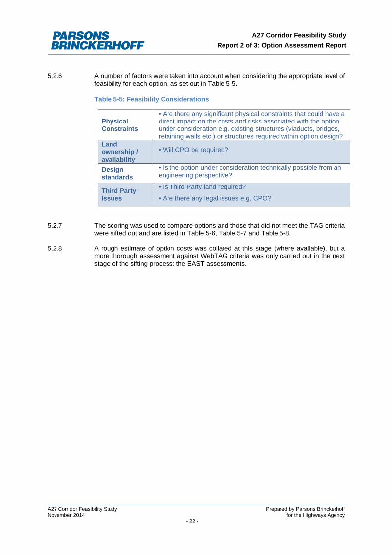
5.2.6 A number of factors were taken into account when considering the appropriate level of
feasibility for each option, as set out in Table 5-5.
Table 5-5: Feasibility Considerations
Physical Constraints
• Are there any significant physical constraints that could have a direct impact on the costs and risks associated with the option under consideration e.g. existing structures (viaducts, bridges, retaining walls etc.) or structures required within option design?
Land ownership / availability
• Will CPO be required?
Design standards
• Is the option under consideration technically possible from an engineering perspective?
Third Party Issues
• Is Third Party land required?
• Are there any legal issues e.g. CPO?
5.2.7 The scoring was used to compare options and those that did not meet the TAG criteria
were sifted out and are listed in Table 5-6, Table 5-7 and Table 5-8.
5.2.8 A rough estimate of option costs was collated at this stage (where available), but a more thorough assessment against WebTAG criteria was only carried out in the next stage of the sifting process: the EAST assessments.
A27 Corridor Feasibility Study Prepared by Parsons Brinckerhoff November 2014 for the Highways Agency - 22 -
A27 Corridor Feasibility Study Report 2 of 3: Option Assessment Report
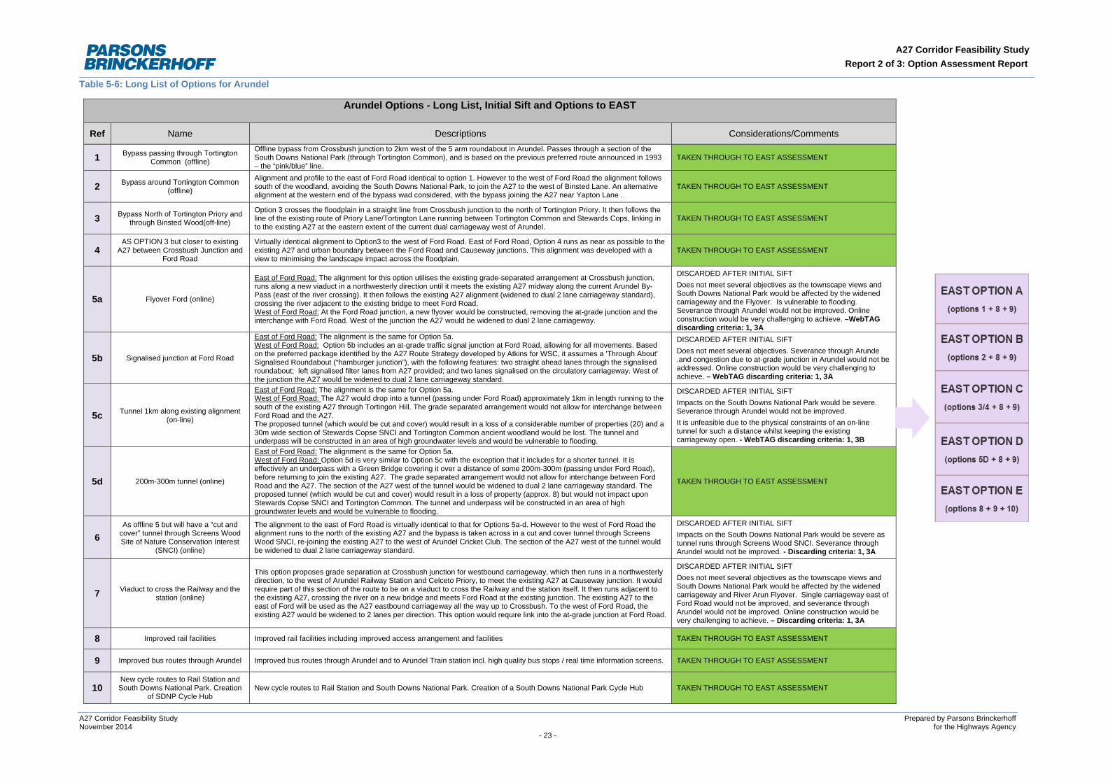
Table 5-6: Long List of Options for Arundel
Arundel Options - Long List, Initial Sift and Options to EAST
Ref Name Descriptions Considerations/Comments
1 Bypass passing through Tortington Common (offline)
Offline bypass from Crossbush junction to 2km west of the 5 arm roundabout in Arundel. Passes through a section of the South Downs National Park (through Tortington Common), and is based on the previous preferred route announced in 1993 – the “pink/blue” line.
TAKEN THROUGH TO EAST ASSESSMENT
2 Bypass around Tortington Common (offline)
Alignment and profile to the east of Ford Road identical to option 1. However to the west of Ford Road the alignment follows south of the woodland, avoiding the South Downs National Park, to join the A27 to the west of Binsted Lane. An alternative alignment at the western end of the bypass wad considered, with the bypass joining the A27 near Yapton Lane .
TAKEN THROUGH TO EAST ASSESSMENT
3 Bypass North of Tortington Priory and through Binsted Wood(off-line)
Option 3 crosses the floodplain in a straight line from Crossbush junction to the north of Tortington Priory. It then follows the line of the existing route of Priory Lane/Tortington Lane running between Tortington Common and Stewards Cops, linking in to the existing A27 at the eastern extent of the current dual carriageway west of Arundel.
TAKEN THROUGH TO EAST ASSESSMENT
4 AS OPTION 3 but closer to existing
A27 between Crossbush Junction and Ford Road
Virtually identical alignment to Option3 to the west of Ford Road. East of Ford Road, Option 4 runs as near as possible to the existing A27 and urban boundary between the Ford Road and Causeway junctions. This alignment was developed with a view to minimising the landscape impact across the floodplain.
TAKEN THROUGH TO EAST ASSESSMENT
5a Flyover Ford (online)
East of Ford Road: The alignment for this option utilises the existing grade-separated arrangement at Crossbush junction, runs along a new viaduct in a northwesterly direction until it meets the existing A27 midway along the current Arundel By-Pass (east of the river crossing). It then follows the existing A27 alignment (widened to dual 2 lane carriageway standard), crossing the river adjacent to the existing bridge to meet Ford Road. West of Ford Road: At the Ford Road junction, a new flyover would be constructed, removing the at-grade junction and the interchange with Ford Road. West of the junction the A27 would be widened to dual 2 lane carriageway.
DISCARDED AFTER INITIAL SIFT Does not meet several objectives as the townscape views and South Downs National Park would be affected by the widened carriageway and the Flyover. Is vulnerable to flooding. Severance through Arundel would not be improved. Online construction would be very challenging to achieve. –WebTAG discarding criteria: 1, 3A
5b Signalised junction at Ford Road
East of Ford Road: The alignment is the same for Option 5a. West of Ford Road: Option 5b includes an at-grade traffic signal junction at Ford Road, allowing for all movements. Based on the preferred package identified by the A27 Route Strategy developed by Atkins for WSC, it assumes a 'Through About' Signalised Roundabout (“hamburger junction”), with the following features: two straight ahead lanes through the signalised roundabout; left signalised filter lanes from A27 provided; and two lanes signalised on the circulatory carriageway. West of the junction the A27 would be widened to dual 2 lane carriageway standard.
DISCARDED AFTER INITIAL SIFT Does not meet several objectives. Severance through Arunde .and congestion due to at-grade junction in Arundel would not be addressed. Online construction would be very challenging to achieve. – WebTAG discarding criteria: 1, 3A
5c Tunnel 1km along existing alignment (on-line)
East of Ford Road: The alignment is the same for Option 5a. West of Ford Road: The A27 would drop into a tunnel (passing under Ford Road) approximately 1km in length running to the south of the existing A27 through Tortingon Hill. The grade separated arrangement would not allow for interchange between Ford Road and the A27. The proposed tunnel (which would be cut and cover) would result in a loss of a considerable number of properties (20) and a 30m wide section of Stewards Copse SNCI and Tortington Common ancient woodland would be lost. The tunnel and underpass will be constructed in an area of high groundwater levels and would be vulnerable to flooding.
DISCARDED AFTER INITIAL SIFT Impacts on the South Downs National Park would be severe. Severance through Arundel would not be improved. It is unfeasible due to the physical constraints of an on-line tunnel for such a distance whilst keeping the existing carriageway open. - WebTAG discarding criteria: 1, 3B
5d 200m-300m tunnel (online)
East of Ford Road: The alignment is the same for Option 5a. West of Ford Road: Option 5d is very similar to Option 5c with the exception that it includes for a shorter tunnel. It is effectively an underpass with a Green Bridge covering it over a distance of some 200m-300m (passing under Ford Road), before returning to join the existing A27. The grade separated arrangement would not allow for interchange between Ford Road and the A27. The section of the A27 west of the tunnel would be widened to dual 2 lane carriageway standard. The proposed tunnel (which would be cut and cover) would result in a loss of property (approx. 8) but would not impact upon Stewards Copse SNCI and Tortington Common. The tunnel and underpass will be constructed in an area of high groundwater levels and would be vulnerable to flooding.
TAKEN THROUGH TO EAST ASSESSMENT
6 As offline 5 but will have a “cut and
cover” tunnel through Screens Wood Site of Nature Conservation Interest
(SNCI) (online)
The alignment to the east of Ford Road is virtually identical to that for Options 5a-d. However to the west of Ford Road the alignment runs to the north of the existing A27 and the bypass is taken across in a cut and cover tunnel through Screens Wood SNCI, re-joining the existing A27 to the west of Arundel Cricket Club. The section of the A27 west of the tunnel would be widened to dual 2 lane carriageway standard.
DISCARDED AFTER INITIAL SIFT Impacts on the South Downs National Park would be severe as tunnel runs through Screens Wood SNCI. Severance through Arundel would not be improved. - Discarding criteria: 1, 3A
7 Viaduct to cross the Railway and the station (online)
This option proposes grade separation at Crossbush junction for westbound carriageway, which then runs in a northwesterly direction, to the west of Arundel Railway Station and Celceto Priory, to meet the existing A27 at Causeway junction. It would require part of this section of the route to be on a viaduct to cross the Railway and the station itself. It then runs adjacent to the existing A27, crossing the river on a new bridge and meets Ford Road at the existing junction. The existing A27 to the east of Ford will be used as the A27 eastbound carriageway all the way up to Crossbush. To the west of Ford Road, the existing A27 would be widened to 2 lanes per direction. This option would require link into the at-grade junction at Ford Road.
DISCARDED AFTER INITIAL SIFT Does not meet several objectives as the townscape views and South Downs National Park would be affected by the widened carriageway and River Arun Flyover. Single carriageway east of Ford Road would not be improved, and severance through Arundel would not be improved. Online construction would be very challenging to achieve. – Discarding criteria: 1, 3A
8 Improved rail facilities Improved rail facilities including improved access arrangement and facilities TAKEN THROUGH TO EAST ASSESSMENT
9 Improved bus routes through Arundel Improved bus routes through Arundel and to Arundel Train station incl. high quality bus stops / real time information screens. TAKEN THROUGH TO EAST ASSESSMENT
10 New cycle routes to Rail Station and South Downs National Park. Creation
of SDNP Cycle Hub New cycle routes to Rail Station and South Downs National Park. Creation of a South Downs National Park Cycle Hub TAKEN THROUGH TO EAST ASSESSMENT
A27 Corridor Feasibility Study Prepared by Parsons Brinckerhoff November 2014 for the Highways Agency - 23 -
A27 Corridor Feasibility Study Report 2 of 3: Option Assessment Report
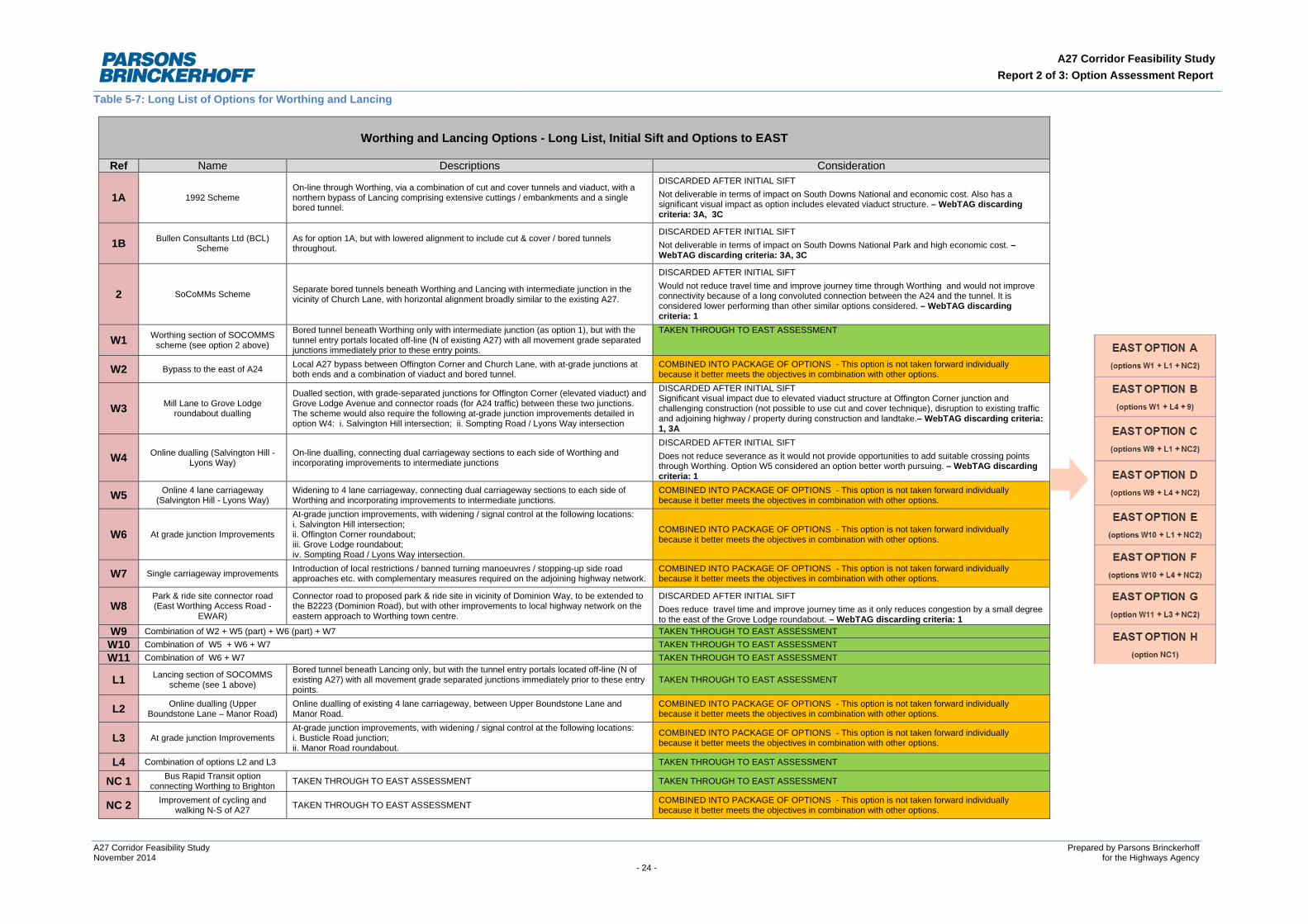
Table 5-7: Long List of Options for Worthing and Lancing
Worthing and Lancing Options - Long List, Initial Sift and Options to EAST
Ref Name Descriptions Consideration
1A 1992 Scheme On-line through Worthing, via a combination of cut and cover tunnels and viaduct, with a northern bypass of Lancing comprising extensive cuttings / embankments and a single bored tunnel.
DISCARDED AFTER INITIAL SIFT Not deliverable in terms of impact on South Downs National and economic cost. Also has a significant visual impact as option includes elevated viaduct structure. – WebTAG discarding criteria: 3A, 3C
1B Bullen Consultants Ltd (BCL) Scheme
As for option 1A, but with lowered alignment to include cut & cover / bored tunnels throughout.
DISCARDED AFTER INITIAL SIFT Not deliverable in terms of impact on South Downs National Park and high economic cost. – WebTAG discarding criteria: 3A, 3C
2 SoCoMMs Scheme Separate bored tunnels beneath Worthing and Lancing with intermediate junction in the vicinity of Church Lane, with horizontal alignment broadly similar to the existing A27.
DISCARDED AFTER INITIAL SIFT Would not reduce travel time and improve journey time through Worthing and would not improve connectivity because of a long convoluted connection between the A24 and the tunnel. It is considered lower performing than other similar options considered. – WebTAG discarding criteria: 1
W1 Worthing section of SOCOMMS scheme (see option 2 above)
Bored tunnel beneath Worthing only with intermediate junction (as option 1), but with the tunnel entry portals located off-line (N of existing A27) with all movement grade separated junctions immediately prior to these entry points.
TAKEN THROUGH TO EAST ASSESSMENT
W2 Bypass to the east of A24 Local A27 bypass between Offington Corner and Church Lane, with at-grade junctions at both ends and a combination of viaduct and bored tunnel.
COMBINED INTO PACKAGE OF OPTIONS - This option is not taken forward individually because it better meets the objectives in combination with other options.
W3 Mill Lane to Grove Lodge roundabout dualling
Dualled section, with grade-separated junctions for Offington Corner (elevated viaduct) and Grove Lodge Avenue and connector roads (for A24 traffic) between these two junctions. The scheme would also require the following at-grade junction improvements detailed in option W4: i. Salvington Hill intersection; ii. Sompting Road / Lyons Way intersection
DISCARDED AFTER INITIAL SIFT Significant visual impact due to elevated viaduct structure at Offington Corner junction and challenging construction (not possible to use cut and cover technique), disruption to existing traffic and adjoining highway / property during construction and landtake.– WebTAG discarding criteria: 1, 3A
W4 Online dualling (Salvington Hill - Lyons Way)
On-line dualling, connecting dual carriageway sections to each side of Worthing and incorporating improvements to intermediate junctions
DISCARDED AFTER INITIAL SIFT Does not reduce severance as it would not provide opportunities to add suitable crossing points through Worthing. Option W5 considered an option better worth pursuing. – WebTAG discarding criteria: 1
W5 Online 4 lane carriageway (Salvington Hill - Lyons Way)
Widening to 4 lane carriageway, connecting dual carriageway sections to each side of Worthing and incorporating improvements to intermediate junctions.
COMBINED INTO PACKAGE OF OPTIONS - This option is not taken forward individually because it better meets the objectives in combination with other options.
W6 At grade junction Improvements
At-grade junction improvements, with widening / signal control at the following locations: i. Salvington Hill intersection; ii. Offington Corner roundabout; iii. Grove Lodge roundabout; iv. Sompting Road / Lyons Way intersection.
COMBINED INTO PACKAGE OF OPTIONS - This option is not taken forward individually because it better meets the objectives in combination with other options.
W7 Single carriageway improvements Introduction of local restrictions / banned turning manoeuvres / stopping-up side road approaches etc. with complementary measures required on the adjoining highway network.
COMBINED INTO PACKAGE OF OPTIONS - This option is not taken forward individually because it better meets the objectives in combination with other options.
W8 Park & ride site connector road (East Worthing Access Road -
EWAR)
Connector road to proposed park & ride site in vicinity of Dominion Way, to be extended to the B2223 (Dominion Road), but with other improvements to local highway network on the eastern approach to Worthing town centre.
DISCARDED AFTER INITIAL SIFT Does reduce travel time and improve journey time as it only reduces congestion by a small degree to the east of the Grove Lodge roundabout. – WebTAG discarding criteria: 1
W9 Combination of W2 + W5 (part) + W6 (part) + W7 TAKEN THROUGH TO EAST ASSESSMENT W10 Combination of W5 + W6 + W7 TAKEN THROUGH TO EAST ASSESSMENT W11 Combination of W6 + W7 TAKEN THROUGH TO EAST ASSESSMENT
L1 Lancing section of SOCOMMS scheme (see 1 above)
Bored tunnel beneath Lancing only, but with the tunnel entry portals located off-line (N of existing A27) with all movement grade separated junctions immediately prior to these entry points.
TAKEN THROUGH TO EAST ASSESSMENT
L2 Online dualling (Upper Boundstone Lane – Manor Road)
Online dualling of existing 4 lane carriageway, between Upper Boundstone Lane and Manor Road.
COMBINED INTO PACKAGE OF OPTIONS - This option is not taken forward individually because it better meets the objectives in combination with other options.
L3 At grade junction Improvements At-grade junction improvements, with widening / signal control at the following locations: i. Busticle Road junction; ii. Manor Road roundabout.
COMBINED INTO PACKAGE OF OPTIONS - This option is not taken forward individually because it better meets the objectives in combination with other options.
L4 Combination of options L2 and L3 TAKEN THROUGH TO EAST ASSESSMENT
NC 1 Bus Rapid Transit option connecting Worthing to Brighton TAKEN THROUGH TO EAST ASSESSMENT TAKEN THROUGH TO EAST ASSESSMENT
NC 2 Improvement of cycling and walking N-S of A27 TAKEN THROUGH TO EAST ASSESSMENT COMBINED INTO PACKAGE OF OPTIONS - This option is not taken forward individually
because it better meets the objectives in combination with other options.
A27 Corridor Feasibility Study Prepared by Parsons Brinckerhoff November 2014 for the Highways Agency - 24 -
A27 Corridor Feasibility Study Report 2 of 3: Option Assessment Report
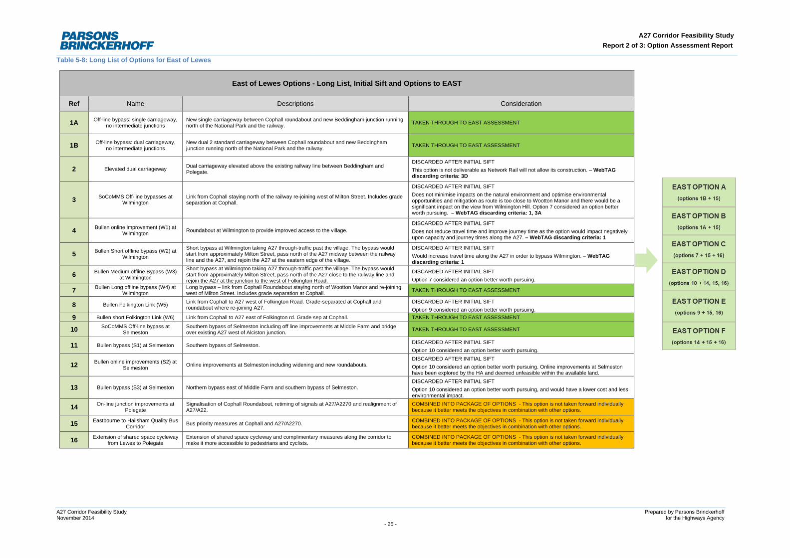
Table 5-8: Long List of Options for East of Lewes
East of Lewes Options - Long List, Initial Sift and Options to EAST
Ref Name Descriptions Consideration
1A Off-line bypass: single carriageway, no intermediate junctions
New single carriageway between Cophall roundabout and new Beddingham junction running north of the National Park and the railway. TAKEN THROUGH TO EAST ASSESSMENT
1B Off-line bypass: dual carriageway, no intermediate junctions
New dual 2 standard carriageway between Cophall roundabout and new Beddingham junction running north of the National Park and the railway. TAKEN THROUGH TO EAST ASSESSMENT
2 Elevated dual carriageway Dual carriageway elevated above the existing railway line between Beddingham and Polegate.
DISCARDED AFTER INITIAL SIFT This option is not deliverable as Network Rail will not allow its construction. – WebTAG discarding criteria: 3D
3 SoCoMMS Off-line bypasses at Wilmington
Link from Cophall staying north of the railway re-joining west of Milton Street. Includes grade separation at Cophall.
DISCARDED AFTER INITIAL SIFT Does not minimise impacts on the natural environment and optimise environmental opportunities and mitigation as route is too close to Wootton Manor and there would be a significant impact on the view from Wilmington Hill. Option 7 considered an option better worth pursuing. – WebTAG discarding criteria: 1, 3A
4 Bullen online improvement (W1) at Wilmington Roundabout at Wilmington to provide improved access to the village.
DISCARDED AFTER INITIAL SIFT Does not reduce travel time and improve journey time as the option would impact negatively upon capacity and journey times along the A27. – WebTAG discarding criteria: 1
5 Bullen Short offline bypass (W2) at Wilmington
Short bypass at Wilmington taking A27 through-traffic past the village. The bypass would start from approximately Milton Street, pass north of the A27 midway between the railway line and the A27, and rejoin the A27 at the eastern edge of the village.
DISCARDED AFTER INITIAL SIFT Would increase travel time along the A27 in order to bypass Wilmington. – WebTAG discarding criteria: 1
6 Bullen Medium offline Bypass (W3) at Wilmington
Short bypass at Wilmington taking A27 through-traffic past the village. The bypass would start from approximately Milton Street, pass north of the A27 close to the railway line and rejoin the A27 at the junction to the west of Folkington Road.
DISCARDED AFTER INITIAL SIFT Option 7 considered an option better worth pursuing.
7 Bullen Long offline bypass (W4) at Wilmington
Long bypass – link from Cophall Roundabout staying north of Wootton Manor and re-joining west of Milton Street. Includes grade separation at Cophall. TAKEN THROUGH TO EAST ASSESSMENT
8 Bullen Folkington Link (W5) Link from Cophall to A27 west of Folkington Road. Grade-separated at Cophall and roundabout where re-joining A27.
DISCARDED AFTER INITIAL SIFT Option 9 considered an option better worth pursuing.
9 Bullen short Folkington Link (W6) Link from Cophall to A27 east of Folkington rd. Grade sep at Cophall. TAKEN THROUGH TO EAST ASSESSMENT
10 SoCoMMS Off-line bypass at Selmeston
Southern bypass of Selmeston including off line improvements at Middle Farm and bridge over existing A27 west of Alciston junction. TAKEN THROUGH TO EAST ASSESSMENT
11 Bullen bypass (S1) at Selmeston Southern bypass of Selmeston. DISCARDED AFTER INITIAL SIFT Option 10 considered an option better worth pursuing.
12 Bullen online improvements (S2) at Selmeston Online improvements at Selmeston including widening and new roundabouts.
DISCARDED AFTER INITIAL SIFT Option 10 considered an option better worth pursuing. Online improvements at Selmeston have been explored by the HA and deemed unfeasible within the available land.
13 Bullen bypass (S3) at Selmeston Northern bypass east of Middle Farm and southern bypass of Selmeston. DISCARDED AFTER INITIAL SIFT Option 10 considered an option better worth pursuing, and would have a lower cost and less environmental impact.
14 On-line junction improvements at Polegate
Signalisation of Cophall Roundabout, retiming of signals at A27/A2270 and realignment of A27/A22.
COMBINED INTO PACKAGE OF OPTIONS - This option is not taken forward individually because it better meets the objectives in combination with other options.
15 Eastbourne to Hailsham Quality Bus Corridor Bus priority measures at Cophall and A27/A2270. COMBINED INTO PACKAGE OF OPTIONS - This option is not taken forward individually
because it better meets the objectives in combination with other options.
16 Extension of shared space cycleway from Lewes to Polegate
Extension of shared space cycleway and complimentary measures along the corridor to make it more accessible to pedestrians and cyclists.
COMBINED INTO PACKAGE OF OPTIONS - This option is not taken forward individually because it better meets the objectives in combination with other options.
A27 Corridor Feasibility Study Prepared by Parsons Brinckerhoff November 2014 for the Highways Agency - 25 -
A27 Corridor Feasibility Study Report 2 of 3: Option Assessment Report
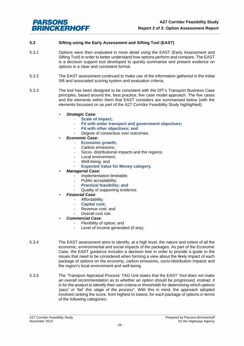
5.3 Sifting using the Early Assessment and Sifting Tool (EAST)
5.3.1 Options were then evaluated in more detail using the EAST (Early Assessment and Sifting Tool) in order to better understand how options perform and compare. The EAST is a decision support tool developed to quickly summarise and present evidence on options in a clear and consistent format.
5.3.2 The EAST assessment continued to make use of the information gathered in the Initial Sift and associated scoring system and evaluation criteria.
5.3.3 The tool has been designed to be consistent with the DfT’s Transport Business Case principles, based around the, best practice, five case model approach. The five cases and the elements within them that EAST considers are summarised below (with the elements focussed on as part of the A27 Corridor Feasibility Study highlighted):
• Strategic Case: - Scale of impact; - Fit with wider transport and government objectives; - Fit with other objectives; and - Degree of consensus over outcomes.
• Economic Case: - Economic growth; - Carbon emissions; - Socio- distributional impacts and the regions; - Local environment; - Well-being; and - Expected Value for Money category.
• Managerial Case: - Implementation timetable; - Public acceptability; - Practical feasibility; and - Quality of supporting evidence.
• Financial Case: - Affordability; - Capital cost; - Revenue cost; and - Overall cost risk.
• Commercial Case: - Flexibility of option; and - Level of income generated (if any).
5.3.4 The EAST assessment aims to identify, at a high level, the nature and extent of all the economic, environmental and social impacts of the packages. As part of the Economic Case, the EAST guidance includes a decision tree in order to provide a guide to the issues that need to be considered when forming a view about the likely impact of each package of options on the economy, carbon emissions, socio-distribution impacts and the region’s local environment and well-being.
5.3.5 The ‘Transport Appraisal Process’ TAG Unit states that the EAST “tool does not make an overall recommendation as to whether an option should be progressed, instead, it is for the analyst to identify their own criteria or thresholds for determining which options ‘pass’ or ‘fail’ this stage of the process”. With this in mind, the approach adopted involved ranking the score, from highest to lowest, for each package of options in terms of the following categories:
A27 Corridor Feasibility Study Prepared by Parsons Brinckerhoff November 2014 for the Highways Agency - 26 -
A27 Corridor Feasibility Study Report 2 of 3: Option Assessment Report
• Scale of Impact; • Practical Feasibility; • Affordability; and • Public Acceptability.
5.3.6 The approach adopted at this stage was to use the output of the EAST to refine the options and understand which areas needed greater mitigation.
5.3.7 Options taken to the EAST assessment stage were, in some cases, packaged together in order to strengthen their effectiveness and impact. A total of 20 options/packages were taken forward to the EAST stage.
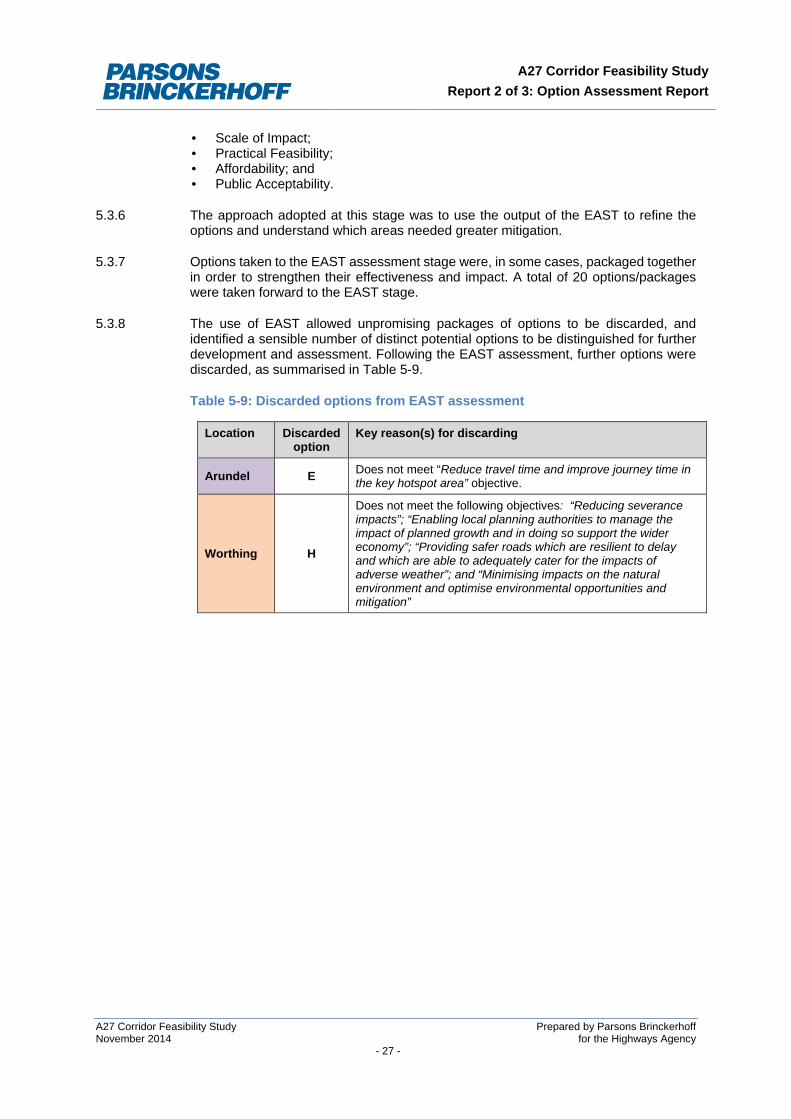
5.3.8 The use of EAST allowed unpromising packages of options to be discarded, and identified a sensible number of distinct potential options to be distinguished for further development and assessment. Following the EAST assessment, further options were discarded, as summarised in Table 5-9.
Table 5-9: Discarded options from EAST assessment
Location Discarded option
Key reason(s) for discarding
Arundel E Does not meet “Reduce travel time and improve journey time in the key hotspot area” objective.
Worthing H
Does not meet the following objectives: “Reducing severance impacts”; “Enabling local planning authorities to manage the impact of planned growth and in doing so support the wider economy”; “Providing safer roads which are resilient to delay and which are able to adequately cater for the impacts of adverse weather”; and “Minimising impacts on the natural environment and optimise environmental opportunities and mitigation”
A27 Corridor Feasibility Study Prepared by Parsons Brinckerhoff November 2014 for the Highways Agency - 27 -
A27 Corridor Feasibility Study Report 2 of 3: Option Assessment Report
6 FURTHER ASSESSMENT OF POTENTIAL OPTIONS
This chapter sets out the further assessment of options for Arundel, Worthing and East of Lewes against the Option Assessment Framework.
6.1 Approach to Further Assessment
6.1.1 Appendix A sets out basic conceptual plans showing the indicative routes considered in Study Stage 2 for further assessment of options. These plans are intentionally schematic in order to avoid property blight at this early stage of options assessment.
6.1.2 The evaluation considered the following elements: • Strategic Fit; • Economic Impact, including:
- Impact on the Economy, Environment, Society, Public Accounts, Distributional impacts and Indicative Benefit Cost Ratio (BCR).
6.1.3 Due to the early stage of the scheme development, the financial, commercial and deliverability elements were not considered in detail as part of this stage.
6.1.4 The strategic case was considered in terms of strategic fit with national and local policy and the intervention specific objectives. The economic case considered economic, environmental and social impacts as well as a high level assessment of potential value for money (VfM).
6.1.5 The assessment of the impacts of each of the options was predominantly qualitative in nature at this stage while suitable transport modelling tools were being developed. Furthermore, costs were being estimated based on conceptual illustrative designs. Due to these factors, alongside the large number of options being considered, the focus was placed upon the Strategic Fit. The remaining criteria are discussed at a higher level in this chapter, and were assessed in greater detail in Study Stage 3.
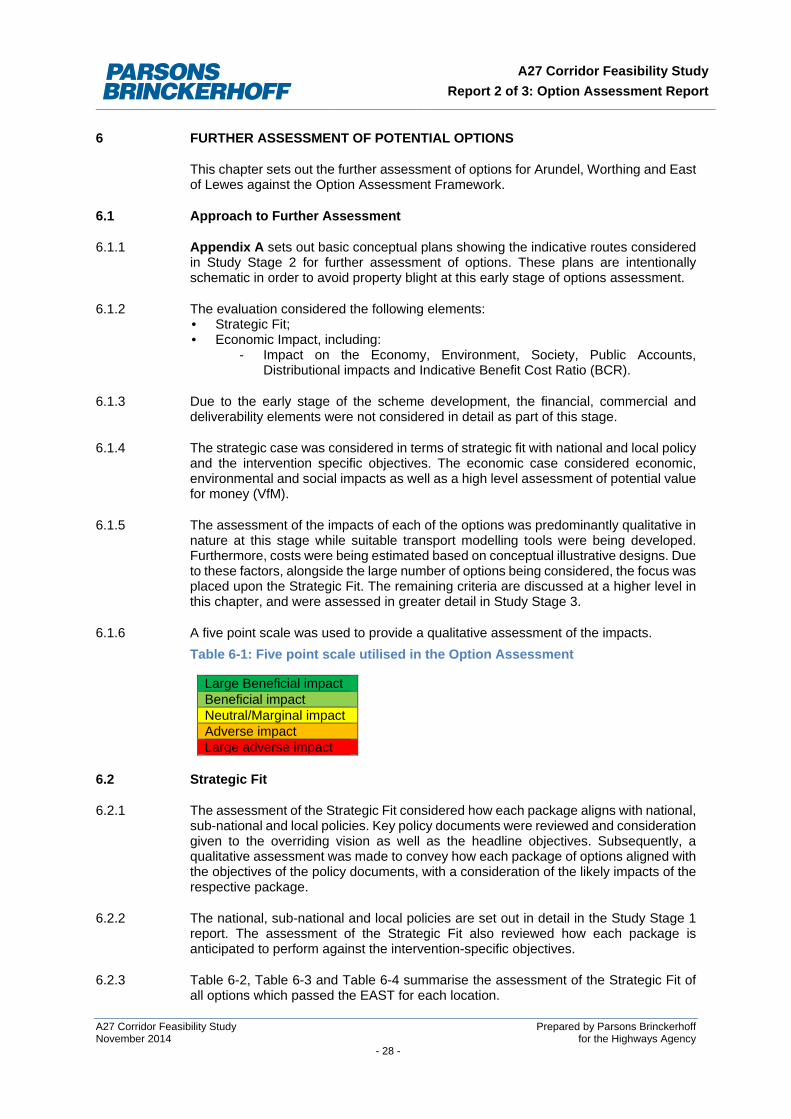
6.1.6 A five point scale was used to provide a qualitative assessment of the impacts.
Table 6-1: Five point scale utilised in the Option Assessment
Large Beneficial impact Beneficial impact Neutral/Marginal impact Adverse impact Large adverse impact
6.2 Strategic Fit
6.2.1 The assessment of the Strategic Fit considered how each package aligns with national, sub-national and local policies. Key policy documents were reviewed and consideration given to the overriding vision as well as the headline objectives. Subsequently, a qualitative assessment was made to convey how each package of options aligned with the objectives of the policy documents, with a consideration of the likely impacts of the respective package.
6.2.2 The national, sub-national and local policies are set out in detail in the Study Stage 1 report. The assessment of the Strategic Fit also reviewed how each package is anticipated to perform against the intervention-specific objectives.
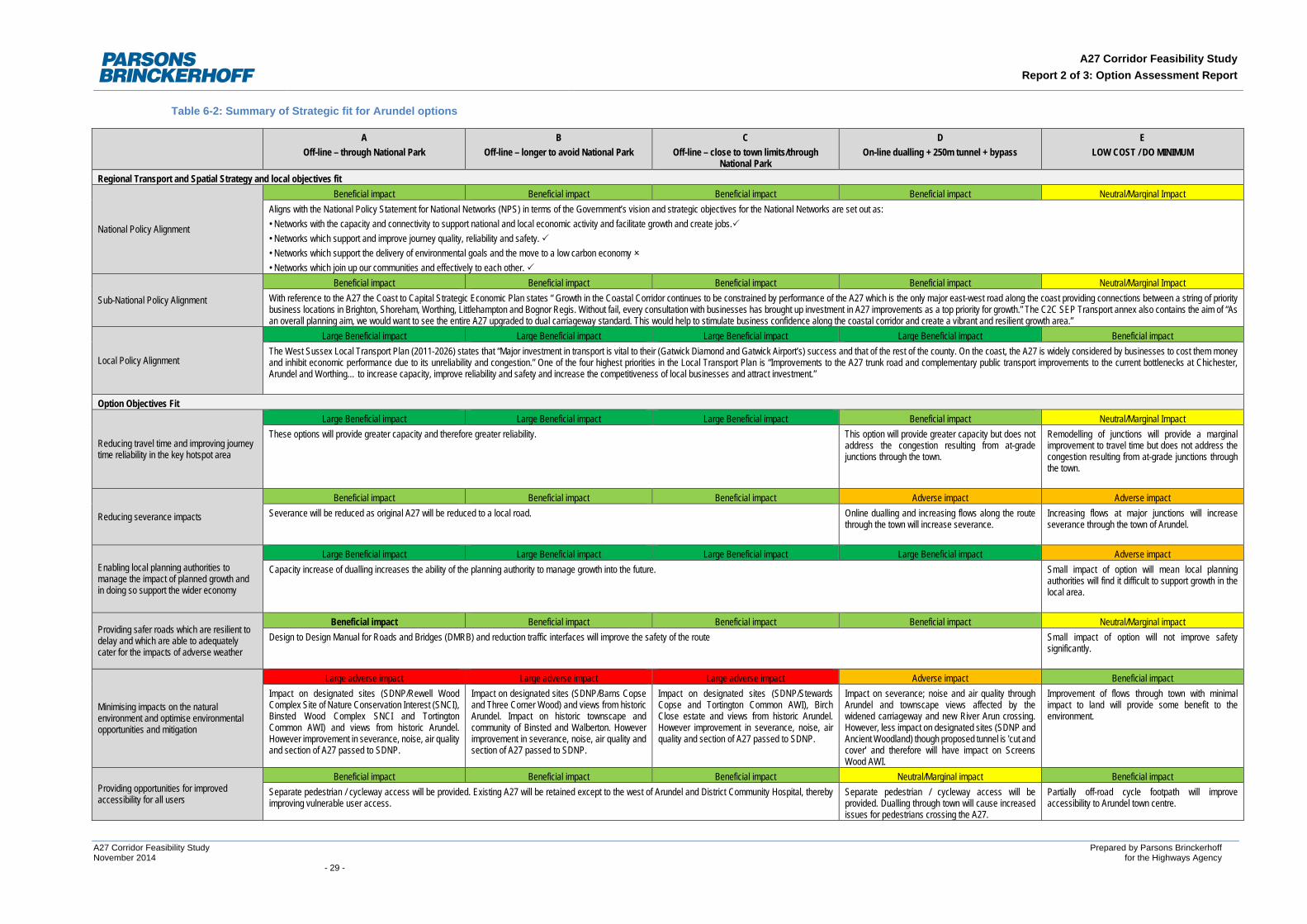
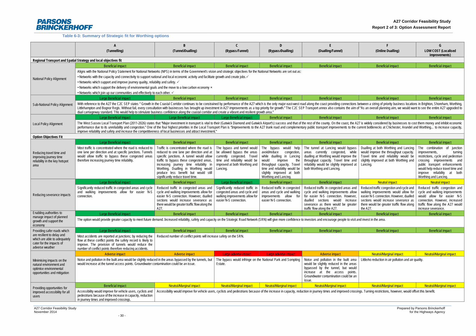
6.2.3 Table 6-2, Table 6-3 and Table 6-4 summarise the assessment of the Strategic Fit of all options which passed the EAST for each location.
A27 Corridor Feasibility Study Prepared by Parsons Brinckerhoff November 2014 for the Highways Agency - 28 -
A27 Corridor Feasibility Study Report 2 of 3: Option Assessment Report
Table 6-2: Summary of Strategic fit for Arundel options
A Off-line – through National Park
B Off-line – longer to avoid National Park
C Off-line – close to town limits/through
National Park
D On-line dualling + 250m tunnel + bypass
E LOW COST / DO MINIMUM
Regional Transport and Spatial Strategy and local objectives fit
National Policy Alignment
Beneficial impact Beneficial impact Beneficial impact Beneficial impact Neutral/Marginal Impact Aligns with the National Policy Statement for National Networks (NPS) in terms of the Government’s vision and strategic objectives for the National Networks are set out as: • Networks with the capacity and connectivity to support national and local economic activity and facilitate growth and create jobs. • Networks which support and improve journey quality, reliability and safety. • Networks which support the delivery of environmental goals and the move to a low carbon economy • Networks which join up our communities and effectively to each other.
Sub-National Policy Alignment
Beneficial impact Beneficial impact Beneficial impact Beneficial impact Neutral/Marginal Impact With reference to the A27 the Coast to Capital Strategic Economic Plan states “ Growth in the Coastal Corridor continues to be constrained by performance of the A27 which is the only major east-west road along the coast providing connections between a string of priority business locations in Brighton, Shoreham, Worthing, Littlehampton and Bognor Regis. Without fail, every consultation with businesses has brought up investment in A27 improvements as a top priority for growth.” The C2C SEP Transport annex also contains the aim of “As an overall planning aim, we would want to see the entire A27 upgraded to dual carriageway standard. This would help to stimulate business confidence along the coastal corridor and create a vibrant and resilient growth area.”
Local Policy Alignment
Large Beneficial impact Large Beneficial impact Large Beneficial impact Large Beneficial impact Beneficial impact The West Sussex Local Transport Plan (2011-2026) states that “Major investment in transport is vital to their (Gatwick Diamond and Gatwick Airport’s) success and that of the rest of the county. On the coast, the A27 is widely considered by businesses to cost them money and inhibit economic performance due to its unreliability and congestion.” One of the four highest priorities in the Local Transport Plan is “Improvements to the A27 trunk road and complementary public transport improvements to the current bottlenecks at Chichester, Arundel and Worthing… to increase capacity, improve reliability and safety and increase the competitiveness of local businesses and attract investment.”
Option Objectives Fit
Reducing travel time and improving journey time reliability in the key hotspot area
Large Beneficial impact Large Beneficial impact Large Beneficial impact Beneficial impact Neutral/Marginal Impact These options will provide greater capacity and therefore greater reliability. This option will provide greater capacity but does not
address the congestion resulting from at-grade junctions through the town.
Remodelling of junctions will provide a marginal improvement to travel time but does not address the congestion resulting from at-grade junctions through the town.
Reducing severance impacts
Beneficial impact Beneficial impact Beneficial impact Adverse impact Adverse impact Severance will be reduced as original A27 will be reduced to a local road. Online dualling and increasing flows along the route
through the town will increase severance. Increasing flows at major junctions will increase severance through the town of Arundel.
Enabling local planning authorities to manage the impact of planned growth and in doing so support the wider economy
Large Beneficial impact Large Beneficial impact Large Beneficial impact Large Beneficial impact Adverse impact Capacity increase of dualling increases the ability of the planning authority to manage growth into the future. Small impact of option will mean local planning
authorities will find it difficult to support growth in the local area.
Providing safer roads which are resilient to delay and which are able to adequately cater for the impacts of adverse weather
Beneficial impact Beneficial impact Beneficial impact Beneficial impact Neutral/Marginal impact Design to Design Manual for Roads and Bridges (DMRB) and reduction traffic interfaces will improve the safety of the route Small impact of option will not improve safety
significantly.
Minimising impacts on the natural environment and optimise environmental opportunities and mitigation
Large adverse impact Large adverse impact Large adverse impact Adverse impact Beneficial impact Impact on designated sites (SDNP/Rewell Wood Complex Site of Nature Conservation Interest (SNCI), Binsted Wood Complex SNCI and Tortington Common AWI) and views from historic Arundel. However improvement in severance, noise, air quality and section of A27 passed to SDNP.
Impact on designated sites (SDNP/Barns Copse and Three Corner Wood) and views from historic Arundel. Impact on historic townscape and community of Binsted and Walberton. However improvement in severance, noise, air quality and section of A27 passed to SDNP.
Impact on designated sites (SDNP/Stewards Copse and Tortington Common AWI), Birch Close estate and views from historic Arundel. However improvement in severance, noise, air quality and section of A27 passed to SDNP.
Impact on severance; noise and air quality through Arundel and townscape views affected by the widened carriageway and new River Arun crossing. However, less impact on designated sites (SDNP and Ancient Woodland) though proposed tunnel is 'cut and cover' and therefore will have impact on Screens Wood AWI.
Improvement of flows through town with minimal impact to land will provide some benefit to the environment.
Providing opportunities for improved accessibility for all users
Beneficial impact Beneficial impact Beneficial impact Neutral/Marginal impact Beneficial impact Separate pedestrian / cycleway access will be provided. Existing A27 will be retained except to the west of Arundel and District Community Hospital, thereby improving vulnerable user access.
Separate pedestrian / cycleway access will be provided. Dualling through town will cause increased issues for pedestrians crossing the A27.
Partially off-road cycle footpath will improve accessibility to Arundel town centre.
A27 Corridor Feasibility Study Prepared by Parsons Brinckerhoff November 2014 for the Highways Agency - 29 -
A27 Corridor Feasibility Study Report 2 of 3: Option Assessment Report
Table 6-3: Summary of Strategic fit for Worthing options
A (Tunnelling)
B (Tunnel/Dualling)
C (Bypass/Tunnel)
D (Bypass/Dualling)
E (Dualling/Tunnel)
F (Online Dualling)
G LOW COST (Localised
improvements) Regional Transport and Spatial Strategy and local objectives fit
National Policy Alignment
Beneficial impact Beneficial impact Beneficial impact Beneficial impact Beneficial impact Beneficial impact Beneficial impact Aligns with the National Policy Statement for National Networks (NPS) in terms of the Government’s vision and strategic objectives for the National Networks are set out as: • Networks with the capacity and connectivity to support national and local economic activity and facilitate growth and create jobs. • Networks which support and improve journey quality, reliability and safety. • Networks which support the delivery of environmental goals and the move to a low carbon economy • Networks which join up our communities and effectively to each other.
Sub-National Policy Alignment
Large Beneficial impact Beneficial impact Beneficial impact Beneficial impact Beneficial impact Beneficial impact Beneficial impact With reference to the A27 the C2C SEP states “ Growth in the Coastal Corridor continues to be constrained by performance of the A27 which is the only major east-west road along the coast providing connections between a string of priority business locations in Brighton, Shoreham, Worthing, Littlehampton and Bognor Regis. Without fail, every consultation with businesses has brought up investment in A27 improvements as a top priority for growth.” The C2C SEP Transport annex also contains the aim of “As an overall planning aim, we would want to see the entire A27 upgraded to dual carriageway standard. This would help to stimulate business confidence along the coastal corridor and create a vibrant and resilient growth area.”
Local Policy Alignment
Large Beneficial impact Large Beneficial impact Large Beneficial impact Beneficial impact Beneficial impact Beneficial impact Beneficial impact The West Sussex Local Transport Plan (2011-2026) states that “Major investment in transport is vital to their (Gatwick Diamond and Gatwick Airport’s) success and that of the rest of the county. On the coast, the A27 is widely considered by businesses to cost them money and inhibit economic performance due to its unreliability and congestion.” One of the four highest priorities in the Local Transport Plan is “Improvements to the A27 trunk road and complementary public transport improvements to the current bottlenecks at Chichester, Arundel and Worthing… to increase capacity, improve reliability and safety and increase the competitiveness of local businesses and attract investment.”
Option Objectives Fit
Reducing travel time and improving journey time reliability in the key hotspot area
Large Beneficial impact Beneficial impact Beneficial impact Beneficial impact Beneficial impact Beneficial impact Beneficial impact Most traffic is concentrated where the road is reduced to one lane per direction and at specific junctions. Tunnels would allow traffic to bypass these congested areas therefore increasing journey time reliability.
Traffic is concentrated where the road is reduced to one lane per direction and at specific junctions. A tunnel would allow traffic to bypass these congested areas, increasing journey time reliability in Worthing. Dualling in Worthing would produce less benefit but would still significantly reduce travel time.
The bypass and tunnel would be allowed bypass the areas currently congested. Travel time and reliability would be improved at both Worthing and Lancing.
The bypass would help avoid/reduce congestion, while dualling in Lancing would improve the throughput capacity. Travel time and reliability would be slightly improved at both Worthing and Lancing.
The tunnel at Lancing would bypass areas currently congested, while dualling at Worthing would improve the throughput capacity. Travel time and reliability would be slightly improved at both Worthing and Lancing.
Dualling at both Worthing and Lancing would improve the throughput capacity. Travel time and reliability would be slightly improved at both Worthing and Lancing.
The combination of junction improvements, turning restrictions, cycle and pedestrian crossing improvements and public transport enhancements would help reduce travel time and improve reliability at both Worthing and Lancing.
Reducing severance impacts
Large Beneficial impact Beneficial impact Large Beneficial impact Beneficial impact Beneficial impact Neutral impact Neutral impact Significantly reduced traffic in congested areas and cycle and walking improvements allow for easier N-S connection.
Reduced traffic in congested areas and cycle and walking improvements allow for easier N-S connection. However, dualled sections would increase severance as there would be greater traffic flow along the A27.
Significantly reduced traffic in congested areas and cycle and walking improvements allow for easier N-S connection.
Reduced traffic in congested areas and cycle and walking improvements allow for easier N-S connection.
Reduced traffic in congested areas and cycle and walking improvements allow for easier N-S connection. However, dualled sections would increase severance as there would be greater traffic flow along the A27.
Reduced traffic congestion and cycle and walking improvements would allow for easier N-S connection. However, dualled sections would increase severance as there would be greater traffic flow along the A27.
Reduced traffic congestion and cycle and walking improvements would allow for easier N-S connection. However, increased traffic flow along the A27 would increase severance.
Enabling authorities to manage impact of planned growth and support the economy
Large Beneficial impact Beneficial impact Beneficial impact Beneficial impact Beneficial impact Beneficial impact Beneficial impact The option would provide greater capacity to meet future demand. Increased reliability, safety and capacity on the Strategic Road Network (SRN) will give more confidence to investors and encourage people to visit and invest in the area.
Providing safer roads which are resilient to delay and which are able to adequately cater for the impacts of adverse weather
Large Beneficial impact Beneficial impact Beneficial impact Beneficial impact Beneficial impact Beneficial impact Beneficial impact Most accidents are reported at junctions; by reducing the flow at these conflict points the safety record is likely to improve. The provision of tunnels would reduce the number of conflict points therefore reducing accidents.
Reduced number of conflict points will increase safety on the SRN.
Minimising impacts on the natural environment and optimise environmental opportunities and mitigation
Adverse impact Adverse impact Large adverse impact Large adverse impact Adverse impact Neutral/Marginal impact Neutral/Marginal impact Noise and pollution in the built area would be slightly reduced in the areas bypassed by the tunnels, but would increase at the tunnel access points. Groundwater contamination could be an issue.
The bypass would infringe on the National Park and Sompting Estate.
Noise and pollution in the built area would be slightly reduced in the areas bypassed by the tunnel, but would increase at the access points. Groundwater contamination could be an issue.
Little/no reduction in air pollution and air quality.
Providing opportunities for improved accessibility for all users
Beneficial impact Neutral/Marginal impact Neutral/Marginal impact Neutral/Marginal impact Neutral/Marginal impact Neutral/Marginal impact Neutral/Marginal impact Accessibility would improve for vehicle users, cyclists and pedestrians because of the increase in capacity, reduction in journey times and improved crossings.
Accessibility would improve for vehicle users, cyclists and pedestrians because of the increase in capacity, reduction in journey times and improved crossings. Turning restrictions, however, would offset this benefit.
A27 Corridor Feasibility Study Prepared by Parsons Brinckerhoff November 2014 for the Highways Agency - 30 -
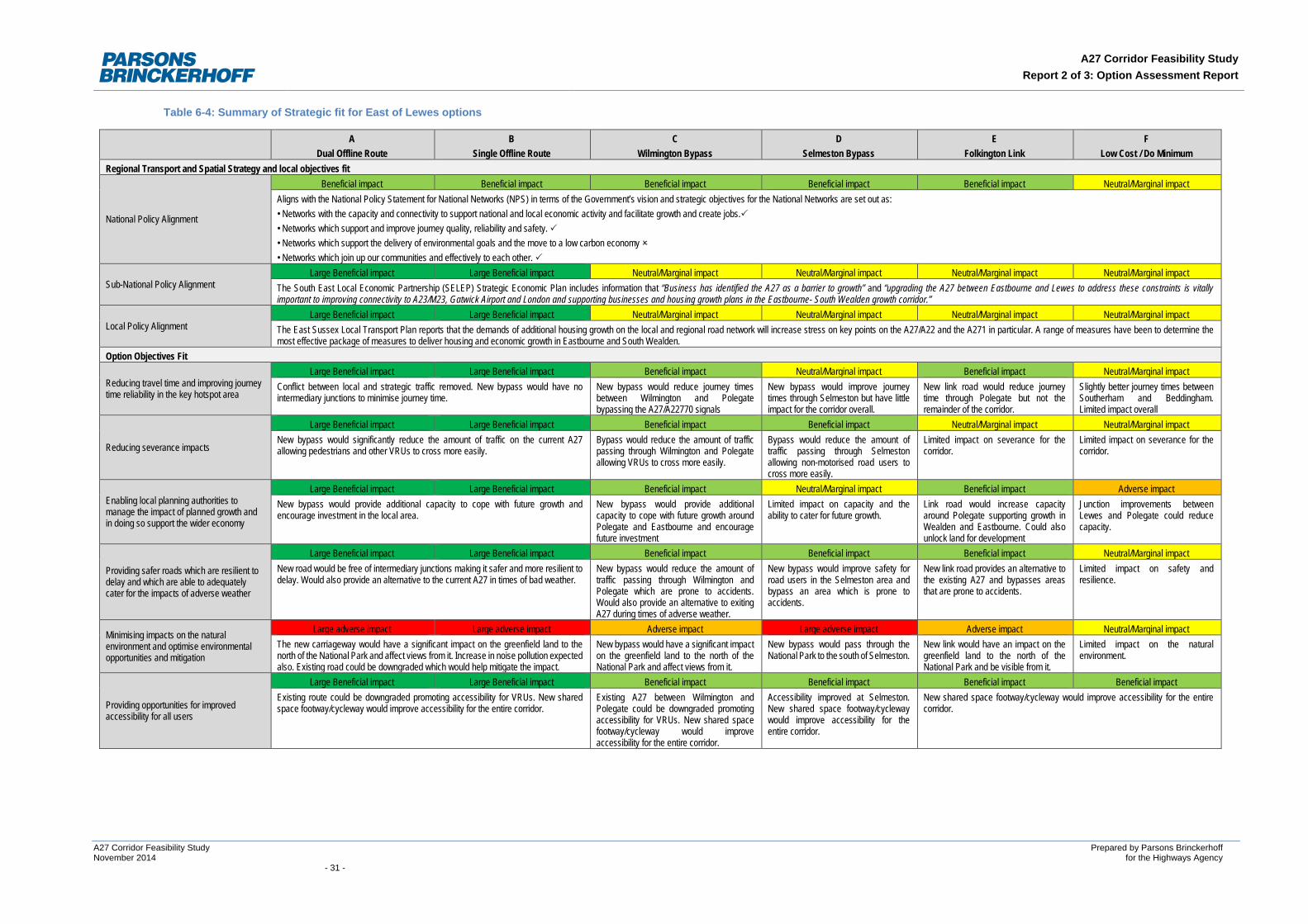
A27 Corridor Feasibility Study Report 2 of 3: Option Assessment Report
Table 6-4: Summary of Strategic fit for East of Lewes options
A Dual Offline Route
B Single Offline Route
C Wilmington Bypass
D Selmeston Bypass
E Folkington Link
F Low Cost / Do Minimum
Regional Transport and Spatial Strategy and local objectives fit
National Policy Alignment
Beneficial impact Beneficial impact Beneficial impact Beneficial impact Beneficial impact Neutral/Marginal impact Aligns with the National Policy Statement for National Networks (NPS) in terms of the Government’s vision and strategic objectives for the National Networks are set out as: • Networks with the capacity and connectivity to support national and local economic activity and facilitate growth and create jobs. • Networks which support and improve journey quality, reliability and safety. • Networks which support the delivery of environmental goals and the move to a low carbon economy • Networks which join up our communities and effectively to each other.
Sub-National Policy Alignment Large Beneficial impact Large Beneficial impact Neutral/Marginal impact Neutral/Marginal impact Neutral/Marginal impact Neutral/Marginal impact
The South East Local Economic Partnership (SELEP) Strategic Economic Plan includes information that “Business has identified the A27 as a barrier to growth” and “upgrading the A27 between Eastbourne and Lewes to address these constraints is vitally important to improving connectivity to A23/M23, Gatwick Airport and London and supporting businesses and housing growth plans in the Eastbourne- South Wealden growth corridor.”
Local Policy Alignment Large Beneficial impact Large Beneficial impact Neutral/Marginal impact Neutral/Marginal impact Neutral/Marginal impact Neutral/Marginal impact
The East Sussex Local Transport Plan reports that the demands of additional housing growth on the local and regional road network will increase stress on key points on the A27/A22 and the A271 in particular. A range of measures have been to determine the most effective package of measures to deliver housing and economic growth in Eastbourne and South Wealden.
Option Objectives Fit
Reducing travel time and improving journey time reliability in the key hotspot area
Large Beneficial impact Large Beneficial impact Beneficial impact Neutral/Marginal impact Beneficial impact Neutral/Marginal impact Conflict between local and strategic traffic removed. New bypass would have no intermediary junctions to minimise journey time.
New bypass would reduce journey times between Wilmington and Polegate bypassing the A27/A22770 signals
New bypass would improve journey times through Selmeston but have little impact for the corridor overall.
New link road would reduce journey time through Polegate but not the remainder of the corridor.
Slightly better journey times between Southerham and Beddingham. Limited impact overall
Reducing severance impacts
Large Beneficial impact Large Beneficial impact Beneficial impact Beneficial impact Neutral/Marginal impact Neutral/Marginal impact New bypass would significantly reduce the amount of traffic on the current A27 allowing pedestrians and other VRUs to cross more easily.
Bypass would reduce the amount of traffic passing through Wilmington and Polegate allowing VRUs to cross more easily.
Bypass would reduce the amount of traffic passing through Selmeston allowing non-motorised road users to cross more easily.
Limited impact on severance for the corridor.
Limited impact on severance for the corridor.
Enabling local planning authorities to manage the impact of planned growth and in doing so support the wider economy
Large Beneficial impact Large Beneficial impact Beneficial impact Neutral/Marginal impact Beneficial impact Adverse impact New bypass would provide additional capacity to cope with future growth and encourage investment in the local area.
New bypass would provide additional capacity to cope with future growth around Polegate and Eastbourne and encourage future investment
Limited impact on capacity and the ability to cater for future growth.
Link road would increase capacity around Polegate supporting growth in Wealden and Eastbourne. Could also unlock land for development
Junction improvements between Lewes and Polegate could reduce capacity.
Providing safer roads which are resilient to delay and which are able to adequately cater for the impacts of adverse weather
Large Beneficial impact Large Beneficial impact Beneficial impact Beneficial impact Beneficial impact Neutral/Marginal impact New road would be free of intermediary junctions making it safer and more resilient to delay. Would also provide an alternative to the current A27 in times of bad weather.
New bypass would reduce the amount of traffic passing through Wilmington and Polegate which are prone to accidents. Would also provide an alternative to exiting A27 during times of adverse weather.
New bypass would improve safety for road users in the Selmeston area and bypass an area which is prone to accidents.
New link road provides an alternative to the existing A27 and bypasses areas that are prone to accidents.
Limited impact on safety and resilience.
Minimising impacts on the natural environment and optimise environmental opportunities and mitigation
Large adverse impact Large adverse impact Adverse impact Large adverse impact Adverse impact Neutral/Marginal impact The new carriageway would have a significant impact on the greenfield land to the north of the National Park and affect views from it. Increase in noise pollution expected also. Existing road could be downgraded which would help mitigate the impact.
New bypass would have a significant impact on the greenfield land to the north of the National Park and affect views from it.
New bypass would pass through the National Park to the south of Selmeston.
New link would have an impact on the greenfield land to the north of the National Park and be visible from it.
Limited impact on the natural environment.
Providing opportunities for improved accessibility for all users
Large Beneficial impact Large Beneficial impact Beneficial impact Beneficial impact Beneficial impact Beneficial impact Existing route could be downgraded promoting accessibility for VRUs. New shared space footway/cycleway would improve accessibility for the entire corridor.
Existing A27 between Wilmington and Polegate could be downgraded promoting accessibility for VRUs. New shared space footway/cycleway would improve accessibility for the entire corridor.
Accessibility improved at Selmeston. New shared space footway/cycleway would improve accessibility for the entire corridor.
New shared space footway/cycleway would improve accessibility for the entire corridor.
A27 Corridor Feasibility Study Prepared by Parsons Brinckerhoff November 2014 for the Highways Agency - 31 -
A27 Corridor Feasibility Study Report 2 of 3: Option Assessment Report
6.3 Economic Impact of Options
6.3.1 This section of the Option Assessment Framework considers a large number of assessment areas grouped into the six key headings, summarised below:
• Impact on the Economy: - Business Users and Transport Providers; - Reliability; - Regeneration; and - Wider Impacts.
• Impact on the Environment: - Noise; - Air Quality; - Greenhouse Gases; - Landscape; - Townscape; - Historic Environment; - Biodiversity; and - Water Environment.
• Impact on Society: - Non-Business Users; - Physical Activity; - Journey Quality; - Accidents; - Security; - Access to Services; - Affordability; - Severance; and - Option Values.
• Public Account Impacts: - Cost to Broad Transport Budget; and - Indirect Tax Revenues.
• Distributional Impacts, (considering User benefits; Noise; Air Quality; Accidents; Security; Severance; Accessibility; Personal Affordability):
• Indicative Benefit Cost Ratio (BCR): - Cost to Private Sector; - Indicative Net Present Value; and - Indicative Economic BCR.
6.3.2 Table 6-5, Table 6-6 and Table 6-7 summarise the assessment of the Impact on Economy of the options considered for each of the hotspots.
6.3.3 Table 6-8, Table 6-9 and Table 6-10 summarise the assessment of the Impact on Environment of the options considered for each of the hotspots. Background environmental information collated during Stage 1 has informed this appraisal.
6.3.4 Table 6-11, Table 6-12 and Table 6-13 summarise the assessment of the Impact on Society of the options considered for each of the three hotspots.
A27 Corridor Feasibility Study Prepared by Parsons Brinckerhoff November 2014 for the Highways Agency - 32 -
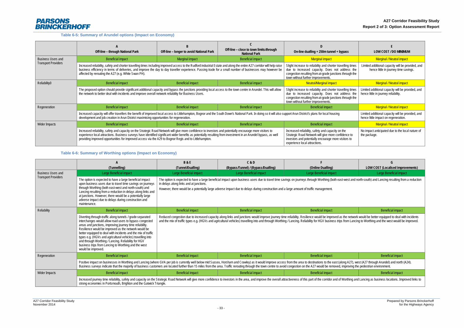
A27 Corridor Feasibility Study Report 2 of 3: Option Assessment Report
Table 6-5: Summary of Arundel options (Impact on Economy)
A Off-line – through National Park
B Off-line – longer to avoid National Park
C Off-line – close to town limits/through
National Park
D On-line dualling + 250m tunnel + bypass
E LOW COST / DO MINIMUM
Business Users and Transport Providers
Beneficial impact Marginal impact Beneficial impact Marginal impact Marginal / Neutral impact
Increased reliability, safety and shorter travelling times including improved access to the Rudford industrial Estate and along the entire A27 corridor will help raise business efficiency in terms of deliveries, and improve the day to day traveller experience. Passing trade for a small number of businesses may however be affected by rerouting the A27 (e.g. White Swan PH).
Slight increase to reliability and shorter travelling times due to increased capacity. Does not address the congestion resulting from at-grade junctions through the town without further improvements.
Limited additional capacity will be provided, and hence little in journey time savings.
Reliability0 Beneficial impact Beneficial impact Beneficial impact Neutral/Marginal impact Marginal / Neutral impact
The proposed option should provide significant additional capacity and bypass the junctions providing local access to the town centre in Arundel. This will allow the network to better deal with incidents and improve overall network reliability for Business Users.
Slight increase to reliability and shorter travelling times due to increased capacity. Does not address the congestion resulting from at-grade junctions through the town without further improvements.
Limited additional capacity will be provided, and hence little in journey reliability.
Regeneration Beneficial impact Beneficial impact Beneficial impact Beneficial impact Marginal / Neutral impact
Increased capacity will offer travellers the benefit of improved local access to Littlehampton, Bognor and the South Down's National Park. In doing so it will also support Arun District's plans for local housing development and job creation in Arun District maximising opportunities for regeneration.
Limited additional capacity will be provided, and hence little impact on regeneration.
Wider Impacts Beneficial impact Beneficial impact Beneficial impact Beneficial impact Marginal / Neutral impact
Increased reliability, safety and capacity on the Strategic Road Network will give more confidence to investors and potentially encourage more visitors to experience local attractions. Business surveys have identified significant wider benefits as potentially resulting from investment in an Arundel bypass, as well providing improved opportunities for improved access via the A29 to Bognor Regis and to Littlehampton.
Increased reliability, safety and capacity on the Strategic Road Network will give more confidence to investors and potentially encourage more visitors to experience local attractions.
No impact anticipated due to the local nature of the package.
Table 6-6: Summary of Worthing options (Impact on Economy)
A (Tunnelling)
B & E (Tunnel/Dualling)
C & D (Bypass/Tunnel) / (Bypass/Dualling)
F (Online Dualling)
G LOW COST (Localised improvements)
Business Users and Transport Providers
Large Beneficial impact Large Beneficial impact Large Beneficial impact Large Beneficial impact Large Beneficial impact
The option is expected to have a large beneficial impact upon business users due to travel time savings on journeys through Worthing (both east-west and north-south) and Lancing resulting from a reduction in delays along links and at junctions. However, there would be a potentially large adverse impact due to delays during construction and maintenance.
The option is expected to have a large beneficial impact upon business users due to travel time savings on journeys through Worthing (both east-west and north-south) and Lancing resulting from a reduction in delays along links and at junctions. However, there would be a potentially large adverse impact due to delays during construction and a large amount of traffic management.
Reliability Beneficial impact Beneficial impact Beneficial impact Beneficial impact Beneficial impact
Diverting through-traffic along tunnels / grade-separated interchanges would allow road users to bypass congested areas and junctions, improving journey time reliability. Resilience would be improved as the network would be better equipped to deal with incidents and the mix of traffic types e.g. (HGVs and agricultural vehicles) travelling into and through Worthing / Lancing. Reliability for HGV business trips from Lancing to Worthing and the west would be improved.
Reduced congestion due to increased capacity along links and junctions would improve journey time reliability. Resilience would be improved as the network would be better equipped to deal with incidents and the mix of traffic types e.g. (HGVs and agricultural vehicles) travelling into and through Worthing / Lancing. Reliability for HGV business trips from Lancing to Worthing and the west would be improved.
Regeneration Beneficial impact Beneficial impact Beneficial impact Beneficial impact Beneficial impact
Positive impact on businesses in Worthing and Lancing (where GVA per job is currently well below mid Sussex, Horsham and Crawley) as it would improve access from the area to destinations to the east (along A27), west (A27 through Arundel) and north (A24). Business surveys indicate that the majority of business customers are located further than 15 miles from the area. Traffic rerouting through the town centre to avoid congestion on the A27 would be removed, improving the pedestrian environment.
Wider Impacts Beneficial impact Beneficial impact Beneficial impact Beneficial impact Beneficial impact
Increased journey time reliability, safety and capacity on the Strategic Road Network will give more confidence to investors in the area, and improve the overall attractiveness of this part of the corridor and of Worthing and Lancing as business locations. Improved links to strong economies in Portsmouth, Brighton and the Gatwick Triangle.
A27 Corridor Feasibility Study Prepared by Parsons Brinckerhoff November 2014 for the Highways Agency - 33 -
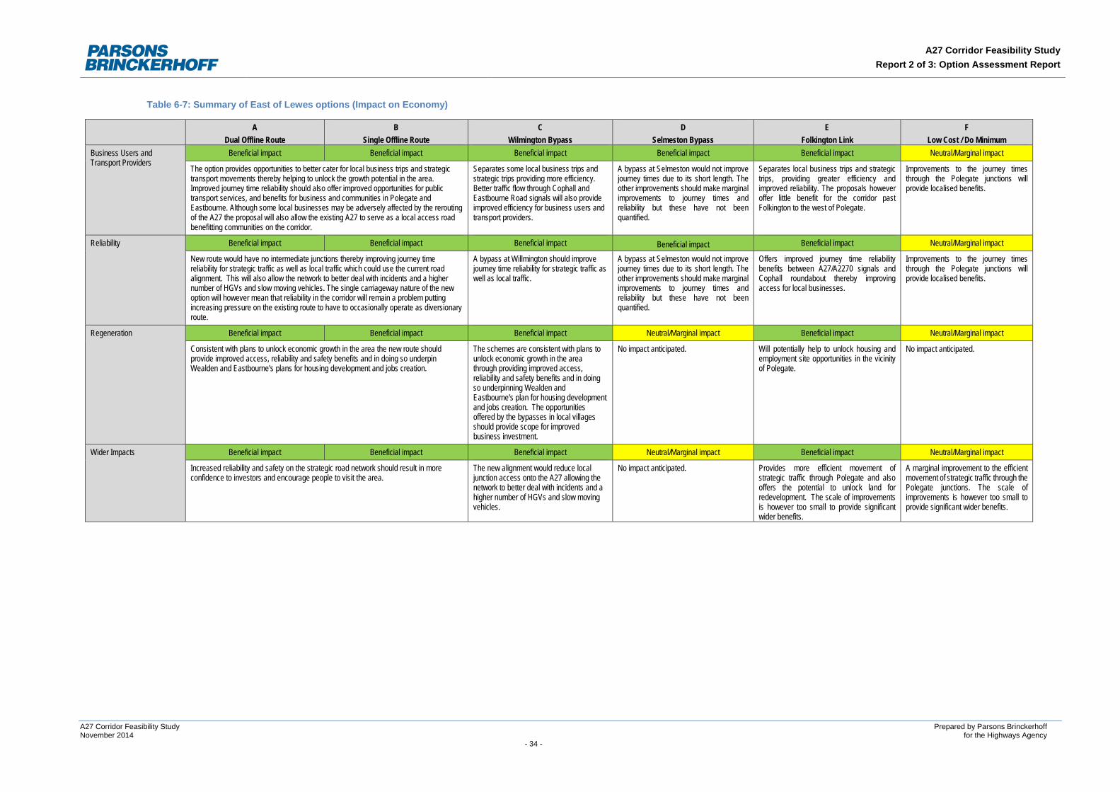
A27 Corridor Feasibility Study Report 2 of 3: Option Assessment Report
Table 6-7: Summary of East of Lewes options (Impact on Economy)
A Dual Offline Route
B Single Offline Route
C Wilmington Bypass
D Selmeston Bypass
E Folkington Link
F Low Cost / Do Minimum
Business Users and Transport Providers
Beneficial impact Beneficial impact Beneficial impact Beneficial impact Beneficial impact Neutral/Marginal impact
The option provides opportunities to better cater for local business trips and strategic transport movements thereby helping to unlock the growth potential in the area. Improved journey time reliability should also offer improved opportunities for public transport services, and benefits for business and communities in Polegate and Eastbourne. Although some local businesses may be adversely affected by the rerouting of the A27 the proposal will also allow the existing A27 to serve as a local access road benefitting communities on the corridor.
Separates some local business trips and strategic trips providing more efficiency. Better traffic flow through Cophall and Eastbourne Road signals will also provide improved efficiency for business users and transport providers.
A bypass at Selmeston would not improve journey times due to its short length. The other improvements should make marginal improvements to journey times and reliability but these have not been quantified.
Separates local business trips and strategic trips, providing greater efficiency and improved reliability. The proposals however offer little benefit for the corridor past Folkington to the west of Polegate.
Improvements to the journey times through the Polegate junctions will provide localised benefits.
Reliability Beneficial impact Beneficial impact Beneficial impact Beneficial impact Beneficial impact Neutral/Marginal impact
New route would have no intermediate junctions thereby improving journey time reliability for strategic traffic as well as local traffic which could use the current road alignment. This will also allow the network to better deal with incidents and a higher number of HGVs and slow moving vehicles. The single carriageway nature of the new option will however mean that reliability in the corridor will remain a problem putting increasing pressure on the existing route to have to occasionally operate as diversionary route.
A bypass at Willmington should improve journey time reliability for strategic traffic as well as local traffic.
A bypass at Selmeston would not improve journey times due to its short length. The other improvements should make marginal improvements to journey times and reliability but these have not been quantified.
Offers improved journey time reliability benefits between A27/A2270 signals and Cophall roundabout thereby improving access for local businesses.
Improvements to the journey times through the Polegate junctions will provide localised benefits.
Regeneration Beneficial impact Beneficial impact Beneficial impact Neutral/Marginal impact Beneficial impact Neutral/Marginal impact
Consistent with plans to unlock economic growth in the area the new route should provide improved access, reliability and safety benefits and in doing so underpin Wealden and Eastbourne's plans for housing development and jobs creation.
The schemes are consistent with plans to unlock economic growth in the area through providing improved access, reliability and safety benefits and in doing so underpinning Wealden and Eastbourne's plan for housing development and jobs creation. The opportunities offered by the bypasses in local villages should provide scope for improved business investment.
No impact anticipated. Will potentially help to unlock housing and employment site opportunities in the vicinity of Polegate.
No impact anticipated.
Wider Impacts Beneficial impact Beneficial impact Beneficial impact Neutral/Marginal impact Beneficial impact Neutral/Marginal impact
Increased reliability and safety on the strategic road network should result in more confidence to investors and encourage people to visit the area.
The new alignment would reduce local junction access onto the A27 allowing the network to better deal with incidents and a higher number of HGVs and slow moving vehicles.
No impact anticipated. Provides more efficient movement of strategic traffic through Polegate and also offers the potential to unlock land for redevelopment. The scale of improvements is however too small to provide significant wider benefits.
A marginal improvement to the efficient movement of strategic traffic through the Polegate junctions. The scale of improvements is however too small to provide significant wider benefits.
A27 Corridor Feasibility Study Prepared by Parsons Brinckerhoff November 2014 for the Highways Agency - 34 -
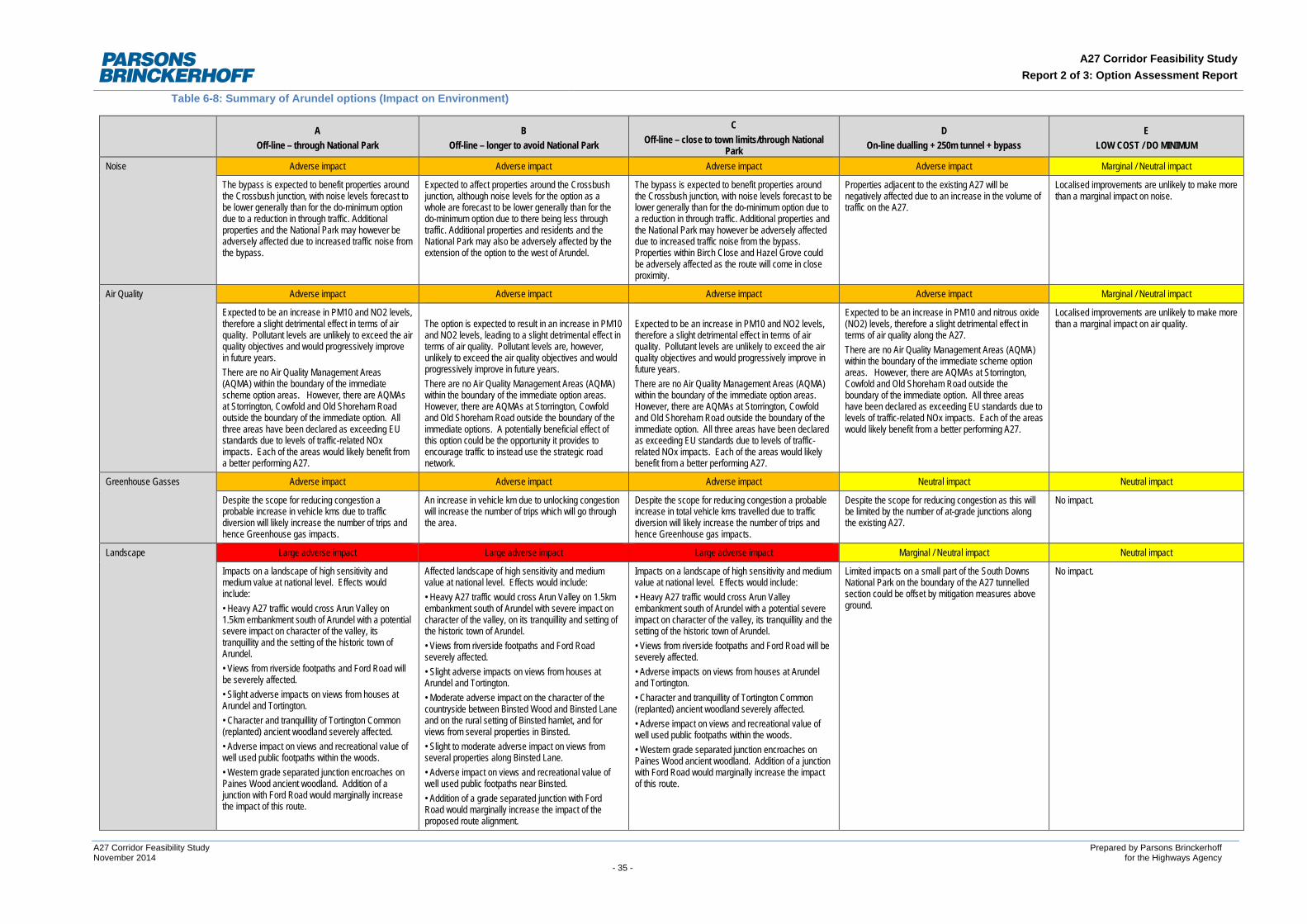
A27 Corridor Feasibility Study Report 2 of 3: Option Assessment Report
Table 6-8: Summary of Arundel options (Impact on Environment)
A Off-line – through National Park
B Off-line – longer to avoid National Park
C Off-line – close to town limits/through National
Park
D On-line dualling + 250m tunnel + bypass
E LOW COST / DO MINIMUM
Noise Adverse impact Adverse impact Adverse impact Adverse impact Marginal / Neutral impact
The bypass is expected to benefit properties around the Crossbush junction, with noise levels forecast to be lower generally than for the do-minimum option due to a reduction in through traffic. Additional properties and the National Park may however be adversely affected due to increased traffic noise from the bypass.
Expected to affect properties around the Crossbush junction, although noise levels for the option as a whole are forecast to be lower generally than for the do-minimum option due to there being less through traffic. Additional properties and residents and the National Park may also be adversely affected by the extension of the option to the west of Arundel.
The bypass is expected to benefit properties around the Crossbush junction, with noise levels forecast to be lower generally than for the do-minimum option due to a reduction in through traffic. Additional properties and the National Park may however be adversely affected due to increased traffic noise from the bypass. Properties within Birch Close and Hazel Grove could be adversely affected as the route will come in close proximity.
Properties adjacent to the existing A27 will be negatively affected due to an increase in the volume of traffic on the A27.
Localised improvements are unlikely to make more than a marginal impact on noise.
Air Quality Adverse impact Adverse impact Adverse impact Adverse impact Marginal / Neutral impact
Expected to be an increase in PM10 and NO2 levels, therefore a slight detrimental effect in terms of air quality. Pollutant levels are unlikely to exceed the air quality objectives and would progressively improve in future years. There are no Air Quality Management Areas (AQMA) within the boundary of the immediate scheme option areas. However, there are AQMAs at Storrington, Cowfold and Old Shoreham Road outside the boundary of the immediate option. All three areas have been declared as exceeding EU standards due to levels of traffic-related NOx impacts. Each of the areas would likely benefit from a better performing A27.
The option is expected to result in an increase in PM10 and NO2 levels, leading to a slight detrimental effect in terms of air quality. Pollutant levels are, however, unlikely to exceed the air quality objectives and would progressively improve in future years. There are no Air Quality Management Areas (AQMA) within the boundary of the immediate option areas. However, there are AQMAs at Storrington, Cowfold and Old Shoreham Road outside the boundary of the immediate options. A potentially beneficial effect of this option could be the opportunity it provides to encourage traffic to instead use the strategic road network.
Expected to be an increase in PM10 and NO2 levels, therefore a slight detrimental effect in terms of air quality. Pollutant levels are unlikely to exceed the air quality objectives and would progressively improve in future years. There are no Air Quality Management Areas (AQMA) within the boundary of the immediate option areas. However, there are AQMAs at Storrington, Cowfold and Old Shoreham Road outside the boundary of the immediate option. All three areas have been declared as exceeding EU standards due to levels of traffic-related NOx impacts. Each of the areas would likely benefit from a better performing A27.
Expected to be an increase in PM10 and nitrous oxide (NO2) levels, therefore a slight detrimental effect in terms of air quality along the A27. There are no Air Quality Management Areas (AQMA) within the boundary of the immediate scheme option areas. However, there are AQMAs at Storrington, Cowfold and Old Shoreham Road outside the boundary of the immediate option. All three areas have been declared as exceeding EU standards due to levels of traffic-related NOx impacts. Each of the areas would likely benefit from a better performing A27.
Localised improvements are unlikely to make more than a marginal impact on air quality.
Greenhouse Gasses Adverse impact Adverse impact Adverse impact Neutral impact Neutral impact
Despite the scope for reducing congestion a probable increase in vehicle kms due to traffic diversion will likely increase the number of trips and hence Greenhouse gas impacts.
An increase in vehicle km due to unlocking congestion will increase the number of trips which will go through the area.
Despite the scope for reducing congestion a probable increase in total vehicle kms travelled due to traffic diversion will likely increase the number of trips and hence Greenhouse gas impacts.
Despite the scope for reducing congestion as this will be limited by the number of at-grade junctions along the existing A27.
No impact.
Landscape Large adverse impact Large adverse impact Large adverse impact Marginal / Neutral impact Neutral impact
Impacts on a landscape of high sensitivity and medium value at national level. Effects would include: • Heavy A27 traffic would cross Arun Valley on 1.5km embankment south of Arundel with a potential severe impact on character of the valley, its tranquillity and the setting of the historic town of Arundel. • Views from riverside footpaths and Ford Road will be severely affected. • Slight adverse impacts on views from houses at Arundel and Tortington. • Character and tranquillity of Tortington Common (replanted) ancient woodland severely affected. • Adverse impact on views and recreational value of well used public footpaths within the woods. • Western grade separated junction encroaches on Paines Wood ancient woodland. Addition of a junction with Ford Road would marginally increase the impact of this route.
Affected landscape of high sensitivity and medium value at national level. Effects would include: • Heavy A27 traffic would cross Arun Valley on 1.5km embankment south of Arundel with severe impact on character of the valley, on its tranquillity and setting of the historic town of Arundel. • Views from riverside footpaths and Ford Road severely affected. • Slight adverse impacts on views from houses at Arundel and Tortington. • Moderate adverse impact on the character of the countryside between Binsted Wood and Binsted Lane and on the rural setting of Binsted hamlet, and for views from several properties in Binsted. • Slight to moderate adverse impact on views from several properties along Binsted Lane. • Adverse impact on views and recreational value of well used public footpaths near Binsted. • Addition of a grade separated junction with Ford Road would marginally increase the impact of the proposed route alignment.
Impacts on a landscape of high sensitivity and medium value at national level. Effects would include: • Heavy A27 traffic would cross Arun Valley embankment south of Arundel with a potential severe impact on character of the valley, its tranquillity and the setting of the historic town of Arundel. • Views from riverside footpaths and Ford Road will be severely affected. • Adverse impacts on views from houses at Arundel and Tortington. • Character and tranquillity of Tortington Common (replanted) ancient woodland severely affected. • Adverse impact on views and recreational value of well used public footpaths within the woods. • Western grade separated junction encroaches on Paines Wood ancient woodland. Addition of a junction with Ford Road would marginally increase the impact of this route.
Limited impacts on a small part of the South Downs National Park on the boundary of the A27 tunnelled section could be offset by mitigation measures above ground.
No impact.
A27 Corridor Feasibility Study Prepared by Parsons Brinckerhoff November 2014 for the Highways Agency - 35 -
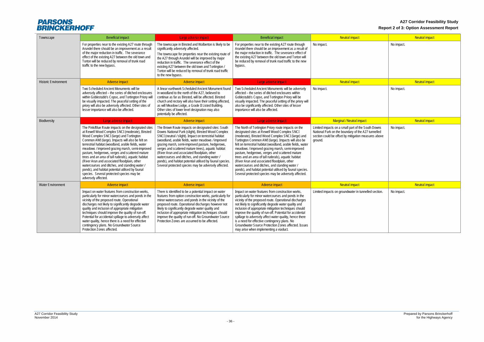
A27 Corridor Feasibility Study Report 2 of 3: Option Assessment Report
Townscape Beneficial impact Large adverse impact Beneficial impact Neutral impact Neutral impact
For properties near to the existing A27 route through Arundel there should be an improvement as a result of the major reduction in traffic. The severance effect of the existing A27 between the old town and Torton will be reduced by removal of trunk road traffic to the new bypass.
The townscape in Binsted and Walberton is likely to be significantly adversely affected. The townscape for properties near the existing route of the A27 through Arundel will be improved by major reduction in traffic. The severance effect of the existing A27 between the old town and Tortington / Torton will be reduced by removal of trunk road traffic to the new bypass.
For properties near to the existing A27 route through Arundel there should be an improvement as a result of the major reduction in traffic. The severance effect of the existing A27 between the old town and Torton will be reduced by removal of trunk road traffic to the new bypass.
No impact. No impact.
Historic Environment Adverse impact Adverse impact Large adverse impact Neutral impact Neutral impact
Two Scheduled Ancient Monuments will be adversely affected – the series of ditched enclosures within Goblestubb’s Copse, and Tortington Priory will be visually impacted. The peaceful setting of the priory will also be adversely affected. Other sites of lesser importance will also be affected.
A linear earthwork Scheduled Ancient Monument found in woodland to the north of the A27, believed to continue as far as Binsted, will be affected. Binsted church and rectory will also have their setting affected, as will Meadow Lodge, a Grade II Listed Building. Other sites of lower level designation may also potentially be affected.
Two Scheduled Ancient Monuments will be adversely affected – the series of ditched enclosures within Goblestubb’s Copse, and Tortington Priory will be visually impacted. The peaceful setting of the priory will also be significantly affected. Other sites of lesser importance will also be affected.
No impact. No impact.
Biodiversity Large adverse impact Adverse impact Large adverse impact Marginal / Neutral impact Neutral impact
The Pink/Blue Route impacts on the designated sites at Rewell Wood Complex SNCI (moderate), Binsted Wood Complex SNCI (large) and Tortington Common AWI (large). Impacts will also be felt on terrestrial habitat (woodland, arable fields, water meadows / improved grazing marsh, semi-improved pasture, hedgerows, verges and scattered mature trees and an area of tall ruderals), aquatic habitat (River Arun and associated floodplain, other watercourses and ditches, and standing water / ponds), and habitat potential utilised by faunal species. Several protected species may be adversely affected.
The Brown Route impacts on designated sites: South Downs National Park (slight), Binsted Wood Complex SNCI (neutral / slight). Impact on terrestrial habitat (woodland, arable fields, water meadows / improved grazing marsh, semi-improved pasture, hedgerows, verges and scattered mature trees), aquatic habitat (River Arun and associated floodplain, other watercourses and ditches, and standing water / ponds), and habitat potential utilised by faunal species. Several protected species may be adversely affected.
The North of Tortington Priory route impacts on the designated sites at Rewell Wood Complex SNCI (moderate), Binsted Wood Complex SNCI (large) and Tortington Common AWI (large). Impacts will also be felt on terrestrial habitat (woodland, arable fields, water meadows / improved grazing marsh, semi-improved pasture, hedgerows, verges and scattered mature trees and an area of tall ruderals), aquatic habitat (River Arun and associated floodplain, other watercourses and ditches, and standing water / ponds), and habitat potential utilised by faunal species. Several protected species may be adversely affected.
Limited impacts on a small part of the South Downs National Park on the boundary of the A27 tunnelled section could be offset by mitigation measures above ground.
No impact.
Water Environment Adverse impact Adverse impact Adverse impact Neutral impact Neutral impact
Impact on water features from construction works, particularly for minor watercourses and ponds in the vicinity of the proposed route. Operational discharges not likely to significantly degrade water quality and inclusion of appropriate mitigation techniques should improve the quality of run-off. Potential for accidental spillage to adversely affect water quality, hence there is a need for effective contingency plans. No Groundwater Source Protection Zones affected.
There is identified to be a potential impact on water features from option construction works, particularly for minor watercourses and ponds in the vicinity of the proposed route. Operational discharges however not likely to significantly degrade water quality and inclusion of appropriate mitigation techniques should improve the quality of run-off. No Groundwater Source Protection Zones are assumed to be affected.
Impact on water features from construction works, particularly for minor watercourses and ponds in the vicinity of the proposed route. Operational discharges not likely to significantly degrade water quality and inclusion of appropriate mitigation techniques should improve the quality of run-off. Potential for accidental spillage to adversely affect water quality, hence there is a need for effective contingency plans. No Groundwater Source Protection Zones affected. Issues may arise when implementing a viaduct.
Limited impacts on groundwater in tunnelled section. No impact.
A27 Corridor Feasibility Study Prepared by Parsons Brinckerhoff November 2014 for the Highways Agency - 36 -
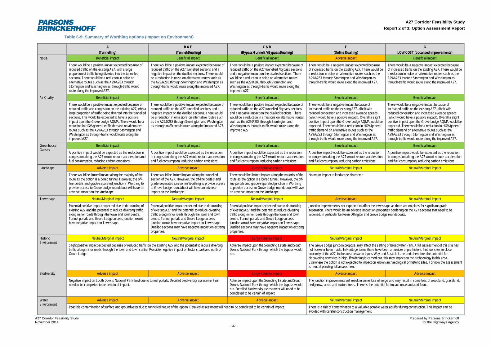
A27 Corridor Feasibility Study Report 2 of 3: Option Assessment Report
Table 6-9: Summary of Worthing options (Impact on Environment)
A (Tunnelling)
B & E (Tunnel/Dualling)
C & D (Bypass/Tunnel) / (Bypass/Dualling)
F (Online Dualling)
G LOW COST (Localised improvements)
Noise Beneficial impact Beneficial impact Beneficial impact Adverse impact Beneficial impact
There would be a positive impact expected because of reduced traffic on the existing A27, with a large proportion of traffic being diverted into the tunnelled sections. There would be a reduction in noise on alternative routes such as the A29/A283 through Storrington and Washington as through-traffic would route along the improved A27.
There would be a positive impact expected because of reduced traffic on the A27 tunnelled sections and a negative impact on the dualled sections. There would be a reduction in noise on alternative routes such as the A29/A283 through Storrington and Washington as through-traffic would route along the improved A27.
There would be a positive impact expected because of reduced traffic on the A27 tunnelled / bypass sections and a negative impact on the dualled sections. There would be a reduction in noise on alternative routes such as the A29/A283 through Storrington and Washington as through-traffic would route along the improved A27.
There would be a negative impact expected because of increased traffic on the existing A27. There would be a reduction in noise on alternative routes such as the A29/A283 through Storrington and Washington as through-traffic would route along the improved A27.
There would be a negative impact expected because of increased traffic on the existing A27. There would be a reduction in noise on alternative routes such as the A29/A283 through Storrington and Washington as through-traffic would route along the improved A27.
Air Quality Beneficial impact Beneficial impact Beneficial impact Beneficial impact Beneficial impact
There would be a positive impact expected because of reduced traffic and congestion on the existing A27, with a large proportion of traffic being diverted into the tunnelled sections. This would be expected to have a positive impact upon the Grove Lodge AQMA. There would be a reduction in HGV/general traffic demand on alternative routes such as the A29/A283 through Storrington and Washington as through-traffic would route along the improved A27.
There would be a positive impact expected because of reduced traffic on the A27 tunnelled sections and a negative impact on the dualled sections. There would be a reduction in emissions on alternative routes such as the A29/A283 through Storrington and Washington as through-traffic would route along the improved A27.
There would be a positive impact expected because of reduced traffic on the A27 tunnelled / bypass sections and a negative impact on the dualled sections. There would be a reduction in emissions on alternative routes such as the A29/A283 through Storrington and Washington as through-traffic would route along the improved A27.
There would be a negative impact because of increased traffic on the existing A27, albeit with reduced congestion and increased average speeds (which would have a positive impact). Overall a slight positive impact upon the Grove Lodge AQMA would be expected. There would be a reduction in HGV/general traffic demand on alternative routes such as the A29/A283 through Storrington and Washington as through-traffic would route along the improved A27.
There would be a negative impact because of increased traffic on the existing A27, albeit with reduced congestion and increased average speeds (which would have a positive impact). Overall a slight positive impact upon the Grove Lodge AQMA would be expected. There would be a reduction in HGV/general traffic demand on alternative routes such as the A29/A283 through Storrington and Washington as through-traffic would route along the improved A27.
Greenhouse Gasses
Beneficial impact Beneficial impact Beneficial impact Beneficial impact Beneficial impact
A positive impact would be expected as the reduction in congestion along the A27 would reduce acceleration and fuel consumption, reducing carbon emissions.
A positive impact would be expected as the reduction in congestion along the A27 would reduce acceleration and fuel consumption, reducing carbon emissions.
A positive impact would be expected as the reduction in congestion along the A27 would reduce acceleration and fuel consumption, reducing carbon emissions.
A positive impact would be expected as the reduction in congestion along the A27 would reduce acceleration and fuel consumption, reducing carbon emissions.
A positive impact would be expected as the reduction in congestion along the A27 would reduce acceleration and fuel consumption, reducing carbon emissions.
Landscape Adverse impact Adverse impact Large Adverse impact Neutral/Marginal impact Neutral/Marginal impact
There would be limited impact along the majority of the route as the option is a bored tunnel. However, the off-line portals and grade-separated junction in Worthing to provide access to Grove Lodge roundabout will have an adverse impact on the landscape.
There would be limited impact along the tunnelled section of the A27. However, the off-line portals and grade-separated junction in Worthing to provide access to Grove Lodge roundabout will have an adverse impact on the landscape.
There would be limited impact along the majority of the route as the option is a bored tunnel. However, the off-line portals and grade-separated junction in Worthing to provide access to Grove Lodge roundabout will have an adverse impact on the landscape.
No major impact to landscape character.
Townscape Neutral/Marginal impact Neutral/Marginal impact Neutral/Marginal impact Adverse impact Neutral/Marginal impact
Potential positive impact expected due to de-trunking of existing A27 and the potential to reduce diverting traffic along minor roads through the town and town centre. Tunnel portals and Grove Lodge access junction would have negative impact on Townscape.
Potential positive impact expected due to de-trunking of existing A27 and the potential to reduce diverting traffic along minor roads through the town and town centre. Tunnel portals and Grove Lodge access junction would have negative impact on Townscape. Dualled sections may have negative impact on existing properties.
Potential positive impact expected due to de-trunking of existing A27 and the potential to reduce diverting traffic along minor roads through the town and town centre. Tunnel portals and Grove Lodge access junction would have negative impact on Townscape. Dualled sections may have negative impact on existing properties.
Junction improvements not expected to affect the townscape as there are no plans for significant grade separation. There would be an adverse impact on properties bordering on the A27 sections that need to be widened, in particular between Offington and Grove Lodge roundabouts.
Historic Environment
Neutral/Marginal impact Neutral/Marginal impact Large Adverse impact Neutral/Marginal impact Neutral/Marginal impact
Slight positive impact expected because of reduced traffic on the existing A27 and the potential to reduce diverting traffic along minor roads through the town and town centre. Possible negative impact on historic parkland north of Grove Lodge.
Adverse impact upon the Sompting Estate and South Downs National Park through which the bypass would run.
The Grove Lodge junction proposal may affect the setting of Broadwater Park. A full assessment of this site has not however been made. In Heritage terms there have been a number of pre historic flint tool sites in close proximity of the A27, in the area between Lyons Way and Busticle Lane and, therefore, the potential for discovering new sites is high. If widening is carried out, this may impact on the archaeology in this area. Elsewhere the option is not expected to impact on known archaeological or historic sites. For now the assessment is neutral pending full assessment.
Biodiversity Adverse impact Adverse impact Large Adverse impact Adverse impact Adverse impact
Negative impact on South Downs National Park land due to tunnel portals. Detailed biodiversity assessment will need to be completed to be certain of impact.
Adverse impact upon the Sompting Estate and South Downs National Park through which the bypass would run. Detailed biodiversity assessment will need to be completed to be certain of impact.
The junction improvements will result in some loss of verge and may result in some loss of woodland, grassland, hedgerow, scrub and mature trees. There is the potential for impact on associated fauna.
Water Environment
Adverse impact Adverse impact Adverse impact Neutral/Marginal impact Neutral/Marginal impact
Possible contamination of surface and groundwater due to tunnelled nature of the option. Detailed assessment will need to be completed to be certain of impact. There is a risk of contamination to a valuable potable water aquifer during construction. This impact can be avoided with careful construction management.
A27 Corridor Feasibility Study Prepared by Parsons Brinckerhoff November 2014 for the Highways Agency - 37 -
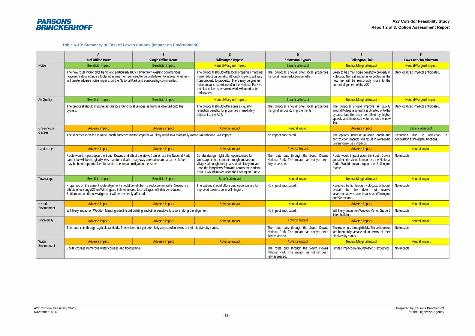
A27 Corridor Feasibility Study Report 2 of 3: Option Assessment Report
Table 6-10: Summary of East of Lewes options (Impact on Environment)
A Dual Offline Route
B Single Offline Route
C Wilmington Bypass
D Selmeston Bypass
E Folkington Link
F Low Cost / Do Minimum
Noise Beneficial impact Beneficial impact Neutral/Marginal impact Beneficial impact Neutral/Marginal impact Neutral/Marginal impact
The new route would take traffic and particularly HGVs away from existing communities, however a detailed noise footprint assessment will need to be undertaken to assess whether it will create adverse noise impacts on the National Park and surrounding communities.
The proposal should offer local properties marginal noise reduction benefits although impacts will vary from property to property. There may be greater noise impacts experienced in the National Park so detailed noise assessment work will need to be undertaken.
The proposal should offer local properties marginal noise reduction benefits.
Likely to be small noise benefit to property in Polegate. No real impact is expected as the new link will be reasonably close to the current alignment of the A27.
Only localised impacts anticipated.
Air Quality Beneficial impact Beneficial impact Neutral/Marginal impact Beneficial impact Neutral/Marginal impact Neutral/Marginal impact
The proposal should improve air quality around local villages as traffic is diverted onto the bypass.
The proposal should offer some air quality reduction benefits for properties immediately adjacent to the A27.
The proposal should offer local properties marginal air quality improvements.
The proposal should improve air quality around Polegate as traffic is diverted onto the bypass, but this may be offset by higher speeds and increased volumes on the new link.
Only localised impacts anticipated.
Greenhouse Gasses
Adverse impact Adverse impact Adverse impact Neutral impact Adverse impact Beneficial impact
The schemes increase in route length and construction impacts will likely result in a marginally worse Greenhouse Gas impact. No impact anticipated. The options increase in route length and construction impacts will result in worsening Greenhouse Gas impacts.
Reduction due to reduction in congestion at Polegate junctions.
Landscape Adverse impact Adverse impact Adverse impact Adverse impact Adverse impact Neutral impact
Route would impact upon the South Downs and affect the views from across the National Park. Land take will be marginally less than for a dual carriageway alternative and as a result there may be better opportunities for landscape impact mitigation measures.
Careful design might offer opportunities for landscape enhancement through and around villages although the bypass would likely impact upon the long views from and across the National Park. It would impact upon the Folkington Estate.
The route cuts through the South Downs National Park. The impact has not yet been fully assessed.
Route would impact upon the South Downs and affect the views from across the National Park. Would impact upon the Folkington Estate.
No impacts.
Townscape Beneficial impact Beneficial impact Beneficial impact Neutral impact Neutral/Marginal impact Neutral impact
Properties on the current route alignment should benefit from a reduction in traffic. Severance effects of existing A27 on Wilmington, Selmeston and local villages will also be reduced. Settlements on the new alignment will be adversely affected.
The options should offer some opportunities for improved townscape in Wilmington.
No impact anticipated. Removes traffic through Polegate, although overall the link does not resolve severance/townscape issues at Wilmington and Selmeston.
No impacts.
Historic Environment
Adverse impact Adverse impact Adverse impact Neutral impact Adverse impact Neutral impact
Will likely impact on Wootton Manor grade 2 listed building and other sensitive locations along the alignment No impact anticipated. Will likely impact on Wooton Manor Grade 2 listed building.
No impacts.
Biodiversity Adverse impact Adverse impact Adverse impact Adverse impact Adverse impact Neutral impact
The route cuts through agricultural fields. These have not yet been fully assessed in terms of their biodiversity status. The route cuts through the South Downs National Park. The impact has not yet been fully assessed.
The route cuts through fields. These have not yet been fully assessed in terms of their biodiversity status.
No impacts.
Water Environment
Adverse impact Adverse impact Adverse impact Adverse impact Neutral/Marginal impact Neutral impact
Route crosses numerous water courses and flood plains. The route cuts through the South Downs National Park. The impact has not yet been fully assessed.
Limited impact on groundwater is expected. No impacts.
A27 Corridor Feasibility Study Prepared by Parsons Brinckerhoff November 2014 for the Highways Agency - 38 -
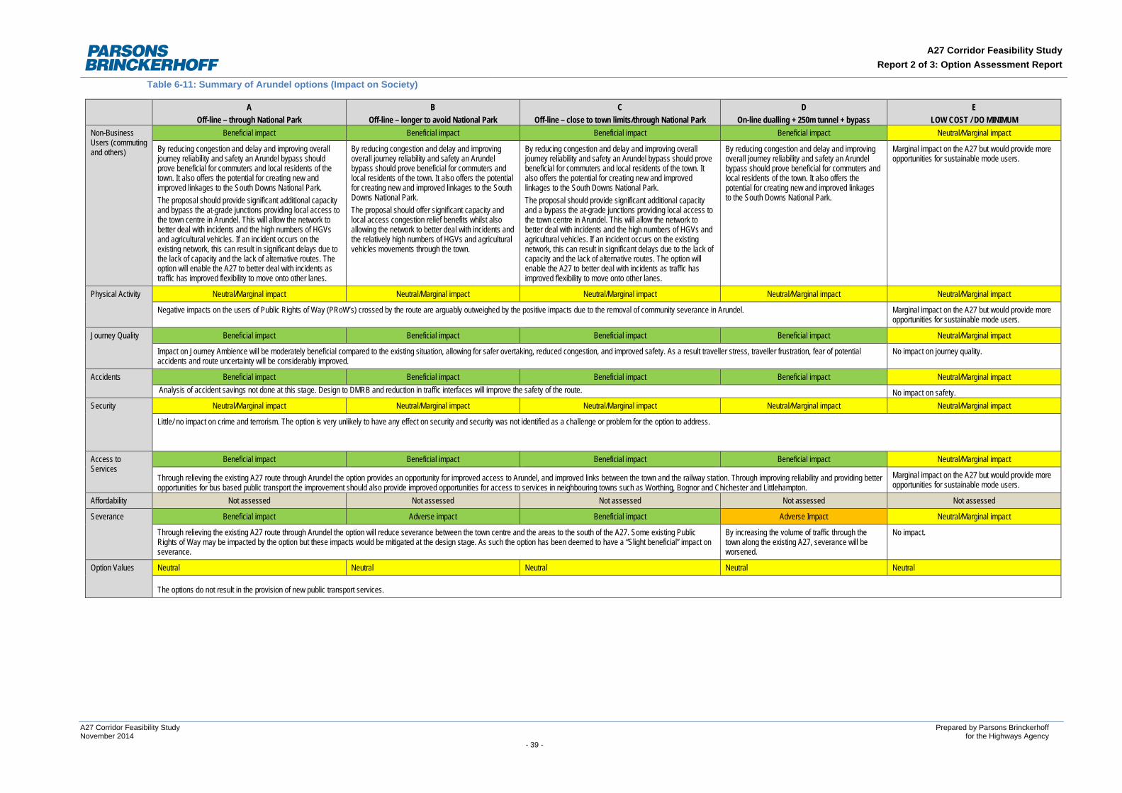
A27 Corridor Feasibility Study Report 2 of 3: Option Assessment Report
Table 6-11: Summary of Arundel options (Impact on Society)
A Off-line – through National Park
B Off-line – longer to avoid National Park
C Off-line – close to town limits/through National Park
D On-line dualling + 250m tunnel + bypass
E LOW COST / DO MINIMUM
Non-Business Users (commuting and others)
Beneficial impact Beneficial impact Beneficial impact Beneficial impact Neutral/Marginal impact
By reducing congestion and delay and improving overall journey reliability and safety an Arundel bypass should prove beneficial for commuters and local residents of the town. It also offers the potential for creating new and improved linkages to the South Downs National Park. The proposal should provide significant additional capacity and bypass the at-grade junctions providing local access to the town centre in Arundel. This will allow the network to better deal with incidents and the high numbers of HGVs and agricultural vehicles. If an incident occurs on the existing network, this can result in significant delays due to the lack of capacity and the lack of alternative routes. The option will enable the A27 to better deal with incidents as traffic has improved flexibility to move onto other lanes.
By reducing congestion and delay and improving overall journey reliability and safety an Arundel bypass should prove beneficial for commuters and local residents of the town. It also offers the potential for creating new and improved linkages to the South Downs National Park. The proposal should offer significant capacity and local access congestion relief benefits whilst also allowing the network to better deal with incidents and the relatively high numbers of HGVs and agricultural vehicles movements through the town.
By reducing congestion and delay and improving overall journey reliability and safety an Arundel bypass should prove beneficial for commuters and local residents of the town. It also offers the potential for creating new and improved linkages to the South Downs National Park. The proposal should provide significant additional capacity and a bypass the at-grade junctions providing local access to the town centre in Arundel. This will allow the network to better deal with incidents and the high numbers of HGVs and agricultural vehicles. If an incident occurs on the existing network, this can result in significant delays due to the lack of capacity and the lack of alternative routes. The option will enable the A27 to better deal with incidents as traffic has improved flexibility to move onto other lanes.
By reducing congestion and delay and improving overall journey reliability and safety an Arundel bypass should prove beneficial for commuters and local residents of the town. It also offers the potential for creating new and improved linkages to the South Downs National Park.
Marginal impact on the A27 but would provide more opportunities for sustainable mode users.
Physical Activity Neutral/Marginal impact Neutral/Marginal impact Neutral/Marginal impact Neutral/Marginal impact Neutral/Marginal impact
Negative impacts on the users of Public Rights of Way (PRoW’s) crossed by the route are arguably outweighed by the positive impacts due to the removal of community severance in Arundel. Marginal impact on the A27 but would provide more opportunities for sustainable mode users.
Journey Quality Beneficial impact Beneficial impact Beneficial impact Beneficial impact Neutral/Marginal impact
Impact on Journey Ambience will be moderately beneficial compared to the existing situation, allowing for safer overtaking, reduced congestion, and improved safety. As a result traveller stress, traveller frustration, fear of potential accidents and route uncertainty will be considerably improved.
No impact on journey quality.
Accidents Beneficial impact Beneficial impact Beneficial impact Beneficial impact Neutral/Marginal impact Analysis of accident savings not done at this stage. Design to DMRB and reduction in traffic interfaces will improve the safety of the route. No impact on safety.
Security Neutral/Marginal impact Neutral/Marginal impact Neutral/Marginal impact Neutral/Marginal impact Neutral/Marginal impact
Little/ no impact on crime and terrorism. The option is very unlikely to have any effect on security and security was not identified as a challenge or problem for the option to address.
Access to Services
Beneficial impact Beneficial impact Beneficial impact Beneficial impact Neutral/Marginal impact
Through relieving the existing A27 route through Arundel the option provides an opportunity for improved access to Arundel, and improved links between the town and the railway station. Through improving reliability and providing better opportunities for bus based public transport the improvement should also provide improved opportunities for access to services in neighbouring towns such as Worthing, Bognor and Chichester and Littlehampton.
Marginal impact on the A27 but would provide more opportunities for sustainable mode users.
Affordability Not assessed Not assessed Not assessed Not assessed Not assessed
Severance Beneficial impact Adverse impact Beneficial impact Adverse Impact Neutral/Marginal impact
Through relieving the existing A27 route through Arundel the option will reduce severance between the town centre and the areas to the south of the A27. Some existing Public Rights of Way may be impacted by the option but these impacts would be mitigated at the design stage. As such the option has been deemed to have a “Slight beneficial” impact on severance.
By increasing the volume of traffic through the town along the existing A27, severance will be worsened.
No impact.
Option Values Neutral Neutral Neutral Neutral Neutral
The options do not result in the provision of new public transport services.
A27 Corridor Feasibility Study Prepared by Parsons Brinckerhoff November 2014 for the Highways Agency - 39 -
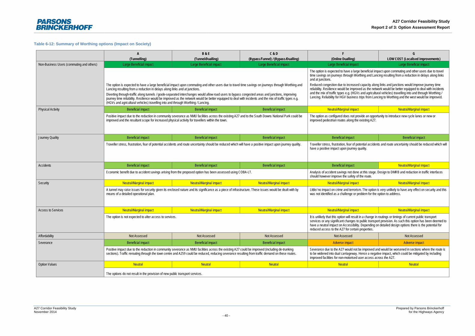
A27 Corridor Feasibility Study Report 2 of 3: Option Assessment Report
Table 6-12: Summary of Worthing options (Impact on Society)
A (Tunnelling)
B & E (Tunnel/Dualling)
C & D (Bypass/Tunnel) / (Bypass/Dualling)
F (Online Dualling)
G LOW COST (Localised improvements)
Non-Business Users (commuting and others) Large Beneficial impact Large Beneficial impact Large Beneficial impact Large Beneficial impact Large Beneficial impact
The option is expected to have a large beneficial impact upon commuting and other users due to travel time savings on journeys through Worthing and Lancing resulting from a reduction in delays along links and at junctions. Diverting through-traffic along tunnels / grade-separated interchanges would allow road users to bypass congested areas and junctions, improving journey time reliability. Resilience would be improved as the network would be better equipped to deal with incidents and the mix of traffic types e.g. (HGVs and agricultural vehicles) travelling into and through Worthing / Lancing.
The option is expected to have a large beneficial impact upon commuting and other users due to travel time savings on journeys through Worthing and Lancing resulting from a reduction in delays along links and at junctions. Reduced congestion due to increased capacity along links and junctions would improve journey time reliability. Resilience would be improved as the network would be better equipped to deal with incidents and the mix of traffic types e.g. (HGVs and agricultural vehicles) travelling into and through Worthing / Lancing. Reliability for HGV business trips from Lancing to Worthing and the west would be improved.
Physical Activity Beneficial impact Beneficial impact Beneficial impact Neutral/Marginal impact Neutral/Marginal impact
Positive impact due to the reduction in community severance as NMU facilities across the existing A27 and to the South Downs National Park could be improved and the resultant scope for increased physical activity for travellers within the town.
The option as configured does not provide an opportunity to introduce new cycle lanes or new or improved pedestrian routes along the existing A27.
Journey Quality Beneficial impact Beneficial impact Beneficial impact Beneficial impact Beneficial impact
Traveller stress, frustration, fear of potential accidents and route uncertainty should be reduced which will have a positive impact upon journey quality. Traveller stress, frustration, fear of potential accidents and route uncertainty should be reduced which will have a positive impact upon journey quality.
Accidents Beneficial impact Beneficial impact Beneficial impact Beneficial impact Neutral/Marginal impact
Economic benefit due to accident savings arising from the proposed option has been assessed using COBA-LT. Analysis of accident savings not done at this stage. Design to DMRB and reduction in traffic interfaces should however improve the safety of the route.
Security Neutral/Marginal impact Neutral/Marginal impact Neutral/Marginal impact Neutral/Marginal impact Neutral/Marginal impact
A tunnel may raise issues for security given its enclosed nature and its significance as a piece of infrastructure. These issues would be dealt with by means of a detailed operational plan.
Little/ no impact on crime and terrorism. The option is very unlikely to have any effect on security and this was not identified as a challenge or problem for the option to address.
Access to Services Neutral/Marginal impact Neutral/Marginal impact Neutral/Marginal impact Neutral/Marginal impact Neutral/Marginal impact
The option is not expected to alter access to services. It is unlikely that this option will result in a change in routings or timings of current public transport services or any significant changes to public transport provision. As such this option has been deemed to have a neutral impact on Accessibility. Depending on detailed design options there is the potential for reduced access to the A27 for certain properties.
Affordability Not Assessed Not Assessed Not Assessed Not Assessed Not Assessed
Severance Beneficial impact Beneficial impact Beneficial impact Adverse impact Adverse impact
Positive impact due to the reduction in community severance as NMU facilities across the existing A27 could be improved (including de-trunking sections). Traffic rerouting through the town centre and A259 could be reduced, reducing severance resulting from traffic demand on these routes.
Severance due to the A27 would not be improved and would be worsened in sections where the route is to be widened into dual carriageway. Hence a negative impact, which could be mitigated by including improved facilities for non-motorised user access across the A27.
Option Values Neutral Neutral Neutral Neutral Neutral
The options do not result in the provision of new public transport services.
A27 Corridor Feasibility Study Prepared by Parsons Brinckerhoff November 2014 for the Highways Agency - 40 -
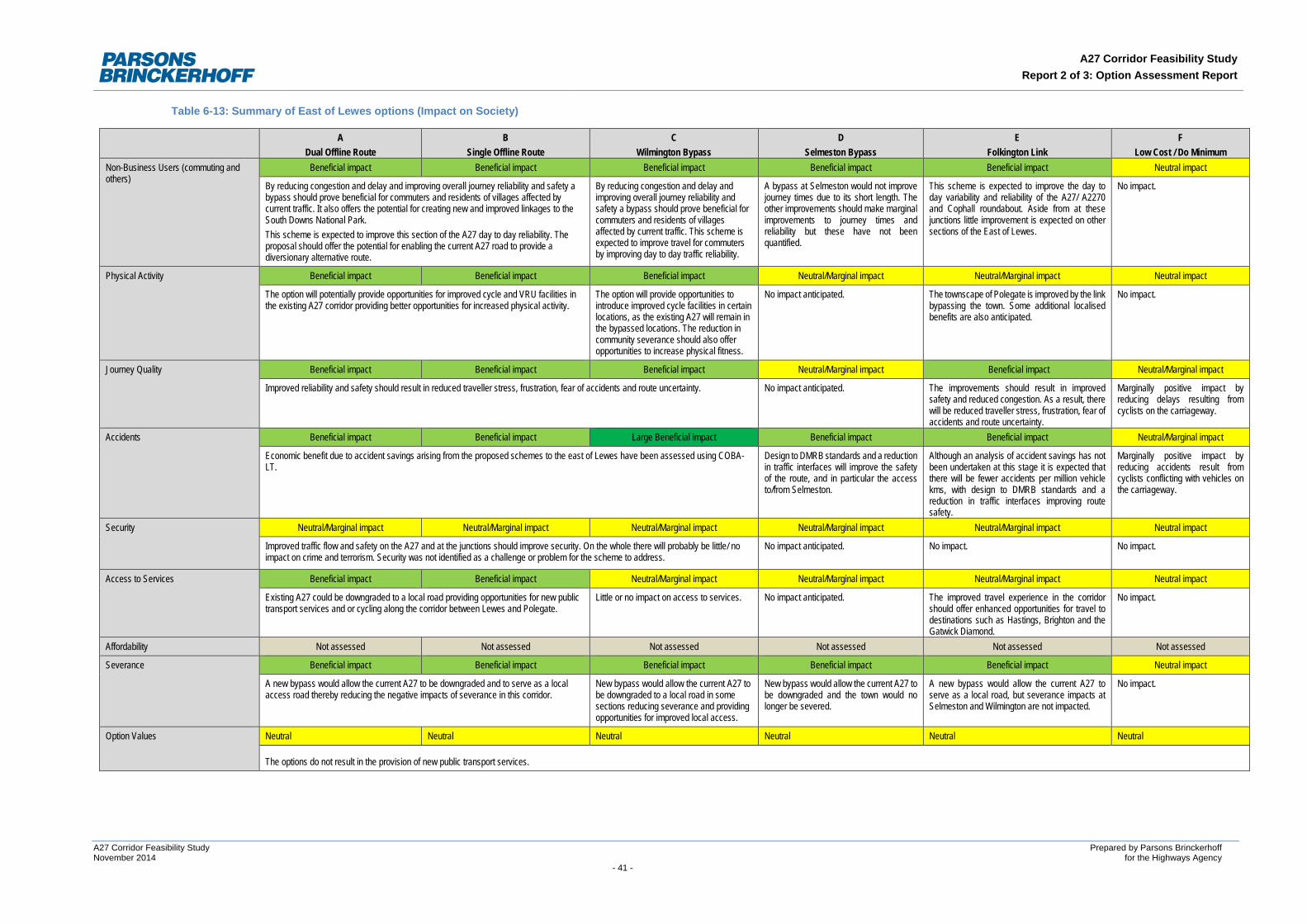
A27 Corridor Feasibility Study Report 2 of 3: Option Assessment Report
Table 6-13: Summary of East of Lewes options (Impact on Society)
A Dual Offline Route
B Single Offline Route
C Wilmington Bypass
D Selmeston Bypass
E Folkington Link
F Low Cost / Do Minimum
Non-Business Users (commuting and others)
Beneficial impact Beneficial impact Beneficial impact Beneficial impact Beneficial impact Neutral impact
By reducing congestion and delay and improving overall journey reliability and safety a bypass should prove beneficial for commuters and residents of villages affected by current traffic. It also offers the potential for creating new and improved linkages to the South Downs National Park. This scheme is expected to improve this section of the A27 day to day reliability. The proposal should offer the potential for enabling the current A27 road to provide a diversionary alternative route.
By reducing congestion and delay and improving overall journey reliability and safety a bypass should prove beneficial for commuters and residents of villages affected by current traffic. This scheme is expected to improve travel for commuters by improving day to day traffic reliability.
A bypass at Selmeston would not improve journey times due to its short length. The other improvements should make marginal improvements to journey times and reliability but these have not been quantified.
This scheme is expected to improve the day to day variability and reliability of the A27/ A2270 and Cophall roundabout. Aside from at these junctions little improvement is expected on other sections of the East of Lewes.
No impact.
Physical Activity Beneficial impact Beneficial impact Beneficial impact Neutral/Marginal impact Neutral/Marginal impact Neutral impact
The option will potentially provide opportunities for improved cycle and VRU facilities in the existing A27 corridor providing better opportunities for increased physical activity.
The option will provide opportunities to introduce improved cycle facilities in certain locations, as the existing A27 will remain in the bypassed locations. The reduction in community severance should also offer opportunities to increase physical fitness.
No impact anticipated. The townscape of Polegate is improved by the link bypassing the town. Some additional localised benefits are also anticipated.
No impact.
Journey Quality Beneficial impact Beneficial impact Beneficial impact Neutral/Marginal impact Beneficial impact Neutral/Marginal impact
Improved reliability and safety should result in reduced traveller stress, frustration, fear of accidents and route uncertainty. No impact anticipated. The improvements should result in improved safety and reduced congestion. As a result, there will be reduced traveller stress, frustration, fear of accidents and route uncertainty.
Marginally positive impact by reducing delays resulting from cyclists on the carriageway.
Accidents Beneficial impact Beneficial impact Large Beneficial impact Beneficial impact Beneficial impact Neutral/Marginal impact
Economic benefit due to accident savings arising from the proposed schemes to the east of Lewes have been assessed using COBA-LT.
Design to DMRB standards and a reduction in traffic interfaces will improve the safety of the route, and in particular the access to/from Selmeston.
Although an analysis of accident savings has not been undertaken at this stage it is expected that there will be fewer accidents per million vehicle kms, with design to DMRB standards and a reduction in traffic interfaces improving route safety.
Marginally positive impact by reducing accidents result from cyclists conflicting with vehicles on the carriageway.
Security Neutral/Marginal impact Neutral/Marginal impact Neutral/Marginal impact Neutral/Marginal impact Neutral/Marginal impact Neutral impact
Improved traffic flow and safety on the A27 and at the junctions should improve security. On the whole there will probably be little/ no impact on crime and terrorism. Security was not identified as a challenge or problem for the scheme to address.
No impact anticipated. No impact. No impact.
Access to Services Beneficial impact Beneficial impact Neutral/Marginal impact Neutral/Marginal impact Neutral/Marginal impact Neutral impact
Existing A27 could be downgraded to a local road providing opportunities for new public transport services and or cycling along the corridor between Lewes and Polegate.
Little or no impact on access to services. No impact anticipated. The improved travel experience in the corridor should offer enhanced opportunities for travel to destinations such as Hastings, Brighton and the Gatwick Diamond.
No impact.
Affordability Not assessed Not assessed Not assessed Not assessed Not assessed Not assessed
Severance Beneficial impact Beneficial impact Beneficial impact Beneficial impact Beneficial impact Neutral impact
A new bypass would allow the current A27 to be downgraded and to serve as a local access road thereby reducing the negative impacts of severance in this corridor.
New bypass would allow the current A27 to be downgraded to a local road in some sections reducing severance and providing opportunities for improved local access.
New bypass would allow the current A27 to be downgraded and the town would no longer be severed.
A new bypass would allow the current A27 to serve as a local road, but severance impacts at Selmeston and Wilmington are not impacted.
No impact.
Option Values Neutral Neutral Neutral Neutral Neutral Neutral
The options do not result in the provision of new public transport services.
A27 Corridor Feasibility Study Prepared by Parsons Brinckerhoff November 2014 for the Highways Agency - 41 -
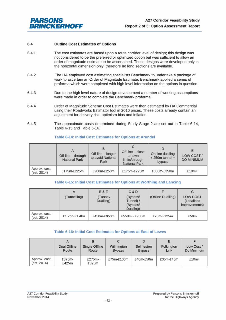
A27 Corridor Feasibility Study Report 2 of 3: Option Assessment Report
6.4 Outline Cost Estimates of Options
6.4.1 The cost estimates are based upon a route corridor level of design; this design was not considered to be the preferred or optimized option but was sufficient to allow an order of magnitude estimate to be ascertained. These designs were developed only in the horizontal dimension only; therefore no long sections are available.
6.4.2 The HA employed cost estimating specialists Benchmark to undertake a package of work to ascertain an Order of Magnitude Estimate. Benchmark applied a series of proforma which were completed with high level information on the options in question.
6.4.3 Due to the high level nature of design development a number of working assumptions were made in order to complete the Benchmark proforma.
6.4.4 Order of Magnitude Scheme Cost Estimates were then estimated by HA Commercial using their Roadworks Estimator tool in 2010 prices. These costs already contain an adjustment for delivery risk, optimism bias and inflation.
6.4.5 The approximate costs determined during Study Stage 2 are set out in Table 6-14, Table 6-15 and Table 6-16.
Table 6-14: Initial Cost Estimates for Options at Arundel
A
Off-line – through National Park
B Off-line – longer to avoid National
Park
C Off-line – close
to town limits/through National Park
D On-line dualling + 250m tunnel +
bypass
E LOW COST / DO MINIMUM
Approx. cost (est. 2014) £175m-£225m £200m-£250m £175m-£225m £300m-£350m £10m+
Table 6-15: Initial Cost Estimates for Options at Worthing and Lancing
A (Tunnelling)
B & E (Tunnel/ Dualling)
C & D (Bypass/ Tunnel) / (Bypass/ Dualling)
F (Online Dualling)
G LOW COST (Localised
improvements)
Approx. cost (est. 2014) £1.2bn-£1.4bn £450m-£950m £550m - £950m £75m-£125m £50m
Table 6-16: Initial Cost Estimates for Options at East of Lewes
A Dual Offline
Route
B Single Offline
Route
C Wilmington
Bypass
D Selmeston
Bypass
E Folkington
Link
F Low Cost /
Do Minimum
Approx. cost (est. 2014)
£375m-£425m
£275m-£325m
£75m-£100m £40m-£50m £35m-£45m £10m+
A27 Corridor Feasibility Study Prepared by Parsons Brinckerhoff November 2014 for the Highways Agency - 42 -
A27 Corridor Feasibility Study Report 2 of 3: Option Assessment Report
Indirect Tax Revenues
6.4.6 It was assumed that there would be an overall increase in indirect tax revenues due to an increase in vehicle journeys travelling slightly further in distance (on bypass options). It is likely that this would be offset by the overall reduction in congestion across the corridor which would be likely to lead to more efficient journeys using less fuel.
6.5 Distributional Impacts of Options
6.5.1 Distributional impacts were not assessed as part of the A27 Corridor Feasibility Study.
6.6 Indicative Benefit Cost Ratio (BCR) of Options
6.6.1 The indicative Benefit Cost Ratio category is concerned with the:
• Cost to the Private Sector; • Indicative Net Present Value; and • Indicative Economic BCR.
6.6.2 The study did not distinguish between different potential sources of funding including third party or developer contributions. Such sources of funding would however be part of any future scheme development.
6.6.3 Whilst outline scheme cost estimates were developed during Study Stage 2, these were fully completed only in Study Stage 3. Furthermore, the transport models used during the Study Stage 3 assessment were still being developed for this purpose.
6.6.4 As a result, a monetised assessment of the options impacts was not produced as part of Study Stage 3. As such, a NPV was not generated for each of the options considered at this stage. However, a high level assessment of the potential benefits of the package versus the likely scheme cost category was considered and is set out in the tables below.
6.6.5 As outlined previously, without a monetised assessment of the anticipated impacts of the packages of measures, it was not appropriate to generate a BCR. The high level assessment of the potential benefits of the package vs. the likely option cost category was considered as set out in Table 6-17, Table 6-18 and Table 6-19.
6.6.6 The categories were based on an estimation of how the quantifiable benefits of the scheme would compare to costs.
• Significant Positive – benefit exceed costs by a factor of 5 or more • Moderate Positive – benefit exceed costs by a factor of between 2 and 5 • Slight Positive – benefits only just exceed costs • Slight Negative – costs slightly exceed benefits • Moderate Negative – costs exceed benefits by a factor of between 2 and 5 • Significant Negative – costs exceed benefits by a factor of 5 or more
A27 Corridor Feasibility Study Prepared by Parsons Brinckerhoff November 2014 for the Highways Agency - 43 -
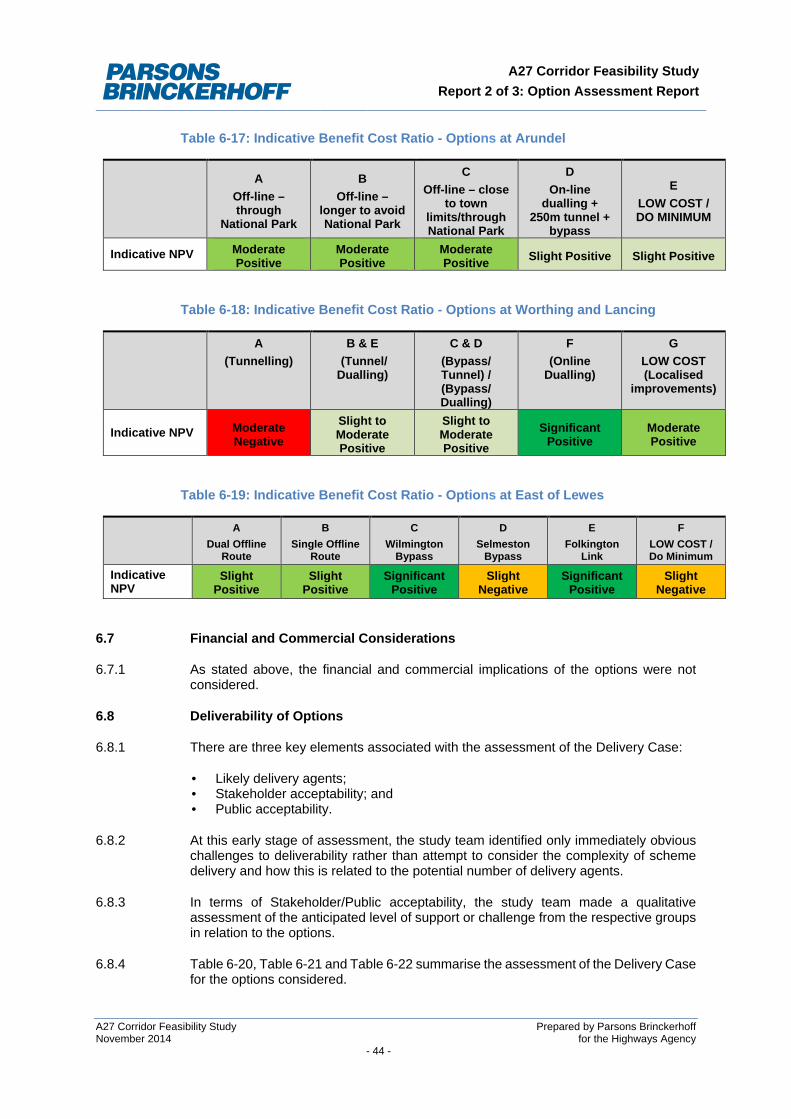
A27 Corridor Feasibility Study Report 2 of 3: Option Assessment Report
Table 6-17: Indicative Benefit Cost Ratio - Options at Arundel
A Off-line – through
National Park
B Off-line –
longer to avoid National Park
C Off-line – close
to town limits/through National Park
D On-line
dualling + 250m tunnel +
bypass
E LOW COST / DO MINIMUM
Indicative NPV Moderate Positive
Moderate Positive
Moderate Positive Slight Positive Slight Positive
Table 6-18: Indicative Benefit Cost Ratio - Options at Worthing and Lancing
A (Tunnelling)
B & E (Tunnel/ Dualling)
C & D (Bypass/ Tunnel) / (Bypass/ Dualling)
F (Online
Dualling)
G LOW COST (Localised
improvements)
Indicative NPV Moderate Negative
Slight to Moderate Positive
Slight to Moderate Positive
Significant Positive
Moderate Positive
Table 6-19: Indicative Benefit Cost Ratio - Options at East of Lewes
A Dual Offline
Route
B Single Offline
Route
C Wilmington
Bypass
D Selmeston
Bypass
E Folkington
Link
F LOW COST / Do Minimum
Indicative NPV
Slight Positive
Slight Positive
Significant Positive
Slight Negative
Significant Positive
Slight Negative
6.7 Financial and Commercial Considerations
6.7.1 As stated above, the financial and commercial implications of the options were not considered.
6.8 Deliverability of Options
6.8.1 There are three key elements associated with the assessment of the Delivery Case:
• Likely delivery agents; • Stakeholder acceptability; and • Public acceptability.
6.8.2 At this early stage of assessment, the study team identified only immediately obvious challenges to deliverability rather than attempt to consider the complexity of scheme delivery and how this is related to the potential number of delivery agents.
6.8.3 In terms of Stakeholder/Public acceptability, the study team made a qualitative assessment of the anticipated level of support or challenge from the respective groups in relation to the options.
6.8.4 Table 6-20, Table 6-21 and Table 6-22 summarise the assessment of the Delivery Case for the options considered.
A27 Corridor Feasibility Study Prepared by Parsons Brinckerhoff November 2014 for the Highways Agency - 44 -
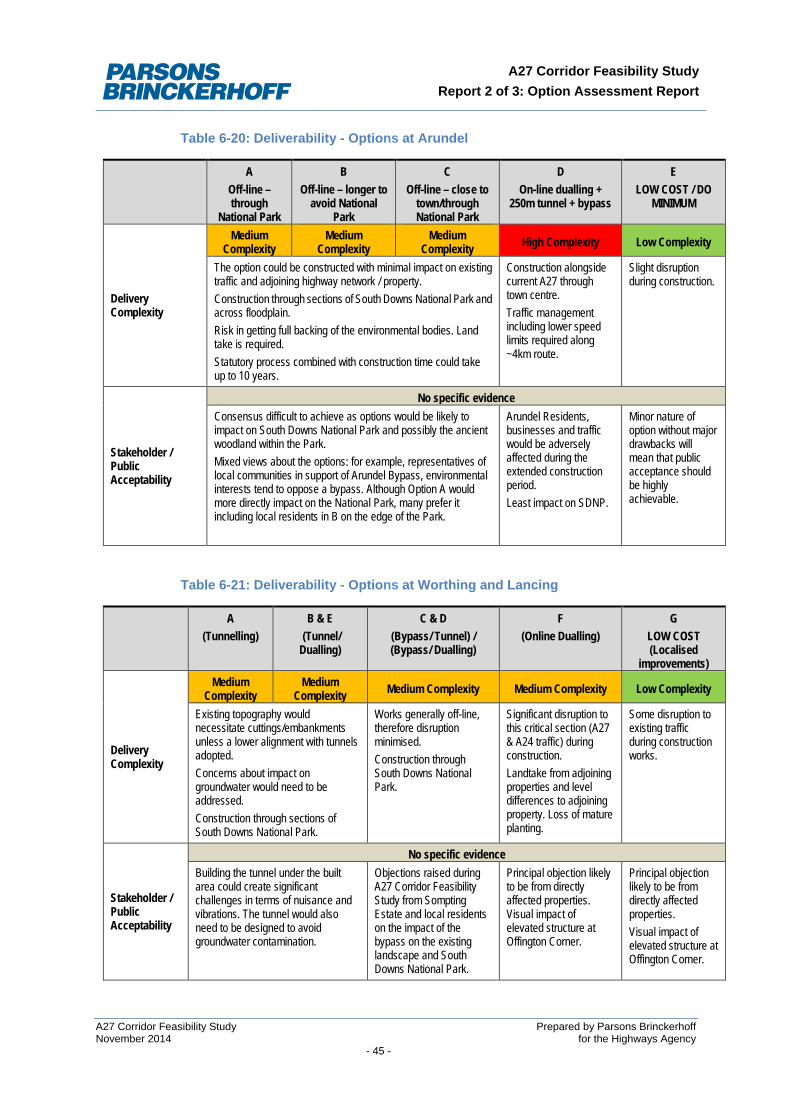
A27 Corridor Feasibility Study Report 2 of 3: Option Assessment Report
Table 6-20: Deliverability - Options at Arundel
A Off-line – through
National Park
B Off-line – longer to
avoid National Park
C Off-line – close to
town/through National Park
D On-line dualling +
250m tunnel + bypass
E LOW COST / DO
MINIMUM
Delivery Complexity
Medium Complexity
Medium Complexity
Medium Complexity High Complexity Low Complexity
The option could be constructed with minimal impact on existing traffic and adjoining highway network / property. Construction through sections of South Downs National Park and across floodplain. Risk in getting full backing of the environmental bodies. Land take is required. Statutory process combined with construction time could take up to 10 years.
Construction alongside current A27 through town centre. Traffic management including lower speed limits required along ~4km route.
Slight disruption during construction.
Stakeholder / Public Acceptability
No specific evidence Consensus difficult to achieve as options would be likely to impact on South Downs National Park and possibly the ancient woodland within the Park. Mixed views about the options: for example, representatives of local communities in support of Arundel Bypass, environmental interests tend to oppose a bypass. Although Option A would more directly impact on the National Park, many prefer it including local residents in B on the edge of the Park.
Arundel Residents, businesses and traffic would be adversely affected during the extended construction period. Least impact on SDNP.
Minor nature of option without major drawbacks will mean that public acceptance should be highly achievable.
Table 6-21: Deliverability - Options at Worthing and Lancing
A (Tunnelling)
B & E (Tunnel/ Dualling)
C & D (Bypass/ Tunnel) / (Bypass/ Dualling)
F (Online Dualling)
G LOW COST (Localised
improvements)
Delivery Complexity
Medium Complexity
Medium Complexity Medium Complexity Medium Complexity Low Complexity
Existing topography would necessitate cuttings/embankments unless a lower alignment with tunnels adopted. Concerns about impact on groundwater would need to be addressed. Construction through sections of South Downs National Park.
Works generally off-line, therefore disruption minimised. Construction through South Downs National Park.
Significant disruption to this critical section (A27 & A24 traffic) during construction. Landtake from adjoining properties and level differences to adjoining property. Loss of mature planting.
Some disruption to existing traffic during construction works.
Stakeholder / Public Acceptability
No specific evidence Building the tunnel under the built area could create significant challenges in terms of nuisance and vibrations. The tunnel would also need to be designed to avoid groundwater contamination.
Objections raised during A27 Corridor Feasibility Study from Sompting Estate and local residents on the impact of the bypass on the existing landscape and South Downs National Park.
Principal objection likely to be from directly affected properties. Visual impact of elevated structure at Offington Corner.
Principal objection likely to be from directly affected properties. Visual impact of elevated structure at Offington Corner.
A27 Corridor Feasibility Study Prepared by Parsons Brinckerhoff November 2014 for the Highways Agency - 45 -
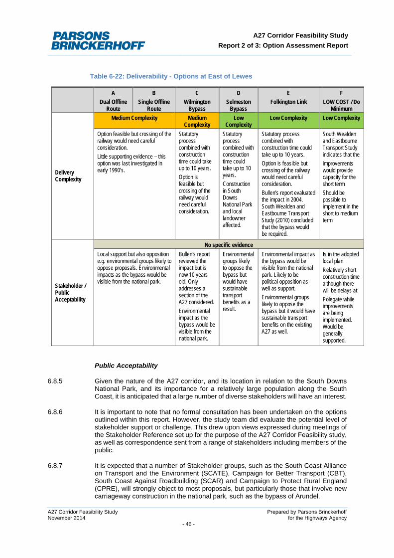
A27 Corridor Feasibility Study Report 2 of 3: Option Assessment Report
Table 6-22: Deliverability - Options at East of Lewes
A Dual Offline
Route
B Single Offline
Route
C Wilmington
Bypass
D Selmeston
Bypass
E Folkington Link
F LOW COST / Do
Minimum
Delivery Complexity
Medium Complexity Medium Complexity
Low Complexity
Low Complexity Low Complexity
Option feasible but crossing of the railway would need careful consideration. Little supporting evidence – this option was last investigated in early 1990’s.
Statutory process combined with construction time could take up to 10 years. Option is feasible but crossing of the railway would need careful consideration.
Statutory process combined with construction time could take up to 10 years. Construction in South Downs National Park and local landowner affected.
Statutory process combined with construction time could take up to 10 years. Option is feasible but crossing of the railway would need careful consideration. Bullen's report evaluated the impact in 2004. South Wealden and Eastbourne Transport Study (2010) concluded that the bypass would be required.
South Wealden and Eastbourne Transport Study indicates that the improvements would provide capacity for the short term Should be possible to implement in the short to medium term
Stakeholder / Public Acceptability
No specific evidence Local support but also opposition e.g. environmental groups likely to oppose proposals. Environmental impacts as the bypass would be visible from the national park.
Bullen's report reviewed the impact but is now 10 years old. Only addresses a section of the A27 considered. Environmental impact as the bypass would be visible from the national park.
Environmental groups likely to oppose the bypass but would have sustainable transport benefits as a result.
Environmental impact as the bypass would be visible from the national park. Likely to be political opposition as well as support. Environmental groups likely to oppose the bypass but it would have sustainable transport benefits on the existing A27 as well.
Is in the adopted local plan Relatively short construction time although there will be delays at Polegate while improvements are being implemented. Would be generally supported.
Public Acceptability
6.8.5 Given the nature of the A27 corridor, and its location in relation to the South Downs National Park, and its importance for a relatively large population along the South Coast, it is anticipated that a large number of diverse stakeholders will have an interest.
6.8.6 It is important to note that no formal consultation has been undertaken on the options outlined within this report. However, the study team did evaluate the potential level of stakeholder support or challenge. This drew upon views expressed during meetings of the Stakeholder Reference set up for the purpose of the A27 Corridor Feasibility study, as well as correspondence sent from a range of stakeholders including members of the public.
6.8.7 It is expected that a number of Stakeholder groups, such as the South Coast Alliance on Transport and the Environment (SCATE), Campaign for Better Transport (CBT), South Coast Against Roadbuilding (SCAR) and Campaign to Protect Rural England (CPRE), will strongly object to most proposals, but particularly those that involve new carriageway construction in the national park, such as the bypass of Arundel.
A27 Corridor Feasibility Study Prepared by Parsons Brinckerhoff November 2014 for the Highways Agency - 46 -
A27 Corridor Feasibility Study Report 2 of 3: Option Assessment Report
6.8.8 The South Downs National Park would object to any potential future schemes that would adversely impact upon the Park unless significant mitigation can be identified.
6.8.9 Conversely, it is anticipated that the options will obtain a substantial level of support from a range of groups including Local Authorities, Local Enterprise Partnerships, Chambers of Commerce, the Highways Agency and business groups. This would be as a result of the anticipated benefits of potential future schemes in relation to reducing journey times, improving journey time reliability / resilience of the route and the reduction in incidents expected across the corridor, all of which are anticipated to improve connectivity and facilitate subsequent economic growth.
A27 Corridor Feasibility Study Prepared by Parsons Brinckerhoff November 2014 for the Highways Agency - 47 -
A27 Corridor Feasibility Study Report 2 of 3: Option Assessment Report
7 CONCLUSIONS – IDENTIFICATION OF BETTER PERFORMING OPTIONS
This chapter provides a reminder of each stage of the sifting process and sets out the results.
7.1 Summary of Study Stage 2
7.1.1 Study Stage 2 assessed the range of infrastructure proposals that could address the challenges at the priority problem locations identified. This stage considered whether options are deliverable, affordable and offer value for money (VfM), and that were likely to achieve the intervention-specific objectives identified in Study Stage 1.
7.1.2 A range of individual investment proposals, as well as combinations of investment propositions, was considered. This approach looked to build on work done to date, rather than completing a completely fresh process of identification of investment proposals.
7.1.3 The option generation process identified an initial long list of discrete interventions at each of the three prioritised locations. Over 40 interventions - comprising a variety of online and offline solutions - were considered at a high level. Only those which met most of the intervention specific objectives and appeared deliverable and feasible were taken forward for further consideration
7.1.4 The shortlisted options were then assessed using the Department’s Early Assessment and Sifting Tool (EAST). This stage culminated in the production of this report - an Option Assessment Report, in accordance with Step 8 of the guidance in TAG unit 2.1.2.
7.1.5 The following is a brief summary of the options generation and sifting:
• Generating a long list of options - The option generation process identified an initial long list of 46 interventions at each of the three prioritised locations comprising a variety of online, offline and public transport solutions.
• Initial Sift - All the 46 interventions were considered at a high level. 20 of these, which met most of the corridor-specific study objectives and were considered potentially deliverable and feasible were taken forward, either as individual options or packages of options.
• EAST assessment - The 20 shortlisted options were assessed using EAST, resulting in 4 options being discarded and 16 options being identified for further assessment.
• Further Assessment – 16 shortlisted options were assessed using the DfT's Option Assessment Framework, with evidence presented about their strategic and economic fit, and their deliverability.
7.1.6 The following options were shortlisted into the EAST assessment:
At Arundel:
• three new bypass options - (a) partly through the National Park, (b) avoiding the National Park or (c) closer to the town limits through the National Park;
• online dualling of the existing road including a 250 metre tunnel and a short stretch of bypass;
• online improvements.
A27 Corridor Feasibility Study Prepared by Parsons Brinckerhoff November 2014 for the Highways Agency - 48 -
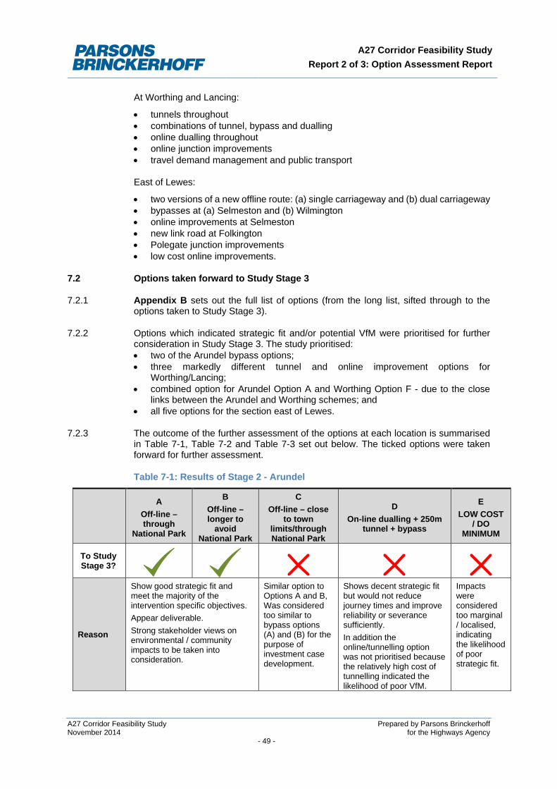
A27 Corridor Feasibility Study Report 2 of 3: Option Assessment Report
At Worthing and Lancing:
• tunnels throughout • combinations of tunnel, bypass and dualling • online dualling throughout • online junction improvements • travel demand management and public transport
East of Lewes:
• two versions of a new offline route: (a) single carriageway and (b) dual carriageway • bypasses at (a) Selmeston and (b) Wilmington • online improvements at Selmeston • new link road at Folkington • Polegate junction improvements • low cost online improvements.
7.2 Options taken forward to Study Stage 3
7.2.1 Appendix B sets out the full list of options (from the long list, sifted through to the options taken to Study Stage 3).
7.2.2 Options which indicated strategic fit and/or potential VfM were prioritised for further consideration in Study Stage 3. The study prioritised: • two of the Arundel bypass options; • three markedly different tunnel and online improvement options for
Worthing/Lancing; • combined option for Arundel Option A and Worthing Option F - due to the close
links between the Arundel and Worthing schemes; and • all five options for the section east of Lewes.
7.2.3 The outcome of the further assessment of the options at each location is summarised in Table 7-1, Table 7-2 and Table 7-3 set out below. The ticked options were taken forward for further assessment.
Table 7-1: Results of Stage 2 - Arundel
A Off-line – through
National Park
B Off-line – longer to
avoid National Park
C Off-line – close
to town limits/through National Park
D On-line dualling + 250m
tunnel + bypass
E LOW COST
/ DO MINIMUM
To Study Stage 3?
Reason
Show good strategic fit and meet the majority of the intervention specific objectives. Appear deliverable. Strong stakeholder views on environmental / community impacts to be taken into consideration.
Similar option to Options A and B, Was considered too similar to bypass options (A) and (B) for the purpose of investment case development.
Shows decent strategic fit but would not reduce journey times and improve reliability or severance sufficiently. In addition the online/tunnelling option was not prioritised because the relatively high cost of tunnelling indicated the likelihood of poor VfM.
Impacts were considered too marginal / localised, indicating the likelihood of poor strategic fit.
A27 Corridor Feasibility Study Prepared by Parsons Brinckerhoff November 2014 for the Highways Agency - 49 -
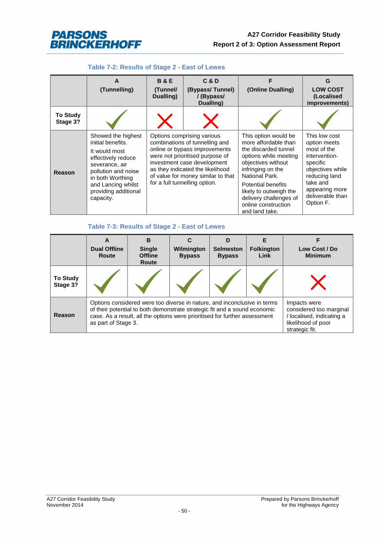
A27 Corridor Feasibility Study Report 2 of 3: Option Assessment Report
Table 7-2: Results of Stage 2 - East of Lewes
A (Tunnelling)
B & E (Tunnel/ Dualling)
C & D (Bypass/ Tunnel)
/ (Bypass/ Dualling)
F (Online Dualling)
G LOW COST (Localised
improvements)
To Study Stage 3?
Reason
Showed the highest initial benefits. It would most effectively reduce severance, air pollution and noise in both Worthing and Lancing whilst providing additional capacity.
Options comprising various combinations of tunnelling and online or bypass improvements were not prioritised purpose of investment case development as they indicated the likelihood of value for money similar to that for a full tunnelling option.
This option would be more affordable than the discarded tunnel options while meeting objectives without infringing on the National Park. Potential benefits likely to outweigh the delivery challenges of online construction and land take.
This low cost option meets most of the intervention-specific objectives while reducing land take and appearing more deliverable than Option F.
Table 7-3: Results of Stage 2 - East of Lewes
A Dual Offline
Route
B Single Offline Route
C Wilmington
Bypass
D Selmeston
Bypass
E Folkington
Link
F Low Cost / Do
Minimum
To Study Stage 3?
Reason
Options considered were too diverse in nature, and inconclusive in terms of their potential to both demonstrate strategic fit and a sound economic case. As a result, all the options were prioritised for further assessment as part of Stage 3.
Impacts were considered too marginal / localised, indicating a likelihood of poor strategic fit.
A27 Corridor Feasibility Study Prepared by Parsons Brinckerhoff November 2014 for the Highways Agency - 50 -
A27 Corridor Feasibility Study Report 2 of 3: Option Assessment Report
8 GLOSSARY
BCR: Benefit Cost Ratio.
CPRE: Campaign to Protect Rural England.
Department of Transport (DfT): The government department responsible for the English transport network.
DMRB: Design Manual for Roads and Bridges.
EAST: Early Assessment and Sifting Tool.
HA: Highways Agency.
NPV: Net Present Value.
On-line: on the existing carriageway
Off-line: away from the existing carriageway
SDNP: South Downs National Park, England’s newest national park covering an area from Winchester in the West to Eastbourne in the East.
SNCI: Site of Nature Conservation Interest.
South Coast Multi Modal Study (SoCoMMS): This 2002 study developed a transport strategy for the corridor between Southampton and Margate to address congestion, safety and environmental problems and support regeneration and economic growth. Further information available at: http://www.socomms.org.uk
Strategic Economic Plans (SEPs): Multiyear strategic ambitious and visionary economic plans document created by LEPs.
Strategic Road Network (SRN): The Strategic Road Network comprises nationally significant roads used for the distribution of goods and services, and a network for the travelling public. In legal terms, it can be defined as those roads which are the responsibility of the Secretary of State for Transport and managed by the Highways Agency.
TAG: Transport Analysis Guidance.
Trunk Road: Roads which constitute the ‘national system of roads for through traffic’ and ‘roads of national importance’.
VfM: Value for Money
WebTAG (Web Transport Analysis Guidance): The Department for Transport’s Transport Analysis Guidance, published on the web.
A27 Corridor Feasibility Study Prepared by Parsons Brinckerhoff November 2014 for the Highways Agency - 51 -
A27 Corridor Feasibility Study Report 2 of 3: Option Assessment Report
APPENDIX A: CONCEPTUAL PLANS OF BETTER PERFORMING OPTIONS
A27 Feasibility Study Prepared by Parsons Brinckerhoff November 2014 for the Highways Agency - APPENDIX 1 -
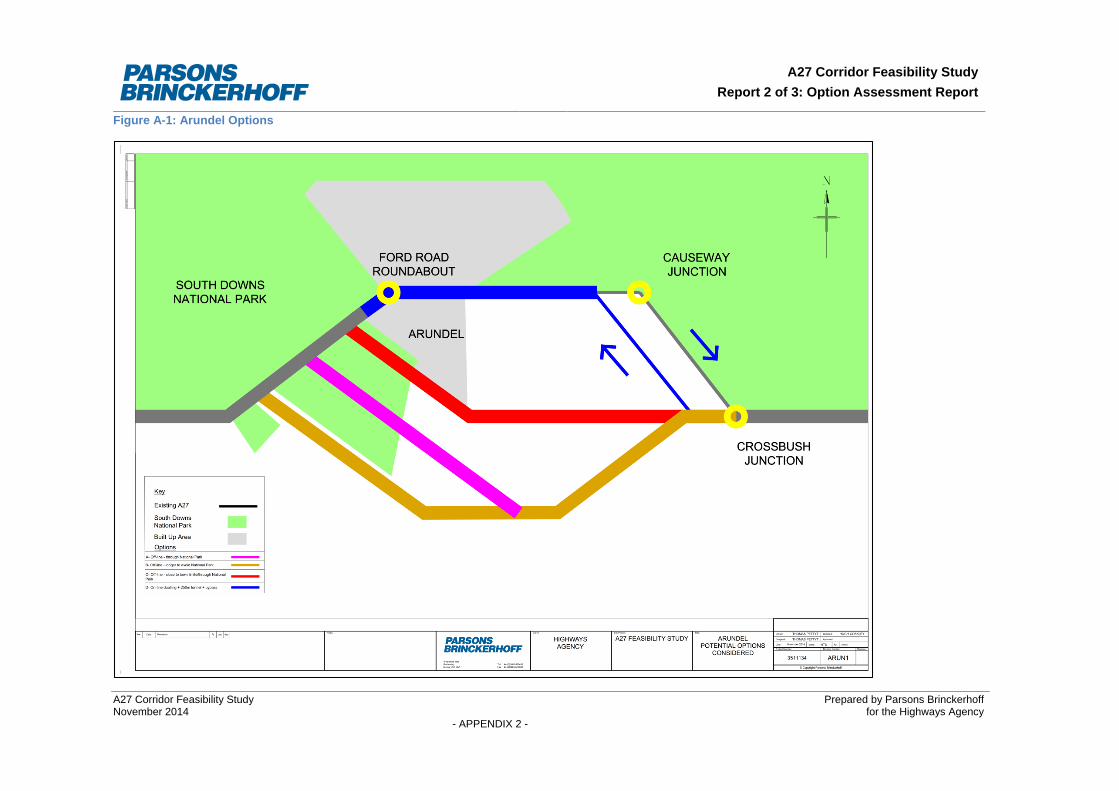
A27 Corridor Feasibility Study Report 2 of 3: Option Assessment Report
Figure A-1: Arundel Options
A27 Corridor Feasibility Study Prepared by Parsons Brinckerhoff November 2014 for the Highways Agency - APPENDIX 2 -
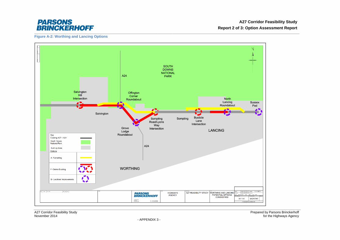
A27 Corridor Feasibility Study Report 2 of 3: Option Assessment Report
Figure A-2: Worthing and Lancing Options
A27 Corridor Feasibility Study Prepared by Parsons Brinckerhoff November 2014 for the Highways Agency - APPENDIX 3 -
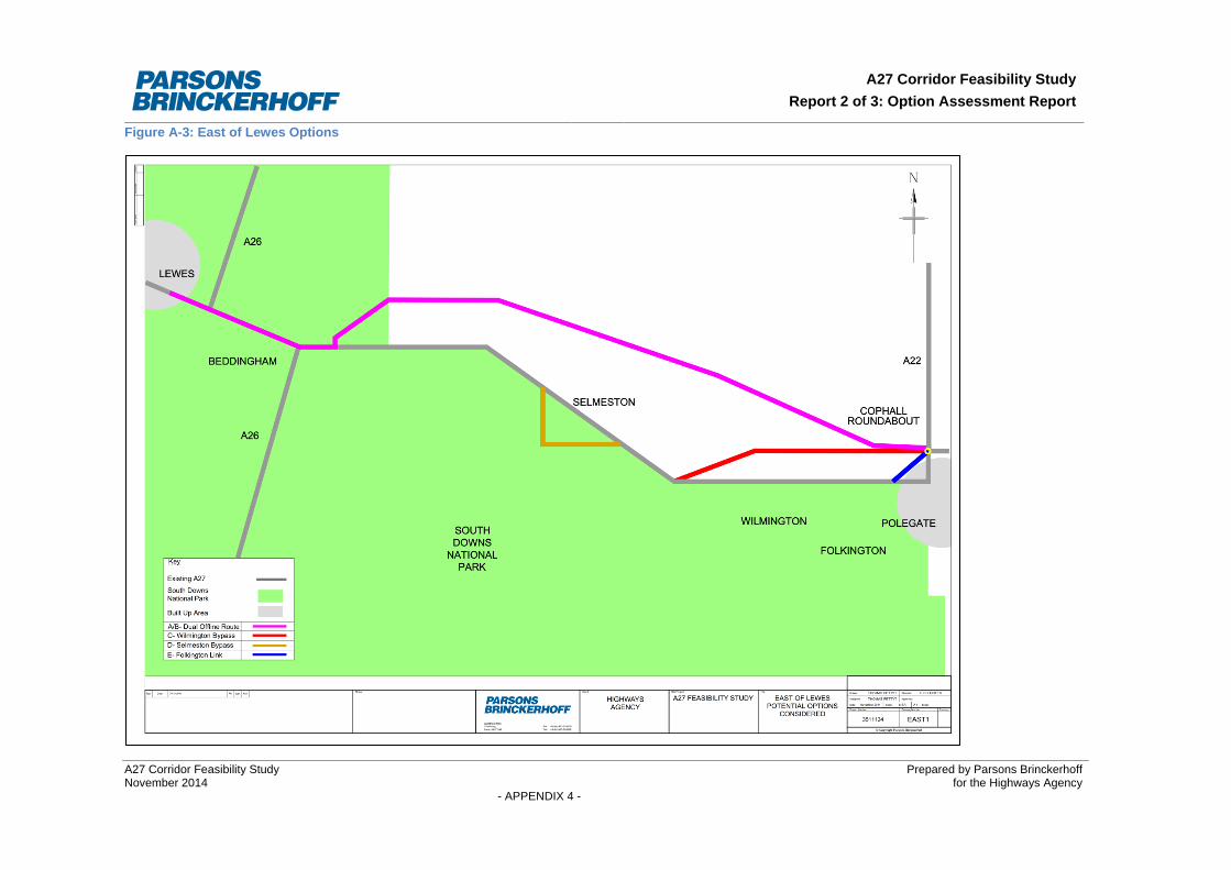
A27 Corridor Feasibility Study Report 2 of 3: Option Assessment Report
Figure A-3: East of Lewes Options
A27 Corridor Feasibility Study Prepared by Parsons Brinckerhoff November 2014 for the Highways Agency - APPENDIX 4 -

A27 Corridor Feasibility Study Report 2 of 3: Option Assessment Report
APPENDIX B: SUMMARY OF OPTIONS SIFTING
A27 Corridor Feasibility Study Prepared by Parsons Brinckerhoff November 2014 for the Highways Agency - APPENDIX 5 -
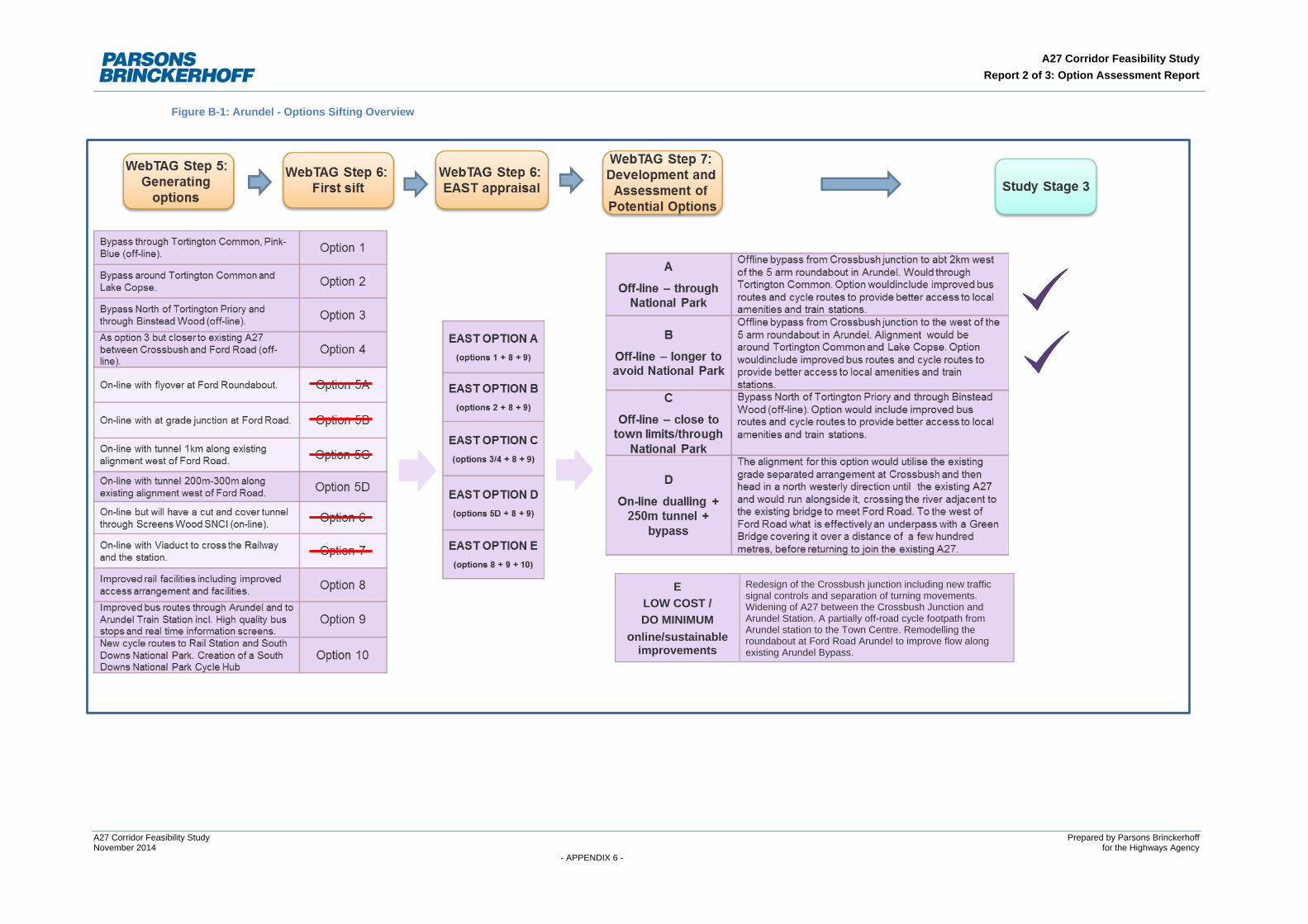
A27 Corridor Feasibility Study Report 2 of 3: Option Assessment Report
Figure B-1: Arundel - Options Sifting Overview
E LOW COST / DO MINIMUM
online/sustainable improvements
Redesign of the Crossbush junction including new traffic signal controls and separation of turning movements. Widening of A27 between the Crossbush Junction and Arundel Station. A partially off-road cycle footpath from Arundel station to the Town Centre. Remodelling the roundabout at Ford Road Arundel to improve flow along existing Arundel Bypass.
A27 Corridor Feasibility Study Prepared by Parsons Brinckerhoff November 2014 for the Highways Agency - APPENDIX 6 -
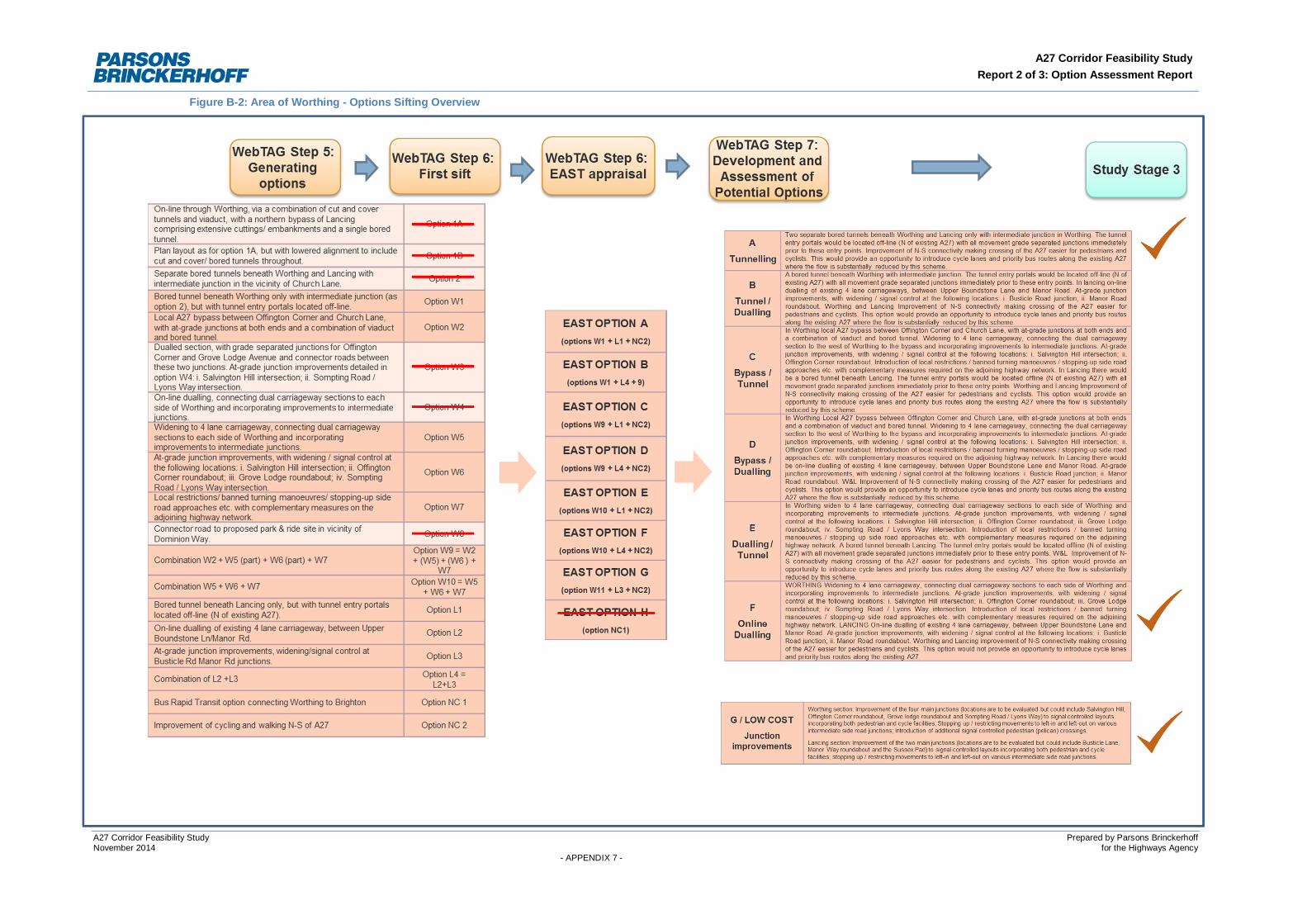
A27 Corridor Feasibility StudyReport 2 of 3: Option Assessment Report
A27 Corridor Feasibility Study Prepared by Parsons BrinckerhoffNovember 2014 for the Highways Agency
- APPENDIX 7 -
Figure B-2: Area of Worthing - Options Sifting Overview
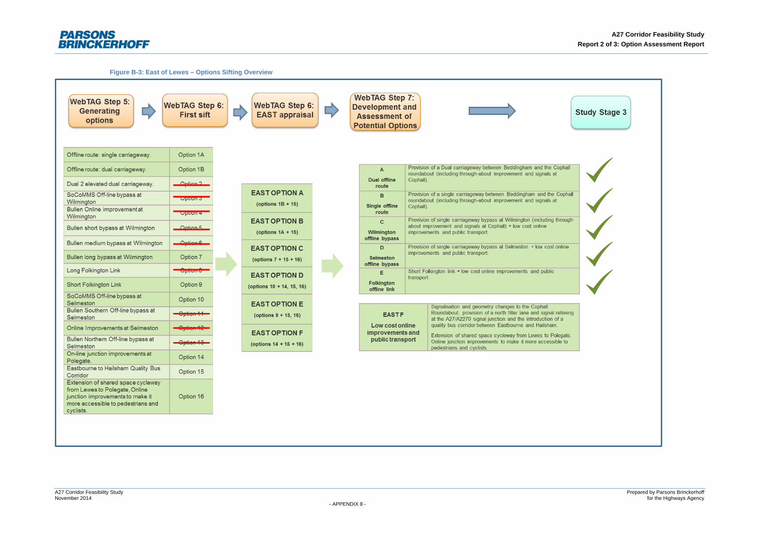
A27 Corridor Feasibility Study Report 2 of 3: Option Assessment Report
Figure B-3: East of Lewes – Options Sifting Overview
A27 Corridor Feasibility Study Prepared by Parsons Brinckerhoff November 2014 for the Highways Agency - APPENDIX 8 -

A27 Corridor Feasibility Study Prepared by Parsons Brinckerhoff November 2014 for the Highways Agency - APPENDIX 9 -