Embed Size (px)
Citation preview
NatureServe MACA – AA December 2010 i
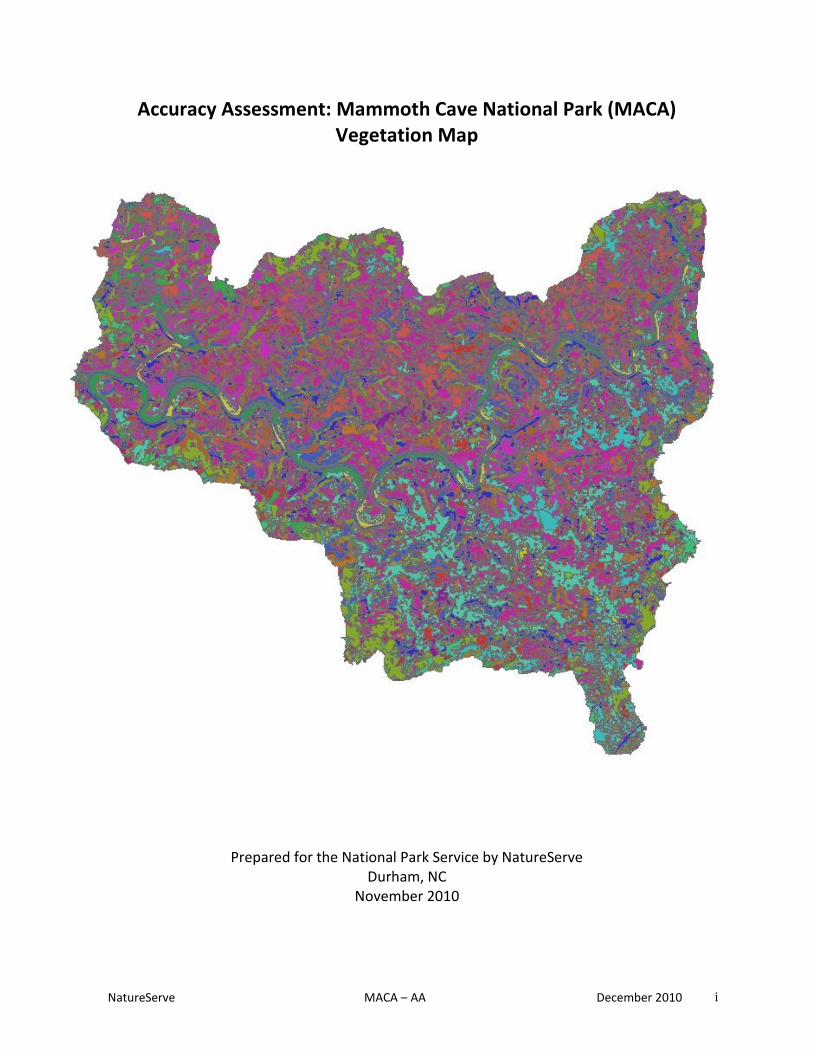
Accuracy Assessment: Mammoth Cave National Park (MACA) Vegetation Map
Prepared for the National Park Service by NatureServe
Durham, NC November 2010
NatureServe MACA – AA December 2010 ii
NatureServe is a non-profit organization providing the scientific knowledge that forms the basis for effective conservation action. A NatureServe Technical Report Prepared for the National Park Service under Cooperative Agreement H 5028 01 0435 Citation: Smart, Lindsey and R. White. 2010. Accuracy Assessment: Mammoth Cave National Park. NatureServe: Durham, North Carolina. © 2010 NatureServe
NatureServe 6114 Fayetteville Road, Suite 109 Durham, NC 27713 919-484-7857 International Headquarters 1101 Wilson Boulevard, 15th Floor Arlington, VA 22209 www.natureserve.org National Park Service Southeast Regional Office Atlanta Federal Center 1924 Building 100 Alabama St., S.W. Atlanta, GA 30303 404-562-3163
The view and conclusions contained in this document are those of the authors and should not be interpreted as representing the opinions or policies of the U.S. Government. Mention of trade names or commercial products does not constitute their endorsement by the U.S. Government. Electronic files have been provided to the National Park Service in addition to hard copies. Current information on all vegetation communities mentioned in this report can be found on NatureServe Explorer at www.natureserve.org/explorer.

NatureServe MACA – AA December 2010 iii
Acknowledgements This report was prepared in cooperation with the Cumberland Piedmont Inventory and Monitoring Network, National Park Service, Department of the Interior. Network coordinator Teresa Leibfreid and her capable colleagues and staff with the Cumberland Piedmont Network cooperated in tasks ranging from data collection in the field to review of draft reports. Special thanks go to NPS staff Bill Moore, Johnathan Jernigan, Larry Johnson, Rick Olson, Steve Thomas, and Lillian Scoggins for their support related to data collection and GIS. In addition, we thank Leslie Meng, and John Hutcherson for their assistance in the field. Marguerite Madden, Director of the Center for Remote Sensing and Mapping Science (CRMS) at the University of Georgia (UGA), Tommy Jordan, the Associate Director of CRMS, and Phyllis Jackson, a photointerpreter/ecologist at CRMS, were actively involved in the creation of the vegetation map. We’re grateful for their help in providing data and answering the questions that arose in the process of conducting the accuracy assessment. Several other NatureServe Southeast staff assisted with various aspects of this accuracy assessment. We thank Milo Pyne, Carl Nordman, Erin Lunsford Jones, and Mary Russo for their assistance with assessment point selection, field data collection, data entry, and data analysis. Others involved with field work include: Alex Siefert, Clare Frederick, Ana Casillas, Kelley Phifer, Mike Luciano, Michael Rotter, Nao Fukubayashi, Eli Schewel, Sean Hutchison, and Shannon Mathey. We very much appreciate all of their assistance in the field in the summer of 2010.

NatureServe MACA – AA December 2010 iv
Table of Contents
ACKNOWLEDGEMENTS ......................................................................................................................................... III
EXECUTIVE SUMMARY ........................................................................................................................................... 5
KEY FINDINGS: ............................................................................................................................................................... 7
INTRODUCTION ..................................................................................................................................................... 8
METHODS .............................................................................................................................................................. 8
SITE SELECTION .............................................................................................................................................................. 9 FIELD DATA COLLECTION ................................................................................................................................................ 10 DATA ANALYSIS ............................................................................................................................................................ 10
Table 1. A sample contingency matrix with shaded cells representing correctly classified points. .................... 11
RESULTS ............................................................................................................................................................... 11
DISCUSSION ......................................................................................................................................................... 13
KEY FINDINGS: ............................................................................................................................................................. 14
REFERENCES ........................................................................................................................................................ 16
APPENDIX A: REVISED CLASSIFICATION KEY FOR MAMMOTH CAVE NATIONAL PARK ........................................ A-1
FIELD KEY TO THE NATIONAL VEGETATION CLASSIFICATION (NVC) ASSOCIATIONS AT MAMMOTH CAVE NATIONAL PARK .............. A-2
APPENDIX B: CONTINGENCY MATRICES ACCURACY TABLES FOR MAMMOTH CAVE NATIONAL PARK ................ B-1
TABLE 1: LIST OF CEGL CODES FOR MAMMOTH CAVE NATIONAL PARK AND ASSOCIATED NVC COMMUNITY TYPE NAME ............. B-2 TABLE 2: CONTINGENCY MATRIX CONSIDERING MATCHES WITH GROUPED CLASSES & DOMINANT/SECONDARY VEGETATION CLASSES. ............................................................................................................................................................................... B-3 TABLE 3: ERROR SUMMARIES FOR GROUPED CLASSES AND DOMINANT/ SECONDARY VEGETATION CLASSES. ............................... B-4 TABLE 4: CONTINGENCY MATRIX CONSIDERING MATCHES WITH DOMINANT/SECONDARY VEGETATION CLASSES .......................... B-5 TABLE 5: ERROR SUMMARIES FOR DOMINANT/SECONDARY VEGETATION CLASSES .................................................................. B-6 TABLE 6: CONTINGENCY MATRIX CONSIDERING DOMINANT VEGETATION MAPPED CLASSES ONLY ............................................ B-7 TABLE 7: ERROR SUMMARIES FOR DOMINANT MAPPED VEGETATION CLASSES ....................................................................... B-8
APPENDIX C: ERROR SUMMARIES FOR RESULTS AT MAMMOTH CAVE NATIONAL PARK .................................... C-1
FIGURE 1: GRAPH DISPLAYING ERROR SUMMARY RESULTS FOR ANALYSIS USING DOMINANT VEGETATION CLASSES ONLY. ................. C-2 FIGURE 2: GRAPH DISPLAYING ERROR SUMMARY RESULTS FOR ANALYSIS USING DOMINANT/SECONDARY VEGETATION CLASSES. ....... C-3 FIGURE 3: GRAPH DISPLAYING ERROR SUMMARY RESULTS FOR ANALYSIS USING GROUPED VEGETATION CLASSES………………………….C-4

NatureServe MACA – AA December 2010 5
EXECUTIVE SUMMARY
This report presents the accuracy assessment for the digital vegetation map of Mammoth Cave National Park (MACA). Vegetation at MACA was mapped by The University of Georgia Center for Remote Sensing and Mapping Science (Jordan and Madden 2010) with ecological consultation and assistance from NatureServe. The mapping was conducted as part of the National Park Service Vegetation Mapping Program. The map accuracy was assessed by comparing mapped vegetation types to field verified vegetation types at randomized evaluation points. The evaluation points were chosen prior to field work using statistical methods to ensure full representation of the range of map classes in the park. An accuracy measure was calculated for each individual map class and an overall accuracy measure was calculated for all map classes combined. The accuracy assessment procedure is intended to quantify the overall usability of the digital vegetation map and the associated map classes. The process is actually not intended to exclusively judge the performance of the mapper or the ecologists on the project since error can be caused at any point during the mapping and accuracy assessment process. Remotely-sensed imagery is limited in its ability to differentiate between certain forest types and even the most experienced mappers cannot differentiate between certain species of oaks or pines in a remotely sensed image. Sources of error for the mapping project are varied and include more than solely “remote sensing error” but also include “ecologist error” caused by poor interpretation of the vegetation community concept, “field worker error” caused by mistakes made by fieldworkers while collecting the data (including misreading of the key), and temporal error when conditions on the ground change between the mapping and assessment processes. It is difficult to isolate a single error that is causing accuracy issues without more research. The accuracy assessment, therefore, should be used more as a tool to discern usability of map classes rather than a way to judge the performance of the mapmakers. The University of Georgia (UGA) Team focused on generating the highest level of detail possible during park vegetation mapping to provide the most accurate information for the National Park Service. As a consequence, assessment of the finished project requires a two step approach: (1) assessing the overall accuracy of the finest-scale map produced, and (2) combining the most “confused” map classes to determine the accuracy measures at coarser scales. The report provides the best approximation of individual map class accuracy and also suggests combinations of map classes to produce a more reliable map at a coarser scale. For MACA, the overall accuracy of the final map, which includes eight map classes (six grouped map classes and two singular map classes), is 75.4%, with a kappa statistic of 60.3%(0.603). This version of the map is the most appropriate for use by the standard user; what it misses in fine-scale detail, it makes up for in the relatively high level of accuracy of map classes. Vegetation associations displayed as grouped map classes on the coarse-scale map include:

NatureServe MACA – AA December 2010 6
a. Mixed Mesophytic Hardwood and Hemlock Class: Beech-Maple Unglaciated Forest (CEGL002411); Eastern Hemlock Hardwood Forest (CEGL005043); Rich Appalachian Red Oak/Sugar Maple Forest (CEGL007698); and Central Interior Beech -White Oak Forest (CEGL007881).
b. Sinkhole Ponds: Sinkhole Pond Marsh (CEGL002413) and Buttonbush Sinkhole Pond Swamp (CEGL004742).
c. Pine and Red-cedar Dominated Upland Forests Class: Virginia Pine Successional Forest (CEGL002591); Shortleaf Pine Early-Successional Forest (CEGL006327); Appalachian Low-Elevation Mixed Pine/Hillside Blueberry Forest (CEGL007119); Virginia Pine-Red-cedar Successional Forest (CEGL007121); and Red-cedar Successional Forest (CEGL007124).
d. Old Fields, Shrublands, and Prairie Class: Successional Broomsedge Vegetation (CEGL004044); Cultivated Meadow (CEGL004048); Kentucky Mesic Tallgrass Prairie (CEGL004677); Blackberry-Greenbrier Successional Shrubland Thicket (CEGL004732); and Little Bluestem-Broomsedge Grassland (CEGL007707).
e. Bottomland/Floodplain Forest, Successional Sweetgum, and Walnut Class: Successional Sweetgum Forest (CEGL007216); Interior Mid-to-Late Successional Sweetgum-Oak Forest (CEGL007217); Successional Sweetgum floodplain Forest (CEGL007330); Sycamore-Silver Maple Calcareous Floodplain Forest (CEGL007334); Successional Black Walnut Forest (CEGL007879); Rich Levee Mixed Hardwood Bottomland Forest (CEGL008429); and Shumard Oak-Chinquapin Oak Mesic Limestone (CEGL008442).
f. Oak and Hickory Dominated Upland Forest and Tuliptree Successional Forest Class: White Oak-Mixed Oak Dry-Mesic Dry-Mesic Alkaline Forest (CEGL002070); Pin Oak Mixed Hardwood Forest (CEGL002432); Nashville Basin Shingle Oak-Shumard Oak-Chinquapin Oak Forest (CEGL003876); Southeastern Successional Black Cherry Forest (CEGL004133); Southern Red Oak Flatwoods Forest (CEGL004412); Western Highland Rim Escarpment Post Oak Barrens (CEGL004686); Nashville Basin Mesic Sugar Maple-Hickory Forest (CEGL004741); Southern Red Oak-Mixed Oak Forest (CEGL005018); Interior Low Plateau Chestnut Oak Forest (CEGL005022); Successional Tuliptree Forest (Rich Type) (CEGL007220); Successional Tuliptree Forest (Typic Type) (CEGL007221); Interior Low Plateau Chestnut Oak –Mixed Oak Forest (CEGL007700); and Interior Dry-Mesic White Oak-Hickory Forest (CEGL007795).
The accuracy assessment for this version of the map considered points as a match if the vegetation observed on the ground matched any of the dominant or secondary vegetation types attributed to the map by the mapmaking team. Then the most commonly confused vegetation classes were grouped together to increase accuracy to an acceptable level. A stricter analysis of the data (before combining map classes) was completed in the initial stages of this analysis. However, this stricter analysis only considered a point as a match if the vegetation observed on the ground matched any of the dominant or secondary vegetation type attributed by the mappers. The accuracy of this map was only 42.4% overall with a kappa statistic of 35.7% (0.357). The initial analysis considering a match only if the dominant vegetation type in the field matched the dominant

NatureServe MACA – AA December 2010 7
vegetation type on the map had the lowest overall accuracy. The overall accuracy for this analysis was 41.2% with a kappa statistic of 34.4% (0.344). The lower accuracy measures from the initial stages of the analyses reflect the difficulty in differentiating the vegetation associations that were combined in the final analysis because of similarities in composition and/or in appearance on aerial photography.
Key findings:
For users interested in preserving the full detail of the map for highly detailed studies or management of the landscape, we recommend use of the fine-scale map as published by UGA. For all other users, we recommend combining map classes as specified above to allow for an overall map accuracy near 80%. In this way, the vegetation maps are useful for a broad audience yet retain potentially important fine-scale detail for interested scientists and managers. If resources become available to improve the map, we recommend that an effort is made to better differentiate the tuliptree and black walnut dominated types in the park (CEGL007220, CEGL007221, and CEGL007879) from the other map classes. This may require a revision of the key so that the types in question are contrasted more effectively with other types and/or remapping of these areas to attain a higher accuracy. Many other vegetation community types in this study had equally low accuracies. However, the tuliptree and walnut types in other park accuracy assessment projects for this network have generally been easily distinguished from the rest of the vegetation communities at each park. The fact that they are so confused at MACA but not at other parks indicates that their mapping error may be easier to address than other map classes.

NatureServe MACA – AA December 2010 8
INTRODUCTION
In 1994, the National Park Service (NPS) and the U.S. Geological Survey (USGS) embarked on a collaborative Vegetative Mapping project to catalog and map the biodiversity of the United States. The goal of the project was to map the 230+ park units within the United States (ESRI et al. 1994). As part of this national mapping initiative, a digital vegetation map of Mammoth Cave National Park (MACA) was completed in by the University of Georgia Center for Remote Sensing and Mapping Science (Jordan and Madden 2010), in consultation with NatureServe. The mapping effort included collection of field data, interpretation of aerial photography, and polygon attribution to GIS maps. Mammoth Cave National Park (MACA) is located in south-central Kentucky, primarily in Edmonson County, with smaller portions in Hart and Barren counties. Mammoth Cave was authorized as a National Park in 1941, designated as a World Heritage Site in 1981, and as an International Biosphere Reserve in 1990. The National Park comprises 21,380 ha (52,830 ac) and contains the longest recorded cave system in the world with more than 538 km explored and mapped. Geologists estimate an additional 960 km or more of remaining undiscovered passageways. The cave ecosystem is considered one of the world’s most diverse, but Mammoth Cave National Park also exhibits tremendous above-ground diversity. As an example, the Park’s numerous bluffs, sinkholes, cave entrances, fields, river system components, and ridgetops all are habitats that host a suite of unique plant and animal communities. The Green River, which is the main watercourse through the Park, is known as one of the most diverse rivers in North America, containing 82 fish species and providing habitat for federally endangered freshwater mussels. MACA features mostly second-growth forests and small areas of old growth. Upland forests are dominated by oaks (Quercus species) with hickories (Carya species) and other hardwoods. Beech-dominated and other mesophytic upland forests are confined to ravines and sheltered lower slopes. The floodplain forests along the Green River and its tributaries are typically dominated by species such as sycamore (Platanus occidentalis), silver maple (Acer saccharinum), sugarberry (Celtis laevigata), box-elder (Acer negundo), river birch (Betula nigra), and other floodplain species. Old fields and successional forests cover much of the Park. These sites are largely dominated by eastern red-cedar and/or Virginia pine mixed with deciduous trees along their outer margins. Accuracy assessments assign a measure of validity to the map product. These assessments allow users to understand the reliability with which the vegetation class mapping captures actual conditions on the ground. Knowledge of map accuracies enables potential users to determine the suitability of the map for any particular application (ESRI et al. 1994). This report describes the methods used in the accuracy assessment for MACA and the results for each map class. METHODS
The thematic accuracy of the map was assessed by visiting a representative sample of evaluation points and comparing the vegetation type shown on the map to the vegetation type identified on the ground. When polygons representing vegetation types are mapped and labeled with the correct community types, then the map has high thematic accuracy. For each map class, both producer’s and user’s accuracy are evaluated. User’s accuracy is defined as the prediction of the percentage of points mapped as a certain type which is confirmed to belong to that

NatureServe MACA – AA December 2010 9
mapped vegetation type through on-the-ground visits. In other words, user’s accuracy is a measure of the reliability of the map to predict what is found on the ground (i.e. how likely the map user is to encounter correct information while using the map). Producer’s accuracy is defined as the percentage of points observed to be of a given vegetation type in the field that are correctly mapped to that type. In other words, producer’s accuracy is a measure of the reliability of the aerial photo-interpretation to distinguish the vegetation types (i.e. how well the map maker was able to represent the ground features). In addition to the user’s and producer’s accuracy, measures of the overall map accuracy are calculated, and contingency tables showing the frequency of confusion (i.e. misclassification) between associations are presented.
Site Selection
Site selection followed a point-based approach to assess the accuracy of the map classes, with one or more evaluation points representing each map class. Different vegetation types are represented in the map as polygons, with one or more polygons for each type. Points were selected from within those polygons using a GRTS selection approach which bases point selection on a generalized random tessellation stratified (GRTS) design. Because representative points, not entire polygons, were evaluated, the assessment results should be interpreted as a measure of the accuracy of the overall map class, rather than an assessment of whether whole polygons were classified correctly. For the MACA accuracy assessment, 778 points representing 37 vegetation types were evaluated. In the mapping process, UGA assigned a dominant vegetation association based on the U.S. National Vegetation Classification (NVC) for each polygon. A few polygons were also assigned secondary associations because of perceived ecotones, inclusions smaller than the minimum mapping unit, areas with active succession, or in blended vegetation types. For the selection of evaluation points, only the dominant vegetation type was considered. Points were distributed across dominant vegetation types, with the number of points in each class determined by and distributed proportionally to the area of these vegetation classes within the park (ESRI et al. 1994, NatureServe 2007) within the constraints that no more than 30, and no less than 5, points be located in a given class. (Note, some classes ultimately had fewer than five points when the very small size of the mapped area precluded placement of five points while maintaining minimum separation distances).Classes that took up a significantly larger portion of the park had more assessment points than classes that represented a small portion of the park. Each point was assigned a weight during the GRTS selection process based on the area of the mapped class and the number of points assigned to it; these weights are indicative of the proportion of the map a given point represents. These weights were applied during data analysis to provide more accurate representations of individual and overall accuracy measures. Locations of evaluation points were generated using the spsurvey package in the statistical software package “R Project for Statistical Computing” (R Development Core Team, 2008). Points were excluded from a 12 meter internal buffer around the boundary of each vegetation polygon to ensure that points were within polygons and to avoid misclassification due to GPS error in the field. In some instances, the size and shape of the vegetation polygons prevented selection of an adequate number of points outside the buffered area. Polygons smaller than 0.045 hectares (452 square meters) with assessment points were flagged for special consideration by the field crew because there was increased potential that GPS error could lead to assessment of an unintended polygon. A distance of at least 80 meters was maintained between adjacent points to prevent overlap in the area evaluated around each point.

NatureServe MACA – AA December 2010 10
Field Data Collection
Field crews located each evaluation point using a WAAS-enabled Garmin 5 GPS unit or comparable unit. Wide Area Augmentation System (WAAS) is a form of Differential GPS, which provides enhanced positional accuracy. At each point, the field crew recorded new coordinates, GPS positional accuracy, and collected limited vegetation data. When collecting vegetation data for accuracy points, the assessment area was the 40 meter radius circle around each point. The primary association type at that point was determined by the field crew using an existing key to the ecological and human influenced communities at MACA, and a “fit” value of high, medium, or low was also selected to characterize the fit of the classification key description. If confidence and fit were considered high, no additional information was required to be taken. If confidence and fit were not high, we asked data collectors to record dominant and diagnostic species for each stratum. The classification key used in the field can be found in Appendix A. In some cases, a secondary or alternate association was also recorded, and notes were taken on any difficulties keying out the point. A total of 778 data points with field data were used for the assessment of thematic accuracy.
Data Analysis
Contingency tables were generated summarizing misclassification rates for each vegetation type. User’s and producer’s accuracy for each vegetation type and overall accuracy of the map including the kappa statistic (Cohen 1960) were calculated. Two scenarios were analyzed using the data. The first scenario was a strict interpretation of map accuracy at the finest scale. An evaluation point was considered correctly classified only if the dominant vegetation type assigned on the map matched the observed value on the ground. The second scenario considered a point a match if the dominant, secondary, or tertiary vegetation type assigned to the mapped polygon matched the observed type and also combined map classes into broader groups when evaluation of the first scenario results indicated they were difficult to differentiate. If questions arose with regard to the proper assignment of a point to a map class, the supplemental notes recorded by the field crew were also considered. In addition, any points that fell within the 12 meter polygon edge buffer (as sometimes happened when gps measurements in the field resulted in an off-set to the planned point location) observed to have the same type as that of an adjacent mapped polygon were either regarded as correct or discarded in the third analysis.
A contingency matrix was constructed for each scenario. This table lists sample data (i.e. mapped values) as rows and reference data (i.e. the type observed in the field) as columns. An example of a contingency matrix is presented below (Table 1). Cell values equal the number of points mapped or field-verified as belonging to that type, with numbers along the diagonal representing correctly classified points, and all others cells representing misclassifications. In this example, four of the five evaluation points mapped as belonging to Class B were mapped correctly, while the fifth point was found to belong to Class D in the field. In addition, the field crew identified two evaluation points that were mapped as Class C but were shown to belong in Class B in the field. They also identified three evaluation points that were mapped in class D but were shown to belong in class C in the field. Examining the contingency table in this manner allows the users to discern patterns in misclassifications between classes.

NatureServe MACA – AA December 2010 11
Table 1. A sample contingency matrix with shaded cells representing correctly classified points.
Observed as: Row Totals
A B C D
Map
ped
as:
A 5 0 0 0 5
B 0 4 0 1 5
C 0 2 8 0 10
D 0 0 3 2 5
Column Totals 5 6 11 3 25
User’s and producer’s accuracy were derived from the values in the contingency table. Producer’s accuracy, or (1 - errors of omission), is calculated by dividing the number of correctly classified points for a map class by the total number of points determined to belong to that class in the field (i.e. the column total). In our example, the producer’s accuracy for Class B is 4 divided by 6, or 67%. User’s accuracy (1 - errors of commission) is determined by dividing the number of correctly classified points in one map class by the total number of evaluation points originally generated for that class (i.e. the row total). In our example, the users’ accuracy for Class B is 4 divided by 5, or 80%. Overall map accuracy was determined by dividing the number of correct points by the total number of points assessed. A kappa statistic, which takes into account that some polygons are correctly classified by chance (ESRI et al. 1994, Foody 1992), was also calculated. The overall accuracy and kappa statistic were calculated based on all map classes for all three analysis scenarios. The weights assigned to each point during the GRTS selection process were used in the calculation of user’s, producer’s, and overall accuracy as well as for the kappa statistic. The application of such weights incorporates the inclusion probability of each point and allows for a more accurate representation of total map accuracy. RESULTS
The overall accuracy of the final MACA vegetation map, which considered dominant, secondary, or tertiary vegetation types as well as several combined map classes, is 75.4% with a kappa statistic of 60.3%(0.603). The tabulation of user’s and producer’s accuracy for each map class in this version of the analysis is provided in Appendix B, Table 3. Groupings were created based on a review of the contingency matrix for the original fine-scale analysis. Grouped associations included:
a. Mixed Mesophytic Hardwood and Hemlock Class: Beech-Maple Unglaciated Forest (CEGL002411); Eastern Hemlock Hardwood Forest (CEGL005043); Rich Appalachian Red Oak/Sugar Maple Forest (CEGL007698); and Central Interior Beech -White Oak Forest (CEGL007881).

NatureServe MACA – AA December 2010 12
b. Sinkhole Ponds: Sinkhole Pond Marsh (CEGL002413) and Buttonbush Sinkhole Pond Swamp (CEGL004742).
c. Pine and Red-cedar Dominated Upland Forests Class: Virginia Pine Successional Forest (CEGL002591); Shortleaf Pine Early-Successional Forest (CEGL006327); Appalachian Low-Elevation Mixed Pine/Hillside Blueberry Forest (CEGL007119); Virginia Pine-Red-cedar Successional Forest (CEGL007121); and Red-cedar Successional Forest (CEGL007124).
d. Old Fields, Shrublands, and Prairie Class: Successional Broomsedge Vegetation (CEGL004044); Cultivated Meadow (CEGL004048); Kentucky Mesic Tallgrass Prairie (CEGL004677); Blackberry-Greenbrier Successional Shrubland Thicket (CEGL004732); and Little Bluestem-Broomsedge Grassland (CEGL007707).
e. Bottomland/Floodplain Forest, Successional Sweetgum, and Walnut Class: Successional Sweetgum Forest (CEGL007216); Interior Mid-to-Late Successional Sweetgum-Oak Forest (CEGL007217); Successional Sweetgum floodplain Forest (CEGL007330); Sycamore-Silver Maple Calcareous Floodplain Forest (CEGL007334); Successional Black Walnut Forest (CEGL007879); Rich Levee Mixed Hardwood Bottomland Forest (CEGL008429); and Shumard Oak-Chinquapin Oak Mesic Limestone (CEGL008442).
f. Oak and Hickory Dominated Upland Forest and Tuliptree Successional Forest Class: White Oak-Mixed Oak Dry-Mesic Dry-Mesic Alkaline Forest (CEGL002070); Pin Oak Mixed Hardwood Forest (CEGL002432); Nashville Basin shingle Oak-Shumard Oak-Chinquapin Oak Forest (CEGL003876); Southeastern Successional Black Cherry Forest (CEGL004133); Southern Red Oak Flatwoods Forest (CEGL004412); Western Highland Rim Escarpment Post Oak Barrens (CEGL004686); Nashville Basin Mesic Sugar Maple-Hickory Forest (CEGL004741); Southern Red Oak-Mixed Oak Forest (CEGL005018); Interior Low Plateau Chestnut Oak Forest (CEGL005022); Successional Tuliptree Forest (Rich Type) (CEGL007220); Successional Tuliptree Forest (Typic Type) (CEGL007221); Interior Low Plateau Chestnut Oak –Mixed Oak Forest (CEGL007700); and Interior Dry-Mesic White Oak-Hickory Forest (CEGL007795).
A stricter analysis, which considered dominant or secondary vegetation types but no combined map classes, produced an overall accuracy of 42.4% with a kappa statistic of 35.7% (0.357) (Appendix B, Table 5). The strictest analysis, which considered dominant vegetation classes only, produced an overall accuracy of 41.2% with a kappa statistic of 34.4% (0.344) (Appendix B, Table 7). Confidence intervals for user’s and producer’s accuracy were not calculated for MACA because of the range in size of the map classes and because those classes with a smaller number of assessment points per map class inflate the size of the confidence interval and thus limit its usefulness for meaningful interpretation. It is apparent from the comparison of accuracies (Appendix B Table 3, Appendix B Table 5) that overall map accuracy is considerably higher when classes are grouped than when dominant/secondary mapped vegetation classes alone are considered. The fine-scale detail that is available to users of the ungrouped map classes will be invaluable to researchers and managers interested in distinct vegetation associations. However, due to the error inherent in mapping at such fine-scale, it is important that the user take into account the misclassification rates shown on the contingency tables in Appendix B when using this version of the map. Because much higher accuracies are achieved when vegetation types are

NatureServe MACA – AA December 2010 13
grouped, we recommend that users who are less inclined to explore the accuracy assessment in depth be guided to use the coarser scale, higher accuracy version of the map. DISCUSSION Overall, the vegetation map for Mammoth Cave National Park provides a relatively accurate representation of broad vegetation types within the park. Some of the individual assessed map classes attained high user’s accuracies. High accuracy individual map classes included Virginia Pine Successional Forest (CEGL002591), Appalachian Low-Elevation Mixed Pine/Hillside Blueberry Forest (CEGL007119), Red-cedar Successional Forest (CEGL007124), Sycamore-Silver Maple Calcareous Floodplain Forest (CEGL007334), and Cultivated Meadow (CEGL004048). Some map classes found at MACA exhibit mimic the patterns of accuracy they exhibit when found in other CUPN parks. For instance, at MACA, upland oak-hickory types were confused with one another at a fairly high rate. No individual oak-hickory map classes attained an initial accuracy higher than 50%. As a consequence, they were all combined to help us attain our final 75% user’s accuracy. Similarly, in every other park in the network, oak-hickory types have been combined into one, two, or three broad classes before attaining 80% accuracy. This confusion of oak-hickory types has occurred at all other 13 CUPN parks as well. Finally, a few map classes behaved differently in this park than in the previous 13 CUPN parks where we have completed accuracy assessments. In other CUPN parks, successional tuliptree and black walnut types were consistently high accuracy classes. If they were confused with any class in other parks, it was typically with bottomland hardwood types. However, at MACA, tuliptree and black walnut types (CEGL007220, CEGL007221, CEGL007879) were equally confused with oak-hickory uplands, mixed mesophytic forests, and bottomland forests. This meant that combining them with other groups for the final map did not significantly impact the overall user’s accuracy. When we isolated this issue by analyzing all the AA data but that of tuliptree and walnut dominated types, our overall accuracy for the park rose from 75% to 79%. This is a significant finding because it demonstrates that error identified by these three mapping types has caused a large amount of the overall map error. Low map accuracies can arise from a variety of error sources. One source that contributes most often to mapping/accuracy assessment error is the temporal difference between the period of mapping and the period of assessment. This influences the relative accuracy of the map because ecological events like succession or storm events, management activities, and other anthropogenic influences may have altered the landscape in a way that makes it different from what it looked like at the time of mapping. This was particularly true at MACA since the imagery used was almost 10 years old by the time the accuracy assessment field work occurred. This most likely heavily impacted the successional types. In fact, we do see that successional types such as old fields generally scored much lower accuracies at MACA than at any of the other parks we have assessed. This is likely due to the fact that many of these successional fields and shrublands had grown up into successional forests by the time they were assessed on the ground. In addition, a very large winter storm/ice event had occurred between the time of the imagery and the field work, causing great confusion when trying to assign a vegetation class name to the highly disturbed area. In some instances, linear features such as creeks or steep slopes also made mapping and assessment problematic. Due to the linearity of many of the polygons and their associated vegetation classes, GPS navigation and accuracy within the polygon is less reliable due to the narrowness and the increased

NatureServe MACA – AA December 2010 14
possibility of assessing the wrong polygon/vegetation type. As a result, GPS error may have contributed somewhat to lower accuracies of steeply sloped communities. While the accuracy assessment is intended to provide a measure of vegetation map and map class reliability, the reader should be aware that error is also inherent in the field assessment of evaluation points. The overall accuracy of the Mammoth Cave vegetation map was lower before grouping map classes. At any park, the overall accuracy and user’s and producer’s accuracy of individual map classes may be affected by a variety of factors including forest fragmentation and severe changes in management practices, GPS error, data collection error by the field crew, poorly built and/or untested classification keys, poor ecological community concepts, inconsistent interpretation of the classification key, and potential lag times between photointerpretation and accuracy assessment. Two or more community types could be similar enough such that one assessment point could be mistakenly assigned to a particular community type by the field crew when another community type was assigned to the same area by the map producers (Townsend 2000). Points may fall into ecotones or into inclusions within the larger community type and the resulting classification in the field may not be the same as that on the map. While measures were taken to reduce these errors, they are not altogether avoidable and it is not within the scope of this project to discern what mistakes led to errors. However, it is important to note that mapping error is but one of many types of error that combine to create accuracy issues with any given map. Users of the MACA digital vegetation map should familiarize themselves with the results of this accuracy assessment, the potential sources of classification error, and the contingency tables provided in Appendix B. When interested in using the map to locate a particular association, it is useful to know what other map classes have been shown to contain points matching that association, and what other vegetation types the mapped association of interest is likely to contain. We recommend that natural resource managers consider combining some commonly confused map classes together for display or other purposes. For casual map users and general display purposes, use of the higher-accuracy map which includes these lumped classes will be most useful. For researchers and managers interested in fine-scale detail and rare vegetation types, a version of the map that preserves the full detail as published by UGA should be maintained. This more detailed version of the map, while less accurate for some map classes, contains valuable information for those interested in locating vegetation types that are inherently difficult to map. Used in conjunction with the results of this accuracy assessment, the original map provides the best tool available for understanding the spatial distribution of vegetation types at MACA.
Key Findings:
For users interested in preserving the full detail of the map for the purpose of highly detailed studies or management of the landscape, we recommend use of the fine-scale MACA map as published by UGA. For all other users, we recommend combining map classes as specified above to allow for an overall map accuracy near 80%. These actions will allow for a map that is useful for the widest audience possible, while maintaining potentially important fine scale detail. If resources become available to improve the map, we would recommend that further differentiation of the tuliptree and black walnut dominated types in the park (CEGL007220, CEGL007221, and CEGL007879) from the other map classes. This may require a revision of the key so that the types in question are contrasted more effectively with other types and/or remapping of these areas to attain a

NatureServe MACA – AA December 2010 15
higher accuracy. Many other vegetation community types in this study had equally low accuracies. However, the tuliptree and walnut types in other park accuracy assessment projects for this network have generally been easily distinguished from the rest of the vegetation communities at each park. The fact that they are so confused at MACA indicates that their mapping error may be easier to address than other map classes.

NatureServe MACA – AA December 2010 16
REFERENCES Cohen, J. 1960. A coefficient of agreement for nominal scales, Educational and Psychological
Measurement 20: 37–46. Environmental Systems Research Institute (ESRI), National Center for Geographic Information and
Analysis, and The Nature Conservancy. 1994. NBS/NPS Vegetation Mapping Program: Accuracy Assessment Procedures. Prepared for the United States Department of Interior, National Biological Survey and National Park Service. Washington, D.C.
Foody, G. M. 1992. On the compensation for chance agreement in image classification accuracy
assessment. Photogrammetric Engineering and Remote Sensing. 58: 1459-1460. Grossman, D.H., D. Faber-Langendoen, A.S. Weakley, M. Anderson, P. Bourgeron, R. Crawford, K.
Goodin, S. Landaal, K. Metzler, K.D. Patterson, M. Pyne, M. Reid, and L. Sneddon. 1998. International classification of ecological communities: Terrestrial vegetation of the United States. Volume I. The national vegetation classification system: Development, status, and applications. The Nature Conservancy, Arlington, VA.
Jordan, T.R., and M. Madden, 2010. Digital Vegetation Maps for the NPS Cumberland-Piedmont I&M
Network: Final Report November 1, 2010. Natural Resource Technical Report NPS/CUPN/NRTR—2010/406. National Park Service, Fort Collins, Colorado.
NatureServe. 2004. International Ecological Classification Standard: Terrestrial Ecological Classifications.
NatureServe Central Databases. Arlington, VA. U.S.A. Data current as of March 29, 2005. NatureServe. 2007. Procedure for Selecting Assessment Points: Guilford Courthouse Accuracy
Assessment Workshop. Durham, North Carolina: NatureServe. Pyne M, Jones E, White R. 2010. Vascular Plant Inventory and Plant Community Classification for
Mammoth Cave National Park. NatureServe. Durham, NC. Olsen, T. and T. Kincaid. 2009 Package ‘spsurvey’: Spatial Survey Design and Analysis. Townsend, P. A. 2000. A quantitative fuzzy approach to assess mapped vegetation classifications for
ecological applications. Remote Sensing of Environment 72:253-267.

A-1
NatureServe MACA – AA Appendix A December 2010
APPENDIX A: REVISED CLASSIFICATION KEY FOR MAMMOTH CAVE NATIONAL PARK

A-2
NatureServe MACA – AA Appendix A December 2010
Field Key to the National Vegetation Classification (NVC) Associations which occur at Mammoth Cave National Park - May 29, 2010
Associations documented from Mammoth Cave are in bold italics and highlighted in yellow. Those which are likely
to occur but are undocumented for Mammoth Cave are unhighlighted and in regular type. For each association, the
common name is given, with the Element Code in parentheses (CEGL00####), and the Alliance Code in brackets
[A.###]. The Alliances are broader units (groups of associations) based on dominant species.
Not every element in this key was used as a map unit in the final map.
KEY TO KEYS
1a. Vegetation dominated by trees, either closed forests or open woodlands.............................................................................. 2
1b. Vegetation not dominated by trees, trees are absent or very sparse ...................................................................................... 4
2a. Upland forests and woodlands, not prone to flooding or saturation ...................................................................................... 3
2b. Forests of bottomlands, swamps, seeps or other areas prone to flooding or saturation (including forests with
Sycamore (Platanus occidentialis) as a dominant, co-dominant, or indicator .......................... KEY C – WETLAND FORESTS
3a. Upland deciduous forests or woodlands, if evergreen trees are present they are a minor canopy component, This
includes stands dominated by upland species (e.g. American Beech; Fagus grandifolia, even if occurring next to
small streams) ......................................................................... KEY B – UPLAND DECIDUOUS FORESTS (and woodlands)
3b. Upland forests dominated or co-dominated by evergreen trees such as Pine (Pinus spp.), Eastern Red-cedar
(Juniperus virginiana), or Eastern Hemlock (Tsuga canadensis) .................................................................................................
..................................................................................................KEY A – UPLAND EVERGREEN (AND MIXED) FORESTS
4a. Shrub-dominated and vine-dominated areas (with few or no tall trees; may include scattered individuals or areas
of low-stature or young trees) .............................................................................................................. KEY D – SHRUBLANDS
4b. Vegetation dominated by herbaceous plants ......................................................................................................................... 5
5a. Vegetation dominated or characterized by grasses or grass-like plants (perennial or annual) ................................................
.............................................................................................. KEY E – GRAMINOID VEGETATION (and sparse woodlands)
5b. Vegetation dominated by forbs (broadleaf plants) ...................... KEY F – FORB (BROADLEAF HERB) VEGETATION
A-3
NatureServe MACA – AA Appendix A December 2010
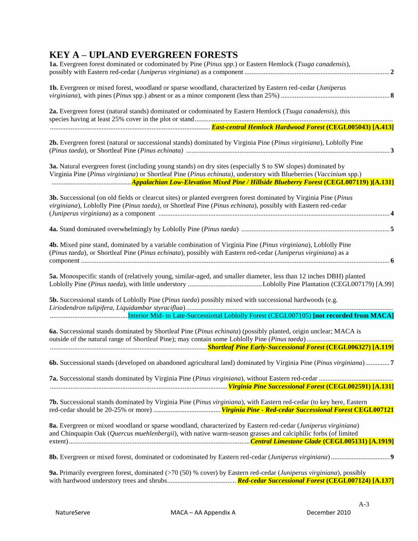
KEY A – UPLAND EVERGREEN FORESTS 1a. Evergreen forest dominated or codominated by Pine (Pinus spp.) or Eastern Hemlock (Tsuga canadensis),
possibly with Eastern red-cedar (Juniperus virginiana) as a component .................................................................................... 2
1b. Evergreen or mixed forest, woodland or sparse woodland, characterized by Eastern red-cedar (Juniperus
virginiana), with pines (Pinus spp.) absent or as a minor component (less than 25%) ............................................................... 8
2a. Evergreen forest (natural stands) dominated or codominated by Eastern Hemlock (Tsuga canadensis), this
species having at least 25% cover in the plot or stand ...................................................................................................................
............................................................................................. East-central Hemlock Hardwood Forest (CEGL005043) [A.413]
2b. Evergreen forest (natural or successional stands) dominated by Virginia Pine (Pinus virginiana), Loblolly Pine
(Pinus taeda), or Shortleaf Pine (Pinus echinata) ...................................................................................................................... 3
3a. Natural evergreen forest (including young stands) on dry sites (especially S to SW slopes) dominated by
Virginia Pine (Pinus virginiana) or Shortleaf Pine (Pinus echinata), understory with Blueberries (Vaccinium spp.)
.............................................. Appalachian Low-Elevation Mixed Pine / Hillside Blueberry Forest (CEGL007119) )[A.131]
3b. Successional (on old fields or clearcut sites) or planted evergreen forest dominated by Virginia Pine (Pinus
virginiana), Loblolly Pine (Pinus taeda), or Shortleaf Pine (Pinus echinata), possibly with Eastern red-cedar
(Juniperus virginiana) as a component ...................................................................................................................................... 4
4a. Stand dominated overwhelmingly by Loblolly Pine (Pinus taeda) ...................................................................................... 5
4b. Mixed pine stand, dominated by a variable combination of Virginia Pine (Pinus virginiana), Loblolly Pine
(Pinus taeda), or Shortleaf Pine (Pinus echinata), possibly with Eastern red-cedar (Juniperus virginiana) as a
component ................................................................................................................................................................................... 6
5a. Monospecific stands of (relatively young, similar-aged, and smaller diameter, less than 12 inches DBH) planted
Loblolly Pine (Pinus taeda), with little understory ........................................... Loblolly Pine Plantation (CEGL007179) [A.99]
5b. Successional stands of Loblolly Pine (Pinus taeda) possibly mixed with successional hardwoods (e.g.
Liriodendron tulipifera, Liquidambar styraciflua) ........................................................................................................................
............................................. Interior Mid- to Late-Successional Loblolly Forest (CEGL007105) [not recorded from MACA]
6a. Successional stands dominated by Shortleaf Pine (Pinus echinata) (possibly planted, origin unclear; MACA is
outside of the natural range of Shortleaf Pine); may contain some Loblolly Pine (Pinus taeda) ..................................................
........................................................................................... Shortleaf Pine Early-Successional Forest (CEGL006327) [A.119]
6b. Successional stands (developed on abandoned agricultural land) dominated by Virginia Pine (Pinus virginiana) .............. 7
7a. Successional stands dominated by Virginia Pine (Pinus virginiana), without Eastern red-cedar ...........................................
....................................................................................................... Virginia Pine Successional Forest (CEGL002591) [A.131]
7b. Successional stands dominated by Virginia Pine (Pinus virginiana), with Eastern red-cedar (to key here, Eastern
red-cedar should be 20-25% or more) ....................................... Virginia Pine - Red-cedar Successional Forest CEGL007121
8a. Evergreen or mixed woodland or sparse woodland, characterized by Eastern red-cedar (Juniperus virginiana)
and Chinquapin Oak (Quercus muehlenbergii), with native warm-season grasses and calciphilic forbs (of limited
extent) ......................................................................................................... Central Limestone Glade (CEGL005131) [A.1919]
8b. Evergreen or mixed forest, dominated or codominated by Eastern red-cedar (Juniperus virginiana) .................................. 9
9a. Primarily evergreen forest, dominated (>70 (50) % cover) by Eastern red-cedar (Juniperus virginiana), possibly
with hardwood understory trees and shrubs........................................ Red-cedar Successional Forest (CEGL007124) [A.137]

A-4
NatureServe MACA – AA Appendix A December 2010
9b. Mixed forest, clearly co-dominated by Eastern red-cedar (Juniperus virginiana) with EITHER earlier
successional, post-disturbance hardwoods (e.g. Tuliptree, Black Walnut, Sugarberry, Red Maple), on flatter post-
cultivation/grazing lands OR with a more “natural” assemblage of hardwoods (e.g. White Ash, Sugar Maple, Post
Oak, and in particular Blue Ash in some examples) .................................................................................................................. 10
10a, Mixed forest, codominated by Eastern red-cedar (Juniperus virginiana), Tuliptree (Liriodendron tulipifera),
Red Maple (Acer rubrum), Black Walnut (Juglans nigra), and/or White Ash (Fraxinus americana), ; an understory
of Flowering Dogwood (Cornus florida) may be present. This type occurs in conjunction with other successional
types as a heterogeneous combination of vegetation that develops following old field succession. Composition is
variable, and the canopy may be dominated by various combinations of hardwoods (including the species mentioned
above, as well as Oaks in some cases (e.g. Quercus stellata, Quercus velutina, Quercus falcata) with Eastern red-
cedar (Juniperus virginiana). .........................................................................................................................................................
................................................................... Southeastern Successional Black Cherry Forest (CEGL004133) (mixed variant)
10b. Mixed forest, natural stands on bouldery, sloping ground, codominated by Eastern red-cedar (Juniperus
virginiana) with White Ash (Fraxinus americana), Chinquapin Oak (Quercus muehlenbergii), Sugar Maple (Acer
saccharum), Post Oak (Quercus stellata), and in particular Blue Ash (Fraxinus quadrangulata) ................................................
....................... Eastern Red-cedar - Blue Ash / Canada Leafcup - (Western Daisy) Woodland (CEGL003754) not mapped;
just use CEGL004133 (mixed variant) if this is found, but rank as less than high in the fit and/or confidence
[note: examples of CEGL003754 (or a related undescribed type), a natural mixed Red-cedar – Ash – Oak
“woodland” (but with the canopy frequently at or above 60% closure) may key here – this association was not
recognized, and was not mapped, and is probably only rarely distinguishable by remote means from the “mixed”
version of CEGL004133 (e.g. Eastern red-cedar with Celtis laevigata, Juglans nigra, Acer saccharum, Fraxinus
americana, etc.), discussed above, which is intended to cover vegetation that arises on abandoned agricultural lands,
particularly in the absence of the planting of Pines. In contrast, CEGL003754 (with some degree of variation) occurs
on more rocky slopes, usually occurring in conjunction with a band or bands of outcropping (limestone) boulders in
between which trees (sometimes large and/or old) grow. The “mixed” CEGL004133 is found on flatter ground,
without boulders, and may occur immediately adjacent (and below) a stand of CEGL003754.
A-5
NatureServe MACA – AA Appendix A December 2010
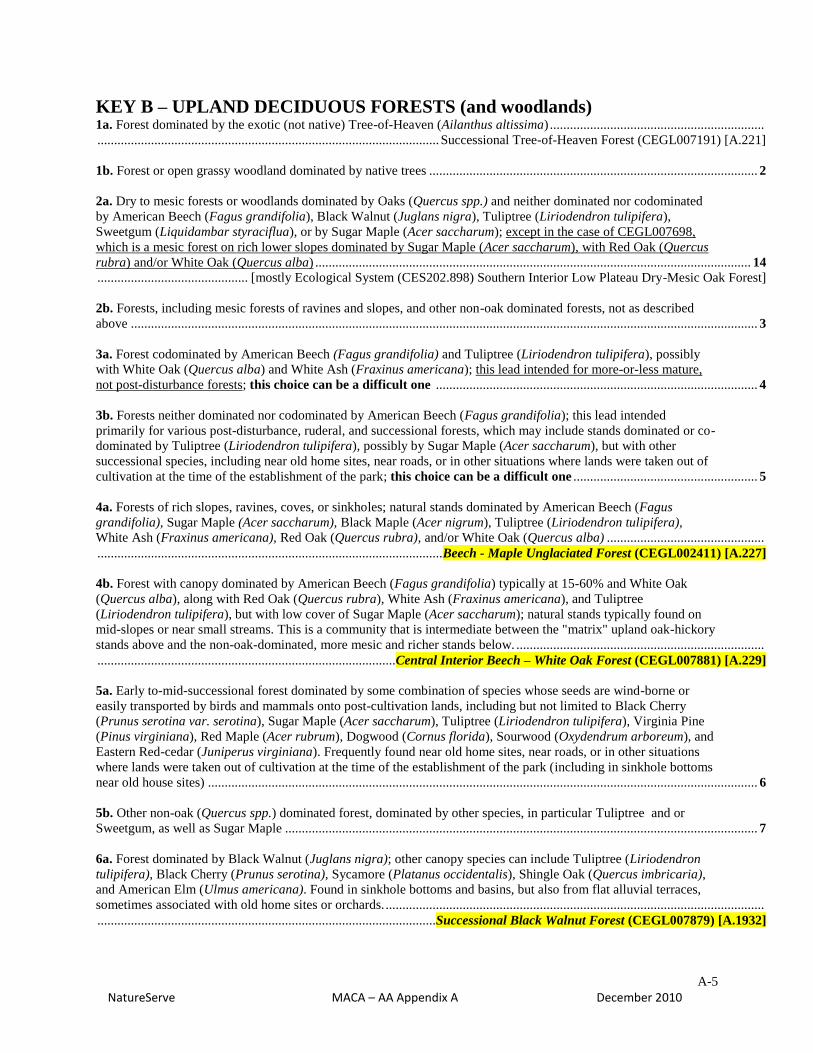
KEY B – UPLAND DECIDUOUS FORESTS (and woodlands) 1a. Forest dominated by the exotic (not native) Tree-of-Heaven (Ailanthus altissima) ................................................................
...................................................................................................... Successional Tree-of-Heaven Forest (CEGL007191) [A.221]
1b. Forest or open grassy woodland dominated by native trees .................................................................................................. 2
2a. Dry to mesic forests or woodlands dominated by Oaks (Quercus spp.) and neither dominated nor codominated
by American Beech (Fagus grandifolia), Black Walnut (Juglans nigra), Tuliptree (Liriodendron tulipifera),
Sweetgum (Liquidambar styraciflua), or by Sugar Maple (Acer saccharum); except in the case of CEGL007698,
which is a mesic forest on rich lower slopes dominated by Sugar Maple (Acer saccharum), with Red Oak (Quercus
rubra) and/or White Oak (Quercus alba) .................................................................................................................................. 14
............................................. [mostly Ecological System (CES202.898) Southern Interior Low Plateau Dry-Mesic Oak Forest]
2b. Forests, including mesic forests of ravines and slopes, and other non-oak dominated forests, not as described
above ........................................................................................................................................................................................... 3
3a. Forest codominated by American Beech (Fagus grandifolia) and Tuliptree (Liriodendron tulipifera), possibly
with White Oak (Quercus alba) and White Ash (Fraxinus americana); this lead intended for more-or-less mature,
not post-disturbance forests; this choice can be a difficult one ................................................................................................ 4
3b. Forests neither dominated nor codominated by American Beech (Fagus grandifolia); this lead intended
primarily for various post-disturbance, ruderal, and successional forests, which may include stands dominated or co-
dominated by Tuliptree (Liriodendron tulipifera), possibly by Sugar Maple (Acer saccharum), but with other
successional species, including near old home sites, near roads, or in other situations where lands were taken out of
cultivation at the time of the establishment of the park; this choice can be a difficult one ....................................................... 5
4a. Forests of rich slopes, ravines, coves, or sinkholes; natural stands dominated by American Beech (Fagus
grandifolia), Sugar Maple (Acer saccharum), Black Maple (Acer nigrum), Tuliptree (Liriodendron tulipifera),
White Ash (Fraxinus americana), Red Oak (Quercus rubra), and/or White Oak (Quercus alba) ...............................................
....................................................................................................... Beech - Maple Unglaciated Forest (CEGL002411) [A.227]
4b. Forest with canopy dominated by American Beech (Fagus grandifolia) typically at 15-60% and White Oak
(Quercus alba), along with Red Oak (Quercus rubra), White Ash (Fraxinus americana), and Tuliptree
(Liriodendron tulipifera), but with low cover of Sugar Maple (Acer saccharum); natural stands typically found on
mid-slopes or near small streams. This is a community that is intermediate between the "matrix" upland oak-hickory
stands above and the non-oak-dominated, more mesic and richer stands below. ..........................................................................
......................................................................................... Central Interior Beech – White Oak Forest (CEGL007881) [A.229]
5a. Early to-mid-successional forest dominated by some combination of species whose seeds are wind-borne or
easily transported by birds and mammals onto post-cultivation lands, including but not limited to Black Cherry
(Prunus serotina var. serotina), Sugar Maple (Acer saccharum), Tuliptree (Liriodendron tulipifera), Virginia Pine
(Pinus virginiana), Red Maple (Acer rubrum), Dogwood (Cornus florida), Sourwood (Oxydendrum arboreum), and
Eastern Red-cedar (Juniperus virginiana). Frequently found near old home sites, near roads, or in other situations
where lands were taken out of cultivation at the time of the establishment of the park (including in sinkhole bottoms
near old house sites) .................................................................................................................................................................... 6
5b. Other non-oak (Quercus spp.) dominated forest, dominated by other species, in particular Tuliptree and or
Sweetgum, as well as Sugar Maple ............................................................................................................................................. 7
6a. Forest dominated by Black Walnut (Juglans nigra); other canopy species can include Tuliptree (Liriodendron
tulipifera), Black Cherry (Prunus serotina), Sycamore (Platanus occidentalis), Shingle Oak (Quercus imbricaria),
and American Elm (Ulmus americana). Found in sinkhole bottoms and basins, but also from flat alluvial terraces,
sometimes associated with old home sites or orchards. .................................................................................................................
..................................................................................................... Successional Black Walnut Forest (CEGL007879) [A.1932]
A-6
NatureServe MACA – AA Appendix A December 2010
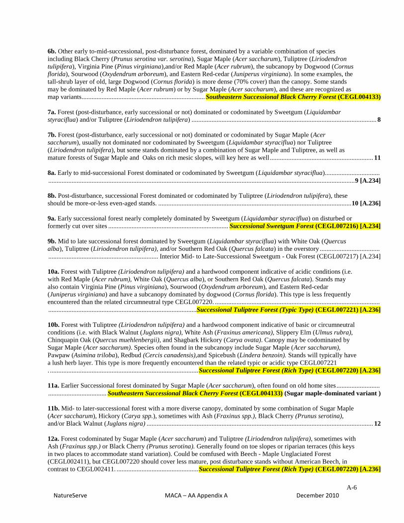
6b. Other early to-mid-successional, post-disturbance forest, dominated by a variable combination of species
including Black Cherry (Prunus serotina var. serotina), Sugar Maple (Acer saccharum), Tuliptree (Liriodendron
tulipifera), Virginia Pine (Pinus virginiana),and/or Red Maple (Acer rubrum), the subcanopy by Dogwood (Cornus
florida), Sourwood (Oxydendrum arboreum), and Eastern Red-cedar (Juniperus virginiana). In some examples, the
tall-shrub layer of old, large Dogwood (Cornus florida) is more dense (70% cover) than the canopy. Some stands
may be dominated by Red Maple (Acer rubrum) or by Sugar Maple (Acer saccharum), and these are recognized as
map variants .......................................................................... Southeastern Successional Black Cherry Forest (CEGL004133)
7a. Forest (post-disturbance, early successional or not) dominated or codominated by Sweetgum (Liquidambar
styraciflua) and/or Tuliptree (Liriodendron tulipifera) ............................................................................................................... 8
7b. Forest (post-disturbance, early successional or not) dominated or codominated by Sugar Maple (Acer
saccharum), usually not dominated nor codominated by Sweetgum (Liquidambar styraciflua) nor Tuliptree
(Liriodendron tulipifera), but some stands dominated by a combination of Sugar Maple and Tuliptree, as well as
mature forests of Sugar Maple and Oaks on rich mesic slopes, will key here as well .............................................................. 11
8a. Early to mid-successional Forest dominated or codominated by Sweetgum (Liquidambar styraciflua).................................
........................................................................................................................................................................................ 9 [A.234]
8b. Post-disturbance, successional Forest dominated or codominated by Tuliptree (Liriodendron tulipifera), these
should be more-or-less even-aged stands. .................................................................................................................... 10 [A.236]
9a. Early successional forest nearly completely dominated by Sweetgum (Liquidambar styraciflua) on disturbed or
formerly cut over sites ........................................................................ Successional Sweetgum Forest (CEGL007216) [A.234]
9b. Mid to late successional forest dominated by Sweetgum (Liquidambar styraciflua) with White Oak (Quercus
alba), Tuliptree (Liriodendron tulipifera), and/or Southern Red Oak (Quercus falcata) in the overstory ....................................
.................................................................. Interior Mid- to Late-Successional Sweetgum - Oak Forest (CEGL007217) [A.234]
10a. Forest with Tuliptree (Liriodendron tulipifera) and a hardwood component indicative of acidic conditions (i.e.
with Red Maple (Acer rubrum), White Oak (Quercus alba), or Southern Red Oak (Quercus falcata). Stands may
also contain Virginia Pine (Pinus virginiana), Sourwood (Oxydendrum arboreum), and Eastern Red-cedar
(Juniperus virginiana) and have a subcanopy dominated by dogwood (Cornus florida). This type is less frequently
encountered than the related circumneutral type CEGL007220. ...................................................................................................
......................................................................................... Successional Tuliptree Forest (Typic Type) (CEGL007221) [A.236]
10b. Forest with Tuliptree (Liriodendron tulipifera) and a hardwood component indicative of basic or circumneutral
conditions (i.e. with Black Walnut (Juglans nigra), White Ash (Fraxinus americana), Slippery Elm (Ulmus rubra),
Chinquapin Oak (Quercus muehlenbergii), and Shagbark Hickory (Carya ovata). Canopy may be codominated by
Sugar Maple (Acer saccharum). Species often found in the subcanopy include Sugar Maple (Acer saccharum),
Pawpaw (Asimina triloba), Redbud (Cercis canadensis),and Spicebush (Lindera benzoin). Stands will typically have
a lush herb layer. This type is more frequently encountered than the related typic or acidic type CEGL007221
. ......................................................................................... Successional Tuliptree Forest (Rich Type) (CEGL007220) [A.236]
11a. Earlier Successional forest dominated by Sugar Maple (Acer saccharum), often found on old home sites ..........................
................................... Southeastern Successional Black Cherry Forest (CEGL004133) (Sugar maple-dominated variant )
11b. Mid- to later-successional forest with a more diverse canopy, dominated by some combination of Sugar Maple
(Acer saccharum), Hickory (Carya spp.), sometimes with Ash (Fraxinus spp.), Black Cherry (Prunus serotina),
and/or Black Walnut (Juglans nigra) ........................................................................................................................................ 12
12a. Forest codominated by Sugar Maple (Acer saccharum) and Tuliptree (Liriodendron tulipifera), sometimes with
Ash (Fraxinus spp.) or Black Cherry (Prunus serotina). Generally found on toe slopes or riparian terraces (this keys
in two places to accommodate stand variation). Could be comfused with Beech - Maple Unglaciated Forest
(CEGL002411), but CEGL007220 should cover less mature, post disturbance stands without American Beech, in
contrast to CEGL002411. ................................................. Successional Tuliptree Forest (Rich Type) (CEGL007220) [A.236]
A-7
NatureServe MACA – AA Appendix A December 2010
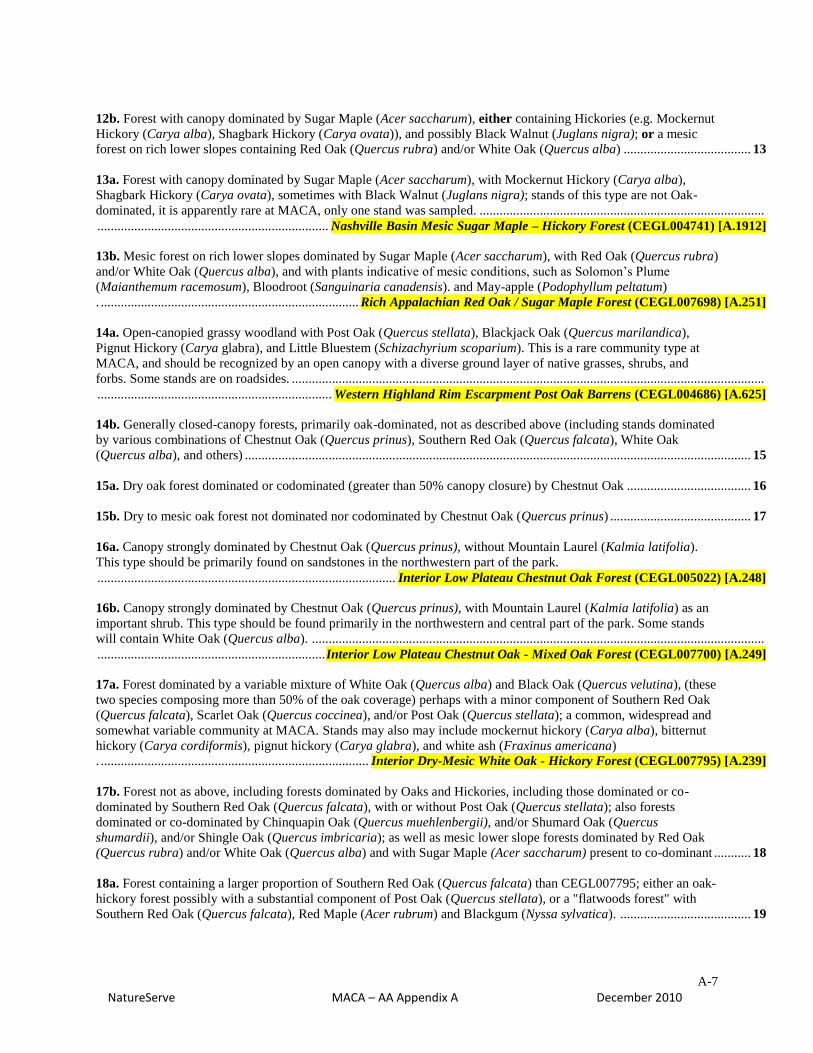
12b. Forest with canopy dominated by Sugar Maple (Acer saccharum), either containing Hickories (e.g. Mockernut
Hickory (Carya alba), Shagbark Hickory (Carya ovata)), and possibly Black Walnut (Juglans nigra); or a mesic
forest on rich lower slopes containing Red Oak (Quercus rubra) and/or White Oak (Quercus alba) ...................................... 13
13a. Forest with canopy dominated by Sugar Maple (Acer saccharum), with Mockernut Hickory (Carya alba),
Shagbark Hickory (Carya ovata), sometimes with Black Walnut (Juglans nigra); stands of this type are not Oak-
dominated, it is apparently rare at MACA, only one stand was sampled. .....................................................................................
..................................................................... Nashville Basin Mesic Sugar Maple – Hickory Forest (CEGL004741) [A.1912]
13b. Mesic forest on rich lower slopes dominated by Sugar Maple (Acer saccharum), with Red Oak (Quercus rubra)
and/or White Oak (Quercus alba), and with plants indicative of mesic conditions, such as Solomon’s Plume
(Maianthemum racemosum), Bloodroot (Sanguinaria canadensis). and May-apple (Podophyllum peltatum)
. ............................................................................. Rich Appalachian Red Oak / Sugar Maple Forest (CEGL007698) [A.251]
14a. Open-canopied grassy woodland with Post Oak (Quercus stellata), Blackjack Oak (Quercus marilandica),
Pignut Hickory (Carya glabra), and Little Bluestem (Schizachyrium scoparium). This is a rare community type at
MACA, and should be recognized by an open canopy with a diverse ground layer of native grasses, shrubs, and
forbs. Some stands are on roadsides. .............................................................................................................................................
...................................................................... Western Highland Rim Escarpment Post Oak Barrens (CEGL004686) [A.625]
14b. Generally closed-canopy forests, primarily oak-dominated, not as described above (including stands dominated
by various combinations of Chestnut Oak (Quercus prinus), Southern Red Oak (Quercus falcata), White Oak
(Quercus alba), and others) ....................................................................................................................................................... 15
15a. Dry oak forest dominated or codominated (greater than 50% canopy closure) by Chestnut Oak ..................................... 16
15b. Dry to mesic oak forest not dominated nor codominated by Chestnut Oak (Quercus prinus) .......................................... 17
16a. Canopy strongly dominated by Chestnut Oak (Quercus prinus), without Mountain Laurel (Kalmia latifolia).
This type should be primarily found on sandstones in the northwestern part of the park.
......................................................................................... Interior Low Plateau Chestnut Oak Forest (CEGL005022) [A.248]
16b. Canopy strongly dominated by Chestnut Oak (Quercus prinus), with Mountain Laurel (Kalmia latifolia) as an
important shrub. This type should be found primarily in the northwestern and central part of the park. Some stands
will contain White Oak (Quercus alba). .......................................................................................................................................
.................................................................... Interior Low Plateau Chestnut Oak - Mixed Oak Forest (CEGL007700) [A.249]
17a. Forest dominated by a variable mixture of White Oak (Quercus alba) and Black Oak (Quercus velutina), (these
two species composing more than 50% of the oak coverage) perhaps with a minor component of Southern Red Oak
(Quercus falcata), Scarlet Oak (Quercus coccinea), and/or Post Oak (Quercus stellata); a common, widespread and
somewhat variable community at MACA. Stands may also may include mockernut hickory (Carya alba), bitternut
hickory (Carya cordiformis), pignut hickory (Carya glabra), and white ash (Fraxinus americana)
. ................................................................................ Interior Dry-Mesic White Oak - Hickory Forest (CEGL007795) [A.239]
17b. Forest not as above, including forests dominated by Oaks and Hickories, including those dominated or co-
dominated by Southern Red Oak (Quercus falcata), with or without Post Oak (Quercus stellata); also forests
dominated or co-dominated by Chinquapin Oak (Quercus muehlenbergii), and/or Shumard Oak (Quercus
shumardii), and/or Shingle Oak (Quercus imbricaria); as well as mesic lower slope forests dominated by Red Oak
(Quercus rubra) and/or White Oak (Quercus alba) and with Sugar Maple (Acer saccharum) present to co-dominant ........... 18
18a. Forest containing a larger proportion of Southern Red Oak (Quercus falcata) than CEGL007795; either an oak-
hickory forest possibly with a substantial component of Post Oak (Quercus stellata), or a "flatwoods forest" with
Southern Red Oak (Quercus falcata), Red Maple (Acer rubrum) and Blackgum (Nyssa sylvatica). ....................................... 19
A-8
NatureServe MACA – AA Appendix A December 2010
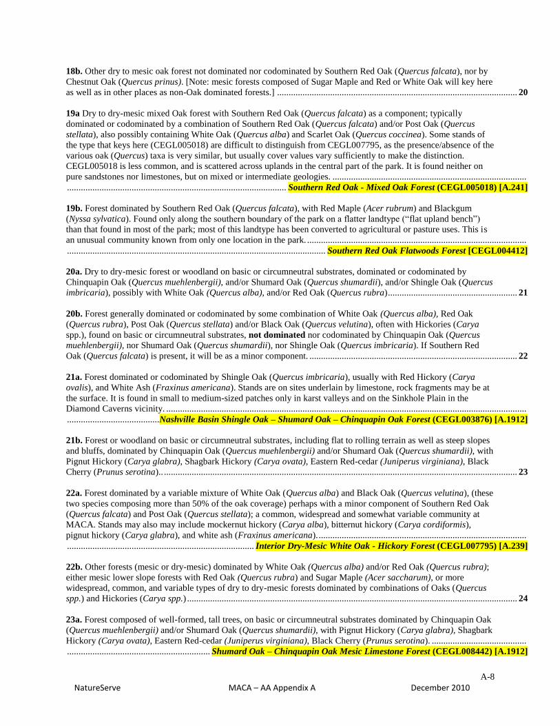
18b. Other dry to mesic oak forest not dominated nor codominated by Southern Red Oak (Quercus falcata), nor by
Chestnut Oak (Quercus prinus). [Note: mesic forests composed of Sugar Maple and Red or White Oak will key here
as well as in other places as non-Oak dominated forests.] ........................................................................................................ 20
19a Dry to dry-mesic mixed Oak forest with Southern Red Oak (Quercus falcata) as a component; typically
dominated or codominated by a combination of Southern Red Oak (Quercus falcata) and/or Post Oak (Quercus
stellata), also possibly containing White Oak (Quercus alba) and Scarlet Oak (Quercus coccinea). Some stands of
the type that keys here (CEGL005018) are difficult to distinguish from CEGL007795, as the presence/absence of the
various oak (Quercus) taxa is very similar, but usually cover values vary sufficiently to make the distinction.
CEGL005018 is less common, and is scattered across uplands in the central part of the park. It is found neither on
pure sandstones nor limestones, but on mixed or intermediate geologies. ....................................................................................
............................................................................................... Southern Red Oak - Mixed Oak Forest (CEGL005018) [A.241]
19b. Forest dominated by Southern Red Oak (Quercus falcata), with Red Maple (Acer rubrum) and Blackgum
(Nyssa sylvatica). Found only along the southern boundary of the park on a flatter landtype (“flat upland bench”)
than that found in most of the park; most of this landtype has been converted to agricultural or pasture uses. This is
an unusual community known from only one location in the park. ...............................................................................................
................................................................................................................ Southern Red Oak Flatwoods Forest [CEGL004412]
20a. Dry to dry-mesic forest or woodland on basic or circumneutral substrates, dominated or codominated by
Chinquapin Oak (Quercus muehlenbergii), and/or Shumard Oak (Quercus shumardii), and/or Shingle Oak (Quercus
imbricaria), possibly with White Oak (Quercus alba), and/or Red Oak (Quercus rubra) ........................................................ 21
20b. Forest generally dominated or codominated by some combination of White Oak (Quercus alba), Red Oak
(Quercus rubra), Post Oak (Quercus stellata) and/or Black Oak (Quercus velutina), often with Hickories (Carya
spp.), found on basic or circumneutral substrates, not dominated nor codominated by Chinquapin Oak (Quercus
muehlenbergii), nor Shumard Oak (Quercus shumardii), nor Shingle Oak (Quercus imbricaria). If Southern Red
Oak (Quercus falcata) is present, it will be as a minor component. .......................................................................................... 22
21a. Forest dominated or codominated by Shingle Oak (Quercus imbricaria), usually with Red Hickory (Carya
ovalis), and White Ash (Fraxinus americana). Stands are on sites underlain by limestone, rock fragments may be at
the surface. It is found in small to medium-sized patches only in karst valleys and on the Sinkhole Plain in the
Diamond Caverns vicinity. ............................................................................................................................................................
........................................ Nashville Basin Shingle Oak – Shumard Oak – Chinquapin Oak Forest (CEGL003876) [A.1912]
21b. Forest or woodland on basic or circumneutral substrates, including flat to rolling terrain as well as steep slopes
and bluffs, dominated by Chinquapin Oak (Quercus muehlenbergii) and/or Shumard Oak (Quercus shumardii), with
Pignut Hickory (Carya glabra), Shagbark Hickory (Carya ovata), Eastern Red-cedar (Juniperus virginiana), Black
Cherry (Prunus serotina).. ......................................................................................................................................................... 23
22a. Forest dominated by a variable mixture of White Oak (Quercus alba) and Black Oak (Quercus velutina), (these
two species composing more than 50% of the oak coverage) perhaps with a minor component of Southern Red Oak
(Quercus falcata) and Post Oak (Quercus stellata); a common, widespread and somewhat variable community at
MACA. Stands may also may include mockernut hickory (Carya alba), bitternut hickory (Carya cordiformis),
pignut hickory (Carya glabra), and white ash (Fraxinus americana). ..........................................................................................
................................................................................. Interior Dry-Mesic White Oak - Hickory Forest (CEGL007795) [A.239]
22b. Other forests (mesic or dry-mesic) dominated by White Oak (Quercus alba) and/or Red Oak (Quercus rubra);
either mesic lower slope forests with Red Oak (Quercus rubra) and Sugar Maple (Acer saccharum), or more
widespread, common, and variable types of dry to dry-mesic forests dominated by combinations of Oaks (Quercus
spp.) and Hickories (Carya spp.) ............................................................................................................................................... 24
23a. Forest composed of well-formed, tall trees, on basic or circumneutral substrates dominated by Chinquapin Oak
(Quercus muehlenbergii) and/or Shumard Oak (Quercus shumardii), with Pignut Hickory (Carya glabra), Shagbark
Hickory (Carya ovata), Eastern Red-cedar (Juniperus virginiana), Black Cherry (Prunus serotina). .........................................
.............................................................. Shumard Oak – Chinquapin Oak Mesic Limestone Forest (CEGL008442) [A.1912]

A-9
NatureServe MACA – AA Appendix A December 2010
23b. Woodland composed of scattered, stunted trees, found on steep, dry, south to southwest-facing limestone
slopes and bluffs above the Green River and its major tributaries. Dominated by Chinquapin Oak (Quercus
muehlenbergii) with Eastern Red-cedar (Juniperus virginiana) and scattered individuals of White Oak (Quercus
alba) and Black Oak (Quercus velutina). Stands also contain Hop-hornbeam (Ostrya virginiana), Fragrant Sumac
(Rhus aromatica), Winged Elm (Ulmus alata), Sideroxylon lycioides, and. Symphoricarpos orbiculatus. .................................
................................................................................................. Chinquapin Oak Unglaciated Bluff Woodland (CEGL004267)
24a. Mesic forest with canopy dominated by Red Oak (Quercus rubra) and/or White Oak (Quercus alba) and with
Sugar Maple (Acer saccharum) present to co-dominant, with plants indicative of mesic conditions, such as
Solomon’s Plume (Maianthemum racemosum) and May-apple (Podophyllum peltatum), found on lower concave
slopes ................................................................... Rich Appalachian Red Oak / Sugar Maple Forest (CEGL007698) [A.251]
24b. Dry-mesic forest, not as above, without co-dominance by Sugar Maple (Acer saccharum), not restricted to
lower slopes ............................................................................................................................................................................... 25
25a. Dry-mesic forest dominated by White Oak (Quercus alba), with Red Oak (Quercus rubra) and/or Shumard
Oak (Quercus shumardii) with plants indicative of basic or circumneutral conditions (such as Sugar Maple (Acer
saccharum), Chinquapin Oak (Quercus muehlenbergii), Hop hornbeam (Ostrya virginiana), Redbud (Cercis
canadensis), Pignut Hickory (Carya glabra), Bitternut Hickory (Carya cordiformis), Buckbrush (Symphoricarpos
orbiculatus), and Eastern Red-cedar (Juniperus virginiana) .........................................................................................................
........................................................................... White Oak - Mixed Oak Dry-Mesic Alkaline Forest (CEGL002070) [A.239]
25b. Dry-mesic forest, not as above, lacking Shumard Oak (Quercus shumardii) and other plants indicative of basic
or circumneutral conditions (such as Sugar Maple (Acer saccharum), Chinquapin Oak (Quercus muehlenbergii),
Hop hornbeam (Ostrya virginiana) ........................................................................................................................................... 26
26a Dry-mesic forest dominated by a variable mixture of White Oak (Quercus alba) and Black Oak (Quercus
velutina), (these two species composing more than 50% of the oak coverage), without Shumard Oak (Quercus
shumardii); a common, widespread and somewhat variable community at MACA. Stands may also may include
mockernut hickory (Carya alba), bitternut hickory (Carya cordiformis), pignut hickory (Carya glabra), and white
ash (Fraxinus americana). ....................................... Interior Dry-Mesic White Oak - Hickory Forest (CEGL007795) [A.239]
26b. Dry to dry-mesic mixed Oak forest typically dominated by a combination of Southern Red Oak (Quercus
falcata) and/or Post Oak (Quercus stellata), also possibly containing White Oak (Quercus alba) and Scarlet Oak
(Quercus coccinea). Some stands of the type that keys here (CEGL005018) are difficult to distinguish from
CEGL007795, as the presence/absence of the various oak (Quercus) taxa is very similar, but usually cover values
vary sufficiently to make the distinction. CEGL005018 is less common, and is scattered across uplands in the central
part of the park. It is found neither on pure sandstones nor limestones, but on mixed or intermediate geologies
. .............................................................................................. Southern Red Oak - Mixed Oak Forest (CEGL005018) [A.241]
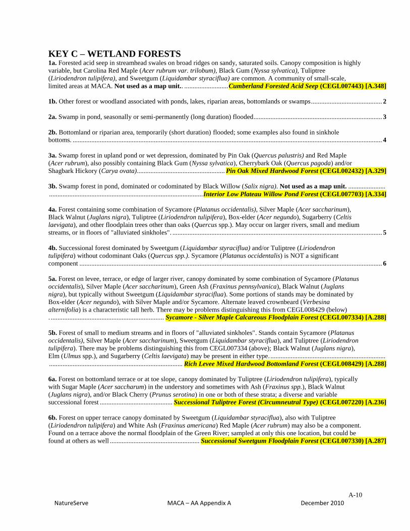
A-10
NatureServe MACA – AA Appendix A December 2010
KEY C – WETLAND FORESTS 1a. Forested acid seep in streamhead swales on broad ridges on sandy, saturated soils. Canopy composition is highly
variable, but Carolina Red Maple (Acer rubrum var. trilobum), Black Gum (Nyssa sylvatica), Tuliptree
(Liriodendron tulipifera), and Sweetgum (Liquidambar styraciflua) are common. A community of small-scale,
limited areas at MACA. Not used as a map unit.. .......................... Cumberland Forested Acid Seep (CEGL007443) [A.348]
1b. Other forest or woodland associated with ponds, lakes, riparian areas, bottomlands or swamps .......................................... 2
2a. Swamp in pond, seasonally or semi-permanently (long duration) flooded ............................................................................ 3
2b. Bottomland or riparian area, temporarily (short duration) flooded; some examples also found in sinkhole
bottoms. ....................................................................................................................................................................................... 4
3a. Swamp forest in upland pond or wet depression, dominated by Pin Oak (Quercus palustris) and Red Maple
(Acer rubrum), also possibly containing Black Gum (Nyssa sylvatica), Cherrybark Oak (Quercus pagoda) and/or
Shagbark Hickory (Carya ovata) .................................................... Pin Oak Mixed Hardwood Forest (CEGL002432) [A.329]
3b. Swamp forest in pond, dominated or codominated by Black Willow (Salix nigra). Not used as a map unit. ......................
........................................................................................... Interior Low Plateau Willow Pond Forest (CEGL007703) [A.334]
4a. Forest containing some combination of Sycamore (Platanus occidentalis), Silver Maple (Acer saccharinum),
Black Walnut (Juglans nigra), Tuliptree (Liriodendron tulipifera), Box-elder (Acer negundo), Sugarberry (Celtis
laevigata), and other floodplain trees other than oaks (Quercus spp.). May occur on larger rivers, small and medium
streams, or in floors of "alluviated sinkholes". ............................................................................................................................ 5
4b. Successional forest dominated by Sweetgum (Liquidambar styraciflua) and/or Tuliptree (Liriodendron
tulipifera) without codominant Oaks (Quercus spp.). Sycamore (Platanus occidentalis) is NOT a significant
component ................................................................................................................................................................................... 6
5a. Forest on levee, terrace, or edge of larger river, canopy dominated by some combination of Sycamore (Platanus
occidentalis), Silver Maple (Acer saccharinum), Green Ash (Fraxinus pennsylvanica), Black Walnut (Juglans
nigra), but typically without Sweetgum (Liquidambar styraciflua). Some portions of stands may be dominated by
Box-elder (Acer negundo), with Silver Maple and/or Sycamore. Alternate leaved crownbeard (Verbesina
alternifolia) is a characteristic tall herb. There may be problems distinguishing this from CEGL008429 (below)
. ................................................................... Sycamore - Silver Maple Calcareous Floodplain Forest (CEGL007334) [A.288]
5b. Forest of small to medium streams and in floors of "alluviated sinkholes". Stands contain Sycamore (Platanus
occidentalis), Silver Maple (Acer saccharinum), Sweetgum (Liquidambar styraciflua), and Tuliptree (Liriodendron
tulipifera). There may be problems distinguishing this from CEGL007334 (above); Black Walnut (Juglans nigra),
Elm (Ulmus spp.), and Sugarberry (Celtis laevigata) may be present in either type. ....................................................................
............................................................................... Rich Levee Mixed Hardwood Bottomland Forest (CEGL008429) [A.288]
6a. Forest on bottomland terrace or at toe slope, canopy dominated by Tuliptree (Liriodendron tulipifera), typically
with Sugar Maple (Acer saccharum) in the understory and sometimes with Ash (Fraxinus spp.), Black Walnut
(Juglans nigra), and/or Black Cherry (Prunus serotina) in one or both of these strata; a diverse and variable
successional forest ........................................... Successional Tuliptree Forest (Circumneutral Type) (CEGL007220) [A.236]
6b. Forest on upper terrace canopy dominated by Sweetgum (Liquidambar styraciflua), also with Tuliptree
(Liriodendron tulipifera) and White Ash (Fraxinus americana) Red Maple (Acer rubrum) may also be a component.
Found on a terrace above the normal floodplain of the Green River; sampled at only this one location, but could be
found at others as well ..................................................... Successional Sweetgum Floodplain Forest (CEGL007330) [A.287]

A-11
NatureServe MACA – AA Appendix A December 2010
KEY D – SHRUBLANDS (includes some stands dominated by young or low-stature trees)
1a. Evergreen needle-leaved shrubland, may have open grassy areas and scattered trees .......................................................... 2
1b. Deciduous shrubland ............................................................................................................................................................. 3
2a. Vegetation dominated (>50% cover) by Eastern red-cedar (Juniperus virginiana) ...............................................................
............................................................................................................ Red-cedar Successional Forest (CEGL007124) [A.137]
2b. Evergreen or mixed shrubland, woodland or sparse woodland, characterized by Eastern red-cedar (Juniperus
virginiana) and Chinquapin Oak (Quercus muehlenbergii). Not used as a map unit, a small scale type ..................................
.................................................................................................................... Central Limestone Glade (CEGL005131) [A.1919]
3a. Deciduous shrubland in wetland (pond, lake or floodplain area near river or creek) ......................................... 4 (3 choices)
3b. Upland deciduous shrubland (generally not subject to flooding), may include groundcovering vine areas .......................... 5
4a. Pond dominated by Buttonbush (Cephalanthus occidentalis) .................................................................................................
...................................................................................................... Buttonbush Sinkhole Pond Swamp (CEGL004742) [A.988]
4b. Shrubland dominated by Smooth Alder (Alnus serrulata). Not used as a map unit..............................................................
....................................................................................................... Southeastern Smooth Alder Swamp (CEGL008474) [A.994]
4c. Swamp in pond, dominated or codominated by Black Willow (Salix nigra). Not used as a map unit. .................................
........................................................................................... Interior Low Plateau Willow Pond Forest (CEGL007703) [A.334]
5a. Vegetation dominated by Kudzu (Pueraria montana var. lobata), with few or no trees.
Not used as a map unit. .............................................................................................. Kudzu Vineland (CEGL003882) [A.904]
5b. Vegetation not dominated by Kudzu (Pueraria montana var. lobata) .................................................................................. 6
6a. Upland deciduous shrubland dominated by greenbrier species (Smilax glauca, Smilax rotundifolia) and
blackberries/dewberries (Rubus argutus, Rubus trivialis), may include grasses and small trees, occurring on
disturbed or successional sites .......................................................................................................................................................
..................................................................Blackberry - Greenbrier Successional Shrubland Thicket (CEGL004732) [A.908]
6b. Vegetation of walls and openings of limestone sinks dominated by Hydrangea arborescens, the herbaceous layer
including Hydrophyllum sp., Impatiens pallida, Parthenocissus quinquefolia, Sedum ternatum, and Heuchera
americana. This is a small scale feature. .......................................................................................................................................
........................................................................................ Highland Rim Limestone Cliff/Talus Seep (CEGL004708) [A.1905]
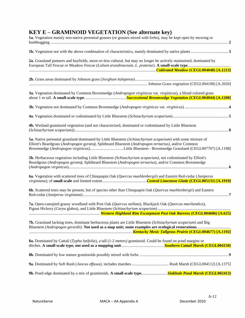
A-12
NatureServe MACA – AA Appendix A December 2010
KEY E – GRAMINOID VEGETATION (See alternate key) 1a. Vegetation mainly non-native perennial grasses (or grasses mixed with forbs), may be kept open by mowing or
bushhogging ................................................................................................................................................................................ 2
1b. Vegetation not with the above combination of characteristics, mainly dominated by native plants ..................................... 3
2a. Grassland pastures and hayfields, more-or-less cultural, but may no longer be actively maintained, dominated by
European Tall Fescue or Meadow Fescue (Lolium arundinaceum, L. pratense). A small-scale type. .........................................
............................................................................................................................. Cultivated Meadow (CEGL004048) [A.1213]
2b. Grass areas dominated by Johnson grass (Sorghum halepense) ..............................................................................................
..................................................................................................................... Johnson Grass vegetation (CEGL004108) [A.2020]
3a. Vegetation dominated by Common Broomsedge (Andropogon virginicus var. virginicus), a blond colored grass
about 1 m tall. A small-scale type. ........................................ Successional Broomsedge Vegetation (CEGL004044) [A.1208]
3b. Vegetation not dominated by Common Broomsedge (Andropogon virginicus var. virginicus) ........................................... 4
4a. Vegetation dominated or codominated by Little Bluestem (Schizachyrium scoparium) ....................................................... 5
4b. Wetland graminoid vegetation (and not characterized, dominated or codominated by Little Bluestem
(Schizachyrium scoparium)) ........................................................................................................................................................ 8
5a. Native perennial grassland dominated by Little Bluestem (Schizachyrium scoparium) with some mixture of
Elliott's Beardgrass (Andropogon gyrans), Splitbeard Bluestem (Andropogon ternarius), and/or Common
Broomsedge (Andropogon virginicus) ................................. Little Bluestem - Broomsedge Grassland (CEGL007707) [A.1198]
5b. Herbaceous vegetation including Little Bluestem (Schizachyrium scoparium), not codominated by Elliott's
Beardgrass (Andropogon gyrans), Splitbeard Bluestem (Andropogon ternarius), and/or Common Broomsedge
(Andropogon virginicus) .............................................................................................................................................................. 6
6a. Vegetation with scattered trees of Chinquapin Oak (Quercus muehlenbergii) and Eastern Red-cedar (Juniperus
virginiana); of small-scale and limited extent............................................ Central Limestone Glade (CEGL005131) [A.1919]
6b. Scattered trees may be present, but of species other than Chinquapin Oak (Quercus muehlenbergii) and Eastern
Red-cedar (Juniperus virginiana) ................................................................................................................................................ 7
7a. Open-canopied grassy woodland with Post Oak (Quercus stellata), Blackjack Oak (Quercus marilandica),
Pignut Hickory (Carya glabra), and Little Bluestem (Schizachyrium scoparium) ........................................................................
...................................................................... Western Highland Rim Escarpment Post Oak Barrens (CEGL004686) [A.625]
7b. Grassland lacking trees, dominant herbaceous plants are Little Bluestem (Schizachyrium scoparium) and Big
Bluestem (Andropogon gerardii). Not used as a map unit; some examples are ecological restorations. ................................
...................................................................................................... Kentucky Mesic Tallgrass Prairie (CEGL004677) [A.1192]
8a. Dominated by Cattail (Typha latifolia), a tall (1-2 meters) graminoid. Could be found on pond margins or
ditches. A small-scale type, not used as a mapping unit .......................................... Southern Cattail Marsh (CEGL004150)
8b. Dominated by low stature graminoids possibly mixed with forbs ........................................................................................ 9
9a. Dominated by Soft Rush (Juncus effusus), includes marshes ..................................... Rush Marsh (CEGL004112) [A.1375]
9b. Pond edge dominated by a mix of graminoids. A small-scale type. ........................ Sinkhole Pond Marsh (CEGL002413)
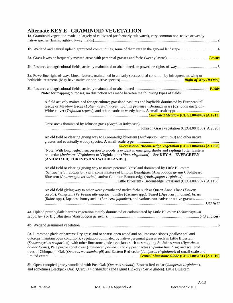
A-13
NatureServe MACA – AA Appendix A December 2010
Alternate KEY E –GRAMINOID VEGETATION 1a. Graminoid vegetation made up largely of cultivated (or formerly cultivated), very common non-native or weedy
native species (lawns, rights-of-way, fields)................................................................................................................................ 2
1b. Wetland and natural upland graminoid communities, some of them rare in the general landscape ..................................... 4
2a. Grass lawns or frequently mowed areas with perennial grasses and forbs (weedy lawns) .......................................... Lawns
2b. Pastures and agricultural fields, actively maintained or abandoned, or powerline rights-of-way ......................................... 3
3a. Powerline right-of-way. Linear feature, maintained in an early successional condition by infrequent mowing or
herbicide treatment. (May have native or non-native species) .................................................................. Right of Way (R/O/W)
3b. Pastures and agricultural fields, actively maintained or abandoned .............................................................................. Fields
Note: for mapping purposes, no distinction was made between the following types of fields:
A field actively maintained for agriculture; grassland pastures and hayfields dominated by European tall
fescue or Meadow fescue (Lolium arundinaceum, Lolium pratense), Bermuda grass (Cynodon dactylon),
White clover (Trifolium repens), and other exotic or weedy herbs. A small-scale type. ............................................
........................................................................................................... Cultivated Meadow (CEGL004048) [A.1213]
Grass areas dominated by Johnson grass (Sorghum halepense) ..................................................................................
............................................................................................ Johnson Grass vegetation (CEGL004108) [A.2020]
An old field or clearing giving way to Broomsedge bluestem (Andropogon virginicus) and other native
grasses and eventually woody species. A small-scale type.........................................................................................
......................................................................Successional Broom-sedge Vegetation (CEGL004044) [A.1208] (Note: With long neglect, succession to woods is evident in emerging shrubs and saplings [often Eastern
red-cedar (Juniperus Virginiana) or Virginia pine (Pinus virginiana) – See KEY A – EVERGREEN
(AND MIXED) FORESTS AND WOODLANDS]).
An old field or clearing giving way to native perennial grassland dominated by Little Bluestem
(Schizachyrium scoparium) with some mixture of Elliott's Beardgrass (Andropogon gyrans), Splitbeard
Bluestem (Andropogon ternarius), and/or Common Broomsedge (Andropogon virginicus) ......................................
.......................................................................... Little Bluestem - Broomsedge Grassland (CEGL007707) [A.1198]
An old field giving way to other weedy exotic and native forbs such as Queen Anne’s lace (Daucus
carota), Wingstem (Verbesina alternifolia), thistles (Cirsium spp.), Teasel (Dipsacus fullonum), briars
(Rubus spp.), Japanese honeysuckle (Lonicera japonica), and various non-native or native grasses. ........................
....................................................................................................................................................................... Old field
4a. Upland prairie/glade/barrens vegetation mainly dominated or codominated by Little Bluestem (Schizachyrium
scoparium) or Big Bluestem (Andropogon gerardii). .............................................................................................. 5 (3 choices)
4b. Wetland graminoid vegetation .............................................................................................................................................. 6
5a. Limestone glade or barrens: Dry grassland or sparse open woodland on limestone slopes (shallow soil and
outcrops maintain open condition); vegetation dominated by native perennial grasses such as Little Bluestem
(Schizachyrium scoparium), with other limestone glade associates such as straggling St. John's-wort (Hypericum
dolabriforme), Pale purple coneflower (Echinacea pallida), Prickly pear cactus (Opuntia humifusa) and scattered
trees of Chinquapin Oak (Quercus muehlenbergii) and Eastern Red-cedar (Juniperus virginiana); of small-scale and
limited extent .............................................................................................. Central Limestone Glade (CEGL005131) [A.1919]
5b. Open-canopied grassy woodland with Post Oak (Quercus stellata), Eastern Red-cedar (Juniperus virginiana),
and sometimes Blackjack Oak (Quercus marilandica) and Pignut Hickory (Carya glabra). Little Bluestem

A-14
NatureServe MACA – AA Appendix A December 2010
(Schizachyrium scoparium) characterizes the herbaceous layer. With fire suppression, all but the most droughty sites
are likely to revert to forest. ............................................... Western Highland Rim Post Oak Barrens (CEGL004686) [A.625]
5c. Submesic grassland of Little Bluestem (Schizachyrium scoparium) and Big Bluestem (Andropogon gerardii),
and sometimes Plume Grass (Saccharum spp.), with scattered trees or shrubs possible [Red Maple (Acer rubrum)
and others] This vegetation has only been found in limited areas of the former “Wondering Woods”, and its origin is
unclear. It is not used as a mapping unit. Not used as a map unit.. .............................................................................................
...................................................................................................... Kentucky Mesic Tallgrass Prairie (CEGL004677) [A.1192]
6a. Areas dominated by Soft Rush (Juncus effusus), including marshes .......................... Rush Marsh (CEGL004112) [A.1375]
6b. Pond edge dominated by a mix of graminoids, including Three-way Sedge (Dulichium arundinaceum) and
Sedges (Carex spp.). A small-scale type. ....................................................... Sinkhole Pond Marsh (CEGL002413) [A.1439]
6a. Dominated by Cattail (Typha latifolia), a tall (1-2 meters) graminoid. Could be found on pond margins or
ditches. A small-scale type, not used as a mapping unit .......................................... Southern Cattail Marsh (CEGL004150)
6b. Dominated by low stature graminoids possibly mixed with forbs ........................................................................................ 7
7a. Dominated by Soft Rush (Juncus effusus), includes marshes ..................................... Rush Marsh (CEGL004112) [A.1375]
7b. Pond edge dominated by a mix of graminoids. A small-scale type. .......................................................................................
......................................................................................................................... Sinkhole Pond Marsh (CEGL002413) [A.1439]
KEY F – FORB (BROADLEAF) VEGETATION
1a. Vegetation of walls and openings of limestone sinks dominated by Hydrangea arborescens, the herbaceous layer
includes Hydrophyllum sp., Impatiens pallida, Parthenocissus quinquefolia, Sedum ternatum, and Heuchera
americana. This is a small scale feature. ........................ Highland Rim Limestone Cliff/Talus Seep (CEGL004708) [A.1905]
1b. Rocky bar or shore of river or creek dominated by Common Water-willow (Justicia americana) .......................................
................................................................................................... Water-willow Rocky Bar and Shore (CEGL004286) [A.1657]

B-1
NatureServe MACA – AA Appendix B December 2010
APPENDIX B: CONTINGENCY MATRICES ACCURACY TABLES FOR MAMMOTH CAVE NATIONAL PARK
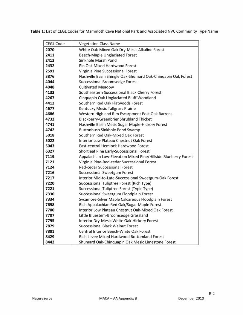
B-2
NatureServe MACA – AA Appendix B December 2010
Table 1: List of CEGL Codes for Mammoth Cave National Park and Associated NVC Community Type Name
CEGL Code
Vegetation Class Name
2070
White Oak-Mixed Oak Dry-Mesic Alkaline Forest 2411
Beech-Maple Unglaciated Forest
2413
Sinkhole Marsh Pond 2432
Pin Oak Mixed Hardwood Forest
2591
Virginia Pine Successional Forest 3876
Nashville Basin Shingle Oak-Shumard Oak-Chinqapin Oak Forest
4044
Successional Broomsedge Forest 4048
Cultivated Meadow
4133
Southeastern Successional Black Cherry Forest 4267
Cinquapin Oak Unglaciated Bluff Woodland
4412
Southern Red Oak Flatwoods Forest 4677
Kentucky Mesic Tallgrass Prairie
4686
Western Highland Rim Escarpment Post Oak Barrens 4732
Blackberry-Greenbrier Shrubland Thicket
4741
Nashville Basin Mesic Sugar Maple-Hickory Forest 4742
Buttonbush Sinkhole Pond Swamp
5018
Southern Red Oak-Mixed Oak Forest 5022
Interior Low Plateau Chestnut Oak Forest
5043
East-central Hemlock Hardwood Forest 6327
Shortleaf Pine Early-Successional Forest
7119
Appalachian Low-Elevation Mixed Pine/Hillside Blueberry Forest 7121
Virginia Pine-Red-cedar Successional Forest
7124
Red-cedar Successional Forest 7216
Successional Sweetgum Forest
7217
Interior Mid-to-Late-Successional Sweetgum-Oak Forest 7220
Successional Tuliptree Forest (Rich Type)
7221
Successional Tuliptree Forest (Typic Type) 7330
Successional Sweetgum Floodplain Forest
7334
Sycamore-Silver Maple Calcareous Floodplain Forest 7698
Rich Appalachian Red Oak/Sugar Maple Forest
7700
Interior Low Plateau Chestnut Oak-Mixed Oak Forest 7707
Little Bluestem-Broomsedge Grassland
7795
Interior Dry-Mesic White Oak-Hickory Forest 7879
Successional Black Walnut Forest
7881
Central Interior Beech-White Oak Forest 8429
Rich Levee Mixed Hardwood Bottomland Forest
8442
Shumard Oak-Chinquapin Oak Mesic Limestone Forest
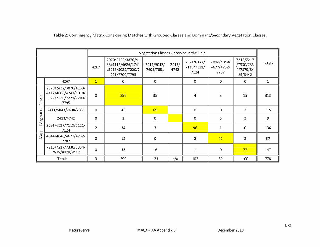
B-3
NatureServe MACA – AA Appendix B December 2010
Table 2: Contingency Matrix Considering Matches with Grouped Classes and Dominant/Secondary Vegetation Classes.
Vegetation Classes Observed in the Field
Totals 4267
2070/2432/3876/4133/4412/4686/4741/5018/5022/7220/7
221/7700/7795
2411/5043/7698/7881
2413/4742
2591/6327/7119/7121/
7124
4044/4048/4677/4732/
7707
7216/7217/7330/7334/7879/8429/8442
Map
ped
Veg
etat
ion
Cla
sses
4267 1 0 0
0 0 0 1
2070/2432/3876/4133/4412/4686/4741/5018/5022/7220/7221/7700/
7795
0 256 35
4 3 15 313
2411/5043/7698/7881 0 43 69
0 0 3 115
2413/4742 0 1 0
0 5 3 9
2591/6327/7119/7121/7124
2 34 3
96 1 0 136
4044/4048/4677/4732/7707
0 12 0
2 41 2 57
7216/7217/7330/7334/7879/8429/8442
0 53 16
1 0 77 147
Totals 3 399 123 n/a 103 50 100 778
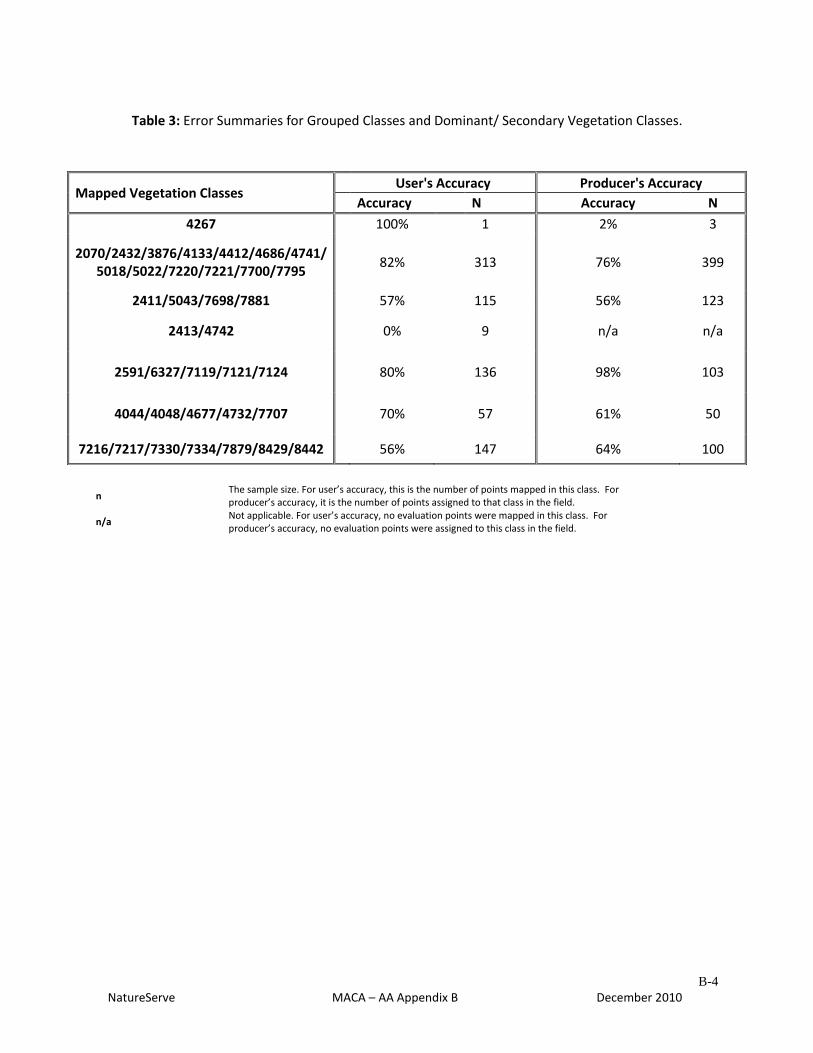
B-4
NatureServe MACA – AA Appendix B December 2010
Table 3: Error Summaries for Grouped Classes and Dominant/ Secondary Vegetation Classes.
Mapped Vegetation Classes User's Accuracy Producer's Accuracy
Accuracy N Accuracy N
4267 100% 1 2% 3
2070/2432/3876/4133/4412/4686/4741/ 5018/5022/7220/7221/7700/7795
82% 313 76% 399
2411/5043/7698/7881 57% 115 56% 123
2413/4742 0% 9 n/a n/a
2591/6327/7119/7121/7124 80% 136 98% 103
4044/4048/4677/4732/7707 70% 57 61% 50
7216/7217/7330/7334/7879/8429/8442 56% 147 64% 100
n The sample size. For user’s accuracy, this is the number of points mapped in this class. For producer’s accuracy, it is the number of points assigned to that class in the field.
n/a Not applicable. For user’s accuracy, no evaluation points were mapped in this class. For producer’s accuracy, no evaluation points were assigned to this class in the field.
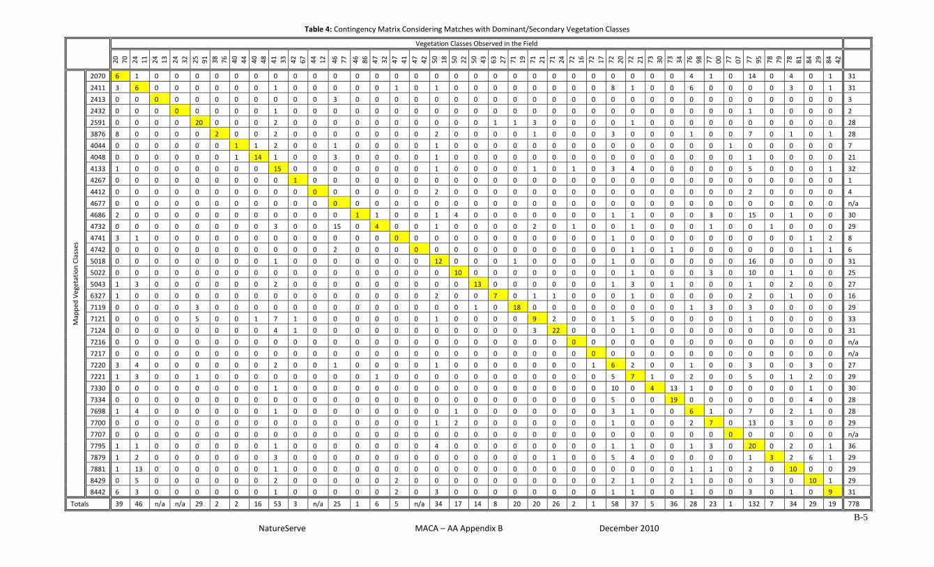
B-5
NatureServe MACA – AA Appendix B December 2010
Table 4: Contingency Matrix Considering Matches with Dominant/Secondary Vegetation Classes
Vegetation Classes Observed in the Field
20
70
24
11
24
13
24
32
25
91
38
76
40
44
40
48
41
33
42
67
44
12
46
77
46
86
47
32
47
41
47
42
50
18
50
22
50
43
63
27
71
19
71
21
71
24
72
16
72
17
72
20
72
21
73
30
73
34
76
98
77
00
77
07
77
95
78
79
78
81
84
29
84
42
Map
ped
Veg
etat
ion
Cla
sses
2070 6 1 0 0 0 0 0 0 0 0 0 0 0 0 0 0 0 0 0 0 0 0 0 0 0 0 0 0 0 4 1 0 14 0 4 0 1 31
2411 3 6 0 0 0 0 0 0 1 0 0 0 0 0 1 0 1 0 0 0 0 0 0 0 0 8 1 0 0 6 0 0 0 0 3 0 1 31
2413 0 0 0 0 0 0 0 0 0 0 0 3 0 0 0 0 0 0 0 0 0 0 0 0 0 0 0 0 0 0 0 0 0 0 0 0 0 3
2432 0 0 0 0 0 0 0 0 1 0 0 0 0 0 0 0 0 0 0 0 0 0 0 0 0 0 0 0 0 0 0 0 1 0 0 0 0 2
2591 0 0 0 0 20 0 0 0 2 0 0 0 0 0 0 0 0 0 0 1 1 3 0 0 0 0 1 0 0 0 0 0 0 0 0 0 0 28
3876 8 0 0 0 0 2 0 0 2 0 0 0 0 0 0 0 2 0 0 0 0 1 0 0 0 3 0 0 0 1 0 0 7 0 1 0 1 28
4044 0 0 0 0 0 0 1 1 2 0 0 1 0 0 0 0 1 0 0 0 0 0 0 0 0 0 0 0 0 0 0 1 0 0 0 0 0 7
4048 0 0 0 0 0 0 1 14 1 0 0 3 0 0 0 0 1 0 0 0 0 0 0 0 0 0 0 0 0 0 0 0 1 0 0 0 0 21
4133 1 0 0 0 0 0 0 0 15 0 0 0 0 0 0 0 1 0 0 0 0 1 0 1 0 3 4 0 0 0 0 0 5 0 0 0 1 32
4267 0 0 0 0 0 0 0 0 0 1 0 0 0 0 0 0 0 0 0 0 0 0 0 0 0 0 0 0 0 0 0 0 0 0 0 0 0 1
4412 0 0 0 0 0 0 0 0 0 0 0 0 0 0 0 0 2 0 0 0 0 0 0 0 0 0 0 0 0 0 0 0 2 0 0 0 0 4
4677 0 0 0 0 0 0 0 0 0 0 0 0 0 0 0 0 0 0 0 0 0 0 0 0 0 0 0 0 0 0 0 0 0 0 0 0 0 n/a
4686 2 0 0 0 0 0 0 0 0 0 0 0 1 1 0 0 1 4 0 0 0 0 0 0 0 1 1 0 0 0 3 0 15 0 1 0 0 30
4732 0 0 0 0 0 0 0 0 3 0 0 15 0 4 0 0 1 0 0 0 0 2 0 1 0 0 1 0 0 0 1 0 0 1 0 0 0 29
4741 3 1 0 0 0 0 0 0 0 0 0 0 0 0 0 0 0 0 0 0 0 0 0 0 0 1 0 0 0 0 0 0 0 0 0 1 2 8
4742 0 0 0 0 0 0 0 0 0 0 0 2 0 0 0 0 0 0 0 0 0 0 0 0 0 0 1 0 1 0 0 0 0 0 0 1 1 6
5018 0 0 0 0 0 0 0 0 1 0 0 0 0 0 0 0 12 0 0 0 1 0 0 0 0 1 0 0 0 0 0 0 16 0 0 0 0 31
5022 0 0 0 0 0 0 0 0 0 0 0 0 0 0 0 0 0 10 0 0 0 0 0 0 0 0 1 0 0 0 3 0 10 0 1 0 0 25
5043 1 3 0 0 0 0 0 0 2 0 0 0 0 0 0 0 0 0 13 0 0 0 0 0 0 1 3 0 1 0 0 0 1 0 2 0 0 27
6327 1 0 0 0 0 0 0 0 0 0 0 0 0 0 0 0 2 0 0 7 0 1 1 0 0 0 1 0 0 0 0 0 2 0 1 0 0 16
7119 0 0 0 0 3 0 0 0 0 0 0 0 0 0 0 0 0 0 1 0 18 0 0 0 0 0 0 0 0 1 3 0 3 0 0 0 0 29
7121 0 0 0 0 5 0 0 1 7 1 0 0 0 0 0 0 1 0 0 0 0 9 2 0 0 1 5 0 0 0 0 0 1 0 0 0 0 33
7124 0 0 0 0 0 0 0 0 4 1 0 0 0 0 0 0 0 0 0 0 0 3 22 0 0 0 1 0 0 0 0 0 0 0 0 0 0 31
7216 0 0 0 0 0 0 0 0 0 0 0 0 0 0 0 0 0 0 0 0 0 0 0 0 0 0 0 0 0 0 0 0 0 0 0 0 0 n/a
7217 0 0 0 0 0 0 0 0 0 0 0 0 0 0 0 0 0 0 0 0 0 0 0 0 0 0 0 0 0 0 0 0 0 0 0 0 0 n/a
7220 3 4 0 0 0 0 0 0 2 0 0 1 0 0 0 0 1 0 0 0 0 0 0 0 1 6 2 0 0 1 0 0 3 0 0 3 0 27
7221 1 3 0 0 1 0 0 0 0 0 0 0 0 1 0 0 0 0 0 0 0 0 0 0 0 5 7 1 0 2 0 0 5 0 1 2 0 29
7330 0 0 0 0 0 0 0 0 1 0 0 0 0 0 0 0 0 0 0 0 0 0 0 0 0 10 0 4 13 1 0 0 0 0 0 1 0 30
7334 0 0 0 0 0 0 0 0 0 0 0 0 0 0 0 0 0 0 0 0 0 0 0 0 0 5 0 0 19 0 0 0 0 0 0 4 0 28
7698 1 4 0 0 0 0 0 0 1 0 0 0 0 0 0 0 0 1 0 0 0 0 0 0 0 3 1 0 0 6 1 0 7 0 2 1 0 28
7700 0 0 0 0 0 0 0 0 0 0 0 0 0 0 0 0 1 2 0 0 0 0 0 0 0 1 0 0 0 2 7 0 13 0 3 0 0 29
7707 0 0 0 0 0 0 0 0 0 0 0 0 0 0 0 0 0 0 0 0 0 0 0 0 0 0 0 0 0 0 0 0 0 0 0 0 0 n/a
7795 1 1 0 0 0 0 0 0 1 0 0 0 0 0 0 0 4 0 0 0 0 0 0 0 0 1 1 0 0 1 3 0 20 0 2 0 1 36
7879 1 2 0 0 0 0 0 0 3 0 0 0 0 0 0 0 0 0 0 0 0 0 1 0 0 5 4 0 0 0 0 0 1 3 2 6 1 29
7881 1 13 0 0 0 0 0 0 1 0 0 0 0 0 0 0 0 0 0 0 0 0 0 0 0 0 0 0 0 1 1 0 2 0 10 0 0 29
8429 0 5 0 0 0 0 0 0 2 0 0 0 0 0 2 0 0 0 0 0 0 0 0 0 0 2 1 0 2 1 0 0 0 3 0 10 1 29
8442 6 3 0 0 0 0 0 0 1 0 0 0 0 0 2 0 3 0 0 0 0 0 0 0 0 1 1 0 0 1 0 0 3 0 1 0 9 31
Totals 39 46 n/a n/a 29 2 2 16 53 3 n/a 25 1 6 5 n/a 34 17 14 8 20 20 26 2 1 58 37 5 36 28 23 1 132 7 34 29 19 778
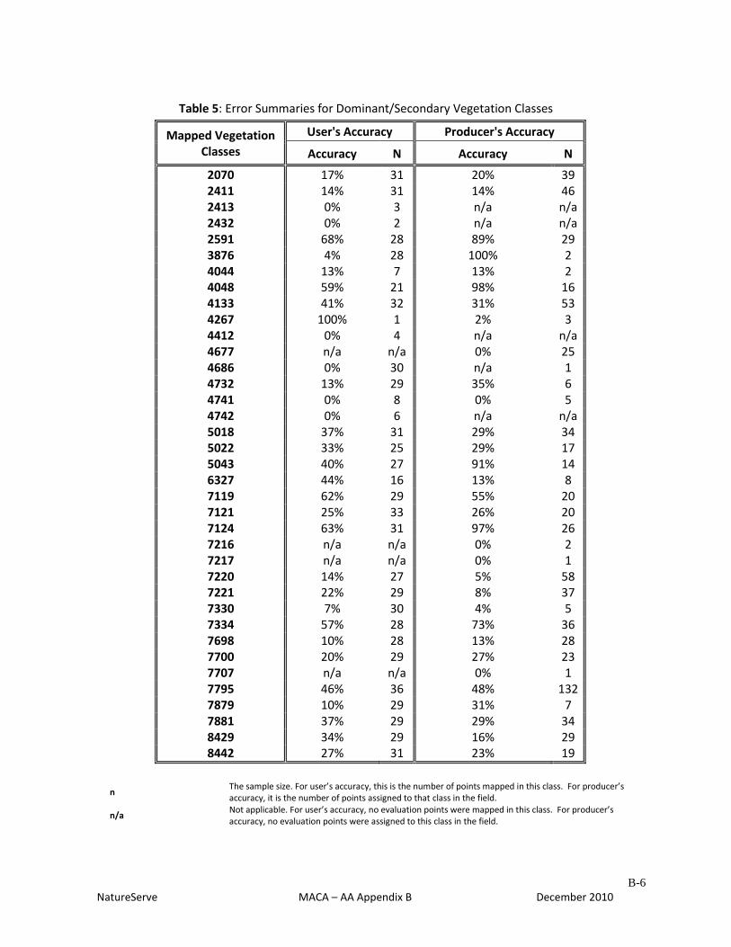
B-6
NatureServe MACA – AA Appendix B December 2010
Table 5: Error Summaries for Dominant/Secondary Vegetation Classes
Mapped Vegetation Classes
User's Accuracy Producer's Accuracy
Accuracy N Accuracy N
2070 17% 31 20% 39 2411 14% 31 14% 46 2413 0% 3 n/a n/a 2432 0% 2 n/a n/a 2591 68% 28 89% 29 3876 4% 28 100% 2 4044 13% 7 13% 2 4048 59% 21 98% 16 4133 41% 32 31% 53 4267 100% 1 2% 3 4412 0% 4 n/a n/a 4677 n/a n/a 0% 25 4686 0% 30 n/a 1 4732 13% 29 35% 6 4741 0% 8 0% 5 4742 0% 6 n/a n/a 5018 37% 31 29% 34 5022 33% 25 29% 17 5043 40% 27 91% 14 6327 44% 16 13% 8 7119 62% 29 55% 20 7121 25% 33 26% 20 7124 63% 31 97% 26 7216 n/a n/a 0% 2 7217 n/a n/a 0% 1 7220 14% 27 5% 58 7221 22% 29 8% 37 7330 7% 30 4% 5 7334 57% 28 73% 36 7698 10% 28 13% 28 7700 20% 29 27% 23 7707 n/a n/a 0% 1 7795 46% 36 48% 132 7879 10% 29 31% 7 7881 37% 29 29% 34 8429 34% 29 16% 29 8442 27% 31 23% 19
n The sample size. For user’s accuracy, this is the number of points mapped in this class. For producer’s accuracy, it is the number of points assigned to that class in the field.
n/a Not applicable. For user’s accuracy, no evaluation points were mapped in this class. For producer’s accuracy, no evaluation points were assigned to this class in the field.
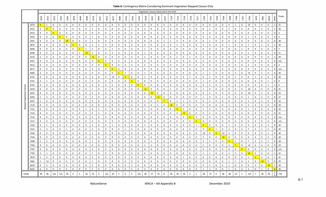
B-7
NatureServe MACA – AA Appendix B December 2010
Table 6: Contingency Matrix Considering Dominant Vegetation Mapped Classes Only
Vegetation Classes Observed in the Field
Totals
20
70
24
11
24
13
24
32
25
91
38
76
40
44
40
48
41
33
42
67
44
12
46
77
46
86
47
32
47
41
47
42
50
18
50
22
50
43
63
27
71
19
71
21
71
24
72
16
72
17
72
20
72
21
73
30
73
34
76
98
77
00
77
07
77
95
78
79
78
81
84
29
84
42
Map
ped
Veg
etat
ion
Cla
sses
2070 6 1 0 0 0 0 0 0 0 0 0 0 0 0 0 0 0 0 0 0 0 0 0 0 0 0 0 0 0 4 1 0 14 0 4 0 1 31
2411 3 4 0 0 0 0 0 0 1 0 0 0 0 0 1 0 1 0 0 0 0 0 0 0 0 8 1 0 0 7 0 0 0 0 3 0 1 30
2413 0 0 0 0 0 0 0 0 0 0 0 3 0 0 0 0 0 0 0 0 0 0 0 0 0 0 0 0 0 0 0 0 0 0 0 0 0 3
2432 0 0 0 0 0 0 0 0 1 0 0 0 0 0 0 0 0 0 0 0 0 0 0 0 0 0 0 0 0 0 0 0 1 0 0 0 0 2
2591 0 0 0 0 20 0 0 0 2 0 0 0 0 0 0 0 0 0 0 1 1 3 0 0 0 0 1 0 0 0 0 0 0 0 0 0 0 28
3876 8 0 0 0 0 2 0 0 2 1 0 0 0 0 0 0 2 0 0 0 0 1 0 0 0 3 0 0 0 1 0 0 7 0 1 0 1 29
4044 0 0 0 0 0 0 1 1 2 0 0 1 0 0 0 0 1 0 0 0 0 0 0 0 0 0 0 0 0 0 0 1 0 0 0 0 0 7
4048 0 0 0 0 0 0 1 14 1 0 0 3 0 0 0 0 1 0 0 0 0 0 0 0 0 0 0 0 0 0 0 0 1 0 0 0 0 21
4133 1 0 0 0 0 0 0 0 11 0 0 0 0 0 0 0 1 0 0 0 0 1 0 1 0 3 4 0 0 0 0 0 6 0 0 0 1 29
4267 0 0 0 0 0 0 0 0 0 0 0 0 0 0 0 0 0 0 0 0 0 0 0 0 0 0 0 0 0 0 0 0 0 0 0 0 0 n/a
4412 0 0 0 0 0 0 0 0 0 0 0 0 0 0 0 0 2 0 0 0 0 0 0 0 0 0 0 0 0 0 0 0 2 0 0 0 0 4
4677 0 0 0 0 0 0 0 0 0 0 0 0 0 0 0 0 0 0 0 0 0 0 0 0 0 0 0 0 0 0 0 0 0 0 0 0 0 n/a
4686 2 0 0 0 0 0 0 0 0 0 0 0 1 1 0 0 1 4 0 0 0 0 0 0 0 1 1 0 0 0 3 0 15 0 1 0 0 30
4732 0 0 0 0 0 0 0 0 3 0 0 15 0 4 0 0 1 0 0 0 0 2 0 1 0 0 1 0 0 0 1 0 0 1 0 0 0 29
4741 3 1 0 0 0 0 0 0 0 0 0 0 0 0 0 0 0 0 0 0 0 0 0 0 0 1 0 0 0 0 0 0 0 0 0 1 3 9
4742 0 0 0 0 0 0 0 0 0 0 0 2 0 0 0 0 0 0 0 0 0 0 0 0 0 0 1 0 1 0 0 0 0 0 0 1 1 6
5018 0 0 0 0 0 0 0 0 1 0 0 0 0 0 0 0 12 0 0 0 1 0 0 0 0 1 0 0 0 0 0 0 16 0 0 0 0 31
5022 0 0 0 0 0 0 0 0 0 0 0 0 0 0 0 0 0 10 0 0 0 0 0 0 0 0 1 0 0 0 3 0 10 0 1 0 0 25
5043 1 3 0 0 0 0 0 0 2 0 0 0 0 0 0 0 0 0 13 0 0 0 0 0 0 1 3 0 1 0 0 0 1 0 2 0 0 27
6327 1 0 0 0 0 0 0 0 0 0 0 0 0 0 0 0 2 0 0 7 0 1 1 0 0 0 1 0 0 0 0 0 2 0 1 0 0 16
7119 0 0 0 0 3 0 0 0 0 0 0 0 0 0 0 0 0 0 1 0 18 0 0 0 0 0 0 0 0 1 3 0 3 0 0 0 0 29
7121 0 0 0 0 5 0 0 1 8 1 0 0 0 0 0 0 1 0 0 0 0 9 2 0 0 1 5 0 0 0 0 0 1 0 0 0 0 34
7124 0 0 0 0 0 0 0 0 4 1 0 0 0 0 0 0 0 0 0 0 0 3 22 0 0 0 1 0 0 0 0 0 0 0 0 0 0 31
7216 0 0 0 0 0 0 0 0 0 0 0 0 0 0 0 0 0 0 0 0 0 0 0 0 0 0 0 0 0 0 0 0 0 0 0 0 0 n/a
7217 0 0 0 0 0 0 0 0 0 0 0 0 0 0 0 0 0 0 0 0 0 0 0 0 0 0 0 0 0 0 0 0 0 0 0 0 0 n/a
7220 3 5 0 0 0 0 0 0 5 0 0 1 0 0 0 0 1 0 0 0 0 0 0 0 1 4 2 0 0 1 0 0 4 0 0 3 0 30
7221 1 3 0 0 1 0 0 0 0 0 0 0 0 1 0 0 0 0 0 0 0 0 0 0 0 5 6 1 0 2 0 0 7 0 1 2 0 30
7330 0 0 0 0 0 0 0 0 1 0 0 0 0 0 0 0 0 0 0 0 0 0 0 0 0 10 0 4 13 1 0 0 0 0 0 1 0 30
7334 0 0 0 0 0 0 0 0 0 0 0 0 0 0 0 0 0 0 0 0 0 0 0 0 0 5 0 0 19 0 0 0 0 0 0 4 0 28
7698 1 5 0 0 0 0 0 0 1 0 0 0 0 0 0 0 0 1 0 0 0 0 0 0 0 3 1 0 0 5 1 0 7 0 2 1 0 28
7700 0 0 0 0 0 0 0 0 0 0 0 0 0 0 0 0 1 2 0 0 0 0 0 0 0 1 0 0 0 2 7 0 13 0 3 0 0 29
7707 0 0 0 0 0 0 0 0 0 0 0 0 0 0 0 0 0 0 0 0 0 0 0 0 0 0 0 0 0 0 0 0 0 0 0 0 0 n/a
7795 1 1 0 0 0 0 0 0 1 0 0 0 0 0 0 0 4 0 0 0 0 0 0 0 0 1 1 0 0 1 3 0 16 0 2 0 1 32
7879 1 2 0 0 0 0 0 0 3 0 0 0 0 0 0 0 0 0 0 0 0 0 1 0 0 6 5 0 0 0 0 0 1 3 2 6 1 31
7881 1 13 0 0 0 0 0 0 1 0 0 0 0 0 0 0 0 0 0 0 0 0 0 0 0 0 0 0 0 1 1 0 2 0 10 0 0 29
8429 0 5 0 0 0 0 0 0 2 0 0 0 0 0 2 0 0 0 0 0 0 0 0 0 0 3 1 0 2 1 0 0 0 3 0 10 1 30
8442 6 3 0 0 0 0 0 0 1 0 0 0 0 0 2 0 3 0 0 0 0 0 0 0 0 1 1 0 0 1 0 0 3 0 1 0 8 30
Totals 39 46 n/a n/a 29 2 2 16 53 3 n/a 25 1 6 5 n/a 34 17 14 8 20 20 26 2 1 58 37 5 36 28 23 1 132 7 34 29 19
778
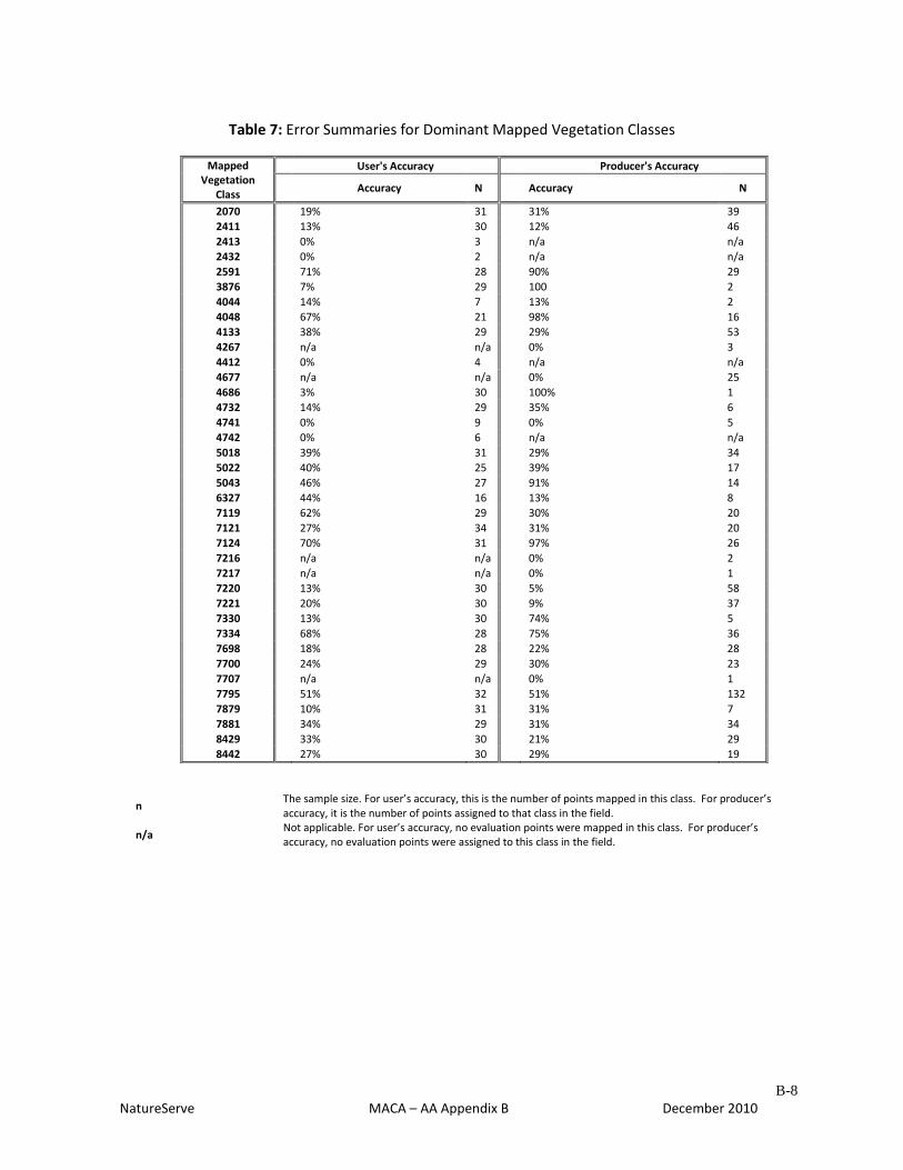
B-8
NatureServe MACA – AA Appendix B December 2010
Table 7: Error Summaries for Dominant Mapped Vegetation Classes
Mapped Vegetation
Class
User's Accuracy Producer's Accuracy
Accuracy N Accuracy N
2070 19% 31 31% 39
2411 13% 30 12% 46
2413 0% 3 n/a n/a
2432 0% 2 n/a n/a
2591 71% 28 90% 29
3876 7% 29 100 2
4044 14% 7 13% 2
4048 67% 21 98% 16
4133 38% 29 29% 53
4267 n/a n/a 0% 3
4412 0% 4 n/a n/a
4677 n/a n/a 0% 25
4686 3% 30 100% 1
4732 14% 29 35% 6
4741 0% 9 0% 5
4742 0% 6 n/a n/a
5018 39% 31 29% 34
5022 40% 25 39% 17
5043 46% 27 91% 14
6327 44% 16 13% 8
7119 62% 29 30% 20
7121 27% 34 31% 20
7124 70% 31 97% 26
7216 n/a n/a 0% 2
7217 n/a n/a 0% 1
7220 13% 30 5% 58
7221 20% 30 9% 37
7330 13% 30 74% 5
7334 68% 28 75% 36
7698 18% 28 22% 28
7700 24% 29 30% 23
7707 n/a n/a 0% 1
7795 51% 32 51% 132
7879 10% 31 31% 7
7881 34% 29 31% 34
8429 33% 30 21% 29
8442 27% 30 29% 19
n The sample size. For user’s accuracy, this is the number of points mapped in this class. For producer’s accuracy, it is the number of points assigned to that class in the field.
n/a Not applicable. For user’s accuracy, no evaluation points were mapped in this class. For producer’s accuracy, no evaluation points were assigned to this class in the field.

C-1
NatureServe MACA – AA Appendix C December 2010
APPENDIX C: ERROR SUMMARIES FOR RESULTS AT MAMMOTH CAVE NATIONAL PARK
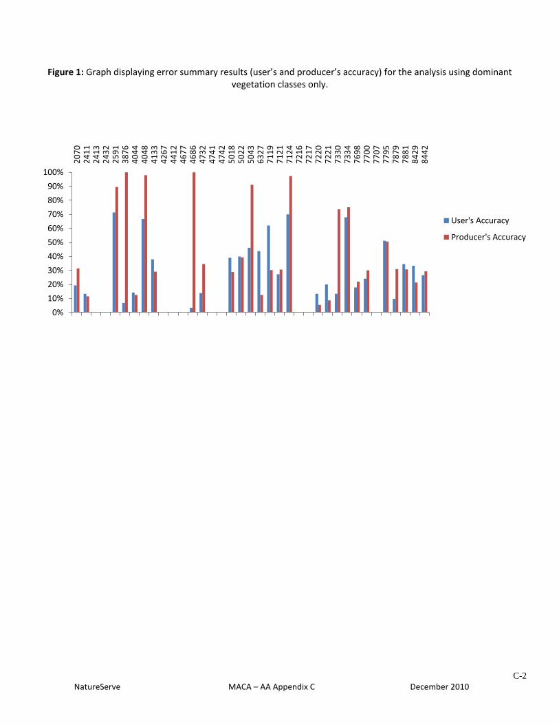
C-2
NatureServe MACA – AA Appendix C December 2010
Figure 1: Graph displaying error summary results (user’s and producer’s accuracy) for the analysis using dominant vegetation classes only.
0%
10%
20%
30%
40%
50%
60%
70%
80%
90%
100%
20
70
24
11
24
13
24
32
25
91
38
76
40
44
40
48
41
33
42
67
44
12
46
77
46
86
47
32
47
41
47
42
50
18
50
22
50
43
63
27
71
19
71
21
71
24
72
16
72
17
72
20
72
21
73
30
73
34
76
98
77
00
77
07
77
95
78
79
78
81
84
29
84
42
User's Accuracy
Producer's Accuracy

C-3
NatureServe MACA – AA Appendix C December 2010
Figure 2: Graph displaying error summary results (user’s and producer’s accuracy) for the analysis using dominant and secondary vegetation classes.
0%10%20%30%40%50%60%70%80%90%
100%
20
70
24
11
24
13
24
32
25
91
38
76
40
44
40
48
41
33
42
67
44
12
46
77
46
86
47
32
47
41
47
42
50
18
50
22
50
43
63
27
71
19
71
21
71
24
72
16
72
17
72
20
72
21
73
30
73
34
76
98
77
00
77
07
77
95
78
79
78
81
84
29
84
42
User's Accuracy
Producer's Accuracy
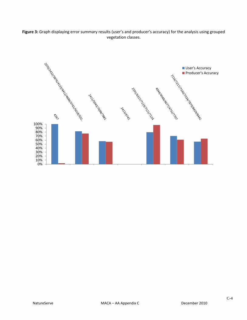
C-4
NatureServe MACA – AA Appendix C December 2010
Figure 3: Graph displaying error summary results (user’s and producer’s accuracy) for the analysis using grouped vegetation classes.
0%10%20%30%40%50%60%70%80%90%
100%
User's AccuracyProducer's Accuracy