Embed Size (px)
DESCRIPTION
Enhancements to the SHIPS Rapid Intensification Index. - PowerPoint PPT Presentation
Citation preview
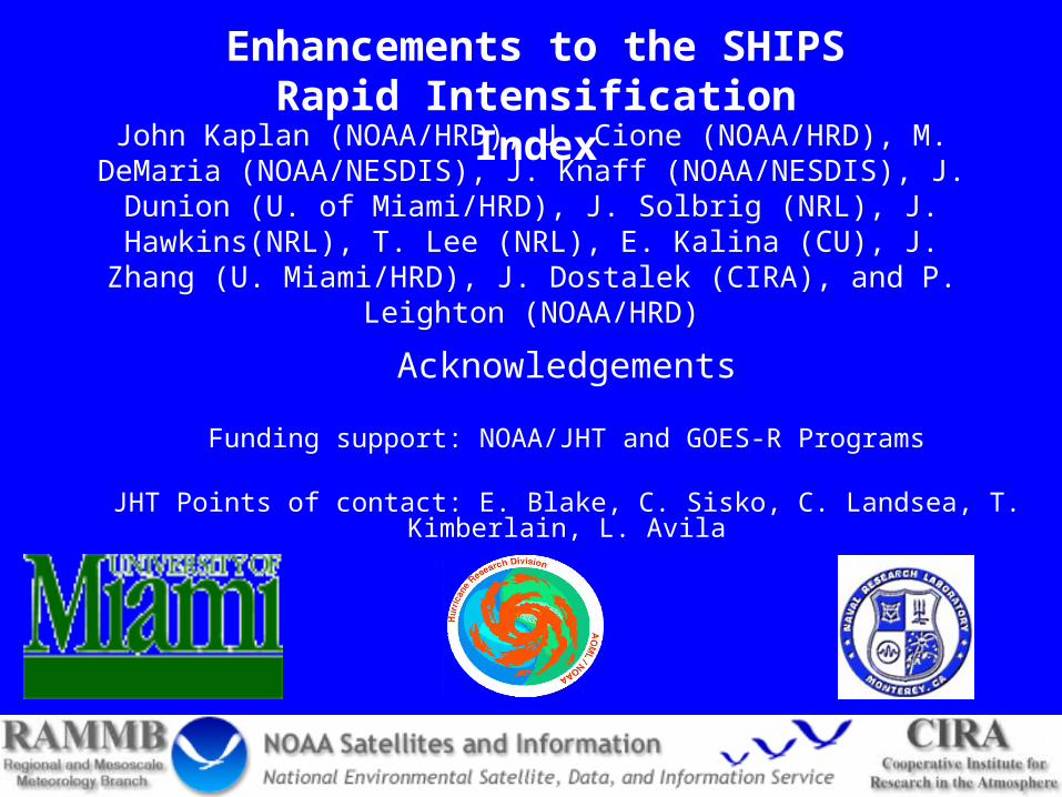
John Kaplan (NOAA/HRD), J. Cione (NOAA/HRD), M. DeMaria (NOAA/NESDIS), J. Knaff (NOAA/NESDIS), J. Dunion (U. of
Miami/HRD), J. Solbrig (NRL), J. Hawkins(NRL), T. Lee (NRL), E. Kalina (CU), J. Zhang (U. Miami/HRD), J. Dostalek (CIRA), and P.
Leighton (NOAA/HRD)
Acknowledgements
Funding support: NOAA/JHT and GOES-R Programs
JHT Points of contact: E. Blake, C. Sisko, C. Landsea, T. Kimberlain, L. Avila
Enhancements to the SHIPS Rapid Intensification Index
Background
• SHIPS rapid intensification index (RII)- provides 24-h probability of RI estimates for 25-kt, 30-kt , and 35-kt RI thresholds in Atlantic and E. Pacific basins using linear discriminant analysis (Kaplan et al. 2010)
• 8 Predictors used in current SHIPS RII
– 6 Large scale/persistence predictors - Vertical shear (850-200 mb), upper-level divergence (200 mb), low-level RH (850-700 mb), potential intensity, ocean heat content, and persistence
– 2 GOES inner-core predictors - Std. dev. of IR brightness T and areal-coverage of -30° C brightness T within 200 km radius
• SHIPS discriminant RII became operational prior to 2008 season
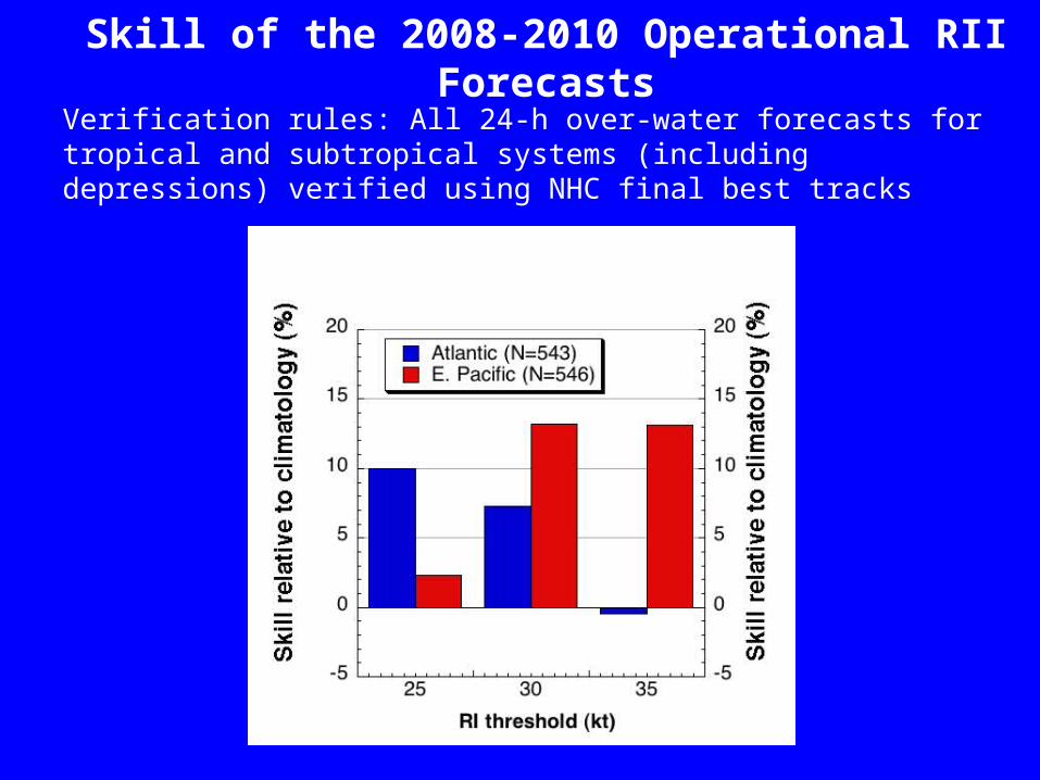
Verification rules: All 24-h over-water forecasts for tropical and subtropical systems (including depressions) verified using NHC final best tracks
Skill of the 2008-2010 Operational RII Forecasts
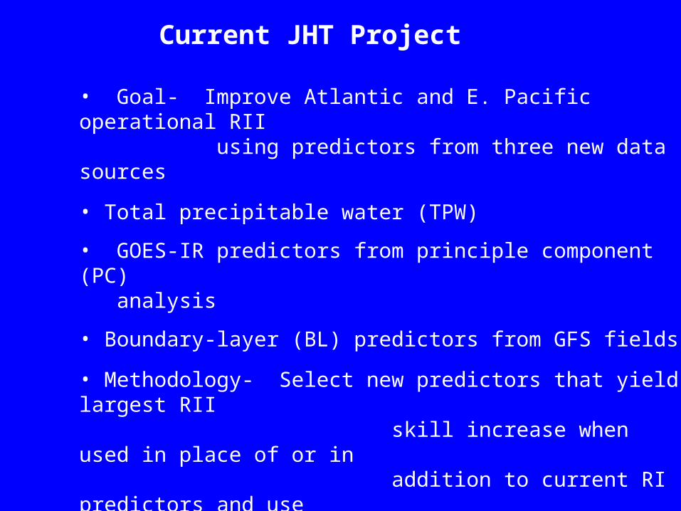
• Goal- Improve Atlantic and E. Pacific operational RII using predictors from three new data sources
• Total precipitable water (TPW)
• GOES-IR predictors from principle component (PC) analysis
• Boundary-layer (BL) predictors from GFS fields
• Methodology- Select new predictors that yield largest RII skill increase when used in place of or in addition to current RI predictors and use to derive new experimental versions of RII
Current JHT Project
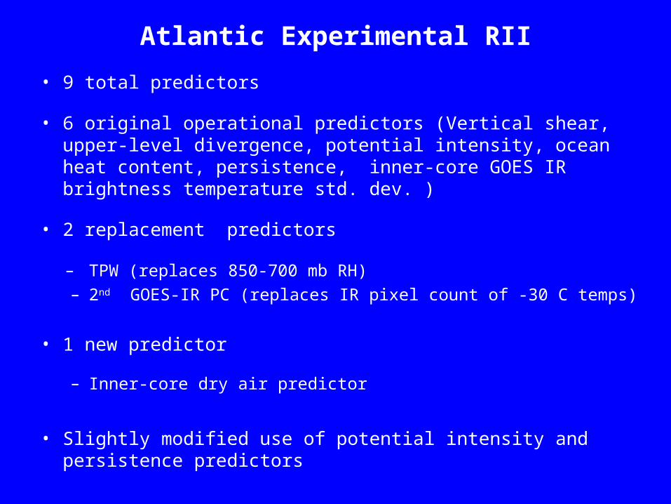
Atlantic Experimental RII
• 9 total predictors
• 6 original operational predictors (Vertical shear, upper-level divergence, potential intensity, ocean heat content, persistence, inner-core GOES IR brightness temperature std. dev. )
• 2 replacement predictors
– TPW (replaces 850-700 mb RH) – 2nd GOES-IR PC (replaces IR pixel count of -30 C temps)
• 1 new predictor
– Inner-core dry air predictor
• Slightly modified use of potential intensity and persistence predictors
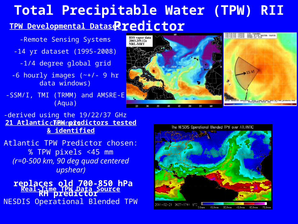
TPW Developmental Dataset
-Remote Sensing Systems
-14 yr dataset (1995-2008)
-1/4 degree global grid
-6 hourly images (~+/- 9 hr data windows)
-SSM/I, TMI (TRMM) and AMSRE-E (Aqua)
-derived using the 19/22/37 GHz channels
Total Precipitable Water (TPW) RII Predictor
21 Atlantic TPW predictors tested & identified
Atlantic TPW Predictor chosen:% TPW pixels <45 mm
(r=0-500 km, 90 deg quad centered upshear)
replaces old 700-850 hPa RH predictor
Real-Time TPW Data Source
NESDIS Operational Blended TPW
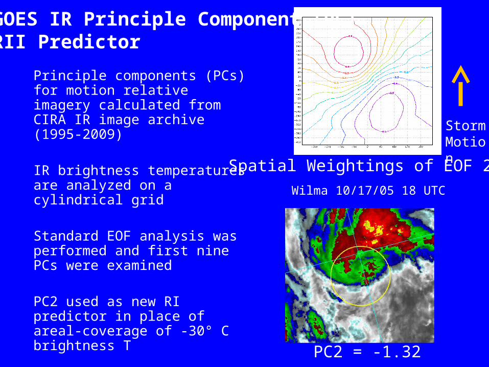
PC2 = -1.32
GOES IR Principle Component (PC)RII Predictor
Principle components (PCs) for motion relative imagery calculated from CIRA IR image archive (1995-2009)
IR brightness temperatures are analyzed on a cylindrical grid
Standard EOF analysis was performed and first nine PCs were examined
PC2 used as new RI predictor in place of areal-coverage of -30° C brightness T
StormMotion
Spatial Weightings of EOF 2
Wilma 10/17/05 18 UTC
Boundary-layer RII Predictor• GFS moisture and temperature analyses used to derive new thermo-
dynamic boundary-layer predictors (Total of 22 predictors tested)
• Inner-core dry air predictor worked best (Added as a 9th predictor)
• q10 is the inner-core 10-m specific humidity estimated using the 1000 mb 200- 800 km environmental RH and T
• q10layer is 10-m inner-core specific humidity estimated using 200-800 km environmental layer-mean RH between 1000 mb to 500 mb
• Vmx is the NHC maximum surface wind
• Smaller values of this predictor (indicating less potential for the mixing of dry air down to surface) are favored for RI
Inner-core dry air predictor = (q10layer-q10)*Vmx
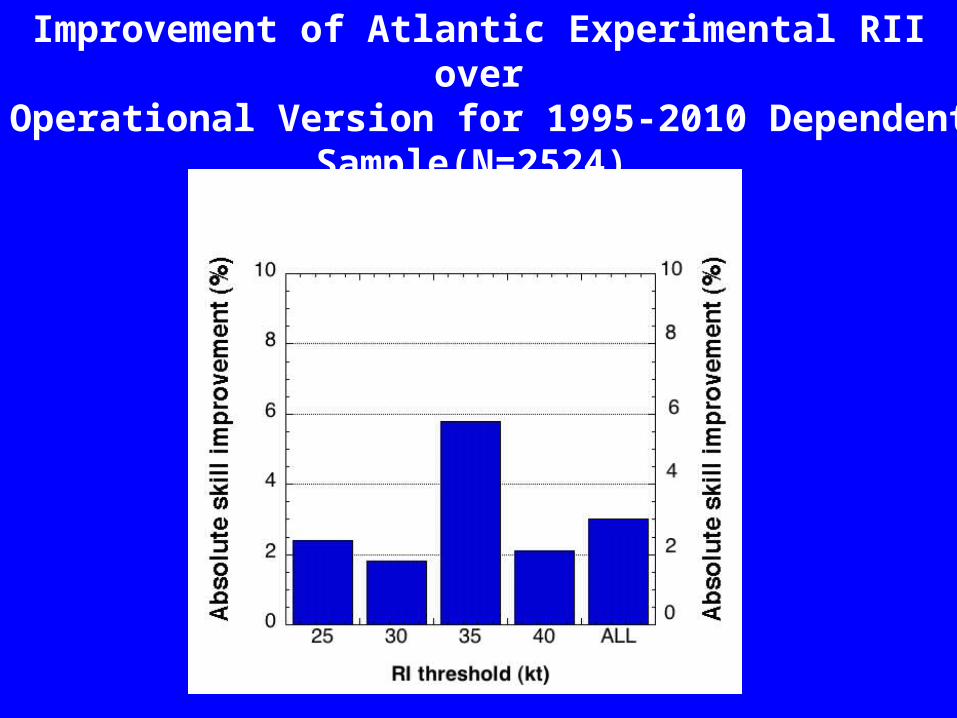
Improvement of Atlantic Experimental RII over Operational Version for 1995-2010 Dependent
Sample(N=2524)
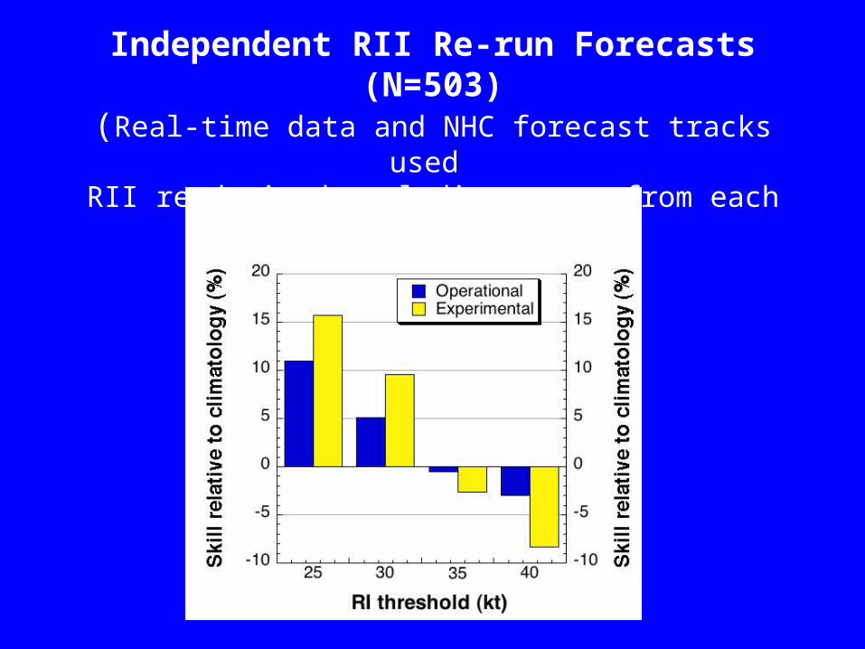
Skill of the 2008-2010 Atlantic Basin Independent RII Re-run Forecasts (N=503)
(Real-time data and NHC forecast tracks used
RII re-derived excluding cases from each year 2008-2010)
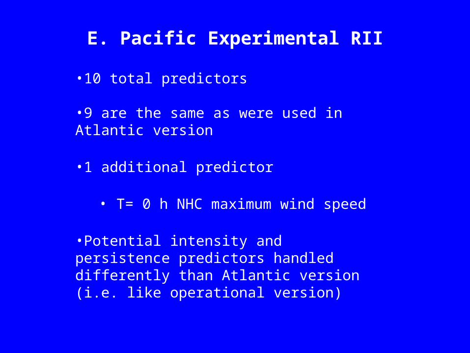
E. Pacific Experimental RII
•10 total predictors
•9 are the same as were used in Atlantic version
•1 additional predictor
• T= 0 h NHC maximum wind speed
•Potential intensity and persistence predictors handled differently than Atlantic version (i.e. like operational version)
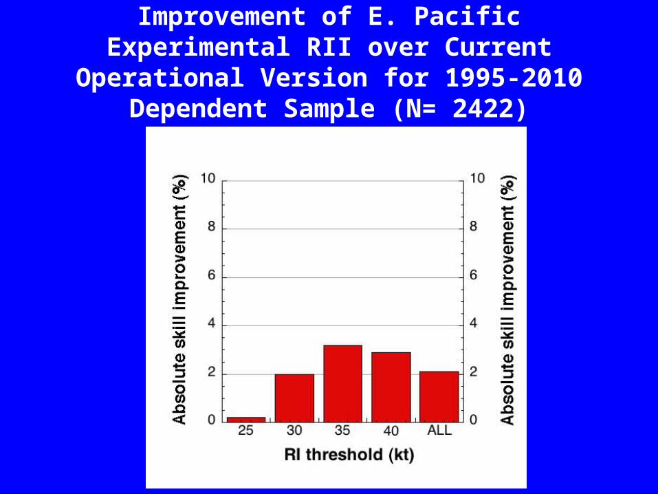
Improvement of E. Pacific Experimental RII over Current Operational Version for 1995-2010
Dependent Sample (N= 2422)
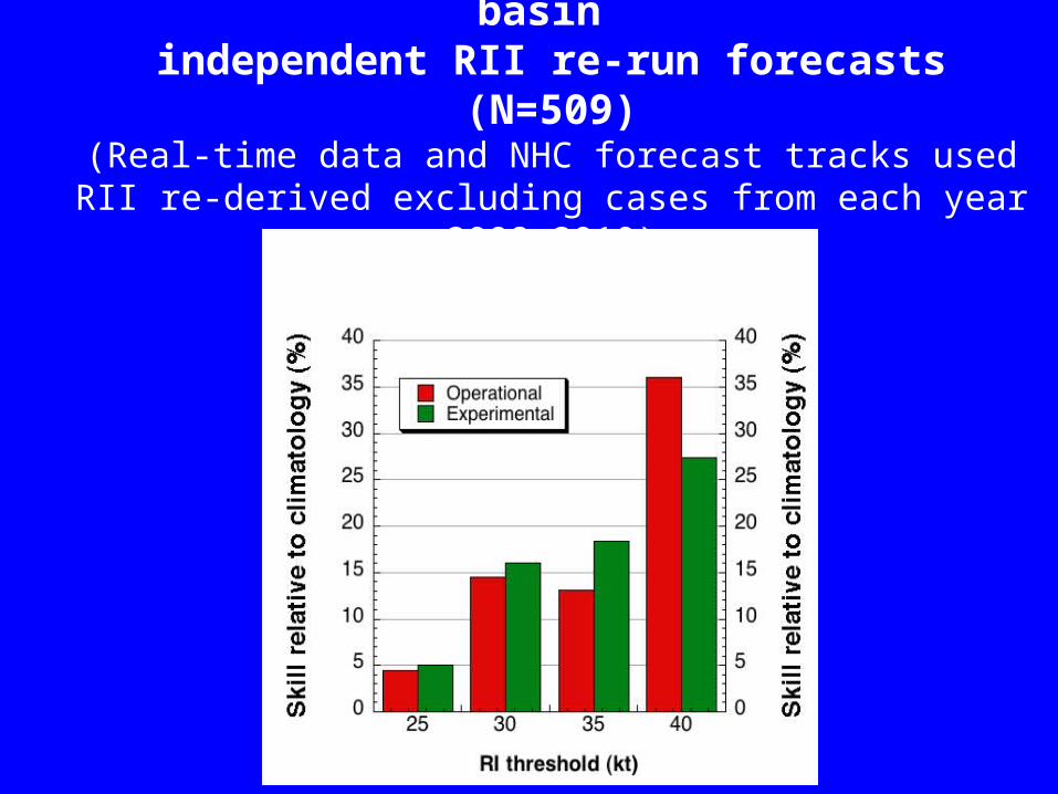
Skill of the 2008-2010 E. Pacific basin independent RII re-run forecasts (N=509)
(Real-time data and NHC forecast tracks usedRII re-derived excluding cases from each year 2008-2010)
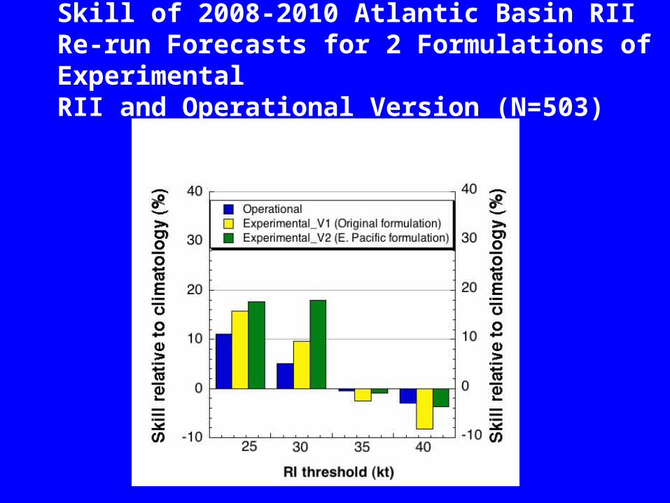
Skill of 2008-2010 Atlantic Basin RII Re-run Forecasts for 2 Formulations of Experimental RII and Operational Version (N=503)
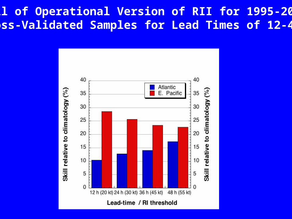
Skill of Operational Version of RII for 1995-2009 Cross-Validated Samples for Lead Times of 12-48 h
Summary/Future Plans• Operational RII exhibited some skill (except for 35 kt RI threshold in the
Atlantic basin) for the 2008-2010 sample for both Atlantic and E. Pacific basins. Skill was considerably higher in E. Pacific.
• Verification of 2008-2010 re-run forecasts showed new Experimental RII generally exhibited more skill than the current operational RII except at higher thresholds where skill was either equal to or somewhat less than current operational version (Sample size?).
• New experimental RII (E. Pacific formulation) will be run in parallel in 2011
in both Atlantic and E. Pacific as part of GOES-R program
• Future plans – extend RII to 48-h, develop/test Microwave-based (Velden et al. 2010), Lighting-based (Knaff et al 2010) and ensemble-based versions
of RII (Rozoff and Kossin 2011).
• Provide RII as input for new RII based intensity consensus model (Sampson et al. 2011)