Embed Size (px)
Citation preview
ACTON RECONNAISSANCE REPORT
FREEDOM’S WAY LANDSCAPE INVENTORY
MASSACHUSETTS HERITAGE LANDSCAPE INVENTORY PROGRAM
Massachusetts Department of Conservation and Recreation
Freedom’s Way Heritage Association
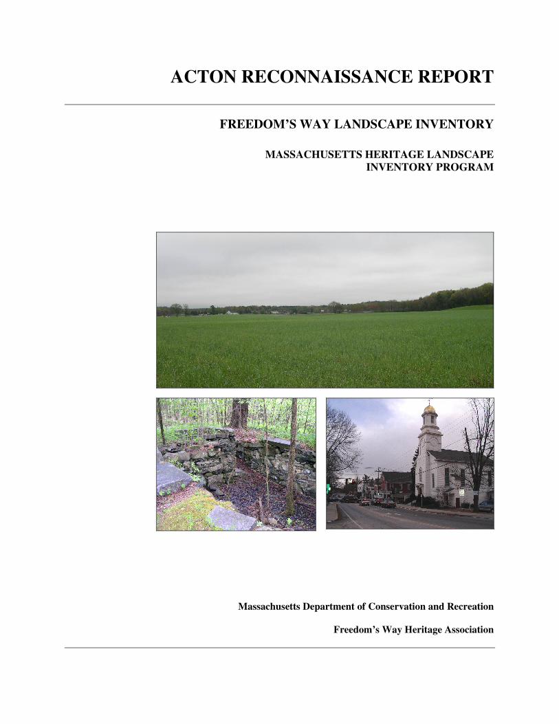
PROJECT TEAM Massachusetts Department of Conservation and Recreation Jessica Rowcroft, Preservation Planner Division of Planning and Engineering Freedom’s Way Heritage Association Mary Whitney, President Marge Darby, Chair, Advisory Committee Project Consultants Shary Page Berg Gretchen G. Schuler Anne M. Forbes Local Project Coordinator Mary Ann Ashton Local Heritage Landscape Participants Mary Ann Ashton Peter Ashton Meg Bagdonas, FWHA Jane Ceraso Ann Chang Kimberly Conners-Hughes Marge Darby, FWHA F. Doré Hunter Andrew Magee Ruth Martin Susan Mitchell-Hardt Cynthia Robinson Debra Simes Tom Tidman June 2006 Cover Photographs Route 2 Gateway Fields Mill Foundation at Wheeler Lane West Acton Streetscape
CONTENTS Introduction . . . . . . . . . . . . . . . . . . . . . . . . . . . . . . . . . . . . . . . . . . . . . . . . . . . . . 1 Acton History . . . . . . . . . . . . . . . . . . . . . . . . . . . . . . . . . . . . . . . . . . . . . . . . . . . 2 Priority Heritage Landscapes . . . . . . . . . . . . . . . . . . . . . . . . . . . . . . . . . . . . . . 3 Conant Land Grassy Pond and Bog Miller Farm – Station Master House Nagog Pond Nashoba Brook Route 2 Gateway Agricultural Fields South Acton Village Stonefield / Simeone Farm Wetherbee Street Woods Critical Concerns . . . . . . . . . . . . . . . . . . . . . . . . . . . . . . . . . . . . . . . . . . . . . . . 12 Historic Markers Scenic Roads Sewer District Development Stone Walls Existing Resource Documentation and Planning Tools. . . . . . . . . . . . . . . . . 14 Inventory of Historic and Archaeological Assets State and National Registers of Historic Places Planning Documents and Tools General Preservation Planning Recommendations . . . . . . . . . . . . . . . . . . . . 16 Inventory of Heritage Landscapes National Register Program Village and Rural Neighborhood Character Agricultural Landscapes Scenic Roads Funding of Preservation Projects Conclusion . . . . . . . . . . . . . . . . . . . . . . . . . . . . . . . . . . . . . . . . . . . . . . . . . . . . . 21 Appendix: Heritage Landscapes Identified by Community . . . . . . . . . . . . . 23
Massachusetts Heritage Landscape Inventory Program 1 Acton Reconnaissance Report
INTRODUCTION The Freedom’s Way Heritage Association includes 37 Massachusetts communities that are linked by historic events that helped to shape America’s democratic form of governance and the intellectual traditions that underpin American freedom, democracy, conservation and social justice. Freedom’s Way communities extend from Arlington on the east to Winchendon on the west. They represent a wide range of cities and towns, each shaped by the relationship between nature and culture. Heritage landscapes are special places created by human interaction with the natural environment that help define the character of a community and reflect its past. They are dynamic and evolving; they reflect the history of a community and provide a sense of place; they show the natural ecology that influenced land use patterns; and they often have scenic qualities. The wealth of landscapes is central to each community’s character, yet heritage landscapes are vulnerable and ever changing. For this reason it is important to take the first steps towards their preservation by identifying those landscapes that are particularly valued by the community – a favorite local farm, a distinctive neighborhood or mill village, a unique natural feature or an important river corridor. To this end, the Massachusetts Department of Conservation and Recreation (DCR) and the Freedom’s Way Heritage Association (FWHA) have collaborated to bring the Heritage Landscape Inventory program (HLI) to communities in the Freedom’s Way area. The primary goal of the program is to help communities identify a wide range of landscape resources, particularly those that are significant and unprotected. The focus is on landscapes that have not been identified in previous survey efforts in a given community. Another important goal of the program is to provide communities with strategies for preserving heritage landscapes. The methodology for the Heritage Landscape Inventory program was developed in a pilot project conducted in southeast Massachusetts and refined in Essex County. It is outlined in the DCR publication Reading the Land which has provided guidance for the program since its inception. In summary, each participating community appoints a Local Project Coordinator (LPC) to assist the DCR-FWHA consulting team. The LPC organizes a heritage landscape identification meeting at which interested residents and town officials offer community input by identifying heritage landscapes. This meeting is followed by a fieldwork session including the consulting team and the LPC, often accompanied by other community members. This group visits the priority landscapes identified in the meeting and gathers information about the community. The final product is this Reconnaissance Report, prepared for each participating community. It outlines the history of the community; describes the priority heritage landscapes; discusses planning issues identified by the community; identifies planning tools available in the community; and concludes with preservation recommendations. A list of all of the heritage landscapes identified by the community is included in the Appendix.
Massachusetts Heritage Landscape Inventory Program 2 Acton Reconnaissance Report
ACTON HISTORY
The Native American history of Acton dates back to the Middle Archaic Period (8,000-6,000 B.P.) with confirmed sites from this period and the Late Archaic Period (6,000-3,000 B.P.) through the Woodland Periods (3,000-450 B.P.). Many areas of Acton were good campsites with presumed hunting and fishing areas along Nashoba and Fort Pond Brooks as well as Nagog Pond. European settlement began in 1655 as part of Concord’s “New Grant,” when the first Concord farmers moved west for pasture and farmland. The 1,000-acre Concord Iron Works Farm, with much of the land in Acton, was established in ca. 1660. Charcoal to fuel the ironworks was produced here on the part of the farm that eventually became South Acton. South Acton was the center of the early industrial activity with the first fulling mill and sawmill on Fort Pond Brook in operation by 1706. Early roads followed the brook where Native Americans had made trails. School Street connected Concord with South Acton and eventually Central Street led west to West Acton where farmland was abundant. Great Road (Rt. 2A/119) and most of Main Street (Rt. 27) also were early roads following former Native American trails along Nashoba Brook. By the time Acton became incorporated in 1735, roads radiated from both South Acton and Acton Center. Soon after, Acton had its own meetinghouse (1738) at the Center. By the mid 18th century and continuing into the 19th century cooperages, a cider mill and two forges were operating in addition to grist and sawmills. Agriculture continued to be important, particularly in the northern and western parts of town where apple orchards took hold. By the 19th century agriculture and industry began to profit from increased mobility. Connections with Concord and the communities to the west were improved with the straight Union Turnpike laid out in 1806 along Massachusetts Avenue (Route 2 and 111) through West Acton to Leominster. In 1844 the Fitchburg Railroad passed through South and West Acton. Other industrial activities were established in the second and third quarter of the 19th century such as the 1835 powder mills on the Assabet River close to the Concord line, some minor shoe industry development and grist and sawmills and two pencil factories on Nashoba Brook. Larger 19th century industries located along Fort Pond Brook at South Acton included sash-and-blind factories, a wool shoddy mill, a calico print works and two piano-stool factories. With the laying out of the railroad and the industrial expansion came Irish immigrants in the mid 19th century and by 1860 Acton’s population had risen to 1,726. In the late 19th and early 20th century the village of West Acton grew with small industrial activities and apple orchards as the primary agricultural focus. Street railways connected Maynard with South Acton and West Acton from the late 19th century to the 1920s. The powder mills, located at the Concord and Maynard boundaries, were prosperous through World War II.
Massachusetts Heritage Landscape Inventory Program 3 Acton Reconnaissance Report
In the early 1900s a new wave of immigrants arrived from Nova Scotia followed by Italians and Norwegians and the population rose to around 2,000. In the 1920s, some town and county roads were improved to become regional highways. The first Route 2 followed Great Road (now Rt. 2A); the old Union Turnpike became Route 111 along Massachusetts Avenue; and Main Street through Acton Center connecting Maynard to the south with Carlisle and Westford to the north became Route 27. At about the time of these road improvements many of the small industries declined; and residential use of land increased, replacing industrial, commercial and even some agricultural uses. However, farming continued to be an important part of the economy as was evidenced by the Acton Agricultural Fair held yearly from 1917 to 1937. In 1950 Route 2 shifted south from the Great Road to follow Massachusetts Avenue and the line of the old Union Turnpike as far as Route 27, then skirted West Acton with a new auto route leading west out of town. Between 1950 and 1970 Acton experienced unprecedented growth. This had much to do with the road system noted above as well as commuter access to Boston along the Fitchburg line with two Acton stops. In 1950 the population was 3,500; by 1970 this figure had grown to nearly 15,000 and Acton was a true bedroom community. The number of housing units grew and has continued to escalate to accommodate over 20,000 residents by the turn of the 21st century. PRIORITY HERITAGE LANDSCAPES Acton’s Heritage Landscape Identification meeting, attended by approximately 12 residents, some representing town boards and local non-profit organizations, was held on March 30, 2006. During the meeting residents compiled a lengthy list of the town’s heritage landscapes, which is included in the Appendix. Once the comprehensive list was created, attendees were asked to articulate the value of each landscape and the issues relating to its preservation. Based on the information gathered, community members identified a group of priority landscapes to be visited by the consulting team during the fieldwork. Each of the priority landscapes is highly valued, contributes to community character and is not permanently protected or preserved. These landscapes, which are listed alphabetically, represent a range of scales and types of resources from individual sites such as the Station Master House to a village center. The descriptions and recommendations included here are an initial step in identifying resources valued by the community and suggesting action strategies. Several of these priority landscapes describe areas that have a number of layers of heritage landscapes. Each of these is a combination of multiple heritage landscapes that appear in the heritage landscape identification meeting chart below. Such layering shows the complexity and interdependence of most heritage landscapes.
Massachusetts Heritage Landscape Inventory Program 4 Acton Reconnaissance Report
Conant Land North of Acton Center is the old New England farmstead of the Conant family. This centrally located town landmark consists of a farmhouse, barn and farmland and woodland on both sides of Main Street, comprising approximately 200 acres divided into at least three parcels in common ownership. In 1793 Abel Conant built this dwelling by turning a small 1743 house into the ell of his Federal house. The house has been home to many generations of Conants who modified it to meet the styles and needs of the time. Major renovations occurred in 1880 when the house was enlarged and elaborated to its present Victorian Eclectic style. The large New England barn was probably built at about the same time, no doubt replacing earlier barns. The location of this farmstead and surrounding agricultural landscape on Main Street (Route 27) places it among the most visible landscapes to thousands of daily travelers using this route. It is an important transition from busy commercial Route 2A to the north and the town center to the south and is one of only a few local farms that retains its historic buildings within the agricultural landscape. Today a tree farm is operated here so that the owner of the property is participating in the Chapter 61-A program for tax purposes. Recommendations This property was most recently documented on an MHC form in 1990 by the Acton Historical Commission; however the total farming complex including agricultural fields and woodland were not accounted for at that time. Documentation and coordination of preservation strategies should be undertaken by the Historical Commission. In addition to the recommendations below, refer also to Agricultural Landscapes under the General Preservation Planning Recommendations section of this report for preservation of farms. � Document the Conant Farm on an MHC Area Form using Heritage
Landscape Inventory and MHC methodology to account for farming activities and extant resources.
� Work with property owners to develop strategies to permanently preserve
farm fields and woodland through conservation and preservation restrictions using M.G.L. Chapter 184, Sections 31-33 or an agricultural preservation restriction if farming activities are sufficient to qualify.
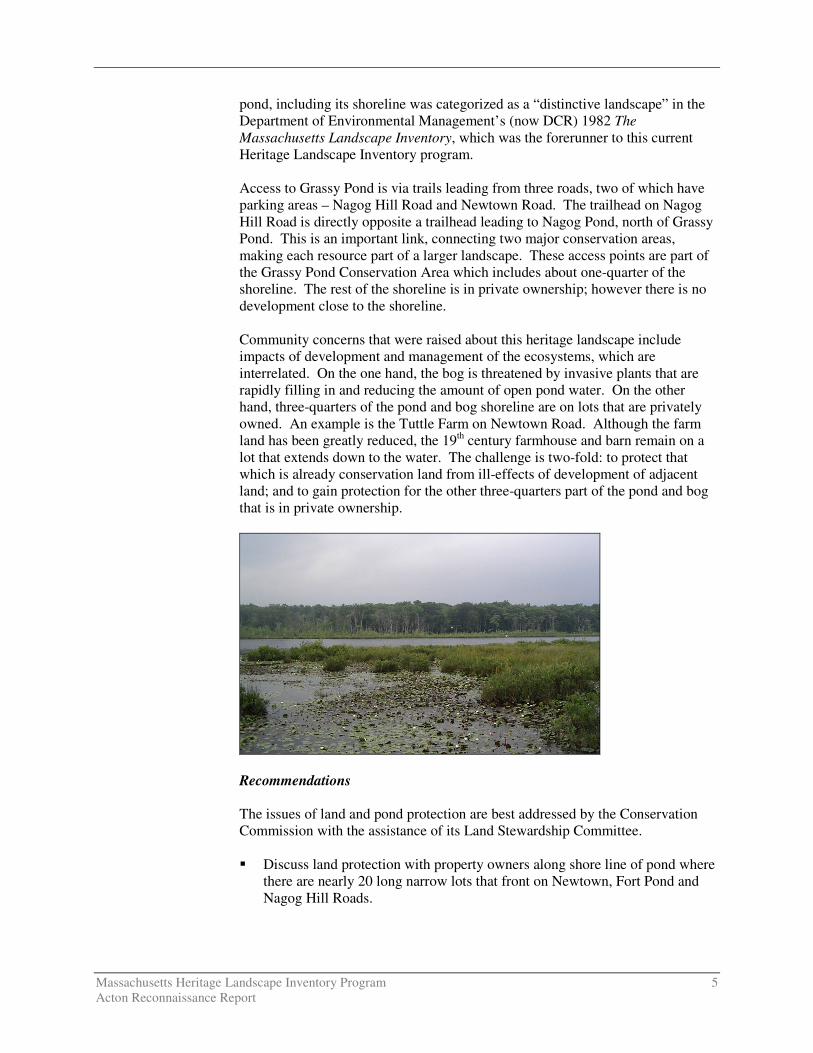
Grassy Pond and Bog Located near the Littleton border between Newtown and Nagog Hill Roads, the 17-acre Grassy Pond is a designated Great Pond open for fishing, canoeing and bird and other wildlife watching. It is a natural kettle hole, formed by a receded glacier. Around the edges and along the pond’s outlet (Grassy Pond Brook) is a quaking bog of ecological importance and high scenic value; the Massachusetts Natural Heritage Program has identified it as worthy of preservation. Adjacent to the southeast edge of the pond are 95 acres of conservation land, including about one-quarter of the pond’s shoreline, on which there are trails leading to the pond. A boardwalk extends into the pond providing views of the pond and bog. The
Massachusetts Heritage Landscape Inventory Program 5 Acton Reconnaissance Report
pond, including its shoreline was categorized as a “distinctive landscape” in the Department of Environmental Management’s (now DCR) 1982 The Massachusetts Landscape Inventory, which was the forerunner to this current Heritage Landscape Inventory program. Access to Grassy Pond is via trails leading from three roads, two of which have parking areas – Nagog Hill Road and Newtown Road. The trailhead on Nagog Hill Road is directly opposite a trailhead leading to Nagog Pond, north of Grassy Pond. This is an important link, connecting two major conservation areas, making each resource part of a larger landscape. These access points are part of the Grassy Pond Conservation Area which includes about one-quarter of the shoreline. The rest of the shoreline is in private ownership; however there is no development close to the shoreline. Community concerns that were raised about this heritage landscape include impacts of development and management of the ecosystems, which are interrelated. On the one hand, the bog is threatened by invasive plants that are rapidly filling in and reducing the amount of open pond water. On the other hand, three-quarters of the pond and bog shoreline are on lots that are privately owned. An example is the Tuttle Farm on Newtown Road. Although the farm land has been greatly reduced, the 19th century farmhouse and barn remain on a lot that extends down to the water. The challenge is two-fold: to protect that which is already conservation land from ill-effects of development of adjacent land; and to gain protection for the other three-quarters part of the pond and bog that is in private ownership.
Recommendations The issues of land and pond protection are best addressed by the Conservation Commission with the assistance of its Land Stewardship Committee. � Discuss land protection with property owners along shore line of pond where
there are nearly 20 long narrow lots that front on Newtown, Fort Pond and Nagog Hill Roads.
Massachusetts Heritage Landscape Inventory Program 6 Acton Reconnaissance Report
� Develop Master Plan for pond area including consideration of land acquisition or conservation restrictions for land that is not protected and preservation management of land already in conservation.
Miller Farm – Station Master’s House The former Charles Miller property remains from a small non-working farm in North Acton fronting on Main Street. The ca. 1875 clapboard dwelling faces south with a gable end to the street behind a tall vegetated screen that nearly hides it from the road. Adjacent to the house are remnants of an old apple orchard. The 3.75-acre property extends easterly to the old Framingham & Lowell/Penn Central Railroad right-of-way which will eventually become the Bruce Freeman Rail Trail. The house was built for the North Acton stationmaster and thus has strong associations with the development of the north part of Acton. Recommendations The property has been the subject of a large subdivision (Comprehensive Permit), which initially contemplated the demolition of the main house. Since the property was first considered for this report an agreement has been reached in which the developer has agreed to preserve the farmhouse, which will be relocated on the property. This agreement stemmed from the demolition delay process in which the Acton Historical Commission was able to make a case for preservation and the developer agreed. Successful preservation of the historic house has added scenic value to the development and this success story should be publicized as a model for other similar projects. The farmhouse was documented on an MHC form prior to this agreement. Nagog Pond Nagog Pond is a 284-acre Great Pond on the Acton-Littleton border, directly adjacent to the southern side of Route 2A. The large pond is partially in Acton and partially in Littleton but it is owned by the town of Concord as part of its water supply. The rights to the water were given to Concord in 1886. Concord also owns most of the Acton shoreline amounting to 58 acres on the Acton side of the pond. There are houses in private ownership along the Littleton banks of Nagog Pond. Most of these houses are well screened and modest in size; however proper management of these properties is essential in order not to have a negative impact on water quality of the pond. Nagog Pond can be viewed from several vantage points. It provides an important vista from the heavily traveled Great Road (Route 2A/119), which follows an old Native American trail along Nashoba Brook and Will’s Hole Brook to Nagog Pond. The road passes along the northeast edge of the pond. Views from Nashoba Road on the west side of the pond (in Littleton looking towards Acton) and a small glimpse from Nagog Hill Road on the southwest side also are picturesque.

Massachusetts Heritage Landscape Inventory Program 7 Acton Reconnaissance Report
The pond was categorized as a “distinctive landscape” in the Department of Environmental Management’s (now DCR) 1982 The Massachusetts Landscape Inventory. Recommendations There are a number of interested parties in Acton, Concord and Littleton. Concord’s plans for the pond are likely to be consistent with preservation of the water quality as well as the scenic view; however if it no longer is needed as a water resource Acton would want to be able to gain control of the property. In addition both communities should work together with Littleton to limit development on the shoreline of Nagog Pond. Finally Acton and Littleton’s Highway Departments should encourage Mass Highway Department to treat Route 2A/119 sensitively with the least invasive road work as possible. The roadway along the pond should not be widened and the use of salt should be minimal due to the close proximity of the road to the pond. Nashoba Brook Nashoba Brook is a main waterway through Acton flowing from Westford to Concord on a more or less north-south route. In Acton the northern part of the brook runs parallel to the northern part of Main Street (Route 27) until crossing under Great Road (Routes 2A/119) where it is joined by Nagog and Conant Brooks. Just south of Great Road, Nashoba Brook turns to flow in a southeasterly direction along the southwest side of Great Road and the old Framingham & Lowell Railroad. Below the pond it flows into Concord, passes under Route 2, and joins with Fort Pond Brook to flow into Warner’s Pond and the Assabet River. Nashoba Brook is rich with history from Native American campsites to 19th century mill sites and 20th century ice-cutting activity. Views of the brook from the road are intermittent. One entrance to the Nashoba Brook Conservation Area is at the end of Wheeler Lane off Main Street in the northern part of town. Here one can view the brook as it meanders through this wooded area where there are mill ruins, the Robbins Mill pond and spillway, a cellar hole and a wide cart path bordered by stone walls paralleling the brook. This 123-acre conservation parcel is one of the best locations from which to view and walk along Nashoba Brook which is scenic and has good fishing areas. A trail from Wheeler Lane south follows the brook along the stone wall-lined cart path to the site of an old pencil factory before looping around over the brook and back to Wheeler Lane. Further downstream, Nashoba Brook winds behind the properties on the southwest side of Great Road from Brook Street south to Wetherbee Street near the Concord border. There are many glimpses of the brook from Great Road, particularly in the area of Ice House Pond and behind the two 1790s “Lottery Houses” that front on Great Road. The town recently reconstructed a “stone chamber” that is an archaeological site near Nashoba Brook.
Massachusetts Heritage Landscape Inventory Program 8 Acton Reconnaissance Report
Besides minimal views and access to Nashoba Brook in Acton, concerns include the impact of large scale development of shopping malls and apartment dwellings along Great Road. Recommendations Most of the historic resources along Nashoba Brook have been documented at some level. Revisiting historic maps and checking to make sure that the context of properties in the area is accounted for would be the work of the Historical Commission. Protection of the water quality will take vigilant enforcement of Acton’s Wetlands Protection Bylaw. Creating more access and education about the importance of Nashoba Brook in Acton’s historical development can be best accomplished through a joint effort of the Historical and Conservation Commissions. Therefore: � Add to historical and archaeological documentation where appropriate. � Enforce Wetlands Protection Bylaw and Rules and Regulations.
� Work with other property owners along the brook to find additional access
points such as from the Moritz property on Wetherbee Street, using the public right-of-way recently granted by the owners of the John Robbins House at 144 Great Road as a model.
� Develop educational materials for schools and general public on the history
of the brook. (Plans are underway to use CPA funds to develop educational information on the stone chamber near the brook.)
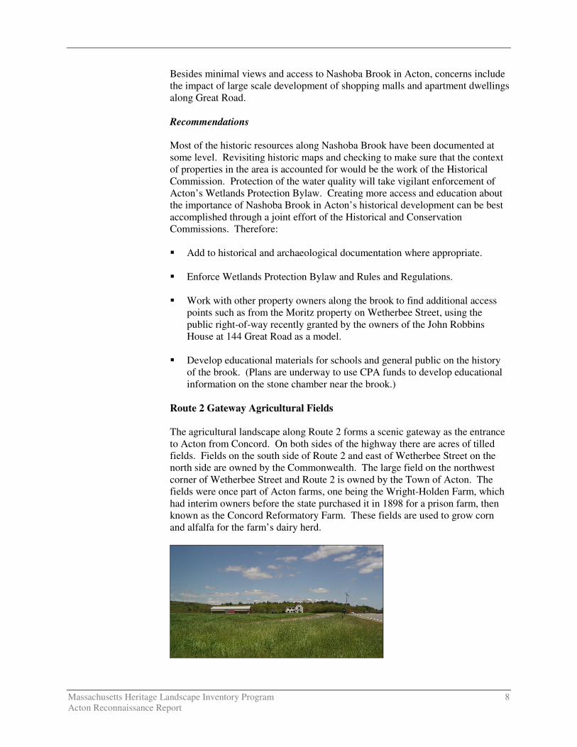
Route 2 Gateway Agricultural Fields The agricultural landscape along Route 2 forms a scenic gateway as the entrance to Acton from Concord. On both sides of the highway there are acres of tilled fields. Fields on the south side of Route 2 and east of Wetherbee Street on the north side are owned by the Commonwealth. The large field on the northwest corner of Wetherbee Street and Route 2 is owned by the Town of Acton. The fields were once part of Acton farms, one being the Wright-Holden Farm, which had interim owners before the state purchased it in 1898 for a prison farm, then known as the Concord Reformatory Farm. These fields are used to grow corn and alfalfa for the farm’s dairy herd.
Massachusetts Heritage Landscape Inventory Program 9 Acton Reconnaissance Report
In addition to the fields on both sides of Route 2, the Commonwealth’s property in Acton (about 122 acres) comprises the ca. 1830 Silas Holden Farmhouse, (on the 2004 Preservation Mass list of Ten Most Endangered Properties), which is dilapidated and abandoned, and two large modern barns, one used to house State Police horses. The house is highly visible from Route 2. Some of the fields are leased to a local farmer; other fields have been turned into paddocks for the State Police horses. The town-owned fields, known as the Wetherbee Conservation Fields (which were purchased from the state in 1982) are leased back to the prison system to grow crops such as corn and alfalfa for the cows at the Concord Reformatory Farm, now part of the Massachusetts Department of Correction. The large scale of this agricultural landscape and its location at the entrance to Acton make it a significant resource to Acton, Concord and the thousands of people who travel along Route 2 daily. In an attempt to preserve this landscape from development, the town rezoned it as Agricultural Recreation Conservation (ARC). However, this protective zoning would not apply to the state if it decided to develop the fields for state purposes or to alter the highway as part of a plan to potentially alleviate traffic at the Concord rotary just east of the fields. These fields extend easterly into Concord and were identified as a priority heritage landscape in that town. Recommendations Preservation of these fields is a top priority in Acton’s 2002-2007 OSRP. Cooperation between Acton, Concord and the State Department of Correction (owner of the fields) will be the only way to secure preservation of this scenic gateway. Acton and Concord have similar concerns so it is important for representatives to continue to work together so that changes in administration and staffing do not mean that the history of the town’s interest is forgotten. The DOC would likely raise objections to any proposed National Register listing; however it may be helpful to ascertain whether the landscape would meet National Register standards. The Historical Commission may work with other town officials and with the Acton Conservation Trust which may act as a facilitator and help provide solutions. � Complete MHC Area Form to discuss agricultural landscape that goes with
the Wright-Holden House which is documented on an MHC building form. This will require additional research about farming practices here and use of fields in the past which may be augmented with Agricultural Census records information.
� Request NR eligibility opinion from the MHC.
� Form ad hoc committee with Concord to address preservation of the overall
state-owned agricultural landscape along Route 2, which is also on the Concord priority heritage landscape list. Continue to remind DOC of Acton’s and Concord’s interest in this vital agricultural landscape.
Massachusetts Heritage Landscape Inventory Program 10 Acton Reconnaissance Report
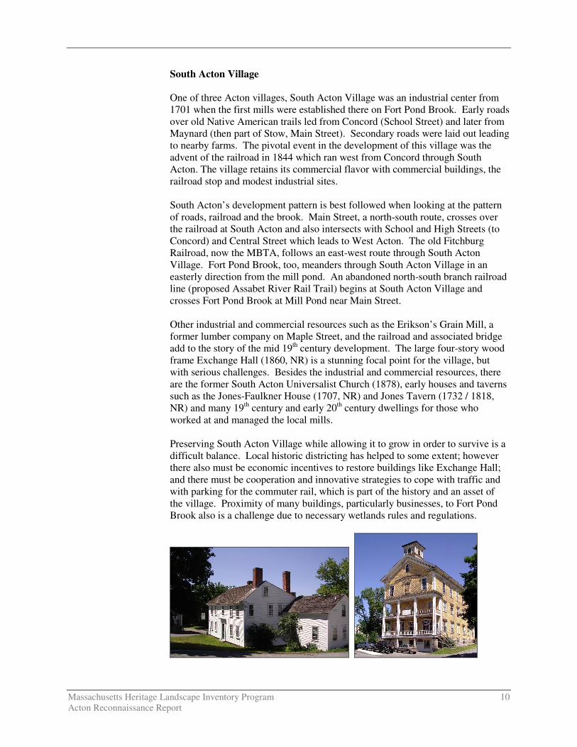
South Acton Village One of three Acton villages, South Acton Village was an industrial center from 1701 when the first mills were established there on Fort Pond Brook. Early roads over old Native American trails led from Concord (School Street) and later from Maynard (then part of Stow, Main Street). Secondary roads were laid out leading to nearby farms. The pivotal event in the development of this village was the advent of the railroad in 1844 which ran west from Concord through South Acton. The village retains its commercial flavor with commercial buildings, the railroad stop and modest industrial sites. South Acton’s development pattern is best followed when looking at the pattern of roads, railroad and the brook. Main Street, a north-south route, crosses over the railroad at South Acton and also intersects with School and High Streets (to Concord) and Central Street which leads to West Acton. The old Fitchburg Railroad, now the MBTA, follows an east-west route through South Acton Village. Fort Pond Brook, too, meanders through South Acton Village in an easterly direction from the mill pond. An abandoned north-south branch railroad line (proposed Assabet River Rail Trail) begins at South Acton Village and crosses Fort Pond Brook at Mill Pond near Main Street. Other industrial and commercial resources such as the Erikson’s Grain Mill, a former lumber company on Maple Street, and the railroad and associated bridge add to the story of the mid 19th century development. The large four-story wood frame Exchange Hall (1860, NR) is a stunning focal point for the village, but with serious challenges. Besides the industrial and commercial resources, there are the former South Acton Universalist Church (1878), early houses and taverns such as the Jones-Faulkner House (1707, NR) and Jones Tavern (1732 / 1818, NR) and many 19th century and early 20th century dwellings for those who worked at and managed the local mills. Preserving South Acton Village while allowing it to grow in order to survive is a difficult balance. Local historic districting has helped to some extent; however there also must be economic incentives to restore buildings like Exchange Hall; and there must be cooperation and innovative strategies to cope with traffic and with parking for the commuter rail, which is part of the history and an asset of the village. Proximity of many buildings, particularly businesses, to Fort Pond Brook also is a challenge due to necessary wetlands rules and regulations.
Massachusetts Heritage Landscape Inventory Program 11 Acton Reconnaissance Report
Recommendations The Historical Commission has documented properties in South Acton Village and in 1991 the area was designated a local historic district, which is under the purview of the Acton Historic District Commission. While only individual buildings are listed in the National Register, the village as a whole would be eligible for listing as a National Register district. The town developed a South Acton Village Plan in 1995 and has accomplished many of the plan’s goals. Presently some economic incentives may assist property owners in saving important village resources. Community Preservation Act funds can be used to this end provided that a Preservation Restriction (PR) (M.G.L. Chapter 184, Section 31-33) is applied to the property in order to protect the public investment. Due to the importance of this intact industrial village it is important for the Historical Commission and the Historic District Commission work with other land use boards to preserve the village while revitalizing it. � Complete a National Register district nomination for the village after
consulting with the MHC to determine the appropriate boundaries. National Register listing will make certain income-producing properties eligible for tax credits when substantial rehabilitation takes place.
� Work with property owners and the Community Preservation Committee to
facilitate financing of restoration for key properties that meet the goals and requirements of Acton’s Community Preservation Plan.
� Work with Planning Board to understand reuse and development constraints
that may inhibit the preservation of historic structures. Stonefield – Simeone Farm Located in South Acton, Stonefield Farm, also known as Simeone Farm, uses its 64 acres for market gardening. Fields stretch along Martin, Stow and Liberty Streets and extend easterly to Fort Pond Brook and the Mill Pond at South Acton center. Additional fields that are used by Stonefield Farm are on the north side of Fort Pond Brook behind dwellings along the eastern end of Maple Street. The farmhouse, on Martin Street, is a ca. 1910 Cape with Colonial Revival detail. The Simeone family has owned and worked this truck farm since 1929 growing vegetables and plants. They sell their produce from greenhouses on the property as well as to retailers. Recommendations The Historical Commission has documented the house, but not the agricultural landscape which has been in active use by the same family for over 75 years. The Historical Commission should complete documentation and consider agricultural landscape preservation strategies to protect farming activities at Stonefield Farm. In addition to the recommendations below, please also refer to Agricultural Landscapes under the General Preservation Planning Recommendations section of this report for preservation of farms.
Massachusetts Heritage Landscape Inventory Program 12 Acton Reconnaissance Report
� Augment MHC documentation by completing an Area Form to address other resources on the property besides the farmhouse.
Wetherbee Street Woods This large parcel that fronts on Wetherbee Street is also referred to as the Moritz land, named for its present owner. The 33 acres are wooded and form a low hill north of the town-owned tilled fields at the corner of Wetherbee Street and Route 2. Wetherbee Street is a short connector between Route 2 and Route 2A/119 to the north. Nashoba Brook flows along the northern edge of the property, following the route of the former Framingham & Lowell / Penn Central Railroad which crosses at the edge of the property as well. Property along Rt. 2A/119 is in a village zoning district allowing commercial uses, while the Moritz parcel is zoned residential; it also is designated Zone II meaning that it is in a well recharge area, which carries limits on the type of development that may occur. There are a number of communications towers among the trees on the hill. Future use of the Moritz land is of concern to the town for its land features, its connections to existing conservation land and the potential negative impact that development may have on the area. The hill forms a wooded backdrop to the town-owned 72-acre Wetherbee Conservation Land, which includes the tilled field just south of the Moritz land. Adding this 33-acre parcel to the Wetherbee land would preserve the beauty of the view across the tilled fields. In addition it would provide a trail link between the Wetherbee Conservation Land and the proposed Bruce Freeman Rail Trail that will run along the railroad right-of-way on the northeast edge of this property. Finally preservation of the open space would better protect Nashoba Brook and provide access to the brook which is also a priority heritage landscape. Recommendations The town has been working with the property owner in the hope of being able to purchase the property; however discussions have been unsuccessful to date. This piece should be part of a master plan to preserve the Route 2 Gateway Agricultural Fields. The Conservation Commission and Open Space Committee should work together to encourage use of CPA funds to purchase the property. This may be a task that is best addressed by an ad hoc committee made up of representatives of the Conservation Commission, Parks and Recreation Commission, Historical Commission and Selectmen, as well as the Acton Conservation Trust. CRITICAL CONCERNS In addition to the priority landscapes listed in the previous section, residents also identified critical issues related to heritage landscapes and community character. Critical issues are town-wide concerns that are linked to a range or category of heritage landscapes, not to a particular place. These issues are listed in alphabetical order. Community members also expressed interest in learning
Massachusetts Heritage Landscape Inventory Program 13 Acton Reconnaissance Report
about preservation tools and strategies that have been effective in other Massachusetts communities and in identifying sources for preservation funding.
Historic Markers
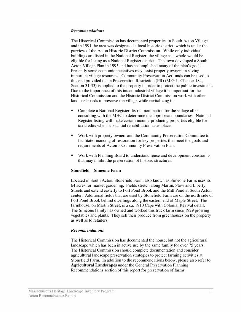
While Acton has only a few documented historic markers there are several kinds of markers that tell the history of the development of the community. They include three commemorative boulders installed in 1895 that record historic events at the onset of the Revolutionary War that helped shape Acton’s history; only one of the boulders is officially documented. Residents expressed concern that these and other markers go unnoticed and may be lost or damaged if they are not brought to the public’s attention.
Scenic Roads
Many of Acton’s roads retain their rural character with narrow width, a tree
canopy and stone walls that frame historic landscapes beyond. Views from the roads include farms, orchards, ponds, brooks, wetlands, 19th century residential neighborhoods and even some mill sites. The town adopted a scenic roads bylaw in which 33 roads or sections of roads were designated. However, there is concern that the general character of these roads changes with new development bringing increased traffic, and with road improvements. Refer to Scenic Roads in the General Preservation Planning Recommendations section of this report for suggestions on ways to address these concerns.
Sewer District Development
Acton residents expressed concern about the effect of sewer proposals on land use in the villages. The density of the villages and the number of failing systems led the town to form sewer districts with plans to build waste water treatment facilities. The facility in South Acton has been constructed but not without difficulty. The plot of land selected turned out to have high archaeological potential so that a full investigation and evacuation of resources was completed prior to construction of the facility which is close to the Assabet River. The archaeological site dates from the Middle Archaic through Middle Woodland periods (7,500 through 2,000 B.P.). Here the concern was with the near loss of important information about the past which may be the case in other locations at East Acton and West Acton. The other major concern is that the success of a
Massachusetts Heritage Landscape Inventory Program 14 Acton Reconnaissance Report
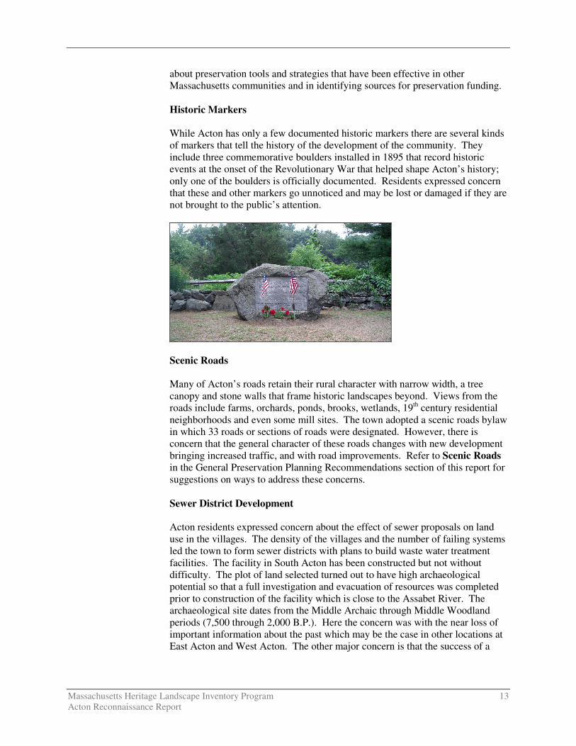
sewer district can lead to increased development in the form of expansion of existing structures and new construction, both at the expense of historical and architectural integrity of the village centers. Stone Walls Historic stone walls are found throughout Acton – along scenic roads; in fields where they are separating one pasture or meadow from another or as markers along property boundaries; and, lining old cart paths. A length of two parallel stone walls marks a cart path off Wheeler’s Lane near the old Robbins Mill Site. Another wall that was mentioned by concerned citizens runs along the South Acton train commuter lot. This wall is believed to be part of the original bounds of the Major Simon Willard grant which became the Iron Work Farm in ca. 1660. Historic stone walls are vulnerable to development and residents expressed concern that they are important to the character of many of Acton’s heritage landscapes.
EXISTING RESOURCE DOCUMENTATION AND PLANNING TOOLS Acton already has important planning tools in place to document current conditions within the town; identify issues of concern to town residents; and to help develop strategies for action. This section of the Reconnaissance Report identifies some of the existing planning documents and tools that provide information relevant to the Heritage Landscape Inventory program. Inventory of Historic and Archaeological Assets The Massachusetts Historical Commission’s (MHC) Inventory of Historic and Archaeological Assets is a statewide list that identifies significant historic resources throughout the Commonwealth. In order to be included in the inventory, a property must be documented on an MHC inventory form, which is then entered into the MHC database. This searchable database, known as MACRIS, is now available online at http://www.sec.state.ma.us/mhc.
Massachusetts Heritage Landscape Inventory Program 15 Acton Reconnaissance Report
According to the MHC, Acton’s inventory documents nearly 600 historic resources ranging from the turn of the 18th century to the late 20th century. Much of the work was completed in 1990 when the town undertook a village survey in preparation for establishing three local historic districts. Many properties had been documented previously and a few have been added to the inventory since 1990. The most recent forms were written in 2006 for the town-owned Morrison Farm and adjacent resources on Concord Road as part of the planning process for that property. Acton has 17 ancient Native American sites dating back to the Middle Archaic Period (8,000-6,000 B.P.) and four historic archaeological sites. One of the ancient Native American sites has been determined eligible for listing in the National Register under Criterion D. Due to the known information about other regions as well as the apparent Native American activity in Acton, it is likely that there will be more archaeological sites identified in the future. State and National Registers of Historic Places The National Register of Historic Places is the official federal list of districts, sites, buildings, structures and objects that have been determined significant in American history, architecture, archaeology, engineering and culture. The Town of Acton’s National Register (NR) program began in 1971 with the listing of the Faulkner Homestead (now referred to as the Jones-Faulkner House) followed in 1972 with listing of the Isaac Davis Trail passing through Acton and Concord. In addition to these two listings Acton has one National Register District (Acton Center Historic District – the National Register listing spells the name of this district Acton Centre) and four other individual listings: Jones Tavern, and Exchange Hall, (both in South Acton); the Jonathan and Simon Hosmer House, now owned by the Acton Historical Society; and the John Robbins House on Great Road. All are automatically listed in the State Register of Historic Places. Three local historic districts – Acton Center, South Acton Village and West Acton Village Historic Districts – also are listed in the State Register. Two of the individually listed properties, the Jones Tavern and the John Robbins House, are protected by preservation restrictions drawn up in accordance with MGL Chapter 184, Sections 31-33. A preservation restriction (PR) runs with the deed and is one of the strongest preservation strategies available. All properties that have preservation restrictions filed under the state statute are also automatically listed in the State Register. Planning Documents and Tools In 1998 Acton adopted the Acton Master Plan as an update to the 1991 plan. The Acton Open Space and Recreation Plan written in 2002 covers the five-year period 2002 to 2007. Preserving Villages, Archaeological Sites and Archives: Common Themes and Proposed Guidelines for Acton, Groton and Stow was written in 1993 by BU Preservation Studies students. Preservation strategies adopted by Acton include a local historic district bylaw, a demolition delay bylaw and a scenic roads bylaw. The Acton Local Historic
Massachusetts Heritage Landscape Inventory Program 16 Acton Reconnaissance Report
District Bylaw regulates changes made to the exterior architectural features of structures located in the Acton Center Historic District, South Acton Village Historic District and the West Acton Village Historic District. Acton also adopted design review standards and guidelines for its local historic districts. The standards and guidelines are helpful tools for applicants and commissioners alike. The Demolition Delay Bylaw gives the Historical Commission the authority to review and delay proposed demolition for up to six months for properties that are listed in the National Register, included in Acton’s Cultural Resource Inventory or determined by the Acton Historical Commission to be historically or architecturally significant; however town-owned properties are exempt. The Scenic Roads Bylaw regulating the removal of trees and stone walls within the right-of-way applies to 33 Acton roads, including the Isaac Davis Trail, as a separate listing although it passes over some of the scenic roads on the town’s list. In 2002 Acton adopted the Community Preservation Act at a 1.5% surcharge on real estate taxes; a portion of the proceeds must be used for historic preservation. Several historic projects have been funded and completed with CPA money. Some examples consistent with preservation of heritage landscapes are restoration of the Davis Monument, installation of historic district signs and planning for the Assabet River Rail Trail. At the 2006 Spring Town Meeting, funds were appropriated to replace the roofs of the Town Hall and Jones Tavern, restore an historic stone chamber, and develop a design for the Bruce Freeman Rail Trail. Acton’s Zoning Bylaw has two sections that guide development in a way that is consistent with preservation of heritage landscapes: the Open Space Development Bylaw and the Planned Conservation Residential Community District Bylaw. Each encourages the use of land to be in harmony with its cultural features and requires the preservation of some open space in the development. The Open Space Development Bylaw requires 30% to 50% of dedicated common land and seeks to “preserve unique and significant natural, historical and archaeological resources…” while promoting development that is consistent with the “traditional landscape.” GENERAL PRESERVATION PLANNING RECOMMENDATIONS Recommendations pertaining to priority heritage landscapes can be found beginning on page 3 of this report. This section of the Reconnaissance Report offers more general recommendations relevant to preserving the character of the community that would be applicable to a wide range of community resources. Acton’s residents highly value on the community’s strong sense of place, which is created by its varied natural features and land use patterns that flow from the fertile land. The town has already taken measures to document and evaluate its most significant buildings and natural areas. It is now looking beyond the
Massachusetts Heritage Landscape Inventory Program 17 Acton Reconnaissance Report
traditional resources to the landscapes, streetscapes, rural roads, 19th century neighborhoods and other natural and cultural assets that define the overall fabric of the community. Like most municipalities, Acton is facing multiple pressures for change that threaten land-based uses and natural resources. Special places within the community that were once taken for granted are now more vulnerable than ever to change. Preservation planning is a three-step process: identification, evaluation and protection. Four useful documents to consult before beginning to implement preservation strategies are: � Department of Conservation and Recreation, Reading the Land
� Freedom’s Way Heritage Association, Feasibility Study
� Massachusetts Historical Commission, Survey Manual
� Massachusetts Historical Commission, Preservation through Bylaws and
Ordinance Recommendations that apply to a broad range of resources are discussed below. These recommendations are listed in the order in which they are most logically addressed when applying the three-step preservation planning process as described above. Thus the goal will be to (1) identify, (2) evaluate, (3) protect. Inventory of Heritage Landscapes The goals and methodology of Acton’s previous historic survey and inventory work were similar to those of the Heritage Landscape Inventory Program and in some cases have addressed the resources in a similar fashion. Many resources will appear on both lists. The vital first step in developing preservation strategies for heritage landscapes is to record information about the resources on MHC inventory forms. One cannot plan or advocate for something unless one knows precisely what it is – the physical characteristics and the historical development. The resources discussed in this Reconnaissance Report that have not been documented should be included in the next inventory project. Thus, using the Massachusetts Historical Commission survey methodology: � Compile a list of resources that are under-represented or not sufficiently
documented, beginning with heritage landscapes. � Document unprotected resources first, beginning with the most threatened
resources. � Make sure to document secondary features on rural, agricultural and
residential properties, such as outbuildings, stone walls and landscape elements.
Massachusetts Heritage Landscape Inventory Program 18 Acton Reconnaissance Report
� Record a wide range of historic and pre-historic resources including archaeological sites, landscape features and industrial resources.
� Conduct a community-wide archaeological reconnaissance survey to identify
patterns of ancient Native American and historic occupation and to identify known and probable locations of archaeological resources associated with these patterns. Known and potential ancient Native American and historic archaeological sites should be documented in the field for evidence of their cultural association and/or integrity. All survey work should be completed by a professional archaeologist who meets the professional qualifications (950 CMR 70.01) outlined in the State Archaeologist Permit Regulations (950 CMR 70.00). The Inventory of Archaeological Assets of the Commonwealth contains sensitive information about archaeological sites. The inventory is confidential; it is not a public record (G.L. c. 9, ss. 26A (1)). Care should be taken to keep archaeological site information in a secure location with restricted access. Refer to the MHC article "Community-Wide Archaeological Surveys" which appeared in the Preservation Advocate, Fall 2005 which can be found at the following MHC link: http://www.sec.state.ma.us/mhc/mhcpdf/pafall05.pdf.
National Register Program Survey work will require an evaluation as to whether resources meet the qualifications for National Register listing. Using the information generated in the survey work and the accompanying National Register evaluations, expand Acton’s National Register program. � Develop a National Register listing plan, taking into consideration a
property’s integrity and vulnerability. Properties that are in need of official NR recognition in order to advance preservation strategies should be given priority.
� Consider potential district National Register nominations for South Acton
Village and West Acton Village, both of which are local historic districts. Village and Rural Neighborhood Character Nearly all preservation strategies address village and neighborhood character in some manner. As described above, thorough documentation on MHC inventory forms is an important first step in the preservation planning process, followed by National Register listing where appropriate. Two of three traditional preservation strategies have been adopted by Acton: a demolition delay bylaw and a local historic district bylaw (in accordance with M.G.L. Chapter 40C). A third strategy that may be useful for East Acton or in a mid 20th century neighborhood is a neighborhood architectural conservation district bylaw and designation. � Demolition delay bylaws provides a time period in which towns can explore
alternatives to demolition. Acton has such a bylaw which should be
Massachusetts Heritage Landscape Inventory Program 19 Acton Reconnaissance Report
modified to extend the period of delay from six months to one year. Such a change, which provides more time for both developers and the town to find alternatives to demolition, would require a majority vote of Town Meeting.
� Local historic districts, adopted through a local initiative, recognize special
areas within a community where the distinctive characteristics of buildings and places are preserved and protected by the designation. As Acton knows local historic district designation and regulation is the strongest form of protection for the preservation of historic resources. The three existing districts and bylaw were adopted by a 2/3 vote of Town Meeting and are administered by a district commission appointed by the Board of Selectmen.
� Neighborhood architectural conservation districts also are local initiatives
that recognize special areas within a community where the distinctive characteristics of buildings and places are preserved and protected. They are less restrictive than local historic districts but still embrace neighborhood character. Neighborhood architectural conservation district designation is appropriate for residential neighborhoods that may have lost some integrity and where more flexibility is needed.
Agricultural Landscapes Preservation of agricultural landscapes means preservation of the farming activities, particularly in Acton where farms are declining and their character is integral to the community’s past. It is important to know what the features of these agricultural landscapes are and which features the community treasures in order to make a case for preservation of these farms. Some preservation tools are available that can assist communities in preserving the actual farming activities even if only a few farms remain. Others are tools to preserve the landscape when the farm is sold. Acton already has adopted the Open Space Development Bylaw which requires 30% to 50% of dedicated common space in a subdivision under this cluster bylaw. The town may want to consider strategies that specifically support farming activities. � Document additional farms that may not presently be included in Acton’s
inventory of historic resource, using MHC survey forms. � Establish a local agricultural commission to advocate for farming. The
Acton Conservation Trust is planning to facilitate the formation of an agricultural commission in Acton or in conjunction with other towns.
� Adopt a right-to-farm bylaw which allows farmers to carry on farming
activities that may be considered a nuisance to neighbors. � Develop partnerships to raise funds to purchase development rights on farms
or to assist farmers in the restoration of historic farm buildings for which the owner would be required to donate a preservation restriction (PR).
Massachusetts Heritage Landscape Inventory Program 20 Acton Reconnaissance Report
� Continue public-private partnerships to preserve farm land through purchase of conservation restrictions (CRs) or agricultural preservation restrictions (APRs).
Scenic Roads Scenic roads are an integral part of the historic fabric of the community. They are highly valued by Acton residents and visitors alike and were listed as a critical concern. Roads must also accommodate modern transportation needs and decisions regarding roadways are often made with travel requirements as the only consideration. Acton already has adopted the Scenic Roads Act (MGL Chapter 40-15C) and designated 33 roads (including the Isaac Davis Trail) for which there must be review and approval for the removal of trees and stone walls that are within the right-of-way. Yet, in addition to roadway issues, much of what we value about scenic roads – the stone walls, views across open fields – is not within the public right-of-way. The preservation and protection of scenic roads therefore requires more than one approach. � Complete an inventory with descriptions and photo documentation of each of
the roads in Acton including the character defining features to assist in review under the Scenic Roads Bylaw.
� Amend the Scenic Roads Bylaw by adding design criteria to be considered
when approving removal of trees and stone walls; such as a provision allowing only one driveway cut per property on scenic roads. Coordinate procedures between Highway Department and Planning Board.
� Consider a scenic overlay district which may provide a no-disturb buffer on
private property bordering on scenic roads or adopt flexible zoning standards to protect certain views. Such bylaws could be written to apply to the numbered routes, which are not protected under the Scenic Roads Bylaw.
� Develop policies and implementation standards for road maintenance and
reconstruction, including bridge reconstructions, which address scenic and historic characteristics while also addressing safety. This is an important public process in which the community may have to accept responsibility for certain costs to implement standards that are not acceptable to projects funded by the Massachusetts Highway Department. Such standards should have a section addressing the way in which the local Highway Department maintains roads, for example requiring a public hearing if any additional pavement is to be added to a town road during reconstruction or repair. Policies can be adopted by local boards having jurisdiction over roads, or can be adopted at Town Meeting through a bylaw. In developing policies consider factors such as road width, clearing of shoulders, walking paths, posted speeds. A delicate balance is required.
Massachusetts Heritage Landscape Inventory Program 21 Acton Reconnaissance Report
Funding of Preservation Projects Funding for preservation projects is an important aspect of implementing preservation strategies. Both the MHC and DCR have had funding programs to assist communities in preservation-related issues including: � Survey and Planning Grants, administered by the MHC, support survey,
National Register and preservation planning work. � The Massachusetts Preservation Projects Fund (MPPF), administered by
the MHC, funds restoration and rehabilitation projects.
� The Historic Landscape Preservation Grant Program (HLPGP), administered by DCR, funds planning, rehabilitation, education and stewardship projects focused on historic landscapes, including cemeteries.
Funding for state programs varies from year to year. When planning Acton’s heritage landscape inventory program, contact relevant agencies to determine whether funding is available. Acton adopted the Community Preservation Act in 2002 with a 1.5% surcharge on each real estate tax bill. This has proved to be an excellent source of funding for many heritage landscape projects. Acton already is aware of the way in which the CPA fosters partnerships among historic preservationists, conservationists and affordable housing advocates. Many of the recommendations in this report could be funded with CPA money, including survey and National Register projects, preservation and conservation easements, agricultural preservation restrictions (APRs) and land acquisition. Additional information about the CPA can be found at www.communitypreservation.org. Towns, like Acton, which have a local historic district bylaw, may apply for Certified Local Government (CLG) status which is granted by the National Park Service (NPS) through the MHC. At least 10% of the MHC’s yearly federal funding allocation is distributed to CLG communities through Survey and Planning matching grants. To become a CLG, the town completes an application; after being accepted as a CLG, it files a report yearly on the status of applications, meetings, and decisions; in return the town may apply for the matching grant funding that the MHC awards competitively to CLGs annually. Presently 18 cities and towns are CLGs in Massachusetts.
CONCLUSION The Acton Reconnaissance Report is a critical tool in starting to identify the rich and diverse heritage landscapes in Acton and in beginning to think about preservation strategies for these resources. Acton will have to determine the best way to implement the recommendations discussed above. One approach that might help Acton begin the process is to form a Heritage Landscape Committee, as described in Reading the Land.
Massachusetts Heritage Landscape Inventory Program 22 Acton Reconnaissance Report
Landscapes identified in this report, especially the priority landscapes, will typically need further documentation on MHC inventory forms. That documentation in turn can be used in publicity efforts to build consensus and gather public support for their preservation. Implementation of recommendations will require a concerted effort of and partnerships among municipal boards and agencies, local non-profit organizations, and state agencies and commissions. Distribution of this Reconnaissance Report to the municipal land use boards and commissions will assist in making this one of the planning documents that guides Acton in preserving important features of the community’s character. The recommended tasks will require cooperation and coordination among boards and commissions, particularly Acton’s Historical Commission, Historic District Commission, Planning Board, Conservation Commission, Open Space Committee, Land Stewardship Committee, Recreation Commission and Community Preservation Committee. It also is advisable to present this information to the Board of Selectmen, the applicants to the Heritage Landscape Inventory program on behalf of the town. Finally distribution of the report to the Historical Society, the Acton Conservation Trust, neighborhood associations, and any other preservation-minded organizations will broaden the audience and assist in gathering interest and support for Acton’s heritage landscapes.
Massachusetts Heritage Landscape Inventory Program 23 Acton Reconnaissance Report
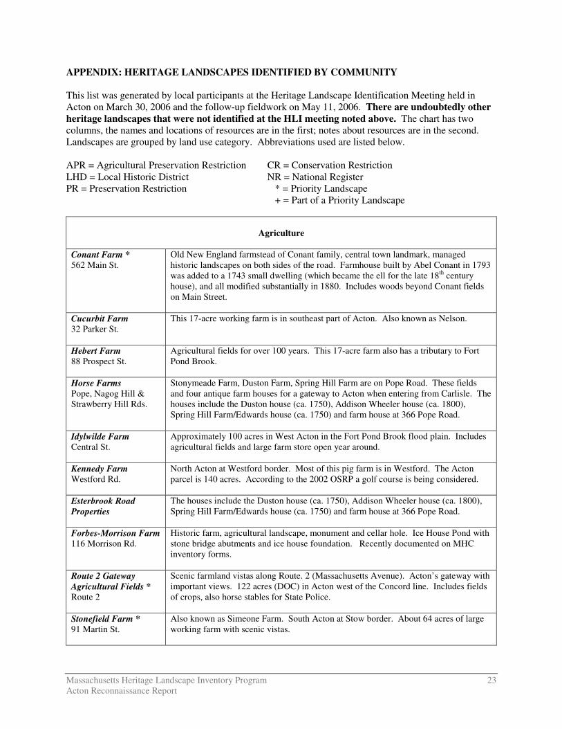
APPENDIX: HERITAGE LANDSCAPES IDENTIFIED BY COMMUNITY This list was generated by local participants at the Heritage Landscape Identification Meeting held in Acton on March 30, 2006 and the follow-up fieldwork on May 11, 2006. There are undoubtedly other heritage landscapes that were not identified at the HLI meeting noted above. The chart has two columns, the names and locations of resources are in the first; notes about resources are in the second. Landscapes are grouped by land use category. Abbreviations used are listed below. APR = Agricultural Preservation Restriction CR = Conservation Restriction LHD = Local Historic District NR = National Register PR = Preservation Restriction * = Priority Landscape + = Part of a Priority Landscape
Agriculture
Conant Farm * 562 Main St.
Old New England farmstead of Conant family, central town landmark, managed historic landscapes on both sides of the road. Farmhouse built by Abel Conant in 1793 was added to a 1743 small dwelling (which became the ell for the late 18th century house), and all modified substantially in 1880. Includes woods beyond Conant fields on Main Street.
Cucurbit Farm 32 Parker St.
This 17-acre working farm is in southeast part of Acton. Also known as Nelson.
Hebert Farm 88 Prospect St.
Agricultural fields for over 100 years. This 17-acre farm also has a tributary to Fort Pond Brook.
Horse Farms Pope, Nagog Hill & Strawberry Hill Rds.
Stonymeade Farm, Duston Farm, Spring Hill Farm are on Pope Road. These fields and four antique farm houses for a gateway to Acton when entering from Carlisle. The houses include the Duston house (ca. 1750), Addison Wheeler house (ca. 1800), Spring Hill Farm/Edwards house (ca. 1750) and farm house at 366 Pope Road.
Idylwilde Farm Central St.
Approximately 100 acres in West Acton in the Fort Pond Brook flood plain. Includes agricultural fields and large farm store open year around.
Kennedy Farm Westford Rd.
North Acton at Westford border. Most of this pig farm is in Westford. The Acton parcel is 140 acres. According to the 2002 OSRP a golf course is being considered.
Esterbrook Road Properties
The houses include the Duston house (ca. 1750), Addison Wheeler house (ca. 1800), Spring Hill Farm/Edwards house (ca. 1750) and farm house at 366 Pope Road.
Forbes-Morrison Farm 116 Morrison Rd.
Historic farm, agricultural landscape, monument and cellar hole. Ice House Pond with stone bridge abutments and ice house foundation. Recently documented on MHC inventory forms.
Route 2 Gateway Agricultural Fields * Route 2
Scenic farmland vistas along Route. 2 (Massachusetts Avenue). Acton’s gateway with important views. 122 acres (DOC) in Acton west of the Concord line. Includes fields of crops, also horse stables for State Police.
Stonefield Farm * 91 Martin St.
Also known as Simeone Farm. South Acton at Stow border. About 64 acres of large working farm with scenic vistas.
Massachusetts Heritage Landscape Inventory Program 24 Acton Reconnaissance Report
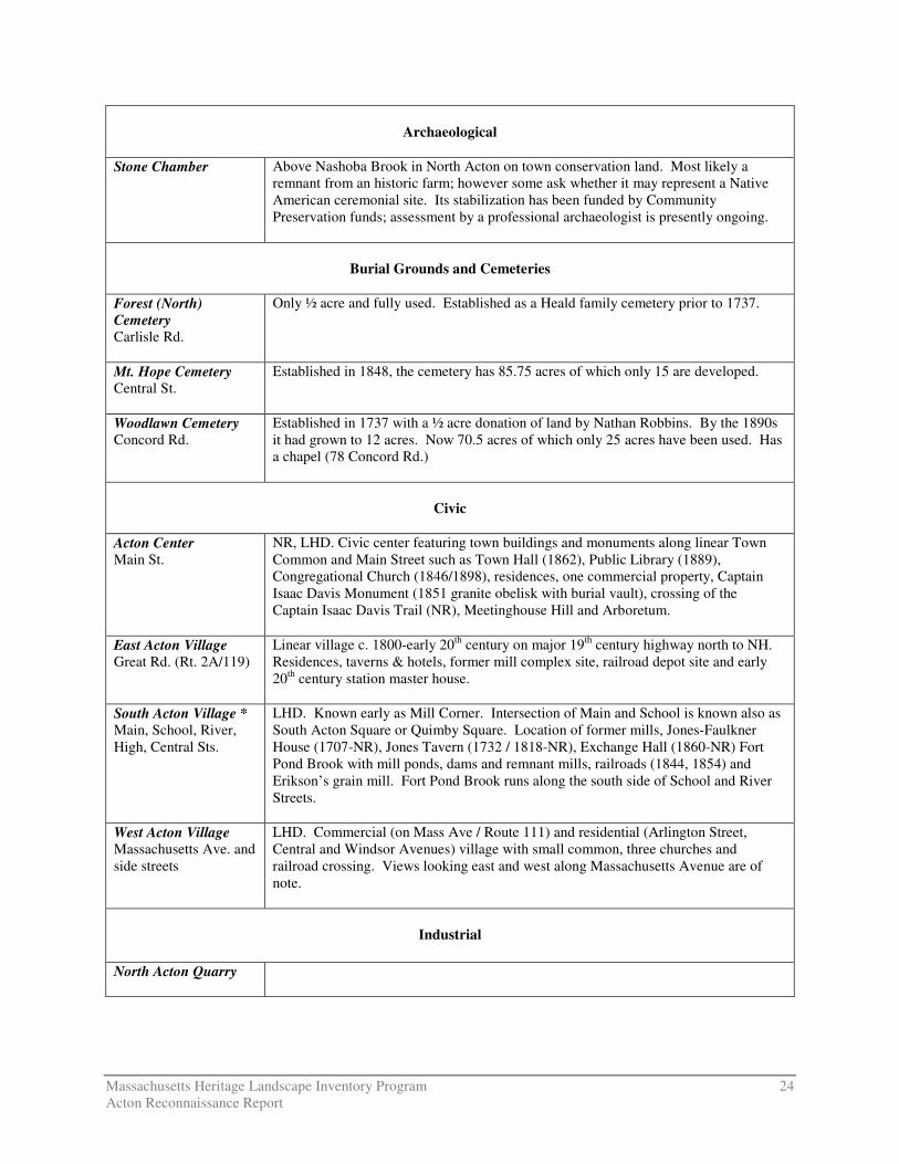
Archaeological
Stone Chamber
Above Nashoba Brook in North Acton on town conservation land. Most likely a remnant from an historic farm; however some ask whether it may represent a Native American ceremonial site. Its stabilization has been funded by Community Preservation funds; assessment by a professional archaeologist is presently ongoing.
Burial Grounds and Cemeteries
Forest (North) Cemetery Carlisle Rd.
Only ½ acre and fully used. Established as a Heald family cemetery prior to 1737.
Mt. Hope Cemetery Central St.
Established in 1848, the cemetery has 85.75 acres of which only 15 are developed.
Woodlawn Cemetery Concord Rd.
Established in 1737 with a ½ acre donation of land by Nathan Robbins. By the 1890s it had grown to 12 acres. Now 70.5 acres of which only 25 acres have been used. Has a chapel (78 Concord Rd.)
Civic
Acton Center Main St.
NR, LHD. Civic center featuring town buildings and monuments along linear Town Common and Main Street such as Town Hall (1862), Public Library (1889), Congregational Church (1846/1898), residences, one commercial property, Captain Isaac Davis Monument (1851 granite obelisk with burial vault), crossing of the Captain Isaac Davis Trail (NR), Meetinghouse Hill and Arboretum.
East Acton Village Great Rd. (Rt. 2A/119)
Linear village c. 1800-early 20th century on major 19th century highway north to NH. Residences, taverns & hotels, former mill complex site, railroad depot site and early 20th century station master house.
South Acton Village * Main, School, River, High, Central Sts.
LHD. Known early as Mill Corner. Intersection of Main and School is known also as South Acton Square or Quimby Square. Location of former mills, Jones-Faulkner House (1707-NR), Jones Tavern (1732 / 1818-NR), Exchange Hall (1860-NR) Fort Pond Brook with mill ponds, dams and remnant mills, railroads (1844, 1854) and Erikson’s grain mill. Fort Pond Brook runs along the south side of School and River Streets.
West Acton Village Massachusetts Ave. and side streets
LHD. Commercial (on Mass Ave / Route 111) and residential (Arlington Street, Central and Windsor Avenues) village with small common, three churches and railroad crossing. Views looking east and west along Massachusetts Avenue are of note.
Industrial
North Acton Quarry
Massachusetts Heritage Landscape Inventory Program 25 Acton Reconnaissance Report
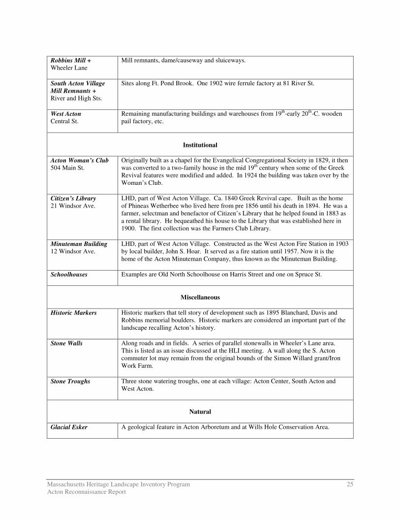
Robbins Mill + Wheeler Lane
Mill remnants, dame/causeway and sluiceways.
South Acton Village Mill Remnants + River and High Sts.
Sites along Ft. Pond Brook. One 1902 wire ferrule factory at 81 River St.
West Acton Central St.
Remaining manufacturing buildings and warehouses from 19th-early 20th-C. wooden pail factory, etc.
Institutional
Acton Woman’s Club 504 Main St.
Originally built as a chapel for the Evangelical Congregational Society in 1829, it then was converted to a two-family house in the mid 19th century when some of the Greek Revival features were modified and added. In 1924 the building was taken over by the Woman’s Club.
Citizen’s Library 21 Windsor Ave.
LHD, part of West Acton Village. Ca. 1840 Greek Revival cape. Built as the home of Phineas Wetherbee who lived here from pre 1856 until his death in 1894. He was a farmer, selectman and benefactor of Citizen’s Library that he helped found in 1883 as a rental library. He bequeathed his house to the Library that was established here in 1900. The first collection was the Farmers Club Library.
Minuteman Building 12 Windsor Ave.
LHD, part of West Acton Village. Constructed as the West Acton Fire Station in 1903 by local builder, John S. Hoar. It served as a fire station until 1957. Now it is the home of the Acton Minuteman Company, thus known as the Minuteman Building.
Schoolhouses Examples are Old North Schoolhouse on Harris Street and one on Spruce St.
Miscellaneous
Historic Markers Historic markers that tell story of development such as 1895 Blanchard, Davis and
Robbins memorial boulders. Historic markers are considered an important part of the landscape recalling Acton’s history.
Stone Walls Along roads and in fields. A series of parallel stonewalls in Wheeler’s Lane area. This is listed as an issue discussed at the HLI meeting. A wall along the S. Acton commuter lot may remain from the original bounds of the Simon Willard grant/Iron Work Farm.
Stone Troughs Three stone watering troughs, one at each village: Acton Center, South Acton and West Acton.
Natural
Glacial Esker
A geological feature in Acton Arboretum and at Wills Hole Conservation Area.
Massachusetts Heritage Landscape Inventory Program 26 Acton Reconnaissance Report
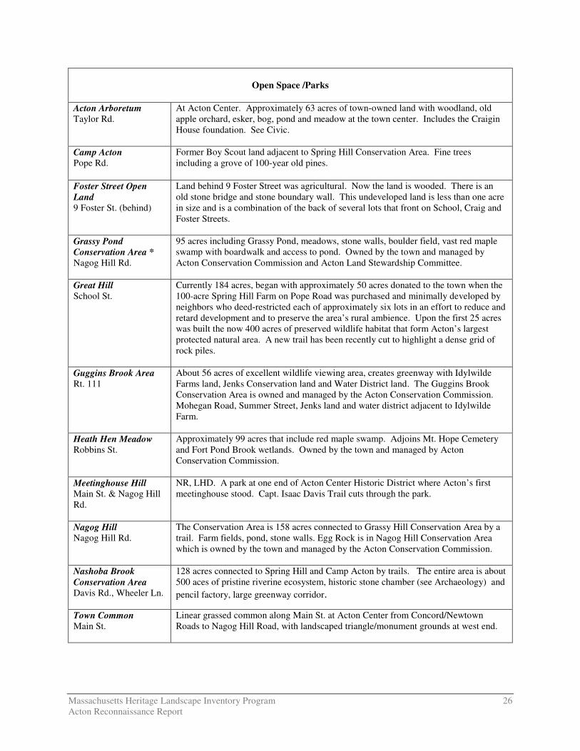
Open Space /Parks
Acton Arboretum Taylor Rd.
At Acton Center. Approximately 63 acres of town-owned land with woodland, old apple orchard, esker, bog, pond and meadow at the town center. Includes the Craigin House foundation. See Civic.
Camp Acton Pope Rd.
Former Boy Scout land adjacent to Spring Hill Conservation Area. Fine trees including a grove of 100-year old pines.
Foster Street Open Land 9 Foster St. (behind)
Land behind 9 Foster Street was agricultural. Now the land is wooded. There is an old stone bridge and stone boundary wall. This undeveloped land is less than one acre in size and is a combination of the back of several lots that front on School, Craig and Foster Streets.
Grassy Pond Conservation Area * Nagog Hill Rd.
95 acres including Grassy Pond, meadows, stone walls, boulder field, vast red maple swamp with boardwalk and access to pond. Owned by the town and managed by Acton Conservation Commission and Acton Land Stewardship Committee.
Great Hill School St.
Currently 184 acres, began with approximately 50 acres donated to the town when the 100-acre Spring Hill Farm on Pope Road was purchased and minimally developed by neighbors who deed-restricted each of approximately six lots in an effort to reduce and retard development and to preserve the area’s rural ambience. Upon the first 25 acres was built the now 400 acres of preserved wildlife habitat that form Acton’s largest protected natural area. A new trail has been recently cut to highlight a dense grid of rock piles.
Guggins Brook Area Rt. 111
About 56 acres of excellent wildlife viewing area, creates greenway with Idylwilde Farms land, Jenks Conservation land and Water District land. The Guggins Brook Conservation Area is owned and managed by the Acton Conservation Commission. Mohegan Road, Summer Street, Jenks land and water district adjacent to Idylwilde Farm.
Heath Hen Meadow Robbins St.
Approximately 99 acres that include red maple swamp. Adjoins Mt. Hope Cemetery and Fort Pond Brook wetlands. Owned by the town and managed by Acton Conservation Commission.
Meetinghouse Hill Main St. & Nagog Hill Rd.
NR, LHD. A park at one end of Acton Center Historic District where Acton’s first meetinghouse stood. Capt. Isaac Davis Trail cuts through the park.
Nagog Hill Nagog Hill Rd.
The Conservation Area is 158 acres connected to Grassy Hill Conservation Area by a trail. Farm fields, pond, stone walls. Egg Rock is in Nagog Hill Conservation Area which is owned by the town and managed by the Acton Conservation Commission.
Nashoba Brook Conservation Area Davis Rd., Wheeler Ln.
128 acres connected to Spring Hill and Camp Acton by trails. The entire area is about 500 aces of pristine riverine ecosystem, historic stone chamber (see Archaeology) and pencil factory, large greenway corridor.
Town Common Main St.
Linear grassed common along Main St. at Acton Center from Concord/Newtown Roads to Nagog Hill Road, with landscaped triangle/monument grounds at west end.
Massachusetts Heritage Landscape Inventory Program 27 Acton Reconnaissance Report
Town Forest-Wills Hole Off Route 2
Approximately 90 acres including a quaking bog (Wills Hole) and historic granite quarry (see industrial). Part of Town Forest (49 acres) was purchased by the town in 1943, the rest much later in the 1960s and 1970s.
Wetherbee Street Woods * Wetherbee St.
Known as the Moritz land. Part of the Route 2 vista and gateway to Acton. A combination of woods and fields adjacent to Wetherbee Conservation Land and DOC agricultural fields.
Residential
Addison Wheeler House Pope Road
Mr. Mason lived in this antique farm house in the early 1900s, and drove the horse-drawn barge to take the children to school. This house was under a PR which was to extend for another twelve years. However, the restriction was removed from the house (not the barn) prior to placing the property on the market.
Apartments in West Acton 265-271 Arlington St.
In West Acton LHD. Building complex on the corner of Central and Arlington Streets built in ca. 1900 as a four family – one of first apartments built for mill workers.
Jones-Faulkner House + 5 High St.
NR. In South Acton LHD. Has been referred to in the past and in the NR listing as the Faulkner Homestead. Property is important not only for its 1707 house but also for the six acres of open space with some historic landscape features.
Hosmer House 300 Main St.
NR. Known as the Jonathan and Simon Hosmer House it was begun in 1760 by Jonathan Hosmer and added to in 1797 by which time it was a 6-bay, 2-family house with two separate entrances on the main facade. Known in 20th century as Twin Chestnut Farm. Now the Acton Historical Society.
Isaac Davis House Hayward Rd.
The house in which Isaac Davis lived on April 19, 1775 when he marched to Concord is on this large open lot which has been the meeting place for the yearly march to Concord for the reenactment. A large stone boulder marker on the property notes this historical fact.
“Lottery” Houses Great Rd., Main St., Nagog Hill Rd.
In the 1790s when Harvard University was raising funds to build Stoughton Hall it ran a lottery. Abel Conant purchased one ticket for $5 and split it four ways with his neighbors. This was a winning ticket, thus the proceeds were split four ways and each winner built a house. All four lottery houses remain: the Conant House (562 Main Street, 1793) was underway and probably was expanded with Conant’s lottery winnings; the John Robbins House (NR, 144 Great Road, 1799-1800); the Abraham Skinner House (140 Nagog Hill Road, 1796) and Calvin Heywood House, now 160 Great Rd.
Maple Street Houses First subdivision in Acton laid out in 1860 by Elnathan Jones, Jr and Francis Conant and referred to as “New England Village” with street trees (maples) and stone sidewalks. Many of houses were rented to workers in South Acton businesses and industries.
Mead House Wright Terrace
The 1911 Craftsman style George V. Mead House on Wright Terrace is situated on a large lot of 16 acres.
Massachusetts Heritage Landscape Inventory Program 28 Acton Reconnaissance Report
Miller Farm – Station Master House * 737 Main St.
Linked to a 40B project, plans for which included demolition of the house. Now proposed to be moved nearby on the expanded property.
School Street Neighborhood + School St.
South Acton, most within LHD. A residential street providing housing for mill workers and owners after the railroad arrived in 1844. Workers, houses are on south side of street while local business owners and mill owners’ houses are on north side of street.
Windsor Avenue Neighborhood
In West Acton Village LHD. Late 19th century Victorian dwellings, many designed by John Hoar, Jr.
Wright-Holden Farmhouse + Route 2
East corner of Wetherbee Street on Route 2 (Massachusetts Avenue). Owned by the State Department of Correction as part of the prison farm. Vacant and in disrepair. Attempts on the part of an Acton resident to rent it and fix it up are apparently stalled.
Transportation
Assabet River Rail Trail +
Follows the mid 1850s Marlborough Branch Railroad, which closed for service in 1980. Line crosses Ft. Pond Brook and the mill pond on an old bridge; other surviving features (off Maple St.) include granite-block remains of a round table. The 1.1 mile section of the trail in Acton will extend from the Maynard border to South Acton village.
Brook Street + Upper part of Brook Street is bordered by open Conant land with a vegetable plot and small tree farm and a crossing of Nashoba Brook where there are woods and dam remnants of a small 19th century pencil factory. Part of the Conant Land Priority Heritage Landscape
Capt. Isaac Davis Trail
NR. A walking trail that memorializes the minutemen’s march to Concord on April 19, 1775. Followed every Patriot’s Day by Acton Minutemen, scouts and local walkers.
Cart Path 107 Concord Rd.
The cart path is between Concord Road and Alcott Street.
Penn Central Railroad/ Bruce Freeman Rail Trail
Historically this was the Framingham and Lowell Railroad Rail trail of 4.6 linear miles that was Old Colony (1872), later Penn Central. Lower section follows the east side of Nashoba Brook through East Acton. Funding was appropriated at Spring 2006 TM for design of rail trail.
Waterbodies
Assabet River and Dam Southeast corner of Acton. Part of this large river and its 19th century granite step-dam are visible from Old High Street and Powdermill Road and behind Concord Rental. Access from Old High Street. There is a canoe landing/access, potential for scenic river walk.
Massachusetts Heritage Landscape Inventory Program 29 Acton Reconnaissance Report
Fort Pond Brook + Flows through western and southern part of Acton to the Concord line. West of Rte.
27/ south and east of railroad are broad wetlands (former hay meadows); 1701 Jones millpond with 1848 dam at South Acton Village; middle section east of Rte. 27 has remnants of other factory dams, stone-arched bridge of railroad. In southeast portion near Concord line the brook and surrounding marsh land are important. (Popular fishing area.)
Grassy Pond + Nagog Hill Rd.
Including the wetlands. Some of pond is within the area and much of the bordering land is private. Between Nagog Hill and Newtown Roads.
Ice House Pond Concord Rd.
This four-acre pond is an impoundment of Nashoba Brook north of Concord Road. Ice was harvested here until ca. 1950s. The pond was dredged in 1995.
Nagog Pond * This is a Great Pond with an important watershed as it is Concord’s water supply. The side of the pond in Littleton is developed while the part in Acton remains wooded. Important views over the pond from 2A/119 (Great Road) on the east and Nagog Hill Road on the west.
Nashoba Brook * Flows from Westford in a southeasterly direction to Ft. Pond Brook and the Assabet River. Most visible areas beginning at 18th century mill site at Wheeler Lane to former pencil-factory site north of Great Road, then below Great Road to Ice House Pond. Modern dam at Concord Road; 18th- and 19th-century mill sites downstream east of Concord Rd (See Camp Acton, Morrison Farm and Robbins Mill.)
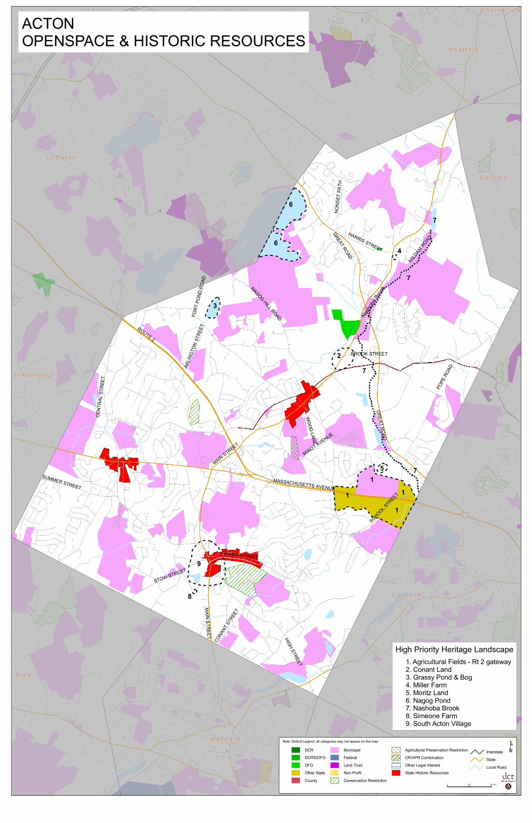
BROOK STREET
GREAT ROAD
NAGOG HILL ROAD
WOOD LANE
POPE
ROADAR
LINGT
ON ST
REETROUTE 2
FORT
POND
ROA
D
MAIN STREET
MASSACHUSETTS AVENUE
HIGH STREET
CONA
NT ST
REET
MAIN STREET
STOW STREET
RIVER STREET
SCHOOL STREET
MINOT AVENUE
SUMMER STREET
NONS
ET PA
TH
GREAT ROAD
HARRIS STREET
MILDAM ROAD
CENT
RAL S
TREE
T
11 1
1
2
3
4
5
6
6
8
9
7
7
7
7
Nasho
ba Bro
ok
L i t t l e t o nL i t t l e t o n
C o n c o r dC o n c o r d
S t o wS t o w
W e s t f o r dW e s t f o r d
M a y n a r dM a y n a r d
S u d b u r yS u d b u r y
B o x b o r o u g hB o x b o r o u g h
C a r l i s l eC a r l i s l e
C h e l m s f o r dC h e l m s f o r d
ACTONOPENSPACE & HISTORIC RESOURCES
High Priority Heritage Landscape1. Agricultural Fields - Rt 2 gateway2. Conant Land3. Grassy Pond & Bog4. Miller Farm5. Moritz Land6. Nagog Pond7. Nashoba Brook8. Simeone Farm9. South Acton Village
DCRDCRS/DFGDFGOther StateCounty
MunicipalFederalLand TrustNon-ProfitConservation Restriction
Agricultural Preservation RestrictionCR/APR CombinationOther Legal InterestState Historic Resources
InterstateState Local Road
Note: Default Legend, all categories may not appear on the map.
¹
0 0.25 0.5 Miles


![INGLES- ACTON the History of Freedom and Other Essays [1907]](https://img.pdfslide.net/doc/110x75/577cdb401a28ab9e78a7bb91/ingles-acton-the-history-of-freedom-and-other-essays-1907.jpg)