Embed Size (px)
Citation preview
ALAMEDA
COUNTYWIDE CLEAN
WATER PROGRAM
STORM WATER
RESOURCE PLAN
PUBLIC RELEASE
DRAFT
October 2018
MEMBER AGENCIES:
Alameda
Albany
Berkeley
Dublin
Emeryville
Fremont
Hayward
Livermore
Newark
Oakland
Piedmont
Pleasanton
San Leandro
Union City
County of Alameda
Alameda County Flood
Control and Water Conservation District
Zone 7 Water Agency
PUBLIC DRAFT SWRP 2 October 2018 Alameda Countywide Clean Water Program
Table of Contents Table of Contents ..................................................................................................................... 2
1. Introduction ...................................................................................................................... 5
1.1 Purpose of the Plan .................................................................................................... 5
1.2 Alameda County’s Watersheds: Approach and Characterization ................................ 5
1.3 Water Quality Issues And Regulatory Requirements .................................................. 5
1.4 Organization of the SWRP .......................................................................................... 6
2. Coordination and Collaboration ...................................................................................... 7
2.1 Entities Involved in Plan Development ........................................................................ 7
2.2 Coordination of Cooperating Entities and Stakeholders .............................................. 7
2.3 Relationship with Existing Planning Documents .......................................................... 7
2.3.1 San Francisco Bay Area Integrated Regional Water Management Plan ................. 7
2.3.2 Other Plans ............................................................................................................. 7
3. Alameda Watersheds Characterization .......................................................................... 9
3.1 SWRP Area ................................................................................................................ 9
3.2 Alameda County Water Suppliers ..............................................................................13
3.3 Watersheds Characterizations ...................................................................................18
3.3.1 Western Alameda County Watersheds ..................................................................20
Alameda Creek Watershed ................................................................................29
Eastern Alameda County Watersheds ...............................................................37
4. Water Quality Concerns and Regulatory Requirements .............................................. 42
4.1 Pollutant Generating Activities ...................................................................................42
4.2 Pollutants of Concern ................................................................................................42
4.2.1 Applicable Permits and TMDLs ..............................................................................43
4.3 Alameda County Water Quality Compliance Strategies and the SWRP .....................46
5. Identification, Quantification of Multiple Benefits, and Prioritization of Projects ...... 49
5.1 Overview of Approach ...............................................................................................49
5.2 Identification of Project Opportunities ........................................................................50
5.2.1 Planned Project Opportunities ...............................................................................50
5.2.2 Potential Project Opportunities ...............................................................................50
5.3 Project Classification .................................................................................................52
5.3.1 Green Infrastructure Projects .................................................................................52
5.3.2 Infiltration Feasibility ..............................................................................................52
5.3.3 Facility Type ..........................................................................................................53
PUBLIC DRAFT SWRP 3 October 2018 Alameda Countywide Clean Water Program
5.3.4 Project Drainage Area............................................................................................54
5.4 Identified Project Database ........................................................................................54
5.5 Metrics-Based Multi-Benefit Evaluation and Project Prioritization ..............................55
5.5.1 Multiple Benefit Evaluation .....................................................................................55
5.6 Prioritization of Scored Projects .................................................................................58
5.6.1 Prioritized List of Project Opportunities ..................................................................59
6. Education, Outreach, and Public Participation ............................................................ 60
6.1 Overview of Stakeholder Outreach and Coordination Strategy ..................................60
6.1.1 Purpose of the Stakeholder Outreach and Coordination Strategy ..........................60
6.1.2 Outreach Approach ................................................................................................60
6.1.3 Key Stakeholder Audiences ...................................................................................60
6.1.4 Matrix of Outreach Methods ...................................................................................61
6.2 Summary of Outreach Activities .................................................................................62
6.2.1 GI Work Group Meetings and Mailing List ..............................................................62
6.2.2 E-mail List and Targeted E-mail Messages ............................................................63
6.2.3 ACCWP SWRP Web Page ....................................................................................63
6.2.4 Social Media ..........................................................................................................63
6.2.5 Bay Area IRWM Group ..........................................................................................63
7. Implementation Strategy for SWRP .............................................................................. 65
7.1 SWRP Implementation ..............................................................................................65
7.1.1 Responsible Entities ..............................................................................................65
7.1.2 Implementation Schedule ......................................................................................65
7.1.3 Community Participation ........................................................................................66
7.2 Decision Support Tools for Plan Implementation .......................................................66
7.3 Project Implementation Tracking and Data Management ...........................................66
7.3.1 Tracking and Managing GI Projects .......................................................................67
7.3.2 Pollutant Load Reduction Accounting ....................................................................67
7.3.3 Reasonable Assurance Analysis ............................................................................67
7.4 Water Quality Monitoring ...........................................................................................68
7.4.1 ACCWP Monitoring Program .................................................................................68
7.4.2 Regional Monitoring Program ................................................................................69
7.5 Funding Needs ..........................................................................................................69
8. References ...................................................................................................................... 71
PUBLIC DRAFT SWRP 4 October 2018 Alameda Countywide Clean Water Program
Appendix 1. Stormwater Resource Plan Checklist and Self Certification ....................... A1-1
Appendix 2. Project Request for Alameda Countywide Clean Water Program Stormwater Resource Plan ................................................................................................................... A2-1
Appendix 3. Alameda Countywide Clean Water Program Stormwater Resource Plan Outreach Strategy ............................................................................................................... A3-1
Appendix 4. Public Comment and Response Matrix ........................................................ A4-1
Appendix 5. Database of Prioritized Project Lists ............................................................ A5-1
PUBLIC DRAFT SWRP 5 October 2018 Alameda Countywide Clean Water Program
1. Introduction
1.1 PURPOSE OF THE PLAN The Alameda Countywide Clean Water Program (ACCWP) Storm Water Resource Plan (SWRP) was created to facilitate the identification, development and implementation of stormwater management projects and programs that provide multiple benefits including improved water quality, reduced localized flooding, increased water supplies for beneficial uses, and community enhancement. Pursuant to Senate Bill 985 (SB 985), a SWRP must be developed in order to receive grant funding for storm water and dry weather runoff capture projects from any voter-approved bond after January 1, 2014, including the Proposition 1 bond act. The SWRP must satisfy requirements in SB 985 and the State Water Resources Control Board’s (State Water Board’s) SWRP Guidelines1 to be eligible for such grant funding.
Development of the ACCWP SWRP is consistent with the Storm Water Resource Plan Guidelines set forth by the State Water Resources Control Board (State Water Board), as demonstrated by the completed SWRP Checklist. The ACCWP SWRP identifies potential stormwater management projects that are eligible to apply for Proposition 1 Storm Water Grant Program implementation and other state grant funding. The implementation of multiple benefit ACCWP SWRP projects will help protect beneficial uses of waterbodies in Alameda County, which provide important environmental, community, health and economic benefits.
1.2 ALAMEDA COUNTY’S WATERSHEDS: APPROACH AND CHARACTERIZATION The Alameda County boundary delineates the planning area of the ACCWP SWRP (as described in Section 3 and shown in Figure 1). The jurisdictional area of the 17 ACCWP member agencies encompass 22 major HUC-12 watersheds, and over 30 smaller subwatersheds, comprised of over 1,700 miles of creeks and drainages. The County watersheds are subject to similar water quality stressors and contribute to regional water quality impairments of the San Francisco Bay. The watersheds are all subject to regional Total Maximum Daily Loads (TMDLs) and regulatory requirements calling for control measures to address the loading of mercury, PCBs, pesticides, trash, and other contaminants. Green infrastructure (GI) is recognized as an essential strategy for the region to mitigate the effects of urbanization and address these water quality concerns. The effort to create a SWRP for the entire County was undertaken to efficiently use administrative resources in its creation and facilitate integration with other ACCWP activities.
1.3 WATER QUALITY ISSUES AND REGULATORY REQUIREMENTS Many watersheds in the County have impaired water quality or are tributary to impaired waters such as the San Francisco Bay. Various watersheds are subject to TMDLs for mercury, PCBs, and pesticides. Compliance with TMDLs and applicable stormwater permits was a major driver informing the selection, evaluation, and prioritization of SWRP projects.
Many watersheds and jurisdictions within Alameda County drain to the San Francisco Bay and are regulated by the San Francisco Bay Regional Water Board (RWCB). ACCWP member agencies (identified in Section 2.1) are Permittees subject to the San Francisco Bay Region Municipal Regional Stormwater National Pollutant Discharge Elimination System 1 State Water Resources Control Board, December 2015. (https://www.waterboards.ca.gov/water_issues/programs/grants_loans/swgp/docs/prop1/swrp_finalguidelines_dec2015.pdf)
PUBLIC DRAFT SWRP 6 October 2018 Alameda Countywide Clean Water Program
(NPDES) Permit (Order No. R2-2015-0049). This stormwater permit is commonly known as the Municipal Regional Permit or MRP.
The MRP requires Permittees to develop GI Plans, as part of the new development and redevelopment provisions for implementation of GI projects and requires reasonable assurance analyses (RAAs) demonstrating that pollutant load reductions for the San Francisco Bay PCBs and Mercury TMDLs will be met through a combination of implementation of the GI Plans and other stormwater management measures focused on source control. The ACCWP SWRP was developed considering regional regulatory requirements for stormwater dischargers, particularly the GI planning requirements. The projects identified in the ACCWP SWRP will be used to help the Permittees meet their GI planning requirements. Projects were also evaluated in a manner consistent with the RAA requirements in the MRP to assess load reductions for compliance with the Mercury and PCBs TMDLs wasteload allocations (WLAs). County jurisdictions and other stakeholders will ultimately have the option of pursuing future implementation grant funding for multiple benefit projects included in their GI Plans.
1.4 ORGANIZATION OF THE SWRP This SWRP is comprised of the following Sections:
• Section 2: Coordination and Collaboration
This section describes entities involved in the development of the SWRP and the relationship of this SWRP to other regional plans.
• Section 3: Alameda County Watersheds Characterization
This section describes the watershed and subwatershed delineations within Alameda County, jurisdictional borders, and as well as the general quality of surface waters within each watershed.
• Section 4: Water Quality Concerns and Regulatory Requirements
This section identifies water quality concerns and regulatory requirements within the ACCWP SWRP planning area and identifies how the ACCWP SWRP addresses compliance with the applicable permits and plans.
• Section 5: Identification, Quantification of Multiple Benefits, and Prioritization of Projects
This section describes the methodology and analytical processes used to identify existing and potential GI project opportunities within the ACCWP SWRP planning area. This section also provides a quantitative and qualitative description of multiple benefits of potential project opportunities, and the results of the prioritization process based on multiple benefits.
• Section 6: Education, Outreach, and Public Participation
This section describes education, outreach, and public participation opportunities to engage the public implemented through the development period of the SWRP.
• Section 7: Implementation Strategy for SWRP
This section describes the implementation strategy and schedule, and includes a discussion of tools, project resources, and funding and engagement opportunities for supporting the implementation of the ACCWP SWRP.
PUBLIC DRAFT SWRP 7 October 2018 Alameda Countywide Clean Water Program
2. Coordination and Collaboration
2.1 ENTITIES INVOLVED IN PLAN DEVELOPMENT The ACCWP SWRP was prepared by a consultant team engaged by the ACCWP on behalf of Alameda County, the Alameda County Flood and Water Conservation District, the Zone 7 Water Agency, and the 14 incorporated cities within Alameda County.
A full list of the member agencies of ACCWP can be found below:
Alameda County Emeryville Piedmont
Alameda County Flood Control and Water
Conservation District Fremont Pleasanton
Alameda Hayward San Leandro
Albany Livermore Union City
Berkeley Newark Zone 7 Water Agency
Dublin Oakland
2.2 COORDINATION OF COOPERATING ENTITIES AND STAKEHOLDERS Key groups identified for participation in the SWRP development process include the ACCWP member agencies, non-municipal public landowners, watershed groups and other non-governmental organizations, Bay Area Integrated Regional Watershed Management Group, and the general public. Engagement and coordination with each of these participant groups is described in Section 6.
2.3 RELATIONSHIP WITH EXISTING PLANNING DOCUMENTS
2.3.1 San Francisco Bay Area Integrated Regional Water Management Plan The San Francisco Bay Area Integrated Regional Water Management Plan (IRWMP) is a nine-county effort to coordinate and improve water supply reliability, protect water quality, manage flood protection, maintain public health standards, protect habitat and watershed resources, and enhance the overall health of the San Francisco Bay. The IRWMP outlines the Region’s water resources management needs and objectives and presents innovative strategies and actions to help achieve the objectives. The IRWMP divides the San Francisco Bay Area into four sub-regions East, West, South, and North. Member agencies of ACCWP are within the East sub-region, which also includes portions of Contra Costa County. The IRWMP has a Coordinating Committee that serves as the governing body for the Plan, providing oversight of the process, guiding development, and supporting implementation. The IRWMP has a wide range of stakeholders including water supply, water quality, wastewater, stormwater, flood control, watershed, municipal, environmental, and regulatory groups.
2.3.2 Other Plans The GI projects identified in the ACCWP SWRP are expected to be an essential part of ACCWP member agencies strategy to meet the TMDL and MRP mandated water quality improvement goals. The ACCWP SWRP incorporates water quality metrics into the process of selecting project opportunities, prioritizing them, and evaluating their benefits. A primary goal for this
PUBLIC DRAFT SWRP 8 October 2018 Alameda Countywide Clean Water Program
ACCWP SWRP was to identify multiple-benefit GI projects that could be included in municipal GI Plans. County jurisdictions and stakeholders will ultimately have the option of pursuing future implementation grant funding for multiple benefit projects included in their GI Plans.
PUBLIC DRAFT SWRP 9 October 2018 Alameda Countywide Clean Water Program
3. Alameda Watersheds Characterization
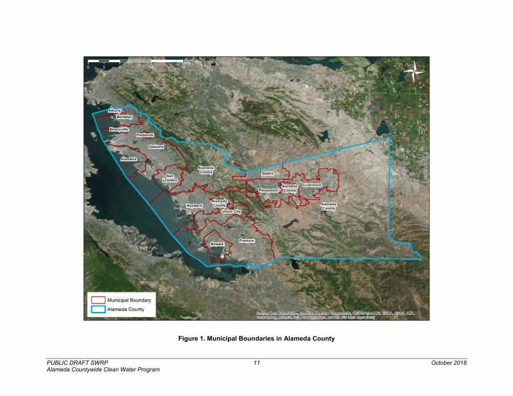
3.1 SWRP AREA For the purposes of the ACCWP SWRP, the planning area consists of watersheds and municipalities within Alameda County (Figure 1). The effort to create a SWRP for the entire County was undertaken to efficiently use administrative resources in its creation and facilitate integration with other ACCWP activities.
The County watersheds are subject to similar water quality stressors and contribute to regional water quality impairments of the San Francisco Bay. The watersheds are all subject to regional TMDLs and regulatory requirements calling for control measures to address the loading of mercury, PCBs, pesticides, trash, and other contaminants. GI is recognized as an essential strategy for the region to mitigate the effects of urbanization and address these water quality concerns.
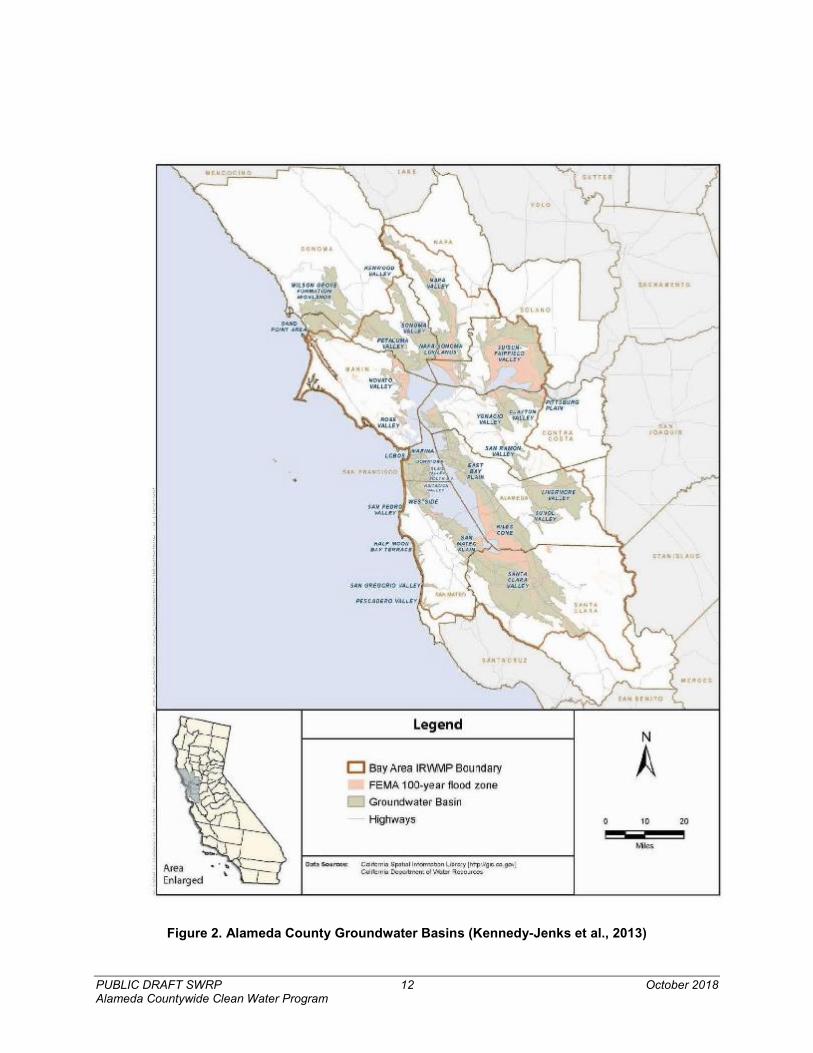
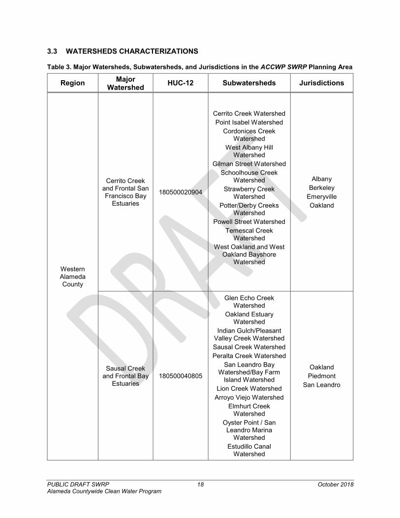
The jurisdictional area of the 17 ACCWP member agencies encompass 22 major HUC-12 watersheds, and over 30 smaller subwatersheds, comprised of over 1,700 miles of creeks and drainages. These 22 major watersheds can be further divided into over 30 smaller subwatersheds, of which all but eight are entirely within the County. Land use types within the County are predominantly developed or herbaceous and the distribution of land use types can be found in Table 1. Figure 2 shows the groundwater basin boundaries throughout the County (Kennedy-Jenks et al., 2013). Figure 3 shows the water utility boundaries for Alameda County (East County Water Management Association, 2015).
The majority of creeks in the County flow towards the San Francisco Bay, however, several subwatersheds flow east towards the Sacramento – San Joaquin Delta. The largest watershed in the County is the 660 square mile Alameda Creek Watershed, which spans multiple jurisdictions, and receives tributary flows from other subwatersheds throughout the eastern portion of the County. Many of the watersheds, especially those in Western Alameda County, are “community sized” and are important features of those communities. A full list of major watersheds and subwatersheds can be found in Table 3.
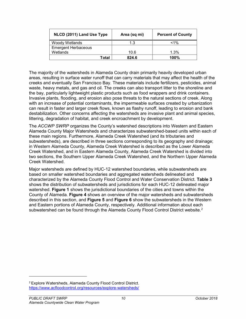
Table 1. Distribution of Land Uses in Alameda County, 2011 National Land Cover Dataset (USGS)
NLCD (2011) Land Use Type Area (sq mi) Percent of County
Open Water 104.2 13% Developed, Open Space 54.2 7% Developed, Low Intensity 52.1 6% Developed, Medium Intensity 124.7 15% Developed, High Intensity 38.7 5% Barren Land 4.6 1% Deciduous Forest <1.0 <1% Evergreen Forest 12.2 1% Mixed Forest 116.2 14% Shrub/Scrub 53.0 6% Herbaceous 240.7 29% Hay/Pasture 3.3 <1% Cultivated Crops 8.9 1%
PUBLIC DRAFT SWRP 10 October 2018 Alameda Countywide Clean Water Program
NLCD (2011) Land Use Type Area (sq mi) Percent of County
Woody Wetlands 1.3 <1% Emergent Herbaceous Wetlands 10.6 1.3%
Total 824.6 100%
The majority of the watersheds in Alameda County drain primarily heavily developed urban areas, resulting in surface water runoff that can carry materials that may affect the health of the creeks and eventually San Francisco Bay. These materials include fertilizers, pesticides, animal waste, heavy metals, and gas and oil. The creeks can also transport litter to the shoreline and the bay, particularly lightweight plastic products such as food wrappers and drink containers. Invasive plants, flooding, and erosion also pose threats to the natural sections of creek. Along with an increase of potential contaminants, the impermeable surfaces created by urbanization can result in faster and larger creek flows, known as flashy runoff, leading to erosion and bank destabilization. Other concerns affecting the watersheds are invasive plant and animal species, littering, degradation of habitat, and creek encroachment by development.
The ACCWP SWRP organizes the County’s watershed descriptions into Western and Eastern Alameda County Major Watersheds and characterizes subwatershed-based units within each of these main regions. Furthermore, Alameda Creek Watershed (and its tributaries and subwatersheds), are described in three sections corresponding to its geography and drainage; in Western Alameda County, Alameda Creek Watershed is described as the Lower Alameda Creek Watershed, and in Eastern Alameda County, Alameda Creek Watershed is divided into two sections, the Southern Upper Alameda Creek Watershed, and the Northern Upper Alameda Creek Watershed.
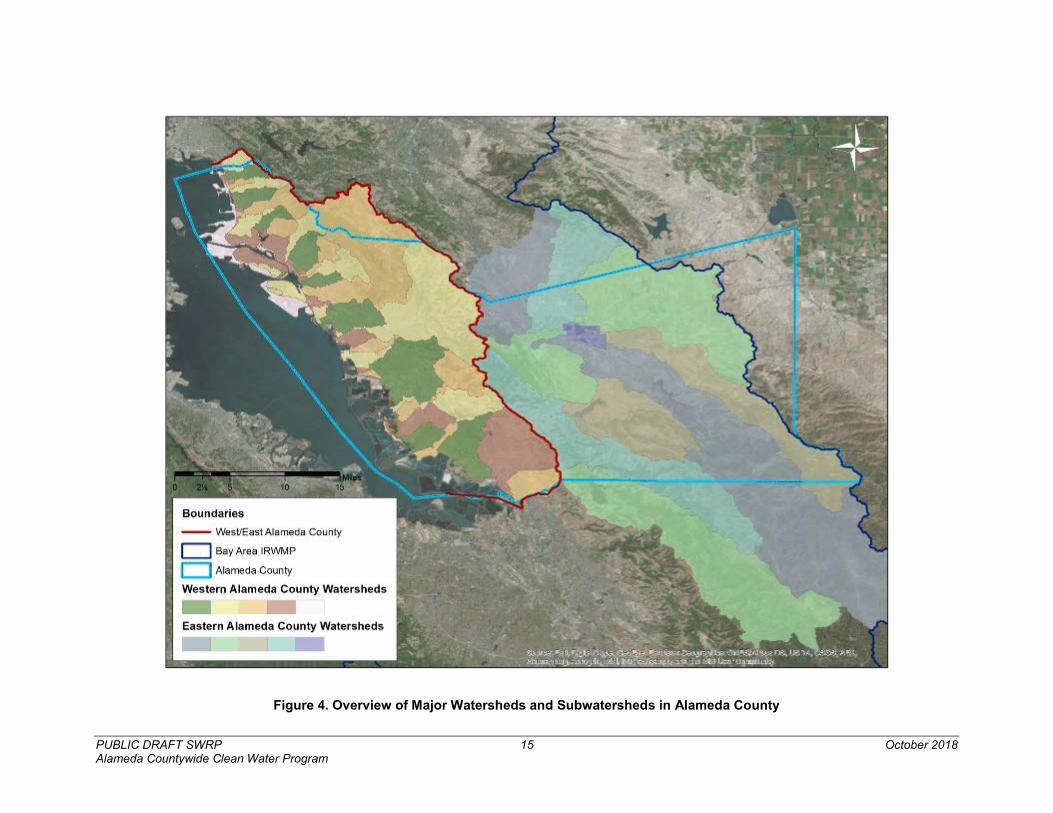
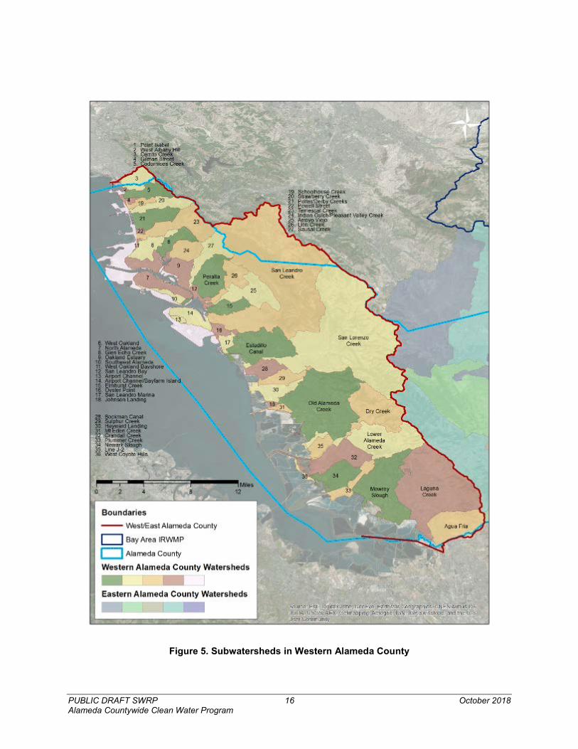
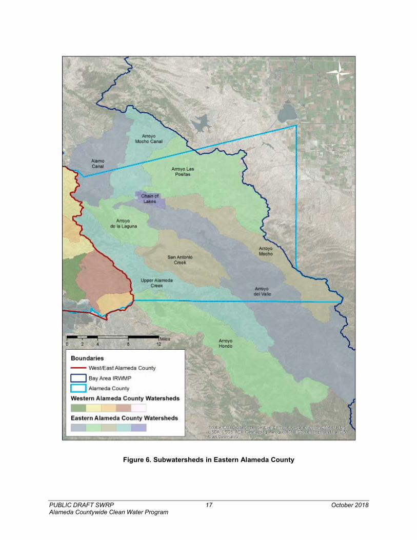
Major watersheds are defined by HUC-12 watershed boundaries, while subwatersheds are based on smaller watershed boundaries and aggregated watersheds delineated and characterized by the Alameda County Flood Control and Water Conservation District. Table 3 shows the distribution of subwatersheds and jurisdictions for each HUC-12 delineated major watershed. Figure 1 shows the jurisdictional boundaries of the cities and towns within the County of Alameda. Figure 4 shows an overview of the major watersheds and subwatersheds described in this section, and Figure 5 and Figure 6 show the subwatersheds in the Western and Eastern portions of Alameda County, respectively. Additional information about each subwatershed can be found through the Alameda County Flood Control District website.2
2 Explore Watersheds, Alameda County Flood Control District. https://www.acfloodcontrol.org/resources/explore-watersheds/
PUBLIC DRAFT SWRP 11 October 2018 Alameda Countywide Clean Water Program
Figure 1. Municipal Boundaries in Alameda County
PUBLIC DRAFT SWRP 12 October 2018 Alameda Countywide Clean Water Program
Figure 2. Alameda County Groundwater Basins (Kennedy-Jenks et al., 2013)
PUBLIC DRAFT SWRP 13 October 2018 Alameda Countywide Clean Water Program
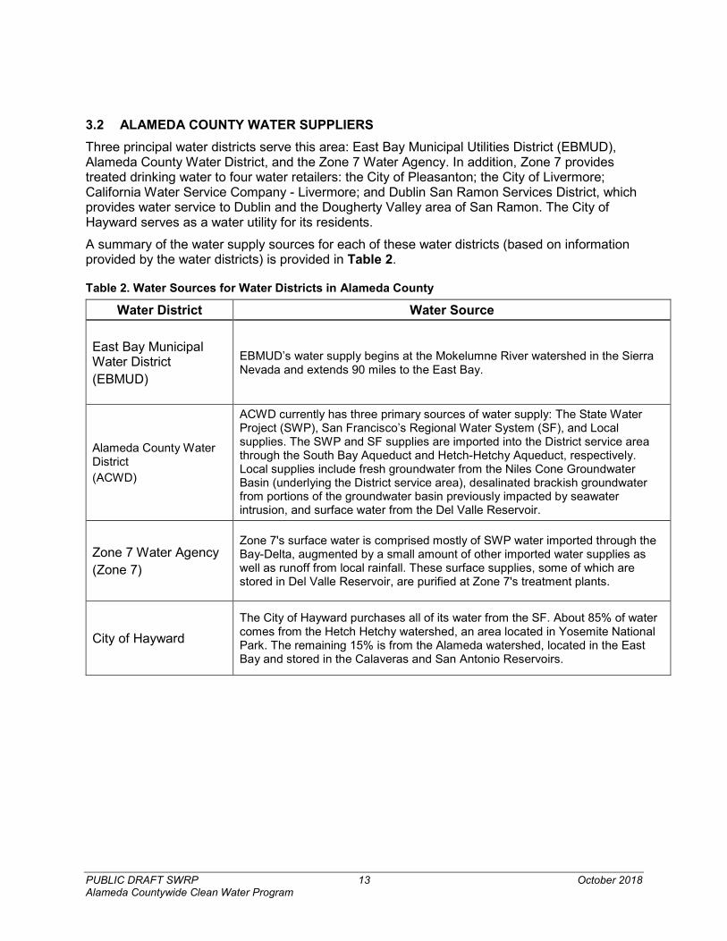
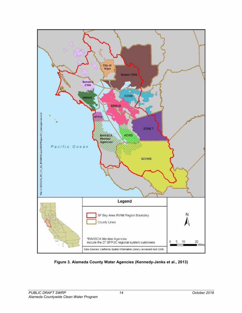
3.2 ALAMEDA COUNTY WATER SUPPLIERS Three principal water districts serve this area: East Bay Municipal Utilities District (EBMUD), Alameda County Water District, and the Zone 7 Water Agency. In addition, Zone 7 provides treated drinking water to four water retailers: the City of Pleasanton; the City of Livermore; California Water Service Company - Livermore; and Dublin San Ramon Services District, which provides water service to Dublin and the Dougherty Valley area of San Ramon. The City of Hayward serves as a water utility for its residents.
A summary of the water supply sources for each of these water districts (based on information provided by the water districts) is provided in Table 2.
Table 2. Water Sources for Water Districts in Alameda County
Water District Water Source
East Bay Municipal Water District (EBMUD)
EBMUD’s water supply begins at the Mokelumne River watershed in the Sierra Nevada and extends 90 miles to the East Bay.
Alameda County Water District (ACWD)
ACWD currently has three primary sources of water supply: The State Water Project (SWP), San Francisco’s Regional Water System (SF), and Local supplies. The SWP and SF supplies are imported into the District service area through the South Bay Aqueduct and Hetch-Hetchy Aqueduct, respectively. Local supplies include fresh groundwater from the Niles Cone Groundwater Basin (underlying the District service area), desalinated brackish groundwater from portions of the groundwater basin previously impacted by seawater intrusion, and surface water from the Del Valle Reservoir.
Zone 7 Water Agency (Zone 7)
Zone 7's surface water is comprised mostly of SWP water imported through the Bay-Delta, augmented by a small amount of other imported water supplies as well as runoff from local rainfall. These surface supplies, some of which are stored in Del Valle Reservoir, are purified at Zone 7's treatment plants.
City of Hayward The City of Hayward purchases all of its water from the SF. About 85% of water comes from the Hetch Hetchy watershed, an area located in Yosemite National Park. The remaining 15% is from the Alameda watershed, located in the East Bay and stored in the Calaveras and San Antonio Reservoirs.
PUBLIC DRAFT SWRP 14 October 2018 Alameda Countywide Clean Water Program
Figure 3. Alameda County Water Agencies (Kennedy-Jenks et al., 2013)
PUBLIC DRAFT SWRP 15 October 2018 Alameda Countywide Clean Water Program
Figure 4. Overview of Major Watersheds and Subwatersheds in Alameda County
PUBLIC DRAFT SWRP 16 October 2018 Alameda Countywide Clean Water Program
Figure 5. Subwatersheds in Western Alameda County
PUBLIC DRAFT SWRP 17 October 2018 Alameda Countywide Clean Water Program
Figure 6. Subwatersheds in Eastern Alameda County
PUBLIC DRAFT SWRP 18 October 2018 Alameda Countywide Clean Water Program
3.3 WATERSHEDS CHARACTERIZATIONS
Table 3. Major Watersheds, Subwatersheds, and Jurisdictions in the ACCWP SWRP Planning Area
Region Major Watershed HUC-12 Subwatersheds Jurisdictions
Western Alameda County
Cerrito Creek and Frontal San Francisco Bay
Estuaries
180500020904
Cerrito Creek Watershed Point Isabel Watershed
Cordonices Creek Watershed
West Albany Hill Watershed
Gilman Street Watershed Schoolhouse Creek
Watershed Strawberry Creek
Watershed Potter/Derby Creeks
Watershed Powell Street Watershed
Temescal Creek Watershed
West Oakland and West Oakland Bayshore
Watershed
Albany Berkeley
Emeryville Oakland
Sausal Creek and Frontal Bay
Estuaries 180500040805
Glen Echo Creek Watershed
Oakland Estuary Watershed
Indian Gulch/Pleasant Valley Creek Watershed Sausal Creek Watershed Peralta Creek Watershed
San Leandro Bay Watershed/Bay Farm
Island Watershed Lion Creek Watershed
Arroyo Viejo Watershed Elmhurt Creek
Watershed Oyster Point / San Leandro Marina
Watershed Estudillo Canal
Watershed
Oakland Piedmont
San Leandro

PUBLIC DRAFT SWRP 19 October 2018 Alameda Countywide Clean Water Program
Western Alameda County
San Leandro Creek 180500040803
Alameda County Moraga Oakland
San Leandro
San Lorenzo Creek
180500040801 180500040802
Crow Creek Alameda County
Castro Valley Hayward
Ward Creek and Frontal Bay Estuaries
180500040804
Bockman Canal Watershed
Sulphur Creek Watershed
Hayward Landing Watershed
Old Alameda Creek Watershed
North Alameda and Southwest Alameda
Watersheds Johnson Landing and Mt. Eden Creek Watersheds
Alameda County Hayward
Union City Alameda
Plummer Creek and Frontal Bay
Estuaries 180500040702
Plummer Creek Watershed
Line J-2 Watershed Newark Slough
Watershed Mowrey Slough
Watershed Crandall Creek
Watershed Laguna Creek Watershed
Alameda Creek Watershed
Fremont Newark
Agua Caliente Creek and Frontal Bay Estuaries
180500040701 Agua Fria Watershed
Laguna Creek Watershed Fremont
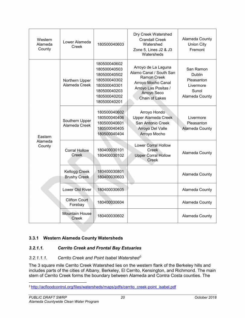
PUBLIC DRAFT SWRP 20 October 2018 Alameda Countywide Clean Water Program
3.3.1 Western Alameda County Watersheds
3.2.1.1. Cerrito Creek and Frontal Bay Estuaries
3.2.1.1.1. Cerrito Creek and Point Isabel Watershed3
The 3 square mile Cerrito Creek Watershed lies on the western flank of the Berkeley hills and includes parts of the cities of Albany, Berkeley, El Cerrito, Kensington, and Richmond. The main stem of Cerrito Creek forms the boundary between Alameda and Contra Costa counties. The 3 http://acfloodcontrol.org/files/watersheds/maps/pdfs/cerrito_creek-point_isabel.pdf
Western Alameda County
Lower Alameda Creek 180500040603
Dry Creek Watershed Crandall Creek
Watershed Zone 5, Lines J2 & J3
Watersheds
Alameda County Union City Fremont
Eastern Alameda County
Northern Upper Alameda Creek
180500040602 180500040503 180500040502 180500040302 180500040301 180500040203 180500040202 180500040201
Arroyo de La Laguna Alamo Canal / South San
Ramon Creek Arroyo Mocho Canal Arroyo Las Positas /
Arroyo Seco Chain of Lakes
San Ramon Dublin
Pleasanton Livermore
Sunol Alameda County
Southern Upper Alameda Creek
180500040602 180500040406 180500040601 180500040405 180500040404
Arroyo Hondo Upper Alameda Creek
San Antonio Creek Arroyo Del Valle Arroyo Mocho
Livermore Pleasanton
Alameda County
Corral Hollow Creek
180400030101 180400030102
Lower Corral Hollow Creek
Upper Corral Hollow Creek
Alameda County
Kellogg Creek Brushy Creek
180400030801 180400030603
Alameda County
Lower Old River 180400030605 Alameda County
Clifton Court Forebay 180400030604 Alameda County
Mountain House Creek 180400030602 Alameda County
PUBLIC DRAFT SWRP 21 October 2018 Alameda Countywide Clean Water Program
watershed currently contains a total of 3.9 miles of open channel; however, stormwater routing, stream culverting, and channel construction have significantly altered the natural drainage of the creek.
The Point Isabel Watershed drains 0.1 square miles of what was once a natural outcrop of sandstone that jutted into the bay and was connected to the shore by a tidal marsh. The elevation and natural drainage of the area was drastically altered during the 1950s when it was dynamited for development. Rubble, industrial waste, and other materials were used to fill the marshlands, widening the point and connecting it to the mainland.
3.2.1.1.2. Cordonices Creek Watershed, West Albany Hill Watershed, and Gilman Street Watershed4
The Codornices Creek Watershed is approximately 2.9 square miles of urbanized area from the Berkeley Hills to San Francisco Bay. The watershed’s network of perennial streams flow through natural channels, culverts, and storm drains in Berkeley and Albany. It encompasses approximately 4.6 miles of open creek and engineered channels, including many sections that have been restored or daylighted. One can also find vibrant communities of aquatic life and multiple access points and walking paths, particularly along Codornices Creek, which is one of Berkeley’s more natural and visible creeks. The watershed discharges through two outlets into San Francisco Bay, after traveling through three underground culverts beneath the I-580 near the Golden Gate Fields racetrack. Two of those culverted sections emerge as engineered channels that course through the mudflats of the Albany Bulb and a tidal slough, which is a fragment of the original slough.
The West Albany Hill Watershed, north of the Codornices Creek Watershed, is 0.05 square miles (32 acres). The watershed drains to the bay via gutters and small underground storm drains (less than 24 inches in diameter).
The Gilman Street Watershed covers an area of 0.5 square miles of Berkeley flatlands south of the Codornices Creek Watershed. It has no creeks or open channels, but rather a network of smaller storm drains that lead to the bay.
3.2.1.1.3. Schoolhouse Creek and Strawberry Creek Watershed5
Schoolhouse Creek emerges in the Berkeley hills from a number of small springs just south of Codornices Creek and north of Virginia Street. With no real tributaries, Schoolhouse Creek proper begins in the vicinity of McGee and Cedar streets on the flatlands below the hills, forming a 1 square mile watershed that extends to the bay. From there the creek runs southwest between Virginia and Cedar streets. Throughout most of its upper and middle courses, the creek is culverted. It emerges for part of the block between Sacramento and Acton streets, above Chestnut Street, and again at Curtis Street. Where it crosses the old right-of-way of the Santa Fe Railroad, now a pedestrian-bicycle trail, a massive buried concrete abutment and culvert hide the creek. The creek eventually passes under Interstate 880 (I-880) and enters San Francisco Bay.
The 3 square mile Strawberry Creek Watershed begins on the western slope of the Berkeley hills with a series of small springs and tributaries, the most prominent being the North Fork and Hamilton Gulch. Strawberry Creek and Hamilton Gulch converge to flow through Strawberry Valley, then through the University of California, Berkeley (UC Berkeley) campus. The North 4 http://www.acfloodcontrol.org/resources/explore-watersheds/cordonices-creek-west-albany-hill-and-gilman-street-watersheds/ 5 http://acfloodcontrol.org/files/watersheds/maps/pdfs/strawberry_creek-schoolhouse_creek.pdf
PUBLIC DRAFT SWRP 22 October 2018 Alameda Countywide Clean Water Program
Fork joins Strawberry Creek at the eucalyptus grove in the center of the campus. Shortly after this confluence the creek enters the city culvert at Oxford Street and flows underground, west through Berkeley, eventually emptying into San Francisco Bay near University Avenue. Stormwater routing as well as stream culverting and channel confinement have significantly altered the natural drainage courses of the North Fork and Strawberry Creek.
3.2.1.1.4. Potter/Derby Creeks Watershed, and Powell Street Watershed6
The 3.8 square mile Potter and Derby Creek Watershed lies predominantly in the City of Berkeley but spans the borders of Oakland and Emeryville in the east and southwest. Draining mostly flat land, the watershed begins on the west side of the Berkeley hills and runs west to San Francisco Bay. The relatively flat topography of the creek channels suggest that they were once tributaries of Strawberry Creek. As the population of Berkeley grew, Potter and Derby creeks were culverted and today are almost entirely underground in constructed channels.
The small 0.24 square mile (153 acre) Powell Street Watershed is located along the western end of Powell Street in Emeryville, south of the Potter/Derby Creek Watershed. It drains a residential and industrial area through underground culverts to the bay.
3.2.1.1.5. Temescal Creek Watershed7
The 6.7 square mile Temescal Creek Watershed spans the northernmost section of the Oakland hills and includes several regionally significant parks managed by the East Bay Regional Park District (EBRPD). South of Highway 24, two of the watershed’s four creeks drain the Montclair residential district and flow into Lake Temescal. North of the highway, the other two creeks drain the Claremont hills residential area and Claremont Canyon Regional Preserve. Both of these join the main channel of Temescal Creek below Lake Temescal, from which point water flows primarily through culverts to the Emeryville Crescent State Marine Preserve.
3.2.1.1.6. West Oakland and West Oakland Bayshore Watershed8
The 3.2 square mile West Oakland Watershed begins in the Rockridge neighborhood of Oakland, the Claremont Country Club marking its eastern boundary. Expanding to the southwest and draining through a network of storm drains, it crosses I-980 and is bounded on the west by I-880 and the 0.2 square mile West Oakland Bayshore Watershed. This smaller watershed is a narrow strip of land between the West Oakland Watershed and the historical bay shoreline. It extends north along I-880 and drains into the Emeryville Crescent, a crescent-shaped marsh and marine reserve on the Oakland-Emeryville border.
3.2.1.2. Sausal Creek and Frontal Bay Estuaries
3.2.1.2.1. Glen Echo Creek Watershed9
The 2.6 square mile Glen Echo Creek Watershed drains the Upper Rockridge and Piedmont Avenue areas in Oakland as well as parts of the City of Piedmont that lie near Mountain View Cemetery. Glen Echo Creek, also referred to as Cemetery Creek where it approaches and flows through the cemetery, and the Rockridge Branch are the two primary creeks that flow from the hills west of Highway 13. The Rockridge Branch flows to a pond behind the Pleasant Hill Shopping Center. There, the Broadway Branch carries the flow underground along Broadway.
6 http://acfloodcontrol.org/files/watersheds/maps/pdfs/potter_derby_creeks-powell_street.pdf 7 http://acfloodcontrol.org/files/watersheds/maps/pdfs/temescal_creek.pdf 8 http://acfloodcontrol.org/files/watersheds/maps/pdfs/west_oakland-west_oakland-bayshore.pdf 9 http://acfloodcontrol.org/files/watersheds/maps/pdfs/glen_echo_creek.pdf
PUBLIC DRAFT SWRP 23 October 2018 Alameda Countywide Clean Water Program
The creeks flow through residential and commercial areas with alternating daylighted and culverted sections. They cross under I-580 and continue until the Broadway Branch joins Glen Echo Creek above the west arm of its eventual outlet, Lake Merritt.
3.2.1.2.2. Oakland Estuary Watershed10
The 5.6 square mile Oakland Estuary Watershed drains a large area of dense urban land uses in central Oakland, including residential neighborhoods, the downtown business district, the Port of Oakland, historic Jack London Square, and the shores of Lake Merritt. Located within the larger San Francisco Bay, the Oakland Estuary is a strait between Alameda Island and Oakland, stretching from the Port of Oakland to the Fruitvale Bridge. The most intense land use in the watershed is the Port of Oakland’s container shipping operations on the west end of the estuary. The fifth busiest container port in the United States, it houses six shipping terminals, three of which lie along the estuary. Two intermodal rail facilities, a major freeway network, and a bustling commercial downtown all operate in and adjacent to the Oakland Estuary Watershed.
3.2.1.2.3. Indian Gulch/Pleasant Valley Creek Watershed11
The Indian Gulch/Pleasant Valley Creek Watershed covers about 3 square miles draining much of the city of Piedmont and parts of the Lower Hills District of the city of Oakland. Urbanized hills with creeks in the valleys between them characterize the natural geography of Piedmont. The watershed’s four small creeks converge downstream and flow into the eastern arm of Lake Merritt, a major landmark near downtown Oakland, and from there into San Francisco Bay. There are two miles of noncontiguous open channel that flow through public parks and private property. Construction of roads in the canyon bottoms resulted in the culverting of most of the creeks in the watershed.
The Indian Gulch/Pleasant Valley Creek Watershed has four creeks: Pleasant Valley Creek, Indian Gulch Creek (also known as Trestle Glen Creek), Bushy Dell Creek, and Wildwood Creek. Although the hills in the watershed are not very high, the creeks navigate through deep narrow ravines (gulches). Most sections of the creeks are culverted except for their headwaters and several lower sections of Indian Gulch Creek.
3.2.1.2.4. Sausal Creek Watershed12
The Sausal Creek watershed begins as a series of ephemeral creeks 1,300-1,500 feet above sea level in the Oakland Hills. Its three main tributaries drain the western slope of the East Bay hills and are bounded by Snake Road and Montclair Village to the north, Skyline Boulevard to the east, and Joaquin Miller Road, Lincoln Avenue, and Fruitvale Boulevard to the south. Its natural channels course through Dimond Canyon and Dimond Park and then dive under Interstate 580. In the Oakland flatlands, culverted sections of the creek channel alternate with open stretches of creek before disappearing into the last culvert at East 22nd Street. Finally, the creek emerges into the Oakland Estuary at the tidal channel that separates the city and island of Alameda from the mainland.
3.2.1.2.5. Peralta Creek Watershed13
The Peralta Creek Watershed, also known as East Creek Watershed, stretches from the Oakland hills through urban residential and commercial areas to the San Leandro Bay. The 10 http://acfloodcontrol.org/files/watersheds/maps/pdfs/oakland_estuary.pdf 11 http://acfloodcontrol.org/files/watersheds/maps/pdfs/indian_gulch-pleasant_valley_creek.pdf 12 http://acfloodcontrol.org/files/watersheds/maps/pdfs/sausal_creek.pdf 13 http://acfloodcontrol.org/files/watersheds/maps/pdfs/peralta_creek.pdf
PUBLIC DRAFT SWRP 24 October 2018 Alameda Countywide Clean Water Program
watershed is drained by several small creeks that join near the bay. From north to south these are Peralta Creek (the largest), Courtland Creek, 54th Avenue Creek, and Seminary Creek. Before flowing beneath I-880, the four join to form East Creek Slough, a straight engineered channel that replaces an old meandering tidal-marsh slough of the same name. East Creek flows into the San Leandro Bay near 50th Avenue.
3.2.1.2.6. San Leandro Bay Watershed/Bay Farm Island Watershed14
Located within the larger San Francisco Bay, San Leandro Bay is formed by the shorelines of Oakland, Alameda, and Bay Farm Island. The 1.3 square mile San Leandro Bay Watershed drains the inland shoreline areas of urban Oakland from the mouths of Elmhurst Creek to Sausal Creek. Most of San Leandro Bay Watershed drains the industrial areas west of I-880 with a small portion extending as far inland as San Leandro Boulevard.
The 2.8 square mile Bay Farm Island Watershed drains through engineered structures to San Francisco and San Leandro bays. Bay Farm Island was once a large sand dune bordered by a wide swath of tidal marsh along the inner bar in San Leandro Bay. Artificial fill was used to extend the island further into San Francisco Bay and cover the marsh on the inland side of the island, eventually connecting the island to the mainland. Most of Bay Farm Island is part of the city of Alameda, except the southern portion where Oakland International Airport is located.
3.2.1.2.7. Lion Creek Watershed15
The 3.5 square mile Lion Creek Watershed lies in the city of Oakland. The watershed begins on the west side of the Oakland hills and runs west to San Francisco Bay, narrowing as it passes through flatter land. The eastern boundary of the watershed roughly follows Skyline Boulevard where it borders the San Leandro Creek Watershed. The watershed includes three creeks: Chimes, Horseshoe, and Lion. The former Leona tributary, now part of Lion Creek, drains an abandoned sulfur mine. Horseshoe and Chimes creeks both discharge into Lion Creek, which empties into Lake Aliso on the Mills College campus. From there the creek enters a series of engineered channels and underground culverts that continue to San Leandro Bay within the larger San Francisco Bay.
3.2.1.2.8. Arroyo Viejo Watershed16
The 6.2 square mile Arroyo Viejo Creek Watershed begins on the western slope of the Oakland hills and runs west through Oakland to the San Francisco Bay, narrowing as it passes through flatter land. The eastern boundary of the watershed roughly parallels Sky line Boulevard, where it meets the San Leandro Creek Watershed. There are five creeks in the watershed: Rifle Range, Country Club, Melrose Highlands Branch, 73rd Avenue Branch, and Arroyo Viejo. The Rifle Range and Country Club branches discharge into the Arroyo Melrose Highlands Branch, which then drains Into Arroyo Viejo Creek proper. At that point, the creek enters a series of engineered channels and underground culverts that carry its water to San Leandro Bay within the larger San Francisco Bay.
3.2.1.2.9. Elmhurst Creek Watershed17
Drainage through the 2.6 square mile Elmhurst Creek Watershed begins at the ridge near Bishop O’Dowd High School in south Oakland and flows entirely through a network of 14 http://acfloodcontrol.org/files/watersheds/maps/pdfs/bayfarm_island-san_leandro_bay.pdf 15 http://acfloodcontrol.org/files/watersheds/maps/pdfs/lion_creek.pdf 16 http://acfloodcontrol.org/files/watersheds/maps/pdfs/arroyo_viejo.pdf 17 http://acfloodcontrol.org/files/watersheds/maps/pdfs/elmhurst_creek.pdf
PUBLIC DRAFT SWRP 25 October 2018 Alameda Countywide Clean Water Program
underground storm drains until it reaches San Leandro Street near Hegenberger Road. Three open channels begin in this area before merging into Elmhurst Creek and entering San Leandro Bay near San Leandro Creek and Arrowhead Marsh.
3.2.1.2.10. Oyster Point and San Leandro Marina Watershed18
Located in San Leandro, the Oyster Point and San Leandro Marina watersheds drain a mix of small industrial areas and parkland near the San Francisco Bay shoreline.
The 1.2 square mile Oyster Point Watershed drains the area east of Oakland International Airport and a former landfill that is now the Oyster Bay Regional Shoreline. Drainage is carried by underground culverts to an engineered channel that flows to Oyster Bay—named for the oyster farms that once existed just off shore.
Also 1.2 square miles, the San Leandro Marina Watershed is located south of Oyster Point and includes the marina, a public golf course, and Marina Park. The watershed is drained by two underground culverts that flow to a larger engineered channel and discharge near the marina.
The San Leandro Marina is built on artificial fill with berms that encircle it to protect docked boats from wave activity and provide a small boating lagoon. By design, marinas limit flushing from tidal surge and strong currents that would otherwise disperse potential contaminants and bring in cleaner water. Where they are not dispersed, these contaminants have the potential to build up and degrade water quality. The sources of these constituents of concern in marinas come from illegal wastewater discharge from boats, urban runoff, and fuel. The limited tidal flushing and currents in marinas lead to sediment accumulation that requires regular dredging to keep marinas viable. Dredging, however, can stir up sediments where potential contaminants have settled. With so much potential for water quality impacts, marina design, discharges, and dredging activities are tightly regulated.
3.2.1.2.11. Estudillo Canal Watershed19
The 9.4 square mile Estudillo Canal Watershed begins on the ridge between Lake Chabot and Fairmont Hospital in San Leandro and drains west through a network of canals and underground culverts in residential and commercial areas of the city on its way to Estudillo Canal. The canal flows toward the San Francisco Bay and connects via a tide gate to Heron Bay tidal marsh. It continues past Tony Lema Golf Course to the bay near San Leandro Marina.
3.2.1.3. San Leandro Creek Watershed20 The San Leandro Creek Watershed covers 49.4 square miles, extending east into the hills above Oakland and San Leandro and north to include the town of Moraga in Contra Costa County. The watershed is unusual among East Bay watersheds today in that its 78.3 miles of creeks remain open and primarily in their natural state. Two large dams, at Upper San Leandro Reservoir and Lake Chabot, provide drinking water storage and regulate the flow of water in San Leandro Creek. Ten tributary creeks flow through parklands and managed watersheds before joining Upper San Leandro Reservoir, Lake Chabot, or San Leandro Creek. Despite the open and more natural landscape, this watershed remains impacted by higher contaminant concentrations where urban development is more extensive.
18 http://acfloodcontrol.org/files/watersheds/maps/pdfs/oyster_point-san_leandro_marina.pdf 19 http://acfloodcontrol.org/files/watersheds/maps/pdfs/estudillo_canal.pdf 20 http://www.acfloodcontrol.org/files/watersheds/maps/pdfs/san_leandro_creek.pdf
PUBLIC DRAFT SWRP 26 October 2018 Alameda Countywide Clean Water Program
3.2.1.4. San Lorenzo Creek Watershed21 The San Lorenzo Creek Watershed, at 48 square miles, is one of the largest watersheds draining to the eastern shore of San Francisco Bay. The watershed begins in the East Bay hills at the Dublin Grade, incorporates the city of Castro Valley and the unincorporated community of San Lorenzo, and includes portions of San Leandro and Hayward. San Lorenzo Creek flows generally west, entering central San Francisco Bay near Roberts Landing, west of San Lorenzo.
A major issue for both Cull Canyon and Don Castro reservoirs is siltation. Eroded silt from upstream creeks continually fills in the reservoirs, which reduces their capacity to hold stormwater. The siltation also jeopardizes water quality and impedes recreation.
3.2.1.5. Ward Creek – Frontal San Francisco Bay Estuaries
3.2.1.5.1. Bockman Canal Watershed Sulphur Creek Watershed, Hayward Landing Watershed22
The waterways of the Hayward Landing-Bockman Canal-Sulphur Creek watersheds flow entirely through underground culverts and engineered channels to drain the low-lying areas of San Lorenzo and the northwest section of Hayward. The three watersheds drain to San Francisco Bay through the Hayward Regional Shoreline Park where former salt evaporation ponds have been restored to tidal marsh.
The 2.78 square mile Bockman Canal Watershed drains the flatlands in western San Lorenzo between Sulphur Creek Watershed and San Lorenzo Creek. It enters the bay in the northern extent of Hayward Regional Shoreline Park.
In the flatlands south of Bockman Canal is the 2.7 square mile Sulphur Creek Watershed. The drainage runs through culverts under Hayward City Hall and drains the Hayward Executive Airport on its way to the bay. The portion of Sulphur Creek above 2nd Street was diverted to San Lorenzo Creek and is no longer part of this watershed.
The 3.4 square mile Hayward Landing Watershed begins in Hayward near Soto Road in the east, shares its southern border with Old Alameda Creek and Johnson Landing watersheds, and follows West Winton Avenue along its northern border.
3.2.1.5.2. Old Alameda Creek Watershed23
The 22 square mile Old Alameda Creek Watershed, part of the larger Alameda Creek Watershed, drains a portion of the East Bay hills in Hayward, then spreads through urban flatlands before flowing to San Francisco Bay. Ward Creek and Zeile Creek drain the hills surrounding California State University East Bay, connect to a series of engineered channels and culverts in the lower watershed, and eventually join the historic path of Alameda Creek, now called Old Alameda Creek.
Old Alameda Creek is listed as an impaired water body because of trash. To ensure water flow, maintenance crews for the ACFCD routinely removes trash from the creek near Eden Landing Ecological Reserve. Siltation is another issue that further impedes water flow in the channelized portion of the creek. The channel is subject to tidal action and receives both estuarine and upstream sediment. ACFCD must remove the accumulation and redeposit it in areas in San
21 http://acfloodcontrol.org/files/watersheds/maps/pdfs/san_lorenzo_creek.pdf 22 http://acfloodcontrol.org/files/watersheds/maps/pdfs/bockman_canal-sulphur_creek-hayward_landing.pdf 23 http://acfloodcontrol.org/files/watersheds/maps/pdfs/old_alameda_creek.pdf
PUBLIC DRAFT SWRP 27 October 2018 Alameda Countywide Clean Water Program
Francisco Bay with sediment deficits. The restoration at Eden Landing was designed so that tidal action would scour sediments within the channel and build natural tidal marsh channels in the former salt ponds.
3.2.1.5.3. North Alameda and Southwest Alameda Watersheds24
The North Alameda and Southwest Alameda watersheds drain Alameda Island, which occupies most of the city of Alameda and is located across the Oakland Estuary from the city of Oakland. The 3.4 square mile North Alameda Watershed covers the majority of the island, including the urbanized area in the north and the former Naval Air Station, now known as Alameda Point. This former Naval Station is now a mixed-use community of wetlands, grasslands, and commercial areas. The Southwest Alameda Watershed covers 1.03 square miles and includes the Southshore area, which is separated from the main section of the island by Alameda Lagoon. Both Alameda Point and Southshore are filled baylands and are relatively flat. Therefore, surface water is transported not by creeks but by a complex system of storm drains that empties into the estuary, San Leandro Bay, and San Francisco Bay–the water bodies that surround the island and the lagoons.
3.2.1.5.4. Johnson Landing and Mt. Eden Creek Watersheds25
The Mt. Eden Creek and Johnson Landing watersheds share a contiguous border along Highway 92 in a light industrial area of Hayward. The small upland areas of the watersheds drain through underground culverts under an inland levee that separates them from a system of industrial salt ponds and wetlands along the bay shoreline known as the baylands. Most of the area within these two small watersheds is part of the baylands, where extensive progress is being made toward restoring tidal marsh and managed wetland habitat while continuing to provide flood control and adapt to rising sea levels.
South of Highway 92 within the 0.7 square mile Mt. Eden Creek Watershed lies Eden Landing Ecological Reserve. Mt. Eden Creek was formerly a tidal slough that wound its way through what is now the reserve but was cut off from the surrounding tidal marsh with construction of the salt pond levees.
The 0.3 square mile Johnson Landing Watershed lies north of Highway 92 and houses the southern portion of Hayward Regional Shoreline Park, which includes Hayward Marsh and the Hayward Shoreline Interpretive Center. The park is a gateway for exploring the tidal marshes and managed wetlands along the shoreline.
3.2.1.6. Plummer Creek and Frontal Bay Estuaries
3.2.1.6.1. Line J-2 Watershed
The small 1.9 square mile Line J-2 watershed drains a residential area into the Alameda Creek Flood Control Channel and eventually into the San Francisco Bay. Located in Union City, this small watershed consists mostly of highly urbanized residential areas.
3.2.1.6.2. Mowrey Slough Watershed26
Located in Newark and Fremont, the 12.8-acre Mowry Slough Watershed drains through culverts and engineered channels from the base of the East Bay hills to a system of stormwater 24 http://acfloodcontrol.org/files/watersheds/maps/pdfs/north_alameda-southwest_alameda.pdf 25 http://acfloodcontrol.org/files/watersheds/maps/pdfs/johnson_landing-mt_eden_creek.pdf
26 https://www.acfloodcontrol.org/files/watersheds/maps/pdfs/mowry_slough.pdf
PUBLIC DRAFT SWRP 28 October 2018 Alameda Countywide Clean Water Program
treatment wetlands called Tule Ponds at Tyson Lagoon and through the gently sloping urban plain toward South San Francisco Bay. Nearly 15 miles of this drainage runs through aboveground engineered channels. The channels drain to Mowry Slough, which winds around Cargill Salt’s crystallizer ponds across the bay marsh plain. San Francisco Bay’s most productive harbor seal rookery is located on the banks of Mowry Slough.
3.2.1.6.3. Newark Slough and Plummer Creek Watersheds27
The Coyote Hills rise out of the San Francisco Bay marsh plain in Fremont between the Alameda Creek Flood Control Channel and the Dumbarton Bridge. The 0.4 square mile West Coyote Hills Watershed extends along the ridge of the hills and drains their western slope directly to the now-diked former tidal marsh at its base. The watershed overlaps the Don Edwards National Wildlife Refuge and Coyote Hills Regional Park.
The Newark Slough Watershed drains 4.9 square miles of urban flatlands near the Dumbarton Bridge in Newark and part of Fremont into Newark Slough via a system of underground culverts and engineered channels. The slough winds its way through a system of salt pond levees to San Francisco Bay.
The 2.6 square mile Plummer Creek Watershed shares Newark Slough Watershed’s southern border and, similarly, drains a small area of the urban flatlands of Newark and Fremont. The watershed is primarily drained by Line F-1, an engineered channel built to carry storm runoff to Plummer Creek.
3.2.1.6.4. Crandall Creek Watershed
Located in Fremont, the Crandall Creek watershed consists of 6.5 square miles, and flows from the urban flatlands of Fremont into the Coyote Hills marsh, where the water is cleaned naturally, then through a pipe under the levee into the Alameda Creek Flood Control Channel. This watershed is described in more detail in the Lower Alameda Creek Watershed section.
3.2.1.6.5. Laguna Creek Watershed28
Located in Fremont, the 25.1 square mile Laguna Creek Watershed drains the foothills of the Diablo Range south of Niles Canyon and includes the 2,500-foot Mission Peak within the Mission Peak Regional Preserve to the southeast. Morrison, Vargas, Mission, Washington, Sabercat, Canada del Aliso, and Aqua Caliente creeks drain the expanse of foothills, flow across the flatlands through underground culverts and engineered channels to meet Laguna Creek and finally Mud Slough on the way to San Francisco Bay.
3.2.1.6.6. Water Quality Considerations
In much of the South Bay, salt ponds have subsided due to groundwater extraction from the 1850s through the early 1900s. Restoring deeper ponds to tidal marsh is difficult due to the amount of sediment that must be imported to raise the elevation up to the marsh plain as well as varying levels of sediment contamination. These problems, along with divergent stakeholder interests within the South Bay’s Mowry Slough, Plummer Creek, and Newark Slough watersheds, make restoring the slough and marsh challenging.
27 https://www.acfloodcontrol.org/files/watersheds/maps/pdfs/newark_slough-plummer_creek-west_coyote_hills.pdf 28 https://www.acfloodcontrol.org/files/watersheds/maps/pdfs/laguna_creek.pdf
PUBLIC DRAFT SWRP 29 October 2018 Alameda Countywide Clean Water Program
3.2.1.7. Agua Caliente Creek and Frontal Bay Estuaries
3.2.1.7.1. Agua Fria Watershed29
Located along the southernmost edge of Fremont and an unincorporated area of Alameda County, the 8 square mile Agua Fria Creek Watershed drains Mount Allison (2,658 feet) and Monument Peak (2,594 feet) along the Mission Peak ridgeline in the Diablo Range. Unlike other East Bay watersheds that drain the hills and then cross a wide flat plain before entering San Francisco Bay, the longest stretches of creek in this watershed are upstream between the Mission Peak ridgeline and I-680. Flowing through rangeland and much of Mission Peak Regional Preserve, Agua Fria, Toroges, and Scott creeks then proceed through small residential pockets, enter culverts under I-680, and continue through a combination of culverts and engineered channels across a condensed urban plain before entering the bay via Coyote Creek.
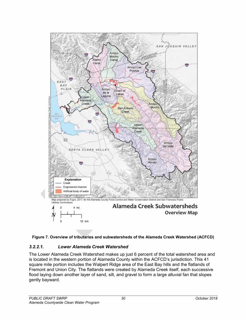
Alameda Creek Watershed The 660 square mile Alameda Creek Watershed is the largest watershed in the Bay Area, and its tributaries and subwatersheds can be seen in Figure 5 and Figure 6. The watershed extends as far south as Mount Hamilton, north to Mount Diablo, east to the Altamont Hills in Livermore, and west to San Francisco Bay. Major tributaries in western Alameda County are Dry Creek, Crandall Creek, and Lines J-2 and J-3. These flow into the Alameda Creek Flood Control Channel, an 11-mile-long channel built in the early 1970s replacing the natural creek. Due to its size, discussion of Alameda Creek Watershed is separated into unique sections: Lower Alameda Creek, Southern Upper Alameda Creek, and Northern Upper Alameda Creek Watersheds. The Lower Alameda Creek Watershed is located in Western Alameda County, while in Eastern Alameda County, the Alameda Creek Watershed can be broken into two sections, northern and southern. There are two major tributaries to Alameda Creek, with many smaller feeder creeks: Arroyo de la Laguna in the north and the south fork of Alameda Creek. The watershed is crossed by two major water delivery systems for the Bay Area, the Hetch Hetchy Aqueduct and the State Water Project, and includes three man-made reservoirs: Lake Del Valle, San Antonio Reservoir and Calaveras Reservoir. Flows in the upper reaches of the Alameda Creek watershed are controlled by water releases from Calaveras Reservoir, which is managed by the San Francisco Public Utilities Commission (SFPUC). Calaveras Reservoir captures natural runoff and stores imported water from the Hetch Hetchy reservoir. The local runoff in the Upper Alameda Creek Watershed is managed by Zone 7 Water Agency, while supplies for public and wildlife use come from the State Water Project.
29 https://www.acfloodcontrol.org/files/watersheds/maps/pdfs/agua_fria.pdf
PUBLIC DRAFT SWRP 30 October 2018 Alameda Countywide Clean Water Program
Figure 7. Overview of tributaries and subwatersheds of the Alameda Creek Watershed (ACFCD)
3.2.2.1. Lower Alameda Creek Watershed The Lower Alameda Creek Watershed makes up just 6 percent of the total watershed area and is located in the western portion of Alameda County within the ACFCD’s jurisdiction. This 41 square mile portion includes the Walpert Ridge area of the East Bay hills and the flatlands of Fremont and Union City. The flatlands were created by Alameda Creek itself, each successive flood laying down another layer of sand, silt, and gravel to form a large alluvial fan that slopes gently bayward.
PUBLIC DRAFT SWRP 31 October 2018 Alameda Countywide Clean Water Program
The Lower Alameda Creek Watershed has been highly modified. In the early 1970s, Alameda Creek was diverted south of its original outflow when it was dredged and channeled for flood control. Lined with levees along both sides, the Alameda Creek Flood Control (ACFC) Channel flows 12 miles from the mouth of Niles Canyon to San Francisco Bay, cutting across the creek’s former alluvial fan where it once deposited sediments that formed rich agricultural soils. Small dams within the flood control channel itself prevent erosion or pond the water for groundwater recharge. The following subwatersheds are included in this southern section of the Lower Alameda Creek Watershed:
• Lower Alameda Creek Subwatershed
• Dry Creek Subwatershed
• Crandall Creek Subwatershed
• Zone 5, Lines J2 & J3 Subwatersheds
3.2.2.1.1. Water Quality Considerations
The largest issues for the Lower Alameda Creek Watershed are dams and sedimentation. Dams create barriers for upstream fish migration and control water supply to downstream areas. Migratory fish historically spawned in the upper reaches of Alameda Creek, and steelhead trout are still found in the lower reaches trying to migrate inland. Within the 12 miles of the ACFC Channel, efforts to restore steelhead involve removing or transforming migratory barriers. Historically Alameda Creek deposited silt throughout Union City, Fremont, and Newark. But having been redirected into a flood control channel, the creek is now more confined, and sediment transport has been altered causing sediment accumulation in the lower seven miles. The four miles closest to the bay are influenced by tides and collect estuarine sediment in addition to stream sediment. The District occasionally dredges the channel. Through its involvement in the South Bay Salt Pond Restoration Project, the District and its partners are modifying the mouth of Alameda Creek to promote scouring of upstream sediment and deposition of sediment in areas where it will create tidal marsh habitat and improve flood control.
Seven creeks and flood control channels drain to the ACFC Channel in western Alameda County, forming significant subwatersheds within the Lower Alameda Creek Watershed, as described below. The north and south forks of Dry Creek drain the hills north of Niles Canyon; Crandall Creek drains the flatlands south of Alameda Creek; The District’s Zone 5, Line J2 drains the flatlands north of Alameda Creek; and Ardenwood Creek, within the Crandall Creek subwatershed, drains the floodplain between Crandall Creek and the managed ponds and wetlands, or “baylands,” of San Francisco Bay.
3.2.2.1.2. Subwatersheds
3.2.2.1.2.1. Lower Alameda Creek Subwatershed30 Lower Alameda Creek is a 11 square-mile subwatershed comprised of the portion of Alameda Creek located in western Alameda County that begins near the mouth of Niles Canyon. From this point, Alameda Creek flows through the 12-mile-long Alameda County Flood Control Channel constructed by the Army Corps of Engineers in the 1970s. The channel passes through Union City and Fremont across the creek’s historic flood plain, then flows north of Coyote Hills Regional Park before reaching San Francisco Bay. With the construction of the flood control
30 https://www.acfloodcontrol.org/wp-content/uploads/2018/03/Lower_Alameda_Creek_Watershed.jpg
PUBLIC DRAFT SWRP 32 October 2018 Alameda Countywide Clean Water Program
channel, Alameda Creek was diverted south of its historic route. Although the historic channel was left intact to form Old Alameda Creek, the western portion of the Alameda Creek Watershed bisected into north and south – old and new.
3.2.2.1.2.2. Dry Creek Subwatershed31 Dry Creek is a 9.9 square mile subwatershed that drains Walpert Ridge in the East Bay hills north of Niles Canyon. The north and south forks of Dry Creek meet near the terminus of Tamarack Drive in Union City. Both forks of Dry Creek run through Garin and Dry Creek Pioneer Regional parks, and through most of the subwatershed Dry Creek remains in its natural condition before its confluence with the ACFC Channel.
3.2.2.1.2.3. Crandall Creek Subwatershed32 Crandall Creek is a 6.5 square mile subwatershed comprised of Crandall Creek and Ardenwood Creek that once drained the floodwaters across the floodplain south of the historic Alameda Creek channel. Historically, Ardenwood Creek joined Crandall Creek just north of Coyote Hills, draining a riparian corridor thick with willows. From the point its confluence with Ardenwood Creek, Crandall Creek made a straight shot across the flatlands to the extensive tidal marsh that rimmed the south bay. Its former outflow to the bay is now the outflow of the ACFC Channel.
Crandall Creek and Ardenwood Creek drain urban runoff through a series of culverts and engineered channels that flow into the Demonstration Urban Stormwater Treatment Marsh, an artificial wetland designed to treat urban runoff, before eventually leading to San Francisco Bay. Its former outflow to the bay is now the outflow of the ACFC Channel.
3.2.2.1.2.4. Zone 5, Lines J2 & J3 Subwatershed33 Zone 5, Lines J2 and J3 drains a 1.9 square mile subwatershed in a residential area of Union City near the managed ponds and wetlands of south San Francisco Bay. A series of culverts drain to an engineered channel that joins the ACFC Channel near the historic Patterson Landing.
3.2.2.2. Southern Upper Alameda Creek Watershed Tributaries The information in this section focuses on the 435 square mile southern section of the Upper Alameda Creek Watershed. Much of this southern section is grazed by cattle and consists of protected public land or rural private lands, and drains areas of Pleasanton, Livermore and Sunol. It contains the two highest peaks in the Diablo Range, Mount Hamilton at 4,230 feet and Mount Isabel at 4,230 feet, and large open-space/wilderness areas with the 28-mile Ohlone Wilderness Trail terminating in Del Valle Regional Park. The following subwatersheds are included in this southern section of the Upper Alameda Creek Watershed:
• Arroyo Hondo
• Upper Alameda Creek
• San Antonio Creek
• Arroyo Del Valle
• Arroyo Mocho
31 Ibid. 32 Ibid. 33 https://www.acfloodcontrol.org/wp-content/uploads/2018/03/Lower_Alameda_Creek_Watershed.jpg
PUBLIC DRAFT SWRP 33 October 2018 Alameda Countywide Clean Water Program
The southern section of the Upper Alameda Creek Watershed is the most rural area within the vast Alameda Creek Watershed. Characterized by broad expanses of protected space, urban development is almost entirely contained within the northern tips of the Arroyo del Valle and Arroyo Mocho subwatersheds. Creeks in this portion of the watershed flow through tens of thousands of acres of protected, undeveloped land owned and managed by public agencies such as East Bay Regional Park District and San Francisco Public Utilities Commission. They begin as small tributaries in the undeveloped hills and mountains of the Diablo Range eventually merging with Alameda Creek in the Sunol Valley.
Despite the expanses of undeveloped land and free-flowing streams, the southern section of the Upper Alameda Creek Watershed has been significantly altered by human activities. As creeks flow down from the Diablo Range, most of them will eventually flow into one of three man-made reservoirs: Calaveras Reservoir, San Antonio Reservoir and Del Valle Reservoir (aka “Lake Del Valle”). These reservoirs and their associated dams are used to store water and release water to downstream areas via creeks and channels. These releases recharge groundwater stores and provide water for use in the Livermore Valley. In addition to the larger dams, smaller dams, such as the Alameda Creek Diversion Dam, have been constructed throughout the watershed to feed the large reservoirs.
3.2.2.2.1. Water Quality Considerations
The greatest water quality consideration in this portion of the Alameda Creek watershed is the historical damming of creeks to create large reservoirs. The reservoirs in the southern section of the Upper Alameda Creek Watershed act as huge sediment traps that prevent coarse sediment from flowing downstream as it would naturally. Coarse sediment is not only an important habitat feature for many native fish, it also helps to prevent things like channel incision and bank erosion. Channel incision and bank erosion can contribute to unnaturally high banks along creeks, cutting the creek off from its historic floodplain. The movement of water from the storage reservoirs to downstream areas also creates unnatural variations in stream flow
Dams in the lower portion of the watershed create barriers for fish migration to the southern section of the Upper Alameda Creek Watershed. This portion of the watershed is not currently accessible to steelhead and other anadromous species, although this species was historically present and have been observed downstream from barriers. The dams of both the San Antonio and Calaveras Reservoirs, along with the Alameda Creek Diversion Dam, have further fragmented fish habitat in this area.
3.2.2.2.2. Subwatersheds
The following information pertains to the southern section of the Upper Alameda Creek Watershed, which includes the following subwatersheds: Arroyo Hondo, Upper Alameda Creek, San Antonio Creek, Arroyo Del Valle, and Arroyo Mocho. While these subwatersheds are all considered tributary to the Alameda Creek Watershed, each are delineated by HUC-12 boundaries.
3.2.2.2.2.1. Arroyo Hondo Subwatershed34 Arroyo Hondo is a 99 square mile subwatershed of the Alameda Creek Watershed that begins in the rugged mountains of the Diablo Range near Mount Hamilton and flows north into Calaveras Reservoir. Most of the vast, undeveloped land in this subwatershed is managed by SFPUC and cattle ranchers. Mount Hamilton, 4,265 feet, is the highest point in the watershed.
34 https://www.acfloodcontrol.org/wp-content/uploads/2017/11/Arroyo_Hondo_Watershed.pdf
PUBLIC DRAFT SWRP 34 October 2018 Alameda Countywide Clean Water Program
Arroyo Hondo is a northwestward-flowing creek in Santa Clara County that begins at the confluence of Smith and Isabel Creeks and flows to Calaveras Reservoir. Arroyo Hondo meets Calaveras Creek in Calaveras Reservoir, and is a main tributary to Alameda Creek. The dam at Calaveras Reservoir is being replaced by the SFPUC and is one of the only dams built in California in the last 30 years. The dam project includes some steelhead restoration measures, including a fish ladder in the Alameda Creek Diversion. The following creeks are found in this subwatershed: Arroyo Hondo, Calaveras Creek, Isabel Creek, Long Branch, Hog Slough, Smith Creek, and Sulphur Creek.
3.2.2.2.2.2. Upper Alameda Creek Subwatershed 35 Upper Alameda Creek is a 74 square mile subwatershed of the Alameda Creek Watershed, and extends from Sunol south, to just northeast of Mount Hamilton. Alameda Creek in its entirety is a large, 45-mile long creek, which starts in the rugged hills of the Diablo Range and flows northwest through broad Sunol Valley, then turns west to run through steep Niles Canyon. “Upper” Alameda Creek becomes “Lower” Alameda Creek about midway through the canyon. Most of the protected, undeveloped land in the Upper Alameda Creek subwatershed is public land managed by the SFPUC and the East Bay Regional Park District or owned by ranchers. There is very little development or access other than the Sunol Regional Wilderness, where the headwaters of Upper Alameda Creek can be explored. The following creeks are found in this subwatershed: Alameda Creek east of Stonybrook Creek, Stonybrook Creek, Sheridan Creek, Pirate Creek, Welch Creek, Leyden Creek, Indian Joe Creek, Whitlock Creek, and Valpe Creek.
3.2.2.2.2.3. San Antonio Creek Subwatershed 36 San Antonio is a 40 square mile subwatershed of the Alameda Creek Watershed located in Unincorporated Alameda County and is very sparsely populated with most of the land being managed for grazing and watershed protection. Several creeks drain this watershed, all flowing north into San Antonio Reservoir. The Reservoir is fed primarily by Indian Creek and San Antonio Creek and is part of the City of San Francisco’s water supply system. It can be filled with Hetch Hetchy aqueduct in addition to the natural creek flow. Indian Creek drains the south side of Wauhab Ridge in the Ohlone Regional Wilderness and flows west to drain the north side of Valpe Ridge. Turning northwest, it then drains the east side of Apperson Ridge and flows to San Antonio Reservoir. San Antonio Creek drains Rowell Ridge in the Ohlone Regional Wilderness and flows northwest where it is joined by La Costa Creek before flowing to the east side of San Antonio Reservoir. La Costa Creek drains the north side of Wauhab Ridge in the Ohlone Regional Wilderness then flows northwest to meet San Antonio Creek. Water released from the dam flows northwest into Alameda Creek. The following creeks are found in this subwatershed: San Antonio Creek, Apperson Creek, La Costa Creek, Indian Creek, and the San Antonio Reservoir.
3.2.2.2.2.4. Arroyo Del Valle Subwatershed 37 Arroyo Del Valle is a 168 square mile subwatershed of the Alameda Creek Watershed. Arroyo del Valle begins in the rugged mountains of the Diablo Range and flows northwest toward Livermore Valley. Before reaching the valley, it is impounded to create Lake Del Valle. Lake Del Valle is a reservoir owned by the California Department of Water Resources and is part of the State Water Project, which provides the majority of Zone 7 Water Agency’s water supply. Lake 35 https://www.acfloodcontrol.org/wp-content/uploads/2017/11/Upper_Alameda_Creek_Watershed.pdf 36 https://www.acfloodcontrol.org/wp-content/uploads/2017/11/San_Antonio_Creek_Watershed.pdf 37 https://www.acfloodcontrol.org/wp-content/uploads/2017/11/Arroyo_del_Valle_Watershed.pdf
PUBLIC DRAFT SWRP 35 October 2018 Alameda Countywide Clean Water Program
Del Valle also collects and stores local runoff for Zone 7 and the Alameda County Water District. Zone 7 manages the Arroyo Del Valle subwatershed, and has purchased approximately 5,000 acres of rangeland near Lake Del Valle for the purposes of watershed protection using integrated management methods. The East Bay Regional Park District manages Del Valle Regional Park, where visitors can enjoy swimming, fishing, boating, camping and hiking in and around the lake. Once released at the dam, Arroyo Del Valle flows along the south side of the valley draining much of the southern portion of the City of Livermore and flows through and drains a considerable fraction of the City of Pleasanton, where it joins Arroyo de la Laguna in Pleasanton. The following creeks are found in this subwatershed: Arroyo del Valle (also known as Arroyo Valle), Dry Creek, Shafer Creek, Trout Creek, Sycamore Creek, Colorado Creek, Arroyo Bayo, San Antonio Creek, Jumpoff Creek, Sulphur Springs Creek, Sweetwater Creek, Beauregard Creek, and Lake Del Valle.
3.2.2.2.2.5. Arroyo Mocho Subwatershed 38 Arroyo Mocho is a 54 square mile subwatershed of the Alameda Creek Watershed which drains a narrow canyon that extends approximately 20 miles southeast of Livermore, to its headwaters in northern Santa Clara County. The Arroyo Mocho flows west along Mines Road in Livermore, through Pleasanton, and eventually joins South San Ramon Creek to become Arroyo de la Laguna, which flows into Alameda Creek. The following creeks are found in this subwatershed: Arroyo Mocho, Tunnel Creek, and Mendenhall Springs.
3.2.2.3. Northern Upper Alameda Creek Watershed Tributaries The information in this section describes the 198 square mile northern section of the Upper Alameda Creek Watershed. This section of the watershed is split between Contra Costa and Alameda Counties, drains areas of San Ramon, Pleasanton, Dublin, Livermore and Sunol. The following subwatersheds are included in this northern section of the Upper Alameda Creek Watershed:
• Arroyo de La Laguna
• Alamo Canal
• Arroyo Mocho Canal
• Arroyo Las Positas
• Chain of Lakes
The northern section of the Upper Alameda Creek Watershed is characterized by large swaths of open space in its northern and eastern portions, transitioning to more suburban and urban areas of San Ramon, Dublin, Pleasanton, and Livermore along the western and southern edges. In the undeveloped portions of the watershed, waterways remain largely free flowing as they make their way through open range. In the transition zone between urban and rural areas, creeks flow through small ranchettes, where houses sit on multiple acres, and often along the creek edge. Upon reaching the urban edge, many of the creeks enter engineered channels, which help control flows as they pass through busy cities on their way to the Arroyo de la Laguna, eventually joining Alameda Creek in the Sunol Valley. Although this portion of the Upper Alameda Creek Watershed does not contain major dams like the portion to the south, it does contain some man-made features such as the engineered channels and the Chain of Lakes, a series of former quarry lakes located in the middle of the Livermore-Amador Valley.
38 https://www.acfloodcontrol.org/wp-content/uploads/2017/11/Arroyo_Mocho_Watershed.pdf

PUBLIC DRAFT SWRP 36 October 2018 Alameda Countywide Clean Water Program
3.2.2.3.1. Water Quality Considerations
The greatest concern for water quality in this portion of the Upper Alameda Creek Watershed is the rapid growth of the urban and suburban areas of Dublin, Pleasanton and Livermore. Developed areas often contain large amounts of impervious surfaces, which reduce groundwater recharge and may increase contaminants and litter in surface water. Creeks flowing through urban areas are often channelized to control flows and alter stream location. Channelization, which often includes straightening a creek’s natural path, can reduce the amount of native riparian habitat along creek banks and create an environment that is inhospitable for native plants and animals.
As with the rest of the Alameda Creek Watershed, dams create barriers for upstream fish migration to the northern section of the Upper Alameda Creek Watershed. This portion of the watershed is not currently accessible to steelhead, although this species was historically present and have been observed downstream from barriers.
3.2.2.3.2. Subwatersheds
3.2.2.3.2.1. Arroyo de la Laguna Subwatershed 39 Arroyo de la Laguna is a 29 square mile subwatershed of the Alameda Creek Watershed that drains flatlands and hills of the southern Amador Valley (covers areas of Pleasanton and Sunol) and transmits flow from six other subwatersheds including Alamo Canal, Arroyo Mocho, Arroyo Mocho Canal, Arroyo Las Positas, and Arroyo del Valle. Historically, much of the eastern part of the Amador Valley consisted of a lake known as Tulare Lake. With development of the valley starting in the 19th century, drainage alterations in this watershed reduced the lake to a creek now called the Arroyo de la Laguna. The 7.5-mile Arroyo de la Laguna creek originates at the confluences of South San Ramon Creek and Arroyo Mocho then flows south to Sunol Valley where it joins, and is the major tributary to, Alameda Creek. The Arroyo has steep banks with an oak-sycamore canopy cover at the top of banks and riparian forest/scrub in and along the margins of the active channel.
Over time, additional development and changes in this section of the watershed have caused instability in the lower five miles of the Arroyo de la Laguna. The Arroyo has also been highly altered throughout the years, with activities ranging from heavy vegetation removal to development along its banks in some sections. These activities in the watershed have caused cumulative effects, resulting in extremely high flows, streambank erosion and channel widening of the Arroyo and increased sedimentation of Alameda Creek. Restoration efforts have been made to address these issues. The following creeks are also found in this subwatershed: Sinbad Creek; Pleasanton Canal; Kottinger Creek; Mission Creek; Sycamore Creek; Happy Valley Creek; Sheep Camp Creek; and Vallecitos Creek.
3.2.2.3.2.2. Alamo Canal Subwatershed 40 Alamo Canal is a 44 square mile subwatershed of the Alameda Creek Watershed that drains northern Amador Valley (sections of San Ramon, Dublin and Pleasanton) and a portion of the hills south of Mount Diablo (spans portions of both Contra Costa and Alameda Counties). The northern two-thirds of this watershed falls within Contra Costa County. However, the entire watershed drains south into Alameda Creek, and subsequently, the San Francisco Bay. Alamo Creek drains the foothills of Mt Diablo flowing parallel to Tassajara Creek, but through the west side of Dublin near San Ramon. Alamo Creek becomes Alamo Canal at its confluence with San 39 https://www.acfloodcontrol.org/wp-content/uploads/2017/11/Arroyo_de_la_Laguna_Watershed.pdf 40 http://www.acfloodcontrol.org/wp-content/uploads/2017/11/Alamo_Canal_Watershed.pdf
PUBLIC DRAFT SWRP 37 October 2018 Alameda Countywide Clean Water Program
Ramon Creek. The Alamo Canal ends at its junction with Arroyo Mocho, where both flow into Arroyo de la Laguna, which eventually flows into Alameda Creek. The following creeks are also found in this subwatershed: West Branch Alamo Creek, South San Ramon Creek, Coyote Creek, Norris Creek, Oak Creek, Big Canyon Creek, Martin Canyon Creek, Dublin Creek, Gold Creek, and Tehan Canyon.
3.2.2.3.2.3. Arroyo Mocho Canal41 Arroyo Mocho Canal is a 39 square mile subwatershed of the Alameda Creek Watershed. The Arroyo Mocho headwaters originate in the far northeastern corner of Santa Clara County and flows northwesterly into eastern Alameda County. The creek flows naturally through rural woodland and grassland habitats along Mines Road on its way to the Livermore Valley. The Arroyo Mocho canal subwatershed begins in west Livermore and carries the flow of Arroyo Mocho northwest through the Chain of Lakes subwatershed, to join with Arroyo Las Positas. From this junction it flows west through Pleasanton, collecting water from Tassajara Creek and Chabot Canal. Eventually it flows through an engineered channel until joining Arroyo de la Laguna northwest of Rose Canal.
3.2.2.3.2.4. Arroyo Las Positas Subwatershed 42
Arroyo Las Positas is an 81 square mile subwatershed of the Alameda Creek Watershed that drains the Altamont pass, and areas just north and east of Livermore. Arroyo Las Positas is a 7.4-mile-long westward-flowing watercourse that originates from Arroyo Seco north of Livermore and empties into Arroyo Mocho in Dublin. Is the driest subwatershed in the Alameda Creek Watershed with mostly intermittent creeks and sparse riparian cover. In 2003 Zone 7 Water Agency constructed two fish ladders as part of a project to widen, realign and restore the confluence of Arroyo Mocho and Arroyo Las Positas in Livermore. The ladders will allow steelhead trout the potential to access spawning and rearing habitat in the Arroyo Mocho gorge when barriers in lower Alameda Creek are removed. Other creeks in this subwatershed include: Altamont Creek; Arroyo Seco; Cayetano Creek; Collier Canyon Creek; Cottonwood Creek; and Frick Lake.
3.2.2.3.2.5. Chain of Lakes Subwatershed 43 Chain of Lakes is a 4.6 square mile subwatershed of Alameda Creek Watershed. It is a series of former quarry lakes, including Cope Lake and Shadow Cliffs Lake, located in the heart of the Livermore-Amador Valley. The Chain of Lakes and was envisioned as a large facility to be used for water management purposes by Zone 7 Water Agency. The water from the lakes drains into the ground, slowly filling the aquifers of the Livermore-Amador Valley groundwater basin.
Eastern Alameda County Watersheds Several additional watersheds are found in eastern Alameda County (Figure 8):
• Corral Hollow Creek
• Upper and Lower Kellogg Creek
• Brushy Creek
• Clifton Court Forebay
41 http://www.acfloodcontrol.org/wp-content/uploads/2017/11/Arroyo_Mocho_Canal_Watershed.pdf 42 https://www.acfloodcontrol.org/wp-content/uploads/2017/11/Arroyo_Mocho_Canal_Watershed.pdf 43 https://www.acfloodcontrol.org/wp-content/uploads/2017/11/Chain_of_Lakes_Watershed.pdf
PUBLIC DRAFT SWRP 38 October 2018 Alameda Countywide Clean Water Program
• Lower Old River
• Mountain House Creek
While these watersheds may have portions of their drainages located within Alameda County, ultimately, the majority of their drainages are found in Contra Costa or San Joaquin County, and surface water flows drain to the Sacramento – San Joaquin Delta. The ACCWP SWRP include these watersheds to allow for potential or future SWRP project considerations.
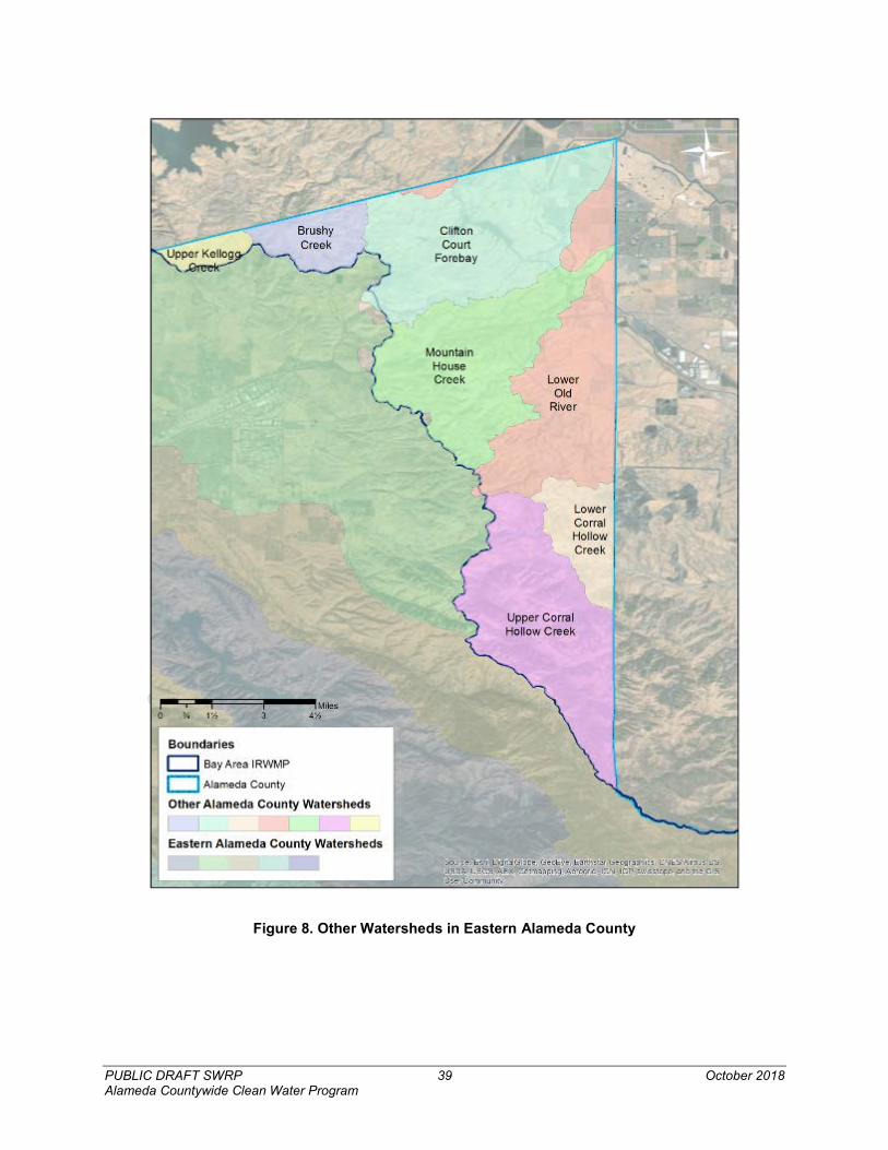
PUBLIC DRAFT SWRP 39 October 2018 Alameda Countywide Clean Water Program
Figure 8. Other Watersheds in Eastern Alameda County
PUBLIC DRAFT SWRP 40 October 2018 Alameda Countywide Clean Water Program
3.2.3.1. Corral Hollow Creek Watershed Corral Hollow Creek watershed is located between the cities of Livermore and Tracy, and the drainage area straddles the border of Alameda and San Joaquin Counties. The watershed can be characterized as predominantly native and non-native grasslands, with land uses including pasturelands, residential dwellings, experimental testing facilities, and off-highway vehicle recreation, and was historically home to coal and other mining operations. Several sensitive plant and wildlife species can be found in Corral Hollow Creek watershed.
In the Corral Hollow Watershed Assessment,44 water quality monitoring results generally indicated that former mine operations as well as off-highway vehicle recreation were sources of significant loads of sediment and sulfates to Corral Hollow Creek.
3.2.3.2. Kellogg and Brushy Creek Watershed The Kellogg and Brushy Creek watersheds are located in the northeastern part of Alameda County, and cross into Contra Costa and San Joaquin Counties. These watersheds are comprised entirely of minimally developed areas. As the majority of this watershed is located within Contra Costa County the watershed is also included in the Contra Costa Watersheds Stormwater Resource Plan.45
Both Kellogg and Brush Creek were diverted and altered by farmers in the north and eastern parts of the watershed, where Marsh, Kellogg and Brushy Creeks enter the alluvial plain. The Kellogg Creek watershed includes the Los Vaqueros Reservoir, which is owned by the Contra Costa Water District and receives water pumped from the Contra Costa Canal. The reservoir provides water to 450,000 County residents during the summer months. The protected open space at Los Vaqueros Reservoir is now home to a variety of animal and bird species.
Land uses in the Kellogg Creek watershed consist of 21% agricultural lands; 1% urban lands; and 78% open space, parks and recreation areas, and water. Land uses in the Brushy Creek watershed consist of 81% agricultural lands; 11% urban areas; and 8% open space, parks and recreation areas, and water.
Kellogg Creek (from Los Vaqueros Reservoir to Discovery Bay) is 303(d) listed as impaired for indicator bacteria, dissolved oxygen, salinity, and toxicity. Discovery Bay is listed as impaired for mercury. Brushy Creek has not been specifically identified in the State’s 303(d) list of Impaired Water Bodies.
3.2.3.3. Old River Watershed The majority of water flowing through the Old River Watershed originates in the Sierra Nevada Mountains, and flows to the Pacific Ocean through the Sacramento-San Joaquin Delta. More than half of California’s water needs are met with water pumped from the Delta in the East County Delta Drainages. However, the portion of the Old River Watershed within Alameda County flows east from Alameda County into the Old River and is not influenced by the Sierra Nevada Mountains. Sediment deposits in this flood-prone region produced soil that attracted agriculture to the area. Flood control infrastructure and irrigation canals were subsequently constructed to 44 OHMVRD, 2007. “Corral Hollow Watershed Assessment”. Prepared for the California Department of Parks and Recreation. Prepared by OHMVRD, Salix Applied Earthcare, and Geosyntec Consultants. June 2007. 45 The Contra Costa Watersheds Stormwater Resource Plan is in development in July 2018 with plans to be finalized by January 2019 and will be posted to https://www.cccleanwater.org/ when finalized.

PUBLIC DRAFT SWRP 41 October 2018 Alameda Countywide Clean Water Program
protect the farmland and to provide water to it. Land uses in the Old River Watershed within Alameda County consist of mostly undeveloped lands.
This watershed is also included in the Contra Costa Watersheds Stormwater Resource Plan as part of the East County Delta Drainages.46
Old River is 303(d) listed as impaired for chlorpyrifos, electrical conductivity, low dissolved oxygen, and total dissolved solids.
3.2.3.4. Clifton Court Forebay Watershed Clifton Court Forebay is a regulating reservoir in the southern Sacramento–San Joaquin Delta and is a key part of the SWP. Clifton Court Forebay serves as the starting point of the California Aqueduct, delivering water to Southern California, as well serves to recharge water in the San Joaquin Valley through the Delta-Mendota Canal. Clifton Court Forebay has an area of approximately 3.47 square miles. The drainage area to the Clifton Court Forebay consists of predominantly undeveloped land.
This watershed is also included in the Contra Costa Watersheds Stormwater Resource Plan as part of the East County Delta Drainages.47
3.2.3.5. Mountain House Creek Watershed The 31 square mile Mountain House Creek watershed consists of mostly lands historically used for agricultural production, and drains through Mountain House Creek to Old River, part of the San Joaquin River Delta. Although the current land uses are largely undeveloped, some areas have been identified for future residential development. Mountain House Creek itself was formerly a channelized irrigation and drainage ditch. In 2011, portions of Mountain House Creek were widened and restored to provide conveyance for offsite flows, slow floodwater, provide temporary storage, and to allow for the settlement of sediments out of suspension.48
This watershed is also included in the Contra Costa Watersheds Stormwater Resource Plan as part of the East County Delta Drainages.49
46 The Contra Costa Watersheds Stormwater Resource Plan is in development in July 2018 with plans to be finalized by January 2019 and will be posted to https://www.cccleanwater.org/ when finalized. 47 Ibid. 48 http://30zz0j1ewgra3qf6cz317ytj.wpengine.netdna-cdn.com/wp-content/uploads/2011/02/Mountain-House-Creek-Restoration.pdf 49 The Contra Costa Watersheds Stormwater Resource Plan is in development in July 2018 with plans to be finalized by January 2019 and will be posted to https://www.cccleanwater.org/ when finalized.
PUBLIC DRAFT SWRP 42 October 2018 Alameda Countywide Clean Water Program
4. Water Quality Concerns and Regulatory Requirements
Urbanization of Alameda County and the Bay Area as a whole can lead to elevated levels of potential contaminants in local waterbodies, such as PCBs, mercury, pesticides, and trash. Addressing water quality concerns and associated regulatory requirements facing the County’s watersheds are a major driver informing selection and prioritization of ACCWP SWRP projects.
4.1 POLLUTANT GENERATING ACTIVITIES Runoff from watersheds within Alameda County carries pollutants associated with urban development, industrialization, agriculture, and atmospheric deposition to local water bodies including the San Francisco Bay.
Contaminant sources vary by pollutant and are dispersed throughout the watersheds in the County and/or attributed to specific historical or contemporary land uses. For example, historical use of the Leona Heights Sulfur Mine, located in the Lion Creek Watershed, continues to contribute contaminants downstream of the Oakland Hills with mitigation and cleanup beginning as recently as 2014. San Leandro Bay, included on California’s 303(d) list of impaired water bodies, is also on California’s list of Toxic Hot Spots due to the concentrations of DDT, lead, mercury, pesticides, PCBs, PAHs, selenium, and zinc in its sediment. Other more contemporary land uses, such as the highly urban use of Lake Merritt, contribute to environmental challenges facing watersheds such as the Oakland Estuary Watershed. ACCWP has documented pollutant generating activities and pollutants of concern and continues to develop and publish progress reports that identify pollutant-impacted watershed management areas, sources of pollutants of concern, and program- and watershed-specific implementation activities.
Regional urbanization has led to the modification and disruption of natural watershed processes. In urban settings, the presence of impervious surfaces increases runoff coefficients50 and therefore runoff volumes. As less precipitation enters soils, increased runoff rates and volumes are capable of more effectively mobilizing and carrying pollutants to storm drainage networks and eventually to receiving waters (McKee, et al., 2003). Additionally, there is a strong relationship between urban watershed sediment yields and loading of contaminants to local water bodies, such as mercury, trace metals, PCBs, polycyclic aromatic hydrocarbons (PAHs), and chlorinated pesticides (McKee, et al., 2003).
4.2 POLLUTANTS OF CONCERN The quality of urban runoff impacts local creeks and larger water bodies such as the San Francisco Bay. Pollutants of concern, for which Alameda County jurisdictions are subject to TMDLs and permit specified load reductions and implementation actions, include mercury, PCBs, copper, pesticide related toxicity, and trash. Concerns related to toxicity due to pesticide loading and trash are both local and regional, as toxicity impacts aquatic life in local water bodies, and trash from watersheds can flow through storm drains into local creeks, ultimately reaching the San Francisco Bay. Although the sources of copper may be reducing over time, copper remains toxic to aquatic life and has major sources in the urbanized areas surrounding the San Francisco Bay. The impairments for mercury and PCBs are based on protection of health of people who consume fish from the San Francisco Bay and protection of aquatic organisms and wildlife. In response to health concerns regarding human exposure to PCBs and other bioaccumulative contaminants, including methyl mercury, dioxins, and organochlorine 50 The proportion of a rainfall volume that subsequently runs off a land surface.
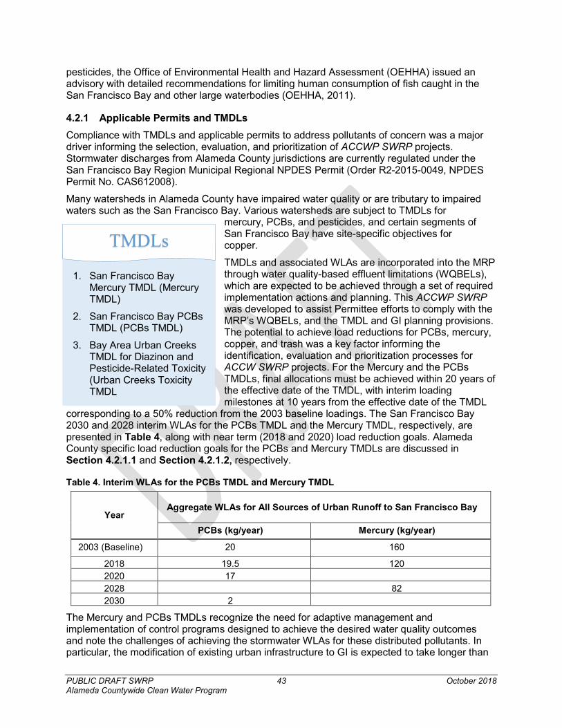
PUBLIC DRAFT SWRP 43 October 2018 Alameda Countywide Clean Water Program
pesticides, the Office of Environmental Health and Hazard Assessment (OEHHA) issued an advisory with detailed recommendations for limiting human consumption of fish caught in the San Francisco Bay and other large waterbodies (OEHHA, 2011).
4.2.1 Applicable Permits and TMDLs Compliance with TMDLs and applicable permits to address pollutants of concern was a major driver informing the selection, evaluation, and prioritization of ACCWP SWRP projects. Stormwater discharges from Alameda County jurisdictions are currently regulated under the San Francisco Bay Region Municipal Regional NPDES Permit (Order R2-2015-0049, NPDES Permit No. CAS612008).
Many watersheds in Alameda County have impaired water quality or are tributary to impaired waters such as the San Francisco Bay. Various watersheds are subject to TMDLs for
mercury, PCBs, and pesticides, and certain segments of San Francisco Bay have site-specific objectives for copper.
TMDLs and associated WLAs are incorporated into the MRP through water quality-based effluent limitations (WQBELs), which are expected to be achieved through a set of required implementation actions and planning. This ACCWP SWRP was developed to assist Permittee efforts to comply with the MRP’s WQBELs, and the TMDL and GI planning provisions. The potential to achieve load reductions for PCBs, mercury, copper, and trash was a key factor informing the identification, evaluation and prioritization processes for ACCW SWRP projects. For the Mercury and the PCBs TMDLs, final allocations must be achieved within 20 years of the effective date of the TMDL, with interim loading milestones at 10 years from the effective date of the TMDL
corresponding to a 50% reduction from the 2003 baseline loadings. The San Francisco Bay 2030 and 2028 interim WLAs for the PCBs TMDL and the Mercury TMDL, respectively, are presented in Table 4, along with near term (2018 and 2020) load reduction goals. Alameda County specific load reduction goals for the PCBs and Mercury TMDLs are discussed in Section 4.2.1.1 and Section 4.2.1.2, respectively.
Table 4. Interim WLAs for the PCBs TMDL and Mercury TMDL
Year Aggregate WLAs for All Sources of Urban Runoff to San Francisco Bay
PCBs (kg/year) Mercury (kg/year)
2003 (Baseline) 20 160
2018 19.5 120 2020 17 2028 82 2030 2
The Mercury and PCBs TMDLs recognize the need for adaptive management and implementation of control programs designed to achieve the desired water quality outcomes and note the challenges of achieving the stormwater WLAs for these distributed pollutants. In particular, the modification of existing urban infrastructure to GI is expected to take longer than
1. San Francisco Bay Mercury TMDL (Mercury TMDL)
2. San Francisco Bay PCBs TMDL (PCBs TMDL)
3. Bay Area Urban Creeks TMDL for Diazinon and Pesticide-Related Toxicity (Urban Creeks Toxicity TMDL
TMDLs
PUBLIC DRAFT SWRP 44 October 2018 Alameda Countywide Clean Water Program
20 years. Each TMDL allows the RWCB to modify the compliance timeframe upon reasonable demonstration of the need for more time to achieve implementation.
The ACCWP SWRP will also assist Permittee efforts to comply with TMDL and MRP requirements for other pollutants of concern for Alameda County, such as pesticides, copper, and trash. Descriptions of MRP and TMDL requirements for addressing the pollutants of concern outlined in in each of the sections that follow.
4.2.1.1 Polychlorinated Biphenyls Polychlorinated Biphenyls (PCBs) are synthetic organic compounds that are toxic to humans and wildlife, highly persistent in the environment, and bioaccumulate51 in the food chain. PCBs were manufactured in the United States between 1929 and 1979 for use in various industrial and commercial applications. The most toxic PCB congeners are those that mimic the effects of dioxin (PCB 77, 126, and 169). Chronic exposure to these PCB congeners is known to cause developmental abnormalities, growth suppression, endocrine disruption, impairment of immune functions, and cancer (McKee, et al., 2003).
Although production of PCBs in the United States has been banned for decades, they persist in watershed soils, estuarine sediment, and biota in many parts of Bay Area. PCBs have a high tendency to partition into organic matter, persist in soil and sediment, and bioaccumulate in lipids of animals. Due to the historical use of PCBs and the persistence of PCBs in the environment, areas urbanized prior to 1979 throughout the region remain sources of PCBs in stormwater runoff and receiving waters (McKee, et al., 2003; SFBRWQCB, 2008).
Urban runoff requirements in the PCBs TMDL are incorporated into the MRP. The MRP requires Permittees to implement non-structural (source control) and structural (GI) control measures to reduce PCBs loads in urban runoff. Alameda County Permittees are required to collectively reduce PCBs loads by 0.16 kg/year by 2018, 0.94 kg/year by 2020. Under the MRP, Permittees are required to develop and implement a GI Plan, as part of the new development and redevelopment provisions for implementation of GI projects by 2020, 2030, and 2040.
For Alameda County, GI projects must achieve a PCBs load reduction of 0.037 kg/year by June 30, 2020. The MRP further requires the Permittees to complete a RAA to demonstrate that required PCBs load reductions will be achieved by the TMDL deadlines through implementation of the GI Plans and other permit required control measures. Projects identified through the ACCWP SWRP are likely to achieve load reduction of PCBs following the RAA evaluation and development of Permittee GI Plans by 2020.
4.2.1.2 Mercury Mercury persists in the environment, bioaccumulates in tissue, and biomagnifies in higher levels of the food web. Mercury may contribute to an increase in hatching failures in aquatic bird species and is a developmental neurotoxin that can lead to birth defects, infant mortality, and learning disorders in humans who consume contaminated fish (McKee, et al., 2003). Sources of mercury in Alameda County watersheds include improper disposal of mercury containing products, such as fluorescent light tubes, and atmospheric deposition due to coal combustion by oil refineries (San Francisco Baykeeper, 2013), which distributes mercury throughout the watersheds (SFBRWQCB, 2006; Davis, et al., 2014).
Urban runoff WLAs in the Mercury TMDL are incorporated into the MRP. Similar to PCBs, the control strategy for mercury is focused on source control and the implementation of GI to 51 Bioaccumulation is the accumulation of a chemical substance in an organism’s tissue.
PUBLIC DRAFT SWRP 45 October 2018 Alameda Countywide Clean Water Program
capture sediment-bound mercury. The MRP draws on previous studies that indicate that focusing on PCBs priority land uses (old urban, industrial) for siting of GI will yield mercury load reductions as well.
The MRP states that Alameda County Permittees must collectively implement GI to reduce mercury loads by 0.015 kg/year by June 30, 2020. The MRP also requires an RAA to demonstrate the achievement of permit-required mercury load reductions through implementation of the GI Plans and other control measures. Projects identified through the ACCWP SWRP are likely to achieve load reduction of mercury following the RAA evaluation and development of Permittee GI Plans by 2020.
4.2.1.3 Copper Copper is commonly found in aquatic systems as a result of both natural and anthropogenic sources. Natural sources of copper in aquatic systems include geological deposits, volcanic activity, and weathering and erosion of rocks and soils. Anthropogenic sources of copper include mining activities, agriculture, metal and electrical manufacturing, sludge from publicly-owned treatment works, pesticide use and more. Copper is an essential nutrient at low concentrations but is toxic to aquatic organisms at higher concentrations. In addition to acute effects such as mortality, chronic exposure to copper can lead to adverse effects on survival, growth, reproduction as well as alterations of brain function, enzyme activity, blood chemistry, and metabolism.
A major source of copper in the San Francisco Bay is in car brake pads, the dust of which can be transported through urban runoff. Copper is also found in antifouling paints, used as coatings for ship hulls, buoys, and underwater surfaces, and as a contaminant from decking, pilings and some marine structures that used chromated copper arsenate treated timbers. Although the State of California passed Senate Bill 346 in 2010, which requires brake pad manufacturers to reduce the use of copper in brake pads sold in California to no more than 5% by weight by 2021, and no more than 0.5% by 2025, existing copper in brake pads has the potential to reach the San Francisco Bay through urban runoff.
The MRP strategy for control of copper requires urban runoff management agencies to implement runoff reduction implement a number of non-structural source control programs. The MRP states that Permittees manage waste from copper sources, such as discharges from the cleaning of copper architectural features during construction or post-construction, as well as minimize discharges from pools, spas, or fountains containing copper cleaning chemicals, and ensure that industrial facilities do not discharge elevated levels of copper.
ACCWP SWRP projects may achieve some load reduction of copper through urban runoff reduction and capture, however the main strategy for compliance with the MRP copper control requirements will be implemented through non-structural control measures, as opposed to structural projects in the ACCWP SWRP.
4.2.1.4 Pesticides Toxicity testing completed in the early 1990s showed that water samples from many Bay Area urban creeks adversely affected indicator organisms used to evaluate toxicity to biological communities due to diazinon and chlorpyrifos use in residential and agricultural areas. Residual diazinon and chlorpyrifos reaches local water bodies through runoff from rainfall events or irrigation. The use of these pesticides has been largely phased out by the United States Environmental Protection Agency, however toxicity due to pesticide use is still a concern due to the application of alternative pesticides, such as pyrethroids (SFBRWQCB, 2005).
PUBLIC DRAFT SWRP 46 October 2018 Alameda Countywide Clean Water Program
Legacy organochlorine pesticides, such as DDT, chlordane, and dieldrin, are also a water quality concern in the County watersheds. These compounds were used as insecticides beginning in the 1940s for agricultural crops and for pest control and mosquito abatement in urban areas (McKee, et al., 2003). Organochlorine pesticides are organic chemicals of current environmental concern in San Francisco Bay due to their lengthy persistence in the ecosystem and their potential deleterious effects on wildlife and human health.
The MRP strategy for control of pesticides associated with toxicity, including chlorpyrifos and diazinon, requires urban runoff management agencies to “minimize their own pesticide use, conduct outreach to others, lead monitoring efforts, and take actions related to pesticide regulatory programs.”
ACCWP SWRP projects are likely to achieve some load reduction of pesticides through runoff reduction and sediment capture, however the main strategy for compliance with the Bay Area Urban Creeks TMDL for Diazinon and Pesticide-Related Toxicity will be implemented through non-structural control measures, such as source control and public outreach and education, as opposed to structural projects in the ACCWP SWRP.
4.2.1.5 Trash The MRP states that trash is being discharged at levels that have the reasonable potential to cause or contribute to exceedances of narrative water quality objectives in the Water Quality Control Plan for the San Francisco Region (Basin Plan). In addition to direct disposal and windblown trash, trash is present in waterways as runoff carries improperly discarded trash into storm drains. There are currently ten waterbodies or creek segments within Alameda County, including the central and south San Francisco Bay, that are listed as impaired by trash on the Clean Water Act section 303(d) list (SFBRWQCB, 2017).
The MRP incorporates trash control strategies and requirements for trash reductions that are consistent with both the Basin Plan and the statewide amendment to the Water Quality Control Plan for Inland Surface Waters, Bays and Estuaries in California relating to trash controls. The approach to trash reduction in the MRP is based on implementation and maintenance of full trash capture systems or other trash management actions, or combinations of actions, with trash discharge control equivalent to or better than full trash capture systems, to reduce trash generation. The MRP recognizes full trash capture systems certified by the State Water Board provided that the “facility, including its maintenance prevents the discharge of trash to the downstream storm drainage system and receiving waters and discharge points from the facility, including overflows, are appropriately screened or otherwise configured to meet the full trash capture screening specification.”
To date, the State Water Board has identified a limited set of GI controls (low impact development [LID]) as meeting the full trash capture system requirements. Therefore, projects identified by the ACCWP SWRP that include LID features that are certified as full capture devices will assist the Permittees efforts to reduce trash loads.
4.3 ALAMEDA COUNTY WATER QUALITY COMPLIANCE STRATEGIES AND THE SWRP A broad array of actions including the implementation of GI and source control efforts is expected to be required to achieve mercury and PCBs WLAs and improve urban water quality. The interim load reduction accounting methodology (BASMAA, 2016c) identifies the following categories of control measures that form this broader strategy:
• GI and treatment control measures;

PUBLIC DRAFT SWRP 47 October 2018 Alameda Countywide Clean Water Program
• Identification of source properties where PCBs and mercury were used, released, or disposed of where concentrations are significantly higher than background levels;
• Implementation of enhanced operations and maintenance measures or structural measures at source properties to prevent contaminated sediment from entering storm drains;
• Management of PCBs in building materials and infrastructure; and
• Source control, including material bans, mercury device recycling, and proper clean-up and disposal of stockpiles, spills and improperly disposed quantities of PCBs.
The GI projects identified in the ACCWP SWRP are expected to be an essential part of County Permittees’ strategy to meet the TMDL and MRP mandated water quality improvement goals. The ACCWP SWRP incorporates water quality metrics into the process of selecting project opportunities, prioritizing them, and evaluating their benefits. A primary goal for this ACCWP SWRP was to identify multiple-benefit GI projects that could be included in municipal GI Plans. County jurisdictions and stakeholders will ultimately have the option of pursuing future implementation grant funding for multiple benefit projects included in their GI Plans.
GI is expected to have a broad effect on water quality and watershed health due to resulting reductions in runoff and sediment loads. Reduction of runoff through infiltration and evapotranspiration disrupts the delivery of pollutants to the storm drainage system and water bodies. Implementation of GI reduces runoff volumes entering storm drain infrastructure and peak flow rates, which is a factor in modification of physical characteristics of streams. GI and other controls also remove sediment from runoff, keeping sediment-bound pollutants, including legacy pesticides, from reaching storm drainage systems.
Figure 9 presents a conceptual understanding of the relationship between the ACCWP SWRP, GI Plans, and the RAA.
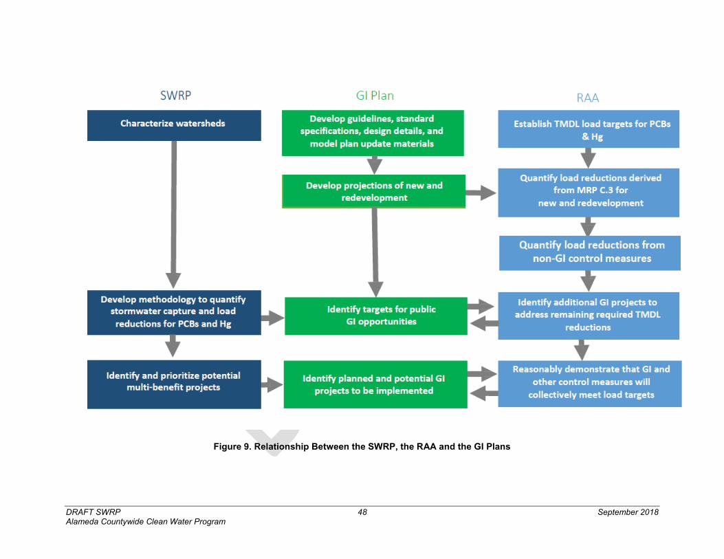
DRAFT SWRP 48 September 2018 Alameda Countywide Clean Water Program
Figure 9. Relationship Between the SWRP, the RAA and the GI Plans
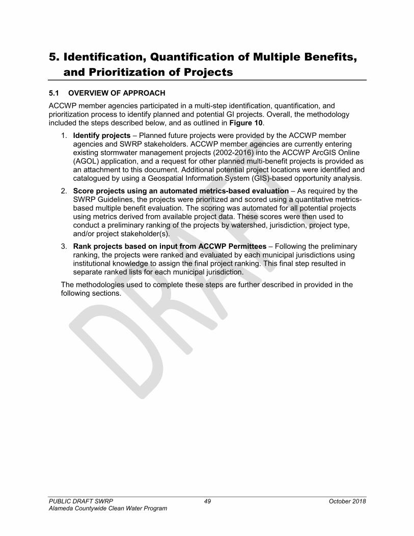
PUBLIC DRAFT SWRP 49 October 2018 Alameda Countywide Clean Water Program
5. Identification, Quantification of Multiple Benefits, and Prioritization of Projects
5.1 OVERVIEW OF APPROACH ACCWP member agencies participated in a multi-step identification, quantification, and prioritization process to identify planned and potential GI projects. Overall, the methodology included the steps described below, and as outlined in Figure 10.
1. Identify projects – Planned future projects were provided by the ACCWP member agencies and SWRP stakeholders. ACCWP member agencies are currently entering existing stormwater management projects (2002-2016) into the ACCWP ArcGIS Online (AGOL) application, and a request for other planned multi-benefit projects is provided as an attachment to this document. Additional potential project locations were identified and catalogued by using a Geospatial Information System (GIS)-based opportunity analysis.
2. Score projects using an automated metrics-based evaluation – As required by the SWRP Guidelines, the projects were prioritized and scored using a quantitative metrics-based multiple benefit evaluation. The scoring was automated for all potential projects using metrics derived from available project data. These scores were then used to conduct a preliminary ranking of the projects by watershed, jurisdiction, project type, and/or project stakeholder(s).
3. Rank projects based on input from ACCWP Permittees – Following the preliminary ranking, the projects were ranked and evaluated by each municipal jurisdictions using institutional knowledge to assign the final project ranking. This final step resulted in separate ranked lists for each municipal jurisdiction.
The methodologies used to complete these steps are further described in provided in the following sections.
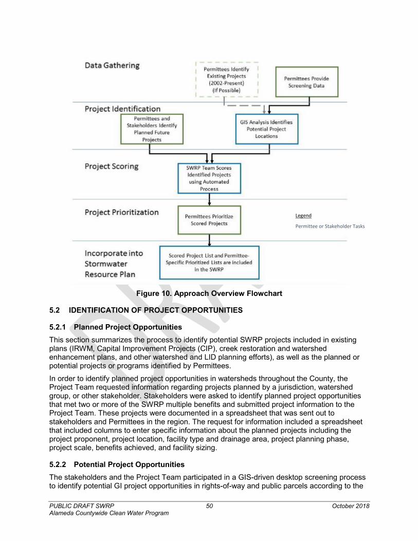
PUBLIC DRAFT SWRP 50 October 2018 Alameda Countywide Clean Water Program
Figure 10. Approach Overview Flowchart
5.2 IDENTIFICATION OF PROJECT OPPORTUNITIES
5.2.1 Planned Project Opportunities This section summarizes the process to identify potential SWRP projects included in existing plans (IRWM, Capital Improvement Projects (CIP), creek restoration and watershed enhancement plans, and other watershed and LID planning efforts), as well as the planned or potential projects or programs identified by Permittees.
In order to identify planned project opportunities in watersheds throughout the County, the Project Team requested information regarding projects planned by a jurisdiction, watershed group, or other stakeholder. Stakeholders were asked to identify planned project opportunities that met two or more of the SWRP multiple benefits and submitted project information to the Project Team. These projects were documented in a spreadsheet that was sent out to stakeholders and Permittees in the region. The request for information included a spreadsheet that included columns to enter specific information about the planned projects including the project proponent, project location, facility type and drainage area, project planning phase, project scale, benefits achieved, and facility sizing.
5.2.2 Potential Project Opportunities The stakeholders and the Project Team participated in a GIS-driven desktop screening process to identify potential GI project opportunities in rights-of-way and public parcels according to the
Legend
Permittee or Stakeholder Tasks
PUBLIC DRAFT SWRP 51 October 2018 Alameda Countywide Clean Water Program
criteria developed through the optimization and prioritization assessment conducted by a consultant.
A desktop project opportunity analysis was conducted in GIS to identify opportunity locations for potential GI projects. The desktop GIS analysis consisted of a multi-criteria screening process. Although additional details can be found below, a summary of the screening process consisted of first identifying publicly-owned parcels and rights-of-way (ROW) without physical feasibility constraints that could preclude implementation of a project. Then, potential projects on publicly-owned parcels and ROWs were categorized as parcel-based projects (i.e., treating only the drainage on the identified parcel); regional projects (i.e., treating a larger area draining to the parcel); and ROW/green street projects (i.e., treating the road and portions of adjacent parcels).
Additional details of the project opportunity analysis were:52
1. Identified publicly-owned parcels through parcel ownership and/or tax-exempt status (although tax-exempt religious facilities may be excluded from consideration).
2. Screened publicly-owned parcels from Step 1 to isolate parcels that are at least 0.1 acres in size and with average slope less than 10% (estimated using USGS topographic data).
3. Parcels meeting Step 2 screening criteria were assessed for physical feasibility constraints that could preclude project implementation. Parcels that did not meet size, slope, and feasibility screening criteria were not considered as project opportunity sites.
4. Identified non-interstate highway public ROW within urban areas. Roadways considered in Step 3 included state and county highways and connecting roads; and local, neighborhood, and rural roads.
5. Identified land uses or adjacent land uses based on a combination of Association of Bay Area Governments (ABAG) land use categories and use codes provided by the Alameda County Assessor. These land uses were combined into specific land use categories for use in the analysis.
6. Screened the identified parcel-based, regional, and ROW locations to remove sites with the following physical constraints (to the extent possible through the provided and obtained data):
a. Regional facilities located close to a storm drain (i.e., within 500 feet) in order to treat drainage from a larger drainage area;
b. Sites with significant drainage area outside of urbanized areas were not considered for regional projects and sites dominated by open space were not considered for parcel-based projects, as these sites would not provide opportunity for significant pollutant load reduction;
c. Sites mostly within environmentally sensitive areas (approximately 50% or more; e.g., designated wetlands, biologically sensitive areas);
d. Sites within 100 feet of septic systems and drain fields;
e. Sites within 100 feet of water supply wells; 52 This analysis did not include screening checks that should occur as part of a project concept development, which include the presence of steep slopes in drainage areas, need for a liner due to proximity to structures, and other feasibility checks. The screening also did not include field checks that would be conducted as part of project design, such as drainage tie-ins, land use checks, or other data verification.
PUBLIC DRAFT SWRP 52 October 2018 Alameda Countywide Clean Water Program
f. Sites mostly overlying seasonal high groundwater (within 10 feet of base); and
g. Sites mostly overlying landslides hazard zones.
5.3 PROJECT CLASSIFICATION All projects (i.e., those identified in the GIS opportunity analysis and the stakeholder planned projects) were classified in order to conduct the metrics-based evaluation (see Section 5.5). The projects were classified based on the following information:
1. Green infrastructure project type;
2. Infiltration feasibility;
3. Facility type; and
4. Drainage area information.
As part of this step, potential project locations that were identified in the GIS analysis may have been manually altered to better reflect practical concerns (e.g., multiple small co-located parcels may be grouped into one potential project location; clearly infeasible project locations may have been removed).
5.3.1 Green Infrastructure Projects Green infrastructure projects were categorized as parcel-based, regional, or ROW/green street projects.
1. All street-based projects were identified as ROW/green street projects.
2. Projects located on a parcel were classified as regional if: a. The parcel contained at least 0.5 acre of undeveloped or pervious area (as
identified through the land use class);
b. The drainage area was larger than the parcel itself; and
c. The location was sufficiently close to a storm drain (i.e., within 500 feet, where storm drain pipe data is available).
3. All other parcel locations were identified as parcel-based projects.
5.3.2 Infiltration Feasibility All potential project locations were categorized as infeasible, partially feasible, or feasible for infiltration, as follows:
1. Hazardous/infeasible for infiltration (i.e., facilities must be lined) – projects that are located:
a. In any portion, over geotechnical hazard areas (e.g., landslides, liquefaction hazards, other available information);
b. Mostly over known soil contamination or groundwater contamination plumes; or
PUBLIC DRAFT SWRP 53 October 2018 Alameda Countywide Clean Water Program
c. Within 100 feet of a site with soil or groundwater contamination (based on proximity to active Geotracker53 or EnviroStor54 sites).
2. Infiltration safe but only partially feasible – This is the case when none of the above constraints exist, but the soil underlying the facility is relatively poorly draining (identified as hydrologic soil group C or D.
3. Infiltration feasible – The site has none of the infiltration hazards present and the soil underlying the facility is relatively well draining (identified as hydrologic soil group A or B).
Infiltration feasibility was used to estimate how much volume could be retained by the facility. Locations feasible for infiltration were assumed to retain the full water quality volume. In locations that are partially feasible for infiltration, it was assumed that infiltration would be promoted in the facility, but the full water quality capture volume would not be infiltrated due to poor drainage. These areas would be assumed to infiltrate to the extent possible using a raised underdrain. Locations that are hazardous for infiltration were assumed to implement non-infiltrating green infrastructure projects (i.e., lined bioretention) and were assumed to retain no volume.
5.3.3 Facility Type Each potential project location was assigned a facility type. For planned projects identified by the ACCWP member agencies, the facility description or classification provided by the project proponent was used to assign the facility type. The facility types that were assigned include:
1. Green Infrastructure55 (distributed or regional) – these types of facilities were assumed to provide good stormwater pollutant removal; moderately augment water supply if infiltration-based and located over a water supply aquifer; moderately provide flood control benefits; moderately reestablish natural hydrology; and moderately develop, restore, or enhance habitat and open space. All projects identified through the GIS screening process ware assumed to be green infrastructure projects.
2. Non-Green Infrastructure Treatment Control Facilities – these facilities, which do not include vegetation, were assumed to provide moderate stormwater pollutant removal, and to moderately reestablish natural water drainage systems. Projects that were provided by the ACCWP member agencies in the request for planned projects that indicated a non-green infrastructure treatment control facility type were included in this category.
3. Water Supply Augmentation - This facility type was assumed if one of the following was true:
53 Geotracker is a California State Water Resources Control Board website which tracks sites with the potential to impact water quality in California, including contaminated sites (https://geotracker.waterboards.ca.gov/). 54 EnviroStor is the Department of Toxic Substances Control's data management system for tracking cleanup, permitting, enforcement and investigation efforts at hazardous waste facilities and sites with known contamination or sites where there may be reasons to investigate further (https://www.envirostor.dtsc.ca.gov/public/). 55 Defined by the San Francisco Bay Regional Water Quality Control Board (SFBRWQCB, 2015) to include: “Infrastructure that uses vegetation, soils, and natural processes to manage water and create healthier urban environments. At the scale of a city or county, green infrastructure refers to the patchwork of natural areas that provides habitat, flood protection, cleaner air, and cleaner water. At the scale of a neighborhood or site, green infrastructure refers to stormwater management systems that mimic nature by soaking up and storing water.”
PUBLIC DRAFT SWRP 54 October 2018 Alameda Countywide Clean Water Program
a. Water supply augmentation (e.g., stormwater capture and use) has been indicated for a planned project submitted by an ACCWP member agency
b. A location conducive for infiltration per the categorization described in Section 5.3.2 is located above a water supply aquifer (to the extent that aquifer data is available). These projects were assumed to be both green infrastructure and water supply augmentation projects.
4. Flood Control Facilities – these are projects that were provided by ACCWP member agencies in the request for planned projects and identified by the project proponent as primarily flood control projects. These projects might also provide multiple benefits.
5. Hydromodification Control, Stream Restoration, or Habitat Restoration – These facilities or areas are designed specifically to restore areas impacted by erosive stormwater or dry weather flows and/or prevent these areas from impacts caused by future erosive flows. These projects were provided by the ACCWP member agencies in the request for planned projects.
6. Public Use Area or Public Education Area – In almost all cases, public use areas or public education areas would not be stand-alone projects but would be supplemental features of one of the facility types listed above.
7. Programmatic Stormwater Management Opportunities – such as sidewalk landscaping and impervious surface removal programs, rainwater harvesting subsidy programs, green roof subsidy programs, residential rain garden and downspout disconnection programs, subsidy or credit programs for stormwater management and/or water quality projects on agricultural lands, and similar opportunities. These projects were provided by the ACCWP member agencies in the request for planned projects.
5.3.4 Project Drainage Area 1. For each identified project, the project drainage area was identified and characterized as
follows:
2. All planned projects with identified drainage areas were characterized as provided.
3. For ROW projects for which drainage area has not been characterized, the roadway and an assumed tributary width (e.g., 50 feet per side) that extends into the adjacent parcels was considered the project drainage area.
4. For parcel-based projects for which drainage area has not been characterized, the entire parcel was assumed to make up the drainage area.
5. For regional projects for which the drainage area has not been characterized, the drainage area characterization (i.e., slope and land use) was roughly approximated.
5.4 IDENTIFIED PROJECT DATABASE The projects identified and classified using the methods described above were compiled into a database that includes all of the project information that was provided (for planned projects) as well as information identified for project opportunities as part of the GIS screening process. Following the compilation of identified projects, additional information was gathered for each project through a desktop analysis. This information was then used to score and rank the identification projects. A thorough description of the ranking process is found throughout the sections that follow.
PUBLIC DRAFT SWRP 55 October 2018 Alameda Countywide Clean Water Program
5.5 METRICS-BASED MULTI-BENEFIT EVALUATION AND PROJECT PRIORITIZATION The planned projects and project opportunities included in the project database were evaluated using an automated scoring process based on quantitative metrics that account for multiple benefits, as described in this section. The automated process requires that scoring metrics are contained in the identified project database. The scoring scheme described below was adapted from the method used to develop the Stormwater Resource Plan for San Mateo County (SMCWPPP, 2017) and the Ventura Countywide Municipal Stormwater Resource Plan (Ventura Countywide Stormwater Quality Management Program, 2016) and is consistent with the Storm Water Resource Plan Guidelines (SWRCB, 2015). The quantitative metrics and qualitative components that are scored are associated with providing the multiple benefits identified in the State’s SWRP Guidance (water quality, water supply, flood control, environmental benefit, and community benefit), derived from the implementation of the project.
After scoring planned projects and project opportunities, the project database was provided to the ACCWP member agencies for review and prioritization. The preliminary project ranking arising from automated scoring was revised by each municipal jurisdiction to reflect their institutional knowledge about local conditions, feasibility, and other priorities. Appendix 5 provides the ranked project database each municipal jurisdiction. These prioritized project lists provide a set of GI project opportunities for each municipal jurisdiction to consider in developing its GI Plan, which are required by the MRP to be submitted to the Regional Water Board in September 2019.
5.5.1 Multiple Benefit Evaluation Using the information compiled in the identified project database, each project received a score using the metrics-based point system provided in Table 5. There are two categories of project components that receive points: General Stormwater Management Performance /Implementation Feasibility, and Individual Benefit Performance. A description of each scored project component is provided below.
The General Stormwater Management Performance/Implementation Feasibility category group includes scores for project components that relate to the ease of implementation. These categories are assumed to apply to all multiple benefit categories (i.e., water quality, water supply, flood control, environmental, and community benefits). This includes the following components:
• Parcel area (For Regional and Parcel-Based Projects Only) – This scoring component provides more points for larger parcel areas, assuming that it would be easier to site a project on a larger parcel.
• Opportunity location slope – This scoring component is related to ease of construction and implementation. Flatter locations typically require less grading and hydraulic connection considerations.
• Infiltration feasibility – Retention of runoff through percolation or infiltration is known to provide enhanced pollutant reduction, reestablishment of natural drainage, recharge potential, and reduction of runoff rates, among other beneficial outcomes. This project component is assumed to apply to all benefit categories.
The Individual Benefit Performance category group provides scores for project components that relate to facility performance, including:
• PCBs/Mercury Yield Classification in Project Drainage Area – This scoring component is related to the influent pollutant loads. Facilities that located in areas with higher pollutant
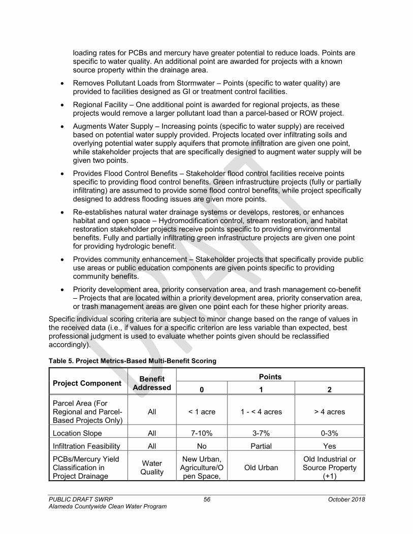
PUBLIC DRAFT SWRP 56 October 2018 Alameda Countywide Clean Water Program
loading rates for PCBs and mercury have greater potential to reduce loads. Points are specific to water quality. An additional point are awarded for projects with a known source property within the drainage area.
• Removes Pollutant Loads from Stormwater – Points (specific to water quality) are provided to facilities designed as GI or treatment control facilities.
• Regional Facility – One additional point is awarded for regional projects, as these projects would remove a larger pollutant load than a parcel-based or ROW project.
• Augments Water Supply – Increasing points (specific to water supply) are received based on potential water supply provided. Projects located over infiltrating soils and overlying potential water supply aquifers that promote infiltration are given one point, while stakeholder projects that are specifically designed to augment water supply will be given two points.
• Provides Flood Control Benefits – Stakeholder flood control facilities receive points specific to providing flood control benefits. Green infrastructure projects (fully or partially infiltrating) are assumed to provide some flood control benefits, while project specifically designed to address flooding issues are given more points.
• Re-establishes natural water drainage systems or develops, restores, or enhances habitat and open space – Hydromodification control, stream restoration, and habitat restoration stakeholder projects receive points specific to providing environmental benefits. Fully and partially infiltrating green infrastructure projects are given one point for providing hydrologic benefit.
• Provides community enhancement – Stakeholder projects that specifically provide public use areas or public education components are given points specific to providing community benefits.
• Priority development area, priority conservation area, and trash management co-benefit – Projects that are located within a priority development area, priority conservation area, or trash management areas are given one point each for these higher priority areas.
Specific individual scoring criteria are subject to minor change based on the range of values in the received data (i.e., if values for a specific criterion are less variable than expected, best professional judgment is used to evaluate whether points given should be reclassified accordingly).
Table 5. Project Metrics-Based Multi-Benefit Scoring
Project Component Benefit Addressed
Points 0 1 2
Parcel Area (For Regional and Parcel-Based Projects Only)
All < 1 acre 1 - < 4 acres > 4 acres
Location Slope All 7-10% 3-7% 0-3%
Infiltration Feasibility All No Partial Yes
PCBs/Mercury Yield Classification in Project Drainage
Water Quality
New Urban, Agriculture/Open Space,
Old Urban Old Industrial or Source Property
(+1)
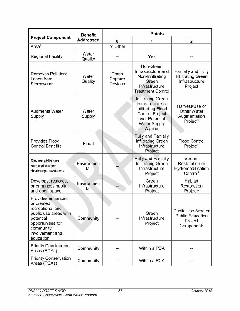
PUBLIC DRAFT SWRP 57 October 2018 Alameda Countywide Clean Water Program
Project Component Benefit Addressed
Points 0 1 2
Area1 or Other
Regional Facility Water Quality -- Yes --
Removes Pollutant Loads from Stormwater
Water Quality
Trash Capture Devices
Non-Green Infrastructure and
Non-Infiltrating Green
Infrastructure Treatment Control
Partially and Fully Infiltrating Green
Infrastructure Project
Augments Water Supply
Water Supply --
Infiltrating Green Infrastructure or Infiltrating Flood Control Project over Potential Water Supply
Aquifer
Harvest/Use or Other Water
Augmentation Project2
Provides Flood Control Benefits Flood --
Fully and Partially Infiltrating Green
Infrastructure Project
Flood Control Project2
Re-establishes natural water drainage systems
Environmental --
Fully and Partially Infiltrating Green
Infrastructure Project
Stream Restoration or
Hydromodification Control2
Develops, restores, or enhances habitat and open space
Environmental --
Green Infrastructure
Project
Habitat Restoration
Project2
Provides enhanced or created recreational and public use areas with potential opportunities for community involvement and education
Community -- Green
Infrastructure Project
Public Use Area or Public Education
Project Component3
Priority Development Areas (PDAs) Community -- Within a PDA --
Priority Conservation Areas (PCAs) Community -- Within a PCA --
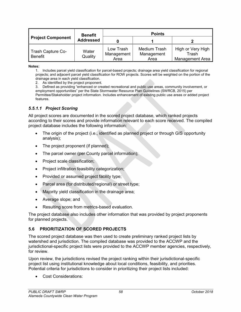
PUBLIC DRAFT SWRP 58 October 2018 Alameda Countywide Clean Water Program
Project Component Benefit Addressed
Points 0 1 2
Trash Capture Co-Benefit
Water Quality
Low Trash Management
Area
Medium Trash Management
Area
High or Very High Trash
Management Area Notes:
1. Includes parcel yield classification for parcel-based projects; drainage area yield classification for regional projects; and adjacent parcel yield classification for ROW projects. Scores will be weighted on the portion of the drainage area in each yield classification. 2. As identified by the project proponent. 3. Defined as providing “enhanced or created recreational and public use areas, community involvement, or employment opportunities” per the State Stormwater Resource Plan Guidelines (SWRCB, 2015) per Permittee/Stakeholder project information. Includes enhancement of existing public use areas or added project features.
5.5.1.1 Project Scoring All project scores are documented in the scored project database, which ranked projects according to their scores and provide information relevant to each score received. The compiled project database includes the following information:
• The origin of the project (i.e., identified as planned project or through GIS opportunity analysis);
• The project proponent (if planned);
• The parcel owner (per County parcel information);
• Project scale classification;
• Project infiltration feasibility categorization;
• Provided or assumed project facility type;
• Parcel area (for distributed/regional) or street type;
• Majority yield classification in the drainage area;
• Average slope; and
• Resulting score from metrics-based evaluation.
The project database also includes other information that was provided by project proponents for planned projects.
5.6 PRIORITIZATION OF SCORED PROJECTS The scored project database was then used to create preliminary ranked project lists by watershed and jurisdiction. The compiled database was provided to the ACCWP and the jurisdictional-specific project lists were provided to the ACCWP member agencies, respectively, for review.
Upon review, the jurisdictions revised the project ranking within their jurisdictional-specific project list using institutional knowledge about local conditions, feasibility, and priorities. Potential criteria for jurisdictions to consider in prioritizing their project lists included:
• Cost Considerations:
PUBLIC DRAFT SWRP 59 October 2018 Alameda Countywide Clean Water Program
o Capital costs
o Maintenance costs
o Funding sources
• Opportunity Considerations:
o Synergies with upcoming transportation and other CIP projects
o ROW projects on pedestrian or bicycle priority streets
• Load Reduction Potential:
o Load reduction potential for PCBs and mercury
• Labor/Staff Considerations:
o Ease of construction/installation
o Complexity and/or frequency of operations and maintenance
• Multiple Benefits:
o Consideration of achieving multiple benefits
o Potential for aesthetic, community, or other benefits not previously identified
• Safety and Security Considerations:
o Potential to cause a safety hazard and/or measures needed to avoid creating a safety hazard
o Potential for vandalism
• Implementation Considerations:
o Potential for implementation challenges due to site constraints or community opposition
5.6.1 Prioritized List of Project Opportunities Through the methodologies described throughout this section, the ACCWP member agencies and stakeholders have identified, quantified the potential for multiple benefits, and prioritized a comprehensive list of potential GI project opportunities. The lists of prioritized projects can be found in Appendix 5.
PUBLIC DRAFT SWRP 60 October 2018 Alameda Countywide Clean Water Program
6. Education, Outreach, and Public Participation
6.1 OVERVIEW OF STAKEHOLDER OUTREACH AND COORDINATION STRATEGY The stakeholder outreach and coordination strategy, summarized below, was implemented as described in the document entitled Alameda Countywide Clean Water Program Stormwater Resource Plan Outreach Strategy (Outreach Strategy) (Appendix 3.)
6.1.1 Purpose of the Stakeholder Outreach and Coordination Strategy Water Code Section 10562(b)(4) requires that the SWRP provide for community participation in SWRP development and implementation, and SWRP Guidelines state the following regarding public outreach requirements:
“To maximize community-based benefits, key stakeholders and the public should be involved in all appropriate implementation steps of the Storm Water Resource Plan. Public education and opportunities for public participation in actions, decisions, and projects implemented through watershed-based storm water management should be provided.”
This strategy is focused on meeting the required element and the overall intent of the Water Code to engage stakeholders and the public in the SWRP development and implementation processes.
6.1.2 Outreach Approach The outreach strategy for the ACCWP SWRP focused on key stakeholders through targeted messages for each stakeholder audience and use of efficient/effective methods to deliver the message to each stakeholder audience. This approach was implemented for the SWRP development phase. Implementation of the ACCWP SWRP will be conducted by the various jurisdictions within Alameda County through local GI Plans and the design and construction of specific multi-benefit stormwater projects. Section 6.1.3 identifies the targeted key stakeholder audiences and their potential interest in the project. Section 6.1.4 provides a matrix linking the key stakeholder audiences and method(s) used to deliver the message and includes the outreach schedule. Targeted messages for each audience were developed and refined during the outreach campaign.
6.1.3 Key Stakeholder Audiences Outreach activities were focused on key stakeholder audiences, as described in the following sub-sections.
6.1.3.1 ACCWP Member Agencies These primary stakeholders in the development of the SWRP were already highly engaged through the related processes of developing GI Plans and the RAA. The GI Work Group assumed the leadership role in developing the SWRP.
6.1.3.2 Non-Municipal Public Landowners This stakeholder audience is comprised of those non-municipal entities that own public lands and easements that are potential partners for multiple-benefit projects. This group includes school districts, park districts, water agencies, transportation/transit districts, and private utilities. This stakeholder group was identified by sorting the ACCWP SWRP project opportunities
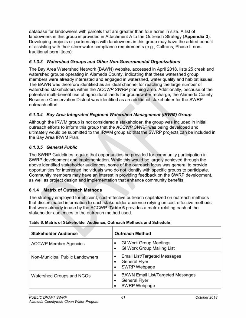
PUBLIC DRAFT SWRP 61 October 2018 Alameda Countywide Clean Water Program
database for landowners with parcels that are greater than four acres in size. A list of landowners in this group is provided in Attachment A to the Outreach Strategy (Appendix 3). Developing projects or partnerships with landowners in this group may have the added benefit of assisting with their stormwater compliance requirements (e.g., Caltrans, Phase II non-traditional permittees).
6.1.3.3 Watershed Groups and Other Non-Governmental Organizations The Bay Area Watershed Network (BAWN) website, accessed in April 2018, lists 25 creek and watershed groups operating in Alameda County, indicating that these watershed group members were already interested and engaged in watershed, water quality and habitat issues. The BAWN was therefore identified as an ideal channel for reaching the large number of watershed stakeholders within the ACCWP SWRP planning area. Additionally, because of the potential multi-benefit use of agricultural lands for groundwater recharge, the Alameda County Resource Conservation District was identified as an additional stakeholder for the SWRP outreach effort.
6.1.3.4 Bay Area Integrated Regional Watershed Management (IRWM) Group Although the IRWM group is not considered a stakeholder, the group was included in initial outreach efforts to inform this group that the ACCWP SWRP was being developed and ultimately would be submitted to the IRWM group so that the SWRP projects can be included in the Bay Area IRWM Plan.
6.1.3.5 General Public The SWRP Guidelines require that opportunities be provided for community participation in SWRP development and implementation. While this would be largely achieved through the above identified stakeholder audiences, some of the outreach focus was general to provide opportunities for interested individuals who do not identify with specific groups to participate. Community members may have an interest in providing feedback on the SWRP development, as well as project design and implementation that enhance community benefits.
6.1.4 Matrix of Outreach Methods The strategy employed for efficient, cost-effective outreach capitalized on outreach methods that disseminated information to each stakeholder audience relying on cost effective methods that were already in use by the ACCWP. Table 6 provides a matrix relating each of the stakeholder audiences to the outreach method used.
Table 6. Matrix of Stakeholder Audience, Outreach Methods and Schedule
Stakeholder Audience Outreach Method
ACCWP Member Agencies • GI Work Group Meetings • GI Work Group Mailing List
Non-Municipal Public Landowners • Email List/Targeted Messages • General Flyer • SWRP Webpage
Watershed Groups and NGOs • BAWN Email List/Targeted Messages • General Flyer • SWRP Webpage
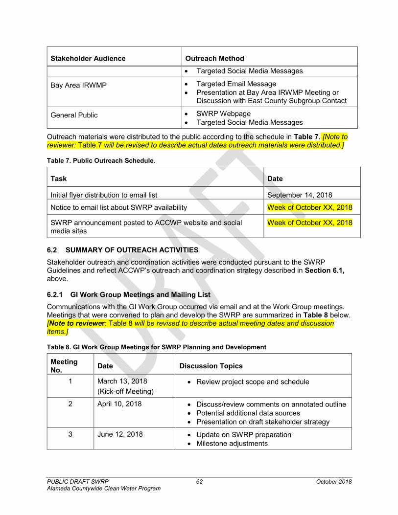
PUBLIC DRAFT SWRP 62 October 2018 Alameda Countywide Clean Water Program
Stakeholder Audience Outreach Method • Targeted Social Media Messages
Bay Area IRWMP • Targeted Email Message • Presentation at Bay Area IRWMP Meeting or
Discussion with East County Subgroup Contact
General Public • SWRP Webpage • Targeted Social Media Messages
Outreach materials were distributed to the public according to the schedule in Table 7. [Note to reviewer: Table 7 will be revised to describe actual dates outreach materials were distributed.]
Table 7. Public Outreach Schedule.
Task Date
Initial flyer distribution to email list September 14, 2018
Notice to email list about SWRP availability Week of October XX, 2018
SWRP announcement posted to ACCWP website and social media sites
Week of October XX, 2018
6.2 SUMMARY OF OUTREACH ACTIVITIES Stakeholder outreach and coordination activities were conducted pursuant to the SWRP Guidelines and reflect ACCWP’s outreach and coordination strategy described in Section 6.1, above.
6.2.1 GI Work Group Meetings and Mailing List Communications with the GI Work Group occurred via email and at the Work Group meetings. Meetings that were convened to plan and develop the SWRP are summarized in Table 8 below. [Note to reviewer: Table 8 will be revised to describe actual meeting dates and discussion items.]
Table 8. GI Work Group Meetings for SWRP Planning and Development
Meeting No. Date Discussion Topics
1 March 13, 2018 (Kick-off Meeting)
• Review project scope and schedule
2 April 10, 2018 • Discuss/review comments on annotated outline • Potential additional data sources • Presentation on draft stakeholder strategy
3 June 12, 2018 • Update on SWRP preparation • Milestone adjustments
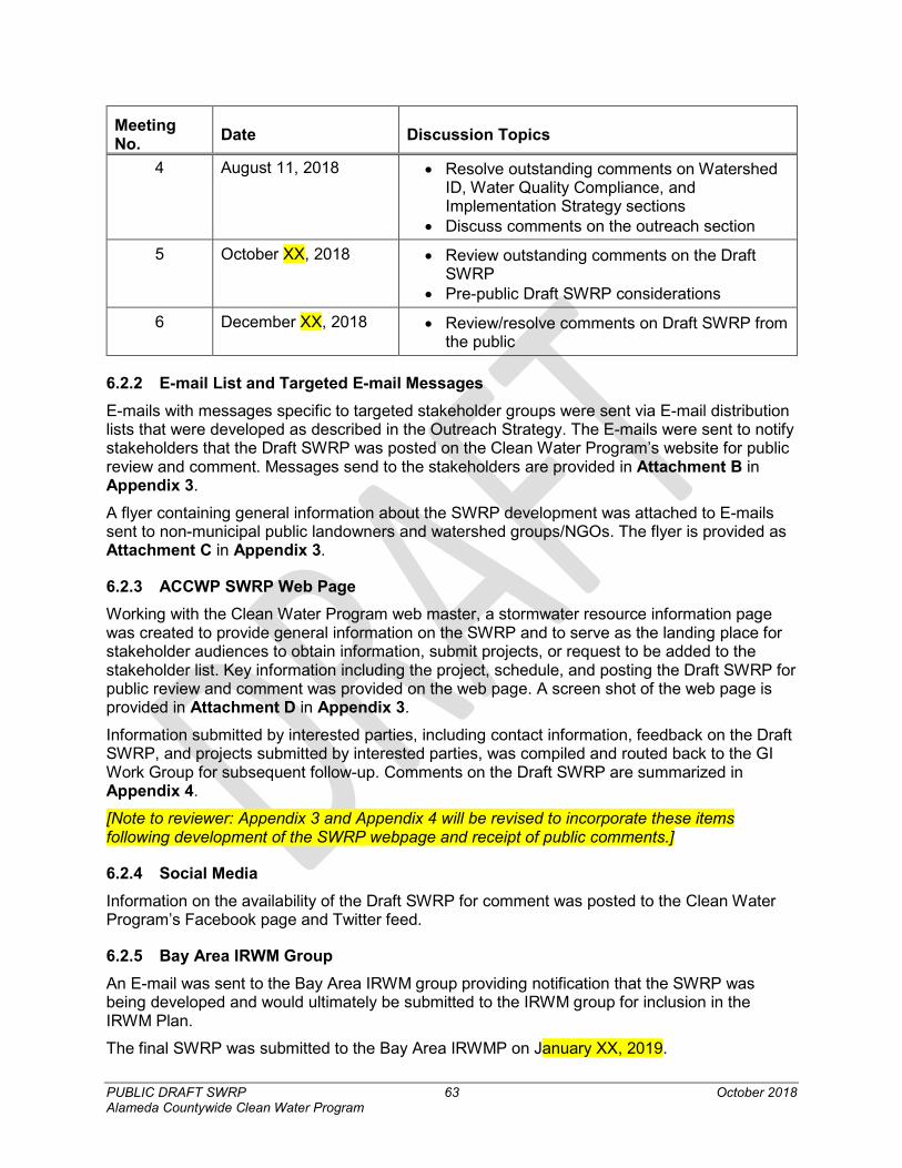
PUBLIC DRAFT SWRP 63 October 2018 Alameda Countywide Clean Water Program
Meeting No. Date Discussion Topics
4 August 11, 2018 • Resolve outstanding comments on Watershed ID, Water Quality Compliance, and Implementation Strategy sections
• Discuss comments on the outreach section
5 October XX, 2018 • Review outstanding comments on the Draft SWRP
• Pre-public Draft SWRP considerations
6 December XX, 2018 • Review/resolve comments on Draft SWRP from the public
6.2.2 E-mail List and Targeted E-mail Messages E-mails with messages specific to targeted stakeholder groups were sent via E-mail distribution lists that were developed as described in the Outreach Strategy. The E-mails were sent to notify stakeholders that the Draft SWRP was posted on the Clean Water Program’s website for public review and comment. Messages send to the stakeholders are provided in Attachment B in Appendix 3.
A flyer containing general information about the SWRP development was attached to E-mails sent to non-municipal public landowners and watershed groups/NGOs. The flyer is provided as Attachment C in Appendix 3.
6.2.3 ACCWP SWRP Web Page Working with the Clean Water Program web master, a stormwater resource information page was created to provide general information on the SWRP and to serve as the landing place for stakeholder audiences to obtain information, submit projects, or request to be added to the stakeholder list. Key information including the project, schedule, and posting the Draft SWRP for public review and comment was provided on the web page. A screen shot of the web page is provided in Attachment D in Appendix 3.
Information submitted by interested parties, including contact information, feedback on the Draft SWRP, and projects submitted by interested parties, was compiled and routed back to the GI Work Group for subsequent follow-up. Comments on the Draft SWRP are summarized in Appendix 4.
[Note to reviewer: Appendix 3 and Appendix 4 will be revised to incorporate these items following development of the SWRP webpage and receipt of public comments.]
6.2.4 Social Media Information on the availability of the Draft SWRP for comment was posted to the Clean Water Program’s Facebook page and Twitter feed.
6.2.5 Bay Area IRWM Group An E-mail was sent to the Bay Area IRWM group providing notification that the SWRP was being developed and would ultimately be submitted to the IRWM group for inclusion in the IRWM Plan.
The final SWRP was submitted to the Bay Area IRWMP on January XX, 2019.

PUBLIC DRAFT SWRP 64 October 2018 Alameda Countywide Clean Water Program
PUBLIC DRAFT SWRP 65 October 2018 Alameda Countywide Clean Water Program
7. Implementation Strategy for SWRP Implementation of the ACCWP SWRP will include both project implementation and adaptive management on a watershed- and project-level basis. Successful implementation of the ACCWP SWRP plan requires continued stakeholder engagement, coordination with efforts to comply with water quality regulations, as well as specific actions for individual project implementation, such as obtaining necessary environmental permits, and identifying and obtaining funding resources.
7.1 SWRP IMPLEMENTATION
7.1.1 Responsible Entities ACCWP is the primary developer and coordinator of the ACCWP SWRP on behalf of the stakeholders. The ACCWP member agencies identified on the prioritized project lists will be responsible for the development and implementation of those projects, should funding become available.
ACCWP will facilitate future ACCWP SWRP updates and ongoing adaptive management of the ACCWP SWRP, unless this task is taken on by another entity. It is also anticipated that the ACCWP will fund ACCWP SWRP updates to the extent feasible with support from its member agencies. The ACCWP member agencies regularly meet to coordinate and discuss the implementation of water quality programs. These regular meetings will periodically include discussions of ACCWP SWRP updates when needed, such as during the SWRP updates once every five years.
Project implementation will depend on funding availability. Through its capital improvement and planning process, each municipality is will refine the list of prioritized projects for inclusion in its GI Plan. Municipalities may develop partnerships with other agencies or entities to support project planning and implementation.
7.1.2 Implementation Schedule The final ACCWP SWRP will be submitted to the Bay Area Integrated Regional Water Coordinating Committee for incorporation into the Bay Area IRWMP. It is anticipated that the finalization and submittal of the ACCWP SWRP will occur in early 2019. Following the finalization of the ACCWP SWRP, the Permittees’ preliminary GI Plans will be complete in September 2019 and the RAA Technical Report will be complete in September 2020. These plans, which will build from the project lists generated for the development of the ACCWP SWRP, will include planning-level schedules for project implementation.
Updates to the ACCWP SWRP are projected to be completed approximately once every five years, although project lists may be updated more frequently. Updates to individual projects is anticipated to be completed by the individual entity responsible for the project through the use of the Alameda County’s regional GIS platform (described later in this section). Updates to the individual projects can include updates to the prioritization score based on new and updated conditions, as well as updates to individual project implementation, development, and completion.
Planning documents for specific projects will identify project-specific implementation schedules and timelines. Municipal GI project sponsors will be responsible for tracking the implementation status of their GI projects and reporting completed projects as described in each entity’s GI Plan. Implementation of projects will be tracked and reporting in the MRP annual reports, available through the Regional Board website.
PUBLIC DRAFT SWRP 66 October 2018 Alameda Countywide Clean Water Program
7.1.3 Community Participation Through on-going feedback mechanisms and direct solicitation, ACCWP’s member agencies encourage the continued community involvement and participation in the ACCWP SWRP through adaptive management and implementation. It is anticipated that outreach for new stakeholder projects would occur periodically with SWPP updates.
In addition, the community is encouraged to participate by submitting individual projects or suggestions for projects eligible for inclusion in the ACCWP SWRP. Guidelines for submitting individual projects or suggestions for projects can be found in Appendix 2. The guidelines and instructions include details on the type of information required for submittal or inclusion to the ACCWP SWRP.
Community engagement and participation will also occur during individual project implementation. Community engagement strategies will focus on the community where the project is located and will be implemented by the project sponsor.
The ACCWP SWRP will be made available to the public on the ACCWP website.
7.2 DECISION SUPPORT TOOLS FOR PLAN IMPLEMENTATION ACCWP has developed or is in the processes of developing a number of tools that can be used as decision support tools for the implementation of projects identified in the ACCWP SWRP. In addition to the existing tools utilized for the prioritization of projects as part of this Plan, the ACCWP member agencies plan to develop and implement jurisdiction specific GI plans in addition to conducting a countywide RAA. Incorporated into these additional tools are processes to evaluate and score individual projects for multiple-benefits and stormwater quality benefits.
ACCWP has developed and is continuing to update the development of an online GIS platform for stormwater program project implementation, tracking, and data management. This system features web maps and applications created using ESRI’s AGOL for Organizations, and accesses GIS data, custom web services and reports hosted within an Amazon cloud service running ESRI’s ArcGIS Server technology.
Of particular interest for supporting the decision support, evaluation and implementation of this Plan, is the AGOL system’s C.3 Project Tracking and Load Reduction Accounting Tool is used to track and report on GI project implementation and planning. It is currently, being used by ACCWP member agencies to track and map existing and future private and public projects incorporating GI, as well as allow ACCWP member agencies ease of ongoing review of opportunities for incorporating GI into existing and planned CIPs. Additionally, this tool will be critical to the Permittees’ ongoing work to identify watersheds and management areas where multiple-benefit control measure implementation opportunities should be prioritized for implementation during this permit term and over the coming decades.
7.3 PROJECT IMPLEMENTATION TRACKING AND DATA MANAGEMENT ACCWP currently has a number of tools in place and/or in the process of development that will assist in tracking project performance over time, particularly as related to water quality improvements. These tools serve to track implementation of this Plan, as well as the development of municipal/jurisdictional GI plans, RAAs, MRP required project tracking and pollutant load reduction accounting, and related monitoring programs (e.g., MRP required monitoring) and data assessment and management relevant to the SWRP effort.
PUBLIC DRAFT SWRP 67 October 2018 Alameda Countywide Clean Water Program
7.3.1 Tracking and Managing GI Projects In Fiscal Year (FY) 2015/16, ACCWP began a countywide GIS project focused on maintaining, analyzing, interpreting, displaying, and reporting relevant municipal stormwater program data and information to address requirements in the following MRP Provisions:
• C.3.j Green Infrastructure (GI) Planning and Implementation;
• C.10 Trash Load Reduction;
• C.11 Mercury Controls; and,
• C.12 PCBs Controls.
This project is critical to the Permittees’ ongoing work to identify watersheds and management areas where multiple-benefit control measure implementation opportunities will be identified and prioritized for implementation during this permit term and over the coming decades. Additionally, this GIS database will be used to track and map existing and future C.3 new and redevelopment projects, allow ease of ongoing review of opportunities for incorporating GI into existing and planned CIPs, and assist in the development of GI plans. The Program anticipates that the stormwater GIS platform will be an important tool for maintaining relevant stormwater data; reviewing, analyzing and displaying data geography; accounting for and assessing compliance with load reduction performance goals; and reporting.
As mentioned earlier, this system features web maps and applications created using ESRI’sAGOL for Organizations, and accesses GIS data, custom web services and reports hosted within an Amazon cloud service running ESRI’s ArcGIS Server technology.
7.3.2 Pollutant Load Reduction Accounting MRP Provisions C.11.b and C.12.b require ACCWP Permittees to develop and implement an assessment methodology and data collection program to quantify mercury and PCBs loads reduced through implementation of pollution prevention, source control, and treatment control measures. The Permittees are using this assessment methodology to demonstrate progress towards achieving the pollutant load reductions required in this permit term. This assessment methodology is outlined in the Final Interim Accounting Methodology for TMDL Loads Reduced report (BASMAA, 2016c). Loads reduced through implementation of GI projects, including those identified in the ACCWP SWRP, are reported each year in the ACCWP Annual Report, which is made available online through the Regional Board Website56.
7.3.3 Reasonable Assurance Analysis MRP Provision C.3.j requires the Permittees to develop a GI plan for inclusion in the 2019 Annual Report. The GI Plan must be developed using a mechanism to prioritize and map areas for potential and planned GI projects, both public and private, on a drainage-area-specific basis, for implementation by 2020, 2030, and 2040. The 2018 ACCWP SWRP and the GI plan served as the foundation for this GI analysis.
MRP Provisions C.11.c and C.12.c require the Permittees to prepare an RAA for inclusion in the 2020 Annual Report that quantitatively demonstrates that mercury load reductions of at least 10 kg/yr and PCBs load reductions of at least 3 kg/yr will be achieved across the Bay Area by 2040 through implementation of GI throughout the permit area. 56 MRP Annual Reports https://www.waterboards.ca.gov/sanfranciscobay/water_issues/programs/stormwater/MRP/Annual_Reports1.html
PUBLIC DRAFT SWRP 68 October 2018 Alameda Countywide Clean Water Program
The RAA will do the following:
1. Quantify the relationship between the areal extent of GI implementation and mercury and PCBs load reductions. This quantification will take into consideration the scale of contamination of the treated area as well as the pollutant removal effectiveness of GI strategies likely to be implemented.
2. Estimate the amount and characteristics of land area that will be treated by GI by 2020, 2030, and 2040.
3. Estimate the amount of mercury and PCBs load reductions that will result from GI implementation by 2020, 2030, and 2040.
4. Quantitatively demonstrate that mercury load reductions of at least 10 kg/yr and PCBs load reductions of at least 3 kg/yr will be realized by 2040 through implementation of GI projects across the Bay Area.
5. Ensure that the calculation methods, models, model inputs, and modeling assumptions used have been validated through a peer review process.
Additionally, MRP Provisions C.11.d. and C.12.d. require the Permittees to prepare plans and schedules for mercury and PCBs control measure implementation and an RAA demonstrating that sufficient control measures will be implemented to attain the mercury TMDL WLAs by 2028 and the PCBs TMDL WLAs by 2030.
The RAA results will be included in ACCWP’s 2020 Annual Report.
7.4 WATER QUALITY MONITORING
7.4.1 ACCWP Monitoring Program MRP Provision C.8 specifies the monitoring required to be conducted by the ACCWP Permittees, including creek status monitoring, stressor/source identification projects, pollutants of concern monitoring, and pesticides and toxicity monitoring. ACCWP Permittees participate in a regional monitoring collaboration, as authorized by the MRP, to address the monitoring requirements in Provision C.8. The collaboration is known as the BASMAA Regional Monitoring Coalition (RMC). The RMC Work Group is a subgroup of the BASMAA Monitoring and Pollutants of Concern Committee (MPC), which meets and communicates regularly to coordinate planning and implementation of monitoring-related activities. RMC Work Group meetings are coordinated by a coordinator funded by the participating county stormwater programs. This workgroup includes staff from the Regional Water Board at two levels – those generally engaged with the MRP, as well as those working regionally with the State of California’s Surface Water Ambient Monitoring Program (SWAMP). Through the RMC Work Group, the BASMAA RMC developed a Quality Assurance Program Plan (QAPP; BASMAA, 2016a), Standard Operating Procedures (SOPs; BASMAA, 2016b), data management tools, and reporting templates and guidelines. Regionally-implemented activities of the RMC are conducted under the auspices of BASMAA.
Water quality monitoring results are provided in the Urban Creeks Monitoring Report, submitted to the Water Boards in March each year. This report is made available to the public on the ACCWP’s website as well as through the Regional Water Board website57.
57 Reports on water quality monitoring required by the MRP. https://www.waterboards.ca.gov/sanfranciscobay/water_issues/programs/water_quality.html#RMC
PUBLIC DRAFT SWRP 69 October 2018 Alameda Countywide Clean Water Program
7.4.2 Regional Monitoring Program San Francisco Bay Estuary monitoring is conducted through the Regional Monitoring Program (RMP). The RMP is a long-term monitoring program that is discharger funded and shares direction and participation by regulatory agencies and the regulated community, with the goal of assessing water quality in San Francisco Bay. The regulated community includes the ACCWP Permittees, publicly owned treatment works, dredgers, and industrial dischargers. The RMP is intended to answer the following core management questions:
1. Are chemical concentrations in the estuary potentially at levels of concern and are associated impacts likely?
2. What are the concentrations and masses of contaminants in the estuary and its segments?
3. What are the sources, pathways, loadings, and processes leading to contaminant-related impacts in the estuary?
4. Have the concentrations, masses, and associated impacts of contaminants in the estuary increased or decreased?
5. What are the projected concentrations, masses, and associated impacts of contaminants in the estuary?
The RMP publishes reports and study results on the San Francisco Estuary Institute website.58
7.5 FUNDING NEEDS Funding for implementation of projects included in the ACCWP SWRP will be obtained by the municipal agency, partnerships of agencies, or other stakeholder project sponsors working to implement the identified projects. Project implementation will depend on funding availability.
It is anticipated that funding needs for the implementation of projects identified in the SWRP and included each jurisdictions GI plan will be evaluated based on criteria including but not limited to, ballot approval, reliability, cost to implement the project, and potential barriers to implementation. Potential options for the evaluation of funding options include:
• Alternative Compliance Funds;
• Grant monies;
• Existing Permittee Resources;
• New Tax or other levees;
• Partnerships with Caltrans or other governmental agencies in the watersheds;
• Round 2 of Proposition 1 Implementation Grants;
• Municipal capital improvement project funding;
• Transportation funding; and
• Other state or federal grant programs.
As funding is identified for projects, the initial task for project implementation will involve a planning phase that will identify necessary permits, including evaluations for the California
58 www.sfei.org/rmp.
PUBLIC DRAFT SWRP 70 October 2018 Alameda Countywide Clean Water Program
Environmental Quality Act. All necessary federal, state, and local permits, as well as CEQA evaluations, will be obtained by project proponents as needed for project implementation.
PUBLIC DRAFT SWRP 71 October 2018 Alameda Countywide Clean Water Program
8. References Bay Area Stormwater Management Agencies Association (BASMAA). 2016a. Regional
Monitoring Coalition Creek Status and Pesticides & Toxicity Monitoring Program Quality Assurance Project Plan. Version 3, March.
Bay Area Stormwater Management Agencies Association (BASMAA). 2016b. Regional Monitoring Coalition Creek Status and Pesticides & Toxicity Monitoring Standard Operating Procedures. Prepared By EOA, Inc. and Applied Marine Sciences. Version 3, March.
Bay Area Stormwater Management Agencies Association (BASMAA), 2016c. Interim Accounting Methodology for TMDL Loads Reduced. Prepared for the Bay Area Stormwater Management Agencies Association by Geosyntec Consultants.
California Office of Environmental Health and Hazard Assessment (OEHHA), 2011. Fish Advisories. https://oehha.ca.gov/fish/advisories. Accessed June 8, 2017.
California Regional Water Quality Control Board San Francisco Bay Region (SFBRWQCB), 2005. Diazinon and Pesticide- Related Toxicity in Bay Area Urban Creeks Water Quality Attainment Strategy and Total Maximum Daily Load Basin Plan Amendment and Staff Report.
California Regional Water Quality Control Board San Francisco Bay Region (SFBRWQCB), 2006. Basin Plan Amendment and Staff Report for the Revised Total Maximum Daily Load and Proposed Mercury Water Quality Objectives
California Regional Water Quality Control Board, San Francisco Bay Region (SFBRWQCB), 2008. Total Maximum Daily Loads for PCBs in San Francisco Bay Final Staff Report
California Regional Water Quality Control Board San Francisco Bay Region (SFBRWQCB), 2017. Water Quality Control Plan for the San Francisco Region.
Davis, J.A., et al., 2014. Reducing Methylmercury Accumulation in the Food Webs of San Francisco Bay and Its Local Watersheds. San Francisco Estuary Institute.
East County Water Management Association, 2015. East Contra Costa County Integrated Regional Water Management Plan, Update 2015. September 2015. http://www.eccc-irwm.org
Kennedy-Jenks, Environmental Science Associates, Kearns & West, and Zentraal, 2013. San Francisco Bay Area Integrated Regional Water Management Plan. September 2013.
McKee, Lester, Leatherbarrow, Jon, Pearce, Sarah, and Davis, Jay, 2003. A Review of Urban Runoff Processes in the Bay Area: Existing Knowledge, Conceptual Models and Monitoring Recommendations. San Francisco Estuary Institute.
San Francisco Baykeeper, 2013. Reducing Mercury in the Bay. https://baykeeper.org/articles/reducing-mercury-bay.
San Mateo Countywide Water Pollution Prevention Program (SMCWPPP), 2017. Stormwater Resource Plan for San Mateo County. February 2017
State Water Resources Control Board (SWRCB), 2015. Storm Water Resources Plan Guidelines. 15 December 2015.
Ventura Countywide Stormwater Quality Management Program, 2016. Ventura Countywide Municipal Stormwater Resource Plan, Ventura County, CA. Prepared by Geosyntec Consultants, Inc. and Larry Walker Associates (LWA). 11 July 2016.
Appendix 1: SWRP Checklist A1-1 October 2018 PUBLIC DRAFT SWRP Alameda Countywide Clean Water Program
Appendix 1. Stormwater Resource Plan Checklist and Self Certification

Appendix 1: SWRP Checklist A1-2 October 2018 PUBLIC DRAFT SWRP Alameda Countywide Clean Water Program
Storm Water Resource Plan Checklist and Self-Certification
The following should be completed and submitted to the State Water Resources Control Board Division of Financial Assistance in support of a storm water resource plan /functionally equivalent plan. The documents submitted, including this checklist, will be used to determine State Water Board concurrence with the Storm Water Resource Plan Guidelines and statutory water code requirements.
When combining multiple documents to form a functionally equivalent Storm Water Resource Plan, submit a cover letter explaining the approach used to arrive at the functionally equivalent document. The cover letter should explain how the documents work together to address the Storm Water Resource Plan Guidelines.
STORM WATER RESOURCE PLAN GENERAL CONTACT INFORMATION Contact Info: Name Phone Number Email
Jim Scanlin, Alameda Countywide Clean Water Program [email protected]
Date Submitted to State Water Resource Control Board:
Regional Water Quality Control Board:
San Francisco Bay Regional Water Quality Control Board
Title of attached documents (expand list as needed):
1. Alameda Countywide Clean Water Program Stormwater Resource Plan
STORM WATER RESOURCE PLAN INFORMATION
Storm Water Resource Plan Title:
Alameda Countywide Clean Water Program Stormwater Resource Plan
Date Plan Completed/Adopted:
Public Agency Preparer:
Alameda Countywide Clean Water Program
IRWM Submission:
Plan Description: The Alameda Countywide Clean Water Program (ACCWP) Storm Water Resource Plan (SWRP) was created to facilitate the identification, development and implementation of stormwater management projects and programs that provide multiple benefits including improved water quality, reduced localized flooding, increased water supplies for beneficial uses, and community enhancement.
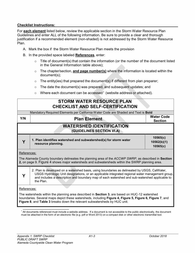
Appendix 1: SWRP Checklist A1-3 October 2018 PUBLIC DRAFT SWRP Alameda Countywide Clean Water Program
Checklist Instructions:
For each element listed below, review the applicable section in the Storm Water Resource Plan Guidelines and enter ALL of the following information. Be sure to provide a clear and thorough justification if a recommended element (non-shaded) is not addressed by the Storm Water Resource Plan.
A. Mark the box if the Storm Water Resource Plan meets the provision
B. In the provided space labeled References, enter:
o Title of document(s) that contain the information (or the number of the document listed in the General Information table above);
o The chapter/section, and page number(s) where the information is located within the document(s);
o The entity(ies) that prepared the document(s) if different from plan preparer; o The date the document(s) was prepared, and subsequent updates; and
o Where each document can be accessed1 (website address or attached).
STORM WATER RESOURCE PLAN CHECKLIST AND SELF-CERTIFICATION
Mandatory Required Elements per California Water Code are Shaded and Text is Bold
Y/N Plan Element Water Code Section
WATERSHED IDENTIFICATION (GUIDELINES SECTION VI.A)
Y 1. Plan identifies watershed and subwatershed(s) for storm water resource planning.
10565(c) 10562(b)(1)
10565(c)
References:
The Alameda County boundary delineates the planning area of the ACCWP SWRP, as described in Section 2, on page 9. Figure 4 shows major watersheds and subwatersheds within the SWRP planning area.
Y 2. Plan is developed on a watershed basis, using boundaries as delineated by USGS, CalWater,
USGS Hydrologic Unit designations, or an applicable integrated regional water management group, and includes a description and boundary map of each watershed and sub-watershed applicable to the Plan.
References:
The watersheds within the planning area described in Section 3. are based on HUC-12 watershed boundaries. Several maps depict these watersheds, including Figure 4, Figure 5, Figure 6, Figure 7, and Figure 8, and Table 3 breaks down the relevant subwatersheds by HUC unit.
1 All documents referenced must include a website address. If a document is not accessible to the public electronically, the document must be attached in the form of an electronic file (e.g. pdf or Word 2013) on a compact disk or other electronic transmittal tool.
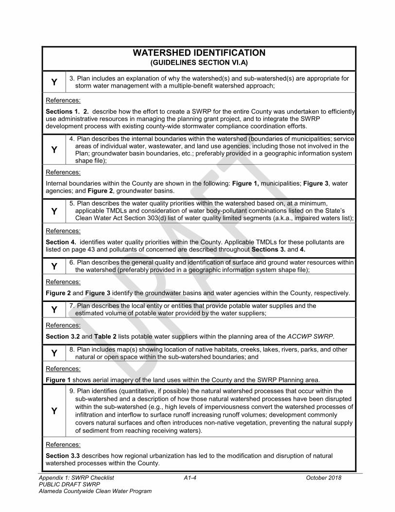
Appendix 1: SWRP Checklist A1-4 October 2018 PUBLIC DRAFT SWRP Alameda Countywide Clean Water Program
WATERSHED IDENTIFICATION (GUIDELINES SECTION VI.A)
Y 3. Plan includes an explanation of why the watershed(s) and sub-watershed(s) are appropriate for storm water management with a multiple-benefit watershed approach;
References:
Sections 1. 2. describe how the effort to create a SWRP for the entire County was undertaken to efficiently use administrative resources in managing the planning grant project, and to integrate the SWRP development process with existing county-wide stormwater compliance coordination efforts.
Y
4. Plan describes the internal boundaries within the watershed (boundaries of municipalities; service areas of individual water, wastewater, and land use agencies, including those not involved in the Plan; groundwater basin boundaries, etc.; preferably provided in a geographic information system shape file);
References:
Internal boundaries within the County are shown in the following: Figure 1, municipalities; Figure 3, water agencies; and Figure 2, groundwater basins.
Y 5. Plan describes the water quality priorities within the watershed based on, at a minimum,
applicable TMDLs and consideration of water body-pollutant combinations listed on the State’s Clean Water Act Section 303(d) list of water quality limited segments (a.k.a., impaired waters list);
References:
Section 4. identifies water quality priorities within the County. Applicable TMDLs for these pollutants are listed on page 43 and pollutants of concerned are described throughout Sections 3. and 4.
Y 6. Plan describes the general quality and identification of surface and ground water resources within
the watershed (preferably provided in a geographic information system shape file);
References:
Figure 2 and Figure 3 identify the groundwater basins and water agencies within the County, respectively.
Y 7. Plan describes the local entity or entities that provide potable water supplies and the
estimated volume of potable water provided by the water suppliers;
References:
Section 3.2 and Table 2 lists potable water suppliers within the planning area of the ACCWP SWRP.
Y 8. Plan includes map(s) showing location of native habitats, creeks, lakes, rivers, parks, and other
natural or open space within the sub-watershed boundaries; and
References:
Figure 1 shows aerial imagery of the land uses within the County and the SWRP Planning area.
Y
9. Plan identifies (quantitative, if possible) the natural watershed processes that occur within the sub-watershed and a description of how those natural watershed processes have been disrupted within the sub-watershed (e.g., high levels of imperviousness convert the watershed processes of infiltration and interflow to surface runoff increasing runoff volumes; development commonly covers natural surfaces and often introduces non-native vegetation, preventing the natural supply of sediment from reaching receiving waters).
References:
Section 3.3 describes how regional urbanization has led to the modification and disruption of natural watershed processes within the County.
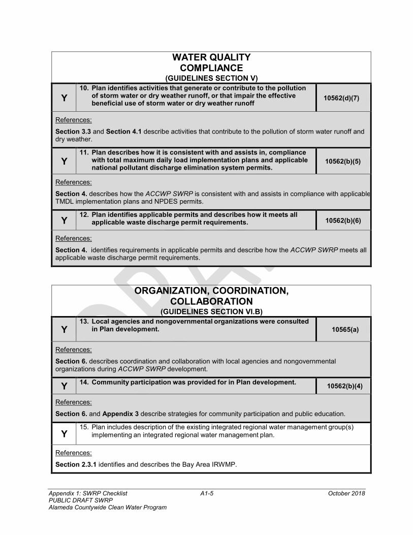
Appendix 1: SWRP Checklist A1-5 October 2018 PUBLIC DRAFT SWRP Alameda Countywide Clean Water Program
WATER QUALITY COMPLIANCE
(GUIDELINES SECTION V)
Y 10. Plan identifies activities that generate or contribute to the pollution
of storm water or dry weather runoff, or that impair the effective beneficial use of storm water or dry weather runoff
10562(d)(7)
References:
Section 3.3 and Section 4.1 describe activities that contribute to the pollution of storm water runoff and dry weather.
Y 11. Plan describes how it is consistent with and assists in, compliance
with total maximum daily load implementation plans and applicable national pollutant discharge elimination system permits.
10562(b)(5)
References:
Section 4. describes how the ACCWP SWRP is consistent with and assists in compliance with applicable TMDL implementation plans and NPDES permits.
Y 12. Plan identifies applicable permits and describes how it meets all
applicable waste discharge permit requirements. 10562(b)(6)
References:
Section 4. identifies requirements in applicable permits and describe how the ACCWP SWRP meets all applicable waste discharge permit requirements.
ORGANIZATION, COORDINATION, COLLABORATION
(GUIDELINES SECTION VI.B)
Y 13. Local agencies and nongovernmental organizations were consulted
in Plan development.
10565(a)
References:
Section 6. describes coordination and collaboration with local agencies and nongovernmental organizations during ACCWP SWRP development.
Y 14. Community participation was provided for in Plan development. 10562(b)(4)
References:
Section 6. and Appendix 3 describe strategies for community participation and public education.
Y 15. Plan includes description of the existing integrated regional water management group(s)
implementing an integrated regional water management plan.
References:
Section 2.3.1 identifies and describes the Bay Area IRWMP.
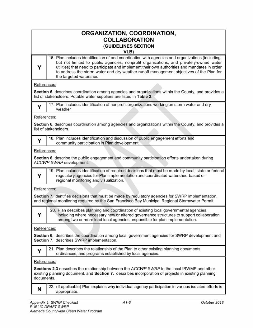
Appendix 1: SWRP Checklist A1-6 October 2018 PUBLIC DRAFT SWRP Alameda Countywide Clean Water Program
ORGANIZATION, COORDINATION, COLLABORATION (GUIDELINES SECTION
VI.B)
Y
16. Plan includes identification of and coordination with agencies and organizations (including, but not limited to public agencies, nonprofit organizations, and privately-owned water utilities) that need to participate and implement their own authorities and mandates in order to address the storm water and dry weather runoff management objectives of the Plan for the targeted watershed.
References:
Section 6. describes coordination among agencies and organizations within the County, and provides a list of stakeholders. Potable water suppliers are listed in Table 2.
Y 17. Plan includes identification of nonprofit organizations working on storm water and dry
weather
References:
Section 6. describes coordination among agencies and organizations within the County, and provides a list of stakeholders.
Y 18. Plan includes identification and discussion of public engagement efforts and
community participation in Plan development.
References:
Section 6. describe the public engagement and community participation efforts undertaken during ACCWP SWRP development.
Y 19. Plan includes identification of required decisions that must be made by local, state or federal
regulatory agencies for Plan implementation and coordinated watershed-based or regional monitoring and visualization.
References:
Section 7. identifies decisions that must be made by regulatory agencies for SWRP implementation, and regional monitoring required by the San Francisco Bay Municipal Regional Stormwater Permit.
Y 20. Plan describes planning and coordination of existing local governmental agencies,
including where necessary new or altered governance structures to support collaboration among two or more lead local agencies responsible for plan implementation.
References:
Section 6. describes the coordination among local government agencies for SWRP development and Section 7. describes SWRP implementation.
Y 21. Plan describes the relationship of the Plan to other existing planning documents,
ordinances, and programs established by local agencies.
References:
Sections 2.3 describes the relationship between the ACCWP SWRP to the local IRWMP and other existing planning document, and Section 7. describes incorporation of projects in existing planning documents.
N 22. (If applicable) Plan explains why individual agency participation in various isolated efforts is appropriate.
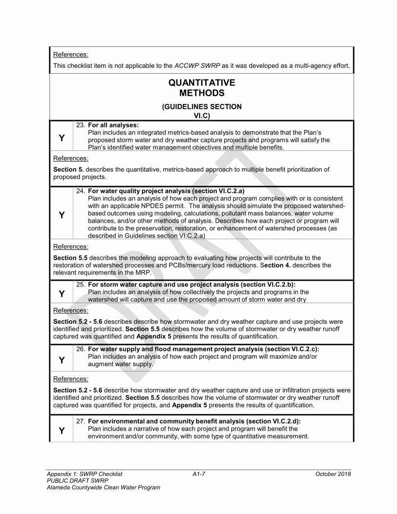
Appendix 1: SWRP Checklist A1-7 October 2018 PUBLIC DRAFT SWRP Alameda Countywide Clean Water Program
References:
This checklist item is not applicable to the ACCWP SWRP as it was developed as a multi-agency effort.
QUANTITATIVE METHODS
(GUIDELINES SECTION VI.C)
Y
23. For all analyses: Plan includes an integrated metrics-based analysis to demonstrate that the Plan’s proposed storm water and dry weather capture projects and programs will satisfy the Plan’s identified water management objectives and multiple benefits.
References:
Section 5. describes the quantitative, metrics-based approach to multiple benefit prioritization of proposed projects.
Y
24. For water quality project analysis (section VI.C.2.a) Plan includes an analysis of how each project and program complies with or is consistent with an applicable NPDES permit. The analysis should simulate the proposed watershed-based outcomes using modeling, calculations, pollutant mass balances, water volume balances, and/or other methods of analysis. Describes how each project or program will contribute to the preservation, restoration, or enhancement of watershed processes (as described in Guidelines section VI.C.2.a)
References:
Section 5.5 describes the modeling approach to evaluating how projects will contribute to the restoration of watershed processes and PCBs/mercury load reductions. Section 4. describes the relevant requirements in the MRP.
Y 25. For storm water capture and use project analysis (section VI.C.2.b):
Plan includes an analysis of how collectively the projects and programs in the watershed will capture and use the proposed amount of storm water and dry
References:
Section 5.2 - 5.6 describes describe how stormwater and dry weather capture and use projects were identified and prioritized. Section 5.5 describes how the volume of stormwater or dry weather runoff captured was quantified and Appendix 5 presents the results of quantification.
Y
26. For water supply and flood management project analysis (section VI.C.2.c): Plan includes an analysis of how each project and program will maximize and/or augment water supply.
References:
Section 5.2 - 5.6 describe how stormwater and dry weather capture and use or infiltration projects were identified and prioritized. Section 5.5 describes how the volume of stormwater or dry weather runoff captured was quantified for projects, and Appendix 5 presents the results of quantification.
Y 27. For environmental and community benefit analysis (section VI.C.2.d):
Plan includes a narrative of how each project and program will benefit the environment and/or community, with some type of quantitative measurement.
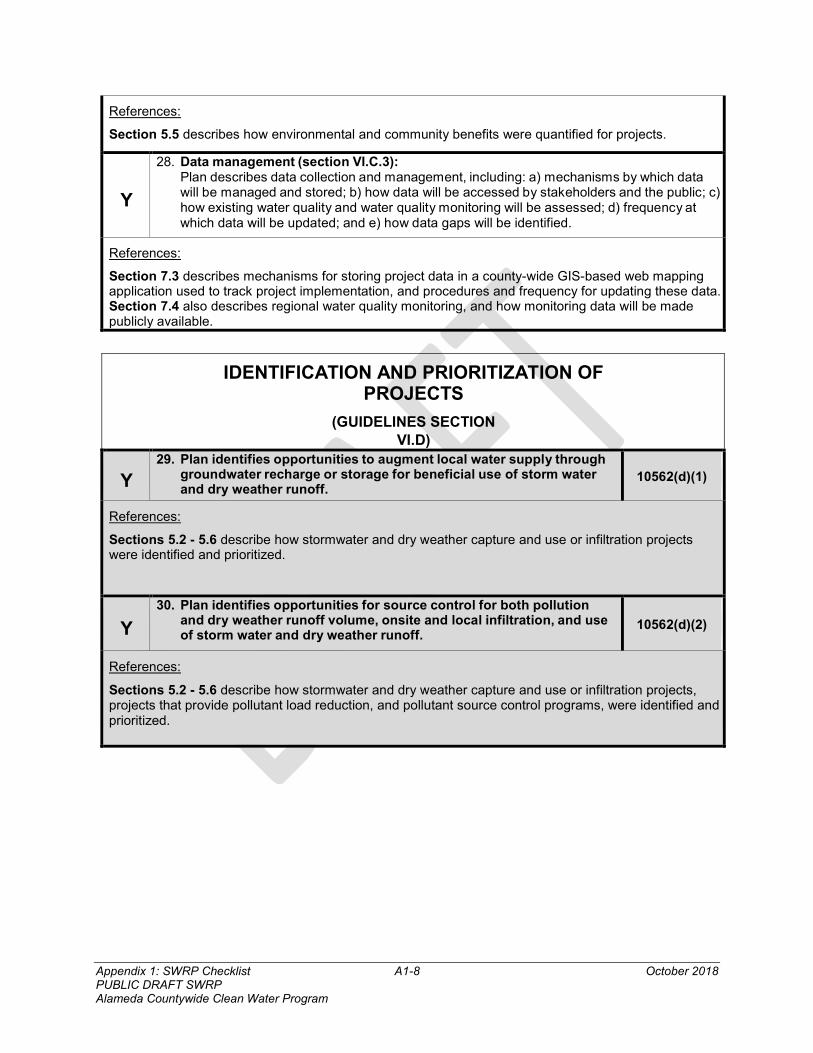
Appendix 1: SWRP Checklist A1-8 October 2018 PUBLIC DRAFT SWRP Alameda Countywide Clean Water Program
References:
Section 5.5 describes how environmental and community benefits were quantified for projects.
Y
28. Data management (section VI.C.3): Plan describes data collection and management, including: a) mechanisms by which data will be managed and stored; b) how data will be accessed by stakeholders and the public; c) how existing water quality and water quality monitoring will be assessed; d) frequency at which data will be updated; and e) how data gaps will be identified.
References:
Section 7.3 describes mechanisms for storing project data in a county-wide GIS-based web mapping application used to track project implementation, and procedures and frequency for updating these data. Section 7.4 also describes regional water quality monitoring, and how monitoring data will be made publicly available.
IDENTIFICATION AND PRIORITIZATION OF PROJECTS
(GUIDELINES SECTION VI.D)
Y 29. Plan identifies opportunities to augment local water supply through
groundwater recharge or storage for beneficial use of storm water and dry weather runoff.
10562(d)(1)
References:
Sections 5.2 - 5.6 describe how stormwater and dry weather capture and use or infiltration projects were identified and prioritized.
Y
30. Plan identifies opportunities for source control for both pollution and dry weather runoff volume, onsite and local infiltration, and use of storm water and dry weather runoff.
10562(d)(2)
References:
Sections 5.2 - 5.6 describe how stormwater and dry weather capture and use or infiltration projects, projects that provide pollutant load reduction, and pollutant source control programs, were identified and prioritized.
Appendix 1: SWRP Checklist A1-9 October 2018 PUBLIC DRAFT SWRP Alameda Countywide Clean Water Program
DECLARATION AND SIGNATURE I declare under penalty of perjury that all information provided is true and correct to the best of my knowledge and belief.
Authorized Signature Title Date
Authorized Signature Title Date
Public Agency
Appendix 2: Project Request A2-1 October 2018 PUBLIC DRAFT SWRP Alameda Countywide Clean Water Program
Appendix 2. Project Request for Alameda Countywide Clean Water Program Stormwater Resource Plan
December 2018 Page 1 of 1
STAKEHOLDER PROJECT REQUEST FOR ALAMEDA COUNTYWIDE STORMWATER RESOURCE PLAN
The Alameda Countywide Clean Water Program is developing the Alameda Countywide Stormwater Resource Plan (SWRP); the SWRP will use a watershed-based planning approach to both compile existing stormwater management project concepts as well as develop new project concepts. Projects included in the SWRP will be eligible for Proposition 1 Stormwater Grant funds as well as other State funding sources. Also, the SWRP will be used to prioritize Green Infrastructure Plan projects. Bottom line: You want to make sure your projects are on the SWRP list!
SWRP projects must have a stormwater management component and must provide two or more benefits from the following benefit categories: water quality, water supply, flood control, environmental, and community. From a landscape perspective, potential additional benefits could include creating and restoring wetlands for riparian habitat, improving in-stream flows, increasing park and recreation lands, increasing urban green space and tree canopy, augmenting recreation opportunities, reducing the heat island effect, and improving air quality. Project examples include: neighborhood or regional-scale green infrastructure, such as sustainable streets projects; flood control facilities; stream or wetland restoration projects; and groundwater recharge or stormwater harvest and use projects. Community benefits can include job creation and public education. For a complete list of the project benefits please consult the SWRP Guidelines1.
Please send information about your planned projects using the accompanying spreadsheet available on the ACCWP Website.
The spreadsheet includes an “Instructions” tab, and a “Database” tab. The “Database” tab should be filled out with your project information. The “Instructions” tab includes a description of each column header in the database. For your project(s) to be included in the SWRP project list, please fill out the cells below the “Required” (i.e., orange) column headers in the “Database” tab. Each project should be included on a separate line in the database. If known, you can also fill out any of the information below the “Optional” (i.e., yellow) column headers. Many columns include drop down lists you can select from when you click on the cell (supported by the “Domains” tab in the spreadsheet).
“Required” information that must be submitted for your project(s) includes: • Project Name • Project Description • Project Jurisdiction/Proponents • Project Scale • Project Location (description, shapefile, APN or lat/long, address, ROW start and end points) • Project Benefit Category(ies) • Facility Type • Drainage Area • Facility Size
To submit your information, Please save a version of the spreadsheet and fill out the “Database” tab for all of the planned or potential projects your group would like to submit, and return to Laura Prickett at [email protected].
Questions about completing the database may also be directed towards Jim Scanlin, the SWRP Project Manager at the Alameda Countywide Clean Water Program ([email protected]), or Austin Orr, who is part of the consultant team working on the project ([email protected]).
We appreciate your attention to this request. Please also note this is part of the initial data collection phase of the SWRP planning process and there will be more opportunities to learn about the process and participate in the future.
1https://www.waterboards.ca.gov/water_issues/programs/grants_loans/swgp/docs/prop1/swrp_finalguidelines_dec2015.pdf
Appendix 3: Outreach Strategy A3-1 October 2018 PUBLIC DRAFT SWRP Alameda Countywide Clean Water Program
Appendix 3. Alameda Countywide Clean Water Program Stormwater Resource Plan Outreach Strategy
ALAMEDA
COUNTYWIDE CLEAN
WATER PROGRAM
STORMWATER
RESOURCE PLAN
OUTREACH STRATEGY July 2018
MEMBER AGENCIES:
Alameda
Albany
Berkeley
Dublin
Emeryville
Fremont
Hayward
Livermore
Newark
Oakland
Piedmont
Pleasanton
San Leandro
Union City
County of Alameda
Alameda County Flood
Control and Water
Conservation District
Zone 7 Water Agency
Appendix 3. Outreach Strategy A3-3 October 2018 PUBLIC DRAFT SWRP Alameda Countywide Clean Water Program
Table of Contents Table of Contents .......................................................................................................................... 3
1. Purpose .................................................................................................................................... 5 2 Outreach Approach .................................................................................................................. 5 3. Key Stakeholder Audiences .................................................................................................... 6
3.1 ACCWP Members ............................................................................................................ 6 3.2 Non-Municipal Public Landowners .................................................................................. 6 3.3 Watershed Groups and Other Non-Governmental Organizations .................................... 7 3.4 Bay Area Integrated Regional Watershed Management Plan........................................... 7 3.5 General Public ................................................................................................................... 7
4. Matrix of recommended Outreach Approaches ...................................................................... 7 4.1 GI Work Group Meeting and Mailing List ....................................................................... 8 4.2 E-mail List and Targeted Email Messages ....................................................................... 8 4.3 General Flyer .................................................................................................................... 8 4.4 ACCWP SWRP Web Page ............................................................................................... 9 4.5 Social Media ..................................................................................................................... 9 BAIRWMP Outreach Coordination ........................................................................................ 9
Attachment A – Non-Municipal Public Landowners ................................................................ 1 Attachment B – Alameda Countywide Clean Water Program Stormwater Resource Plan Outreach Materials ....................................................................................................................... 1
1. Targeted Messages for Non-Municipal Public Landowners .................................................. 1 Schools and School Districts Message ................................................................................... 1 Water Districts and Sanitary Districts Message...................................................................... 1 Park Districts Message ............................................................................................................ 2 Transportation and Transit Districts Message ........................................................................ 2 Miscellaneous Public Landowners Message .......................................................................... 2
2. Targeted Messages for Watershed groups and Other Non-governmental organizations ....... 3 Bay Area Watershed Network (BAWN) Message ................................................................. 3 Alameda County Resource Conservation District Message ................................................... 3
3. Targeted Messages for bay area integrated regional watershed management (BAIRWM) group ........................................................................................................................................... 3 4. Targeted Messages for General Public ................................................................................... 4
Appendix 3. Outreach Strategy A3-4 October 2018 PUBLIC DRAFT SWRP Alameda Countywide Clean Water Program
Clean Water Program Web Page ............................................................................................ 4 Municipal Web Pages ............................................................................................................. 4 Clean Water Program’s Facebook Page ................................................................................. 4 Clean Water Program’s Twitter Feed ..................................................................................... 4
Attachment C – SWRP Flyer ....................................................................................................... 1 Attachment D – ACCWP SWRP Web Page............................................................................... 1
Appendix 3. Outreach Strategy A3-5 October 2018 PUBLIC DRAFT SWRP Alameda Countywide Clean Water Program
1. PURPOSE The Alameda Countywide Clean Water Program (ACCWP) is in the process of developing a Stormwater Resource Plan (SWRP), which is required as a condition for receiving state grant funding for multiple-benefit stormwater management projects.
Water Code Section 10562(b)(4) requires that the SWRP provide for community participation in SWRP development and implementation, and The Storm Water Resource Plan Guidelines (Guidelines)1 states the following regarding public outreach requirements:
“To maximize community-based benefits, key stakeholders and the public should be involved in all appropriate implementation steps of the Storm Water Resource Plan. Public education and opportunities for public participation in actions, decisions, and projects implemented through watershed-based storm water management should be provided.”
The Guidelines checklist includes one required and six recommended outreach elements.
☒ Outreach and Scoping: Community participation is provided for in Plan implementation.
Plan describes strategies to engage disadvantaged and climate vulnerable communities within the Plan boundaries and ongoing tracking of their involvement in the planning process.
Plan describes efforts to identify and address environmental injustice needs and issues within the watershed.
Plan describes mechanisms to engage communities in project design and implementation.
Plan identifies specific audiences including local ratepayers, developers, locally regulated commercial and industrial stakeholders, nonprofit organizations, and the general public.
Plan describes strategies to engage disadvantaged and climate vulnerable communities within the Plan boundaries and ongoing tracking of their involvement in the planning process.
Plan includes a schedule for initial public engagement and education.
This strategy is focused on meeting the required element and the overall intent of the Water Code to engage stakeholders and the public in the SWRP development and implementation processes.
2 OUTREACH APPROACH The recommended outreach strategy for the ACCWP SWRP is to focus on key stakeholders, develop targeted messages for each stakeholder audience, and identify the methods to deliver the message to each stakeholder audience. This approach is intended for the SWRP development 1 State Water Resources Control Board, December 2015. (https://www.waterboards.ca.gov/water_issues/programs/grants_loans/swgp/docs/prop1/swrp_finalguidelines_dec2015.pdf)
Appendix 3. Outreach Strategy A3-6 October 2018 PUBLIC DRAFT SWRP Alameda Countywide Clean Water Program
phase. Implementation of the SWRP will be conducted by the various jurisdictions within Alameda County through the local Green Infrastructure Plans and the design and construction of specific multi-benefit stormwater projects. Section 3 identifies the recommended key stakeholder audiences and their potential interest in the project. Section 4 provides a matrix linking the key stakeholder audiences and recommended method(s) to deliver the message. Targeted messages for each audience will be developed and refined during the outreach campaign.
3. KEY STAKEHOLDER AUDIENCES This section identifies the key stakeholder audiences that will be the focus of outreach efforts, including ACCWP members, public landowners, non-profit organizations, and the public.
3.1 ACCWP Members The primary stakeholders in the development of the SWRP are the ACCWP members who are highly engaged through the related processes of developing Green Infrastructure (GI) Plans and the Reasonable Assurance Analysis. The GI Work Group has assumed the leadership role in developing the SWRP. The GI Work Group meets regularly and will provide direction on the development of the SWRP. The GI Work Group will establish the optimal level of outreach and outreach mechanisms that will effectively engage stakeholders and the public throughout SWRP development.
3.2 Non-Municipal Public Landowners In addition to the ACCWP members that are actively engaged in SWRP development, the Guidelines characterize as “valuable partners” those non-municipal entities that own public lands and easements that could be used for multiple-benefit projects. Examples of such public landowners include school districts, park districts, water agencies, transportation/transit districts, and private utilities. According to the Guidelines, “…water agencies in particular can directly benefit from projects that use stormwater and dry weather runoff as a resource; these beneficiaries have the potential to be important partners and/or serve crucial inter-agency coordination roles.” To identify the non-municipal public landowner stakeholder audience, the ACCWP SWRP project opportunities database was sorted to identify public landowners with parcels that are greater than four acres in size. (This parcel size was selected to allow for focus on the significant landowners.) Attachment 1 provides a listing of the non-municipal public landowners. The lists include: 24 schools and school districts; 6 water and sanitary districts; 4 park districts; and 4 transportation agencies and transit districts.
As noted in the above, the non-municipal public landowners are potential partners for stormwater multi-benefit projects. In the case of Caltrans, partnering on multi-benefit stormwater projects, may help Caltrans fulfill water quality compliance obligations for their stormwater discharge permit and Total Maximum Daily Loads. Other non-municipal public landowners may be Phase II non-traditional stormwater permittees (e.g., public universities) or future permittees (e.g., K-
Appendix 3. Outreach Strategy A3-7 October 2018 PUBLIC DRAFT SWRP Alameda Countywide Clean Water Program
142 school districts), and developing projects or partnerships may assist with their stormwater compliance requirements.
3.3 Watershed Groups and Other Non-Governmental Organizations The Guidelines emphasizes the importance of collaboration with non-governmental organizations (NGOs) during the SWRP development.
Alameda County has numerous organizations engaged in watershed and creek protection and improvement. The Bay Area Watershed Network (BAWN), accessed on April 9, 2018, lists 25 creek and watershed groups operating in Alameda County. These watershed group members are already interested and engaged in watershed, water quality and habitat issues. The BAWN network represents an ideal means of reaching the large number of watershed stakeholders within the ACCWP SWRP planning area.
In addition to creek and watershed organizations, because of the potential multi-benefit use of agricultural lands for groundwater recharge, the Alameda County Resource Conservation District and the Alameda County Farm Bureau represent additional stakeholders for the SWRP outreach effort.
3.4 Bay Area Integrated Regional Watershed Management Plan Although the Integrated Regional Watershed Management Plan (IRWMP) group technically is not considered a stakeholder in the Guidelines, including the Bay Area IRWMP in initial outreach efforts will help to inform this group that the ACCWP is developing a SWRP that ultimately will be submitted to the IRWM so that the SWRP projects can be included in the Bay Area IRWMP. Representatives to the Bay Area IRWMP include many of the stakeholder audiences for the SWRP including water supply, water quality, wastewater, stormwater, flood management, watershed and habitat agencies, local governments, environmental groups, business groups, community-based organizations, and disadvantaged communities.
3.5 General Public The SWRP Guidelines require that opportunities be provided for community participation in SWRP development and implementation. While this can be largely achieved through the above identified stakeholder audiences, some of the outreach focus will be general to provide opportunities for interested individuals who do not identify with specific groups to participate. Community members may have an interest in project design and implementation that enhance community benefits.
4. MATRIX OF RECOMMENDED OUTREACH APPROACHES The recommended strategy for efficient, cost-effective outreach is to capitalize on outreach methods that disseminate information to each stakeholder audience relying on cost effective methods already in use by the Clean Water Program. Table 1 provides a matrix relating each of the stakeholder audiences to the recommended outreach method. A conceptual approach for each of the methods is described following Table 1.
2 K-14 includes kindergarten through 12th grade and community colleges.
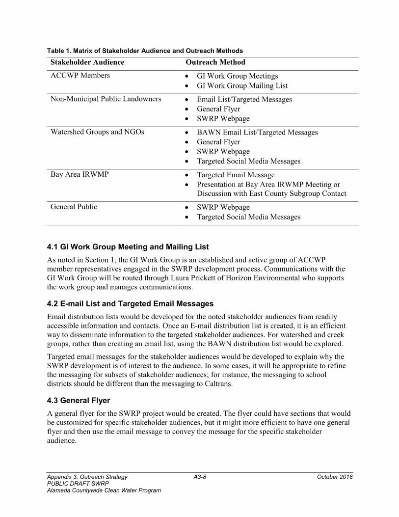
Appendix 3. Outreach Strategy A3-8 October 2018 PUBLIC DRAFT SWRP Alameda Countywide Clean Water Program
Table 1. Matrix of Stakeholder Audience and Outreach Methods
Stakeholder Audience Outreach Method
ACCWP Members • GI Work Group Meetings • GI Work Group Mailing List
Non-Municipal Public Landowners • Email List/Targeted Messages • General Flyer • SWRP Webpage
Watershed Groups and NGOs • BAWN Email List/Targeted Messages • General Flyer • SWRP Webpage • Targeted Social Media Messages
Bay Area IRWMP • Targeted Email Message • Presentation at Bay Area IRWMP Meeting or
Discussion with East County Subgroup Contact
General Public • SWRP Webpage • Targeted Social Media Messages
4.1 GI Work Group Meeting and Mailing List As noted in Section 1, the GI Work Group is an established and active group of ACCWP member representatives engaged in the SWRP development process. Communications with the GI Work Group will be routed through Laura Prickett of Horizon Environmental who supports the work group and manages communications.
4.2 E-mail List and Targeted Email Messages Email distribution lists would be developed for the noted stakeholder audiences from readily accessible information and contacts. Once an E-mail distribution list is created, it is an efficient way to disseminate information to the targeted stakeholder audiences. For watershed and creek groups, rather than creating an email list, using the BAWN distribution list would be explored.
Targeted email messages for the stakeholder audiences would be developed to explain why the SWRP development is of interest to the audience. In some cases, it will be appropriate to refine the messaging for subsets of stakeholder audiences; for instance, the messaging to school districts should be different than the messaging to Caltrans.
4.3 General Flyer A general flyer for the SWRP project would be created. The flyer could have sections that would be customized for specific stakeholder audiences, but it might more efficient to have one general flyer and then use the email message to convey the message for the specific stakeholder audience.
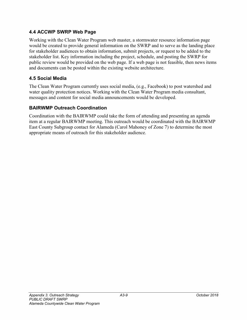
Appendix 3. Outreach Strategy A3-9 October 2018 PUBLIC DRAFT SWRP Alameda Countywide Clean Water Program
4.4 ACCWP SWRP Web Page Working with the Clean Water Program web master, a stormwater resource information page would be created to provide general information on the SWRP and to serve as the landing place for stakeholder audiences to obtain information, submit projects, or request to be added to the stakeholder list. Key information including the project, schedule, and posting the SWRP for public review would be provided on the web page. If a web page is not feasible, then news items and documents can be posted within the existing website architecture.
4.5 Social Media The Clean Water Program currently uses social media, (e.g., Facebook) to post watershed and water quality protection notices. Working with the Clean Water Program media consultant, messages and content for social media announcements would be developed.
BAIRWMP Outreach Coordination Coordination with the BAIRWMP could take the form of attending and presenting an agenda item at a regular BAIRWMP meeting. This outreach would be coordinated with the BAIRWMP East County Subgroup contact for Alameda (Carol Mahoney of Zone 7) to determine the most appropriate means of outreach for this stakeholder audience.
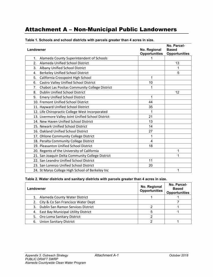
Appendix 3. Outreach Strategy Attachment A-1 October 2018 PUBLIC DRAFT SWRP Alameda Countywide Clean Water Program
Attachment A – Non-Municipal Public Landowners
Table 1. Schools and school districts with parcels greater than 4 acres in size.
Landowner No. Regional Opportunities
No. Parcel-Based Opportunities
1. Alameda County Superintendent of Schools 1 2. Alameda Unified School District 13 3. Albany Unified School District 1 4. Berkeley Unified School District 5 5. California Crosspoint High School 1 6. Castro Valley Unified School District 10 7. Chabot Las Positas Community College District 1 8. Dublin Unified School District 12 9. Emery Unified School District 1 10. Fremont Unified School District 44 11. Hayward Unified School District 35 12. Life Chiropractic College West Incorporated 1 13. Livermore Valley Joint Unified School District 21 14. New Haven Unified School District 13 15. Newark Unified School District 14 16. Oakland Unified School District 27 17. Ohlone Community College District 1 18. Peralta Community College District 4 19. Pleasanton Unified School District 18 20. Regents of the University of California 1 21. San Joaquin Delta Community College District 1 22. San Leandro Unified School District 11 23. San Lorenzo Unified School District 20 24. St Marys College High School of Berkeley Inc 1
Table 2. Water districts and sanitary districts with parcels greater than 4 acres in size.
Landowner No. Regional Opportunities
No. Parcel-Based
Opportunities 1. Alameda County Water District 1 1 2. City & Co San Francisco Water Dept 7 3. Dublin San Ramon Services District 2 1 4. East Bay Municipal Utility District 5 1 5. Oro Loma Sanitary District 2 6. Union Sanitary District 2 1
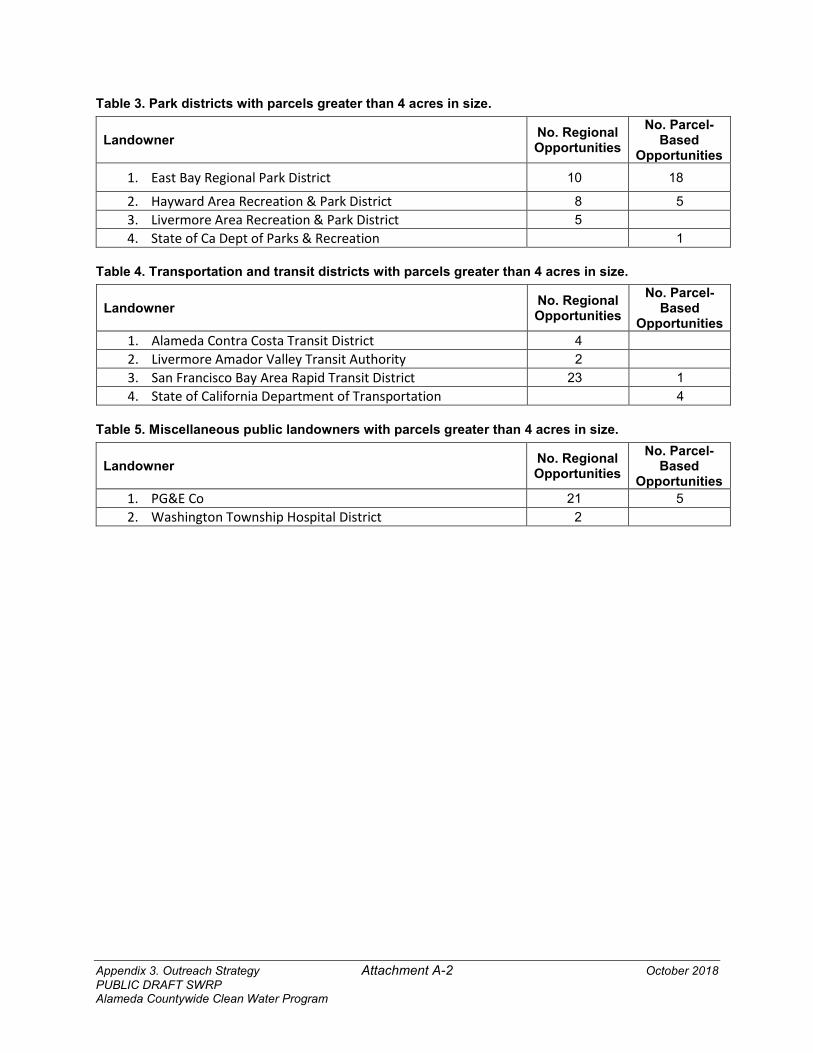
Appendix 3. Outreach Strategy Attachment A-2 October 2018 PUBLIC DRAFT SWRP Alameda Countywide Clean Water Program
Table 3. Park districts with parcels greater than 4 acres in size.
Landowner No. Regional Opportunities
No. Parcel-Based
Opportunities
1. East Bay Regional Park District 10 18
2. Hayward Area Recreation & Park District 8 5 3. Livermore Area Recreation & Park District 5 4. State of Ca Dept of Parks & Recreation 1
Table 4. Transportation and transit districts with parcels greater than 4 acres in size.
Landowner No. Regional Opportunities
No. Parcel-Based
Opportunities 1. Alameda Contra Costa Transit District 4 2. Livermore Amador Valley Transit Authority 2 3. San Francisco Bay Area Rapid Transit District 23 1 4. State of California Department of Transportation 4
Table 5. Miscellaneous public landowners with parcels greater than 4 acres in size.
Landowner No. Regional Opportunities
No. Parcel-Based
Opportunities 1. PG&E Co 21 5 2. Washington Township Hospital District 2
Appendix 3. Outreach Strategy Attachment B-1 October 2018 PUBLIC DRAFT SWRP Alameda Countywide Clean Water Program
Attachment B – Alameda Countywide Clean Water Program Stormwater Resource Plan Outreach Materials Outreach materials developed for the Alameda Countywide Clean Water Program (Clean Water Program) Stormwater Resource Plan (SWRP) stakeholder groups consist of a general flyer and targeted messaging to specific audiences designed to be distributed through E-mail distribution lists and posts to the Clean Water Program’s web pages and social media accounts. Audience- and media-specific messaging and the method of distribution are provided in the sections below. The general flyer and messages posted to the Clean Water Program’s web page and social media accounts are made available for all stakeholder groups, including the general public. The general flyer is attached.
1. TARGETED MESSAGES FOR NON-MUNICIPAL PUBLIC LANDOWNERS The primary/most efficient outreach method for the stakeholder groups identified in this section is the use of an E-mail distribution list, consisting of E-mail addresses for facilities managers and environmental compliance personnel. The E-mail message targeting each stakeholder group is provided below.
Schools and School Districts Message “Public school districts and community college districts may have stormwater discharge requirements in the upcoming statewide stormwater permit for non-traditional Small Municipal Separate Storm Sewer Systems (MS4) (link: Phase II MS4 website). The stormwater permit is intended to reduce pollutants in stormwater runoff, such as trash, fertilizer, and automotive fluids. Property owned by your school/district may be eligible for grant-funded stormwater and dry weather runoff capture projects, which may provide opportunities to partner with your local municipality and assist your school/district with meeting the stormwater permit requirements. Projects that are ultimately selected for implementation may also provide benefits to the surrounding community, such as enhancement and/or creation of recreational and public use areas and increased green space and connectivity. The Alameda Countywide Clean Water Program has developed a Draft Stormwater Resource Plan (SWRP), which is required as a condition of receiving grant funding for such projects. The Draft SWRP will be posted on the Clean Water Program’s website in October 2018 for 30 days for public review and comment. We welcome your feedback. Please visit www.cleanwaterprogram.org to learn more about the SWRP and how to provide comments.”
Water Districts and Sanitary Districts Message “The Alameda Countywide Clean Water Program is pleased to announce the development of a Draft Stormwater Resource Plan (SWRP). The SWRP is required as a condition of receiving grant funding for stormwater and dry weather runoff capture projects. Property owned by your agency or district may be eligible for grant-funded stormwater and dry weather runoff capture projects that are designed to reduce stormwater pollution, recharge groundwater, provide additional benefits to the community, and that may assist you with stormwater permit compliance. Your agency/district may benefit from SWRP projects that augment the water
Appendix 3. Outreach Strategy Attachment B-2 October 2018 PUBLIC DRAFT SWRP Alameda Countywide Clean Water Program
supply through groundwater infiltration and the use of stormwater in place of the potable water supply.
Once finalized, the SWRP will be submitted to the Bay Area Integrated Regional Watershed Management (IRWM) group so that the SWRP projects can be included in the IRWM Plan.
The Draft SWRP will be posted on the Clean Water Program’s website in October 2018 for 30 days for public review and comment. We welcome your feedback. Please visit www.cleanwaterprogram.org to learn more about the SWRP and how to provide comments.”
Park Districts Message “The Alameda Countywide Clean Water Program is pleased to announce development of a Draft Stormwater Resource Plan (SWRP). The SWRP is required as a condition of receiving grant funding for stormwater and dry weather runoff capture projects. The SWRP is intended to be a resource for park districts and other interested parties that may want to obtain grant funding for local projects in the future.
Property owned by your district may be eligible for grant-funded stormwater and dry weather runoff capture projects that are designed to reduce stormwater pollution, recharge groundwater and provide additional community benefits, such as watershed improvement projects, enhancement and/or creation of recreational and public use areas, and increased green space and connectivity. Projects that are ultimately selected for implementation, if sited on park district property, may provide opportunities for your district to partner with your local municipality.
The Draft SWRP will be posted on the Clean Water Program’s website in October 2018 for 30 days for public review and comment. We welcome your feedback. Please visit www.cleanwaterprogram.org to learn more about the SWRP and how to provide comments.”
Transportation and Transit Districts Message “The Alameda Countywide Clean Water Program has developed a Draft Stormwater Resource Plan (SWRP). The SWRP is required as a condition of receiving grant funding for stormwater and dry weather runoff capture projects. Such projects are designed to reduce stormwater pollution, recharge groundwater and provide additional community benefits.
SWRP projects that are ultimately selected for implementation may provide opportunities for the district to partner with the local municipality and assist the district with stormwater permit compliance, including requirements related to Total Maximum Daily Loads.
The Draft SWRP will be posted on the Clean Water Program’s website in October 2018 for 30 days for public review and comment. We welcome your feedback. Please visit www.cleanwaterprogram.org to learn more about the SWRP and how to provide comments.”
Miscellaneous Public Landowners Message “The Alameda Countywide Clean Water Program is pleased to announce the development of a Draft Stormwater Resource Plan (SWRP). The SWRP is required as a condition of receiving grant funding for stormwater and dry weather runoff capture projects. Such projects are designed to reduce stormwater pollution, recharge groundwater and provide additional community benefits.
Appendix 3. Outreach Strategy Attachment B-3 October 2018 PUBLIC DRAFT SWRP Alameda Countywide Clean Water Program
Property owned by your organization may be eligible for grant-funded stormwater and dry weather runoff capture projects. SWRP projects that are ultimately selected for implementation may also create opportunities for the utility to partner with the local municipality and assist the utility with stormwater permit compliance.
The Draft SWRP will be posted on the Clean Water Program’s website in October 2018 for 30 days for public review and comment. We welcome your feedback. Please visit www.cleanwaterprogram.org to learn more about the SWRP and how to provide comments.”
2. TARGETED MESSAGES FOR WATERSHED GROUPS AND OTHER NON-GOVERNMENTAL ORGANIZATIONS The primary outreach method used for the stakeholder groups listed in this section is the use of E-mail. Specific E-mail messages for distribution to the primary contacts at the Bay Area Watershed Network (for subsequent distribution to the 25 creek and watershed groups operating in Alameda County) and the Alameda County Resource Conservation District (for subsequent distribution to Alameda County growers) are provided below.
Bay Area Watershed Network (BAWN) Message “The Alameda Countywide Clean Water Program is pleased to announce that it has developed a Draft Stormwater Resource Plan (SWRP). The SWRP is required as a condition of receiving grant funding for stormwater and dry weather runoff capture projects. The SWRP requirement is intended to encourage the use of stormwater and dry weather runoff as a resource to improve water quality, reduce localized flooding, and increase water supplies for beneficial uses and the environment. As such, the SWRP is intended to be a resource for watershed groups and other interested parties that may want to obtain grant funding for local projects in the future.
Priority SWRP projects that are ultimately selected for implementation may be sited in your favorite watershed(s) to reduce stormwater pollution, use stormwater as a valuable resource, enhance habitat, and provide additional watershed and community benefits.
The SWRP will be posted on the Clean Water Program’s website in October 2018 for a 30-day public review and comment period. Please visit www.cleanwaterprogram.org to learn more about the SWRP and how to provide comments.”
Alameda County Resource Conservation District Message “The Alameda Countywide Clean Water Program is pleased to announce that it has developed a Draft Stormwater Resource Plan (SWRP). The SWRP is required as a condition of receiving grant funding for stormwater and dry weather runoff capture projects. Farmers in your jurisdiction may benefit from SWRP projects that use stormwater for crop irrigation or groundwater recharge and that may create opportunities to partner with the local municipality.
The Draft SWRP will be posted on the Clean Water Program’s website in October 2018 for 30 days for public review and comment. We welcome your feedback. Please visit the www.cleanwaterprogram.org to learn more about the SWRP and how to provide comments.”
3. TARGETED MESSAGES FOR BAY AREA INTEGRATED REGIONAL WATERSHED MANAGEMENT (BAIRWM) GROUP An E-mail containing the following message will be sent to the BAIRWM Group representative:
Appendix 3. Outreach Strategy Attachment B-4 October 2018 PUBLIC DRAFT SWRP Alameda Countywide Clean Water Program
“The Alameda Countywide Clean Water Program would like to notify you that its Draft Stormwater Resource Plan (SWRP) will be posted on the Clean Water Program’s website on in October 2018 for a 30-day public review and comment period. Once finalized, the SWRP will be submitted to the IRWM group for inclusion in the IRWM Plan, as required by law. Please visit www.cleanwaterprogram.org for more information on the SWRP and how to submit comments.”
4. TARGETED MESSAGES FOR GENERAL PUBLIC Outreach methods used to inform the general public include information and messages posted on the Clean Water Program’s web page and social media accounts. The SWRP team plans to work with the Clean Water Program’s media consultant to refine and distribute the social media messaging.
Clean Water Program Web Page The general flyer can be posted on this web page. Specific content for the web page will be developed based on the SWRP Executive Summary.
Municipal Web Pages Each municipality can post the general flyer.
Clean Water Program’s Facebook Page The general flyer and/or other notices will be posted to the Facebook account.
Clean Water Program’s Twitter Feed Messages that meet the 280-character per-tweet limit will be posted to the Twitter account. An example 2-part tweet is provided below.
“The Alameda Countywide Clean Water Program posted its Draft Stormwater Resource Plan (SWRP) today. The SWRP is required for receiving grant funding for stormwater and dry weather runoff capture projects. Visit www.cleanwaterprograms.org for more information.” “SWRP projects green our neighborhoods - improving community and watershed health by providing improved pedestrian and bike safety, improved water quality, reduced flooding, and healthier watersheds. The SWRP is a resource for project sponsor to qualify for grant funding.”
Appendix 3. Outreach Strategy Attachment C-1 October 2018 PUBLIC DRAFT SWRP Alameda Countywide Clean Water Program
Attachment C – SWRP Flyer
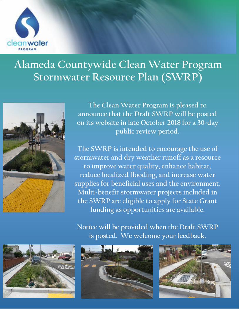
Alameda Countywide Clean Water Program Stormwater Resource Plan (SWRP)
The Clean Water Program is pleased to
announce that the Draft SWRP will be posted on its website in late October 2018 for a 30-day
public review period.
The SWRP is intended to encourage the use of stormwater and dry weather runoff as a resource
to improve water quality, enhance habitat, reduce localized flooding, and increase water
supplies for beneficial uses and the environment. Multi-benefit stormwater projects included in the SWRP are eligible to apply for State Grant
funding as opportunities are available.
Notice will be provided when the Draft SWRP is posted. We welcome your feedback.
Appendix 3. Outreach Strategy Attachment D-1 October 2018 PUBLIC DRAFT SWRP Alameda Countywide Clean Water Program
Attachment D – ACCWP SWRP Web Page
[NOTE TO THE REVIEWER: ATTACHMENT D IS NOT INCLUDED IN THIS DRAFT AND WILL BE INCLUDED IN THE FINAL ACCWP SWRP]
Appendix 4: Public Comments A4-1 October 2018 PUBLIC DRAFT SWRP Alameda Countywide Clean Water Program
Appendix 4. Public Comment and Response Matrix
>127(�72�7+(�5(9,(:(5�$33(1',;���,6�127�,1&/8'('�,1�7+,6�'5$)7�$1'�:,//�%(�,1&/8'('�,1�7+(�),1$/�$&&:3�6:53@