Embed Size (px)
Citation preview
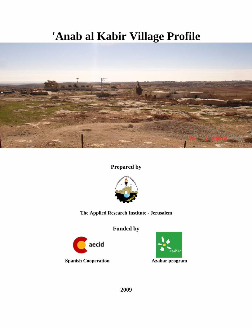
'Anab al Kabir Village Profile
Prepared by
The Applied Research Institute - Jerusalem
Funded by
Spanish Cooperation Azahar program
2009
Palestinian Localities Study Hebron Governorate
1
Acknowledgments ARIJ hereby expresses its deep gratitude to the Spanish Agency for International Cooperation for Development (AECID) for their funding of this project through the Azahar Program. ARIJ is grateful to the Palestinian officials in the ministries, municipalities, joint services councils, village committees and councils, and the Palestinian Central Bureau of Statistics (PCBS) for their assistance and cooperation with the project team members during the data collection process. ARIJ also thanks all the staff who worked throughout the past couple of years towards the accomplishment of this work.
Palestinian Localities Study Hebron Governorate
2
Background
This booklet is part of a series of booklets, which contain compiled information about each city, town, and village in Hebron Governorate. These booklets come as a result of a comprehensive study of all localities in Hebron Governorate, which aims at depicting the overall living conditions in the governorate and presenting developmental plans to assist in developing the livelihood of the population in the area. It was accomplished through the 'Village Profiles and Azahar Needs Assessment'; a project funded by the Spanish Agency for International Cooperation for Development (AECID) and the Azahar Program. The 'Village Profiles and Azahar Needs Assessment' was designed to study, investigate, analyze and document the socio-economic conditions and the needed programs and activities to mitigate the impact of the current unsecure political, economic and social conditions in Hebron Governorate with particular focus on the Azahar program objectives and activities concerning water, environment, and agriculture. The project's objectives are to survey, analyze and document the available natural, human, socioeconomic and environmental resources, and the existing limitations and needs assessment for the development of the rural and marginalized areas in Hebron Governorate. In addition, the project aims at preparing strategic developmental programs and activities to mitigate the impact of the current political, social, and economic instability with the focus on the agricultural sector. All locality profiles in Arabic and English are available online at http://proxy.arij.org/vprofile/
Palestinian Localities Study Hebron Governorate
3
Table of Contents
Location and Physical Characteristics _____________________________________________4
History_______________________________________________________________________5
Religious and Archaeological Sites ________________________________________________5
Demography and Population _____________________________________________________6
Education ____________________________________________________________________7
Health Status _________________________________________________________________7
Economic Activities ____________________________________________________________7
Agricultural Sector_____________________________________________________________9
Institutions and Services _______________________________________________________10
Infrastructure and Natural Resources ____________________________________________10
Impact of the Israeli Occupation _________________________________________________10
Development Plans and Projects _________________________________________________11
Locality Development Priorities and Needs ________________________________________11
References: __________________________________________________________________12
Palestinian Localities Study Hebron Governorate
4
'Anab al Kabir Village Profile
Location and Physical Characteristics
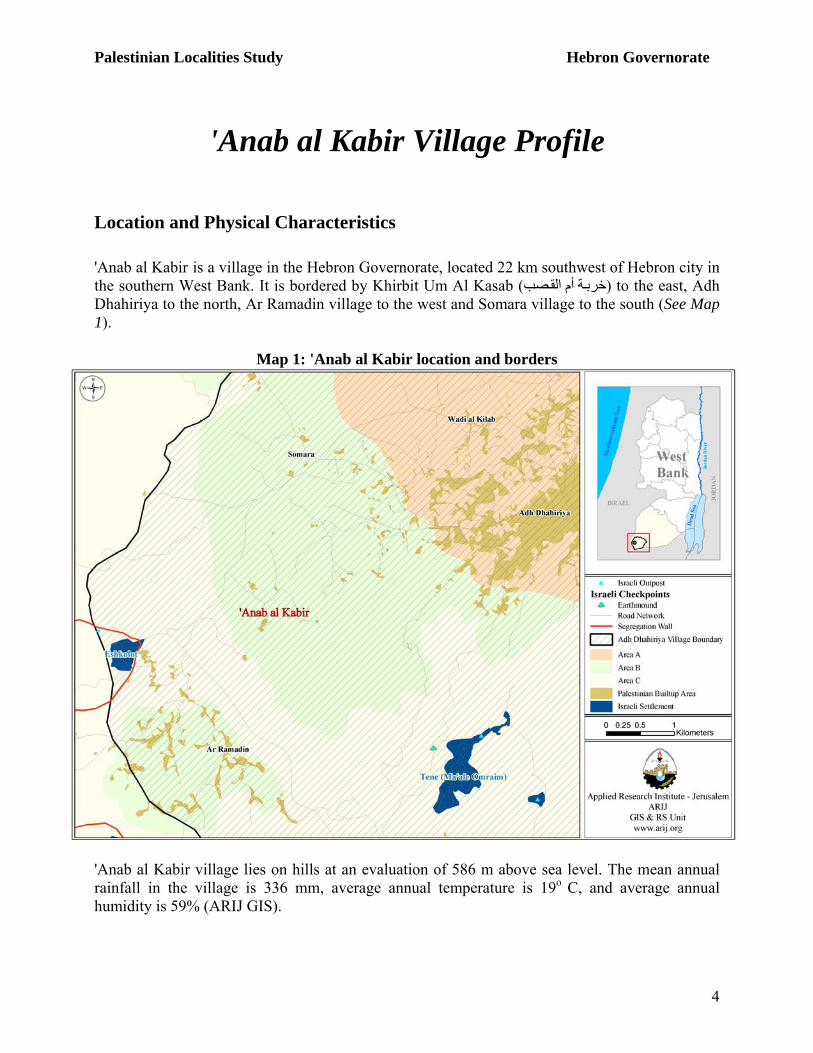
'Anab al Kabir is a village in the Hebron Governorate, located 22 km southwest of Hebron city in the southern West Bank. It is bordered by Khirbit Um Al Kasab ( ة أم القصب to the east, Adh (خربDhahiriya to the north, Ar Ramadin village to the west and Somara village to the south (See Map 1).
Map 1: 'Anab al Kabir location and borders
'Anab al Kabir village lies on hills at an evaluation of 586 m above sea level. The mean annual rainfall in the village is 336 mm, average annual temperature is 19o C, and average annual humidity is 59% (ARIJ GIS).
Palestinian Localities Study Hebron Governorate
5
'Anab al Kabir village is governed by a Project Committee, established in 2002, which currently consists of three members operating from its formal headquarters. The Committee provides services to the households in the village such as:
o Social and human services o Administration and planning for village projects
History 'Anab al Kabir village history dates back to about 600 years before the Byzantine era. There are two narratives about the name of 'Anab al Kabir. The first suggests the town is named for an old Greek Church in the village called 'Anab al Kabir Church, which was originally written in Latin. The second suggests the name is derived from grapes (in Arabic 'Enab عنب), because the village is known for, grapes and there is an old grape press in the village; over the years, the name was converted to "'Anab al Kabir." (addabag, 1991) Residents of 'Anab al Kabir were originally from Adh Dhahiriya and Ar Ramadin villages. The 'Anab al Kabir area also includes the small localities of Khirbit Aseeleh ( ة عسيلة AlKasher ,(خرب .(واد أبو خروبة) and Wad Abu Kharuba (جريدة) Jarideh ,(اقطيط) Iqteiet ,(الكاشر)
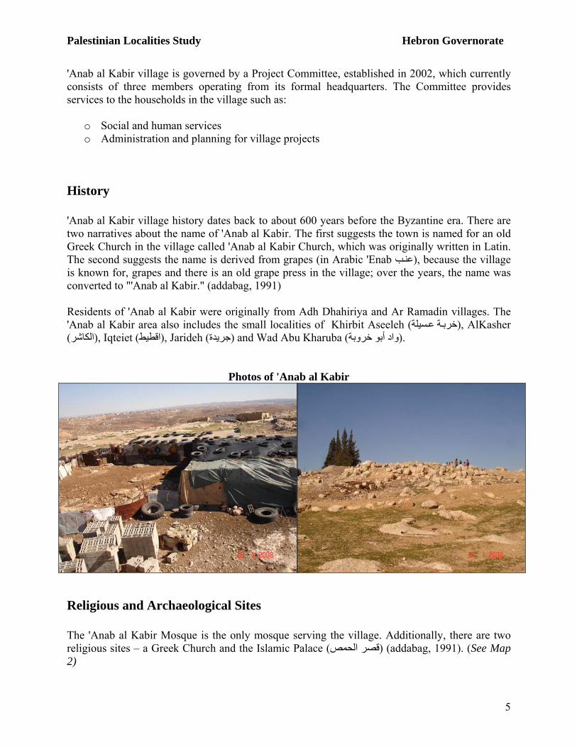
Photos of 'Anab al Kabir
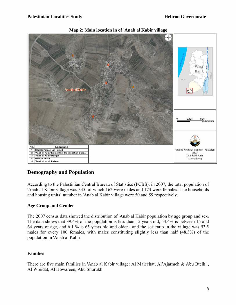
Religious and Archaeological Sites The 'Anab al Kabir Mosque is the only mosque serving the village. Additionally, there are two religious sites – a Greek Church and the Islamic Palace (قصر الحمص) (addabag, 1991). (See Map 2)
Palestinian Localities Study Hebron Governorate
6
Map 2: Main location in of 'Anab al Kabir village
Demography and Population According to the Palestinian Central Bureau of Statistics (PCBS), in 2007, the total population of 'Anab al Kabir village was 335, of which 162 were males and 173 were females. The households and housing units’ number in 'Anab al Kabir village were 50 and 59 respectively. Age Group and Gender The 2007 census data showed the distribution of 'Anab al Kabir population by age group and sex. The data shows that 39.4% of the population is less than 15 years old, 54.4% is between 15 and 64 years of age, and 6.1 % is 65 years old and older , and the sex ratio in the village was 93.5 males for every 100 females, with males constituting slightly less than half (48.3%) of the population in 'Anab al Kabir Families There are five main families in 'Anab al Kabir village: Al Maleehat, Al’Ajarmeh & Abu Bteih , Al Wreidat, Aِl Howareen, Abu Shurukh.
Palestinian Localities Study Hebron Governorate
7
Education According to the 2007 PCBS, Population, Housing and Establishment Census final results, 46 persons (10 years and over) were illiterate. Of these, 70% were females. Of the literate population, 15% of the population could read and write but received no schooling, 30% had completed elementary education, 21% had completed preparatory education, 9% had completed secondary education and 5.3% had completed higher education (See Table 1).
Table 1: 'Anab al Kabir population (10 years and over) by sex and educational attainment Sex
Illiterate Can read & write Elementary Preparatory Secondary Associate
Diploma Bachelor Higher Diploma Master PhD Total
M 14 20 44 21 11 3 3 - - - 116 F 32 15 26 28 10 - 6 - - - 117 T 46 35 70 49 21 3 9 - - - 233
Source: PCBS, May 2009. Population, Housing and Establishment Census-2007, Final Results According to the field survey data, “'Anab al Kabir Elementary Co-education School”, which is supervised by the governmental sector, is the one elementary school in the village. . Due to the shortage of secondary classes in the village, students in 'Anab al Kabir village travel five km to reach Adh Dhahiriya village or two and a half km to reach Ar Ramadin village to complete their secondary education. The educational sector in the village suffers from the following problems:
• Lack of a secondary school • Overcrowded classes
Health Status 'Anab al Kabir village lacks health services, and no health centers, physician clinics or pharmacies exist in the village. In the event of an emergency, residents of 'Anab al Kabir travel to Adh Dhahiriya hospitals and health centers, located five km from the village. The project committee officials cite that the main obstacles facing the health sector in the village are:
o Lack of health clinics in the village o Lack of resident doctors, though there are a few doctors from UNRWA and PMRS ( اإلغاثة
.who visit the village (الطبية
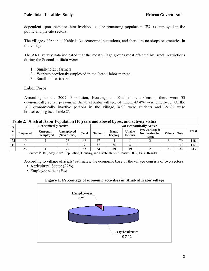
Economic Activities According to data from the field survey conducted in the Hebron localities by ARIJ in 2006, approximately 97% of 'Anab al Kabir village residents are engaged in agricultural activities and
Palestinian Localities Study Hebron Governorate
8
dependent upon them for their livelihoods. The remaining population, 3%, is employed in the public and private sectors. The village of 'Anab al Kabir lacks economic institutions, and there are no shops or groceries in the village. The ARIJ survey data indicated that the most village groups most affected by Israeli restrictions during the Second Intifada were:
1. Small-holder farmers 2. Workers previously employed in the Israeli labor market 3. Small-holder traders
Labor Force According to the 2007, Population, Housing and Establishment Census, there were 53 economically active persons in 'Anab al Kabir village, of whom 43.4% were employed. Of the 180 economically inactive persons in the village, 47% were students and 38.3% were housekeeping (see Table 2).
Table 2: 'Anab al Kabir Population (10 years and above) by sex and activity status Economically Active Not Economically Active S
ex Employed Currently
Unemployed Unemployed (Never work) Total Student House
keeping Unable to work
Not working & Not looking for
Work Others Total
Total
M 19 1 26 46 47 4 11 2 6 70 116 F 4 - 3 7 37 65 8 - - 110 117 T 23 1 29 53 84 69 19 2 6 180 233
Source: PCBS, May 2009. Population, Housing and Establishment Census-2007, Final Results According to village officials’ estimates, the economic base of the village consists of two sectors:
Agricultural Sector (97%) Employee sector (3%)
Figure 1: Percentage of economic activities in 'Anab al Kabir village
Agriculture97%
Employee3%
Palestinian Localities Study Hebron Governorate
9
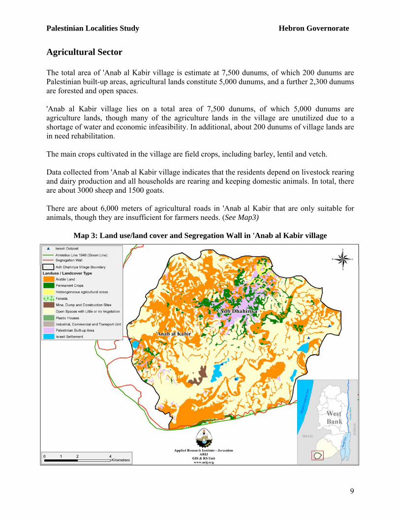
Agricultural Sector The total area of 'Anab al Kabir village is estimate at 7,500 dunums, of which 200 dunums are Palestinian built-up areas, agricultural lands constitute 5,000 dunums, and a further 2,300 dunums are forested and open spaces. 'Anab al Kabir village lies on a total area of 7,500 dunums, of which 5,000 dunums are agriculture lands, though many of the agriculture lands in the village are unutilized due to a shortage of water and economic infeasibility. In additional, about 200 dunums of village lands are in need rehabilitation. The main crops cultivated in the village are field crops, including barley, lentil and vetch. Data collected from 'Anab al Kabir village indicates that the residents depend on livestock rearing and dairy production and all households are rearing and keeping domestic animals. In total, there are about 3000 sheep and 1500 goats. There are about 6,000 meters of agricultural roads in 'Anab al Kabir that are only suitable for animals, though they are insufficient for farmers needs. (See Map3)
Map 3: Land use/land cover and Segregation Wall in 'Anab al Kabir village
Palestinian Localities Study Hebron Governorate
10
Institutions and Services The main institute in the village is the Project Committee, which was founded in 2002.
Infrastructure and Natural Resources
Telecommunication Services: 'Anab al Kabir is connected to telecommunication network and approximately 20% of the households are currently connected. Water Services: 'Anab al Kabir is not connected to water network. The alternative resources of water in the village are the cisterns and water tankers. Village officials cite the lack of water and water pollution as the main problems facing water services in the village. Electricity Services: 'Anab al Kabir village is not connected to an electricity network, and also suffers due to a lack of generators. Sewage Disposal Facilities: As the village is not connected to the sewage disposal network, wastewater is disposed of in cesspits. Solid Waste Collection Services: There is no solid waste management system in the village, and residents dispose of solid wastes by burning. Transportation Facilities: The village is served by informal transportation vehicles, and in the case of a shortage or absence of these informal vehicles, residents walk or request a private taxi. The primary obstacles to transportation in the village are the lack of vehicles and automotive services. In terms of road quality, 3 km of main roads are paved and in good condition and 13 km are unpaved (4 km are main roads, 3 km are internal roads and 6 km are agricultural roads).
Impact of the Israeli Occupation Two Israeli settlements surround 'Anab al Kabir village, Eshkolot settlement and Tene (Maale Omarim) settlement. The village is also subjected to one flying checkpoint. The Segregation Wall surrounds the village from two sides, the west and south. The construction of the Wall in the village, which is constructed from wire and concrete, began in 2006 and lies on 100 dunums of confiscated village land. Since the beginning of second Intifada, one house has been destroyed by Israeli Forces.
Palestinian Localities Study Hebron Governorate
11
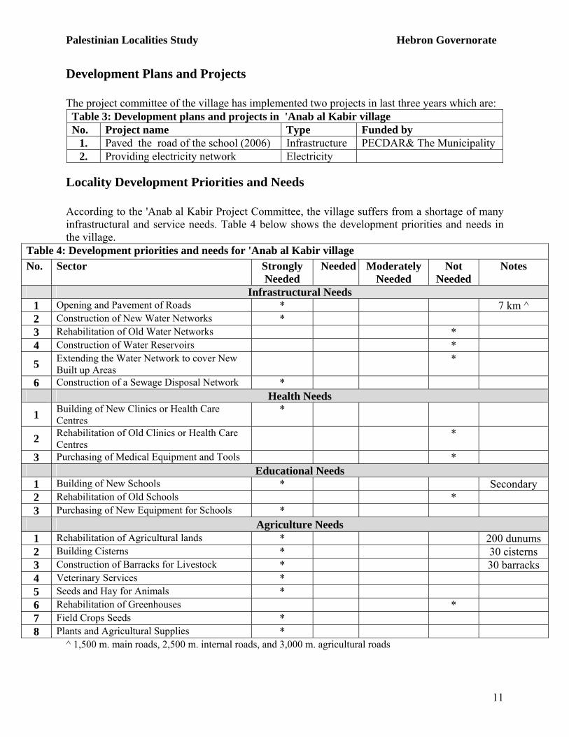
Development Plans and Projects The project committee of the village has implemented two projects in last three years which are:
Table 3: Development plans and projects in 'Anab al Kabir village No. Project name Type Funded by
1. Paved the road of the school (2006) Infrastructure PECDAR& The Municipality 2. Providing electricity network Electricity
Locality Development Priorities and Needs According to the 'Anab al Kabir Project Committee, the village suffers from a shortage of many infrastructural and service needs. Table 4 below shows the development priorities and needs in the village.
Table 4: Development priorities and needs for 'Anab al Kabir village No. Sector Strongly
Needed Needed Moderately
Needed Not
Needed Notes
Infrastructural Needs 1 Opening and Pavement of Roads * 7 km ^ 2 Construction of New Water Networks * 3 Rehabilitation of Old Water Networks * 4 Construction of Water Reservoirs *
5 Extending the Water Network to cover New Built up Areas
*
6 Construction of a Sewage Disposal Network * Health Needs
1 Building of New Clinics or Health Care Centres
*
2 Rehabilitation of Old Clinics or Health Care Centres
*
3 Purchasing of Medical Equipment and Tools * Educational Needs
1 Building of New Schools * Secondary 2 Rehabilitation of Old Schools * 3 Purchasing of New Equipment for Schools *
Agriculture Needs 1 Rehabilitation of Agricultural lands * 200 dunums 2 Building Cisterns * 30 cisterns 3 Construction of Barracks for Livestock * 30 barracks 4 Veterinary Services * 5 Seeds and Hay for Animals * 6 Rehabilitation of Greenhouses * 7 Field Crops Seeds * 8 Plants and Agricultural Supplies *
^ 1,500 m. main roads, 2,500 m. internal roads, and 3,000 m. agricultural roads
Palestinian Localities Study Hebron Governorate
12
References:
- Addabag, Mustafa. “BELADUNA FALESTINE” Kufr Qaree, Palestine: Dar Alhuda Press,
1991. (In Arabic).
- Applied Research Institute- Jerusalem (ARIJ). GIS Database. 2006-2009
- Palestinian Central Bureau of Statistics. Population, Housing and Establishment Census-Final
Results. Ramallah, Palestine. 1997-2007
- Arraf, Shukry, 1996, The Arab Palestinian Village, third edition, Dar Nasher Ela Alumek,
Mualea, Palestine.


![Curso esteroides anab%c3%b3licos[1]](https://img.pdfslide.net/doc/110x75/549173efb479599d0e8b4b52/curso-esteroides-anabc3b3licos1.jpg)