Embed Size (px)
Citation preview
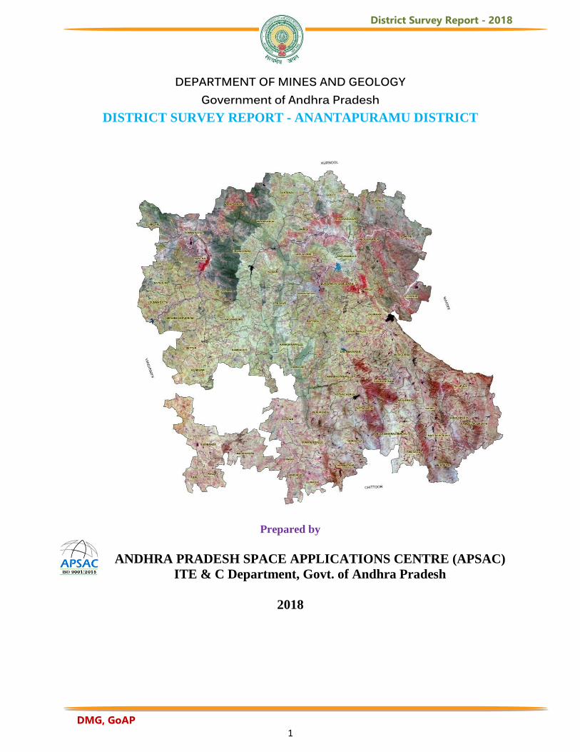
District Survey Report - 2018
DMG, GoAP 1
DEPARTMENT OF MINES AND GEOLOGY
Government of Andhra Pradesh DISTRICT SURVEY REPORT - ANANTAPURAMU DISTRICT
Prepared by
ANDHRA PRADESH SPACE APPLICATIONS CENTRE (APSAC)
ITE & C Department, Govt. of Andhra Pradesh
2018
District Survey Report - 2018
DMG, GoAP 2
ACKNOWLEDGEMENTS
APSAC wishes to place on record its sincere thanks to Sri. B.Sreedhar IAS, Secretary to Government (Mines) and the Director, Department of Mines and Geology, Govt. of Andhra Pradesh for entrusting the work for preparation of District Survey Reports of Andhra Pradesh. The team gratefully acknowledge the help of the Commissioner, Horticulture Department, Govt. of Andhra Pradesh and the Director, Directorate of Economics and Statistics, Planning Department, Govt. of Andhra Pradesh for providing valuable statistical data and literature. The project team is also thankful to all the Joint Directors, Deputy Directors, Assistant Directors and the staff of Mines and Geology Department for their overall support and guidance during the execution of this work. Also sincere thanks are due to the scientific staff of APSAC who has generated all the thematic maps.
VICE CHAIRMAN APSAC
District Survey Report - 2018
DMG, GoAP 3
TABLE OF CONTENTS
Contents Page
1
Acknowledgements List of Figures List of Tables Salient Features of the District
1
1.1
Historical Background 1
1.2
Topography 1
1.3
Places of Tourist Importance 2
1.4
Rainfall and Climate 6
1.5
Winds 12
1.6
Population 13
1.7
Transportation: 14
2
Land Utilization, Forest and Slope in the District 16
2.1
Land Use / Land Cover Classification 16
2.2
Slope of Anantapuramu District 30
2.3
Forest Cover Distribution 34
3
Agriculture and Soils 36
3.1
Groundnut crop acreage estimation and yield behaviour in mid season for production estimates using Remote sensing technique in Anantapuramu District of Andhra Pradesh
36
3.2
Groundnut crop acreage during Kharif (2017) at mandal level, Anantapuramu District
38
3.3 Groundnut yield behaviour
40
3.4
Relationship between observed and predicted yield
40
3.5 Pre-Harvest Groundnut Production behaviour for Kharif, 2017 41
3.6
Bengalgram (Cicer arientinum L.) acreage estimation using satellite remote sensing data and Geographical Information System in Rabi, 2016-17
42
3.7 Soils
44
3.8 Horticulture Development in Anantapuramu District 46
4 Water and Irrigation Resources of Anantapuramu District 55
District Survey Report - 2018
DMG, GoAP 4
4.1 Surface Water and Irrigation Resources of the District
55
4.1.1 Rivers in Anantapuramu District
55
4.2 Major and Medium Irrigation Projects
56
4.2.1 Major Irrigation Projects
56
4.2.2 Medium Irrigation Projects
56
4.3 Minor Irrigation Tanks
57
4.4 River Basins in Anantapuramu District
59
4.5 Ground Water Prospects of Anantapuramu District
61
4.6 Geology
62
4.6.1 Mineral Resources
65
4.6.2 Geomorphology of Anantapuramu District
73
4.6.3 Landforms of fluvial origin
75
4.6.4 Landforms of Structural Origin
75
4.6.5 Landforms of Denudational origin
76
4.7 Structural Features of Anantapuramu District
78
4.8 Ground Water Prospect Zones
80
4.8.1 Ground water in Archaean Crystalline rocks
80
4.8.2 Ground Water in Cuddapah and Kurnool formations
81
4.8.3 Ground water in Alluvium 82
4.9 Ground Water Quality
83
5.0
Details of Major and Minor Minerals Their Production and Revenue in the District
84
5.1 Administrative Set-Up of DMG in Anantapuramu District
84
References
103
District Survey Report - 2018
DMG, GoAP 5
LIST OF FIGURES
Page
Fig.1 Administrative boundaries of Anantapuramu District, A.P 2
Fig.2 Important Tourist Locations in Anantapuramu District, Andhra Pradesh
6
Fig.3 Distribution of Rainfall in Anantapuramu District, Andhra Pradesh
8
Fig. 4 Distribution of Automatic Weather Stations in Anantapuramu District, Andhra Pradesh
12
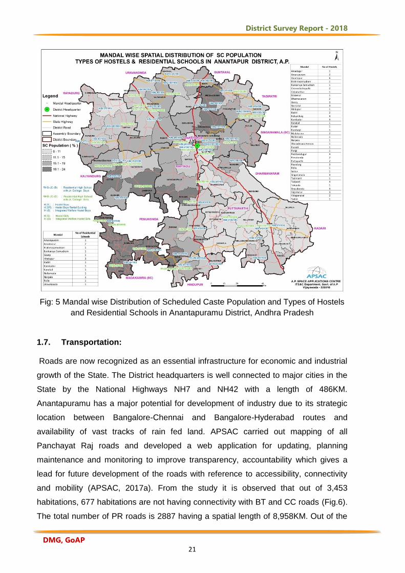
Fig: 5 Mandal wise Distribution of Scheduled Caste Population and Types of Hostels and Residential Schools in Anantapuramu District, Andhra Pradesh
14
Fig. 6 Transport Network of Anantapuramu District, Andhra Pradesh
15
Fig. 7 Land use/land cover distribution in Anantapuramu District, Andhra Pradesh
28
Fig. 8 Slope map of Anantapuramu District, Andhra Pradesh
32
Fig. 9 Satellite Image Draped Over Digital Elevation Model of Anantapuramu District, Andhra Pradesh
33
Fig:10.Forest cover map of Anantapuramu District during 2015-16 35
Fig: 11 Groundnut crop acreage during Kharif (2017) at
mandal level in Anantapuramu District 38
Figure:12 MODIS-250m NDVI, Fortnightly from 2008 to 2017 40
Fig:13 Average observed yield and predicted yield 40
Fig: 14 Pre-harvest fortnightly production behaviour of Kharif,
2017 41
Fig: 15 Bengalgram Cropped Area in Anantapuramu District 43
District Survey Report - 2018
DMG, GoAP 6
Fig.16 Distribution of Soil Resources in Anantapuramu District, Andhra Pradesh
45
Fig. 17 Distribution of salt-affected soils in Anantapuramu District, Andhra Pradesh
46
Fig. 18 Major and Medium Irrigation Projects in Anantapuramu
District 57
Fig.19 Drainage, Surface Water Bodies, Basin and Sub-basin Boundaries in Anantapuramu District, Andhra Pradesh
61
Fig. 20 Geology map of Anantapuramu District, Andhra Pradesh (Source GSI, 2001)
63
Fig.21 Detailed Legend with Stratigraphic Sequence of Anantapuramu District
64
Fig.22 Geomorphological set up of Anantapuramu District, Andhra Pradesh
74
Fig. 23 Structural Features of Anantapuramu District, Andhra Pradesh
79
Fig. 24 Ground Water Prospects of Anantapuramu District, Andhra Pradesh
81
Fig.25 Network of piezometer Observation wells in Anantapuramu District,
82
Fig.26 Ground Water Quality in Anantapuramu District, Andhra Pradesh
83
LIST OF TABLES
Page Table :1 Mandal Wise Average Annual Rainfall (mm) in
Anantapuramu District, Andhra Pradesh 9 Table :2 Category-wise Distributions of Land use/Land Cove
during 2015-16 29
Table:3 Forest Cover Distribution Of Anantapuramu District 34 Table : 4 Groundnut crop acreage during Kharif (2017)
38 Table : 5 Fortnightly production estimates and crop sown area up
to 12th September, 2017 41
Table :6 Bengal gram area (ha) in Anantapuramu District 43
District Survey Report - 2018
DMG, GoAP 7
Table: 7 Aerial Extent (Ha) of Fresh Fruits with Production (MT) in Anantapuramu District (2017-18) 49
Table:8 Aerial Extent (Ha) of Vegetables with Production (MT) in Anantapuramu District (2017-18) 50
Table: 9 Aerial Extent (Ha) of Plantation with Production (MT) in Anantapuramu District (2017-18) 51
Table:10 Aerial Extent (Ha) of Spices with Production (MT) in Anantapuramu District (2017-18) 52
Table:11 Aerial Extent (Ha) of Flowers with Production (MT) in Anantapuramu District (2017-18) 52
Table: 12 Aerial Extent (Ha) of Medicinal & Aromatic Plants with Production (MT) in Anantapuramu District (2017-18) 53
Table :13. Minor basin-wise distribution of tanks by each category in Anantapuramu District
59
Table :14. Hydrological units of Anantapuramu District 59
Table:14. Drainage System with Description of main rivers 60
Table:15. Salient Features of Important Rivers and Streams 60
Table :16 The number of sand reaches and details of dispatches during the last three years 84
Table: 17 Statement showing the list of leases for Major and Minor Minerals and details of lease wise production and Revenue collections during the last three years pertaining to O/o ADM&G, Ananthapuramu 87
District Survey Report - 2018
DMG, GoAP 8
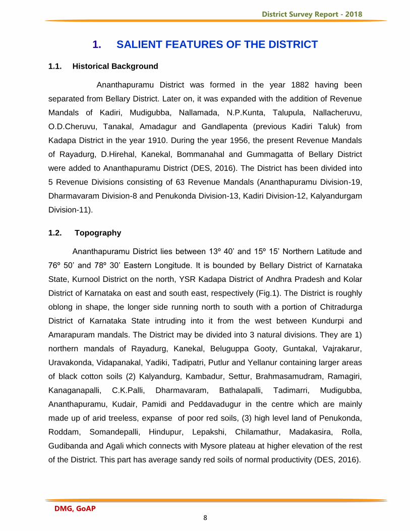
1. SALIENT FEATURES OF THE DISTRICT 1.1. Historical Background
Ananthapuramu District was formed in the year 1882 having been
separated from Bellary District. Later on, it was expanded with the addition of Revenue
Mandals of Kadiri, Mudigubba, Nallamada, N.P.Kunta, Talupula, Nallacheruvu,
O.D.Cheruvu, Tanakal, Amadagur and Gandlapenta (previous Kadiri Taluk) from
Kadapa District in the year 1910. During the year 1956, the present Revenue Mandals
of Rayadurg, D.Hirehal, Kanekal, Bommanahal and Gummagatta of Bellary District
were added to Ananthapuramu District (DES, 2016). The District has been divided into
5 Revenue Divisions consisting of 63 Revenue Mandals (Ananthapuramu Division-19,
Dharmavaram Division-8 and Penukonda Division-13, Kadiri Division-12, Kalyandurgam
Division-11).
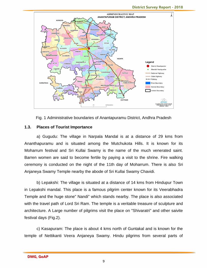
1.2. Topography Ananthapuramu District lies between 13º 40’ and 15º 15’ Northern Latitude and
76º 50’ and 78º 30’ Eastern Longitude. It is bounded by Bellary District of Karnataka
State, Kurnool District on the north, YSR Kadapa District of Andhra Pradesh and Kolar
District of Karnataka on east and south east, respectively (Fig.1). The District is roughly
oblong in shape, the longer side running north to south with a portion of Chitradurga
District of Karnataka State intruding into it from the west between Kundurpi and
Amarapuram mandals. The District may be divided into 3 natural divisions. They are 1)
northern mandals of Rayadurg, Kanekal, Beluguppa Gooty, Guntakal, Vajrakarur,
Uravakonda, Vidapanakal, Yadiki, Tadipatri, Putlur and Yellanur containing larger areas
of black cotton soils (2) Kalyandurg, Kambadur, Settur, Brahmasamudram, Ramagiri,
Kanaganapalli, C.K.Palli, Dharmavaram, Bathalapalli, Tadimarri, Mudigubba,
Ananthapuramu, Kudair, Pamidi and Peddavadugur in the centre which are mainly
made up of arid treeless, expanse of poor red soils, (3) high level land of Penukonda,
Roddam, Somandepalli, Hindupur, Lepakshi, Chilamathur, Madakasira, Rolla,
Gudibanda and Agali which connects with Mysore plateau at higher elevation of the rest
of the District. This part has average sandy red soils of normal productivity (DES, 2016).
District Survey Report - 2018
DMG, GoAP 9
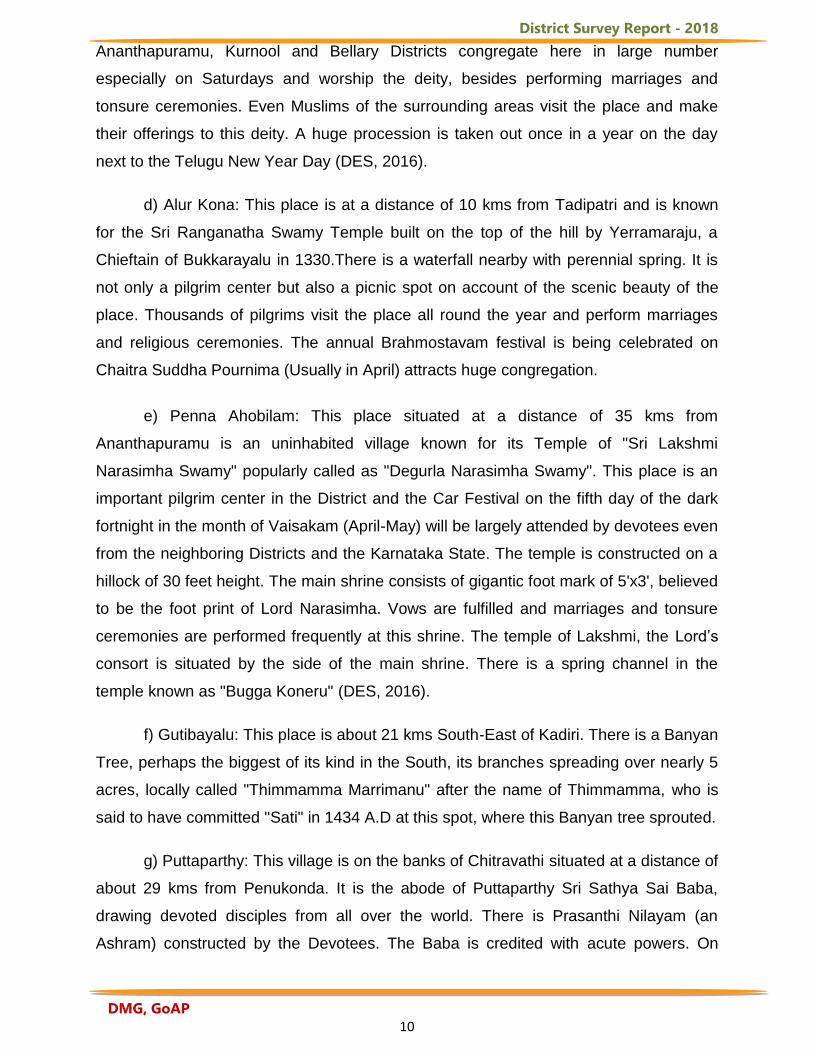
Fig. 1 Administrative boundaries of Anantapuramu District, Andhra Pradesh 1.3. Places of Tourist Importance a) Gugudu: The village in Narpala Mandal is at a distance of 29 kms from
Ananthapuramu and is situated among the Mutchukota Hills. It is known for its
Moharrum festival and Sri Kullai Swamy is the name of the much venerated saint.
Barren women are said to become fertile by paying a visit to the shrine. Fire walking
ceremony is conducted on the night of the 11th day of Moharrum. There is also Sri
Anjaneya Swamy Temple nearby the abode of Sri Kullai Swamy Chavidi.
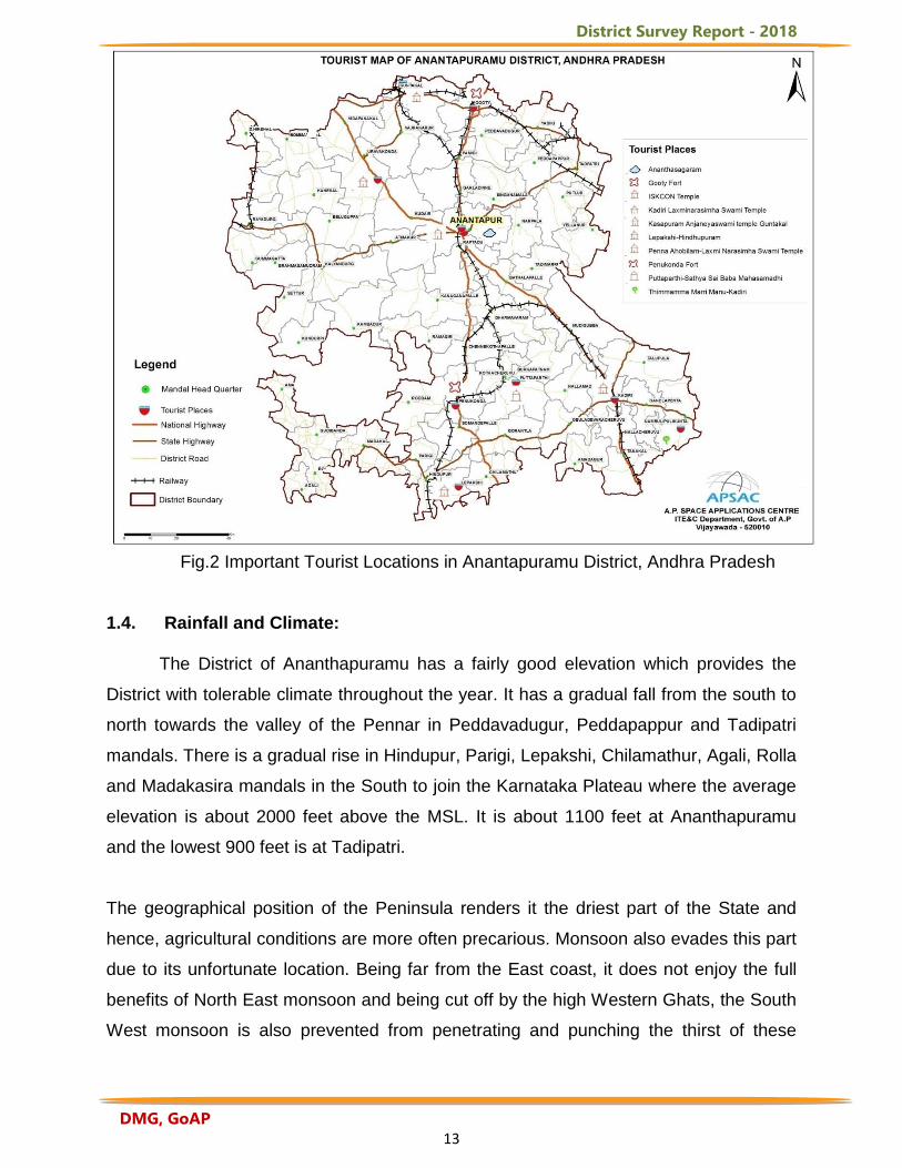
b) Lepakshi: The village is situated at a distance of 14 kms from Hindupur Town
in Lepakshi mandal. This place is a famous pilgrim center known for its Veerabhadra
Temple and the huge stone" Nandi" which stands nearby. The place is also associated
with the travel path of Lord Sri Ram. The temple is a veritable treasure of sculpture and
architecture. A Large number of pilgrims visit the place on "Shivaratri" and other saivite
festival days (Fig.2).
c) Kasapuram: The place is about 4 kms north of Guntakal and is known for the
temple of Nettikanti Veera Anjaneya Swamy. Hindu pilgrims from several parts of
District Survey Report - 2018
DMG, GoAP 10
Ananthapuramu, Kurnool and Bellary Districts congregate here in large number
especially on Saturdays and worship the deity, besides performing marriages and
tonsure ceremonies. Even Muslims of the surrounding areas visit the place and make
their offerings to this deity. A huge procession is taken out once in a year on the day
next to the Telugu New Year Day (DES, 2016).
d) Alur Kona: This place is at a distance of 10 kms from Tadipatri and is known
for the Sri Ranganatha Swamy Temple built on the top of the hill by Yerramaraju, a
Chieftain of Bukkarayalu in 1330.There is a waterfall nearby with perennial spring. It is
not only a pilgrim center but also a picnic spot on account of the scenic beauty of the
place. Thousands of pilgrims visit the place all round the year and perform marriages
and religious ceremonies. The annual Brahmostavam festival is being celebrated on
Chaitra Suddha Pournima (Usually in April) attracts huge congregation.
e) Penna Ahobilam: This place situated at a distance of 35 kms from
Ananthapuramu is an uninhabited village known for its Temple of "Sri Lakshmi
Narasimha Swamy" popularly called as "Degurla Narasimha Swamy". This place is an
important pilgrim center in the District and the Car Festival on the fifth day of the dark
fortnight in the month of Vaisakam (April-May) will be largely attended by devotees even
from the neighboring Districts and the Karnataka State. The temple is constructed on a
hillock of 30 feet height. The main shrine consists of gigantic foot mark of 5'x3', believed
to be the foot print of Lord Narasimha. Vows are fulfilled and marriages and tonsure
ceremonies are performed frequently at this shrine. The temple of Lakshmi, the Lord’s
consort is situated by the side of the main shrine. There is a spring channel in the
temple known as "Bugga Koneru" (DES, 2016).
f) Gutibayalu: This place is about 21 kms South-East of Kadiri. There is a Banyan
Tree, perhaps the biggest of its kind in the South, its branches spreading over nearly 5
acres, locally called "Thimmamma Marrimanu" after the name of Thimmamma, who is
said to have committed "Sati" in 1434 A.D at this spot, where this Banyan tree sprouted.
g) Puttaparthy: This village is on the banks of Chitravathi situated at a distance of
about 29 kms from Penukonda. It is the abode of Puttaparthy Sri Sathya Sai Baba,
drawing devoted disciples from all over the world. There is Prasanthi Nilayam (an
Ashram) constructed by the Devotees. The Baba is credited with acute powers. On
District Survey Report - 2018
DMG, GoAP 11
Sivarathri, on the birth day of the Baba and particularly during Dasara, quite a large
number of devotees visit the place. A beautiful mandapa by name" Poornachandra" is
constructed in which a large number of Baba devotees would assemble and perform
"Bhajana" on festival days (Fig.2).
h) Penukonda: Penukonda is one of the early capitals of the Vijayanagara
empire, the fort was impregnable during its time. The two most noteworthy sights in the
fort are the “Gagan Mahal” the summer resort of the kings and “Babayya Darga”, a
splendid example for communal harmony. Here Kumbhakarna garden was spread over
5 acres. It has a gigantic statue of the sleeping Kumbhakarna, measuring 142 feet in
length and 32 feet in height into whose cavernous belly one can walk into it. Several
asuras are seen trying to wake up the sleeping giant (DES, 2016).
i) Hemavathi: Hemavathi is located at a distance of 140kms from
Ananthapuramu. It is famous for Doddeswara Swamy temple built during the Pallava
reign. The stone used in making the idols sounds like metal when stuck and is also
remarkably polished. A Nandi made of black granite, 8 feet in length and 4 feet in height
sits at the entrance. There is a 6 feet tall Lingam installed inside the sanctum
sanctorum. The temple area houses two other temples dedicated to Lord Shiva called
the Siddeswara Swamy temple and Mallikarjuna Swamy temple. There is a museum
inside which has rare idols displayed which are of historical importance.
j) Rayadurg Fort: It is located at a distance of 130kms from Ananthapuramu. The
fort was built by the Vijayanagara Kings and has inscriptions indicative of the period, on
its walls. Located within the fort is the RasaSidda Temple. Carved out of a single stone,
the temple is embellished with the fine sculptures depicting Jain gurus and their
disciples. In the proximity are other sites like Rama Temple, Narasimha Swamy Temple,
Neelakanteswara Temple and Jambukeswara Temple.
k) Gooty Fort: Gooty fort is majestically located at a distance of 52kms from
Ananthapuramu at a height of 300mts on a hill. It is one of the oldest hill forts in A.P.
Built during the Vijayanagara era, the fort is uniquely built in the shape of a shell with 15
main doors and is significant for its water resources available at such a height.
l) Tadipatri: Chintala Venkataramana Temple is located in Tadipatri town which
is at a distance of 52 kms from Ananthapuramu. From Tadipatri town at a distance of 1
District Survey Report - 2018
DMG, GoAP 12
km, overlooking the Penna River, the Bugga Ramalingeswara Temple is remarkable for
a Lingam on a pedestal constantly filled with water from a small spring.
m) Sri Kadiri Lakshmi Narasimha Swamy Temple: Kadiri is the holy shrine where
Lord Vishnu set foot and handed over the Utsavamoorthis to Brugu Maharshi for his
daily worship. Special Poojas are performed during Dasera and Sankranthi. There are
several sacred thirthas connected to the Temple (Fig.2).
n) Dharmavaram: Sri Lakshmi Chennakeshava Temple is renowned for its
architectural brilliance and for the perennial waterspout and pillars, which produce
seven different musical notes when struck. Dharmavaram is also known for its cotton
and silk weaving industry with its silk sarees being popular all over the world. This place
is also known for its expertise in making leather puppets.
o) Jambu Dweepa at Konakondla: The Jain mythical cosmographical diagram of
Jambu Dweepa is engraved on a stone on the top of the hill by Alchemists at
Konakondla village in Vajrakarur mandal which was identified by Sri R.V. Chakravarthy,
Head Master, Parishad High School, Konakondla in the year 1966. The pilgrims,
especially south Indian Jain pilgrims are mostly attracted by this Jambu Dweepa which
is 70 kms from Ananthapuramu or 10 kms from Guntakal Railway Station. Adjacent to
this, there are Kambam Narasimha Swamy Hills, Rasasidda hillock and Kari Basappa
hillock. There is a Thirthanka Temple with idols of Thirthankaras (high priests) on
Rasasidda hillock. This may belong to 13th Century A.D. (DES, 2016).
District Survey Report - 2018
DMG, GoAP 13
Fig.2 Important Tourist Locations in Anantapuramu District, Andhra Pradesh 1.4. Rainfall and Climate: The District of Ananthapuramu has a fairly good elevation which provides the
District with tolerable climate throughout the year. It has a gradual fall from the south to
north towards the valley of the Pennar in Peddavadugur, Peddapappur and Tadipatri
mandals. There is a gradual rise in Hindupur, Parigi, Lepakshi, Chilamathur, Agali, Rolla
and Madakasira mandals in the South to join the Karnataka Plateau where the average
elevation is about 2000 feet above the MSL. It is about 1100 feet at Ananthapuramu
and the lowest 900 feet is at Tadipatri.
The geographical position of the Peninsula renders it the driest part of the State and
hence, agricultural conditions are more often precarious. Monsoon also evades this part
due to its unfortunate location. Being far from the East coast, it does not enjoy the full
benefits of North East monsoon and being cut off by the high Western Ghats, the South
West monsoon is also prevented from penetrating and punching the thirst of these
District Survey Report - 2018
DMG, GoAP 14
parched soils. It is therefore seen that the District is deprived of both the monsoons and
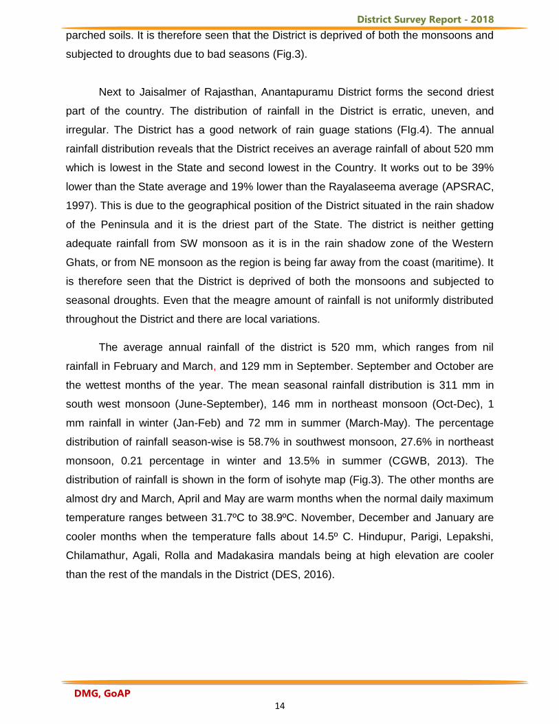
subjected to droughts due to bad seasons (Fig.3).
Next to Jaisalmer of Rajasthan, Anantapuramu District forms the second driest
part of the country. The distribution of rainfall in the District is erratic, uneven, and
irregular. The District has a good network of rain guage stations (FIg.4). The annual
rainfall distribution reveals that the District receives an average rainfall of about 520 mm
which is lowest in the State and second lowest in the Country. It works out to be 39%
lower than the State average and 19% lower than the Rayalaseema average (APSRAC,
1997). This is due to the geographical position of the District situated in the rain shadow
of the Peninsula and it is the driest part of the State. The district is neither getting
adequate rainfall from SW monsoon as it is in the rain shadow zone of the Western
Ghats, or from NE monsoon as the region is being far away from the coast (maritime). It
is therefore seen that the District is deprived of both the monsoons and subjected to
seasonal droughts. Even that the meagre amount of rainfall is not uniformly distributed
throughout the District and there are local variations.
The average annual rainfall of the district is 520 mm, which ranges from nil
rainfall in February and March, and 129 mm in September. September and October are
the wettest months of the year. The mean seasonal rainfall distribution is 311 mm in
south west monsoon (June-September), 146 mm in northeast monsoon (Oct-Dec), 1
mm rainfall in winter (Jan-Feb) and 72 mm in summer (March-May). The percentage
distribution of rainfall season-wise is 58.7% in southwest monsoon, 27.6% in northeast
monsoon, 0.21 percentage in winter and 13.5% in summer (CGWB, 2013). The
distribution of rainfall is shown in the form of isohyte map (Fig.3). The other months are
almost dry and March, April and May are warm months when the normal daily maximum
temperature ranges between 31.7ºC to 38.9ºC. November, December and January are
cooler months when the temperature falls about 14.5º C. Hindupur, Parigi, Lepakshi,
Chilamathur, Agali, Rolla and Madakasira mandals being at high elevation are cooler
than the rest of the mandals in the District (DES, 2016).
District Survey Report - 2018
DMG, GoAP 15
Fig.3 Distribution of Rainfall in Anantapuramu District, Andhra Pradesh
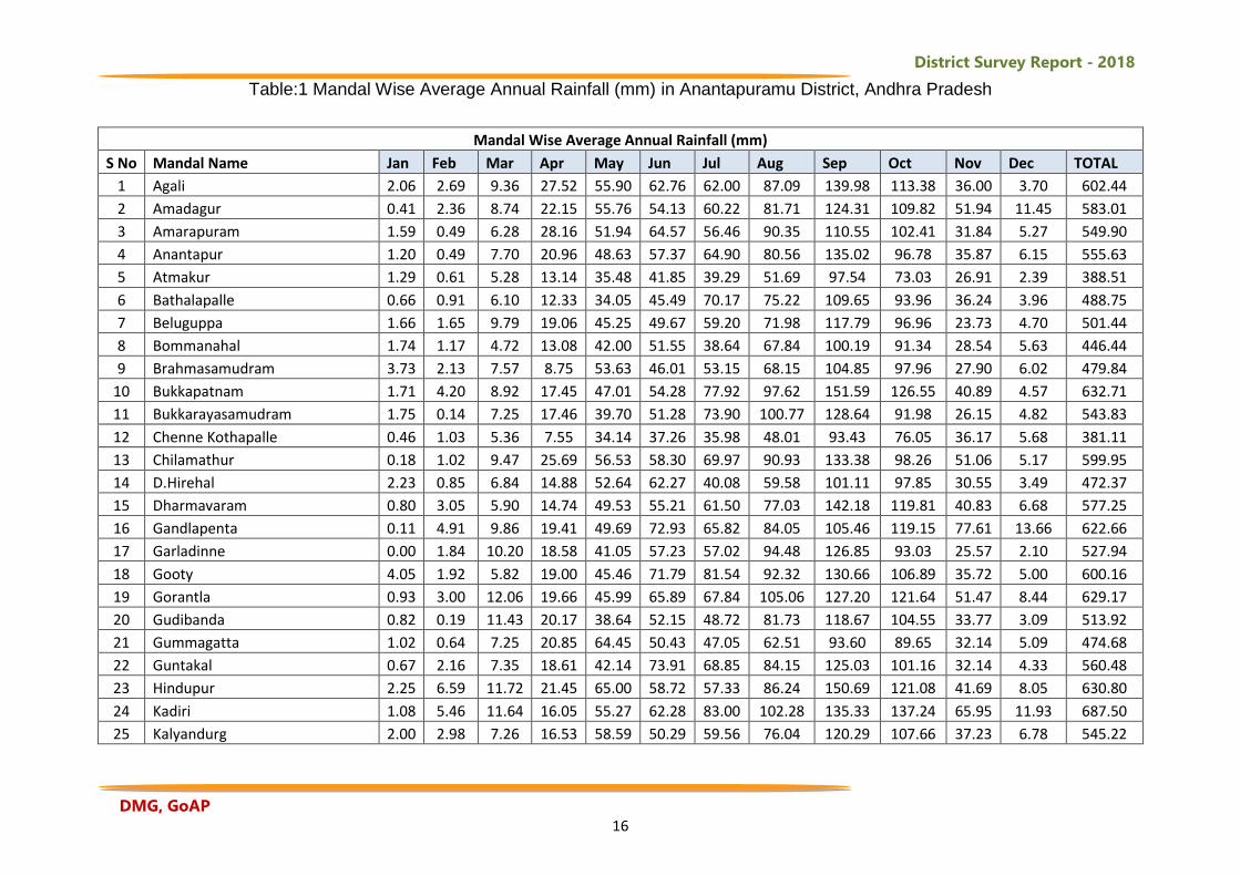
The monthly average rainfall is collected from the Directorate of Economics and
Statistics (DES), Planning Department, Govt. of A.P. and tabulated (Table 1). For the
entire District, September month shows highest rainfall in all mandalls followed by
October. January month shows lowest average rainfall in all the mandals.
District Survey Report - 2018
DMG, GoAP 16
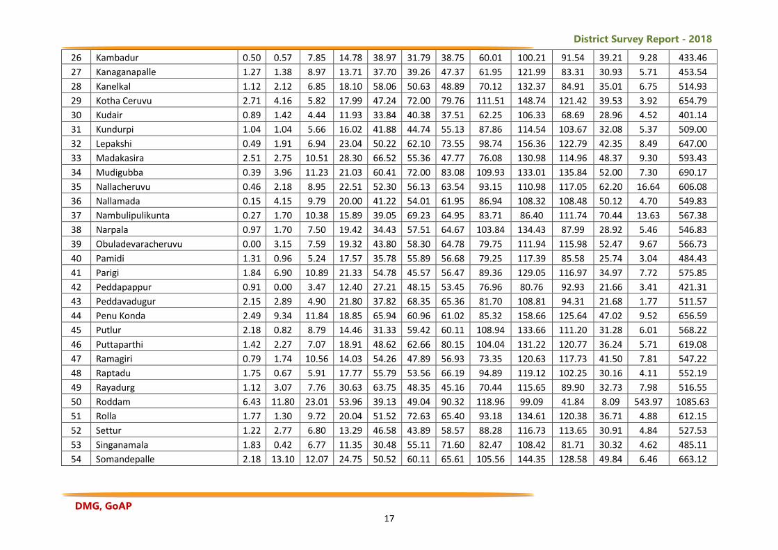
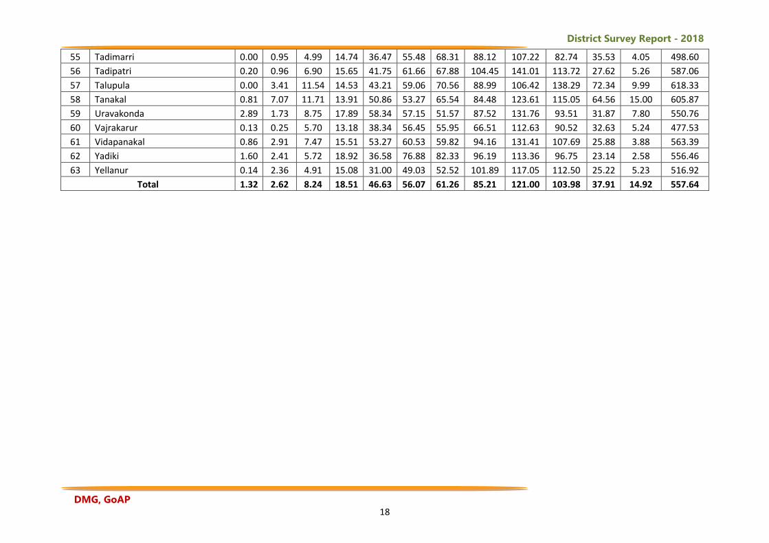
Table:1 Mandal Wise Average Annual Rainfall (mm) in Anantapuramu District, Andhra Pradesh
Mandal Wise Average Annual Rainfall (mm)
S No Mandal Name Jan Feb Mar Apr May Jun Jul Aug Sep Oct Nov Dec TOTAL
1 Agali 2.06 2.69 9.36 27.52 55.90 62.76 62.00 87.09 139.98 113.38 36.00 3.70 602.44
2 Amadagur 0.41 2.36 8.74 22.15 55.76 54.13 60.22 81.71 124.31 109.82 51.94 11.45 583.01
3 Amarapuram 1.59 0.49 6.28 28.16 51.94 64.57 56.46 90.35 110.55 102.41 31.84 5.27 549.90
4 Anantapur 1.20 0.49 7.70 20.96 48.63 57.37 64.90 80.56 135.02 96.78 35.87 6.15 555.63
5 Atmakur 1.29 0.61 5.28 13.14 35.48 41.85 39.29 51.69 97.54 73.03 26.91 2.39 388.51
6 Bathalapalle 0.66 0.91 6.10 12.33 34.05 45.49 70.17 75.22 109.65 93.96 36.24 3.96 488.75
7 Beluguppa 1.66 1.65 9.79 19.06 45.25 49.67 59.20 71.98 117.79 96.96 23.73 4.70 501.44
8 Bommanahal 1.74 1.17 4.72 13.08 42.00 51.55 38.64 67.84 100.19 91.34 28.54 5.63 446.44
9 Brahmasamudram 3.73 2.13 7.57 8.75 53.63 46.01 53.15 68.15 104.85 97.96 27.90 6.02 479.84
10 Bukkapatnam 1.71 4.20 8.92 17.45 47.01 54.28 77.92 97.62 151.59 126.55 40.89 4.57 632.71
11 Bukkarayasamudram 1.75 0.14 7.25 17.46 39.70 51.28 73.90 100.77 128.64 91.98 26.15 4.82 543.83
12 Chenne Kothapalle 0.46 1.03 5.36 7.55 34.14 37.26 35.98 48.01 93.43 76.05 36.17 5.68 381.11
13 Chilamathur 0.18 1.02 9.47 25.69 56.53 58.30 69.97 90.93 133.38 98.26 51.06 5.17 599.95
14 D.Hirehal 2.23 0.85 6.84 14.88 52.64 62.27 40.08 59.58 101.11 97.85 30.55 3.49 472.37
15 Dharmavaram 0.80 3.05 5.90 14.74 49.53 55.21 61.50 77.03 142.18 119.81 40.83 6.68 577.25
16 Gandlapenta 0.11 4.91 9.86 19.41 49.69 72.93 65.82 84.05 105.46 119.15 77.61 13.66 622.66
17 Garladinne 0.00 1.84 10.20 18.58 41.05 57.23 57.02 94.48 126.85 93.03 25.57 2.10 527.94
18 Gooty 4.05 1.92 5.82 19.00 45.46 71.79 81.54 92.32 130.66 106.89 35.72 5.00 600.16
19 Gorantla 0.93 3.00 12.06 19.66 45.99 65.89 67.84 105.06 127.20 121.64 51.47 8.44 629.17
20 Gudibanda 0.82 0.19 11.43 20.17 38.64 52.15 48.72 81.73 118.67 104.55 33.77 3.09 513.92
21 Gummagatta 1.02 0.64 7.25 20.85 64.45 50.43 47.05 62.51 93.60 89.65 32.14 5.09 474.68
22 Guntakal 0.67 2.16 7.35 18.61 42.14 73.91 68.85 84.15 125.03 101.16 32.14 4.33 560.48
23 Hindupur 2.25 6.59 11.72 21.45 65.00 58.72 57.33 86.24 150.69 121.08 41.69 8.05 630.80
24 Kadiri 1.08 5.46 11.64 16.05 55.27 62.28 83.00 102.28 135.33 137.24 65.95 11.93 687.50
25 Kalyandurg 2.00 2.98 7.26 16.53 58.59 50.29 59.56 76.04 120.29 107.66 37.23 6.78 545.22
District Survey Report - 2018
DMG, GoAP 17
26 Kambadur 0.50 0.57 7.85 14.78 38.97 31.79 38.75 60.01 100.21 91.54 39.21 9.28 433.46
27 Kanaganapalle 1.27 1.38 8.97 13.71 37.70 39.26 47.37 61.95 121.99 83.31 30.93 5.71 453.54
28 Kanelkal 1.12 2.12 6.85 18.10 58.06 50.63 48.89 70.12 132.37 84.91 35.01 6.75 514.93
29 Kotha Ceruvu 2.71 4.16 5.82 17.99 47.24 72.00 79.76 111.51 148.74 121.42 39.53 3.92 654.79
30 Kudair 0.89 1.42 4.44 11.93 33.84 40.38 37.51 62.25 106.33 68.69 28.96 4.52 401.14
31 Kundurpi 1.04 1.04 5.66 16.02 41.88 44.74 55.13 87.86 114.54 103.67 32.08 5.37 509.00
32 Lepakshi 0.49 1.91 6.94 23.04 50.22 62.10 73.55 98.74 156.36 122.79 42.35 8.49 647.00
33 Madakasira 2.51 2.75 10.51 28.30 66.52 55.36 47.77 76.08 130.98 114.96 48.37 9.30 593.43
34 Mudigubba 0.39 3.96 11.23 21.03 60.41 72.00 83.08 109.93 133.01 135.84 52.00 7.30 690.17
35 Nallacheruvu 0.46 2.18 8.95 22.51 52.30 56.13 63.54 93.15 110.98 117.05 62.20 16.64 606.08
36 Nallamada 0.15 4.15 9.79 20.00 41.22 54.01 61.95 86.94 108.32 108.48 50.12 4.70 549.83
37 Nambulipulikunta 0.27 1.70 10.38 15.89 39.05 69.23 64.95 83.71 86.40 111.74 70.44 13.63 567.38
38 Narpala 0.97 1.70 7.50 19.42 34.43 57.51 64.67 103.84 134.43 87.99 28.92 5.46 546.83
39 Obuladevaracheruvu 0.00 3.15 7.59 19.32 43.80 58.30 64.78 79.75 111.94 115.98 52.47 9.67 566.73
40 Pamidi 1.31 0.96 5.24 17.57 35.78 55.89 56.68 79.25 117.39 85.58 25.74 3.04 484.43
41 Parigi 1.84 6.90 10.89 21.33 54.78 45.57 56.47 89.36 129.05 116.97 34.97 7.72 575.85
42 Peddapappur 0.91 0.00 3.47 12.40 27.21 48.15 53.45 76.96 80.76 92.93 21.66 3.41 421.31
43 Peddavadugur 2.15 2.89 4.90 21.80 37.82 68.35 65.36 81.70 108.81 94.31 21.68 1.77 511.57
44 Penu Konda 2.49 9.34 11.84 18.85 65.94 60.96 61.02 85.32 158.66 125.64 47.02 9.52 656.59
45 Putlur 2.18 0.82 8.79 14.46 31.33 59.42 60.11 108.94 133.66 111.20 31.28 6.01 568.22
46 Puttaparthi 1.42 2.27 7.07 18.91 48.62 62.66 80.15 104.04 131.22 120.77 36.24 5.71 619.08
47 Ramagiri 0.79 1.74 10.56 14.03 54.26 47.89 56.93 73.35 120.63 117.73 41.50 7.81 547.22
48 Raptadu 1.75 0.67 5.91 17.77 55.79 53.56 66.19 94.89 119.12 102.25 30.16 4.11 552.19
49 Rayadurg 1.12 3.07 7.76 30.63 63.75 48.35 45.16 70.44 115.65 89.90 32.73 7.98 516.55
50 Roddam 6.43 11.80 23.01 53.96 39.13 49.04 90.32 118.96 99.09 41.84 8.09 543.97 1085.63
51 Rolla 1.77 1.30 9.72 20.04 51.52 72.63 65.40 93.18 134.61 120.38 36.71 4.88 612.15
52 Settur 1.22 2.77 6.80 13.29 46.58 43.89 58.57 88.28 116.73 113.65 30.91 4.84 527.53
53 Singanamala 1.83 0.42 6.77 11.35 30.48 55.11 71.60 82.47 108.42 81.71 30.32 4.62 485.11
54 Somandepalle 2.18 13.10 12.07 24.75 50.52 60.11 65.61 105.56 144.35 128.58 49.84 6.46 663.12
District Survey Report - 2018
DMG, GoAP 18
55 Tadimarri 0.00 0.95 4.99 14.74 36.47 55.48 68.31 88.12 107.22 82.74 35.53 4.05 498.60
56 Tadipatri 0.20 0.96 6.90 15.65 41.75 61.66 67.88 104.45 141.01 113.72 27.62 5.26 587.06
57 Talupula 0.00 3.41 11.54 14.53 43.21 59.06 70.56 88.99 106.42 138.29 72.34 9.99 618.33
58 Tanakal 0.81 7.07 11.71 13.91 50.86 53.27 65.54 84.48 123.61 115.05 64.56 15.00 605.87
59 Uravakonda 2.89 1.73 8.75 17.89 58.34 57.15 51.57 87.52 131.76 93.51 31.87 7.80 550.76
60 Vajrakarur 0.13 0.25 5.70 13.18 38.34 56.45 55.95 66.51 112.63 90.52 32.63 5.24 477.53
61 Vidapanakal 0.86 2.91 7.47 15.51 53.27 60.53 59.82 94.16 131.41 107.69 25.88 3.88 563.39
62 Yadiki 1.60 2.41 5.72 18.92 36.58 76.88 82.33 96.19 113.36 96.75 23.14 2.58 556.46
63 Yellanur 0.14 2.36 4.91 15.08 31.00 49.03 52.52 101.89 117.05 112.50 25.22 5.23 516.92
Total 1.32 2.62 8.24 18.51 46.63 56.07 61.26 85.21 121.00 103.98 37.91 14.92 557.64
District Survey Report - 2018
DMG, GoAP 19
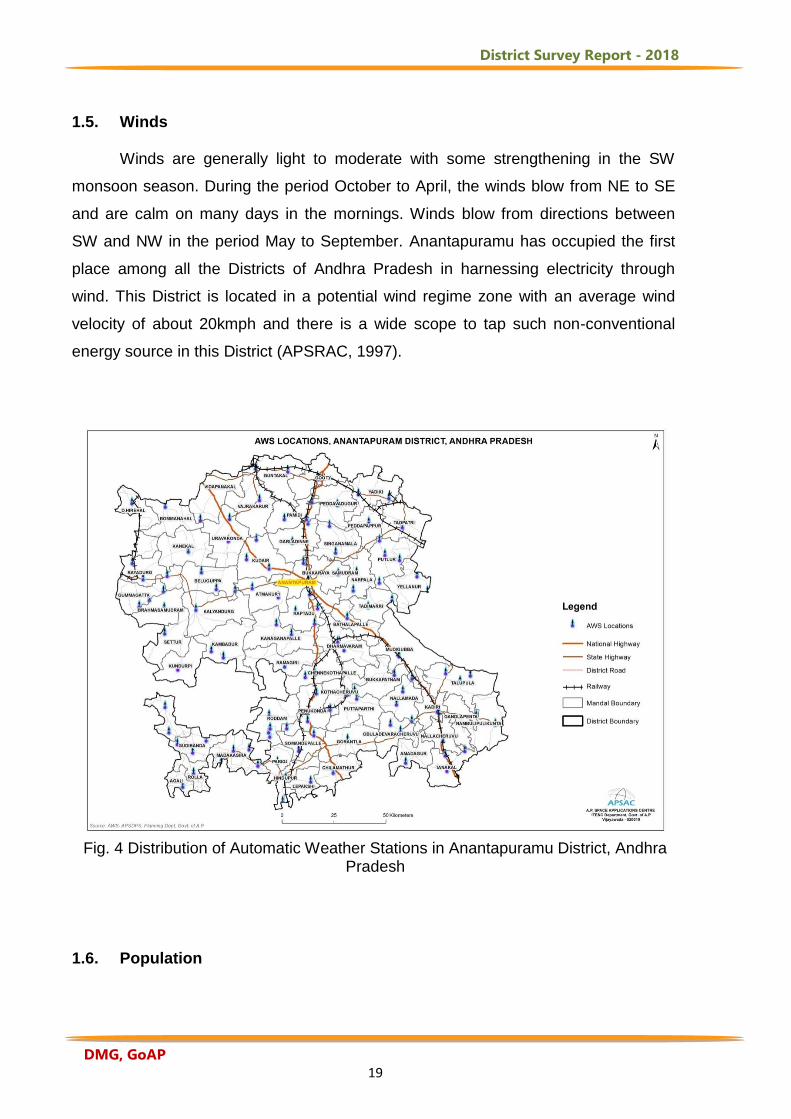
1.5. Winds Winds are generally light to moderate with some strengthening in the SW
monsoon season. During the period October to April, the winds blow from NE to SE
and are calm on many days in the mornings. Winds blow from directions between
SW and NW in the period May to September. Anantapuramu has occupied the first
place among all the Districts of Andhra Pradesh in harnessing electricity through
wind. This District is located in a potential wind regime zone with an average wind
velocity of about 20kmph and there is a wide scope to tap such non-conventional
energy source in this District (APSRAC, 1997).
Fig. 4 Distribution of Automatic Weather Stations in Anantapuramu District, Andhra
Pradesh 1.6. Population
District Survey Report - 2018
DMG, GoAP 20
The total population of the District is 4081148 as per 2011 census. The density
of population of the District is 213 per Sq. K.M, against 308 of the State. The
population of rural and urban to the total population of the District work out to 72%
and 28% in 2011 Census as against 75% and 25% of 2001 Census. There are 977
females per 1000 males in 2011 Census. The working force in the total population of
District forms 49.89% as per 2011 census out of which 25% are in the agriculture
sector.
There are 929 inhabited villages, out of 964 total revenue villages of the
District. The number of villages in size group of 500 to 1999 forms 32.79% of the total
inhabited villages. The size group of 2000 to 4999 forms 41.37% and the size group
of 5000 to 9999 forms 13.57% only out of total villages while 81 (8.80%) of total
inhabited villages have a population less than 500. There are 32 villages with more
than 10000 population excluding Towns (2011 Census). The population of schedule
caste is 5.83 lakhs as per 2011 census with a decennial growth rate of 13.20% and
occupies 14.29% to the total population of the District. The spatial distribution of SC
population and types of hostels and residential schools in Anantapuramu District is
shown in Fig.5.
District Survey Report - 2018
DMG, GoAP 21
Fig: 5 Mandal wise Distribution of Scheduled Caste Population and Types of Hostels
and Residential Schools in Anantapuramu District, Andhra Pradesh
1.7. Transportation: Roads are now recognized as an essential infrastructure for economic and industrial
growth of the State. The District headquarters is well connected to major cities in the
State by the National Highways NH7 and NH42 with a length of 486KM.
Anantapuramu has a major potential for development of industry due to its strategic
location between Bangalore-Chennai and Bangalore-Hyderabad routes and
availability of vast tracks of rain fed land. APSAC carried out mapping of all
Panchayat Raj roads and developed a web application for updating, planning
maintenance and monitoring to improve transparency, accountability which gives a
lead for future development of the roads with reference to accessibility, connectivity
and mobility (APSAC, 2017a). From the study it is observed that out of 3,453
habitations, 677 habitations are not having connectivity with BT and CC roads (Fig.6).
The total number of PR roads is 2887 having a spatial length of 8,958KM. Out of the
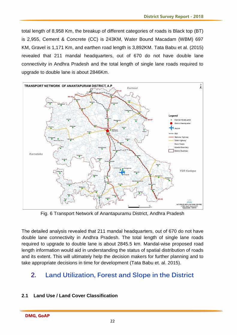
District Survey Report - 2018
DMG, GoAP 22
total length of 8,958 Km, the breakup of different categories of roads is Black top (BT)
is 2,955, Cement & Concrete (CC) is 243KM, Water Bound Macadam (WBM) 697
KM, Gravel is 1,171 Km, and earthen road length is 3,892KM. Tata Babu et al. (2015)
revealed that 211 mandal headquarters, out of 670 do not have double lane
connectivity in Andhra Pradesh and the total length of single lane roads required to
upgrade to double lane is about 2846Km.
Fig. 6 Transport Network of Anantapuramu District, Andhra Pradesh
The detailed analysis revealed that 211 mandal headquarters, out of 670 do not have
double lane connectivity in Andhra Pradesh. The total length of single lane roads
required to upgrade to double lane is about 2845.5 km. Mandal-wise proposed road
length information would aid in understanding the status of spatial distribution of roads
and its extent. This will ultimately help the decision makers for further planning and to
take appropriate decisions in time for development (Tata Babu et. al. 2015).
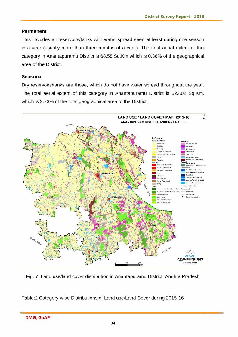
2. Land Utilization, Forest and Slope in the District 2.1 Land Use / Land Cover Classification
District Survey Report - 2018
DMG, GoAP 23
Land use/land cover mapping of Anantapuramu District was carried out by onscreen
interpretation techniques (NRSA, 2006). False colour composite images of IRS-P6
LISS-III images are used for preparation of these maps on 1:50,000 scale. Using the
satellite data, preliminary interpretation of various land use/land cover categories and
ground truth verification has been carried out and finally the following land use/land
cover classes are identified and mapped (Fig.7). The land use/land cover system
developed by National Remote Sensing Agency (NRSA, 2006) is utilized for this
study. Following is the description of different land use/land cover classes along with
their aerial extent (Table-2) and are presented.
Built-Up Land
Built-up areas are characterized by substitution of the original (semi-) natural cover or
water surface with an artificial, often impervious cover. This artificial cover is usually
characterized by long cover duration. Basically they are the area of human habitation
that has a cover of buildings, transport and communication, utilities in association with
water, vegetation and vacant lands. It consists of four level-2 classes namely – Urban
built-up, Rural, Industrial and Mining/Quarry. The total built-up land is 426.18 Sq.Km
which is 2.23% of the total geographical area of Anantapuramu District.
Built up - Compact (Continuous)
Most of the land is covered by buildings, roads and artificially surfaced area and cover
almost all the ground. The built up - compact class is assigned when the urban
structures and transport network (i.e. impermeable surfaces) occupy more than 80 %
of the surface area, like parking lots, concrete or asphalt surfaces, transport network,
small squares, pedestrian zones, yards, urban greenery areas, etc. The aerial extent
of this category is 55.51 Sq.Km. which is 0.29% of the total geographical area of
Anantapuramu District.
Built up - Sparse (Discontinuous)
Most of the land is covered by the structures like buildings, roads and artificially
surfaced areas associated with vegetated areas and bare soil, which occupy
discontinuous but significant surfaces. Between 30 and 80 % of the total surface
should be impermeable. This also includes scattered blocks of residential flats,
hamlets, small villages where numerous interstitial spaces (gardens, lawns) can be
District Survey Report - 2018
DMG, GoAP 24
distinguished. Large blocks of flats where green spaces, parking areas and
adventure playgrounds cover significant surface area. Transport network, sport area,
cemeteries with or without vegetation and Urban residential layouts marked for the
construction of residential houses are also included. The aerial extent of this category
in Anantapuram District is 32.18 Sq.Km. which is 0.17% of the total geographical area
of the District.
Vegetated / Open Area
These are vegetated areas within urban agglomeration (situated within or in contact
with urban areas). A polygon will be included in this category if vegetation cover of
trees, shrubs and herbs covers at least 5% of the total surface area. This also
includes parks, sport and leisure facilities, camping grounds, sports grounds, leisure
parks, golf courses, race courses, including formal parks etc. The aerial extent of this
category in Anantapuramu District is 19.88 Sq.Km. which is 0.10% of the total
geographical area of the District.
Built-Up Area - Rural
The classification is based on the proportion of people living in settlements defined as
rural (below 10,000 population) or living in certain hubs and which is more than 80%
of the people are involved in the primary activity of agriculture. All the agricultural
villages covering 5 hectares of areal extent and more are included in this category.
The aerial extent of this category in Anantapuramu District is 244.76 Sq.Km. which is
1.28% of the total geographical area of the District.
Industrial :
Non-linear impervious surfaces are included in this class which is related to trade,
manufacturing, distribution and commerce and are not occurring in continuity with
urban cover.
Industrial area
All the areas that are described above except for the areas under ash / cooling /
tailing pond, which are characterized by water saturation, are classified under this
category. These are artificially surfaced areas (with concrete, asphalt, tar macadam,
or stabilized, e.g. beaten earth) without vegetation, which also contains buildings
and/or vegetation. These are areas where the human activity is observed in the form
District Survey Report - 2018
DMG, GoAP 25
of manufacturing along with other supporting establishments of maintenance. They
cover heavy metallurgical industry, thermal, cement, petrochemical, engineering
plants, etc and Urban built-up areas with units equal or larger than 2.25 ha inside
commercial/industrial units. The aerial extent of this category in Anantapuramu
District is 34.85 Sq.Km. which is 0.18% of the total geographical area of the District.
Mining / Quarry
Mining / quarry areas encompass area under surface operations. The recognizable
impacts of these activities on the landscape are unmistakable giant pit mines covering
vast areas. The presence of water bodies does not necessarily imply inactive or
unused extractive areas. Ponds or lakes are often an integral part of an extractive
operation. This also includes Industrial complexes where the extracted material is
refined, packaged or further processed, Open-pit extraction often associated with
heaps of extracted building material (gravel, sand, stone or clays) or ore and non-ore
mineral material (iron, manganese ores, magnetite, lignite, brown coal, Kaolin etc.).
Mining - Active
These are the areas where large scale surface operations of removal of economically
important ores are presently going on. The aerial extent of this category in
Anantapuramu District is 0.32 Sq.Km.
Mining - Abandoned
These are the areas where large scale surface operations of removal of economically
important ores are carried out in the past, but presently kept abandoned due to
various reasons like, economic, operational, viability, disturbances, etc. The aerial
extent of this category in Anantapuram District is 0.07 Sq.Km.
Quarry
These are the manifestations of surface mining operations wherein small scale
excavation of land surface for sand, gravel, clay phosphate mines, limestone quarries
etc. are taking place. They are mostly characterized by its nearness to urban areas.
This also includes surface rocks and stone quarries, sand and gravel pits, brick kilns,
etc. The aerial extent of this category in Anantapuram District is 38.61 Sq.Km. which
is 0.20% of the total geographical area of the District.
District Survey Report - 2018
DMG, GoAP 26
Agricultural Land
These are the lands primarily used for agriculture for production of food, fiber, and
other commercial and horticultural crops. It includes land under crops (irrigated and
unirrigated, fallow, plantations, etc.). In a broad sense, agricultural lands may be
defined as those lands which are cultivated to produce food crops and related
activities. Native vegetation has largely been replaced by introduced species through
clearing, and sowing of new species. Under this, four Level-2 classes are included
namely cropland, fallow land, agricultural plantation and aquaculture. The aerial
extent of this category in Anantapuramu District is 13432.34 Sq.Km. which is 70.21%
of the total geographical area of the District.
Cropland
These are the areas with standing crop as on the date of satellite overpass. Cropped
areas appear in bright red to red in color with varying shape and size in a contiguous
to non-contiguous pattern. Three cropping seasons exist in India viz., kharif
(June/July-September/October), rabi (November/December-February/March) and
zaid (April-May).
Kharif Crop
These are cultivated between June/July to September/ October coinciding with SW
monsoon season. It is associated with rain-fed crops under dry land farming with
limited or no irrigation and areas of rain-fed paddy and other dry crops. The major un-
irrigated crops in the District are groundnut, un-irrigated cotton, jowar and pulses. The
aerial extent of this category in Anantapuramu District is 7934.17 Sq.Km. which is
41.47% of the total geographical area of the District.
Rabi Crop
These areas are cultivated between November / December to February / March. It is
associated with areas under assured irrigation irrespective of the source of irrigation.
However, rabi cropped areas also occur in rain-fed regions, under residual soil
moisture conditions especially in black soil areas with high rainfall during Kharif
season. The un-irrigated crops of Rabi season are cotton and groundnut. These Rabi
un-irrigated crops are seen mainly on the black soils. The aerial extent of this
District Survey Report - 2018
DMG, GoAP 27
category in Anantapuramu District is 1769.29 Sq.Km. which is 9.25% of the total
geographical area of the District.
Zaid Crop
These are the areas that are cropped during April - May (summer) which are mostly
associated with irrigated areas with fertile soils, confined to plains/delta areas. While
classifying areas under kharif/rabi/zaid, a prior knowledge about the area, ground
data, crop calendar of the area and interaction with local officials are necessary. The
aerial extent of this category in Anantapuramu District is 0.49 Sq.Km.
Cropped in 2 seasons
These are the areas that are cropped during two cropping seasons that are often
seen associated with irrigated areas. Three combinations are possible in this category
viz., Kharif + Rabi, Kharif + Zaid and Rabi + Zaid. Kharif and Rabi cropped areas are
the areas mostly in command areas and have two crops grown in kharif and rabi
seasons. The aerial extent of this category in Anantapuramu District is 2362.74
Sq.Km. which is 12.35% of the total geographical area of the District. Double crop is
prevalent under the ayacuts/reservoirs like Bhairavanitippa, Upper Penner, Chennaya
Swamy gudi project, Tungabhadra project high level canal stage-I and stage-II, tanks
like Gooti tank, Ananthasagar, Singanamala and many other medium tanks and the
commands of the bore wells. The double crop is mainly seen in mandals namely
Kanekal, Bommanahal, Gummagatta, Tadipatri, Putlur, Garladinne,
Bukkarayasamudram, Kotha Cheruvu, Lepakshi, Hindupur, Pamidi, Singanamala and
Vidapanakal. The crops are paddy, irrigated groundnut, cotton, sugarcane, jowar, ragi
and vegetables.
Cropped in more than 2 seasons
These are the areas which are cropped in more than two cropping seasons. It
includes triple cropped areas (kharif, rabi and zaid), areas under multiple cropping.
Long duration crops like sugarcane, cotton, banana, pineapple, etc., need to be
considered classifying under this category. The aerial extent of this category in
Anantapuramu District is 3.95 Sq.Km which is 0.02% of the total geographical area of
the District.
District Survey Report - 2018
DMG, GoAP 28
Fallow Land
These are the lands, which are taken up for cultivation but are temporarily allowed to
rest, un-cropped for one or more season, but not less than one year and for not more
than five years. Very small patches of fallow lands have been identified because un-
irrigated groundnut is grown even along the slope of the hills. The aerial extent of this
category in Anantapuramu District is 1285.45 Sq.Km which is 6.72% of the total
geographical area of the District.
Agricultural Plantation
These are the areas under agricultural tree crops planted adopting agricultural
management techniques. These also include the areas of land use systems and
practices wherein cultivation of herbs, shrubs, and vegetable crops are deliberately
integrated with agricultural crops mostly in irrigated conditions for ecological and
economic reasons, for example permanent commercial crops like coffee, mulberry,
tea, rubber, etc., which are normally grown in the hilly regions and are closely
associated with forest cover; Plantations of berry shrubs, rasberries, gooseberries,
blackberry crops etc. The aerial extent of this category in Anantapuramu District is
76.24 Sq.Km. which is 0.40% of the total geographical area of the District.
Forest
The term forest is used to refer to land with a tree canopy cover of more than 10
percent and area of more than 0.5 ha. Forest is determined both by the presence of
trees and the absence of other predominant land uses within the notified forest
boundaries. The trees should be able to reach a minimum height of 5 m within the
notified forest boundaries. This also includes forest stands on agricultural lands (e.g.
windbreaks and shelterbelts of trees with a width of more than 20 m). The total aerial
extent of this category in Anantapuramu District is 1802.42 Sq.Km. which is 9.42% of
the total geographical area of the District. The District is not rich in the forest wealth.
The name 'Forest' in Ananthapuramu District does not indicate any dense tree
population with thick foliage of variform of pastures. The forests in the District are thin
and scanty. The Muchukota Hills about 35 Kms in length, run from north of Gooty
town up to extreme southern corner of Tadipatri and Yadiki mandals. Another line of
Hills starts from west of Gooty mandal and runs 80 Kms called by name
Nagasamudram hills. The Mallappakonda Range begins at Dharmavaram and runs
District Survey Report - 2018
DMG, GoAP 29
into Karnataka State. The Penukonda Range which starts in the south of
Dharmavaram through Penukonda and Hindupur proceeds to Karnataka State. In
Madakasira, the hills divide Rolla and Agali mandals into southern and northern
portions. These hill ranges cover some forest cover.
Deciduous (Moist/Dry/Thorn)
This applies to the phonology of perennial plants that are leafless for a certain period
of the year. The leaf shedding usually takes place simultaneously in connection with
the unfavourable season. This category is predominantly composed of species, which
shed their leaves once a year, especially during summer. These are mostly broad
leaved tropical forests with a tendency to shed their leaves annually. Delineation of
two sub-categories is possible using satellite data under level III viz., dense/ closed
and open, based on the canopy cover/ density. The aerial extent of deciduous forest
dense category is 61.60 Sq.Km in Anantapuramu District which is 0.32% of the total
geographical area of the District. The aerial extent of deciduous forest open category
is 609.60 Sq.Km in Anantapuramu District which is 3.19% of the total geographical
area of the District. Deciduous (dense) forest is identified in Bukkapatnam mandal,
Raptadu mandal, near Mudigubba and Kadiri mandals.
Forest Plantation
These are the areas of tree species of forestry importance, raised and managed
especially in notified forest areas. Most of these are located in uplands, coastal areas
within notified areas. Many of these can be identified based on the sharp boundary
exhibited by them. This also includes Teak, Sal, Eucalyptus, Casuarinas, Bamboo,
etc. The aerial extent of this category in Anantapuramu District is 0.56 Sq.Km.
Scrub Forest
These are the forest areas which are generally seen at the fringes of dense forest
cover and settlements, where there is biotic and abiotic interference. Most times, they
are located closer to habitations. Forest blanks which are the openings amidst forest
areas, devoid of tree cover, observed as openings of assorted size and shapes as
manifested on the imagery are also included in this category. The aerial extent of this
category in Anantapuramu District is 1120.42 Sq.Km. which is 5.86% of the total
geographical area of the District.
District Survey Report - 2018
DMG, GoAP 30
Tree Clad Area
Areas with tree cover lying outside the notified forest area with woody perennial plant
with a single, well-defined stem carrying a more-or-less-defined crown and being at
least 3 m tall. Plants essentially herbaceous but with a woody appearance (e.g.
bamboos and ferns) are also classified as trees if the height is more than 5 m and as
shrubs if the height is less than 5 m. Delineation of two sub-categories is possible
using satellite data under level III viz., dense/ closed and open, based on the canopy
cover/ density. The aerial extent of tree-clad area (dense) category is 9.54 Sq.Km in
Anantapuramu District which is 0.05% of the total geographical area of the District.
The aerial extent of tree clad area (open) category is 0.70 Sq.Km in Anantapuramu
District.
Wastelands
Wasteland is described as degraded land which can be brought under vegetative
cover with reasonable effort and which is currently underutilized, and land which is
deteriorating for lack of appropriate water and soil management or on account of
natural causes. Wastelands can result from inherent/imposed disabilities such as by
location, environment, chemical and physical properties of the soil or financial or
management constraints. The total aerial extent of this category in Anantapuramu
District is 2442.48 Sq.Km which is 12.77% of the total geographical area of the
District.
Salt-Affected Land
When salts more soluble than calcium carbonate and gypsum are present in the soil
and effect crop and yield of most crops, these soils are considered salt affected.
Salinization can result from improper management of canal irrigation water resulting
in the rise of water table and consequent accumulation of salts in the root zone in
arid, semi-arid and sub humid (dry) conditions and ingress of sea water in coastal
regions and/or use of high-salt containing ground water. The aerial extent of this
category in Anantapuramu District is 264.97 Sq.Km which is 1.39% of the total
geographical area of the District. These lands have been identified in Ananthapuram,
Peddavaduguru, Gooty, Dharmavaram and Kundurpi mandals.
Ravenous Land
District Survey Report - 2018
DMG, GoAP 31
The word ravine is usually associated not with an isolated gully but an intricate
network of gullies formed generally in deep alluvium and entering a nearby river,
flowing much lower than the surrounding. Ravines are basically extensive systems of
gullies developed along the river course. The aerial extent of this category in
Anantapuramu District is 0.28 Sq.Km.
Scrub Land
This is a land, which is generally prone to deterioration due to erosion. Such lands
generally occupy topographically high locations, excluding hilly/ mountainous terrain.
Scrublands are associated with moderate slopes in plains and foothills and are
generally surrounded by agricultural lands.
Dense Scrub
These areas possess shallow and skeletal soils, at times chemically degraded,
extremes of slopes, severely eroded and lands subjected to excessive aridity with
scrubs dominating the landscape. They have a tendency for intermixing with cropped
areas. The total aerial extent of this category in Anantapuramu District is 622.42
Sq.Km which is 3.25% of the total geographical area of the District.
Open Scrub
This category has a similar description as mentioned in the earlier class excepting
that they possess sparse vegetation or devoid of scrub and have a thin soil cover.
The total aerial extent of this category in Anantapuramu District is 1032.21 Sq.Km
which is 5.40% of the total geographical area of the District.
Riverine sand
Riverine sands are those that are seen as accumulations in the flood plain as sheets
which are the resultant phenomena of river flooding. The sandy areas occurring within
or in continuity to river course are to be excluded from this category. The total aerial
extent of this category in Anantapuramu District is 4.47 Sq.Km. which is 0.02% of the
total geographical area of the District.
Barren/Rocky/Stony Waste
District Survey Report - 2018
DMG, GoAP 32
This class contains areas that are either dominated by a continuous rock surface or
covered by a coarse rock fragments. Rock surface is continuous with some areas
may be covered by shallow layer of soil. The total aerial extent of this category in
Anantapuramu District is 2442.48 Sq.Km which is 2.71% of the total geographical
area of the District. These areas have been identified and mapped in Ramagiri,
Tadipatri, Yellanur, Tadimarri, C.K.Palli mandals.
Wetland
All submerged or water-saturated lands, natural or man-made, inland or coastal,
permanent or temporary, static or dynamic which necessarily have a land-water
interface are defined as wetlands. Hence, the portions of water body (partial or full)
having emergent vegetation or observable submerged vegetation is placed in the
Wetlands category.
Water Body
This category comprises areas with surface water, either impounded in the form of
ponds, lakes and reservoirs or flowing as streams, rivers, canals, etc. These are seen
clearly on the satellite image in blue to dark blue or cyan color depending on the
depth of water. If lake or reservoir is a part of river system, then the boundary
demarcation between streams and lakes / reservoirs or the ocean can be the straight
line across the mouth of the stream. The total aerial extent of this category in
Anantapuramu District is 1027.24 Sq.Km which is 5.37% of the total geographical
area of the District.
River /Stream
Rivers/streams are natural course of water flowing on the land surface along a
definite channel/slope regularly or intermittently towards a sea in most cases or a lake
or an inland basin in desert areas or a marsh or another river.
Perennial
These are the rivers/streams that flow continuously throughout the year. The total
aerial extent of this category in Anantapuramu District is 1.29 Sq.Km. which is 0.01%
of the total geographical area of the District.
District Survey Report - 2018
DMG, GoAP 33
Non Perennial
The water covers the surface for less than nine months in each year. This also
includes the dry part of river generally characterized by the presence of sand or
exposed rocks. The total aerial extent of this category in Anantapuramu District is
357.04 Sq.Km. which is 1.87% of the total geographical area of the District.
Canal / Drain
Canals and drains are artificial water course constructed for irrigation, navigation or to
drain out excess water from agricultural lands. The total aerial extent of this category
in Anantapuramu District is 77.97 Sq.Km which is 0.41% of the total geographical
area of the District.
Lakes / Ponds
These are accumulation of water in a depression of various sizes either natural or
saline. Areas of tailings and abandoned pits and quarries may remain recognizable
for a long time due to presence of water is to be classified under this category.
Permanent
Perennial lakes/ponds are those that retain water in them either for more than one
season (usually more than three months of a year), or throughout the year and
usually not subjected to extreme fluctuation in water level. Ponds are body of water
limited in size, either natural or artificial, regular in shape, smaller in size than a lake,
generally located near settlement. The total aerial extent of this category in
Anantapuramu District is 0.19 Sq.Km.
Reservoir / Tanks
Reservoir is an artificial lake created by construction of a dam across the river
specifically for hydel power generation, irrigation, and water supply for domestic/
industrial needs, flood control, either singly or in combination. Tanks are small lakes
of impounded water ways constructed on land surface for irrigation. They are
associated with croplands, low lands and reservoirs surrounded by hills without
vegetation.
District Survey Report - 2018
DMG, GoAP 34
Permanent
This includes all reservoirs/tanks with water spread seen at least during one season
in a year (usually more than three months of a year). The total aerial extent of this
category in Anantapuramu District is 68.58 Sq.Km which is 0.36% of the geographical
area of the District.
Seasonal
Dry reservoirs/tanks are those, which do not have water spread throughout the year.
The total aerial extent of this category in Anantapuramu District is 522.02 Sq.Km.
which is 2.73% of the total geographical area of the District.
Fig. 7 Land use/land cover distribution in Anantapuramu District, Andhra Pradesh
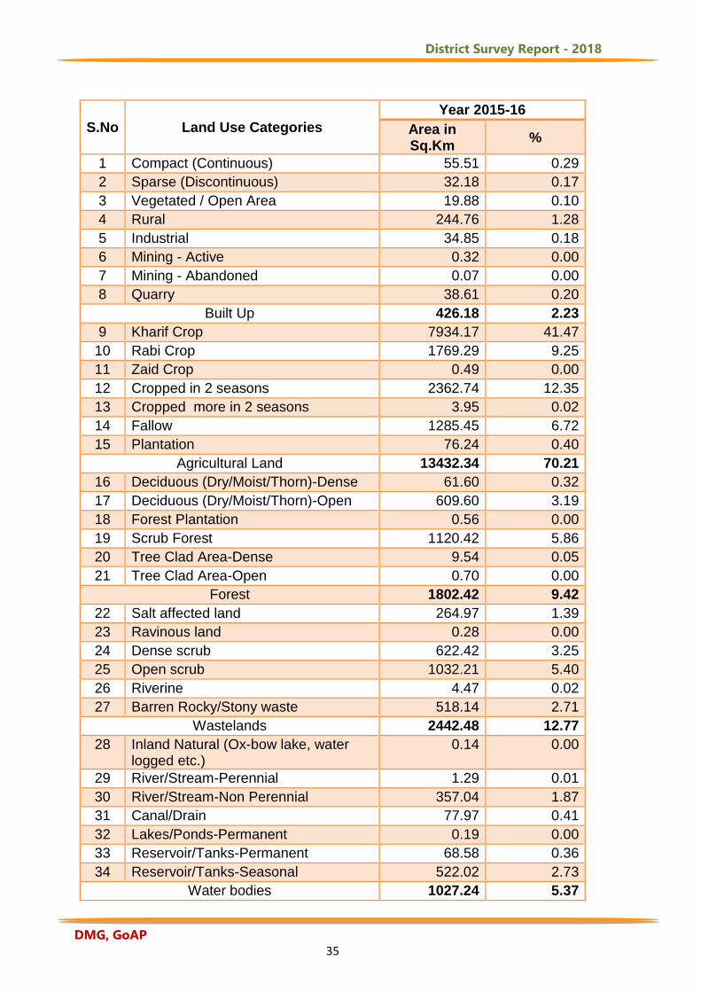
Table:2 Category-wise Distributions of Land use/Land Cover during 2015-16
District Survey Report - 2018
DMG, GoAP 35
S.No Land Use Categories
Year 2015-16
Area in Sq.Km
%
1 Compact (Continuous) 55.51 0.29
2 Sparse (Discontinuous) 32.18 0.17
3 Vegetated / Open Area 19.88 0.10
4 Rural 244.76 1.28
5 Industrial 34.85 0.18
6 Mining - Active 0.32 0.00
7 Mining - Abandoned 0.07 0.00
8 Quarry 38.61 0.20
Built Up 426.18 2.23
9 Kharif Crop 7934.17 41.47
10 Rabi Crop 1769.29 9.25
11 Zaid Crop 0.49 0.00
12 Cropped in 2 seasons 2362.74 12.35
13 Cropped more in 2 seasons 3.95 0.02
14 Fallow 1285.45 6.72
15 Plantation 76.24 0.40
Agricultural Land 13432.34 70.21
16 Deciduous (Dry/Moist/Thorn)-Dense 61.60 0.32
17 Deciduous (Dry/Moist/Thorn)-Open 609.60 3.19
18 Forest Plantation 0.56 0.00
19 Scrub Forest 1120.42 5.86
20 Tree Clad Area-Dense 9.54 0.05
21 Tree Clad Area-Open 0.70 0.00
Forest 1802.42 9.42
22 Salt affected land 264.97 1.39
23 Ravinous land 0.28 0.00
24 Dense scrub 622.42 3.25
25 Open scrub 1032.21 5.40
26 Riverine 4.47 0.02
27 Barren Rocky/Stony waste 518.14 2.71
Wastelands 2442.48 12.77
28 Inland Natural (Ox-bow lake, water logged etc.)
0.14 0.00
29 River/Stream-Perennial 1.29 0.01
30 River/Stream-Non Perennial 357.04 1.87
31 Canal/Drain 77.97 0.41
32 Lakes/Ponds-Permanent 0.19 0.00
33 Reservoir/Tanks-Permanent 68.58 0.36
34 Reservoir/Tanks-Seasonal 522.02 2.73
Water bodies 1027.24 5.37
District Survey Report - 2018
DMG, GoAP 36
Grand Total 19130.66 100.00
2.2 Slope of Anantapuramu District The concept of measuring slope from a topographic map is a familiar one for
most professionals in the natural resources and landscape planning / management
and surveying professions. Slope is a measurement of how steep the ground surface
is. Steeper the ground surface is, greater the slope. Slope is measured by calculating
the tangent of the surface. The tangent is calculated by dividing the vertical change in
elevation by the horizontal distance. Slope is normally expressed in planning as a
percent slope which is the tangent (slope) multiplied by 100. Percent Slope = Height /
Base * 100 (NRSC, 2009).
Reliable estimation of the stability of slopes and foundations is very demanding
because it is important for terrain analysis to understand the natural process in the
disciplines of topography, geology, soils, hydro-geology, infrastructure planning,
hazard management both at surface and subsurface. In view of this, slope plays an
important role while doing decentralized planning at grassroots level. Traditionally,
contour information from 1:50,000 or 1:25,000 topographic maps are used for
preparation of slope by manual procedure based contour value difference for unit
horizontal distance. The emergence of remote sensing & GIS systems and the
availability of topographic data in DEM or TIN formats, slope maps can be generated
using image processing and GIS methods. Representation of slope in percentage is
understandable rationale for the resource mapping and planning. Slope information is
one of the GIS layers that play an important role in natural resources and district
planning process. Necessary slope layer is generated from the available digital
topographic data such as Carto DEM and open source Digital Elevation Model data
(NRSC, 2009).
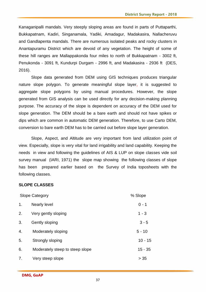
From Fig.8 it is observed that level to nearly level slope is observed in parts of
Bommanahal, Uravakonda, Kanekal, Peddavaduguru, Singanamala and Tadipatri
mandals. Gently sloping areas are observed in Kudair, Pamidi, Guntakal, Tanakal,
N.P.Kunta, Gorantla, and Talupula mandals. Moderately sloping areas are observed
in parts of Tadimarri, Putlur, Narpala, Peddapappur, C.K.Palli, Ramagiri and
District Survey Report - 2018
DMG, GoAP 37
Kanaganipalli mandals. Very steeply sloping areas are found in parts of Puttaparthi,
Bukkapatnam, Kadiri, Singanamala, Yadiki, Amadagur, Madakasira, Nallacheruvu
and Gandlapenta mandals. There are numerous isolated peaks and rocky clusters in
Anantapuramu District which are devoid of any vegetation. The height of some of
these hill ranges are Mallappakonda four miles to north of Bukkapatnam - 3002 ft,
Penukonda - 3091 ft, Kundurpi Durgam - 2996 ft, and Madakasira - 2936 ft (DES,
2016).
Slope data generated from DEM using GIS techniques produces triangular
nature slope polygon. To generate meaningful slope layer, it is suggested to
aggregate slope polygons by using manual procedures. However, the slope
generated from GIS analysis can be used directly for any decision-making planning
purpose. The accuracy of the slope is dependent on accuracy of the DEM used for
slope generation. The DEM should be a bare earth and should not have spikes or
dips which are common in automatic DEM generation. Therefore, to use Carto DEM,
conversion to bare earth DEM has to be carried out before slope layer generation.
Slope, Aspect, and Altitude are very important from land utilization point of
view. Especially, slope is very vital for land irrigability and land capability. Keeping the
needs in view and following the guidelines of AIS & LUP on slope classes vide soil
survey manual (IARI, 1971) the slope map showing the following classes of slope
has been prepared earlier based on the Survey of India toposheets with the
following classes.
SLOPE CLASSES
Slope Category % Slope
1. Nearly level 0 - 1
2. Very gently sloping 1 - 3
3. Gently sloping 3 - 5
4. Moderately sloping 5 - 10
5. Strongly sloping 10 - 15
6. Moderately steep to steep slope 15 - 35
7. Very steep slope > 35
District Survey Report - 2018
DMG, GoAP 38
The above slope classes had to be derived from the Survey of India
topographical sheets on 1: 50, 000 scale based on the intensity of contours and
contour interval.
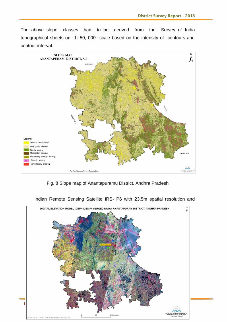
Fig. 8 Slope map of Anantapuramu District, Andhra Pradesh Indian Remote Sensing Satellite IRS- P6 with 23.5m spatial resolution and
District Survey Report - 2018
DMG, GoAP 39
Cartosat-I with 2.5m spatial resolution is fused and the hybrid satellite data is draped
over Digital Elevation Model of Anantapuramu District, Andhra Pradesh. From the
map (Fig. 9), it is observed that the southern and eastern parts of the District are
covered with hilly areas. The Mutchkota hills about 35Km in length run from north of
Gooty up to extreme southern corner of Tadipatri and Yadiki mandals. Another line of
hills starts from west of Gooty mandal and runs 80Km called Nagasamudram hills.
The Mallappakonda range begins at Dharmavaram and runs in to Karnataka State.
The Penukonda range which starts from south of Dharmavaram through Penukonda
and Hindupur proceeds to Karnataka State. In Madakasira, the hill divides Rolla and
Agali mandals in to southern and northern portions.
Fig. 9. Satellite Image Draped Over Digital Elevation Model of Anantapuramu District,
Andhra Pradesh
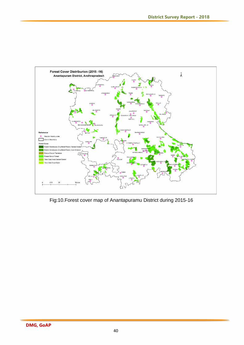
2.3 Forest Cover Distribution The forest cover in the District is based on the interpretation of IRS R2 LISS III data
(2015-16) and the area is 1802.42 sq. km which is 9.42% of the total geographical
area (TGA) of the District. As per the land use manual (NRSC, 2016), the forest of the
District can be classified into 6 forest classes and class-wise areas are presented in
Table-3. The spatial distribution of forest cover in the District is shown in Table:3.
Table:3 Forest Cover Distribution of Anantapuramu District
S. No
Forest Category ( 2015 - 16) Area in sq. km.
% to Total Geographical area
1 Deciduous (Dry/Moist/Thorn)-Dense 61.60 0.32
2 Deciduous (Dry/Moist/Thorn)-Open 609.60 3.19
3 Forest Plantation 0.56 0.00
4 Scrub Forest 1120.42 5.86
5 Tree Clad Area-Dense 9.54 0.05
6 Tree Clad Area-Open 0.70 0.00
Forest 1802.42 9.42
District Survey Report - 2018
DMG, GoAP 40
Fig:10.Forest cover map of Anantapuramu District during 2015-16
District Survey Report - 2018
DMG, GoAP 41
3. Agriculture and Soils
The total geographical area of the District is 19.13 lakh ha. The net area sown
is 8.49 Lakh ha, which forms 44.38% of the total area. The total cropped area is 9.21
Lakh ha. Area sown more than once is 0.72 Lakh ha. The cultivated area of the
District is 9.21 Lakh ha out of which 7.59 Lakh ha is under Kharif, and 6.62 Lakh ha,
is under Rabi Season during the year 2015-16. The District occupies the lowest
position in respect of Irrigation facilities with only 18.89% of the gross cropped area
during 2015-16. Out of the gross irrigated area of 1.74 Lakh ha during 2015-16 canals
accounted for 8.39%, tanks 2.11%, Tube wells 88.59%, Dug wells 0.18% and other
sources 0.73 %. All the principal sources except canals are non-precarious (DES,
2016).
3.1 Groundnut crop acreage estimation and yield behaviour in mid season for
production estimates using Remote sensing technique in Anantapuramu
District of Andhra Pradesh
The timely and reliable agricultural information is important in the decision
making process at international, national and state levels. Crop inventory is one of the
most important elements in agricultural information system as it decides total crop
production when integrated with yield forecast. Area estimation under different crops
during the cropping season has been practiced in our country for a long time from the
conventional procedures. However, the traditional methods of area and production
estimates do not maintain the timeless value of the estimate and are also not free
from errors in operational scenario. The remote sensing using space–borne sensors
is a tool, par excellence, for crop identification and area estimation at mandal to
national scale.
Remote sensing applications to agriculture have grown to a stage where such
inputs are being used for a number of policy level decisions related to food security,
poverty alleviation and sustainable development in the country. Decision on buffer
stock of food grains could be based on pre-harvest crop acreage and production
District Survey Report - 2018
DMG, GoAP 42
estimation. Monitoring crop condition with remote sensing can get the condition of
crop, as well as the status and trend of their growth. It also helps to acquire the crop
production information. Acquiring the crop condition and pre-harvest crop
yield/production information at early stages of crop growth is even more important
than acquiring the exact production after harvest time, especially when large scale
commissariat shortage or surplus happens. Anantapuramu is a perennially drought
affected district of Andhra Pradesh and the major kharif crop is groundnut that
contributes 6 to 8 lakh ha in kharif season per year. MODIS time series have been
used to analyze crop phenological changes and to discriminate vegetation types at
regional and global scales. Improvements in the timeliness and accuracy of yield
forecasting by incorporating near real-time remote sensing data and the use of
sophisticated statistical methods can improve our capacity to respond effectively to
these challenges. Satellite data of ten year time series (2008–2017) of 16-Day
composite, Global 250m product (MOD13Q1) and Groundnut yield data from 2008 to
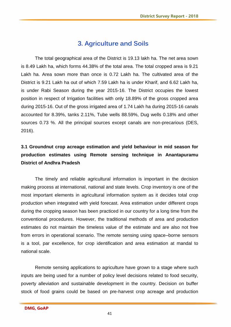
2016 are used for yield assessment (Fig.11).
Fig: 11 Groundnut crop acreage during Kharif (2017) at mandal level in Anantapuramu District
District Survey Report - 2018
DMG, GoAP 43
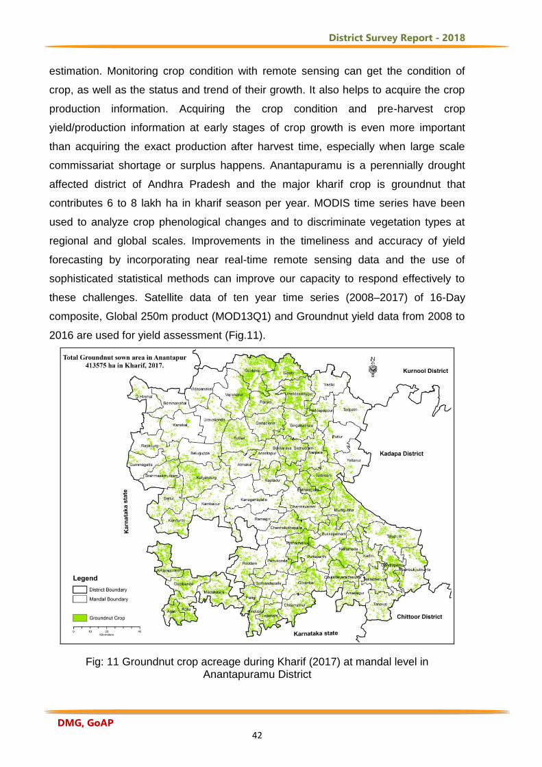
3.2 Groundnut crop acreage during Kharif (2017) at mandal level, Anantapuramu District Table : 4 Groundnut crop acreage during Kharif (2017)
DMcode
Mandal Name
Groundnut
Cropped area in
ha.
DMcod
e Mandal Name
Groundnut
Cropped area in
ha.
1262 Agali 5644 1259 Madakasira 9944
1245 Amadagur 4581 1238 Mudigubba 18000
1261 Amarapuram 9175 1240 Nambulipulikunta 4406
1225 Anantapuramu 6656 1242 Nallacheruvu 8969
1224 Atmakur 3800 1247 Nallamada 6719
1226 Bukkaraya Samudram
8875 1227 Narpala 7113
1231 Bathalapalle 3313 1246 Obuladevaracheruvu
9200
1216 Beluguppa 1138 1212 Pamidi 7894
1202 Bommanahal 4975 1258 Parigi 4988
1220 Brahmasamudram 7694 1210 Peddapappur 4100
1250 Bukkapatnam 7588 1207 Peddavadugur 14000
1236 Chennekothapalle 7769 1252 Penukonda 4388
1255 Chilamathur 7375 1228 Putlur 3131
1201 D.Hirehal 1863 1249 Puttaparthi 8463
1237 Dharmavaram 7531 1235 Ramagiri 1544
1243 Gandlapenta 6294 1232 Raptadu 4363
1213 Garladinne 8388 1218 Rayadurg 3719
1206 Gooty 13713 1253 Roddam 6119
1248 Gorantla 9419 1263 Rolla 7025
1260 Gudibanda 7281 1221 Settur 5800
1219 Gummagatta 1738 1211 Singanamala 10000
1205 Guntakal 17781 1254 Somandepalle 4181
1257 Hindupur 5663 1230 Tadimarri 10106
1244 Kadiri 5506 1209 Tadpatri 1188
1223 Kalyandurg 12575 1239 Talupula 7844
1234 Kambadur 3581 1241 Tanakal 4838
1233 Kanaganapalle 2138 1215 Uravakonda 4725
1217 Kanekal 1875 1204 Vajrakarur 9106
1251 Kothacheruvu 8325 1203 Vidapanakal 1381
1214 Kudair 10319 1208 Yadiki 3100
District Survey Report - 2018
DMG, GoAP 44
1222 Kundurpi 6238 1229 Yellanur 1375
1256 LEPAKSHI 7044 Total 413575
Note: Total Groundnut cropped area in Anantapuramu District is 413575 ha up to 29th
September, 2017 based on satellite data
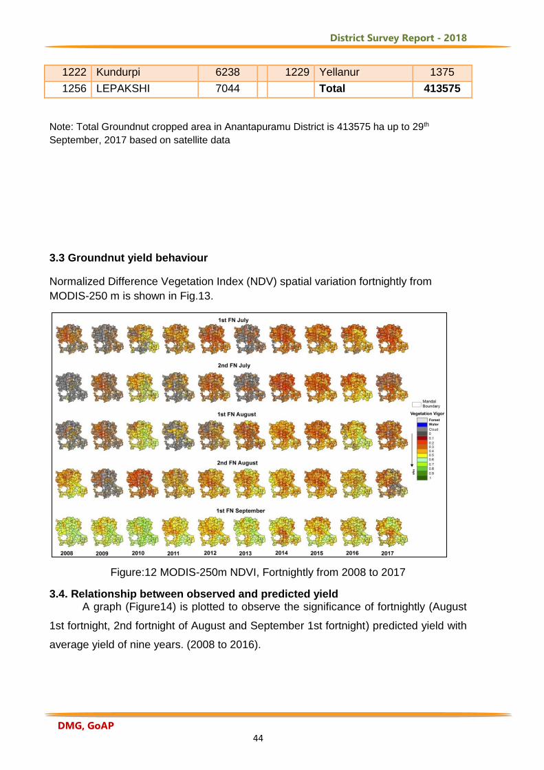
3.3 Groundnut yield behaviour
Normalized Difference Vegetation Index (NDV) spatial variation fortnightly from
MODIS-250 m is shown in Fig.13.
Figure:12 MODIS-250m NDVI, Fortnightly from 2008 to 2017
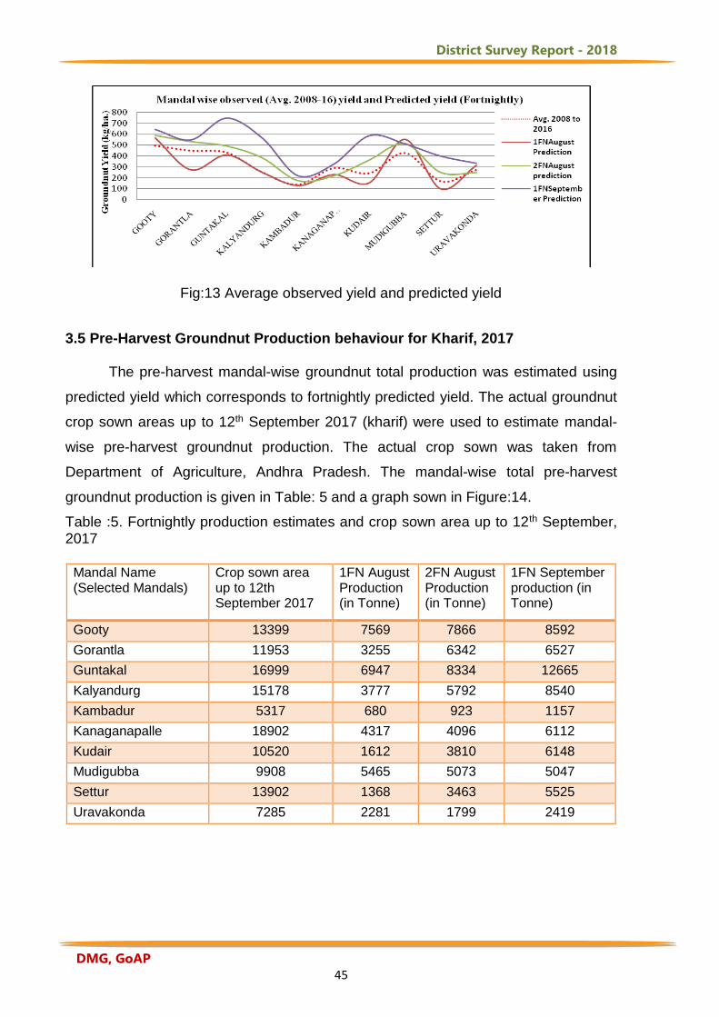
3.4. Relationship between observed and predicted yield A graph (Figure14) is plotted to observe the significance of fortnightly (August
1st fortnight, 2nd fortnight of August and September 1st fortnight) predicted yield with
average yield of nine years. (2008 to 2016).
District Survey Report - 2018
DMG, GoAP 45
Fig:13 Average observed yield and predicted yield
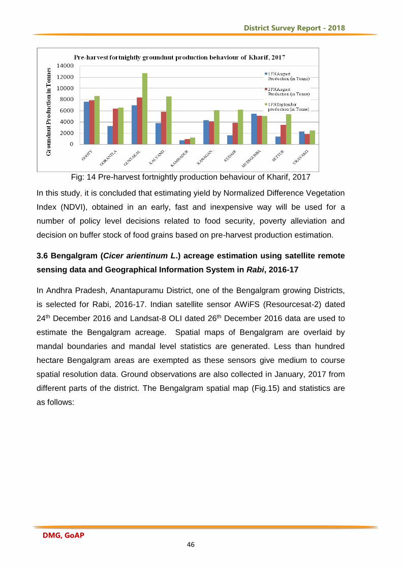
3.5 Pre-Harvest Groundnut Production behaviour for Kharif, 2017 The pre-harvest mandal-wise groundnut total production was estimated using
predicted yield which corresponds to fortnightly predicted yield. The actual groundnut
crop sown areas up to 12th September 2017 (kharif) were used to estimate mandal-
wise pre-harvest groundnut production. The actual crop sown was taken from
Department of Agriculture, Andhra Pradesh. The mandal-wise total pre-harvest
groundnut production is given in Table: 5 and a graph sown in Figure:14.
Table :5. Fortnightly production estimates and crop sown area up to 12th September, 2017
Mandal Name (Selected Mandals)
Crop sown area up to 12th September 2017
1FN August Production (in Tonne)
2FN August Production (in Tonne)
1FN September production (in Tonne)
Gooty 13399 7569 7866 8592
Gorantla 11953 3255 6342 6527
Guntakal 16999 6947 8334 12665
Kalyandurg 15178 3777 5792 8540
Kambadur 5317 680 923 1157
Kanaganapalle 18902 4317 4096 6112
Kudair 10520 1612 3810 6148
Mudigubba 9908 5465 5073 5047
Settur 13902 1368 3463 5525
Uravakonda 7285 2281 1799 2419
District Survey Report - 2018
DMG, GoAP 46
Fig: 14 Pre-harvest fortnightly production behaviour of Kharif, 2017
In this study, it is concluded that estimating yield by Normalized Difference Vegetation
Index (NDVI), obtained in an early, fast and inexpensive way will be used for a
number of policy level decisions related to food security, poverty alleviation and
decision on buffer stock of food grains based on pre-harvest production estimation.
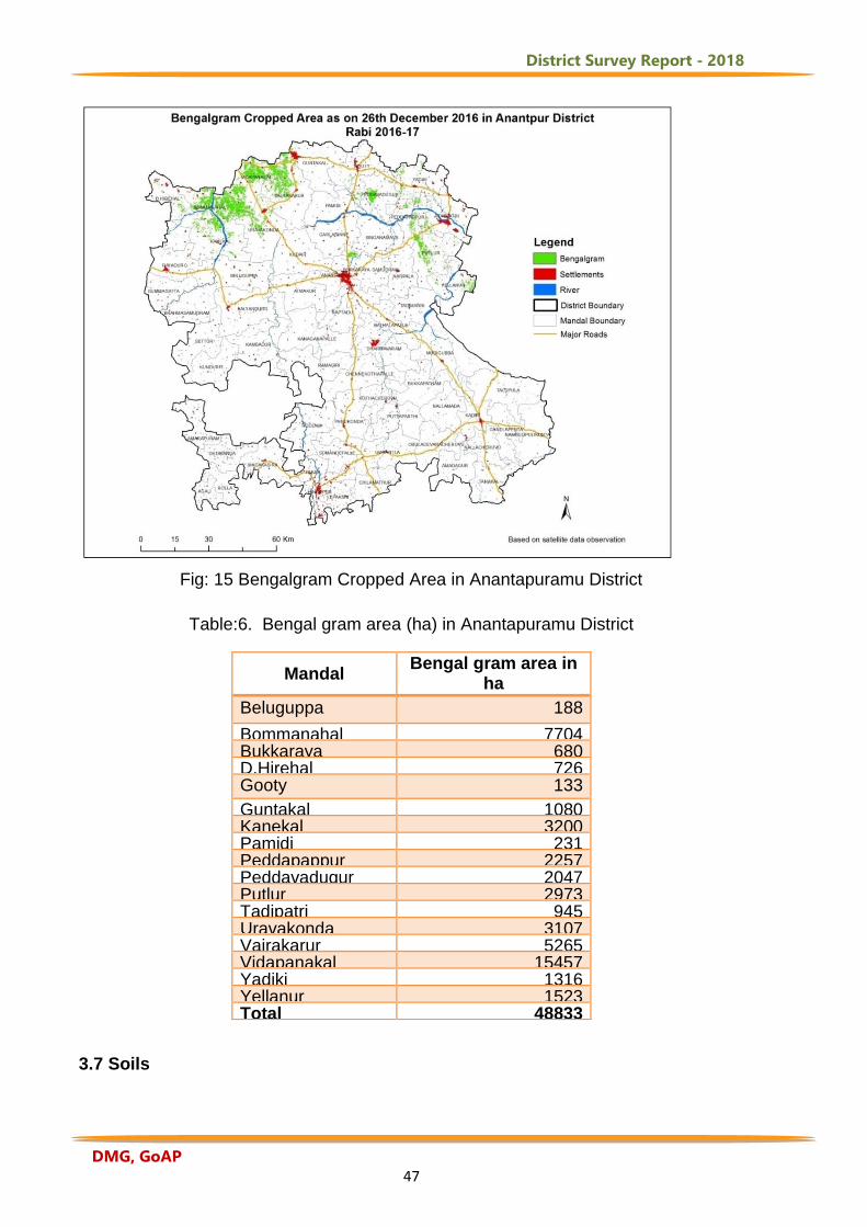
3.6 Bengalgram (Cicer arientinum L.) acreage estimation using satellite remote
sensing data and Geographical Information System in Rabi, 2016-17
In Andhra Pradesh, Anantapuramu District, one of the Bengalgram growing Districts,
is selected for Rabi, 2016-17. Indian satellite sensor AWiFS (Resourcesat-2) dated
24th December 2016 and Landsat-8 OLI dated 26th December 2016 data are used to
estimate the Bengalgram acreage. Spatial maps of Bengalgram are overlaid by
mandal boundaries and mandal level statistics are generated. Less than hundred
hectare Bengalgram areas are exempted as these sensors give medium to course
spatial resolution data. Ground observations are also collected in January, 2017 from
different parts of the district. The Bengalgram spatial map (Fig.15) and statistics are
as follows:
District Survey Report - 2018
DMG, GoAP 47
Fig: 15 Bengalgram Cropped Area in Anantapuramu District
Table:6. Bengal gram area (ha) in Anantapuramu District
Mandal Bengal gram area in
ha
ha ha. Beluguppa 188
Bommanahal 7704 Bukkaraya Samudram
680 D.Hirehal 726 Gooty 133
Guntakal 1080 Kanekal 3200 Pamidi 231 Peddapappur 2257 Peddavadugur 2047 Putlur 2973 Tadipatri 945 Uravakonda 3107 Vajrakarur 5265 Vidapanakal 15457 Yadiki 1316 Yellanur 1523 Total 48833
3.7 Soils
District Survey Report - 2018
DMG, GoAP 48
Soils differ greatly in their morphological, physico-chemical and mineralogical
properties. These differences affect the response of the soils to management inputs.
For appraising the productivity of the soils and for preparation of perspective plan for
land use and soil conservation for sustainable development, one needs to have
thorough knowledge of the kind and distribution of different soils of the area
(APSRAC, 1997). The soils in Ananthapuramu District are predominantly red except
Kanekal, Bommanahal, Vidapanakal, Uravakonda, Vajrakarur, Guntakal, Gooty,
Pamidi, Peddavadugur, Yadiki, Tadipatri, Yellanur, Peddapappur and Putlur mandals
(Fig. 10). In these mandals, red and black soils occur almost in equal proportion.
Thus, 76% are red soils, 24% black soils (DES, 2016). The classification of soils of
Anantapuramu District according to Soil Taxonomy places them in the orders of
Entisols, Inceptisols, Vertisols,and Alfisols. These are further divided in to sub-order,
great groups and sub-groups in each of the orders which have a number of soil
series. Soil is mostly from disintegrated gneisses though occasional quartz zone
formations are seen here and there. On the whole, the soil in the division is more or
less red sandy ferruginous loam and shallow in depth and mostly the forest areas are
heavily grazed and subject to annual fires. The surface is devoid of any humus except
in a few sheltered valleys. In some rare plain portions and valleys, deep sandy to
clayey loam is met with. The depth of soil in such localities gradually decreases as it
approaches the hill slopes where it tends to be loose and boulder. It is often gravelly
and occasionally mixed with boulders of varying sizes and varies from red sandy
ferruginous to clayey loam. The top soil in some of the plain portions of the Panchayat
reserve forests is saline. Black cotton soils occur in Gooty range especially in north
western and eastern portions of it. Sandy soil occurs in Yellanur reserve forests of
Gooty range (Fig.16).
District Survey Report - 2018
DMG, GoAP 49
Salt accumulation process represents a form of chemical degradation that has
taken place over a period of time due to climate and faulty management practices. In
Anantapuramu District, about 1750 ha area (2.2%) is salt affected. Major salt affected
area is situated in Anantapuramu (4.8%), Tadipatri (4%) taluks (NBSS&LUP, 2008).
Nearly 75% of the area is free from any kind of salt problems. In remaining areas it is
noticed in small pockets. Sodic moderate soils are observed in parts of Rayadurg,
D.Herehal and Settur mandals. Sodic slight soils are distributed in Raptadu,
Bathalapalli, Kanaganipalli and Dharmavaram mandals (Fig.17).
Fig.16 Distribution of Soil Resources in Anantapuramu District, Andhra Pradesh
District Survey Report - 2018
DMG, GoAP 50
Fig. 17 Distribution of salt-affected soils in Anantapuramu District, Andhra Pradesh 3.8. Horticulture Development in Anantapuramu District:
Anantapuramu, popularly known as the ‘fruit hub’ of Andhra Pradesh, is all set
to increase horticulture and floriculture output. Despite, severe drought and rain deficit
conditions, the rich quality of soil in Anantapuramu District helped in producing
different varieties of fruits which have a huge demand in national and international
markets. Tadipatri is the centre for production of orange while Anantapuram suburbs
are known for Papaya, and Madakasira and Kalyanadurgam are the producer of
pomegranate which grows based on different climatic and soil conditions.
Anantapuramu is the only District that produces a variety of fruits that are not
available in other Districts of Andhra Pradesh. This District is drawing inspiration from
Israel despite recording annual rainfall of only 435 mm has emerged as the major fruit
cultivator and exporter of horticulture products (fruits) to the world. A small country
like Israel which is smaller than Anantapuramu District and registering far less rainfall
than the District is able to export horticulture produce worth $ 2 billion to United States
and other European countries. The annual rainfall in Anantapuramu District is
anywhere between 500 to 565 mm and is climatically in a better position than Israel.
District Survey Report - 2018
DMG, GoAP 51
Horticulture crops were raised in 1.5 lakh hectares in Anantapuramu during
2015-16. The fruits grown in the District are said to be the best, tastier and sweeter
than fruits produced at other places. The extent of horticulture crops in the District is
nearly 1.50 lakh hectares (3.75 lakh acres) in the year 2015-16. Mango plantations
are spread over 40,000 hectares, sweet oranges 40,000 hectares, banana 10,000
hectares, pomegranate 10,000 hectares, grape 500 hectares and vegetables in
30,000 hectares apart from sapota, guava and papaya in considerable extent.
The extent of groundnut crop in the District is around 25 lakh acres. More and
more farmers are calling to quit groundnut cultivation which is subject to vagaries of
nature and are turning to horticulture crops including fruits and vegetables. The
District officials from the departments of Horticulture, Minor irrigation, DWMA and
other stakeholders under the leadership of the District Collector are racing against
time to pull the District out of the clutches of drought and to banish drought conditions
permanently by developing horticulture crops. The subsidy being provided by the
government is a major motivating factor for the farmers to partly divert to horticulture.
With the government extending 75% subsidy and the demand for fruits going up the
world over, the thinking of farmers has changed from the traditional to commercial
lines.
The farmers’ views have changed during the last 10 years from being confined
to the traditional groundnut crop to growing commercial horticulture crops and even
venturing into new ones like capsicum and strawberries which are actually hill station
crops. The farmers have graduated from being timid to venturing into any new crop
which is impossible to grow in hot climatic conditions. The Horticulture Department is
of the opinion that for the District to emerge as a horticulture hub, many steps have to
be taken on the infrastructure front. Already the District is on top in horticulture in the
State going by the figures of extent of acreage of crops. One major challenge is the
marketing of the produce and fixing the Minimum Support Price (MSP). The fixing of
MSP by the government for different fruits will ensure minimum guaranteed price. The
major impediment to a targeted achievement is the non-availability of water. Things
would change if the Handri-Neeva project which promises around 40 tmc of water to
the District is completed soon. Apart from ensuring water availability for irrigation
purpose, the groundwater levels would get a boost. If bore wells are rejuvenated, the
idea of emerging as a State horticulture hub will be a reality. The other factors include
District Survey Report - 2018
DMG, GoAP 52
establishment of collection centres, cold storages and development of e-marketing
and setting up of processing units on the lines of Chittoor District would go a long way
in the direction. If export markets are to be created, awareness needs to be created
among farmers on grading of products and scientific packing methods.
The gross value addition (GVA) of horticulture produce from the District is
around Rs 4,067 crore every year. The Department of Horticulture is promoting
horticulture in the District under the ‘Mission for Integrated Development of
Horticulture' funded by the Union government. It is also doing a great deal in
rejuvenation of old orchards through micro-irrigation projects. Promotion of protected
horticulture in the form of poly houses, green houses and digging of nearly 1,50,000
farm ponds both by DWMA and Horticulture departments is also contributing to
recharging of ground water and also in developing the District as a horticulture
hub. The Krishna water diversion towards Rayalaseema through Handri-Neeva
project has been recharging bore wells. As a result, horticulture holds promise for the
future and is poised for expansion every year. An estimated 1.90 lakh acres are under
horticulture cultivation in the District and 59,000 acres are under vegetable and
floriculture cultivation. The Horticulture Department planned to increase 20% more dry
lands towards horticulture production.
Area statistics in hectares and production in metric tonnes of six types of
horticultural species/ categories are collected for Anantapuramu District from the
Department of Horticulture, Govt. of Andhra Pradesh for 2017-2018. They are fresh
fruits, vegetables, plantations, spices, flowers, and medicinal & aromatic plants and
the information is presented in Tables 7 -12. In each Table, the breakup of each
horticultural variety is given in terms of aerial extent (ha) and production (MT).
Table: 7 Aerial Extent (Ha) of Fresh Fruits with Production (MT) in Anantapuramu District(2017-18)
Sl.No Name of The Fresh Fruit Statistics
1 Amla Area 70
Production 1400
2 Banana Area 11136
Production 612480
3 Ber Area 1333
Production 23818
3 Lemon (Lime & Other Citrus Fruits) Area 963
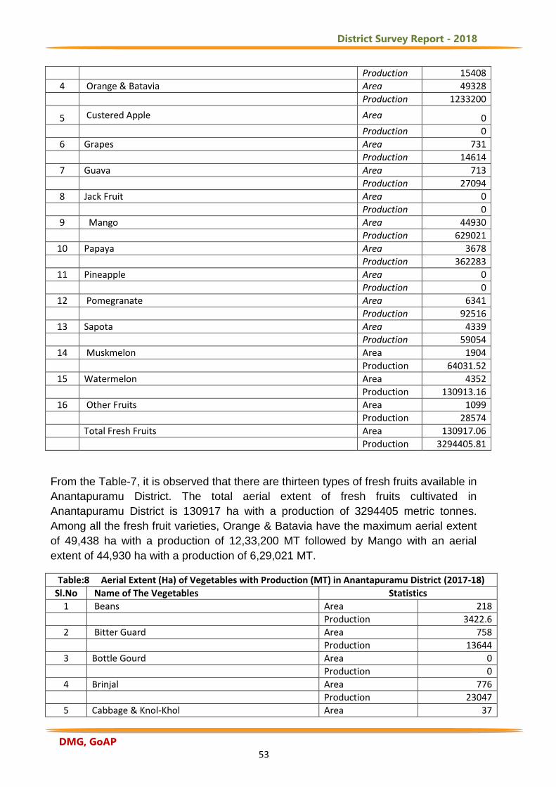
District Survey Report - 2018
DMG, GoAP 53
Production 15408
4 Orange & Batavia Area 49328
Production 1233200
5 Custered Apple Area 0
Production 0
6 Grapes Area 731
Production 14614
7 Guava Area 713
Production 27094
8 Jack Fruit Area 0
Production 0
9 Mango Area 44930
Production 629021
10 Papaya Area 3678
Production 362283
11 Pineapple Area 0
Production 0
12 Pomegranate Area 6341
Production 92516
13 Sapota Area 4339
Production 59054
14 Muskmelon Area 1904
Production 64031.52
15 Watermelon Area 4352
Production 130913.16
16 Other Fruits Area 1099
Production 28574
Total Fresh Fruits Area 130917.06
Production 3294405.81
From the Table-7, it is observed that there are thirteen types of fresh fruits available in
Anantapuramu District. The total aerial extent of fresh fruits cultivated in
Anantapuramu District is 130917 ha with a production of 3294405 metric tonnes.
Among all the fresh fruit varieties, Orange & Batavia have the maximum aerial extent
of 49,438 ha with a production of 12,33,200 MT followed by Mango with an aerial
extent of 44,930 ha with a production of 6,29,021 MT.
Table:8 Aerial Extent (Ha) of Vegetables with Production (MT) in Anantapuramu District (2017-18)
Sl.No Name of The Vegetables Statistics
1 Beans Area 218
Production 3422.6
2 Bitter Guard Area 758
Production 13644
3 Bottle Gourd Area 0
Production 0
4 Brinjal Area 776
Production 23047
5 Cabbage & Knol-Khol Area 37
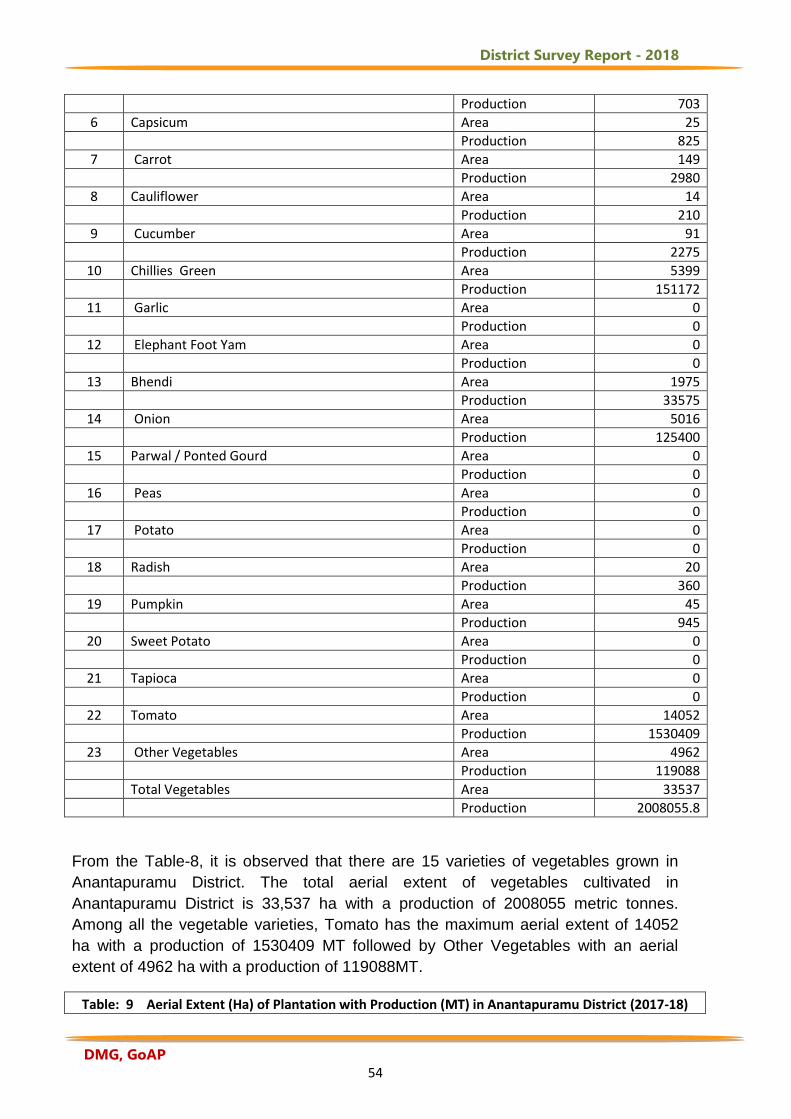
District Survey Report - 2018
DMG, GoAP 54
Production 703
6 Capsicum Area 25
Production 825
7 Carrot Area 149
Production 2980
8 Cauliflower Area 14
Production 210
9 Cucumber Area 91
Production 2275
10 Chillies Green Area 5399
Production 151172
11 Garlic Area 0
Production 0
12 Elephant Foot Yam Area 0
Production 0
13 Bhendi Area 1975
Production 33575
14 Onion Area 5016
Production 125400
15 Parwal / Ponted Gourd Area 0
Production 0
16 Peas Area 0
Production 0
17 Potato Area 0
Production 0
18 Radish Area 20
Production 360
19 Pumpkin Area 45
Production 945
20 Sweet Potato Area 0
Production 0
21 Tapioca Area 0
Production 0
22 Tomato Area 14052
Production 1530409
23 Other Vegetables Area 4962
Production 119088
Total Vegetables Area 33537
Production 2008055.8
From the Table-8, it is observed that there are 15 varieties of vegetables grown in
Anantapuramu District. The total aerial extent of vegetables cultivated in
Anantapuramu District is 33,537 ha with a production of 2008055 metric tonnes.
Among all the vegetable varieties, Tomato has the maximum aerial extent of 14052
ha with a production of 1530409 MT followed by Other Vegetables with an aerial
extent of 4962 ha with a production of 119088MT.
Table: 9 Aerial Extent (Ha) of Plantation with Production (MT) in Anantapuramu District (2017-18)
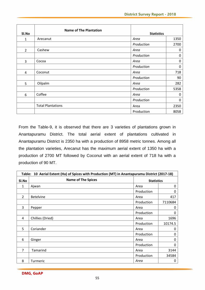
District Survey Report - 2018
DMG, GoAP 55
Sl.No Name of The Plantation
Statistics
1 Arecanut Area 1350
Production 2700
2 Cashew Area 0
Production 0
3 Cocoa Area 0
Production 0
4 Coconut Area 718
Production 90
5 Oilpalm Area 282
Production 5358
6 Coffee Area 0
Production 0
Total Plantations Area 2350
Production 8058
From the Table-9, it is observed that there are 3 varieties of plantations grown in
Anantapuramu District. The total aerial extent of plantations cultivated in
Anantapuramu District is 2350 ha with a production of 8958 metric tonnes. Among all
the plantation varieties, Arecanut has the maximum aerial extent of 1350 ha with a
production of 2700 MT followed by Coconut with an aerial extent of 718 ha with a
production of 90 MT.
Table: 10 Aerial Extent (Ha) of Spices with Production (MT) in Anantapuramu District (2017-18)
Sl.No Name of The Spices Statistics
1 Ajwan Area 0
Production 0
2 Betelvine Area 417
Production 7110684
3 Pepper Area 0
Production 0
4 Chillies (Dried) Area 1696
Production 10174.5
5 Coriander Area 0
Production 0
6 Ginger Area 0
Production 0
7 Tamarind Area 3144
Production 34584
8 Turmeric Area 0
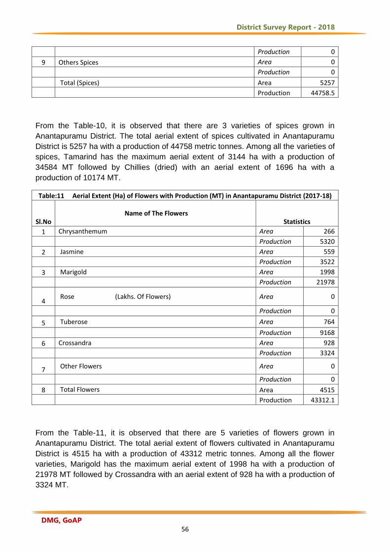
District Survey Report - 2018
DMG, GoAP 56
Production 0
9 Others Spices Area 0
Production 0
Total (Spices) Area 5257
Production 44758.5
From the Table-10, it is observed that there are 3 varieties of spices grown in
Anantapuramu District. The total aerial extent of spices cultivated in Anantapuramu
District is 5257 ha with a production of 44758 metric tonnes. Among all the varieties of
spices, Tamarind has the maximum aerial extent of 3144 ha with a production of
34584 MT followed by Chillies (dried) with an aerial extent of 1696 ha with a
production of 10174 MT.
Table:11 Aerial Extent (Ha) of Flowers with Production (MT) in Anantapuramu District (2017-18)
Sl.No Name of The Flowers
Statistics
1 Chrysanthemum Area 266
Production 5320
2 Jasmine Area 559
Production 3522
3 Marigold Area 1998
Production 21978
4 Rose (Lakhs. Of Flowers) Area 0
Production 0
5 Tuberose Area 764
Production 9168
6 Crossandra Area 928
Production 3324
7 Other Flowers Area 0
Production 0
8 Total Flowers Area 4515
Production 43312.1
From the Table-11, it is observed that there are 5 varieties of flowers grown in
Anantapuramu District. The total aerial extent of flowers cultivated in Anantapuramu
District is 4515 ha with a production of 43312 metric tonnes. Among all the flower
varieties, Marigold has the maximum aerial extent of 1998 ha with a production of
21978 MT followed by Crossandra with an aerial extent of 928 ha with a production of
3324 MT.
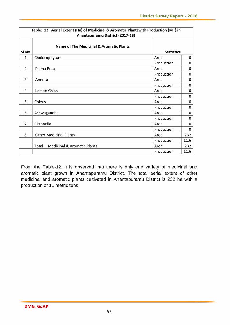
District Survey Report - 2018
DMG, GoAP 57
Table: 12 Aerial Extent (Ha) of Medicinal & Aromatic Plantswith Production (MT) in Anantapuramu District (2017-18)
Sl.No
Name of The Medicinal & Aromatic Plants
Statistics
1 Cholorophytum Area 0
Production 0
2 Palma Rosa Area 0
Production 0
3 Annota Area 0
Production 0
4 Lemon Grass Area 0
Production 0
5 Coleus Area 0
Production 0
6 Ashwagandha Area 0
Production 0
7 Citronella Area 0
Production 0
8 Other Medicinal Plants Area 232
Production 11.6
Total Medicinal & Aromatic Plants Area 232
Production 11.6
From the Table-12, it is observed that there is only one variety of medicinal and
aromatic plant grown in Anantapuramu District. The total aerial extent of other
medicinal and aromatic plants cultivated in Anantapuramu District is 232 ha with a
production of 11 metric tons.

District Survey Report - 2018
DMG, GoAP 58
4. Water and Irrigation Resources of Anantapuramu District 4.1 Surface Water and Irrigation Resources of the District
4.1.1 Rivers in Anantapuramu District
i) Pennar:
The important river in the District is Pennar. It has its origin in the Nandi Hills of
Karnataka State where it is called "Uttara Pinakini" and enters this District in the
extreme south of Hindupur mandal and flows through Parigi, Roddam, Ramagiri,
Kambadur, Kalyandurg, Beluguppa, Uravakonda, Vajrakarur, Pamidi, Peddavadugur,
Peddapappur and Tadipatri mandals and finally enters Kadapa District.
ii) Jayamangala:
This River which has its origin in Karnataka State enters this District in Parigi
mandal and joins Pennar River at Sangameswarampalli of Parigi mandal.
iii) Chitravathi:
Another significant river in the District is "Chitravathi". Its origin is in Karnataka
State. This river enters the District near Kodikonda village of Chilamathur mandal and
flows north over rocky and hilly uplands of Gorantla, Puttaparthi, Bukkapatnam,
District Survey Report - 2018
DMG, GoAP 59
Kothacheruvu, C.K.Palli, Dharmavaram, Bathalapalli, Tadimarri and Yellanur mandals
and falls into Pennar River at Gandikota in Kadapa District.
iv) Vedavathi or Hagari: This river also an important one in the District which has its
origin in Karnataka State and flows through Gummagatta, Brahmasamudram,
Beluguppa, Kanekal and D.Hirehal mandals and enters Bellary District of Karnataka
State. Bhairavanithippa Project (B.T.Project) is constructed on this river.
Apart from these, streams like Kushavathi in Chilamathur mandal,
Swarnamukhi in Agali mandal, Maddileru in Nallamada, Kadiri and Mudigubba
mandals, Pandameru in Kanaganipalli, Raptadu, Ananthapuramu, B.K.Samudram,
and Singanamala mandals, Papagni in Tanakal mandal are important water supply
sources to various large and medium irrigation tanks in the District.
4.2 Major and Medium Irrigation Projects
Irrigation has assumed an increasing significance in agriculture in the context
of new technology, where high yielding varieties and multiple cropping are being
practiced. The main reasons for low yields are inadequate rainfall, uneven and
uncertain rains during the period of crop growth. It is generally found that the
introduction of irrigation is associated with changes in the cropping pattern. The shift
from traditional cropping pattern to the most advantageous cropping pattern is
possible only in the presence of irrigation facilities. The new agricultural technology is
highly based on sufficient moisture conditions. Thus, the development of irrigation is
crucial for increasing agricultural production. The irrigation projects are classified as
major, medium projects and minor irrigation sources.
4.2.1 Major Irrigation Projects: The major irrigation projects completed in
Anantapuramu District are 1) Tunga Bhadra Project High Level Canal System (Stage-
1) covered an ayacut of 1,07,516 acres falling in six assembly constituencies namely
Guntakal, Raptadu, Rayadurg, Singanamala, Tadipatri and Uravakonda. 2)
Pulivendula Branch Canal is covered an ayacut of 5,000 acres falling in Singanamala
assembly constituency.
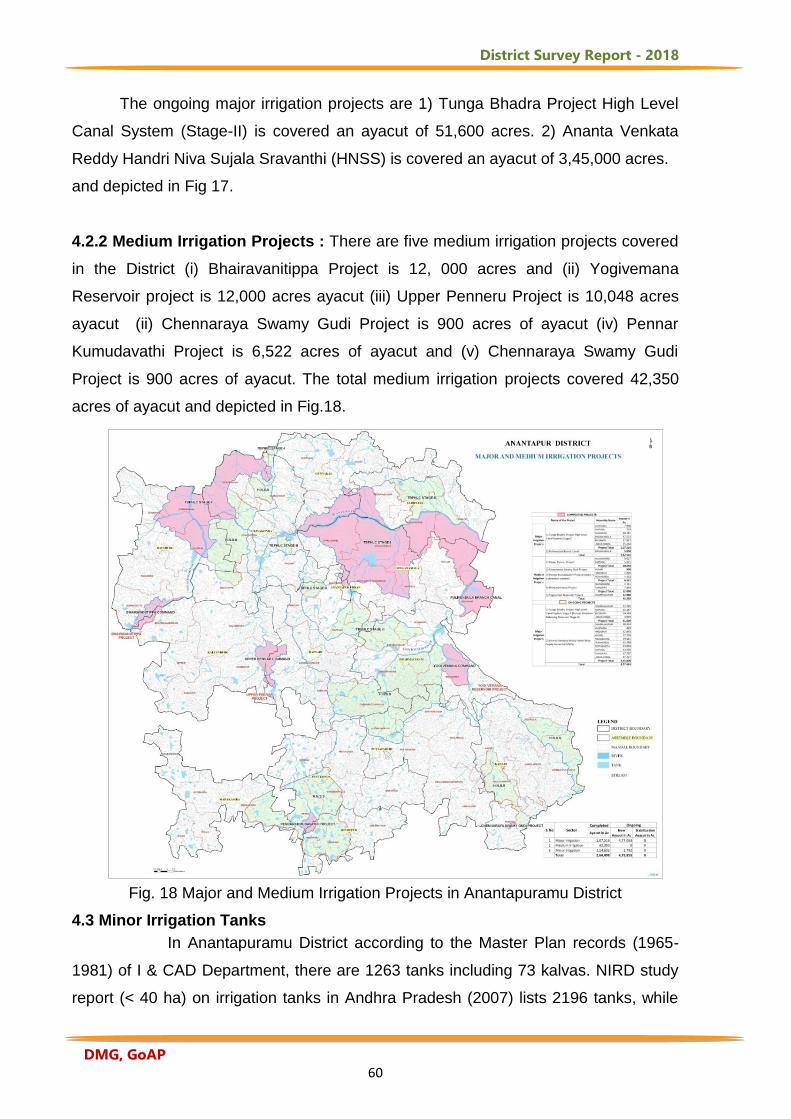
District Survey Report - 2018
DMG, GoAP 60
The ongoing major irrigation projects are 1) Tunga Bhadra Project High Level
Canal System (Stage-II) is covered an ayacut of 51,600 acres. 2) Ananta Venkata
Reddy Handri Niva Sujala Sravanthi (HNSS) is covered an ayacut of 3,45,000 acres.
and depicted in Fig 17.
4.2.2 Medium Irrigation Projects : There are five medium irrigation projects covered
in the District (i) Bhairavanitippa Project is 12, 000 acres and (ii) Yogivemana
Reservoir project is 12,000 acres ayacut (iii) Upper Penneru Project is 10,048 acres
ayacut (ii) Chennaraya Swamy Gudi Project is 900 acres of ayacut (iv) Pennar
Kumudavathi Project is 6,522 acres of ayacut and (v) Chennaraya Swamy Gudi
Project is 900 acres of ayacut. The total medium irrigation projects covered 42,350
acres of ayacut and depicted in Fig.18.
Fig. 18 Major and Medium Irrigation Projects in Anantapuramu District
4.3 Minor Irrigation Tanks
In Anantapuramu District according to the Master Plan records (1965-
1981) of I & CAD Department, there are 1263 tanks including 73 kalvas. NIRD study
report (< 40 ha) on irrigation tanks in Andhra Pradesh (2007) lists 2196 tanks, while
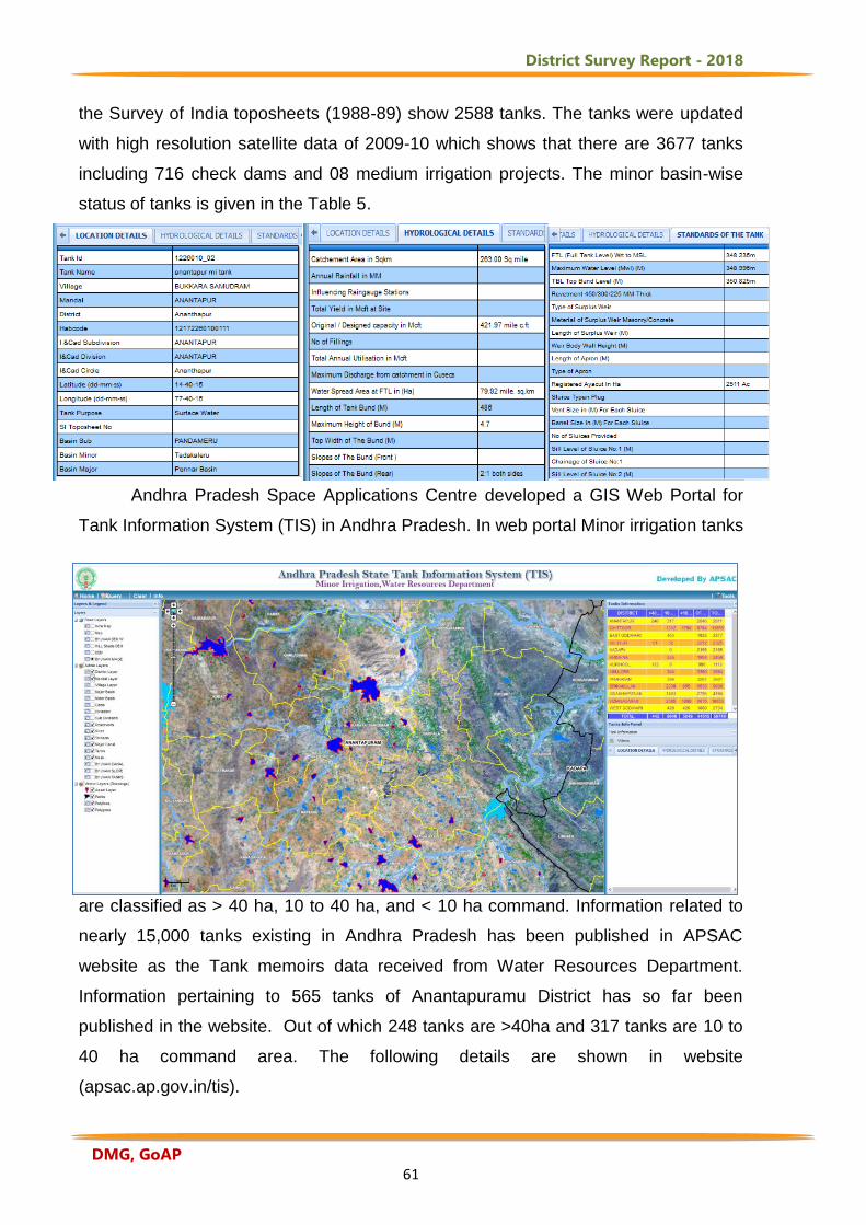
District Survey Report - 2018
DMG, GoAP 61
the Survey of India toposheets (1988-89) show 2588 tanks. The tanks were updated
with high resolution satellite data of 2009-10 which shows that there are 3677 tanks
including 716 check dams and 08 medium irrigation projects. The minor basin-wise
status of tanks is given in the Table 5.
Andhra Pradesh Space Applications Centre developed a GIS Web Portal for
Tank Information System (TIS) in Andhra Pradesh. In web portal Minor irrigation tanks
are classified as > 40 ha, 10 to 40 ha, and < 10 ha command. Information related to
nearly 15,000 tanks existing in Andhra Pradesh has been published in APSAC
website as the Tank memoirs data received from Water Resources Department.
Information pertaining to 565 tanks of Anantapuramu District has so far been
published in the website. Out of which 248 tanks are >40ha and 317 tanks are 10 to
40 ha command area. The following details are shown in website
(apsac.ap.gov.in/tis).
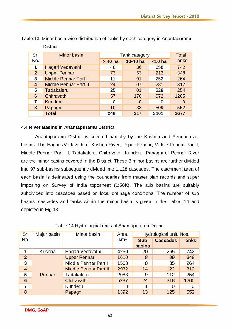
District Survey Report - 2018
DMG, GoAP 62
Table:13. Minor basin-wise distribution of tanks by each category in Anantapuramu
District
Sr. No.
Minor basin Tank category Total Tanks > 40 ha 10-40 ha <10 ha
1 Hagari Vedavathi 48 36 658 742
2 Upper Pennar 73 63 212 348
3 Middle Pennar Part I 11 01 252 264
4 Middle Pennar Part II 24 07 281 312
5 Tadakaleru 25 01 228 254
6 Chitravathi 57 176 972 1205
7 Kunderu 0 0 0 0
8 Papagni 10 33 509 552
Total 248 317 3101 3677
4.4 River Basins in Anantapuramu District
Anantapuramu District is covered partially by the Krishna and Pennar river
basins. The Hagari /Vedavathi of Krishna River, Upper Pennar, Middle Pennar Part-I,
Middle Pennar Part- II, Tadakaleru, Chitravathi, Kunderu, Papagni of Pennar River
are the minor basins covered in the District. These 8 minor-basins are further divided
into 97 sub-basins subsequently divided into 1,128 cascades. The catchment area of
each basin is delineated using the boundaries from master plan records and super
imposing on Survey of India toposheet (1:50K). The sub basins are suitably
subdivided into cascades based on local drainage conditions. The number of sub
basins, cascades and tanks within the minor basin is given in the Table. 14 and
depicted in Fig.18.
Table:14 Hydrological units of Anantapuramu District
Sr. No.
Major basin Minor basin Area, km2
Hydrological unit, Nos.
Sub basins
Cascades Tanks
1 Krishna Hagari Vedavathi 4250 20 265 742
2
Pennar
Upper Pennar 1610 8 99 348
3 Middle Pennar Part I 1568 8 85 264
4 Middle Pennar Part II 2932 14 122 312
5 Tadakaleru 2083 9 112 254
6 Chitravathi 5287 24 318 1205
7 Kunderu 8 1 0 0
8 Papagni 1392 13 125 552
District Survey Report - 2018
DMG, GoAP 63
Total 19130 97 1128 3677
Table:15 Drainage system with description of main rivers
S.No Name of the River Area Drained
(Sq.KM)
% of Area Drained
in the District
1 Vedavathi 4250.65 22.21
2 Penner 8192.57 42.87
3 Chitravathi 5285.99 27.63
4 Papagni 1392.89 7.2
Table:16 Salient Features of Important Rivers and Streams
S.No Name of the
River or
Stream
Total Length in
the District (in
Kms)
Place of Origin Altitude at
Origin
1 Vedavathi 79.474 Bababudangiri Mountains of
Karnataka
360 mts
2 Penner 292.99 Nandi Hills, Chikballapur
District, Karnataka
600-1500 mts
3 Chitravathi 149.73 Nandi Hills, Chikballapur
District, Karnataka
905 mts
4 Papagni 56.54 Nandi Hills, Chikballapur
District, Karnataka
792 mts
The major rivers in the District, the area drained by each river and percentage of the area of
the total geographical area of the District (Table-15) and the length of each river in the
District, its place of origin and altitude at origin are given in Table-16.
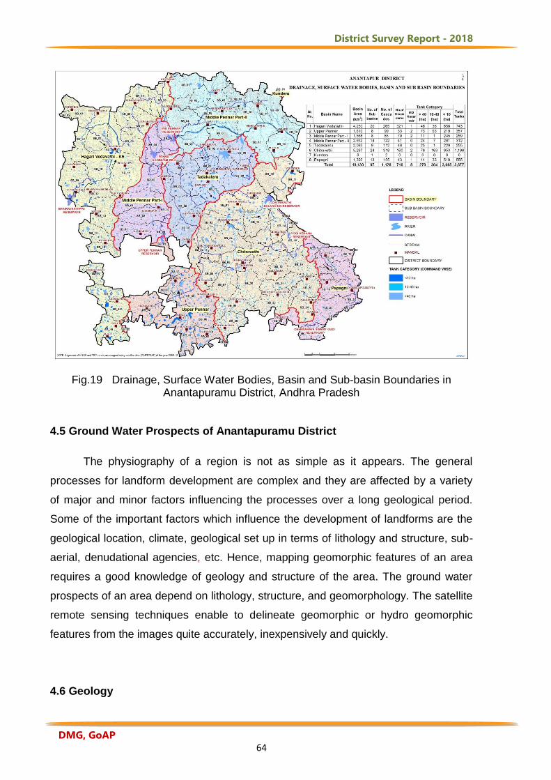
District Survey Report - 2018
DMG, GoAP 64
Fig.19 Drainage, Surface Water Bodies, Basin and Sub-basin Boundaries in
Anantapuramu District, Andhra Pradesh 4.5 Ground Water Prospects of Anantapuramu District
The physiography of a region is not as simple as it appears. The general
processes for landform development are complex and they are affected by a variety
of major and minor factors influencing the processes over a long geological period.
Some of the important factors which influence the development of landforms are the
geological location, climate, geological set up in terms of lithology and structure, sub-
aerial, denudational agencies, etc. Hence, mapping geomorphic features of an area
requires a good knowledge of geology and structure of the area. The ground water
prospects of an area depend on lithology, structure, and geomorphology. The satellite
remote sensing techniques enable to delineate geomorphic or hydro geomorphic
features from the images quite accurately, inexpensively and quickly.
4.6 Geology
District Survey Report - 2018
DMG, GoAP 65
The geological formations in the Anantapuramu District can be broadly
divided into distinct and well marked groups; an older group of metamorphic rocks
belonging to the Archaean and a younger group of sedimentary rocks belonging to
the Proterozoic age (GSI, 2001). The latter cover part of Tadipatri, Putlur, eastern
parts of Gooty and Narpala mandals. The remaining parts of the District are occupied
by Archaean rocks which consist of Schists, Gneisses, Migmatites and younger
Granites, pegmatites, Quartz veins and basic dykes (Fig.20). The Archaean rocks
have suffered considerable degree of tectonic disturbances as a result of which the
rocks have been metamorphosed and recrystallized. A detailed legend showing the
stratigraphic sequence of various geological formations occurring in the District is
given in Fig.21. The source of the legend is GSI, 2001.
Some of the dykes seem to act as barriers to the ground water
movement so much so area of good ground water potential are found upstream of
the dykes and low potential and deep water level conditions are indicated
downstream of the dykes . The NW-SE and E-W trending dykes act as barriers to
the ground water flow in the area and the NE-SW and the N-S trending dykes are
usually following stream courses and lineaments act as conduits for the flow of
ground water.
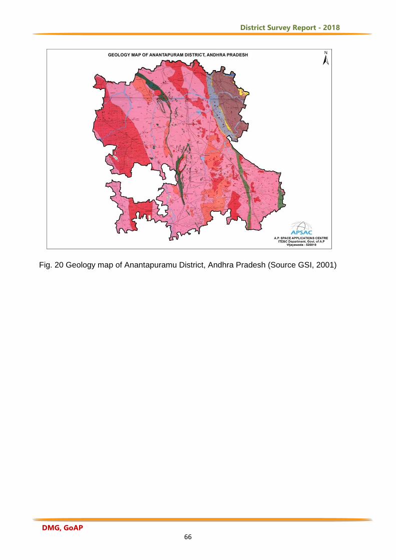
District Survey Report - 2018
DMG, GoAP 66
Fig. 20 Geology map of Anantapuramu District, Andhra Pradesh (Source GSI, 2001)
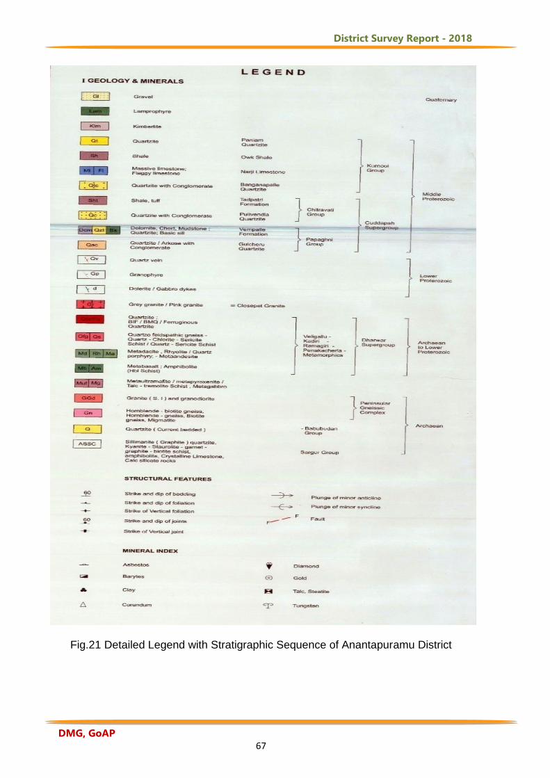
District Survey Report - 2018
DMG, GoAP 67
Fig.21 Detailed Legend with Stratigraphic Sequence of Anantapuramu District
District Survey Report - 2018
DMG, GoAP 68
4.6.1 Mineral Resources: As per the literature surveyed (GSI, 2001) the following
minerals are present in Anantapuramu District. A brief description of each mineral and
its uses is as follows.
Gold: The gold deposits of Ramagiri are being exploited since 1910 and still
investigation is continuing to establish gold bearing zones in the extensions of
Ramagiri schist belt. Gold is seen associated with N-S trending blue quartz vein.
At Ramagiri village in Ramagiri mandal, gold is also found to occur in the Chlorite
Schist and phyllite along with western part of Dharwar Schist Belt.
Uses of Gold
Of all the minerals mined from the Earth, none is more useful than gold. Its usefulness
is derived from a diversity of special properties. Gold conducts electricity and does not
tarnish. It is very easy to work and can be drawn into wire, hammered into thin
sheets, alloys with many other metals, can be melted and cast into highly detailed
shapes. It has a wonderful colour and a brilliant lustre. Gold has been used to make
ornamental objects and jewellery for thousands of years. Gold nuggets found in a
stream are very easy to work and were probably one of the first metals used by
humans. Today, most of the gold that is newly mined or recycled is used in the
manufacture of jewellery. About 78% of the gold consumed each year is used in the
manufacture of jewellery.
Special properties of gold make it perfect for manufacturing jewellery. These include
very high lustre, desirable yellow colour, and tarnish resistance. It has the ability to be
drawn into wires, hammered into sheets, or cast into shapes. These are all properties
of an attractive metal that is easily worked into beautiful objects. Another extremely
important factor that demands the use of gold as a jewellery metal is tradition. Pure
gold is too soft to stand up to the stresses applied to many jewellery items. Craftsmen
learned that alloying gold with other metals such as copper, silver, and platinum
would increase its durability. Since then most gold used to make jewellery is an alloy
of gold with one or more other metals.
Diamonds: Diamonds of gem quality are extensively mined at Wajrakarur (15º
01’: 77º 23’) and Lattavaram (14º 45’:77º 17’ Uravakonda mandal) while sporadic
District Survey Report - 2018
DMG, GoAP 69
occurrences have been reported from Peddatturu, Mulakalapenta, Kunganapalli,
Dibbasanipalli and Chigicherla (Dharmavaram mandal). A number of diamond bearing
Kimberlite pipes have been discovered recently in this area.
Uses of Diamonds Diamond is very popularly known for being used as a gem in jewellery but other than
this basic use of diamond, there are many other uses of this valuable stone.
Diamonds are being used in many industries as well for various operations. Along
with being used in the industry, diamonds are also used for some basic general uses.
Diamond membranes are durable, resistant to heat, and transparent, making them
highly useful. Because diamonds are so hard and durable, they are ideal for grinding,
cutting, drilling, and polishing. When used as an abrasive, very small pieces
of diamond are embedded into grinding wheels, saw blades, or drill bits. Small pieces
of diamonds are used for cutting glasses. The small portions of diamonds are also
used for drilling the rocks. The hardness of the diamond is the main reason why
diamonds are preferred for doing such cutting and drilling activities. No matter if a
diamond is used in the solid form or in the form of dust, diamond holds a number of
uses. The dust of the diamond can be used for polishing other diamonds and precious
stones. The dust of the diamond gives an enhanced shine in the other stones. The
diamond dyes are used for the process of making the wires using the lab equipment.
Diamonds can be used for engraving stones to various other metals. The various
stones that can be engraved are granite, quartz, etc. The workers feel no need for the
replacement of engraving bit as the diamond does not break, scratch or damage any
of the stones. Since diamonds possess a high level of thermal conductivity, therefore,
diamonds can be used in various electronic applications to prevent the delicate parts
from getting damaged from the heat rays of the Sun. The diamonds are used as heat
sinks in such electronic applications for repealing away the heat of the Sun.
In the process of lapping, diamond slurry is used. The diamond slurry is made by
mixing water with a mixture that contains small pieces of diamonds. This diamond
slurry is then applied between the two surfaced that needs to be lapped and rubbed
for getting results. Diamonds are often used as antidotes in various places for poisons
or diseases. Diamonds have a high thermal conductivity that means they are very
good heat conductors and diamonds are used as a good tool for heat sinks. The
District Survey Report - 2018
DMG, GoAP 70
researchers chose nano diamonds because they reflect light and they are compatible
with human cells. Using the diamonds’ reflective properties, the researchers are able
to monitor the cellular processes that occurred once patients are given cancer
medication. Because diamonds have such a unique relationship with light, medical
researchers have also looked into using them to help the visually impaired.
Researchers have been testing diamonds as a potential material for bionic eyes and
eye implants for the blind.
Dimensional Stones: Pink granite is being commercially mined and large
blocks of which are being exported to UK. The massive limestones are good
building stone. The well-known Cuddapah slabs are the flaggy limestones of
Kurnool Group. The cement plants at Tadipatri and Yadiki are based on the
Kurnool limestones.
Uses of Dimensional Stones Dimension Stone is stone that is cut and finished to specified sizes and shapes, which
can be used for buildings, monuments, paving, furniture, and decorative objects.
Sometimes called cut stone, it is typically quarried in rectangular blocks, then sawed
and finished to specification. Stone (usually granite) countertops and bathroom
vanities both involve a finished slab of stone, usually polished but sometimes with
another finish (such as honed or sandblasted). The slabs are cut to fit the top of the
kitchen or bathroom cabinet, by measuring, templating or digital templating.
Countertop slabs are commonly cut from rough blocks of stone by reciprocating gang
saws using steel shot as abrasive. The slabs are finished (i.e., polished, honed), then
sealed with resin to fill micro-fissures and surface imperfections typically due to the
loss of poorly bonded elements such as biotite. The fabricators sharply cut these
slabs down to final size and finish the edges with equipment such as hand-
held routers, grinders, CNC equipment, or polishers. The stone for countertops or
vanities is usually granite, but often is marble (especially for vanity tops), and is
sometimes limestone or slate.
Dolomite: It is available in vast quantities at Dadikota (14°35':77°'57'
Tadimarri mandal), Elluttla (14°40': 77°54' Putlur manadal) Rangarajupalli
(13°48':77°07'), Vengannapalle, Ayalacheruvu (15°03':77°49') and Madugupalle
(14°42':77°53' Putluru mandal). Chemical grade occurrences are seen near
District Survey Report - 2018
DMG, GoAP 71
Kona-Rameshwar swami temple. Shale interbedded with the dolomite is used
as filler in insecticides. There are two large scale Cement Factories (Ms. L&T
Ltd., and Ms. Penna Cement Ltd.,) in Tadipatri Mandal and producing lakh
tonnes of cement in private sector.
Uses of Dolomite Dolomite is used for acid neutralization in the chemical industry, in stream restoration
projects, and as a soil conditioner. Dolomite is used as a source of magnesia (MgO),
a feed additive for livestock, a sintering agent and flux in metal processing, and as an
ingredient in the production of glass, bricks, and ceramics. Dolomite as a mineral has
very few uses. However, dolostone has an enormous number of uses because it
occurs in deposits that are large enough to mine. The most common use for
dolostone is in the construction industry. It is crushed and sized for use as a road
base material, an aggregate in concrete and asphalt, railroad ballast, rip-rap, or fill. It
is also calcined in the production of cement and cut into blocks of specific size known
as "dimension stone." Dolomite's reaction with acid also makes it useful. Dolomite is
used as a source of magnesia (MgO), a feed additive for livestock, a sintering agent
and flux in metal processing, and as an ingredient in the production of glass, bricks,
and ceramics. Dolomite also serves as an oil and gas reservoir rock. During the
conversion of calcite to dolomite, a volume reduction occurs. This can produce pore
spaces in the rock that can be filled with oil or natural gas that migrate in as they are
released from other rock units. This makes the dolomite a reservoir rock and a target
of oil and gas drilling.
Corundum: Corundum of abrasive variety is seen at Parigi
(13°53'46":77°27'30") Atmakuru (14°38'45”:77°21'30"), Nutimadugu
(14°29':77°19'45” Kambadur mandal) areas.
Uses of Corundum Corundum is a precious gem finds some use as an abrasive, owing to the extreme
hardness of the material (9 on the Moh’s hardness scale). It is used for grinding
optical glass and for polishing metals and has also been made into sandpapers and
grinding wheels. The extreme hardness of corundum makes it especially useful as an
abrasive. Crushed corundum is processed to remove impurities and then screened to
District Survey Report - 2018
DMG, GoAP 72
produce uniformly sized granules and powders. These are used for grinding media,
polishing compounds, sand papers, grinding wheels, and other cutting applications.
Corundum has many other uses. It is chemically inert and resistant to heat. These
properties make it a perfect material for making refractory products such as fire brick,
kiln liners, and kiln furniture. Today, these products are usually made with synthetic
corundum. Pure corundum is colourless, transparent, durable, and scratch resistant.
Large crystals of clear synthetic corundum are grown, sawn into thin sheets, and then
used as the windows of grocery store scanners, watch crystals, aircraft windows, and
protective covers for electronic devices.
Iron Ore: Iron Ore occurrences are reported at Malapanagudi
(14°15':77°49' D.Herahal mandal).
Uses of Iron
The primary use of iron ore is in the production of iron. Most of the iron produced is
then used to make steel. Steel is used to make automobiles, locomotives, ships,
beams used in buildings, furniture, paper clips, tools, reinforcing rods for concrete,
bicycles, and thousands of other items. Iron ore is needed for train tracks and other
types of infrastructure, which is one reason for the great demand. Of all the metals
that make modern life possible, steel is the most widely used and iron ore is its main
ingredient. But it’s also used in medicine, cosmetics, engineering, construction, paint
and a whole range of products we need for modern life. Iron ore is usually smelted to
produce pig iron (metallic iron), which is used to make steel. It is for this reason iron is
perhaps one of the most important metals used in developed and developing
economies. There is also wrought iron (low in carbon) and cast iron (otherwise known
as pig iron), and corrugated iron structural sheeting, a recognisable material in the
buildings throughout. The pure iron metal is strongly magnetic, melts at 1528°
Magnetite ore is used to remove impurities in coal washing, and its magnetic qualities
enable recovery and reuse.
Steatite: Occurs at Mutsukota (14° 51':77°52' Peddapappuru mandal),
Kamapudi and Tabjula (14°54'30": 77°49'15" Peddapappuru mandal) and within
the sheared zones of Jangamreddipalle (14°40'30":77°50') in serpentine
dolomite.
District Survey Report - 2018
DMG, GoAP 73
Uses of Steatite
Steatite is a massive variety of Talc with a greasy feeling, often used for ornamental
carvings. Steatite otherwise called Soapstone is used for inlaid designs,
sculpture, and kitchen counter tops and sinks. It is often used for traditional carvings.
Soapstone is sometimes used for construction of fireplace surrounds, cladding
on wood-burning stoves, and as the preferred material for wood burning masonry
heaters because it can absorb, store, and evenly radiate heat due to its high density
and magnesite (MgCO3) content. Soapstone has been used in India for centuries as a
medium for carving. In Brazil, due to the abundance of soapstone mines, local
artisans still craft objects from that material, including pots and pans, wine glasses,
statues, jewel boxes, coasters, and vases. These handicrafts are commonly sold in
street markets found in cities across the state. Some wood-burning stoves make use
of soapstone to take advantage of its useful thermal and fire-resistant properties.
Currently, soapstone is most commonly used for architectural applications, such as
counter tops, floor tiles, shower bases, and interior surfacing.
Soap stones can be put in a freezer and later used in place of ice cubes to chill
alcoholic beverages without diluting. Sometimes called whiskey stones, these were
first introduced around 2007. Most whiskey stones feature a semi-polished finish,
retaining the soft look of natural soapstone, while others are highly polished.
Steatite ceramics are low-cost biaxial porcelains of nominal composition
(MgO)3(SiO2)4. Steatite is used primarily for its dielectric and thermal insulating
properties in applications such as tile, substrates, washers, bushings, beads and
pigments. It is also used for high-voltage insulators, which have to stand large
mechanical loads, e.g. insulators of mast radiators.
Barytes: Occurs at Mutsukota (14°51':77'52' Peddapappuru mandal),
Lakshumpalle (15°11':77°56'30"), Venkatampalle (14°56':77°22'30" Tadipatri
mandal) and Tabjula (14°54'30":77°49'15" Peddapappuru mandal) within the
sheared dolomite.
Uses of Barytes
Barite is the primary ore of barium. Most barite produced is used as a weighing agent
in drilling muds. These high-density muds are pumped down the drill stem, exit
District Survey Report - 2018
DMG, GoAP 74
through the cutting bit and return to the surface between the drill stem and the wall of
the well. This flow of fluid does two things: 1) it cools the drill bit; and, 2) the high-
density barite mud suspends the rock cuttings produced by the drill and carries them
up to the surface. Barite is also used as a pigment in paints and as weighted filler for
paper, cloth and rubber. The paper used to make some playing cards has barite
packed between the paper fibres. This gives the paper a very high density that allows
the cards to be "dealt" easily to players around a card table. Barite is used as
weighting filler in rubber to make "anti-sail" mud flaps for trucks.
Barite is used to make a wide variety of barium compounds. Some of these are used
for x-ray shielding. Barite has the ability to block x-ray and gamma-ray emissions.
Barite is used to make high-density concrete to block x-ray emissions in hospitals,
power plants, and laboratories. Barite compounds are also used in diagnostic medical
tests. The oil and gas industry is the primary user of barite worldwide. There, it is
used as a weighing agent in drilling mud. Substitutes for barite in drilling mud include
Celestite, ilmenite, iron ore and synthetic hematite. None of these substitutes have
been effective at displacing barite in any major market area. They are very expensive
or do not perform competitively.
Clay: Kaolinitic clay is reported from shale of Tadipatri Formation about 1.5
km of Putlur (14°48'30":77°30'35").
Uses of Clay
Clay is used for making pottery, both utilitarian and decorative, and construction
products, such as bricks, wall and floor tiles. Different types of clay, when used with
different minerals and firing conditions, are used to produce earthenware, stoneware,
and porcelain. Clays exhibit plasticity when mixed with water in certain proportions.
However, when dry, clay becomes firm and when fired in a kiln, permanent physical
and chemical changes occur. These changes convert the clay into a ceramic material.
Because of these properties, clay is used for making pottery, both utilitarian and
decorative, and construction products. Prehistoric humans discovered the useful
properties of clay. Clay tablets were the first known writing medium. Scribes wrote by
inscribing them with cuneiform script using a blunt reed called a stylus. Purpose-made
clay balls were also used as sling ammunition.
District Survey Report - 2018
DMG, GoAP 75
Clays sintered in fire were the first form of ceramic. Bricks, cooking pots, art
objects, dishware, smoking pipes, and even musical instruments such as
the ocarina can all be shaped from clay before being fired. Clay is also used in many
industrial processes, such as paper making, cement production, and
chemical filtering. Until the late 20th century, bentonite clay was widely used as a
mold binder in the manufacture of sand castings. Clay, being
relatively impermeable to water, is also used where natural seals are needed, such as
in the cores of dams, or as a barrier in landfills against toxic seepage (lining the
landfill). Studies in the early 21st century have investigated
clay's absorption capacities in various applications, such as the removal of heavy
metals from waste water and air purification. Traditional use of clay as medicine goes
back to prehistoric times.
Clay as the defining ingredient of loam is one of the oldest building materials
on Earth, among other ancient, naturally-occurring geologic materials such
as stone and organic materials like wood. Between one-half and two-thirds of the
world's population, in both traditional societies as well as developed countries, still live
or work in buildings made with clay, often baked into brick, as an essential part of its
load-bearing structure. Also a primary ingredient in many natural building techniques,
clay is used to create adobe, cob, cordwood, and rammed earth structures and
building elements such as wattle and daub, clay plaster, clay render case, clay floors
and clay paints and ceramic building material. Clay was used as a mortar in
brick chimneys and stone walls where protected from water.
Scheelite: Tungsten mineralization as Scheelite occurs as disseminations,
stringers and fracture fillings within quartz vein traversing the granites,
gneisses and metamorphic rocks near Penukonda (14°05':77°36') and
Pampanuru (14°40'00":77°30'45" Anantapuramu mandal) 2.5 km SE of
Balepalyam(14°20'25":77°30'35").
Uses of Scheelite
Scheelite is named after the Swedish chemist Karl Wilhelm Scheele (1742-1786).
Scheele is credited with the discovery of tungsten within the Scheelite and is an
important ore of Tungsten. Pure Scheelite has blue-white fluorescence in ultraviolet
District Survey Report - 2018
DMG, GoAP 76
light, a property which is utilised in prospecting. Scheelite is an important ore mineral,
and is well-known among collectors for its distinctly coloured crystals associated with
brilliant fluorescence. It forms a series with the rarer mineral, Powellite, which
contains molybdenum in place of tungsten. Good crystals are rare and expensive,
and highly desired by mineral collectors.
4.6.2.Geomorphology of Anantapuramu District: Using IRS satellite data and GIS detailed geological, geomorphological and
structural map of Anantapuramu District was generated as per Rajiv Gandhi National
Drinking Water Mission (RGNDWM Phase-III) guidelines on 1: 50,000 scale. The
objective of this is to map lithology, geomorphology and structural characteristics of
an area on 1:50,000 scale and to integrate the same to locate potential ground water
prospect zones and to recommend suitable structures for ground water recharge.
Various hydrogeomorphic units are delineated and suitable recharge structures are
proposed at drinking water affected villages under this project (NRSA, 2007). The
description of geomorphic units of different origins mapped in Anantapuramu District
is described as follows.
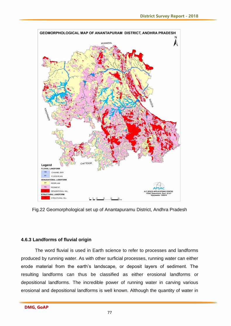
District Survey Report - 2018
DMG, GoAP 77
Fig.22 Geomorphological set up of Anantapuramu District, Andhra Pradesh
4.6.3 Landforms of fluvial origin The word fluvial is used in Earth science to refer to processes and landforms
produced by running water. As with other surficial processes, running water can either
erode material from the earth’s landscape, or deposit layers of sediment. The
resulting landforms can thus be classified as either erosional landforms or
depositional landforms. The incredible power of running water in carving various
erosional and depositional landforms is well known. Although the quantity of water in
District Survey Report - 2018
DMG, GoAP 78
stream is small at one time during the course of the year, very large volumes of water
move through the channel and they form an important component in the hydrological
cycle. The fluvial dissection of the landscape consists of valleys and their included
channel ways organized into a system of connection known as a drainage network.
Drainage networks display many types of quantitative regularity that are useful in
analyzing both the fluvial systems and the terrains that they dissect (NRSA, 2007).
Flood plain: The surface or strip of relatively smooth land adjacent to a river channel
constructed (or in the process of being constructed) by the present river in its existing
regimen and covered with water when the river overflows its banks at times of high
water. It is built of alluvium carried by the river during floods and deposited in the
sluggish water beyond the influence of the swiftest current. This feature is observed
along the course of Pennar, Chitravati and Papagni rivers (Fig.22).
Valley fill: The unconsolidated sediment deposited by any fluvial agent so as to fill or
partly fill a valley.
4.6.4 Landforms of Structural Origin Landforms of structural origin are related to structural aspect of the area. Most
of the landforms under this class have genesis related to underlying structure.
Structure plays an important role for reducing the resistance of rock which manifests
itself in different geomorphic forms. Some of the variations are minor and some are in
mega scale. The mega scale forms have a dramatic effect on the genesis of
landforms and hence mapping of such forms indirectly indicates the structural set up
of the area. The mega scale structural features like fault and fold depending on its
type plays an important role in genesis of structural landform. The influence of
geologic structures on the development and appearance of landscapes is prominent.
The influence of geologic structures ranges from large features, which exert a
dominant influence on the form of an entire landscape, to small features, which affect
an individual landform and the geomorphic processes operating on it. The structural
control could be active structures whose form is directly impressed on the modern
landscape or ancient structural features whose influence on a modern landscape is
due primarily to differential erosion (NRSA, 2007).
District Survey Report - 2018
DMG, GoAP 79
Structural Hills: Hills and valleys, which are originated due to tectonic process and
are highly dissected by the drainage lines. This can be further classified as highly,
moderately and low dissection depending on the density of joints and drainage.
Mostly this will be interpreted from a planimetric satellite data and the classification is
highly subjective.
Dyke Ridge: Intrusive features that are emplaced within the pre-existing fractures or
where the fluid pressure is great enough for them to form their own fracture during
emplacements. They are discordant bodies.
Cuesta: A hill or ridge with a gentle slope on one side and a steep slope on the other;
specifically an asymmetric ridge with one face (dip slope) long and gentle and
conforming with the dip of the resistant bed or beds that form it, and the opposite face
(scarp slope) steep or even cliff-like and formed by the out crop of the resistant rocks,
the formation of the ridge being controlled by the differential erosion of the gently
inclined strata (Fig.22).
4.6.5. Landforms of Denudational origin Landform of denudational origin is formed where the denudation process
dominates over the other process. Most of the landforms resulting due to this process
are the combined effect of mechanical and chemical weathering. Denudation is the
process of removal of material by erosion and weathering. This has direct influence
on the relief of the area especially in the reduction of relief to the base level. The
agents are mostly water, ice and wind. The major factors affecting denudation are
geology, climate, tectonics and anthropogenic effects. All rocks and minerals at or
near surface are attacked by physical and chemical process. The effect of this
process is not same everywhere because of rocks varying resistance to change. As a
result weathering and erosion yield number of landforms, which have typical shape
and forms. Weathering is an essential part of the rock cycle. The parent material, or
rock weathered material is disaggregated to form smaller fragments and some of the
minerals are dissolved and removed by the agent of water. This removal of material is
erosion and is accomplished by running water, wind, glacier etc. The weathering
provides a raw material for the sedimentary rock and soil (NRSA, 2007).
District Survey Report - 2018
DMG, GoAP 80
Denudational Hill: It is a highly dissected hill which has obliterated the structures.
Inselberg: A prominent, isolated, steep sided, usually smoothed and rounded,
residual knob, hill or small mountain of circumdenudation rising abruptly from and
surrounded by an extensive and nearly level, lowland erosion surface in a hot, dry
region, generally bare and rocky although partly buried by the debris derived from and
overlapping its slopes. It is characteristic of an arid or semiarid landscape in a late
stage of the erosion cycle (Fig.22).
Pediment: A broad, flat or gently sloping, rock floored erosion surface or plain of low
relief, typically developed by sub aerial agents (including running water) in an arid or
semiarid region at the base of an abrupt and receding mountain front or plateau
escarpment, and underlain by bedrock (occasionally by older alluvial deposits) that
may be bare but more often partly mantled with a discontinuous veneer of alluvium
derived from the upland masses and in transit across the surface.
Pediment-Inselberg Complex: The pediments dotted by numerous inselberg of
small sizes, which make it difficult to distinguish from the pediments. Hence, it is
called a complex of pediment and inselberg.
Pediplain: An extensive, multi-concave, rock cut erosion surface formed by the
coalescence of two or more adjacent pediments and occasional desert domes, and
representing the end result (the “peneplain”) of the mature stage of the erosion cycle.
Based on the thickness of weathering, they are further classified into shallow,
moderate and deep pediplains.
Residual Hill: A small remnant hill, which has witnessed all forms of denudation.
4.7 Structural Features of Anantapuramu District
The terms lineaments and its derivatives have been defined and used in a
variety of ways in the geosciences. O' Leary et. aI., (1976) have defined lineament
in a geomorphological sense as a "mappable, simple or composite linear feature of a
surface, whose parts are aligned in a rectilinear or slightly curvilinear relationship
and which differs distinctly from the patterns of adjacent features and presumably
District Survey Report - 2018
DMG, GoAP 81
reflects a sub-surface phenomenon". Bhave et. aI., (1989) state that the term
lineament is commonly assigned to any unidirectional pattern and it is especially
applied to describe natural and endogenic earth features of a linear nature of
different magnitude such as structural planes, geomorphic anomalies, etc.
Lineaments usually represent faults, fractures, shear zones, joints or an
unconformity through which ground water movement takes place. These features are
identified on satellite images on the basis of tonal contrast, river / stream alignment,
differences in vegetation cover, knick-points in terminations of patterns, etc. Folds can
be identified easily on the image by the variation in the trend, circular form of line-
aments and other geomorphological features (Fig.23). In Anantapuramu District, the
E-W, N-S and NNW-SSE fractures are tensile fractures and the bore wells drilled
close to these fractures yield 1 to 8 lps while the NE-SW, NNE-SSW fractures are
shallow in nature and yield between 0.2 to 6.0 lps (CGWB, 2013).
The remote sensing based hydrogeomorphological maps on 1:50,000 scale are
of much help in the ground water studies. These maps are of immense use for
quickening and delineating the areas of different ground water potentials and also
for indicating the zones along which ground water exploration and development
can take place.
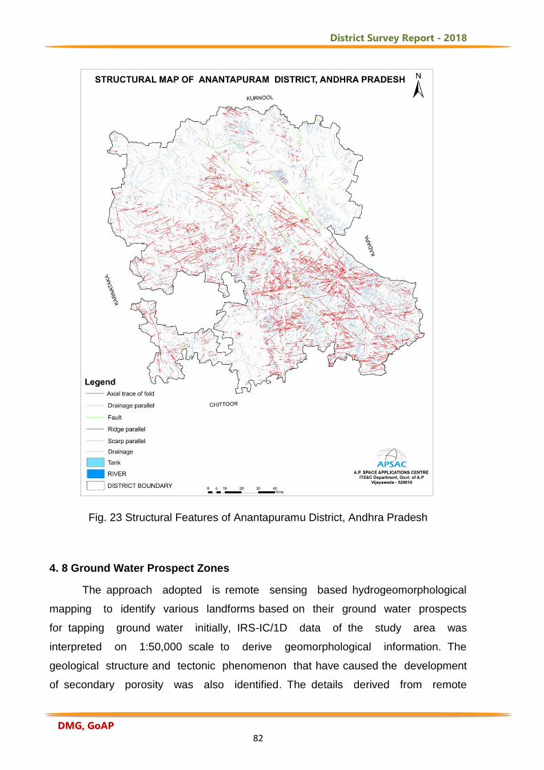
District Survey Report - 2018
DMG, GoAP 82
Fig. 23 Structural Features of Anantapuramu District, Andhra Pradesh 4. 8 Ground Water Prospect Zones
The approach adopted is remote sensing based hydrogeomorphological
mapping to identify various landforms based on their ground water prospects
for tapping ground water initially, IRS-IC/1D data of the study area was
interpreted on 1:50,000 scale to derive geomorphological information. The
geological structure and tectonic phenomenon that have caused the development
of secondary porosity was also identified. The details derived from remote
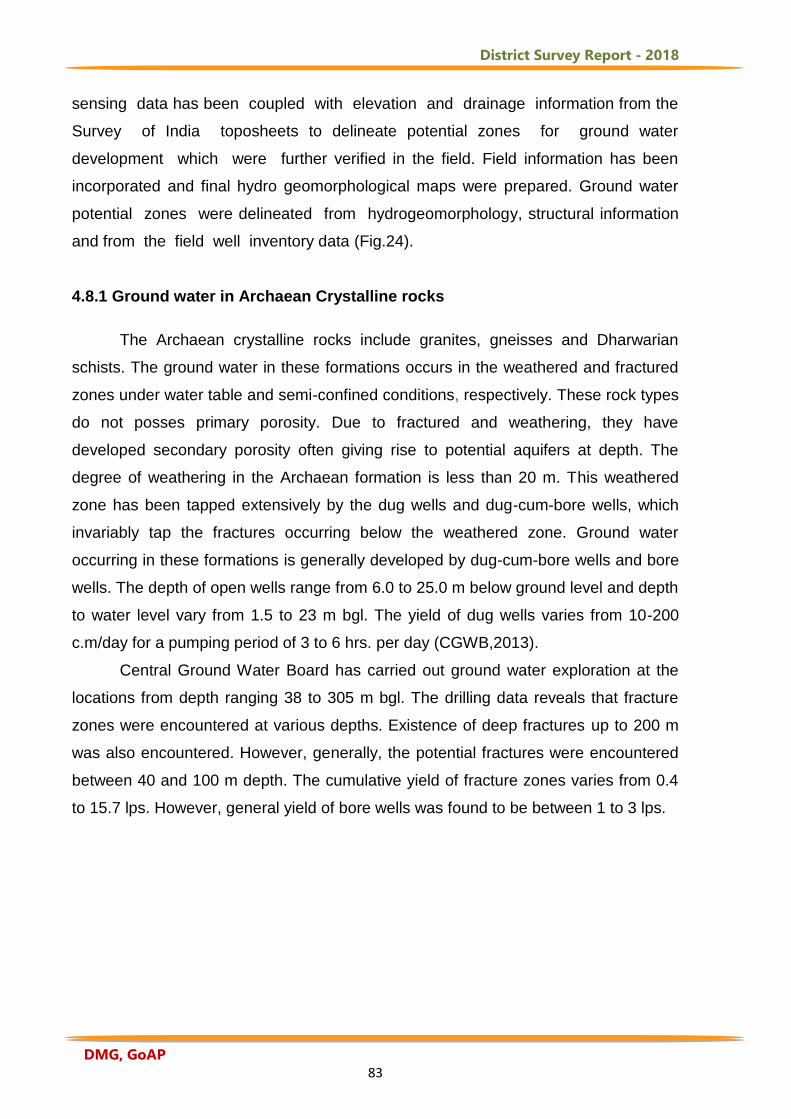
District Survey Report - 2018
DMG, GoAP 83
sensing data has been coupled with elevation and drainage information from the
Survey of India toposheets to delineate potential zones for ground water
development which were further verified in the field. Field information has been
incorporated and final hydro geomorphological maps were prepared. Ground water
potential zones were delineated from hydrogeomorphology, structural information
and from the field well inventory data (Fig.24).
4.8.1 Ground water in Archaean Crystalline rocks
The Archaean crystalline rocks include granites, gneisses and Dharwarian
schists. The ground water in these formations occurs in the weathered and fractured
zones under water table and semi-confined conditions, respectively. These rock types
do not posses primary porosity. Due to fractured and weathering, they have
developed secondary porosity often giving rise to potential aquifers at depth. The
degree of weathering in the Archaean formation is less than 20 m. This weathered
zone has been tapped extensively by the dug wells and dug-cum-bore wells, which
invariably tap the fractures occurring below the weathered zone. Ground water
occurring in these formations is generally developed by dug-cum-bore wells and bore
wells. The depth of open wells range from 6.0 to 25.0 m below ground level and depth
to water level vary from 1.5 to 23 m bgl. The yield of dug wells varies from 10-200
c.m/day for a pumping period of 3 to 6 hrs. per day (CGWB,2013).
Central Ground Water Board has carried out ground water exploration at the
locations from depth ranging 38 to 305 m bgl. The drilling data reveals that fracture
zones were encountered at various depths. Existence of deep fractures up to 200 m
was also encountered. However, generally, the potential fractures were encountered
between 40 and 100 m depth. The cumulative yield of fracture zones varies from 0.4
to 15.7 lps. However, general yield of bore wells was found to be between 1 to 3 lps.
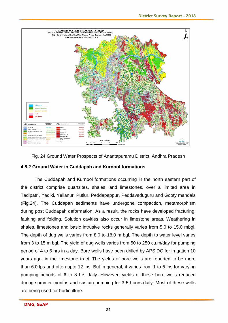
District Survey Report - 2018
DMG, GoAP 84
Fig. 24 Ground Water Prospects of Anantapuramu District, Andhra Pradesh 4.8.2 Ground Water in Cuddapah and Kurnool formations
The Cuddapah and Kurnool formations occurring in the north eastern part of
the district comprise quartzites, shales, and limestones, over a limited area in
Tadipatri, Yadiki, Yellanur, Putlur, Peddapappur, Peddavaduguru and Gooty mandals
(Fig.24). The Cuddapah sediments have undergone compaction, metamorphism
during post Cuddapah deformation. As a result, the rocks have developed fracturing,
faulting and folding. Solution cavities also occur in limestone areas. Weathering in
shales, limestones and basic intrusive rocks generally varies from 5.0 to 15.0 mbgl.
The depth of dug wells varies from 8.0 to 18.0 m bgl. The depth to water level varies
from 3 to 15 m bgl. The yield of dug wells varies from 50 to 250 cu.m/day for pumping
period of 4 to 6 hrs in a day. Bore wells have been drilled by APSIDC for irrigation 10
years ago, in the limestone tract. The yields of bore wells are reported to be more
than 6.0 lps and often upto 12 lps. But in general, it varies from 1 to 5 lps for varying
pumping periods of 6 to 8 hrs daily. However, yields of these bore wells reduced
during summer months and sustain pumping for 3-5 hours daily. Most of these wells
are being used for horticulture.
District Survey Report - 2018
DMG, GoAP 85
4.8.3 Ground water in Alluvium
Unconsolidated alluvium occurs along major river stream courses like Pennar,
Chitravathi, Kushavati, Tadakaleru, Maravanka. Filter points and shallow wells and
infiltration wells have been constructed to tap the alluvium in addition to dug wells.
The depth varies from 3.5 to 12.0 m bgl with yield varying from 8 to 135 cu.m/hr.
These wells also generally go dry or with less water during summer months (CGWB,
2013). The Ground Water Department established a good network of piezometer
observation wells throughout the District to monitor the depth of ground water levels
(Fig.25).
Fig.25 Network of piezometer Observation wells in Anantapuramu District
4.9. Ground Water Quality
Ground water samples were collected from 2991 habitations out of 3447
habitations representing for two seasons i.e., post monsoon and pre monsoon in
December 2012 and June 2014 for the entire District. The water samples were
collected from Rural Water Supply and Sanitation Department (RWS & S) and
analyzed for physico-chemical parameters like TDS, TH, Cl, NO3, pH, F, Fe, TA and
SO4 using standard techniques in the laboratory and compared with the BIS (10500-
2015) standards in terms of desirable, permissible and non potable classes (NRSC,
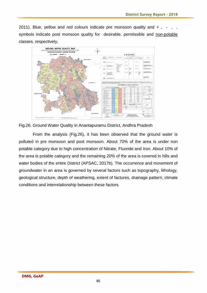
District Survey Report - 2018
DMG, GoAP 86
2011). Blue, yellow and red colours indicate pre monsoon quality and + , - , .
symbols indicate post monsoon quality for desirable, permissible and non-potable
classes, respectively.
Fig.26. Ground Water Quality in Anantapuramu District, Andhra Pradesh
From the analysis (Fig.26), it has been observed that the ground water is
polluted in pre monsoon and post monsoon. About 70% of the area is under non
potable category due to high concentration of Nitrate, Fluoride and Iron. About 10% of
the area is potable category and the remaining 20% of the area is covered in hills and
water bodies of the entire District (APSAC, 2017b). The occurrence and movement of
groundwater in an area is governed by several factors such as topography, lithology,
geological structure, depth of weathering, extent of factures, drainage pattern, climate
conditions and interrelationship between these factors.
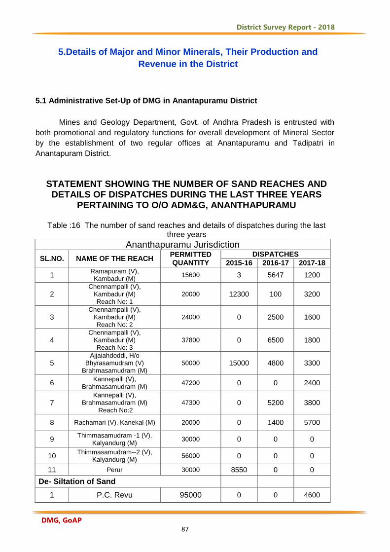
District Survey Report - 2018
DMG, GoAP 87
5.Details of Major and Minor Minerals, Their Production and
Revenue in the District
5.1 Administrative Set-Up of DMG in Anantapuramu District Mines and Geology Department, Govt. of Andhra Pradesh is entrusted with
both promotional and regulatory functions for overall development of Mineral Sector
by the establishment of two regular offices at Anantapuramu and Tadipatri in
Anantapuram District.
STATEMENT SHOWING THE NUMBER OF SAND REACHES AND
DETAILS OF DISPATCHES DURING THE LAST THREE YEARS PERTAINING TO O/O ADM&G, ANANTHAPURAMU
Table :16 The number of sand reaches and details of dispatches during the last
three years Ananthapuramu Jurisdiction
SL.NO. NAME OF THE REACH
PERMITTED QUANTITY
DISPATCHES 2015-16 2016-17 2017-18
1 Ramapuram (V), Kambadur (M)
15600 3 5647 1200
2
Chennampalli (V), Kambadur (M) Reach No: 1
20000 12300 100 3200
3
Chennampalli (V), Kambadur (M) Reach No: 2
24000 0 2500 1600
4
Chennampalli (V), Kambadur (M) Reach No: 3
37800 0 6500 1800
5
Ajjaiahdoddi, H/o Bhyrasamudram (V)
Brahmasamudram (M) 50000 15000 4800 3300
6
Kannepalli (V), Brahmasamudram (M)
47200 0 0 2400
7
Kannepalli (V), Brahmasamudram (M)
Reach No:2 47300 0 5200 3800
8 Rachamari (V), Kanekal (M) 20000 0 1400 5700
9
Thimmasamudram -1 (V), Kalyandurg (M)
30000 0 0 0
10
Thimmasamudram--2 (V), Kalyandurg (M)
56000 0 0 0
11 Perur 30000 8550 0 0
De- Siltation of Sand
1 P.C. Revu 95000 0 0 4600
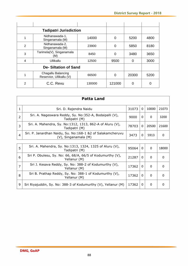
District Survey Report - 2018
DMG, GoAP 88
Tadipatri Jurisdiction
1
Nidhanawada-1, Singanamala (M)
14000 0 5200 4800
2
Nidhanawada-2, Singanamala (M)
23900 0 5850 8180
3
Tarimela(V), Singanamala (M)
8450 0 3480 3650
4 Ullikallu 12500 9500 0 3000
De- Siltation of Sand
1
Chagallu Balancing Reservior, Ullikallu (V)
66500 0 20300 5200
2 C.C. Revu 130000 121000 0 0
Patta Land
1 Sri. D. Rajendra Naidu 31073 0 10000 21073
2
Sri. A. Nageswara Reddy, Sy. No:352-A, Bodaipalli (V),
Tadipatri (M) 9000 0 0 3200
3
Sri. A. Mahendra, Sy. No:1312, 1313, 862-A of Aluru (V),
Tadipatri (M) 78703 0 20500 21600
4
Sri. P. Janardhan Naidu, Su. No:168-1 &2 of Salakamcheruvu
(V), Singanamala (M) 3473 0 5913 0
5 Sri. A. Mahendra, Sy. No:1313, 1324, 1325 of Aluru (V),
Tadipatri (M) 95064 0 0 18000
6
Sri P. Obulesu, Sy. No: 66, 68/A, 66/5 of Kodumurthy (V),
Yellanur (M) 21287 0 0 0
7
Sri J. Kesava Reddy, Sy. No: 388-2 of Kodumurthy (V),
Yellanur (M) 17362 0 0 0
8
Sri B. Prathap Reddy, Sy. No: 388-1 of Kodumurthy (V),
Yellanur (M) 17362 0 0 0
9 Sri Riyajuddin, Sy. No: 388-3 of Kodumurthy (V), Yellanur (M) 17362 0 0 0
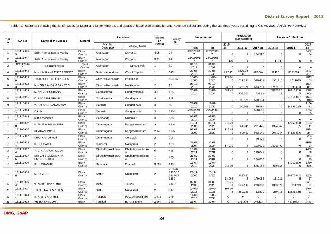
District Survey Report - 2018
DMG, GoAP 89
Table: 17 Statement showing the list of leases for Major and Minor Minerals and details of lease wise production and Revenue collections during the last three years pertaining to O/o ADM&G, ANANTHAPURAMU
S.No
I.D. No Name of the Lessee Mineral
Location Extent (In
Hects)
Survey No.
Lease period Production
(Dispatches) Revenue Collections
Mandal_ Description
Village_ Name From To
2015-16 2016-17 2017-18 2015-16 2016-17
2017-18
1 1211170459
Sri K. Ramachandra Murthy Black Granite
Anantapur Chiyyedu 4.95 24 29/12/201
7 28/12/203
7 0 0 104.373 0 0 2472
04
2 1211170476
Sri K. Ramachandra Murthy Black Granite
Anantapur Chiyyedu 3.99 24 29/12/201
7 28/12/203
7 100 0 0 11000 0 0
3 121117044
5 B.Rajamunedra
Black Granite
Anantapur Uppara Palli 1 19 01-10-2017
01-09-2037 0 0 0 0 0 0
4 1211150400
M/s HIMALAYA ENTERPRISES Black Granite
Brahmasamudram West kodipalle 1 348 23-06-2015
22-06-1935
21.835 1509.34
8 623.884 52455 3695094
1510387
5 1211060198
THULASEE ENTERPRISES Black Granite
Chenne Kothapalle Poletipalle 1 603-1A 15-06-2006
14-06-2026
129.615 611.141 390.401 331916 1517623
1043169
6 1211150393
M/s SRI RANGA GRANITES Black Granite
Chenne Kothapalle Mustikovila 2 73 03-12-2015
02-12-2035 83.813 926.676 633.761 197921.15 2190849.3
1504887
7 1211140192
K. NAGABHUSHANA Black Granite
Gandlapenta Godduvelagala 4.5 125 25-03-2014
24-03-2034
481.467 703.523 533.11
1055564.58
1691641.05
1318008
8 1211160417
K. NAGABHUSHANA Black Granite
Gandlapenta Gandlapenta 4 848 0 907.29 638.134 0
2141835.75
1501013
9 1211100191
V. BALASUBRAMANYAM Black Granite
Gorantla Gangampalle 3 50 23-07-2016
22-07-2036 0 60.669 90.897 0 142572.15
216021
10 1211170447
K.Babu Black Granite
Gorantla Gangampalle 2 260/1 28/03/201
7 27/03/203
7 0 0 5084.86
3 0 0 5753
55
11 1211170444
R.R.Associates Black Granite
Gudibanda Muthukur 3 378 01-05-2017
01-04-2037 0 0 0 0 0 0
12 1211060070
M. RAMAKRISHNAPPA Black Granite
Gummagatta Rangasamudram 2 63-A 10-11-2006
09-11-2026
615.238 544.945 211.478 1324842
1296291.85
519311
13 1211090071
DHANAM IMPEX Black Granite
Gummagatta Rangasamudram 2.14 63-A 05-03-2008
04-03-2028
1298.42 598.62 882.142 2951064 1412526.6
2078277
14 1211170471
Sri C. Afak Ahmed Black Granite
Gummagatta Gollapalle 2 206 0 0 29.179 0 0
62342
15 1211070164
K. SESHADRI Black Granite
Kundurpi Malayanur 2 103 23-07-2007
22-07-2027 17.276 0 153.535 33256.32 0
355963
16 1211110174
Y. S. AVINASH REDDY Black Granite
Obuladevaracheruvu
Obuladevaracheruvu
5 455 19-04-2011
18-04-2031 0 0 190.029 0 0
446568
17 1211110175
SRI SAI SIDDESWARA ENTERPRISES
Black Granite
Obuladevaracheruvu
Obuladevaracheruvu
1 455 21-02-2011
20-02-2031 0 0 124.883 0 0
293475
18 1211120067
S. K. GRANITE Black Granite
Ramagiri Polepalle 3.637 143 13-04-2012
12-04-2032 248.98 0 526.158 589855
1301025.65
1380576
19 1211080086
K. RAMESH Black Granite
Settur Mulakaledu 2
738-6B, 1185-1B, 1189-1A 1189
29-11-2008
28-11-2028
68.063 1223.67
5 179.088 131021 2877304.2
5 4208
57
20 1211090064
G. R. ENTERPRISES Black Granite
Settur Yatakal 1 193/7 02-09-2005
01-09-2025
678.753 277.147 233.683 1360870 651799
548731
21 1211130177
TRINETRA GRANITES Black Granite
Settur Mulakaledu 2 617 24-05-2013
23-05-1933
107.588 559.149 63.599 269418 135214.85
157821
22 1211160431
S. R. S. GRANTIES Black Granite
Talupula Peddannavaripalle 1.416 145 14-09-2016
13-09-2036
0 0 0 0 0 0
23 121112018 VENKATA SUDHA Black Tanakal Bonthalapalle 2.964 966 21-04- 20-04- 0 173.304 144.124 0 407264.4 3487
District Survey Report - 2018
DMG, GoAP 90
3 ENTERPRISES Granite 2012 2032 52
BLACK GRANITE
Non-Working Leases
1 1211040185 A. KRISHNA Black Granite
Amadagur Edigavaripalle 3 64 18-10-2004 17-10-2024 0 0 0 0 0 0
2 1211100176 BANU PRASAD Black Granite
Amarapuram Valasa 1 9-2, 9-1C, 10
16-02-2010 15-02-2030 0 0 0 0 0 0
3 1211090184 ARCHEAN GRANITES (P) LIMITED
Black Granite
Anantapur Kodimi 1 1 16-02-2009 15-02-2029 0 0 0 0 0 0
4 1211110189 C. YERRI SWAMY Black Granite
Anantapur Kodimi 1 1 04-08-2011 03-08-2031 20.153 0 0 47359.55 0 0
5 1211080193 K. THIPPANNA Black Granite
Atmakur Goridindla 1 249 19-04-2008 18-04-2028 0 0 0 0 0 0
6 1211140182 J. R. ENTERPRISES Black Granite
Brahmasamudram West kodipalle 6 348 22-11-2014 21-11-2034 0 0 0 0 0 0
7 1211140196 K. RAGHAVENDRA Black Granite
Chenne Kothapalle Nagasamudram 2 51 29-03-2014 28-03-2034 0 0 0 0 0 0
8 1211100186 V. BALASUBRAMANAYAM Black Granite
Gorantla Gangampalle 2.985 50 05-08-2009 04-08-2029 0 9.634 0 0 22639 0
9 1211100187 V. BALASUBRAMANYAM Black Granite
Gorantla Gangampalle 3 129 05-08-2009 04-08-2029 0 0 0 0 0 0
10 1211130210 M. GOWRI Black Granite
Gorantla Gangampalle 2 260-1 17-04-2013 16-04-2033 0 0 0 0 0 0
11 1211130338 G. PAVAN KUMAR Black Granite
Kalyandurg East kodipalle 1 232/2 28-11-2013 27-11-2033 0 0 0 0 0 0
12 1211140378 M/s GAYATRI GRANITES Black Granite
Mudigubba Sankepalle 3 528 15-03-2014 14-03-2034 0 0 0 0 0 0
13 1211060213 P. LAKSHMAIAH Black Granite
Obuladevaracheruvu Sunnampalle 1 301 16-10-2006 15-10-2026 0 0 0 0 0 0
14 1211110062 S K GRANITES Black Granite
Ramagiri Polepalle 2 143 22-10-2011 21-10-2031 81.564 205.972 0 194751 487774 0
15 1211150420 P. NABHI KHAN Black Granite
Settur Bachepalli 1 112-2 14-08-2015 13-08-2035 0 0 0 0 0 0
16 1211060211 NIVETHA GRANITES Black Granite
Settur Khairevu 1 7 02-09-2006 01-09-2026 0 0 0 0 0 0
17 1211030215 SUSHEELA ENTERPRISES
Black Granite
Settur Mulakaledu 2 605/1B, 738/6A, 1185/1A
21-03-2003 20-03-2023
0 0 0 0 0 0
18 1211070352 BHARGAVI GRANITES Black Granite
Settur Mulakaledu 3 617 12-02-2007 11-02-2027 0 0 0 0 0 0
19 1211090197 J. R. ENTERPRISES Black Granite
Settur Mulakaledu 1 711-5, 711-6
26-11-2004 25-11-2024 0 0 0 0 0 0
20 1211090313 RAJWIN GRANITES Black Granite
Settur Mulakaledu 2 193/2B, 3B 14-05-2004 13-05-2024 0 0 0 0 0 0
21 1211130214 G. T. R. ENTERPRISES Black Granite
Settur Mulakaledu 1 739-1 15-06-2006 14-06-2026 0 0 0 0 0 0
22 1211120091 KEMPSZ TRADING PVT. LTD.
Black Granite
Somandepalle Pandiparthi 1.8 318 15-06-2012 14-06-2032 52.219 38.544 0 116902 90578 0
District Survey Report - 2018
DMG, GoAP 91
23 1211050188 ABDUL KHADER SAHEB Black Granite
Talupula Lakkasamudram 1 573-P 05-01-2005 04-01-2025 0 0 0 0 0 0
24 1211100173 B. LAKSHMANA Black Granite
Talupula Peddannavaripalle 1 276 21-10-2010 20-10-2030 0 0 0 0 0 0
25 1211120108 MOHAMMED RAFEEQ Black Granite
Tanakal Agraharampalli 2.74 9, 2 13-04-2004 12-04-2024 0 0 0 0 0 0
26 1211030190 A. SREEDHAR Black Granite
Tanakal Tavalam 1 1779 18-09-2003 17-09-2023 0 0 0 0 0 0
27 1211120180 A. MARKANDEYA Black Granite
Tanakal Tanakal 0.98 1649 16-03-2012 15-03-2032 0 0 0 0 0 0
28 1211080199 S. SREERAMULU Black Granite
Uravakonda Uravakonda 1.914 181-5 27-09-2008 26-09-2028 0 0 0 0 0 0
COLOUR GRANITE
Working Leases
1 1211120308 SMT. NOOR TAJ Color Granite
Agali Hulikeradevarahalli
1.053 143 27-03-2010 26-03-2030 670.146 537.665 205.731 1409705 1221593 472283
2 1211140243 K. Y. V. VADDERA GRANITES
Color Granite
Agali Hulikeradevarahalli
1.705 143 17-09-2014 16-09-2034 1190.841 1625.736 1747.075 2146655 3407744 3659073
3 1211150390 Smt. B. ACHAMMA Color Granite
Agali Hulikeradevarahalli
1.841 140-1 28-04-2015 27-04-2035 191.381 1024.463 1022.736 442752 2294940 2322759
4 1211990266 SUN ROCK AGES Color Granite
Agali Hulikeradevarahalli
1.865 139 19-05-1999 18-05-2034 0 3589.949 3693.563 0 8321103 8181161
5 1211180475 S.A. Basha Color Granite
Agali Hulikeradevarahalli
3.929 416/1 & 2 02-03-2018 02-02-2038 0 0 0 0
6 1211100068 K. BABU Color Granite
Amadagur Chinaganipalle 2 28 25-08-2010 24-08-2030 1598.354 335.506 100.947 2980242 744818 227611
7 1211120069 RAJA RAJESWARI VADDERA Coop. SOCIETY
Color Granite
Amadagur Chinaganipalle 3 28 04-02-2012 03-02-2032 182.85 173.872 605.331 337254 379569 1360395
8 1211160418 S. NARENDRANATH REDDY
Color Granite
Brahmasamudram
Theetakal 6 287 09-05-2016 08-05-2036 0 291.294 302.039 0 595443 606386
9 1211170450 Sri S. Naraya Swamy Color Granite
Bukkapatnam Siddarampuram
9.48 894 in Black.No. 21
22.06.2017 22.06.2037 0 0 583.782 0 0 1296538
10 1211030090 VASUNDHARA ENTERPRISES
Color Granite
Bukkarayasamudram
Siddarampuram
5 196 02-09-2003 01-09-2023 56.602 247.426 250.439 10178 501237 518929
11 1211140080 NANJE GOWDA Color Granite
Chenne Kothapalle
Bramhanapalle 2.3 31 20-08-2014 19-08-2034 985 0 462.568 58875 0 1005596
12 1211160429 C. NARAYANAMMA Color Granite
Chenne Kothapalle
Ganginepalle 5 195/P 13-06-2016 12-06-2036 0 0 550.072 0 0 1148154
13 1211090260 M. S. SIVANANDA KUMAR
Color Granite
Chilamathur Chagaleru 1 63-7B 25-06-2009 24-06-2029 0 0 0 0 0 0
14 1211150380 Sri K. C. MURUGESH Color Granite
Chilamathur Chagaleru 1 84/7-P 16-03-2012 15-03-2032 0 53.646 226.968 0 114339 502266
15 1211150381 Sri K. C. MURUGESH Color Granite
Chilamathur Chagaleru 2 83/P 04-07-2015 03-07-2035 0 138.607 237.058 0 298393 513830
16 1211160424 M. S. SHIVANANDA KUMAR
Color Granite
Chilamathur Chagaleru 1.469 63-1, 68/2-P
26-07-2016 25-07-2036 0 0 203.024 0 0 445224
17 1211170464 Sri K.V. Narayana Swamy
Color Granite
Chilamathur Chagaleru 2 317/4 15/12/2017 14/12/2037 0 0 0 0 0 0
18 1211170465 Sri S. Khasim Color Granite
Chilamathur Chagaleru 2 317/4 15/12/2017 14/12/2037 0 0 0 0 0 0
19 1211100088 SAMA CONSTRUCTIONS
Color Granite
Gorantla Gangampalle 2 253 17-03-2010 16-03-2030 59.837 92.333 236.379 98190 191527 506485
District Survey Report - 2018
DMG, GoAP 92
20 1211130319 SAMA CONSTRUCTIONS
Color Granite
Gorantla Gangampalle 3 253 15-04-2013 14-04-2033 249.847 185.867 141.202 423083 379694 293403
21 1211050058 Parimala Granites Color Granite
Gummagatta Veerapuram 1 229 15-04-2013 14-04-2033 462.91 708.042 350.945 831961 1442777 703935
22 1211110256 T. UDAY BHASKAR Color Granite
Gummagatta Gollapalle 3.638 78-P 08-12-2011 07-12-2031 0 0 185.146 0 0 385186
23 1211140060 S SHABANA Color Granite
Gummagatta Veerapuram 3 B4-1 24-04-2014 04-10-2029 306.62 21.373 162.357 507948 427446 331695
24 1211160414 M/s NISSI POWER PROJECTS PVT. LTD.
Color Granite
Kambadur Kambadur 23.99 82/p 22-07-2016 21-07-2036 0 1409.652 1450.431 0 3207213 3285313
25 1211160430 SAVIOUR MINES & MINERALS PVT. LTD.
Color Granite
Kambadur Kambadur 12.81 932 15-06-2016 14-06-2036 0 0 0 0 0 0
26 1211170466 Smt. G. Sarada Padma Color
Granite Kambadur Pallur 6 399
31.08.2017 30.08.2037 0 0 166.695 0 0 348147
27 1211060094 H. IMAM SAB Color Granite
Madakasira Jadrahalli 1 3 07-08-2006 06-08-2026 0 545.16 73.247 0 1176995 155019
28 1211070076 G. RADHAKRISHNA Color Madakasira Jadrahalli 1 3 30-08-2007 29-08-2027 395.815 1017.499 119.703 725210 2298791 271263
29 1211120074 SREE TIRUPATHI BALAJI MINERALS
Color Granite
Madakasira Amidalagondi 4 246 23-04-2010 22-04-1930 0 0 194.436 0 0 453115
30 1211120075 G. SHIVANANDAPPA Color Granite
Madakasira Jadrahalli 1 3 19-03-2012 18-03-2032 1301.42 1487.472 1242.948 2525272 3226482 2642267
31 1211120093 H. IMAM SAB Color Granite
Madakasira Jadrahalli 0.998 3-1 02-08-2012 01-08-2032 161.532 591.726 365.227 301725 1281604
782582.75
32 1211120315 G. SHIVANANDAPPA Color Granite
Madakasira Amidalagondi 2 246 19-03-2012 18-03-2032 53.758 1117.849 85.313 118685 2481194 179631
33 1211120328 P. KHASIM Color Granite
Madakasira Jadrahalli 1 3 19-03-2012 18-03-2032 712.048 1352.906 560.937 1300617 2901760 1166133
34 1211120361 H IMAM SAB Color Granite
Madakasira Jadrahalli 0.682 3-1 02-08-2012 01-08-2032 0 100.974 58.331 0 213861 114427
35 1211120366 G. CHANDRAPPA Color Granite
Madakasira Jadrahalli 0.912 3-9 25-06-2012 24-06-2032 745.283 508.377 544.657 1403881 1154738 1220576
36 1211140239 SAAS GRANITES Color Granite
Madakasira Mallinayakanahalli
2 6 20-09-2014 19-09-2034 122.341 108.942 87.397 250755 227465 195234
37 1211140245 G. RADHAKRISHNA Color Granite
Madakasira Amidalagondi 1.919 246 15-07-2014 14-07-2034 126.38 381.967 421.921 252894 834054 945575
38 1211180470 Sri G. Chandrappa Color Granite
Madakasira Govindapuram 2 443/2 01-09-2018 01-08-2038 0 0 0 0 0 0
39 1211160425 SUN GRANITES Color Granite
Mudigubba Thimmanayanipalem
4.79 1 28-07-2016 27-07-2036 0 0 0 0 0 0
40 1211160427 B. PRASAD Color Granite
Mudigubba Thimmanayanipalem
1.596 1 20-08-2016 19-08-2036 0 0 0 0 0 0
41 1211160419 S. GANGULAPPA Color Granite
Nallacheruvu Jogannapeta 2.97 998 27-09-2016 26-09-2036 0 492.411 941.296 0 1088977 2064564
42 1211170446 P.Sreenivasulu Color Granite
Nallamada Reddipalle 1 183 23/02/2017 22/02/2037 0 0 136.873 0 0 283447
43 1211160433 N. V. K. ASSOCIATES Color Granite
Nallamada Reddipalle 2 183 04-11-2016 03-11-2036 0 0 0 0 0 0
44 1211160428 R. RAMANJINEYULU Color Granite
Nambulipulikunta Mekalacheruvu 4.98 657 27-07-2016 26-07-2036 0 192.346 129.828 0 399979 284007
45 1211150394 M/s APM TRADERS Color Granite
Penu Konda Settipalle 3.16
400/2 & 345/2 (new-556)
14-08-2015 13-08-2035
0 0 142.487 0 0 294791
District Survey Report - 2018
DMG, GoAP 93
46 1211080078 SRI GAJANAND GRANITE PVT. LTD.
Color Granite
Puttaparthi Beedupalle 2 269 29-08-2008 28-08-2028 375.53 681.843 501.352 711669 1432648 1078950
47 1211090172 T. HEMALATHA Color Granite
Puttaparthi Beedupalle 1.373 269 05-06-2007 04-06-2027 672.02 1066.004 404.365 1311197 2347469 885178
48 1211100085 S. N. MANOHAR Color Granite
Puttaparthi Beedupalle 3 269 29-08-2008 28-08-2028 617.675 404.87 709.809 1286983 878406 1522402
49 1211120171 T. VENKATESH Color Granite
Puttaparthi Beedupalle 1 269 11-09-2012 04-06-2027 0 129.01 991.756 0 270562 2114227
50 1211100059 P A INTERNATIONAL Color Granite
Ramagiri Nasanakota 1.906 629/2, 4 08-11-2010 07-11-2030 21.681 0 636.791 395362 0 1275397
51 1211140077 M. S. ENTERPRISES Color Granite
Ramagiri Nasanakota 1.86 670 05-06-2014 04-06-2034 286.316 265.433 254.498 507484 534991 510528
52 1211060329 IMPERIAL GRANITES Color Granite
Rayadurg Veparalla 3 142/P 16-03-2006 15-03-2026 0 264.447 261.75 0 553026 567486
53 1211120073 SOMESHWARA GRANITES
Color Granite
Rayadurg Veparalla 3.238 406/P 09-07-2011 08-07-2031 735.285 538.176 768.846 1459379 1122254 1605345
54 1211160426 A. MARRI SWAMY REDDY
Color Granite
Rayadurg Chadam 1.214 170-B 30-08-2016 29-08-2036 0 0 0 0 0 0
55 1211160439 M/s Om Sree Hanuman Granites
Color Granite
Rayadurg Mallapuram 1 140-C/A 31/12/2016 30/12/2036 0 0 313.268 0 0 677429
56 1211120261 V. SYAMALA Color Granite
Talupula Puligundlapalle 2 53 25-07-2012 24-07-2032 267.024 89.746 205.731 548795 182921 472282
57 1211140072 SMT. A. SREEDEVI Color Granite
Talupula Udumulakurthy 11.96 416 28-05-2014 27-05-2034 1600.29 1612.402 2590.798 2994146 3393576 5649067
58 1211160432 K. RAVI SHANKAR Color Granite
Talupula Odulapalle 3 100 19-09-2016 18-09-2036 0 0 72.93 0 0 138879
59 1211160421 SAVIOUR MINES & MINERALS PVT. LTD.
Color Granite
Tanakal Kokkanti 1.98 385-1 23-08-2016 22-08-2036 0 0 0 0 0 0
60 1211160422 M/s Saviour Mines & Minerals Pvt. Ltd.
Color Granite
Tanakal Kokkanti 2.71 385-1 23-08-2016 22-08-2036
0 0 0 0 0 0
61 1211170456 R. Jaya Prakash Naidu Color Granite
Tanakal T.sadum 15 85 06.10.2017 05.10.2037 0 0 356.86 0 0 752803
62 1211170474 H.S. Ramanjaneya Color Granite
Tanakal Tanakal 2 1649 30/12/2017 29/12/2037 0 0 44.923 0 0 96634
63 1211090318 U. ANJANEYULU Color Granite
Vajrakarur Gulapalem 1 187 22-06-2009 21-06-2029 0 46.228 122.712 0 94023 247328
64 1211130061 B. Kamakshamma Color Granite
Vidapanakal Velpumadugu 1.384 531 14-02-2013 13-02-2033 111.341 611.038 164.7 205211 1227030 329400
COLOUR GRANITE Non-Working Leases
1 1211100307 A. SUBBARAYUDU Color Granite
Agali Hulikeradevarahalli 1 290 28-12-2007 27-12-2027 0 0 0 0 0 0
2 1211140367 M/s S. L. N. COMPANY
Color Granite
Agali Hulikeradevarahalli 4.63 301 12-06-2014 11-06-2034 0 0 0 0 0 0
3 1211140369 G. CHANDRAPPA Color Granite
Agali Hulikeradevarahalli 2 420 04-10-2014 03-10-2034 0 0 0 0 0 0
4 1211060163 P Gangi Reddy Color Granite
Chilamathur Veerapuram 1 61/6 61/7 25-04-2006 24-04-2026 0 0 0 0 0 0
5 1211120118 S. RAJA REDDY Color Granite
Chilamathur Veerapuram 1.8 77-3 16-03-2012 15-03-2032 0 0 0 0 0 0
6 1211120238 S AMARNATH Color Chilamathur Veerapuram 0.955 64/4 66/4 20-04-2012 19-04-2032 0 0 0 0 0 0
District Survey Report - 2018
DMG, GoAP 94
Granite 67/1
7 1211040065 NAWAZ KHAN Color Granite
Chilamathur Morasalapalle 1 231 04-08-2004 03-08-2024 301.547 628648 0 0 0 0
8 1211100265 SRI SAI GRANITES Color Granite
Gorantla Gangampalle 2 146/8 28-09-2010 27-09-2030 0 0 0 0 0 0
9 1211100317 P. NATARAJAN Color Granite
Gorantla Vadigepalle 1.71 299/2 19-10-2010 18-10-2030 0 0 0 0 0 0
10 1211120237 H N VENKATA RAMANAPPA
Color Granite
Gorantla Gownivaripalle 1 813814 12-09-2012 11-09-2032 0 0 0 0 0 0
11 1211120250 H. G. NARAYANA SWAMY
Color Granite
Gorantla Gownivaripalle 3 816-3 14-09-2012 13-09-2032 0 0 0 0 0 0
12 1211130066 R. SHAKTHI Color Granite
Kadiri Muthyalacheruvu 3 748 11-01-2013 10-01-2033 0 0 0 0 0 0
13 1211140257 SRI SAI MONICA ENTERPRISES
Color Granite
Kadiri Kowlepalle 1.55 227-6, 228-5
29-01-2014 28-01-2034 0 64.651 0 0 143004 0
14 1211110351 S SUVARNA DEVI Color Granite
Kambadur Kambadur 1 651-7A, 651-8A
09-08-2011 08-08-2031 0 0 0 0 0 0
15 1211120268 SRINIVASA GRANITES
Color Granite
Madakasira Mallinayakanahalli 1 6 25-06-2012 24-06-2032 0 0 0 0 0 0
16 1211120122 SUN GRANITES Color Granite
Mudigubba Thimmanayanipalem 2.17 1 22-11-2012 21-11-2032 225.077 280.03 0 419139 590055 0
17 1211140312 S. SUDHAKAR REDDY
Color Granite
Mudigubba Thimmanayanipalem 2 1 01-09-2014 31-08-2034 0 0 0 0 0 0
18 1211040254 YAK GRANITES Color Granite
Nallacheruvu Ubicherla 1 742-7 24-11-2004 23-11-2024 0 0 0 0 0 0
19 1211040263 SRI SAI ROCKS Color Granite
Nallacheruvu Allugundu 2.929
610-1,
611/1-P, 611/2-P
28-07-2004 27-07-2024 89.064 135.443 0 183105 303773 0
20 1211040264 SRI SAI ROCKS Color Granite
Nallacheruvu Allugundu 2.52 612 03-09-2004 02-09-2024 79.973 119.39 0 0 175815 258587
21 1211040299 BETHAN GRANITES Color Granite
Nallacheruvu Ubicherla 1 477/2 24-11-2004 23-11-2024 0 0 0 0 0 0
22 1211040330 SENTINEL GRANITES Color Granite
Nallacheruvu Ubicherla 2 473-14 24-11-2004 23-11-2024 0 0 0 0 0 0
23 1211060316 FUJI GRANITES Color Granite
Nallacheruvu Ubicherla 1 473/15 24-04-2006 23-04-2026 0 0 0 0 0 0
24 1211060327 ENTERPRISING EXPORTERS
Color Granite
Nallacheruvu Ubicherla 1 473-13 24-04-2006 23-04-2026 0 0 0 0 0 0
25 1211120240 C R SWAMY Color Granite
Nallamada Gopepalle 2.12 133 20-04-2012 19-04-2032 131.283 91.068 146.885 266742 208901 345179
26 1211130262 SYED MOHIDDIN Color Granite
Nallamada Reddipalle 1 183 09-01-2013 08-01-2033 0 0 0 0 0 0
27 1211980402 M/s Karthik Enterprises
Color Granite
Nallamada Reddipalle 1 183 31-12-1998 30-12-2013 0 0 0 0 0 0
28 1211060310 POOSHYA EXPORTS (P) LTD.
Color Granite
Narpala Gugudu 1 394/2 20-01-2006 19-01-2026 0 0 0 0 0 0
29 1211070096 Khudrat Color Granite
Obuladevaracheruvu Allapalle 2 501 22-11-2007 21-11-2027 165.587 0 0 306552 0 0
District Survey Report - 2018
DMG, GoAP 95
30 1211060376 A. H. SHARIFF Color Granite
Ramagiri Makkinavaripalle 1 1-1-P 02-02-2006 01-02-2026 0 0 0 0 0 0
31 1211070089 M. S. ENTERPRISES Color Granite
Ramagiri Nasanakota 1.985 133, 131/2 01-10-2007 30-09-2027 0 0 0 0 0 0
32 1211080259 M. RAGHAVENDRA NAIDU
Color Granite
Ramagiri Nasanakota 1.01 84 01-05-2008 30-04-2028 0 0 0 0 0 0
33 1211090311 RADHA EXPORTS (INDIA) PVT. LTD.
Color Granite
Ramagiri Nasanakota 4 41 01-09-2008 31-08-2028 0 0 0 0 0 0
34 1211130116 SUN GRANITES Color Granite
Raptadu Bandameedapalle 1 356 06-04-2013 05-04-2033 0 0 0 0 0 0
35 1211100242 SAKTHI PARAMGURU Color Granite
Rayadurg Veparalla 1.501 3 B 26-02-2010 25-02-2030 0 0 0 0 0 0
36 1211100364 M/s G. T. P. GRANITES LIMITED
Color Granite
Rayadurg Veparalla 5.026 406/P 17-06-1998 16-06-2013 0 0 0 0 0 0
37 1211120360 M/s G T P GRANITES Color Granite
Rayadurg Veparalla 2 406/P 05-03-2012 04-03-2032 0 0 0 0 0 0
38 1211110340 T. N. BALASUBRAMANYAM
Color Granite
Somandepalle Naginayanicheruvu 2 105 07-05-2011 06-05-2031 0 0 0 0 0 0
39 1211120339 M. SAKTHIVEL Color Granite
Somandepalle Bussaiahgaripalle 1.804 20 28-08-2012 27-08-2032 0 0 0 0 0 0
40 1211120249 MADHUCON GRANITES LTD.
Color Granite
Talupula Odulapalle 5.5 100 13-09-2012 12-09-2032 21.845 0 0 0 0 0
41 1211060301 A. EHESANULLAH Color Granite
Tanakal Tavalam 5 352 07-01-2006 06-01-2026 0 0 0 0 0
42 1211130161 POOJA GRANITES & MINERALS
Color Granite
Tanakal Tanakal 1.8 321 21-05-2013 20-05-2033 0 0 0 0 0 0
43 1211040255 G. VENKATA REDDY Color Granite
Vajrakarur Gulapalem 1 74-P 08-01-2004 07-01-2024 57.305 0 0 107157 0 0
44 1211080247 S. AFZAL AHMED Color Granite
Vajrakarur Konakondla 1 653 06-02-2008 05-02-2028 0 0 0 0 0 0
45 1211060103 Bharathi Granites Color Granite
Vidapanakal Havaligi 2 266 16-05-2006 15-05-2026 75.505 0 0 0 0 0
46 1211080370 M/s K. SADDRU KHAN GRANITES
Color Granite
Vidapanakal Havaligi 1 266 22-05-2008 21-05-2028 0 0 0 0 0 0
47 1211090252 K. VIBHUSHANAN Color Granite
Vidapanakal Havaligi 1.525 266 09-10-2009 08-10-2029 0 0 0 0 0 0
48 1211120336 M/s ADITYA GRANITES
Color Granite
Vidapanakal Havaligi 2 150 18-10-2012 17-10-2032
244.196 0 0 454890 0 0
IRON ORE AND 31 MINERALS
Working Leases
1 1212070095 SAI BALAJI MINERALS
Iron Ore(< 55% Fines)
D.Hirchal Obulapuram 4.046 370, 58/p 22-09-2007 21-09-2027
27515 69878 4688 3080678 6717344 446532
2 1211180469 K. Thulasamma Quartz Amadagur Thummala 18 1 01-04-2018 01-03-2032 0 0 0 0 0 0
3 1212090057 Maharishi Meltchems Pvt. Ltd.
Quartz Amadagur Thummala 10.2 409/B 390
16-07-2009 15-07-2029 22425 14055 14500 1076025 1054125 1087500
4 1212040079 G. M. NAGARAJU Quartz Chenne Kothapalle Mustikovila 4.8 1 25-06-2004 24-06-2024 1500 4898 4420 48750 367350 331500
5 1212970129 V. Sudhakar Quartz D.Hirehal H.siddapuram 1.618 77/A 17-10-1997 16-10-2017 0 0 0 0 0 0
6 1212980082 D. KRISTAPPA Quartz D.Hirehal Pulakurthi 2 279/D-22 30-12-1998 29-12-2018 1070 5460 7350 39153 409500 551250
7 1212990083 D. KRISTAPPA Quartz D.Hirehal D.Hirehal 6 461/P 03-11-1999 02-11-2019 0 0 0 0 0 0
District Survey Report - 2018
DMG, GoAP 96
8 1212120097 S. M. HUSSAIN AHMED
Quartz Gandlapenta Maddivarigondi 4.813 144 08-05-2012 07-05-2032 3459 7748 10469 200600 581100 785175
9 1212000128 V. SUDHAKAR Quartz Guntakal Ameenpalle 11.384 1/1-P 01-11-2000 31-10-2020 303 2200 8550 22725 165000 641250
10 1212010133 D. MANJULA Quartz Guntakal Patha kothachervu 36.423 40/p 11-07-2001 10-07-2021 0 0 5000 0 0 375000
11 1212130162 PRAVEENA MINES & MINERALS COMPANY
Quartz Kadiri Kutagulla 22.553 445-1 11-06-2013
10-06-2033
0 4000 4700 0 300000 352500
12 1212050087 SANDHYA MINES & MINERALS
Quartz Nallacheruvu Talamarlavandlapalle
5.091 1094, 1099
07-10-2005
06-10-2025 3600 2350 29280 134680 176250 2196000
13 1211170463 Sri M. Siva Sankar Reddy Quartz Nambulipulikunta Velichelimala 6 988/P 18/12/201
7 17/12/2037 0 0 0 0 0 0
14 1211170441 Sri G. Harinarayana Gupta Quartz Nambulipulikunta Edurudona 30.615 458 01-12-2017
01-11-2037 0 0 3750 0 0 281250
15 1212020084 V. SUDHAKAR Quartz Nambulipulikunta Velichelimala 52.2 988/P 19-12-2002
18-12-2022 5100 16130 4250 310620
1209750 318750
16 1212070134 M. MURALI MOHAN REDDY
Quartz Nambulipulikunta Velichelimala 25.9 988 19-12-2007
18-12-2027 9810 19100 16000 609840
1432500 1200000
17 1212090126 Sree Vishnu Mines & Minerals Pvt. Ltd.
Dolomite Narpala Venkatampalle 77.297 265/1F 31-05-2002
30-05-2022
0 14500 0 0 116000
0 0
18 1211160423 M. Ravindranath Quartz Obuladevaracheruvu
Veeraobanapalle 8.905 145 03-10-2016
02-10-2036 0 0 0 0 0 0
19 1212080165 K. SATYAVATHI Quartz Tanakal Malreddipalle 4.622 742 30-06-2008
29-06-2028 0 800 3100 0 60000 232500
IRON ORE AND 31 MINERALS Non-Working Leases
1 1212080141 GLOBEX COMMODITIES Iron Ore D.Hirchal H.SIDDAPURAM 4.7 33/A,
08-02-2008
07-02-2028 0 0 0 0 0 0
2 1212090297 K. SREENIVASULU Quartz Amadagur Thummala 6.473 409/B 22-07-2009
21-07-2029 0 0 0 0 0 0
3 1212990135 MADHU MINERAL STONES BEADS
Quartz Bommanahal Nemakallu 17.3 167 29-04-1999
28-04-2019 0 0 0 0 0 0
4 1212990132 P. NAGARJUNA Quartz D.Hirehal Obulapuram 3.104 155/1, 2, 3
24-02-1999
23-02-2019 0 0 0 0 0 0
5 1212060158 MD. JAFFER ALI Pyrophylite Nambulipulikunta Vankamaddi 24.836 441-2 14-02-2006
13-02-2026 0 0 0 0 0 0
6 1212080142 MINEX RESOURCES (P) LTD.
Pyrophylite Nambulipulikunta Marrikommadinne 157.49 583 16-02-2005
15-02-2025 0 0 0 0 0 0
7 1212010140 Y. V. KRISHNA REDDY Dolomite Narpala Venkatampalle 4.047 209 08-05-2001
07-05-2021 0 0 0 0 0 0
8 1212010160 S J K STEEL CORPORATION LTD.
Dolomite Narpala Venkatampalle 8.094 209 23-06-2001
22-06-2021 0 0 0 0 0 0
9 1212990137 B. MADHUSUDHANA REDDY
Quartz Narpala B.pappuru 9.53 290/P 23-06-1999
22-06-2019 0 0 0 0 0 0
10 1212990147 M. S. ABDUL REHIMAN Quartz Rayadurg Gramadatla 1.425 118-P 18-02-1999
17-02-2019 0 0 0 0 0 0
ROAD METAL
Working Leases
District Survey Report - 2018
DMG, GoAP 97
1 1211060043 B. Seenaiah & Company (Projects) Ltd.
Road Metal Anantapur Mannila 1 28/P 12-06-2006
11-06-2021
3600 3644 765 225000 273300 574050
2 1211070110 VAKULA DEVI Road Metal Anantapur Chiyyedu 2 231-P 05-11-2007
04-11-2017 8550 21300 41100 517500
1597500 3082500
3 1211130056 A. Sivaram Krishna Reddy Road Metal Anantapur Chiyyedu 3 231 15-05-2013
14-05-2023 7894 7200 8800 477050 540000 660000
4 1211080216 O. VENKATESWARA REDDY
Road Metal Anantapur Chiyyedu 2 231/P 02-07-2008
01-07-2018 950 0 1000 58750 0 75000
5 1211130205 K. PRASANNA Road Metal Anantapur Chiyyedu 2 231 15-05-2013
14-05-2023 2202 600 1300 125100 45000 97500
6 1211080044 B. Seenaiah & Co. (Projects) Ltd.
Road Metal Anantapur Mannila 10.3 28 29-02-2008
28-02-2023 17784 35406 31881
1108800
2655450 2391075
7 1211100289 Alakunta Gurappa Road Metal Anantapur Kodimi 2 1 29-07-2010
28-07-2020 0 0 2066 0 0 154950
8 1211150382 K. BASHA Road Metal Anantapur Chiyyedu 3.25 231 12-08-2015
11-08-2025 1150 19034 0 86250
1427550 0
9 1211150383 K. SAMBHASIVUDU Road Metal Anantapur Chiyyedu 4.6 231 12-08-2015
11-08-2025 1600 19813 0 120000
1485975 0
10 1211150384 M. GNANESWAR Road Metal Anantapur Chiyyedu 0.76 231 12-08-2015
11-08-2025 9810 3629 8680 609840 272175 651000
11 1211150385 M. GAYATHRI Road Metal Anantapur Chiyyedu 1 231 12-08-2015
11-08-2025 9810 4169 9290 609840 312675 696750
12 1211170457 BSCPL Infrastructure Limited
Road Metal Anantapur Mannila 9.357 28 0 0 7740 0 0 580500
13 1211030167 B. SEENAIAH & CO. (PROJECTS) LTD.
Road Metal Anantapur Mannila 1 28 29-03-2003
28-03-2013 0 672 3853 0 50400 288975
14 1211160403 M. VAKULA DEVI Road Metal Anantapur Chiyyedu 2 231 11-03-2016
10-03-2026 0 3000 30600 0 225000 2295000
15 1211150387 M. SUNIL KUMAR Road Metal Atmakur Atmakur 1.864 384/2 28-08-2015
27-08-2025 300 1100 2000 22500 82500 150000
16 1211080201 M/s Shree Manjunatha Minerals
Road Metal Bommanahal Elanji 1.942 6/2 23-10-2008
22-10-2018 11521 4188 500 670550 314100 37500
17 1211130111 H. RAJENDRA PRASAD Road Metal Bommanahal Nemakallu 2 253 24-11-2008
23-11-2018 120 2300 1000 131500 172500 75000
18 1211020143 T. V. S. KANTHA RAO Road Metal Bommanahal Nemakallu 1 253 02-11-2002
01-11-2017 11425 17499 150920 571250
1312425
11319000
19 1211070104 Nemakal Mineral Road Metal Bommanahal Nemakallu 2 253 30-03-2007
29-03-2017 3708 4255 2514 185400 319125 188550
20 1211080005 M. Subramanyeswara Rao Road Metal Bommanahal Nemakallu 1 253 08-09-2008
07-09-2018 15450 7000 3700 938750 525000 277500
20 1211080005 M. Subramanyeswara Rao Road Metal
Bommanahal Nemakallu 1 253 08-09-2008 07-09-2018 15450 7000 3700 938750 525000 277500
21 1211080034 K. Ramachandra Reddy Road Metal
Bommanahal Nemakallu 21.372 19-08-2008 18-08-2018 10500 33500 42500 6287500 2512500 3187500
22 1211080244 M/s MODEL ENTERPRISES Road Metal
Bommanahal Nemakallu 10.382 253 29-08-2008 28-08-2018 7190 6927 10920 396750 519525 819000
23 1211080246 A RAGHU PRATAP Road Metal
Bommanahal Nemakallu 4.662 253 29-08-2008 28-08-2018 7110 6100 116170 357000 457500 8712750
24 1211080284 T. Rajesh Reddy Road Metal
Bommanahal Nemakallu 1.056 253 02-09-2008 01-09-2018 0 100 0 0 7500 0
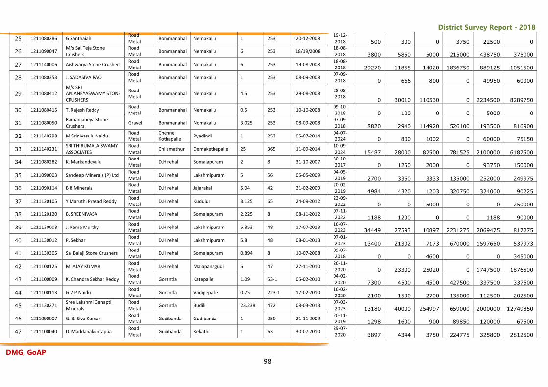
District Survey Report - 2018
DMG, GoAP 98
25 1211080286 G Santhaiah Road Metal
Bommanahal Nemakallu 1 253 20-12-2008 19-12-2018 500 300 0 3750 22500 0
26 1211090047 M/s Sai Teja Stone Crushers
Road Metal
Bommanahal Nemakallu 6 253 18/19/2008 18-08-2018 3800 5850 5000 215000 438750 375000
27 1211140006 Aishwarya Stone Crushers Road Metal
Bommanahal Nemakallu 6 253 19-08-2008 18-08-2018 29270 11855 14020 1836750 889125 1051500
28 1211080353 J. SADASIVA RAO Road Metal
Bommanahal Nemakallu 1 253 08-09-2008 07-09-2018 0 666 800 0 49950 60000
29 1211080412 M/s SRI ANJANEYASWAMY STONE CRUSHERS
Road Metal
Bommanahal Nemakallu 4.5 253 29-08-2008 28-08-2018
0 30010 110530 0 2234500 8289750
30 1211080415 T. Rajesh Reddy Road Metal
Bommanahal Nemakallu 0.5 253 10-10-2008 09-10-2018 0 100 0 0 5000 0
31 1211080050 Ramanjaneya Stone Crushers
Gravel Bommanahal Nemakallu 3.025 253 08-09-2008 07-09-2018 8820 2940 114920 526100 193500 816900
32 1211140298 M.Srinivasulu Naidu Road Metal
Chenne Kothapalle
Pyadindi 1 253 05-07-2014 04-07-2024 0 800 1002 0 60000 75150
33 1211140231 SRI THIRUMALA SWAMY ASSOCIATES
Road Metal
Chilamathur Demakethepalle 25 365 11-09-2014 10-09-2024 15487 28000 82500 781525 2100000 6187500
34 1211080282 K. Markandeyulu Road Metal
D.Hirehal Somalapuram 2 8 31-10-2007 30-10-2017 0 1250 2000 0 93750 150000
35 1211090003 Sandeep Minerals (P) Ltd. Road Metal
D.Hirehal Lakshmipuram 5 56 05-05-2009 04-05-2019 2700 3360 3333 135000 252000 249975
36 1211090114 B B Minerals Road Metal
D.Hirehal Jajarakal 5.04 42 21-02-2009 20-02-2019 4984 4320 1203 320750 324000 90225
37 1211120105 Y Maruthi Prasad Reddy Road Metal
D.Hirehal Kudulur 3.125 65 24-09-2012 23-09-2022 0 0 5000 0 0 250000
38 1211120120 B. SREENIVASA Road Metal
D.Hirehal Somalapuram 2.225 8 08-11-2012 07-11-2022 1188 1200 0 0 1188 90000
39 1211130008 J. Rama Murthy Road Metal
D.Hirehal Lakshmipuram 5.853 48 17-07-2013 16-07-2023 34449 27593 10897 2231275 2069475 817275
40 1211130012 P. Sekhar Road Metal
D.Hirehal Lakshmipuram 5.8 48 08-01-2013 07-01-2023 13400 21302 7173 670000 1597650 537973
41 1211130305 Sai Balaji Stone Crushers Road Metal
D.Hirehal Somalapuram 0.894 8 10-07-2008 09-07-2018 0 0 4600 0 0 345000
42 1211100125 M. AJAY KUMAR Road Metal
D.Hirehal Malapanagudi 5 47 27-11-2010 26-11-2020 0 23300 25020 0 1747500 1876500
43 1211100009 K. Chandra Sekhar Reddy Road Metal
Gorantla Katepalle 1.09 53-1 05-02-2010 04-02-2020 7300 4500 4500 427500 337500 337500
44 1211100113 G V P Naidu Road Metal
Gorantla Vadigepalle 0.75 223-1 17-02-2010 16-02-2020 2100 1500 2700 135000 112500 202500
45 1211130271 Sree Lakshmi Ganapti Minerals
Road Metal
Gorantla Budili 23.238 472 08-03-2013 07-03-2023 13180 40000 254997 659000 2000000 12749850
46 1211090007 G. B. Siva Kumar Road Metal
Gudibanda Gudibanda 1 250 21-11-2009 20-11-2019 1298 1600 900 89850 120000 67500
47 1211100040 D. Maddanakuntappa Road Metal
Gudibanda Kekathi 1 63 30-07-2010 29-07-2020 3897 4344 3750 224775 325800 2812500
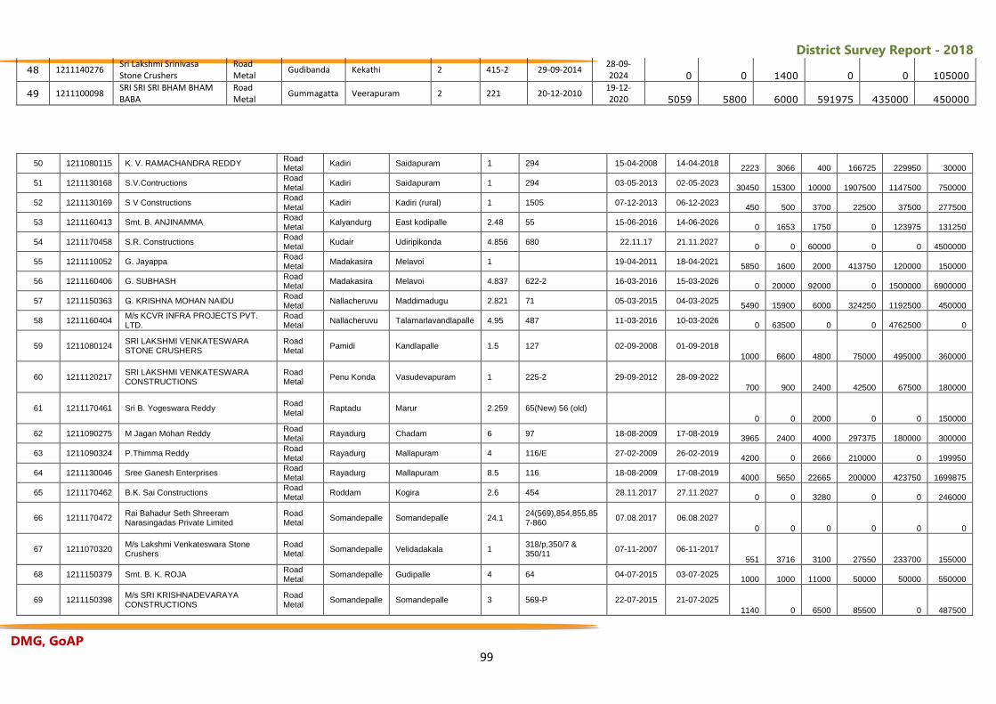
District Survey Report - 2018
DMG, GoAP 99
48 1211140276 Sri Lakshmi Srinivasa Stone Crushers
Road Metal
Gudibanda Kekathi 2 415-2 29-09-2014 28-09-2024 0 0 1400 0 0 105000
49 1211100098 SRI SRI SRI BHAM BHAM BABA
Road Metal
Gummagatta Veerapuram 2 221 20-12-2010 19-12-2020 5059 5800 6000 591975 435000 450000
50 1211080115 K. V. RAMACHANDRA REDDY Road Metal
Kadiri Saidapuram 1 294 15-04-2008 14-04-2018 2223 3066 400 166725 229950 30000
51 1211130168 S.V.Contructions Road Metal
Kadiri Saidapuram 1 294 03-05-2013 02-05-2023 30450 15300 10000 1907500 1147500 750000
52 1211130169 S V Constructions Road Metal
Kadiri Kadiri (rural) 1 1505 07-12-2013 06-12-2023 450 500 3700 22500 37500 277500
53 1211160413 Smt. B. ANJINAMMA Road Metal
Kalyandurg East kodipalle 2.48 55 15-06-2016 14-06-2026 0 1653 1750 0 123975 131250
54 1211170458 S.R. Constructions Road Metal
Kudair Udiripikonda 4.856 680 22.11.17 21.11.2027 0 0 60000 0 0 4500000
55 1211110052 G. Jayappa Road Metal
Madakasira Melavoi 1 19-04-2011 18-04-2021 5850 1600 2000 413750 120000 150000
56 1211160406 G. SUBHASH Road Metal
Madakasira Melavoi 4.837 622-2 16-03-2016 15-03-2026 0 20000 92000 0 1500000 6900000
57 1211150363 G. KRISHNA MOHAN NAIDU Road Metal
Nallacheruvu Maddimadugu 2.821 71 05-03-2015 04-03-2025 5490 15900 6000 324250 1192500 450000
58 1211160404 M/s KCVR INFRA PROJECTS PVT. LTD.
Road Metal
Nallacheruvu Talamarlavandlapalle 4.95 487 11-03-2016 10-03-2026 0 63500 0 0 4762500 0
59 1211080124 SRI LAKSHMI VENKATESWARA STONE CRUSHERS
Road Metal
Pamidi Kandlapalle 1.5 127 02-09-2008 01-09-2018
1000 6600 4800 75000 495000 360000
60 1211120217 SRI LAKSHMI VENKATESWARA CONSTRUCTIONS
Road Metal
Penu Konda Vasudevapuram 1 225-2 29-09-2012 28-09-2022
700 900 2400 42500 67500 180000
61 1211170461 Sri B. Yogeswara Reddy Road Metal
Raptadu Marur 2.259 65(New) 56 (old)
0 0 2000 0 0 150000
62 1211090275 M Jagan Mohan Reddy Road Metal
Rayadurg Chadam 6 97 18-08-2009 17-08-2019 3965 2400 4000 297375 180000 300000
63 1211090324 P.Thimma Reddy Road Metal
Rayadurg Mallapuram 4 116/E 27-02-2009 26-02-2019 4200 0 2666 210000 0 199950
64 1211130046 Sree Ganesh Enterprises Road Metal
Rayadurg Mallapuram 8.5 116 18-08-2009 17-08-2019 4000 5650 22665 200000 423750 1699875
65 1211170462 B.K. Sai Constructions Road Metal
Roddam Kogira 2.6 454 28.11.2017 27.11.2027 0 0 3280 0 0 246000
66 1211170472 Rai Bahadur Seth Shreeram Narasingadas Private Limited
Road Metal
Somandepalle Somandepalle 24.1 24(569),854,855,857-860
07.08.2017 06.08.2027
0 0 0 0 0 0
67 1211070320 M/s Lakshmi Venkateswara Stone Crushers
Road Metal
Somandepalle Velidadakala 1 318/p,350/7 & 350/11
07-11-2007 06-11-2017
551 3716 3100 27550 233700 155000
68 1211150379 Smt. B. K. ROJA Road Metal
Somandepalle Gudipalle 4 64 04-07-2015 03-07-2025 1000 1000 11000 50000 50000 550000
69 1211150398 M/s SRI KRISHNADEVARAYA CONSTRUCTIONS
Road Metal
Somandepalle Somandepalle 3 569-P 22-07-2015 21-07-2025
1140 0 6500 85500 0 487500
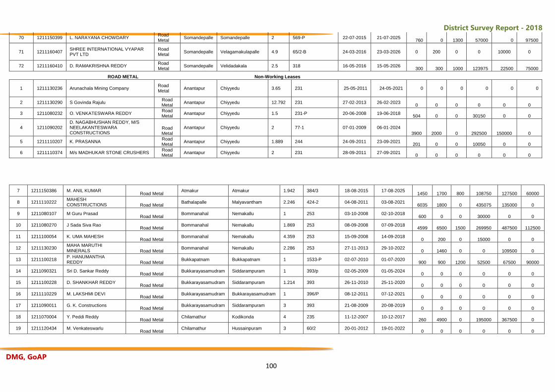
District Survey Report - 2018
DMG, GoAP 100
70 1211150399 L. NARAYANA CHOWDARY Road Metal
Somandepalle Somandepalle 2 569-P 22-07-2015 21-07-2025 760 0 1300 57000 0 97500
71 1211160407 SHREE INTERNATIONAL VYAPAR PVT LTD
Road Metal
Somandepalle Velagamakulapalle 4.9 65/2-B 24-03-2016 23-03-2026 0 200 0 0 10000 0
72 1211160410 D. RAMAKRISHNA REDDY Road Metal
Somandepalle Velidadakala 2.5 318 16-05-2016 15-05-2026 300 300 1000 123975 22500 75000
ROAD METAL
Non-Working Leases
1 1211130236 Arunachala Mining Company Road Metal
Anantapur Chiyyedu 3.65 231 25-05-2011 24-05-2021 0 0 0 0 0 0
2 1211130290 S Govinda Rajulu Road Metal
Anantapur Chiyyedu 12.792 231 27-02-2013 26-02-2023 0 0 0 0 0 0
3 1211080232 O. VENKATESWARA REDDY Road Metal
Anantapur Chiyyedu 1.5 231-P 20-06-2008 19-06-2018 504 0 0 30150 0 0
4 1211090202 D. NAGABHUSHAN REDDY, M/S NEELAKANTESWARA CONSTRUCTIONS
Road Metal
Anantapur Chiyyedu 2 77-1 07-01-2009 06-01-2024
3900 2000 0 292500 150000 0
5 1211110207 K. PRASANNA Road Metal
Anantapur Chiyyedu 1.889 244 24-09-2011 23-09-2021 201 0 0 10050 0 0
6 1211110374 M/s MADHUKAR STONE CRUSHERS Road Metal
Anantapur Chiyyedu 2 231 28-09-2011 27-09-2021 0 0 0 0 0 0
7 1211150386 M. ANIL KUMAR Road Metal
Atmakur Atmakur 1.942 384/3 18-08-2015 17-08-2025 1450 1700 800 108750 127500 60000
8 1211110222 MAHESH CONSTRUCTIONS Road Metal
Bathalapalle Malyavantham 2.246 424-2 04-08-2011 03-08-2021 6035 1800 0 435075 135000 0
9 1211080107 M Guru Prasad Road Metal
Bommanahal Nemakallu 1 253 03-10-2008 02-10-2018 600 0 0 30000 0 0
10 1211080270 J Sada Siva Rao Road Metal
Bommanahal Nemakallu 1.869 253 08-09-2008 07-09-2018 4599 6500 1500 269950 487500 112500
11 1211100054 K. UMA MAHESH Road Metal
Bommanahal Nemakallu 4.359 253 15-09-2008 14-09-2018 0 200 0 15000 0 0
12 1211130230 MAHA MARUTHI MINERALS Road Metal
Bommanahal Nemakallu 2.286 253 27-11-2013 29-10-2022 0 1460 0 0 109500 0
13 1211100218 P. HANUMANTHA REDDY Road Metal
Bukkapatnam Bukkapatnam 1 1533-P 02-07-2010 01-07-2020 900 900 1200 52500 67500 90000
14 1211090321 Sri D. Sankar Reddy Road Metal
Bukkarayasamudram Siddarampuram 1 393/p 02-05-2009 01-05-2024 0 0 0 0 0 0
15 1211100228 D. SHANKHAR REDDY Road Metal
Bukkarayasamudram Siddarampuram 1.214 393 26-11-2010 25-11-2020 0 0 0 0 0 0
16 1211110229 M. LAKSHMI DEVI Road Metal
Bukkarayasamudram Bukkarayasamudram 1 396/P 08-12-2011 07-12-2021 0 0 0 0 0 0
17 1211090011 G. K. Constructions Road Metal
Bukkarayasamudram Siddarampuram 3 393 21-08-2009 20-08-2019 0 0 0 0 0 0
18 1211070004 Y. Peddi Reddy Road Metal
Chilamathur Kodikonda 4 235 11-12-2007 10-12-2017 260 4900 0 195000 367500 0
19 1211120434 M. Venkateswarlu Road Metal
Chilamathur Hussainpuram 3 60/2 20-01-2012 19-01-2022 0 0 0 0 0 0
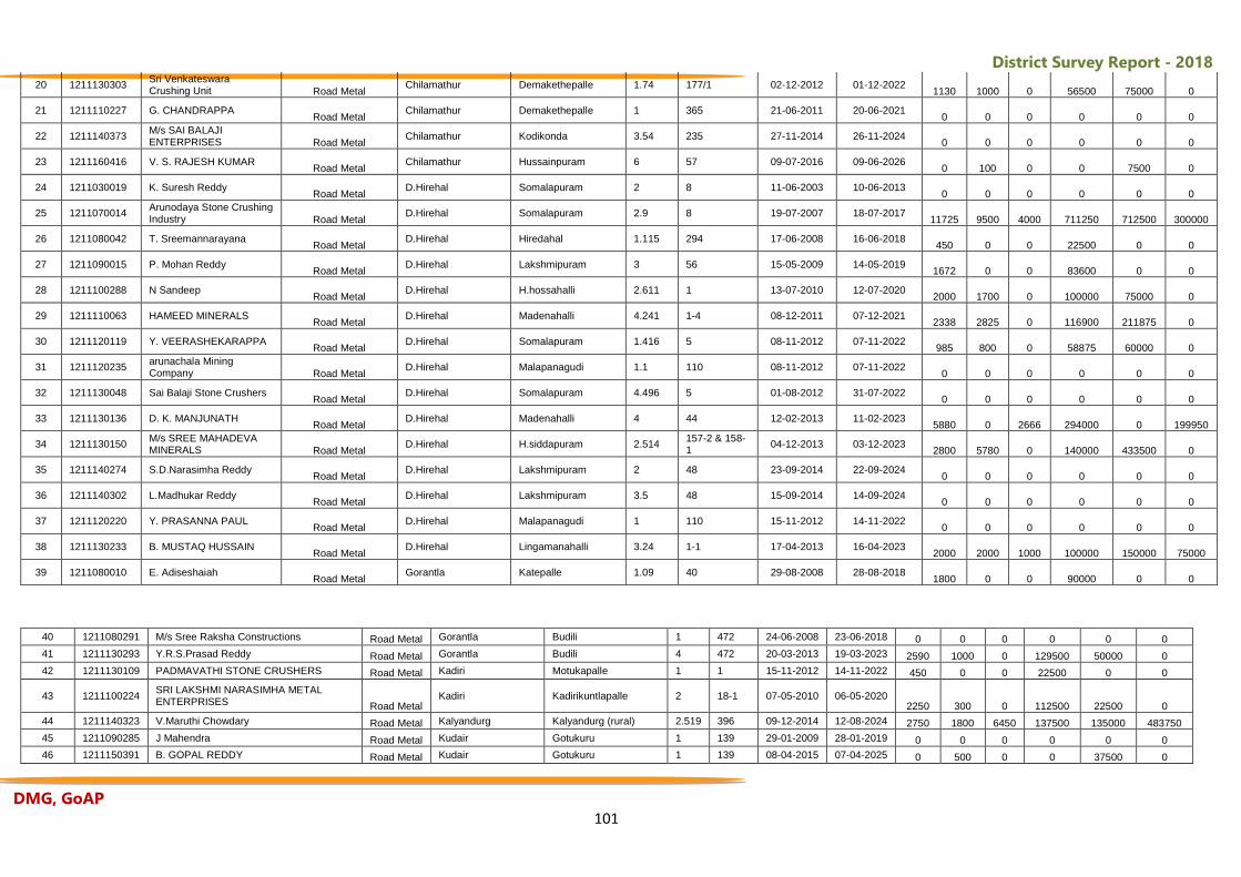
District Survey Report - 2018
DMG, GoAP 101
20 1211130303 Sri Venkateswara Crushing Unit Road Metal
Chilamathur Demakethepalle 1.74 177/1 02-12-2012 01-12-2022 1130 1000 0 56500 75000 0
21 1211110227 G. CHANDRAPPA Road Metal
Chilamathur Demakethepalle 1 365 21-06-2011 20-06-2021 0 0 0 0 0 0
22 1211140373 M/s SAI BALAJI ENTERPRISES Road Metal
Chilamathur Kodikonda 3.54 235 27-11-2014 26-11-2024 0 0 0 0 0 0
23 1211160416 V. S. RAJESH KUMAR Road Metal
Chilamathur Hussainpuram 6 57 09-07-2016 09-06-2026 0 100 0 0 7500 0
24 1211030019 K. Suresh Reddy Road Metal
D.Hirehal Somalapuram 2 8 11-06-2003 10-06-2013 0 0 0 0 0 0
25 1211070014 Arunodaya Stone Crushing Industry Road Metal
D.Hirehal Somalapuram 2.9 8 19-07-2007 18-07-2017 11725 9500 4000 711250 712500 300000
26 1211080042 T. Sreemannarayana Road Metal
D.Hirehal Hiredahal 1.115 294 17-06-2008 16-06-2018 450 0 0 22500 0 0
27 1211090015 P. Mohan Reddy Road Metal
D.Hirehal Lakshmipuram 3 56 15-05-2009 14-05-2019 1672 0 0 83600 0 0
28 1211100288 N Sandeep Road Metal
D.Hirehal H.hossahalli 2.611 1 13-07-2010 12-07-2020 2000 1700 0 100000 75000 0
29 1211110063 HAMEED MINERALS Road Metal
D.Hirehal Madenahalli 4.241 1-4 08-12-2011 07-12-2021 2338 2825 0 116900 211875 0
30 1211120119 Y. VEERASHEKARAPPA Road Metal
D.Hirehal Somalapuram 1.416 5 08-11-2012 07-11-2022 985 800 0 58875 60000 0
31 1211120235 arunachala Mining Company Road Metal
D.Hirehal Malapanagudi 1.1 110 08-11-2012 07-11-2022 0 0 0 0 0 0
32 1211130048 Sai Balaji Stone Crushers Road Metal
D.Hirehal Somalapuram 4.496 5 01-08-2012 31-07-2022 0 0 0 0 0 0
33 1211130136 D. K. MANJUNATH Road Metal
D.Hirehal Madenahalli 4 44 12-02-2013 11-02-2023 5880 0 2666 294000 0 199950
34 1211130150 M/s SREE MAHADEVA MINERALS Road Metal
D.Hirehal H.siddapuram 2.514 157-2 & 158-1
04-12-2013 03-12-2023 2800 5780 0 140000 433500 0
35 1211140274 S.D.Narasimha Reddy Road Metal
D.Hirehal Lakshmipuram 2 48 23-09-2014 22-09-2024 0 0 0 0 0 0
36 1211140302 L.Madhukar Reddy Road Metal
D.Hirehal Lakshmipuram 3.5 48 15-09-2014 14-09-2024 0 0 0 0 0 0
37 1211120220 Y. PRASANNA PAUL Road Metal
D.Hirehal Malapanagudi 1 110 15-11-2012 14-11-2022 0 0 0 0 0 0
38 1211130233 B. MUSTAQ HUSSAIN Road Metal
D.Hirehal Lingamanahalli 3.24 1-1 17-04-2013 16-04-2023 2000 2000 1000 100000 150000 75000
39 1211080010 E. Adiseshaiah Road Metal
Gorantla Katepalle 1.09 40 29-08-2008 28-08-2018 1800 0 0 90000 0 0
40 1211080291 M/s Sree Raksha Constructions Road Metal Gorantla Budili 1 472 24-06-2008 23-06-2018 0 0 0 0 0 0
41 1211130293 Y.R.S.Prasad Reddy Road Metal Gorantla Budili 4 472 20-03-2013 19-03-2023 2590 1000 0 129500 50000 0
42 1211130109 PADMAVATHI STONE CRUSHERS Road Metal Kadiri Motukapalle 1 1 15-11-2012 14-11-2022 450 0 0 22500 0 0
43 1211100224 SRI LAKSHMI NARASIMHA METAL ENTERPRISES Road Metal
Kadiri Kadirikuntlapalle 2 18-1 07-05-2010 06-05-2020 2250 300 0 112500 22500 0
44 1211140323 V.Maruthi Chowdary Road Metal Kalyandurg Kalyandurg (rural) 2.519 396 09-12-2014 12-08-2024 2750 1800 6450 137500 135000 483750
45 1211090285 J Mahendra Road Metal Kudair Gotukuru 1 139 29-01-2009 28-01-2019 0 0 0 0 0 0
46 1211150391 B. GOPAL REDDY Road Metal Kudair Gotukuru 1 139 08-04-2015 07-04-2025 0 500 0 0 37500 0
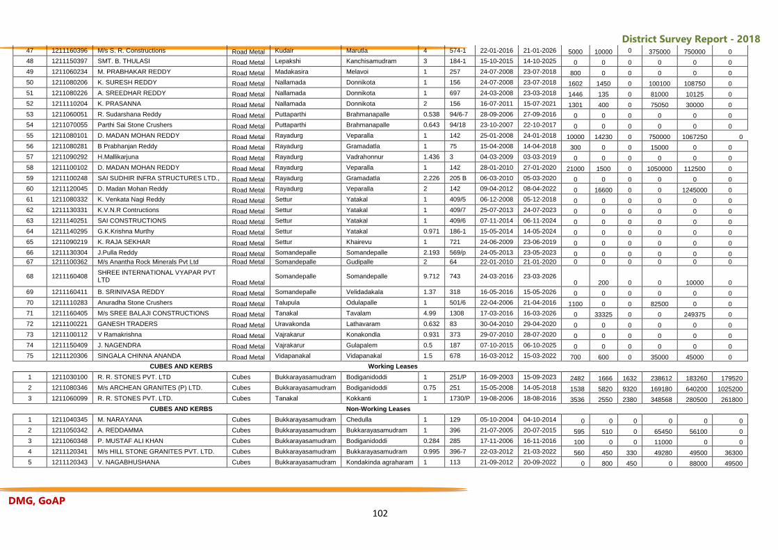
District Survey Report - 2018
DMG, GoAP 102
47 1211160396 M/s S. R. Constructions Road Metal Kudair Marutla 4 574-1 22-01-2016 21-01-2026 5000 10000 0 375000 750000 0
48 1211150397 SMT. B. THULASI Road Metal Lepakshi Kanchisamudram 3 184-1 15-10-2015 14-10-2025 0 0 0 0 0 0
49 1211060234 M. PRABHAKAR REDDY Road Metal Madakasira Melavoi 1 257 24-07-2008 23-07-2018 800 0 0 0 0 0
50 1211080206 K. SURESH REDDY Road Metal Nallamada Donnikota 1 156 24-07-2008 23-07-2018 1602 1450 0 100100 108750 0
51 1211080226 A. SREEDHAR REDDY Road Metal Nallamada Donnikota 1 697 24-03-2008 23-03-2018 1446 135 0 81000 10125 0
52 1211110204 K. PRASANNA Road Metal Nallamada Donnikota 2 156 16-07-2011 15-07-2021 1301 400 0 75050 30000 0
53 1211060051 R. Sudarshana Reddy Road Metal Puttaparthi Brahmanapalle 0.538 94/6-7 28-09-2006 27-09-2016 0 0 0 0 0 0
54 1211070055 Parthi Sai Stone Crushers Road Metal Puttaparthi Brahmanapalle 0.643 94/18 23-10-2007 22-10-2017 0 0 0 0 0 0
55 1211080101 D. MADAN MOHAN REDDY Road Metal Rayadurg Veparalla 1 142 25-01-2008 24-01-2018 10000 14230 0 750000 1067250 0
56 1211080281 B Prabhanjan Reddy Road Metal Rayadurg Gramadatla 1 75 15-04-2008 14-04-2018 300 0 0 15000 0 0
57 1211090292 H.Mallikarjuna Road Metal Rayadurg Vadrahonnur 1.436 3 04-03-2009 03-03-2019 0 0 0 0 0 0
58 1211100102 D. MADAN MOHAN REDDY Road Metal Rayadurg Veparalla 1 142 28-01-2010 27-01-2020 21000 1500 0 1050000 112500 0
59 1211100248 SAI SUDHIR INFRA STRUCTURES LTD., Road Metal Rayadurg Gramadatla 2.226 205 B 06-03-2010 05-03-2020 0 0 0 0 0 0
60 1211120045 D. Madan Mohan Reddy Road Metal Rayadurg Veparalla 2 142 09-04-2012 08-04-2022 0 16600 0 0 1245000 0
61 1211080332 K. Venkata Nagi Reddy Road Metal Settur Yatakal 1 409/5 06-12-2008 05-12-2018 0 0 0 0 0 0
62 1211130331 K.V.N.R Contructions Road Metal Settur Yatakal 1 409/7 25-07-2013 24-07-2023 0 0 0 0 0 0
63 1211140251 SAI CONSTRUCTIONS Road Metal Settur Yatakal 1 409/6 07-11-2014 06-11-2024 0 0 0 0 0 0
64 1211140295 G.K.Krishna Murthy Road Metal Settur Yatakal 0.971 186-1 15-05-2014 14-05-2024 0 0 0 0 0 0
65 1211090219 K. RAJA SEKHAR Road Metal Settur Khairevu 1 721 24-06-2009 23-06-2019 0 0 0 0 0 0
66 1211130304 J.Pulla Reddy Road Metal Somandepalle Somandepalle 2.193 569/p 24-05-2013 23-05-2023 0 0 0 0 0 0
67 1211100362 M/s Anantha Rock Minerals Pvt Ltd Road Metal Somandepalle Gudipalle 2 64 22-01-2010 21-01-2020 0 0 0 0 0 0
68 1211160408 SHREE INTERNATIONAL VYAPAR PVT LTD Road Metal
Somandepalle Somandepalle 9.712 743 24-03-2016 23-03-2026 0 200 0 0 10000 0
69 1211160411 B. SRINIVASA REDDY Road Metal Somandepalle Velidadakala 1.37 318 16-05-2016 15-05-2026 0 0 0 0 0 0
70 1211110283 Anuradha Stone Crushers Road Metal Talupula Odulapalle 1 501/6 22-04-2006 21-04-2016 1100 0 0 82500 0 0
71 1211160405 M/s SREE BALAJI CONSTRUCTIONS Road Metal Tanakal Tavalam 4.99 1308 17-03-2016 16-03-2026 0 33325 0 0 249375 0
72 1211100221 GANESH TRADERS Road Metal Uravakonda Lathavaram 0.632 83 30-04-2010 29-04-2020 0 0 0 0 0 0
73 1211100112 V Ramakrishna Road Metal Vajrakarur Konakondla 0.931 373 29-07-2010 28-07-2020 0 0 0 0 0 0
74 1211150409 J. NAGENDRA Road Metal Vajrakarur Gulapalem 0.5 187 07-10-2015 06-10-2025 0 0 0 0 0 0
75 1211120306 SINGALA CHINNA ANANDA Road Metal Vidapanakal Vidapanakal 1.5 678 16-03-2012 15-03-2022 700 600 0 35000 45000 0
CUBES AND KERBS
Working Leases
1 1211030100 R. R. STONES PVT. LTD Cubes Bukkarayasamudram Bodiganidoddi 1 251/P 16-09-2003 15-09-2023 2482 1666 1632 238612 183260 179520
2 1211080346 M/s ARCHEAN GRANITES (P) LTD. Cubes Bukkarayasamudram Bodiganidoddi 0.75 251 15-05-2008 14-05-2018 1538 5820 9320 169180 640200 1025200
3 1211060099 R. R. STONES PVT. LTD. Cubes Tanakal Kokkanti 1 1730/P 19-08-2006 18-08-2016 3536 2550 2380 348568 280500 261800
CUBES AND KERBS
Non-Working Leases
1 1211040345 M. NARAYANA Cubes Bukkarayasamudram Chedulla 1 129 05-10-2004 04-10-2014 0 0 0 0 0 0
2 1211050342 A. REDDAMMA Cubes Bukkarayasamudram Bukkarayasamudram 1 396 21-07-2005 20-07-2015 595 510 0 65450 56100 0
3 1211060348 P. MUSTAF ALI KHAN Cubes Bukkarayasamudram Bodiganidoddi 0.284 285 17-11-2006 16-11-2016 100 0 0 11000 0 0
4 1211120341 M/s HILL STONE GRANITES PVT. LTD. Cubes Bukkarayasamudram Bukkarayasamudram 0.995 396-7 22-03-2012 21-03-2022 560 450 330 49280 49500 36300
5 1211120343 V. NAGABHUSHANA Cubes Bukkarayasamudram Kondakinda agraharam 1 113 21-09-2012 20-09-2022 0 800 450 0 88000 49500
District Survey Report - 2018
DMG, GoAP
References
1. APSAC (2017a) Project Report on A.P. Road Information System, 26p.
2. APSAC (2017b) Ground Water Quality Mapping of Andhra Pradesh, Technical Report, 40p.
3. Bhave, K.N., Ganju,J.L. and Jokhan Ram (1989) Origin, nature geological significance of lineaments. In:
Regional Geophysical Lineaments. Their tectonic and Economic Significance (Ed. M.N.Qureshy and W.J.
Hinze), Memoir of Geological Society of India,305p.
4. CGWB (2013) Ground Water Brochure, Anantapur District, Andhra Pradesh,29p.
5. DES (2016) Hand Book of Statistics, Ananthapuramu District, 444p.
6. Geological Survey of India (GSI) (2001) District Resource Map, Anantapur District, Andhra Pradesh
7. NBSS&LUP (2008) Soil Resources of Anantapur District, Andhra Pradesh, NBSS Report No:1017, 22p.
8. NRSA (2006) Manual of National Land Use Land Cover Mapping Using Multi-Temporal Satellite Data.
National Remote Sensing Centre, Department of Space, Government of India, Hyderabad.
9. NRSA., (2007) Ground Water Prospects Mapping Using Remote Sensing Techniques and Geographic
Information System, Rajiv Gandhi National Drinking Water Mission Project, Phase-III, Manual, 222p.
10. NRSC (2009) Space Based Information Support for Decentralized Planning (SIS-DP), Manual, 214p.
11. NRSC (2011) Ground Water Quality Mapping (RGNDWM), Methodology Manual, 75p.
12. O'Leary, D.W., Driedman, J.D. and Pohn, H.A. (1976) Lineaments, linear, lineation, some proposed new
standards for old terms. Geological Society of America Bulletin, Vol.87,pp.1463-1469.
13. Tata Babu, Ch., Padma, G.V., Venkata Ramireddy, P. and Prasada Rao, G. (2015) Double lane road
connectivity with mandal headquarters to District headquarters in Andhra Pradesh - A geospatial analysis,
International Journal of Remote Sensing & Geoscience, 44-53p.