Embed Size (px)
Citation preview
7/27/2019 APC Report Greeley Subdivision
http://slidepdf.com/reader/full/apc-report-greeley-subdivision 1/18
APC REPORT
Page 1 of 7
SHORT SUMMARY:
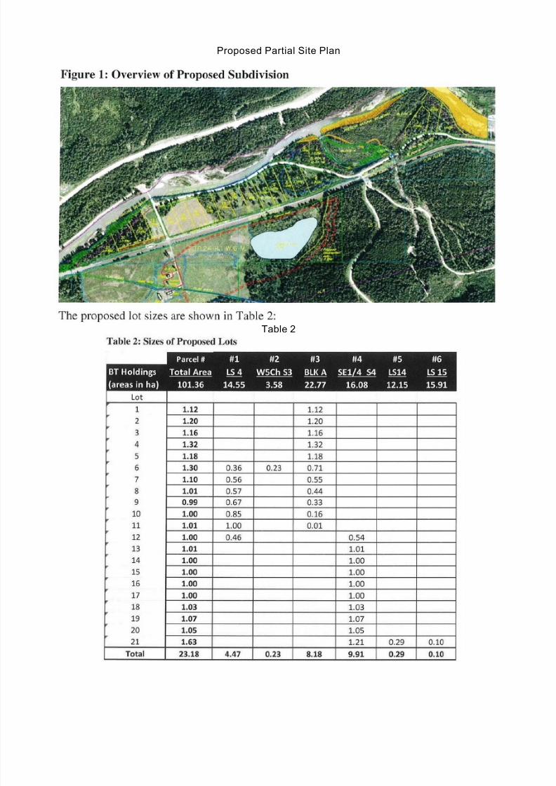
The owner of the subject properties would like to subdivide portions of the subject properties into 21proposed new lots of around 1.0 ha or more.
BACKGROUND:
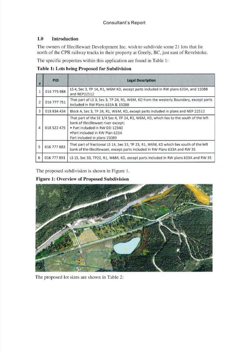
PROPERTY OWNERS: Illicilliwaet Development Inc., Inc. No. BC0825174
ELECTORAL AREA: 'B'CIVIC ADDRESS: Greely Road
TO: APC 'B' File No: LC 2487 B
FROM: Dan PassmoreSenior Planner
Date: September 25, 2013
SUBJECT: Agricultu ral Land Commission (ALC) applicationSection 21(2) – Subdivision within the ALRRegency Consultants (Mr. Bob Holtby)
1. Legal Subdivis ion 4, Section 3, Township 24, Range 1, W6M,Kootenay Dist rict , Except Parts inc luded in R/W Plans 633Aand 15088 and Plan NEP22512;
2. That Part of Legal Subdivis ion 3, Section 3, Townsh ip 24,Range 1, W6M, Kootenay Distr ict , Which lies west o f a lineparallel to and 5 chains d istant from the westerly boundary,Excpet parts included in R/W Plans 633A and 15088;
3. Block A, Section 3, Township 24, Range 1, W6M, KootenayDistrict, Except Part included in Plans 15088 and NEP22512;
4. That Part of the SE ¼, Section 4, Township 24, Range 1,W6M, Kootenay Distr ict Which lies to the South o f the leftbank of the Illecillewaet River, Except (1) Part included inR/W DD12340, (2) Part included in R/W Plan 633A, and (3)Part included in Plans 15089 and NEP22512;
5. That Part of Fractional Legal Subdivision 14, Section 33,Township 23, Range 1, W6M, Kootenay Dist rict , Which liessouth of the left bank of the Illicillewaet River, Except Partsincluded in R/W Plans 633A and R/W 35; and,
6. Legal Subdivis ion 15, Section 33, Township 23, Range 1,W6M, Kootenay Distric t, Except Parts included in R/W Plans633A and R/W 35.
7/27/2019 APC Report Greeley Subdivision
http://slidepdf.com/reader/full/apc-report-greeley-subdivision 2/18
APC Report EX 2000-05 DVP 2000-71 September 25, 2013
Page 2 of 7
LEGAL DESCRIPTIONS:
1. Legal Subdivision 4, Section 3, Township 24, Range 1, W6M,Kootenay District, Except Parts included in R/W Plans 633A and15088 and Plan NEP22512 (PID: 016-775-988);
2. That Part of Legal Subdivision 3, Section 3, Township 24, Range 1,
W6M, Kootenay District, Which lies west of a line parallel to and 5chains distant from the westerly boundary, Excpet parts included inR/W Plans 633A and 15088 (PID: 016-777-751);
3. Block A, Section 3, Township 24, Range 1, W6M, KootenayDistrict, Except Part included in Plans 15088 and NEP22512 (PID:018-834-434);
4. That Part of the SE ¼, Section 4, Township 24, Range 1, W6M,Kootenay District Which lies to the South of the left bank of theIllecillewaet River, Except (1) Part included in R/W DD12340, (2)Part included in R/W Plan 633A, and (3) Part included in Plans15089 and NEP22512 (PID: 018-522-475);
5. That Part of Fractional Legal Subdivision 14, Section 33, Township
23, Range 1, W6M, Kootenay District, Which lies south of the leftbank of the Illicillewaet River, Except Parts included in R/W Plans633A and R/W 35 (PID: 016-777-883); and,
6. Legal Subdivision 15, Section 33, Township 23, Range 1, W6M,Kootenay District, Except Parts included in R/W Plans 633A andR/W 35 (PID: 016-777-891).
SIZE OF PROPERTY:
1. 14.55 ha. (35.94 ac.)2. 3.58 ha. (8.85 ac.)3. 22.72 ha. (56.15 ac.)4. 16.08 ha. (39.73 ac.)
5. 12.15 ha. (30.02 ac.)6. 15.91 ha. (39.31 ac.)Total Area = 84.99 ha. (210.01 ac.)
SURROUNDING LAND USE PATTERN:
North: CP Rail Tracks, Illicilliwaet River, TCHSouth: MountainEast: Hobby FarmsWest: Illicilliwaet River
CURRENT USE: Vacant Residential Land/Former Pasture/Residence
PROPOSED USE: Comprehensive Resort Commercial Development
CURRENT DESIGNATION: RR – Rural Resource
PROPOSED DESIGNATION: RC – Resort Commercial/RR – Rural Residential
CURRENT ZONING: R – Rural
PROPOSED ZONING: CD Comprehensive Development Zone/RR1 - Rural Residential (1.0ha.) Zone
7/27/2019 APC Report Greeley Subdivision
http://slidepdf.com/reader/full/apc-report-greeley-subdivision 3/18
APC Report EX 2000-05 DVP 2000-71 September 25, 2013
Page 3 of 7
SITE COMMENTS:
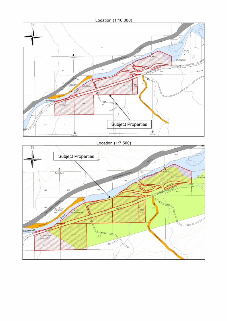
The subject properties are located approximately 8 km west of the City of Revelstokeand just north of the Revelstoke Mountain Resort. The properties are south of theTrans Canada Highway and the Illicillewaet River. The CPR main line runningeast/west bisects the properties.
The properties are accessed from the Trans Canada Highway by Greely Road, whichcrosses the river. Leoffer Road intersects with Greely Road just south of the bridgeand runs south from this intersection into and through the property crossing over theCPR mailn line and provides access to the existing residence.
The properties are in the bottom of a narrow valley between large mountains, but theproperties themselves are relatively flat with a mild slope to the south where thetopography dramatically steepens.
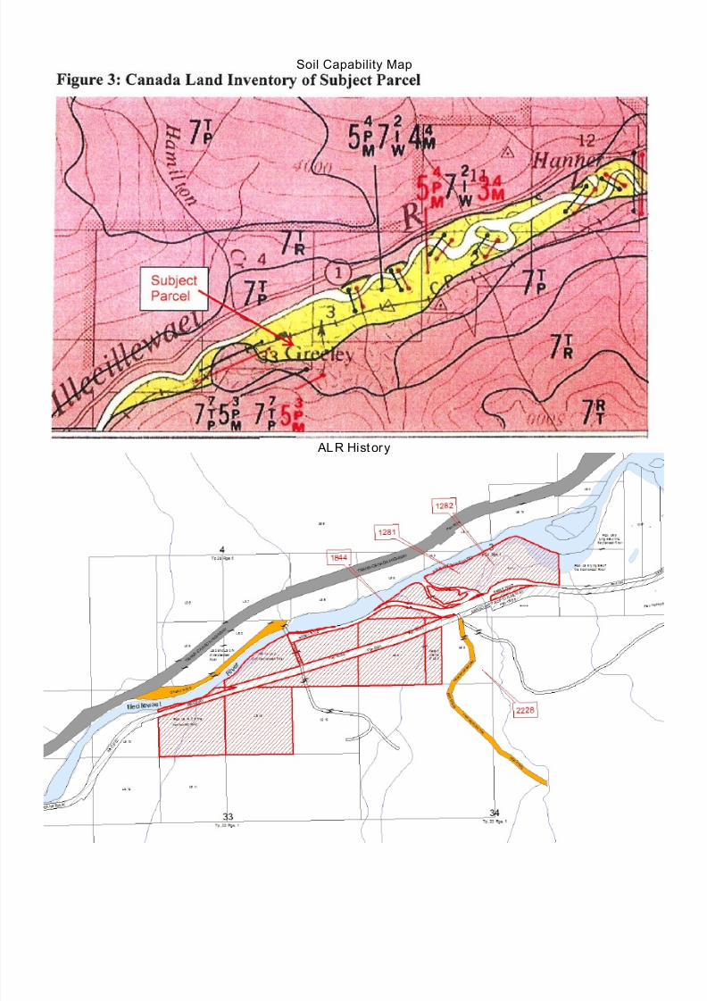
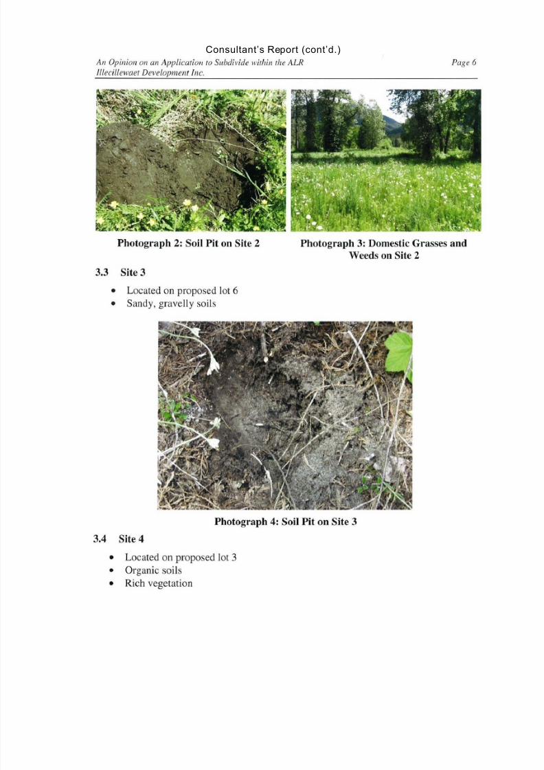
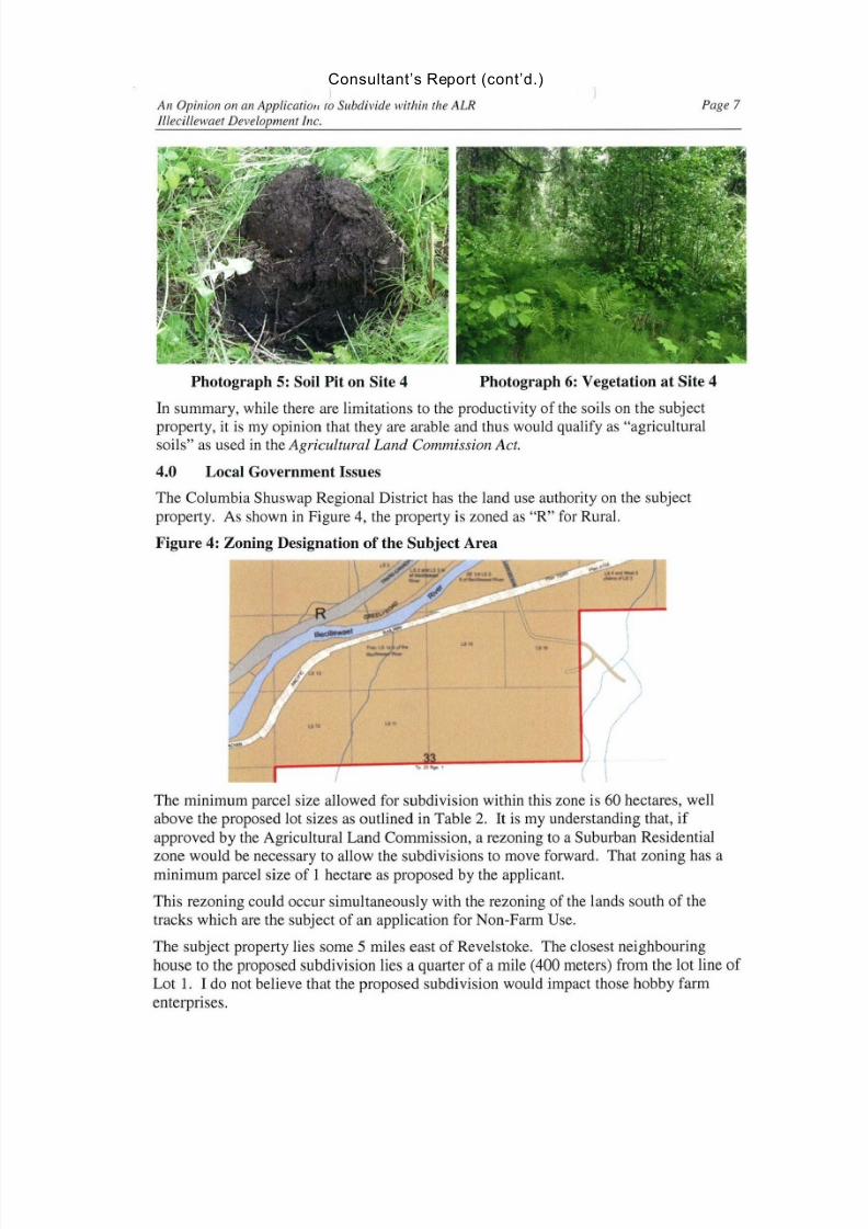
Soils Capability:
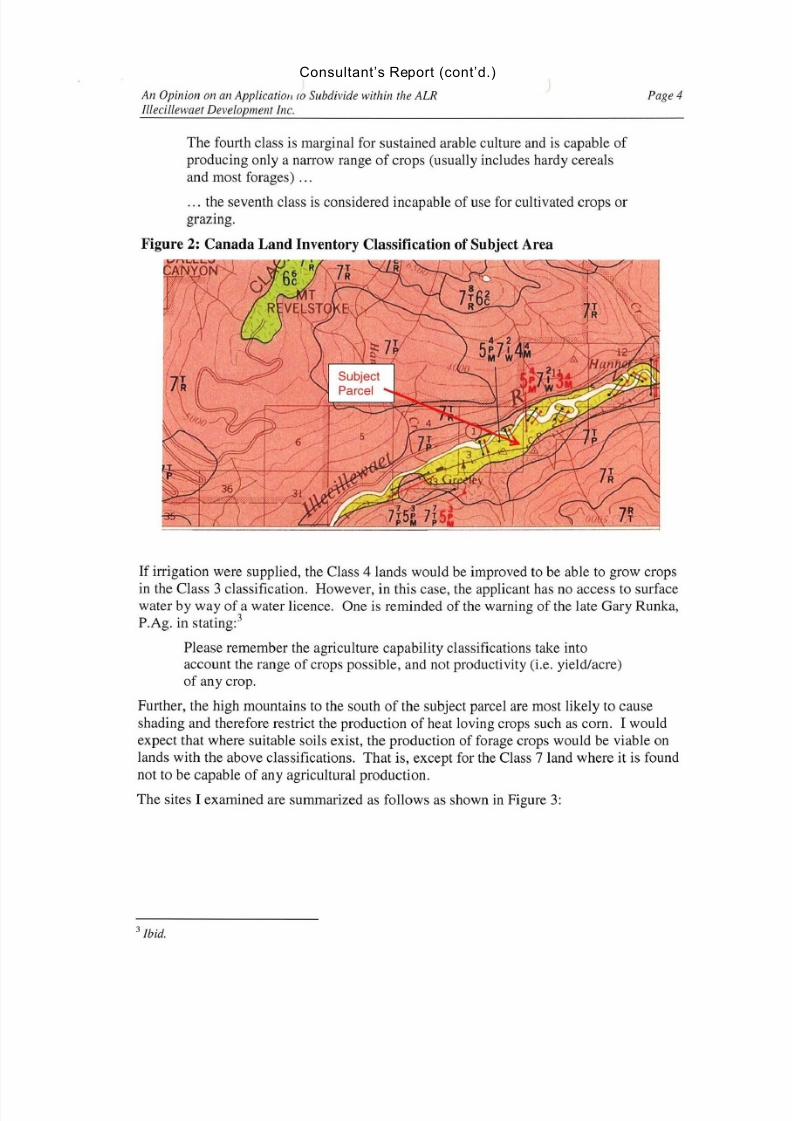
Canada Land Inventory Soil mapping indicates thatapproximately 70% of the subject property has 40% Class 5with excess stoniness and soil moisture deficiencies as themajor and minor limiting factors, respectively, 20% is Class 7with inundation and excess water as the major and minor limiting factors and 40% is Class 4 with the limiting factor beingsoil moisture deficiencies.
Only the last category is improveable to class 3 withirrigation.
30% of the subject property in the southern portion are 70%Class 7 with topography and stoniness as the major and minor limiting factors, respectively, and 30% is Class 5 with stoninessand soil moisture deficiencies as major and minor limitingfactors.
The soils do not appear to be improvable.
History: There have been 4 ALC applications made in the area. See ALR/History Map.
1281 ALC Resoltuion #5163/76 allowed subdivision into 4 equal size lots (22 ac.)
1282 ALC Resolution #5164/76 allowed subdivision into 3 10 ac. Lots.
1844 ALC Resolution #2084/82 allowed subdivision into 3 lots of 12 ha., 11.05 ha. And 2.8ha.
2228 ALC Resolution #488/98 allowed subdivision into 2 lots along the CPR railway tracks.1 lot of 6.8 ha. North of the tracks and 9.4 ha south of the tracks.
7 3
7 T – 5 P P M
4 2 4
5 P – 7 I – 3 M M W
4 2 4
5 P – 7 I – 4 M
M W
7 3
7 T – 5 P P M
7/27/2019 APC Report Greeley Subdivision
http://slidepdf.com/reader/full/apc-report-greeley-subdivision 4/18
APC Report EX 2000-05 DVP 2000-71 September 25, 2013
Page 4 of 7
POLICY:
Electoral Area “B” Official Community Plan – Agriculture Objectives and Policies
The Community Context portion of Section 10 Agriculture discusses the limitations to agriculture inthe area around Revelstoke, but indicates that there has been a history of agriculture in the river valleys.
Objectives for Agriculture include;
10.2.1 To support the preservation of the agricultural land base where lands have continuing valuefor agriculture.
Policies for Agriculture include;
10.3.1 The Regional District supports the preservation, maintenance and enhancement of lands for agricultural use within the Agricultural Land Reserve.
Electoral Area “ B” Official Community Plan – East Revelstoke Context
General context statements include:
The East Revelstoke area, including Canyon Hot Springs and Greeley, includes a small developedarea of highway commercial uses and the Canyon Hot Springs resort development. There are also afew private properties and small farms. Some of the lands are in the ALR. This area contains twoNational Parks and is not an area specified for significant future growth. Any future developmentpressures must carefully consider environmental issues, particularly in relation to the National Parks.
Electoral Area “ B” Official Community Plan – Current Rural Resource Designation
The subject properties are currently designated as Rural Resource. This designation includes thefollowing objectives;
3.2.3 Plan for and protect wildlife corridors, habitat of threatened and endangered species andecosystem connectivity in advance of expansion of settlement areas or tenures.
3.2.6 Support efforts to protect the natural values of the river valley ecosystems, particularly infloodplain or reservoir water management areas, managing recreation use where there is potentialfor conflict between recreation and environmental values.
Additionally, the following Policies apply to this designation;
3.3.4 Limit development activity and human access within designated community watersheds. Publicroads and settlement uses are not encouraged. Management of crown tenures should includeprovisions to restore the site to natural condition and watershed flow levels.
3.3.7 Develop a zone for resort or intensive recreation uses on Crown Land and require rezoningapproval for new resort or intensive recreation uses. This process will provide an opportunity for public input and a comprehensive review of the proposal including: environmental impact (sensitiveand hazardous areas), servicing (water, sewer, roads, power generation, waste disposal) and other
relevant issues.3.3.12 For subdivisions within or adjacent to Rural Resource areas, provide for: routes to accessforest roads; backcountry trail parking areas; and, controlled access facilities (gates, signage etc.)where such access does not conflict with resource tenures such as water reservoirs, watersheds,mining and timber harvesting.
3.3.14 Backcountry recreation activity is supported subject to the policies and guidelines of theMinistry of Forests & Range Land Management Plan and a local public consultation process.The Regional District recognizes the multi-agency nature of backcountry recreation
7/27/2019 APC Report Greeley Subdivision
http://slidepdf.com/reader/full/apc-report-greeley-subdivision 5/18
APC Report EX 2000-05 DVP 2000-71 September 25, 2013
Page 5 of 7
management and commits to participating cooperatively in the development of inter-agencybackground strategies. Recognizing that Area ‘B’ contains areas where backcountryrecreation may impact wilderness management objectives, the CSRD supports using acomprehensive strategy to evaluate new backcountry wilderness recreation activities. Thestrategy should include the following:
a. Recognition of three broad policy tools:
prohibitive – activity not allowed in specific areas or during specific periods of theyear.
limits on inputs – activity allowed but quotas applied to the number of users and their activities.
limits on outcomes – activity allowed within the context of activity-specific evaluationof backcountry recreation guidelines.
b. Evaluation Components:
i. Issue themes to be considered.
degradation of the soil, air and water quality.
integrity of vegetation communities.
direct disturbance of wildlife.
integrity of fisheries resource.
special management related to species of concern.
ii. Achieves desired “results” with respect to wildlife and their habitats.
iii. “Desired behaviours” that outline the practices of users that are most likely toachieve desired conditions.
iv. Indicators that measure whether a desired condition is being achieved.
v. Limits that set upper and lower targets for indicators.
3.3.17 Recognize uses associated with Revelstoke Mountain Resort (RMR) within CSRD boundaries
in the South Revelstoke Area.Electoral Area “ B” Official Community Plan – East Revelstoke Residential Polic ies
4.4.25 Recognizing the rural nature of this area and the presence of ALR designations, this area willnot be an area specified for significant future growth.
Electoral Area “ B” Official Community Plan – Proposed Resort Commercial Designation
Policies under the Resort Commercial designate include the following;
7/27/2019 APC Report Greeley Subdivision
http://slidepdf.com/reader/full/apc-report-greeley-subdivision 6/18
APC Report EX 2000-05 DVP 2000-71 September 25, 2013
Page 6 of 7
5.3.9 Resort Commercial uses may be considered throughout the plan area and should meet thefollowing criteria:
a. accessible to adequate transportation routes;
b. capable of being serviced with municipal, private or public utilities;
c. capable of being sufficiently buffered from adjacent non-compatible land uses to ensure thequality of life (e.g. character and integrity of quiet rural residential area) of those and adjacentoccupiers;
d. accessible to community services, recreation and open space;
e. cognizant of, and addressing special site features such as mature vegetation, landscaping,topography, adjacent development, environmental sensitive habitat and wildlife corridors, andview sheds; and
f. all parking requirements, as specified in the zoning bylaw shall be provided on site.
g. may include primary and accessory residential uses in conjunction with the ResortCommercial use.
5.3.10 New Resort Commercial Developments should consult and implement strategies from theBest Practices Guide for Resort Developments in British Columbia, September 2005, Province of British Columbia.
It should be noted that all Commercial developments within the OCP have been designated asDevelopment Permit Areas.
Electoral Area “ B” Official Community Plan – Environmental Management
11.3.6 Applications for new land use designations shall be accompanied by a detailed EnvironmentalReview of environmentally sensitive and hazardous areas such as watercourses, sensitive habitat areas,wildlife corridors, flood plains and steep slopes. The environmental review shall include recommendationson the management of sensitive conditions. The Regional District may implement recommendedenvironmental management practices through such mechanisms as;
a. The establishment of an Environmental Reserve designation where development on privatelands in sensitive areas is protected from adverse development. Passive uses, with minimalimpact on the applicable area would be supported within the Environmental Reservedesignation. Developments acceptable in the reserve area would include trails, interpretivesigns, benches and other similar types of passive recreation, conservation or environmentalprotection and management purpose or represent some other public benefit to the community
that would not compromise the environmental sensitivity of the area.
b. The use of Conservation Agreements with the Regional District as a party to the agreement, toprotect sensitive areas and implement conditions and recommendations of the environmentalreview conducted as part of the required development approval information as identified inSection 1.5.3.
c. A conservation zone or Environmental Reserve designation may be assigned to landcovenanted or deeded against further development or use, including common property in
7/27/2019 APC Report Greeley Subdivision
http://slidepdf.com/reader/full/apc-report-greeley-subdivision 7/18
APC Report EX 2000-05 DVP 2000-71 September 25, 2013
Page 7 of 7
strata title subdivisions.
d. Owners entering into Conservation Agreements and placing voluntary conservationcovenants on their land shall not be deprived of the privilege to enjoy land as their ownbut they may not close, fence or otherwise obstruct any adjoining public route of access.Developments acceptable in the covenanted area could include trails, interpretive signs,
benches and other similar types of passive recreation, conservation or environmentalprotection and management purpose or represent some other public benefit to thecommunity and not compromise the environmental sensitivity of the area.
Rural Revelstoke Land Use Bylaw No. 2200 – R - Rural Zone
The permitted uses of the R - Rural Zone are agriculture; guest ranch; silviculture, wood harvesting;mining, gravel extraction and mineral exploration; trapping, hunting and fishing camps; aquaculture;kennel; airfield, airstrip; golf course; public utility; single family dwelling; home occupation; accessoryuse; and public use. Two single family dwellings are permitted per parcel and the minimum area of parcels to be created through subdivision is 60.0 ha.
Rural Revelstoke Land Use Bylaw No. 2000 - Rezoning
The applicant is required to rezone the portion of the subject properties proposed to be subdivided toallow for the proposed lot sizes for the new lots. At this time, a RR1- Rural Residential (1.0 ha.) Zonewould be required for the single family dwelling lots proposed along the River.
SUMMARY:
The owner of the subject properties would like to subdivide portions of them into a 21 lot subdivision.
LIST NAME OF REPORT(S) / DOCUMENT(S):
1. Maps: General Location, Zoning Attached to APC
Report:
Available from
Staff:□
2. Site Plan Attached to APC
Report:
Available from
Staff:□
3. Photos Attached to APC
Report:
Available from
Staff:□
4. Consultant’s Report on the Application Attached to APC
Report:
Available from
Staff:□
7/27/2019 APC Report Greeley Subdivision
http://slidepdf.com/reader/full/apc-report-greeley-subdivision 8/18
Location (1:10,000)
Location (1:7,500)
Subject Properties
Subject Properties
7/27/2019 APC Report Greeley Subdivision
http://slidepdf.com/reader/full/apc-report-greeley-subdivision 9/18
Proposed Partial Site Plan
Table 2
7/27/2019 APC Report Greeley Subdivision
http://slidepdf.com/reader/full/apc-report-greeley-subdivision 10/18
Soil Capability Map
ALR History
7/27/2019 APC Report Greeley Subdivision
http://slidepdf.com/reader/full/apc-report-greeley-subdivision 11/18
Consultant’s Report
7/27/2019 APC Report Greeley Subdivision
http://slidepdf.com/reader/full/apc-report-greeley-subdivision 12/18
Consultant’s Report (cont’d.)
7/27/2019 APC Report Greeley Subdivision
http://slidepdf.com/reader/full/apc-report-greeley-subdivision 13/18
Consultant’s Report (cont’d.)
7/27/2019 APC Report Greeley Subdivision
http://slidepdf.com/reader/full/apc-report-greeley-subdivision 14/18
Consultant’s Report (cont’d.)
7/27/2019 APC Report Greeley Subdivision
http://slidepdf.com/reader/full/apc-report-greeley-subdivision 15/18
Consultant’s Report (cont’d.)
7/27/2019 APC Report Greeley Subdivision
http://slidepdf.com/reader/full/apc-report-greeley-subdivision 16/18
Consultant’s Report (cont’d.)
7/27/2019 APC Report Greeley Subdivision
http://slidepdf.com/reader/full/apc-report-greeley-subdivision 17/18
Consultant’s Report (cont’d.)
7/27/2019 APC Report Greeley Subdivision
http://slidepdf.com/reader/full/apc-report-greeley-subdivision 18/18
Consultant’s Report (cont’d.)


![INDEX [meanwell.com]meanwell.com/Upload/PDF/meanwell_LED.pdf · APC-8, APC-12, APC-16, APC-25, APC-35 3 APV-8E, APV-12E, APV-16E 4 APC-8E, APC-12E, APC-16E LP ... Over voltage protection](https://img.pdfslide.net/doc/110x75/5b619e107f8b9a40488c919f/index-apc-8-apc-12-apc-16-apc-25-apc-35-3-apv-8e-apv-12e-apv-16e-4.jpg)