Embed Size (px)
Citation preview
Fife Council Review of Onshore Wind Energy in Fife Strategic Cumulative Landscape and Visual Impact Assessment
______________________________________________________________________________________________________________________________________________________________________________________________________
______________________________________________________________________________________________________________________________________________________________________________________________________
IronsideFarrar
APPENDICES

Fife Council Review of Onshore Wind Energy in Fife Strategic Cumulative Landscape and Visual Impact Assessment
______________________________________________________________________________________________________________________________________________________________________________________________________
______________________________________________________________________________________________________________________________________________________________________________________________________
IronsideFarrar
Fife Council Review of Onshore Wind Energy in Fife Strategic Cumulative Landscape and Visual Impact Assessment
______________________________________________________________________________________________________________________________________________________________________________________________________
______________________________________________________________________________________________________________________________________________________________________________________________________
IronsideFarrar A1 8024 / May 2013
APPENDIX 1: CURRENT POLICY AND GUIDANCE FOR ONSHORE WIND ENERGY
1.1 National Policy and Guidance
National policy in relation to renewable energy development is expressed in SPP with related web-based guidance reflecting the Scottish Government’s commitment to greatly increasing the amount of energy produced by renewable sources. Inevitably it focuses on wind power as, at least in the short term, the most available resource suitable for expansion.
SPP is thus very positively disposed to renewable energy production and directs all councils to create development plan policies that encourage renewable energy generation capacity, including onshore wind power.
SPP and published guidance recognise that wind energy developments are likely to have significant impacts on the environment, including the landscape. SPP therefore underlines the need to ensure that developments do not have unacceptable impacts. In this respect Government describes the need for development plans to set out a Spatial Framework for windfarms of more than 20MW capacity. Web based guidance lists the criteria that should be considered in the location of windfarms. It suggests the extent to which developments below this capacity are considered in this way would depend on the scale of the development proposed.
Web based guidance also highlights the issue of cumulative impact.
Scottish Natural Heritage provides comprehensive guidance on most aspects of onshore wind energy development and the landscape:
� Assessment of landscape and visual impacts and visual representation of wind turbines;
� Siting and design guidance;
� Assessment of cumulative impacts.
1.2 Development Plan Policies
Structure Plan
The Fife Structure Plan 2006-2026 became operational in May 2009. Strategic Policy R1 indicates that Local Development plans should provide a spatial framework for wind farms over 20 megawatts and the extent to which the considerations in the spatial framework will be relevant to proposals below 20 megawatts will be dependent on the scale of the proposal, its design, location and the landscape it is located in. �
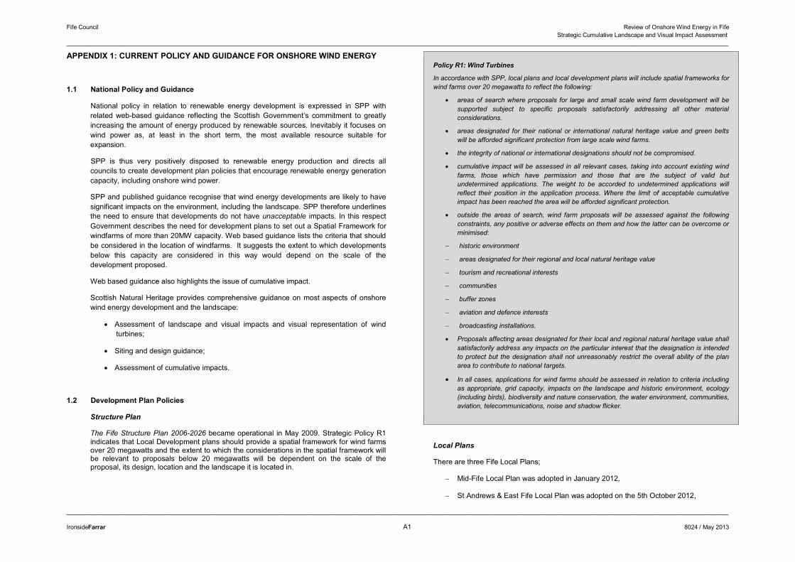
Policy R1: Wind Turbines
In accordance with SPP, local plans and local development plans will include spatial frameworks for wind farms over 20 megawatts to reflect the following:
� areas of search where proposals for large and small scale wind farm development will be supported subject to specific proposals satisfactorily addressing all other material considerations.
� areas designated for their national or international natural heritage value and green belts will be afforded significant protection from large scale wind farms.
� the integrity of national or international designations should not be compromised.
� cumulative impact will be assessed in all relevant cases, taking into account existing wind farms, those which have permission and those that are the subject of valid but undetermined applications. The weight to be accorded to undetermined applications will reflect their position in the application process. Where the limit of acceptable cumulative impact has been reached the area will be afforded significant protection.
� outside the areas of search, wind farm proposals will be assessed against the following constraints, any positive or adverse effects on them and how the latter can be overcome or minimised:
� historic environment
� areas designated for their regional and local natural heritage value
� tourism and recreational interests
� communities
� buffer zones
� aviation and defence interests
� broadcasting installations.
� Proposals affecting areas designated for their local and regional natural heritage value shall satisfactorily address any impacts on the particular interest that the designation is intended to protect but the designation shall not unreasonably restrict the overall ability of the plan area to contribute to national targets.
� In all cases, applications for wind farms should be assessed in relation to criteria including as appropriate, grid capacity, impacts on the landscape and historic environment, ecology (including birds), biodiversity and nature conservation, the water environment, communities, aviation, telecommunications, noise and shadow flicker.
Local Plans
There are three Fife Local Plans;
� Mid-Fife Local Plan was adopted in January 2012,
� St Andrews & East Fife Local Plan was adopted on the 5th October 2012,
Fife Council Review of Onshore Wind Energy in Fife Strategic Cumulative Landscape and Visual Impact Assessment
______________________________________________________________________________________________________________________________________________________________________________________________________
______________________________________________________________________________________________________________________________________________________________________________________________________
IronsideFarrar A2 8024 / May 2013
� The Dunfermline & West Fife Local Plan was approved for adoption by Fife's Planning Committee on 4th October 2012. A formal notice of Intention to adopt the Local Plan will be published on 19th October 2012
The renewable energy policies in these indicate a broad support for renewable energy generation provided that there are no significant adverse impacts. They recognise that the main sources are likely to be in rural areas.
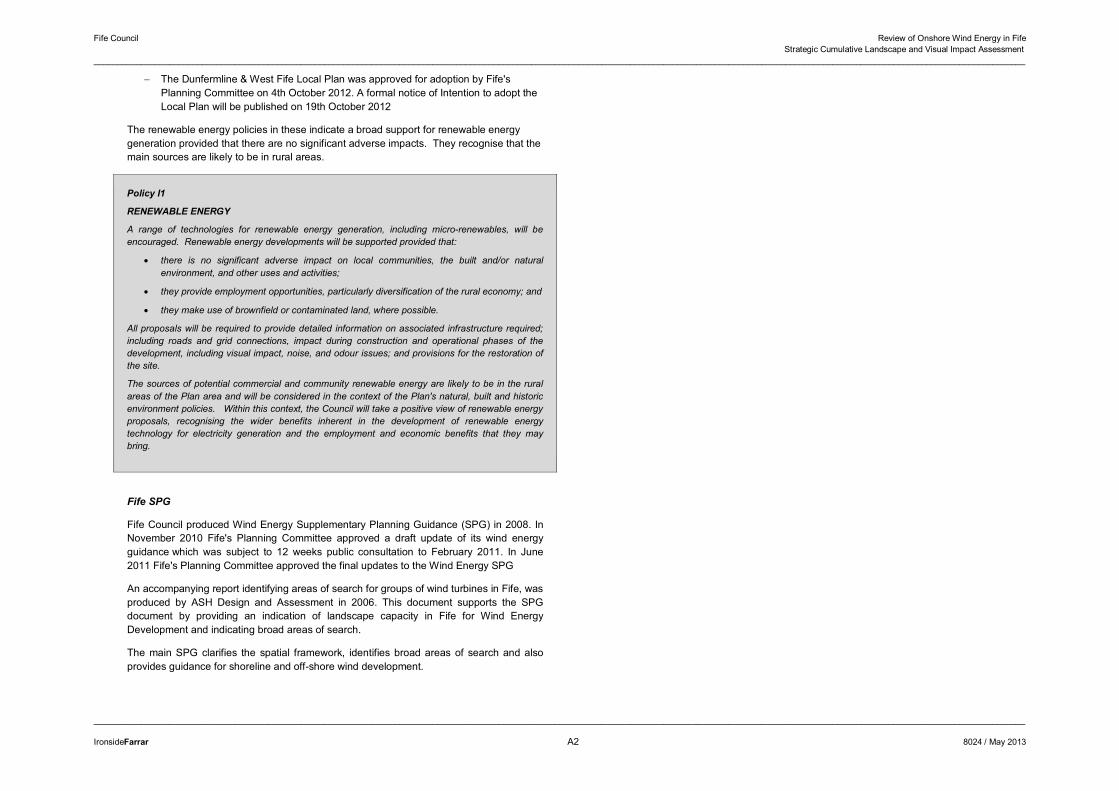
Policy I1
RENEWABLE ENERGY
A range of technologies for renewable energy generation, including micro-renewables, will be encouraged. Renewable energy developments will be supported provided that:
� there is no significant adverse impact on local communities, the built and/or natural environment, and other uses and activities;
� they provide employment opportunities, particularly diversification of the rural economy; and
� they make use of brownfield or contaminated land, where possible.
All proposals will be required to provide detailed information on associated infrastructure required; including roads and grid connections, impact during construction and operational phases of the development, including visual impact, noise, and odour issues; and provisions for the restoration of the site.
The sources of potential commercial and community renewable energy are likely to be in the rural areas of the Plan area and will be considered in the context of the Plan's natural, built and historic environment policies. Within this context, the Council will take a positive view of renewable energy proposals, recognising the wider benefits inherent in the development of renewable energy technology for electricity generation and the employment and economic benefits that they may bring.
Fife SPG
Fife Council produced Wind Energy Supplementary Planning Guidance (SPG) in 2008. In November 2010 Fife's Planning Committee approved a draft update of its wind energy guidance which was subject to 12 weeks public consultation to February 2011. In June 2011 Fife's Planning Committee approved the final updates to the Wind Energy SPG
An accompanying report identifying areas of search for groups of wind turbines in Fife, was produced by ASH Design and Assessment in 2006. This document supports the SPG document by providing an indication of landscape capacity in Fife for Wind Energy Development and indicating broad areas of search.�
The main SPG clarifies the spatial framework, identifies broad areas of search and also provides guidance for shoreline and off-shore wind development.
Fife Council Review of Onshore Wind Energy in Fife Strategic Cumulative Landscape and Visual Impact Assessment
______________________________________________________________________________________________________________________________________________________________________________________________________
______________________________________________________________________________________________________________________________________________________________________________________________________
IronsideFarrar A3 8024 / May 2013
APPENDIX 2: CUMULATIVE IMPACT AND LANDSCAPE CAPACITY ASSESSMENT METHODOLOGIES
1.0 Background
Cumulative environmental impact is the impact that results from incremental changes caused by past, present or reasonably foreseeable actions. Scottish Government Guidance on wind energy states:
‘Assessing the cumulative impact of a number of wind turbines or a number of wind farms involves considering the combined effects of siting proposals in proximity to each other’.
Cumulative impact is a critical consideration in the case of landscape and visual impacts of onshore wind turbines and windfarms in Scotland due to the current number of existing and consented developments in the landscape, proposed developments in the planning system and the long term implications of national policy that encourages the development of onshore wind energy generation.
The characteristics of wind turbines that lead to cumulative impacts include:
� The large scale and striking visual appearance of wind turbines and windfarms in most landscapes;
� The great extent of their visibility and the potential for intervisibility between wind turbine developments and as seen by receptors;
The larger modern turbines are prominent, large scale, man-made features and there are few other precedents in terms of scale, height and appearance in most landscapes. Topography aside, they are much taller than any natural features such as trees or most buildings and other structures. Of similar built structures in rural landscapes, electricity pylons are significantly smaller than the largest turbines and although broadcasting masts are often taller they are usually singular and infrequent, whereas wind turbines are built in multiples, often in great numbers. Furthermore, most landscape features are static whereas wind turbines rotate. Smaller turbines may also present issues of scale and appearance in more localised contexts, as well as visual confusion when seen together with larger turbines.
This study on behalf of Angus Council requires the assessment of cumulative development and landscape capacity. However it is recognised in guidance that the determination of landscape capacity and cumulative impacts is not a straightforward exercise. The background and considerations involved in this process are detailed in this Appendix.
Definitions of the term ‘capacity’ applied to landscape generally refer to the ability to accept a development without a ‘significant’ or ‘unacceptable’ level of change to a landscape. This implies that criteria must be identified and thresholds must be determined to give meaning to the words ‘significant’ and ‘unacceptable’.
Guidance on the assessment of cumulative impacts and landscape capacity is available from a number of sources, most particularly Scottish Natural Heritage Assessing the cumulative impact of onshore wind energy developments (March 2012) but also in UK guidance (eg. Landscape Character Assessment Guidance for England and Scotland Topic paper 6: Techniques and Criteria for Judging Capacity and Sensitivity. SNH and The Countryside Agency, 2002) and will be referred to in the following sections.
The determination of ‘cumulative impacts’ and ‘capacity’ is subject to debate. No clear guidance is given in the published information beyond the need for the individual impact assessor or Development Plans to determine what the assessment criteria and significance thresholds are. Reasoned argument applicable to the specific circumstances applies, rather than the establishment of an absolute or universal definition. Inevitably this approach is subject to differences of opinion, with thresholds of significance and views on acceptability often differing depending on the background or vested interests of those involved in the debate.
In the absence of any clearly stated or agreed criteria or thresholds and to progress this study some form of threshold or thresholds need to be defined. In order to do this a number of terms and concepts need to be clarified, defining exactly what is being assessed and how. The purpose of the following section is to focus the subsequent assessment and to provide guidance and a basis for decisions to be made by the appropriate authorities.
2.0 Defining Terms: Sensitivity, Significance, Capacity and Acceptability of Change
Topic Paper 6 of Landscape Character Assessment: Guidance for England and Scotland (2002) refers to the fact that the terms ‘sensitivity’ and ‘capacity’ have often been used in an interchangeable manner in landscape character assessment, essentially referring to the ability of a landscape to absorb change without a significant effect on its character. A landscape of high sensitivity is often considered to have a low capacity for change, and vice-versa. Furthermore sensitivity is used as a key criterion in determining both significance of impact and landscape capacity. In fact there are subtle but important differences between sensitivity and capacity. This section discusses the differences and interrelationships between sensitivity, capacity and significance in landscape character assessment and how the acceptability of change may be determined.
2.1 Landscape Sensitivity
The sensitivity of a landscape is a measure of its inherent vulnerability to potential changes and their effects on fabric and character. Vulnerability to change can be considered in two ways:
1) As an inherent part of the landscape’s characteristics, regardless of possible types or scales of change that may occur; or
2) In relation to a specific proposed type and scale of change.
Fife Council Review of Onshore Wind Energy in Fife Strategic Cumulative Landscape and Visual Impact Assessment
______________________________________________________________________________________________________________________________________________________________________________________________________
______________________________________________________________________________________________________________________________________________________________________________________________________
IronsideFarrar A4 8024 / May 2013
In the former case the assessment of sensitivity would be applied in landscape character assessment where no particular change is being contemplated or assessed, and the landscape is being considered in a resource planning context. In the latter case the assessment of sensitivity would typically be applied in an environmental impact assessment where specific changes are envisaged. In the EIA case the sensitivity of the receiving landscape would be assessed against the magnitude of change in order to determine impact significance.
2.2 Landscape Capacity
Landscape capacity is variously described as the ability of a landscape to accommodate (or absorb) change without a significant (or unacceptable) change in fabric or character. This is usually taken to mean whether or not one or more of the key defining characteristics of the landscape is changed such that the overall fabric or character of the landscape is changed, ie. a ‘capacity threshold’ is crossed. In the case of windfarms it is primarily landscape character that is being considered, particularly in cumulative assessments.
The determination of landscape capacity is closely related to landscape sensitivity and the determination of significance of impact. However assessment of capacity is a not necessarily based around the assessment of known development proposals, but rather the hypothetical ability to accommodate particular types of development, such as windfarms before a threshold or series of increasing thresholds are crossed.
According to Topic Paper 6, in determining capacity not only the sensitivity of the landscape to the particular type of development is considered but also the landscape valueof the area concerned. Value may be determined in a number of ways, including by landscape designations (national, regional or local); cultural and historic associations and in terms of how it is valued by those who live in it or use it in some way.
The determination of capacity is primarily a planning tool rather than a reactive or assessment tool. Nevertheless the determination of capacity thresholds can also be used to assess existing levels of development or potential development scenarios such as is the case with windfarm developments in Fife.
2.3 Determination of Impact Significance
The principles involved in determining impact significance are the same whether a single or multiple developments are being considered. This involves assessing:
1) The sensitivity of the receptor to the type of change proposed; and
2) The magnitude of change that would result from the proposals.
Sensitivity and magnitude are considered in combination, leading to an overall assessment of impact. This informs a determination of whether the impact is significant in terms of the EIA regulations. In doing this the considerations about what exactly is being assessed should be taken into account and clearly delineated including baseline, types of impacts and specific developments.
The threshold at which significance is determined in relation to the EIA regulations should also be defined prior to assessment. However, this threshold is particularly open to debate and often subject to the perceptions of different groups of stakeholders.
2.4 The Nature of Impacts
The issue of whether impacts are positive, beneficial or neutral is also an important consideration when making decisions on the acceptability of impacts, regardless of their significance. If an impact were considered positive or neutral in nature it is likely that its level of significance would be considered less critical than were it considered negative. Most windfarm developers equivocate this issue by reference to public opinion polls indicating support for renewable energy and the division of public opinion that is apparent over most windfarm developments. This masks the underlying landscape issue that should be considered independently of a windfarm’s primary function or other effects.
The purpose of a windfarm is to provide renewable energy involving low levels atmospheric carbon pollution. This accords with current policy and is considered positive and beneficial. Conversely, wind turbines are objects that are unprecedented in scale and appearance in most landscapes, especially the rural area s in which they are mainly located. Many published landscape character assessments of rural areas do not specifically mention wind turbines and windfarms, although increasingly there are guidelines relating to placing them within particular character types. Furthermore, whilst government policy and advice (eg. SPP, web based guidance, SNH guidance) and local authority policy (Development Plans) support their development, it is always with a precautionary note relating to balancing benefits and impacts.
The tone of most guidance is that of achieving a balance of impacts against the positive returns of renewable energy. For example SPP states in paragraph 187:
‘Planning authorities should support the development of wind farms in locations where the technology can operate efficiently and environmental and cumulative impacts can be satisfactorily addressed.’
and;
‘The design and location of any wind farm development should reflect the scale and character of the landscape. The location of turbines should be considered carefully to ensure that the landscape and visual impact is minimised.’
Web based guidance for onshore wind states:
‘Wind turbines can impact upon the landscape by virtue of their number, size or layout, how they impact on the skyline, their design and colour, any land form change, access tracks and ancillary components anemometers, substations andpower lines. The ability of the landscape to absorb development often depends largely on features of landscape character such as landform, ridges, hills, valleys, and vegetation’.
and:
Fife Council Review of Onshore Wind Energy in Fife Strategic Cumulative Landscape and Visual Impact Assessment
______________________________________________________________________________________________________________________________________________________________________________________________________
______________________________________________________________________________________________________________________________________________________________________________________________________
IronsideFarrar A5 8024 / May 2013
‘As more areas of search are taken up and as more sites are proposed within or near sensitive landscapes, landscape protection and designing appropriate mitigation through conditions and/or legal agreements, will become a more routine consideration alongside maximising the potential of wind energy. In relation to landscape impact, a cautious approach is necessary in relation to particular landscapes which are rare or valued, such as National Scenic Areas and National Parks’.
Wind turbines are placed in the landscape for a specific purpose other than landscape change. Given this fact and the nature of Government advice, a precautionary approach should be taken in the assessment of impacts by concluding that in most cases the impacts are to some degree negative. The degree of negative impact and level of significance will of course depend on the characteristics of the landscape in which the windfarm is located. It is conceivable that in some degraded or industrial landscapes the construction of a windfarm could be considered a neutral or positive change.
In terms of visual impacts the issue of public opinion is more relevant, but a precautionary note applies in this case as well. Particularly the issue of positive responses to the provision of clean energy needs to be separated from the consideration of visual impact of turbines in the landscape.
2.5 Acceptability of Change
As discussed above there is published guidance on methods of assessment of cumulative landscape and visual impacts of windfarms (eg. SNH, 2012) and separate guidance on the factors that determine impact significance (eg. LI & IEMA, 2002). However there is currently no generic guidance that defines how to determine the acceptability of impacts. Indeed generic guidance on acceptability may be inappropriate as any judgement on this is contextual and often a case of weighing perceived impacts against perceived benefits. The impacts and benefits will often be different in type and the balance of judgement is to an extent subjective. The acceptability of change in any particular landscape will depend on the nature of the landscape, the significance of the impacts and the purpose of the change. The final judgement is often informed by and weighed against specific development plan policies and material considerations.
The determination of significant change should theoretically be a clearly defined stage in this process, similar to an impact assessment. Nevertheless, as previously discussed, significance in landscape and visual impact assessment is not universally defined and is open to debate. If the significance of change is open to interpretation, then ‘acceptability’ of change is a still less definable term that is often based on opinion and is open to debate.
What is acceptable to one individual or organisation may not be acceptable to another. What may be seen as unacceptable change in a narrow context (eg. landscape and visual impacts) may be seen as acceptable when considering the overall balance of positive and negative impacts (eg. provision of carbon-neutral energy). In a study of windfarms in the Western Isles (SNH, 2004) the idea of a predetermined ‘carrying capacity’ is questioned and the concept of Limits of Acceptable Change (LAC) is discussed:
‘LAC is first and foremost a process through which decisions are made on the conditions which are acceptable and then prescriptions are made for the actions needed to protect or achieve those conditions. So the objective of the LAC process is not to prevent change but rather to control it and to decide on the actions required to maintain or achieve the desired conditions. Other key features of LAC are the use of indicators and a monitoring programme. As a process, LAC is always participatory and multi-disciplinary, and may or may not involve a wide range of stakeholders. Whilst the term capacity may still be used in LAC, (recreational) carrying capacity is not a simple, single, absolute value. It is the amount, kind and distribution of use that can occur without causing unacceptable impacts on either natural resources or the perceptions and experiences of the users’.
This concept requires qualitative judgements about what is important in a landscape or to people using that landscape and what level of change is acceptable (ie. what types and levels of change can take place before the landscape is considered to be critically or significantly changed). In the context of this study, acceptability of change will be related to cumulative landscape and visual impacts judged against landscape capacity as determined by structured a process of judgement; the provisions of criteria-based landscape policies; other material considerations and the wider Scottish picture of windfarm development. No account will be taken of the other potential impacts or benefits of windfarms. The resulting judgements of this study will need to be balanced against the other benefits or disadvantages of the proposals.
2.6 National and Local Policy
The acceptability of proposed windfarms and cumulative landscape and visual impacts of multiple windfarm development has to be considered in the light of national and development plan policy. National policies and Fife structure and local plan policies are described in Appendix 1 above.
2.7 Developing a Cumulative Impact Assessment Methodology
2.7.1 Cumulative Impacts
For the purposes of this study, cumulative impacts are taken to be those arising from more than one development of the same type, rather than the accumulation of changes making up one development. In the case of windfarms, cumulative studies concentrate on other windfarms. In practice, other features in the landscape or views (eg. communications masts or electricity pylons) should also be taken into account. Nevertheless, given the singular appearance of windfarms and their generally isolated rural locations, the potential for overlap of cumulative impacts with other developments is more limited.
2.7.2 Baseline
The baseline for a cumulative, or indeed any, assessment is usually taken to include the existing landscape and visual receptors in the study area at the time of assessment. The baseline should include all operating windfarms and, arguably, all consented windfarms as this is effectively the ‘permitted landscape’. The assessment of change and significance of
Fife Council Review of Onshore Wind Energy in Fife Strategic Cumulative Landscape and Visual Impact Assessment
______________________________________________________________________________________________________________________________________________________________________________________________________
______________________________________________________________________________________________________________________________________________________________________________________________________
IronsideFarrar A6 8024 / May 2013
impact should be carried out relative to this baseline whether carrying out a standard or cumulative assessment.
Nevertheless, a landscape capacity study leading to the determination of an ‘acceptable’ level of windfarm development requires consideration of a full picture of all the windfarms in the landscape: operating, consented and proposed, in order to determine the extent and acceptability of change. The fact that there are operating or consented windfarms in an area is not necessarily an indication that the landscape is less sensitive to further development and that capacity is available. Indeed, depending on the landscape type, degree of development and objectives of policy in relation to landscape character, it may mean that most or all of the capacity is already occupied. Therefore, despite the existing baseline, the development must also in effect be considered relative to the underlying landscape.
2.7.3 Types of Cumulative Impact
Landscape
The assessment of cumulative landscape impacts involves an assessment of change in the fabric and character of the landscape as a result of the combined changes of more than one development. The changes are assessed in relation to defined areas of landscape such as a project study area, landscape character area or designated landscape. As previously discussed, it is effects on landscape character that are the primary focus in relation to windfarms from which all other assessments are derived.
Visual
The assessment of cumulative visual impacts involves an assessment of the change in views and visual amenity as a result of combined changes of more than one development, as experienced by people at their homes and during recreation, travel or work. There are three types of cumulative impact in relation to visual receptors:
1) Combined: more than one development is seen from a single static viewpoint in one arc of view (ie. within the span of one view, without the receptor turning around). This would include particular directional viewpoints or the view from the principal aspect of a residential property.
2) Successive: more than one development is seen from a single static viewpoint by a receptor turning around to encompass more than one arc of view, up to 3600. This includes high and open viewpoints, or views from all aspects of a residential property.
3) Sequential: more than one development is seen by a receptor visiting a series of viewpoints. This may involve travelling along a linear route or through an area in which views of the developments may be continuous or intermittent and different developments may be seen at different locations. This includes roads, railways, paths and other defined routes or could involve an area such as a designated landscape.
In practice most assessment will include all of these types of impact in order to gain a full picture of how cumulative impacts will be experienced by receptors.
2.7.4 Effect of Pattern of Development on Perception of Impact
Cumulative studies tend to focus on the number of windfarms, turbines or output capacities within a particular area as an indication of level of cumulative impact. Nevertheless, there is not necessarily a simple relationship between numbers, areas and cumulative impact. The pattern of windfarm and wind turbine development, in terms of size, layout and proximity may also affect the perception of cumulative impacts.
The effect of proximity of different windfarms and turbines to one another has a bearing on impacts. Whilst close proximity of two or more windfarms may reduce the total area visually affected, the level of perceived cumulative impact may be increased by juxtaposition of windfarms or turbines of significantly different appearance (due for example to differing turbine sizes or site layouts) leading to a jarring visual clash or an untidy, disorganised appearance.
Furthermore, studies and planning decisions have indicated that there is less resistance to expansion of existing windfarms than to creation of separate new windfarms. In particular, respondents to a survey on impacts of windfarms on tourism in Scotland (Glasgow Caledonian University and others, March 2008) showed little concern about views being affected by one windfarm compared with more than one windfarm being visible in the same view.
“A significant proportion of respondents (44%) agreed that they don’t like to see several Wind farms in the same view. These results suggest that those respondents who have indicated having a neutral or even positive perspective on individual wind farm sites are less likely to have a similar opinion on a landscape that has several developments in view.
This clear result compares with analysis in the previous section where there was a small increase in the negative response as the visual impact increased for an individual wind farm development. This suggests that people see one large scale development in an area as preferable to several smaller scale developments dotted on the landscape.
On the other hand, both sets of results also confirm that a definite tipping point exists where wind farm development becomes untenable for a significant number of visitors”.
Current guidance and recent planning decisions are tending towards the concept of concentration of wind turbines into large clusters in certain areas. This is on the basis that this reduces the potential for a widespread dispersal of effects over a larger area and allows areas more sensitive to windfarm development to remain free of windfarm development. SNH guidance now highlights this issue and supports this type of approach where appropriate (SNH, 2009).
The policy may also offer advantages in terms of economies of scale for site servicing and electricity transmission. The disadvantages are likely to be that areas chosen for concentration of the turbines are likely to be significantly and adversely affected by development – this being effectively a ‘sacrificial’ landscape policy. Furthermore, this
Fife Council Review of Onshore Wind Energy in Fife Strategic Cumulative Landscape and Visual Impact Assessment
______________________________________________________________________________________________________________________________________________________________________________________________________
______________________________________________________________________________________________________________________________________________________________________________________________________
IronsideFarrar A7 8024 / May 2013
concept does not necessarily sit well with recent encouragement for smaller scale wind energy development promoted by the Feed in Tariff where turbines are likely to relate to individual properties scattered across the landscape.
2.7.5 Setting Assessment Objectives
What exactly is being assessed depends on the purpose of the cumulative assessment. In the case of an EIA for a single development it is primarily the impacts of the proposal and its contribution to cumulative impacts that is being assessed. Such a study would therefore typically concentrate on areas in which the impact of the windfarm under consideration is significant and give only slight consideration to areas in which it is not, even if there were significant cumulative impacts from other windfarms.
In the case of a more broad-based cumulative study such as this, it is the overall impact of windfarm developments on a defined study area that is being assessed. Nevertheless this study requires a consideration of the both the full cumulative impact and the contribution that specific developments (proposed or operating) make to that impact, in order to inform decisions.
2.7.6 Defining Thresholds of Cumulative Development
The discussion above has defined the terminology and our approach to cumulative assessment. It has isolated the central issues that inform the assessment of acceptability of levels of change. The key requirement is to develop a methodology for defining thresholds of significance and acceptability that are clear and robust enough to be accepted by all sides of the debate. This study as a stage in the debate about acceptable levels of change in the landscape of Fife. Whilst we can describe and define what those levels of change might be it is difficult to enforce a universal view as to what levels of change are significant or acceptable.
Scottish Government Guidance underlines the landscape and visual issues associated with increasing levels of cumulative wind turbine development:
‘In areas approaching their carrying capacity the assessment of cumulative effects is likely to become more pertinent in considering new wind turbines, either as stand alone groups or extensions to existing wind farms. In other cases, where proposals are being considered in more remote places, the thresholds of cumulative impact are likely to be lower, although there may be other planning considerations.
In assessing cumulative landscape and visual impacts, the scale and pattern of the turbines plus the tracks, power lines and ancillary development will be relevant considerations. It will also be necessary to consider the significance of the landscape and the views, proximity and inter-visibility and the sensitivity of visual receptors.’
SNH guidance Siting and Designing Windfarms in the Landscape (SNH, Dec 2009) lists the factors that affect the perception of cumulative impact of windfarm development:
‘The cumulative impact of windfarm development on landscape and visual amenity is a product of:
• the distance between individual windfarms (or turbines),
• the distance over which they are visible, • the overall character of the landscape and its sensitivity to windfarms, • the siting and design of the windfarms themselves, and • the way in which the landscape is experienced.
The combination of single turbines and small clusters of turbines can raise the same issues’.
To this list might be added turbine height and windfarm size. In determining an acceptable level of development, it is necessary to clearly define what differing levels of development actually entail.
The SNH guidance identifies three broad levels of cumulative change in the landscape that may be set by local authorities depending on landscape sensitivity and value and local policy objectives:
� Landscape Protection: Maintain existing landscape character.
� Landscape Accommodation: Accept a degree of change providing this is not detrimental to key landscape characteristics and key visual resources.
� Landscape Change: Accept large amounts of change that may have detrimental effects on key landscape characteristics and visual resources.
In determining an acceptable level of development, it is necessary to clearly define what differing levels of development actually entail. The methodology therefore sets out defined levels of change to the landscape and visual environment that might occur or be experienced depending on the size, number and location of turbines to be built within an area.
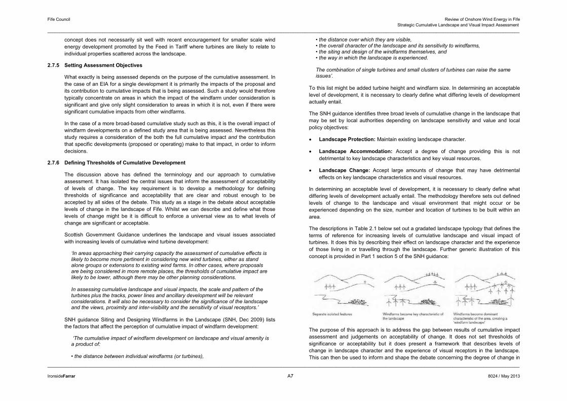
The descriptions in Table 2.1 below set out a gradated landscape typology that defines the terms of reference for increasing levels of cumulative landscape and visual impact of turbines. It does this by describing their effect on landscape character and the experience of those living in or travelling through the landscape. Further generic illustration of this concept is provided in Part 1 section 5 of the SNH guidance:
The purpose of this approach is to address the gap between results of cumulative impact assessment and judgements on acceptability of change. It does not set thresholds of significance or acceptability but it does present a framework that describes levels of change in landscape character and the experience of visual receptors in the landscape. This can then be used to inform and shape the debate concerning the degree of change in
Fife Council Review of Onshore Wind Energy in Fife Strategic Cumulative Landscape and Visual Impact Assessment
______________________________________________________________________________________________________________________________________________________________________________________________________
______________________________________________________________________________________________________________________________________________________________________________________________________
IronsideFarrar A8 8024 / May 2013
a landscape and the acceptability of cumulative impacts and the Limits of Acceptable Change.
Table 1: Description of Levels of Cumulative Wind Turbine Development
Landscape Type
Landscape Character Visual Experience
Landscape with no Wind Turbines
A landscape type or area in which no or very few wind turbines are present, and none are clearly visible from neighbouring areas.
There would be no discernible effects on visual receptors.
Landscape with Occasional Wind Turbines
A landscape type or area in which windfarms or wind turbines are located and/or are close to and visible. However they are not of such a size, number, extent or contrast in character that they become one of the defining characteristics of the landscape’s character.
Visual receptors would experience occasional close-quarters views of a windfarm or turbine and more frequent background views of windfarms or turbines. Some of the turbines would not be perceived as being located in the landscape character type or area. No overall perception of wind turbines being a defining feature of the landscape.
Landscape with Wind Turbines
A landscape type or area in which a windfarm, windfarms or wind turbines are located and/or visible to such an extent that they become one of the defining characteristics of the landscape character. However, they are clearly separated and not the single most dominant characteristic of the landscape.
Visual receptors would experience frequent views of windfarms or wind turbines as foreground, mid-ground or background features, affecting their perception of the landscape character. However there would be sufficient separation between windfarms and turbines and sufficient areas from which wind turbines are not visible such that they would not be seen as dominating the landscape over all other landscape features.
Wind Turbine Landscape
A landscape type or area in which windfarms or wind turbines are extensive, frequent and nearly always visible. They become the dominant, defining characteristic of the landscape. Nevertheless there is a clearly defined separation between developed areas.
Visual receptors would experience views of windfarms as foreground, mid-ground and background features, to the extent that they are seen to dominate landscape character. Few areas would be free of views of wind turbines.
Windfarm Landscape fully developed as a windfarm with no clear separation between groups of turbines. Few if any areas where turbines not visible.
Visual receptors would always be close to and nearly always in full view of wind turbines.
The above descriptions of levels of turbine development within a landscape are necessarily simple, factual and generic. They can be applied to any chosen scale of study area, from a region to a landscape type or a single landscape character area. They do not apply to any specific baseline landscape type or types: indeed the character of the landscape is likely to affect judgements on the assignation to a particular level of development. For instance, a large scale landscape may be less dominated and affected than a smaller scale landscape; or a more complex topography, or a densely wooded landscape may reduce
the visibility of wind turbines within an area and hence affect the perception by visual receptors. A large landscape character area will require a greater extent and frequency of development than a smaller area to become affected by wind turbines. Furthermore, as discussed in Chapter 5 of this report, there are a number of design and siting factors that affect the perception of cumulative impacts. This includes not only size and number of turbines and windfarms in an area but also the juxtaposition of different layouts including turbine size, positioning and distribution.
The descriptions assume conditions of good visibility covering the 30-35km range that visibility studies and visual impact assessments of larger windfarms adopt as best practice. Clearly this exceeds the requirements for assessments of smaller turbines.
The descriptions are intended to be neutral in that they are purely descriptions of levels of development and the frequency or proximity at which wind turbines and windfarms may be seen. They do not attempt to define the levels of development as being good, bad, acceptable or unacceptable. This is a judgement that would be made when considering specific cases against the landscape type, its capacity for windfarm development, the development policy framework and other material considerations. In this case it is the determination of areas in which cumulative impact has reached the capacity of the landscape.
2.8 Capacity Assessment Method
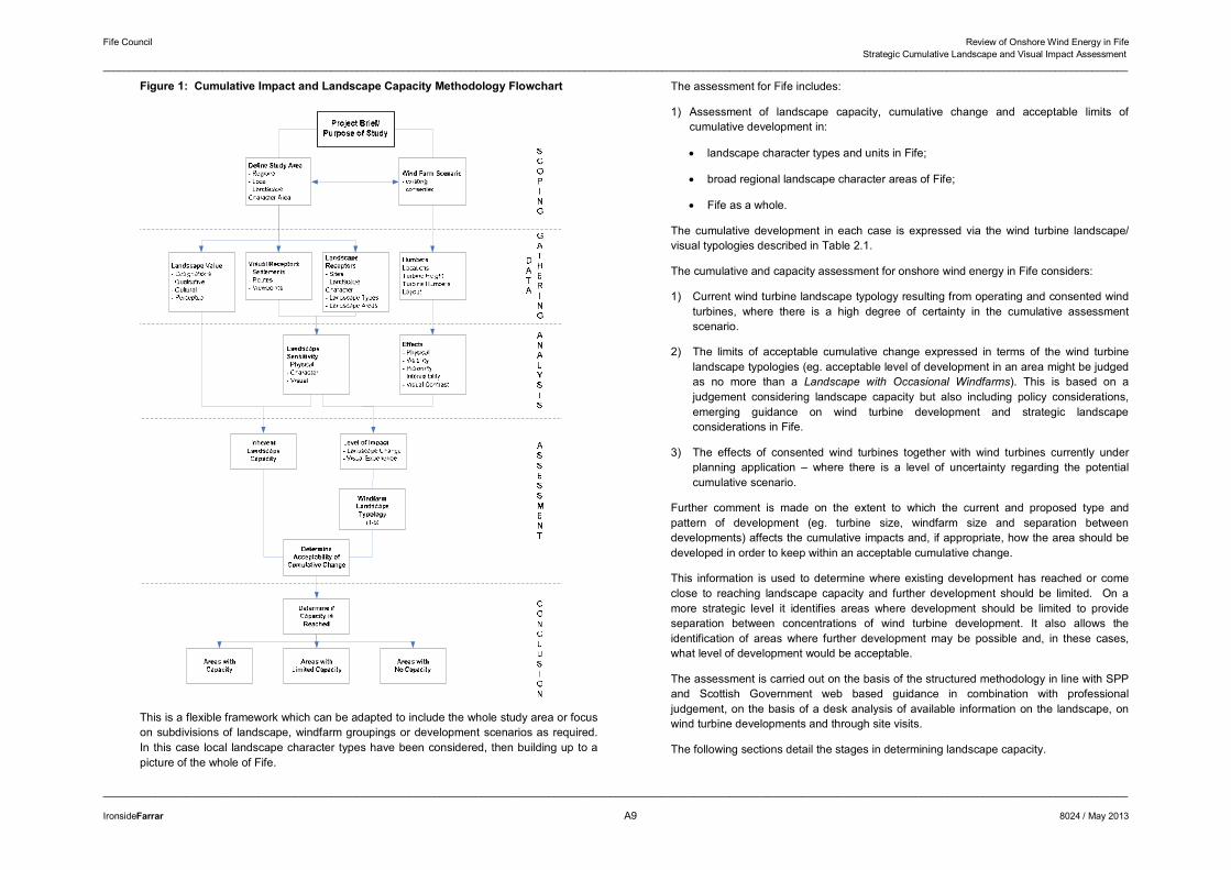
2.8.1 Assessment Process
The considerations discussed above have been taken into account in the staged methodology. This is illustrated by the flow diagram in Figure 1 overleaf. There are 5 stages in the process as shown in Table 2 below:
Table 2: Stages in Landscape Capacity Assessment
Scoping: Define the purpose of the study, the study area and the wind energy development scenario that is to be assessed.
Data Gathering:
Gather information on receptors (visual and/or landscape); landscape designations and potential constraints; windfarms/ turbines (existing, proposed etc).
Analysis: Determine landscape character sensitivity, visual sensitivity and landscape value.
Determine visibility, direct and indirect landscape effects of the consented windfarms and turbines.
Assessment: Determine landscape capacity from landscape sensitivity and value.
Determine level of cumulative change caused by consented wind turbines, leading to a wind turbine landscape/ visual typology.
Conclusions: Determine significance and/ or acceptability of existing and future potential cumulative change to the landscape and visual environment.
Fife Council Review of Onshore Wind Energy in Fife Strategic Cumulative Landscape and Visual Impact Assessment
______________________________________________________________________________________________________________________________________________________________________________________________________
______________________________________________________________________________________________________________________________________________________________________________________________________
IronsideFarrar A9 8024 / May 2013
Figure 1: Cumulative Impact and Landscape Capacity Methodology Flowchart
This is a flexible framework which can be adapted to include the whole study area or focus on subdivisions of landscape, windfarm groupings or development scenarios as required. In this case local landscape character types have been considered, then building up to a picture of the whole of Fife.
The assessment for Fife includes:
1) Assessment of landscape capacity, cumulative change and acceptable limits of cumulative development in:
� landscape character types and units in Fife;
� broad regional landscape character areas of Fife;
� Fife as a whole.
The cumulative development in each case is expressed via the wind turbine landscape/ visual typologies described in Table 2.1.
The cumulative and capacity assessment for onshore wind energy in Fife considers:
1) Current wind turbine landscape typology resulting from operating and consented wind turbines, where there is a high degree of certainty in the cumulative assessment scenario.
2) The limits of acceptable cumulative change expressed in terms of the wind turbine landscape typologies (eg. acceptable level of development in an area might be judged as no more than a Landscape with Occasional Windfarms). This is based on a judgement considering landscape capacity but also including policy considerations, emerging guidance on wind turbine development and strategic landscape considerations in Fife.
3) The effects of consented wind turbines together with wind turbines currently under planning application – where there is a level of uncertainty regarding the potential cumulative scenario.
Further comment is made on the extent to which the current and proposed type and pattern of development (eg. turbine size, windfarm size and separation between developments) affects the cumulative impacts and, if appropriate, how the area should be developed in order to keep within an acceptable cumulative change.
This information is used to determine where existing development has reached or come close to reaching landscape capacity and further development should be limited. On a more strategic level it identifies areas where development should be limited to provide separation between concentrations of wind turbine development. It also allows the identification of areas where further development may be possible and, in these cases, what level of development would be acceptable.
The assessment is carried out on the basis of the structured methodology in line with SPP and Scottish Government web based guidance in combination with professional judgement, on the basis of a desk analysis of available information on the landscape, on wind turbine developments and through site visits.
The following sections detail the stages in determining landscape capacity.
Fife Council Review of Onshore Wind Energy in Fife Strategic Cumulative Landscape and Visual Impact Assessment
______________________________________________________________________________________________________________________________________________________________________________________________________
______________________________________________________________________________________________________________________________________________________________________________________________________
IronsideFarrar A10 8024 / May 2013
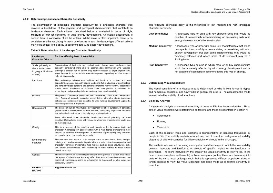
2.8.2 Determining Landscape Character Sensitivity
The determination of landscape character sensitivity for a landscape character type involves a breakdown of the physical and perceptual characteristics that contribute to landscape character. Each criterion described below is evaluated in terms of high, medium or low for sensitivity to wind energy development. An overall assessment is derived from a composite of all the criteria. Whilst scale is often important, there is no consistent relative weighting for each criterion, as in each landscape type different criteria may to be critical to the ability to accommodate wind energy development.
Table 3. Determination of Landscape Character Sensitivity
Landscape Character Criteria
Factors affecting level of sensitivity
Scale (primarily in character but also in geographical size of area)
Consideration of horizontal and vertical scale. Larger scale landscapes are generally considered more able to accommodate commercial wind turbines, although a smaller size of turbine may reduce impacts. A larger physical area would be able to accommodate more development depending on other aspects determining capacity.
Landform The relationship between wind turbines and landform is complex and also dependent on scale. Generally simple landforms: flat, undulating or gently rolling, are considered less sensitive and complex landforms more sensitive, especially if smaller scale. Landforms of sufficient scale may provide opportunities for screening or backgrounding turbines, reducing their visual sensitivity.
Pattern The pattern of landcover (woodland, field boundaries, crops, roads, settlements etc). Degree of strength, regularity, fragmentation. Minimal or simple landscape patterns are considered less sensitive to wind turbine development. Again the relationship to scale is important.
Development The degree of built or infrastructure development will affect suitability. In general a greater level of development is more suitable, particularly large scale industrial and extractive industries, or potentially large scale agriculture.
Areas with small scale residential development would potentially be more sensitive. Undeveloped areas with remote or wilderness characteristics would also be more sensitive.
Quality This is a measure of the condition and integrity of the landscape fabric and character. A landscape in good condition with a high degree of integrity is more likely to be sensitive to development. A landscape of poor quality may represent an opportunity to compensate for impacts.
Elements and Features
The elements that make up a landscape, such as woodlands, fields, hedges, buildings and landforms create its pattern but add to its distinctive composition and character. Prominent or distinctive focal features such as steep hills, towers, lochs add further distinctiveness. The relationship of wind turbines to these affects overall sensitivity.
Context The characteristics of surrounding landscape areas provide a context that affects perception of a landscape and may affect how wind turbine developments are perceived. Landscapes acting as a backdrop or foreground to other areas are particularly sensitive.
OVERALL RATING
High/ Medium/ Low
The following definitions apply to the thresholds of low, medium and high landscape character sensitivity:
Low Sensitivity: A landscape type or area with key characteristics that would be capable of successfully accommodating or co-existing with wind energy development of all or most scales.
Medium Sensitivity: A landscape type or area with some key characteristics that would be capable of successfully accommodating or co-existing with wind energy development but also some characteristics that would be adversely affected and where scale of development may be a limiting factor.
High Sensitivity: A landscape type or area in which most or all key characteristics would be adversely affected by wind energy development and is not capable of successfully accommodating this type of change.
2.8.3 Determining Visual Sensitivity
The visual sensitivity of a landscape area is determined by who is likely to see it, (types and numbers of receptors) and how visible in general the area is. The assessment is made in relation to the visibility of tall structures.
2.8.4 Visibility Analysis
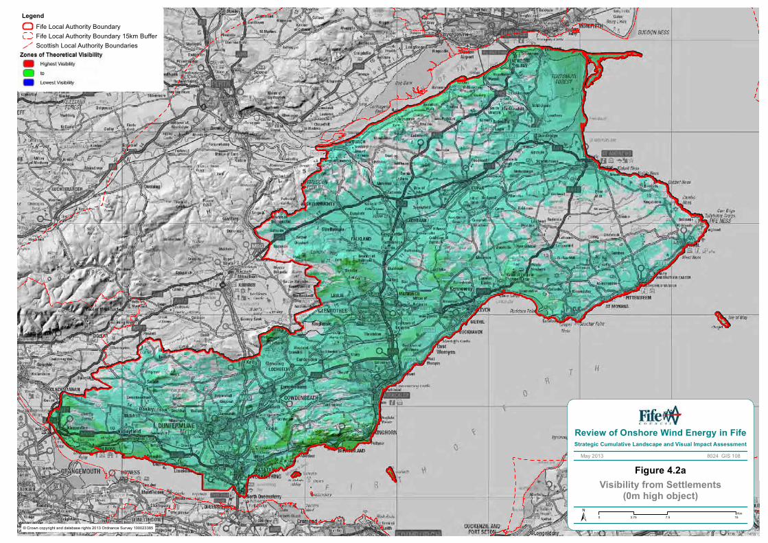
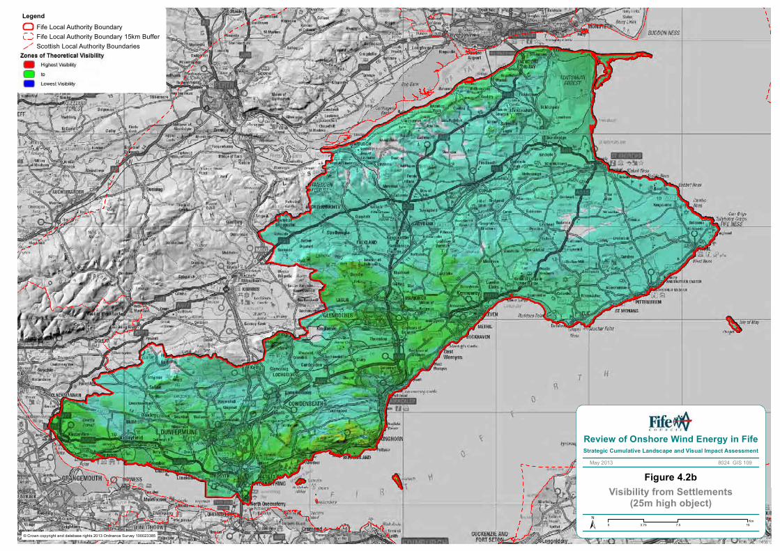
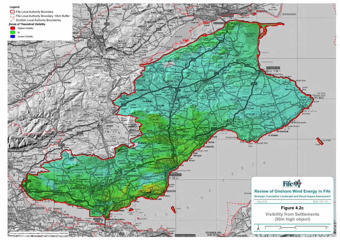
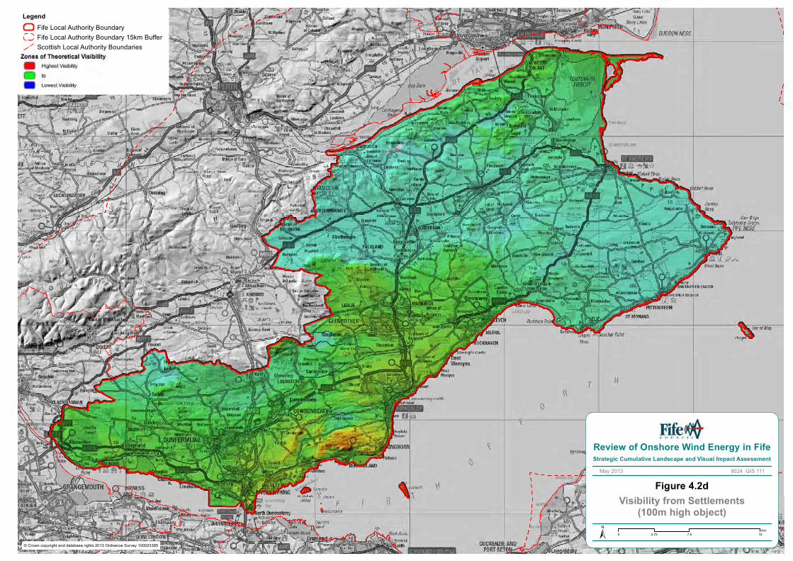
A systematic analysis of the relative visibility of areas of Fife has been undertaken. Three sets of visual receptors were determined as follows, and these are identified in Section 4:
� Settlements;
� Routes;
� Viewpoints
Each of the receptor types and locations is representative of locations frequented by people in Fife. The visibility analysis included each set of receptors, and generated visibility diagrams of different scenarios for different heights of objects in the landscape.
The analysis was carried out using a computer based technique in which the intervisibility between receptors and landforms, or objects of specific heights on the landforms, is determined. The more intervisibility, the greater the visual sensitivity is likely to be. In the case of area receptors (settlements) or linear receptors (routes) these are broken up into units of the same area or length such that this represents different population sizes or length exposed to view. No value judgement has been made as to relative sensitivity of receptors.
Fife Council Review of Onshore Wind Energy in Fife Strategic Cumulative Landscape and Visual Impact Assessment
______________________________________________________________________________________________________________________________________________________________________________________________________
______________________________________________________________________________________________________________________________________________________________________________________________________
IronsideFarrar A11 8024 / May 2013
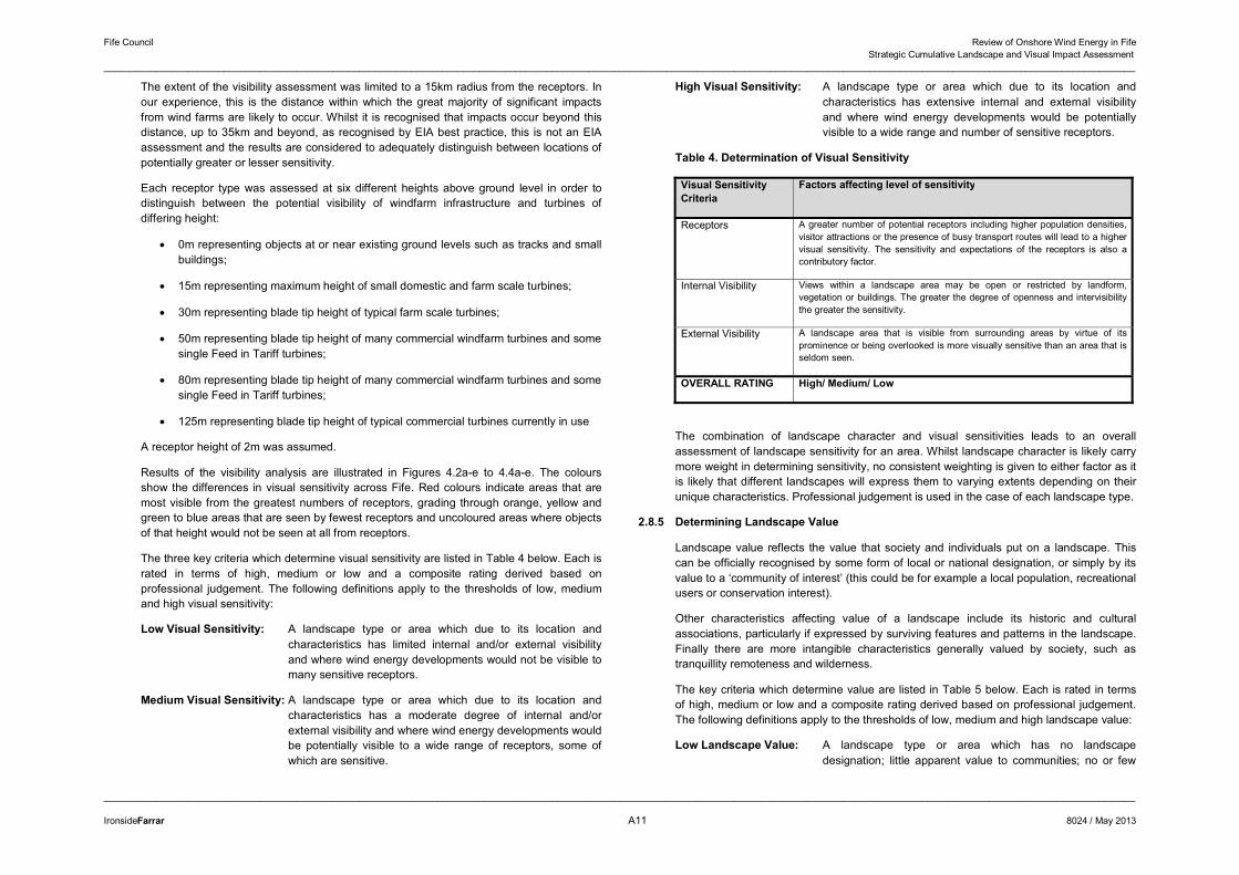
The extent of the visibility assessment was limited to a 15km radius from the receptors. In our experience, this is the distance within which the great majority of significant impacts from wind farms are likely to occur. Whilst it is recognised that impacts occur beyond this distance, up to 35km and beyond, as recognised by EIA best practice, this is not an EIA assessment and the results are considered to adequately distinguish between locations of potentially greater or lesser sensitivity.
Each receptor type was assessed at six different heights above ground level in order to distinguish between the potential visibility of windfarm infrastructure and turbines of differing height:
� 0m representing objects at or near existing ground levels such as tracks and small buildings;
� 15m representing maximum height of small domestic and farm scale turbines;
� 30m representing blade tip height of typical farm scale turbines;
� 50m representing blade tip height of many commercial windfarm turbines and some single Feed in Tariff turbines;
� 80m representing blade tip height of many commercial windfarm turbines and some single Feed in Tariff turbines;
� 125m representing blade tip height of typical commercial turbines currently in use
A receptor height of 2m was assumed.
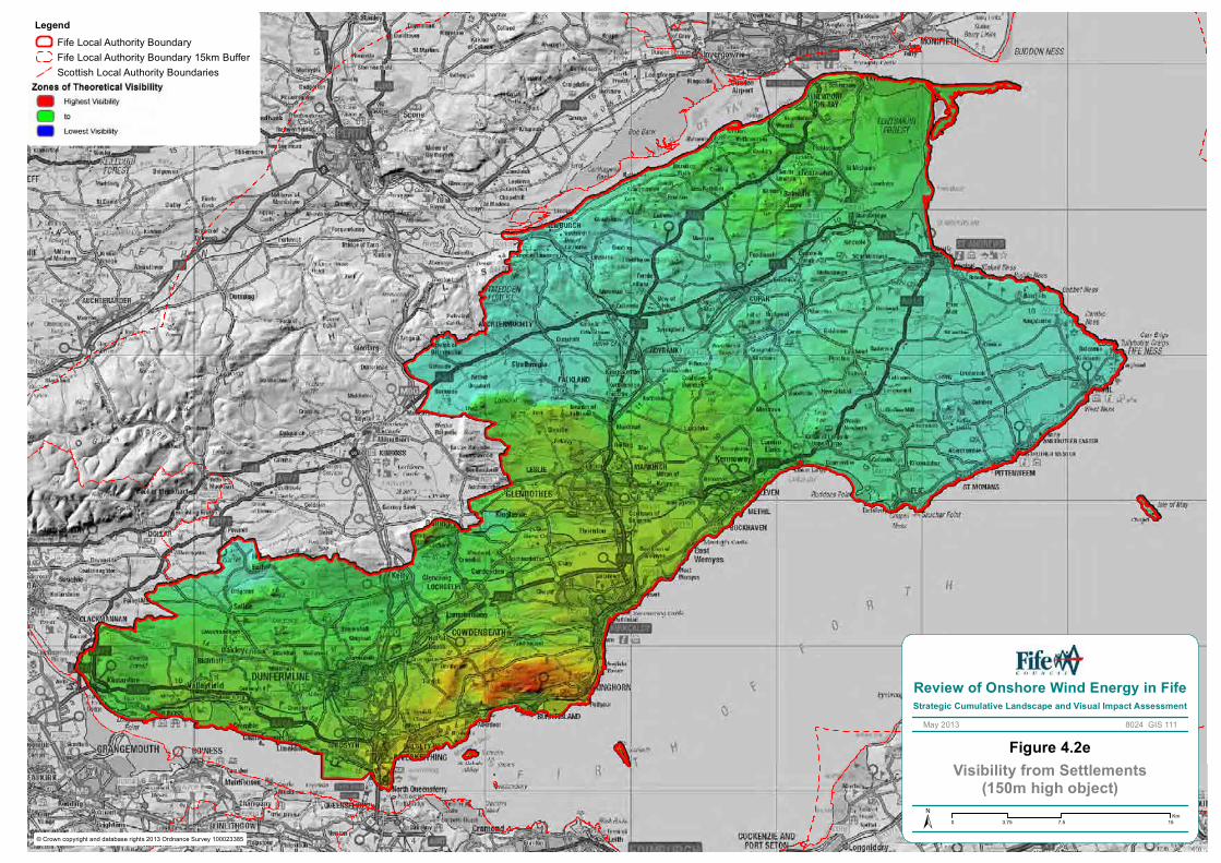
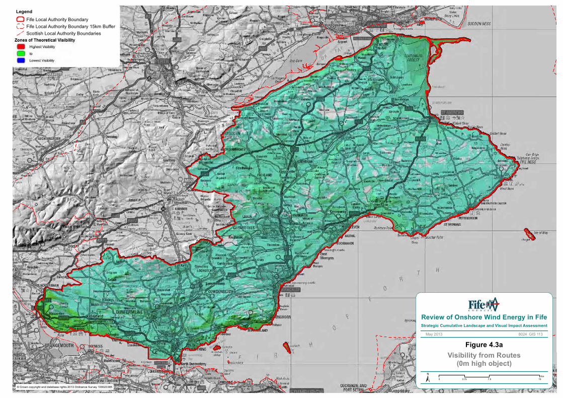
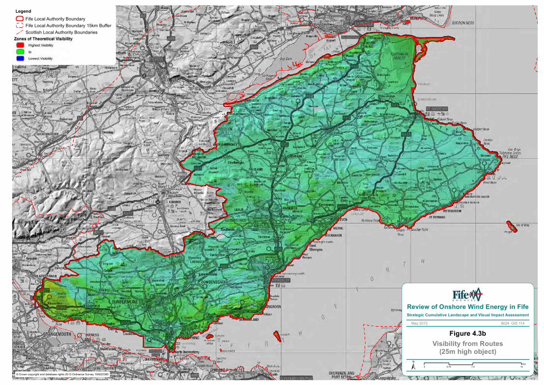
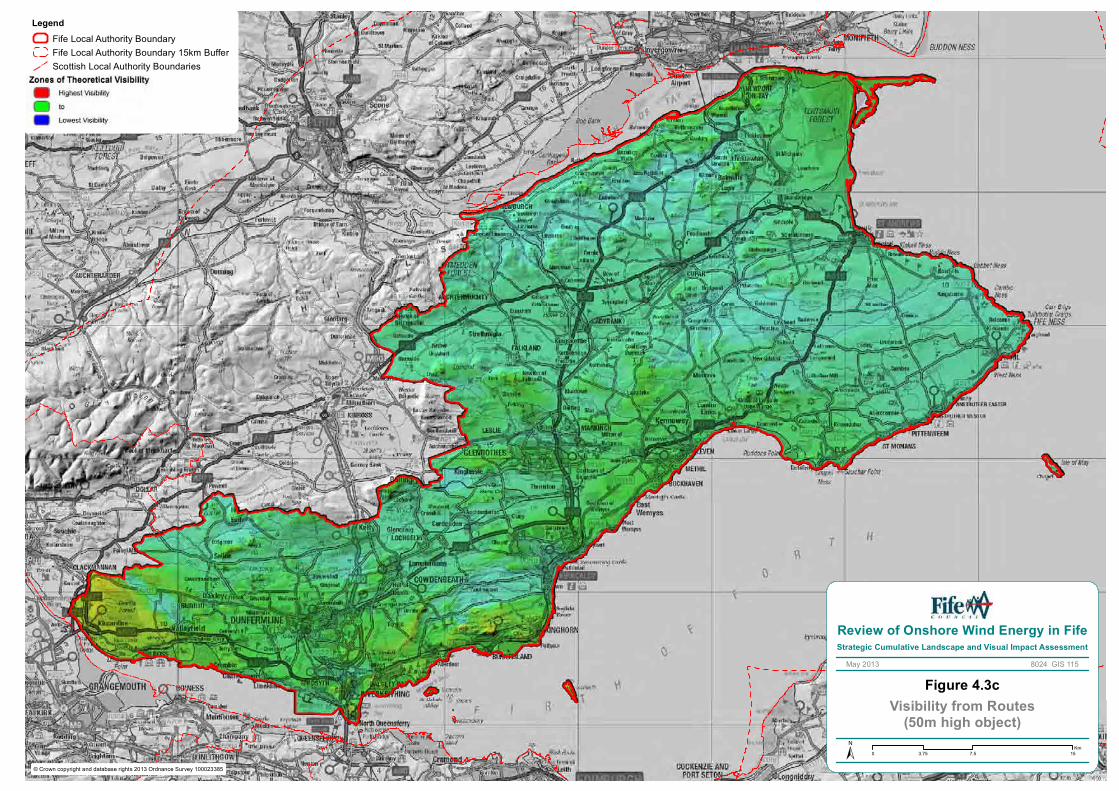
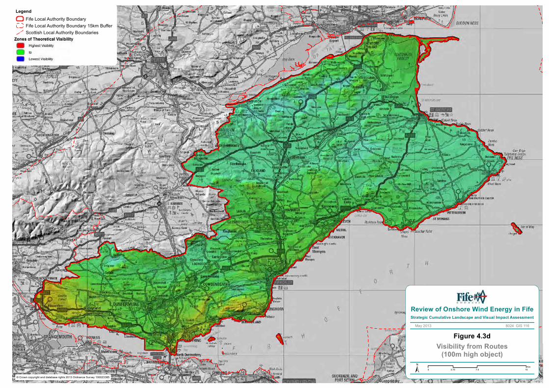
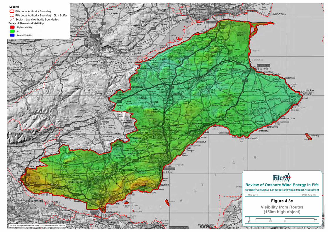
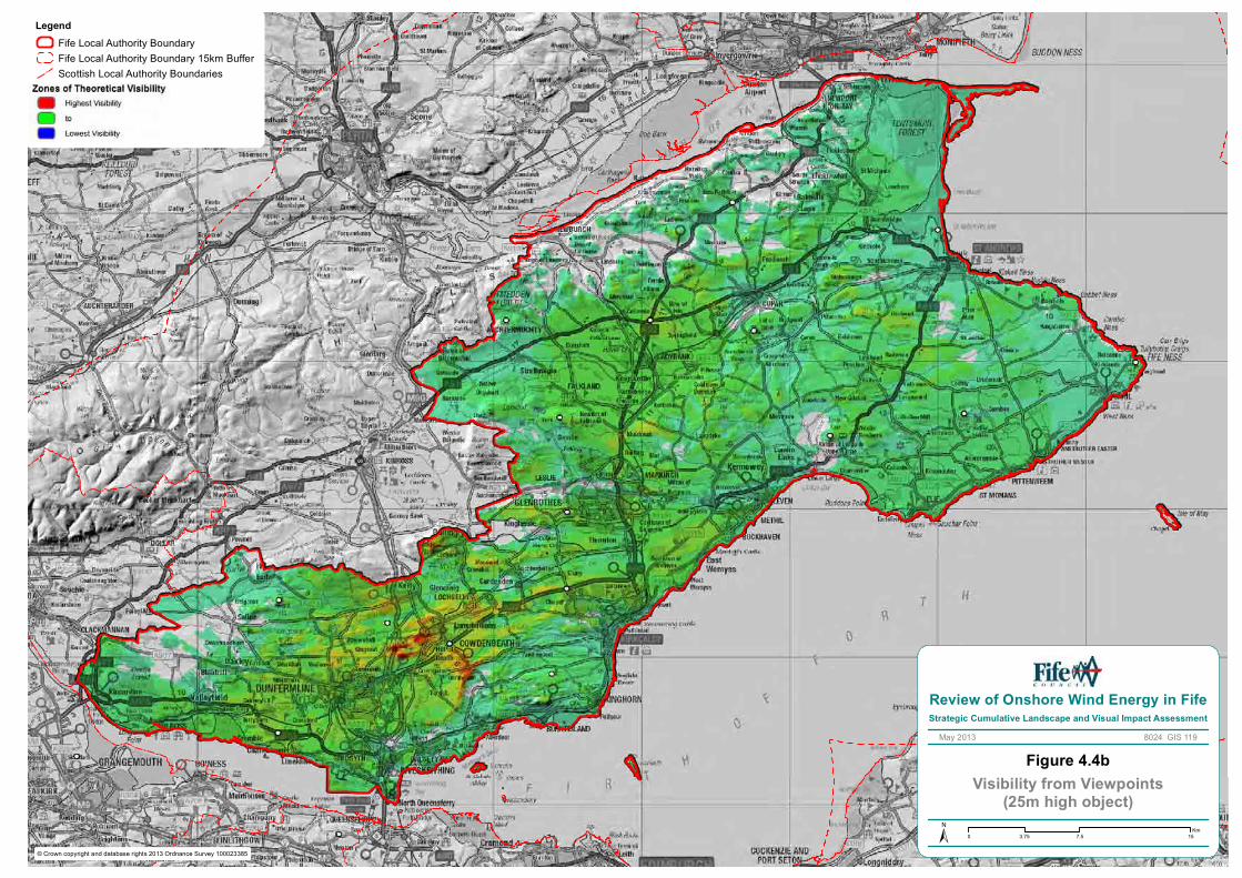
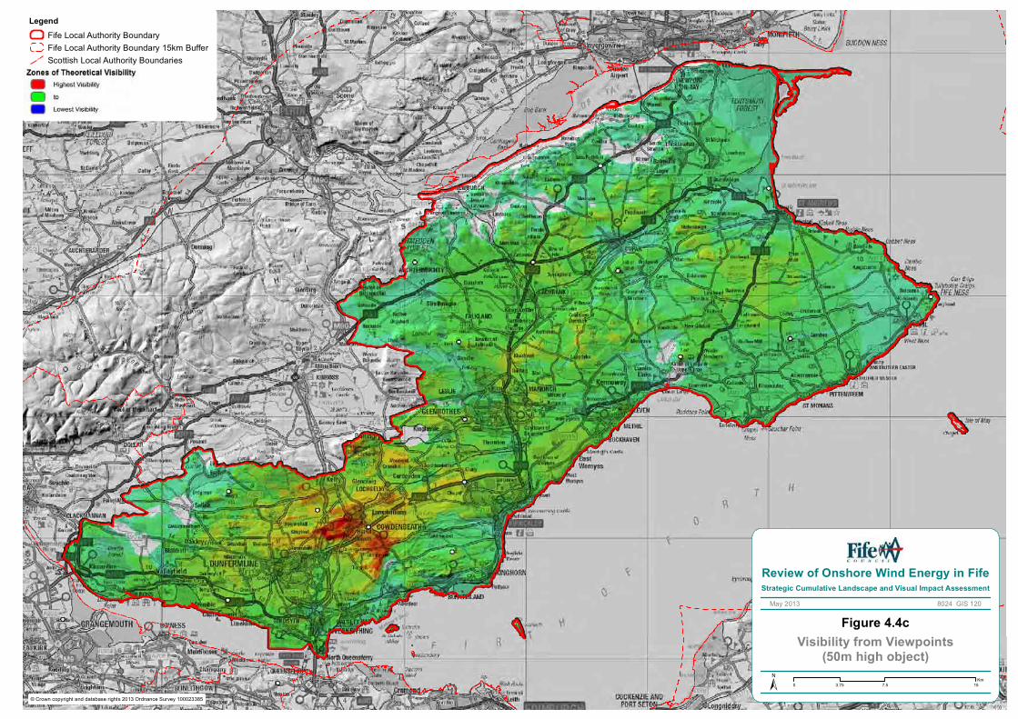
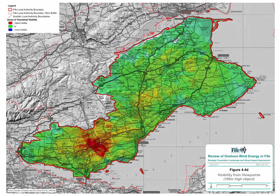
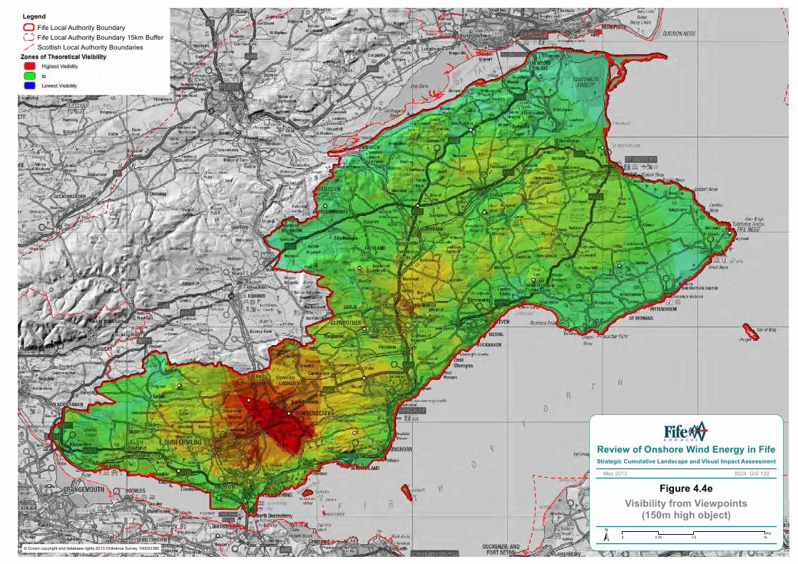
Results of the visibility analysis are illustrated in Figures 4.2a-e to 4.4a-e. The colours show the differences in visual sensitivity across Fife. Red colours indicate areas that are most visible from the greatest numbers of receptors, grading through orange, yellow and green to blue areas that are seen by fewest receptors and uncoloured areas where objects of that height would not be seen at all from receptors.
The three key criteria which determine visual sensitivity are listed in Table 4 below. Each is rated in terms of high, medium or low and a composite rating derived based on professional judgement. The following definitions apply to the thresholds of low, medium and high visual sensitivity:
Low Visual Sensitivity: A landscape type or area which due to its location and characteristics has limited internal and/or external visibility and where wind energy developments would not be visible to many sensitive receptors.
Medium Visual Sensitivity: A landscape type or area which due to its location and characteristics has a moderate degree of internal and/or external visibility and where wind energy developments would be potentially visible to a wide range of receptors, some of which are sensitive.
High Visual Sensitivity: A landscape type or area which due to its location and characteristics has extensive internal and external visibility and where wind energy developments would be potentially visible to a wide range and number of sensitive receptors.
Table 4. Determination of Visual Sensitivity
Visual Sensitivity Criteria
Factors affecting level of sensitivity
Receptors A greater number of potential receptors including higher population densities, visitor attractions or the presence of busy transport routes will lead to a higher visual sensitivity. The sensitivity and expectations of the receptors is also a contributory factor.
Internal Visibility Views within a landscape area may be open or restricted by landform, vegetation or buildings. The greater the degree of openness and intervisibility the greater the sensitivity.
External Visibility A landscape area that is visible from surrounding areas by virtue of its prominence or being overlooked is more visually sensitive than an area that is seldom seen.
OVERALL RATING High/ Medium/ Low
The combination of landscape character and visual sensitivities leads to an overall assessment of landscape sensitivity for an area. Whilst landscape character is likely carry more weight in determining sensitivity, no consistent weighting is given to either factor as it is likely that different landscapes will express them to varying extents depending on their unique characteristics. Professional judgement is used in the case of each landscape type.
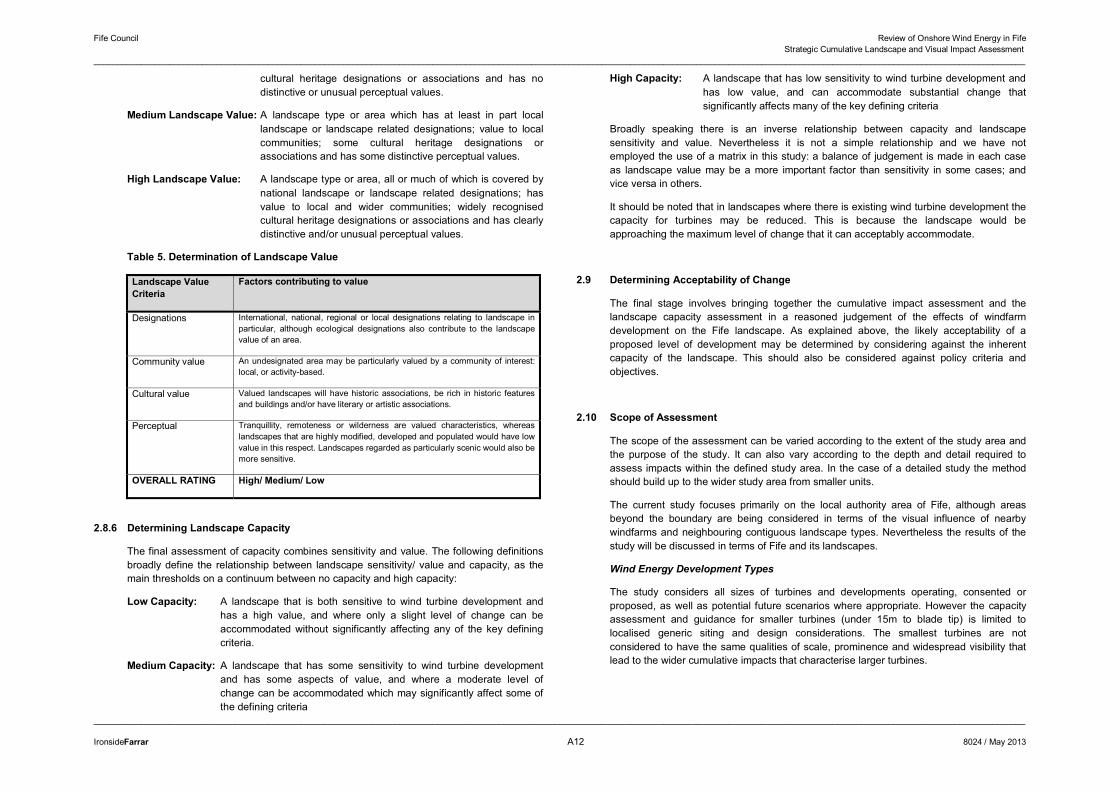
2.8.5 Determining Landscape Value
Landscape value reflects the value that society and individuals put on a landscape. This can be officially recognised by some form of local or national designation, or simply by its value to a ‘community of interest’ (this could be for example a local population, recreational users or conservation interest).
Other characteristics affecting value of a landscape include its historic and cultural associations, particularly if expressed by surviving features and patterns in the landscape. Finally there are more intangible characteristics generally valued by society, such as tranquillity remoteness and wilderness.
The key criteria which determine value are listed in Table 5 below. Each is rated in terms of high, medium or low and a composite rating derived based on professional judgement. The following definitions apply to the thresholds of low, medium and high landscape value:
Low Landscape Value: A landscape type or area which has no landscape designation; little apparent value to communities; no or few
Fife Council Review of Onshore Wind Energy in Fife Strategic Cumulative Landscape and Visual Impact Assessment
______________________________________________________________________________________________________________________________________________________________________________________________________
______________________________________________________________________________________________________________________________________________________________________________________________________
IronsideFarrar A12 8024 / May 2013
cultural heritage designations or associations and has no distinctive or unusual perceptual values.
Medium Landscape Value: A landscape type or area which has at least in part local landscape or landscape related designations; value to local communities; some cultural heritage designations or associations and has some distinctive perceptual values.
High Landscape Value: A landscape type or area, all or much of which is covered by national landscape or landscape related designations; has value to local and wider communities; widely recognised cultural heritage designations or associations and has clearly distinctive and/or unusual perceptual values.
Table 5. Determination of Landscape Value
Landscape Value Criteria
Factors contributing to value
Designations International, national, regional or local designations relating to landscape in particular, although ecological designations also contribute to the landscape value of an area.
Community value An undesignated area may be particularly valued by a community of interest: local, or activity-based.
Cultural value Valued landscapes will have historic associations, be rich in historic features and buildings and/or have literary or artistic associations.
Perceptual Tranquillity, remoteness or wilderness are valued characteristics, whereas landscapes that are highly modified, developed and populated would have low value in this respect. Landscapes regarded as particularly scenic would also be more sensitive.
OVERALL RATING High/ Medium/ Low
2.8.6 Determining Landscape Capacity
The final assessment of capacity combines sensitivity and value. The following definitions broadly define the relationship between landscape sensitivity/ value and capacity, as the main thresholds on a continuum between no capacity and high capacity:
Low Capacity: A landscape that is both sensitive to wind turbine development and has a high value, and where only a slight level of change can be accommodated without significantly affecting any of the key defining criteria.
Medium Capacity: A landscape that has some sensitivity to wind turbine development and has some aspects of value, and where a moderate level of change can be accommodated which may significantly affect some of the defining criteria
High Capacity: A landscape that has low sensitivity to wind turbine development and has low value, and can accommodate substantial change that significantly affects many of the key defining criteria
Broadly speaking there is an inverse relationship between capacity and landscape sensitivity and value. Nevertheless it is not a simple relationship and we have not employed the use of a matrix in this study: a balance of judgement is made in each case as landscape value may be a more important factor than sensitivity in some cases; and vice versa in others.
It should be noted that in landscapes where there is existing wind turbine development the capacity for turbines may be reduced. This is because the landscape would be approaching the maximum level of change that it can acceptably accommodate.
2.9 Determining Acceptability of Change
The final stage involves bringing together the cumulative impact assessment and the landscape capacity assessment in a reasoned judgement of the effects of windfarm development on the Fife landscape. As explained above, the likely acceptability of a proposed level of development may be determined by considering against the inherent capacity of the landscape. This should also be considered against policy criteria and objectives.
2.10 Scope of Assessment
The scope of the assessment can be varied according to the extent of the study area and the purpose of the study. It can also vary according to the depth and detail required to assess impacts within the defined study area. In the case of a detailed study the method should build up to the wider study area from smaller units.
The current study focuses primarily on the local authority area of Fife, although areas beyond the boundary are being considered in terms of the visual influence of nearby windfarms and neighbouring contiguous landscape types. Nevertheless the results of the study will be discussed in terms of Fife and its landscapes.
Wind Energy Development Types
The study considers all sizes of turbines and developments operating, consented or proposed, as well as potential future scenarios where appropriate. However the capacity assessment and guidance for smaller turbines (under 15m to blade tip) is limited to localised generic siting and design considerations. The smallest turbines are not considered to have the same qualities of scale, prominence and widespread visibility that lead to the wider cumulative impacts that characterise larger turbines.
© Crown copyright and database rights 2013 Ordnance Survey 100023385
Legend
Fife Local Authority BoundaryFife Local Authority Boundary 15km BufferScottish Local Authority Boundaries
RGB
Red: Band_1Green: Band_2Blue: Band_3
May 2013 8024 GIS 108
Figure 4.2aVisibility from Settlements
(0m high object)
0 7.5 153.75Km±
Review of Onshore Wind Energy in FifeStrategic Cumulative Landscape and Visual Impact Assessment

© Crown copyright and database rights 2013 Ordnance Survey 100023385
Legend
Fife Local Authority BoundaryFife Local Authority Boundary 15km BufferScottish Local Authority Boundaries
RGB
Red: Band_1Green: Band_2Blue: Band_3
May 2013 8024 GIS 109
Figure 4.2bVisibility from Settlements
(25m high object)
0 7.5 153.75Km±
Review of Onshore Wind Energy in FifeStrategic Cumulative Landscape and Visual Impact Assessment

© Crown copyright and database rights 2013 Ordnance Survey 100023385
Legend
Fife Local Authority BoundaryFife Local Authority Boundary 15km BufferScottish Local Authority Boundaries
RGB
Red: Band_1Green: Band_2Blue: Band_3
May 2013 8024 GIS 110
Figure 4.2cVisibility from Settlements
(50m high object)
0 7.5 153.75Km±
Review of Onshore Wind Energy in FifeStrategic Cumulative Landscape and Visual Impact Assessment

© Crown copyright and database rights 2013 Ordnance Survey 100023385
Legend
Fife Local Authority BoundaryFife Local Authority Boundary 15km BufferScottish Local Authority Boundaries
RGB
Red: Band_1Green: Band_2Blue: Band_3
May 2013 8024 GIS 111
Figure 4.2dVisibility from Settlements
(100m high object)
0 7.5 153.75Km±
Review of Onshore Wind Energy in FifeStrategic Cumulative Landscape and Visual Impact Assessment

© Crown copyright and database rights 2013 Ordnance Survey 100023385
Legend
Fife Local Authority BoundaryFife Local Authority Boundary 15km BufferScottish Local Authority Boundaries
RGB
Red: Band_1Green: Band_2Blue: Band_3
May 2013 8024 GIS 111
Figure 4.2eVisibility from Settlements
(150m high object)
0 7.5 153.75Km±
Review of Onshore Wind Energy in FifeStrategic Cumulative Landscape and Visual Impact Assessment

© Crown copyright and database rights 2013 Ordnance Survey 100023385
Legend
Fife Local Authority BoundaryFife Local Authority Boundary 15km BufferScottish Local Authority Boundaries
RGB
Red: Band_1Green: Band_2Blue: Band_3
May 2013 8024 GIS 113
Figure 4.3aVisibility from Routes
(0m high object)
0 7.5 153.75Km±
Review of Onshore Wind Energy in FifeStrategic Cumulative Landscape and Visual Impact Assessment

© Crown copyright and database rights 2013 Ordnance Survey 100023385
Legend
Fife Local Authority BoundaryFife Local Authority Boundary 15km BufferScottish Local Authority Boundaries
RGB
Red: Band_1Green: Band_2Blue: Band_3
May 2013 8024 GIS 114
Figure 4.3bVisibility from Routes
(25m high object)
0 7.5 153.75Km±
Review of Onshore Wind Energy in FifeStrategic Cumulative Landscape and Visual Impact Assessment

© Crown copyright and database rights 2013 Ordnance Survey 100023385
Legend
Fife Local Authority BoundaryFife Local Authority Boundary 15km BufferScottish Local Authority Boundaries
RGB
Red: Band_1Green: Band_2Blue: Band_3
May 2013 8024 GIS 115
Figure 4.3cVisibility from Routes
(50m high object)
0 7.5 153.75Km±
Review of Onshore Wind Energy in FifeStrategic Cumulative Landscape and Visual Impact Assessment

© Crown copyright and database rights 2013 Ordnance Survey 100023385
Legend
Fife Local Authority BoundaryFife Local Authority Boundary 15km BufferScottish Local Authority Boundaries
RGB
Red: Band_1Green: Band_2Blue: Band_3
May 2013 8024 GIS 116
Figure 4.3dVisibility from Routes
(100m high object)
0 7.5 153.75Km±
Review of Onshore Wind Energy in FifeStrategic Cumulative Landscape and Visual Impact Assessment

© Crown copyright and database rights 2013 Ordnance Survey 100023385
Legend
Fife Local Authority BoundaryFife Local Authority Boundary 15km BufferScottish Local Authority Boundaries
RGB
Red: Band_1Green: Band_2Blue: Band_3
May 2013 8024 GIS 117
Figure 4.3eVisibility from Routes
(150m high object)
0 7.5 153.75Km±
Review of Onshore Wind Energy in FifeStrategic Cumulative Landscape and Visual Impact Assessment


© Crown copyright and database rights 2013 Ordnance Survey 100023385
Legend
Fife Local Authority BoundaryFife Local Authority Boundary 15km BufferScottish Local Authority Boundaries
RGB
Red: Band_1Green: Band_2Blue: Band_3
May 2013 8024 GIS 118
Figure 4.4aVisibility from Viewpoints
(0m high object)
0 7.5 153.75Km±
Review of Onshore Wind Energy in FifeStrategic Cumulative Landscape and Visual Impact Assessment

© Crown copyright and database rights 2013 Ordnance Survey 100023385
Legend
Fife Local Authority BoundaryFife Local Authority Boundary 15km BufferScottish Local Authority Boundaries
RGB
Red: Band_1Green: Band_2Blue: Band_3
May 2013 8024 GIS 119
Figure 4.4bVisibility from Viewpoints
(25m high object)
0 7.5 153.75Km±
Review of Onshore Wind Energy in FifeStrategic Cumulative Landscape and Visual Impact Assessment

© Crown copyright and database rights 2013 Ordnance Survey 100023385
Legend
Fife Local Authority BoundaryFife Local Authority Boundary 15km BufferScottish Local Authority Boundaries
RGB
Red: Band_1Green: Band_2Blue: Band_3
May 2013 8024 GIS 120
Figure 4.4cVisibility from Viewpoints
(50m high object)
0 7.5 153.75Km±
Review of Onshore Wind Energy in FifeStrategic Cumulative Landscape and Visual Impact Assessment

© Crown copyright and database rights 2013 Ordnance Survey 100023385
Legend
Fife Local Authority BoundaryFife Local Authority Boundary 15km BufferScottish Local Authority Boundaries
RGB
Red: Band_1Green: Band_2Blue: Band_3
May 2013 8024 GIS 121
Figure 4.4dVisibility from Viewpoints
(100m high object)
0 7.5 153.75Km±
Review of Onshore Wind Energy in FifeStrategic Cumulative Landscape and Visual Impact Assessment

© Crown copyright and database rights 2013 Ordnance Survey 100023385
Legend
Fife Local Authority BoundaryFife Local Authority Boundary 15km BufferScottish Local Authority Boundaries
RGB
Red: Band_1Green: Band_2Blue: Band_3
May 2013 8024 GIS 122
Figure 4.4eVisibility from Viewpoints
(150m high object)
0 7.5 153.75Km±
Review of Onshore Wind Energy in FifeStrategic Cumulative Landscape and Visual Impact Assessment

Fife Council Review of Onshore Wind Energy in Fife Strategic Cumulative Landscape and Visual Impact Assessment
______________________________________________________________________________________________________________________________________________________________________________________________________
______________________________________________________________________________________________________________________________________________________________________________________________________
IronsideFarrar A13 8024 / May 2013
APPENDIX 3: CHANGES TO LANDSCAPE CHARACTER UNITS
The principal differences between the 1999 assessment and that carried out in 2009 include;
1) The amalgamation of 2 Upland Foothills Landscape Character Units north west of Cupar with the surrounding Lowland Hills and Valleys LCU due to their generally indistinct height and landform when compared with the other hills which surround them.
2) The merging of 2 adjacent Upland Foothills LCU due to similarities in landform and landcover. This new single Landscape Character Unit is called Ochils Foothills Letham and Black Hill;
3) The creation of an Upland Slopes LCU called Thornton Slopes from a Lowland Loch Basin at the mine near Kelty which reflects changes brought about on its character during the mines restoration;
4) Subdivision of an existing Pronounced Volcanic Hills and Craigs LCU Clatto, into 2 (Clatto and Tarvit) to reflect the large extent of this LCU and the variation in landscape quality and character across it.
Further changes carried out during the current study include redefining the extent of urban areas to reflect their expansion since 1999
Fife Council Review of Onshore Wind Energy in Fife Strategic Cumulative Landscape and Visual Impact Assessment
______________________________________________________________________________________________________________________________________________________________________________________________________
______________________________________________________________________________________________________________________________________________________________________________________________________
IronsideFarrar A14 8024 / May 2013
Fife Council Review of Onshore Wind Energy in Fife Strategic Cumulative Landscape and Visual Impact Assessment
______________________________________________________________________________________________________________________________________________________________________________________________________
______________________________________________________________________________________________________________________________________________________________________________________________________
IronsideFarrar A15 8024 / May 2013
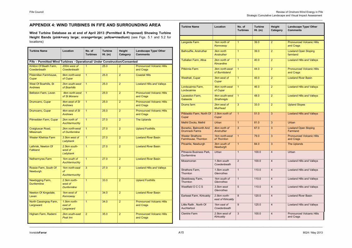
APPENDIX 4: WIND TURBINES IN FIFE AND SURROUNDING AREA
Wind Turbine Database as at end of April 2013 (Permitted & Proposed) Showing Turbine Height Bands (pink=very large; orange=large; yellow=medium) (see Figs. 5.1 and 5.2 for locations)
Turbine Name Location No. of Turbines
Turbine Ht. (m)
Height Category
Landscape Type/ Other Comments
Fife – Permitted Wind Turbines - Operational/ Under Construction/Consented Kirkton Of Beath Farm, Cowdenbeath
200m west of Cowdenbeath
1 25.0 2 Pronounced Volcanic Hills and Crags
Fliskmillan Farmhouse, Cupar
9km north-westof Cupar
1 25.0 2 Coastal Hills
West Of Boarhills, St Andrews
2km south-west of Boarhills
1 25.0 2 Lowland Hills and Valleys
Belliston Farm, Leven 4km north-west of St Monans
1 25.0 2 Pronounced Volcanic Hills and Crags
Drumcarro, Cupar 4km west of St Andrews
1 25.0 2 Pronounced Volcanic Hills and Crags
Drumcarro, Cupar 4km west of St Andrews
1 25.0 2 Pronounced Volcanic Hills and Crags
Pitmedden Farm, Cupar 2km north of Auchtermuchty
1 27.0 2 The Uplands
Craigluscar Road, Milesmark
2km north-west of Dunfermline
1 27.0 2 Upland Foothills
Wester Kilwhiss Farm 3.5km west of Ladybank
1 27.0 2 Lowland River Basin
Lathrisk, Newton Of Falkland
2.5km south-west of Ladybank
1 27.0 2 Lowland River Basin
Nethermyres Farm 1km south of Auchtermuchty
1 27.0 2 Lowland River Basin
Rossie Farm, South Of Newburgh
1km north-east of Auchtermuchty
3 27.0 2 Lowland Hills and Valleys
Newbigging Farm, Dunfermline
2.5km north-west of Dunfermline
1 33.0 2 Upland Foothills
Newton Of Kingsdale, Leven
1km west of Kennoway
1 34.0 2 Lowland River Basin
North Cassingray Farm, Largoward
1.5km north-east of Largoward
1 34.0 2 Pronounced Volcanic Hills and Crags
Higham Farm, Raderni 2km south-east Peat Inn
2 35.0 2 Pronounced Volcanic Hills and Crags
Turbine Name Location No. of Turbines
Turbine Ht. (m)
Height Category
Landscape Type/ Other Comments
Langside Farm 1km north of Kennoway
1 39.0 2 Pronounced Volcanic Hills and Crags
Balhouffie, Anstruther 3km north Anstruther
1 39.0 2 Lowland Open Sloping farmland
Tulliallan Farm, Alloa 2km north of Kincardine
1 40.0 2 Lowland Hills and Valleys
Pitkinnie Farm 3km north-west of Burntisland
1 44.0 2 Pronounced Volcanic Hills and Crags
Westhall, Cupar 3km west of Cupar
1 45.0 2 Lowland River Basin
Lordscairnie Farm, Lordscairnie
4km north-west of Cupar
1 46.0 2 Lowland Hills and Valleys
Lacesston Farm, Gateside
4km south-west Strathmiglo
1 48.0 2 Lowland Hills and Valleys
Drums farm 2km west of Muirhead
3 33.0 2 Upland Slopes
Pitbladdo Farm, North Of Cupar
2.5km north of Cupar
1 51.0 3 Lowland Hills and Valleys
Methil Docks, Methil Urban 1 81.0 3 Urban
Bonerbo, Balmonth And Drumrack Farms
4km north of Anstruther
3 67.0 3 Lowland Open Sloping Farmland
Wester Strathore Farmhouse, Thornton
1km north-west of Thornton
1 79.0 3 Pronounced Volcanic Hills and Crags
Pitcairlie, Newburgh 3km south of Newburgh
1 84.0 3 The Uplands
Pitreavie Business Park, Dunfermline
Urban 1 100.0 4 Urban
Mossmorran 1.5km south Cowdenbeath
2 100.0 4 Lowland Hills and Valleys
Strathore Farm, Thornton
1.5km southGlenrothes
1 110.0 4 Lowland Hills and Valleys
Skeddoway Farm, Thornton
1km south of Glenrothes
1 110.0 4 Lowland Hills and Valleys
Westfield O C C S 3.5km west Glenrothes
5 110.0 4 Lowland Hills and Valleys
Earlseat Farm, Kirkcaldy 2.5km north-east of Kirkcaldy
8 120.0 4 Lowland River Basin
Little Raith , North Of Auchtertool
1km east of Cowdenbeath
9 125.0 4 Lowland Hills and Valleys
Clentrie Farm 2.5km west of Kirkcaldy
3 100.0 4 Pronounced Volcanic Hills and Crags
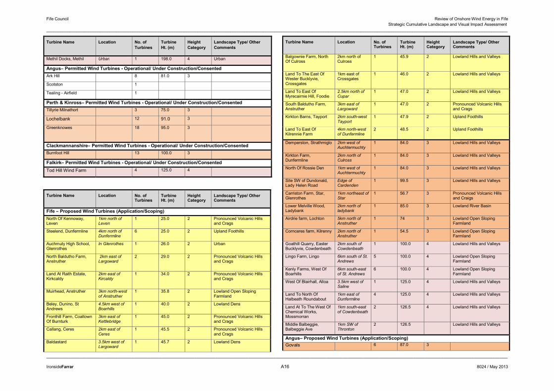
Fife Council Review of Onshore Wind Energy in Fife Strategic Cumulative Landscape and Visual Impact Assessment
______________________________________________________________________________________________________________________________________________________________________________________________________
______________________________________________________________________________________________________________________________________________________________________________________________________
IronsideFarrar A16 8024 / May 2013
Turbine Name Location No. of Turbines
Turbine Ht. (m)
Height Category
Landscape Type/ Other Comments
Methil Docks, Methil Urban 1 198.0 4 Urban
Angus– Permitted Wind Turbines - Operational/ Under Construction/Consented Ark Hill 8 81.0 3
Scotston 1
Tealing - Airfield 1
Perth & Kinross– Permitted Wind Turbines - Operational/ Under Construction/ConsentedTillyrie Milnathort 3 75.0 3
Lochelbank 12 91.0 3
Greenknowes 18 95.0 3
Clackmannanshire– Permitted Wind Turbines - Operational/ Under Construction/ConsentedBurnfoot Hill 13 100.0 3
Falkirk– Permitted Wind Turbines - Operational/ Under Construction/Consented Tod Hill Wind Farm 4 125.0 4
�
Turbine Name Location No. of Turbines
Turbine Ht. (m)
Height Category
Landscape Type/ Other Comments
Fife – Proposed Wind Turbines (Application/Scoping)North Of Kennoway, Leven
1km north of Leven
1 25.0 2 Pronounced Volcanic Hills and Crags
Steelend, Dunfermline 4km north of Dunfermline
6 25.0 2 Upland Foothills
Auchmuty High School, Glenrothes
In Glenrothes 1 26.0 2 Urban
North Baldutho Farm, Anstruther
2km east of Largoward
2 29.0 2 Pronounced Volcanic Hills and Crags
Land At Raith Estate, Kirkcaldy
2km east of Kircaldy
1 34.0 2 Pronounced Volcanic Hills and Crags
Muirhead, Anstruther 3km north-west of Anstruther
1 35.8 2 Lowland Open Sloping Farmland
Beley, Dunino, St Andrews
4.5km west of Boarhills
1 40.0 2 Lowland Dens
Fronthill Farm, Coaltown Of Burnturk
3km east of Kettlebridge
1 45.0 2 Pronounced Volcanic Hills and Crags
Callang, Ceres 2km east of Ceres
1 45.5 2 Pronounced Volcanic Hills and Crags
Baldastard 3.5km west of Largoward
1 45.7 2 Lowland Dens
Turbine Name Location No. of Turbines
Turbine Ht. (m)
Height Category
Landscape Type/ Other Comments
Balgownie Farm, North Of Culross
2km north of Culross
1 45.9 2 Lowland Hills and Valleys
Land To The East Of Wester Bucklyvie, Crossgates
1km east of Crossgates
1 46.0 2 Lowland Hills and Valleys
Land To East Of Myrecairnie Hill, Foodie
2.5km north of Cupar
1 47.0 2 Lowland Hills and Valleys
South Baldutho Farm, Anstruther
3km east of Largoward
1 47.0 2 Pronounced Volcanic Hills and Crags
Kirkton Barns, Tayport 2km south-west Tayport
1 47.9 2 Upland Foothills
Land To East Of Kilrennie Farm
4km north-west of Dunfermline
2 48.5 2 Upland Foothills
Demperston, Strathmiglo 2km west of Auchtermuchty
1 84.0 3 Lowland Hills and Valleys
Kirkton Farm, Dunfermline
2km north of Culross
1 84.0 3 Lowland Hills and Valleys
North Of Rossie Den 1km west ofAuchtermuchty
1 84.0 3 Lowland Hills and Valleys
Site SW of Dundonald, Lady Helen Road
Edge of Cardenden
1 99.5 3 Lowland Hills and Valleys
Carriston Farm, Star, Glenrothes
1km northeast of Star
1 56.7 3 Pronounced Volcanic Hills and Craigs
Lower Melville Wood, Ladybank
2km north of ladybank
1 85.0 3 Lowland River Basin
Airdrie farm, Lochton 5km north of Anstruther
1 74 3 Lowland Open Sloping Farmland
Cornceres farm, Kilrenny 2km north of Anstruther
1 54.5 3 Lowland Open Sloping Farmland
Goathill Quarry, Easter Bucklyvie, Cowdenbeath
2km south of Cowdenbeath
1 100.0 4 Lowland Hills and Valleys
Lingo Farm, Lingo 6km south of St. Andrews
5 100.0 4 Lowland Open Sloping Farmland
Kenly Farms, West Of Boarhills
6km south-east of St. Andrews
6 100.0 4 Lowland Open Sloping Farmland
West Of Blairhall, Alloa 3.5km west of Saline
1 125.0 4 Lowland Hills and Valleys
Land To North Of Halbeath Roundabout
1km east of Dunfermline
4 125.0 4 Lowland Hills and Valleys
Land At To The West Of Chemical Works, Mossmorran
1km south-east of Cowdenbeath
2 126.5 4 Lowland Hills and Valleys
Middle Balbeggie, Balbeggie Ave
1km SW of Thronton
2 126.5 Lowland Hills and Valleys
Angus– Proposed Wind Turbines (Application/Scoping) Govals 6 87.0 3
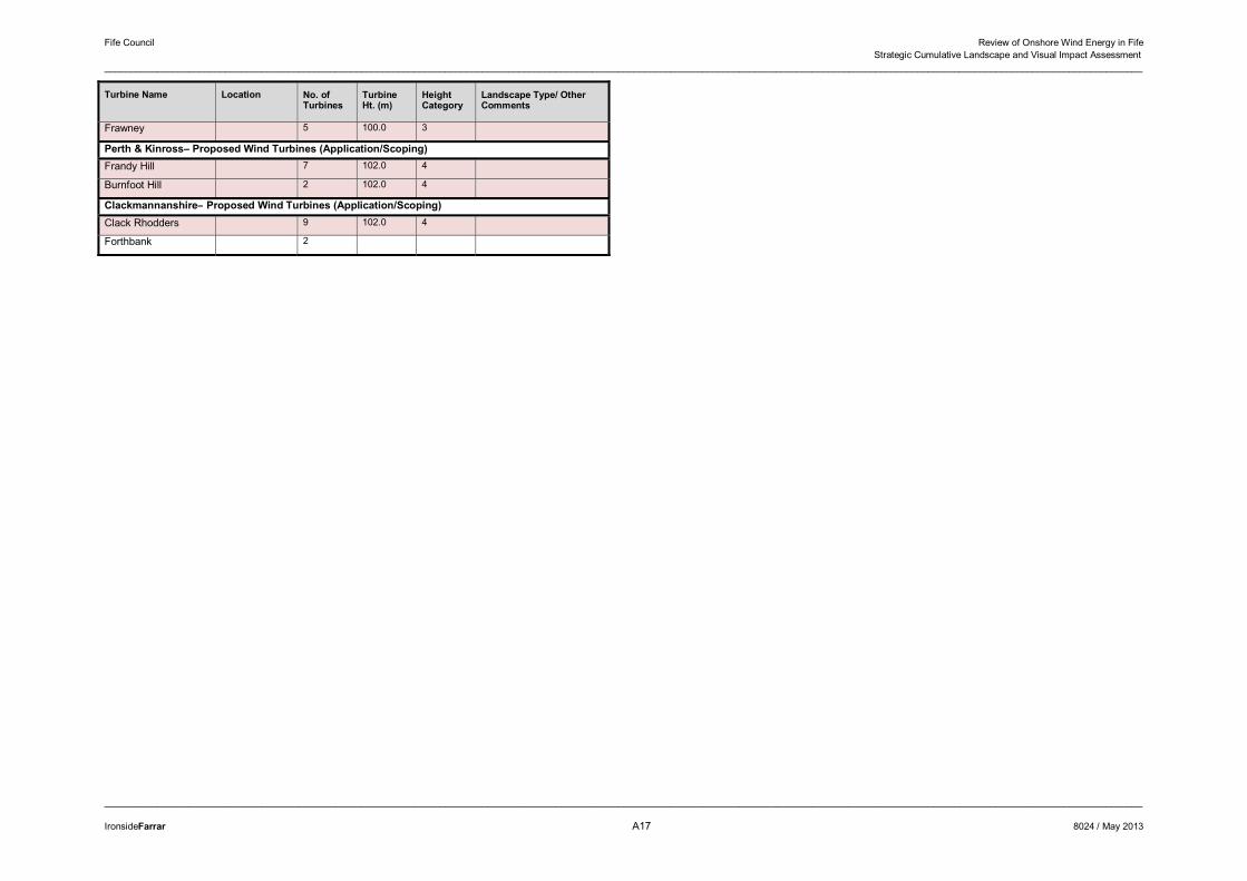
Fife Council Review of Onshore Wind Energy in Fife Strategic Cumulative Landscape and Visual Impact Assessment
______________________________________________________________________________________________________________________________________________________________________________________________________
______________________________________________________________________________________________________________________________________________________________________________________________________
IronsideFarrar A17 8024 / May 2013
Turbine Name Location No. of Turbines
Turbine Ht. (m)
Height Category
Landscape Type/ Other Comments
Frawney 5 100.0 3
Perth & Kinross– Proposed Wind Turbines (Application/Scoping) Frandy Hill 7 102.0 4
Burnfoot Hill 2 102.0 4
Clackmannanshire– Proposed Wind Turbines (Application/Scoping)Clack Rhodders 9 102.0 4
Forthbank 2

Fife Council Review of Onshore Wind Energy in Fife Strategic Cumulative Landscape and Visual Impact Assessment
______________________________________________________________________________________________________________________________________________________________________________________________________
______________________________________________________________________________________________________________________________________________________________________________________________________
IronsideFarrar A18 8024 / May 2013
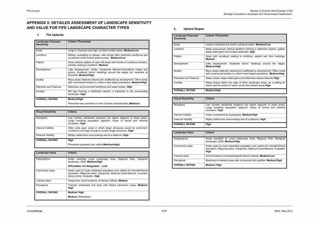
Fife Council Review of Onshore Wind Energy in Fife Strategic Cumulative Landscape and Visual Impact Assessment
______________________________________________________________________________________________________________________________________________________________________________________________________
______________________________________________________________________________________________________________________________________________________________________________________________________
IronsideFarrar A19 8024 / May 2013
APPENDIX 5: DETAILED ASSESSMENT OF LANDSCAPE SENSITIVITY AND VALUE FOR FIFE LANDSCAPE CHARACTER TYPES
1. The Uplands
Landscape Character Sensitivity
Criteria /Thresholds
Scale Large in character and high, but fairly limited extent. Medium/Low
Landform Rolling, undulating or plateau, with simple often distinctive landforms and occasional small incised watercourses Medium/Low
Pattern Fairly random pattern of open hill areas with blocks of coniferous forestry, partially relating to landform. Medium
Development Little development: tracks, occasional telecommunications masts and pylons. Scattered farms/ dwellings around the edges but racetrack at Knockhill. Medium/High
Quality Many areas relatively natural and unaffected by development. Other areas with commercial forestry in uniform hard edged plantations. Medium/High
Elements and Features Distinctive and prominent landforms and water bodies. High
Context Hill tops forming a distinctive skyline, a backdrop to the surrounding landscape. High
OVERALL RATING Medium/High
Pitmedden less sensitive in most of these characteristics (Medium)
Visual Sensitivity Criteria
Receptors Low number residential receptors but higher adjacent to these areas. Large travelling population adjacent. Areas of formal and informal recreation. High
Internal Visibility Often wide open views in which larger structures would be prominent. Landforms not large enough to screen larger structures. High
External Visibility Widely visible from surroundings and at a distance. High
OVERALL RATING High
Pitmedden generally less visible (Medium/High)
Landscape Value Criteria
Designations Areas classified Local Landscape Area, Regional Park, Designed landscape, SSSI. Medium/High
(Pitmedden not designated - Low)
Community value Areas used by local residential population and visitors for formal/informal recreation. Regional parks, Viewpoints, National Cycle Network, mountain biking centre, footpaths. High
Cultural value Viewpoints, some locations of interest, hillforts. Medium
Perceptual Tranquil, windswept and open with distant panoramic views. Medium/ High
OVERALL RATING Medium/ High
Medium (Pitmedden)
2. Upland Slopes
Landscape Character Sensitivity
Criteria /Thresholds
Scale Large in character but small in physical extent. Medium/Low
Landform Steep pronounced vertical landform forming a distinctive skyline, gullies, steep-sided glens and incised waterfalls. High
Pattern Open with woodland relating to landform, aspect and farm buildings. Medium
Development Little development. Scattered farms/ dwellings around the edges. Medium/High
Quality Many areas relatively natural and unaffected by development. Other areas with commercial forestry in uniform hard edged plantations. Medium/High
Elements and Features Steep slopes, steep sided glens and distinctive skyline features High
Context Steep slopes define the edge of other landscape areas, as a setting for towns and the extent of views across the lowland areas High
OVERALL RATING Medium/High
Visual Sensitivity Criteria
Receptors Low number residential receptors but higher adjacent to these areas. Large travelling population adjacent. Areas of formal and informal recreation. High
Internal Visibility Views constrained by topography. Medium/High
External Visibility Highly visible from surroundings and at a distance. High
OVERALL RATING High
Landscape Value Criteria
Designations Areas classified as Local Landscape Area, Regional Park, Designed landscape, SSSI. Medium/High
Community value Areas used by local residential population and visitors for formal/informal recreation. Regional parks, Viewpoints, National Cycle Network, footpaths. High
Cultural value Some locations of archaeological/ historic interest. Medium/Low
Perceptual Backdrop to lowland areas with occasional wild qualities. Medium/High
OVERALL RATING Medium/ High
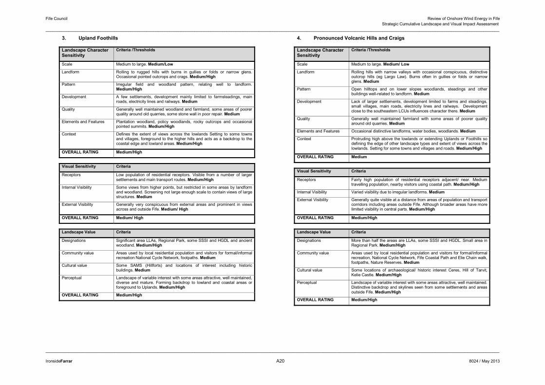
Fife Council Review of Onshore Wind Energy in Fife Strategic Cumulative Landscape and Visual Impact Assessment
______________________________________________________________________________________________________________________________________________________________________________________________________
______________________________________________________________________________________________________________________________________________________________________________________________________
IronsideFarrar A20 8024 / May 2013
3. Upland Foothills
Landscape Character Sensitivity
Criteria /Thresholds
Scale Medium to large. Medium/Low
Landform Rolling to rugged hills with burns in gullies or folds or narrow glens. Occasional pointed outcrops and crags. Medium/High
Pattern Irregular field and woodland pattern, relating well to landform. Medium/High
Development A few settlements, development mainly limited to farmsteadings, main roads, electricity lines and railways. Medium
Quality Generally well maintained woodland and farmland, some areas of poorer quality around old quarries, some stone wall in poor repair. Medium
Elements and Features Plantation woodland, policy woodlands, rocky outcrops and occasional pointed summits. Medium/High
Context Defines the extent of views across the lowlands Setting to some towns and villages, foreground to the higher hills and acts as a backdrop to the coastal edge and lowland areas. Medium/High
OVERALL RATING Medium/High
Visual Sensitivity Criteria
Receptors Low population of residential receptors. Visible from a number of larger settlements and main transport routes. Medium/High
Internal Visibility Some views from higher points, but restricted in some areas by landform and woodland. Screening not large enough scale to contain views of large structures. Medium
External Visibility Generally very conspicuous from external areas and prominent in views across and outside Fife. Medium/ High
OVERALL RATING Medium/ High
Landscape Value Criteria
Designations Significant area LLAs, Regional Park, some SSSI and HGDL and ancient woodland. Medium/High
Community value Areas used by local residential population and visitors for formal/informal recreation National Cycle Network, footpaths. Medium
Cultural value Some SAMS (Hillforts) and locations of interest including historic buildings. Medium
Perceptual Landscape of variable interest with some areas attractive, well maintained, diverse and mature. Forming backdrop to lowland and coastal areas or foreground to Uplands. Medium/High
OVERALL RATING Medium/High
4. Pronounced Volcanic Hills and Craigs
Landscape CharacterSensitivity
Criteria /Thresholds
Scale Medium to large. Medium/ Low
Landform Rolling hills with narrow valleys with occasional conspicuous, distinctive outcrop hills (eg Largo Law). Burns often in gullies or folds or narrow glens. Medium
Pattern Open hilltops and on lower slopes woodlands, steadings and other buildings well-related to landform. Medium
Development Lack of larger settlements, development limited to farms and steadings, small villages, main roads, electricity lines and railways. Development close to the southeastern LCUs influences character there. Medium
Quality Generally well maintained farmland with some areas of poorer quality around old quarries. Medium
Elements and Features Occasional distinctive landforms, water bodies, woodlands. Medium
Context Protruding high above the lowlands or extending Uplands or Foothills so defining the edge of other landscape types and extent of views across the lowlands. Setting for some towns and villages and roads. Medium/High
OVERALL RATING Medium
Visual Sensitivity Criteria
Receptors Fairly high population of residential receptors adjacent/ near. Medium travelling population, nearby visitors using coastal path. Medium/High
Internal Visibility Varied visibility due to irregular landforms. Medium
External Visibility Generally quite visible at a distance from areas of population and transport corridors including areas outside Fife. Although broader areas have more limited visibility in central parts. Medium/High
OVERALL RATING Medium/High
Landscape Value Criteria
Designations More than half the areas are LLAs, some SSSI and HGDL. Small area in Regional Park. Medium/High
Community value Areas used by local residential population and visitors for formal/informal recreation, National Cycle Network, Fife Coastal Path and Elie Chain walk, footpaths, Nature Reserves. Medium
Cultural value Some locations of archaeological/ historic interest Ceres, Hill of Tarvit, Kelie Castle. Medium/High
Perceptual Landscape of variable interest with some areas attractive, well maintained. Distinctive backdrop and skylines seen from some settlements and areas outside Fife. Medium/High
OVERALL RATING Medium/High
�
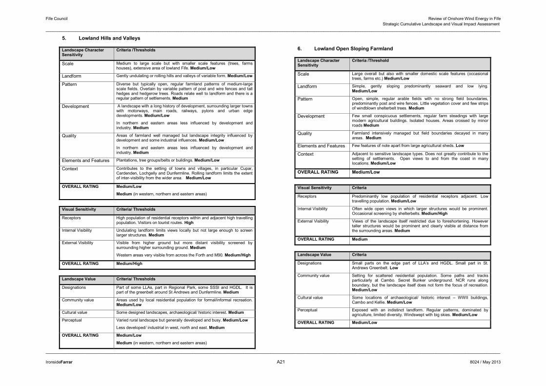
Fife Council Review of Onshore Wind Energy in Fife Strategic Cumulative Landscape and Visual Impact Assessment
______________________________________________________________________________________________________________________________________________________________________________________________________
______________________________________________________________________________________________________________________________________________________________________________________________________
IronsideFarrar A21 8024 / May 2013
5. Lowland Hills and Valleys
Landscape CharacterSensitivity
Criteria /Thresholds
Scale Medium to large scale but with smaller scale features (trees, farms houses), extensive area of lowland Fife. Medium/Low
Landform Gently undulating or rolling hills and valleys of variable form. Medium/Low
Pattern Diverse but typically open, regular farmland patterns of medium-large scale fields. Overlain by variable pattern of post and wire fences and tall hedges and hedgerow trees. Roads relate well to landform and there is a regular pattern of settlements. Medium
Development A landscape with a long history of development, surrounding larger towns with motorways, main roads, railways, pylons and urban edge developments. Medium/Low
In northern and eastern areas less influenced by development and industry. Medium
Quality Areas of farmland well managed but landscape integrity influenced by development and some industrial influences. Medium/Low
In northern and eastern areas less influenced by development and industry. Medium
Elements and Features Plantations, tree groups/belts or buildings. Medium/Low
Context Contributes to the setting of towns and villages, in particular Cupar, Cardenden, Lochgelly and Dunfermline. Rolling landform limits the extent of inter-visibility from the wider area. Medium/Low
OVERALL RATING Medium/Low
Medium (in western, northern and eastern areas)
Visual Sensitivity Criteria/ Thresholds
Receptors High population of residential receptors within and adjacent high travelling population. Visitors on tourist routes. High
Internal Visibility Undulating landform limits views locally but not large enough to screen larger structures. Medium
External Visibility Visible from higher ground but more distant visibility screened by surrounding higher surrounding ground. Medium
Western areas very visible from across the Forth and M90. Medium/High
OVERALL RATING Medium/High
Landscape Value Criteria/ Thresholds
Designations Part of some LLAs, part in Regional Park, some SSSI and HGDL. It is part of the greenbelt around St Andrews and Dunfermline. Medium
Community value Areas used by local residential population for formal/informal recreation. Medium/Low
Cultural value Some designed landscapes, archaeological/ historic interest. Medium
Perceptual Varied rural landscape but generally developed and busy. Medium/Low
Less developed/ industrial in west, north and east. Medium
OVERALL RATING Medium/Low
Medium (in western, northern and eastern areas)
6. Lowland Open Sloping Farmland
Landscape CharacterSensitivity
Criteria /Threshold
Scale Large overall but also with smaller domestic scale features (occasional trees, farms etc.) Medium/Low
Landform Simple, gently sloping predominantly seaward and low lying. Medium/Low
Pattern Open, simple, regular arable fields with no strong field boundaries, predominantly post and wire fences. Little vegetation cover and few strips of windblown shelterbelt trees. Medium
Development Few small conspicuous settlements, regular farm steadings with large modern agricultural buildings. Isolated houses. Areas crossed by minor roads Medium
Quality Farmland intensively managed but field boundaries decayed in many areas. Medium
Elements and Features Few features of note apart from large agricultural sheds. Low
Context Adjacent to sensitive landscape types. Does not greatly contribute to the setting of settlements. Open views to and from the coast in many locations. Medium/Low
OVERALL RATING Medium/Low
Visual Sensitivity Criteria
Receptors Predominantly low population of residential receptors adjacent. Low travelling population. Medium/Low
Internal Visibility Often wide open views in which larger structures would be prominent. Occasional screening by shelterbelts. Medium/High
External Visibility Views of the landscape itself restricted due to foreshortening. However taller structures would be prominent and clearly visible at distance from the surrounding areas. Medium
OVERALL RATING Medium
Landscape Value Criteria
Designations Small parts on the edge part of LLA’s and HGDL. Small part in St. Andrews Greenbelt. Low
Community value Setting for scattered residential population. Some paths and tracks particularly at Cambo. Secret Bunker underground. NCR runs along boundary, but the landscape itself does not form the focus of recreation. Medium/Low
Cultural value Some locations of archaeological/ historic interest – WWII buildings, Cambo and Kellie. Medium/Low
Perceptual Exposed with an indistinct landform. Regular patterns, dominated by agriculture, limited diversity. Windswept with big skies. Medium/Low
OVERALL RATING Medium/Low
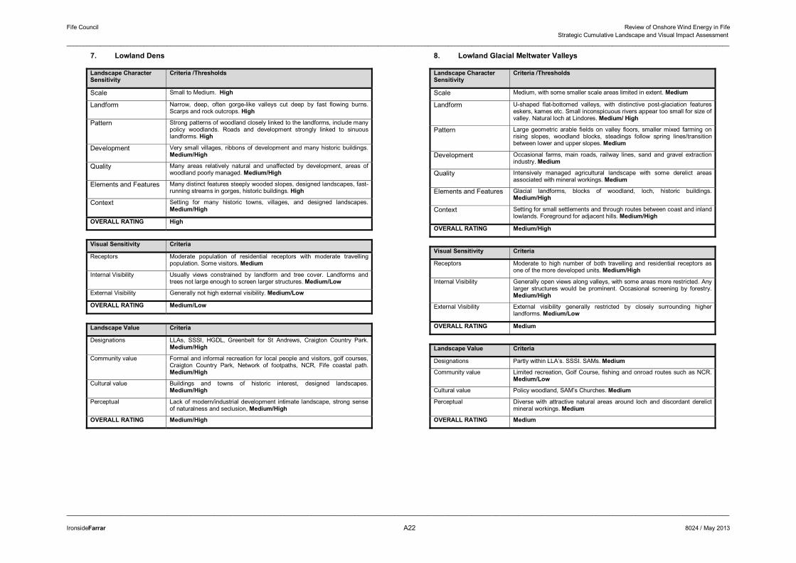
Fife Council Review of Onshore Wind Energy in Fife Strategic Cumulative Landscape and Visual Impact Assessment
______________________________________________________________________________________________________________________________________________________________________________________________________
______________________________________________________________________________________________________________________________________________________________________________________________________
IronsideFarrar A22 8024 / May 2013
7. Lowland Dens
Landscape CharacterSensitivity
Criteria /Thresholds
Scale Small to Medium. High
Landform Narrow, deep, often gorge-like valleys cut deep by fast flowing burns. Scarps and rock outcrops. High
Pattern Strong patterns of woodland closely linked to the landforms, include many policy woodlands. Roads and development strongly linked to sinuous landforms. High
Development Very small villages, ribbons of development and many historic buildings. Medium/High
Quality Many areas relatively natural and unaffected by development, areas of woodland poorly managed. Medium/High
Elements and Features Many distinct features steeply wooded slopes, designed landscapes, fast-running streams in gorges, historic buildings. High
Context Setting for many historic towns, villages, and designed landscapes. Medium/High
OVERALL RATING High
Visual Sensitivity Criteria
Receptors Moderate population of residential receptors with moderate travelling population. Some visitors. Medium
Internal Visibility Usually views constrained by landform and tree cover. Landforms and trees not large enough to screen larger structures. Medium/Low
External Visibility Generally not high external visibility. Medium/Low
OVERALL RATING Medium/Low
Landscape Value Criteria
Designations LLAs, SSSI, HGDL, Greenbelt for St Andrews, Craigton Country Park. Medium/High
Community value Formal and informal recreation for local people and visitors, golf courses, Craigton Country Park, Network of footpaths, NCR, Fife coastal path. Medium/High
Cultural value Buildings and towns of historic interest, designed landscapes. Medium/High
Perceptual Lack of modern/industrial development intimate landscape, strong sense of naturalness and seclusion, Medium/High
OVERALL RATING Medium/High
8. Lowland Glacial Meltwater Valleys
Landscape CharacterSensitivity
Criteria /Thresholds
Scale Medium, with some smaller scale areas limited in extent. Medium
Landform U-shaped flat-bottomed valleys, with distinctive post-glaciation features eskers, kames etc. Small inconspicuous rivers appear too small for size of valley. Natural loch at Lindores. Medium/ High
Pattern Large geometric arable fields on valley floors, smaller mixed farming on rising slopes, woodland blocks, steadings follow spring lines/transition between lower and upper slopes. Medium
Development Occasional farms, main roads, railway lines, sand and gravel extraction industry. Medium
Quality Intensively managed agricultural landscape with some derelict areas associated with mineral workings. Medium
Elements and Features Glacial landforms, blocks of woodland, loch, historic buildings. Medium/High
Context Setting for small settlements and through routes between coast and inland lowlands. Foreground for adjacent hills. Medium/High
OVERALL RATING Medium/High
Visual Sensitivity Criteria
Receptors Moderate to high number of both travelling and residential receptors as one of the more developed units. Medium/High
Internal Visibility Generally open views along valleys, with some areas more restricted. Any larger structures would be prominent. Occasional screening by forestry. Medium/High
External Visibility External visibility generally restricted by closely surrounding higher landforms. Medium/Low
OVERALL RATING Medium
Landscape Value Criteria
Designations Partly within LLA’s. SSSI. SAMs. Medium
Community value Limited recreation, Golf Course, fishing and onroad routes such as NCR. Medium/Low
Cultural value Policy woodland, SAM’s Churches. Medium
Perceptual Diverse with attractive natural areas around loch and discordant derelict mineral workings. Medium
OVERALL RATING Medium
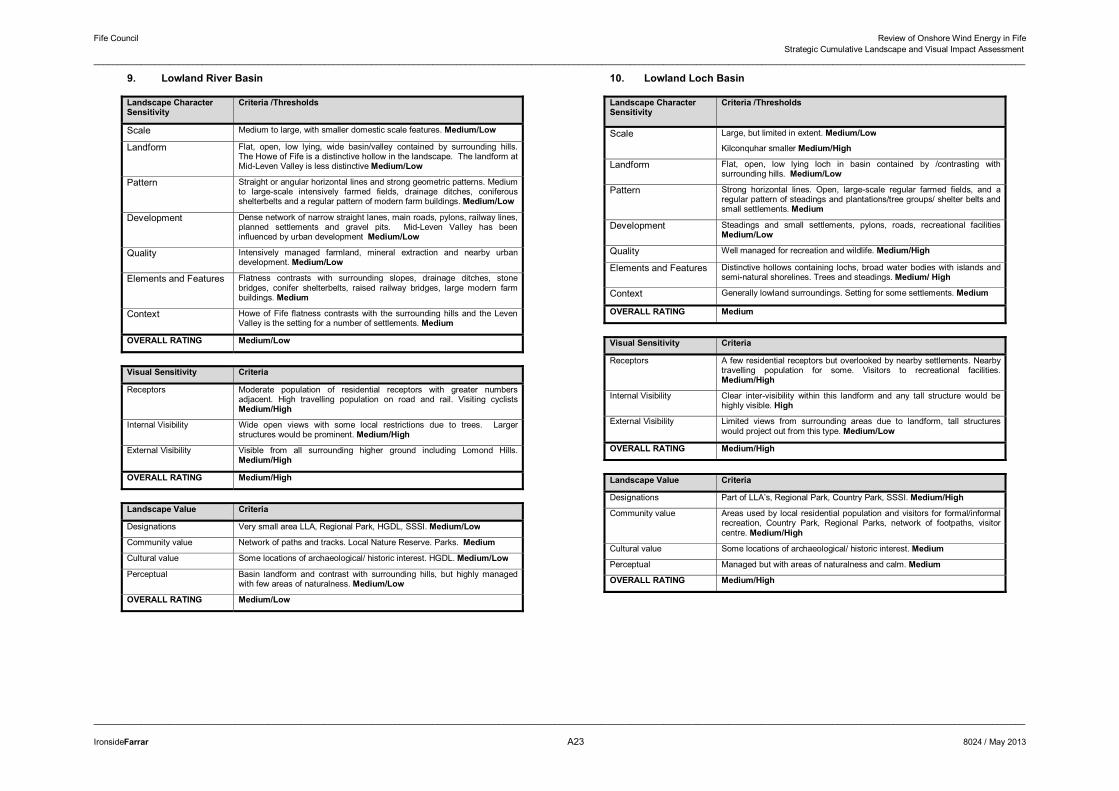
Fife Council Review of Onshore Wind Energy in Fife Strategic Cumulative Landscape and Visual Impact Assessment
______________________________________________________________________________________________________________________________________________________________________________________________________
______________________________________________________________________________________________________________________________________________________________________________________________________
IronsideFarrar A23 8024 / May 2013
9. Lowland River Basin
Landscape CharacterSensitivity
Criteria /Thresholds
Scale Medium to large, with smaller domestic scale features. Medium/Low
Landform Flat, open, low lying, wide basin/valley contained by surrounding hills. The Howe of Fife is a distinctive hollow in the landscape. The landform at Mid-Leven Valley is less distinctive Medium/Low
Pattern Straight or angular horizontal lines and strong geometric patterns. Medium to large-scale intensively farmed fields, drainage ditches, coniferous shelterbelts and a regular pattern of modern farm buildings. Medium/Low
Development Dense network of narrow straight lanes, main roads, pylons, railway lines, planned settlements and gravel pits. Mid-Leven Valley has been influenced by urban development Medium/Low
Quality Intensively managed farmland, mineral extraction and nearby urban development. Medium/Low
Elements and Features Flatness contrasts with surrounding slopes, drainage ditches, stone bridges, conifer shelterbelts, raised railway bridges, large modern farm buildings. Medium
Context Howe of Fife flatness contrasts with the surrounding hills and the Leven Valley is the setting for a number of settlements. Medium
OVERALL RATING Medium/Low
Visual Sensitivity Criteria
Receptors Moderate population of residential receptors with greater numbers adjacent. High travelling population on road and rail. Visiting cyclists Medium/High
Internal Visibility Wide open views with some local restrictions due to trees. Larger structures would be prominent. Medium/High
External Visibility Visible from all surrounding higher ground including Lomond Hills. Medium/High
OVERALL RATING Medium/High
Landscape Value Criteria
Designations Very small area LLA, Regional Park, HGDL, SSSI. Medium/Low
Community value Network of paths and tracks. Local Nature Reserve. Parks. Medium
Cultural value Some locations of archaeological/ historic interest. HGDL. Medium/Low
Perceptual Basin landform and contrast with surrounding hills, but highly managed with few areas of naturalness. Medium/Low
OVERALL RATING Medium/Low
10. Lowland Loch Basin
Landscape Character Sensitivity
Criteria /Thresholds
Scale Large, but limited in extent. Medium/Low
Kilconquhar smaller Medium/High
Landform Flat, open, low lying loch in basin contained by /contrasting with surrounding hills. Medium/Low
Pattern Strong horizontal lines. Open, large-scale regular farmed fields, and a regular pattern of steadings and plantations/tree groups/ shelter belts and small settlements. Medium
Development Steadings and small settlements, pylons, roads, recreational facilities Medium/Low
Quality Well managed for recreation and wildlife. Medium/High
Elements and Features Distinctive hollows containing lochs, broad water bodies with islands and semi-natural shorelines. Trees and steadings. Medium/ High
Context Generally lowland surroundings. Setting for some settlements. Medium
OVERALL RATING Medium
Visual Sensitivity Criteria
Receptors A few residential receptors but overlooked by nearby settlements. Nearby travelling population for some. Visitors to recreational facilities. Medium/High
Internal Visibility Clear inter-visibility within this landform and any tall structure would be highly visible. High
External Visibility Limited views from surrounding areas due to landform, tall structures would project out from this type. Medium/Low
OVERALL RATING Medium/High
Landscape Value Criteria
Designations Part of LLA’s, Regional Park, Country Park, SSSI. Medium/High
Community value Areas used by local residential population and visitors for formal/informal recreation, Country Park, Regional Parks, network of footpaths, visitor centre. Medium/High
Cultural value Some locations of archaeological/ historic interest. Medium
Perceptual Managed but with areas of naturalness and calm. Medium
OVERALL RATING Medium/High
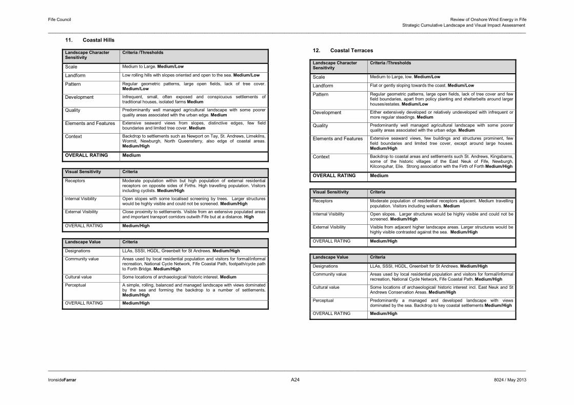
Fife Council Review of Onshore Wind Energy in Fife Strategic Cumulative Landscape and Visual Impact Assessment
______________________________________________________________________________________________________________________________________________________________________________________________________
______________________________________________________________________________________________________________________________________________________________________________________________________
IronsideFarrar A24 8024 / May 2013
11. Coastal Hills
Landscape Character Sensitivity
Criteria /Thresholds
Scale Medium to Large. Medium/Low
Landform Low rolling hills with slopes oriented and open to the sea. Medium/Low
Pattern Regular geometric patterns, large open fields, lack of tree cover. Medium/Low
Development Infrequent, small, often exposed and conspicuous settlements of traditional houses, isolated farms Medium
Quality Predominantly well managed agricultural landscape with some poorer quality areas associated with the urban edge. Medium
Elements and Features Extensive seaward views from slopes, distinctive edges, few field boundaries and limited tree cover. Medium
Context Backdrop to settlements such as Newport on Tay, St. Andrews, Limekilns, Wormit, Newburgh, North Queensferry, also edge of coastal areas. Medium/High
OVERALL RATING Medium
Visual Sensitivity Criteria
Receptors Moderate population within but high population of external residential receptors on opposite sides of Firths. High travelling population. Visitors including cyclists. Medium/High
Internal Visibility Open slopes with some localised screening by trees. Larger structures would be highly visible and could not be screened. Medium/High
External Visibility Close proximity to settlements. Visible from an extensive populated areas and important transport corridors outwith Fife but at a distance. High
OVERALL RATING Medium/High
Landscape Value Criteria
Designations LLAs, SSSI, HGDL, Greenbelt for St Andrews. Medium/High
Community value Areas used by local residential population and visitors for formal/informal recreation, National Cycle Network, Fife Coastal Path, footpath/cycle path to Forth Bridge. Medium/High
Cultural value Some locations of archaeological/ historic interest. Medium
Perceptual A simple, rolling, balanced and managed landscape with views dominated by the sea and forming the backdrop to a number of settlements.Medium/High
OVERALL RATING Medium/High
12. Coastal Terraces
Landscape Character Sensitivity
Criteria /Thresholds
Scale Medium to Large, low. Medium/Low
Landform Flat or gently sloping towards the coast. Medium/Low
Pattern Regular geometric patterns, large open fields, lack of tree cover and few field boundaries, apart from policy planting and shelterbelts around larger houses/estates. Medium/Low
Development Either extensively developed or relatively undeveloped with infrequent or more regular steadings. Medium
Quality Predominantly well managed agricultural landscape with some poorer quality areas associated with the urban edge. Medium
Elements and Features Extensive seaward views, few buildings and structures prominent, few field boundaries and limited tree cover, except around large houses. Medium/High
Context Backdrop to coastal areas and settlements such St. Andrews, Kingsbarns, some of the historic villages of the East Neuk of Fife, Newburgh, Kilconquhar, Elie. Strong association with the Firth of Forth Medium/High
OVERALL RATING Medium
Visual Sensitivity Criteria
Receptors Moderate population of residential receptors adjacent. Medium travelling population. Visitors including walkers. Medium
Internal Visibility Open slopes. Larger structures would be highly visible and could not be screened. Medium/High
External Visibility Visible from adjacent higher landscape areas. Larger structures would be highly visible contrasted against the sea. Medium/High
OVERALL RATING Medium/High
Landscape Value Criteria
Designations LLAs, SSSI, HGDL, Greenbelt for St Andrews. Medium/High
Community value Areas used by local residential population and visitors for formal/informal recreation, National Cycle Network, Fife Coastal Path. Medium/High
Cultural value Some locations of archaeological/ historic interest incl. East Neuk and St Andrews Conservation Areas. Medium/High
Perceptual Predominantly a managed and developed landscape with views dominated by the sea. Backdrop to key coastal settlements Medium/High
OVERALL RATING Medium/High
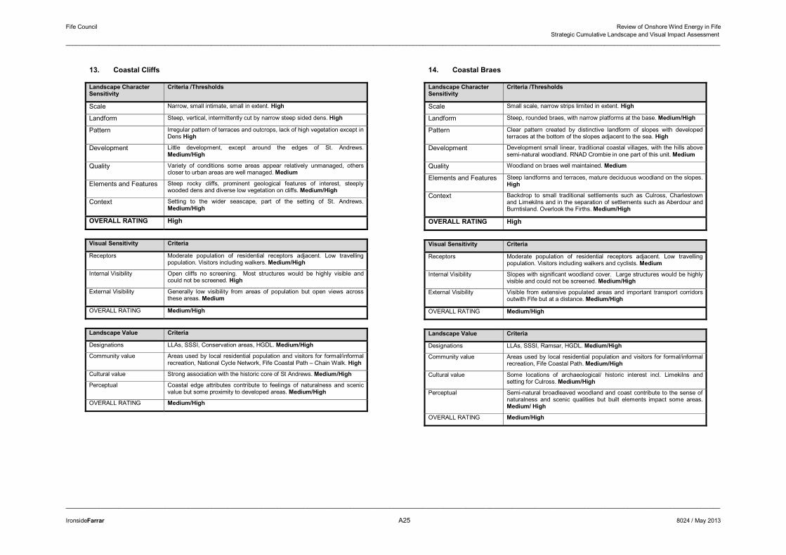
Fife Council Review of Onshore Wind Energy in Fife Strategic Cumulative Landscape and Visual Impact Assessment
______________________________________________________________________________________________________________________________________________________________________________________________________
______________________________________________________________________________________________________________________________________________________________________________________________________
IronsideFarrar A25 8024 / May 2013
13. Coastal Cliffs
Landscape Character Sensitivity
Criteria /Thresholds
Scale Narrow, small intimate, small in extent. High
Landform Steep, vertical, intermittently cut by narrow steep sided dens. High
Pattern Irregular pattern of terraces and outcrops, lack of high vegetation except in Dens High
Development Little development, except around the edges of St. Andrews. Medium/High
Quality Variety of conditions some areas appear relatively unmanaged, others closer to urban areas are well managed. Medium
Elements and Features Steep rocky cliffs, prominent geological features of interest, steeply wooded dens and diverse low vegetation on cliffs. Medium/High
Context Setting to the wider seascape, part of the setting of St. Andrews. Medium/High
OVERALL RATING High
Visual Sensitivity Criteria
Receptors Moderate population of residential receptors adjacent. Low travelling population. Visitors including walkers. Medium/High
Internal Visibility Open cliffs no screening. Most structures would be highly visible and could not be screened. High
External Visibility Generally low visibility from areas of population but open views across these areas. Medium
OVERALL RATING Medium/High
Landscape Value Criteria
Designations LLAs, SSSI, Conservation areas, HGDL. Medium/High
Community value Areas used by local residential population and visitors for formal/informal recreation, National Cycle Network, Fife Coastal Path – Chain Walk. High
Cultural value Strong association with the historic core of St Andrews. Medium/High
Perceptual Coastal edge attributes contribute to feelings of naturalness and scenic value but some proximity to developed areas. Medium/High
OVERALL RATING Medium/High
14. Coastal Braes
Landscape Character Sensitivity
Criteria /Thresholds
Scale Small scale, narrow strips limited in extent. High
Landform Steep, rounded braes, with narrow platforms at the base. Medium/High
Pattern Clear pattern created by distinctive landform of slopes with developed terraces at the bottom of the slopes adjacent to the sea. High
Development Development small linear, traditional coastal villages, with the hills above semi-natural woodland. RNAD Crombie in one part of this unit. Medium
Quality Woodland on braes well maintained. Medium
Elements and Features Steep landforms and terraces, mature deciduous woodland on the slopes. High
Context Backdrop to small traditional settlements such as Culross, Charlestown and Limekilns and in the separation of settlements such as Aberdour and Burntisland. Overlook the Firths. Medium/High
OVERALL RATING High
Visual Sensitivity Criteria
Receptors Moderate population of residential receptors adjacent. Low travelling population. Visitors including walkers and cyclists. Medium
Internal Visibility Slopes with significant woodland cover. Large structures would be highly visible and could not be screened. Medium/High
External Visibility Visible from extensive populated areas and important transport corridors outwith Fife but at a distance. Medium/High
OVERALL RATING Medium/High
Landscape Value Criteria
Designations LLAs, SSSI, Ramsar, HGDL. Medium/High
Community value Areas used by local residential population and visitors for formal/informal recreation, Fife Coastal Path. Medium/High
Cultural value Some locations of archaeological/ historic interest incl. Limekilns and setting for Culross. Medium/High
Perceptual Semi-natural broadleaved woodland and coast contribute to the sense of naturalness and scenic qualities but built elements impact some areas. Medium/ High
OVERALL RATING Medium/High
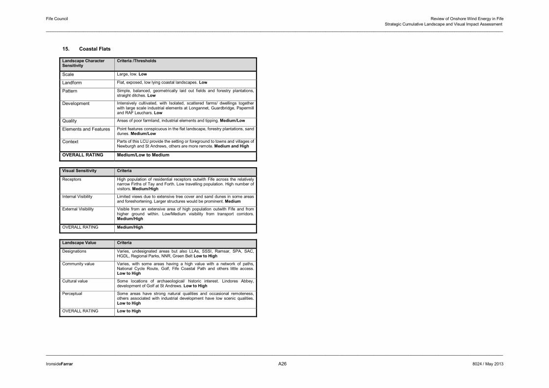
Fife Council Review of Onshore Wind Energy in Fife Strategic Cumulative Landscape and Visual Impact Assessment
______________________________________________________________________________________________________________________________________________________________________________________________________
______________________________________________________________________________________________________________________________________________________________________________________________________
IronsideFarrar A26 8024 / May 2013
15. Coastal Flats
Landscape Character Sensitivity
Criteria /Thresholds
Scale Large, low. Low
Landform Flat, exposed, low lying coastal landscapes. Low
Pattern Simple, balanced, geometrically laid out fields and forestry plantations, straight ditches. Low
Development Intensively cultivated, with Isolated, scattered farms/ dwellings together with large scale industrial elements at Longannet, Guardbridge, Papermill and RAF Leuchars. Low
Quality Areas of poor farmland, industrial elements and tipping. Medium/Low
Elements and Features Point features conspicuous in the flat landscape, forestry plantations, sand dunes. Medium/Low
Context Parts of this LCU provide the setting or foreground to towns and villages of Newburgh and St Andrews, others are more remote. Medium and High
OVERALL RATING Medium/Low to Medium
Visual Sensitivity Criteria
Receptors High population of residential receptors outwith Fife across the relatively narrow Firths of Tay and Forth. Low travelling population. High number of visitors. Medium/High
Internal Visibility Limited views due to extensive tree cover and sand dunes in some areas and foreshortening. Larger structures would be prominent. Medium
External Visibility Visible from an extensive area of high population outwith Fife and from higher ground within. Low/Medium visibility from transport corridors. Medium/High
OVERALL RATING Medium/High
Landscape Value Criteria
Designations Varies, undesignated areas but also LLAs, SSSI, Ramsar, SPA, SAC, HGDL, Regional Parks, NNR, Green Belt Low to High
Community value Varies, with some areas having a high value with a network of paths, National Cycle Route, Golf, Fife Coastal Path and others little access. Low to High
Cultural value Some locations of archaeological/ historic interest. Lindores Abbey, development of Golf at St Andrews. Low to High
Perceptual Some areas have strong natural qualities and occasional remoteness, others associated with industrial development have low scenic qualities. Low to High
OVERALL RATING Low to High