Embed Size (px)
Citation preview

Appendix C Baseline Report

Stage 1 Repo r t : F i s t r a l Beach
Cornwall Beach & Dune Management Plans
Prepared forCornwall Council
9 July 2015
Ash House Falcon Road
Sowton Exeter Devon
EX2 7LB

Contents Section Page
1 Introduction ............................................................................................................................ 1 1.1 Background ......................................................................................................................... 1 1.2 Project aim, objectives and approach ................................................................................ 1 1.3 About this document .......................................................................................................... 4
2 Site Visit Report....................................................................................................................... 5 2.1 Attendees............................................................................................................................ 5 2.2 Site Visit Record .................................................................................................................. 5 2.3 Thoughts on Potential Management Solutions for Consideration ..................................... 6 2.4 Data Sources ....................................................................................................................... 6 2.5 Photos ................................................................................................................................. 7
3 Environmental Characteristics ................................................................................................. 9 3.1 Introduction ........................................................................................................................ 9 3.2 Methodology....................................................................................................................... 9
3.2.1 Designated Nature Conservation sites and Protected Habitats Considered......... 9 3.3 Environmental Setting ...................................................................................................... 10
3.3.1 Ecology................................................................................................................. 11 3.3.2 Designated Geological Conservation Sites .......................................................... 14 3.3.3 Landscape Setting ................................................................................................ 14 3.3.4 Archaeology and Cultural Heritage...................................................................... 14
3.4 Main human impact pressures affecting the natural dynamics of the site...................... 14
4 Coastal Processes Understanding........................................................................................... 15 4.1 Introduction ...................................................................................................................... 15 4.2 Shoreline Processes Overview.......................................................................................... 15
4.2.1 Key Characteristics of the Coastline Today.......................................................... 15 4.2.2 Forcing Factors..................................................................................................... 25 4.2.3 Sediment Dynamics ............................................................................................. 28 4.2.4 Historical Shoreline Change................................................................................. 28 4.2.5 Beach Profile Analysis .......................................................................................... 30
4.3 New Shoreline and Beach Profile Analysis........................................................................ 30 4.4 Summary and Recommendations..................................................................................... 36
4.4.1 Summary.............................................................................................................. 36 4.4.2 Recommendations............................................................................................... 36 4.4.3 Uncertainties and Limitations.............................................................................. 36
5 Site Summary ........................................................................................................................ 37 5.1 Dune Inventory Summary................................................................................................. 37 5.2 Recommendation for update of 2009 Pilot BDMP ........................................................... 39
6 References............................................................................................................................. 40
III

1 SECTION 1 INTRODUCTION
Introduction 1.1 Background Many of the sand dunes and beaches around Cornwall’s coast are currently experiencing erosion and sediment loss. This is a pressing concern as these sand dunes and their associated sandy beaches are one of the most important resources in Cornwall due to:
1. Their role in providing protection against the risk of coastal flooding due to the dynamic nature of beach‐dune interactions and their sheer size preventing the sea from impacting upon the hinterland behind the dune systems.
2. Their role in providing important biologically diverse habitats that cannot be easily recreated elsewhere if it were to be lost to coastal erosion or inappropriate development.
3. Their role in providing access to the sea for residents and visitors alike, which is vital to the holiday industry upon which a significant proportion of Cornwall’s economy depends.
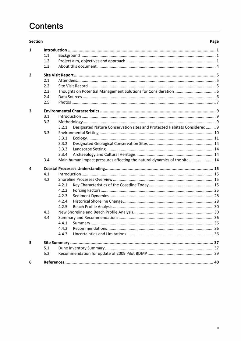
It is vital therefore that the sand dunes and beaches around Cornwall’s coast, that represent some 15% of the total sand dune habitat in Britain, are managed in a holistic, sustainable way over the long‐term that balances the needs of each of the three distinct functions of sand dunes and beaches that combined make up the beach‐dune system, as illustrated in Figure 1.1.
Figure 1.1 The interaction of beach systems that compose the ‘beach environment’ and which must be considered together to provide a holistic approach to beach management (after James, 2000 in Frampton, A.P.R. (2010). “A review of amenity beach management”. Journal of Coastal research, 26(6), 1112‐1122, November 2010).
The approach to managing the beaches and sand dunes was investigated in between 2006 and 2009 by Halcrow on behalf of the Cornwall and Isles of Scilly Coastal Group, and led to the production of the Cornwall Sand Dune and Beach Management Strategy (Halcrow, 2009a). The main focus of the strategy is the management of flood and coastal erosion, although the habitat and tourism value of the dunes will also be considered. This 2009 project delivered an Inventory of Beaches and Dunes; a Best Practice Management Guide and two pilot Beach and Dune Management Plans (BDMPs) for Harvey’s Towans and Fistral Beach. It is this 2009 work that this current project is building upon to develop six new BDMPs and review the two pilot BDMPs (see Section 1.2).
1.2 Project aim, objectives and approach The purpose of the project is to develop six new long‐term strategic BDMPs for Constantine Bay, Porthtowan, Summerleaze, Par Sands, Widemouth Bay and Praa Sands; and review the need (or
1
SECTION 1 INTRODUCTION
otherwise) to update the two pilot BDMPs produced in 2009 for Fistral Beach and Harvey’s Towans. This will be achieved by:
1. Identifying the best management approach; in terms of monitoring and intervention (when trigger levels are reached) requirements for beach and dune systems at each individual site, based upon the best practice framework developed as part of the Cornwall Sand Dune and Beach Management Strategy produced by Halcrow in 2009.
2. Providing a long‐term (50 year) approach to each site that is based upon an up‐to‐date understanding of the beach‐dune system and coastal processes at each site, as well as predictions of future coastal evolution.
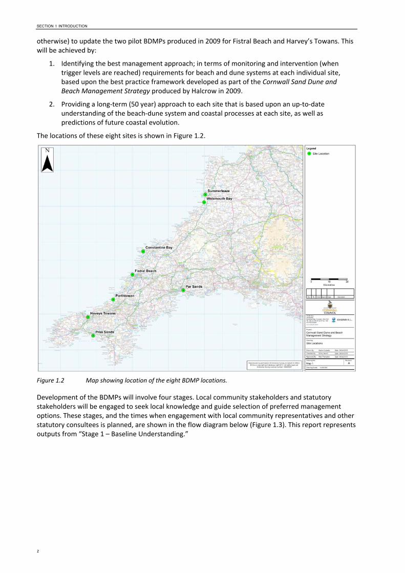
The locations of these eight sites is shown in Figure 1.2.
Figure 1.2 Map showing location of the eight BDMP locations.
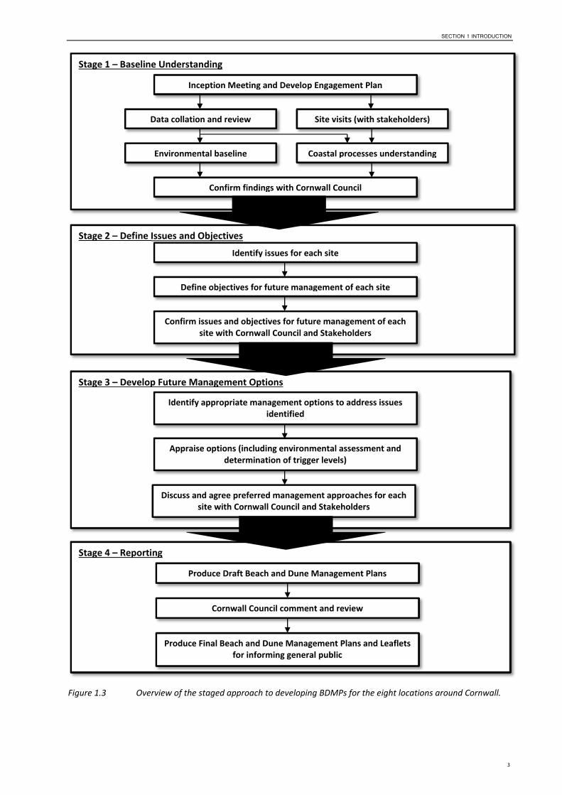
Development of the BDMPs will involve four stages. Local community stakeholders and statutory stakeholders will be engaged to seek local knowledge and guide selection of preferred management options. These stages, and the times when engagement with local community representatives and other statutory consultees is planned, are shown in the flow diagram below (Figure 1.3). This report represents outputs from “Stage 1 – Baseline Understanding.”
2
SECTION 1 INTRODUCTION
Stage 1 – Baseline Understanding
Inception Meeting and Develop Engagement Plan
Data collation and review Site visits (with stakeholders)
Coastal processes understandingEnvironmental baseline
Confirm findings with Cornwall Council
Stage 2 – Define Issues and Objectives
Identify issues for each site
Define objectives for future management of each site
Confirm issues and objectives for future management of each site with Cornwall Council and Stakeholders
Stage 3 – Develop Future Management Options
Stage 4 – Reporting
Produce Draft Beach and Dune Management Plans
Cornwall Council comment and review
Produce Final Beach and Dune Management Plans and Leaflets for informing general public
Identify appropriate management options to address issues identified
Appraise options (including environmental assessment and determination of trigger levels)
Discuss and agree preferred management approaches for each site with Cornwall Council and Stakeholders
Figure 1.3 Overview of the staged approach to developing BDMPs for the eight locations around Cornwall.
3
SECTION 1 INTRODUCTION
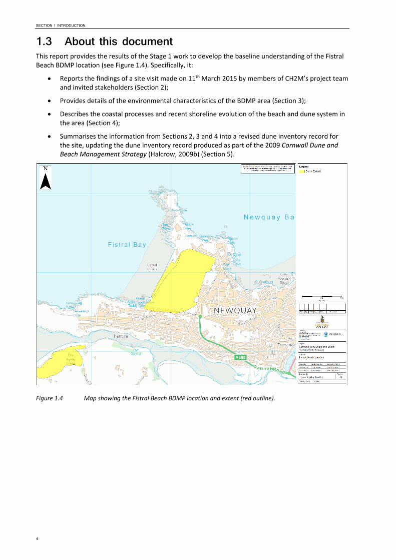
1.3 About this document This report provides the results of the Stage 1 work to develop the baseline understanding of the Fistral Beach BDMP location (see Figure 1.4). Specifically, it:
Reports the findings of a site visit made on 11th March 2015 by members of CH2M’s project team and invited stakeholders (Section 2);
Provides details of the environmental characteristics of the BDMP area (Section 3);
Describes the coastal processes and recent shoreline evolution of the beach and dune system in the area (Section 4);
Summarises the information from Sections 2, 3 and 4 into a revised dune inventory record for the site, updating the dune inventory record produced as part of the 2009 Cornwall Dune and Beach Management Strategy (Halcrow, 2009b) (Section 5).
Figure 1.4 Map showing the Fistral Beach BDMP location and extent (red outline).
4
SECTION 2 SITE VISIT REPORT
2 Site Visit Report Over a period of four days, three members of CH2M’s project team visited the eight BDMP sites to capture information about each site and take ground‐level photos. At each site, client representatives, stakeholders and local community groups were given the opportunity to attend, meet with the project team, discuss their aims and objectives for the site, and raise any issues and concerns. Information collected during the site visits will be considered when developing later stages of the project, including:
Stage 1 – Baseline Understanding (refer to Sections 3 and 4 of this report)
Stage 2 – Define Issues and Objectives; and
Stage 3 – Develop Future Management Options.
The site visit report for the Fistral Beach BDMP area, which was undertaken on 11th March 2015, is presented within this section and provides:
a list of attendees at each site (Section 2.1);
a record of the site visit including both factual information, comment and opinion provided stakeholders (Section 2.2);
a summary of potential management solutions identified on the day of the site visit for consideration in later stage of the project (Section 2.3);
a section on ‘Data Sources’ where CH2M’s project team were informed of, or provided with, relevant information at the site or following the site visit (Section 2.4); and
a selection of photographs taken during the site visit to highlight salient points (Section 2.5).
The information presented is a record of both information recorded during the site visit, and additional information provided by stakeholders as comments on the draft site visit report between 8th and 15th
April 2015.
2.1 Attendees Name Role Organisation
Emma Allan Senior Coastal Scientist CH2M Hill
Emily Hewitt Environmental Scientist CH2M Hill
James Clapp Cormac
Comments on the draft site visit report for this location were received from: Martin Clemo and Jolyon Sharpe (Cornwall Council).
2.2 Site Visit Record Cormac and a Cornwall Council beach manager are responsible for looking after the beach at Fistral.
Key issues at Fistral Beach are erosion of the backshore and dunes, and anti‐social behaviour of beach users.
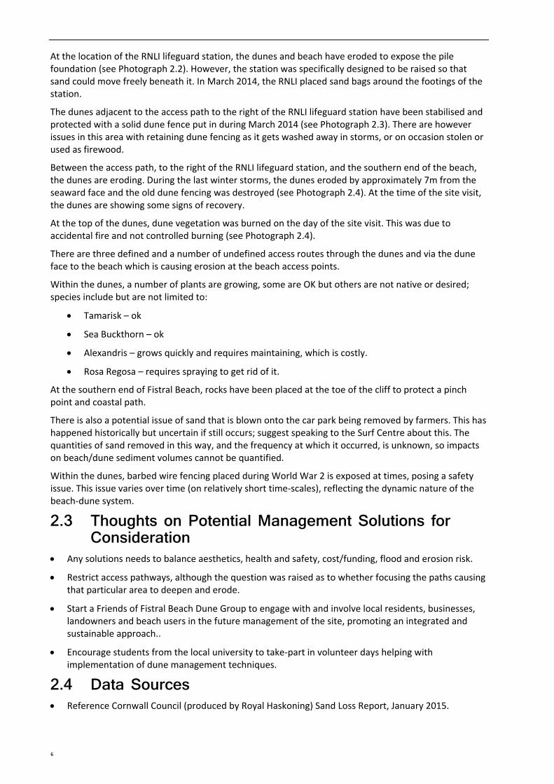
At the northern end of the beach, there is significant cut‐back of the backshore cliffs/dunes, resulting in collapse and failure of the footings of the commercial buildings and the gabion baskets (see Photograph 2.1). Large rocks have been placed at the toe of the cliffs/dunes and foundations to help stabilise the beach/dunes and protect the foundations of the building. Metal fencing containing the site is becoming buried, suggesting some build‐up of sand.
The local businesses here cannot get insurance because of the damage that has occurred to date.
5
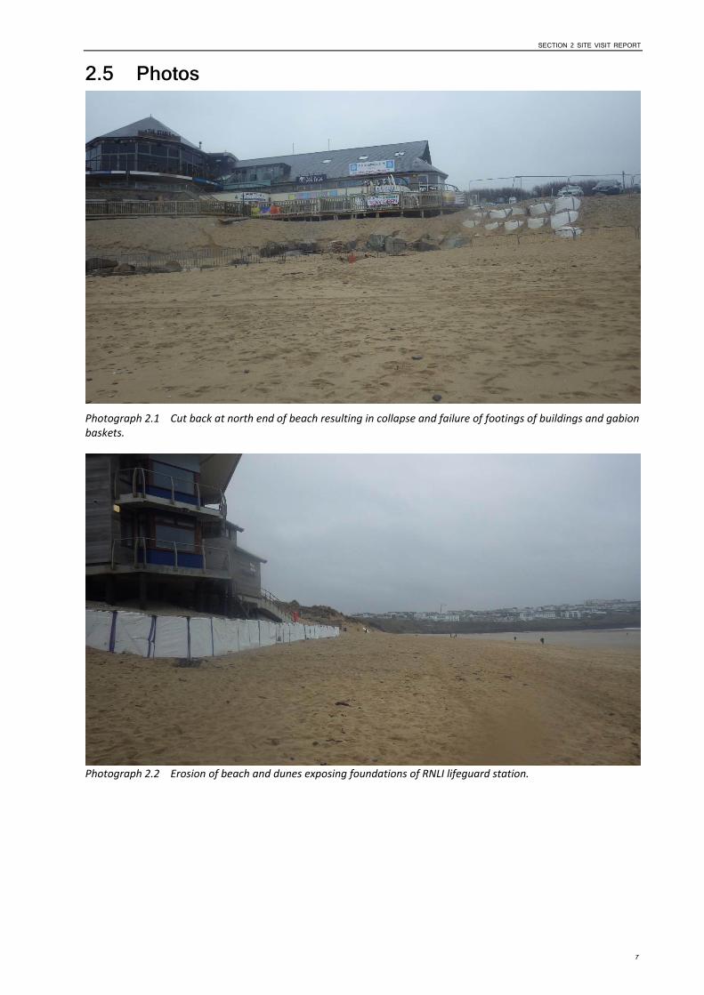
At the location of the RNLI lifeguard station, the dunes and beach have eroded to expose the pile foundation (see Photograph 2.2). However, the station was specifically designed to be raised so that sand could move freely beneath it. In March 2014, the RNLI placed sand bags around the footings of the station.
The dunes adjacent to the access path to the right of the RNLI lifeguard station have been stabilised and protected with a solid dune fence put in during March 2014 (see Photograph 2.3). There are however issues in this area with retaining dune fencing as it gets washed away in storms, or on occasion stolen or used as firewood.
Between the access path, to the right of the RNLI lifeguard station, and the southern end of the beach, the dunes are eroding. During the last winter storms, the dunes eroded by approximately 7m from the seaward face and the old dune fencing was destroyed (see Photograph 2.4). At the time of the site visit, the dunes are showing some signs of recovery.
At the top of the dunes, dune vegetation was burned on the day of the site visit. This was due to accidental fire and not controlled burning (see Photograph 2.4).
There are three defined and a number of undefined access routes through the dunes and via the dune face to the beach which is causing erosion at the beach access points.
Within the dunes, a number of plants are growing, some are OK but others are not native or desired; species include but are not limited to:
Tamarisk – ok
Sea Buckthorn – ok
Alexandris – grows quickly and requires maintaining, which is costly.
Rosa Regosa – requires spraying to get rid of it.
At the southern end of Fistral Beach, rocks have been placed at the toe of the cliff to protect a pinch point and coastal path.
There is also a potential issue of sand that is blown onto the car park being removed by farmers. This has happened historically but uncertain if still occurs; suggest speaking to the Surf Centre about this. The quantities of sand removed in this way, and the frequency at which it occurred, is unknown, so impacts on beach/dune sediment volumes cannot be quantified.
Within the dunes, barbed wire fencing placed during World War 2 is exposed at times, posing a safety issue. This issue varies over time (on relatively short time‐scales), reflecting the dynamic nature of the beach‐dune system.
2.3 Thoughts on Potential Management Solutions forConsideration
Any solutions needs to balance aesthetics, health and safety, cost/funding, flood and erosion risk.
Restrict access pathways, although the question was raised as to whether focusing the paths causing that particular area to deepen and erode.
Start a Friends of Fistral Beach Dune Group to engage with and involve local residents, businesses, landowners and beach users in the future management of the site, promoting an integrated and sustainable approach..
Encourage students from the local university to take‐part in volunteer days helping with implementation of dune management techniques.
2.4 Data Sources Reference Cornwall Council (produced by Royal Haskoning) Sand Loss Report, January 2015.
6
SECTION 2 SITE VISIT REPORT
2.5 Photos
Photograph 2.1 Cut back at north end of beach resulting in collapse and failure of footings of buildings and gabion baskets.
Photograph 2.2 Erosion of beach and dunes exposing foundations of RNLI lifeguard station.
7
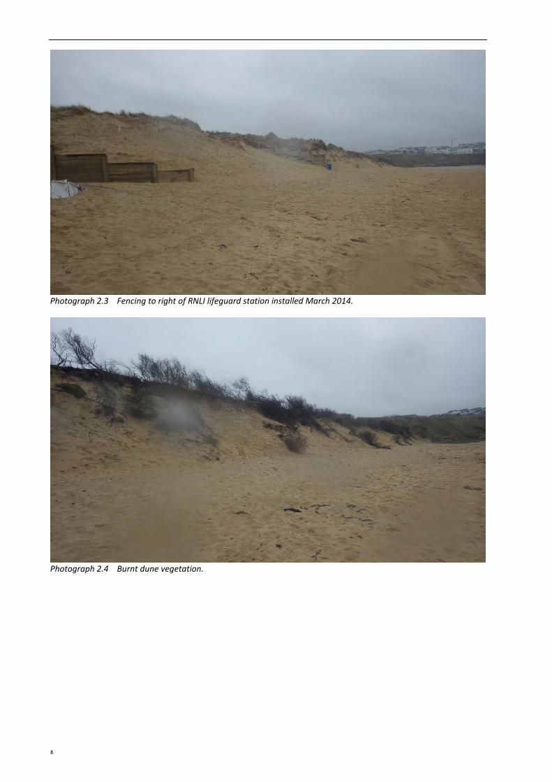
Photograph 2.3 Fencing to right of RNLI lifeguard station installed March 2014.
Photograph 2.4 Burnt dune vegetation.
8
3 SECTION 3 ENVIRONMENTAL CHARACTERISTICS
Environmental Characteristics 3.1 Introduction The purpose of this section is to identify key environmental features within and near the Study Area. This is to ensure that appropriate consideration of these features is made when developing a future Beach and Dune Management Plan for Fistral Beach (including ongoing monitoring and maintenance works and any new works that may be required).
It should be noted that the level of detail presented in this document allows for an initial appraisal of environmental features to provide for an environmentally sustainable future management regime. This does not negate the requirement for future detailed environmental assessment which may be required to support consent applications or prejudge the scope of the assessment. Background information on possible consenting requirements and legislative drivers are described in the methodology section below.
3.2 Methodology Conservation designations and their qualifying interest features (with exception of Special Protected Areas (SPAs) see below), and UK priority Biodiversity Action Plan (BAP) habitats that lie within the study area or within 2km have been described and will require consideration during the development of the BDMPs. Only those features that are currently considered relevant to the Study Area, i.e. those that are likely to be impacted upon or are likely to have an influence on the proposed scheme, have been described.
In the case of SPA sites, they have been considered within around 150km of the BDMP Study area and on the basis of bird‐habitat connectivity in line with standard practice for habitat regulations assessments (i.e. how the birds use the habitat in a region and so depend on different resources in a regional context, for example estuarine mudflats and fully marine areas at different stages of the tidal cycle).
The designation information has been sourced using the online interactive mapping tool Magic http://www.magic.gov.uk/.
3.2.1 Designated Nature Conservation sites and Protected Habitats Considered
The following nature conservation designations and their qualifying interests have been considered:
International Nature Conservation Sites:
o The Natura 2000 European network of protected sites represents areas of the highest value for natural habitats and species of plants and animals that are rare, endangered or vulnerable in the European Community.
o Special Areas of Conservation (SACs) are strictly protected sites designated under the EC Habitats Directive, and contribute to conserving habitat and species identified in Annexes I and II of the Directive.
o Special Protection Areas (SPAs) are strictly protected sites classified in accordance with Article 4 of the EC Birds Directive, which came into force in April 1979. They are classified for rare and vulnerable birds (as listed on Annex I of the Directive), and for regularly occurring migratory species.
National and Local Conservation sites:
o Site of Special Scientific Interest (SSSI) sites are nationally designated sites, selected for being the best examples of our natural heritage in terms of wildlife habitats, geological features or landforms. A SSSI area is notified as being of special interest under the Wildlife and Countryside Act 1981. Geological SSSI sites may also afford further
9
designation as Geological Conservation Review sites (GCR) that make a special contribution to our understanding and appreciation of Earth science and the geological history of Britain, which stretches back hundreds of millions of years
o Marine Conservation Zones (MCZs). The Marine and Coastal Access Act 2009 allows for the creation of MCZs. MCZs protect a range of nationally important marine wildlife, habitats, geology and geomorphology, and can be designated anywhere in English and Welsh territorial and UK offshore waters. 27 MCZs were designated in 2013 with a further round of six recommended MCZs (rMCZ) are being considered for 2015.
o Local Nature Reserves (LNRs) are declared and managed for nature conservation by local authorities under the National Parks and Access to the Countryside Act 1949, and provide opportunities for research and education, or simply enjoying and having contact with nature.
Habitats and Species
The government has a commitment “to conserve and enhance the biological diversity within the UK and to contribute to the conservation of global biodiversity through all appropriate mechanisms”.
Former Biodiversity Action Plans (BAPs) were developed at a national and local level to protect and enhance the diversity of flora and fauna. The UK BAP (Biodiversity: The UK Action Plan, 2004) set out action plans for priority species and habitats. As a result of devolution, and new country‐level and international drivers and requirements, much of the work previously carried out by the UK BAP is now focussed at a country‐level rather than a UK‐level, and the UK BAP was succeeded by the 'UK Post‐2010 Biodiversity Framework' in July 2012. The UK list of priority habitats, however, remains an important reference source and has been used to help draw up statutory lists of priority habitats in England, as required under Section 41 (England) of the Natural Environment and Rural Communities (NERC) Act 2006. Habitats and species of principal importance, which could potentially be affected by the management options, are considered.
Heritage Designations:
o World Heritage Sites are designated to meet the UK's commitments under the World Heritage Convention. Sites are designated for their globally important cultural or natural interest and require appropriate management and protection measures.
o Historic and archaeological sites of significance are designated as historical assets by English Heritage and include listed historic buildings, scheduled monuments, registered parks and gardens, battlefields and protected wreck sites. They designation are afforded to protect against any future loss of their significance.
o Heritage Coast is a section of coast exceeding one mile in length that is of exceptionally fine scenic quality, substantially undeveloped and containing features of special significance and interest.
Landscape Designations:
o Area of Outstanding Natural Beauty (AONB) are designated under the National Parks and Access to the Countryside Act 1949, amended in the Environment Act 1995, with responsibility of care assumed by local authorities and the rural community.
3.3 Environmental Setting The Study Area contains the following nature conservation designations. These are central in the consideration of options for the beach and dune management plan:
Newquay and The Gannel recommended Marine Conservation Zone (under current consultation for designation by end of 2015)
Archaeological and Cultural Heritage designated features.
10
SECTION 3 ENVIRONMENTAL CHARACTERISTICS
These features are shown on Figure 3.1 and discussed in further detail below.
Figure 3.1 Environmental designation features in the vicinity of the Fistral BDMP area.
3.3.1 Ecology3.3.1.1 Designated Nature Conservation Sites Newquay and The Gannel recommended Marine Conservation Zone encompasses Fistral beach from mean high water seaward. The site is currently under consultation review for designation by end of 2015. The rMCZ is being recommended in order to protect the areas wide range of habitats and high biodiversity. Habitats include the exposed sandy beaches and diverse rocky shores that are associated with a range of important species.
No further nature conservation designations are present within or in close proximity to the Study Area, however the following designated sites have been identified and considered for bird‐habitat connectivity with Fistral Beach (see also Figure 3.2). Those with possible connectivity will require consideration during the development of the BDMP:
Falmouth Bay to St Austell Bay pSPA is approximately 18km from Fistral Beach at its nearest point. The pSPA supports rare wintering birds and diving birds that are proposed for designation under the Birds Directive (2009/147/EC). The pSPA is a large area, and encompasses the Fal and Helford SAC within the pSPAs north western section. This site is designated under article 4 (4) of the Habitats Directive (92/43/EEC) for the following Annex 1 habitats: Sandbanks which are slightly covered by sea water all the time; Mudflats and sandflats not covered by seawater at low tide; Large shallow inlets and bays that include low tidal sandbanks and Atlantic salt meadows (Glauco‐Puccinellietalia maritimae). Other Annex I habitats that are present as a qualifying feature of the SAC but not the primary reason for selection include Estuaries and Reefs and includes the Annex II plant species Shore dock Rumex rupestris. Connectivity with Fistral Beach is possible. Particular habitat, as described in the MCZ that surrounds Fistral Beach
11
seaward (as mentioned above) may support diving birds and therefore consideration is required.
Fistral is approximately 40km from the nearest SPA (Marizion Marsh, southwest), important rich freshwater habitat for European important wintering, breeding and on passage birds; associated with the marsh and reed beds (listed on Annex I of the Directive). The majority of species covered by this citation are associated with freshwater habitat and it is unlikely that they will frequent the coastal area of Fistral.
Tamar Estuaries complex SPA (approximately 55km northeast from Fistral Beach). The estuary system is a large marine inlet on the English Channel coast comprising the estuaries of the rivers Tamar, Lynher and Tavy. Habitats include extensive tidal mud‐flats bordered by saltmarsh communities. The mud‐flats contain extensive and varied infaunal communities rich in bivalves and other invertebrates, and feeding grounds for waterbirds in numbers of European importance. Saltmarshes provide important feeding and roosting areas for large numbers of wintering and passage waterbirds. This site qualifies under Article 4.1 of the Directive (79/409/EEC) by supporting populations of Little Egret Egretta garzetta (on passage, and a population over winter) and Avocet Recurvirostra avosetta (over winter). Connectivity with Fistral is unlikely due to the distinct lack of estuarine rich feeding opportunities.
Marizion Marsh SPA/SSSI is approximately 39km south of Fistral Beach from its nearest point. The marsh is situated at the mouth of a wide coastal valley, separated from the sea by a shingle bar with fringing sand dunes. The marsh is important for passage and wintering birds associated in particular with the extensive reedbed. The site qualifies under Article 4.1 of the Directive (79/409/EEC) by supporting populations of Annex I species Aquatic Warbler Acrocephalus paludicola (in passage) and Bittern Botaurus stellaris (over winter). Connectivity between the SPA/SSSI and Fistral Beach is unlikely due the absence of similar reedbed habitat.
Isles of Scilly SPA is approximately 95km southwest from its closest point. The SPA qualifies for its seabird assemblage of international importance and breeding seabird assemblage of European importance. The isolated nature of the islands and rocks, together with their low levels of disturbance and predation, makes them particularly suitable for nesting seabirds. This site qualifies under Article 4.1 of the Directive (79/409/EEC) by supporting populations of European importance of the following Annex I species Storm Petrel Hydrobates pelagicus and Lesser Black‐backed Gull Larus fuscus. The site also qualifies under Article 4.2 of the Directive (79/409/EEC) for regularly supporting a seabird assemblage of international importance of at least 20,000 seabirds. The SPA boundary only encompasses those areas used for nesting. The vast majority of the feeding areas used by the seabirds are marine waters outside the SPA. Connectivity with feeding areas seaward around Fistral Beach is feasible.
The Exe Estuary SPA (approximately 120km from Fistral) is a complex of coastal habitats waters, foreshore, low‐lying land, three saltmarshes and an unusual double spit across the mouth of the estuary, and the sand dunes of Dawlish Warren. The mud and sandflats support Eelgrass Zostera spp. and Enteromorpha beds, and contain an abundance of invertebrates including extensive Mussel Mytilus edulis beds, which together provide rich feeding habitats for wintering waders and wildfowl. The site qualifies under Article 4.1 of the Directive (79/409/EEC) by supporting populations of Annex I species Avocet Recurvirostra avosetta and Slavonian Grebe Podiceps auritus (over winter) and qualifies under Article 4.2 of the Directive (79/409/EEC) as a wetland of international importance for regularly supporting at least 20,000 waterfowl. Connectivity with Fistral Beach has been discounted due to the lack of similar habitat of rich feeding opportunities.
12
SECTION 3 ENVIRONMENTAL CHARACTERISTICS
Figure 3.2 Potential bird‐habitat connectivity between the protected area and the BDMP site.
3.3.1.2 Biodiversity Action Plan (BAP) Habitats The following are listed as UK priority BAP habitats and are either represented in the Study Area or are within 1km as identified in the Cornwall County Council report: Ecological Assessment of Coastal Zone Management Issues at Fistral Beach (Spalding Associates Ltd, 2005). Only habitats that are considered relevant to the Study Area, i.e. they are likely to be impacted upon or are likely to have an influence on the proposed scheme, have been described. The associated targets are quoted under them:
Coastal Sand Dunes
o Strandline and mobile dunes (open dune) (Quality assessment: Unfavourable; reduced extent, damage and significant presence of non‐native species):
Give temporary protection to strandline, pioneer and foredune zones by re‐siting fencing
Reduce removal of strandline debris and weed
Prevent excessive trampling disturbance/erosion
Consider policing of exclusion
Consider alternative of re‐profiling of dune face with temporary exclusion to re‐instate dune growth
Eliminate invasive non‐native shrubs Sea Buckthorn and Japanese Rose from fore and yellow dune zones, working from seaward edge
Consider long term management of retreating dune
Investigate historic documentation of dune formation and structure
Monitor the habitat according to recommendations
13
Consider longer term management by opening entire dune system to trampling
Discourage further loss of dune extent to development
Monitor the habitat.
o Dune grassland (Quality assessment: Unfavourable; fragmentation and lack of bare sand):
Ensure Rabbit grazing continues
Discourage adjacent development that will increase
pressure
Maintain light trampling
Monitor the habitat.
Maritime cliff and slopes
o (Quality assessment: Unfavourable; Some decline probable and presence of non‐native species)
o Control and remove where possible non‐native species
o Consider exclusion of trampling from cliff edges
o Target management to maintain Western Clover population
o Monitor the habitat.
3.3.2 Designated Geological Conservation Sites Fistral is designated a County Geology Site previously known as RIGS. County Geology Sites represents the most important places for geology and geomorphology outside statutory protected land but are not protected by law. The Fistral Bay site is of interest for its cemented raised beach exhibiting karstic pipes (ERCCIS and Cornwall Wildlife Trust, 2010).
3.3.3 Landscape Setting There are no designated landscape features in the vicinity of the BDMP area.
3.3.4 Archaeology and Cultural Heritage There are a number of historic sites within the area that include Scheduled Monuments and Listed Buildings. These features are shown on Figure 3.1 above.
3.4 Main human impact pressures affecting the naturaldynamics of the site
The following observations were made by Spalding Associates Ltd (2005) and are still relevant following the site visit in March 2015 (refer to Section 2):
Commercial and development pressure.
Presence of extensive growths of non‐native shrubs (the dunes are dominated by introduced shrub species Sea Buckthorn Hippophae rhamnoides and Japanese Rose Rosa rugose).
Trampling, erosion and loss of sand cover on dune.
Reduced lateral extent and fragmentation of dune.
Cliff and coastal footpath erosion.
Recreational pressure on the site as a whole.
14
SECTION 4 COASTAL PROCESSES UNDERSTANDING
4 Coastal Processes Understanding 4.1 Introduction This section of the report provides the coastal processes understanding for the Fistral Beach BDMP area, which will be used in Stage 2 of the development of the BDMP for this area to help define the issues for each of the BDMP site and the objectives for their future management.
Specifically, this section of the report presents a review of existing literature and the findings of new data analysis to assess the coastal processes and shoreline change at the BDMP location. The work draws primarily from key data sources, including the 2009 sediment budget report (Halcrow, 2009c), the SMP2 (Royal Haskoning, 2011a), latest beach profile monitoring data (Plymouth Coastal Observatory (PCO), 2014a and b) and new data received from stakeholders. It provides:
A review of past shoreline evolution, characteristics of the coastline today, hydrodynamics and sediment transport patterns, to provide a conceptual understanding of the coastline;
Review of the latest beach profile data by Plymouth Coastal Observatory (PCO);
Recommendations for consideration when developing the future management options.
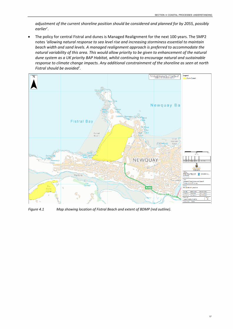
4.2 Shoreline Processes Overview 4.2.1 Key Characteristics of the Coastline Today Fistral Beach is located on the north coast of Cornwall, to the west of Newquay (refer to Figure 4.1). The beach is bounded to the north and south by the cliffed headlands and rocky foreshores of Towan Head and Pentire Point East, respectively. The geology of the headlands is primarily of Devonian slates with some intrusions of harder rock (Royal Haskoning, 2011b). Fistral bay is cut into soft shales and the beach contains shell fragments and fragments of slate and quartz (Bird, 1998).
Fistral Beach is sandy and at low‐tide the beach is wide and flat. The beach is backed by dunes (refer to Figure 4.2), with a fronting strip of 3ha active dunes and 38ha fixed dunes behind (as estimated in 2009 by Halcrow, 2009a). The active fringing dunes are backed by cliffs and these have a cover of blown sand which extends inland forming cliff top dunes and the fixed dunes are an area of inactive dunes that has now been developed into Newquay Golf Course. To the north a restaurant/shopping complex and car park (both constructed in 2003, Royal Haskoning (2011b) have been built in the dunes. South of this, the dune field is undeveloped and tapers in width to the south of the beach.
The nearshore area is largely composed of rock with some areas covered with a thin layer of sand or with pockets of sand (Halcrow, 2009b). These offshore sediments consist principally of sandy gravel, and the deposits extend to between the 15m and 30m isobaths. Beyond this the bedrock is exposed with only light patchy sediment coverings.
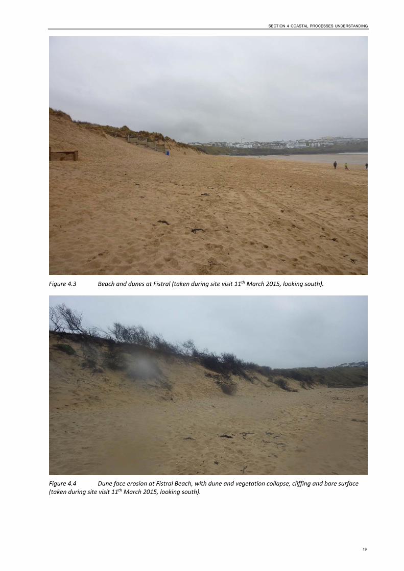
The backshore and dunes at Fistral Beach are currently eroding (refer to the aerial photographs in Figure 4.3), with significant beach loss and erosion experienced during the storms of 2013/2014. To the north, the coastline at the boundary of the cliff headland is eroding and cutting back behind the restaurant/shopping complex. The land on which the complex has been built has a history of erosion and suffered significant erosion following the 2013/2014 storms, which resulted in the collapse of the periphery of the complex and exposure of its foundations. Intervention has taken place (described below), and there is now evidence of recovery as during the site visit on the 11th March 2015 sand was observed to have built‐up and around the site‐fencing. During the winter months sand is frequently blown onshore to cover the car park (Halcrow, 2009b). This sand is cleared with some being removed from the system for farming purposes and some returned to the beach.
To the south, the active strip of dunes were also eroded significantly during the 2014/2015 winter storms. The dune face was noted to have eroded by approximately 7m and the evidence of this erosion was clear during the site visit (refer to Section 2 and Figure 4.4). The dunes showed signs of cliffing and collapse of the vegetated dune surface, and in places the dunes were left bare of vegetation. Dune
15
fencing that was in place (visible in the 2006 site visit photographs taken for the Cornwall Sand Dune and Beach Management Strategy (Halcrow, 2009c) have since been destroyed or removed with only remnants of it left scattered within the dunes. At the time of the site visit, and as can been seen from Figure 4.4, some of the vegetation on top of the dunes was black and was the result of an accidental man‐made fire and not controlled burning.
Newquay, is a very popular tourist destination in Cornwall and Fistral Beach, in particular, is intensely used (Royal Haskoning, 2011b). The coastal path runs along the top of the dunes, from which there is access to the north and south and the golf course. A number of access routes exist from the coastal path through the dunes to the beach and high footfall via these and alternative routes is exacerbating dune erosion.
Cliff recession at Fistral Beach is historically low due to the resistant nature of the headlands (Royal Haskoning, 2011b), however the backshore and dunes are evidently subject to erosion. Flooding is not reported to be a risk at Fistral Beach.
Management intervention at Fistral Beach extends along the length of the backshore and varies in type, as follows:
To the immediate north of the restaurant and shopping complex, the coastline at the boundary of the cliff headland is eroding and cutting back behind the complex (refer to Figure 4.5). Private defences have been put in place in attempt to slow the beach erosion and include rock armour and cliff‐face stabilisation measures.
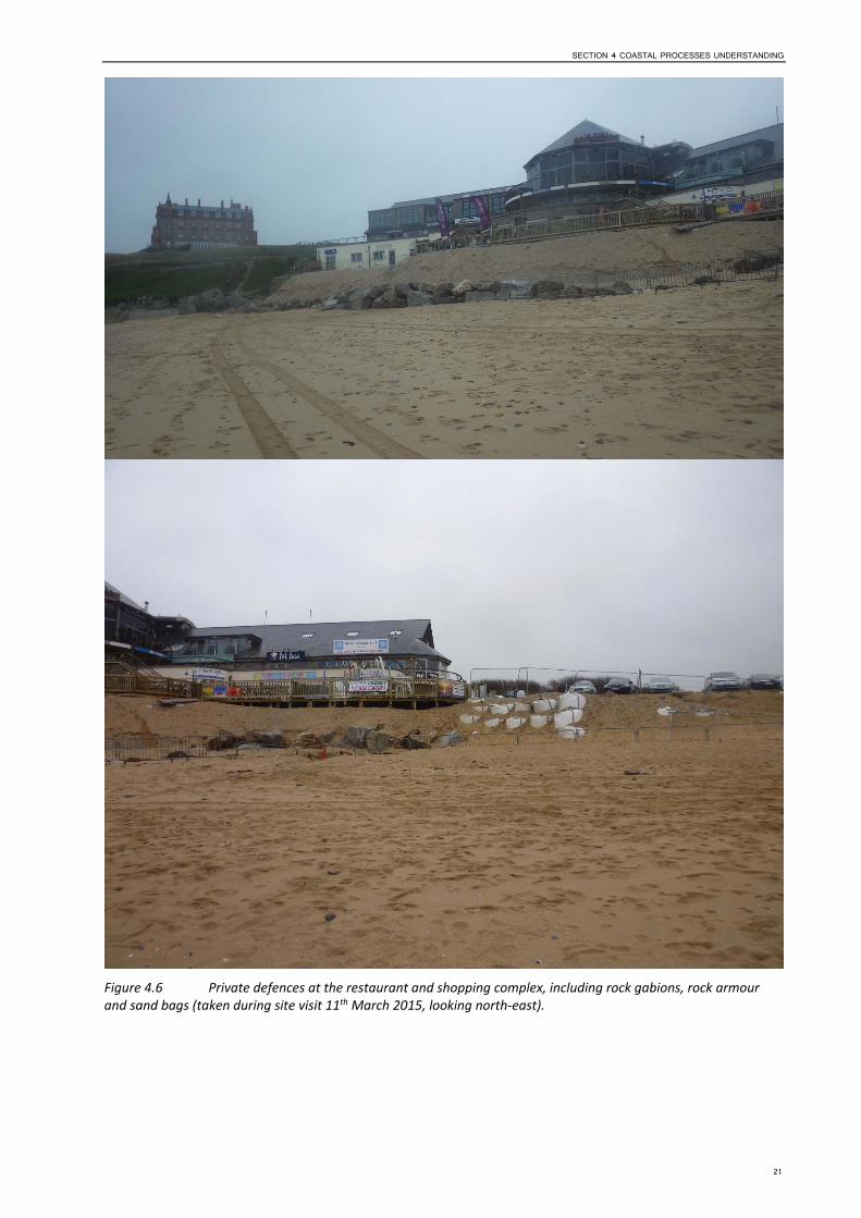
Around the footings of the restaurant and shopping complex, the underlying land is eroding. Measures have been put in place to retain the existing material beneath the footings in the form of rock gabions, rock armour and sand bags (refer to Figure 4.6). The backshore/ underlying material also appeared, on the day of the site visit (11th March 2015), to have been mechanically graded up onto the rock gabions, rock armour and sand bags to form a slope.
Located seaward of the southern end of the car park within the backshore is the RNLI building. The building has been constructed on piles to allow the free movement of sand beneath. However, erosion of the backshore resulted in exposure of the piles and in March 2014, the RNLI placed sand bags around the footings of the station.
Within the active dune strip, to the north, exist two access pathways, which have been lined with rock gabions and fencing (refer to Figure 4.7).
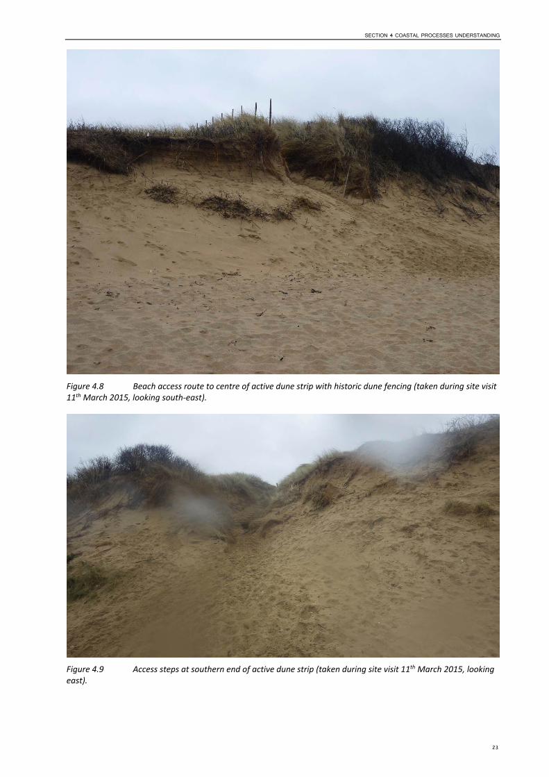
Two further access routes exists through the dunes, one to the centre, where there is evidence of dune fencing (shown in Figure 4.8), and one to the south where concrete steps have been built into the dunes (shown in Figure 4.9).
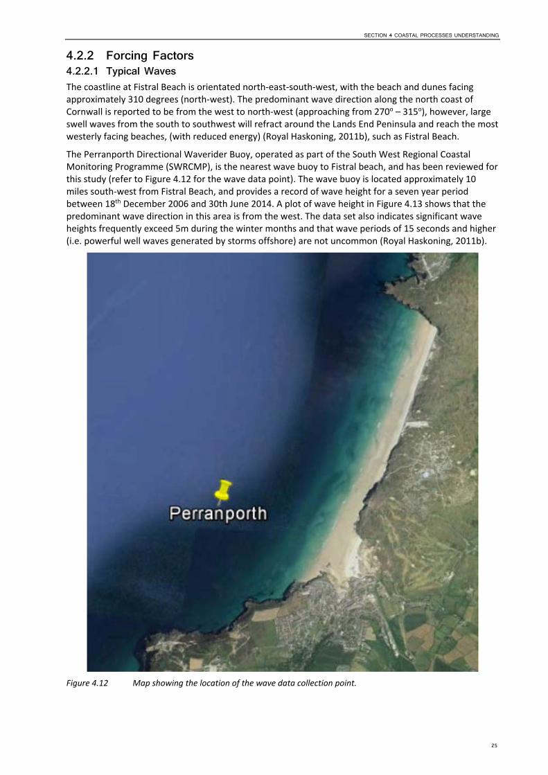
At the southern end of the beach, the toe of the cliff has been lined with rock armour to help prevent toe erosion and further cliff falls (refer to Figure 4.10).
Attempts have been made to enclose some of the active dune strip between the coastal path and the dune face with fencing to protect the conservation area (refer to Figure 4.11).
Fistral Beach is located within SMP2 PDZ12 / Management Area 31, but in terms of policy the frontage has been spilt into two units: north Fistral (where the restaurant and shopping complex is currently located) and south Fistral (Royal Haskoning, 2011a):
The policy for ‘north Fistral’ is Hold the Line in the first epoch (to 2025), Hold the Line / Managed Realignment in the second epoch (to 2055) and Managed Realignment in the third epoch (to 2105). The SMP2 notes ‘importance to local economy of surf centre, car parking and RNLI lifeguard station is recognised through HTL policy through epochs 1 & 2. But beyond epoch 2 it is likely to be technically and economically unsustainable to maintain the current shoreline position. It will also be increasingly detrimental to dune habitat and general functioning of the beach‐dune system as the shoreline and dunes to the south of the car park roll back landward. Therefore some realignment and
16
SECTION 4 COASTAL PROCESSES UNDERSTANDING
adjustment of the current shoreline position should be considered and planned for by 2055, possibly earlier’.
The policy for central Fistral and dunes is Managed Realignment for the next 100 years. The SMP2 notes ‘allowing natural response to sea level rise and increasing storminess essential to maintain beach width and sand levels. A managed realignment approach is preferred to accommodate the natural variability of this area. This would allow priority to be given to enhancement of the natural dune system as a UK priority BAP Habitat, whilst continuing to encourage natural and sustainable response to climate change impacts. Any additional constrainment of the shoreline as seen at north Fistral should be avoided’.
Figure 4.1 Map showing location of Fistral Beach and extent of BDMP (red outline).
17

2008
2010
2013
Figure 4.2 Historical aerial photographs for Fistral Beach (source: Plymouth Coastal Observatory).
18
SECTION 4 COASTAL PROCESSES UNDERSTANDING
Figure 4.3 Beach and dunes at Fistral (taken during site visit 11th March 2015, looking south).
Figure 4.4 Dune face erosion at Fistral Beach, with dune and vegetation collapse, cliffing and bare surface (taken during site visit 11th March 2015, looking south).
19
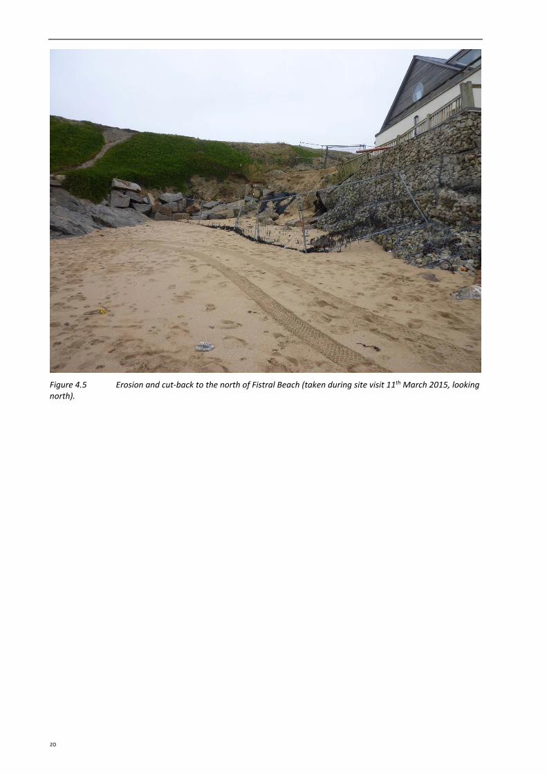
Figure 4.5 Erosion and cut‐back to the north of Fistral Beach (taken during site visit 11th March 2015, looking north).
20
SECTION 4 COASTAL PROCESSES UNDERSTANDING
Figure 4.6 Private defences at the restaurant and shopping complex, including rock gabions, rock armour and sand bags (taken during site visit 11th March 2015, looking north‐east).
21
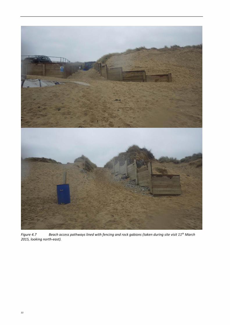
Figure 4.7 Beach access pathways lined with fencing and rock gabions (taken during site visit 11th March 2015, looking north‐east).
22
SECTION 4 COASTAL PROCESSES UNDERSTANDING
Figure 4.8 Beach access route to centre of active dune strip with historic dune fencing (taken during site visit 11th March 2015, looking south‐east).
Figure 4.9 Access steps at southern end of active dune strip (taken during site visit 11th March 2015, looking east).
23
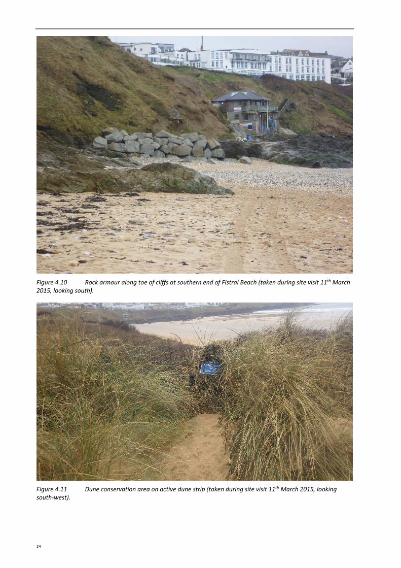
Figure 4.10 Rock armour along toe of cliffs at southern end of Fistral Beach (taken during site visit 11th March 2015, looking south).
Figure 4.11 Dune conservation area on active dune strip (taken during site visit 11th March 2015, looking south‐west).
24
SECTION 4 COASTAL PROCESSES UNDERSTANDING
4.2.2 Forcing Factors4.2.2.1 Typical Waves The coastline at Fistral Beach is orientated north‐east‐south‐west, with the beach and dunes facing approximately 310 degrees (north‐west). The predominant wave direction along the north coast of Cornwall is reported to be from the west to north‐west (approaching from 270o – 315o), however, large swell waves from the south to southwest will refract around the Lands End Peninsula and reach the most westerly facing beaches, (with reduced energy) (Royal Haskoning, 2011b), such as Fistral Beach.
The Perranporth Directional Waverider Buoy, operated as part of the South West Regional Coastal Monitoring Programme (SWRCMP), is the nearest wave buoy to Fistral beach, and has been reviewed for this study (refer to Figure 4.12 for the wave data point). The wave buoy is located approximately 10 miles south‐west from Fistral Beach, and provides a record of wave height for a seven year period between 18th December 2006 and 30th June 2014. A plot of wave height in Figure 4.13 shows that the predominant wave direction in this area is from the west. The data set also indicates significant wave heights frequently exceed 5m during the winter months and that wave periods of 15 seconds and higher (i.e. powerful well waves generated by storms offshore) are not uncommon (Royal Haskoning, 2011b).
Figure 4.12 Map showing the location of the wave data collection point.
25
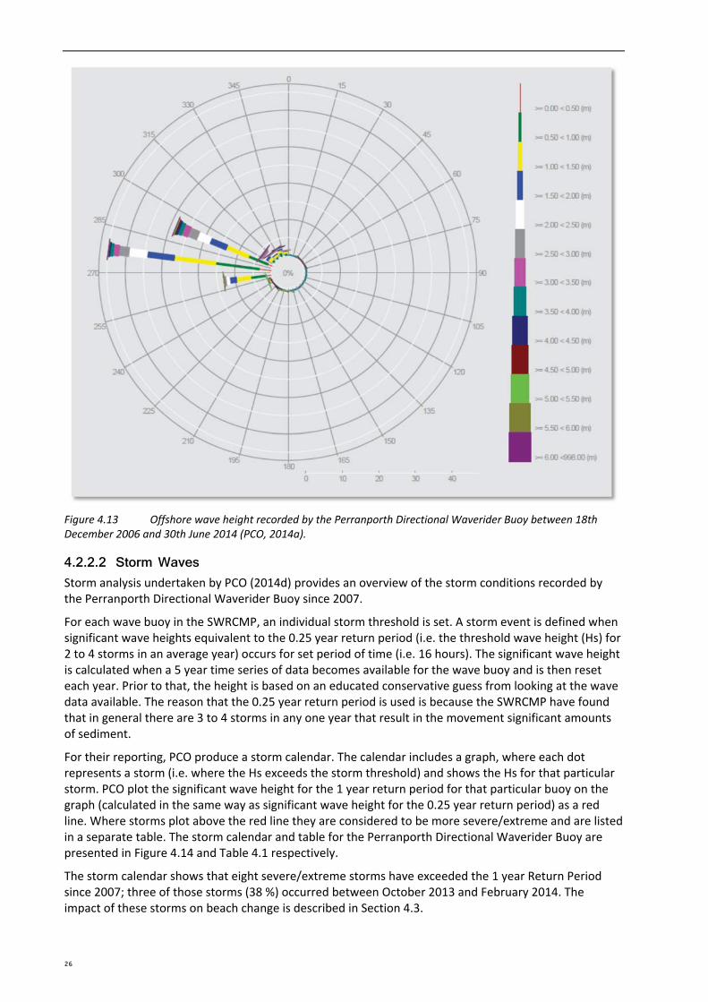
Figure 4.13 Offshore wave height recorded by the Perranporth Directional Waverider Buoy between 18th December 2006 and 30th June 2014 (PCO, 2014a).
4.2.2.2 Storm Waves Storm analysis undertaken by PCO (2014d) provides an overview of the storm conditions recorded by the Perranporth Directional Waverider Buoy since 2007.
For each wave buoy in the SWRCMP, an individual storm threshold is set. A storm event is defined when significant wave heights equivalent to the 0.25 year return period (i.e. the threshold wave height (Hs) for 2 to 4 storms in an average year) occurs for set period of time (i.e. 16 hours). The significant wave height is calculated when a 5 year time series of data becomes available for the wave buoy and is then reset each year. Prior to that, the height is based on an educated conservative guess from looking at the wave data available. The reason that the 0.25 year return period is used is because the SWRCMP have found that in general there are 3 to 4 storms in any one year that result in the movement significant amounts of sediment.
For their reporting, PCO produce a storm calendar. The calendar includes a graph, where each dot represents a storm (i.e. where the Hs exceeds the storm threshold) and shows the Hs for that particular storm. PCO plot the significant wave height for the 1 year return period for that particular buoy on the graph (calculated in the same way as significant wave height for the 0.25 year return period) as a red line. Where storms plot above the red line they are considered to be more severe/extreme and are listed in a separate table. The storm calendar and table for the Perranporth Directional Waverider Buoy are presented in Figure 4.14 and Table 4.1 respectively.
The storm calendar shows that eight severe/extreme storms have exceeded the 1 year Return Period since 2007; three of those storms (38 %) occurred between October 2013 and February 2014. The impact of these storms on beach change is described in Section 4.3.
26

SECTION 4 COASTAL PROCESSES UNDERSTANDING
Figure 4.14 Storm calendar for Perranporth (source: PCO, 2014b).
Table 4.1 Storms exceeding 1 year Return Period at Perranporth since deployment in 2007. Those occurring during the storm season October 2013 to February 2014 are shaded pink (source: PC0, 2014b).
Date Wave Height (m) Return Period
01/02/2014 7.28 Greater than 1 in 20 years
02/11/2013 7.06 1 in 10 years
27/12/2013 6.81 1 in 5 years
15/12/2011 6.75 1 in 5 years
12/03/2008 6.53 1 in 3 years
10/03/2008 6.37 1 in 2 years
11/11/2010 6.3 1 in 1 year
31/03/2010 6.25 1 in 1 year
4.2.2.3 Tides Tidal levels have been extracted from the current Admiralty Tide Tables (UKHO, 2013) for the closest location with the best available data, in this case Newquay, and converted to Ordnance Datum (mOD), see Table 4.2.
27
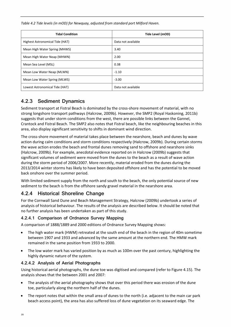
Table 4.2 Tide levels (in mOD) for Newquay, adjusted from standard port Milford Haven.
Tidal Condition Tide Level (mOD)
Highest Astronomical Tide (HAT) Data not available
Mean High Water Spring (MHWS) 3.40
Mean High Water Neap (MHWN) 2.00
Mean Sea Level (MSL) 0.38
Mean Low Water Neap (MLWN) ‐1.10
Mean Low Water Spring (MLWS) ‐3.00
Lowest Astronomical Tide (HAT) Data not available
4.2.3 Sediment Dynamics Sediment transport at Fistral Beach is dominated by the cross‐shore movement of material, with no strong longshore transport pathways (Halcrow, 2009b). However, the SMP2 (Royal Haskoning, 2011b) suggests that under storm conditions from the west, there are possible links between the Gannel, Crantock and Fistral Beach. The SMP2 also notes that Fistral beach, like the neighbouring beaches in this area, also display significant sensitivity to shifts in dominant wind direction.
The cross‐shore movement of material takes place between the nearshore, beach and dunes by wave action during calm conditions and storm conditions respectively (Halcrow, 2009b). During certain storms the wave action erodes the beach and frontal dunes removing sand to offshore and nearshore sinks (Halcrow, 2009b). For example, anecdotal evidence reported on in Halcrow (2009b) suggests that significant volumes of sediment were moved from the dunes to the beach as a result of wave action during the storm period of 2006/2007. More recently, material eroded from the dunes during the 2013/2014 winter storms has likely to have been deposited offshore and has the potential to be moved back onshore over the summer period.
With limited sediment supply from the north and south to the beach, the only potential source of new sediment to the beach is from the offshore sandy gravel material in the nearshore area.
4.2.4 Historical Shoreline Change For the Cornwall Sand Dune and Beach Management Strategy, Halcrow (2009b) undertook a series of analysis of historical behaviour. The results of the analysis are described below. It should be noted that no further analysis has been undertaken as part of this study.
4.2.4.1 Comparison of Ordnance Survey Mapping A comparison of 1888/1889 and 2000 editions of Ordnance Survey Mapping shows:
The high water mark (HWM) retreated at the south end of the beach in the region of 40m sometime between 1907 and 1933 and advanced by the same amount at the northern end. The HMW mark remained in the same position from 1933 to 2000.
The low water mark has varied position by as much as 100m over the past century, highlighting the highly dynamic nature of the system.
4.2.4.2 Analysis of Aerial Photographs Using historical aerial photographs, the dune toe was digitised and compared (refer to Figure 4.15). The analysis shows that the between 2001 and 2007:
The analysis of the aerial photography shows that over this period there was erosion of the dune toe, particularly along the northern half of the dunes.
The report notes that within the small area of dunes to the north (i.e. adjacent to the main car park beach access point), the area has also suffered loss of dune vegetation on its seaward edge. The
28
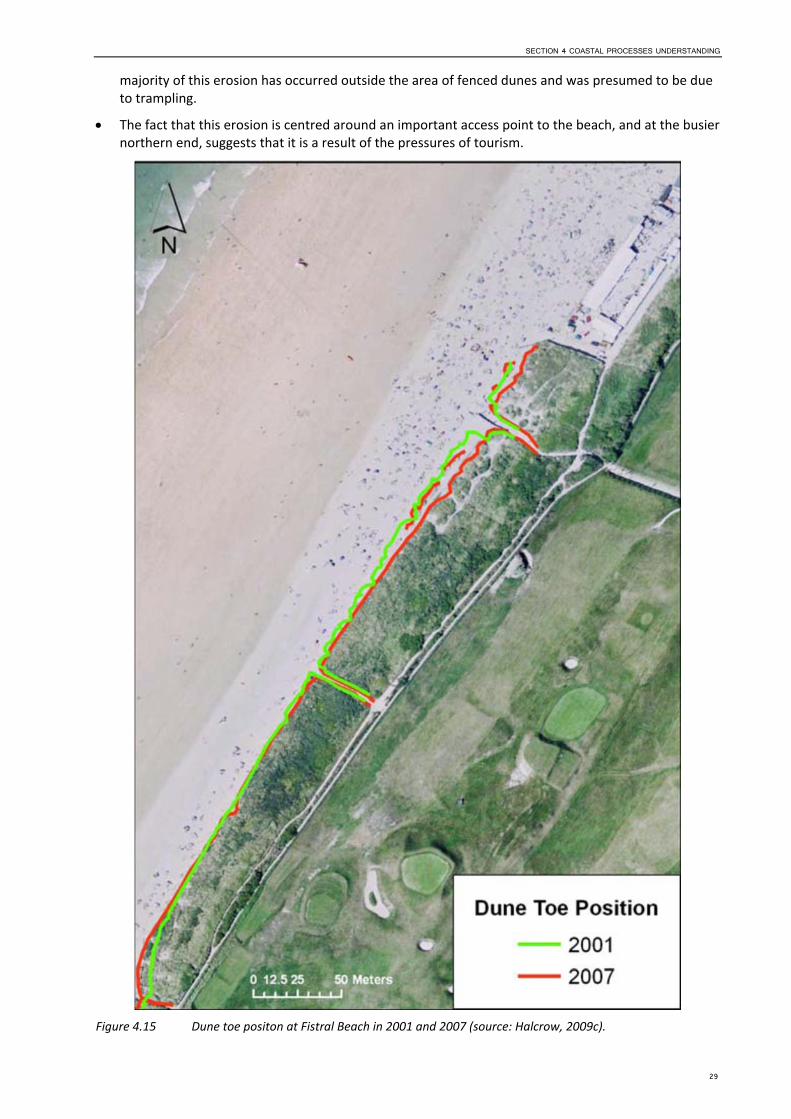
SECTION 4 COASTAL PROCESSES UNDERSTANDING
majority of this erosion has occurred outside the area of fenced dunes and was presumed to be due to trampling.
The fact that this erosion is centred around an important access point to the beach, and at the busier northern end, suggests that it is a result of the pressures of tourism.
Figure 4.15 Dune toe positon at Fistral Beach in 2001 and 2007 (source: Halcrow, 2009c).
29
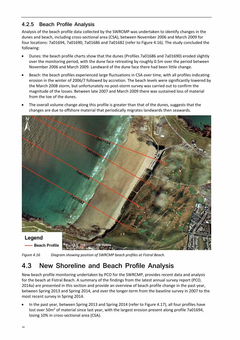
4.2.5 Beach Profile Analysis Analysis of the beach profile data collected by the SWRCMP was undertaken to identify changes in the dunes and beach, including cross‐sectional area (CSA), between November 2006 and March 2009 for four locations: 7a01694, 7a01690, 7a01686 and 7a01682 (refer to Figure 4.16). The study concluded the following:
Dunes: the beach profile charts show that the dunes (Profiles 7a01686 and 7a01690) eroded slightly over the monitoring period, with the dune face retreating by roughly 0.5m over the period between November 2006 and March 2009. Landward of the dune face there had been little change.
Beach: the beach profiles experienced large fluctuations in CSA over time, with all profiles indicating erosion in the winter of 2006/7 followed by accretion. The beach levels were significantly lowered by the March 2008 storm, but unfortunately no post‐storm survey was carried out to confirm the magnitude of the losses. Between late 2007 and March 2009 there was sustained loss of material from the toe of the dunes.
The overall volume change along this profile is greater than that of the dunes, suggests that the changes are due to offshore material that periodically migrates landwards then seawards.
Figure 4.16 Diagram showing position of SWRCMP beach profiles at Fistral Beach.
4.3 New Shoreline and Beach Profile Analysis New beach profile monitoring undertaken by PCO for the SWRCMP, provides recent data and analysis for the beach at Fistral Beach. A summary of the findings from the latest annual survey report (PCO, 2014a) are presented in this section and provide an overview of beach profile change in the past year, between Spring 2013 and Spring 2014, and over the longer‐term from the baseline survey in 2007 to the most recent survey in Spring 2014.
In the past year, between Spring 2013 and Spring 2014 (refer to Figure 4.17), all four profiles have lost over 50m2 of material since last year, with the largest erosion present along profile 7a01694, losing 10% in cross‐sectional area (CSA).
30

SECTION 4 COASTAL PROCESSES UNDERSTANDING
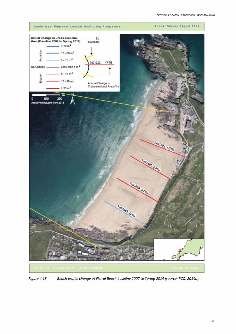
Over the longer term, between 2007 and Spring 2014 (refer to Figure 4.18), all profiles show the beach to be losing material, with only profile 7a01682 gaining material (2% CSA).
Mapping of the Mean High Water (MHW) contour (refer to Figure 4.19Error! Reference source not found.) shows a trend for the seaward movement of the MHW contour to the north, but no clear trend to the south.
As part of the SWRCMP, PCO have also prepared a report (PCO, 2014b) which examines the change to a selection of the beaches along the south‐west coast following the winter 2013/2014 storms. This analysis includes a plot of beach elevation change using LiDAR data from before and after the storms. Where this analysis has been completed for the BMP sites, a summary of the changes are described below.
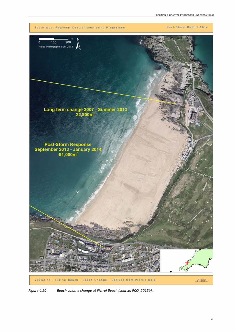
The net change from Summer 2013 to Winter 2013/14 was ‐90,954m3 and the net change from Winter 2013/14 to Summer 2014 was 5,245m3. The percentage of beach volume recovered by Summer 2014 was +6%.
The long‐term net change between the baseline survey in 2007 and Summer 2013 is 22,900m3 (refer to Figure 4.20). The beach showed recovery of material during the storms.
31
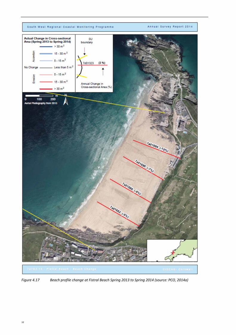
Figure 4.17 Beach profile change at Fistral Beach Spring 2013 to Spring 2014 (source: PCO, 2014a)
32
SECTION 4 COASTAL PROCESSES UNDERSTANDING
Figure 4.18 Beach profile change at Fistral Beach baseline 2007 to Spring 2014 (source: PCO, 2014a).
33
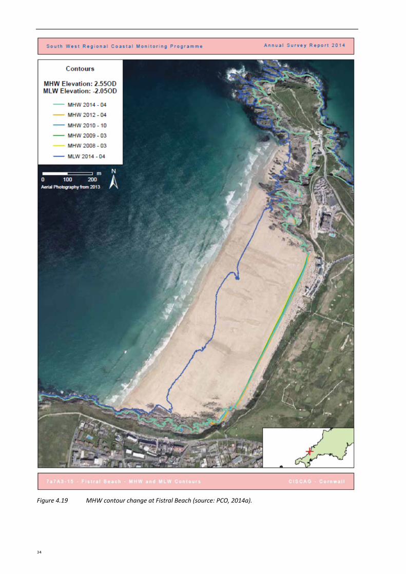
Figure 4.19 MHW contour change at Fistral Beach (source: PCO, 2014a).
34
SECTION 4 COASTAL PROCESSES UNDERSTANDING
Figure 4.20 Beach volume change at Fistral Beach (source: PCO, 2015b).
35
4.4 Summary and Recommendations4.4.1 Summary The beach at Fistral is north‐west facing and exposed to the predominant westerly/north‐westerly waves. The beach is a closed system, with alongshore sediment transport limited by the cliffed headlands and rock platforms to the north and south. Rather, sediment movement across the beach tends to be across the shore in response to winter storm waves and calmer summer conditions. The backshore and dunes are subject to erosion and suffered particularly during the storms in 2006/2007, 2008 and 2014/2015. The dunes are also subject to erosion via beach access routes due to high footfall through the dunes. Dune fencing that was put in place to help stabilise the dunes was washed away over the 2014/2015 winter period. A recent fire in the dunes also resulted in burning of much of the vegetation, which would otherwise help to stabilise the dunes. Beach profile analysis shows the beach to be eroding, with accretion at the southern end. During the recent site visit on the 11th March, there was signs of beach recovery to the north, with accumulation of material against the construction fencing and against the dune toe in places.
4.4.2 Recommendations The dunes require some significant management intervention to help restore them after the 2014/2015 winter storms and to help provide some resistance to the erosion they incur from high footfall. Although an area has been fenced off as a conservation zone, signage is minimal.
It is therefore recommended that new dune fencing is constructed along the toe of the dunes to encourage re‐growth. Access paths through the dunes should be managed, also with fencing.
Signage showing how the general public can act to help look after the dunes would also help to bring the general public’s attention to the vulnerability of the dunes.
Form a ‘Friends of Fistral Dunes’ group, which could draw members from the local residents of Newquay. Members could help to look after the dunes and management measures, prepare signage, and help to raise funds for the require management interventions.
The local university could also use Fistral Beach as a location for volunteer work, thereby contributing the students residential and development activities.
4.4.3 Uncertainties and Limitations None to report.
36
SECTION 5 SITE SUMMARY
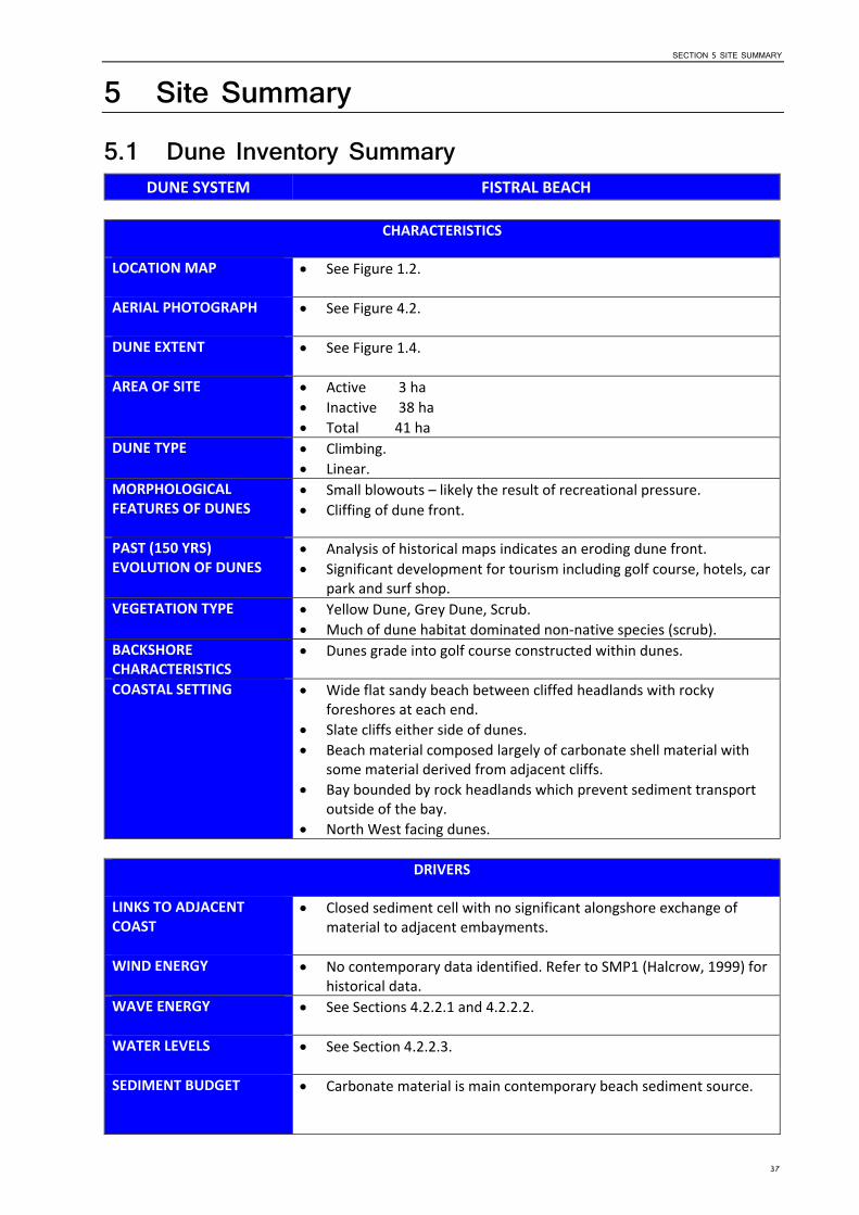
5 Site Summary 5.1 Dune Inventory Summary
DUNE SYSTEM FISTRAL BEACH
CHARACTERISTICS
LOCATION MAP See Figure 1.2.
AERIAL PHOTOGRAPH See Figure 4.2.
DUNE EXTENT See Figure 1.4.
AREA OF SITE Active 3 ha Inactive 38 ha Total 41 ha
DUNE TYPE Climbing. Linear.
MORPHOLOGICAL FEATURES OF DUNES
Small blowouts – likely the result of recreational pressure. Cliffing of dune front.
PAST (150 YRS) EVOLUTION OF DUNES
Analysis of historical maps indicates an eroding dune front. Significant development for tourism including golf course, hotels, car
park and surf shop. VEGETATION TYPE Yellow Dune, Grey Dune, Scrub.
Much of dune habitat dominated non‐native species (scrub). BACKSHORE CHARACTERISTICS
Dunes grade into golf course constructed within dunes.
COASTAL SETTING Wide flat sandy beach between cliffed headlands with rocky foreshores at each end.
Slate cliffs either side of dunes. Beach material composed largely of carbonate shell material with
some material derived from adjacent cliffs. Bay bounded by rock headlands which prevent sediment transport
outside of the bay. North West facing dunes.
DRIVERS
LINKS TO ADJACENT COAST
Closed sediment cell with no significant alongshore exchange of material to adjacent embayments.
WIND ENERGY No contemporary data identified. Refer to SMP1 (Halcrow, 1999) for historical data.
WAVE ENERGY See Sections 4.2.2.1 and 4.2.2.2.
WATER LEVELS See Section 4.2.2.3.
SEDIMENT BUDGET Carbonate material is main contemporary beach sediment source.
37
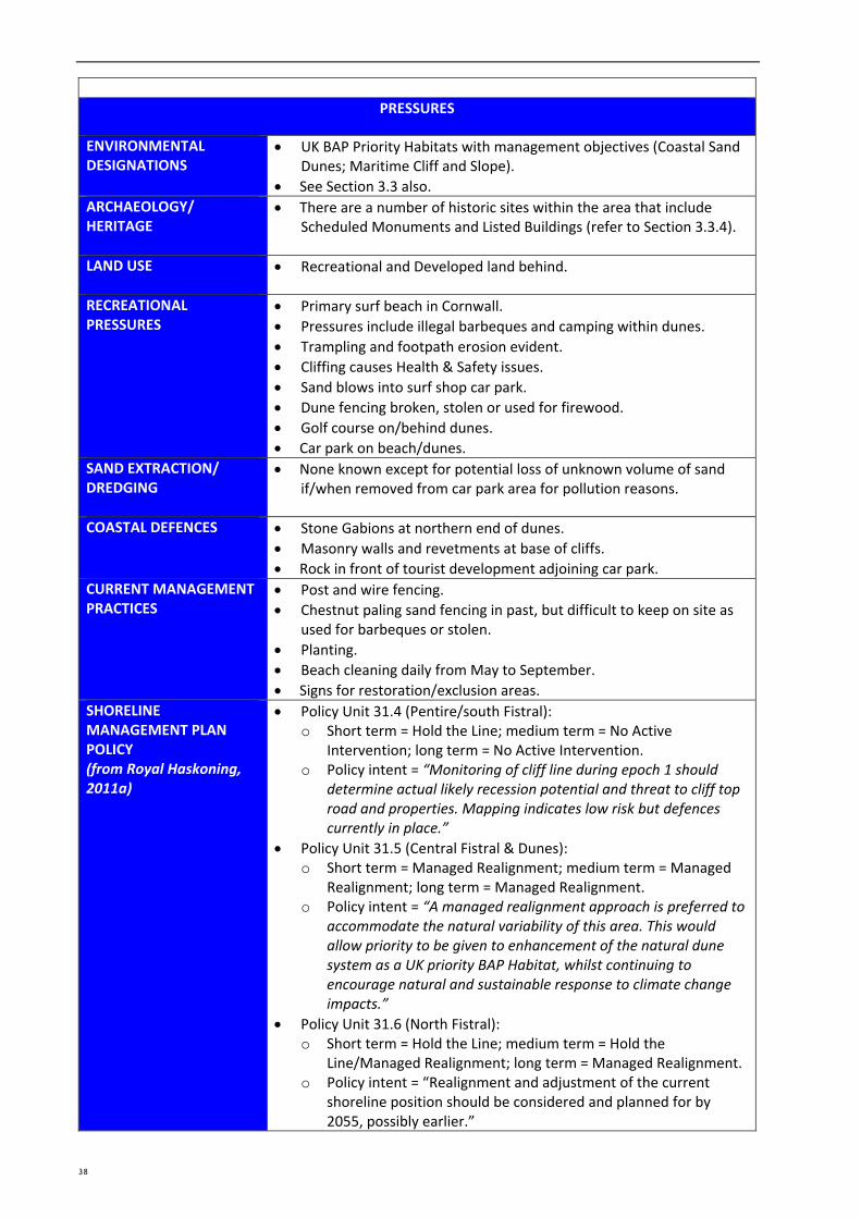
PRESSURES
ENVIRONMENTAL DESIGNATIONS
UK BAP Priority Habitats with management objectives (Coastal Sand Dunes; Maritime Cliff and Slope).
See Section 3.3 also. ARCHAEOLOGY/ HERITAGE
There are a number of historic sites within the area that include Scheduled Monuments and Listed Buildings (refer to Section 3.3.4).
LAND USE Recreational and Developed land behind.
RECREATIONAL Primary surf beach in Cornwall. PRESSURES Pressures include illegal barbeques and camping within dunes.
Trampling and footpath erosion evident. Cliffing causes Health & Safety issues. Sand blows into surf shop car park. Dune fencing broken, stolen or used for firewood. Golf course on/behind dunes. Car park on beach/dunes.
SAND EXTRACTION/ DREDGING
None known except for potential loss of unknown volume of sand if/when removed from car park area for pollution reasons.
COASTAL DEFENCES Stone Gabions at northern end of dunes. Masonry walls and revetments at base of cliffs. Rock in front of tourist development adjoining car park.
CURRENT MANAGEMENT PRACTICES
Post and wire fencing. Chestnut paling sand fencing in past, but difficult to keep on site as
used for barbeques or stolen. Planting. Beach cleaning daily from May to September. Signs for restoration/exclusion areas.
SHORELINE MANAGEMENT PLAN POLICY (from Royal Haskoning, 2011a)
Policy Unit 31.4 (Pentire/south Fistral): o Short term = Hold the Line; medium term = No Active
Intervention; long term = No Active Intervention. o Policy intent = “Monitoring of cliff line during epoch 1 should
determine actual likely recession potential and threat to cliff top road and properties. Mapping indicates low risk but defences currently in place.”
Policy Unit 31.5 (Central Fistral & Dunes): o Short term = Managed Realignment; medium term = Managed
Realignment; long term = Managed Realignment. o Policy intent = “A managed realignment approach is preferred to
accommodate the natural variability of this area. This would allow priority to be given to enhancement of the natural dune system as a UK priority BAP Habitat, whilst continuing to encourage natural and sustainable response to climate change impacts.”
Policy Unit 31.6 (North Fistral): o Short term = Hold the Line; medium term = Hold the
Line/Managed Realignment; long term = Managed Realignment. o Policy intent = “Realignment and adjustment of the current
shoreline position should be considered and planned for by 2055, possibly earlier.”
38
SECTION 5 SITE SUMMARY
MANAGED BY Cornwall Council.
5.2 Recommendation for update of 2009 Pilot BDMP Since the 2009 pilot BDMP was produced for Fistral Beach, there have been a number of important changes/developments in coastal management including:
Lessons learnt from implementation of the 2009 BDMP.
Change in Shoreline Management Plan policy in 2011 from Hold the Line to No Active Intervention (PU 31.4) and Managed Realignment (PU 31.6); and from Do Nothing to Managed Realignment in PU 31.5.
Six years’ monitoring by the South West Regional Coastal Monitoring Programme to provide information on recent coastal evolution.
Experience following the winter 2013/14 storms, the worst in a generation.
Proposed changes to environmental designations in the area (e.g. rMCZ).
For all of these reasons, it is recommended that the 2009 pilot BDMP be fully reviewed and updated as part of this current project to reflect the above changes (i.e. continue to include Fistral Beach in the following Stages 2 to 4 of BDMP development as outlined in Figure 1.3 above).
39
6 SECTION 6 REFERENCES
References ERCCIS and Cornwall Wildlife Trust (2010). County Geology Site Criteria for Cornwall and the Isles of
Scilly.
Frampton, A.P.R. (2010). A review of amenity beach management. Journal of Coastal research, 26(6), 1112‐1122, November 2010.
Halcrow (2009a). Cornwall Sand Dune and Beach Management Strategy. Report produced by Halcrow Group Limited for the Cornwall and Isles of Scilly Coastal Advisory Group, September 2009.
Halcrow (2009b). Sand Dune Inventory. Cornwall Sand Dune and Beach Management Strategy. Report produced by Halcrow Group Limited for the Cornwall and Isles of Scilly Coastal Advisory Group, September 2009.
Halcrow (2009c). Sediment Budget Report. Cornwall Sand Dune and Beach Management Strategy. Report produced by Halcrow Group Limited for the Cornwall and Isles of Scilly Coastal Advisory Group, September 2009.
Halcrow (2009d). Site Visit Report. Cornwall Sand Dune and Beach Management Strategy. Report produced by Halcrow Group Limited for the Cornwall and Isles of Scilly Coastal Advisory Group, September 2009.
Halcrow (1999). Land’s End to Hartland Point Shoreline Management Plan. Volumes 1 to 4. Report produced by Halcrow Group Limited for Cornwall and Isles of Scilly Coastal Group.
Plymouth Coastal Observatory (PCO) (2014a). Annual Survey Report. Land’s End to Hartland Point. Report Number AR43. Report produced for the South West Regional Monitoring Programme, September 2014.
Plymouth Coastal Observatory (PCO) (2014b). Review of South West Coast Beach Response to Wave Conditions During the Winter of 2013‐2014. Report Number SW SR01. Report produced for the South West Regional Monitoring Programme, June 2014.
Royal Haskoning (2011a). Cornwall and Isles of Scilly Shoreline Management Plan Review (SMP2). Report for the Cornwall and Isles of Scilly Coastal Group. February 2011.
Royal Haskoning (2011b). Cornwall and Isles of Scilly SMP2. Main Report, Final. Report produced by Royal Haskoning for the Cornwall and Isles of Scilly Coastal Advisory Group, February 2011.
Royal Haskoning (2011c). Cornwall and Isles of Scilly SMP2. Appendix C, Review of Coastal Processes and Geomorphology, Final Report. Report produced by Royal Haskoning for the Cornwall and Isles of Scilly Coastal Advisory Group, February 2011. Report reference 9T8801.
Spalding Associates (2005). Ecological Assessment of Coastal Zone Management Issues at Fistral, Cornwall. Report for Cornwall County Council.
United Kingdom Hydrographic Office, UKHO (2013). Admiralty Tide Tables. Volume 1. United Kingdom and Ireland. Reference NP201‐13.
40