Embed Size (px)
Citation preview
Baird Substation Connecticut Siting Council Application
APPLICATION TO THE CONNECTICUT
SITING COUNCIL
FOR THE
CONSTRUCTION AND OPERATION OF A NEW 115/13.8
KILOVOLT DISTRIBUTION SUBSTATION
IN THE
TOWN OF STRATFORD, CONNECTICUT
BY
THE UNITED ILLUMINATING COMPANY
DECEMBER 2015
Baird Substation Connecticut Siting Council Application
TABLE OF CONTENTS
CONNECTICUT SITING COUNCIL APPLICATION GUIDE FOR AN ELECTRIC SUBSTATION
FACILITY April 2010……………………………………………………………………………………i
I. EXECUTIVE SUMMARY .......................................................................................................... 1
I.A Overview of the Proposed Project and Project Need .......................................................................... 1
I.B Location of the Proposed Baird Substation Site.................................................................................. 4
I.C Proposed Substation Facilities .............................................................................................................. 6
I.D Construction Sequencing, Schedule and Project Costs ...................................................................... 7
I.E Environmental Impact .......................................................................................................................... 8
I.F Electric and Magnetic Fields ................................................................................................................ 9
I.G Alternative Evaluation Process ........................................................................................................... 10
II. FORM OF THE APPLICATION ............................................................................................... 13
II.A Purpose of the Application .................................................................................................................. 13
II.B Statutory Authority ............................................................................................................................. 13
II.C Legal Name and Address of Applicant .............................................................................................. 13
II.D Applicant’s Contacts and formal signatures ..................................................................................... 14
III. FORMAL REQUIREMENTS .................................................................................................... 15
III.A Proof of Service .................................................................................................................................... 15
III.B Notice to Community Organizations .................................................................................................. 18
III.C Public Notice......................................................................................................................................... 20
III.D Notice to Abutting Landowners .......................................................................................................... 21
IV. PROJECT OVERVIEW AND NEED ........................................................................................ 23
IV.A Project Need ......................................................................................................................................... 23
IV.B Benefits of the Substation .................................................................................................................... 25
IV.C Alternative Energy and Capacity Solutions Considered .................................................................. 25
V. DESCRIPTION OF PROPOSED FACILITY ........................................................................... 28
V.A Project Location ................................................................................................................................... 28
V.B Land Requirements and Access .......................................................................................................... 30
V.C Access Roads and Work Pads ............................................................................................................. 32
V.D Site History and Environmental Remediation .................................................................................. 33
V.E Description of Proposed Substation Facilities ................................................................................... 33
V.F Estimated Cost of the Project ............................................................................................................. 36
V.G Facility Service Life ............................................................................................................................. 36
VI. PROPOSED CONSTRUCTION AND OPERATION/MAINTENANCE PROCEDURES ..... 37
VI.A Construction Procedures ..................................................................................................................... 37
Baird Substation Connecticut Siting Council Application VI.B Substation Construction Sequence ..................................................................................................... 37
VI.C Substation Construction Coordination with Petition 1176 .............................................................. 40
VI.D Stormwater Management .................................................................................................................... 41
VI.E General Construction Work Hours and Schedule ............................................................................ 42
VI.F Distribution Line Connections ............................................................................................................ 42
VI.G Project Facilities Reliability, Safety and Security Information ....................................................... 43
Emergency Operations and Shutdown .................................................................................................................... 43
Fire Detection Technology ..................................................................................................................................... 44
Physical Site Security ............................................................................................................................................. 44
VI.H Traffic Considerations ......................................................................................................................... 45
VII. EXISTING ENVIRONMENTAL CONDITIONS ..................................................................... 46
VII.A Topography, Geology and Soils .......................................................................................................... 46
VII.B Water Resources and Water Quality ................................................................................................. 47
VII.C Biological Resources ............................................................................................................................ 48
VII.D Land Use, Zoning, Land Use Plans and Recreation ......................................................................... 49
VII.E Visual and Aesthetic Characteristics ................................................................................................. 50
VII.F Transportation and Utilities ............................................................................................................... 51
VII.G Cultural (Archaeological and Historic) Resources ........................................................................... 51
VII.H Air Quality, Noise and Lighting ......................................................................................................... 52
VIII. POTENTIAL ENVIRONMENTAL EFFECTS AND MITIGATION MEASURES ................ 55
VIII.A Topography, Geology and Soils .......................................................................................................... 55
VIII.B Water Resources and Water Quality ................................................................................................. 56
VIII.C Biological Resources ............................................................................................................................ 58
VIII.D Land Use, Zoning, Land Use Plans and Recreation ......................................................................... 59
VIII.E Visual and Aesthetic Characteristics ................................................................................................. 59
VIII.F Transportation and Utilities ............................................................................................................... 60
VIII.G Cultural (Archaeological and Historic) Resources ........................................................................... 61
IX. ELECTRIC AND MAGNETIC FIELD CONSIDERATIONS ...................................................... 64
X. ALTERNATIVES CONSIDERED ................................................................................................. 72
X.A UI Site Selection Criteria .................................................................................................................... 73
General Criteria ...................................................................................................................................................... 73
Distribution System Considerations in the Stratford Area ...................................................................................... 74
X.B Identification and Screening of Potential Sites .................................................................................. 75
Overview of the Site Screening Process ................................................................................................................. 75
Bruce Street ............................................................................................................................................................ 77
West Broad Street ................................................................................................................................................... 78
Baird Annex ............................................................................................................................................................ 79
Baird Substation Connecticut Siting Council Application Summary of Site Selection Process ........................................................................................................................ 80
XI. PROJECT SCHEDULE ............................................................................................................. 81
XII. PROJECT PERMITS, APPROVALS AND CONSULTATIONS ............................................ 81
XIV. BULK FILING OF MUNICIPAL DOCUMENTS .................................................................... 86
XV. APPLICATION FILING FEE .................................................................................................... 86
XVI. CONCLUSION .......................................................................................................................... 86
APPENDICES
APPENDIX A MAPS AND DRAWINGS
DR.1 U.S.G.S. Topographic Quadrangle Map: Proposed Project Location
DR.2 Proposed Substation Location Within the Town of Stratford
DR.3 Site Plan
DR.4 Substation Drawings
DR.5 Existing and Historic Aerial Photographs of the Project Site
DR.6 Public Facilities and Resources (Map and Table)
APPENDIX B AGENCY CORRESPONDENCE
SH.1 Natural Diversity Database – Baird Annex
SH.2 State Historic Preservation Office – Dunne
SH.3 State Historic Preservation Office – Mancuso
APPENDIX C WETLAND DELINEATION REPORT
APPENDIX D NOISE ASSESSMENT
APPENDIX E VISIBILITY ANALYSIS
APPENDIX F SITE SELECTION STUDY
APPENDIX G ELECTRIC AND MAGNETIC FIELD ASSESSMENT
APPENDIX H BAIRD SUBSTATION CONDITION ASSESSMENT
DISTRIBUTION CAPACITY AND VOLTAGE REGULATION
APPENDIX I BASELINE ENVIRONMENTAL ASSESSMENT: BAIRD
SUBSTATION
APPENDIX J CULTURAL RESOURCE REVIEW
APPENDIX K HABITAT ASSESSMENT FOR NORTHERN LONG EARED BAT
APPENDIX L FORMAL REQUIREMENTS
Baird Substation Connecticut Siting Council Application
BULK FILING OF MUNICIPAL DOCUMENTS – PROVIDED UNDER SEPARATE COVER
A. Abutter Information (Notice and List)
B. Town of Stratford Inland Wetlands and Watercourses Regulations
C. Town of Stratford Zoning Regulations and Amendments
D. Stratford Plan of Conservation and Development 2014
E. Greater Bridgeport Regional Council Draft Plan of Conservation and Development
F. Stratford Waterfront Vision Plan
G. Housatonic Greenway Plan
H. Baird Substation Municipal Consultation Filing
I. Appendix I Baseline Environmental Assessment: Baird Substation
J. Town of Stratford Zoning Map
Baird Substation Connecticut Siting Council Application
LIST OF FIGURES
Figure No.
I-1 Visual Simulation of the Proposed Substation …………………………… …….…..…3
I-2 Overview Map: Proposed Baird Substation Site………………………… ……….……4
I-3 Aerial Photograph of UI Property and Substation Site at 1770 Stratford Avenue…..….5
V.A-1 General Property Location……………………………….……………………….…....29
V.A-2 Aerial Overlay.…………………………………………………………………........…30
VII.E-1 Visual Simulation of the Proposed Substation with Changes Highlighted…….……....53
IX-1 Electric and Magnetic Field Levels in the Environment…………………….….……...64
IX-2 Perpendicular Profiles Extending from the Perimeter of the Existing and Proposed
Baird Substation……………………………………………………………………….67
IX-3 Perpendicular Profile #6 Extending from the Eastern Perimeter toward the Two
Roads Brewing Company……………………………………………………….…......68
IX-4 Perpendicular Profile #7 Extending from the Northern Perimeter toward
Jackson Avenue……………………………………………………….…….................68
X.B-1 Alternate Sites Evaluated………………………………………………………...........77
LIST OF TABLES
Table No.
VII.H-1 Typical Noise Levels Associated with Different Indoor and Outdoor
Activities……………………………………………………………………………….53
IX-1 ICNIRP and ICES Guidelines for EMF Exposure………………………….………….69
XII-1 Permits and Approvals Applicable to the Baird Substation Project………………...…82
XII-2 Summary of Outreach Efforts ………………………………………………………....84
Baird Substation Connecticut Siting Council Application
i
CONNECTICUT SITING COUNCIL APPLICATION GUIDE FOR AN ELECTRIC
SUBSTATION FACILITY April 2010
This application guide is designed to assist applicants in filing for a Certificate of Environmental
Compatibility and Public Need (Certificate) from the Connecticut Siting Council (Council) for
the construction of an electric substation facility. Such facilities are defined in the Connecticut
General Statutes § 16-50i (a) (4).
Applicants should consult Connecticut General Statutes §§ 16-50g through 16-50aa, § 16a-7c,
and Sections 16-50j-1 through 16-50z-4 of the Regulations of Connecticut State Agencies to assure
complete compliance with the requirements of those sections. Where appropriate, statutory and
regulatory references are noted below.
I. PRE-APPLICATION PROCESS
A. Municipal Consultation (Conn. Gen. Stat. § 16-50l (e)) Refer to Bulk Filing
“….at least 60 days prior to the filing of any application with the Council, the applicant shall
consult with the municipality in which the facility may be located and with any other
municipality required to be served with a copy of the application under subdivision (1) of
subsection (b) of this section [any adjoining municipality having a boundary not more than
2500 feet from such facility] concerning the proposed and alternative sites of the
facility…..Such consultation with the municipality shall include, but not be limited to,
good faith efforts to meet with the chief elected official of the municipality. At the time of
the consultation, the applicant shall provide the chief elected official with any technical
reports concerning the public need, the site selection process and the environmental effects
of the proposed facility. The municipality may conduct public hearings and meetings as it
deems necessary for it to advise the applicant of its recommendations concerning the
proposed facility. Within 60 days of the initial consultation, the municipality shall issue its
recommendations to the applicant. No later than 15 days after submitting the application
to the Council, the applicant shall provide to the Council all materials provided to the
municipality and a summary of the consultations with the municipality including all
recommendations issued by the municipality.”
“…the applicant shall submit to the Connecticut Energy Advisory Board (CEAB) the same
information that it provides to a municipality … on the same day of the consultation with
the municipality.”
B. APPLICATION TO MUNICIPAL AGENCIES (CONN. GEN. STAT. § 16-50X (D)) Refer Bulk Filing
Municipal zoning and inland wetland agencies may regulate and restrict the location of an
electric substation facility. Such action must be taken within 30 days of application filed
with the Council. Orders made by the municipal zoning and inland wetland agencies may be
appealed within thirty days by any party or municipality required to be served with a
copy of the application.
ii
Baird Substation Connecticut Siting Council Application
II. Form of Application (Regs. Conn. State Agencies § 16-50l-2)
All applications shall include the following components:
A. The purpose for which the application is being made;
Refer to Section II.A
B. The statutory authority for such application;
Refer to Section II.B
C. The exact legal name of each person seeking the authorization or relief and the address or
principal place of business of each such person. If any applicant is a corporation, trust
association, or other organized group, it shall also give the state under the laws of which it
was created or organized; Refer to Section II.C
D. The name, title, address, and telephone number of the attorney or other person to whom
correspondence or communications in regard to the application are to be addressed. Notice,
orders, and other papers may be served upon the person so named, and such service shall
be deemed to be service to the applicant; Refer to Section II.D
E. Such information as may be required under the applicable provisions of Section 16-50l
of the Connecticut General Statutes; Refer to this Document and Bulk Filing
F. Such information as any department or agency of the state exercising environmental controls
may, by regulation, require; and Refer to this Document and Bulk Filing
G. Such information as the applicant may consider relevant.
Refer to this Document and Bulk Filing
III. FILING REQUIREMENTS (REGS. CONN. STATE AGENCIES § 16-50J-12)
A. Except as may be otherwise required, at the time applications are filed with the
Council, there shall be furnished to the Council an original and 20 copies. All filings
from the applicant, parties, or intervenors must consist of an original and 20 copies, labeled
with the docket number, properly collated and paginated, and bound. An electronic version
of all filings, as appropriate, should be provided.
We are providing one (1) original and 20 copies of this Application
B. Bulk filing should be provided of not less than four (4) copies of the applicable town zoning
and Inland wetlands regulations (including a map showing the location of inland wetlands
if relevant) and plan of development and any other publicly available material in support
of the application. These documents shall include effective dates, revision dates, or
dates of adoption. If no such dates are available, the document shall include the date the
document was obtained. Refer to Appendix C and Bulk Filing
C. Applications filed for the purpose of any proceeding before the Council shall be printed or
typewritten on paper cut or folded to letter size, 8 1/2 by 11 inches. Width of margins
shall be not less than one inch. The impression shall be on only one side of the papers,
unless printed, and shall be double spaced, except that quotations in excess of five
typewritten lines shall be single spaced and indented. Mimeographed, multigraphed,
Baird Substation Connecticut Siting Council Application
iii
photoduplicated, or the like copies will be accepted as typewritten, provided all copies are
clear and permanently legible. In accordance with the State Solid Waste Management
Plan, all filings should be submitted on recyclable paper, primarily regular weight white
office paper. Applicants should avoid using heavy stock paper, colored paper, and metal
or plastic binders and separators.
Refer to this Document and Bulk Filing
D. Every original shall be signed by the applicant or by one or more attorneys in their
individual names on behalf of the applicant. All applications shall be filed at the office of
the Council, Ten Franklin Square, New Britain, Connecticut 06051. Service of all
documents and other papers filed as applications, briefs, and exhibits, but not limited to
those categories, shall be by personal delivery or by first class mail to the Council and all
parties and intervenors to the proceeding, unless service has been waived.
Refer to this Document and Bulk Filing
E. Any exhibits, sworn written testimony, data, models, illustrations, and all other
materials that the applicant deems necessary or desirable to support the granting of the
application shall be attached to the application. In addition, annexed materials shall
include such exhibits, sworn written testimony, and other data that any statute or
regulations may require. The applicant may request that administrative notice be taken of
and refer in the application to portions of other Council docket records and generic hearings
or statements prepared by the Council as a result of generic hearings. All documents,
including but not limited to maps, shall include effective dates, revision dates, or dates of
adoption. If no such dates are available the document shall include the date the document
was obtained. Maps must include a key table(s) and a matching source list/table,
appropriately organized. Refer to this Document and Bulk Filing
F. Applicants may present material in a sequence and format most appropriate for the
particular proposal. To allow timely Council review, include with the application a
copy of this form with page references for each item required in Section VI below.
Included Herein
G. Potential applicants are urged to carefully review Connecticut General Statutes §§ 16-
50l(e), 16-50i and 16a-7c to determine whether the proposed project falls within the
Connecticut Energy Advisory Board (CEAB) “request-for-proposal” process.
No Longer Applicable
IV. APPLICATION FILING FEES (CONN. GEN. STAT. § 16l-50(A); CONN. GEN. STATE. §4-
189J; REGS., CONN. STATE AGENCIES § 16-50V-1A)
Conn. Gen. Stat. § 16-50l(a) mandates a municipal participation fee of $25,000 to
be deposited in the account established in accordance with Conn. Gen. Stat. § 16-50bb.
The filing fee for an application is determined by the following schedule:

Baird Substation Connecticut Siting Council Application
iv
Estimated Construction Cost Fee
Up to $5,000,000 0.05% or $1,250.00, whichever is
greater; Above
$5,000,000
0.1% or $25,250.00, whichever is
less.
All application fees shall be paid to the Council at the time an application is filed with the
Council. Additional assessments may be made for expenses in excess of the filing fee.
Fees in excess of the Council’s actual costs will be refunded to the applicant.
Refer to Section XV - Filing Fees accompany CSC Application
V. MUNICIPAL PARTICIPATION ACCOUNT (CONN. GEN. STAT. § 16-50BB)
Conn. Gen. Stat. § 16-50bb requires that each application be accompanied by a payment in
the amount of $25,000 to be deposited in a Municipal Participation Account within the
General Fund to defray expenses incurred by each municipality entitled to receive a copy
the application under Conn. Gen. Stat. § 16-50l that chooses to participate as a party to
the certification proceeding. Any moneys remaining at the end of the proceeding shall be
refunded to the applicant.
Refer to Section XV (Application Filing Fees) and Application Cover Letter
VI. CONTENTS OF APPLICATION
An application for a Certificate for the construction of an electric substation or switchyard
shall include the following (Conn. Gen. Stat. § 16-50l(A)(1)(A)):
A. An executive summary. A description and the location of the proposed facility,
including an artist’s rendering and/or narrative describing its appearance.
Refer to Executive Summary (ES)
B. A description of the technical specifications, including but not limited to:
1. Itemized estimated costs;
2. Comparative costs of alternatives considered;
3. Facility service life;
4. Bus design and specifications;
5. Overhead take-off design, appearance, and heights, if any;
6. Length of interconnections to transmission and distribution;
7. Initial and design voltages and capacities;
8. Rights-of-way and access-way acquisition;
9. Transmission connections and distribution feeders; and
10. Service area. Refer to Sections V, IV and Appendix A
C. A statement and full explanation of why the proposed facility is needed and how the
facility would conform to a long-range plan for the expansion of the electric power grid
serving the state and interconnected utility systems that would serve the public need for
adequate, reliable, and economic service, including:
1. A description and documentation of the existing system and its limitations;
2. Justification for the proposed in-service date;
Baird Substation Connecticut Siting Council Application
v
3. The estimated length of time the existing system is judged to be adequate with
and without the proposed facility;
4. Identification of system alternatives with the advantages and disadvantages of
each;
5. If applicable, identification of the facility in the forecast of loads and resources
pursuant to Connecticut General Statutes § 16-50r; and
Refer to Sections IV and (1-5 above)
6. An impact assessment of any electromagnetic fields to be produced by the proposed
transmission line, pursuant to Conn. Gen. Stat. § 16-50l(a)(1)(A).
Refer to Section IX
D. A justification for overhead portions, if any, including life cycle cost studies comparing
overhead alternatives with underground alternatives.
Refer to Section I and V
E. A schedule of dates showing the proposed program of right of way or property
acquisition, construction, completion and operation. Refer to Section XI
F. A description of the named sites, including:
Refer to Sections I,V, VII and Appendix A and E 1. The most recent U.S.G.S. topographic quadrangle map (scale 1 inch = 2,000 feet)
marked to show the site of the facility and any significant changes within a
one mile radius of the site.
2. A map (scale not less than 1 inch = 200 feet) of the lot or tract on which the facility
is proposed to be located showing the acreage and dimensions of such site, the name
and location of adjoining public roads or the nearest public road, and the names
of abutting owners and the portions of their lands abutting the site and the
proximity to the following:
a. Settled areas;
b. Schools and daycare centers;
c. Hospitals;
d. Group homes;
e. Forests and parks;
f. Recreational areas;
g. Seismic areas;
h. Scenic areas;
i. Historic areas;
j. Areas of geologic or archaeological interest;
k. Areas regulated under the Inland Wetlands and Watercourses Act;
l. Areas regulated under the Tidal Wetlands Act and Coastal Zone
Management Act;
m. Public water supplies;
n. Hunting or wildlife management areas; and
o. Existing transmission lines within one mile of the site.
Baird Substation Connecticut Siting Council Application
vi
3. A site plan (scale not less than 1 inch = 40 feet) showing the proposed facility, set
back radius, existing and proposed contour elevations, 100 year flood zones,
waterways, wetlands, and all associated equipment and structures on the site.
4. Where relevant, a terrain profile showing the proposed facility and access road with
existing and proposed grades; and
5. The most recent aerial photograph (scale not less than 1 inch = 1,000 feet) showing the
proposed site, access roads, and all abutting properties.
Refer to Sections I and IV and Appendix A and E
G. A justification for selection of the proposed site including a comparison with alternative
sites which are environmentally, technically, and economically practicable. Include
enough information for a complete comparison between the proposed site and any
alternative site contemplated. Refer to Section IV
H. Safety and reliability information, including:
1. Provisions for emergency operations and shutdowns; and
2. Fire suppression technology. Refer to Section IV
I. A description of the effect that the proposed facility would have on the environment,
ecology, and scenic, historic, and recreational values, including effects on:
Refer to Section VIII
1. Public health and safety; 2. Local, state, and federal land use plans;
3. Existing and future development;
4. Roads;
5. Wetlands;
6. Wildlife and vegetation, including rare and endangered species, and species of special
concern, with documentation by the Department of Environmental Protection Natural
Diversity Data Base;
7. Water supply areas;
8. Archaeological and historic resources, with documentation by the State Historic
Preservation Officer; and
9. Other environmental concerns identified by the applicant, the Council, or any
public agency, including but not limited to, where applicable:
• Coastal Consistency Analysis (C.G.S. § 22a-90)
• Connecticut Heritage Areas (C.G.S. § 16a-27)
• Ridgeline Protection Zones (C.G.S. § 8-1aa)
• Aquifer Protection Zones (C.G.S. § 22a-354b)
• DOT Scenic Lands (C.G.S. § 13a-85a)
• State Parks and Forests (C.G.S. § 23-5)
• Agricultural Lands (C.G.S. § 22-26aa)
• Wild and Scenic Rivers (C.G.S. § 25-199)
• Protected Rivers (C.G.S. § 25-200)
• Endangered, Threatened and Special Concern Species (C.G.S. § 26-303)
vii
Baird Substation Connecticut Siting Council Application
J. Sight line graphs to the named sites from visually impacted areas such as residential
developments, recreational areas, and historic sites;
Refer to Section VIII and Appendix E K. A statement explaining mitigation measures for the proposed facility including:
1. Description of proposed site clearing for access road and compound including
type of vegetation scheduled for removal and quantity of trees greater than six
inches diameter at breast height and involvement with wetlands;
2. Construction techniques designed specifically to minimize adverse effects on natural
areas and sensitive areas;
3. Special routing or design features made specifically to avoid or minimize adverse
effects on natural areas and sensitive areas;
4. Establishment of vegetation proposed near residential, recreational, and scenic areas;
and
5. Methods for preservation of vegetation for wildlife habitat and screening. Refer to Section VIII
L. Justification that the location of the proposed facility would not pose an undue safety or
health hazard to persons or property at the site of the proposed facility including:
1. Measurements of existing electric and magnetic fields (EMF) at site boundaries,
and at boundaries of adjacent schools, daycare facilities, playgrounds, and hospitals,
with extrapolated calculations of exposure levels during expected normal and
peak normal line loading;
2. Calculations of expected EMF levels at the above-listed locations that would
occur during normal and peak normal operation of the facility; and
3. A statement describing consistency with the Council’s “Best Management Practices for Electric and Magnetic Fields,” as amended; and
4. A description of siting security measures for the proposed facility, consistent with the
Council’s “White Paper on the Security of Siting Energy Facilities,” as amended. Refer to Section VIII
M. A schedule of the proposed program for right-of-way or property acquisition,
construction, rehabilitation, testing, and operation. Refer to Section XI
N. A statement of estimated costs for site acquisition, construction, and equipment for a
facility at the various proposed sites of the facility, including all candidates referred to in
the application; Refer to Section X
O. Identification of each federal, state, regional, district, and municipal agency with which
proposed route or site reviews have been undertaken or will be undertaken, including a
copy of each written agency position on such route or site, and a schedule for obtaining
approvals not yet received. Refer to Section XII and Appendix B
P. Bulk filing of the most recent conservation, inland wetland, zoning, and plan of
development documents of the municipality, including a description of the zoning
classification of the site and surrounding areas, and a narrative summary of the
consistency of the project with the Town’s regulations and plans.
Refer to section VIII and Bulk Filing
Baird Substation Connecticut Siting Council Application
viii
Please note that all documents, including but not limited to maps, must be dated. If the document
date is unavailable, the date the document was obtained shall be provided. Maps must include a
key table(s) and a matching source list/table, appropriately organized. Included Herein
VII. PROOF OF SERVICE (CONN. GEN. STAT. § 16-50l (B))
Refer to Section III.A
Each application shall be accompanied by proof of service of such application on:
A. The chief elected official, the zoning commission, planning commission, the planning
and zoning commissions, and the conservation and wetlands commissions of the site
municipality and any adjoining municipality having a boundary not more than 2500 feet
from the facility;
B. The regional planning agency that encompasses the site municipality;
C. The State Attorney General;
D. Each member of the Legislature whose district is in or is within 2500 feet from the
municipality where the facility is proposed;
E. Any federal agency, department, commission or instrumentality which has
jurisdiction over the proposed facility; and
F. The state Departments of Environmental Protection, Public Health, Public Utility
Control, Economic and Community Development, Agriculture and Transportation;
the Council on Environmental Quality; and the Office of Policy and Management.
G. Any such other state and municipal bodies as the Council may by regulation
designate, including but not limited to, the State Historic Preservation Officer of the
Commission on Culture and Tourism and the Department of Emergency Management
and Homeland Security.
VIII. NOTICE TO COMMUNITY ORGANIZATIONS
The applicant shall use reasonable efforts to provide notice of the application on the
following:
A. Affected community groups including Chambers of Commerce, land trusts,
environmental groups, trail organizations, historic preservation groups, advocacy groups
for the protection of Long Island Sound and river protection organizations within the
watershed affected by the proposed facility that have been identified by the municipality
where the facility is proposed to be located or that have registered with the Council to
be provided notice; and
B. Any affected water company that would provide water to, or be within the watershed
affected by, the proposed facility.
Refer to Section III.B
ix
Baird Substation Connecticut Siting Council Application
IX. PUBLIC NOTICE (CONN. GEN. STAT. § 16-50l (B))
Notice shall be made in accordance with all relevant sections of Conn. Gen. Stat. §16-
50l(b). The Council’s regulations should also be consulted when determining appropriate
notice. Notice of the application shall be published at least twice prior to the filing of the
application in a newspaper having general circulation in the site municipality or municipalities.
The notice shall state the name of the applicant, the date of filing, and a summary of the
application. The notice must be published in not less than ten point type.
The Council also advises each applicant that at least ten business days prior to the public
hearing such applicant should erect and maintain in a legible condition a sign not less than six
feet by four feet upon the site at the entrance to the property from a public road where such
facility is to be located. The sign shall set forth the name of the applicant, the type of facility,
the public hearing date, and contact information for the Council (Web site and phone number).
Example:
PUBLIC NOTICE:
CL&P has filed an application with the Connecticut Siting Council (Council) for construction
of an electric substation facility on this site. The Council will hold a public hearing on March
27, 2010 at the Newington Town Hall Auditorium at 3 and 7 p.m. A copy of the application
can be reviewed at the town hall or at the Council offices in New Britain, CT. For more
information, please contact the Council by telephone at 860-827-2935, electronically at
www.ct.gov/csc, or by mail at 10 Franklin Square, New Britain, Connecticut 06051.
Refer to Section III.C
X. NOTICE TO ABUTTING LANDOWNERS (CONN. GEN. STAT. § 16-50L (B))
Notice of the application shall be sent by certified or registered mail to each person appearing
of record as an owner of property which abuts the primary or alternative sites on which the
proposed facility would be located. Notice shall be sent at the same time that notice of the
application is given to the general public.
The application shall be accompanied by an affidavit of notice to all abutting landowners and
an affidavit of publication each time notice of application is published.
Refer to Section III.D
Baird Substation Connecticut Siting Council Application
x
XI. PROCEDURES
A. The Council will review and may reject the application within 30 days if it fails to
comply with specific data or exhibit requirements or if the applicant fails to
promptly correct deficiencies. (Regs., Conn. State Agencies §§ 16-50l-4 through
16-50l-5)
B. The Council and any party or intervenor to the proceeding may file exhibits and
interrogatories requesting supplemental or explanatory materials. All filings will
be subject to cross-examination and the Council’s discretion for admission into the
record. (Conn. Gen. Stat. § 16-50o)
C. A public hearing must be held at a location selected by the Council in the
county in which the facility is proposed, with one session held after 6:30 p.m. for the
convenience of the public. If the proposed facility is to be located in more than one
county, the Council shall fix the location for at least one public hearing session in
whichever county it deems appropriate, provided that the Council may hold
hearing sessions in more than one county. The Council’s record must remain
open for 30 days after the close of the hearing. (Conn. Gen. Stat. § 16-50n (f))
D. The Council must render a decision within 180 days of receipt of an application,
extendible by 180 days upon consent of applicant. (Conn. Gen. Stat. § 16-50p)
PLEASE NOTE THAT THIS GUIDE IS NO SUBSTITUTION FOR OBTAINING
ADVICE FROM LEGAL COUNSEL. IN THE EVENT OF ANY CONFLICT BETWEEN
THIS GUIDE AND THE ACTUAL STATUTES AND REGULATIONS, THE STATUTES
AND REGULATIONS SHALL GOVERN.
Baird Substation Connecticut Siting Council Application
1
I. EXECUTIVE SUMMARY
I.A OVERVIEW OF THE PROPOSED PROJECT AND PROJECT NEED
The United Illuminating Company (“UI”) proposes to construct and operate a new open air-
insulated 115/13.8 kilovolt (“kV”) distribution substation adjacent to UI’s existing Baird
substation (“Baird”), located at 1770 Stratford Avenue in Stratford (“Stratford”), Connecticut, in
order to address several compliance and aging infrastructure needs (“the Project”).
This is a replacement Project. UI, after careful review, has determined that it must address
various issues at Baird. Although UI could temporarily resolve some of the issues through the
replacement and expansion of existing facilities, the construction of an entirely new substation is
the best option based upon constructability, reliability and cost considerations. Necessary
improvements to the existing substation, if UI does not undertake this replacement include, but
are not limited to: the replacement of the transmission path through the substation due to
capacity limitations, the replacement of support structures due to integrity issues, additional
major equipment to control voltage levels to customers, the replacement of existing components
due to age, and the expansion of the control room to allow for needed upgrades.
The risks of not remediating the needs identified for this substation include;
Unacceptable risks to the delivery of safe and reliable electric service to our customers.
Inability to meet State voltage compliance requirements under certain loading scenarios.
Long duration outages to address unexpected failure of equipment that has reached the
end of its useful life.
Inability to modify existing substation to accommodate identified upgrades to the control
room and equipment.
Not addressing the needs could have significant negative impacts on reliability, customer
satisfaction, and the economic vitality of the region.
Upon completion, the new Baird substation will occupy approximately 1.5 acres of the 3.5 acres
between the 2 parcels. During construction there will be about 3 acres of disturbance between
the substation construction and transmission monopole installation. The new Baird substation
Baird Substation Connecticut Siting Council Application
2
will be positioned directly adjacent the existing Baird substation and have a slightly larger
footprint than the existing substation.
UI will secure the perimeter of the open air-insulated substation with a 14 foot chain link fence
equipped with opaque slats and topped with an additional one foot of barbed wire for enhanced
physical security and visual screening. Various pieces of electrical equipment and structures
(similar in scale to the existing substation) will be contained within this secure perimeter
including a control enclosure, two switchgear enclosures, two 50 MVA transformers and
associated 115 kV bus work and disconnect switches. The equipment within the substation yard
will be protected with six 70-foot tall lightning masts. Additionally, there will be an 80 foot
wood communication pole and low-level security lighting within the substation perimeter.
Electricity will be supplied to the new substation by two existing 115 kV transmission lines
located in the Metro-North Railroad (“MNR”) corridor which abuts the site to the north. These
transmission lines presently supply the existing Baird substation and will be redirected to the
new Baird substation through the installation of eight transmission monopoles (the poles vary in
height from 70-85 feet tall), three of the poles are part of a previously approved project and five
poles will be installed as part of this project. The scope of this project did not explore the option
of relocating any of the overhead transmission circuits along the MNR corridor underground but
to only interconnect to the existing circuits. A visual simulation of the proposed substation and
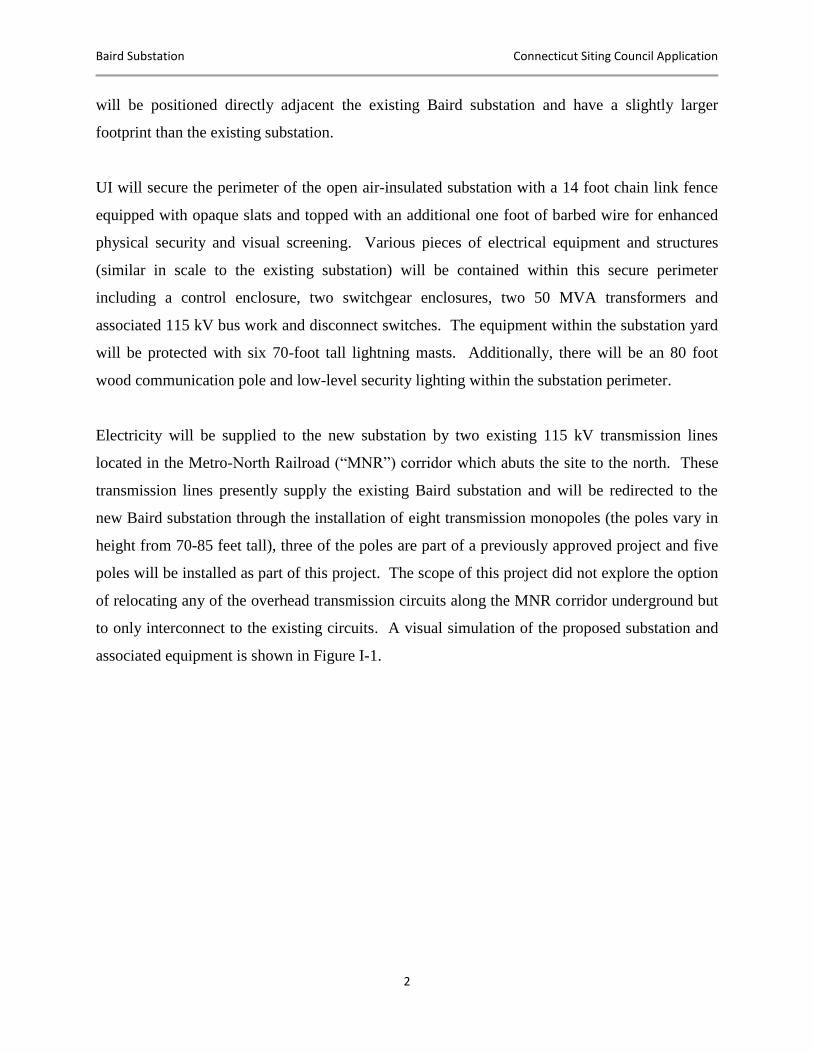
associated equipment is shown in Figure I-1.
Baird Substation Connecticut Siting Council Application
3
Figure I-1: Visual Simulation of the Proposed Substation
Source: Visibility Analysis, Baird Substation
The construction, operation and maintenance of the proposed substation will result in generally
minor impacts that will be localized to the Site and the immediate vicinity of the Site.
Overall, the Project will result in beneficial reuse of a portion of a former industrial site while
addressing several aging infrastructure and compliance needs that threaten the reliability of
electric service to the Stratford area. Currently, Baird helps to supply electricity to customers
and businesses in the greater Bridgeport and Stratford areas and this Project is crucial to maintain
that safe and reliable service.
Upon completion of the Project, the existing Baird substation will no longer be required and will
be removed from service. UI is currently planning to keep the existing Baird substation intact
and utilize it as a full scale substation training facility.
Baird Substation Connecticut Siting Council Application
4
I.B LOCATION OF THE PROPOSED BAIRD SUBSTATION SITE
UI proposes to build the Baird substation on a portion of two adjoining UI-owned properties
totaling 3.5 acres at 1770 Stratford Avenue in Stratford. The westernmost portion of these two
combined parcels is presently occupied by the existing Baird substation. The Site is bounded to
the west by the Savings Auto Center, to the south by Stratford Avenue (State Route 130), to the
east by the Two Roads Brewing Company and to the north by the MNR corridor. Two UI-owned
115 kV transmission circuits occupy the MNR corridor, serving the existing Baird substation as
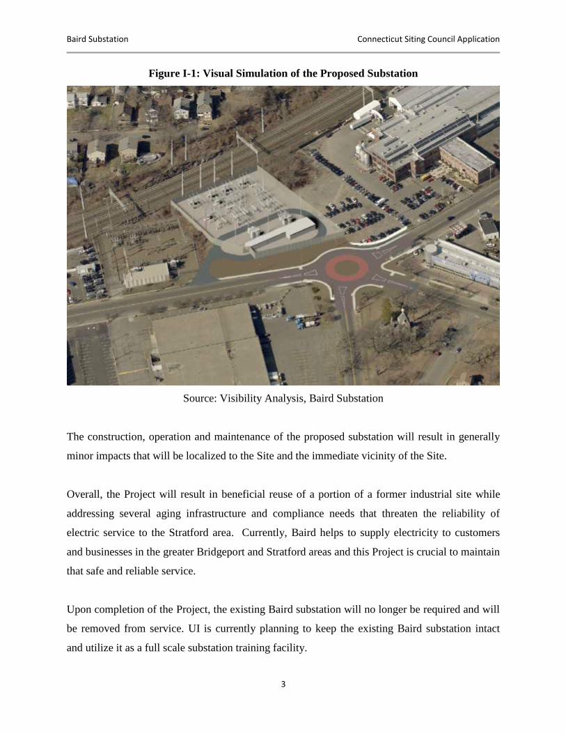
well as nearby UI substations in Bridgeport and Stratford. (Refer to Figures I-2 and I-3.)
Figure I-2: Overview Map: Proposed Baird Substation Site
Source: Town of Stratford and the City of Bridgeport
Baird Substation Connecticut Siting Council Application
5
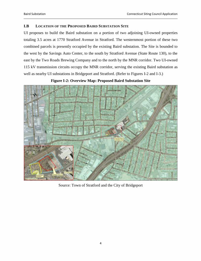
Figure I-3: Aerial Photograph of UI Property and Substation Site at 1770 Stratford Avenue
Source: Google Earth, August 2015
The Project was originally planned for location solely on a 1.8-acre parcel of UI-owned property
located at 1770 Stratford Avenue in Stratford, referred to as the Baird Annex. However, during
discussions between UI, Stratford and the abutting property owners, several modifications were
made to the original positioning of the substation. These modifications accommodate the
proposed roundabout at the intersection of Stratford Avenue, Honeyspot Road and South
Avenue. Additionally, an approximately 110-foot buffer area was created between the substation
fence line and the Two Roads Brewing Company. The modifications better utilize an adjacent
parcel to the west, also owned by UI. The western portion of this adjacent parcel is occupied by
the existing Baird substation, while the eastern portion is comprised of a forested area with low-
lying shrubs, a small wetland and visible rock outcroppings. The proposed substation Site
comprises portions of both UI-owned parcels.
The Site was historically developed for industrial purposes by the U.S. Baird Corporation
(“Baird Corporation”), which was established in the 1890s. UI has uncovered evidence that
Baird Substation Connecticut Siting Council Application
6
Baird Corporation first built on the Site in 1920. Additional structures were added at other
locations on the original Baird property, but no structures except for a small storage shed were
constructed in the area UI plans to construct the Project. The parcel remained substantially
wooded until the 1970s when it was partially paved and used for additional parking areas for the
Baird Corporation.
The proposed substation Site consists of previously disturbed soils, with a small palustrine
emergent nonpersistent wetland (approximately 654 square feet), located on the Site. Based on
historic aerial photography, this area has consisted of primarily wooded and captured stormwater
runoff from the railroad corridor to the north. Large deciduous trees and scrub shrub vegetation
are the dominant forms of plant life surrounding the wetland.
I.C PROPOSED SUBSTATION FACILITIES
The proposed substation will bisect two existing UI-owned 115 kV transmission lines, which
will be routed into the substation. Within the substation, power from the 115 kV transmission
lines will be stepped down to 13.8 kV for delivery to the electric distribution system in the
Stratford area. The proposed substation facilities will include 115 kV circuit breakers, disconnect
switches, transformers to step down the voltage from 115 kV to 13.8 kV, metal switchgear
enclosures and a control enclosure. The substation also will include space to accommodate a
mobile transformer for emergency conditions.
As with all UI substations, the Baird substation will be designed to meet or exceed the State
Building Code, which takes into account seismic loading, wind loading, and snow and ice
loadings, among others.
To access the proposed substation, UI will construct a new driveway off of Stratford Avenue,
west of the roundabout proposed by the Town of Stratford. The new access road will extend into
the substation to provide direct ingress and egress to the substation equipment and enclosures,
while avoiding impacts to the proposed roundabout.
Baird Substation Connecticut Siting Council Application
7
I.D CONSTRUCTION SEQUENCING, SCHEDULE AND PROJECT COSTS
Among others, construction of the Baird substation will require the following activities:
Install erosion and sedimentation control measures.
Remove vegetation.
Prepare the Site for development (cut, fill, grading).
Install substation foundations, conduits, grounding grid and distribution facilities.
Spread trap rock.
Install power transformers.
Install high-voltage circuit breakers.
Set metal control enclosure and switchgear enclosures.
Install steel structures, substation equipment and buswork.
Install transmission line interconnections.
Commission the substation.
Install asphalt access drives.
Complete Site restoration activities.
Remove temporary erosion and sedimentation control measures after Site stabilization is
achieved.
No blasting will be required for the construction of the substation. Grading will be performed as
needed to level the substation Site for the electric transmission and distribution facilities.
The construction and testing of the substation facilities are expected to occur over a 12- to 18-
month period, commencing in the fourth quarter of 2016 and ending with an in-service during
the first quarter of 2018. In general, UI will limit construction to the hours between 7:00 AM to
5:00 PM, Monday through Friday, although certain critical tasks will require extended work
hours. Site preparation, including grading and installation of foundations, will take place during
the initial six months of construction and will involve the use of earth-moving equipment and
construction vehicles. The installation and testing of the substation will take approximately nine
months.
Baird Substation Connecticut Siting Council Application
8
The estimated cost for the siting, design and construction of the Baird substation and supporting
infrastructure is approximately $35 million (in 2015 dollars).
I.E ENVIRONMENTAL IMPACT
The substation will represent a long-term change in the current (vacant) land use of the Project
area, but will be consistent with the historical use of the Site for industrial/commercial purposes.
The Project will modify on-site vegetation and wildlife habitats, as well as views of the Site. In
addition, the development of the substation will require the unavoidable filling of a small
isolated wetland (approximately 654 square feet) located on the western section of the
undeveloped portion of the Site. UI will coordinate with the necessary federal and state
regulatory authorities to obtain a permit for the filling of this wetland. In addition to obtaining
the necessary permit(s) for the filling of this wetland, UI will provide Stratford with
compensation consistent with the ACOE in-lieu fee schedule for the elimination of this wetland.
In August of 2015, UI performed a survey to determine whether or not a viable habitat for the
Northern Long-Eared Bat (“NLEB”) was present on the proposed new Baird Substation
property. Based on the results of the survey, factors such as the urbanized land use, diameter of
trees and the observed smooth bark on the trees the new Baird Substation Project property, make
this location an unlikely habitat for the NLEB.
In order to avoid, minimize and mitigate any secondary impacts from construction activities, UI
will register under CT DEEP’s General Permit for Stormwater and Dewatering Wastewaters
from Construction Activities. In addition to obtaining this registration from CT DEEP, UI will
also employ a site-specific Stormwater Pollution Control Plan (“SWPCP”).
The construction, operation and maintenance of the proposed substation will result in minor
impacts to the area within the construction boundaries of the Site. Taken as a whole, the Project
will result in the beneficial reuse of a portion of a formerly used industrial facility.
Baird Substation Connecticut Siting Council Application
9
I.F ELECTRIC AND MAGNETIC FIELDS
Electric and Magnetic Fields (“EMF”) surround anything that generates, transmits or uses
electricity and are present in nearly every place we encounter daily, including our schools,
workplaces and homes. Typical sources of EMF in these locations include appliances, nearby
electric distribution and transmission lines, wiring in homes and businesses, and electric current
flowing on conductive water pipes.
UI conducted the EMF assessment for this Project in accordance with the Connecticut Siting
Council’s (“Council”) Application Guide for an Electric Substation Facility1and addresses
requirements of the EMF Best Management Practices (“BMP”) for the Construction of Electric
Transmission Lines in Connecticut.2 In addition, the design of the substation has incorporated
reasonable measures to minimize the EMF consistent with the Council’s recommendations for
transmission lines.
The highest calculated magnetic field level at the perimeter of the proposed Baird substation is
less than 6% of that recommended by international health-based standards (International
Committee on Electromagnetic Safety and the International Commission on Non-Ionizing
Radiation Protection) for the general public and is comparable to fields that may be found in
homes near major appliances. At a distance of 170 feet from the substation perimeter (the
distance of the nearest residence), this level reduces to 18.0 mG (0.9% of recommended
guidelines). This level is comparable to fields that may be found in homes, particularly near
appliances. The highest calculated magnetic fields found under the transmission lines entering
the substation were determined to be 40% lower in post-Project conditions than in pre-Project
conditions for the same load level. Additionally, the 100-foot shift of the substation to the west
decreased the magnetic field levels calculated at the property line of the closest abutter to the east
from approximately 41 mG to 14 mG, or less than 1% of the recommended guideline for the
1 Connecticut Siting Council, Application Guide for an Electric Substation Facility, April 2010, available at
http://www.ct.gov/csc/lib/csc/guides/guides2015/elec_sub_application_guide_410.pdf#55846. 2 Connecticut Siting Council. Electric and Magnetic Field Best Management Practices for the Construction of
Electric Transmission Lines in Connecticut, February 20, 2014, available at http://www.ct.gov/csc/lib/csc/emf_bmp/revisions_updates/754bmpfinal.pdf.
Baird Substation Connecticut Siting Council Application
10
general public. The calculated magnetic fields produced by the proposed Baird substation,
therefore, will be below recommended guidelines for exposure of the general public.
I.G ALTERNATIVE EVALUATION PROCESS
UI identified and evaluated various solutions to address aging infrastructure and compliance
issues before determining that building a new substation at the Site is the best available option.
For example, replacing and relocating the distribution or transmission portions of the substation
while leaving the other in place were investigated; however, both options are either impractical
or insufficient to address all of the identified needs and are not viable. Additionally, the “no
action” alternative (i.e., not implementing any solution, including a new substation) was
investigated; however, it was deemed not viable because it could have significant adverse impact
on system reliability levels and, in turn, customer satisfaction and the economic vitality of the
region. Based on this analysis, two feasible solutions were identified for further investigation: the
“In-Kind” and “Full Replacement” options.
An In-Kind solution to replace all components identified for remedial action under the Baird
Substation Needs Assessment3 was investigated. This alternative was based on the concept of
upgrading the existing substation in a piecemeal fashion with minimal expansion of the existing
footprint. However, this alternative was found to expose UI’s customers to significant reliability
risks, due to the long equipment outages required to replace nearly the entire substation while the
facility remained energized, operational and serving customers in the Stratford area. The
construction sequencing and construction hazards are substantially greater in this alternative than
for new construction. In addition, this alternative requires longer construction duration and is
substantially more expensive than a full replacement of the facility on adjacent property.
This evaluation concluded that the construction of a new 115 kV/13.8 kV distribution substation
in the Stratford area would best meet the long-term capacity, infrastructure and compliance needs
of the area safely and reliably. A Site Selection Study was then conducted to evaluate the best
3 Baird Substation Assessment Report – Needs Assessment. April 2, 2012.
Baird Substation Connecticut Siting Council Application
11
location for the proposed substation. The Baird Substation Site Selection Study (Appendix F)4
concluded that the Baird Annex Site is the best location for the proposed substation.
UI used an iterative process to identify feasible alternative sites for the development of the new
substation. Potential locations were first identified and screened in accordance with UI’s
standard objectives for substation siting. UI’s screening included consideration of the following
guiding principles:
Minimize the need to acquire residences and parcels with the potential for viable
commercial/industrial use to accommodate substation development.
Maintain consistency/compatibility with existing land uses and land use plans to the
extent possible.
Minimize adverse effects on sensitive environmental resources and the social
environment.
Maintain public health and safety.
Demonstrate cost-effectiveness, while adhering to good engineering and sound
environmental planning practices.
Present the public with a clear and well-documented methodology for the identification
of the proposed and alternative sites.
Other key considerations in the site evaluation process included the locations of potential sites in
relation to the existing substation and to the 115 kV transmission lines that traverse east to west
along the Metro-North Railroad corridor and feed nearby UI substations in Bridgeport and
Stratford. Proximity to these two existing distribution and transmission assets reduces the
likelihood of conflicts with physical encumbrances, presence of other utilities and the cost
associated with the installation of new infrastructure.
UI proposes to develop the new substation at the Baird Annex Site. However, as part of the
alternatives analysis process that led to the selection of this preferred Site, UI also identified
4 The Baird Annex Site was evaluated as a standalone site using criteria outlined in UI’s Transmission and
Distribution Guideline for Substation Site Selection. The incorporation of the adjacent UI-owned parcel to the west (on which the existing Baird substation resides) to accommodate the shift of the substation to the west occurred after the completion of the Baird Substation Site Selection Study.
Baird Substation Connecticut Siting Council Application
12
other potential viable sites, but found them either impractical or not viable. Thus UI is not
proposing an alternative location with this Application.
Of the twelve sites UI examined, it initially selected three sites for further examination. These
three sites include the preferred Baird location, as well as sites on West Broad and Bruce Streets.
Although the West Broad Street location would make use of an unoccupied industrial site east of
the existing Baird substation, UI does not prefer this site for the new substation based on
anticipated remediation activities, distance to the existing Baird substation, a lack of existing
distribution infrastructure in the area, the presence of existing foundations and buildings, and the
additional required costs. For example, due to the distance from the existing Baird substation, UI
would need to construct new underground distribution infrastructure over a distance of
approximately one mile with two crossings under Interstate 95. In addition, the site is noted as a
brownfield and would likely require significantly more remediation of contaminated soils during
construction. While portions of the previous manufacturing facility have been demolished, a
large building remains and is abandoned. Overall, the development of the new substation at the
West Broad Street site would be approximately 54% more costly than the development of the
substation at the preferred Baird Annex Site.
Additionally, UI does not consider the third site, Bruce Street, as viable as it does not contain
sufficient space to house a new substation. Specifically, any substation design that meets UI’s
current needs would violate clearance requirements between the energized equipment and the
fence line. Finally, the Bruce Street site could not accommodate a mobile transformer, limiting
UI’s ability to ensure safe and reliable service.
Baird Substation Connecticut Siting Council Application
13
II. FORM OF THE APPLICATION
II.A PURPOSE OF THE APPLICATION
In this Application, UI is requesting that the Connecticut Siting Council (“Council”) issue a
Certificate of Environmental Compatibility and Public Need (“Certificate”) for the construction
and operation of a new 115/13.8 kV substation on a portion of two adjoining UI-owned
properties at 1770 Stratford Avenue in Stratford, Fairfield County. The proposed Project will
occupy approximately 1.5 acres within the 3.5 acre combined parcel (Appendix A includes a
map of the Project location and Substation Site Plans). The substation is needed to reliably serve
the customers in the Stratford and Bridgeport areas (“service area”).
II.B STATUTORY AUTHORITY
UI is making this Application pursuant to the Public Utility Environmental Standards Act,
Section 16-50g et seq. of the Connecticut General Statutes (“Conn. Gen. Stat.”) and Section 16-
50j-1 et seq. of the Regulations of Connecticut State Agencies (“RCSA”). This Application
follows the Siting Council’s Application Guide for an Electric Substation Facility (April 2010).
II.C LEGAL NAME AND ADDRESS OF APPLICANT
UI is a specially chartered Connecticut corporation. UI’s name and permanent place of business
is:
The United Illuminating Company
180 Marsh Hill Road
Orange, CT 06477
Mailing Address: 157 Church Street
PO Box 1564
New Haven, CT 06506
Baird Substation Connecticut Siting Council Application
14
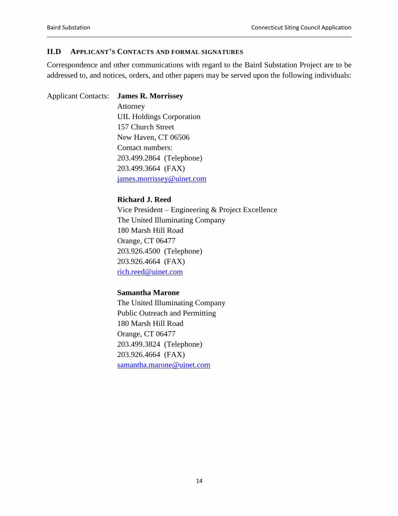
II.D APPLICANT’S CONTACTS AND FORMAL SIGNATURES
Correspondence and other communications with regard to the Baird Substation Project are to be
addressed to, and notices, orders, and other papers may be served upon the following individuals:
Applicant Contacts: James R. Morrissey
Attorney
UIL Holdings Corporation
157 Church Street
New Haven, CT 06506
Contact numbers:
203.499.2864 (Telephone)
203.499.3664 (FAX)
Richard J. Reed
Vice President – Engineering & Project Excellence
The United Illuminating Company
180 Marsh Hill Road
Orange, CT 06477
203.926.4500 (Telephone)
203.926.4664 (FAX)
Samantha Marone
The United Illuminating Company
Public Outreach and Permitting
180 Marsh Hill Road
Orange, CT 06477
203.499.3824 (Telephone)
203.926.4664 (FAX)
Baird Substation Connecticut Siting Council Application
15
III. FORMAL REQUIREMENTS
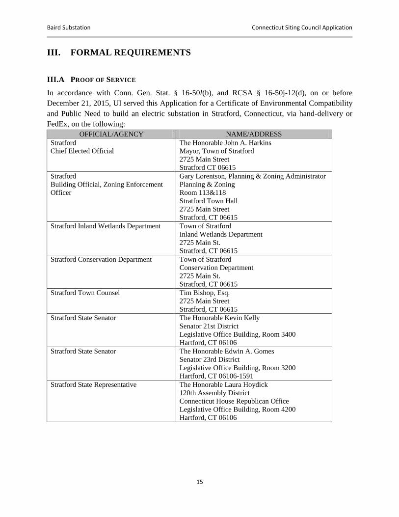
III.A PROOF OF SERVICE
In accordance with Conn. Gen. Stat. § 16-50l(b), and RCSA § 16-50j-12(d), on or before
December 21, 2015, UI served this Application for a Certificate of Environmental Compatibility
and Public Need to build an electric substation in Stratford, Connecticut, via hand-delivery or
FedEx, on the following:
OFFICIAL/AGENCY NAME/ADDRESS
Stratford
Chief Elected Official
The Honorable John A. Harkins
Mayor, Town of Stratford
2725 Main Street
Stratford CT 06615
Stratford
Building Official, Zoning Enforcement
Officer
Gary Lorentson, Planning & Zoning Administrator
Planning & Zoning
Room 113&118
Stratford Town Hall
2725 Main Street
Stratford, CT 06615
Stratford Inland Wetlands Department Town of Stratford
Inland Wetlands Department
2725 Main St.
Stratford, CT 06615
Stratford Conservation Department Town of Stratford
Conservation Department
2725 Main St.
Stratford, CT 06615
Stratford Town Counsel
Tim Bishop, Esq.
2725 Main Street
Stratford, CT 06615
Stratford State Senator The Honorable Kevin Kelly
Senator 21st District
Legislative Office Building, Room 3400
Hartford, CT 06106
Stratford State Senator The Honorable Edwin A. Gomes
Senator 23rd District
Legislative Office Building, Room 3200
Hartford, CT 06106-1591
Stratford State Representative The Honorable Laura Hoydick
120th Assembly District
Connecticut House Republican Office
Legislative Office Building, Room 4200
Hartford, CT 06106
Baird Substation Connecticut Siting Council Application
16
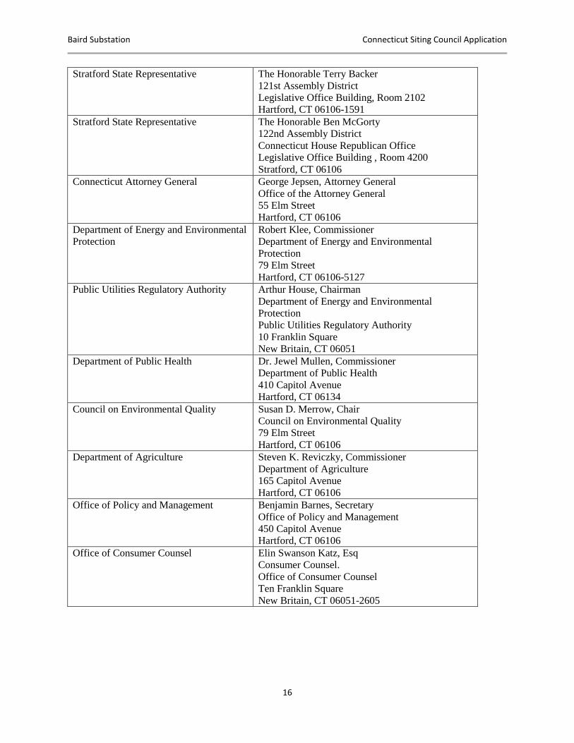
Stratford State Representative
The Honorable Terry Backer
121st Assembly District
Legislative Office Building, Room 2102
Hartford, CT 06106-1591
Stratford State Representative The Honorable Ben McGorty
122nd Assembly District
Connecticut House Republican Office
Legislative Office Building , Room 4200
Stratford, CT 06106
Connecticut Attorney General George Jepsen, Attorney General
Office of the Attorney General
55 Elm Street
Hartford, CT 06106
Department of Energy and Environmental
Protection
Robert Klee, Commissioner
Department of Energy and Environmental
Protection
79 Elm Street
Hartford, CT 06106-5127
Public Utilities Regulatory Authority Arthur House, Chairman
Department of Energy and Environmental
Protection
Public Utilities Regulatory Authority
10 Franklin Square
New Britain, CT 06051
Department of Public Health Dr. Jewel Mullen, Commissioner
Department of Public Health
410 Capitol Avenue
Hartford, CT 06134
Council on Environmental Quality Susan D. Merrow, Chair
Council on Environmental Quality
79 Elm Street
Hartford, CT 06106
Department of Agriculture Steven K. Reviczky, Commissioner
Department of Agriculture
165 Capitol Avenue
Hartford, CT 06106
Office of Policy and Management Benjamin Barnes, Secretary
Office of Policy and Management
450 Capitol Avenue
Hartford, CT 06106
Office of Consumer Counsel Elin Swanson Katz, Esq
Consumer Counsel.
Office of Consumer Counsel
Ten Franklin Square
New Britain, CT 06051-2605
Baird Substation Connecticut Siting Council Application
17
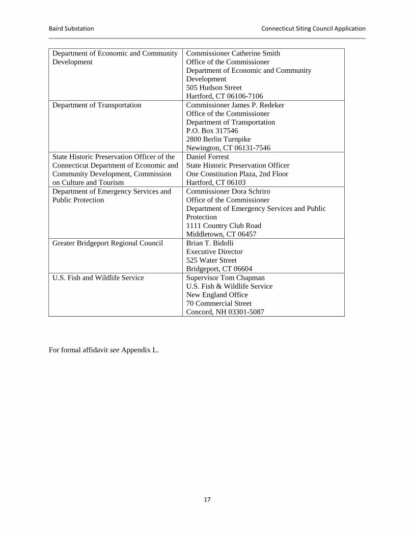
Department of Economic and Community
Development
Commissioner Catherine Smith
Office of the Commissioner
Department of Economic and Community
Development
505 Hudson Street
Hartford, CT 06106-7106
Department of Transportation Commissioner James P. Redeker
Office of the Commissioner
Department of Transportation
P.O. Box 317546
2800 Berlin Turnpike
Newington, CT 06131-7546
State Historic Preservation Officer of the
Connecticut Department of Economic and
Community Development, Commission
on Culture and Tourism
Daniel Forrest
State Historic Preservation Officer
One Constitution Plaza, 2nd Floor
Hartford, CT 06103
Department of Emergency Services and
Public Protection
Commissioner Dora Schriro
Office of the Commissioner
Department of Emergency Services and Public
Protection
1111 Country Club Road
Middletown, CT 06457
Greater Bridgeport Regional Council Brian T. Bidolli
Executive Director
525 Water Street
Bridgeport, CT 06604
U.S. Fish and Wildlife Service Supervisor Tom Chapman
U.S. Fish & Wildlife Service
New England Office
70 Commercial Street
Concord, NH 03301-5087
For formal affidavit see Appendix L.

Baird Substation Connecticut Siting Council Application
18
III.B NOTICE TO COMMUNITY ORGANIZATIONS
In accordance with the Siting Council’s Application Guide for an Electric Substation Facility
(April 2010), UI has made reasonable efforts to provide notice of the Application to affected
community groups including Chambers of Commerce, land trusts, environmental groups, trail
organizations, historic preservation groups, advocacy groups for protection of rivers within the
watershed of the proposed facility that have been identified by the municipality where the facility
is proposed to be located or that have registered with the Council to be provided notice, and any
affected water company that would provide water to, or be within the watershed affected by, the
proposed substation. Accordingly, on or around December 21, 2015, UI sent notice of this
Application for a Certificate of Environmental Compatibility and Public Need to build an electric
substation in Stratford, Connecticut, via certified mail, postage prepaid, to the following:
OFFICIAL/AGENCY NAME/ADDRESS
Stratford Chamber of Commerce
Bridgeport Regional Business Council
10 Middle Street, 14th Floor
Bridgeport, CT06604
Connecticut Audubon Society 314 Unquowa Road
Fairfield, CT 06824
Connecticut’s Central Coast
157 Church Street
MS 1-15E
New Haven, CT 06510
East Coast Greenway
5826 Fayetteville Rd.
Suite 210
Durham, NC 27713
Housatonic River Estuary Commission 70 West River Street
Milford, CT 06460
Stratford Community Organizations
Council
South End Community Council of
Stratford
19 Bates St.
Stratford, CT 06615
Stratford Action for the Environment
(SAFE)
c/o Charles A Perez
52 Cottage Pl.
Stratford, CT 06614
Protect Your Environment
(www.lordshiphistory.com)
PO Box 38
Stratford, CT 06615
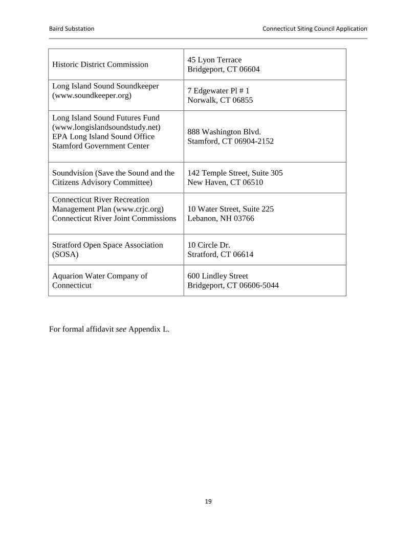
Baird Substation Connecticut Siting Council Application
19
Historic District Commission 45 Lyon Terrace
Bridgeport, CT 06604
Long Island Sound Soundkeeper
(www.soundkeeper.org)
7 Edgewater Pl # 1
Norwalk, CT 06855
Long Island Sound Futures Fund
(www.longislandsoundstudy.net)
EPA Long Island Sound Office
Stamford Government Center
888 Washington Blvd.
Stamford, CT 06904-2152
Soundvision (Save the Sound and the
Citizens Advisory Committee)
142 Temple Street, Suite 305
New Haven, CT 06510
Connecticut River Recreation
Management Plan (www.crjc.org)
Connecticut River Joint Commissions
10 Water Street, Suite 225
Lebanon, NH 03766
Stratford Open Space Association
(SOSA)
10 Circle Dr.
Stratford, CT 06614
Aquarion Water Company of
Connecticut
600 Lindley Street
Bridgeport, CT 06606-5044
For formal affidavit see Appendix L.
Baird Substation Connecticut Siting Council Application
20
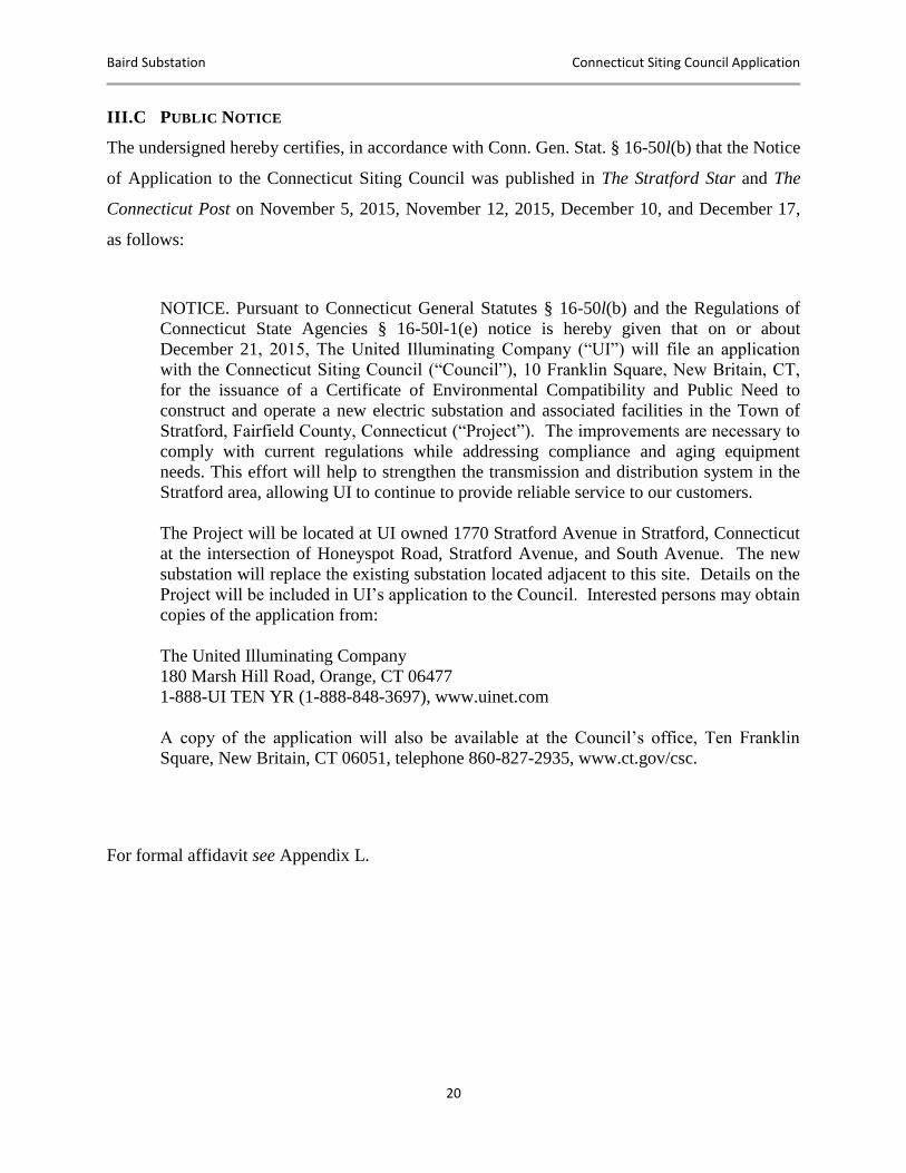
III.C PUBLIC NOTICE
The undersigned hereby certifies, in accordance with Conn. Gen. Stat. § 16-50l(b) that the Notice
of Application to the Connecticut Siting Council was published in The Stratford Star and The
Connecticut Post on November 5, 2015, November 12, 2015, December 10, and December 17,
as follows:
NOTICE. Pursuant to Connecticut General Statutes § 16-50l(b) and the Regulations of
Connecticut State Agencies § 16-50l-1(e) notice is hereby given that on or about
December 21, 2015, The United Illuminating Company (“UI”) will file an application
with the Connecticut Siting Council (“Council”), 10 Franklin Square, New Britain, CT,
for the issuance of a Certificate of Environmental Compatibility and Public Need to
construct and operate a new electric substation and associated facilities in the Town of
Stratford, Fairfield County, Connecticut (“Project”). The improvements are necessary to
comply with current regulations while addressing compliance and aging equipment
needs. This effort will help to strengthen the transmission and distribution system in the
Stratford area, allowing UI to continue to provide reliable service to our customers.
The Project will be located at UI owned 1770 Stratford Avenue in Stratford, Connecticut
at the intersection of Honeyspot Road, Stratford Avenue, and South Avenue. The new
substation will replace the existing substation located adjacent to this site. Details on the
Project will be included in UI’s application to the Council. Interested persons may obtain
copies of the application from:
The United Illuminating Company
180 Marsh Hill Road, Orange, CT 06477
1-888-UI TEN YR (1-888-848-3697), www.uinet.com
A copy of the application will also be available at the Council’s office, Ten Franklin
Square, New Britain, CT 06051, telephone 860-827-2935, www.ct.gov/csc.
For formal affidavit see Appendix L.
Baird Substation Connecticut Siting Council Application
21
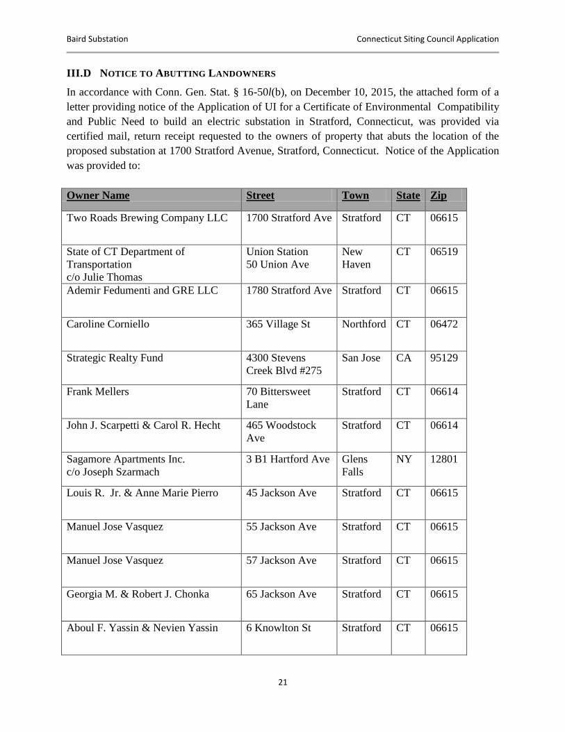
III.D NOTICE TO ABUTTING LANDOWNERS
In accordance with Conn. Gen. Stat. § 16-50l(b), on December 10, 2015, the attached form of a
letter providing notice of the Application of UI for a Certificate of Environmental Compatibility
and Public Need to build an electric substation in Stratford, Connecticut, was provided via
certified mail, return receipt requested to the owners of property that abuts the location of the
proposed substation at 1700 Stratford Avenue, Stratford, Connecticut. Notice of the Application
was provided to:
Owner Name Street Town State Zip
Two Roads Brewing Company LLC 1700 Stratford Ave Stratford CT 06615
State of CT Department of
Transportation
c/o Julie Thomas
Union Station
50 Union Ave
New
Haven
CT 06519
Ademir Fedumenti and GRE LLC 1780 Stratford Ave Stratford CT 06615
Caroline Corniello 365 Village St Northford CT 06472
Strategic Realty Fund 4300 Stevens
Creek Blvd #275
San Jose CA 95129
Frank Mellers 70 Bittersweet
Lane
Stratford CT 06614
John J. Scarpetti & Carol R. Hecht 465 Woodstock
Ave
Stratford CT 06614
Sagamore Apartments Inc.
c/o Joseph Szarmach
3 B1 Hartford Ave Glens
Falls
NY 12801
Louis R. Jr. & Anne Marie Pierro 45 Jackson Ave Stratford CT 06615
Manuel Jose Vasquez 55 Jackson Ave Stratford CT 06615
Manuel Jose Vasquez 57 Jackson Ave Stratford CT 06615
Georgia M. & Robert J. Chonka 65 Jackson Ave Stratford CT 06615
Aboul F. Yassin & Nevien Yassin 6 Knowlton St Stratford CT 06615
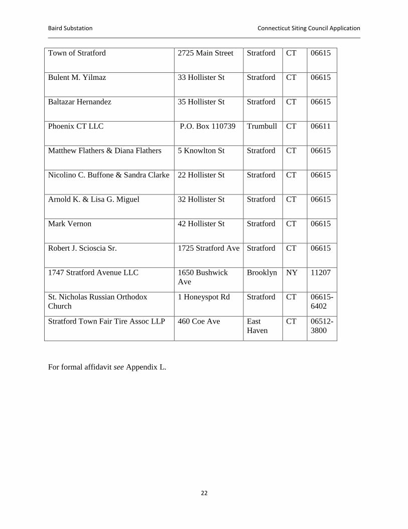
Baird Substation Connecticut Siting Council Application
22
Town of Stratford 2725 Main Street Stratford CT 06615
Bulent M. Yilmaz 33 Hollister St Stratford CT 06615
Baltazar Hernandez 35 Hollister St Stratford CT 06615
Phoenix CT LLC P.O. Box 110739 Trumbull CT 06611
Matthew Flathers & Diana Flathers 5 Knowlton St Stratford CT 06615
Nicolino C. Buffone & Sandra Clarke 22 Hollister St Stratford CT 06615
Arnold K. & Lisa G. Miguel 32 Hollister St Stratford CT 06615
Mark Vernon 42 Hollister St Stratford CT 06615
Robert J. Scioscia Sr. 1725 Stratford Ave Stratford CT 06615
1747 Stratford Avenue LLC 1650 Bushwick
Ave
Brooklyn NY 11207
St. Nicholas Russian Orthodox
Church
1 Honeyspot Rd Stratford CT 06615-
6402
Stratford Town Fair Tire Assoc LLP 460 Coe Ave East
Haven
CT 06512-
3800
For formal affidavit see Appendix L.
Baird Substation Connecticut Siting Council Application
23
IV. PROJECT OVERVIEW AND NEED
IV.A PROJECT NEED
The existing Baird substation requires major modifications due to the following issues:
Inadequate transmission bus capacity
Lack of structural integrity of the transmission bus and support structures
Inability to provide adequate distribution voltage regulation
Aging and antiquated switchgear
Insufficient control enclosure space for planned modifications
Four 115 kV transmission circuits carry electricity through the substation along the Metro-North
Railroad corridor and supply power to the Baird substation. These transmission circuits not only
deliver electricity to the Baird substation but also allow electricity to pass through it to nearby
substations feeding UI customers. The Southwest Connecticut Area Transmission Needs
Assessment from July 13, 2011,5 identified these circuits as requiring significant capacity
upgrades due to projected load growth, generation and system topology changes. In addition, this
assessment determined that the Baird transmission bus would be substantially overloaded under
contingency conditions. These overloads range in severity under worst case contingency
conditions. These necessary modifications to alleviate overloaded elements of the Baird
substation require a substantial investment in the transmission bus system.
The transmission bus at Baird substation has structural concerns, due to the potential for
overstressing of the existing strain bus and support structures under extreme weather conditions
or due to certain faults on the transmission bus. The overstressed conditions could lead to a
structural failure of the bus support system, which in turn could lead to an extended duration
outage for the customers served from the substation. This kind of extended duration outage could
have significant negative impacts on reliability, customer satisfaction, and the regional economy.
5 The Southwest Connecticut Area Transmission Needs Assessment is available on the ISO New England website.
However, access to this document is restricted by the Federal Energy Regulatory Commission as it contains Critical Energy Infrastructure Information (“CEII”). With appropriate credentials, the document is available at https://smd.isone.com/committees/comm_wkgrps/prtcpnts_comm/pac/ceii/reports/2011/final_swct_needs_report.pdf.

Baird Substation Connecticut Siting Council Application
24
The Baird substation delivers electricity to UI’s residential, commercial and industrial customers
through a series of 13.8 kV distribution circuits. The Baird substation utilizes two 115 kV/13.8
kV transformers to transform (step down) the electric power carried by the railroad corridor
transmission circuits. Currently these two transformers fail to maintain adequate distribution
voltages to UI’s customers under normal and contingency conditions. Under ANSI C84.1-2006
voltage regulations, voltages provided to customers should not fall below 91.6% nominal
voltage. UI’s System Integrity Department completed a formal report6 on the Baird substation’s
ability to adequately regulate voltage on its distribution circuits. The analysis found that voltages
in 2011 would be below the ANSI allowable voltage level on all 16 distribution circuits supplied
by the substation under line and transformer contingency conditions. These levels also violate the
allowable voltage levels defined by PURA of - +3% for high voltage and -5% for low voltage.
The full report detailing these analyses and conclusions can be found in Appendix H.
The distribution circuits supplied from Baird are controlled by switchgear manufactured over 50
years ago, that is reaching the end of its useful operating life. This equipment will need to be
replaced in the near future. Although UI can keep this equipment in service, doing so will likely
result in increased maintenance, custom fabrication of replacement components and harvesting
parts from spare switchgear on UI’s system. Aged equipment of this vintage can experience
sudden failures resulting in unexpected customer outages, increased maintenance and
unscheduled replacement activities. The increased risk of frequent sudden failures contributes to
increased reliability risk and maintenance efforts. As a result of this equipment’s deteriorating
condition and risks to reliability, its replacement is required.
The existing Baird control enclosure lacks sufficient space to accommodate any future
expansion, upgrades or modifications at the substation. Existing identified protection system
upgrades at nearby substations will require modification of the protection and control systems at
the Baird substation. These modifications are not viable within the existing control enclosure.
Additionally, the existing cable tray system within the control enclosure is significantly
overfilled, and any additional protection and control cable work at the station will be difficult to
implement.
6 Baird substation Condition Assessment – Distribution Capacity and Voltage Regulation. November 18, 2011.
Baird Substation Connecticut Siting Council Application
25
All of the aforementioned needs, as well as several others, were evaluated and thoroughly
documented in the formal Baird Substation Needs Assessment.7 All of the needs exist with
present-day conditions and require remediation as soon as practical.
Due to the extensive modifications and significant investment required to address the numerous
deficiencies at the Baird substation, UI undertook a comprehensive Solution Study8 to evaluate
potential alternatives. The Baird Substation Solution Study determined that UI should construct a
new substation on property owned by UI to the east of the existing Baird substation.
IV.B BENEFITS OF THE SUBSTATION
The proposed Project will provide a new substation on land already owned by UI to the east of
the existing Baird substation. The new substation will replace the existing Baird substation and
allow UI to take the existing facility out of service once the new substation is in service. UI will
construct the new substation to meet or exceed the capacity of the interconnected transmission
circuits and utilize Load Tap Changing (“LTC”) transformers to provide adequate distribution
voltage regulation. New 13.8 kV switchgear will control the new distribution circuits. As a
result, the new substation will eliminate significant compliance issues and mitigate reliability
risks to UI customers as a result of aging and antiquated equipment.
IV.C ALTERNATIVE ENERGY AND CAPACITY SOLUTIONS CONSIDERED
UI identified and evaluated five potential solutions, as follows:
No Action
Rebuild 115 kV Transmission Bus in Place and Relocate 13.8 kV Distribution System
Rebuild 13.8 kV Distribution System in Place and Relocate 115 kV Transmission Bus
In-Kind Replacement
Full Replacement
7 Baird Substation Assessment Report – Needs Assessment, April 2, 2012, available at https://smd.iso-
ne.com/committees/comm_wkgrps/prtcpnts_comm/pac/ceii/mtrls/2012/jul182012/baird_old_town_needs.pdf. However, access to this document is restricted by the Federal Energy Regulatory Commission as it contains CEII. 8 Baird Substation Solution Study Report, March 2013, available at https://smd.iso-
ne.com/committees/comm_wkgrps/prtcpnts_comm/pac/ceii/mtrls/2014/jun192014/a8_baird_substation_study.pdf. However, access to this document is restricted by the Federal Energy Regulatory Commission as it contains CEII.
Baird Substation Connecticut Siting Council Application
26
These potential solutions were evaluated based on economics and system performance (capacity,
availability and reliability), as well as engineering considerations. The following section
summarizes the analysis of the above-referenced alternatives.
In the “No Action” alternative, UI must accept the risks and consequences associated with this
option, including the possibility of insufficient transmission capacity during peak load and
contingency scenarios. UI would also need to accept the risk of unacceptable distribution
voltages provided to customers, potentially violating ANSI and CT PURA requirements, as well
as the reliability risks associated with the aging and antiquated distribution switchgear.
Accepting the risk associated with the “No Action” option is unacceptable and non-viable and
was rejected due to the significant adverse impact on system reliability levels and, in turn,
customer satisfaction and the economic vitality of the region.
UI discussed alternatives that involved changes to the existing substation configuration in terms
of transmission and distribution connections or separation of the transmission and distribution
facilities from each other (“Rebuild” alternatives). Both options are either impractical or
insufficient to address all of the identified needs and are not viable.
The In-Kind Replacement alternative was based on the concept of upgrading the existing
substation in a piecemeal fashion to address each area identified as requiring modification under
the Needs Assessment. The parts of the substation not identified in the Needs Assessment would
remain in place to the greatest extent possible. This alternative requires:
Upgrading the existing 115 kV transmission bus current carrying components, to at least
the ratings of the incoming/outgoing transmission lines.
Replacement of two existing 115 kV/13.8 kV non-LTC transformers with two 115 kV/13.8
kV transformers with LTC capability.
Replacement of the existing 13.8 kV distribution switchgear with new switchgear of a
modern design inside the existing control enclosure.
Addition of a new control enclosure, located adjacent to the existing masonry block
enclosure, to allow for the additional space for planned modification/upgrades of protection
and control equipment.
Baird Substation Connecticut Siting Council Application
27
Any other minor ancillary needs would be addressed through modifications to the existing
substation facility with minimal expansion of the existing footprint. While this alternative
addressed all identified needs, it would expose UI’s customers to significant reliability risks, due
to the long equipment outages required to replace nearly the entire substation while the facility
remained energized, operational and serving customers in the Stratford area. The construction
sequencing and construction hazards are substantially greater in this alternative than for new
construction. In addition, this alternative creates a longer construction duration and is
substantially more expensive than a full replacement of the facility on adjacent property.
This evaluation concluded that the construction of a new 115 kV/13.8 kV distribution substation
in the Stratford area would best meet the long-term capacity, infrastructure and compliance needs
of the area safely and reliably. A Site Selection Study reviewed 12 sites and identified three that
were potentially viable. UI evaluated each of the three sites from an engineering perspective as
potential locations for a new substation in this area and concluded that the Baird Annex was the
preferred location for the proposed Baird substation. Section X discusses the alternative site
selection process in greater detail.
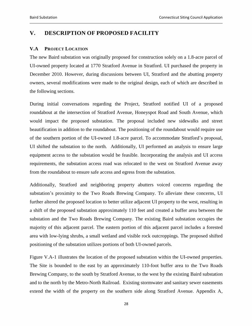
Baird Substation Connecticut Siting Council Application
28
V. DESCRIPTION OF PROPOSED FACILITY
V.A PROJECT LOCATION
The new Baird substation was originally proposed for construction solely on a 1.8-acre parcel of
UI-owned property located at 1770 Stratford Avenue in Stratford. UI purchased the property in
December 2010. However, during discussions between UI, Stratford and the abutting property
owners, several modifications were made to the original design, each of which are described in
the following sections.
During initial conversations regarding the Project, Stratford notified UI of a proposed
roundabout at the intersection of Stratford Avenue, Honeyspot Road and South Avenue, which
would impact the proposed substation. The proposal included new sidewalks and street
beautification in addition to the roundabout. The positioning of the roundabout would require use
of the southern portion of the UI-owned 1.8-acre parcel. To accommodate Stratford’s proposal,
UI shifted the substation to the north. Additionally, UI performed an analysis to ensure large
equipment access to the substation would be feasible. Incorporating the analysis and UI access
requirements, the substation access road was relocated to the west on Stratford Avenue away
from the roundabout to ensure safe access and egress from the substation.
Additionally, Stratford and neighboring property abutters voiced concerns regarding the
substation’s proximity to the Two Roads Brewing Company. To alleviate these concerns, UI
further altered the proposed location to better utilize adjacent UI property to the west, resulting in
a shift of the proposed substation approximately 110 feet and created a buffer area between the
substation and the Two Roads Brewing Company. The existing Baird substation occupies the
majority of this adjacent parcel. The eastern portion of this adjacent parcel includes a forested
area with low-lying shrubs, a small wetland and visible rock outcroppings. The proposed shifted
positioning of the substation utilizes portions of both UI-owned parcels.
Figure V.A-1 illustrates the location of the proposed substation within the UI-owned properties.
The Site is bounded to the east by an approximately 110-foot buffer area to the Two Roads
Brewing Company, to the south by Stratford Avenue, to the west by the existing Baird substation
and to the north by the Metro-North Railroad. Existing stormwater and sanitary sewer easements
extend the width of the property on the southern side along Stratford Avenue. Appendix A,
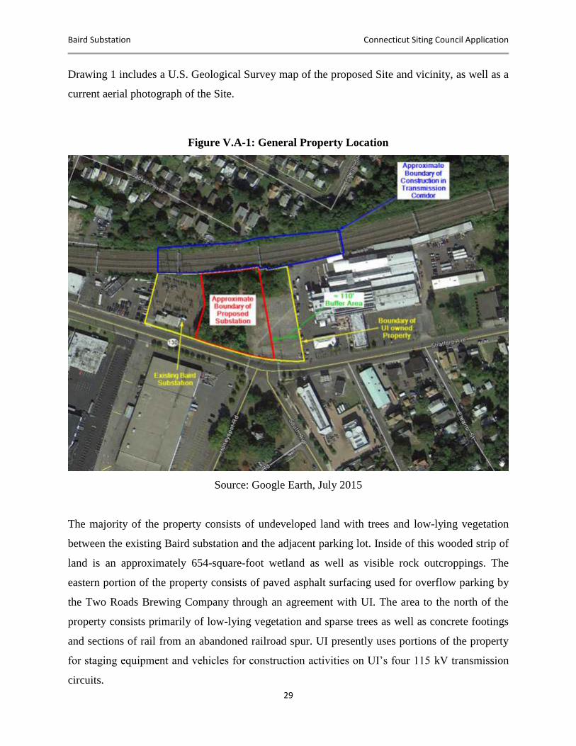
Baird Substation Connecticut Siting Council Application
29
Drawing 1 includes a U.S. Geological Survey map of the proposed Site and vicinity, as well as a
current aerial photograph of the Site.
Figure V.A-1: General Property Location
Source: Google Earth, July 2015
The majority of the property consists of undeveloped land with trees and low-lying vegetation
between the existing Baird substation and the adjacent parking lot. Inside of this wooded strip of
land is an approximately 654-square-foot wetland as well as visible rock outcroppings. The
eastern portion of the property consists of paved asphalt surfacing used for overflow parking by
the Two Roads Brewing Company through an agreement with UI. The area to the north of the
property consists primarily of low-lying vegetation and sparse trees as well as concrete footings
and sections of rail from an abandoned railroad spur. UI presently uses portions of the property
for staging equipment and vehicles for construction activities on UI’s four 115 kV transmission
circuits.
Baird Substation Connecticut Siting Council Application
30
The Site was historically developed for industrial purposes by the U.S. Baird Corporation. The
company dates back to the 1890s, with evidence of original building occupation at the Site in
1920. Additional structures were added at other locations on the original Baird property, but no
structures except for a small storage shed were constructed on this parcel. The parcel remained
substantially wooded until the 1970s when it was partially paved and used for additional parking
areas for the U.S. Baird Corporation.
Figure V.A-2: Aerial Overlay
Source: Google Earth, July 2015
V.B LAND REQUIREMENTS AND ACCESS
The proposed Project is located on approximately 1.5 acres spanning two UI-owned properties
with a combined size of 3.5 acres. The existing Baird substation constructed in the early 1960s

Baird Substation Connecticut Siting Council Application
31
occupies approximately 0.9 acres of the western UI-owned property. The new substation would
utilize portions of both UI-owned properties and would abut the MNR corridor to the north. This
corridor is presently occupied by two UI-owned 115 kV transmission lines.
Development of the Site includes a trap rock surface and installation of a 14-foot-high chain link
fence equipped with opaque slats, topped with one foot of barbed wire (three strands) around the
perimeter.
UI will construct a new access road for the proposed Project off of Stratford Avenue. This access
road would exit the western portion of the substation in order to accommodate Stratford’s
roundabout proposed for the front of the substation.
Construction of eight new monopole structures in the MNR corridor and UI property will be
required to reroute the two existing 115 kV transmission circuits through the proposed
substation. The location and heights of these new monopoles are detailed on the Site Plan
(Drawing #25253-401) included in Appendix A. These new monopole structures will support the
energized circuits that will transmit electricity to and from the proposed substation. Due to the
high-voltage nature of these circuits, appropriate electrical clearances are required for buildings,
vegetation, temporary structures, etc. to ensure the safety of the general public and reliable
operation of the circuits. To maintain these clearances and facilitate construction of the new
monopoles, both permanent and temporary easements are required.
To maintain electrical clearances, a permanent easement is required across the northern border of
the adjacent Two Roads Brewing Company property. This easement will ensure that new or
existing structures are constructed/modified while maintaining a safe electrical clearance to the
115 kV transmission circuits. The easement required on Two Roads Brewing Company property
varies in width depending on the location of the transmission circuits, but would extend
approximately 12 feet from the property line at its widest point. This easement addresses not
only the construction planned for the proposed Project, but also construction planned for the
transmission circuits heading east along the MNR corridor during potential future UI projects.
To enable construction of three monopoles on the north side of the MNR corridor, a temporary
construction easement is required through the property located at 45 Jackson Avenue. This
easement will enable cranes to stage at the end of Jackson Avenue to install the two monopoles
Baird Substation Connecticut Siting Council Application
32
in the MNR Right of Way (“ROW”). This temporary easement will require removal of portions
of the existing vegetation; however efforts will be made to limit clearing activities in this area to
maintain visual screening of the MNR ROW. The boundaries of this easement are shown on the
Grading and Drainage Site Plan drawing (Drawing # 25253-004B) included in Appendix A. UI
is continuing to investigate alternative access plans and construction practices for this area in an
effort to minimize impacts to the property. Additionally, UI has engaged the property owner at
45 Jackson Avenue to develop a plan for permanent restoration of areas within the property line
after construction activities have been completed in an effort to restore screening of new and
existing infrastructure.
V.C ACCESS ROADS AND WORK PADS
To enable construction at each location of the new monopole structures for transmission
interconnection, access roads will need to be created to permit safe passage of construction
vehicles and equipment. Through the construction of the access roads and work pads, UI intends
to trim and remove vegetation, as well as re-grade and excavate areas where and when necessary.
Prior to any of the previously described construction activities for the building of access roads
and work pads, UI will install all of the necessary erosion and sedimentation controls as outlined
on UI’s Erosion Control Site Plan included in Appendix A (Drawing # 25253-006). UI
anticipates access roads to range from 12 to 16 feet in width with the work pads between 1,500
and 5,000 square feet. Work pads range in size due to certain types of equipment needed,
obstructions and/or grading challenges. At the close of the civil and electrical phases of the
Project, all areas that were impacted due to construction will be restored. Restoration includes,
but is not limited to, seeding, mulching and stabilization of soils. Vegetative screening will be
restored where feasible, subject to federal and state electrical clearance requirements for
overhead 115 kV transmission lines and approvals from the Connecticut Department of
Transportation (“CDOT”) and MNR.
In total there will be two separate access drives required to enable movement of construction
vehicles and equipment for the Project. One access road will extend from the south side of
Hollister Street and the other from the northeast corner of the Project Site. Access to the MNR
corridor will be achieved via a new access drive created through a currently wooded area on
municipal property abutting the south side of Hollister Street. This access drive will extend to the
Baird Substation Connecticut Siting Council Application
33
west, paralleling the MNR corridor, enabling access to the two new monopoles to the north of
the proposed substation as well as the single new monopole northeast of the existing catenary
structure. Additionally, a new graded access drive from the northeast corner of the Project Site
will enable construction of the monopole behind the Two Roads Brewing Company. This access
road will enter the MNR corridor and proceed parallel along its southern edge to the area of
construction. Lastly, access to the remaining four new monopoles along the northernmost portion
of the Site will be through the Project Site itself. Plan view drawings detailing the paths of each
required access road and access pads can be found on the Grading and Drainage Site Plan in
Appendix A (Drawing # 25253-004B).
V.D SITE HISTORY AND ENVIRONMENTAL REMEDIATION
The primary use of the Site by the U.S. Baird Corporation during their occupancy was for
parking or material storage. Based on the Connecticut Department of Energy and Environmental
Protection’s (“CT DEEP”) records, the segment of the Site where the substation will be located
has had no historic environmental soil and/or groundwater contamination issues. However,
according to CT DEEP, properties abutting the Site, such as 1725 Stratford Avenue and 1650-
1700 Stratford Avenue, are on record with the CT DEEP as having remedial activities
performed. These activities at the abutting properties include, but are not limited to, leaking
underground storage tanks and a phase II/III site investigation. UI does anticipate performing
minor remedial activities and intends to manage spills in accordance with the State of
Connecticut Solid Waste Regulations during the civil construction of the substation.
V.E DESCRIPTION OF PROPOSED SUBSTATION FACILITIES
UI proposes to locate the Project adjacent to the MNR corridor and the existing 115 kV
transmission lines. The 115 kV transmission line interconnection will be segmented and looped
through the substation. Within the substation, UI will step down the power from these
transmission lines to 13.8 kV for delivery to the electric distribution system in the Stratford
region. As illustrated on the Site Plan and Drawings in Appendix A, the proposed substation
facilities would include:
Two 115 kV circuit breakers.
Eight 115 kV disconnect switches.
Baird Substation Connecticut Siting Council Application
34
Two 50 MVA power transformers to step down the voltage from 115 kV to 13.8 kV.
Provisions to accommodate a temporary mobile transformer for emergency conditions
Two switchgear enclosures, each approximately 42 feet long, 15 feet wide and 13 feet
high, installed to provide for the switching equipment, relaying and control equipment.
A control enclosure (for equipment protection), approximately 60 feet long by 28 feet
wide by 13 feet high, installed at the southern end of the substation and attached to the
two switchgear enclosures. This enclosure would be designed to house the protective
relaying and control equipment as well as the DC station service equipment.
UI will design the new Baird substation to meet or exceed the state Building and Fire Codes,
taking into account seismic loading, wind loading, and snow and ice loadings, among others.
UI’s existing transmission lines are supported on the MNR catenary structures running east to
west along the northernmost edge of the Project Site. These transmission lines supply the
existing Baird substation in a similar configuration as the proposed substation. The existing
transmission lines would be routed into the new substation by installation of eight new steel
monopoles. While all eight monopoles are integral for the interconnection of the new Baird
substation and consequently will be discussed throughout this Application, three of these new
monopoles were previously submitted to the Council and approved under UI Petition No. 1176.9
The remaining five monopoles fall solely under the purview of the proposed Project. The
delineation of monopoles can be found on the Site Plan (Drawing # 25253-401) included in
Appendix A.
The eight new steel monopoles, which will be installed to interconnect the substation to the
existing transmission lines, will be 70 to 85 feet tall and similar in height to the monopole
structures approved for future installation to the east of the Project Site on the MNR corridor.
The height of each new monopole can be found on the Site Plan (Drawing # 25253-401)
included in Appendix A. Four of the new monopoles will interconnect to the substation along the
northernmost portion of the Project Site and will be located on UI property. To the north of the
9 The United Illuminating Company Petition to the Connecticut Siting Council for Declaratory Ruling for the
Bridgeport 115-kV Transmission Line Upgrade Project, Decision Dated September 21, 2015, available at http://www.ct.gov/csc/lib/csc/pending_petitions/1_petitions_1144through1200/pe1176-dcltr-energy-bridgeport-stratford.pdf. The Petition is available at http://www.ct.gov/csc/lib/csc/pending_petitions/1_petitions_1144through1200/pe1176_filing_ui.pdf.
Baird Substation Connecticut Siting Council Application
35
Project Site, UI will install two monopoles directly across the MNR corridor, as well as one
monopole northeast of the existing railroad catenary structure to support the new transmission
conductors that will interconnect the new substation. The remaining monopole must be installed
in the MNR corridor behind the Two Roads Brewing Company as the existing catenary structure
is insufficient to support the required interconnection to the proposed substation. The precise
positioning and height of each monopole may vary marginally due to physical access
considerations and design requirements. The proposed positioning and height of each monopole
can be found on the Site Plan in Appendix A (Drawing #25253-401).
In addition to the eight new transmission monopoles (70-85 feet tall), six 70 foot tall lightning
masts will be installed within the substation fence line, to prevent severe damage to critical
equipment due to direct lightning strikes in accordance with UI and industry standards for
lightning protection. These lightning masts provide a very low resistance path to the ground
ensuring lightning strikes the masts rather than critical equipment susceptible to damage from
strikes. The area of protection each mast provides is directly proportional to the masts height,
with 70 feet providing the optimal area of protection with the fewest masts. The mast height can
be lowered to 55 feet, but the total number of masts required must be increased to protect the
same area. UI discussed this lower mast and higher quantity alternative with the Town of
Stratford, however it was agreed that fewer masts at 70 feet was the least visibly obtrusive
option. Additionally an 80 foot communication pole will be located on the west side of the site
to provide communication between the substation and UI’s distribution infrastructure.
To access the proposed substation, UI will create a new access road to the Site from Stratford
Avenue. This new access road would enter Stratford Avenue to the west of the Honeyspot Road,
South Avenue and Stratford Avenue intersection. The new access road will have a travel surface
of approximately 190 feet and will extend into the substation to provide direct ingress and egress
to the substation equipment and enclosures.
Development of the proposed substation requires protective relay system changes within the
existing control enclosures at remote substations, including the existing Baird substation. These
upgrades are required for the safe and proper operation of the proposed substation. Additionally,
these upgrades will allow both the existing and new Baird substations to be in service
simultaneously, enabling the transference of load between the two substations with minimal
Baird Substation Connecticut Siting Council Application
36
potential for service interruption to customers. A temporary fiber connection will run between
the existing and new control enclosures to coordinate protective relaying systems between the
two facilities while they are both temporarily in service during the transition period.
V.F ESTIMATED COST OF THE PROJECT
The estimated cost for the siting, design and construction of the new Baird substation and
supporting infrastructure is approximately $35 million. The scope of this project did not explore
the option of relocating any of the overhead transmission circuits along the MNR corridor
underground but to only interconnect to the existing transmission circuits.
V.G FACILITY SERVICE LIFE
The substation equipment and supporting infrastructure are estimated to have a service life of
approximately 40 years.
Baird Substation Connecticut Siting Council Application
37
VI. PROPOSED CONSTRUCTION AND
OPERATION/MAINTENANCE PROCEDURES
UI will construct, operate, and maintain the Baird substation in full compliance with the
standards of the National Electrical Safety Code, any conditions of the Council’s approval of the
Project and good utility practice.
VI.A CONSTRUCTION PROCEDURES
Before any construction activities occur, UI will prepare and submit a Development and
Management Plan (“D&M Plan”) to the Council for approval. The D&M Plan will include the
SWPCP and adhere to the 2002 Connecticut Guidelines for Sedimentation and Erosion Control,
which are designed to minimize or eliminate potential adverse environmental effects that may
result from construction activities.
The D&M Plan will include specific procedures and information on, but not limited to, the
management of spoils and groundwater, erosion and sedimentation control, spill prevention
control and countermeasures, construction staffing and hours, traffic control, and provisions for
restoration and landscaping after construction of the substation. The D&M Plan will also provide
contact information should questions or concerns arise during construction or operation of the
facility.
VI.B SUBSTATION CONSTRUCTION SEQUENCE
The general construction sequence of the substation and the 115 kV line interconnection is as
follows:
Install erosion and sedimentation control measures
Manage vegetation
Prepare the Site for development (cut, fill, grading)
Install perimeter fencing
Install substation foundations, conduits, grounding grid and distribution facilities
Spread trap rock
Install power transformers
Install high-voltage circuit breakers
Set control and switchgear enclosures
Install steel structures and substation equipment
Install transmission line interconnections
Baird Substation Connecticut Siting Council Application
38
Commission the substation
Install asphalt access drives
Complete Site restoration activities
Remove temporary erosion and sedimentation control measures after Site stabilization is
achieved
UI will deploy temporary erosion and sediment controls will be deployed during the earthwork
and construction phases of the Project in accordance with the CT DEEP General Permit for the
Discharge of Stormwater and Dewatering Wastewaters Associated with Construction Activities,
a Site-specific SWPCP and the 2002 Connecticut Guidelines for Soil Erosion and Sediment
Control, and as depicted on the approved Project Site Plan in Appendix A. On a weekly basis,
GHD Pty Ltd (“GHD”) (formerly known as Conestoga Rovers Associates Inc.) of Plainville,
Connecticut (UI’s qualified environmental professional/consultant), will inspect the temporary
erosion control measures throughout the below-grade construction phase of the Project. If
deficiencies are identified on any of the erosion and sediment controls during the construction of
the Site, GHD will work with the construction team to mitigate the situation and provide a
compliant solution. The above-grade construction subcontractor will assume this role after the
below-grade construction subcontractor has demobilized from the Site. In addition, monthly
inspections may occur within 24 hours after each qualifying storm event, assessing turbidity and
the stability of erosion and sediment controls. If, during this inspection, GHD identifies areas
where erosion and sediment controls have excessive sediment buildup, GHD will work with the
contractor to have the sediment cleared from the erosion and sediment controls. Sediment will be
managed in accordance with UI’s Site-specific Soil Management Plan.
In addition, UI will be fully responsible for sequencing construction activities such that earth
materials are exposed for a minimum of time before they are covered, seeded or otherwise
stabilized to prevent or minimize the potential for erosion. Upon completion of construction and
establishment of permanent groundcover, the contractor will install new erosion and
sedimentation controls per the restoration requirements in compliance with the SWPCP. In
addition, UI’s contractor will remove excessive sediment and debris from areas where control
measures were used.
Baird Substation Connecticut Siting Council Application
39
UI will grade the substation Site to contain and treat stormwater runoff on the Site via a series of
containment basins and underground storage chambers. The remainder of the stormwater will
then infiltrate through the gravel base of the substation.
Upon completion of construction activities, all disturbed/exposed areas that are not otherwise
developed with the substation facilities, graveled or paved would be stabilized with topsoil, seed
and mulch. Erosion and sedimentation controls will remain in place until final Site stabilization.
This is achieved by monthly inspections for a period of three months where no breaches or
breakdown of erosion and sediment controls occur as outlined in UI’s SWPCP. GHD will
perform these inspections, confirming compliance with this condition.
The substation design includes two 50 MVA transformers that will contain insulating (mineral)
oil. The transformers will each have secondary containment designed to hold 110% of a
transformer’s fluid capacity. UI proposes to install a gravity drain system that requires manual
discharge via sump pump of the containment area through a petro barrier system to assist in
minimizing the potential for inadvertent oil discharges from the containment. Further, UI will
remotely monitor a low oil level alarm that is integral to the system and will notify UI in the
event of an abnormal condition at the Site. Monthly inspections of the sumps will be performed
by UI personnel to promote proper function of the systems. A float switch will be used to
provide notification that water needs to be pumped out of the containment area to prevent any
overflow.
The distribution circuit get-away from the substation will be two new PVC underground duct
banks from the substation property exiting directly into two new splicing chambers located on
Stratford Avenue. These new duct banks would interconnect to the existing and new
underground infrastructure on Stratford Avenue. To accommodate Stratford’s proposed
roundabout and to address the aging underground infrastructure, UI is currently replacing and
repairing duct banks and splicing chambers along Stratford Avenue under a separate UI project.
The new duct banks and splicing chambers required for the proposed Project will interconnect to
this new underground infrastructure on Stratford Avenue.
Baird Substation Connecticut Siting Council Application
40
VI.C SUBSTATION CONSTRUCTION COORDINATION WITH PETITION 1176
Under Petition 1176, UI submitted the Bridgeport 115 kV Transmission Line Upgrade Project
(“Transmission Line Upgrade Project”) and received Council approval on September 17, 2015.
The Transmission Line Upgrade Project includes the construction of 83 new tubular steel
monopole structures. Four of the 83 previously approved poles are integral to the design of the
proposed Baird Substation.
As previously mentioned, UI modified its design of the proposed Baird substation in response to
concerns over the Project’s proximity to the Two Roads Brewing Company and a roadway
improvement scheme. See Section V.A for a more detailed explanation. This modification
necessitates a change in the location of four poles approved in Petition 1176 as the locations of
these poles are dependent on the final design of the proposed Project. UI will seek approval of
such a change under a Request to Amend Petition 1176.
UI seeks approval within this Application for five monopoles to the east. All of the
aforementioned monopole locations and the projects to which they belong are depicted in their
final locations on the Site Plan (Drawing # 25253-401) found in Appendix A.
To coordinate between these two projects, UI has delineated both construction and engineering
activities to eliminate conflicts and ensure synchronization. Not only will this enable the
successful completion of both projects, but it will also make sure that UI can continue to deliver
safe and reliable electric service throughout the duration of construction activities. To achieve
this, the construction of the eight monopoles necessary for transmission interconnection of the
new Baird substation (four of which are also part of the Transmission Line Upgrade Project) will
be performed by the same construction contractors and during the same general time period. This
will ensure that responsibility for all construction activities falls under the purview of only one
set of construction contractors, thereby increasing efficiency, safety and accountability.
Additionally, construction and maintenance of required access roads (detailed in Section V.D)
for the proposed Project will be utilized for the installation of the three monopoles associated
with the Transmission Line Upgrade Project, minimizing required grading activities and
vegetation removal.
Baird Substation Connecticut Siting Council Application
41
VI.D STORMWATER MANAGEMENT
The final grade elevations throughout the Site will be constructed to create a relatively uniform
grade within the new substation area. The existing drainage patterns will be revised to direct
runoff to flow to the catch basins located within the Project Site.
The stormwater system for the proposed substation would consist of a network of eight catch
basins and one manhole with grates at grade elevation to collect runoff for various drainage areas
within the Project Site. The catch basins will transport runoff via Corrugated High-Density
Polyethylene (“CHDPE”) piping to an underground detention chamber, located in the
southwestern portion of the substation. The below-grade stormwater detention chamber will be
designed with a treatment chamber ahead of the storage chamber. This treatment chamber will
provide for removal of sediment, trash or debris that enters the catch basin and piping system.
The below-grade stormwater detention chamber will convey runoff via a pipe to the existing
stormwater sewer system of Stratford. To maintain the post-development peak flow rates at less
than the pre-development peak flow rates, the below-grade stormwater detention chamber will
have a controlled outlet pipe. The pipe will transfer the excess runoff into the existing
stormwater system of Stratford within the city drainage easement along the southwest border of
the Site. Stormwater runoff from the access road will be conveyed via vegetated swales to the
Site stormwater drainage system. The quantity and size of the swales will be finalized in final
grading and drainage design for the Project Site. Additionally, the stormwater system design will
be modified and finalized to accommodate Stratford’s proposed roundabout design.
Offsite runoff from the neighboring property along the eastern portion of the Site will be directed
to a boundary swale constructed to limit off-site water to the existing Town of Stratford’s
stormwater sewer system.
For rainfall events greater than the regulated rainfall events (100-year, 24-hour), the incremental
runoff will be designed to flow through the substation stormwater sewer system (including the
below-grade stormwater storage chamber) and conveyed to the Site stormwater outlet.
Baird Substation Connecticut Siting Council Application
42
VI.E GENERAL CONSTRUCTION WORK HOURS AND SCHEDULE
All construction activities will be conducted in accordance with the D&M Plan as approved by
the Council. The construction and testing of the substation facilities are expected to occur over a
12- to 18-month period. In general, construction hours will be scheduled within a window from
7:00 AM to 5:00 PM, Monday through Friday, but some extended hours and weekend work may
prove necessary on a limited basis. Site preparation, including grading and installation of
foundations, will take place during the initial six months of construction and will involve the use
of earth-moving equipment and construction vehicles.
The installation and testing of substation equipment will take approximately nine months. These
activities will involve the use of cranes to unload and install structural elements and large
equipment.
The installation of the 115 kV line and substation terminal structure, interconnection of the
supply lines to the substation and connections to the distribution system will require that critical
transmission and/or distribution equipment be taken temporarily out of service. As a result, this
work will be scheduled for off-peak electrical demand hours and coordinated with the Town of
Stratford. To complete these interconnections as efficiently as possible with minimal service
disruptions, work will have to be performed continuously, including outside of normal work
hours.
VI.F DISTRIBUTION LINE CONNECTIONS
To deliver power from the substation into UI’s electric distribution system in the Stratford area,
new distribution circuits will be installed from the substation to interconnect with the existing
distribution network presently served by the existing Baird substation. These distribution circuits
will consist of duct lines and splicing chambers, which will be buried beneath local roads.
The distribution get-away from the Baird substation will consist of two PVC underground duct
banks that will extend from the substation to two new splicing chambers that will be located
beneath Stratford Avenue. One duct bank will exit the substation through the west side of the
property directly onto Stratford Avenue by running adjacent to the new access road. The other
duct bank will extend east into the 100-foot buffer area between the substation and the Two

Baird Substation Connecticut Siting Council Application
43
Roads Brewing Company before exiting out to Stratford Avenue. This routing of the eastern duct
bank prevents splicing chamber locations from interfering with the proposed roundabout.
In addition to the splicing chambers and duct banks required to connect the substation to
Stratford Avenue, construction will take place on the underground distribution infrastructure
along Stratford Avenue, Honeyspot Road and South Avenue under a separate UI project. This
work is currently being performed prior to the Project to accommodate the proposed roundabout,
replace aging infrastructure and allow for interconnection of the new substation.
VI.G PROJECT FACILITIES RELIABILITY, SAFETY AND SECURITY INFORMATION
UI will operate and maintain the new Baird substation in accordance with standard UI protocols
and in conformance with required industry standards and good utility practice.
EMERGENCY OPERATIONS AND SHUTDOWN
UI will equip the substation with measures designed to ensure continued service in the event of
outages or faults in transmission or substation equipment. The Project will achieve continued
reliability by incorporating a “loop through” design configuration for the existing 115 kV
overhead transmission lines, transformer protection and redundant automatic protective relaying
equipment.
In the event that an energized line or substation equipment fails, protective relaying equipment
will immediately remove the failed line or equipment from service, thereby protecting the public
and the remaining equipment within the substation. The Project design includes protective
relaying equipment to automatically detect abnormal system conditions (e.g., a faulted overhead
transmission line) and will send a protective trip signal to circuit breakers to isolate the faulted
section of the transmission system. The protective relaying schemes will include fully redundant
primary and backup equipment so that a failure of one scheme would not require the portion of
the system being monitored by the protective relaying equipment to be removed from service.
UI will house the protective relaying and associated equipment, along with a Supervisory
Control and Data Acquisition (“SCADA”) system for 24/7 remote control and equipment
monitoring, at the UI System Operations Center in a weatherproof, environmentally controlled
electrical equipment enclosure.
Baird Substation Connecticut Siting Council Application
44
FIRE DETECTION TECHNOLOGY
UI incorporates IEEE/ANSI and NFPA standards for fire protection in its substation design and
operates these facilities to minimize the impact of fire, in the unlikely event it occurs. UI also
trains its employees and the local fire department on the safe methods to deal with a substation
fire. UI will secure the control enclosure and equip it with fire extinguishers, as well as remotely
monitored smoke detectors. Smoke detection will automatically activate an alarm at the UI
System Operations Center, and the system operators would then take appropriate action.
PHYSICAL SITE SECURITY
UI’s currently employs fencing and gates to protect its facilities located at the Site. UI permits
the Two Roads Brewing Company to use a paved portion of one of the parcels for overflow
parking Wednesday through Sunday of each week, via a license agreement. This arrangement
will continue post-construction, but UI will appropriately secure the Site to protect the public at
large in addition to the existing and proposed equipment.
Security devices will constantly monitor the substation to alert UI of any abnormal or emergency
situations. UI plans to implement several physical site security measures outlined as follows:
UI will enclose the perimeter of the substation with a 14-foot-high chain link fence
equipped with opaque slats, topped with an additional one foot (three strands) of barbed
wire to discourage unauthorized entry and/or vandalism.
Security cameras and motion detectors will be installed that provide complete visibility
within the interior of the proposed substation and perimeter fence.
The substation yard will be gated and locked. All gates will be padlocked at the end of
the workday during construction activities and at all times once the substation is in
service.
Appropriate signs will be posted at the substation fence and gates, alerting the general
public of the presence of high-voltage facilities.
Crash barriers will be in installed along the southern and eastern sides of the property to
discourage vehicle entry through the chain link fence.
UI will install low-level LED lighting within the substation yard to facilitate work at
night or during inclement weather as well identify entry by unauthorized personnel.
Baird Substation Connecticut Siting Council Application
45
UI will additionally install oil spill containment basins around the proposed transformers. UI will
design the oil spill containment basins so that they meet the requirements under EPA’s Spill
Prevention Controls and Countermeasures secondary containment criteria for oil-filled
equipment of 110% capacity. The containment basins will be pumped out through a petro barrier
after a visual inspection.
VI.H TRAFFIC CONSIDERATIONS
UI will design the substation for remote operation, with personnel on site only for periodic
inspections, maintenance and (as needed) emergency work. Permanent access to the property
will be via the access road from Stratford Avenue. The access gates will be in a location where
vehicles entering the Site will not impede traffic while unlocking the security gates. UI will
develop an on-site access road to facilitate the movement of maintenance equipment and access
to the control enclosure. This access road has been positioned to accommodate Stratford’s
planned roundabout in front of the substation.
Baird Substation Connecticut Siting Council Application
46
VII. EXISTING ENVIRONMENTAL CONDITIONS
This section summarizes the existing environmental conditions on the Site and within the Project
area of the Baird Annex property. This section is meant to illustrate the Project’s potential
environmental effects and the methods used to mitigate such effects.
UI has assessed and gathered the data specifically related to the potential environmental effects
to the Site, which include the following:
Wetland Delineation Report (Appendix C)
Cultural Resource Review (Appendix J)
Baseline Environmental Assessment: Baird Substation (Appendix I)
Natural Diversity Database – CT DEEP Correspondence (Appendix B)
VII.A TOPOGRAPHY, GEOLOGY AND SOILS
The proposed substation Site is located within the southern portion of the Western Uplands, near
the Coastal Slope physiographic province. The topography of the Site is relatively level, with
elevations of approximately 13–15 feet North American Vertical Datum 1988 (“NAVD 88”). In
general, past development modified the topography, including the former use of the Site for
industrial purposes and the associated installation of parking areas and access roads. The
topography on the western portion of the Site varies, with elevation of approximately 9–23 feet
NAVD 88 Datum. In general, the topography is wooded with several rock outcrops. The western
portion of the Site also includes a small wetland.
Connecticut’s bedrock geology has a direct effect on landscape forms because of its different
resistances to weathering and erosion. The proposed substation Site is located within the Western
Uplands geologic terrain, where granitic gneisses and schists predominate. Bedrock beneath the
proposed substation Site consists of medium-grained schists in the Trap Falls Formation.
The surficial (unconsolidated) materials that overlie bedrock in Connecticut consist of deposits
from the continental glaciers that covered New England at least twice during the Pleistocene Ice
Age. In the vicinity of the substation Site, these deposits are classified as glacial till, the most
common type of deposit, which was laid down directly by glacier ice and consists of a matrix of
Baird Substation Connecticut Siting Council Application
47
sand, silt and clay with variable amounts of stones and large boulders. The till is generally less
than 10–15 feet thick.
The U.S. Department of Agriculture, Natural Resources Conservation Service maps soil types
and produces countywide soil surveys. The Soil Survey of Fairfield County provides information
concerning soil characteristics, including depth to bedrock, slope, drainage and erosion potential;
soils information is also mapped and available via Connecticut Environmental Conditions
Online.10
The soils on a portion of the proposed substation Site have been altered due to previous industrial
development. The upland soil on the Site is characterized as an udorthent. This soil unit consists
primarily of manmade or disturbed cut and/or fill areas that are not wet, with slopes ranging from
0% to 8%. Portions of the Site also include small areas of well-drained loamy soils and non-soil
impervious areas (e.g., parking lot).
VII.B WATER RESOURCES AND WATER QUALITY
UI has reviewed the proposed Site for water resources including inland and tidal wetlands,
watercourses, vernal pools and floodplains. UI also assessed the groundwater quality, as
Connecticut has established both Water Quality Standards and Classifications in order to protect
its surface and groundwater resources.
Surface Water Resources
On April 14, 2015, UI performed a Site wetland delineation to assess the presence of water
resources such as wetlands, watercourses, vernal pools and/or floodplains. In the State of
Connecticut, wetlands are determined by soils. These soil types include poorly drained, very
poorly drained and alluvial plain soils. In addition to delineating wetlands in accordance with the
State of Connecticut requirements, vegetation and hydrology were assessed in accordance with
the ACOE Wetland Delineation Manual: Northcentral and Northeast Region (Version 2.0;
January 2012).
10
Map Catalog, Connecticut Environmental Conditions Online, accessed December 15, 2015, available at http://www.cteco.uconn.edu/map_catalog.asp?town=138.
Baird Substation Connecticut Siting Council Application
48
During the wetland delineation, UI only identified one small palustrine emergent nonpersistent
wetland (approximately 654 square feet), located on the western boundary of the Site. Based on
aerial photography, this area has historically consisted of primarily wooded and captured
stormwater runoff from the railroad corridor to the north. Large deciduous trees and scrub shrub
vegetation are the dominant forms of plant life surrounding the wetland. No vernal pools were
identified during this delineation event. A Wetland Delineation Report generated by GHD can be
found in Appendix C. This report explains how the resource area on the Site was determined, the
approach for determining whether or not certain areas meet the qualifications of a resource area
and the additional areas which were surveyed in order to determine whether or not they meet the
State of Connecticut wetland definition.
Groundwater Resources
Based on the latest available (January 2011) DEEP Groundwater Quality Classification Map
data, groundwater at the Site is classified as GB. Water with a GB classification includes
industrial process and cooling waters and baseflow for hydraulically connected water bodies.
Such water is presumed not suitable for human consumption without treatment. The
classification of groundwater as GB is consistent with the historic uses at the Site. Therefore, in
this section of Stratford, due to industrial and commercial activities, Aquarion Water Company
supplies potable water.
Flood Zones
Based on a review of the Federal Emergency Management Agency Flood Insurance Rate Map
(Map Number 09001C0442G), the proposed Site is not in a “Flood Hazard Area.”
VII.C BIOLOGICAL RESOURCES
Vegetation
Although the proposed substation Site is previously disturbed from historic
commercial/industrial activities, the Site is predominantly occupied by deciduous and scrub
shrub vegetation. Mature hardwoods such as pin oak, tree-of-heaven and Norway maple
primarily extend along the western and northern sides of the Site. Also noted on the Site are such
species as the southern catalpa, sycamore, black cherry and red mulberry. The eastern and
southern portions of the Site are paved and do not contain vegetation.
Baird Substation Connecticut Siting Council Application
49
Biological Habitat
Based on the CT DEEP obligation to conserve the habitats of both endangered and threatened
species, and UI’s commitment to environmental stewardship, in March 2015 UI submitted a
“Project Review Form” to CT DEEP for a Natural Diversity Database (“NDDB”) review. In
April 2015, CT DEEP – NDDB Group responded to UI and stated that DEEP anticipates that no
negative impact will occur to state-listed species resulting from the proposed activities. This
correspondence can be found in the Agency Correspondence in Appendix B.
Additional wildlife inhabiting the Site and areas around the Project area includes, but is not
limited to, raccoons, squirrels, chipmunks, rats and native birds such as crows, robins and
Canadian geese. These species are typically more tolerant of human disturbance and are capable
of adapting to alternate environments.
On July 8, 2015, UI was notified by the U.S. Fish and Wildlife Service and CT DEEP that
Section 7 of the Endangered Species Act has been amended. The amendment to this section
pertained to the conservation of the Northern Long Eared Bat (“NLEB”) and its habitat(s). Based
on this amendment, UI assessed the Baird Annex property for a sustainable habitat. UI and its
consultant GHD determined that, due to the lack of hibernacula and smooth bark present on the
tree species, the Baird Annex property does not provide a sustainable habitat for the NLEB. This
report and its findings can be seen in Appendix K. UI therefore does not expect the Project to
impact the biological habitat for any threatened or endangered species.
VII.D LAND USE, ZONING, LAND USE PLANS AND RECREATION
The Site is a portion of a former industrial property that is located in a substantially
industrial/commercial area, although there are some nearby residential areas. The property is
zoned industrial. The Site is adjacent to the MNR corridor to the north. Beyond the rail corridor,
additional mixed use areas include residential and small commercial/industrial properties. The
Site is approximately a quarter mile southeast of High Park on Graham Street in Stratford.
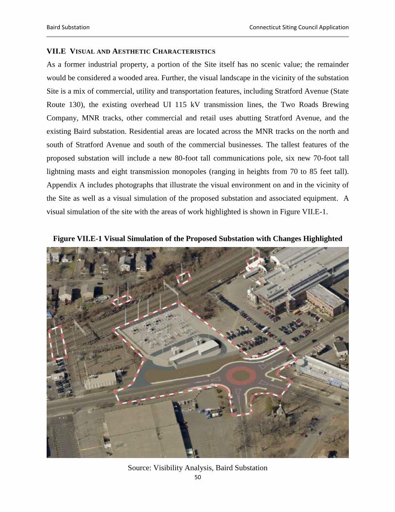
Baird Substation Connecticut Siting Council Application
50
VII.E VISUAL AND AESTHETIC CHARACTERISTICS
As a former industrial property, a portion of the Site itself has no scenic value; the remainder
would be considered a wooded area. Further, the visual landscape in the vicinity of the substation
Site is a mix of commercial, utility and transportation features, including Stratford Avenue (State
Route 130), the existing overhead UI 115 kV transmission lines, the Two Roads Brewing
Company, MNR tracks, other commercial and retail uses abutting Stratford Avenue, and the
existing Baird substation. Residential areas are located across the MNR tracks on the north and
south of Stratford Avenue and south of the commercial businesses. The tallest features of the
proposed substation will include a new 80-foot tall communications pole, six new 70-foot tall
lightning masts and eight transmission monopoles (ranging in heights from 70 to 85 feet tall).
Appendix A includes photographs that illustrate the visual environment on and in the vicinity of
the Site as well as a visual simulation of the proposed substation and associated equipment. A
visual simulation of the site with the areas of work highlighted is shown in Figure VII.E-1.
Figure VII.E-1 Visual Simulation of the Proposed Substation with Changes Highlighted
Source: Visibility Analysis, Baird Substation
Baird Substation Connecticut Siting Council Application
51
VII.F TRANSPORTATION AND UTILITIES
The proposed substation Site is readily accessible via Stratford Avenue. Interstate 95 is
accessible via South Avenue and Honeyspot Road, which intersect Stratford Avenue in front of
the Site. Stratford Avenue is a major arterial road that extends generally east-west through
Stratford as part of State Route 130. Route 130 extends approximately 40 miles from Fairfield to
Stratford. Other major regional highways, including State Route 8 and the Merritt Parkway
(State Route 15), are accessible from Interstate 95.
UI’s overhead 115 kV transmission lines extend east to west across the northern portion of the
proposed substation Site along the MNR corridor. The MNR corridor is approximately 100 feet
wide and is occupied by two active transmission lines that loop through the existing Baird
substation.
A municipal stormwater line also extends across the southern portion of the Site within a 15-
foot-wide easement. This stormwater line extends across Stratford Avenue in front of the Site
and to the east onto the Two Roads Brewing Company’s property.
Additionally, a sanitary sewer line extends across the southernmost portion of the Site within a
10 to 12-foot easement retained by the U.S. Baird Corporation. The sanitary sewer line easement
is directly between the adjacent stormwater line easement to the north and the Site property line
to the south.
Lastly, Stratford proposes to construct a roundabout at the intersection of Stratford Avenue,
Honeyspot Road and South Avenue. The construction of this roundabout requires use of the
southern portion of the UI-owned property presently occupied by the aforementioned stormwater
and sanitary line easements.
VII.G CULTURAL (ARCHAEOLOGICAL AND HISTORIC) RESOURCES
Based on the historical uses of the Baird Annex property, UI performed a review of any
archaeological or historic structures contained within the Site. Based on an analysis performed
by Heritage Consultants of Newington, Connecticut, in February 2015, UI determined that the
proposed Project would not affect any historical archaeological sites. To further assess the Site,
Baird Substation Connecticut Siting Council Application
52
in April 2015 a “Project Review Form” was submitted to the Connecticut State Historic
Preservation Office (“CT SHPO”) in order to review the National and State Registers of Historic
Places. On May 14, 2015, a response from CT SHPO was received by UI indicating that “no
historical properties will be affected by this Project.” Please see Appendix B for official agency
correspondence and Appendix J for the Cultural Resource Review.
VII.H AIR QUALITY, NOISE AND LIGHTING
AIR QUALITY
The construction of the substation will require the movement of construction equipment, as well
as Site preparation activities (e.g., grading, filling), that will create vehicular air emissions and
dust. UI will minimize emissions from construction equipment and vehicles through proper
maintenance and by limiting unnecessary idling per CT DEEP’s Anti-Idling Program. In addition
to minimizing the emissions generated from idling vehicles, UI’s below-grade contractor will be
responsible for controlling dust emissions by applying water or equivalent substances to exposed
soils on the Site, as necessary, per guidance through UI’s SWPCP.
NOISE
To assess the existing sound environment in the vicinity of the Project Site, UI commissioned a
noise survey. Black & Veatch completed the noise survey in March 2015. The results of this
survey are presented in Appendix D and summarized below and in Section VIII.H.
In order to effectively quantify and qualify the existing daily sound levels surrounding the
Project Site, the ambient survey included continuous sound level monitoring and short-term
(attended) sound level measurements. Noise measurement locations (“NMLs”) were selected to
represent nearby noise-sensitive receptors. Specifically, NMLs were established at the end of
Jackson Avenue (a residential neighborhood north of the Project Site) and south of the Project
Site along Old Honeyspot Rd. (St. Nicholas Russian Orthodox Church and a residential
neighborhood).
The existing ambient sound levels in the vicinity of the Project Site ranged from 52 dBA to 64
dBA at the two survey locations. The quietest periods occurred during the early morning hours
(2:00 A.M., March 11) when traffic on Interstate 95 had subsided. In general, the existing
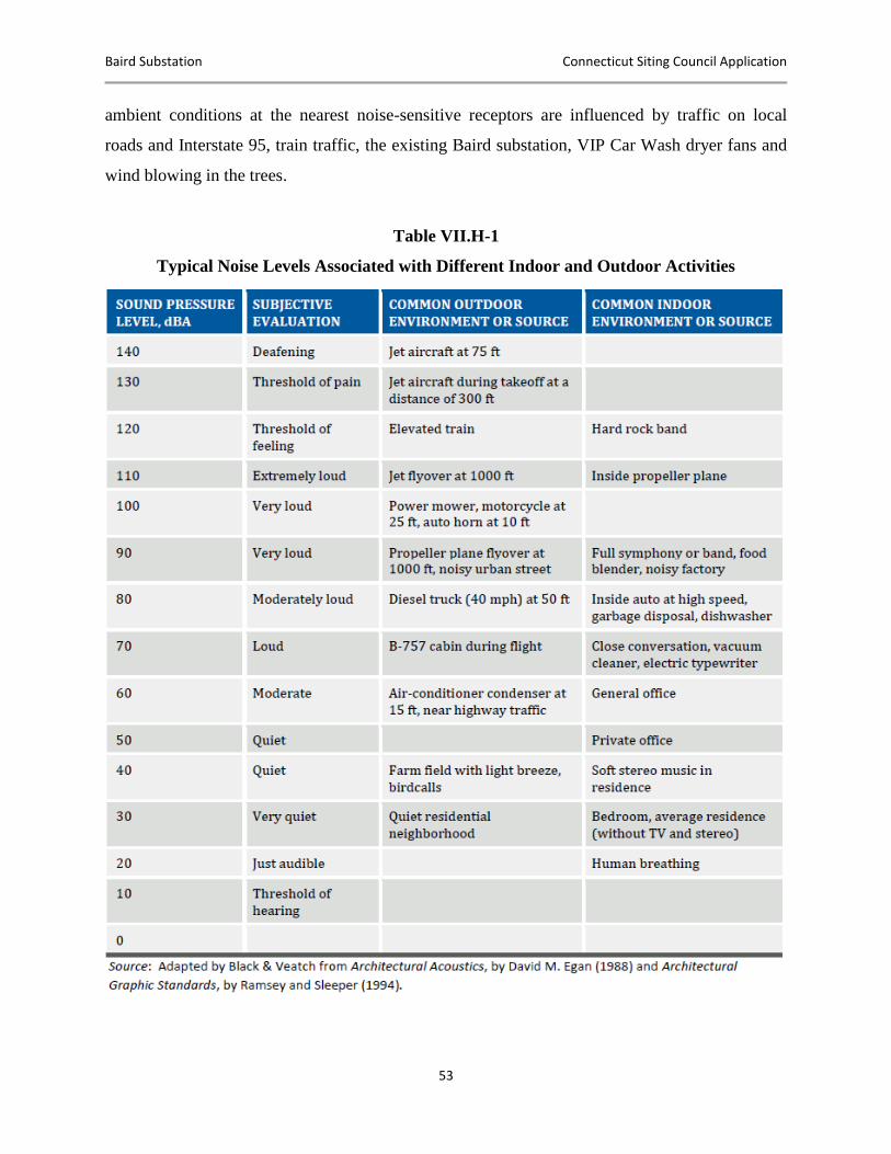
Baird Substation Connecticut Siting Council Application
53
ambient conditions at the nearest noise-sensitive receptors are influenced by traffic on local
roads and Interstate 95, train traffic, the existing Baird substation, VIP Car Wash dryer fans and
wind blowing in the trees.
Table VII.H-1
Typical Noise Levels Associated with Different Indoor and Outdoor Activities
Baird Substation Connecticut Siting Council Application
54
Stratford’s noise regulations are more restrictive than those specified by the State of Connecticut.
As such, UI used the noise level standards in Chapter 142 of the Stratford Town Code to evaluate
regulatory compliance of the Project. To ensure regulatory compliance, the Project must meet the
following criteria:
The sound levels associated with the Project should not exceed 45 dBA along the
residential zoning boundaries to the north and south
The sound levels associated with the Project should not exceed 62 dBA along the
commercial zoning boundaries to the east and west.
The Project will conform to Stratford’s noise regulations and thus the less restrictive state
standards.
LIGHTING
The proposed Project Site is located in a busy, well-lit industrial area. Parking lot and
commercial lighting is evident along Stratford Avenue, as well as from the various factories,
warehouses, and retail and restaurant locations in the adjacent areas.
Baird Substation Connecticut Siting Council Application
55
VIII. POTENTIAL ENVIRONMENTAL EFFECTS AND MITIGATION
MEASURES
This section discusses the localized potential environmental effects that would result from the
construction and operation of the proposed Project and the measures that UI has identified to
mitigate such effects. Overall, the Project will result in beneficial reuse of a portion of a former
industrial site. As the Project proceeds, UI would implement measures to mitigate adverse
effects, as described within this document.
The construction and operation of the substation will represent a long-term change in the current
land use, but will be consistent with the historical use of the Site for industrial purposes. The
Project will modify on-site vegetation and wildlife habitat, as well as views of the Site. The
construction of the substation and transmission structures will remove about 130 trees greater
than 6 inches in diameter. In addition, the development of the substation will require the
unavoidable filling of 654 square feet of a small wetland located on the western portion of the
Site, due to the final shifted arrangement of the substation.
In general, however, these changes will be localized to the Site, its immediate vicinity, and the
Metro North ROW. Further, UI will implement measures to avoid, minimize or mitigate adverse
effects, as appropriate, based on UI’s SWPCP, standard construction best management practices,
the results of the Council’s process, and the conditions and other approvals required for the
Project.
VIII.A TOPOGRAPHY, GEOLOGY AND SOILS
The construction and operation of the Project will not affect the Site’s overall geological
conditions However, UI must excavate or remove soils and bedrock as required to level the Site
for development. In order to determine the appropriate management of the soil and groundwater
during construction, GHD and UI performed a baseline environmental assessment from May 4
through May 11, 2015, on the Baird Annex property. During this baseline assessment, UI
sampled 16 different areas of the Site in order to classify the soil and determine a management
approach to spoils. In addition to sampling the soil, UI and GHD also classified the groundwater.
A summary report can be seen in Appendix I. Based on this report, the majority of the material
Baird Substation Connecticut Siting Council Application
56
will be transported off-site for limited reuse or disposed of at an approved covered landfill.
Additionally, the imported soils and fill materials will establish an appropriate base for the
substation equipment and ground grid.
The existing Site drainage patterns are based on the present topography and do not include a
constructed drainage system. Runoff that falls on the Site north of the abandoned railroad spur
generally flows to the northeast corner of the property before flowing onto adjacent property. For
the larger area south of the abandoned railroad spur, runoff flows to a low spot along the western
boundary. There are multiple catch basins along the southern property line (Stratford Avenue)
that connect to the town’s stormwater system.
Based on CT DEEP’s criteria under the General Permit for Stormwater and Dewatering
Wastewaters from Construction Activities regarding construction activities disturbing greater
than one acre, UI will submit a registration to CT DEEP and develop a Project-specific SWPCP.
Under the Project-specific SWPCP, UI’s civil contractor will deploy temporary soil erosion and
sedimentation controls around construction work areas in order to minimize the potential for
sedimentation or stormwater runoff into off-site areas. Some of the erosion and sediment controls
which are to be implemented during construction include but are not limited to the following:
Hay bales
Silt fence
Straw wattles
Diversion swales
Track pads
Hay bale corrals for management of spoils or concrete washout areas
Erosion control blankets
VIII.B WATER RESOURCES AND WATER QUALITY
The location of the proposed substation originally avoided impacts to the forested area adjacent
to the existing Baird substation. However, after discussions with Stratford and the Two Roads
Brewing Company, repositioning of the substation to the west was desirable to create a buffer
area between the substation fence line and UI’s eastern property line. Due to this proposed
Baird Substation Connecticut Siting Council Application
57
configuration, UI’s construction activities will permanently fill the small palustrine emergent
nonpersistent wetland located on the Site. The total permanent impact caused by the
configuration of the substation to the wetland is 654 square feet. Based on the permanent filling
of this wetland, UI intends to submit an Army Corps of Engineers (“ACOE”) Category I
Certification Form (“CF”) and copying CT DEEP. UI will implement the conditions per the
ACOE and CT DEEP’s approval during construction.
Because of the permanent filling of this wetland area, UI has developed a scenario to provide
compensation to the town for this activity. The compensation scenario was developed by
mirroring the ACOE’s “In-Lieu Program.” This program allows applicants who are permanently
impacting wetlands or watercourses the ability to compensate the local chapter of the Audubon
Society in order to provide a positive monitoring program and long-term solution. UI will be
conducting work within the Housatonic River service area, and each square foot of impact would
result in a rate of $7.56 based on the compensation structure within the ACOE’s program. UI
would provide the town payment totaling $4,944.24 (see Appendix C in the ACOE Final
Instrument for the Audubon In-Lieu Fee Program).11
During the construction and development of the Site, UI will install erosion and sediment
controls in order to protect the water quality and localized resources that could be impacted by
runoff. The installation of any erosion and sediment controls during the construction and
development of the Site will conform to both the Site-specific SWPCP and the DEEP General
Permit.
UI also will protect the water quality in this area by complying with appropriate Spill Prevention
Control and Countermeasures (“SPCC”) regulation, 40 CFR 112, due to the presence of oil-filled
equipment. UI will install the necessary containment and best management techniques for oil-
filled equipment in order to minimize the potential for inadvertent spills or leaks to watercourses
or stormwater infrastructure.
11
U.S. Army Corps of Engineers In-Lieu-Fee Program, accessed December 15, 2015, available at http://www.nae.usace.army.mil/Missions/Regulatory/Mitigation/InLieuFeePrograms.aspx.
Baird Substation Connecticut Siting Council Application
58
VIII.C BIOLOGICAL RESOURCES
Vegetation
The development of the Baird substation will involve the removal of all existing vegetation in
and around the footprint of the proposed substation facilities and the northern portion of the 110-
foot buffer area. The current vegetation communities that characterizes the north and west sides
of the Site will need to be removed in order to meet certain clearance requirements. There are
approximately 150 trees over three inches in diameter that will be removed, with any species
localized to the Site being displaced. Based on the historic and current use of the CDOT ROW
and a review of the Project area, there will be impacts to the vegetative screening on the north
side of the CDOT ROW. Presently, both CDOT/Metro-North Railroad and UI maintain the
ROW by applying their respective vegetation management practices, removing any low-growth
vegetation, and removing or trimming any large-growing trees invasive to the clearance
requirements, in order to meet federal and state standards. Additionally, vegetation and tree
clearing will be required for temporary access drives (see Appendix A, Drawing 25253-006A).
For areas outside of the CDOT ROW, vegetation restoration would be provided and coordinated
with the immediate abutters.
Biological Habitats
Based on a review of CT DEEP’s NDDB Program database, in March 2015 UI submitted a
“Project Review Form” to CT DEEP due to the presence of a polygon/shaded area indicating that
a listed species may be present. On April 14, 2015, a letter was received by UI from CT DEEP
stating that no state-listed species reside within the Project area.
In addition to the CT DEEP – NDDB review and based on a change in the regulations under the
Endangered Species Act, Section 7, for federally funded or permitted projects regarding the
degradation of the NLEB population, UI performed a Site assessment to determine if a
sustainable habitat is present for the NLEB at the Baird Annex property. Based on the report
generated by GHD (see Appendix K), the Baird Annex Site does not provide a sustainable
habitat due to the smooth bark trees present and heavily urbanized area.
Therefore, UI’s construction activities will not result in any adverse effects on state or federally
listed species.
Baird Substation Connecticut Siting Council Application
59
VIII.D LAND USE, ZONING, LAND USE PLANS AND RECREATION
The proposed substation will result in the conversion of the existing vacant parking lot to
productive utility use. The substation will also be consistent with the industrial historical use of
the Site, as well as with existing zoning and state, regional and local land use plans.
Due to its location in close proximity to MNR, UI’s overhead 115 kV transmission lines and the
existing Baird substation, the new Baird substation will be consistent with other utilities in the
area.
The proposed substation will not affect any designated or planned recreational uses. The Site is
owned by UI, was previously used for industrial purposes and is presently fenced and gated.
Stratford has plans to reconstruct the intersection of Stratford Avenue, Honeyspot Road and
South Avenue, including a new roundabout and streetscaping, to improve a gateway to Stratford.
UI has met with Stratford to coordinate the intersection design and has reconfigured the
positioning of the substation to accommodate this roundabout and streetscaping, including
shifting the substation to the north away from Stratford Avenue. Thus the new substation will not
affect the redevelopment of this area.
VIII.E VISUAL AND AESTHETIC CHARACTERISTICS
The proposed substation will represent a change in the current visual environment. To evaluate
potential views associated with the proposed substation, UI retained All-Points Technology
Corporation, P.C. (“APT”) to conduct a visibility analysis. This analysis, which is provided in
Appendix E, included a combination of predictive computer modeling and field evaluations.
Visual simulations of the proposed substation under “leaf off” (winter-type) conditions also were
performed.
The visibility analysis determined that year-round views of the substation would be limited to a
modest geographic footprint due to the relatively short height of the majority of the
infrastructure, the intervening development and existing vegetation. Year-round views would be
confined to locations on and within the immediate vicinity of the Site and would extend
approximately 0.3 miles south and 0.75 miles east and west along Stratford Avenue. To the
north, views would be more limited because of intervening structures and vegetation. The Site is
Baird Substation Connecticut Siting Council Application
60
in a relatively industrial/commercial area and located directly adjacent to the existing substation
with similar visual characteristics. In general, views of the proposed equipment would be similar
to what exists today and would not have a substantial adverse visual effect on the surrounding
equipment.
VIII.F TRANSPORTATION AND UTILITIES
The construction and operation of the proposed Project Site will not result in any significant
adverse effects on transportation or utility systems. The proposed Site is readily accessible from
the local and regional highway network and is adjacent to UI’s 115 kV overhead transmission
lines and MNR. The development of the substation will improve UI’s transmission system
capacity and improve distribution voltage regulation, as well as replace aging and antiquated
equipment, thereby affording UI customers more reliable electric service. The Project will not
affect any above-grade existing municipal utilities. The operation of the substation will not
require full-time on-site personnel and thus will not result in any long-term effects on traffic.
The construction of the proposed substation may have a minor and short-term effect on vehicular
traffic on the local roads leading to the Site, particularly Stratford Avenue. At times, localized
traffic congestion may occur when heavy construction equipment or large components are
transported to the Site, as well as when construction workers travel to and from the Site.
However, these effects, if any, will be limited to the immediate vicinity of the Site and relatively
minor.
UI expects to locate the parking and laydown areas in support of the construction activities in the
110-foot buffer area located on the east side of the Project Site. This area will be secured with a
temporary eight-foot-high chain link fence with one foot (three strands) of barbed wire. To
utilize this area during construction, UI must suspend the existing license agreement for overflow
parking between UI and Two Roads Brewing Company. Access to this area will be achieved
both through the substation perimeter via a temporary drive gate and from Stratford Avenue.
Access to Stratford Avenue will be achieved through a new temporary access road entering the
eastern edge of the 110-foot buffer area. This temporary access drive will limit construction
traffic to UI-owned property, as well as direct traffic outside the limits of the proposed
roundabout. Overall, due to the Site’s proximity to multi-lane major transportation routes (i.e.,
Baird Substation Connecticut Siting Council Application
61
near Interstate 95 Exit 31), UI expects that the effects on local traffic congestion will be
insignificant. Details of the proposed laydown area and temporary access road can be found on
the Construction Facilities Plan (Drawing # 25253-805) included in Appendix A.
To accommodate Stratford’s proposed roundabout, UI designed the proposed substation access
road to avoid direct egress to the roundabout due to safety, traffic and large equipment access
considerations. To ensure unimpeded access to and from the proposed substation with minimal
disruption to local traffic, the proposed access drive will enter Stratford Avenue approximately
300 feet to the west of the roundabout edge. The security gates will be located off the property
line and street, allowing vehicles to park on the access drive while unlocking the security gates.
VIII.G CULTURAL (ARCHAEOLOGICAL AND HISTORIC) RESOURCES
No cultural resource sites (archaeological or historical) or standing historic structures are known
to exist on or in the immediate vicinity of the proposed substation Site. Construction activities
associated with the proposed substation will be in areas where soils were previously disturbed
and historically used for industrial purposes. As a result, the potential for encountering intact,
previously unrecorded, significant archaeological resources is negligible, and no adverse effects
on cultural resources are expected to occur. Based on a letter received by UI from the CT SHPO,
dated May 14, 2015, and a report generated by Heritage Consultants (see Appendix B), no
cultural resource sites (archaeological or historical) or standing historical structures are known to
occur on or in the immediate vicinity of the proposed substation Site. Therefore, the Project will
not have any significant adverse effects on cultural resources.
VIII.H Air Quality, Noise and Lighting
The development of the proposed substation will result in short-term and localized effects on air
quality as a result of emissions from construction equipment and related vehicles. Localized
noise impacts as a result of construction equipment movements and general construction
activities may occur. In addition, some modifications to the ambient sound environment will
occur as a result of the operation of the substation.
Baird Substation Connecticut Siting Council Application
62
AIR QUALITY
The construction of the substation will require the movement of construction equipment, as well
as Site preparation activities (e.g., grading, filling), that will create vehicular air emissions and
dust. UI will minimize emissions from construction equipment and vehicles through proper
maintenance and by limiting unnecessary idling per CT DEEP’s Anti-Idling Program. UI will
additionally avoid mass startups of vehicles and construction equipment. Finally, UI’s below-
grade contractor will be responsible for controlling dust emissions by applying water or
equivalent substances to exposed soils on the Site, as necessary, per guidance through UI’s
SWPCP.
NOISE
As a result of the movement of construction vehicles, the operation of construction equipment
and the performance of construction activities, the development of the proposed facilities will
cause temporary increases in the sound levels in the vicinity of the Project. However, because the
proposed Project is located adjacent to a major interstate (I-95) and the Metro-North Railroad,
these temporary daytime increases will generally be consistent with the existing ambient
conditions.
After the substation is placed in service, infrequent impulse noise will be generated by the
operation of equipment. The impulse noise levels and steady-state transformer noise levels are
not expected to exceed the levels permitted by Stratford’s noise regulations. Based on the results
of the noise study (refer to Appendix D), the Project’s sound pressure levels along the adjacent
residential and commercial zoning boundaries will be below 45 dBA and 62 dBA, respectively.
As such, the Project is expected to comply with the noise regulations promulgated by Stratford
and the State of Connecticut.
LIGHTING
A portion of the existing parking lot lighting, as well as commercial and industrial lighting along
Stratford Avenue, will remain intact during and after completion of the Project.
During operation, the substation will have low-level lighting for safety and security purposes.
The illumination from these lights will be visible in the immediate vicinity of the substation. UI
will employ additional lighting only for work at night under abnormal or emergency conditions.

Baird Substation Connecticut Siting Council Application
63
UI’s standard lighting design for illumination of substation yards includes the use of high mast
lights mounted on the same masts used for lightning protection. However, in consideration of the
surrounding landscape of the proposed substation, UI will utilize alternative low-level LED
lighting to achieve the necessary illumination levels while minimizing light dissipation to
adjacent properties.
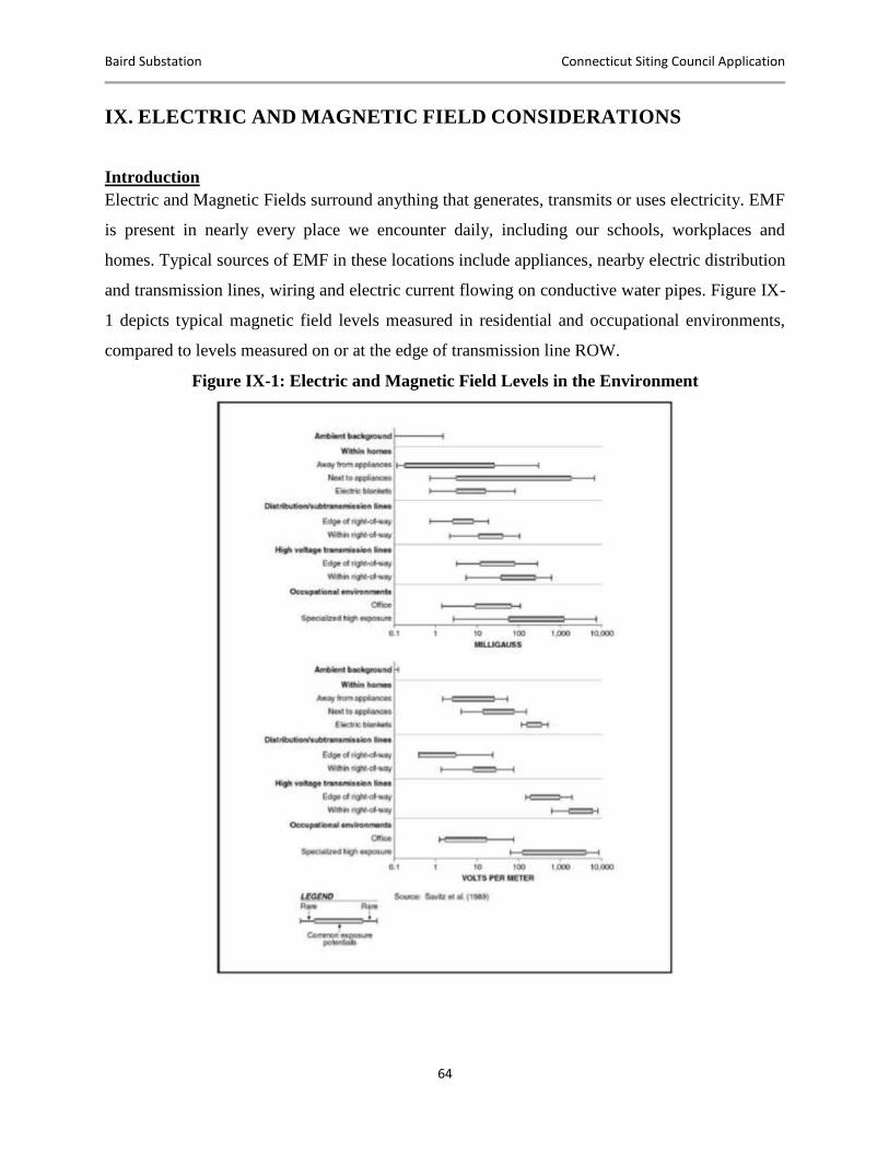
Baird Substation Connecticut Siting Council Application
64
IX. ELECTRIC AND MAGNETIC FIELD CONSIDERATIONS
Introduction
Electric and Magnetic Fields surround anything that generates, transmits or uses electricity. EMF
is present in nearly every place we encounter daily, including our schools, workplaces and
homes. Typical sources of EMF in these locations include appliances, nearby electric distribution
and transmission lines, wiring and electric current flowing on conductive water pipes. Figure IX-
1 depicts typical magnetic field levels measured in residential and occupational environments,
compared to levels measured on or at the edge of transmission line ROW.
Figure IX-1: Electric and Magnetic Field Levels in the Environment

Baird Substation Connecticut Siting Council Application
65
Magnetic Fields: The current flowing in the conductors of a substation bus-line or an overhead
transmission line generates a magnetic field near the conductors. The strength of Project-related
magnetic fields described herein is expressed as magnetic flux density in units of milligauss
(mG) where 1 Gauss = 1,000 mG. In the case of alternating current (“AC”) transmission lines,
these currents (and thus magnetic fields) vary in direction and magnitude with a 60-Hertz (Hz)
cycle. Since load current, expressed in units of amperes (A), generates magnetic fields around
the conductors, measurements or calculations of the magnetic field present a “snapshot” for the
load conditions at only one moment in time. On a given day, throughout a week or over the
course of months and years, the magnetic field level can change depending upon the patterns of
power demand on the bulk transmission system.
Electric Fields: The voltage on the conductors of transmission lines generates an electric field in
the space between the conductors and the ground. Many objects are conductive, including fences,
shrubbery and buildings, and thus shield electric fields. Electric fields within the Baird
substation, therefore, are not calculated since they are likely to be blocked by the substation
fence. In addition, the buried distribution lines will not be a source of 60-Hz electric fields above
ground, since electric fields are confined by the cables’ conductive sheath and armor, as well as
blocked by the surrounding soil and duct bank. Electric field levels were calculated beneath the
transmission lines and are expressed in units of kilovolts per meter (“kV/m”); 1 kV/m is equal to
1,000 volts per meter (“V/m”).
Assessment of EMF for the Baird Substation
Substations are less common EMF sources than distribution lines. Nevertheless, substations of
varying sizes can be found in many communities. For this Project, UI proposes to construct a
new substation adjacent to an existing substation that will take electricity from two existing,
adjacent 115 kV transmission lines and convert it to 13.8 kV for distribution in the surrounding
Stratford area.
An EMF assessment of the potential effects of the Baird substation was performed by Exponent.
Exponent’s Electric and Magnetic Field Assessment: The Baird Substation Rebuild Project
report is provided in Appendix G, including EMF measurements of the existing electrical
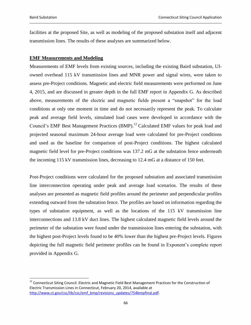
Baird Substation Connecticut Siting Council Application
66
facilities at the proposed Site, as well as modeling of the proposed substation itself and adjacent
transmission lines. The results of these analyses are summarized below.
EMF Measurements and Modeling
Measurements of EMF levels from existing sources, including the existing Baird substation, UI-
owned overhead 115 kV transmission lines and MNR power and signal wires, were taken to
assess pre-Project conditions. Magnetic and electric field measurements were performed on June
4, 2015, and are discussed in greater depth in the full EMF report in Appendix G. As described
above, measurements of the electric and magnetic fields present a “snapshot” for the load
conditions at only one moment in time and do not necessarily represent the peak. To calculate
peak and average field levels, simulated load cases were developed in accordance with the
Council’s EMF Best Management Practices (BMP).12
Calculated EMF values for peak load and
projected seasonal maximum 24-hour average load were calculated for pre-Project conditions
and used as the baseline for comparison of post-Project conditions. The highest calculated
magnetic field level for pre-Project conditions was 137.2 mG at the substation fence underneath
the incoming 115 kV transmission lines, decreasing to 12.4 mG at a distance of 150 feet.
Post-Project conditions were calculated for the proposed substation and associated transmission
line interconnection operating under peak and average load scenarios. The results of these
analyses are presented as magnetic field profiles around the perimeter and perpendicular profiles
extending outward from the substation fence. The profiles are based on information regarding the
types of substation equipment, as well as the locations of the 115 kV transmission line
interconnections and 13.8 kV duct lines. The highest calculated magnetic field levels around the
perimeter of the substation were found under the transmission lines entering the substation, with
the highest post-Project levels found to be 40% lower than the highest pre-Project levels. Figures
depicting the full magnetic field perimeter profiles can be found in Exponent’s complete report
provided in Appendix G.
12
Connecticut Siting Council. Electric and Magnetic Field Best Management Practices for the Construction of Electric Transmission Lines in Connecticut, February 20, 2014, available at http://www.ct.gov/csc/lib/csc/emf_bmp/revisions_updates/754bmpfinal.pdf.
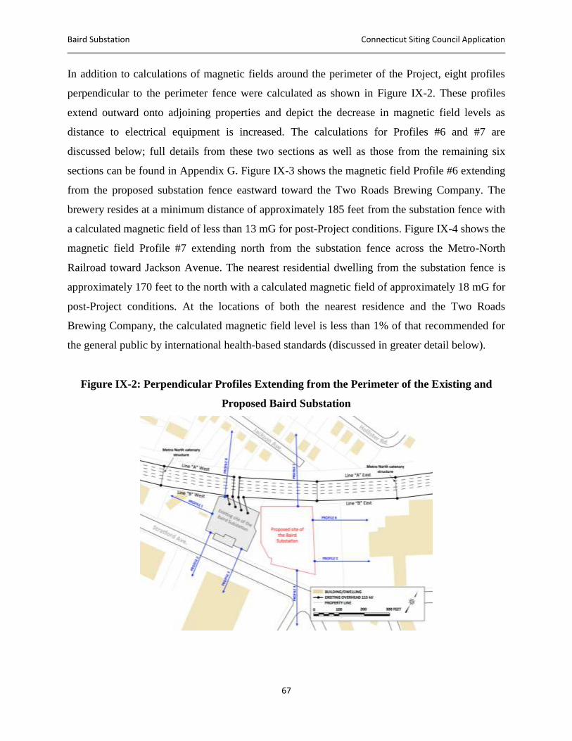
Baird Substation Connecticut Siting Council Application
67
In addition to calculations of magnetic fields around the perimeter of the Project, eight profiles
perpendicular to the perimeter fence were calculated as shown in Figure IX-2. These profiles
extend outward onto adjoining properties and depict the decrease in magnetic field levels as
distance to electrical equipment is increased. The calculations for Profiles #6 and #7 are
discussed below; full details from these two sections as well as those from the remaining six
sections can be found in Appendix G. Figure IX-3 shows the magnetic field Profile #6 extending
from the proposed substation fence eastward toward the Two Roads Brewing Company. The
brewery resides at a minimum distance of approximately 185 feet from the substation fence with
a calculated magnetic field of less than 13 mG for post-Project conditions. Figure IX-4 shows the
magnetic field Profile #7 extending north from the substation fence across the Metro-North
Railroad toward Jackson Avenue. The nearest residential dwelling from the substation fence is
approximately 170 feet to the north with a calculated magnetic field of approximately 18 mG for
post-Project conditions. At the locations of both the nearest residence and the Two Roads
Brewing Company, the calculated magnetic field level is less than 1% of that recommended for
the general public by international health-based standards (discussed in greater detail below).
Figure IX-2: Perpendicular Profiles Extending from the Perimeter of the Existing and
Proposed Baird Substation
Baird Substation Connecticut Siting Council Application
68
Figure IX-3: Perpendicular Profile #6 Extending from the Eastern Perimeter toward the
Two Roads Brewing Company
Figure IX-4: Perpendicular Profile #7 Extending from the Northern Perimeter toward
Jackson Avenue
Consistency with Connecticut Siting Council Policies
Neither the federal government nor Connecticut has enacted standards for magnetic fields or
electric fields from power lines or other sources at power frequencies. Several other states have
statutes or guidelines that apply to fields produced by new transmission lines, but these
guidelines are not health based. For example, New York and Florida have limits on EMF that
were designed to limit fields from new transmission lines to levels characteristic of the fields
from existing transmission lines.
Baird Substation Connecticut Siting Council Application
69
More relevant EMF assessment criteria include the exposure limits recommended by scientific
organizations. These exposure limits are included in guidelines developed to protect health and
safety and are based upon reviews and evaluations of relevant health research. These guidelines
include exposure limits for the general public recommended by the International Committee on
Electromagnetic Safety (“ICES”) and the International Commission on Non-Ionizing Radiation
Protection (“ICNIRP”) to address health and safety issues (ICES, 2002; ICNIRP, 2010).
In a June 2007 Fact Sheet, the World Health Organization included recommendations that
policymakers should adopt international exposure limit guidelines, such as those from ICNIRP
or ICES (Table IX-1), for occupational and public exposure to EMF.
Table IX-1: ICNIRP and ICES Guidelines for EMF Exposure
Exposure (60 Hz)
Electric Field Magnetic Field
ICNIRP
Occupational 8.3 kV/m 10 G (10,000 mG)
General Public 4.2 kV/m 2 G (2,000 mG)
ICES
Occupational 20 kV/m 27.1 G (27,100 mG)
General Public 5 kV/m* 9.040 G (9,040 mG)
*Within power line ROWs, the guideline is 10 kV/m under normal load conditions.
The Siting Council has published a guide for applications for Certificates of Environmental
Compatibility and Public Need for electric substations that addresses EMF (2010). The guide
calls for information to be provided on a number of topics, including public health and safety in
Section I.1 and on EMF specifically in Section L, where information supporting the consistency
of the proposed facility with the Siting Council’s EMF BMPs for transmission lines (2014) is to
be provided.
Interdisciplinary panels of scientists formed by national and international scientific agencies are
good sources of information and guidance for governmental agencies and the public; these
panels have evaluated the scientific research related to health and power-frequency EMF.
Baird Substation Connecticut Siting Council Application
70
Research on this topic varies widely in its approach, but the general scientific consensus of the
health agencies reviewing this research is that at levels associated with the operation of the
proposed substation, associated lines or other common sources of EMF in our environment, the
weight of the scientific evidence does not confirm that EMF causes any long-term adverse health
effects.
While neither the Council nor the above cited national and international health and scientific
agencies have concluded that electric or magnetic fields pose a health hazard, the Council has
embraced policies that would tend to minimize public exposure to ensure that a “proposed
facility would not pose an undue safety or health hazard”13
and have advocated for “the use of
effective no-cost and low-cost technologies and management techniques on a project-specific
basis to reduce MF [magnetic field] exposure to the public while allowing for the development
of efficient and cost-effective electrical transmission projects.”14
The EMF assessment for this Project was conducted in accordance with the Council’s
Application Guide for an Electric Substation Facility and, as summarized below, fulfills
requirements of the Siting Council’s EMF Best Management Practices (“BMP”) for the
Construction of Electric Transmission Lines in Connecticut (EMF BMP).
The design of the substation has incorporated reasonable measures to minimize EMF consistent
with the Council’s recommendations for transmission lines, including:
The proposed location of the substation has been shifted to the west by approximately
100 feet to create a buffer area between the substation and the closest abutting property
owner, the Two Roads Brewing Company.
The substation and related construction are to be designed to meet or exceed the
requirements of the National Electric Safety Code (“NESC”).
13
Connecticut Siting Council. Application Guide for an Electric Substation Facility, April 2010, available at http://www.ct.gov/csc/lib/csc/guides/guides2015/elec_sub_application_guide_410.pdf#55846. 14
Connecticut Siting Council. Electric and Magnetic Field Best Management Practices for the Construction of Electric Transmission Lines in Connecticut, February 20, 2014, available at http://www.ct.gov/csc/lib/csc/emf_bmp/revisions_updates/754bmpfinal.pdf.

Baird Substation Connecticut Siting Council Application
71
The proposed Site does not abut statutory facilities defined in Public Act No. 04-246, and
no additional buffer beyond that called for by the NESC and standard utility design and
practice is required.
The substation is located adjacent to the existing 115 kV transmission line ROW on the
MNR corridor, and the length of the transmission line interconnection is very short.
The new substation will be located directly adjacent to the existing energized substation
to be replaced, with magnetic field magnitudes similar to or lower than existing
conditions, but shifted eastward with the proposed equipment.
While the substation will be an additional source of EMF, the field levels produced will
be consistent with the range of EMF associated with the existing sources (e.g., the
existing substation, the adjacent overhead transmission and distribution lines, MNR
power and signal feeders) and will decrease rapidly with distance. At commercial
buildings adjacent to the Site to the east and residential areas to the north, the magnetic
field levels will be less than 1% of that recommended for the general public by
international health-based standards (ICES and ICNIRP).
The new 13.8 kV distribution circuits will exit the substation in an underground duct
bank. The close proximity of the conductors within this duct bank will help to minimize
the magnetic field above ground and totally shield the electric field as compared to an
above-ground line.
The four incoming transmission towers have been designed for a height of 85 feet,
reducing the post-Project magnetic field levels in this vicinity by 40% as compared to
pre-Project levels for this same area (i.e., under the incoming transmission lines).
Comparing Figure IX-1 to the results discussed above, the calculated magnetic field levels in the
vicinity of the new substation will be comparable to the existing conditions and similar in
magnitude to the magnetic field levels encountered in the vicinity of typical distribution lines and
in homes and workplaces.
The highest calculated magnetic field level at the perimeter of the proposed Baird substation
fence is less than 6% of that recommended for the general public by international health-based
standards (CES and ICNIRP) and is comparable to fields that may be found in homes near major
appliances.
Baird Substation Connecticut Siting Council Application
72
X. ALTERNATIVES CONSIDERED
After determining that UI’s distribution network required the construction of a new facility to
replace the existing Baird substation, UI identified and evaluated alternative substation sites that
would meet distribution and transmission system needs as well as provide a cost-effective
approach for interconnecting to the existing electric transmission and distribution network. The
objectives of this alternatives evaluation process were to:
Identify and assess potential substation sites that would meet existing distribution system
needs, including distribution substation requirements (size, design), as well as the new or
upgraded distribution lines that would be required to interconnect any new substation site
to the existing distribution infrastructure and the load centers in Stratford.
Evaluate potential substation sites based on engineering, constructability, environmental,
social and cost considerations, applying in particular the criteria contained in UI’s
Transmission and Distribution Guideline for Substation Site Selection (TDG 002; March
2013).
Select, from among the locations identified in the first two objectives, potential sites that
could be feasibly developed for a distribution substation to meet the overall demands for
electricity in the Stratford area, taking into consideration UI’s site selection guidelines.
Using this analysis process, the Baird Substation Site Selection Study (Appendix F) identified 12
sites, three of which were potentially viable. These three potentially feasible sites for the new
substation were subsequently evaluated in greater detail, taking into consideration engineering
design, construction, environmental and cost factors (Baird, West Broad Street, Bruce Street). As
a result of these evaluations, UI selected the Baird Annex property as the preferred Site. Due to
the exponential costs and environmental effects associated with the other two sites, UI is not
proposing an alternative site for the Council’s consideration. For the preferred Baird Annex Site,
UI also investigated alternative substation configurations, including the shifted arrangement
proposed after discussions with Stratford and neighboring property abutters.
The following subsections:
Summarize the step-by-step alternative site selection evaluation process that UI used to
identify the Baird Annex property as the preferred Site for the new substation.
Baird Substation Connecticut Siting Council Application
73
Describe the characteristics of the West Broad Street site.
Review the substation configuration options considered for the preferred Baird Annex
Site.
X.A UI SITE SELECTION CRITERIA
GENERAL CRITERIA
UI followed the procedures contained in the Transmission and Distribution Guideline for
Substation Site Selection (“Guideline”), which describes the standard procedures and criteria
used to identify and evaluate a location for the determination of a substation site. The key factors
considered in the selection of the Site included the following:
Distance to the existing Baird substation and to existing electric transmission lines
Site size requirements
Site terrain
Environmental and land use compatibility
Substation construction issues
Transmission and distribution line construction requirements
Accessibility
Cost
UI assembled a multidisciplinary team comprised of personnel with expertise in electrical
distribution and transmission system planning, design, construction, environmental science and
real estate to conduct an analysis of the alternative sites. This team followed a step-by-step
process, whereby potential substation locations were first identified and screened in accordance
with UI’s standard objectives for substation siting. In addition to the factors listed above, the UI
team considered the following principles, as detailed in the Guideline:
Minimize the need to acquire residences and viable commercial/industrial uses to
accommodate substation development.
Baird Substation Connecticut Siting Council Application
74
Maintain consistency/compatibility with existing land uses and land use plans to the
extent possible.
Minimize adverse effects on sensitive environmental resources and the social
environment.
Maintain public health and safety.
Demonstrate cost-effectiveness, while adhering to good engineering and sound
environmental planning practices.
Present the public with a clear and well-documented methodology for the identification
of the proposed and alternative sites.
DISTRIBUTION SYSTEM CONSIDERATIONS IN THE STRATFORD AREA
To meet the distribution capacity needs of the Stratford area, UI determined that any new
substation that would replace the existing Baird substation should be located to facilitate
interconnections to the existing electrical transmission and distribution systems, particularly to
allow cost-effective interconnections to the existing and projected electric load areas. The
following primary factors were considered when identifying and assessing potential sites:
Location of potential sites in relation to the existing electric distribution network. For
distribution interconnections, preferred sites are near existing distribution infrastructure
or in areas where new distribution infrastructure could be economically developed to
reach load centers. The distance of the Project is a primary consideration, as the
distribution infrastructure required to serve the electric load areas collectively terminates
at the existing substation. Location of the proposed Project in close proximity to the
existing substation limits conflicts with physical encumbrances, the presence of other
utilities and costs associated with the installation of additional distribution infrastructure.
Availability of land for development of a distribution substation. The minimum required
area for the proposed Project, a “distribution only” open-air 115/13.8 kV substation
supplied by four transmission lines with two transmission circuit breakers, no expansion
capability on the transmission side and appropriate buffers and setbacks, is 1.5 acres.
Location of sites in relation to existing transmission lines (possible interconnections).
Four UI 115 kV transmission lines extend east to west along the MNR corridor and are
located adjacent to UI’s existing Baird substation. These four transmission lines are
interconnected to several distribution and transmission substations in UI’s territory.
These distribution substations each feed independent electric load centers, both to the east
and west of the existing Baird substation in Bridgeport and Stratford.
Baird Substation Connecticut Siting Council Application
75
After taking these factors into consideration, UI defined the preferred geographic location of the
proposed Site for the Project as an approximately 1,000-foot-wide corridor along the existing
MNR corridor bounded by the two existing distribution substations to the east and west of the
existing Baird substation. This siting region was selected because of the existing Stratford
electric load area the Project would serve.
X.B IDENTIFICATION AND SCREENING OF POTENTIAL SITES
OVERVIEW OF THE SITE SCREENING PROCESS
UI applied the siting criteria within the preferred geographic siting region and conducted
baseline research, performed field reconnaissance and consulted with municipal officials to
evaluate potential site locations. As a result of this process, UI identified 12 potential sites for
initial consideration of the Project. These potential sites were identified based on the Guideline
and the existing distribution and transmission considerations specific to the Stratford area.
The 12 identified sites were screened using the following preliminary criteria:
Greater than or equal to 1.5 acres of developable land (the estimated minimum size for
the development of an open-air distribution substation of this type)
Sites with at least one of the following characteristics:
o Land adjacent to the MNR corridor between the distribution substations directly
to the east and west of the existing Baird substation
o Land owned by UI
o Land that is vacant, available for sale, underdeveloped (e.g., formerly developed
properties that are available for reuse) or otherwise undeveloped
Sites that appeared, based on the initial evaluation, to meet at least some of the preliminary siting
criteria were then qualitatively evaluated using the following factors:
Environmental – Environmental issues, including site characteristics, present and past
land uses, cultural resources, threatened and endangered species, tidal or inland wetlands,
ponds, aquifers, watercourses, public watersheds and floodplains, the potential need for
environmental remediation (for previously developed sites) and encumbrances
Surroundings – Zoning and description of the surrounding area, including the site’s
proximity to statutory facilities (schools, playgrounds, daycares, nursery schools, day
camps and residential neighborhoods)
Baird Substation Connecticut Siting Council Application
76
Transmission and Distribution System – System transmission and distribution
interconnection costs and other considerations, including system impacts, accessibility
and right-of-way requirements
Construction – Substation construction, vehicular access costs and other related
considerations, including the effects of site size, shape and subsurface topographical
conditions
Acreage Available – Property availability, additional land for buffer or expansion,
expected cost and availability of easements
Permitability – Anticipated ability to obtain all the required siting, land use,
environmental and construction permits
Using this process, most of the potential sites initially identified were found to be impractical for
the development of the proposed Project and were eliminated from further consideration. The
reasons for eliminating a particular site varied, ranging from environmental issues (e.g., presence
of wetlands, rock, insufficient developable area, incompatible land uses) to the identification of
new information regarding the future development plans for vacant property.
When the screening analysis was completed, UI identified three sites that appeared to be feasible
for the development of the proposed Project:
Bruce Street
West Broad Street
Baird Annex (UI property)15
Figure X.B-1 illustrates the locations of these three sites.
UI conducted a more detailed evaluation of each of these three sites. As discussed in the
following subsections, of the three alternative sites, UI determined that the development of the
Baird Annex Site would best meet the Project objectives, based on environmental, technical and
15
The Baird Annex site was evaluated as a standalone site using criteria outlined in UI’s Transmission and
Distribution Guideline for Substation Site Selection. The incorporation of the adjacent UI-owned parcel to the west
(on which the existing Baird substation resides) to accommodate the shift of the substation to the west occurred after
the completion of the Baird Substation Site Selection Study.
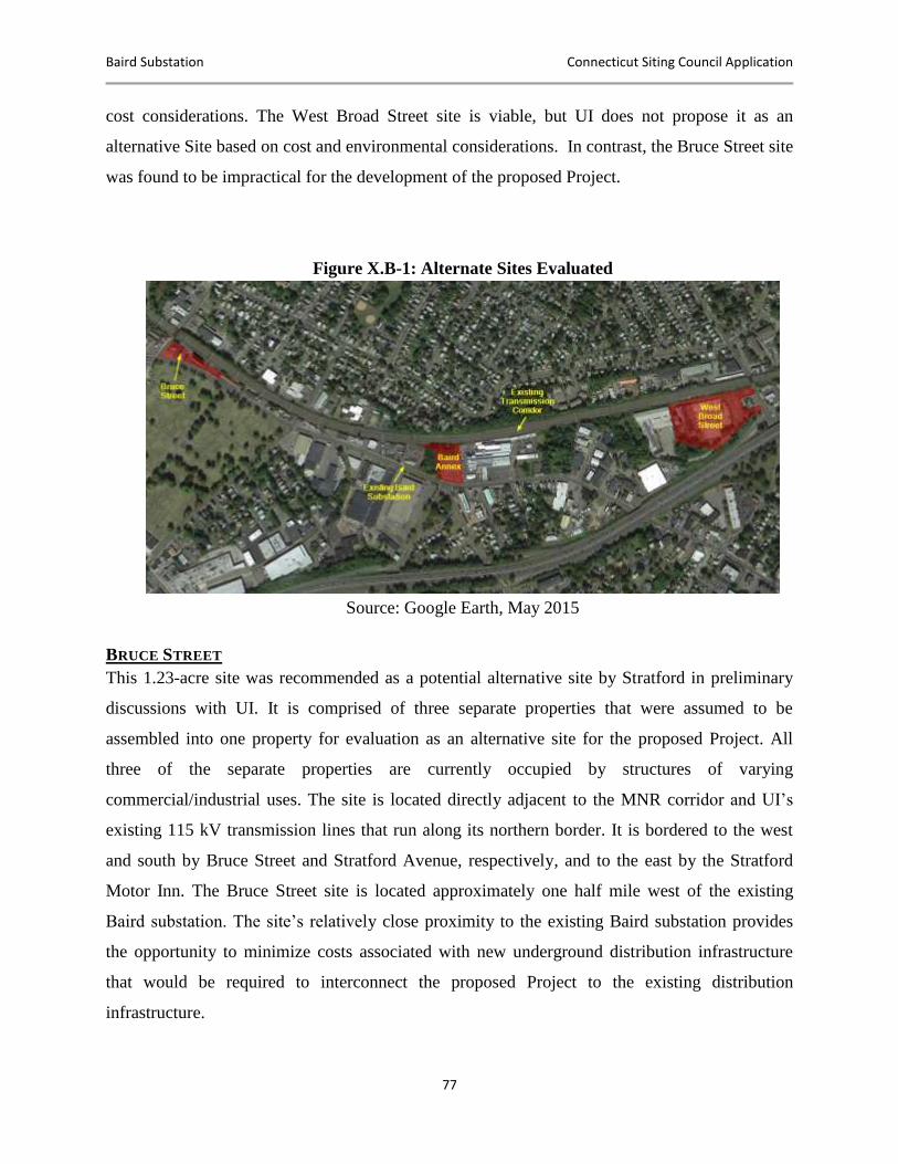
Baird Substation Connecticut Siting Council Application
77
cost considerations. The West Broad Street site is viable, but UI does not propose it as an
alternative Site based on cost and environmental considerations. In contrast, the Bruce Street site
was found to be impractical for the development of the proposed Project.
Figure X.B-1: Alternate Sites Evaluated
Source: Google Earth, May 2015
BRUCE STREET
This 1.23-acre site was recommended as a potential alternative site by Stratford in preliminary
discussions with UI. It is comprised of three separate properties that were assumed to be
assembled into one property for evaluation as an alternative site for the proposed Project. All
three of the separate properties are currently occupied by structures of varying
commercial/industrial uses. The site is located directly adjacent to the MNR corridor and UI’s
existing 115 kV transmission lines that run along its northern border. It is bordered to the west
and south by Bruce Street and Stratford Avenue, respectively, and to the east by the Stratford
Motor Inn. The Bruce Street site is located approximately one half mile west of the existing
Baird substation. The site’s relatively close proximity to the existing Baird substation provides
the opportunity to minimize costs associated with new underground distribution infrastructure
that would be required to interconnect the proposed Project to the existing distribution
infrastructure.
Baird Substation Connecticut Siting Council Application
78
Upon further review of the feasibility of this site, it was determined that there is insufficient
space to accommodate the proposed Project. An engineering review of conceptual arrangement
plans for the necessary equipment revealed that electrical clearances would be violated from
energized equipment to the perimeter fence. In addition, the narrow nature of the parcel results in
insufficient maintenance access around critical pieces of equipment that would need to be
located on the eastern portion of the site. There would also be inadequate space for UI’s mobile
transformer, which would be brought to the site if one of the station transformers is removed
from service for an extended period of time.
Although the Bruce Street site is physically located close to the existing Baird substation and
shares Stratford Avenue as an access road, the parcel is not sufficiently large enough for the
proposed Project. Additionally, the existing structures would need to be demolished and the
foundations removed prior to construction of the Project. This would result in a significant
increase in site preparation costs over a greenfield site. These factors contributed to UI’s
determination that the Bruce Street site would not be feasible or cost-effective for a new
115/13.8 kV distribution substation.
WEST BROAD STREET
This site is located to the east of the existing Baird substation, between the MNR corridor and
Interstate 95, at 1297 West Broad Street. UI’s two 115 kV transmission lines run along its
northern border. The site is the former location of an industrial facility that had several structures
demolished, but still has several remaining. Abutting the property to the west along a joint access
road is the MLI Redemption Services bottle and can redemption center.
In the general vicinity of the site, industrial and commercial buildings border West Broad Street
and also characterize areas to the north of the site. Farther to the north, beyond the MNR corridor
and commercial/industrial facilities, are residential neighborhoods along Knowlton Street.
The siting of the new substation at the West Broad Street site is constrained from interconnecting
to the existing Baird substation’s distribution infrastructure along Stratford Avenue. Utilization
of this site for the proposed Project would require the interconnection of new distribution circuits
to their collective termination point in front of the existing Baird substation. Since there is no
Baird Substation Connecticut Siting Council Application
79
direct road access between the existing Baird substation and the West Broad Street site on
Stratford Avenue, it would require a longer access route using Beardsley Avenue. No
underground distribution infrastructure currently exists on the necessary portions of Beardsley
Avenue or West Broad Street. Additionally, the existing underground infrastructure on the
necessary portions of Stratford Avenue would not be sufficient to support the number of circuits
that would be required. As a result, new underground infrastructure would be required over a
distance of approximately one mile with two crossings under Interstate 95.
The site is also a brownfield and would likely require considerable remediation of contaminated
soils during construction. While portions of the previous manufacturing facility have been
demolished, a large building remains and is abandoned. The foundations from the demolished
portions of the facility remain on site and would require removal to accommodate the necessary
site grading, equipment foundations, duct lines for distribution get-aways and grounding for the
new substation.
BAIRD ANNEX
UI selected the Baird Annex property as the preferred Site for the proposed Project due primarily
to the following factors:
The Site is consistent with the industrial/commercial land uses of the surrounding area.
The Site is located directly along UI’s existing 115 kV transmission lines adjacent to the
MNR corridor,
The proposed Town of Stratford roundabout requires modifications to UI’s existing
overhead and underground distribution infrastructure directly adjacent to the Site. With
modifications to underground infrastructure already required, the costs and impacts of
interconnecting the new substation distribution circuits to existing infrastructure are
decreased.
The Site is located immediately adjacent to the existing substation property, decreasing
the impacts and costs of new infrastructure to interconnect the proposed Project’s
distribution circuits to the existing infrastructure.
The Site provides the lowest evaluated cost option.
After discussions with Stratford and neighboring property abutters, UI reevaluated the
positioning of the substation on the Baird Annex property to better utilize the adjacent UI-owned
property to the west. The proposed substation position utilizes both the aforementioned Baird
Annex property and the UI-owned property directly to the west.
Baird Substation Connecticut Siting Council Application
80
SUMMARY OF SITE SELECTION PROCESS
In summary, the Baird Annex Site is the optimal site for the development of the new Baird
substation. After closely examining the three potential options, UI decided against proposing the
West Broad Street and Bruce Street locations as they contain significant compliance,
engineering, and cost impediments.
The construction of a substation at the Baird Site is consistent with the land uses of the
surrounding area, particularly the immediately adjacent existing Baird substation, as well as the
historic uses of the Site itself. The Baird Annex Site’s close proximity to the existing substation
that it will replace makes it best suited for interconnection to existing distribution infrastructure.
In addition, the Site’s abutment of the MNR corridor provides direct access to UI’s 115 kV
transmission lines. All of these factors, amongst others, make the Baird Site the least cost
option.
Furthermore, the planned modification of UI’s overhead and underground infrastructure along
Stratford Avenue to accommodate Stratford’s proposed roundabout provides a unique
opportunity to interconnect the new substation’s distribution circuits to infrastructure required
for modification.
Finally, UI was able to secure Project support from Stratford and a major industrial abutter at the
proposed Site after modifying the original design. This shifted arrangement efficiently utilizes
the Baird Annex property, as well as the adjacent UI-owned property on which the existing
substation resides.
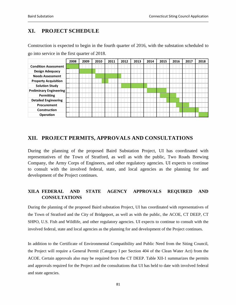
Baird Substation Connecticut Siting Council Application
81
XI. PROJECT SCHEDULE
Construction is expected to begin in the fourth quarter of 2016, with the substation scheduled to
go into service in the first quarter of 2018.
XII. PROJECT PERMITS, APPROVALS AND CONSULTATIONS
During the planning of the proposed Baird Substation Project, UI has coordinated with
representatives of the Town of Stratford, as well as with the public, Two Roads Brewing
Company, the Army Corps of Engineers, and other regulatory agencies. UI expects to continue
to consult with the involved federal, state, and local agencies as the planning for and
development of the Project continues.
XII.A FEDERAL AND STATE AGENCY APPROVALS REQUIRED AND
CONSULTATIONS
During the planning of the proposed Baird substation Project, UI has coordinated with representatives of
the Town of Stratford and the City of Bridgeport, as well as with the public, the ACOE, CT DEEP, CT
SHPO, U.S. Fish and Wildlife, and other regulatory agencies. UI expects to continue to consult with the
involved federal, state and local agencies as the planning for and development of the Project continues.
In addition to the Certificate of Environmental Compatibility and Public Need from the Siting Council,
the Project will require a General Permit (Category I per Section 404 of the Clean Water Act) from the
ACOE. Certain approvals also may be required from the CT DEEP. Table XII-1 summarizes the permits
and approvals required for the Project and the consultations that UI has held to date with involved federal
and state agencies.
Condition Assessment
Design Adequacy
Needs Assessment
Property Acquisition
Solution Study
Preliminary Engineering
Permitting
Detailed Engineering
Procurement
Construction
Operation
2014 2015 2016 2017 20182008 2009 2010 2011 2012 2013
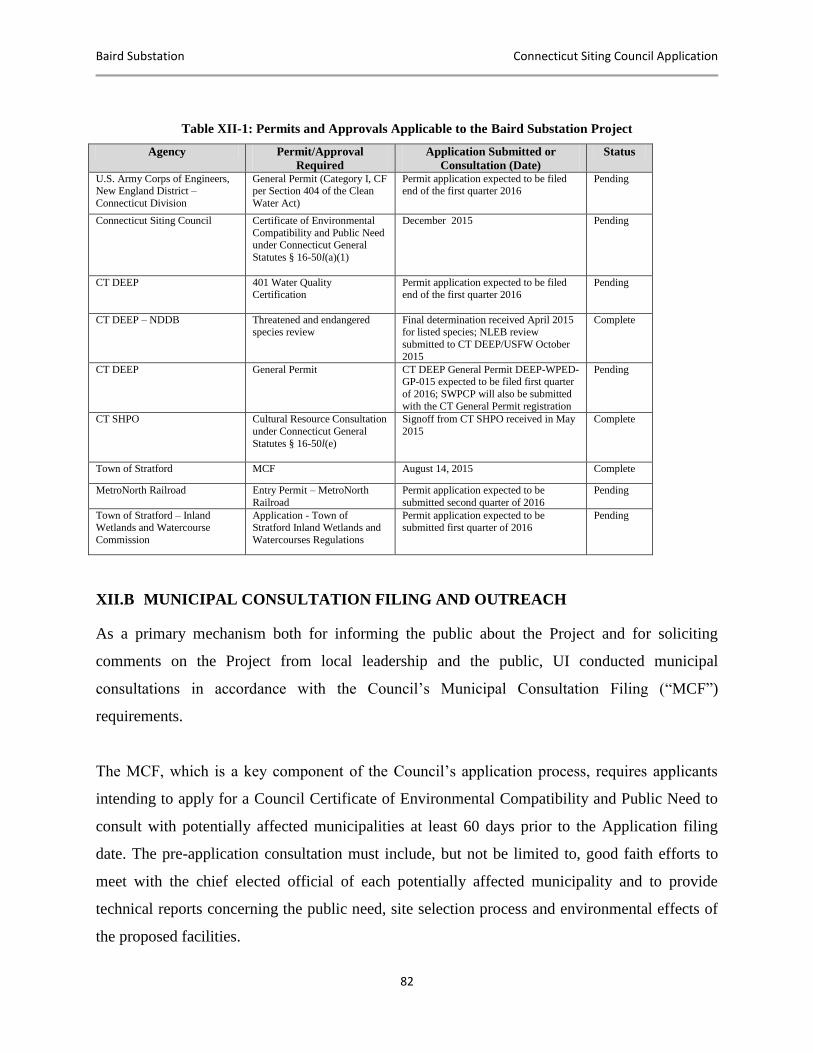
Baird Substation Connecticut Siting Council Application
82
Table XII-1: Permits and Approvals Applicable to the Baird Substation Project
Agency Permit/Approval
Required
Application Submitted or
Consultation (Date)
Status
U.S. Army Corps of Engineers, New England District –
Connecticut Division
General Permit (Category I, CF per Section 404 of the Clean
Water Act)
Permit application expected to be filed end of the first quarter 2016
Pending
Connecticut Siting Council Certificate of Environmental
Compatibility and Public Need under Connecticut General
Statutes § 16-50l(a)(1)
December 2015 Pending
CT DEEP 401 Water Quality Certification
Permit application expected to be filed end of the first quarter 2016
Pending
CT DEEP – NDDB Threatened and endangered species review
Final determination received April 2015 for listed species; NLEB review
submitted to CT DEEP/USFW October
2015
Complete
CT DEEP General Permit CT DEEP General Permit DEEP-WPED-GP-015 expected to be filed first quarter
of 2016; SWPCP will also be submitted
with the CT General Permit registration
Pending
CT SHPO Cultural Resource Consultation
under Connecticut General
Statutes § 16-50l(e)
Signoff from CT SHPO received in May
2015
Complete
Town of Stratford MCF August 14, 2015 Complete
MetroNorth Railroad Entry Permit – MetroNorth
Railroad
Permit application expected to be
submitted second quarter of 2016
Pending
Town of Stratford – Inland Wetlands and Watercourse
Commission
Application - Town of Stratford Inland Wetlands and
Watercourses Regulations
Permit application expected to be submitted first quarter of 2016
Pending
XII.B MUNICIPAL CONSULTATION FILING AND OUTREACH
As a primary mechanism both for informing the public about the Project and for soliciting
comments on the Project from local leadership and the public, UI conducted municipal
consultations in accordance with the Council’s Municipal Consultation Filing (“MCF”)
requirements.
The MCF, which is a key component of the Council’s application process, requires applicants
intending to apply for a Council Certificate of Environmental Compatibility and Public Need to
consult with potentially affected municipalities at least 60 days prior to the Application filing
date. The pre-application consultation must include, but not be limited to, good faith efforts to
meet with the chief elected official of each potentially affected municipality and to provide
technical reports concerning the public need, site selection process and environmental effects of
the proposed facilities.
Baird Substation Connecticut Siting Council Application
83
In August of 2015, UI submitted an MCF for the Project. This MCF was duly noted and
provided to Stratford, the municipality in which the proposed Project may be constructed.
During the municipal consultation period, UI offered to meet with the chief executive officer of
Stratford to review the MCF in more detail in order to present an overview of the Project and the
siting process and to review the methods available for the town to provide input to the Project’s
siting process. UI has met with Mayor Harkins of Stratford on several occasions, and has gained
input regarding concerns and special considerations associated with the proposed Site in
Stratford. UI has also had multiple meetings with the owners of the Two Roads Brewery
Company to review the proposed Project and discuss potential impacts to their property and
business. UI has incorporated concerns raised by the Town of Stratford as well as by the owners
of the Two Roads Brewing Company into its final site plans for the Project, including moving
the new substation further away from the brewery to provide a larger buffer and accommodate
customer parking for Two Roads Brewing Company. The brewery has offered to sponsor the
landscaping at the substation in areas that will face the street.
On May 27, 2015, prior to the municipal filing, UI held a public “open house” meeting at Two
Roads Brewing Company to discuss the Project with members of the public and to obtain
comments regarding the proposed Project. Members of the UI Project Team and subject matter
experts were available at the open house to provide information and to answer specific questions.
There were a total of five attendees, two from the Town of Stratford, the owner of Two Roads
Brewing Company and two residents of Stratford.
The overall objective of the municipal consultation process was to obtain input regarding the
proposed Project from representatives of the municipality potentially affected by the proposed
Project, as well as from the interested public. In accordance with the Council’s requirements and
Connecticut General Statutes § 16-50l(e), within 15 days of filing the Application, UI will supply
to the Council all materials provided to the municipalities and a summary of the consultations
with the towns, including any comments or recommendations issued by the municipalities, as
well as copies of comments received from the public.
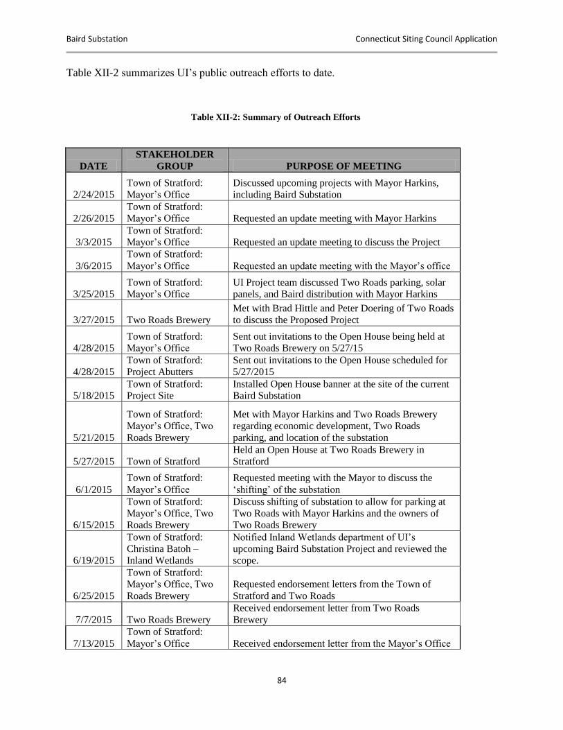
Baird Substation Connecticut Siting Council Application
84
Table XII-2 summarizes UI’s public outreach efforts to date.
Table XII-2: Summary of Outreach Efforts
DATE
STAKEHOLDER
GROUP PURPOSE OF MEETING
2/24/2015
Town of Stratford:
Mayor’s Office
Discussed upcoming projects with Mayor Harkins,
including Baird Substation
2/26/2015
Town of Stratford:
Mayor’s Office Requested an update meeting with Mayor Harkins
3/3/2015
Town of Stratford:
Mayor’s Office Requested an update meeting to discuss the Project
3/6/2015
Town of Stratford:
Mayor’s Office Requested an update meeting with the Mayor’s office
3/25/2015
Town of Stratford:
Mayor’s Office
UI Project team discussed Two Roads parking, solar
panels, and Baird distribution with Mayor Harkins
3/27/2015 Two Roads Brewery
Met with Brad Hittle and Peter Doering of Two Roads
to discuss the Proposed Project
4/28/2015
Town of Stratford:
Mayor’s Office
Sent out invitations to the Open House being held at
Two Roads Brewery on 5/27/15
4/28/2015
Town of Stratford:
Project Abutters
Sent out invitations to the Open House scheduled for
5/27/2015
5/18/2015
Town of Stratford:
Project Site
Installed Open House banner at the site of the current
Baird Substation
5/21/2015
Town of Stratford:
Mayor’s Office, Two
Roads Brewery
Met with Mayor Harkins and Two Roads Brewery
regarding economic development, Two Roads
parking, and location of the substation
5/27/2015 Town of Stratford
Held an Open House at Two Roads Brewery in
Stratford
6/1/2015
Town of Stratford:
Mayor’s Office
Requested meeting with the Mayor to discuss the
‘shifting’ of the substation
6/15/2015
Town of Stratford:
Mayor’s Office, Two
Roads Brewery
Discuss shifting of substation to allow for parking at
Two Roads with Mayor Harkins and the owners of
Two Roads Brewery
6/19/2015
Town of Stratford:
Christina Batoh –
Inland Wetlands
Notified Inland Wetlands department of UI’s
upcoming Baird Substation Project and reviewed the
scope.
6/25/2015
Town of Stratford:
Mayor’s Office, Two
Roads Brewery
Requested endorsement letters from the Town of
Stratford and Two Roads
7/7/2015 Two Roads Brewery
Received endorsement letter from Two Roads
Brewery
7/13/2015
Town of Stratford:
Mayor’s Office Received endorsement letter from the Mayor’s Office
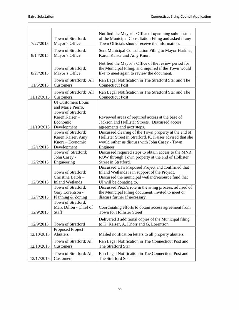
Baird Substation Connecticut Siting Council Application
85
7/27/2015
Town of Stratford:
Mayor’s Office
Notified the Mayor’s Office of upcoming submission
of the Municipal Consultation Filing and asked if any
Town Officials should receive the information.
8/14/2015
Town of Stratford:
Mayor’s Office
Sent Municipal Consultation Filing to Mayor Harkins,
Karen Kaiser and Amy Knorr
8/27/2015
Town of Stratford:
Mayor’s Office
Notified the Mayor’s Office of the review period for
the Municipal Filing, and inquired if the Town would
like to meet again to review the document.
11/5/2015
Town of Stratford: All
Customers
Ran Legal Notification in The Stratford Star and The
Connecticut Post
11/12/2015
Town of Stratford: All
Customers
Ran Legal Notification in The Stratford Star and The
Connecticut Post
11/19/2015
UI Customers Louis
and Marie Pierro,
Town of Stratford:
Karen Kaiser –
Economic
Development
Reviewed areas of required access at the base of
Jackson and Hollister Streets. Discussed access
agreements and next steps.
12/1/2015
Town of Stratford:
Karen Kaiser, Amy
Knorr – Economic
Development
Discussed clearing of the Town property at the end of
Hollister Street in Stratford. K. Kaiser advised that she
would rather us discuss with John Casey - Town
Engineer.
12/2/2015
Town of Stratford:
John Casey -
Engineering
Discussed required steps to obtain access to the MNR
ROW through Town property at the end of Hollister
Street in Stratford.
12/3/2015
Town of Stratford:
Christina Batoh –
Inland Wetlands
Discussed UI’s Proposed Project and confirmed that
Inland Wetlands is in support of the Project.
Discussed the municipal wetland/resource fund that
UI will be donating to.
12/7/2015
Town of Stratford:
Gary Lorentson -
Planning & Zoning
Discussed P&Z’s role in the siting process, advised of
the Municipal Filing document, invited to meet or
discuss further if necessary.
12/9/2015
Town of Stratford:
Marc Dillon - Chief of
Staff
Coordinating efforts to obtain access agreement from
Town for Hollister Street
12/9/2015 Town of Stratford
Delivered 3 additional copies of the Municipal filing
to K. Kaiser, A. Knorr and G. Lorentson
12/10/2015
Proposed Project
Abutters Mailed notification letters to all property abutters
12/10/2015
Town of Stratford: All
Customers
Ran Legal Notification in The Connecticut Post and
The Stratford Star
12/17/2015
Town of Stratford: All
Customers
Ran Legal Notification in The Connecticut Post and
The Stratford Star
Baird Substation Connecticut Siting Council Application
86
XIV. BULK FILING OF MUNICIPAL DOCUMENTS
As applicable, bulk filing of the municipal zoning, planning, planning and zoning, conservation
(including any plans of conservation and development and open space plans), and inland wetland
regulations and bylaws of the Town of Stratford will be provided to the Council by a separate
filing.
XV. APPLICATION FILING FEE The filing fee for this Application is determined by the Council’s filing fee schedule set forth in
RCSA § 16-50v-1a and based on the estimated construction cost for the substation. Pursuant to
RCSA § 16-50v-4 and Conn. Gen. Stat. § 16-50bb, the Company also encloses a separate check
in the amount of $25,000 payable to the Council for the Municipal Participation Fee.
XVI. CONCLUSION
This Application and the accompanying materials and documentation clearly demonstrate that a
public need for the Project exists. The Company respectfully submits that the public need for the
Project outweighs any limited potential environmental effects from the development of a new
substation in Stratford. The United Illuminating Company respectfully requests that the Council
grant a Certificate of Environmental Compatibility and Public Need for this Project.
Respectfully submitted,
THE UNITED ILLUMINATING COMPANY
By: ______________________________
Richard J. Reed, PMP
Baird Substation Connecticut Siting Council Application
87
APPENDICES
Baird Substation Connecticut Siting Council Application
APPENDIX A
MAPS AND DRAWINGS
DR.1 U.S.G.S. Topographic Quadrangle Map: Proposed Project Location
DR.2 Proposed Substation Location within the Town of Stratford
DR.3 Site Plan
DR.4 Substation Drawings
DR.5 Existing and Historic Aerial Photographs of the Project Site
DR.6 Public Facilities and Resources (Map and Table)
Baird Substation Connecticut Siting Council Application
APPENDIX B
AGENCY CORRESPONDENCE
Baird Substation Connecticut Siting Council Application
APPENDIX C
WETLAND DELINEATION REPORT
Baird Substation Connecticut Siting Council Application
APPENDIX D
NOISE ASSESSMENT
Baird Substation Connecticut Siting Council Application
APPENDIX E
VISIBILITY ANALYSIS

Baird Substation Connecticut Siting Council Application
APPENDIX F
SITE SELECTION STUDY
Baird Substation Connecticut Siting Council Application
APPENDIX G
ELECTRIC AND MAGNETIC FIELD (EMF)
ASSESSMENT
Baird Substation Connecticut Siting Council Application
APPENDIX H
BAIRD SUBSTATION CONDITION ASSESSMENT
DISTRIBUTION CAPACITY AND VOLTAGE
REGULATION
Baird Substation Connecticut Siting Council Application
APPENDIX I
BASELINE ENVIRONMENTAL ASSESSMENT:
BAIRD SUBSTATION
Baird Substation Connecticut Siting Council Application
APPENDIX J
CULTURAL RESOURCE REVIEW
Baird Substation Connecticut Siting Council Application
APPENDIX K
HABITAT ASSESSMENT FOR NORTHERN LONG
EARED BAT
Baird Substation Connecticut Siting Council Application
APPENDIX L
FORMAL REQUIREMENTS