Embed Size (px)
Citation preview

AQA A2 Human Geography Revision booklet
A2 Geography 2016 | De La Salle, Jersey
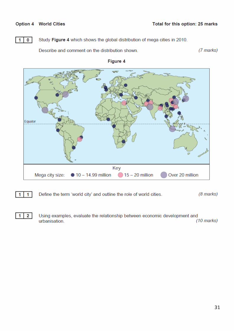
World CitiesThe global pattern of urbanisation: millionaire cities, mega cities and world cities
At a global scale, rapid urbanisation has occurred over the last 50 years. Almost 50% of the world’s population lives in towns and cities. 19% of the world’s population lives
in cities of more than 1 million people. The most urbanised continents are Europe, North and South America and Oceania and the least
urbanised continents are Asia and Africa. The number of urban dwellers is by far largest in Asia, with 1.4 billion people living in towns and
cities (40% of the population). Urbanisation is increasing most rapidly in Africa and Asia. This trend is expected to continue so that by 2025 almost half the population of these continents
will live in urban areas and 80% of urban dwellers will live in developing countries. Increased global urbanisation has resulted in the development of many millionaire cities. There is also a significant number of enormous megacities, some of which are classed as world
cities. Millionaire cities are those with more than 1 million people. India and China have the most
millionaire cities in the world. Megacities are those with more than 10 million people, of which there are 20 (15 in the
developing world) World cities are those which have great influence on a global scale, because of their
financial status and worldwide commercial power. Three cities sit at the top of the global hierarchy: New York, London and Tokyo.
Economic development and change related to urbanisation A consequence of the rapid economic development taking place in parts of China, India and
southeast Asia is that the level of urbanisation will increase very rapidly here. Rates of economic development and rates of urbanisation are rising simultaneously in these
countries. In Europe, Oceania and North America, the more economically developed areas of the world,
urbanisation levels peaked in the 1970s and have fallen steadily since then.
1
Millionaire cities, mega Cities, and world cities.Millionaire cities are those that have over a million residents. Mega cities have at least 10 million people.World cities are important focal points in terms of politics, economies, transport, and other global processes.Different factors cause cities to develop into mega cities. These include:
Natural increase Push factorsPorts and trade Colonial Influences
The World Health Organisation estimate that “By 2030, 6 out of every 10 people will live in a city, and by 2050, this proportion will increase to 7 out of 10 people.”
“Urbanisation is a more recent arrival in LEDCs and NICs. The growth over the past fifty years of many developing world cities has had major implications for the people living there and the management of those issues. NICs (Newly Industrialising Countries) have urbanisation that takes place with rapid industrialisation, as has been witnessed in Brazil and South Eastern China, whilst in some LDCs (Least Developed Countries) urbanisation takes place in the relative absence of industrialisation, people forced to cities to live in poor conditions with limited opportunities for jobs.” Indeed, we must consider to what extent are the two processes of urbanisation and industrialisation mutually dependent?”
(www.coolgeography.co.uk
Exam questions could include:Define the term ‘world city’ and outline the role of world cities. (8) Using examples, evaluate the relationship between economic development and urbanisation. (10)
2
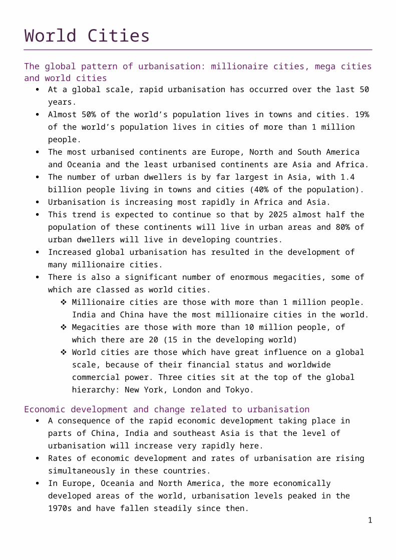
A map showing the distribution of GaWC-ranked world cities (2010 data)
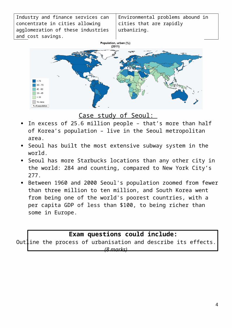
UrbanisationThis is the demographic change from rural areas to urban areas. In 2010, 50% of the
world’s population lived in urban areas.These occur due to push and pull factors.Push: crop failure, unemployment, hazards, poverty, etc.Pull: fertile land, political stability, friends and family, etc.Positives of Urbanisation Negatives of UrbanisationBetter services Encourages the growth of unplanned and illegal
shanty towns. Infant mortality is lower in cities and life expectancy tends to be higher than in rural areas.
Informal sector employment rarely receives support from government and is often subject to harassment.
Industry and finance services can concentrate in cities allowing agglomeration of these industries and cost savings.
Environmental problems abound in cities that are rapidly urbanizing.
Case study of Seoul: In excess of 25.6 million people – that’s more than half of Korea’s population – live in
the Seoul metropolitan area. Seoul has built the most extensive subway system in the world. Seoul has more Starbucks locations than any other city in the world: 284 and
counting, compared to New York City’s 277. Between 1960 and 2000 Seoul's population zoomed from fewer than three million to
ten million, and South Korea went from being one of the world's poorest countries, with a per capita GDP of less than $100, to being richer than some in Europe.
Exam questions could include:Outline the process of urbanisation and describe its effects. (8 marks)
3
Suburbanisation“The process of population movement from the central areas of cities towards the suburbs on the outskirts or the rural-urban fringe.”These are caused by:
1. “White flight”. 2. Improvements of transport infrastructure.3. Developments in communication technology.4. Demand for housing.
Positives NegativesInner city
Suburbs mean that there is less need for high-rise, high-density housing, such as in deindustrialised areas of Newcastle, leading to clearance and replacement by low-rise, low-density housing. This is better for residents.
The greater availability of space created by clearance of inner city areas allows for improved communication networks
Derelict land can be cleared in the Inner city allowing for increased opportunity for environmental improvement of that land to create recreational open spaces.
Suburbanisation can lead to the decline of inner city areas as skilled people and businesses move away.
This means that the suburbanisation of jobs leads to employment opportunities, leading to lower employment opportunities which leads to a spiral of decline.Communities are split up and damaged as people migrate out to the suburbs.
Suburbanisation means that more buildings are left vacant. These buildings might be dangerous, look bad and stop people investing in the area (inward investment).
The large income gaps between suiburb and inner city lead to polarisation and resentment.
Rural urban fringe
The local tax base increases which means that councils can afford to develop new facilities and services in the expanding suburbs.
As wealthy people move in there is increasing demand for recreational facilities suchas golf courses and gyms
Wealthy people also want to shop, and in Britain this has created demand for retailing which has resulted in the development of retail parks at the edge of the city
Land increases in price as demand increases at the city edge.
The green belt, designed to limit city growth, is put under increasing pressure There is increased commuting therefore increased congestion and pollution.
Decay of local village community atmosphere
The city increases in size as the demand for low density housing increases.
4
There are increasing employment opportunities in offices and shops such as at Baliol Business park in Longbenton
It is important to remember that effects of suburbanisation which are good for the suburbs are often at the expense of the inner city.
Case study of Newcastle Great Park:• Where? Northwest of Newcastle. Near A1- which is being widened and improved.• When? Completed Summer 2014.• Why? New homes needed
There will be 80 hectares of commercial development which could generate jobs,There is an integrated transport plan which will see every home not more than 400 metres from a bus stop, 27km of cycle routes in and around NGP.2,500 new homes in a parkland setting of 442 hectares will be complete.
There is no guarantee of job creation.The NGP housing plans contradict the principles of no/little development in the Green Belt.The three-storey properties priced from £188,000 are well beyond the average wage of people in Newcastle.
POSITIVE EFFECTS NEGATIVE EFFECTS1. 2,500 new homes in a parkland setting of 442 hectares will be complete. Useful for richer residents and generating income for the developers.
2. There will be 80 hectares of commercial development which could generate jobs. Already, the £50m headquarters for Newcastle computer group Sage have been completed. It is expected the software firm's 575,000 sq ft building headquarters will provide jobs for 1,500 workers within two years.
3. There is an integrated transport plan which will see every home not more than 400 metres from a bus stop, 27km of cycle routes in and around NGP, a discount cycle purchase scheme for residents and a car share database on the Internet.
4. A full time ranger will be employed to manage the country park to ensure local wildlife conservation
5. The development lies adjacent to the A1, which will be widened and improved, and is within easy reach of the airport, providing excellent opportunities for national and international travel.
6. It is hoped that the scheme will slow down the net loss of 1,500 people per year who migrate from Newcastle.
1. The three-storey properties priced from £188,000 are well beyond the average wage of people in Newcastle.
2. Environmentalists are concerned about the impact upon Red Squirrel (an endangered species) and deer populations which inhabit this area North of Newcastle.
3. The NGP housing plans contradict the principles of no/little development in the Green Belt. The greenbelt was designed to prevent urban sprawl into countryside areas which have recreation and agricultural uses.
4. There is space for around 20,000 high quality homes on brownfield sites near to the city centre in the East and West end of the city. These areas (e.g. Scotswood, Benwell and Byker) are in decline since the loss of the shipping industry and are in need of a boost.
5. There is no guarantee of job creation.
6. Traffic volumes in Gosforth and Newcastle city centre will increase.
7. Improving inner-city areas could slow down out migration.
5
Counter-urbanisation“The process where the population of cities actually falls as people move out beyond the urban-rural fringe into areas that are truly rural.”Causes include:
Rising age of retirement, When people start families, they often move outwards, Second homes, New towns, (postwar)
Effects include:• Villages can become suburbanised, so…• The doughnut effect…• Second home ownership increase, so…• Local services are impacted as supermarkets etc relocate to surbubanised villages,• Decrease in public transport, as…, so…• Traffic congestion as… so…
Re-urbanisation“The movement of people back to live in old city centres which have been redeveloped.”Causes include:• Developing CBDs (covered walkways, pedestrianisation, and street furniture)…• Enterprise zones- areas of high unemployment with low taxes and subsidized land…• Urban development Corporations were established…• Single regeneration budgets… • English partnerships (stopped in 2008)
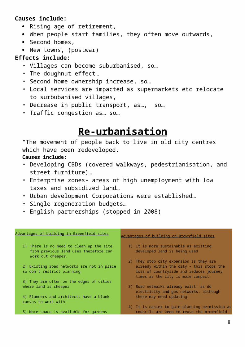
Advantages of building in Greenfield sites Advantages of building on Brownfield sites
1) There is no need to clean up the site from previous land uses therefore can work out cheaper.
1) It is more sustainable as existing developed land is being used
6
2) Existing road networks are not in place so don't restrict planning
3) They are often on the edges of cities where land is cheaper
4) Planners and architects have a blank canvas to work with
5) More space is available for gardens
6) The edge of city countryside environment can appeal to buyers and businesses.
7) Sites on the edge of the city are often close to major motorways providing great access
2) They stop city expansion as they are already within the city - this stops the loss of countryside and reduces journey times as the city is more compact
3) Road networks already exist, as do electricity and gas networks, although these may need updating
4) It is easier to gain planning permission as councils are keen to reuse the brownfield sites.
5) The sites are closer to the CBD for shopping and job opportunities
Exam questions could include:• Outline the process of counter-urbanisation and describe its effects. (8 marks)
• Outline the process of re-urbanisation and describe its effects. (8 marks)
Planning and Management issues.There are concerns with: The provision of affordable housing, protecting and retaining shops and community facilities, and the need to diversify and grow the economy but, at the same time, retaining the very character and qualities that define our rural communities. Many rural areas are caught in what has been termed the ‘sustainability trap’: many are identified in local plans as inherently unsustainable locations because they lack services and facilities and have limited transport accessibility.
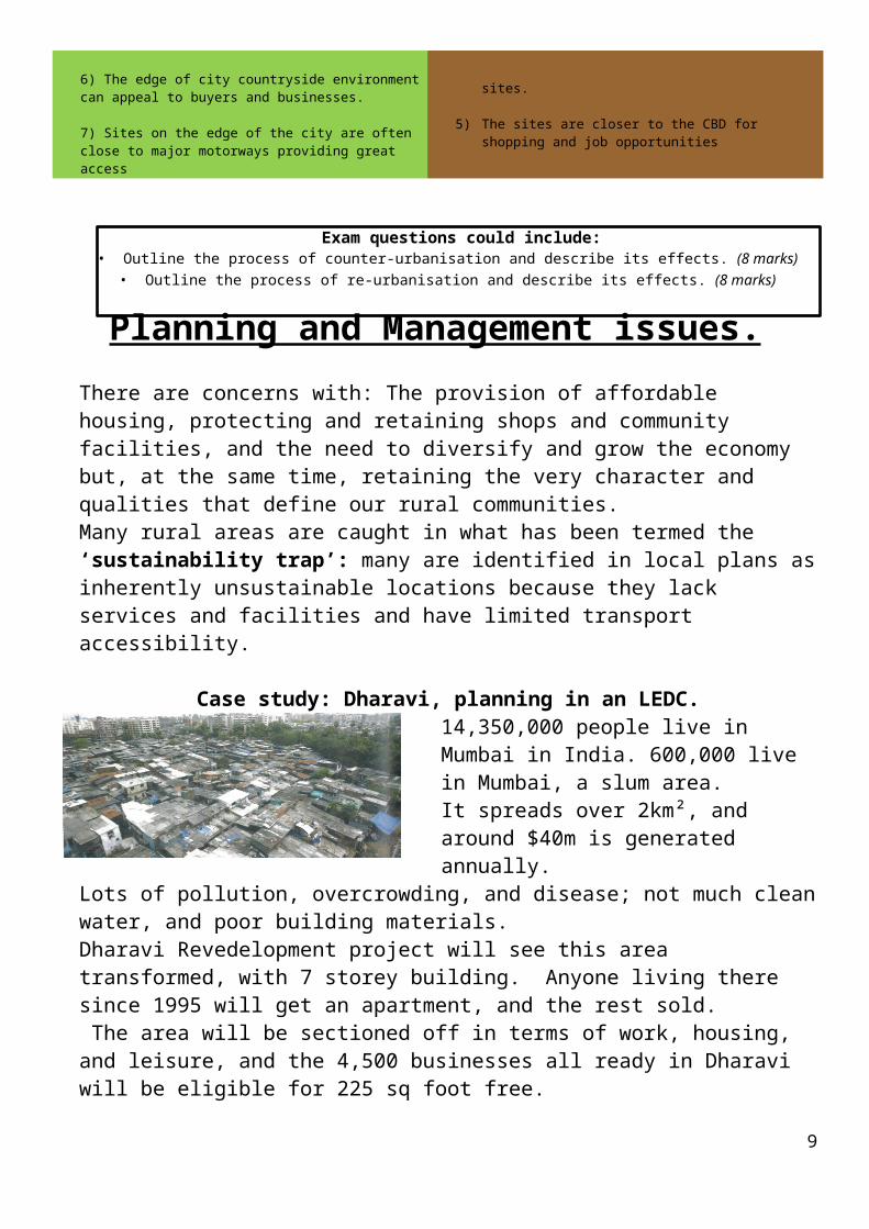
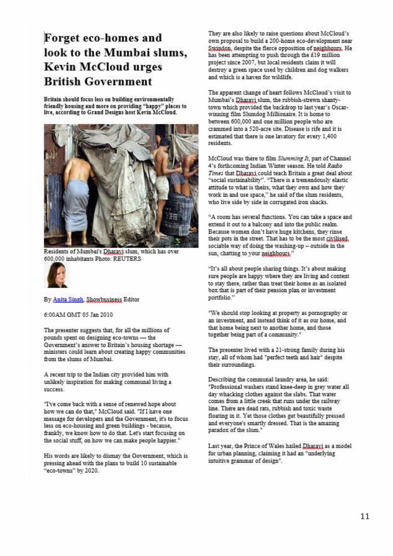
Case study: Dharavi, planning in an LEDC.14,350,000 people live in Mumbai in India. 600,000 live in Mumbai, a slum area.It spreads over 2km², and around $40m is generated annually. Lots of pollution, overcrowding, and disease; not much clean water, and poor building
materials.Dharavi Revedelopment project will see this area transformed, with 7 storey building. Anyone living there since 1995 will get an apartment, and the rest sold. The area will be sectioned off in terms of work, housing, and leisure, and the 4,500 businesses all ready in Dharavi will be eligible for 225 sq foot free.
7
Case study: Dharavi, Mumbai [India]
8
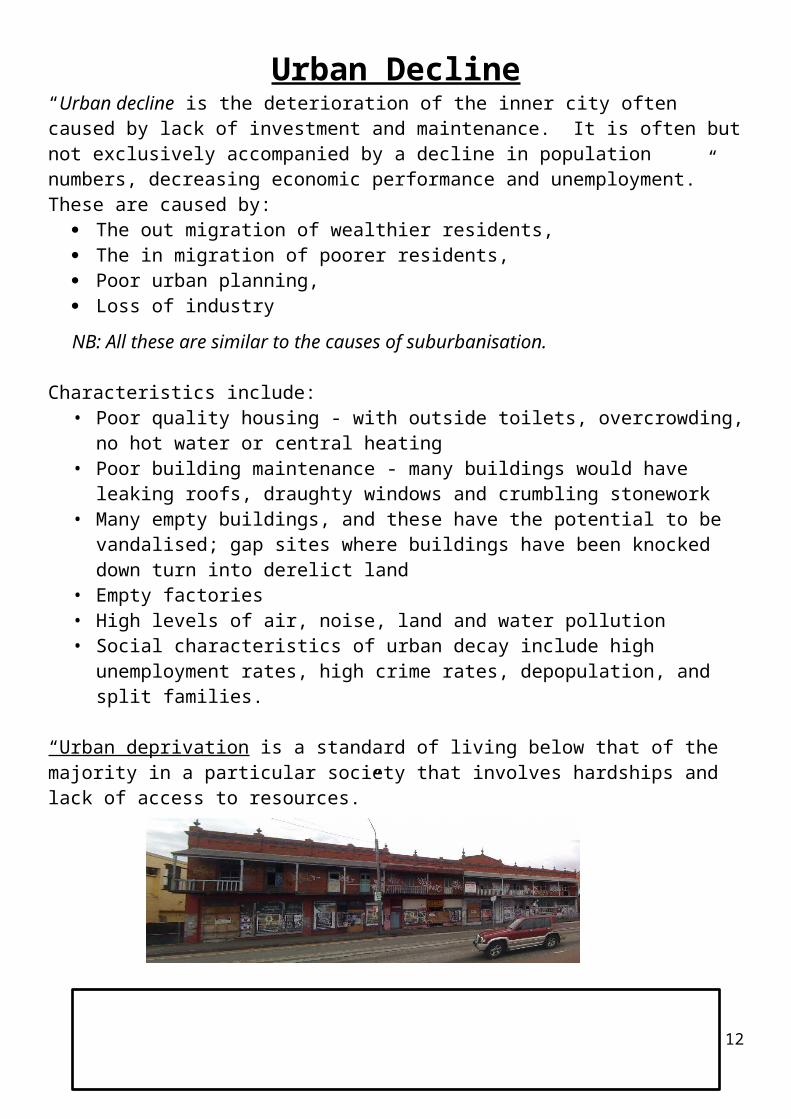
Urban Decline9
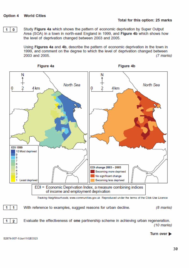
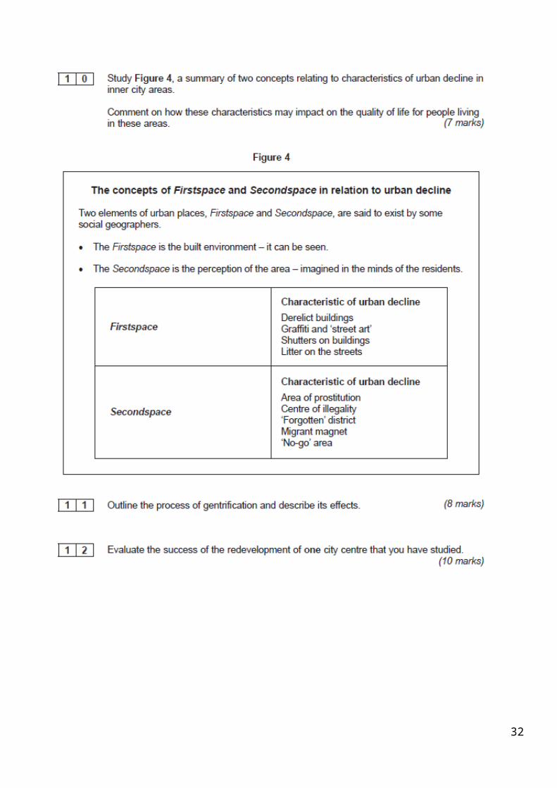
“Urban decline is the deterioration of the inner city often caused by lack of investment and maintenance. It is often but not exclusively accompanied by a decline in population numbers, decreasing economic performance and unemployment.”These are caused by:
The out migration of wealthier residents, The in migration of poorer residents, Poor urban planning, Loss of industry
NB: All these are similar to the causes of suburbanisation.
Characteristics include:• Poor quality housing - with outside toilets, overcrowding, no hot water or central
heating • Poor building maintenance - many buildings would have leaking roofs, draughty
windows and crumbling stonework • Many empty buildings, and these have the potential to be vandalised; gap sites
where buildings have been knocked down turn into derelict land • Empty factories• High levels of air, noise, land and water pollution• Social characteristics of urban decay include high unemployment rates, high crime
rates, depopulation, and split families.
“Urban deprivation is a standard of living below that of the majority in a particular society that involves hardships and lack of access to resources.”
Exam questions could include:Outline the process of Urban Decline and explain its causes. (8 marks)
10
Urban Regeneration1: Gentrification:
The renovation of houses and stores in deteriorated urban neighbourhoods by upper- or middle-income families or individuals, thus improving property values but often displacing low-income families and small businesses. It can also be attempted by businesses and local councils.
EG: Newington Green in North London is one small area that has been gentrified since the 1990s.
2: Property led RegenerationThis involves the regeneration of an inner-city area by changing the image of the area, improving the environment, attracting private investment and improving confidence for further investment.
In many cases, it involves ‘flagship’ projects such as at Canary Wharf in the London Docklands. UDCs are the main form of property-led regeneration.
3: Partnership SchemesPartnership schemes are partnerships between the local authorities, local people,
governments and private investors. They include schemes like city challenge, sustainable communities and flagship projects.
Hulme City- City Challenge Initiative in 1991/1992. Central Government awarded £37.5 million over five years - a basis to attract further public and private funds. It works with three main consultative fora: the Hulme Economic Assembly, the Hulme Social Issues Committee and Hulme Community Homes. 1000 new
homes and rising population.Here is a good link: www.rudi.net/books/12104
4: Private sector schemesIt can best be characterized as a contract form between public and private parties, where private businesses invest to regenerate an area, with the primary aim of making money.
Eg: The Manchester-based business “Place First” gained Cabinet approval from Hyndburn Borough Council for the second stage of a £15m project to breathe new life into 131 empty terraced homes
in Woodnook, Accrington, Lancashire.
Exam questions could include:Outline the process of gentrification and describe its effects. (8 marks)
Evaluate the success of one or more partnership scheme(s) in the regeneration of urban areas. (10 marks)
11
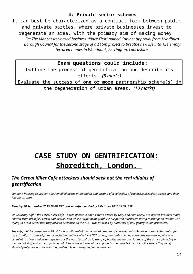
CASE STUDY ON GENTRIFICATION: Shoreditch, London. The Cereal Killer Cafe attackers should seek out the real villains of gentrification
London’s housing issues can’t be remedied by the intimidation and ousting of a collection of expensive breakfast cereals and their hirsute curators
Monday 28 September 2015 20.00 BST Last modified on Friday 9 October 2015 14.57 BST
On Saturday night, the Cereal Killer Cafe – a trendy east-London eaterie owned by Gary and Alan Keery, two hipster brothers made entirely from breakfast cereal and beards, and whose target demographic is suspected murderers facing mornings so chaotic with trying to avoid arrest that they have to breakfast on the run – was attacked by hundreds of anti-gentrification protesters.
The cafe, which charges up to £4.40 for a small bowl of the cremated remains of convicted retro American serial killers (milk, for an extra 60p, is sourced from the lactating mothers of a local NCT group), was ambushed by anarchists who threw paint and cereal at its shop window and spelled out the word “scum” on it, using Alphabites multigrain. Footage of the attack, filmed by a member of staff inside the cafe (who didn’t know the address of the cafe and so couldn’t tell the riot police where they were), showed protesters outside wearing pigs’ masks and carrying flaming torches.
One of them, in a hi-vis orange jacket, is seen approaching the shop window shouting “Fuck cereals! What’s wrong with eggs or toast?”, or something like that – I couldn’t hear him properly because he had a mask on and was outside. Another is seen holding up a bunch of balloons, but there wasn’t anything written on them, so I’m not sure what the balloons signified. Perhaps, inspired by the millions of balloons released on VDay for One Billion Rising (the biggest mass action to end violence against women in human history) and incensed by the opening of the nearby Jack the Ripper museum, the five balloons signified each of the five canonical victims of the local vintage serial killer. The museum, which charges up to £4.40 for a small bowl of Cheerios, was originally billed as a project to “recognise and celebrate the women of the East End”, showcasing 150 years of the social history of London’s women, but actually just ended up celebrating the horrific murders of London women, by a man, which is not really the same thing. Either that, or it could have just been the protester’s birthday.
The event, billed as the third “Fuck Parade”, was organised by the anarchist group Class War. I had a look at their Facebook page, which states: “Our communities are being ripped apart – by Russian oligarchs, Saudi sheiks, Israeli scumbag property developers, Texan oil-money twats and our own home-grown Eton toffs,” which would explain why they were dressed as pigs. Luckily for the police, no one from the Piers Gaveston Society joined the protest, mistaking it for one of their own parties, or they’d have been investigating an entirely different and far more serious crime.
I’m sure the majority of the protesters had noble intentions – to protest against rising rents in the capital, social cleansing, exploitative landlords and property developers, who are tearing communities apart, and a government that seems to actively encourage it. Some of the most affluent areas in London are becoming like ghost towns, as foreign investors buy properties and leave them vacant, while the majority of Londoners are forced out.
Gentrification is a hugely complex issue, and I agree with the fundamental point the protesters are making (even though I have personally financially benefitted from the gentrification of my own area and am therefore a total hypocrite) – but it can’t be remedied by the intimidation and ousting of a collection of expensive breakfast cereals and their hirsute curators.
The Cereal Killer Cafe is in one of the poorest boroughs in Britain, Tower Hamlets, where the proportion of children living under the poverty line has reached nearly 50%. Maybe Class War should stage their next protest outside the offices of the Department for Education, where it was recently indicated that the universal infant free school meals programme could be cut as part of George Osborne’s November spending review. Or those of London mayor Boris Johnson, who has just called in the Bishopsgate Goodsyard development in Shoreditch and removed the two local councils from the planning process, giving City Hall the final say on the future of the 11-acre development, which involves two skyscrapers of 47 and 43 storeys respectively. Johnson is unlikely to be as concerned about the height of the buildings, the lack of affordable housing or the worries of local residents. Surely, these are the real villains, not a couple of beatniks whizzing down Brick Lane on MonoRover R2 Two-Wheel Self-Balancing Electric Scooters with detachable vintage Teasmades.
12
The attack on the cafe reminded me of a protest by the People for the Ethical Treatment of Animals (Peta) against a cheesemonger in my home town of Gloucester. The shop had been targeted for providing Gloucestershire’s annual cheese rolling competition with the 8lb double Gloucester cheese that Gloucester people then chase down the death-defyingly steep Cooper’s Hill. Vegans branded the event “unethical” and said the cheese should be replaced with a non-dairy soya alternative. I pointed out to Peta that we’re not chucking a cow down the hill, and that they should target factory farmers or ivory poachers instead. Pick your targets, Class War. Purveyors of breakfast cereals are not the enemy.
CASE STUDY ON A PARTNERSHIP SCHEME REGENERATION: CARDIFF BAY.
This case study could also be used for re-urbanisation, urban decline and re-development.
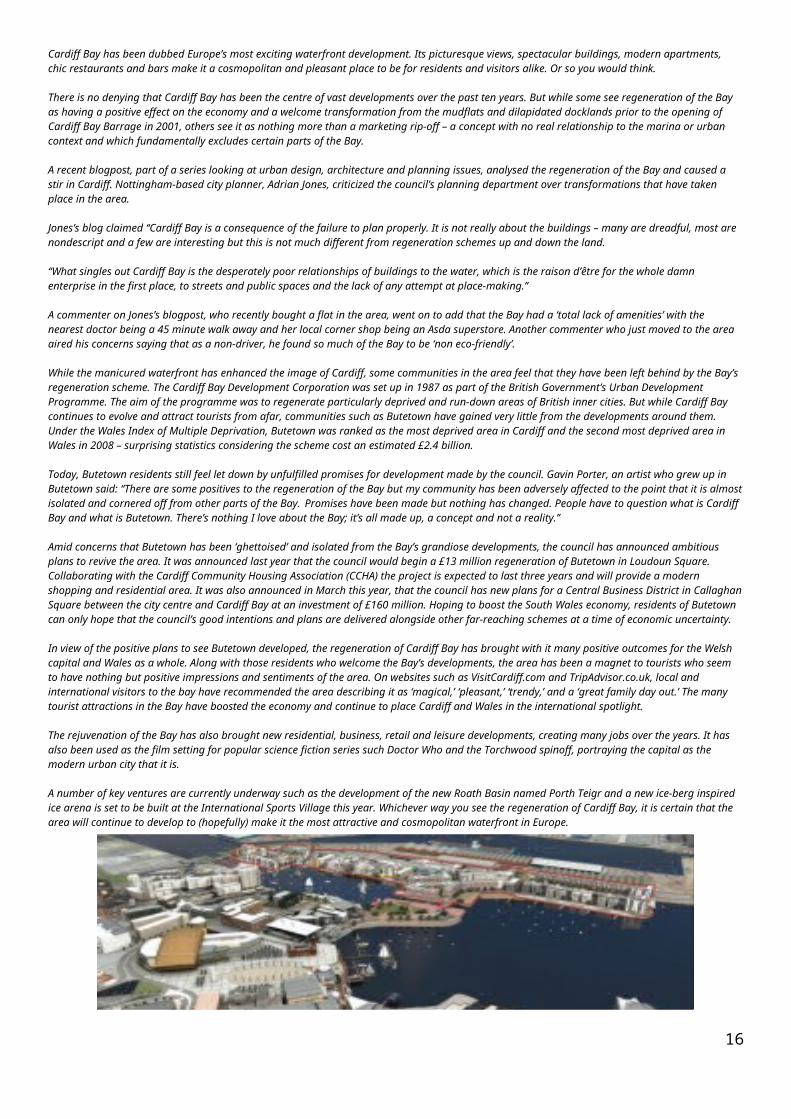
Cardiff Bay regeneration: love it or loathe it?
Cardiff Bay has been dubbed Europe’s most exciting waterfront development. Its picturesque views, spectacular buildings, modern apartments, chic restaurants and bars make it a cosmopolitan and pleasant place to be for residents and visitors alike. Or so you would think.
There is no denying that Cardiff Bay has been the centre of vast developments over the past ten years. But while some see regeneration of the Bay as having a positive effect on the economy and a welcome transformation from the mudflats and dilapidated docklands prior to the opening of Cardiff Bay Barrage in 2001, others see it as nothing more than a marketing rip-off – a concept with no real relationship to the marina or urban context and which fundamentally excludes certain parts of the Bay.
A recent blogpost, part of a series looking at urban design, architecture and planning issues, analysed the regeneration of the Bay and caused a stir in Cardiff. Nottingham-based city planner, Adrian Jones, criticized the council’s planning department over transformations that have taken place in the area.
Jones’s blog claimed ‘‘Cardiff Bay is a consequence of the failure to plan properly. It is not really about the buildings – many are dreadful, most are nondescript and a few are interesting but this is not much different from regeneration schemes up and down the land.
‘‘What singles out Cardiff Bay is the desperately poor relationships of buildings to the water, which is the raison d’être for the whole damn enterprise in the first place, to streets and public spaces and the lack of any attempt at place-making.’’
A commenter on Jones’s blogpost, who recently bought a flat in the area, went on to add that the Bay had a ‘total lack of amenities’ with the nearest doctor being a 45 minute walk away and her local corner shop being an Asda superstore. Another commenter who just moved to the area aired his concerns saying that as a non-driver, he found so much of the Bay to be ‘non eco-friendly’.
While the manicured waterfront has enhanced the image of Cardiff, some communities in the area feel that they have been left behind by the Bay’s regeneration scheme. The Cardiff Bay Development Corporation was set up in 1987 as part of the British Government’s Urban Development Programme. The aim of the programme was to regenerate particularly deprived and run-down areas of British inner cities. But while Cardiff Bay continues to evolve and attract tourists from afar, communities such as Butetown have gained very little from the developments around them. Under the Wales Index of Multiple Deprivation, Butetown was ranked as the most deprived area in Cardiff and the second most deprived area in Wales in 2008 – surprising statistics considering the scheme cost an estimated £2.4 billion.
Today, Butetown residents still feel let down by unfulfilled promises for development made by the council. Gavin Porter, an artist who grew up in Butetown said: ‘‘There are some positives to the regeneration of the Bay but my community has been adversely affected to the point that it is almost isolated and cornered off from other parts of the Bay. Promises have been made but nothing has changed. People have to question what is Cardiff Bay and what is Butetown. There’s nothing I love about the Bay; it’s all made up, a concept and not a reality.’’
Amid concerns that Butetown has been ‘ghettoised’ and isolated from the Bay’s grandiose developments, the council has announced ambitious plans to revive the area. It was announced last year that the council would begin a £13 million regeneration of Butetown in Loudoun Square. Collaborating with the Cardiff Community Housing Association (CCHA) the project is expected to last three years and will provide a modern shopping and residential area. It was also announced in March this year, that the council has new plans for a Central Business District in Callaghan Square between the city centre and Cardiff Bay at an investment of £160 million. Hoping to boost the South Wales economy, residents of Butetown can only hope that the council’s good intentions and plans are delivered alongside other far-reaching schemes at a time of economic uncertainty.
In view of the positive plans to see Butetown developed, the regeneration of Cardiff Bay has brought with it many positive outcomes for the Welsh capital and Wales as a whole. Along with those residents who welcome the Bay’s developments, the area has been a magnet to tourists who seem to have nothing but positive impressions and sentiments of the area. On websites such as VisitCardiff.com and TripAdvisor.co.uk, local and international visitors to the bay have recommended the area describing it as ‘magical,’ ‘pleasant,’ ‘trendy,’ and a ‘great family day out.’ The many tourist attractions in the Bay have boosted the economy and continue to place Cardiff and Wales in the international spotlight.
The rejuvenation of the Bay has also brought new residential, business, retail and leisure developments, creating many jobs over the years. It has also been used as the film setting for popular science fiction series such Doctor Who and the Torchwood spinoff, portraying the capital as the modern urban city that it is.
A number of key ventures are currently underway such as the development of the new Roath Basin named Porth Teigr and a new ice-berg inspired ice arena is set to be built at the International Sports Village this year. Whichever way you see the regeneration of Cardiff Bay, it is certain that the area will continue to develop to (hopefully) make it the most attractive and cosmopolitan waterfront in Europe.
13
Mr Johnson’s virtual field trip of the Cardiff Bay Development
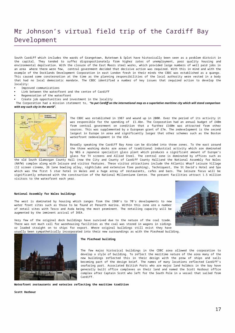
South Cardiff which includes the wards of Grangetown, Butetown & Splot have historically been seen as a problem district in the capital. They tended to suffer disproportionately from higher rates of unemployment, poor quality housing and environmental deprivation. With the closure of the East Moors steel works, which provided large numbers of well paid jobs in an area where there were few, central government decided that decisive action was required. With this in mind and with the example of the Docklands Development Corporation in east London fresh in their minds the CBDC was established as a quango. This caused some consternation at the time as the planning responsibilities of the local authority were vested in a body that had no local democratic mandate. The CBDC identified a number of key issues that required action to develop the locality: Improved communications Link between the waterfront and the centre of Cardiff Regeneration of the waterfront Create job opportunities and investment in the locality The Corporation had a mission statement to, “to put Cardiff on the international map as a superlative maritime city which will stand comparison with any such city in the world”.
The CBDC was established in 1987 and wound up in 2000. Over the period of its activity it was responsible for the spending of £1.4bn. The Corporation had an annual budget of £40m from central government on condition that a further £160m was attracted from other sources. This was supplemented by a European grant of £7m. The redevelopment is the second largest in Europe in area and significantly larger that other schemes such as the Boston waterfront redevelopment in the USA.
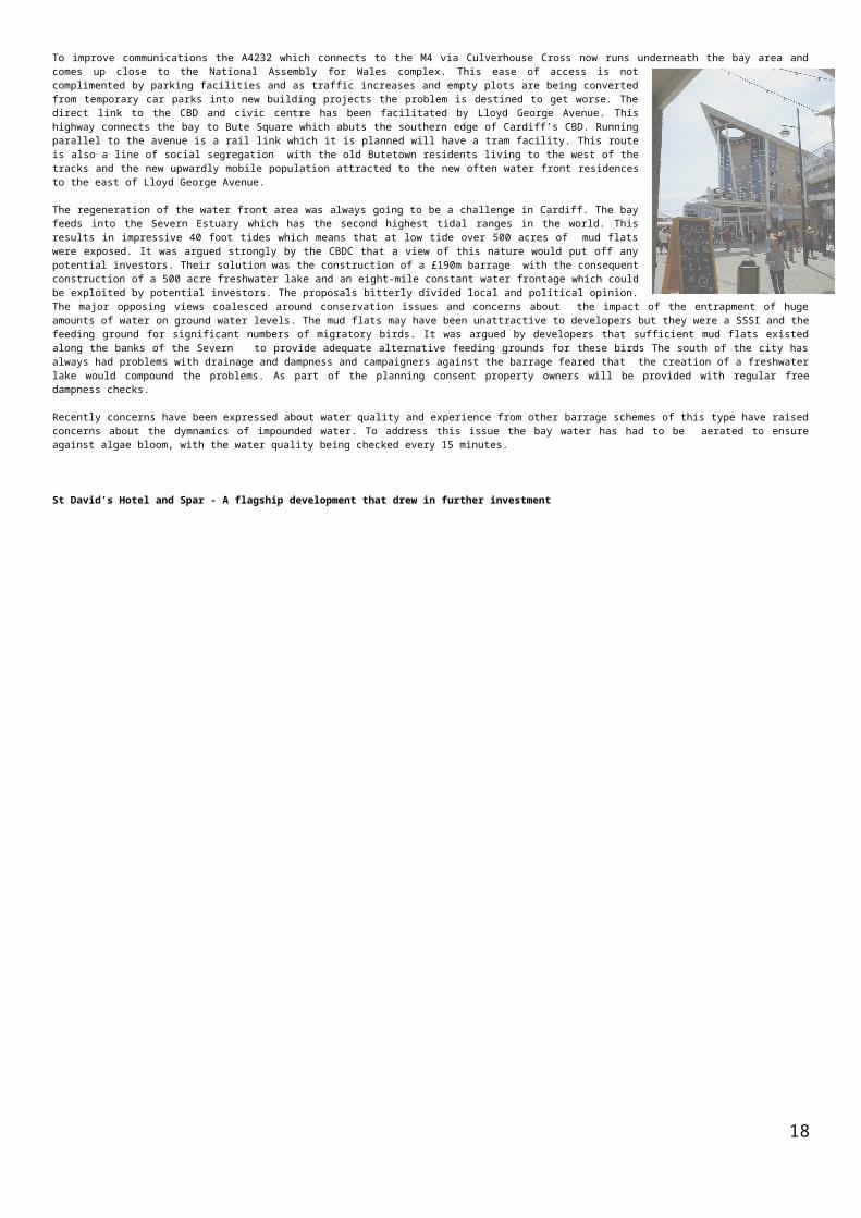
Broadly speaking the Cardiff Bay Area can be divided into three zones. To the east around the three working docks are areas of traditional industrial activity which are dominated by NEG a Japanese specialist glass plant which produces a significant amount of Europe’s glass for TV screens and Allied Steel. The central zone is dominated by offices such as the old South Glamorgan County Hall (now the City and County of Cardiff County Hall)and the National Assembly for Wales (NAfW) complex along with leisure and visitor features. These visitor attractions include the Atlantic Wharf Leisure Village (12 screen cinema, 26 lane bowling alley, nightclubs and extensive free parking), Techniquest, the St David’s Hotel and Spa which was the first 5 star hotel in Wales and a huge array of restaurants, cafes and bars. The leisure focus will be
significantly enhanced with the construction of the National Millenniunm Centre. The present facilities attract 1.5 million visitors to the waterfront each year.
National Assembly for Wales buildings
The west is dominated by housing which ranges from the 1960’s to 70’s developments to new water front sites such as those to be found at Penarth marina. Within this zone are a number of retail sites with Tesco and Asda being the most prominent. The retailing capacity will be augmented by the imminent arrival of IKEA.
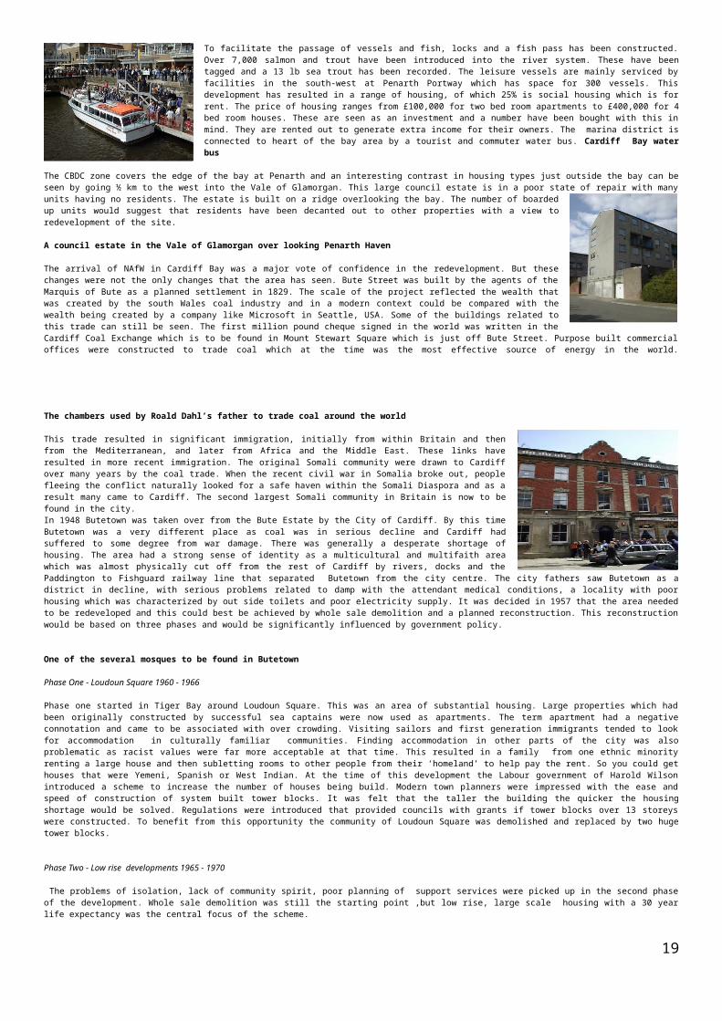
Very few of the original dock buildings have survived due to the nature of the coal trade. There was not much call for warehousing facilities as the coal was stored in wagons in sidings or loaded straight on to ships for export. Where original buildings still exist they have usually been sympathetically incorporated into their new surroundings as with the Pierhead building.
The Pierhead building
The few major historical buildings in the CDBC area allowed the corporation to develop a style of building. To reflect the maritime nature of the area many of the new buildings reflected this in their design with the prow of ships and sails becoming part of the design brief. The names of many locations reflected Cardiff’s seafaring part. Associated British Ports who are major land holders in the bay have generally built office complexes on their land and named the Scott Harbour office complex after Captain Scott who left for the South Pole in a vessel that sailed from Cardiff.
Waterfront restaurants and eateries reflecting the maritime tradition
Scott Harbour
To improve communications the A4232 which connects to the M4 via Culverhouse Cross now runs underneath the bay area and comes up close to the National Assembly for Wales complex. This ease of access is not complimented by parking facilities and as traffic increases and empty plots are being converted from temporary car parks into new building projects the problem is destined to get worse. The direct link to the CBD and civic centre has been facilitated by Lloyd George Avenue. This highway connects the bay to Bute Square which abuts the southern edge of Cardiff’s CBD. Running parallel to the avenue is a rail link which it is planned will have a tram facility. This route is also a line of social segregation with the old Butetown residents living to the west of the tracks and the new upwardly mobile population attracted to the new often water front residences to the east of Lloyd George Avenue.
The regeneration of the water front area was always going to be a challenge in Cardiff. The bay feeds into the Severn Estuary which has the second highest tidal ranges in the world. This results in impressive 40 foot tides which means that at low tide over 500 acres of mud flats were exposed. It was argued strongly by the CBDC that
14
a view of this nature would put off any potential investors. Their solution was the construction of a £190m barrage with the consequent construction of a 500 acre freshwater lake and an eight-mile constant water frontage which could be exploited by potential investors. The proposals bitterly divided local and political opinion. The major opposing views coalesced around conservation issues and concerns about the impact of the entrapment of huge amounts of water on ground water levels. The mud flats may have been unattractive to developers but they were a SSSI and the feeding ground for significant numbers of migratory birds. It was argued by developers that sufficient mud flats existed along the banks of the Severn to provide adequate alternative feeding grounds for these birds The south of the city has always had problems with drainage and dampness and campaigners against the barrage feared that the creation of a freshwater lake would compound the problems. As part of the planning consent property owners will be provided with regular free dampness checks.
Recently concerns have been expressed about water quality and experience from other barrage schemes of this type have raised concerns about the dymnamics of impounded water. To address this issue the bay water has had to be aerated to ensure against algae bloom, with the water quality being checked every 15 minutes.
St David’s Hotel and Spar - A flagship development that drew in further investment
15
To facilitate the passage of vessels and fish, locks and a fish pass has been constructed. Over 7,000 salmon and trout have been introduced into the river system. These have been tagged and a 13 lb sea trout has been recorded. The leisure vessels are mainly serviced by facilities in the south-west at Penarth Portway which has space for 300 vessels. This development has resulted in a range of housing, of which 25% is social housing which is for rent. The price of housing ranges from £100,000 for two bed room apartments to £400,000 for 4 bed room houses. These are seen as an investment and a number have been bought with this in mind. They are rented out to generate extra income for their owners. The marina district is connected to heart of the bay area by a tourist and commuter water bus. Cardiff Bay water bus
The CBDC zone covers the edge of the bay at Penarth and an interesting contrast in housing types just outside the bay can be seen by going ½ km to the west into the Vale of Glamorgan. This large council estate is in a poor state of repair with many units having no residents. The estate is built on a
ridge overlooking the bay. The number of boarded up units would suggest that residents have been decanted out to other properties with a view to redevelopment of the site.
A council estate in the Vale of Glamorgan over looking Penarth Haven
The arrival of NAfW in Cardiff Bay was a major vote of confidence in the redevelopment. But these changes were not the only changes that the area has seen. Bute Street was built by the agents of the Marquis of Bute as a planned settlement in 1829. The scale of the project reflected the wealth that was created by the south Wales coal industry and in a modern context could be compared with the wealth being created by a company like Microsoft in Seattle, USA. Some of the buildings related to this trade can still be seen. The first million pound cheque signed in the world was written in the Cardiff Coal Exchange which is to be found in Mount Stewart Square which is just off Bute Street. Purpose built commercial offices were constructed to trade coal which at the time was the most effective source of energy in the world.
The chambers used by Roald Dahl’s father to trade coal around the world
This trade resulted in significant immigration, initially from within Britain and then from the Mediterranean, and later from Africa and the Middle East. These links have resulted in more recent immigration. The original Somali community were drawn to Cardiff over many years by the coal trade. When the recent civil war in Somalia broke out, people fleeing the conflict naturally looked for a safe haven within the Somali Diaspora and as a result many came to Cardiff. The second largest Somali community in Britain is now to be found in the city.In 1948 Butetown was taken over from the Bute Estate by the City of Cardiff. By this time Butetown was a very different place as coal was in serious decline and Cardiff had suffered to some degree from war damage. There was generally a desperate shortage of housing. The area had a strong sense of identity as a multicultural and multifaith area which was almost physically cut off from the rest of Cardiff by rivers, docks and the Paddington to Fishguard railway line that separated Butetown from the city centre. The city fathers saw Butetown as a district in decline, with serious problems related to damp with the attendant medical conditions, a locality with poor housing which was characterized by out side toilets and poor electricity supply. It was decided in 1957 that the area needed to be redeveloped and this could best be achieved by whole sale demolition and a planned reconstruction. This reconstruction would be based on three phases and would be significantly influenced by government policy.
One of the several mosques to be found in Butetown
Phase One - Loudoun Square 1960 - 1966
Phase one started in Tiger Bay around Loudoun Square. This was an area of substantial housing. Large properties which had been originally constructed by successful sea captains were now used as apartments. The term apartment had a negative connotation and came to be associated with over crowding. Visiting sailors and first generation immigrants tended to look for accommodation in culturally familiar communities. Finding accommodation in other parts of the city was also problematic as racist values were far more acceptable at that time. This resulted in a family from one ethnic minority renting a large house and then subletting rooms to other people from their ‘homeland’ to help pay the rent. So you could get houses that were Yemeni, Spanish or West Indian. At the time of this development the Labour government of Harold Wilson introduced a scheme to increase the number of houses being build. Modern town planners were impressed with the ease and speed of construction of system built tower blocks. It was felt that the taller the building the quicker the housing shortage would be solved. Regulations were introduced that provided councils with grants if tower blocks over 13 storeys were constructed. To benefit from this opportunity the community of Loudoun Square was demolished and replaced by two huge tower blocks.
Phase Two - Low rise developments 1965 - 1970
The problems of isolation, lack of community spirit, poor planning of support services were picked up in the second phase of the development. Whole sale demolition was still the starting point ,but low rise, large scale housing with a 30 year life expectancy was the central focus of the scheme.
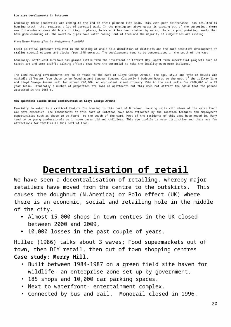
Low rise developments in Butetown
Generally these properties are coming to the end of their planned life span. This with poor maintenance has resulted is housing stock that requires a lot of remedial work. In the photograph above grass is growing out of the guttering, there are old wooden windows which are rotting in places, brick work has been stained by water, there is poor pointing, seals that have gone ensuring all the overflow pipes have water coming out of them and the majority of ridge tiles are missing.
Phase Three - Pockets of low rise developments from1975
Local political pressure resulted in the halting of whole sale demolition of districts and the more sensitive development of smaller council estates and blocks from 1975 onwards. The developments tend to be concentrated in the south of the ward.
Generally, north-west Butetown has gained little from the investment in Cardiff Bay, apart from superficial projects such as street art and some traffic calming efforts that have the potential to make the locality even more isolated.
The CBDB housing developments are to be found to the east of Lloyd George Avenue. The age, style and type of houses are markedly different from those to be found around Loudoun Square. Currently 4 bedroom houses to the west of the railway line and Lloyd George Avenue sell for around
16
£40,000. An equivalent sized property 150m to the east sells for £400,000 on a 99 year lease. Ironically a number of properties are sold as apartments but this does not attract the odium that the phrase attracted in the 1960’s.
New apartment blocks under construction on Lloyd George Aveune
Proximity to water is a critical feature for housing in this part of Butetown. Housing units with views of the water front are more expensive. The inhabitants of this part of Butetown have been attracted by the location features and employment opportunities such as those to be found to the south of the ward. Most of the residents of this area have moved in. Many tend to be young professionals or in some cases old and childless. This age profile is very distinctive and there are few attractions for families in this part of town.
Decentralisation of retailWe have seen a decentralisation of retailing, whereby major retailers have moved from the centre to the outskirts. This causes the doughnut (N.America) or Polo effect (UK) where there is an economic, social and retailing hole in the middle of the city.
Almost 15,000 shops in town centres in the UK closed between 2000 and 2009, 10,000 losses in the past couple of years.
Hiller (1986) talks about 3 waves; Food supermarkets out of town, then DIY retail, then out of town shopping centresCase study: Merry Hill.
• Built between 1984-1987 on a green field site haven for wildlife- an enterprise zone set up by government.
• 185 shops and 10,000 car parking spaces.• Next to waterfront- entertainment complex.• Connected by bus and rail. Monorail closed in 1996.
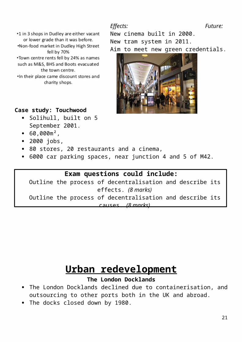
Effects: Future:New cinema built in 2000.New tram system in 2011.Aim to meet new green credentials.
Case study: Touchwood Solihull, built on 5 September 2001. 60,000m², 2000 jobs, 80 stores, 20 restaurants and a cinema, 6000 car parking spaces, near junction 4 and 5 of M42.
17
Exam questions could include:Outline the process of decentralisation and describe its effects. (8 marks)Outline the process of decentralisation and describe its causes. (8 marks)
Urban redevelopmentThe London Docklands
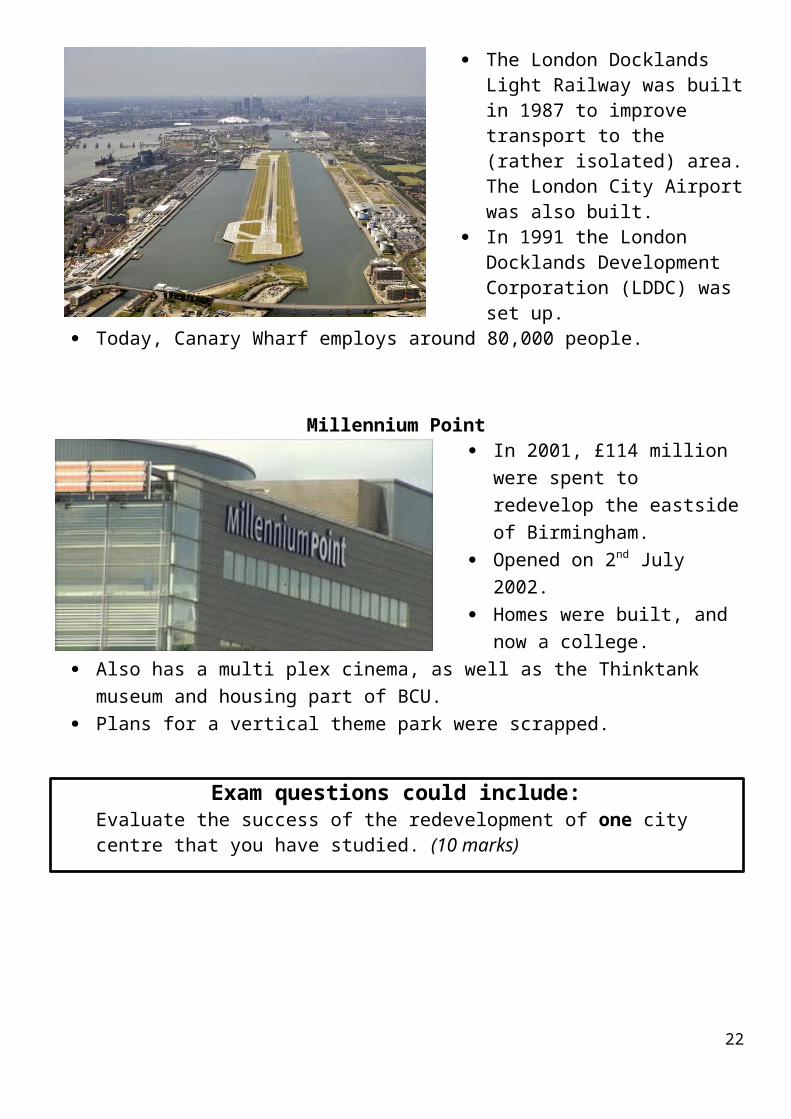
The London Docklands declined due to containerisation, and outsourcing to other ports both in the UK and abroad.
The docks closed down by 1980. The London Docklands Light
Railway was built in 1987 to improve transport to the (rather isolated) area. The London City Airport was also built.
In 1991 the London Docklands Development Corporation (LDDC) was set up.
Today, Canary Wharf employs around 80,000 people.
Millennium Point In 2001, £114 million were spent
to redevelop the eastside of Birmingham.
Opened on 2nd July 2002. Homes were built, and now a
college. Also has a multi plex cinema, as
well as the Thinktank museum and housing part of BCU.
Plans for a vertical theme park were scrapped.
Exam questions could include:18
Evaluate the success of the redevelopment of one city centre that you have studied. (10 marks)
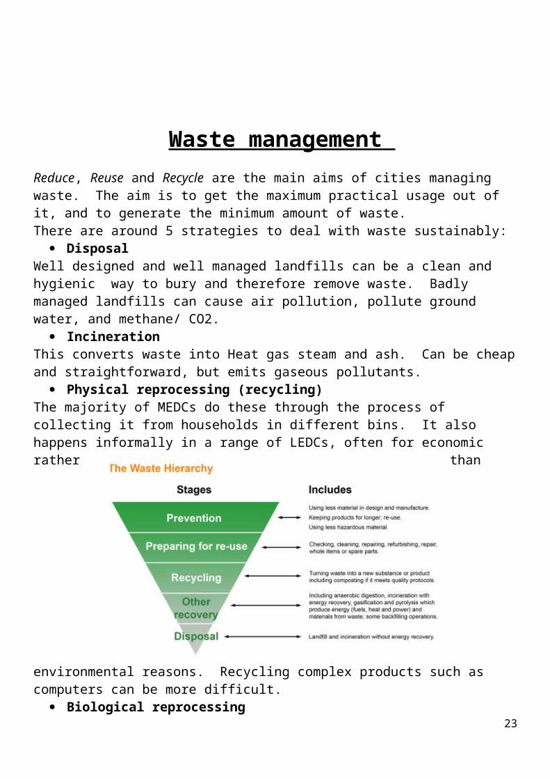
Waste management Reduce, Reuse and Recycle are the main aims of cities managing waste. The aim is to get the maximum practical usage out of it, and to generate the minimum amount of waste.There are around 5 strategies to deal with waste sustainably:
DisposalWell designed and well managed landfills can be a clean and hygienic way to bury and therefore remove waste. Badly managed landfills can cause air pollution, pollute ground water, and methane/ CO2.
IncinerationThis converts waste into Heat gas steam and ash. Can be cheap and straightforward, but emits gaseous pollutants.
Physical reprocessing (recycling)The majority of MEDCs do these through the process of collecting it from households in different bins. It also happens informally in a range of LEDCs, often for economic rather than environmental reasons. Recycling complex products such as computers can be more difficult.
19
Biological reprocessingOrganic waste materials can be broken down, creating mulch which can be used for composting. The gasses which are given off can be used for electricity.
Energy recovery.This is where the potential energy of fuel is harnessed and combusted to create energy.
Case study: Peterborough, a Beacon Authority for waste disposal. EARP, and a major new recycling plant
Exam questions could include:Outline characteristic strategies of waste management in urban areas. (8 marks)
CASE STUDY: Waste management in MumbaiCurrent situation
19 million people live in Mumbai and produce 6.11% of India’s total waste The city produces high levels of emission and is compact so it is always difficult to find somewhere
to put this waste. The city has three main landfill sites Dharavi is one of the largest slums in the world, however it is also very clean and has many plastic
recycling methods. It is part of the local economy there. 23% of plastic waste gets recycled in the UK, in Mumbai it is 80%. However, even though there are
appalling conditions they only earn around a £1 a day for their work
Future However, a lot of the waste is still reaching landfills from Mumbai as a whole To reduce this amount, BMC has floated an expression of interest to set up a 1000-tonne
waste-to-energy incineration plant at Deonar
There are plans to diversify techniques to deal with waste
20
Traffic management.The majority of people in MEDCs use their own transport. This leads to a range of issues; not least, how to sustainably address the air pollution and congestion this traffic causes.
Case study: London 2013. The vision:London had a population of 8.2 million in 2011, according to the UK census. This represents a 12 per cent growth since 2001. Such a large and growing population puts great pressure on services – not least on the capital’s transport network. In March 2013, the London Mayor announced plans to increase the number of people cycling. Currently over half a million cycling journeys are made in London each day. It is hoped that this will ease pressure on the existing transport network and also help to make London an increasingly sustainable city. £913 million will be invested in the ten-year plan. A connected cycle network will be built with the aim of getting more people cycling to work and for leisure. Measures will be taken to improve road safety and efforts will be made to instil a culture of cycling within London. If the Mayor’s projections are correct, then cycling in London will double over the next 10 years of investment.
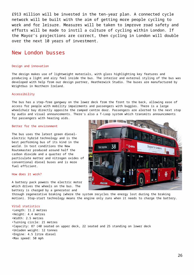
New London bussesDesign and innovation
21
The design makes use of lightweight materials, with glass highlighting key features and producing a light and airy feel inside the bus. The interior and external styling of the bus was developed with help from our design partner, Heatherwick Studio. The buses are manufactured by Wrightbus in Northern Ireland.
Accessibility
The bus has a step-free gangway on the lower deck from the front to the back, allowing ease of access for people with mobility impairments and passengers with buggies. There is a large wheelchair bay directly opposite the ramped centre door. Passengers are alerted to the next stop by audio and visual announcements. There's also a T-Loop system which transmits announcements for passengers with hearing aids.
Better for the environment
The bus uses the latest green diesel-electric hybrid technology and is the best performing bus of its kind in the world. In test conditions the New Routemaster produced around half the carbon dioxide and a quarter of the particulate matter and nitrogen oxides of conventional diesel buses and is more fuel efficient.
How does it work?
A battery pack powers the electric motor which drives the wheels on the bus. The battery is charged by a generator and through regenerative braking (where the system recycles the energy lost during the braking motion). Stop-start technology means the engine only runs when it needs to charge the battery.
Vital statistics•Length: 11.2 metres •Height: 4.4 metres •Width: 2.5 metres •Turning circle: 21 metres •Capacity: 87 (40 seated on upper deck, 22 seated and 25 standing on lower deck •Unladen weight: 12 tonnes •Engine: 4.5 litre diesel •Max speed: 50 mph
Case study: Curitiba in Brazil. Since 1968. 2013Part of the plan is the Bus Rapid Transport (BRT) System. It was the first city in Brazil to have dedicated bus lanes.A bus rapid transit system operates. This is cheaper to run than a tube system. Some employers subsidise their employees who use it. 80 per cent of travellers use the BRT.The bus rapid transit system uses triple section bendy buses. It carries 2 million passengers a day.The bus fare is the same wherever you go.No one lives more than 400 metres from a bus stop.Urban growth is restricted to corridors of growth - along key transport routes. Tall buildings are allowed only along bus routes.
Case study - waste and traffic management scheme CURITIBA Brazil
Curitiba is a city in Brazil with a population of 2 million. It provides a world model for how to integrate a sustainable transport and waste management scheme and has been awarded the UN’s highest award for its recycling scheme. In 1965 Curitiba produced a master plan to;1 Encourage growth along transport routes
22
2 Establish industrial zones3 Encourage the community to be self-sufficient by providing them education, health care, recreation and parks
The plan had to be flexible enough to allow future developments within the traffic management and development of the city. Public transport was given the highest priority.
Traffic management
Curitiba decided against building an underground transport system as it was too expensive to build and running costs would be high. The only way forward was to develop an efficient transport system on the ground. The integrated bus transport system has five arteries which run out from the pedestrianised city centre. Along these arteries are direct routes which go directly to the suburbs, they travel on a two way bus only route. The express buses run along side the direct routes but the express buses stop at bus stops which link the suburbs together to avoid the city centre these are called inter district routes. The feeder buses link from the outskirts of the city to the express bus stops. The buses are painted in different colours so that they are easily identifiable.
Red - express busGrey – direct buses to the suburbsGreen – suburb buses link to red express busesOrange – feeder bus from the outskirts link to the suburbs
There are 10 privately owned bus companies, the money collected from the transportation of passengers is combined together and managed by a quasi-public company, the bus companies are then paid on the distance they travel not the amount of passengers they carry, this system means that more area of the city is covered by public transport. The coverage of the city is so good that there is no need for a light railway. The transport system is fast and 500 times cheaper than other transport systems such as the tube/metro. There is no need for bus conductors as people pay at the tubular bus stops in advance and a one way on and off wide door design makes boarding on and off quicker. The biarticular buses used can carry up to 4000 passengers a day, 3000 more than a conventional bus. The average person only pays 10% of their income on travelling. The increase in passengers using the transport system means that 75% of commuters use the public transport cutting the congestion by 25%. Fuel consumption is 30% lower than other similar sized cities.
Waste management
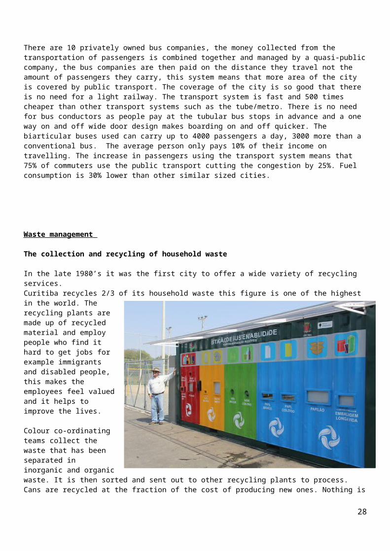
The collection and recycling of household waste
In the late 1980’s it was the first city to offer a wide variety of recycling services. Curitiba recycles 2/3 of its household waste this figure is one of the highest in the world. The recycling plants are made up of recycled material and employ people who find it hard
23

to get jobs for example immigrants and disabled people, this makes the employees feel valued and it helps to improve the lives.
Colour co-ordinating teams collect the waste that has been separated in inorganic and organic waste. It is then sorted and sent out to other recycling plants to process. Cans are recycled at the fraction of the cost of producing new ones. Nothing is wasted, Books are sent to the public libraries’ for all to use and artefacts are placed in a museum.
The Green exchange
The green exchange was introduced in 1990, this scheme was to encourage the poor to recycle their waste in return for food produce or bus transport tickets. This has proved to be a valuable service for the poor as they live in favelas which are hard for the recycling team to access. They deliver their waste to a collection point and exchange for goods. The programme costs the same as landfill but has the advantage of improving their health, reducing litter and creating jobs. 30,000 people benefit from this scheme.
Curitiba has a large industry base but the city is cleaner than most cities. It has been awarded the UN’s highest award for recycling.
Exam questions could include:Outline characteristic strategies of waste management in urban areas. (10)
24
•25
26
27
28
Copyright: Last 5 pages accessed from http://www.aqa.org.uk/subjects/geography/a-level/geography-2030/past-papers-and-mark-schemes
29
Conflict and challenges
30
Tryweryn: How reservoir of anger 'fuelled nationalist cause'
By Vaughan Roderick BBC Welsh Affairs Editor 21 October 2015 From the section Wales politics
There are a surprising number of "lost" villages lying under Welsh reservoirs.
Many of them, such as Llanwddyn in Montgomeryshire and Ynysyfelin, north of Merthyr Tydfil, were far more substantial than Capel Celyn, the hamlet which lies beneath the waters of Llyn Celyn - the Tryweryn reservoir - in Snowdonia.
It was the combination of time and place that made Tryweryn such a symbolic moment in Welsh history, and which sets Capel Celyn apart from all the other lost settlements.
The early 1960s in Wales was a period when a renewed interest in devolution coincided with a sharp decline in the number of Welsh speakers.
As one of the last virtually monoglot Welsh communities, Capel Celyn came to symbolise both the pressure on the language and the apparent powerlessness of Welsh MPs to protect Welsh interests.
Despite near unanimous opposition from Welsh politicians, mass protests and an attempt to bomb the site of the dam, the plans of Liverpool Corporation moved forward relentlessly.
For Plaid Cymru, Tryweryn was to prove transformational - although that was not apparent at the time.
The results of the 1964 general election, held while the controversy was at its height, were disappointing for the party - even in Meirionnydd, where the reservoir is located.
However, the campaign led to an influx of new party members, and the decision to reject the use of civil disobedience tactics during the campaign earned the party credibility and respect in Welsh-speaking communities that had previously viewed Plaid Cymru with suspicion.
Even so, it was Labour which swept the board in rural Wales in the 1966 general election, the first to be held after the completion of the project.
31
Just a few months later though, Plaid Cymru won their first ever seat in parliament in the Carmarthen by-election.
It was a victory which might never have occurred had Capel Celyn not disappeared beneath the waters of Llyn Celyn.
32