Embed Size (px)
Citation preview
ARCGIS 10.4 FOR SERVER FUNCTIONALITY MATRIX
FEBRUARY 17, 2016

Page i of 23
Copyright © 2016 Esri
All rights reserved.
Printed in the United States of America.
The information contained in this document is the exclusive property of Esri. This work
is protected under United States copyright law and other international copyright
treaties and conventions. No part of this work may be reproduced or transmitted in any
form or by any means, electronic or mechanical, including photocopying and recording,
or by any information storage or retrieval system, except as expressly permitted in
writing by Esri. All requests should be sent to Attention: Contracts and Legal Services
Manager, Esri, 380 New York Street, Redlands, CA 92373-8100 USA.
The information contained in this document is subject to change without notice.
Esri, the Esri globe logo, ArcGIS, 3D Analyst, ArcPad, EDN, ModelBuilder, GeoEvent,
arcgis.com, esri.com, and @esri.com are trademarks, service marks, or registered marks
of Esri in the United States, the European Community, or certain other jurisdictions.
Other companies and products or services mentioned herein may be trademarks,
service marks, or registered marks of their respective mark owners.
Page ii of 23
Table of Contents Introduction ...................................................................................... 1
ArcGIS for Server Components …………………………….……………….………….2
How to use this document .................................................................... 3
Functionality Matrix Overview ........................................................... 4
Functionality ............................................................................................. 4
GIS services capabilities............................................................................. 5
Extensions and other products ......................................................... 6
ArcGIS applications ........................................................................... 7
Capacity .................................................................................................... 7
Deployment .............................................................................................. 8
Functionality Matrix Details ............................................................... 8
GIS Portal ................................................................................................... 8
Portal for ArcGIS ........................................................................................ 8
Hosted web layers ………………………………………………………………………..9
Feature layers ............................................................................ 10
Tile layers ................................................................................... 10
Vector tile layers …………………………………………………………………..10
Named User Entitlements ............................................................... 10
Web services ........................................................................................... 11
What are web services? .................................................................. 11
Open Geospatial Consortium Standards ......................................... 12
Real-time data processing ...................................................................... 12
What is the ArcGIS GeoEvent Extension for Server? ...................... 12
What are stream services? .............................................................. 13
Imagery management and processing ................................................... 13
What is the ArcGIS Image Extension for Server? ............................ 14
What are image services? ............................................................... 14
Other ways to serve imagery .......................................................... 14
Web editing ............................................................................................ 14
What is a feature service? ............................................................... 15
What is the geometry service?.. ..................................................... 15
Page iii of 23
Visualizing 3D spatial content ................................................................ 15
What is a scene service? ................................................................. 16
What is a globe service?................................................................. 16
Geoprocessing … ..................................................................................... 16
What is a geoprocessing service? ................................................... 16
What is advanced geoprocessing? .................................................. 17
Support for Spatially Enabled Databases ........................................... …..17
Geodatabase management ............................................................. 17
Why use a geodatabase?... ............................................................. 18
ArcGIS Client Apps and APIs .................................................................... 18
Smartphone and Tablet Apps/Runtime SDKs .......................................... 19
ArcGIS for Server User Stories .......................................................... 19
Resources ........................................................................................ 19
1
ArcGIS 10.4 for Server Functionality Matrix
Introduction
Web GIS is a pattern for delivering GIS capabilities and is at the center of Esri’s
strategic direction for implementing GIS as a platform. The key concept of Web
GIS is that all members of an organization can easily access and use GIS content
within a collaborative environment. Web GIS leverages your existing GIS
investments and makes them discoverable and more accessible. It provides a
platform for integrating your GIS with other business systems and promotes
cross organizational collaboration making it a system of engagement. In this
way, Web GIS extends the reach of GIS to everyone in your organization
enabling better decision making.
ArcGIS for Server enables the Web GIS pattern by deploying the ArcGIS
Platform in your own infrastructure. This deployment enables anyone in your
organization to discover, create, use and share geographic content from
anywhere, anytime, on any device. ArcGIS for Server is designed to run in your
infrastructure, either on-premises or in virtualized environments. It can be
configured to work within your existing IT infrastructure and integrate with
your enterprise security systems.
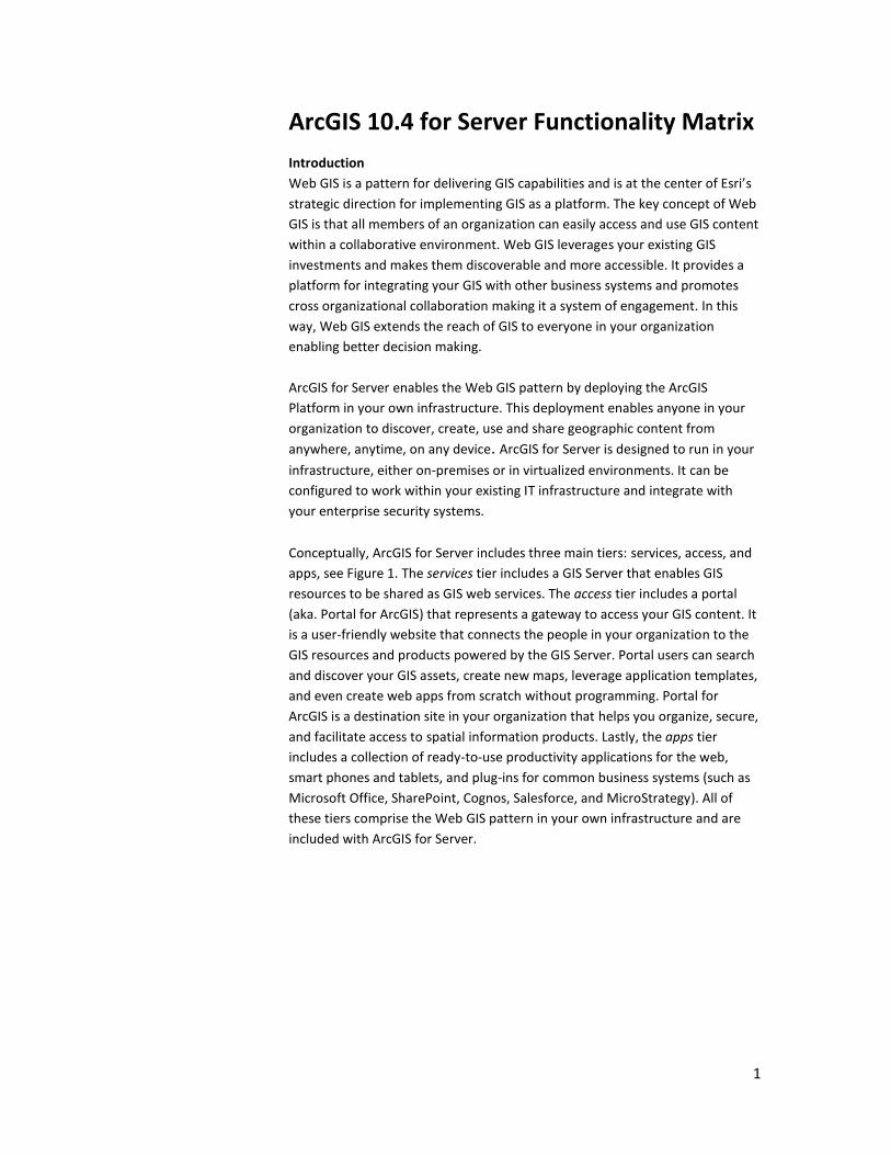
Conceptually, ArcGIS for Server includes three main tiers: services, access, and
apps, see Figure 1. The services tier includes a GIS Server that enables GIS
resources to be shared as GIS web services. The access tier includes a portal
(aka. Portal for ArcGIS) that represents a gateway to access your GIS content. It
is a user-friendly website that connects the people in your organization to the
GIS resources and products powered by the GIS Server. Portal users can search
and discover your GIS assets, create new maps, leverage application templates,
and even create web apps from scratch without programming. Portal for
ArcGIS is a destination site in your organization that helps you organize, secure,
and facilitate access to spatial information products. Lastly, the apps tier
includes a collection of ready-to-use productivity applications for the web,
smart phones and tablets, and plug-ins for common business systems (such as
Microsoft Office, SharePoint, Cognos, Salesforce, and MicroStrategy). All of
these tiers comprise the Web GIS pattern in your own infrastructure and are
included with ArcGIS for Server.
Page 2 of 23
Figure 1: The Web GIS pattern with ArcGIS for Server’s three conceptual tiers:
services, access, and apps.
Additionally, developers can build customized apps that work with ArcGIS for
Server using the ArcGIS REST API, ArcGIS API for JavaScript, and a host of ArcGIS
Runtime SDKs.
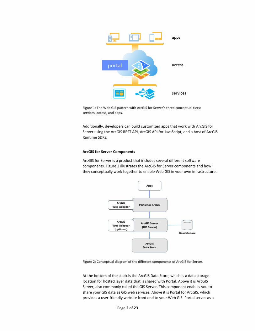
ArcGIS for Server Components
ArcGIS for Server is a product that includes several different software
components. Figure 2 illustrates the ArcGIS for Server components and how
they conceptually work together to enable Web GIS in your own infrastructure.
Figure 2: Conceptual diagram of the different components of ArcGIS for Server.
At the bottom of the stack is the ArcGIS Data Store, which is a data storage
location for hosted layer data that is shared with Portal. Above it is ArcGIS
Server, also commonly called the GIS Server. This component enables you to
share your GIS data as GIS web services. Above it is Portal for ArcGIS, which
provides a user-friendly website front end to your Web GIS. Portal serves as a
Page 3 of 23
destination point for your organization to search, discover and interact with
your GIS assets. Collectively, these three components: Portal for ArcGIS, the GIS
Server, and the ArcGIS Data Store are the main parts of an on-premises Web
GIS deployment.
At the top of the stack are apps. ArcGIS for Server has many applications that
connect and work with Portal for ArcGIS. These include: Collector for ArcGIS,
Explorer for ArcGIS, Operations Dashboard for ArcGIS, ArcGIS Maps for Office,
Esri Maps for … (SharePoint, Cognos, Salesforce, and MicroStrategy), and Web
AppBuilder for ArcGIS.
Two other important components are the ArcGIS Web Adaptor – which works
with 3rd party web servers, and the geodatabase - the native data structure for
ArcGIS with a comprehensive information model for representing and
managing geographic information.
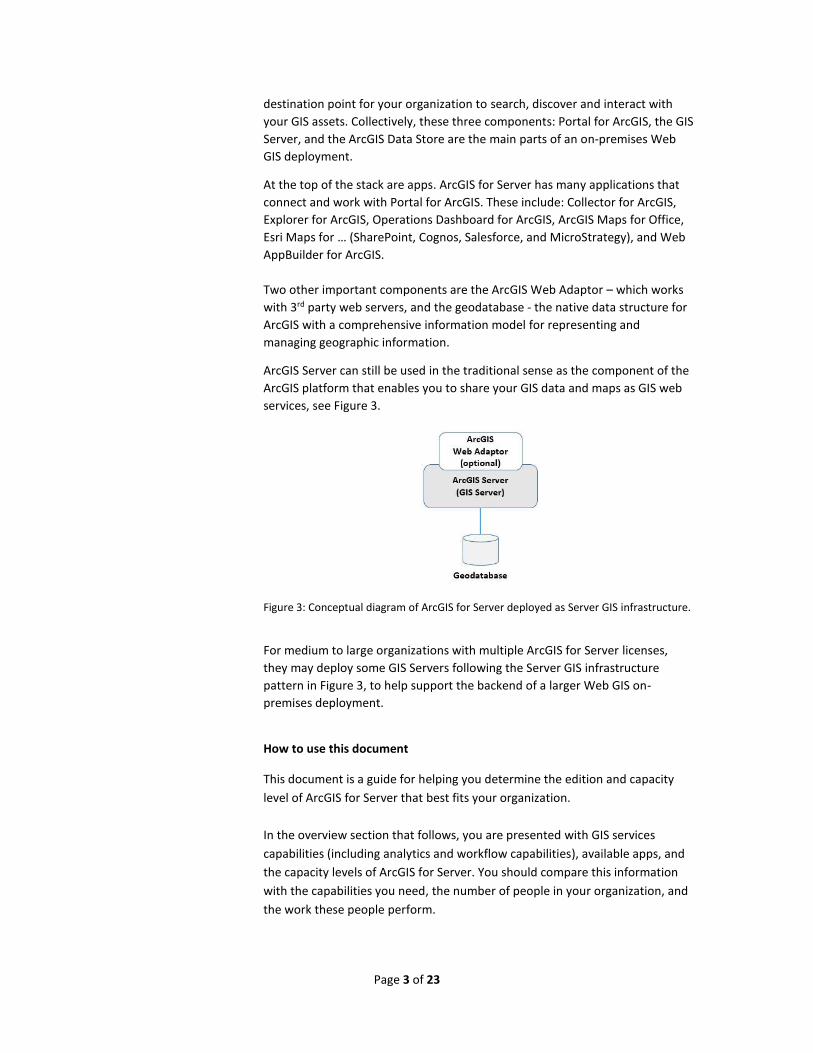
ArcGIS Server can still be used in the traditional sense as the component of the
ArcGIS platform that enables you to share your GIS data and maps as GIS web
services, see Figure 3.
Figure 3: Conceptual diagram of ArcGIS for Server deployed as Server GIS infrastructure.
For medium to large organizations with multiple ArcGIS for Server licenses,
they may deploy some GIS Servers following the Server GIS infrastructure
pattern in Figure 3, to help support the backend of a larger Web GIS on-
premises deployment.
How to use this document
This document is a guide for helping you determine the edition and capacity
level of ArcGIS for Server that best fits your organization.
In the overview section that follows, you are presented with GIS services
capabilities (including analytics and workflow capabilities), available apps, and
the capacity levels of ArcGIS for Server. You should compare this information
with the capabilities you need, the number of people in your organization, and
the work these people perform.
Page 4 of 23
Next, the details section contains additional information about important
concepts that are unique to ArcGIS for Server and its components.
At the end, you will find links to ArcGIS for Server user stories that may be
helpful when comparing to your own situation.
As always, your local Esri representative can help you further define what
capabilities you require to meet your objectives.
Functionality Matrix Overview
Selecting the Appropriate ArcGIS for Server Edition and Level
When selecting the appropriate ArcGIS for Server edition and level for your
organization, consider these two questions:
1. What functionality (GIS service capabilities and applications) do you
require?
2. What level of capacity (storage and number of simultaneous connections)
do you want to support?
Functionality
ArcGIS for Server is offered in three editions. Each successive edition offers
greater functionality.
Basic
With Basic edition, you get geodatabase management and the ability to publish
feature services for map visualization and query. Web-based editing using
feature services is not available with the Basic edition. You also get the
geometry service and the ability to publish geodata services.
Standard
With Standard edition, you get everything in the Basic edition, plus all the GIS
web service types offered by ArcGIS Server. This allows you to web-enable your
maps, imagery, 3D content, and more. You can also support web-based editing
using feature services and publish geoprocessing services from any tool
included in ArcGIS for Desktop Standard. Portal for ArcGIS, which enables you
to deploy your own portal to enable Web GIS is also included. Standard also
includes apps (e.g., Collector for ArcGIS, Explorer for ArcGIS, Operations
Dashboard for ArcGIS, ArcGIS Maps for Office, Esri Maps for … [SharePoint,
Cognos, Salesforce, and MicroStrategy], and Web AppBuilder for ArcGIS) that
connect and work with content from Portal for ArcGIS.
Page 5 of 23
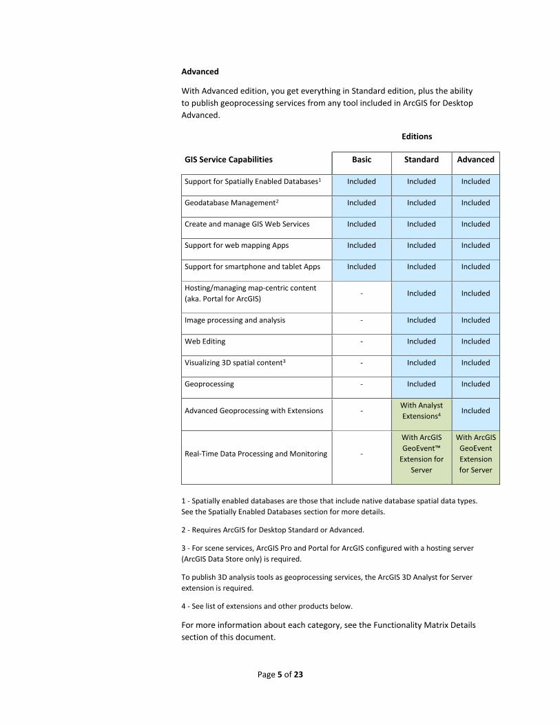
Advanced
With Advanced edition, you get everything in Standard edition, plus the ability
to publish geoprocessing services from any tool included in ArcGIS for Desktop
Advanced.
Editions
GIS Service Capabilities Basic Standard Advanced
Support for Spatially Enabled Databases1 Included Included Included
Geodatabase Management2 Included Included Included
Create and manage GIS Web Services Included Included Included
Support for web mapping Apps Included Included Included
Support for smartphone and tablet Apps Included Included Included
Hosting/managing map-centric content
(aka. Portal for ArcGIS) - Included Included
Image processing and analysis - Included Included
Web Editing - Included Included
Visualizing 3D spatial content3 - Included Included
Geoprocessing - Included Included
Advanced Geoprocessing with Extensions - With Analyst
Extensions4 Included
Real-Time Data Processing and Monitoring -
With ArcGIS
GeoEvent™
Extension for
Server
With ArcGIS
GeoEvent
Extension
for Server
1 - Spatially enabled databases are those that include native database spatial data types.
See the Spatially Enabled Databases section for more details.
2 - Requires ArcGIS for Desktop Standard or Advanced.
3 - For scene services, ArcGIS Pro and Portal for ArcGIS configured with a hosting server
(ArcGIS Data Store only) is required.
To publish 3D analysis tools as geoprocessing services, the ArcGIS 3D Analyst for Server
extension is required.
4 - See list of extensions and other products below.
For more information about each category, see the Functionality Matrix Details
section of this document.
Page 6 of 23
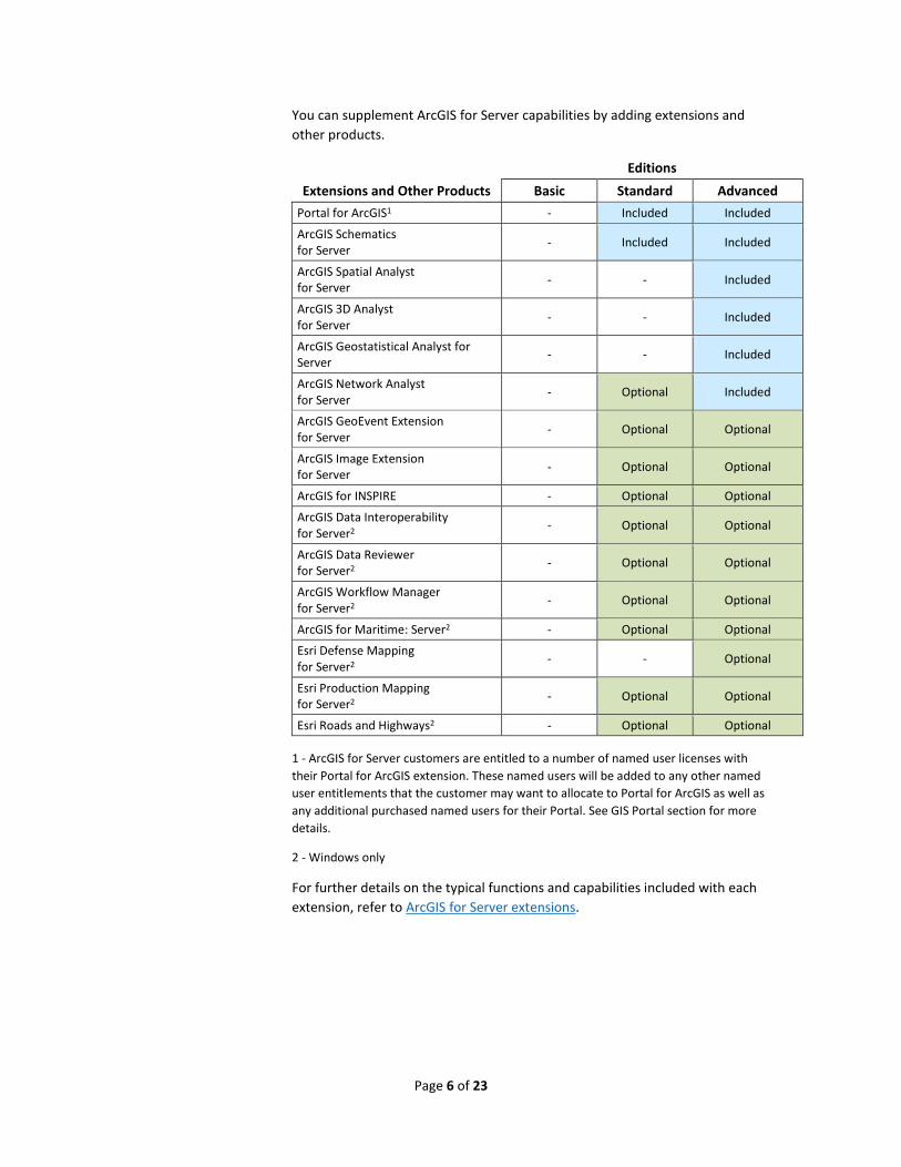
You can supplement ArcGIS for Server capabilities by adding extensions and
other products.
Editions
Extensions and Other Products Basic Standard Advanced
Portal for ArcGIS1 - Included Included
ArcGIS Schematics for Server
- Included Included
ArcGIS Spatial Analyst for Server
- - Included
ArcGIS 3D Analyst for Server
- - Included
ArcGIS Geostatistical Analyst for Server
- - Included
ArcGIS Network Analyst for Server
- Optional Included
ArcGIS GeoEvent Extension for Server
- Optional Optional
ArcGIS Image Extension for Server
- Optional Optional
ArcGIS for INSPIRE - Optional Optional
ArcGIS Data Interoperability for Server2
- Optional Optional
ArcGIS Data Reviewer for Server2
- Optional Optional
ArcGIS Workflow Manager for Server2
- Optional Optional
ArcGIS for Maritime: Server2 - Optional Optional
Esri Defense Mapping for Server2
- - Optional
Esri Production Mapping for Server2
- Optional Optional
Esri Roads and Highways2 - Optional Optional
1 - ArcGIS for Server customers are entitled to a number of named user licenses with
their Portal for ArcGIS extension. These named users will be added to any other named
user entitlements that the customer may want to allocate to Portal for ArcGIS as well as
any additional purchased named users for their Portal. See GIS Portal section for more
details.
2 - Windows only
For further details on the typical functions and capabilities included with each
extension, refer to ArcGIS for Server extensions.
Page 7 of 23
ArcGIS for Server includes a broad range of ready to use apps. Most apps
require a named user license to use. The following table lists which apps are
available for each ArcGIS for Server edition.
Editions
ArcGIS Applications Basic Standard Advanced
ArcGIS Earth* Available Available Available
ArcGIS Maps for Office - Included Included
Collector for ArcGIS - Included Included
Esri Maps for IBM Cognos - Included Included
Esri Maps for MicroStrategy - Included Included
Esri Maps for Salesforce - Included Included
Esri Maps for SharePoint - Included Included
Explorer for ArcGIS - Included Included
Navigator for ArcGIS** - Available Available
Operations Dashboard for ArcGIS*** - Included Included
Web AppBuilder for ArcGIS**** - Included Included
* ArcGIS Earth is a separate app that can work with ArcGIS Server web services. It does
not require a named user license to use for items shared to public.
** Requires additional licensing.
*** Operations Dashboard for ArcGIS includes two versions:
1. A desktop, Windows-based version for creating and monitoring operation views.
2. A browser-based version for monitoring operation views.
**** Requires a named user license to create new apps (this includes the Developer
Edition). Deployed apps do not require a named user if shared to public.
Capacity
The ArcGIS for Server editions described in the previous section are available at
two levels, scaled according to capacity: Workgroup and Enterprise.
Capacity Level
Workgroup Enterprise
Simultaneous connections to multiuser geodatabase 10 Unlimited
Multiuser geodatabase storage capacity 10 GB1 Unlimited
Maximum number of licensable cores 4 cores Unlimited
Maximum number of Portal for ArcGIS named users 10 Unlimited
Distributed deployment of ArcGIS for Server components
Not supported2 Supported
1 - ArcGIS 10.4 for Server Workgroup ships with Microsoft SQL Server Express 2012,
which is limited to databases of up to 10 GB in size.
Page 8 of 23
2 - Workgroup-level components can only be installed on one machine.
Selecting functionalities and the capacity level you want will determine the
ArcGIS for Server edition and level you need. For example, ArcGIS for Server
Enterprise Standard supports unlimited simultaneous connections, a large
multiuser geodatabase, and a standard set of functionality.
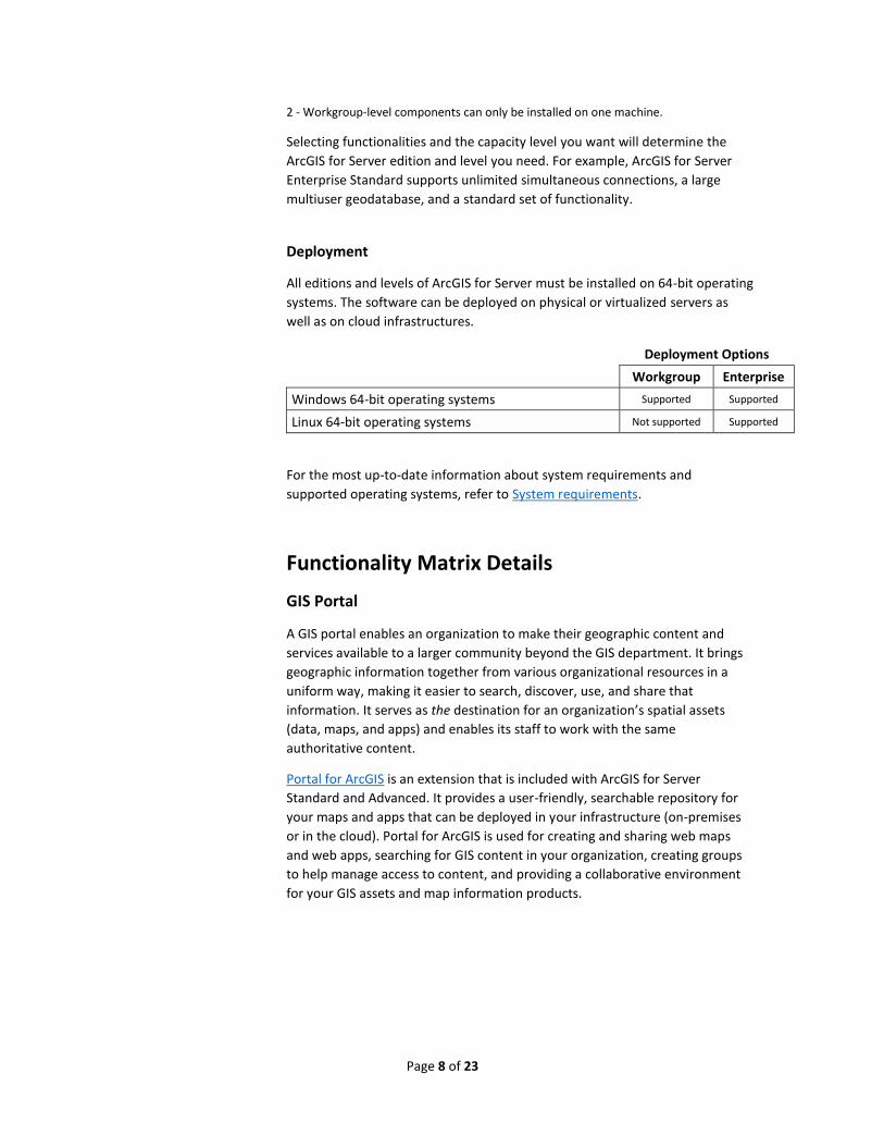
Deployment
All editions and levels of ArcGIS for Server must be installed on 64-bit operating
systems. The software can be deployed on physical or virtualized servers as
well as on cloud infrastructures.
Deployment Options
Workgroup Enterprise
Windows 64-bit operating systems Supported Supported
Linux 64-bit operating systems Not supported Supported
For the most up-to-date information about system requirements and
supported operating systems, refer to System requirements.
Functionality Matrix Details
GIS Portal
A GIS portal enables an organization to make their geographic content and
services available to a larger community beyond the GIS department. It brings
geographic information together from various organizational resources in a
uniform way, making it easier to search, discover, use, and share that
information. It serves as the destination for an organization’s spatial assets
(data, maps, and apps) and enables its staff to work with the same
authoritative content.
Portal for ArcGIS is an extension that is included with ArcGIS for Server
Standard and Advanced. It provides a user-friendly, searchable repository for
your maps and apps that can be deployed in your infrastructure (on-premises
or in the cloud). Portal for ArcGIS is used for creating and sharing web maps
and web apps, searching for GIS content in your organization, creating groups
to help manage access to content, and providing a collaborative environment
for your GIS assets and map information products.
Page 9 of 23
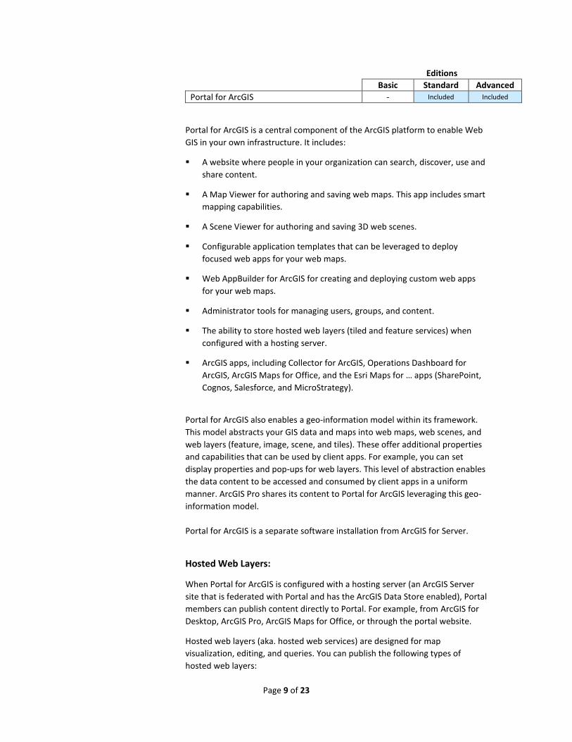
Editions
Basic Standard Advanced
Portal for ArcGIS - Included Included
Portal for ArcGIS is a central component of the ArcGIS platform to enable Web
GIS in your own infrastructure. It includes:
A website where people in your organization can search, discover, use and
share content.
A Map Viewer for authoring and saving web maps. This app includes smart
mapping capabilities.
A Scene Viewer for authoring and saving 3D web scenes.
Configurable application templates that can be leveraged to deploy
focused web apps for your web maps.
Web AppBuilder for ArcGIS for creating and deploying custom web apps
for your web maps.
Administrator tools for managing users, groups, and content.
The ability to store hosted web layers (tiled and feature services) when
configured with a hosting server.
ArcGIS apps, including Collector for ArcGIS, Operations Dashboard for
ArcGIS, ArcGIS Maps for Office, and the Esri Maps for … apps (SharePoint,
Cognos, Salesforce, and MicroStrategy).
Portal for ArcGIS also enables a geo-information model within its framework.
This model abstracts your GIS data and maps into web maps, web scenes, and
web layers (feature, image, scene, and tiles). These offer additional properties
and capabilities that can be used by client apps. For example, you can set
display properties and pop-ups for web layers. This level of abstraction enables
the data content to be accessed and consumed by client apps in a uniform
manner. ArcGIS Pro shares its content to Portal for ArcGIS leveraging this geo-
information model.
Portal for ArcGIS is a separate software installation from ArcGIS for Server.
Hosted Web Layers:
When Portal for ArcGIS is configured with a hosting server (an ArcGIS Server
site that is federated with Portal and has the ArcGIS Data Store enabled), Portal
members can publish content directly to Portal. For example, from ArcGIS for
Desktop, ArcGIS Pro, ArcGIS Maps for Office, or through the portal website.
Hosted web layers (aka. hosted web services) are designed for map
visualization, editing, and queries. You can publish the following types of
hosted web layers:
Page 10 of 23
Feature layers
Hosted feature layers support vector feature querying, visualization, and
editing. Hosted feature layers are most appropriate for visualizing data on top
of your basemaps. In web apps, hosted feature layers are drawn by the
browser and support interactive highlighting, queries, and pop-ups.
You can publish existing features from zipped shapefiles, comma-separated
values (CSV) files, feature collections, ArcMap documents, ArcGIS Pro maps,
GeoJSON files, or zipped file geodatabases to be hosted as feature layers in
your Portal.
Tile layers
Hosted tile layers support fast map visualization using a collection of pre-drawn
map images, or tiles. These tiles are created and stored on the server after you
upload your data. Hosted tile layers are appropriate for basemaps that give
your maps geographic context. You can publish tiles from a service definition
file or ArcMap document that is hosted in your Portal.
Vector tile layers
ArcGIS Pro 1.2 supports the creation of vector tiles, which contain vector
representations of data across a range of scales. Unlike raster tiles, they can
adapt to the resolution of their display device and even be restyled for multiple
uses. When a vector tile package is shared with Portal for ArcGIS, a
corresponding vector tile layer is created.
Named User Entitlements
ArcGIS for Server includes a set of named user entitlements to be used with
Portal for ArcGIS based on the level and capacity of the implementation.
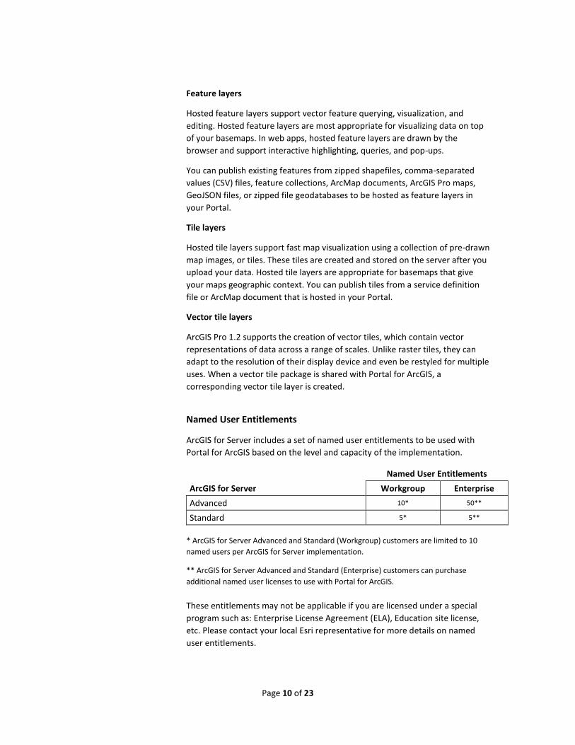
Named User Entitlements
ArcGIS for Server Workgroup Enterprise
Advanced 10* 50**
Standard 5* 5**
* ArcGIS for Server Advanced and Standard (Workgroup) customers are limited to 10
named users per ArcGIS for Server implementation.
** ArcGIS for Server Advanced and Standard (Enterprise) customers can purchase
additional named user licenses to use with Portal for ArcGIS.
These entitlements may not be applicable if you are licensed under a special
program such as: Enterprise License Agreement (ELA), Education site license,
etc. Please contact your local Esri representative for more details on named
user entitlements.
Page 11 of 23
Portal for ArcGIS is not available with ArcGIS for Server Basic (Enterprise or
Workgroup). However, customers are permitted to register services from
ArcGIS for Server Basic with their Portal for ArcGIS implementation.
Web Services
Web services make it easy to share GIS resources across client applications,
including ArcGIS for Desktop, web mapping applications, mobile devices, and
third-party applications.
What are GIS Web Services?
GIS web services are used to share resources over a local network or the
Internet. ArcGIS for Server web services conform to web standards
(Representational State Transfer [REST]); industry standards (Simple Object
Access Protocol [SOAP]); and Open Geospatial Consortium, Inc.® (OGC®),
standards.
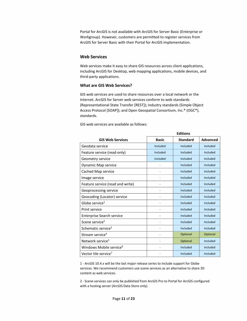
GIS web services are available as follows:
Editions
GIS Web Services Basic Standard Advanced
Geodata service Included Included Included
Feature service (read-only) Included Included Included
Geometry service Included Included Included
Dynamic Map service - Included Included
Cached Map service - Included Included
Image service - Included Included
Feature service (read and write) - Included Included
Geoprocessing service - Included Included
Geocoding (Locator) service - Included Included
Globe service1 - Included Included
Print service - Included Included
Enterprise Search service - Included Included
Scene service2 - Included Included
Schematic service3 - Included Included
Stream service4 - Optional Optional
Network service5 - Optional Included
Windows Mobile service6 - Included Included
Vector tile service7 - Included Included
1 - ArcGIS 10.4.x will be the last major release series to include support for Globe
services. We recommend customers use scene services as an alternative to share 3D
content as web services.
2 - Scene services can only be published from ArcGIS Pro to Portal for ArcGIS configured
with a hosting server (ArcGIS Data Store only).
Page 12 of 23
3 - Schematic services require the ArcGIS for Server Schematics extension.
4 - Stream services require the ArcGIS GeoEvent Extension for Server.
5 - Network services require the ArcGIS Network Analyst for Server extension.
6 - Windows mobile services are used for supporting legacy Windows mobile apps only.
7 - Vector tile services are created when vector tile packages are shared and uploaded
to Portal for ArcGIS configured with a hosting server (ArcGIS Data Store only).
Open Geospatial Consortium Standards
The Open Geospatial Consortium (OGC) is an international industry consortium
of 511 companies, government agencies and universities participating in a
consensus process to develop publicly available interface standards. ArcGIS for
Server Standard and Advanced editions support OGC web services.
The OGC web services that are supported by ArcGIS for Server:
Web Map Service - WMS (versions: 1.0, 1.1, 1.1.1, and 1.3)
Web Feature Service - WFS (versions: 1.0, 1.1, and 2.0)
Web Coverage Service - WCS (versions: 1.0.0, 1.1.0, 1.1.1, 1.1.2, and
2.0.1)
Web Map Tile Service - WMTS (version 1.0)
Keyhole Markup Language - KML (version 2.2)
Web Processing Service - WPS (version 1.0)
The GIS server also supports many optional parts to these specifications please
refer to this Esri whitepaper for details: Esri Support for Geospatial Standards
OGC and ISO/TC211. ArcGIS 10.4 for Server is listed in the OGC Compliance
database and the certification details are available here: Esri Current OGC
Compliant Listings.
Real-time Data Processing
Real-time data processing is an important consideration for organizations that
work with high velocity, high volume data, and both in static formats and in
motion data streams. As the number of data sources providing real-time data
streams increases, it is becoming more important that your applications are
able to consume and immediately display this event data. ArcGIS for Server
provides this capability through an optional extension.
What is the ArcGIS GeoEvent Extension for Server?
The ArcGIS GeoEvent Extension for Server extends the capabilities of ArcGIS for
Server, enabling real-time event-based data streams to be integrated as data
sources in your enterprise GIS.
Editions
Basic Standard Advanced
ArcGIS GeoEvent Extension for Server - Optional Optional
Page 13 of 23
Event data can be filtered, processed, and sent to multiple destinations,
allowing you to connect with virtually any type of streaming data and
automatically alert personnel when specified conditions occur, all in real-time.
The GeoEvent Extension is capable of consuming event data from multiple real-
time data streams. Filters and processors enable analysts to discover and focus
on the most interesting events, locations, and thresholds for their operations.
The GeoEvent Extension includes a Manager application similar to the ArcGIS
Server Manager but is used to create and configure GeoEvent services. (Note:
GeoEvent services are NOT used by ArcGIS for Server client apps.) It also
includes:
Out-of-the-box connectors for common data formats, such as text, RSS,
Esri feature JSON, and generic JSON, and data communication channels,
such as system file, HTTP, TCP, UDP, WebSocket, and feature services.
A rich set of processors that perform specific actions on the GeoEvents,
such as identification or enrichment as GeoEvents are routed from inputs
to outputs.
A configurable set of standard operators for attribute filtering and a
powerful set of spatial filters for filtering GeoEvents based on a spatial
relationship with a GeoFence.
The GeoEvent Extension changes your everyday GIS applications into frontline
decision applications, helping you respond faster with increased awareness
whenever and wherever change occurs.
The GeoEvent Extension is a separate software installation from ArcGIS for
Server.
What Are Stream Services?
The GeoEvent Extension allows you to create and publish a stream service that
emphasizes low latency, real-time data dissemination, for client-server data
flows. Client apps connecting to a stream service begin receiving data
immediately upon subscribing to the service. Clients can specify and
reconfigure both spatial and attribute constraints without first unsubscribing
and then reconnecting to the service.
Stream service content can be incorporated into ArcGIS Online and Portal for
ArcGIS web maps as well as exposed through clients developed using the
ArcGIS API for JavaScript.
Imagery Management and Processing
ArcGIS for Server provides the ability to effectively process and serve imagery,
making imagery and imagery-derived products accessible to a wide range of
applications. Image services can serve single images or collections of images in
mosaic datasets.
Page 14 of 23
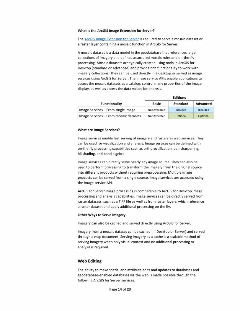
What is the ArcGIS Image Extension for Server?
The ArcGIS Image Extension for Server is required to serve a mosaic dataset or
a raster layer containing a mosaic function in ArcGIS for Server.
A mosaic dataset is a data model in the geodatabase that references large
collections of imagery and defines associated mosaic rules and on-the-fly
processing. Mosaic datasets are typically created using tools in ArcGIS for
Desktop (Standard or Advanced) and provide rich functionality to work with
imagery collections. They can be used directly in a desktop or served as image
services using ArcGIS for Server. The image service APIs enable applications to
access the mosaic datasets as a catalog, control many properties of the image
display, as well as access the data values for analysis.
Editions
Functionality Basic Standard Advanced
Image Services—From single image Not Available Included Included
Image Services—From mosaic datasets Not Available Optional Optional
What are Image Services?
Image services enable fast serving of imagery and rasters as web services. They
can be used for visualization and analysis. Image services can be defined with
on-the-fly processing capabilities such as orthorectification, pan sharpening,
hillshading, and band algebra.
Image services can directly serve nearly any image source. They can also be
used to perform processing to transform the imagery from the original source
into different products without requiring preprocessing. Multiple image
products can be served from a single source. Image services are accessed using
the image service API.
ArcGIS for Server image processing is comparable to ArcGIS for Desktop image
processing and analysis capabilities. Image services can be directly served from
raster datasets, such as a TIFF file as well as from raster layers, which reference
a raster dataset and apply additional processing on the fly.
Other Ways to Serve Imagery
Imagery can also be cached and served directly using ArcGIS for Server.
Imagery from a mosaic dataset can be cached (in Desktop or Server) and served
through a map document. Serving imagery as a cache is a scalable method of
serving imagery when only visual context and no additional processing or
analysis is required.
Web Editing
The ability to make spatial and attribute edits and updates to databases and
geodatabase-enabled databases via the web is made possible through the
following ArcGIS for Server services:
Page 15 of 23
Feature service
Hosted feature layer (see previous section on page 10)
Geometry service (optionally used to support editing workflows)
What is a Feature Service?
Feature services support multiuser database editing across your intranet or the
Internet. Through this web service, you can add, delete, and update geographic
features from web browsers, mobile applications, and any REST and OGC
Transactional Web Feature Service (WFS-T) capable client.
The feature service is implemented as a stateless REST web service, providing
maximum performance and scalability. It exposes feature templates created in
ArcGIS for Desktop to clients and enables structured editing of your GIS data
over the web; this gives clients an intuitive web editing user experience.
Feature services support direct access to spatial types in databases and
geodatabases (see the section Why Use a Geodatabase?). ArcGIS for Server
Standard and ArcGIS for Server Advanced support read and write feature
services with native spatial types from your database without the need to
register tables in the geodatabase.
What is the Geometry Service?
The geometry service helps applications perform geometric calculations such as
buffering, simplifying, calculating areas and lengths, merging, splitting,
validating topological relationships, and projecting data. Often, the geometry
service is used in combination with the feature service to support sophisticated
GIS editing over the web.
Visualizing 3D Spatial Content
Maps typically have 2D data content that are representations of reality and
include additional information to enhance our understanding of the world
around us. For cases where the vertical axis is important, ArcGIS Pro includes
the ability to tilt up a 2D map and view spatial relationships in a three-
dimensional scene. This makes the data more understandable and may help to
reveal new insights. ArcGlobe is another application that enables 3D
visualization.
Working in 3D can highlight influences such as the undulations of the terrain
and the 3D extent of features like trees, buildings, and subsurface geology.
Additionally, the display of quantitative GIS content such as population,
temperature, or relative occurrences of an event, can often be communicated
more effectively in a 3D view.
ArcGIS Server supports two types of web services for 3D visualization:
Scene service
Globe service*
Page 16 of 23
*ArcGIS 10.4.x will be the last major release series to include support for Globe services.
We recommend customers use scene services as an alternative to share 3D content as
web services.
What Is a Scene Service?
ArcGIS Pro enables you to create and manage 3D spatial content, which can be
shared with Portal for ArcGIS. A scene service is a web service originating from
a 3D scene layer in ArcGIS Pro. Scene services (aka. web scene layers) allow you
to share 3D content as a web service and can be aggregated together into a
web scene. Web scenes are interactive displays of geographic information that
are useful when you need to expose 3D data on the web for visualization and
analysis.
To enable ArcGIS Pro to share 3D data to Portal for ArcGIS, Portal must be
configured with a hosting server. A hosting server is an ArcGIS Server site that
is federated with Portal and has the ArcGIS Data Store enabled. ArcGIS Pro can
share 3D content to Portal for ArcGIS as a scene service (aka. web scene layer)
or as a web scene.
What Is a Globe Service?
A globe service gives you access to 3D content originating from an ArcGlobe
document (.3dd). It supports all the same display options that are available
when viewing the layer locally. For example, globe services can be created to
share 3D objects, such as a virtual city of building features and street furniture,
or high-resolution elevation surfaces.
Geoprocessing
ArcGIS for Server provides an extensive array of geoprocessing functionality.
What Is a Geoprocessing Service?
Geoprocessing services are how you expose the powerful analytic capabilities
of ArcGIS. They contain geoprocessing tasks, which take simple data captured
in a web application, processes it, and returns meaningful and useful output in
the form of features, maps, reports, and files.
Geoprocessing takes an input dataset, performs an operation on that dataset,
and returns the result of the operation as an output dataset.
With ArcGIS for Server, you can publish geoprocessing services that allow you
to submit jobs to the server and return a set of results. Building a
geoprocessing service requires that you first create a model using the
ModelBuilder™ feature in ArcGIS for Desktop. A model is a logical sequence of
geoprocessing tools and/or scripts that help automate a GIS operation. The
server accesses the model and does the work, freeing client computer
resources and eliminating the problem of having to share copies of the model
across client computers.
Geoprocessing supports tools comparable to the ArcGIS for Desktop Standard
software-level geoprocessing toolbox.
Page 17 of 23
What Is Advanced Geoprocessing?
Advanced geoprocessing refers to the additional tools available with ArcGIS for
Server Analyst Extensions (3D Analyst, Spatial Analyst, Geostatistical Analyst,
and Network Analyst). Advanced routing and suitability analysis are also
examples of advanced geoprocessing.
ArcGIS for Server Advanced edition includes extensions for specialized advance
analytics.
Support for Spatially Enabled Databases
ArcGIS for Server allows you to work directly with spatial data stored and
managed by commercial databases that support spatial types. With ArcGIS for
Server Basic edition, you can enable read-only feature services for your data.
These feature services will allow you to display and query your database
information on a map from web browsers and mobile devices. The following
databases are supported:
ALTIBASE®
Amazon RDS for Microsoft SQL Server
Amazon RDS for PostgreSQL
Dameng
IBM® DB2®
IBM Informix® Dynamic Server
IBM Netezza®
Microsoft® SQL Server®
Microsoft Azure® SQL Database
Oracle®
PostgreSQL
SAP HANA®
Teradata®
Note: All databases are read-only in ArcGIS for Server Basic edition and
read/write in ArcGIS for Server Standard and Advanced editions (except for
Netezza, which is read-only).
Geodatabase Management
The geodatabase enables ArcGIS for Server to extend the spatial capabilities of
databases to support more sophisticated GIS data management workflows
such as versioning, and geospatial data models (e.g., topologies, geometric
networks, and network datasets).
Page 18 of 23
Why Use a Geodatabase?
Commercial databases support simple spatial features. Geodatabases build on
this framework and extend the capabilities of your database to ensure that you
can enrich your GIS data models and satisfy the most demanding GIS workflows
such as the following:
Long transactions and conflict resolution (versioning)
Modeling of utility, water, and transportation networks (geometric
networks and network datasets)
Data validation including topological, attribute, and connectivity rules
(topologies)
Tracking of historic transactions (archiving)
Complex features: annotations (text), dimensions, parcel fabrics, etc.
Advanced symbology (cartographic representations)
Replication across multiple commercial databases in connected and
disconnected environments (geodata services)
ArcGIS for Server Enterprise level supports multiuser geodatabases on the
following relational database management systems (RDBMS):
Amazon RDS for PostgreSQL
Amazon RDS for Microsoft SQL Server
IBM DB2
IBM Informix Dynamic Server
Microsoft SQL Server
Oracle
PostgreSQL
ArcGIS for Server Workgroup level only supports Microsoft SQL Server Express.
ArcGIS for Desktop Standard or Advanced includes tools to create a multiuser
geodatabase.
ArcGIS Client Apps and APIs
ArcGIS for Server users benefit from a variety of ready to use client
applications:
ArcGIS Online and Portal for ArcGIS map and scene viewers
Configurable Application Templates
Collector for ArcGIS
Operations Dashboard for ArcGIS
Explorer for ArcGIS
ArcGIS Maps for Office
Esri Maps for SharePoint
Esri Maps for IBM Cognos
Esri Maps for MicroStrategy
Esri Maps for Salesforce
Web AppBuilder for ArcGIS
ArcGIS Earth
Page 19 of 23
Navigator for ArcGIS
Web application developers can build custom web mapping apps using the
ArcGIS API for JavaScript™.
Smartphone and Tablet Apps/Runtime SDKs
ArcGIS for Server supports a variety of mobile applications across all editions
and on many platforms:
Collector for ArcGIS
Operations Dashboard for ArcGIS
Explorer for ArcGIS
Application developers can build custom native apps for desktop and mobile devices using the ArcGIS Runtime SDKs:
ArcGIS Runtime SDK for iOS ArcGIS Runtime SDK for Android ArcGIS Runtime SDK for OS X ArcGIS Runtime SDK for Qt ArcGIS Runtime SDK for Java
ArcGIS Runtime SDK for .NET
ArcGIS for Server User Stories
Please click the links below for some real customer success stories of working
with ArcGIS for Server:
Seneca Resources
Field crew gets online information with map-portal
Spatially Mapping Chick-fil-A Restaurants
A Clear View for Retail Success
For more customer stories:
http://www.esri.com/software/arcgis/arcgisserver/success-stories
Resources
ArcGIS for Server 101 – ArcUser Technical article
Portal for ArcGIS 101 – ArcUser Technical article

Page 20 of 23
Esri inspires and enables people to positively impact their future through a
deeper, geographic understanding of the changing world around them.
Governments, industry leaders, academics, and nongovernmental organizations
trust us to connect them with the analytic knowledge they need to make the
critical decisions that shape the planet. For more than 40 years, Esri has
cultivated collaborative relationships with partners who share our commitment
to solving earth’s most pressing challenges with geographic expertise and
rational resolve. Today, we believe that geography is at the heart of a more
resilient and sustainable future. Creating responsible products and solutions
drives our passion for improving quality of life everywhere.
Contact Esri
380 New York Street
Redlands, California 92373-8100 USA
1 800 447 9778
t 909 793 2853
f 909 793 5953
esri.com
Offices worldwide
esri.com/locations


![Python and ArcGIS Enterprise - static.packt-cdn.com€¦ · Python and ArcGIS Enterprise [ 2 ] ArcGIS enterprise Starting with ArcGIS 10.5, ArcGIS Server is now called ArcGIS Enterprise](https://img.pdfslide.net/doc/110x75/5ecf20757db43a10014313b7/python-and-arcgis-enterprise-python-and-arcgis-enterprise-2-arcgis-enterprise.jpg)


![[Arcgis] Riset ArcGIS JS & Flex](https://img.pdfslide.net/doc/110x75/55cf96d7550346d0338e2017/arcgis-riset-arcgis-js-flex.jpg)