Embed Size (px)
Citation preview
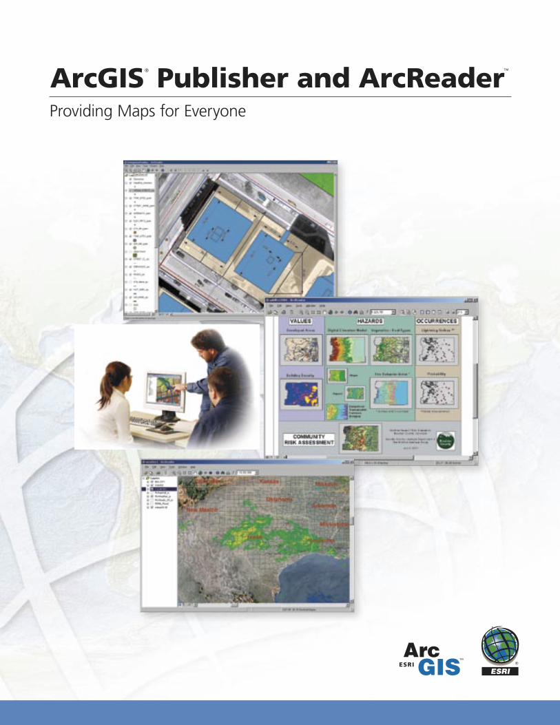
Providing Maps for Everyone
ArcGIS® Publisher and ArcReader™
Australia www.esriaustralia.com.au
Belgium/Luxembourg www.esribelux.com
Bulgaria www.esribulgaria.com
Canada www.esricanada.com
China (Beijing) www.esrichina-bj.cn
China (Hong Kong) www.esrichina-hk.com
Finland www.esri-finland.com
France www.esrifrance.fr
Germany/Switzerland www.esri-germany.de
www.esri-suisse.ch
Hungary www.esrihu.hu
India www.esriindia.com
Indonesia/Malaysia 62-21-527-1023 603-7874-9930
Italy www.esriitalia.it
Japan www.esrij.com
Korea www.esrikr.co.kr
Netherlands www.esrinl.com
Poland www.esripolska.com.pl
Portugal www.esri-portugal.pt
Romania www.esriro.ro
Singapore www.esrisa.com
Spain www.esri-es.com
Sweden www.esri-sweden.com
Thailand www.esrith.com
United Kingdom www.esriuk.com
Venezuela www.esriven.com
No. GS-35F-5086H
Printed in USA97944INLD2.5M7/04pr
Copyright © 2004 ESRI. All rights reserved. ESRI, the ESRI globe logo, ArcGIS, ArcReader, @esri.com, ArcObjects, ArcView, ArcEditor, ArcInfo, ArcMap, the ArcGIS logo, and www.esri.com are trademarks, registered trademarks, or service marks of ESRI in the United States, the European Community, or certain other jurisdictions. Other companies and products mentioned herein are trademarks or registered trademarks of their respective trademark owners.
Place ESRI business partner or distributor address here.
For more than 35 years ESRI has been helping people manage and analyze geographic information. ESRI offers a framework for implementing GIS technology in any organization with a seamless link from personal GIS on the desktop
to enterprisewide GIS client/server and data management systems. ESRI GIS solutions are flexible and can be customized to meet the needs of our users. ESRI is a full-service GIS company, ready to help you begin, grow, and build success with GIS.
International Offices
ESRI
380 New York Street
Redlands, California
92373-8100, USA
Telephone: 909-793-2853
Fax: 909-793-5953
For more information
on ESRI, call
1-800-447-9778(1-800-GIS-XPRT)
or contact an ESRI value-added reseller near you.
Send e-mail inquiries to
Visit ESRI’s Web page at
www.esri.com
Corporate
Outside the United States,
contact your local ESRI distributor.
For the number of your distributor,
call ESRI at 909-793-2853,
ext. 1235,
or visit our Web site at www.esri.com/international
Regional Offices
ESRI–Minneapolis 651-454-0600ESRI–Olympia
360-754-4727ESRI–Boston 978-777-4543
ESRI–California 909-793-2853 ext. 1-1906
ESRI–Denver 303-449-7779
ESRI–San Antonio 210-499-1044
ESRI–Charlotte 704-541-9810
ESRI–Washington, D.C. 703-506-9515
ESRI–St. Louis 636-949-6620 ESRI–Philadelphia
610-337-8380
ESRI–New York City 212-349-3700
Using the ArcReader Control
Developing with the ArcReader Control in Visual Studio .NET
Custom ArcReader applications
ArcGIS Publisher allows developers to create custom ArcReader applications or embed ArcReader capabilities into existing appli-cations. This is done by programming with ArcReader Control, which can be used with an industry-standard COM-based development environment such as Microsoft® Visual Basic®. The ArcReader Control is included with ArcGIS Publisher.
ArcReader Control provides a set of components that develop-ers can use to build custom applications. These components are designed for ease of use and rapid application development.
In addition to the functionality available within ArcReader, developers can also program simple data queries to enhance data exploration and navigation of the map.
Custom applications created with ArcReader Control can be freely distributed and used by anyone who has ArcReader.
For more information or to evaluate ArcGIS Publisher, visitwww.esri.com/arcreader
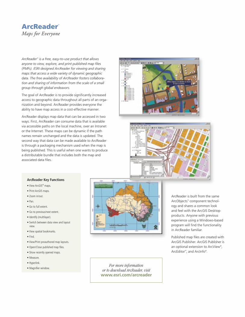
ArcReader™
Maps for Everyone
ArcReader Key Functions
• View ArcGIS® maps.
• Print ArcGIS maps.
• Zoom in/out.
• Pan.
• Go to full extent.
• Go to previous/next extent.
• Identify (multilayer).
• Switch between data view and layout view.
• View spatial bookmarks.
• Find.
• View/Print preauthored map layouts.
• Open/Close published map files.
• Show recently opened maps.
• Measure.
• Hyperlink.
• Magnifier window.For more information
or to download ArcReader, visit www.esri.com/arcreader
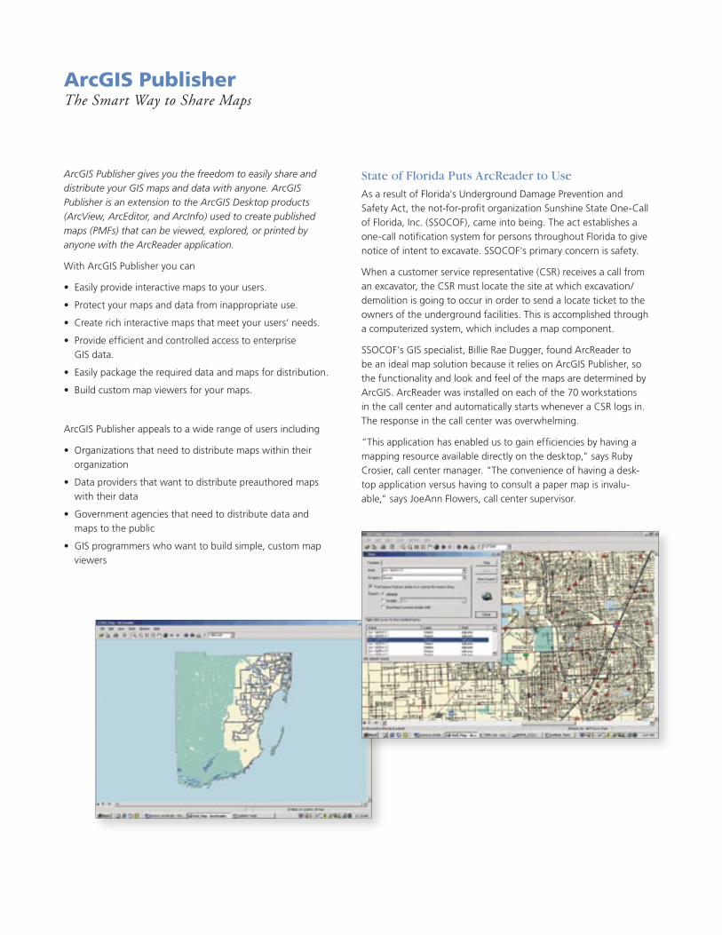
ArcGIS PublisherThe Smart Way to Share Maps
ArcGIS Publisher gives you the freedom to easily share and distribute your GIS maps and data with anyone. ArcGIS Publisher is an extension to the ArcGIS Desktop products (ArcView, ArcEditor, and ArcInfo) used to create published maps (PMFs) that can be viewed, explored, or printed by anyone with the ArcReader application.
With ArcGIS Publisher you can
• Easily provide interactive maps to your users.
• Protect your maps and data from inappropriate use.
• Create rich interactive maps that meet your users’ needs.
• Provide efficient and controlled access to enterprise GIS data.
• Easily package the required data and maps for distribution.
• Build custom map viewers for your maps.
ArcGIS Publisher appeals to a wide range of users including
• Organizations that need to distribute maps within their organization
• Data providers that want to distribute preauthored maps with their data
• Government agencies that need to distribute data and maps to the public
• GIS programmers who want to build simple, custom map viewers
State of Florida Puts ArcReader to Use
As a result of Florida's Underground Damage Prevention and Safety Act, the not-for-profit organization Sunshine State One-Call of Florida, Inc. (SSOCOF), came into being. The act establishes a one-call notification system for persons throughout Florida to give notice of intent to excavate. SSOCOF's primary concern is safety.
When a customer service representative (CSR) receives a call from an excavator, the CSR must locate the site at which excavation/demolition is going to occur in order to send a locate ticket to the owners of the underground facilities. This is accomplished through a computerized system, which includes a map component.
SSOCOF's GIS specialist, Billie Rae Dugger, found ArcReader to be an ideal map solution because it relies on ArcGIS Publisher, so the functionality and look and feel of the maps are determined by ArcGIS. ArcReader was installed on each of the 70 workstations in the call center and automatically starts whenever a CSR logs in. The response in the call center was overwhelming.
“This application has enabled us to gain efficiencies by having a mapping resource available directly on the desktop," says Ruby Crosier, call center manager. "The convenience of having a desk-top application versus having to consult a paper map is invalu-able," says JoeAnn Flowers, call center supervisor.
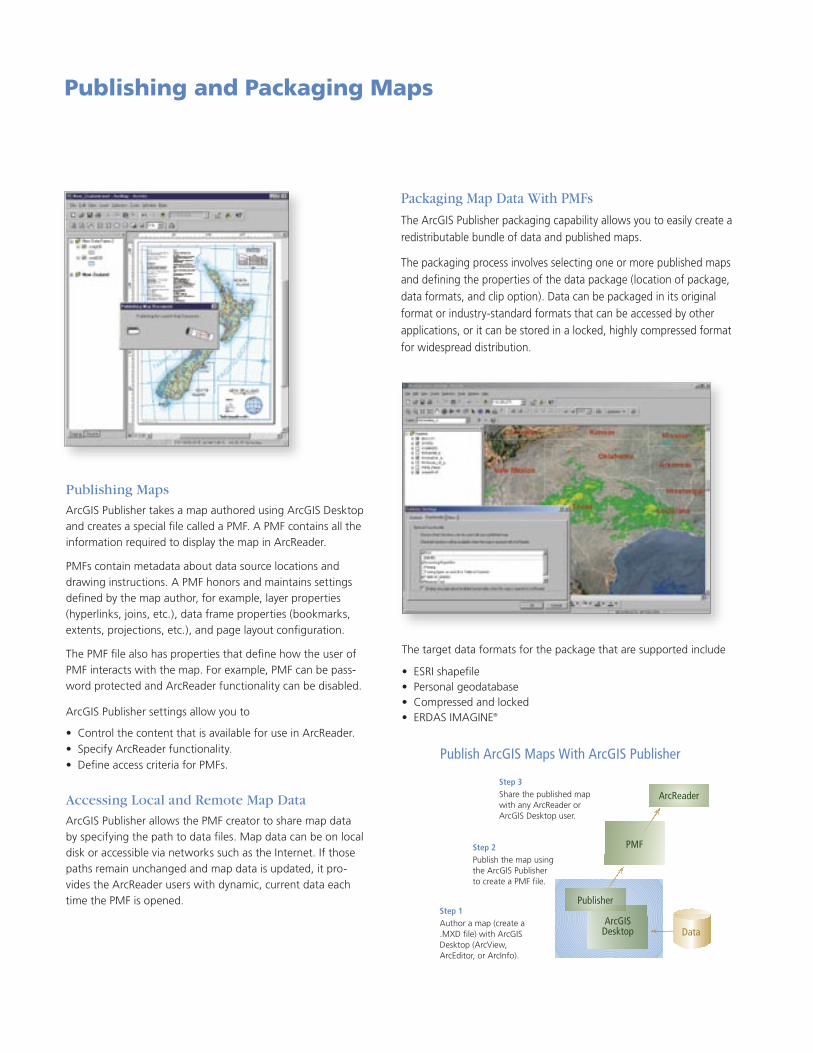
Publishing and Packaging Maps
Publish ArcGIS Maps With ArcGIS Publisher
Step 3Share the published map with any ArcReader or ArcGIS Desktop user.
Step 2Publish the map using the ArcGIS Publisher to create a PMF file.
Step 1Author a map (create a .MXD file) with ArcGIS Desktop (ArcView, ArcEditor, or ArcInfo).
ArcGISDesktop
Publisher
Data
ArcReader
PMF
The target data formats for the package that are supported include
• ESRI shapefile • Personal geodatabase • Compressed and locked • ERDAS IMAGINE®
ArcReader is built from the same ArcObjects™ component technol-ogy and shares a common look and feel with the ArcGIS Desktop products. Anyone with previous experience using a Windows-based program will find the functionality in ArcReader familiar.
Published map files are created with ArcGIS Publisher. ArcGIS Publisher is an optional extension to ArcView®, ArcEditor™, and ArcInfo®.
ArcReader™ is a free, easy-to-use product that allows anyone to view, explore, and print published map files (PMFs). ESRI designed ArcReader for viewing and sharing maps that access a wide variety of dynamic geographic data. The free availability of ArcReader fosters collabora-tion and sharing of information from the scale of a small group through global endeavors.
The goal of ArcReader is to provide significantly increased access to geographic data throughout all parts of an orga-nization and beyond. ArcReader provides everyone the ability to have map access in a cost-effective manner.
ArcReader displays map data that can be accessed in two ways. First, ArcReader can consume data that is available via accessible paths on the local machine, over an Intranet or the Internet. These maps can be dynamic if the path names remain unchanged and the data is updated. The second way that data can be made available to ArcReader is through a packaging mechanism used when the map is being published. This is useful when one wants to produce a distributable bundle that includes both the map and associated data files.
Packaging Map Data With PMFs
The ArcGIS Publisher packaging capability allows you to easily create a redistributable bundle of data and published maps.
The packaging process involves selecting one or more published maps and defining the properties of the data package (location of package, data formats, and clip option). Data can be packaged in its original format or industry-standard formats that can be accessed by other applications, or it can be stored in a locked, highly compressed format for widespread distribution.
Publishing Maps
ArcGIS Publisher takes a map authored using ArcGIS Desktop and creates a special file called a PMF. A PMF contains all the information required to display the map in ArcReader.
PMFs contain metadata about data source locations and drawing instructions. A PMF honors and maintains settings defined by the map author, for example, layer properties (hyperlinks, joins, etc.), data frame properties (bookmarks, extents, projections, etc.), and page layout configuration.
The PMF file also has properties that define how the user of PMF interacts with the map. For example, PMF can be pass-word protected and ArcReader functionality can be disabled.
ArcGIS Publisher settings allow you to
• Control the content that is available for use in ArcReader. • Specify ArcReader functionality. • Define access criteria for PMFs.
Accessing Local and Remote Map Data
ArcGIS Publisher allows the PMF creator to share map data by specifying the path to data files. Map data can be on local disk or accessible via networks such as the Internet. If those paths remain unchanged and map data is updated, it pro-vides the ArcReader users with dynamic, current data each time the PMF is opened.
ArcReader™
Maps for Everyone
ArcReader Key Functions
• View ArcGIS® maps.
• Print ArcGIS maps.
• Zoom in/out.
• Pan.
• Go to full extent.
• Go to previous/next extent.
• Identify (multilayer).
• Switch between data view and layout view.
• View spatial bookmarks.
• Find.
• View/Print preauthored map layouts.
• Open/Close published map files.
• Show recently opened maps.
• Measure.
• Hyperlink.
• Magnifier window.For more information
or to download ArcReader, visit www.esri.com/arcreader
ArcGIS PublisherThe Smart Way to Share Maps
ArcGIS Publisher gives you the freedom to easily share and distribute your GIS maps and data with anyone. ArcGIS Publisher is an extension to the ArcGIS Desktop products (ArcView, ArcEditor, and ArcInfo) used to create published maps (PMFs) that can be viewed, explored, or printed by anyone with the ArcReader application.
With ArcGIS Publisher you can
• Easily provide interactive maps to your users.
• Protect your maps and data from inappropriate use.
• Create rich interactive maps that meet your users’ needs.
• Provide efficient and controlled access to enterprise GIS data.
• Easily package the required data and maps for distribution.
• Build custom map viewers for your maps.
ArcGIS Publisher appeals to a wide range of users including
• Organizations that need to distribute maps within their organization
• Data providers that want to distribute preauthored maps with their data
• Government agencies that need to distribute data and maps to the public
• GIS programmers who want to build simple, custom map viewers
State of Florida Puts ArcReader to Use
As a result of Florida's Underground Damage Prevention and Safety Act, the not-for-profit organization Sunshine State One-Call of Florida, Inc. (SSOCOF), came into being. The act establishes a one-call notification system for persons throughout Florida to give notice of intent to excavate. SSOCOF's primary concern is safety.
When a customer service representative (CSR) receives a call from an excavator, the CSR must locate the site at which excavation/demolition is going to occur in order to send a locate ticket to the owners of the underground facilities. This is accomplished through a computerized system, which includes a map component.
SSOCOF's GIS specialist, Billie Rae Dugger, found ArcReader to be an ideal map solution because it relies on ArcGIS Publisher, so the functionality and look and feel of the maps are determined by ArcGIS. ArcReader was installed on each of the 70 workstations in the call center and automatically starts whenever a CSR logs in. The response in the call center was overwhelming.
“This application has enabled us to gain efficiencies by having a mapping resource available directly on the desktop," says Ruby Crosier, call center manager. "The convenience of having a desk-top application versus having to consult a paper map is invalu-able," says JoeAnn Flowers, call center supervisor.
Publishing and Packaging Maps
Publish ArcGIS Maps With ArcGIS Publisher
Step 3Share the published map with any ArcReader or ArcGIS Desktop user.
Step 2Publish the map using the ArcGIS Publisher to create a PMF file.
Step 1Author a map (create a .MXD file) with ArcGIS Desktop (ArcView, ArcEditor, or ArcInfo).
ArcGISDesktop
Publisher
Data
ArcReader
PMF
The target data formats for the package that are supported include
• ESRI shapefile • Personal geodatabase • Compressed and locked • ERDAS IMAGINE®
ArcReader is built from the same ArcObjects™ component technol-ogy and shares a common look and feel with the ArcGIS Desktop products. Anyone with previous experience using a Windows-based program will find the functionality in ArcReader familiar.
Published map files are created with ArcGIS Publisher. ArcGIS Publisher is an optional extension to ArcView®, ArcEditor™, and ArcInfo®.
ArcReader™ is a free, easy-to-use product that allows anyone to view, explore, and print published map files (PMFs). ESRI designed ArcReader for viewing and sharing maps that access a wide variety of dynamic geographic data. The free availability of ArcReader fosters collabora-tion and sharing of information from the scale of a small group through global endeavors.
The goal of ArcReader is to provide significantly increased access to geographic data throughout all parts of an orga-nization and beyond. ArcReader provides everyone the ability to have map access in a cost-effective manner.
ArcReader displays map data that can be accessed in two ways. First, ArcReader can consume data that is available via accessible paths on the local machine, over an Intranet or the Internet. These maps can be dynamic if the path names remain unchanged and the data is updated. The second way that data can be made available to ArcReader is through a packaging mechanism used when the map is being published. This is useful when one wants to produce a distributable bundle that includes both the map and associated data files.
Packaging Map Data With PMFs
The ArcGIS Publisher packaging capability allows you to easily create a redistributable bundle of data and published maps.
The packaging process involves selecting one or more published maps and defining the properties of the data package (location of package, data formats, and clip option). Data can be packaged in its original format or industry-standard formats that can be accessed by other applications, or it can be stored in a locked, highly compressed format for widespread distribution.
Publishing Maps
ArcGIS Publisher takes a map authored using ArcGIS Desktop and creates a special file called a PMF. A PMF contains all the information required to display the map in ArcReader.
PMFs contain metadata about data source locations and drawing instructions. A PMF honors and maintains settings defined by the map author, for example, layer properties (hyperlinks, joins, etc.), data frame properties (bookmarks, extents, projections, etc.), and page layout configuration.
The PMF file also has properties that define how the user of PMF interacts with the map. For example, PMF can be pass-word protected and ArcReader functionality can be disabled.
ArcGIS Publisher settings allow you to
• Control the content that is available for use in ArcReader. • Specify ArcReader functionality. • Define access criteria for PMFs.
Accessing Local and Remote Map Data
ArcGIS Publisher allows the PMF creator to share map data by specifying the path to data files. Map data can be on local disk or accessible via networks such as the Internet. If those paths remain unchanged and map data is updated, it pro-vides the ArcReader users with dynamic, current data each time the PMF is opened.
Providing Maps for Everyone
ArcGIS® Publisher and ArcReader™
Australia www.esriaustralia.com.au
Belgium/Luxembourg www.esribelux.com
Bulgaria www.esribulgaria.com
Canada www.esricanada.com
China (Beijing) www.esrichina-bj.cn
China (Hong Kong) www.esrichina-hk.com
Finland www.esri-finland.com
France www.esrifrance.fr
Germany/Switzerland www.esri-germany.de
www.esri-suisse.ch
Hungary www.esrihu.hu
India www.esriindia.com
Indonesia/Malaysia 62-21-527-1023 603-7874-9930
Italy www.esriitalia.it
Japan www.esrij.com
Korea www.esrikr.co.kr
Netherlands www.esrinl.com
Poland www.esripolska.com.pl
Portugal www.esri-portugal.pt
Romania www.esriro.ro
Singapore www.esrisa.com
Spain www.esri-es.com
Sweden www.esri-sweden.com
Thailand www.esrith.com
United Kingdom www.esriuk.com
Venezuela www.esriven.com
No. GS-35F-5086H
Printed in USA97944INLD2.5M7/04pr
Copyright © 2004 ESRI. All rights reserved. ESRI, the ESRI globe logo, ArcGIS, ArcReader, @esri.com, ArcObjects, ArcView, ArcEditor, ArcInfo, ArcMap, the ArcGIS logo, and www.esri.com are trademarks, registered trademarks, or service marks of ESRI in the United States, the European Community, or certain other jurisdictions. Other companies and products mentioned herein are trademarks or registered trademarks of their respective trademark owners.
Place ESRI business partner or distributor address here.
For more than 35 years ESRI has been helping people manage and analyze geographic information. ESRI offers a framework for implementing GIS technology in any organization with a seamless link from personal GIS on the desktop
to enterprisewide GIS client/server and data management systems. ESRI GIS solutions are flexible and can be customized to meet the needs of our users. ESRI is a full-service GIS company, ready to help you begin, grow, and build success with GIS.
International Offices
ESRI
380 New York Street
Redlands, California
92373-8100, USA
Telephone: 909-793-2853
Fax: 909-793-5953
For more information
on ESRI, call
1-800-447-9778(1-800-GIS-XPRT)
or contact an ESRI value-added reseller near you.
Send e-mail inquiries to
Visit ESRI’s Web page at
www.esri.com
Corporate
Outside the United States,
contact your local ESRI distributor.
For the number of your distributor,
call ESRI at 909-793-2853,
ext. 1235,
or visit our Web site at www.esri.com/international
Regional Offices
ESRI–Minneapolis 651-454-0600ESRI–Olympia
360-754-4727ESRI–Boston 978-777-4543
ESRI–California 909-793-2853 ext. 1-1906
ESRI–Denver 303-449-7779
ESRI–San Antonio 210-499-1044
ESRI–Charlotte 704-541-9810
ESRI–Washington, D.C. 703-506-9515
ESRI–St. Louis 636-949-6620 ESRI–Philadelphia
610-337-8380
ESRI–New York City 212-349-3700
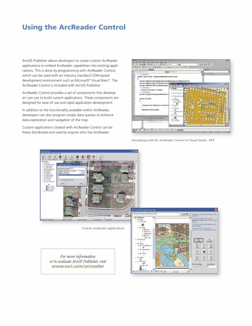
Using the ArcReader Control
Developing with the ArcReader Control in Visual Studio .NET
Custom ArcReader applications
ArcGIS Publisher allows developers to create custom ArcReader applications or embed ArcReader capabilities into existing appli-cations. This is done by programming with ArcReader Control, which can be used with an industry-standard COM-based development environment such as Microsoft® Visual Basic®. The ArcReader Control is included with ArcGIS Publisher.
ArcReader Control provides a set of components that develop-ers can use to build custom applications. These components are designed for ease of use and rapid application development.
In addition to the functionality available within ArcReader, developers can also program simple data queries to enhance data exploration and navigation of the map.
Custom applications created with ArcReader Control can be freely distributed and used by anyone who has ArcReader.
For more information or to evaluate ArcGIS Publisher, visitwww.esri.com/arcreader
Providing Maps for Everyone
ArcGIS® Publisher and ArcReader™
Australia www.esriaustralia.com.au
Belgium/Luxembourg www.esribelux.com
Bulgaria www.esribulgaria.com
Canada www.esricanada.com
China (Beijing) www.esrichina-bj.cn
China (Hong Kong) www.esrichina-hk.com
Finland www.esri-finland.com
France www.esrifrance.fr
Germany/Switzerland www.esri-germany.de
www.esri-suisse.ch
Hungary www.esrihu.hu
India www.esriindia.com
Indonesia/Malaysia 62-21-527-1023 603-7874-9930
Italy www.esriitalia.it
Japan www.esrij.com
Korea www.esrikr.co.kr
Netherlands www.esrinl.com
Poland www.esripolska.com.pl
Portugal www.esri-portugal.pt
Romania www.esriro.ro
Singapore www.esrisa.com
Spain www.esri-es.com
Sweden www.esri-sweden.com
Thailand www.esrith.com
United Kingdom www.esriuk.com
Venezuela www.esriven.com
No. GS-35F-5086H
Printed in USA97944INLD2.5M7/04pr
Copyright © 2004 ESRI. All rights reserved. ESRI, the ESRI globe logo, ArcGIS, ArcReader, @esri.com, ArcObjects, ArcView, ArcEditor, ArcInfo, ArcMap, the ArcGIS logo, and www.esri.com are trademarks, registered trademarks, or service marks of ESRI in the United States, the European Community, or certain other jurisdictions. Other companies and products mentioned herein are trademarks or registered trademarks of their respective trademark owners.
Place ESRI business partner or distributor address here.
For more than 35 years ESRI has been helping people manage and analyze geographic information. ESRI offers a framework for implementing GIS technology in any organization with a seamless link from personal GIS on the desktop
to enterprisewide GIS client/server and data management systems. ESRI GIS solutions are flexible and can be customized to meet the needs of our users. ESRI is a full-service GIS company, ready to help you begin, grow, and build success with GIS.
International Offices
ESRI
380 New York Street
Redlands, California
92373-8100, USA
Telephone: 909-793-2853
Fax: 909-793-5953
For more information
on ESRI, call
1-800-447-9778(1-800-GIS-XPRT)
or contact an ESRI value-added reseller near you.
Send e-mail inquiries to
Visit ESRI’s Web page at
www.esri.com
Corporate
Outside the United States,
contact your local ESRI distributor.
For the number of your distributor,
call ESRI at 909-793-2853,
ext. 1235,
or visit our Web site at www.esri.com/international
Regional Offices
ESRI–Minneapolis 651-454-0600ESRI–Olympia
360-754-4727ESRI–Boston 978-777-4543
ESRI–California 909-793-2853 ext. 1-1906
ESRI–Denver 303-449-7779
ESRI–San Antonio 210-499-1044
ESRI–Charlotte 704-541-9810
ESRI–Washington, D.C. 703-506-9515
ESRI–St. Louis 636-949-6620 ESRI–Philadelphia
610-337-8380
ESRI–New York City 212-349-3700
Using the ArcReader Control
Developing with the ArcReader Control in Visual Studio .NET
Custom ArcReader applications
ArcGIS Publisher allows developers to create custom ArcReader applications or embed ArcReader capabilities into existing appli-cations. This is done by programming with ArcReader Control, which can be used with an industry-standard COM-based development environment such as Microsoft® Visual Basic®. The ArcReader Control is included with ArcGIS Publisher.
ArcReader Control provides a set of components that develop-ers can use to build custom applications. These components are designed for ease of use and rapid application development.
In addition to the functionality available within ArcReader, developers can also program simple data queries to enhance data exploration and navigation of the map.
Custom applications created with ArcReader Control can be freely distributed and used by anyone who has ArcReader.
For more information or to evaluate ArcGIS Publisher, visitwww.esri.com/arcreader


![Unit 7 Pythagorean Theorem Dugger Review [1595396]dugger8math.weebly.com/uploads/3/8/1/3/38133439/unit_7_review.pdf · Unit 7 Pythagorean Theorem Dugger Review Page 14 / 15 C. x y](https://img.pdfslide.net/doc/110x75/60cabe0c117ae71f0d5e007c/unit-7-pythagorean-theorem-dugger-review-1595396-unit-7-pythagorean-theorem-dugger.jpg)