Embed Size (px)
Citation preview
The Argo profiling float project will enable,for the first time,continuous global observationsof the temperature, salinity, and velocity of theupper ocean in near-real time.This new capa-bility will improve our understanding of theocean’s role in climate, as well as spawn anenormous range of valuable ocean applications.Because over 90% of the observed increase inheat content of the air/land/sea climate systemover the past 50 years occurred in the ocean[Levitus et al.,2001],Argo will effectively monitorthe pulse of the global heat balance.The endof 2003 was marked by two significant eventsfor Argo. In mid-November 2003, over 200 sci-entists from 22 countries met at Argo’s first sci-ence workshop to discuss early results fromthe floats.Two weeks later,Argo had 1000 pro-filing floats—one-third of the target total—delivering data. As of 7 May,that total was 1171.
The Argo Project
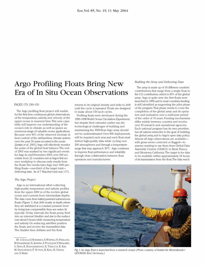
Argo is an international effort collectinghigh-quality temperature and salinity profilesfrom the upper 2000 m of the ice-free globalocean and currents from intermediate depths.The data come from battery-powered autonomousfloats (Figure 1) that drift mostly at depth,wherethey are stabilized at a constant pressure levelby being less compressible than sea water.Attypically 10-day intervals, the floats pump fluidinto an external bladder and rise to the surfaceover about 6 hours while measuring temperatureand salinity. On surfacing, satellites positionthe floats, and receive the transmitted data.The bladder then deflates and the float
returns to its original density and sinks to driftuntil the cycle is repeated. Floats are designedto make about 150 such cycles.
Profiling floats were developed during the1990–1998 World Ocean Circulation Experiment,but despite their extensive earlier use, thetechnological challenges of building andmaintaining the 3000-float Argo array shouldnot be underestimated.Over 800 deploymentswill be required each year,and each float mustdeliver high-quality data while cycling over200 atmospheres and through a temperaturerange that may approach 30°C. Argo continuesto improve float performance and reliabilitythrough close collaboration between float operators and manufacturers.
Building the Array and Delivering Data
The array is made up of 18 different countries’contributions that range from a single float, tothe U.S.contribution,which is 50% of the globalarray. Argo is quite new: the first floats werelaunched in 1999,and in most countries,fundingis still identified as supporting the pilot phaseof the program.That phase needs to cover thecompletion of the global array and its opera-tion and evaluation over a multi-year periodof the order of 10 years. Funding mechanismsdiffer widely between counties and involveover 50 research and operational agencies.Each national program has its own priorities,but all nations subscribe to the goal of buildingthe global array,and to Argo’s open data policy.Almost all Argo observations are available—with gross errors corrected or flagged—toanyone wanting to use them from Global DataAssembly Centers (GDACS) in Brest, France,and Monterey, California.The target is for datato be available within approximately 24 hoursof its transmission from the float.The data reach
Eos,Vol. 85, No. 19, 11 May 2004
Argo Profiling Floats Bring NewEra of In Situ Ocean ObservationsPAGES 179, 190–191
Fig.1.An Argo float is launched from a research vessel.(Photo courtesy of Institut für Meereskunde/GEOMAR,Kiel,Germany.)
BY J.GOULD,D.ROEMMICH,S.WIJFFELS,H.FREELAND,M.IGNASZEWSKY,X.JIANPING,S.POULIQUEN,Y.DESAUBIES,U. SEND, K. RADHAKRISHNAN, K.TAKEUCHI, K. KIM,M. DANCHENKOV, P. SUTTON, B. KING, B. OWENS,AND S. RISER
Eos,Vol. 85, No. 19, 11 May 2004
operational centers via the Global Telecom-munications System (GTS).The array’s growthis monitored by the Argo Information Center.
Populating remote and previously data-sparseregions of the southern hemisphere posesparticular challenges.Most floats are launchedfrom research ships (including Antarctic supplyvessels) on an opportunistic basis.A smallernumber have been launched from merchantvessels on passage. However, many areas inthe southern hemisphere are rarely visited byany ship. For these regions, dedicated shipcharter or aircraft deployment must be used.
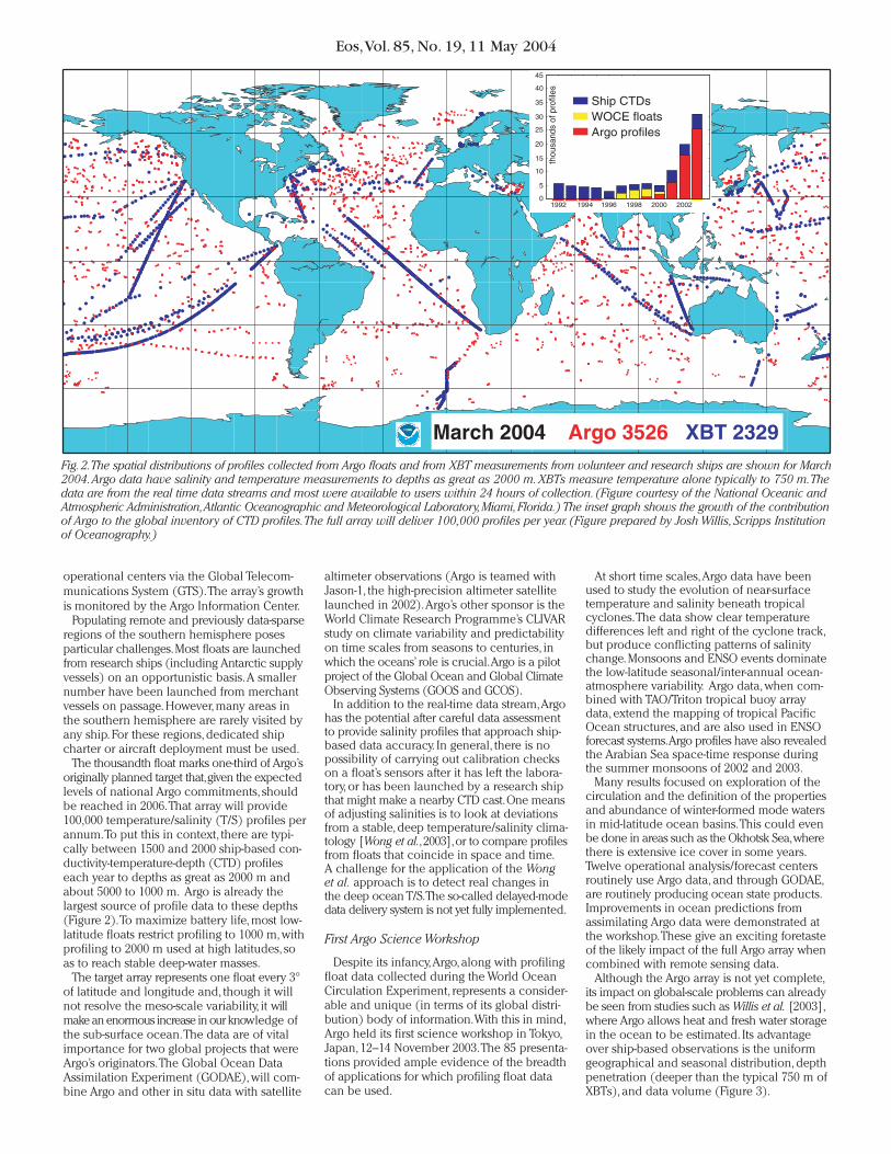
The thousandth float marks one-third of Argo’soriginally planned target that,given the expectedlevels of national Argo commitments, shouldbe reached in 2006.That array will provide100,000 temperature/salinity (T/S) profiles perannum.To put this in context, there are typi-cally between 1500 and 2000 ship-based con-ductivity-temperature-depth (CTD) profileseach year to depths as great as 2000 m andabout 5000 to 1000 m. Argo is already thelargest source of profile data to these depths(Figure 2).To maximize battery life, most low-latitude floats restrict profiling to 1000 m, withprofiling to 2000 m used at high latitudes, soas to reach stable deep-water masses.
The target array represents one float every 3°of latitude and longitude and, though it willnot resolve the meso-scale variability, it willmake an enormous increase in our knowledge ofthe sub-surface ocean.The data are of vitalimportance for two global projects that wereArgo’s originators.The Global Ocean DataAssimilation Experiment (GODAE), will com-bine Argo and other in situ data with satellite
altimeter observations (Argo is teamed withJason-1, the high-precision altimeter satellitelaunched in 2002).Argo’s other sponsor is theWorld Climate Research Programme’s CLIVARstudy on climate variability and predictabilityon time scales from seasons to centuries, inwhich the oceans’ role is crucial.Argo is a pilotproject of the Global Ocean and Global ClimateObserving Systems (GOOS and GCOS).
In addition to the real-time data stream,Argohas the potential after careful data assessmentto provide salinity profiles that approach ship-based data accuracy. In general, there is nopossibility of carrying out calibration checkson a float’s sensors after it has left the labora-tory, or has been launched by a research shipthat might make a nearby CTD cast.One meansof adjusting salinities is to look at deviationsfrom a stable, deep temperature/salinity clima-tology [Wong et al.,2003],or to compare profilesfrom floats that coincide in space and time.A challenge for the application of the Wonget al. approach is to detect real changes inthe deep ocean T/S.The so-called delayed-modedata delivery system is not yet fully implemented.
First Argo Science Workshop
Despite its infancy,Argo, along with profilingfloat data collected during the World OceanCirculation Experiment, represents a consider-able and unique (in terms of its global distri-bution) body of information.With this in mind,Argo held its first science workshop in Tokyo,Japan, 12–14 November 2003.The 85 presenta-tions provided ample evidence of the breadthof applications for which profiling float datacan be used.
At short time scales,Argo data have beenused to study the evolution of near-surfacetemperature and salinity beneath tropicalcyclones.The data show clear temperaturedifferences left and right of the cyclone track,but produce conflicting patterns of salinitychange.Monsoons and ENSO events dominatethe low-latitude seasonal/inter-annual ocean-atmosphere variability. Argo data, when com-bined with TAO/Triton tropical buoy arraydata, extend the mapping of tropical PacificOcean structures, and are also used in ENSOforecast systems.Argo profiles have also revealedthe Arabian Sea space-time response duringthe summer monsoons of 2002 and 2003.
Many results focused on exploration of thecirculation and the definition of the propertiesand abundance of winter-formed mode watersin mid-latitude ocean basins.This could evenbe done in areas such as the Okhotsk Sea,wherethere is extensive ice cover in some years.Twelve operational analysis/forecast centersroutinely use Argo data, and through GODAE,are routinely producing ocean state products.Improvements in ocean predictions fromassimilating Argo data were demonstrated atthe workshop.These give an exciting foretasteof the likely impact of the full Argo array whencombined with remote sensing data.
Although the Argo array is not yet complete,its impact on global-scale problems can alreadybe seen from studies such as Willis et al. [2003],where Argo allows heat and fresh water storagein the ocean to be estimated. Its advantageover ship-based observations is the uniformgeographical and seasonal distribution, depthpenetration (deeper than the typical 750 m ofXBTs), and data volume (Figure 3).
Fig.2.The spatial distributions of profiles collected from Argo floats and from XBT measurements from volunteer and research ships are shown for March2004.Argo data have salinity and temperature measurements to depths as great as 2000 m.XBTs measure temperature alone typically to 750 m.Thedata are from the real time data streams and most were available to users within 24 hours of collection. (Figure courtesy of the National Oceanic andAtmospheric Administration,Atlantic Oceanographic and Meteorological Laboratory,Miami,Florida.) The inset graph shows the growth of the contributionof Argo to the global inventory of CTD profiles.The full array will deliver 100,000 profiles per year. (Figure prepared by Josh Willis, Scripps Institutionof Oceanography.)
Eos,Vol. 85, No. 19, 11 May 2004
Argo data have been shown to be of highenough quality to document changes overalmost 20 years in sub-surface salinity acrossthe south Indian Ocean,an area where climatechange models predict that anthropogenicchange will be most easily detected [Banksand Wood, 2002].However,applications of thistype highlight the need for caution in adjustingfloat data to climatological values.
While much emphasis is placed on Argoprofile data, velocity estimates both at depthand from the floats’ time at the surface havebeen used for the global estimation of inertialoscillation statistics to reveal hitherto unsus-pected sub-surface circulation patterns.Whencombined with surface drifter data and T/Sprofiles, they can be used to derive velocityfield estimates on basin (and ultimately global)scales throughout much of the water column.
The workshop presentations and links tooperational applications can be found athttp://www.argo.ucsd.edu/.
Future Directions
Reaching one-third of the target array andholding the workshop were mere markers along
the path that Argo is pursuing. Float reliabilityhas improved,and there have been successfultrials using low-Earth orbit, two-way satellitecommunication with GPS positioning,allowingtransmission of more detailed profiles in lesstime at the surface.Two models of oxygensensors have been deployed, acoustic sensorsare being tested to estimate wind speed andrainfall,bio-optical sensors hold great promise[Bishop et al., 2002; Emerson et al., 2002], andfloats have collected data under sea ice.However,Argo will, for the foreseeable future, give prior-ity to its core of temperature, salinity, and cir-culation measurements.The data system isestablished, and delayed mode data (withdrift-adjusted salinities) will soon be availablefrom the GDACS later this year.Regional centerswill assemble data and produce products basedon Argo observations.A concerted effort in 2004is underway to deploy floats in the empty areasof the southern hemisphere. Above all, therewill be a rapid expansion of the use of Argodata by researchers,and by operational oceanand climate analysis and forecasting centers.
Argo poses challenges not previously facedby the oceanographic community. As mentionedearlier, each country has a different model for
running its national contribution. In all coun-tries, research scientists are playing a leadingrole, but there are varying degrees of involve-ment by operational agencies.The challengeis to sustain initial funding for 10 years, longenough to complete the array and demonstrateits value, but longer than the usual duration of research funding. Success in meeting thatchallenge will depend on demonstrating thevalue of the data in addressing a wide rangeof problems, and establishing in each countryan effective partnership between operationalagencies and researchers.
There is an increasing recognition,as shownby the Global Earth Observation (GEO) processand by the earlier Global Monitoring for Envi-ronment and Security (GMES) initiative in Europe,that sustained monitoring of our planet isessential if we wish to address a wide rangeof environmental and socioeconomic issues.Argo is positioned to be a central and essen-tial element of these observing strategies.
References
Banks, H., and R.Wood (2002),Where to look foranthropogenic climate change in the ocean,J.Clim., 15, 8, 879–881.
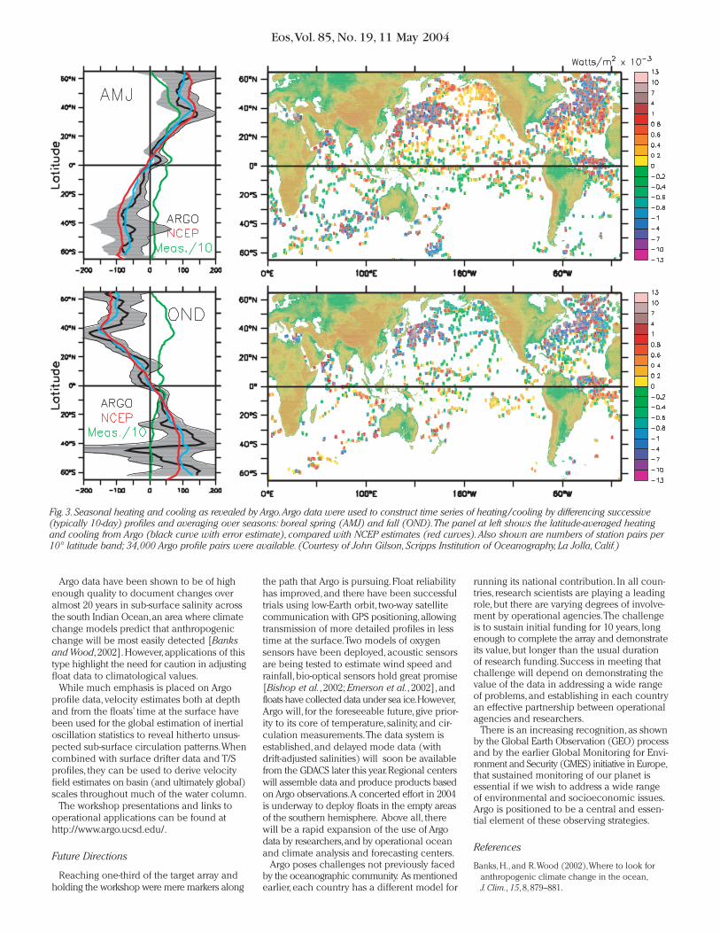
Fig.3.Seasonal heating and cooling as revealed by Argo.Argo data were used to construct time series of heating/cooling by differencing successive(typically 10-day) profiles and averaging over seasons: boreal spring (AMJ) and fall (OND).The panel at left shows the latitude-averaged heatingand cooling from Argo (black curve with error estimate), compared with NCEP estimates (red curves).Also shown are numbers of station pairs per10° latitude band; 34,000 Argo profile pairs were available. (Courtesy of John Gilson,Scripps Institution of Oceanography,La Jolla,Calif.)
Eos,Vol. 85, No. 19, 11 May 2004
Bishop, J. K. B., R. E. Davis, and J.T. Sherman (2002),Robotic observations of dust-storm enhancementof carbon biomass in the north Pacific, Science,298, 817–821.
Emerson,S.,C.Stump,B.Johnson,and D.M.Karl (2002),In-situ determination of oxygen and nitrogen dynamicsin the upper ocean, Deep-Sea Res. I, 49, 941–952.
Levitus, S., J. I.Antonov, J.Wang,T. L. Delworth, K.W.Dixon, and A. J. Broccoli (2001),Anthropogenicwarming of Earth’s climate system, Science,292,5515, 267–270.
Willis, J. K., D. Roemmich, and B. Cornuelle (2003),Combining altimetric height with broadscale profile data to estimate steric height, heat storage,subsurface temperature, and sea-surface tempera-ture variability, J.Geophys.Res., 108(C9), 3292,doi:10.1029/2002JC001755.
Wong,A. P. S., G. C. Johnson, and W. B. Owens (2003),Delayed-mode calibration of Autonomous CTDprofiling float salinity data by Theta-S climatology,J.Atmos.Ocean.Technol., 20(2), 308–318.
Author Information
John Gould,Dean Roemmich,Susan Wijffels,HowardFreeland,Mark Ignaszewsky,Xu Jianping,Sylvie Pouliquen,Yves Desaubies, Uwe Send, Kopillil Radhakrishnan,
Kensuke Takeuchi, Kuh Kim, Mikhail Danchenkov,Phil Sutton,Brian King,Breck Owens,and Steve Riser
For additional information, contact John Gould,Scripps Institution of Oceanography, La Jolla,Calif.; E-mail: [email protected]
©2004 American Geophysical Union. This article may be photocopied by individual scientistsfor research or classroom use. Permission is also granted to use short quotes, figures, and tablesfor publication in scientific books and journals.


![ARGO, Profiling Floats, and Iridium Stephen C. Riser Dana Swift School of Oceanography, University of Washington [acknowledgements to NOAA, ONR, NSF, NASA]](https://img.pdfslide.net/doc/110x75/56649e6b5503460f94b6a144/argo-profiling-floats-and-iridium-stephen-c-riser-dana-swift-school-of-oceanography.jpg)