Embed Size (px)
Citation preview
Arkansas Geology Outdoors: Exploring the Upper Buffalo River Region
Angela Chandler
Little Rock, ArkansasSeptember 2015
EWS-09
STATE OF ARKANSAS
ARKANSAS GEOLOGICAL SURVEYBEKKI WHITE DIRECTOR AND STATE GEOLOGIST
EDUCATIONAL WORKSHOP SERIES 09
___________________________________________________________________
________________________________________________________________________________

Arkansas Geology Outdoors: Exploring the Upper Bu�alo River Region
Angela Chandler
Little Rock, Arkansas September 2015
EWS-09
STATE OF ARKANSAS
ARKANSAS GEOLOGICAL SURVEYBEKKI WHITE DIRECTOR AND STATE GEOLOGIST
EDUCATIONAL WORKSHOP SERIES 09
___________________________________________________________________
________________________________________________________________________________

STATE OF ARKANSAS Asa Hutchinson, Governor
Arkansas Geological Survey Bekki White, State Geologist and Director
COMMISSIONERS
Dr. Richard Cohoon, Chairman………………………. Russellville
William Willis, Vice Chairman………………………… Hot Springs
Gus Ludwig…….…………………………………......... Quitman
Ken Fritsche……………………………………………. Greenwood
William Cains…………………………………………… Altus
Quin Baber……………………………………………… Benton
David Lumbert………………………………………….. Little Rock
Little Rock, Arkansas 2015
Table of Contents
Geologic Setting..…………………………………………………….. 1
Deposition of rock formations - Middle Ordovician to Late Ordo- vician (472-444 million years ago)…………………………............. 4
Description of rock formations – Salem Plateau……......... 6
Deposition of rock formations - Upper Mississippian-340-323 million years ago ………………………………….………………….. 6
Description of rock formations – Springfield Plateau…….. 7
Description of rock formations - Pennsylvanian (Morrowan) (323-307 million years ago)…………………………………………. 7
Description of rock formations – Boston Mts. Plateau…… 9
Formation of karst – present day…………………………………… 10
Fieldtrip Stops................................................................................ 14
Stop 1 – Lost Valley………………………….………………………. 15 1A – St. Joe Limestone along creek……………………….. 16 1B – Natural Bridge………………………………………….. 16 1C – Cobb Cave – Bluff Shelter……………………………. 20 1D – Eden Falls………………………………………………. 22 1E – Lost Valley Cave – Optional………………………….. 23
Stop 2 – Ponca Quarry………………………………………………. 24
Stop 3 – Steel Creek…………………………………………………. 28
Stop 4 – Whitaker Point Trail………………………………………… 30 4A – Sandstone Bluff………………………………………… 31 4B – Liesegang Banding…………………………………….. 32 4C – Whitaker Point…………………………………………… 33
References……………………………………………………………. 36
Appendix 1 – Relative Age Dating of Ponca Quarry……………..
Appendix 2 – Gravel Bar Learning Activity………………………… 43
Appendix 3 – Eons and Eons of Ozarks Long Ago………………… 53
Appendix 4 – Karst Rock Detective – Identifying Ozark Rocks…… 59
37

Acknowledgments
This laboratory manual is written for Arkansas teachers studying Earth Science. It is also written with the Arkansas Science Curriculum in mind so that students can meet the requirements and goals set for their age groups. Thanks to various staff members at the Arkansas Geological Survey for suggestions and edits to this booklet.
For information related to this manual please contact Angela Chandler: 501-683-0111
www.geology.arkansas.gov
Arkansas Geological Survey 3815 W Roosevelt Rd Little Rock, AR 72204 501-296-1877
Front cover images: Left – mini crag on top of Hawksbill Crag Middle – waterfalls along headwaters of Clark Creek, Lost Valley, Arkansas Right – calcite in the Everton Formation at Ponca Quarry
Arkansas Educators Outdoors: Exploring the Buffalo River
This is a two-day workshop that explores rock formations and karst features on the upper portion of the Buffalo National River. The first day of the workshop, we travel to Lost Valley to see how a stream has carved an interesting path into the underlying limestone. Next, we look at the relative age of rock layers, an unconformity, and fossils in Ponca Quarry. Finally, we will conduct a gravel bar experiment at Steel Creek on the Buffalo National River. On day two, we hike to Whitaker Point (aka Hawksbill Crag) to see a distinctive sandstone bluff in the Boston Mountains.
The following frameworks in Earth and Space Sciences and Environmental Science are addressed:
ESS.8.3.1 – Distinguish among Earth’s materials: rocks, minerals, fossils, soil
ESS.8.3.3 – Identify sedimentary rocks – differentiate between limestone, dolostone, chert, and sandstone
ESS.8.4.1 – Locate the Ozark Plateaus Region and identify each plateau – Salem, Springfield, and Boston Mountains.
ESS.8.8.7 – Use topographic maps to identify surface features of Earth
ESS.9.4.1 – Analyze changes to the Earth’s surface through erosion and weathering of karst terrain – identify landforms such caves, springs, sinkholes, and disappearing streams
ESS.9.5.1 – Explain and give examples of how physical evidence from fossils supports the theory that Earth has changed over time
ESS.9.5.2 – Analyze fossil record evidence about plants and animals that lived long ago
ESS.9.5.3 – Infer the nature of ancient environments based on fossil record evidence
ESS.9.8.2 – Analyze how rock sequences may be disturbed by the following: erosion and deposition –
ESS.9.8.4 – Apply geologic laws of superposition, original horizontality and continuity and the principle of unconformities to determine the relative age of rock in a cross-section
PD.1.ES.6. – Describe the processes of degradation by weathering and erosion
PD.1.ES.10 – Describe the characteristics of each of the natural divisions of Arkansas: Ozark Plateaus


Geologic Setting
This workshop is located in the upper portion of the Buffalo National River in the Ozark Plateaus Region of north-central Arkansas. The Ozark Plateaus Region is a broad, asymmetrical dome (or uplift) with its center (oldest Pre-Cambrian basement rocks) in the St. Francois Mountains of southeast Missouri (Fig. 1). The rock formations dip gently away from this area in all directions. The Ozarks of Arkansas form the southwestern flank of the dome.
Figure 1. Map depicting the plateaus surfaces of the Ozark Plateaus Region. Location of workshop is highlighted in yellow.
1
The Ozarks are divided into 3 plateaus (broad, flat-topped areas) that are separated from each other by steep slopes called escarpments.
1) Salem Plateau – capped by Ordovician age rocks, mostly dolostone
2) Springfield Plateau – capped by Mississippian age rocks, mostly limestone
3) Boston Mountains Plateau – capped by Pennsylvanian age rocks, mostly sandstone
The plateaus become progressively higher in elevation and expose younger rocks from north to south in the Ozarks of Arkansas.
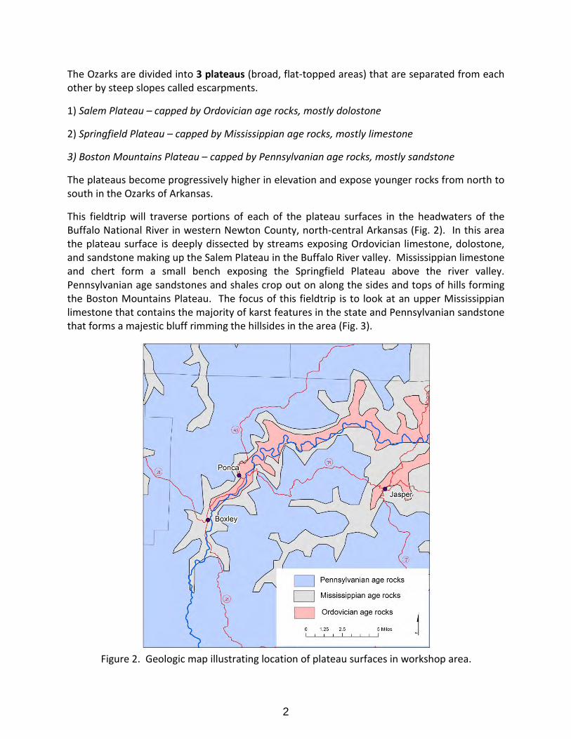
This fieldtrip will traverse portions of each of the plateau surfaces in the headwaters of the Buffalo National River in western Newton County, north-central Arkansas (Fig. 2). In this area the plateau surface is deeply dissected by streams exposing Ordovician limestone, dolostone, and sandstone making up the Salem Plateau in the Buffalo River valley. Mississippian limestone and chert form a small bench exposing the Springfield Plateau above the river valley. Pennsylvanian age sandstones and shales crop out on along the sides and tops of hills forming the Boston Mountains Plateau. The focus of this fieldtrip is to look at an upper Mississippian limestone that contains the majority of karst features in the state and Pennsylvanian sandstone that forms a majestic bluff rimming the hillsides in the area (Fig. 3).
Figure 2. Geologic map illustrating location of plateau surfaces in workshop area.
2
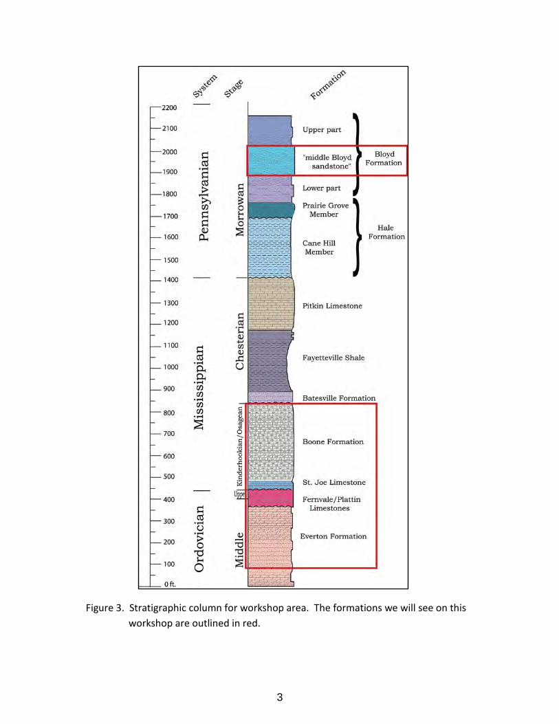
Figure 3. Stratigraphic column for workshop area. The formations we will see on this workshop are outlined in red.
3
Deposition of rock formations – Middle Ordovician to Late Ordovician – 472-444 million years ago
The Ordovician period is probably best known as a time of high sea level, although there were periods of relatively low sea level as can be seen by unconformable surfaces in the rock record. An unconformity is a rock surface that represents a gap in the geologic record. This is due either to no deposition during this time period or erosion after deposition.
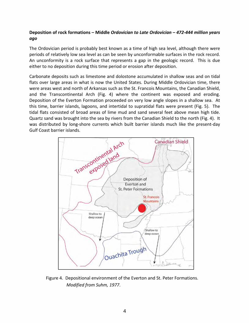
Carbonate deposits such as limestone and dolostone accumulated in shallow seas and on tidal flats over large areas in what is now the United States. During Middle Ordovician time, there were areas west and north of Arkansas such as the St. Francois Mountains, the Canadian Shield, and the Transcontinental Arch (Fig. 4) where the continent was exposed and eroding. Deposition of the Everton Formation proceeded on very low angle slopes in a shallow sea. At this time, barrier islands, lagoons, and intertidal to supratidal flats were present (Fig. 5). The tidal flats consisted of broad areas of lime mud and sand several feet above mean high tide. Quartz sand was brought into the sea by rivers from the Canadian Shield to the north (Fig. 4). It was distributed by long-shore currents which built barrier islands much like the present-day Gulf Coast barrier islands.
Figure 4. Depositional environment of the Everton and St. Peter Formations. Modified from Suhm, 1977.
4
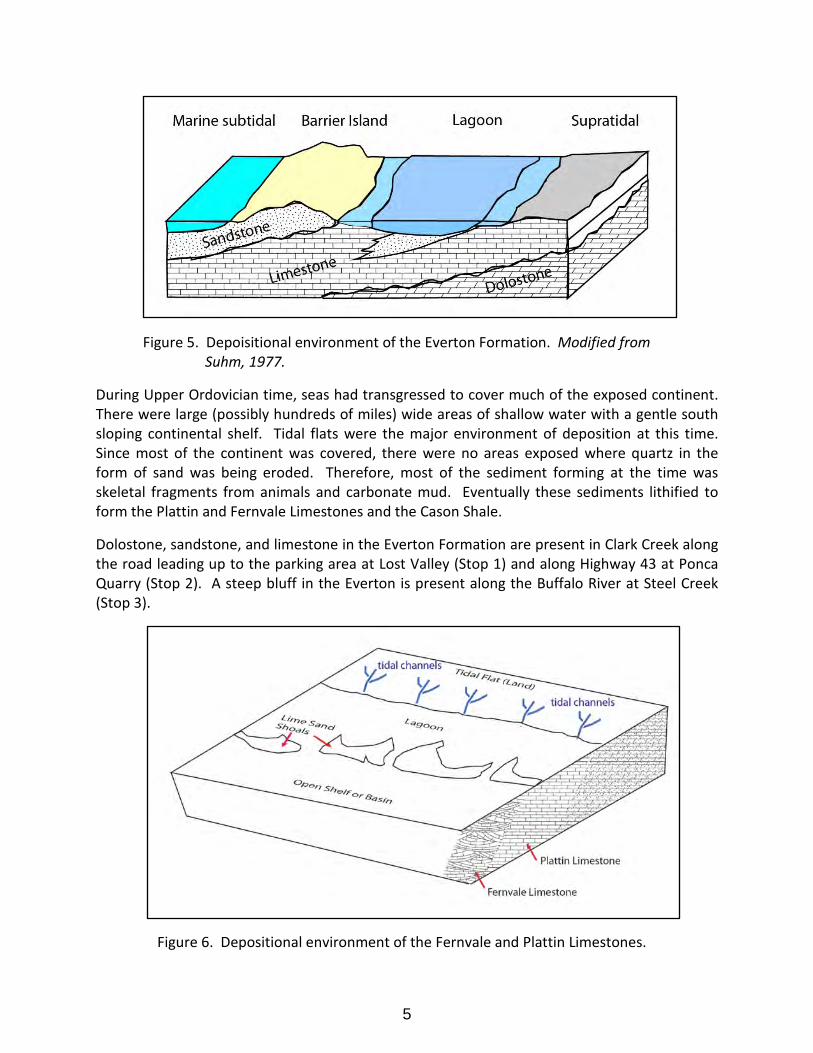
Figure 5. Depoisitional environment of the Everton Formation. Modified from Suhm, 1977.
During Upper Ordovician time, seas had transgressed to cover much of the exposed continent. There were large (possibly hundreds of miles) wide areas of shallow water with a gentle south sloping continental shelf. Tidal flats were the major environment of deposition at this time. Since most of the continent was covered, there were no areas exposed where quartz in the form of sand was being eroded. Therefore, most of the sediment forming at the time was skeletal fragments from animals and carbonate mud. Eventually these sediments lithified to form the Plattin and Fernvale Limestones and the Cason Shale.
Dolostone, sandstone, and limestone in the Everton Formation are present in Clark Creek along the road leading up to the parking area at Lost Valley (Stop 1) and along Highway 43 at Ponca Quarry (Stop 2). A steep bluff in the Everton is present along the Buffalo River at Steel Creek (Stop 3).
Figure 6. Depositional environment of the Fernvale and Plattin Limestones.
5
Description of rock formations – Salem Plateau
Cason Shale - A clay shale with abundant black phosphate pebbles. Dark gray on fresh surface but weathers buff to light brown.
Fernvale Limestone – This limestone was named for the town of Fernvale in western Tennessee. It is a medium to coarse grained crinoidal limestone that is white to light gray with a pink to reddish tint or mottles on fresh surface. It contains nautiloids and barrel-shaped crinoid fragments that are accentuated on a weathered surface. The Fernvale is present in Ponca Quarry along Highway 21 south of Ponca. Approximately 20 feet of limestone is present in this area.
Plattin Limestone – This limestone was named for exposures near Plattin Creek, Jefferson County, Missouri. It is a thin- to thick-bedded fine-grained limestone. Only a thin layer (3-5 inches) of cherty Plattin is present in Ponca quarry.
Everton Formation – The Everton Formation was named for exposures near the town of Everton in Boone County, Arkansas. This formation consists of interbedded sandy dolostone, sandstone, and limestone. Sandstone and dolostone in the Everton are present in the creek at the parking area for Lost Valley and in the lower portion of Ponca Quarry. We will see a thicker section (approximately 200 feet) of these units at Steel Creek on the Buffalo National River.
Deposition of rock formations: Upper Mississippian (340-323 million years ago)
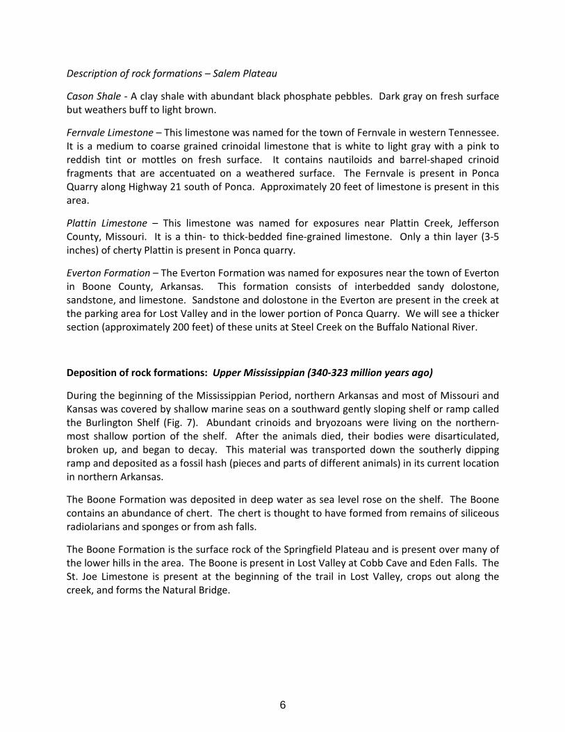
During the beginning of the Mississippian Period, northern Arkansas and most of Missouri and Kansas was covered by shallow marine seas on a southward gently sloping shelf or ramp called the Burlington Shelf (Fig. 7). Abundant crinoids and bryozoans were living on the northern-most shallow portion of the shelf. After the animals died, their bodies were disarticulated, broken up, and began to decay. This material was transported down the southerly dipping ramp and deposited as a fossil hash (pieces and parts of different animals) in its current location in northern Arkansas.
The Boone Formation was deposited in deep water as sea level rose on the shelf. The Boone contains an abundance of chert. The chert is thought to have formed from remains of siliceous radiolarians and sponges or from ash falls.
The Boone Formation is the surface rock of the Springfield Plateau and is present over many of the lower hills in the area. The Boone is present in Lost Valley at Cobb Cave and Eden Falls. The St. Joe Limestone is present at the beginning of the trail in Lost Valley, crops out along the creek, and forms the Natural Bridge.
6
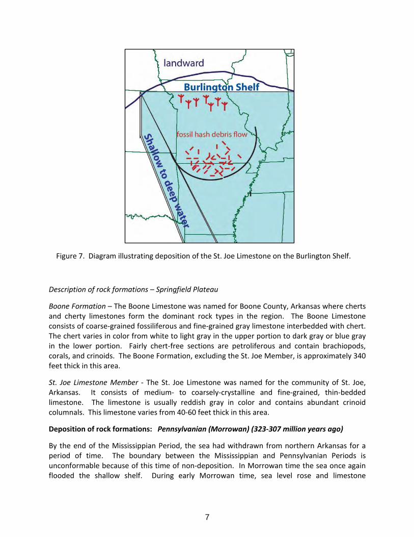
Figure 7. Diagram illustrating deposition of the St. Joe Limestone on the Burlington Shelf.
Description of rock formations – Springfield Plateau
Boone Formation – The Boone Limestone was named for Boone County, Arkansas where cherts and cherty limestones form the dominant rock types in the region. The Boone Limestone consists of coarse-grained fossiliferous and fine-grained gray limestone interbedded with chert. The chert varies in color from white to light gray in the upper portion to dark gray or blue gray in the lower portion. Fairly chert-free sections are petroliferous and contain brachiopods, corals, and crinoids. The Boone Formation, excluding the St. Joe Member, is approximately 340 feet thick in this area.
St. Joe Limestone Member - The St. Joe Limestone was named for the community of St. Joe, Arkansas. It consists of medium- to coarsely-crystalline and fine-grained, thin-bedded limestone. The limestone is usually reddish gray in color and contains abundant crinoid columnals. This limestone varies from 40-60 feet thick in this area.
Deposition of rock formations: Pennsylvanian (Morrowan) (323-307 million years ago)
By the end of the Mississippian Period, the sea had withdrawn from northern Arkansas for a period of time. The boundary between the Mississippian and Pennsylvanian Periods is unconformable because of this time of non-deposition. In Morrowan time the sea once again flooded the shallow shelf. During early Morrowan time, sea level rose and limestone
7
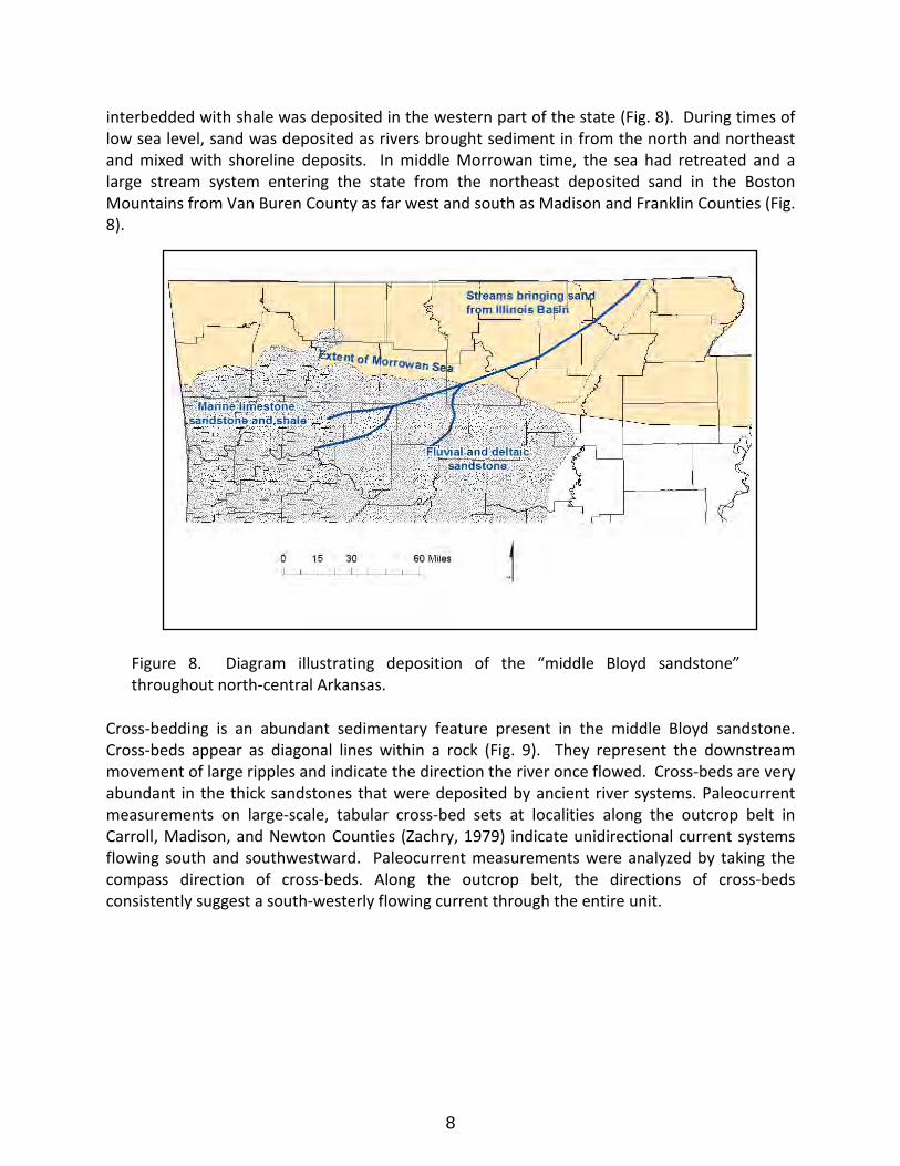
interbedded with shale was deposited in the western part of the state (Fig. 8). During times of low sea level, sand was deposited as rivers brought sediment in from the north and northeast and mixed with shoreline deposits. In middle Morrowan time, the sea had retreated and a large stream system entering the state from the northeast deposited sand in the Boston Mountains from Van Buren County as far west and south as Madison and Franklin Counties (Fig. 8).
Cross-bedding is an abundant sedimentary feature present in the middle Bloyd sandstone. Cross-beds appear as diagonal lines within a rock (Fig. 9). They represent the downstream movement of large ripples and indicate the direction the river once flowed. Cross-beds are very abundant in the thick sandstones that were deposited by ancient river systems. Paleocurrent measurements on large-scale, tabular cross-bed sets at localities along the outcrop belt in Carroll, Madison, and Newton Counties (Zachry, 1979) indicate unidirectional current systems flowing south and southwestward. Paleocurrent measurements were analyzed by taking the compass direction of cross-beds. Along the outcrop belt, the directions of cross-beds consistently suggest a south-westerly flowing current through the entire unit.
Figure 8. Diagram illustrating deposition of the “middle Bloyd sandstone” throughout north-central Arkansas.
8
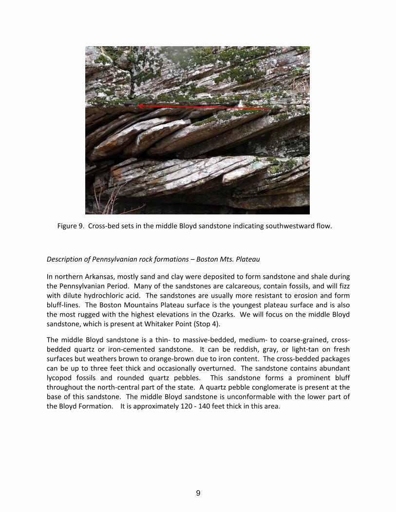
Figure 9. Cross-bed sets in the middle Bloyd sandstone indicating southwestward flow.
Description of Pennsylvanian rock formations – Boston Mts. Plateau
In northern Arkansas, mostly sand and clay were deposited to form sandstone and shale during the Pennsylvanian Period. Many of the sandstones are calcareous, contain fossils, and will fizz with dilute hydrochloric acid. The sandstones are usually more resistant to erosion and form bluff-lines. The Boston Mountains Plateau surface is the youngest plateau surface and is also the most rugged with the highest elevations in the Ozarks. We will focus on the middle Bloyd sandstone, which is present at Whitaker Point (Stop 4).
The middle Bloyd sandstone is a thin- to massive-bedded, medium- to coarse-grained, cross-bedded quartz or iron-cemented sandstone. It can be reddish, gray, or light-tan on fresh surfaces but weathers brown to orange-brown due to iron content. The cross-bedded packages can be up to three feet thick and occasionally overturned. The sandstone contains abundant lycopod fossils and rounded quartz pebbles. This sandstone forms a prominent bluff throughout the north-central part of the state. A quartz pebble conglomerate is present at the base of this sandstone. The middle Bloyd sandstone is unconformable with the lower part of the Bloyd Formation. It is approximately 120 - 140 feet thick in this area.
9
Formation of karst– present day
Karst Topography
Karst topography refers to natural features produced on a land surface due to the chemical weathering or slow dissolving of limestone, dolostone, marble, or evaporite deposits such as halite and gypsum. The chemical weathering agent is slightly acidic groundwater that begins as rainwater. Rainwater becomes acidic by absorbing carbon dioxide to create carbonic acid as it falls through the atmosphere. It then passes through the soil horizon and becomes even more acidic. As it moves down through fractures (cracks) and open spaces within the rock below, the carbonic acid in groundwater dissolves minerals such as calcite, a process called solution or dissolution. Calcite is the principal mineral in limestone and marble and is a major mineral in dolostone.
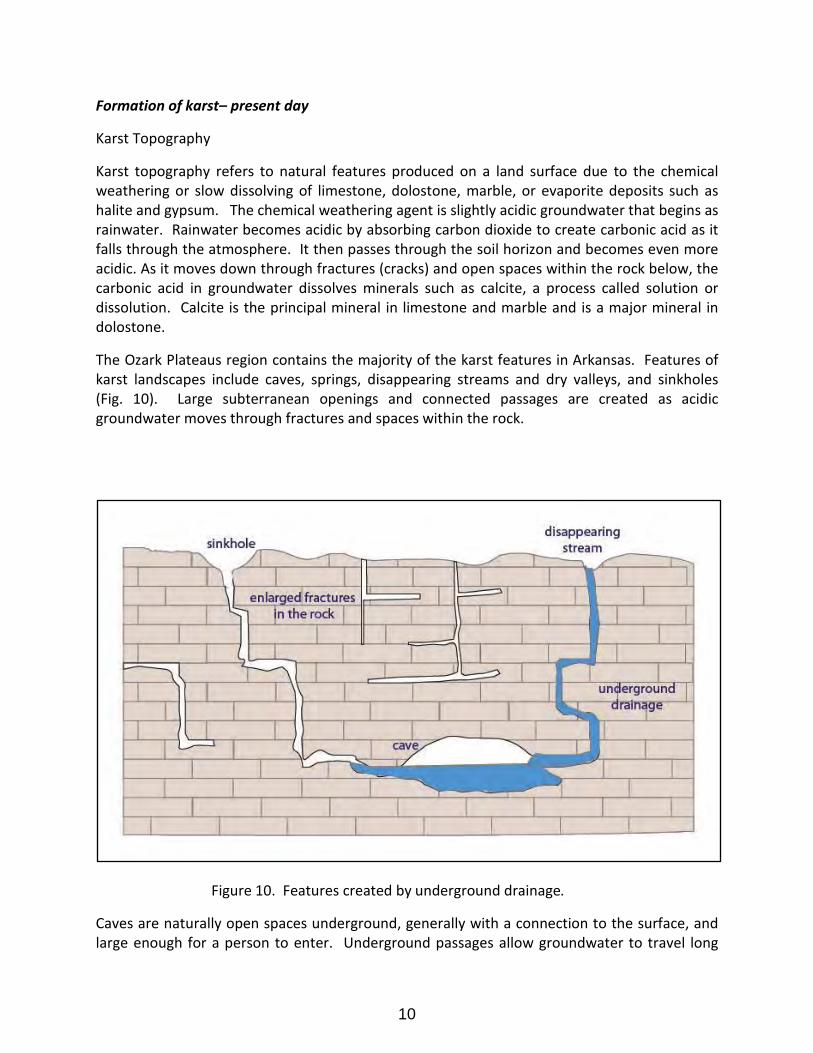
The Ozark Plateaus region contains the majority of the karst features in Arkansas. Features of karst landscapes include caves, springs, disappearing streams and dry valleys, and sinkholes (Fig. 10). Large subterranean openings and connected passages are created as acidic groundwater moves through fractures and spaces within the rock.
Figure 10. Features created by underground drainage.
Caves are naturally open spaces underground, generally with a connection to the surface, and large enough for a person to enter. Underground passages allow groundwater to travel long
10
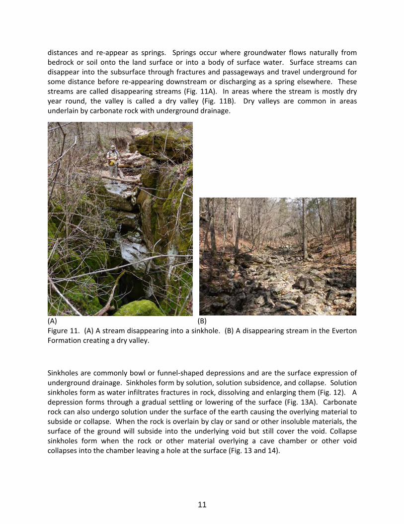
distances and re-appear as springs. Springs occur where groundwater flows naturally from bedrock or soil onto the land surface or into a body of surface water. Surface streams can disappear into the subsurface through fractures and passageways and travel underground for some distance before re-appearing downstream or discharging as a spring elsewhere. These streams are called disappearing streams (Fig. 11A). In areas where the stream is mostly dry year round, the valley is called a dry valley (Fig. 11B). Dry valleys are common in areas underlain by carbonate rock with underground drainage.
(A) (B) Figure 11. (A) A stream disappearing into a sinkhole. (B) A disappearing stream in the Everton Formation creating a dry valley.
Sinkholes are commonly bowl or funnel-shaped depressions and are the surface expression of underground drainage. Sinkholes form by solution, solution subsidence, and collapse. Solution sinkholes form as water infiltrates fractures in rock, dissolving and enlarging them (Fig. 12). A depression forms through a gradual settling or lowering of the surface (Fig. 13A). Carbonate rock can also undergo solution under the surface of the earth causing the overlying material to subside or collapse. When the rock is overlain by clay or sand or other insoluble materials, the surface of the ground will subside into the underlying void but still cover the void. Collapse sinkholes form when the rock or other material overlying a cave chamber or other void collapses into the chamber leaving a hole at the surface (Fig. 13 and 14).
11
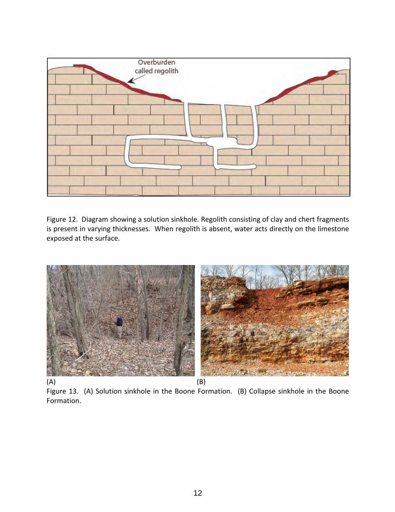
Figure 12. Diagram showing a solution sinkhole. Regolith consisting of clay and chert fragments is present in varying thicknesses. When regolith is absent, water acts directly on the limestone exposed at the surface.
(A) (B) Figure 13. (A) Solution sinkhole in the Boone Formation. (B) Collapse sinkhole in the Boone Formation.
12
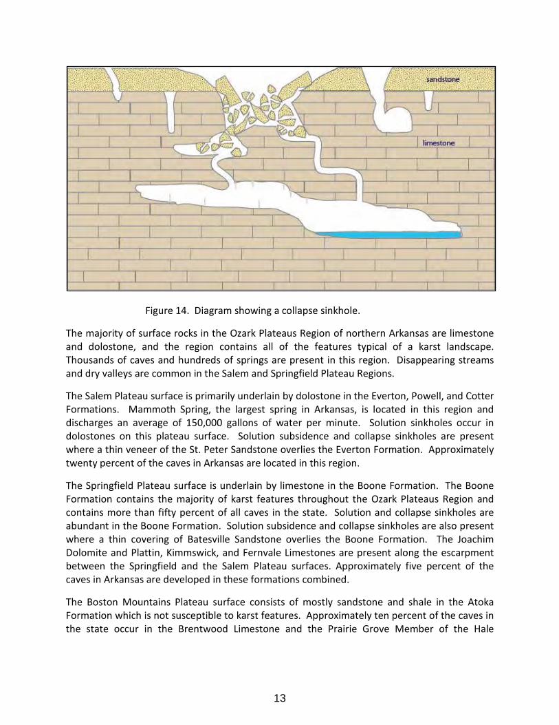
Figure 14. Diagram showing a collapse sinkhole.
The majority of surface rocks in the Ozark Plateaus Region of northern Arkansas are limestone and dolostone, and the region contains all of the features typical of a karst landscape. Thousands of caves and hundreds of springs are present in this region. Disappearing streams and dry valleys are common in the Salem and Springfield Plateau Regions.
The Salem Plateau surface is primarily underlain by dolostone in the Everton, Powell, and Cotter Formations. Mammoth Spring, the largest spring in Arkansas, is located in this region and discharges an average of 150,000 gallons of water per minute. Solution sinkholes occur in dolostones on this plateau surface. Solution subsidence and collapse sinkholes are present where a thin veneer of the St. Peter Sandstone overlies the Everton Formation. Approximately twenty percent of the caves in Arkansas are located in this region.
The Springfield Plateau surface is underlain by limestone in the Boone Formation. The Boone Formation contains the majority of karst features throughout the Ozark Plateaus Region and contains more than fifty percent of all caves in the state. Solution and collapse sinkholes are abundant in the Boone Formation. Solution subsidence and collapse sinkholes are also present where a thin covering of Batesville Sandstone overlies the Boone Formation. The Joachim Dolomite and Plattin, Kimmswick, and Fernvale Limestones are present along the escarpment between the Springfield and the Salem Plateau surfaces. Approximately five percent of the caves in Arkansas are developed in these formations combined.
The Boston Mountains Plateau surface consists of mostly sandstone and shale in the Atoka Formation which is not susceptible to karst features. Approximately ten percent of the caves in the state occur in the Brentwood Limestone and the Prairie Grove Member of the Hale
13
Formation in this region. In deep drainages and along the escarpment of the plateau, the Pitkin Limestone is present and contains hundreds of caves and springs.
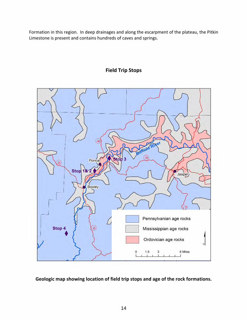
Field Trip Stops
Geologic map showing location of field trip stops and age of the rock formations.
14
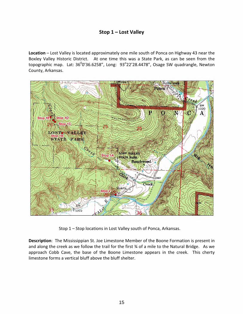
Stop 1 – Lost Valley
Location – Lost Valley is located approximately one mile south of Ponca on Highway 43 near the Boxley Valley Historic District. At one time this was a State Park, as can be seen from the topographic map. Lat: 3600’36.6258”, Long: 93o22’28.4478”, Osage SW quadrangle, Newton County, Arkansas.
Stop 1 – Stop locations in Lost Valley south of Ponca, Arkansas.
Description: The Mississippian St. Joe Limestone Member of the Boone Formation is present in and along the creek as we follow the trail for the first ¾ of a mile to the Natural Bridge. As we approach Cobb Cave, the base of the Boone Limestone appears in the creek. This cherty limestone forms a vertical bluff above the bluff shelter.
15
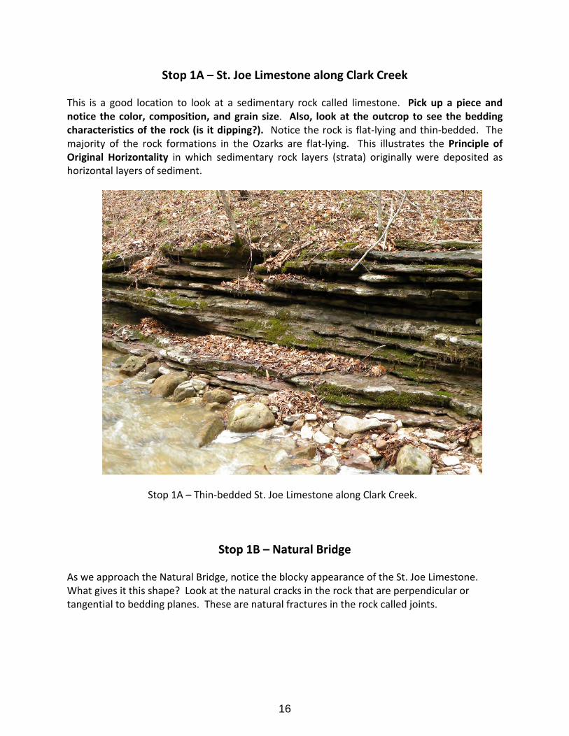
Stop 1A – St. Joe Limestone along Clark Creek
This is a good location to look at a sedimentary rock called limestone. Pick up a piece and notice the color, composition, and grain size. Also, look at the outcrop to see the bedding characteristics of the rock (is it dipping?). Notice the rock is flat-lying and thin-bedded. The majority of the rock formations in the Ozarks are flat-lying. This illustrates the Principle of Original Horizontality in which sedimentary rock layers (strata) originally were deposited as horizontal layers of sediment.
Stop 1A – Thin-bedded St. Joe Limestone along Clark Creek.
Stop 1B – Natural Bridge
As we approach the Natural Bridge, notice the blocky appearance of the St. Joe Limestone. What gives it this shape? Look at the natural cracks in the rock that are perpendicular or tangential to bedding planes. These are natural fractures in the rock called joints.
16
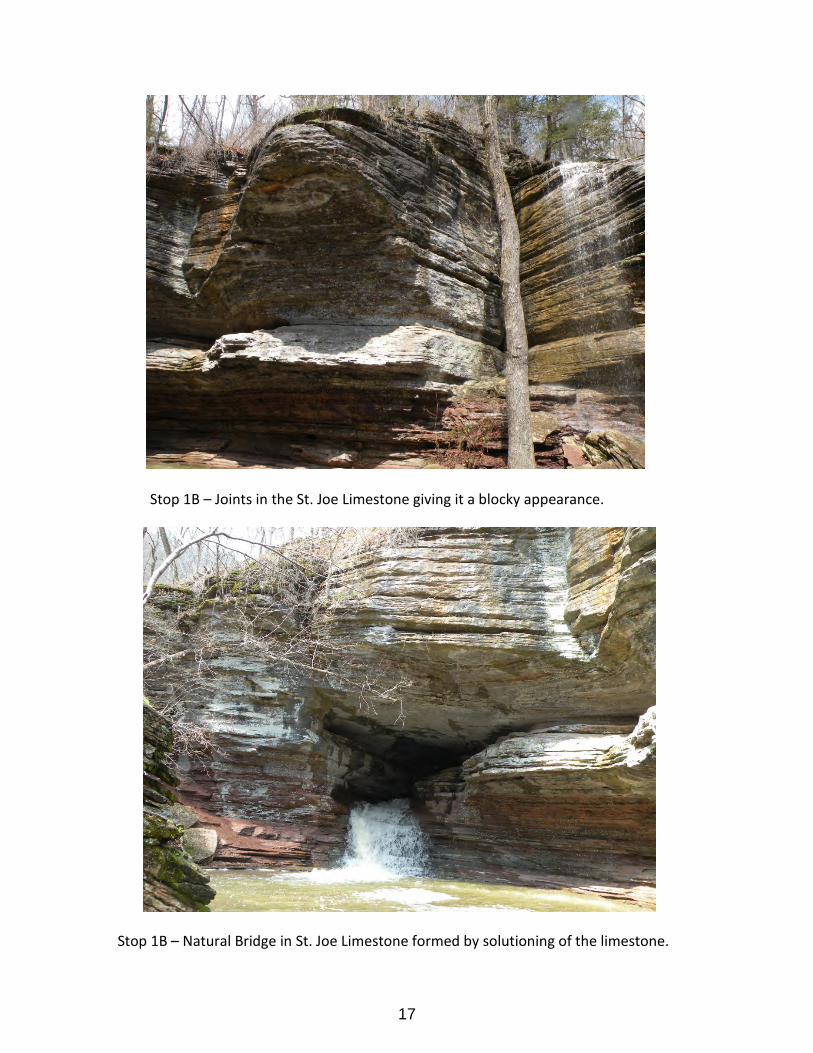
Stop 1B – Joints in the St. Joe Limestone giving it a blocky appearance.
Stop 1B – Natural Bridge in St. Joe Limestone formed by solutioning of the limestone.
17
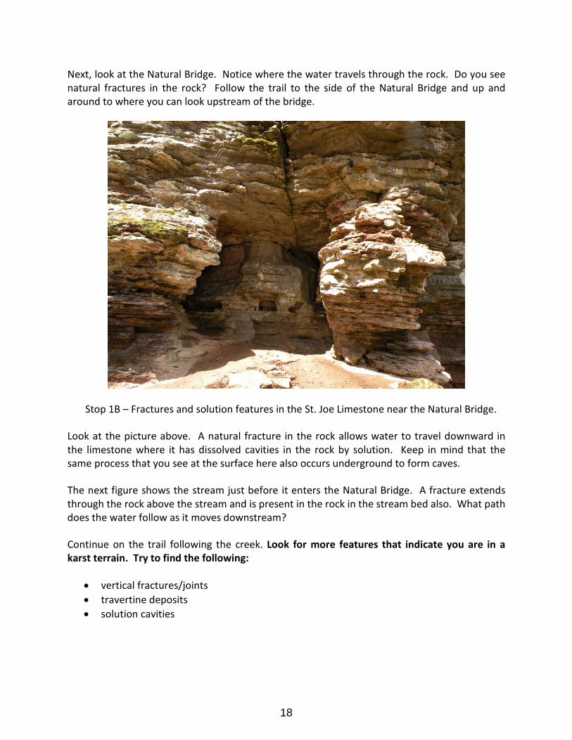
Next, look at the Natural Bridge. Notice where the water travels through the rock. Do you see natural fractures in the rock? Follow the trail to the side of the Natural Bridge and up and around to where you can look upstream of the bridge.
Stop 1B – Fractures and solution features in the St. Joe Limestone near the Natural Bridge.
Look at the picture above. A natural fracture in the rock allows water to travel downward in the limestone where it has dissolved cavities in the rock by solution. Keep in mind that the same process that you see at the surface here also occurs underground to form caves.
The next figure shows the stream just before it enters the Natural Bridge. A fracture extends through the rock above the stream and is present in the rock in the stream bed also. What path does the water follow as it moves downstream?
Continue on the trail following the creek. Look for more features that indicate you are in a karst terrain. Try to find the following:
• vertical fractures/joints • travertine deposits • solution cavities
18
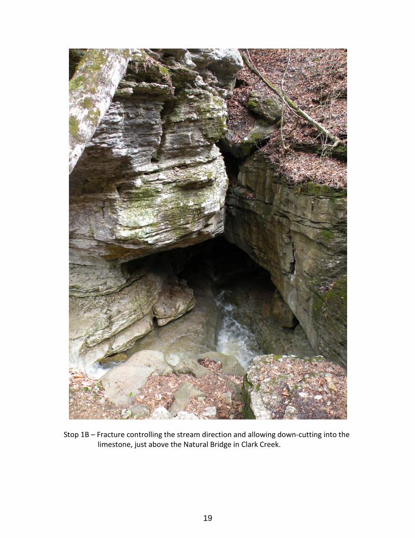
Stop 1B – Fracture controlling the stream direction and allowing down-cutting into the limestone, just above the Natural Bridge in Clark Creek.
19
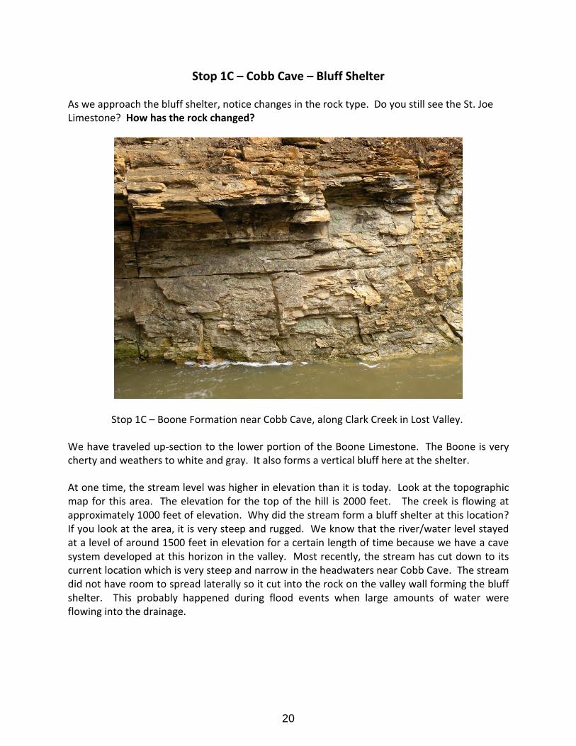
Stop 1C – Cobb Cave – Bluff Shelter
As we approach the bluff shelter, notice changes in the rock type. Do you still see the St. Joe Limestone? How has the rock changed?
Stop 1C – Boone Formation near Cobb Cave, along Clark Creek in Lost Valley.
We have traveled up-section to the lower portion of the Boone Limestone. The Boone is very cherty and weathers to white and gray. It also forms a vertical bluff here at the shelter.
At one time, the stream level was higher in elevation than it is today. Look at the topographic map for this area. The elevation for the top of the hill is 2000 feet. The creek is flowing at approximately 1000 feet of elevation. Why did the stream form a bluff shelter at this location? If you look at the area, it is very steep and rugged. We know that the river/water level stayed at a level of around 1500 feet in elevation for a certain length of time because we have a cave system developed at this horizon in the valley. Most recently, the stream has cut down to its current location which is very steep and narrow in the headwaters near Cobb Cave. The stream did not have room to spread laterally so it cut into the rock on the valley wall forming the bluff shelter. This probably happened during flood events when large amounts of water were flowing into the drainage.
20
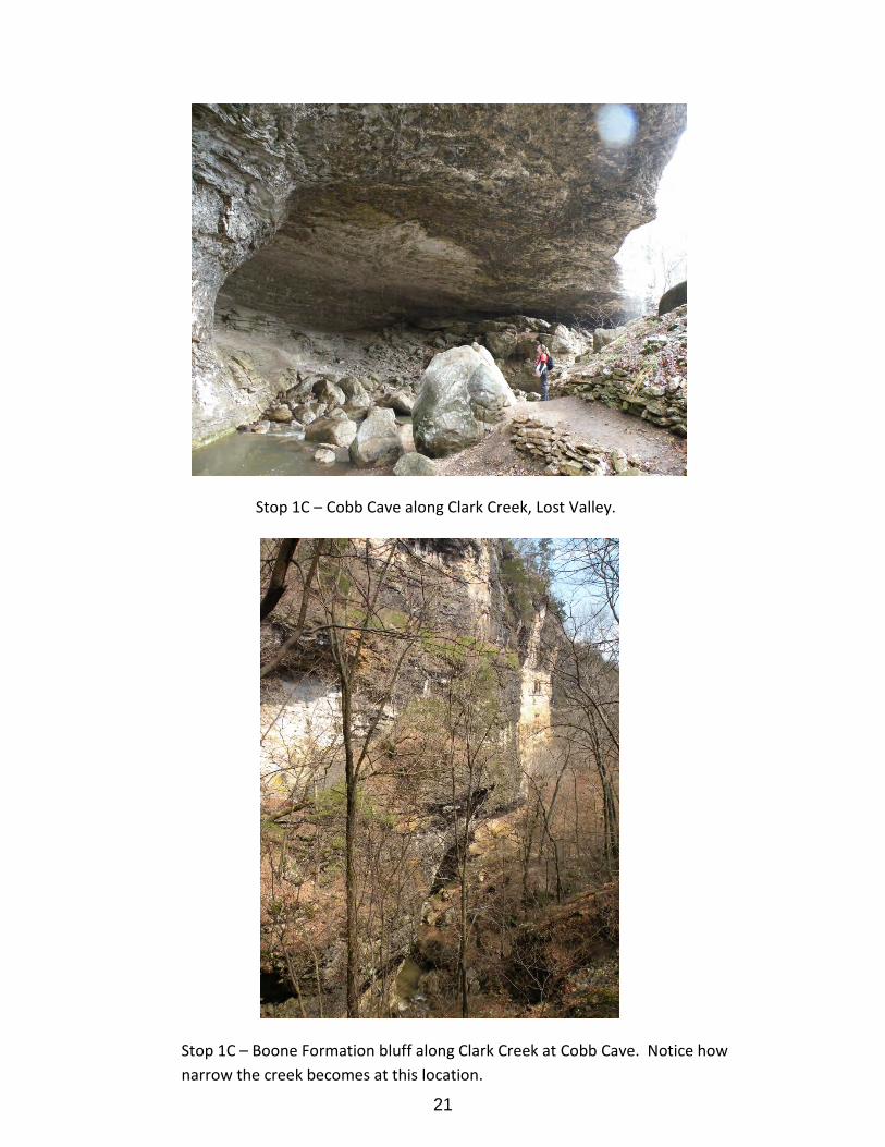
Stop 1C – Cobb Cave along Clark Creek, Lost Valley.
Stop 1C – Boone Formation bluff along Clark Creek at Cobb Cave. Notice how narrow the creek becomes at this location.
21
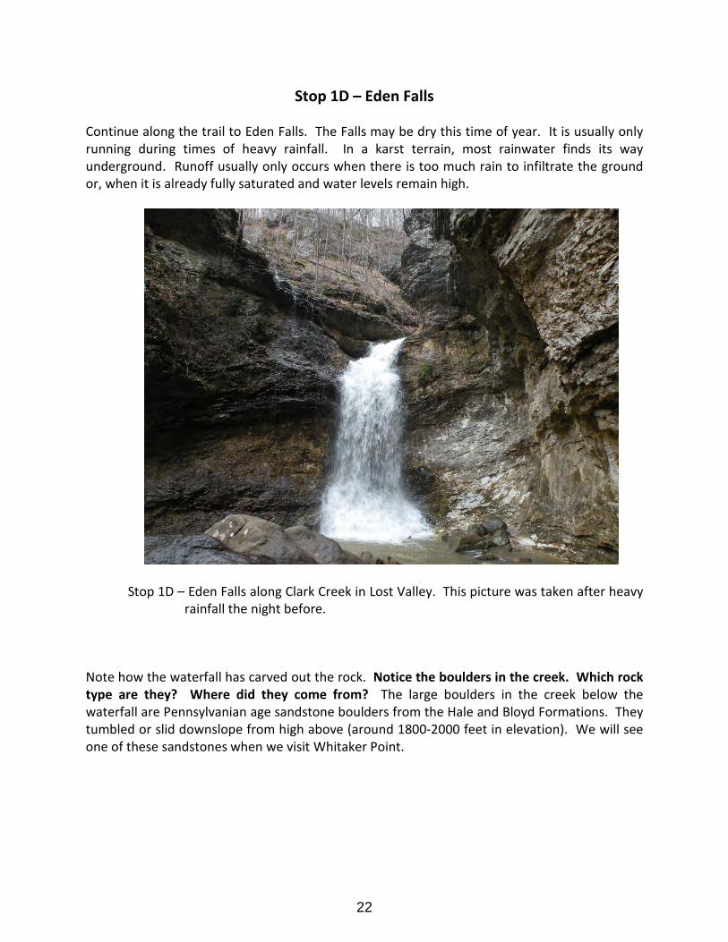
Stop 1D – Eden Falls
Continue along the trail to Eden Falls. The Falls may be dry this time of year. It is usually only running during times of heavy rainfall. In a karst terrain, most rainwater finds its way underground. Runoff usually only occurs when there is too much rain to infiltrate the ground or, when it is already fully saturated and water levels remain high.
Stop 1D – Eden Falls along Clark Creek in Lost Valley. This picture was taken after heavy rainfall the night before.
Note how the waterfall has carved out the rock. Notice the boulders in the creek. Which rock type are they? Where did they come from? The large boulders in the creek below the waterfall are Pennsylvanian age sandstone boulders from the Hale and Bloyd Formations. They tumbled or slid downslope from high above (around 1800-2000 feet in elevation). We will see one of these sandstones when we visit Whitaker Point.
22
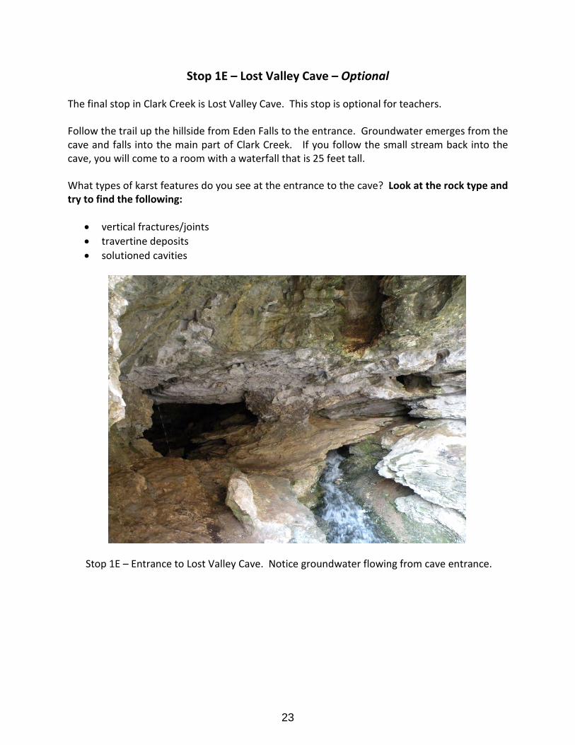
Stop 1E – Lost Valley Cave – Optional
The final stop in Clark Creek is Lost Valley Cave. This stop is optional for teachers.
Follow the trail up the hillside from Eden Falls to the entrance. Groundwater emerges from the cave and falls into the main part of Clark Creek. If you follow the small stream back into the cave, you will come to a room with a waterfall that is 25 feet tall.
What types of karst features do you see at the entrance to the cave? Look at the rock type and try to find the following:
• vertical fractures/joints • travertine deposits • solutioned cavities
Stop 1E – Entrance to Lost Valley Cave. Notice groundwater flowing from cave entrance.
23

Stop 2 – Ponca Quarry
Location – Ponca Quarry is located a little over one mile south of Ponca, just south of the entrance to Lost Valley, on Highway 43 near the Boxley Valley Historic District. Lat: 36o0’16.519”, Long: 93o22’ 25.448”, Osage SW quadrangle, Newton County, Arkansas. See Location map at Stop 1.
Description – Mississippian St. Joe Limestone sits unconformably upon Ordovician Cason Shale, Fernvale and Plattin Limestones, and the Everton Formation.
Stop 2 – Ponca Quarry on Highway 43, Boxley Valley.
The rock exposed along the roadside and in the bottom of the quarry is dolostone in the Everton Formation. Calcite-filled vugs are present here, so look for calcite along the road. Walk into the quarry to see fossiliferous gray limestone in the Fernvale Limestone. The limestone contains crinoid pieces that can be distinguished from other crinoids by their barrel shape. Look around to see large blocks of the red St. Joe Limestone. This limestone also contains white crinoid pieces, however they are not barrel-shaped.
24
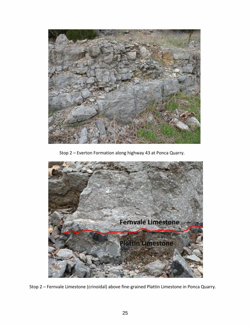
Stop 2 – Everton Formation along highway 43 at Ponca Quarry.
Stop 2 – Fernvale Limestone (crinoidal) above fine-grained Plattin Limestone in Ponca Quarry.
Fernvale Limestone
Plattin Limestone
25
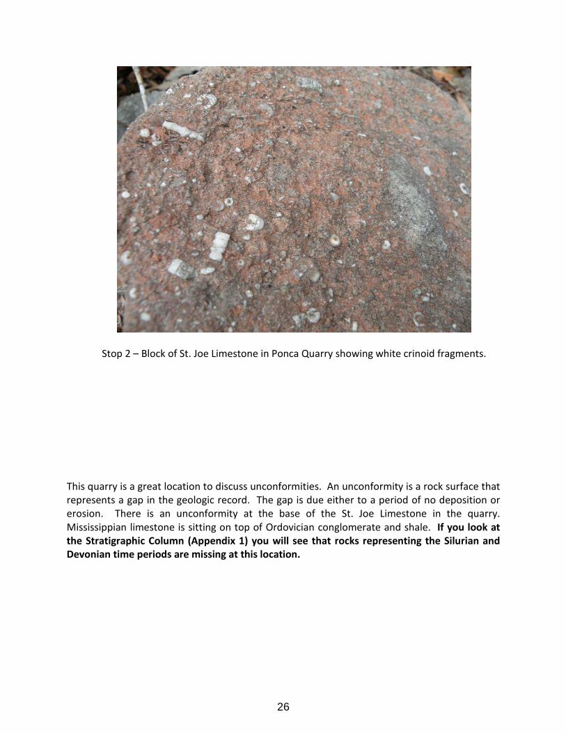
Stop 2 – Block of St. Joe Limestone in Ponca Quarry showing white crinoid fragments.
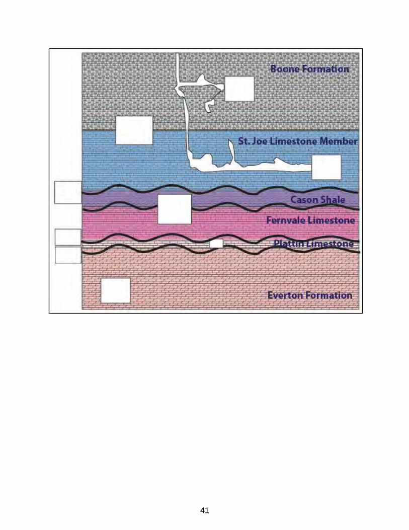
This quarry is a great location to discuss unconformities. An unconformity is a rock surface that represents a gap in the geologic record. The gap is due either to a period of no deposition or erosion. There is an unconformity at the base of the St. Joe Limestone in the quarry. Mississippian limestone is sitting on top of Ordovician conglomerate and shale. If you look at the Stratigraphic Column (Appendix 1) you will see that rocks representing the Silurian and Devonian time periods are missing at this location.
26

Stop 2 – Unconformity (red line) at the Mississippian St. Joe Limestone and the Ordovician Cason Shale contact.
Mississippian St. Joe Limestone
Ordovician Cason Shale
Ordovician Fernvale Limestone
27
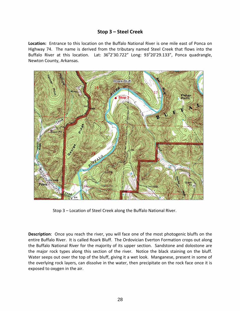
Stop 3 – Steel Creek
Location: Entrance to this location on the Buffalo National River is one mile east of Ponca on Highway 74. The name is derived from the tributary named Steel Creek that flows into the Buffalo River at this location. Lat: 36o2’30.722” Long: 93o20’29.133”, Ponca quadrangle, Newton County, Arkansas.
Stop 3 – Location of Steel Creek along the Buffalo National River.
Description: Once you reach the river, you will face one of the most photogenic bluffs on the entire Buffalo River. It is called Roark Bluff. The Ordovician Everton Formation crops out along the Buffalo National River for the majority of its upper section. Sandstone and dolostone are the major rock types along this section of the river. Notice the black staining on the bluff. Water seeps out over the top of the bluff, giving it a wet look. Manganese, present in some of the overlying rock layers, can dissolve in the water, then precipitate on the rock face once it is exposed to oxygen in the air.
28
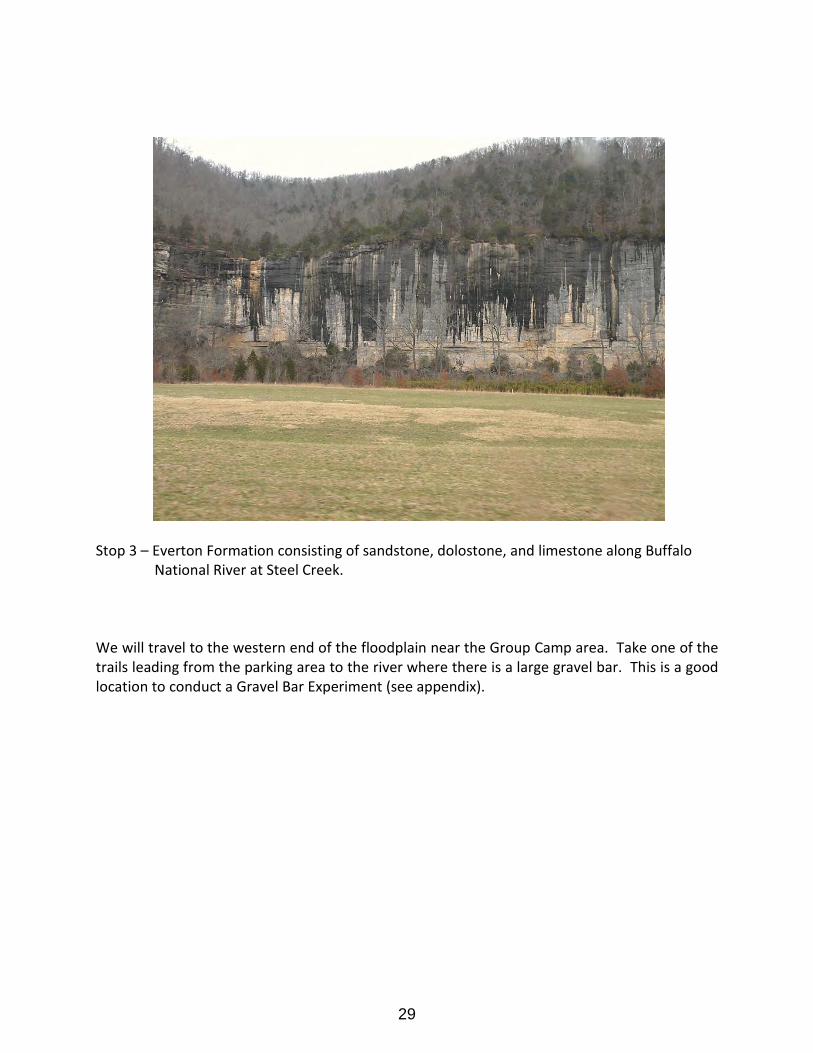
Stop 3 – Everton Formation consisting of sandstone, dolostone, and limestone along Buffalo National River at Steel Creek.
We will travel to the western end of the floodplain near the Group Camp area. Take one of the trails leading from the parking area to the river where there is a large gravel bar. This is a good location to conduct a Gravel Bar Experiment (see appendix).
29
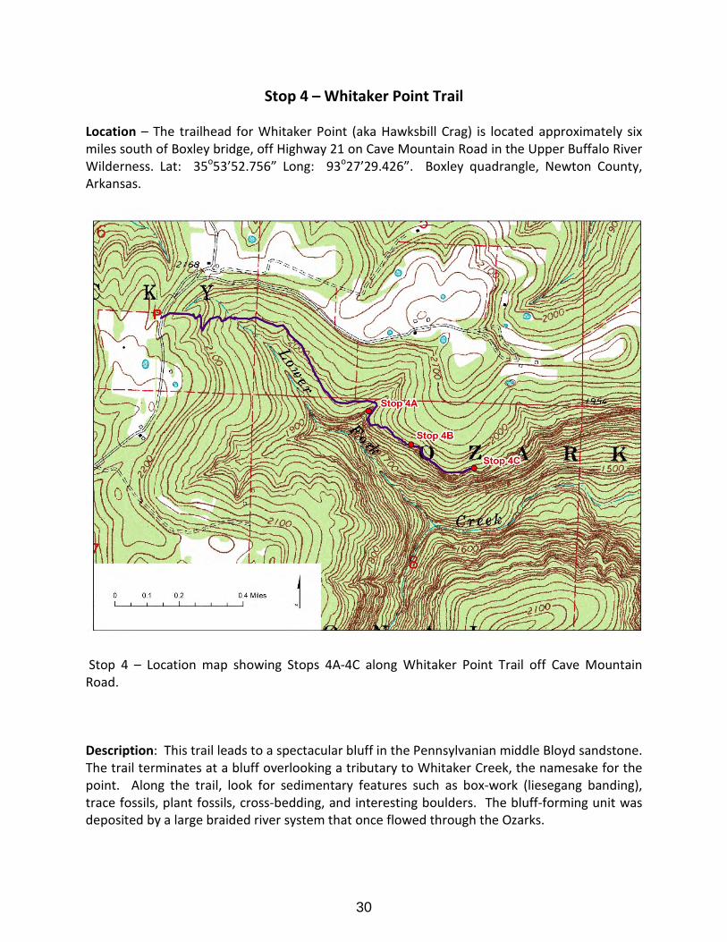
Stop 4 – Whitaker Point Trail
Location – The trailhead for Whitaker Point (aka Hawksbill Crag) is located approximately six miles south of Boxley bridge, off Highway 21 on Cave Mountain Road in the Upper Buffalo River Wilderness. Lat: 35o53’52.756” Long: 93o27’29.426”. Boxley quadrangle, Newton County, Arkansas.
Stop 4 – Location map showing Stops 4A-4C along Whitaker Point Trail off Cave Mountain Road.
Description: This trail leads to a spectacular bluff in the Pennsylvanian middle Bloyd sandstone. The trail terminates at a bluff overlooking a tributary to Whitaker Creek, the namesake for the point. Along the trail, look for sedimentary features such as box-work (liesegang banding), trace fossils, plant fossils, cross-bedding, and interesting boulders. The bluff-forming unit was deposited by a large braided river system that once flowed through the Ozarks.
30
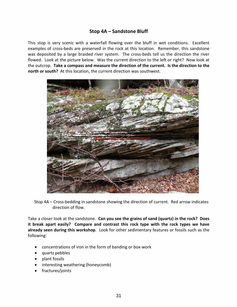
Stop 4A – Sandstone Bluff
This stop is very scenic with a waterfall flowing over the bluff in wet conditions. Excellent examples of cross-beds are preserved in the rock at this location. Remember, this sandstone was deposited by a large braided river system. The cross-beds tell us the direction the river flowed. Look at the picture below. Was the current direction to the left or right? Now look at the outcrop. Take a compass and measure the direction of the current. Is the direction to the north or south? At this location, the current direction was southwest.
Stop 4A – Cross-bedding in sandstone showing the direction of current. Red arrow indicates direction of flow.
Take a closer look at the sandstone. Can you see the grains of sand (quartz) in the rock? Does it break apart easily? Compare and contrast this rock type with the rock types we have already seen during this workshop. Look for other sedimentary features or fossils such as the following:
• concentrations of iron in the form of banding or box-work • quartz pebbles • plant fossils • interesting weathering (honeycomb) • fractures/joints
31
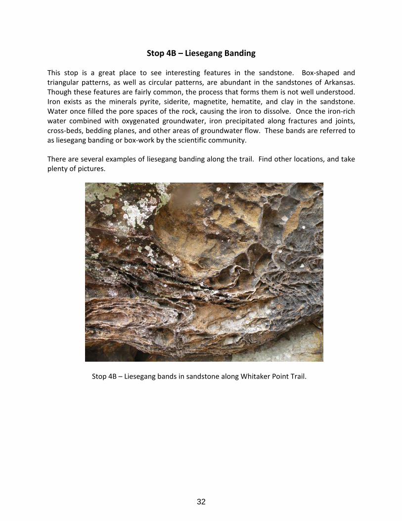
Stop 4B – Liesegang Banding
This stop is a great place to see interesting features in the sandstone. Box-shaped and triangular patterns, as well as circular patterns, are abundant in the sandstones of Arkansas. Though these features are fairly common, the process that forms them is not well understood. Iron exists as the minerals pyrite, siderite, magnetite, hematite, and clay in the sandstone. Water once filled the pore spaces of the rock, causing the iron to dissolve. Once the iron-rich water combined with oxygenated groundwater, iron precipitated along fractures and joints, cross-beds, bedding planes, and other areas of groundwater flow. These bands are referred to as liesegang banding or box-work by the scientific community.
There are several examples of liesegang banding along the trail. Find other locations, and take plenty of pictures.
Stop 4B – Liesegang bands in sandstone along Whitaker Point Trail.
32
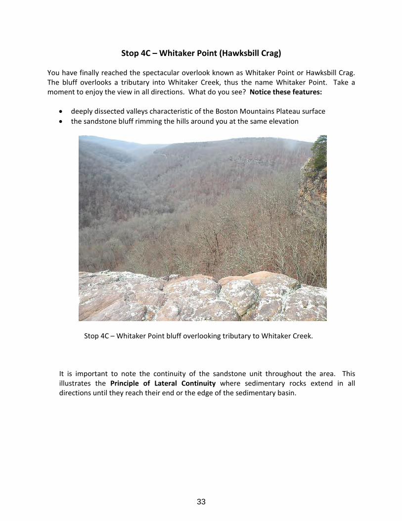
Stop 4C – Whitaker Point (Hawksbill Crag)
You have finally reached the spectacular overlook known as Whitaker Point or Hawksbill Crag. The bluff overlooks a tributary into Whitaker Creek, thus the name Whitaker Point. Take a moment to enjoy the view in all directions. What do you see? Notice these features:
• deeply dissected valleys characteristic of the Boston Mountains Plateau surface• the sandstone bluff rimming the hills around you at the same elevation
Stop 4C – Whitaker Point bluff overlooking tributary to Whitaker Creek.
It is important to note the continuity of the sandstone unit throughout the area. This illustrates the Principle of Lateral Continuity where sedimentary rocks extend in all directions until they reach their end or the edge of the sedimentary basin.
33
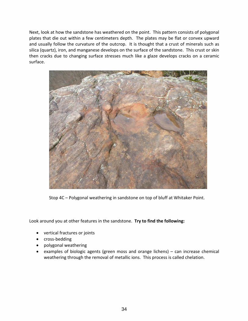
Next, look at how the sandstone has weathered on the point. This pattern consists of polygonal plates that die out within a few centimeters depth. The plates may be flat or convex upward and usually follow the curvature of the outcrop. It is thought that a crust of minerals such as silica (quartz), iron, and manganese develops on the surface of the sandstone. This crust or skin then cracks due to changing surface stresses much like a glaze develops cracks on a ceramic surface.
Stop 4C – Polygonal weathering in sandstone on top of bluff at Whitaker Point.
Look around you at other features in the sandstone. Try to find the following:
• vertical fractures or joints • cross-bedding • polygonal weathering • examples of biologic agents (green moss and orange lichens) – can increase chemical
weathering through the removal of metallic ions. This process is called chelation.
34
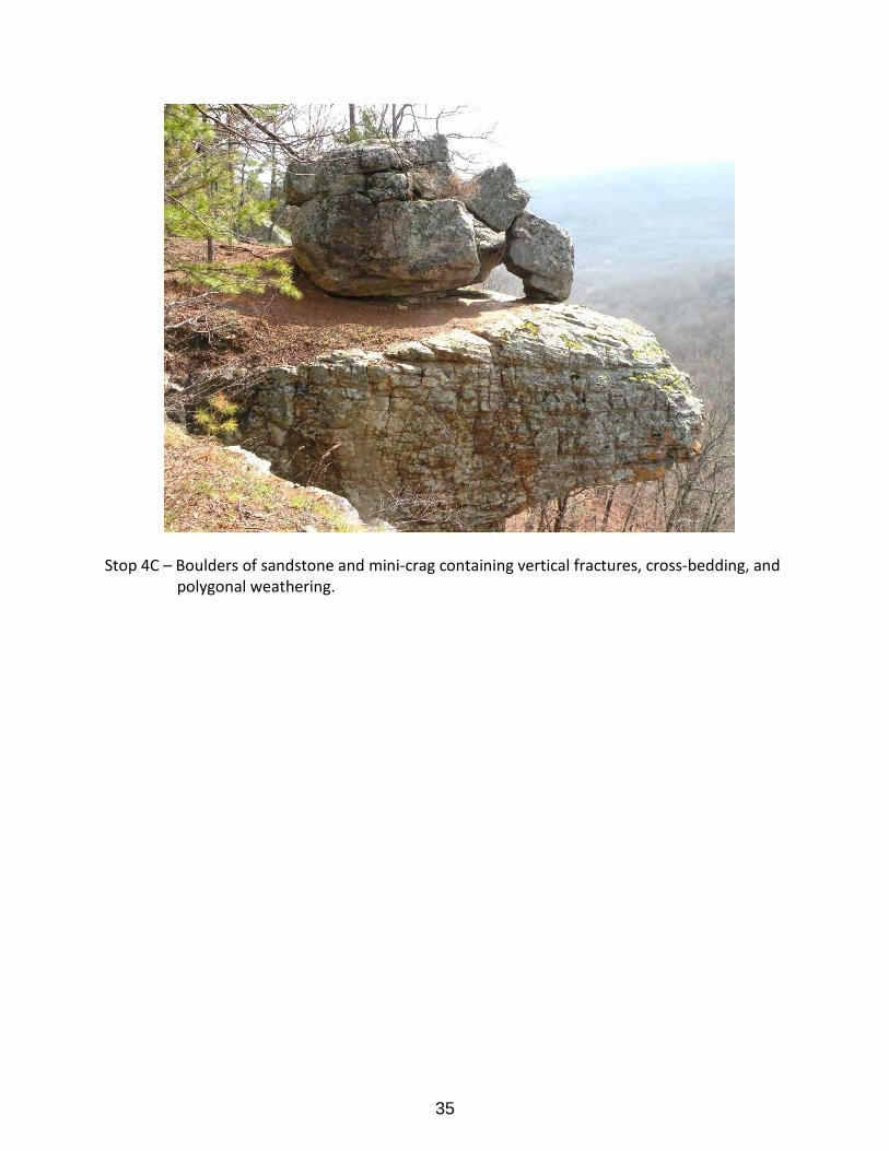
Stop 4C – Boulders of sandstone and mini-crag containing vertical fractures, cross-bedding, and polygonal weathering.
35

References:
Environmental Science Institute, circa 2005, What is karst?: University of Texas, Austin, Factsheet.
Palmer, A.N., 1991, Origin and morphology of limestone caves: Geological Society of America Bulletin, v. 103, p.1-21. Suhm, R.W., 1977, Simpson stratigraphy of the southern Midcontinent, in Johnson, K.S. (ed.) Simpson and Viola Groups in the southern Midcontinent, 1994 symposium: Oklahoma Geological Survey Circular 99, p. 3-38.
U.S. Geological Survey, 2007, Sinkholes: U.S. Geological Survey Factsheet 2007-3060.
Zachry, D.L., Jr., 1979, Early Pennsylvanian braided stream sedimentation, northwest Arkansas in Hyne, N.J. (ed.), Pennsylvanian sandstones in the mid-continent: Tulsa Geological Society, p. 269-282.
36

Appendix 1
Ponca Quarry Exercise
37

38

Exercise 1 Relative Age Dating of Ponca Quarry and Karst
Match the following geologic events listed below in order from oldest to youngest, to their correct order in the diagram on the next page. Place the number of each event in the box next to the formation or feature. Use the stratigraphic columns to identify which formations are missing due to the unconformities.
1. The Fernvale through the Cason Formations were deposited with an unconformity between them.
2. The Everton Formation was exposed to weathering. Neither the St. Peter nor Joachim Formations were deposited creating an unconformity.
3. The Plattin Limestone was deposited on the unconformable Everton Formation. 4. The St. Joe Limestone Member and the Boone Formation were deposited on an
unconformable surface. 5. The level of the water table was once higher in this area and caves formed in the Boone
Formation. Once the water level lowered, the caves were open to air circulation forming stalactites and stalagmites.
6. No Silurian or Devonian Formations were deposited creating an unconformity. 7. The Everton Formation was deposited in the Ozarks. 8. The water table was lowered even more, and caves in the St. Joe Limestone were open
to air circulation forming stalactites and stalagmites. 9. The Kimmswick Limestone was not deposited creating an unconformity.
39
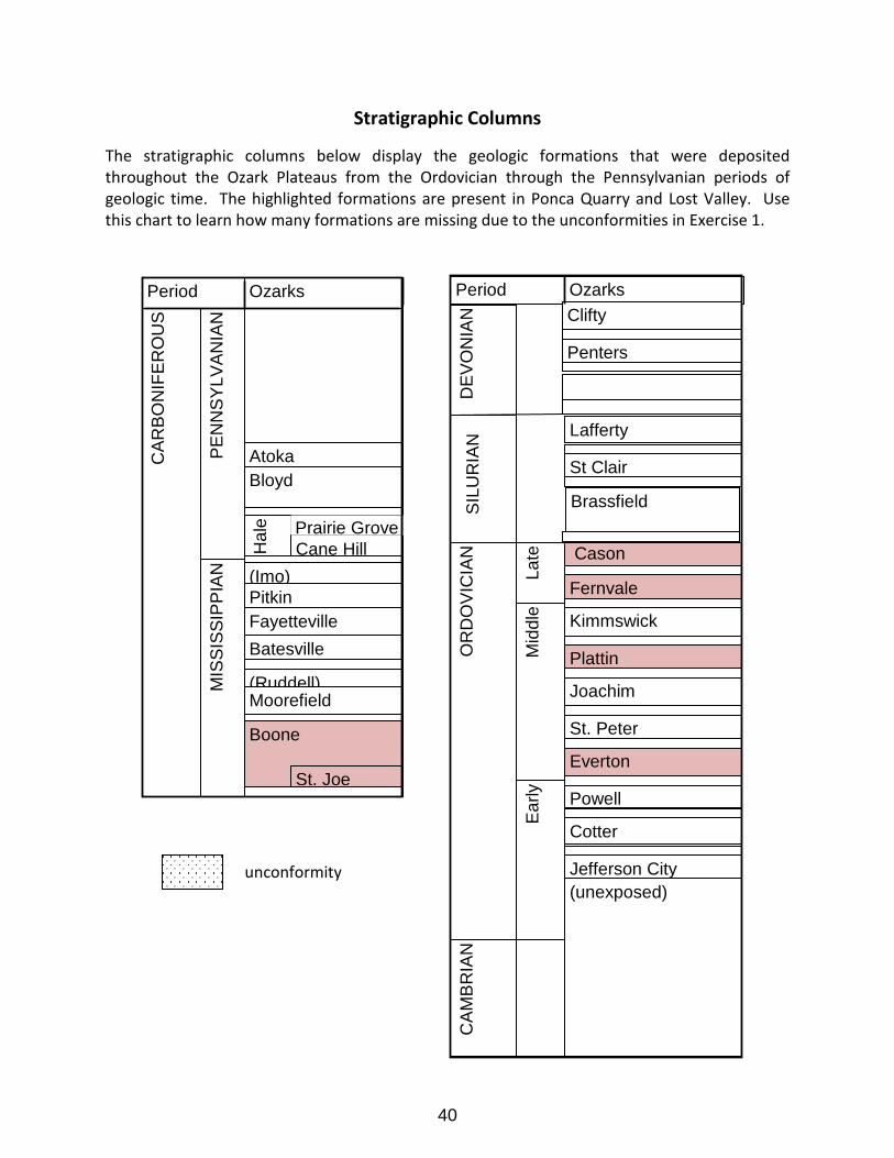
Stratigraphic Columns
The stratigraphic columns below display the geologic formations that were deposited throughout the Ozark Plateaus from the Ordovician through the Pennsylvanian periods of geologic time. The highlighted formations are present in Ponca Quarry and Lost Valley. Use this chart to learn how many formations are missing due to the unconformities in Exercise 1.
Late
CA
MB
RIA
N
OR
DO
VIC
IAN
Fernvale
Jefferson City
Cotter
Powell
Everton
St. Peter
Joachim
Plattin
Kimmswick
Ear
ly
Mid
dle
(unexposed)
Cason
Brassfield
St Clair
Lafferty
SIL
UR
IAN
D
EV
ON
IAN
Period Ozarks
Penters
Clifty
Atoka
Boone
Period Ozarks
PE
NN
SY
LVA
NIA
N
MIS
SIS
SIP
PIA
N
CA
RB
ON
IFE
RO
US
Bloyd
St. Joe
Moorefield
Batesville Fayetteville
Hal
e
Cane HillPrairie Grove
Pitkin (Imo)
(Ruddell)
unconformity
40
41

42

Appendix 2
Gravel Bar Learning Activity
43

44

Ozark Plateau Region
Gravel Bar Learning ActivityObjective:
Students will work together to characterize the geology of a gravel bar by
conducting their own scientific experiment.
Time: Allow close to one hour, depending on class size and age. This includes the
time to discuss findings.
Gravel Bar Lesson
The gravel found in a stream bed is derived from the bedrock in the
stream’s drainage basin upstream. Once detached from bedrock’s
outcrop, erosion, both mechanical and chemical, will reduce the rock
fragments to gravel and smaller
particles with time and distance
of transport. Rocks that are
mechanically weak or chemically
unstable will be quickly
reduced, whereas, more
durable rocks will be more
resistant to weathering.
Gravel Bar Lesson Plan Directions: Divide your students into groups of 3 to 5 members. Have each team come up with a
team name relating to geology. This makes it more fun for students and gives them
team spirit! Assign each group member a job. Jobs include: Rock gathers, sorters,
counters, and a recorder to collect data and draw graph.
Methods Used: Data collection
Rock identification
Graphing data – Creating a bar graph
Calculating percentage of rock types
Analyzing rocks by shape and size
Critical analysis
Materials: One towel per team
One laminated copy of rock identification
sheet
A small bottle of acid per group (vinegar)
One data entry sheet
One bar graph template
Several permanent markers
One measuring tape per group *optional*
45
Ozark Plateau Region
Gravel Bar Learning Activity
Step 1. Have rock gathers from each team collect 100 gravel particles from the
gravel bar at random and place on towel.
Here are some suggestions for getting a random sample: One way is to mark off a grid (this does not need to be a large area, 10 feet by 10
feet); this can be quickly done with measuring tapes. Mark off corners using water
bottles or other objects at hand. Or, have gathers take 2 steps, close eyes, and
reach down to pick up a rock. Continue until enough samples are collected. Make
sure that gathers are instructed to collect the first piece they touch each time.
Step 2. Once 100 rocks are gathered and placed on the towel, finish sorting using
the rock identification sheet provided. All team members can participate in the
rock identification. *Hint* Remember to use properties such as hardness and
reaction to acid, when identifying rocks types. Sort alike rocks into individual piles.
Step 3. Once the rocks are properly sorted, team members will count the number
of rocks in each pile. The recorder writes this data down in the data entry sheet.
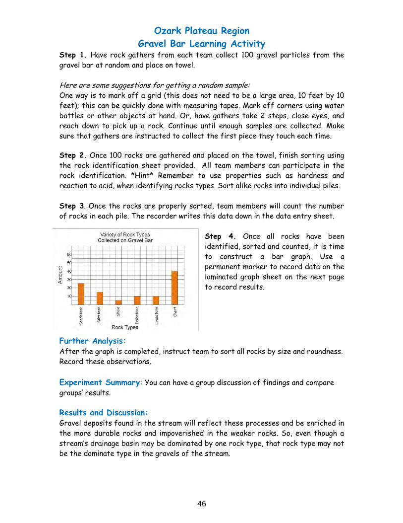
Step 4. Once all rocks have been
identified, sorted and counted, it is time
to construct a bar graph. Use a
permanent marker to record data on the
laminated graph sheet on the next page
to record results.
Further Analysis: After the graph is completed, instruct team to sort all rocks by size and roundness.
Record these observations.
Experiment Summary: You can have a group discussion of findings and compare
groups’ results.
Results and Discussion: Gravel deposits found in the stream will reflect these processes and be enriched in
the more durable rocks and impoverished in the weaker rocks. So, even though a
stream’s drainage basin may be dominated by one rock type, that rock type may not
be the dominate type in the gravels of the stream.
46

Ozark Plateau Region
Gravel Bar Learning Activity
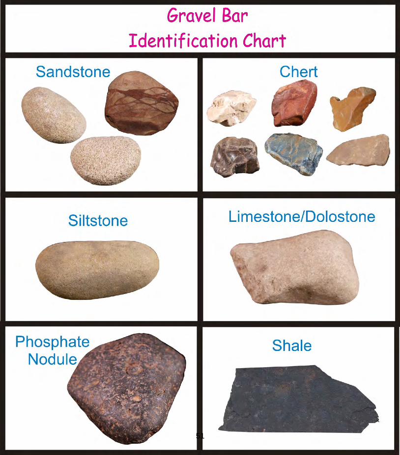
Rock Types:
Most of the rocks in Arkansas are one of 6 types: sandstone, siltstone,
shale, limestone, dolostone, and chert.
1. Sandstone- is nothing more than sand sized particles, mostly grains of
quartz, cemented together. Sandstone is generally durable and
frequently occurs as one of the more common rock types found in the
gravel bars along a river bed.
2. Siltstone- is the halfway rock between sandstone and shale. It is
generally composed of quartz and clay minerals. It is normally not as
durable as sandstone, so not as common in gravel deposits.
3. Shale- is mud that has become stone. It is basically clay, often with
trace amounts of fine sand and silt. Shale is not very durable and
hardly found in gravel deposits unless recently introduced.
4. Limestone- Calcite (calcium carbonate) is the dominate mineral in
limestone. A limestone is frequently nothing more than a layer of
seashell fragments cemented together. Limestone normally erodes
more rapidly than many sandstones or cherts in a gravel environment;
therefore, you will generally not find as much limestone in the gravel
bars.
5. Dolostone- Dolomite (calcium magnesium carbonate) is the dominate
mineral in dolostone. Dolostone has durability in a gravel environment
close to limestone.
6. Chert- is an amorphous form of quartz with no obvious crystalline
texture. Chert is frequently the most common constituent of gravel
bars in Arkansas streams due to its durability. Chert is often
fossiliferous, displaying molds and impressions of various creatures.
47
Ozark Plateau Region
Gravel Bar Learning Activity
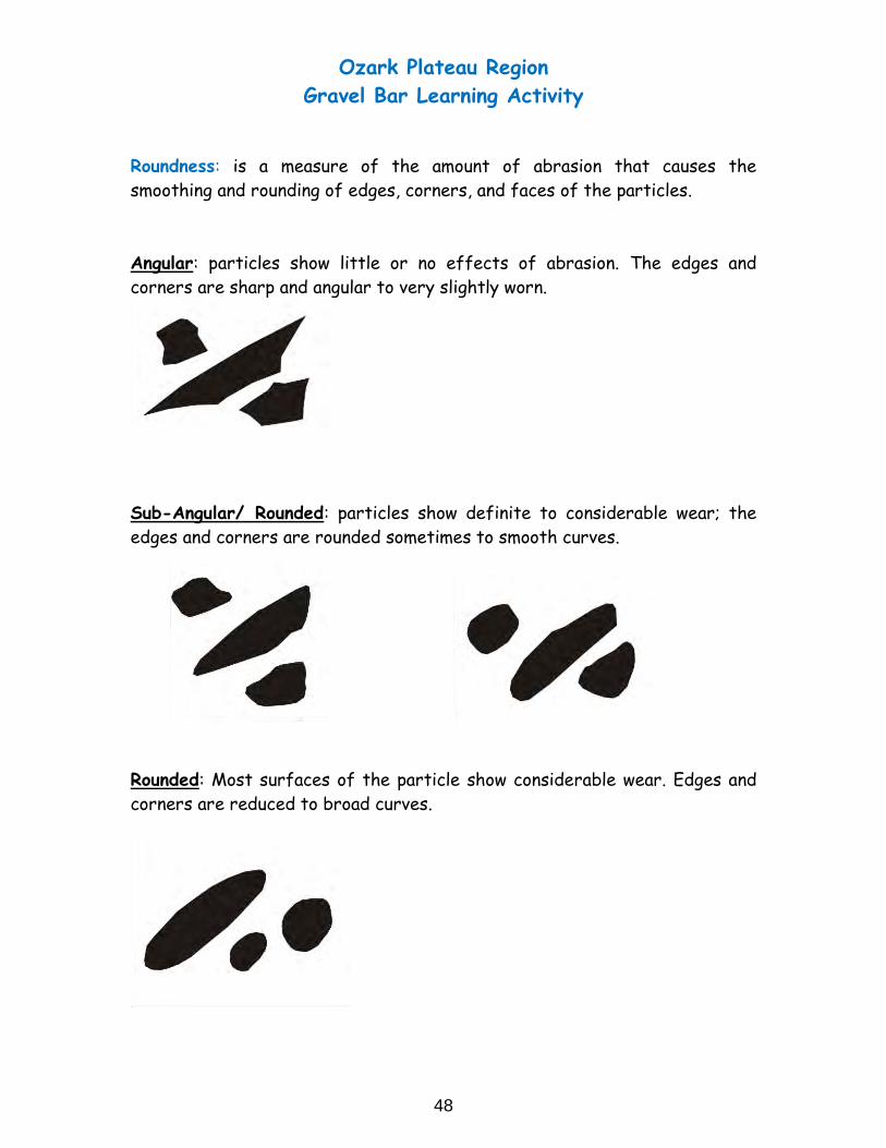
Roundness: is a measure of the amount of abrasion that causes the
smoothing and rounding of edges, corners, and faces of the particles.
Angular: particles show little or no effects of abrasion. The edges and
corners are sharp and angular to very slightly worn.
Sub-Angular/ Rounded: particles show definite to considerable wear; the
edges and corners are rounded sometimes to smooth curves.
Rounded: Most surfaces of the particle show considerable wear. Edges and
corners are reduced to broad curves.
48

Ozark Plateau Region
Gravel Bar Learning Activity
49

50
51

52

Appendix 3
Eons and Eons of Ozarks Long Ago
53

54
Appendix 3
“Eons and Eons of Ozarks Long Ago” Modified from exercises by Mary Ann Mutrux, Willow Springs Middle School, Missouri
Directions: The table below describes various events in Arkansas’ geologic past that have lead to today’s geologic conditions.
1) Your team will read the table that your teacher assigns.
2) Your team will then discuss the table and examine the sequence of events in the table.Afterwards your teacher will take the table away from you and provide you with the table in cut up sections. Then, your team will try to reconstruct the geological past by reconstructing the table as best as you can.
3) Once your team has completed the table reconstruction, ask the teacher for a key to checkyour work.
4) After checking your table reconstruction, discuss where any “mistakes” have occurred. In afew cases, the order may not affect the processes, and therefore may not be a “mistake”, but
remember that the order is the most relevant and important part of the exercise.
Your teacher may instruct you to read and reconstruct other tables as time allows.
55

Fossils Form in Warm Shallow Seas During most of north Arkansas’ geological past, the state was covered by warm shallow seas. [North America was located at a lower latitude and had not moved to its present temperate location.] These warm shallow seas were teeming with diverse marine organisms. Many of these marine organisms had shells made of the mineral calcite (consisting of the elements calcium, carbon, and oxygen). After the shelled organisms died, gravity pulled them down to the bottom of the sea. Many of them became dissolved into calcite particles. Some organisms remained all or partly intact. These layers of sediment formed in horizontal layers. Geologists call this the principle of original horizontality. Many shelled organisms fell into soft sediments and made an impression in the seafloor. Over time, the soft tissue of the organism decayed leaving the “hard parts” or shells to make a “mold” of the organism. Some of these molds became filled with dissolved minerals in the water and in time became “casts” of the organism. These hard parts were buried in the layers of sediment. Shelled organisms continued to die and fall to the sea floor. In time the sediment was cemented together by calcite and hardened into the sedimentary rock limestone containing marine fossils. Today, these rock layers can be seen in bluffs along Arkansas streams and along road cuts on highways. These are good places to hunt for fossils. Geologists infer that if these sedimentary rocks layers are not disturbed (folded or faulted); the oldest rocks are on the bottom, and the youngest are on top. This is called relative dating.
56
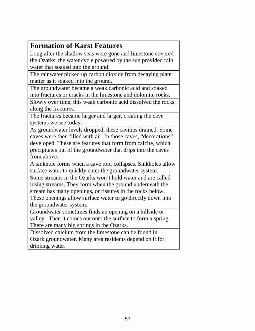
Formation of Karst Features Long after the shallow seas were gone and limestone covered the Ozarks, the water cycle powered by the sun provided rain water that soaked into the ground. The rainwater picked up carbon dioxide from decaying plant matter as it soaked into the ground. The groundwater became a weak carbonic acid and soaked into fractures or cracks in the limestone and dolomite rocks. Slowly over time, this weak carbonic acid dissolved the rocks along the fractures. The fractures became larger and larger, creating the cave systems we see today. As groundwater levels dropped, these cavities drained. Some caves were then filled with air. In those caves, “decorations” developed. These are features that form from calcite, which precipitates out of the groundwater that drips into the caves from above. A sinkhole forms when a cave roof collapses. Sinkholes allow surface water to quickly enter the groundwater system. Some streams in the Ozarks won’t hold water and are called losing streams. They form when the ground underneath the stream has many openings, or fissures in the rocks below. These openings allow surface water to go directly down into the groundwater system. Groundwater sometimes finds an opening on a hillside or valley. Then it comes out onto the surface to form a spring. There are many big springs in the Ozarks. Dissolved calcium from the limestone can be found in Ozark groundwater. Many area residents depend on it for drinking water.
57

58

Appendix 4
Karst Rock Detective – Identifying Ozark Rocks
59


“Karst Rock Detective: Identifying Ozark Rocks” Lesson Plan
Modified from Mary Ann Mutrux, Willow Springs Middle School, Missouri
Lesson Summary:
For this lesson, students will be asked to bring an Ozark rock from home or nearby. They will conduct common tests
to identify the rocks. A simple rock lab chart will be used to identify four common Ozark rocks: limestone, dolostone, chert, and sandstone. Students will most likely bring in chert. The limestone and dolostone are soluble in the presence of a weak acid and therefore, are more easily dissolved. The insoluble chert will not dissolve or become solutioned. Students will graph the lab results and most likely realize that the limestone and dolostone at the surface
have been solutioned and the water-resistant chert is not subject to solution.
This curriculum was written to accompany the educational video “Karst in the Ozarks.” Students should watch the video
before beginning the lesson. It is available online at http://www.watersheds.org .
Note: This lesson is recommended only for schools located in the Ozarks.
Arkansas Standards:
Science Contents Standards – Strand 5 Earth Systems:
ESS.8.5.7 - Identify characteristics of sedimentary rocks.
ESS.9.3.1 - Analyze the effect of water on earth's surface.
ESS.9.4.1 - Analyze changes to Earth's surface: Erosion and Weathering.
PD.1.ES.6 - Describe the processes of degradation by weathering and
erosion. PD.1.ES.10 - Describe the characteristics of of the plateau surfaces of the Arkansas Ozarks
Essential Vocabulary:
Sedimentary rock Chemical change
Sediments Limestone
Minerals DolostoneCalcite Sandstone
Acid Chert / Nodules
Weathering Silicate

Template for bar graphs]
Required Materials:
Lab:
- Assorted Ozark rocks collected by students (this lesson is limited to schools located in the Ozarks)
- Weak acid in drop bottle (5% hydrochloric acid – see high school chemistry teacher for solution) or
vinegar - Ozark Rock Chart copies (one per student)
- Hand lens (one per student)
- Goggles (one pair per student, if students are allowed to do the acid test)
- Iron Nails (one per student)
- Access to water / Paper Towels
- Thick Glass Plates (for mineral hardness test, see a geology supply catalog)
Visuals:
- Overhead transparency of the sedimentary rock formation or projected Internet image
- Rock Samples: Limestone / Dolostone / Sandstone / Chert
- Rock hammer:( Utilize to break rock open to observe fresh face of rock instead of weathered exterior). -
Copies of the MDNR Fact Sheet: Chert and / or Missouri Ozarks

Safety Considerations:
- Depending on student ages, general level of lab experience, and the availability of goggles, the teacher needs to
decide who will apply the weak acid drops on the rock samples (teacher or students).
- If possible (not necessary), break the rock open with a rock hammer to expose a fresh face. Observations and
tests are easier to conduct on an exposed interior of the rock. For middle school children, the teacher
should break the rocks and anyone in the area must be wearing goggles. This must be done outdoors so
tile or flooring is not damaged.
- Goggles should be worn when placing a drop of weak acid on the rock samples.
- Students should not touch the rocks where acid has been applied.
- All rocks that have had acid placed on them need to be washed immediately by the teacher.
- If students touch the acid, they need to wash their hands immediately.
- If glass plates are used for a hardness test, then they will need to be kept flat on the table surface when
performing the test.
- All rock samples should be rinsed with water thoroughly after the lab.
Time Requirements:
Preparation Time:
- Preparation time will vary according to the availability of the lab supplies.
- Students will have to be given direction and the opportunity to gather a rock from their home, park, or
nearby area in the Ozarks before conducting the activity.
Activity Time:
- Activity time will depend on the number of samples being tested. Instruct students to get a rock sample from
the sides of Ozark hills, rocky outcrops along roads (with adult supervision) or along creeks and streams.
Lesson Warm Up:
- Have students get out their rocks and examine them. Then have them look at each other’s and make general
comparisons. Ask them to determine if they think any of them are the same kind. Ask for students to support
their reasoning.
- Tell students that they are going to use several tests and a rock lab chart to determine what type of rock they
may have. Explain they will be testing both a physical property (hardness ) and chemical property (acid test).
- Explain that the limestone and dolostone (only when powdered) will bubble or effervesce in the weak acid. This ishow karst features such as caves and sinkholes form. Rainwater becomes a weak acid when

it picks up carbon dioxide from decaying vegetation on its way into the ground. The rainwater, like the acid, dissolves surrounding soluble material.
- Explain that they are like detectives and are using tests to find clues about the unknown rock. Explain that if their
rock cannot be identified with the key, then it may not be one of those rocks.
- Have students predict which of the four rock types will make up most of the samples collected by the class.
Karst Rock Detective Activity:
- Pass out the Ozark Rock Lab chart and step sheet. Go through the handout and explain how to conduct each
test (see safety considerations above). Note: the chart is required, but the step sheet is optional.
- Take a rock (one that you have previously identified as one on the flow chart) and demonstrate the process of
identifying the rock using the flow chart and tests. If possible, do this for each of the four rocks on the chart.
- Tell students that they will be doing the same thing. Have students work in small groups and verify each others observations. Assist each group.
- Emphasize that a chemical change is taking place when the acid test produces bubbles and that a physical change is
taking place if the rock is scratched.
- Students can read the handout about chert after they conduct the activity and are waiting for others to finish.
Lesson Wrap Up:
- Have students construct a bar graph for the number of Ozark rocks identified. Make a bar for the unknown
rocks that could not be identified by the chart. For bar graph construction see the performance event
template for immediate science at the DESE website (stated above).
- Explain that when the limestone bubbled on contact and the dolostone bubbled when in powder form, the rock
was dissolving. Rainwater that soaks through the ground acts like a weak acid and dissolves these two rocks.
As a result, cavities such as caves and sinkholes form. This is a chemical change taking place.
- Remind students that the rocks under their feet in the Ozarks are mainly layers of limestone and dolostone that
dissolve by rain water, creating karst features over millions of years. The chert and sandstone are other rocks
that formed along with them, but they are not soluble in water. (In the pilot for this lesson 76% of the rocks
students brought in were chert. Students realized that the insoluble chert will not be solutioned. The rocks
which are soluble in water have “disappeared” as they have dissolved in water.
Have the students group the rocks according to type and discuss other differences or similarities thatthey may observe.
-

Modifications:
The lesson difficulty could be decreased by making the following adaptations:
- Provide students with rock samples that were previously identified.
- Take students to a location to collect rocks (quarry, outcrop).
The lesson difficulty could be increased by making the following additions:
- Provide students with the chemical formula for the weak acid reaction.
- Have other rock and mineral identification guides available for students to use with rock specimens that are not
on the flow chart.
Assessments:
To assess the student's learning, have them complete one or both of the following activities.
- Construct a table of four common sedimentary rocks of the Ozarks. Include their name, grain or crystal composition,
and identification tests.
- Write a paragraph explaining how limestone and dolostone can be identified.

Kars
t Roc
k De
tect
ive:
Oza
rk R
ock
Lab
Dire
ctio
ns: I
dent
ify y
our O
zark
rock
usin
g th
e pr
ovid
ed su
pplie
s and
teac
her i
nstr
uctio
ns; t
hen
follo
w th
e ke
y be
low
to d
eter
min
e its
type
. N
ote
the
teac
her w
ill p
rovi
de a
ll ac
id d
rops
and
will
col
lect
and
was
h al
l roc
ks a
fter
aci
d us
e. T
his c
hart
is u
sefu
l onl
y to
iden
tify
limes
tone
, do
lom
ite, s
ands
tone
, and
che
rt. I
f the
rock
doe
s not
fit a
ny o
f the
des
crip
tions
bel
ow, i
t may
be
anot
her r
ock
type
.
Step
1: E
xam
ine
the
rock
to d
eter
min
e if
you
can
or c
anno
t see
the
grai
ns.
If yo
u ca
nnot
obs
erve
gra
ins g
o, to
Ste
p 2.
If y
ou c
an se
e gr
ains
go
to S
tep
3. If
nei
ther
or u
ncer
tain
, the
n go
to S
tep
4.
Step
2: (
If yo
u ca
nnot
find
gra
ins)
Exa
min
e th
e ro
ck c
aref
ully
. Se
e if
a na
il ca
n sc
ratc
h it.
If th
e ro
ck c
anno
t be
scra
tche
d by
a n
ail,
go to
Ste
p 5.
If
the
rock
can
be
scra
tche
d by
a n
ail,
go to
Ste
p 6.
Step
3: (
If yo
u fo
und
grai
ns) E
xam
ine
the
grai
ns c
aref
ully
. Usin
g a
nail,
try
to p
ick
off s
ome
of th
e gr
ains
. Exa
min
e th
e gr
ains
usin
g a
hand
lens
. Use
a
wat
er d
ropp
er to
drib
ble
wat
er o
nto
the
rock
. Do
the
wat
er d
ropl
ets r
oll o
ff or
are
they
abs
orbe
d in
to th
e ro
ck?
If gr
ains
you
obs
erve
are
sand
an
d if
som
e of
the
wat
er d
ropl
ets a
re a
bsor
bed
into
the
rock
, you
hav
e sa
ndst
one.
Loo
k to
see
if yo
ur ro
ck h
as a
ny la
yers
of c
olor
. If s
o, th
ose
are
diffe
rent
min
eral
s tha
t “ce
men
ted”
you
r san
dsto
ne ro
ck. I
t is p
ossib
le th
at y
our s
ands
tone
may
hav
e a
cem
ent o
f cal
cite
. Ask
you
r tea
cher
to fi
nd
out b
y pl
acin
g a
drop
of H
CL fi
ve p
erce
nt (w
eak)
aci
d so
lutio
n on
you
r san
dsto
ne. I
f it f
izzes
, the
rock
has
cal
cite
cem
ent.
Your
teac
her w
ill n
eed
to
was
h yo
ur ro
ck if
you
test
for c
alci
te c
emen
t.
Step
4: (
If yo
u ar
e un
cert
ain)
Exa
min
e yo
ur ro
ck c
aref
ully
. Fee
l the
rock, a
nd se
e if
it is
smoo
th. U
sing
a gl
ass p
late
pro
vide
d by
you
r tea
cher
, see
if
the
rock
can
scra
tch
a pi
ece
of g
lass
. Be
sure
that
the
glas
s sta
ys fl
at o
n th
e ta
ble,
and
hol
d th
e gl
ass d
own
care
fully
and
firm
ly. I
f the
rock
sc
ratc
hes g
lass
and
is sm
ooth
, it i
s che
rt. L
ook
to se
e if
it ha
s any
line
s of d
iffer
ent c
olor
s. It
may
be
wel
l rou
nded
. The
rock
mig
ht h
ave
smal
l po
cket
s of q
uart
z cry
stal
s as w
ell.
Step
5: (
If it
cann
ot b
e sc
ratc
hed
by a
nai
l) U
sing
a gl
ass p
late
pro
vide
d by
you
r tea
cher
, see
if th
e ro
ck c
an sc
ratc
h a
piec
e of
gla
ss. B
e ca
refu
l. If
the
rock
scra
tche
s gla
ss, i
t is c
hert
. Mos
t che
rt is
smoo
th, b
ut so
me
has v
ery
smal
l gra
ins.
See
Ste
p 4
to le
arn
mor
e ab
out c
hert
.
Step
6: (
If yo
ur ro
ck c
an b
e sc
ratc
hed
by a
nai
l) Ha
ve y
our t
each
er p
lace
a sm
all d
rop
of H
CL fi
ve p
erce
nt (w
eak)
aci
d so
lutio
n ca
refu
lly o
n yo
ur ro
ck.
Exam
ine
care
fully
with
a h
and
lens
to se
e if
bubb
ling
occu
rs. I
f the
rock
bub
bles
, you
hav
e lim
esto
ne. L
et y
our t
each
er ta
ke th
e ro
ck fo
r was
hing
. Af
terw
ards
, see
if th
e ro
ck h
as a
ny fo
ssils
-it m
ight
! If t
he ro
ck d
oes n
ot fi
zz in
aci
d, p
roce
ed to
step
7 a
fter
the
teac
her c
lean
s off
your
rock
.
Step
7: (
If yo
ur ro
ck d
id n
ot fi
zz in
aci
d) T
ake
a na
il an
d sc
rape
the
rock
unt
il yo
u ac
cum
ulat
e so
me
pow
der o
n th
e su
rfac
e of
the
rock
. Onc
e yo
u ha
ve a
n ar
ea a
bout
the
size
of a
pen
ny c
over
ed w
ith p
owde
r, th
en a
sk th
e te
ache
r to
plac
e a
drop
of H
CL fi
ve p
erce
nt (w
eak)
aci
d so
lutio
n on
the
pow
der.
Exam
ine
it fo
r bub
bles
with
the
hand
lens
. If t
he p
owde
r bub
bles
, you
hav
e do
lost
one.
Let
the
teac
her t
ake
your
rock
for w
ashi
ng.
Afte
rwar
ds, e
xam
ine
your
rock
for f
ossil
s.

Kars
t Roc
k D
etec
tive:
Oza
rk R
ock
Lab
Char
t
Dire
ctio
ns:
Iden
tify
your
Oza
rk ro
ck u
sing
the
prov
ided
supp
lies,
teac
her i
nstr
uctio
ns, a
nd th
e ch
art b
elow
. Not
e th
e te
ache
r will
pro
vide
all
acid
dro
ps a
nd w
ill c
olle
ct a
nd w
ash
all r
ocks
aft
er a
cid
use.
Thi
s key
is o
nly
usef
ul to
iden
tify
limes
tone
, dol
osto
ne, s
ands
tone
, and
che
rt. I
f the
ro
ck d
oes n
ot fi
t any
of t
he d
escr
iptio
ns b
elow
, it m
ay b
e an
othe
r roc
k ty
pe.
Oza
rk R
ock
Type
Cr
ysta
l / G
rain
Co
mpo
sitio
n
Hard
ness
O
ther
Obs
erva
tions
Ac
id R
eact
ion
Lim
esto
ne
Com
pose
d of
smal
l cr
ysta
ls
Lim
esto
ne c
anno
t sc
ratc
h gl
ass.
A
nail
can
scra
tch
limes
tone
.
Gray
col
or
Solu
tioni
ng o
f su
rfac
e.
May
con
tain
foss
ils.
Fizz
es o
n co
ntac
t
Dolo
ston
e Co
mpo
sed
of sm
all
crys
tals
Do
lost
one
cann
ot
scra
tch
glas
s. A
nai
l can
scra
tch
dolo
ston
e.
Gray
col
or
May
con
tain
foss
ils.
Fizz
es o
n co
ntac
t w
ith p
owde
r of r
ock
Sand
ston
e Co
mpo
sed
of sa
nd
grai
ns th
at c
an b
e pi
cked
off
with
a
nail
Hard
er v
arie
ties
may
scra
tch
glas
s.
Sand
gra
ins c
an b
e id
entif
ied.
So
me
wat
er d
ropl
ets
are
abso
rbed
.
If th
e sa
ndst
one
cem
ent i
s co
mpo
sed
of
calc
ite, i
t will
fizz
. Ch
ert
Com
pose
d of
: Cr
ysta
ls to
o sm
all t
o se
e, o
r Cr
ysta
ls th
at c
an b
e se
en
Cher
t can
scra
tch
glas
s.
Smoo
th o
r sh
arp
edge
s. M
ay c
onta
in
foss
il m
olds
. M
ay b
e a
nodu
le
and/
or b
ande
d
No
fizz