Embed Size (px)
Citation preview
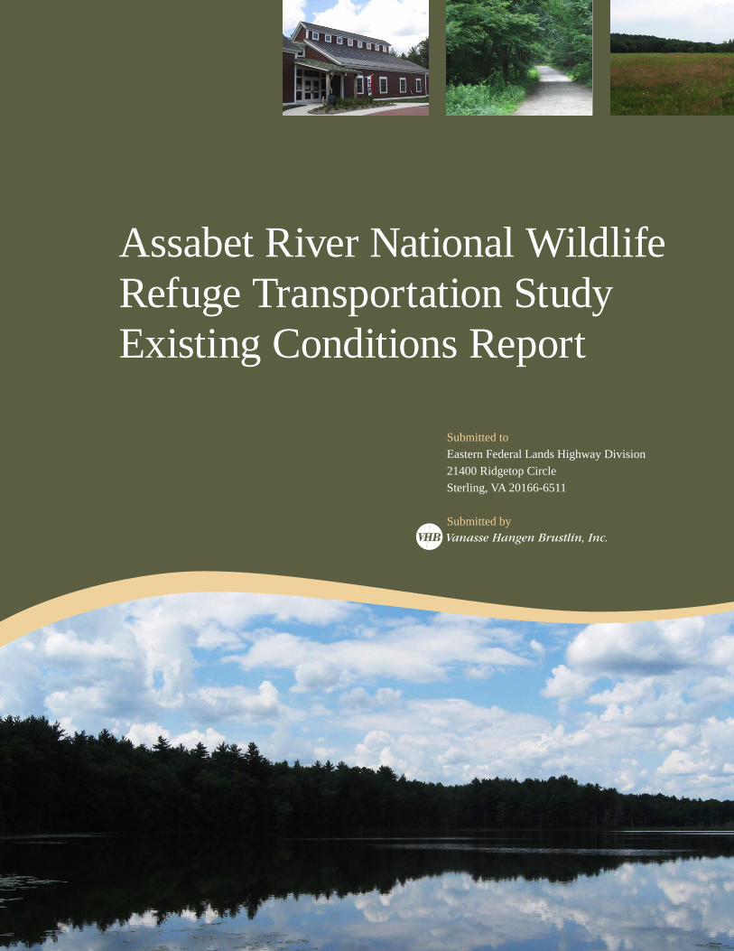
Assabet River National Wildlife Refuge Transportation StudyExisting Conditions Report
Submitted to
Eastern Federal Lands Highway Division
21400 Ridgetop Circle
Sterling, VA 20166-6511
Submitted byVanasse Hangen Brustlin, Inc.
Assabet River National Wildlife Refuge Transportation Study
Existing Conditions Report
Prepared For: Federal Highway Administration Eastern Federal Lands Highway Division U.S. Fish and Wildlife Service Northeast Region Prepared By: Vanasse Hangen Brustlin, Inc. April 2012
Assabet River National Wildlife Refuge – TRANSPORTATION PLANNING STUDY – EXISTING CONDITIONS REPORT
i
Table ofContents1 Introduction ........................................................................................................... 1-1
1.1 Refuge Overview ............................................................................................................................................................................. 1-1
1.2 Purpose of the Transportation Study ............................................................................................................................................... 1-4
1.3 Study Area ....................................................................................................................................................................................... 1-5
1.4 U.S. Fish and Wildlife Service Mission and Goals ........................................................................................................................... 1-5
1.5 National Wildlife Refuge System Mission and Goals ....................................................................................................................... 1-5
2 Activities and Visitation ............................................................................................. 2-1
2.1 Activities .......................................................................................................................................................................................... 2-1
2.2 Visitation Summary and Profile ....................................................................................................................................................... 2-3
3 Regional Demographic and Socioeconomic Characteristics .................................................. 3-1
3.1 Demographic Profile ........................................................................................................................................................................ 3-1
3.2 Socioeconomic and Community Features ....................................................................................................................................... 3-2
4 Habitat and Cultural Resources .................................................................................... 4-1
4.1 Habitat ............................................................................................................................................................................................. 4-1
4.2 Cultural Resources .......................................................................................................................................................................... 4-3
5 Existing Transportation Conditions ............................................................................... 5-1
5.1 Adjacent Land Uses ........................................................................................................................................................................ 5-1
5.2 Entrances to the Refuge .................................................................................................................................................................. 5-3
5.3 Visitor Travel Mode .......................................................................................................................................................................... 5-5
5.4 Pedestrian Access to the Refuge .................................................................................................................................................... 5-5
5.5 Bicycle Access to the Refuge ......................................................................................................................................................... 5-6
5.6 Vehicle Access to the Refuge ......................................................................................................................................................... 5-9
5.7 Mobility and Transportation Infrastructure within the Refuge ....................................................................................................... 5-13
5.8 Major Transportation Issues and Challenges at the Refuge ........................................................................................................ 5-21
Assabet River National Wildlife Refuge – TRANSPORTATION PLANNING STUDY – EXISTING CONDITIONS REPORT
ii
List of Figures1.1 Project Location ...................................................................................................... 1-2
1.2 Study Area ............................................................................................................. 1-3
2.1 Monthly Visitation Patterns (2011) ............................................................................... 2-3
2.2 Average Daily Visitation (2011) .................................................................................... 2-3
3.1 Share of Area Population by Town ................................................................................ 3-1
3.2 Area Population by Age and Gender .............................................................................. 3-2
3.3 Median Annual Household Income ................................................................................ 3-4
4.1 Habitat .................................................................................................................. 4-2
4.2 Historic USGS 1940-1941 (pre-military era) .................................................................... 4-4
4.3 Historic USGS 1950 (military era) ................................................................................. 4-5
4.4 Ammunition Bunkers ................................................................................................. 4-6
5.1 Nearby Land Uses ..................................................................................................... 5-2
5.2 Rail Trails ............................................................................................................... 5-7
5.3 Hourly Traffic Volumes on Hudson Road (Weekday) ........................................................ 5-10
5.4 Hourly Traffic Volumes on Hudson Road (Weekend day) ................................................... 5-11
5.5 Access Easements .................................................................................................. 5-16
5.6 Roadway Condition ................................................................................................. 5-18
Assabet River National Wildlife Refuge – TRANSPORTATION PLANNING STUDY – EXISTING CONDITIONS REPORT
iii
List of Tables2.1 2011 Hunting Seasons ............................................................................................... 2-2
2.2 Average Daily Visitation at ARNWR Visitor Center (2011) .................................................... 2-3
3.1 Area Housing by Occupant Type ................................................................................... 3-2
3.2 Unemployment Rate ................................................................................................. 3-3
3.3 Employment by Industry ........................................................................................... 3-3
4.1 State-listed Birds, Amphibians and Reptiles .................................................................... 4-3
5.1 Vistitor Travel Mode ................................................................................................. 5-5
5.2 Roadway Classification .............................................................................................. 5-9
5.3 Average Daily Traffic Volume (weekday) ...................................................................... 5-10
5.4 Average Daily Traffic Volume (weekend) ...................................................................... 5-10
5.5 Crash Frequency at Entrances to ARNWR ..................................................................... 5-11
5.6 Crash Frequency at Key Intersections ......................................................................... 5-12
5.7 Sight Distances at the Main Entrance ........................................................................... 5-13
5.8 Parking Inventory ................................................................................................... 5-14
5.9 Peak Parking Lot Occupancy, October 13-23, 2011 ......................................................... 5-14
5.10 Winterberry Way Traffic Volumes, November 12-18, 2011 ............................................... 5-15
5.11 Roads and Ways on which Bicycles are Allowed .............................................................. 5-19
5.12 Walking Trails in the ARNWR ..................................................................................... 5-20
Assabet River National Wildlife Refuge – TRANSPORTATION PLANNING STUDY – EXISTING CONDITIONS REPORT
Introduction 1-1 4/10/2012
1 Introduction
1.1 Refuge Overview
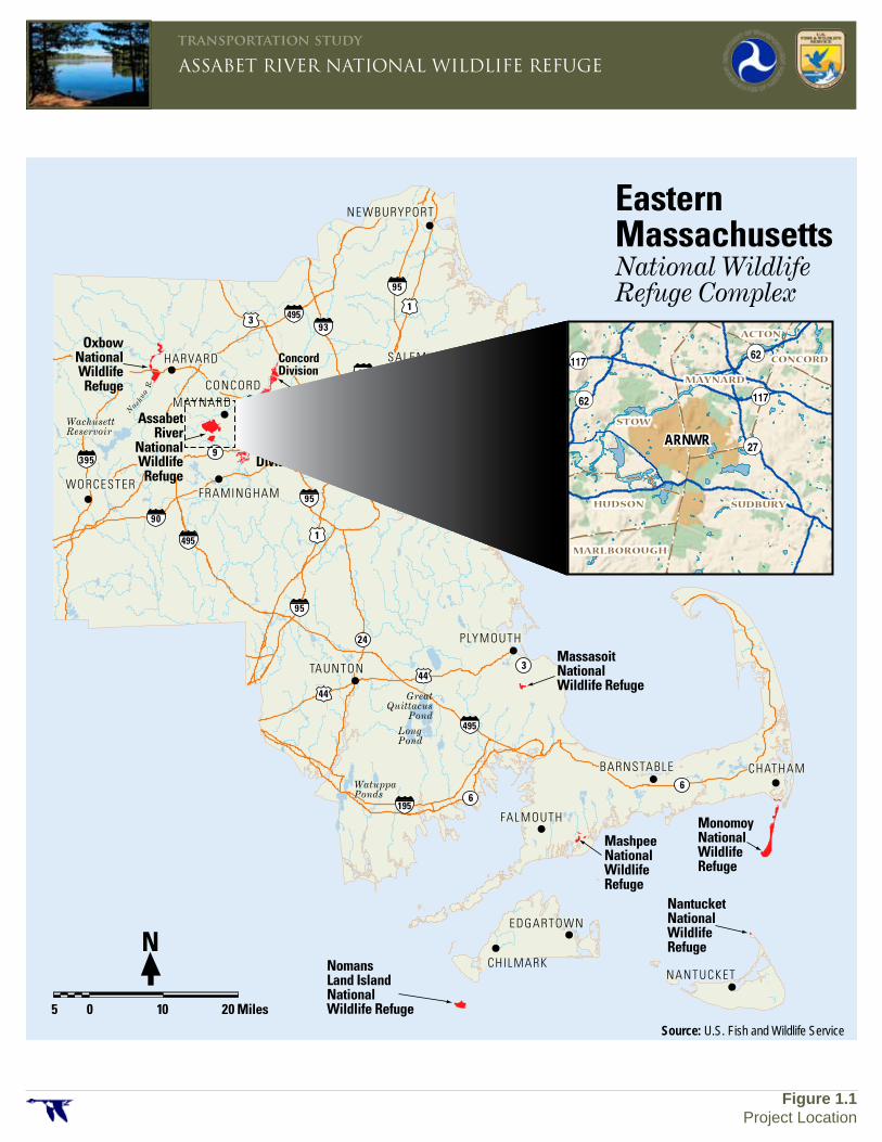
The Assabet River National Wildlife Refuge (ARNWR) is one of eight refuges comprising the Eastern Massachusetts National Wildlife Complex. The locations of the ARNWR and the other refuges are shown in Figure 1.1. The Refuge is relatively new. It was established in 2000 and first opened to the public in 2005. The Refuge is located in the communities of Hudson, Stow, Maynard and Sudbury, Massachusetts. The property had been under the control of the U.S. Army since 1942 and used for a variety of training and research purposes until it was transferred to the U.S. Fish & Wildlife Service (USFWS) in 2000 as a result of the Base Closure and Realignment Act of 1990. The Refuge was established for the purpose of having “particular value in carrying out the national migratory bird management program.” The large areas of wetlands and forest that comprise the Refuge provide feeding and breeding areas for migratory birds as well as other wildlife.
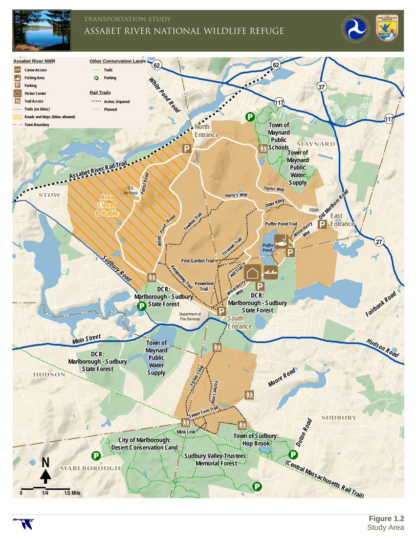
As detailed in the Assabet River National Wildlife Refuge Comprehensive Conservation Plan1, the Refuge is home to more than 135 bird species, 25 mammals, 20 reptile species, and 20 fish species, as well as over 650 different plant species. Figure 1.2 depicts the two primary areas comprising the Assabet River National Wildlife Refuge. The Refuge contains about 2,300 acres. The north tract is approximately 1,900 acres and the south tract is approximately 300 acres. There are also some parcels along the nearby Assabet River that are part of the Refuge. 2 The north tract contains 12.5 miles of trails, the Visitor Center, parking areas, a canoe launch and a fishing area. The Main Entrance to the Refuge is along Hudson Road. The south tract of the Refuge is undeveloped and has 2.7 miles of trails. The first settlers on the Refuge lands were Native Americans.3 European settlement in the area began around 1650. For more than 200 years the lands were used primarily for farming.
1 Assabet River National Wildlife Refuge, Comprehensive
Conservation Plan, U.S. Fish & Wildlife Service, January 2005. 2 Those outlying parcels are excluded from this transportation study
and are not shown on Figure 1.2. 3 Information about the history of the Refuge is taken from the
Comprehensive Conservation Plan.
PLYMOUTH
EDGARTOWN
BARNSTABLE
FALMOUTH
SALEM
BOSTON
BURYPORT
WORCESTER
MAYNARD
HARVARD
FRAMINGHAM
TAUNTON
CHATHAM
CONCORD
PLYMOUTH
EDGARTOWN
NANTUCKET
BARNSTABLE
FALMOUTH
SALEM
BOSTON
NEWBURYPORT
WORCESTER
MAYNARD
HARVARD
FRAMINGHAM
TAUNTON
CHATHAM
CONCORD
90
95
395
95
93
95
95
90
495
495
495
195
1
13
44
44
66
3
24
9
2
LongPond
WatuppaPonds
GreatQuittacus
Pond
WachusettReservoir
N
ashu
a
R.
Oxbow National Wildlife Refuge
Assabet River
National Wildlife Refuge
Massasoit National Wildlife Refuge
Great MeadowsNational Wildlife Refuge
Concord Division
Sudbury Division
MashpeeNational Wildlife Refuge
CHILMARKNomansLand IslandNational Wildlife Refuge
MonomoyNational Wildlife Refuge
NantucketNational Wildlife Refuge
EasternMassachusetts National WildlifeRefuge Complex
5 0 10 20 Miles
N
¬«117
¬«62
¬«62
¬«27
¬«117
STOW
ACTON
HUDSON
MARLBOROUGH
SUDBURY
MAYNARD
CONCORD
ARNWR
Source: U.S. Fish and Wildlife Service
ASSABET RIVER NATIONAL WILDLIFE REFUGEtransportation study
Figure 1.1Project Location
Fairbank Road
Hudson Road
Sudbury Road
Main Street
Old Marlboro Road
White Pond Road
Assabet River Rail Trail
(Central Massachusetts Rail Trail)
Town ofMaynard
PublicSchools
Town ofMaynard
PublicWater
Supply
Town ofMaynard
PublicWater
Supply
DCR:Marlborough - Sudbury
State Forest
DCR:Marlborough - Sudbury
State Forest
DCR:Marlborough - Sudbury
State Forest
City of Marlborough:Desert Conservation Land
Sudbury Valley Trustees:Memorial Forest
Town of Sudbury:Hop Brook
Moore Road
Duto
n Roa
d
Towhee
Trail
Petapawag Trail
Tri-to
wn Trail
Otter Alley
Hill Trai
lPine Garden Trail
PowerlineTrail
Fish
er L
oop
Fisher Loop
Sweet Fern Trail
Mink Link
Puffer Pond Trail
Patro
l Roa
d
Pond
Whi
te
Road
Harry's WayTaylor Way
PufferPond
Winterberry
Way
Winterberry
Way
62 62
117
27
27
117
STOW
HUDSON
MARLBOROUGH
SUDBURY
MAYNARD
�N
0 1/4 1/2 Mile
Canoe Access
Fishing Area
Parking
Visitor Center
Trail Access
Trails (no bikes)
Roads and Ways (bikes allowed)
Town Boundary
Assabet River NWR Other Conservation Lands
Rail Trails
Trails
Parking
Active, Unpaved
Planned
ASSABET RIVER NATIONAL WILDLIFE REFUGEtransportation study
Figure 1.2Study Area
U.S. Air Force
Department of Fire Services
NorthEntrance
EastEntrance
SouthEntrance
FEMA
AreaClosed
to Public
Assabet River National Wildlife Refuge – TRANSPORTATION PLANNING STUDY – EXISTING CONDITIONS REPORT
Introduction 1-4 4/10/2012
By the start of the 20th century, some of the farms were being replaced by smaller homesteads and a few decades later vacation home lots were being developed on Puffer Pond. In 1942 the military era of the lands began when the private properties were acquired through eminent domain by the U.S. Army to support the war effort. The original purpose of the military facility was to store ammunition that was transferred between the site and the port of Boston via the Central Massachusetts Rail Line. Some fifty ammunition bunkers, and a series of railroad spurs to those bunkers, were constructed. New roadways, notably the perimeter Patrol Road, were built. For almost 50 years, the property was used for a variety of training and research purposes by the Army. During that time many of the original houses and farm buildings were removed, a few adapted for Army use, and some new Army buildings constructed. Management of the Army property was transferred in 2000. Most of the property was transferred to the USFWS. A small parcel inside what is now the Refuge was transferred to the U.S. Air Force and used until recently as a weather station. Some of the Army property was transferred to the Federal Emergency Management Agency (FEMA) and now abuts the Refuge near the Refuge’s north and east entrances. Despite the impact of the Army activity, the long period of military ownership and restricted access allowed the lands to remain undeveloped, unlike much of the land in the adjacent suburban towns. During the past 10 years, there was environmental remediation of the site and most of the Army facilities, including the railroad lines, were removed. Only the ammunition bunkers remain.
When the Refuge was first opened to the public in 2005 there were minimal physical improvements constructed by the USFWS. The trail network was created primarily on old road and rail beds. The only significant USFWS construction projects that have occurred since then are the Visitor Center, and the construction of Winterberry Way to provide access to the Visitor Center. The Visitor Center opened in the fall of 2010.
1.2 Purpose of the Transportation Study
The purpose of this study is to evaluate the existing transportation system and infrastructure to understand current conditions and use, and to develop a plan of near-term and long-term projects to improve access to, and mobility within, the Refuge. This report presents the findings of the first phase of the study — the evaluation of existing conditions. The need for the study arises from several factors. One is the desire to determine the best means to accommodate the growing amount and changing type of visitation experienced since the opening of the Refuge in 2005 and the Visitor Center in 2010. Another reason for the study is that many of the then existent trails, roads and travelways in the Refuge were in disrepair at the time the property was transferred to the USFWS in 2000 and the roadway surfaces have deteriorated further since. In addition, the Refuge lands were isolated from the surrounding communities in the decades they were used by the Army and there are opportunities for better connectivity to the adjacent neighborhoods and communities.
Assabet River National Wildlife Refuge – TRANSPORTATION PLANNING STUDY – EXISTING CONDITIONS REPORT
Introduction 1-5 4/10/2012
1.3 Study Area
The primary project study area for purposes of mobility within the Assabet River National Wildlife Refuge encompasses the entirety of the ARNWR’s north tract and south tract. The ARNWR outlying parcels along the Assabet River are excluded from this transportation study. An important element of the study is consideration of potential improvements to the existing pedestrian and bicycle access between the Refuge and the host communities of Stow, Sudbury, Maynard, and Hudson. The study area for pedestrian and bicycle access focuses on routes that provide a reasonable length of travel path to the ARNWR Visitor Center. The pedestrian evaluation includes access via trails in adjacent conservation and recreation properties. The evaluation of bicycle access considers connections to the Assabet Rail Trail, the Bruce Freeman Rail Trail, and the Central Mass Rail Trail. The study area includes roadways external to the Refuge that provide direct access to existing or proposed entrances and parking areas. This includes White Pond Road, Old Marlboro Road, and the Sudbury Road/State Road/Hudson Road corridor.
1.4 U.S. Fish and Wildlife Service Mission and Goals
The U.S. Fish & Wildlife Service is a bureau within the Department of the Interior. The mission of the U.S. Fish and Wildlife Service is to “work with others to conserve, protect, and enhance fish, wildlife, and plants and their habitats for the continuing benefit of the American people.”4
4 National Policy Issuance 99-01, United States Department of the
Interior, Fish and Wildlife Service, 6/15/1999.
The goals of the USFWS are aimed at fulfilling this mission. Primary USFWS goals are to: Sustain fish and wildlife populations including
migratory birds, endangered species, anadromous fish, and marine animals.
Conserve a network of lands and waters, including the National Wildlife Refuge System.
Provide Americans opportunity to understand and participate in the conservation and use of fish and wildlife resources.
1.5 National Wildlife Refuge System Mission and Goals
The mission of the National Wildlife Refuge System is to “administer a national network of lands and waters for the conservation, management, and where appropriate, restoration of the fish, wildlife, plant resources and their habitats within the United States for the benefit of present and future generations of Americans” 5. The primary goals of the National Wildlife Refuge System are to: Preserve, restore, and enhance threatened and
endangered species in their natural ecosystems.
Perpetuate the migratory bird resource.
Preserve a natural diversity and abundance of fish and wildlife ecology.
Provide the public an understanding and appreciation of fish and wildlife ecology.
Provide visitors with wildlife-dependent recreation.
5 The National Wildlife Service Administration Act of 1966, as
amended by the National Wildlife Refuge System Improvement Act of 1997.
Assabet River National Wildlife Refuge – TRANSPORTATION PLANNING STUDY – EXISTING CONDITIONS REPORT
Introduction 1-6 4/10/2012
Legislative history recognizes the importance of providing for wildlife-oriented recreation for people on National Wildlife Refuges. The Refuge Recreation Act of 1962 provided guidance for the USFWS to provide wildlife-oriented recreational opportunities for the public if deemed compatible with the primary purpose of the refuge. The National Wildlife Refuge System Improvement Act of 1997 specified that the refuge system must focus on wildlife, and it defined the following six wildlife-dependent recreational uses as priority public uses of refuge lands.
Hunting
Fishing
Environmental education
Environmental interpretation
Wildlife observation
Wildlife photography
Assabet River National Wildlife Refuge – TRANSPORTATION PLANNING STUDY – EXISTING CONDITIONS REPORT
Activities and Visitation 2-1 4/10/2012
2 Activities and Visitation
2.1 Activities
The Assabet River National Wildlife Refuge is open daily, from sunrise to sunset. The Refuge offers opportunities for walking, bicycling, canoeing, fishing, hunting, as well as educational activities at the Visitor Center. 2.1.1 Visitor Center
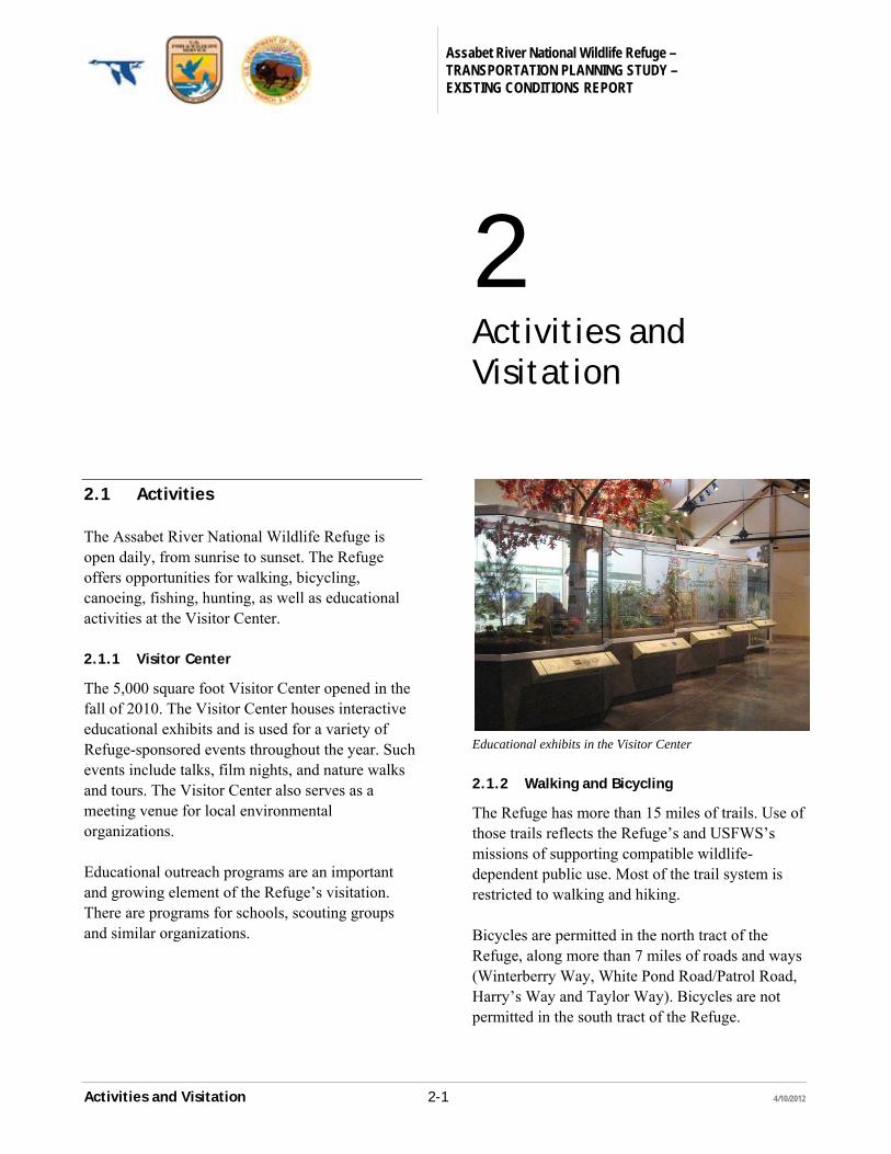
The 5,000 square foot Visitor Center opened in the fall of 2010. The Visitor Center houses interactive educational exhibits and is used for a variety of Refuge-sponsored events throughout the year. Such events include talks, film nights, and nature walks and tours. The Visitor Center also serves as a meeting venue for local environmental organizations. Educational outreach programs are an important and growing element of the Refuge’s visitation. There are programs for schools, scouting groups and similar organizations.
Educational exhibits in the Visitor Center
2.1.2 Walking and Bicycling
The Refuge has more than 15 miles of trails. Use of those trails reflects the Refuge’s and USFWS’s missions of supporting compatible wildlife-dependent public use. Most of the trail system is restricted to walking and hiking. Bicycles are permitted in the north tract of the Refuge, along more than 7 miles of roads and ways (Winterberry Way, White Pond Road/Patrol Road, Harry’s Way and Taylor Way). Bicycles are not permitted in the south tract of the Refuge.
Assabet River National Wildlife Refuge – TRANSPORTATION PLANNING STUDY – EXISTING CONDITIONS REPORT
Activities and Visitation 2-2 4/10/2012
Except for Winterberry Way, which provides access to the Visitor Center and parking areas, the Refuge is closed to motorized vehicles. Horses and dogs are not allowed in the Refuge. 2.1.3 Hunting and Fishing
Hunting and fishing are allowed in accordance with Refuge, state and federal regulations. Hunting is allowed in much of the Refuge, including a section west of White Pond Road that is not otherwise open to the public. Table 2.1: 2011 Hunting Seasons
Activity Open Season
White-tailed Deer Archery Oct. 17-Nov. 26 Shotgun Nov. 28-Dec. 10 Primitive Firearms Dec. 12-Dec. 31 Ruffed Grouse Oct. 15-Nov. 26 Gray Squirrel Sept. 12-Jan. 2,2012 Rabbit Jan. 1-Feb. 28,
Oct. 15-Feb. 29,2012 Woodcock Oct. 5-Oct. 29,
Oct. 31-Nov. 19 Turkey Apr. 25-May 21
Source: 2011 Massachusetts Guide to Hunting, Freshwater Fishing and Trapping: Quick Reference List; MassWildlife Migratory Bird Regulations for 2011-12 Season
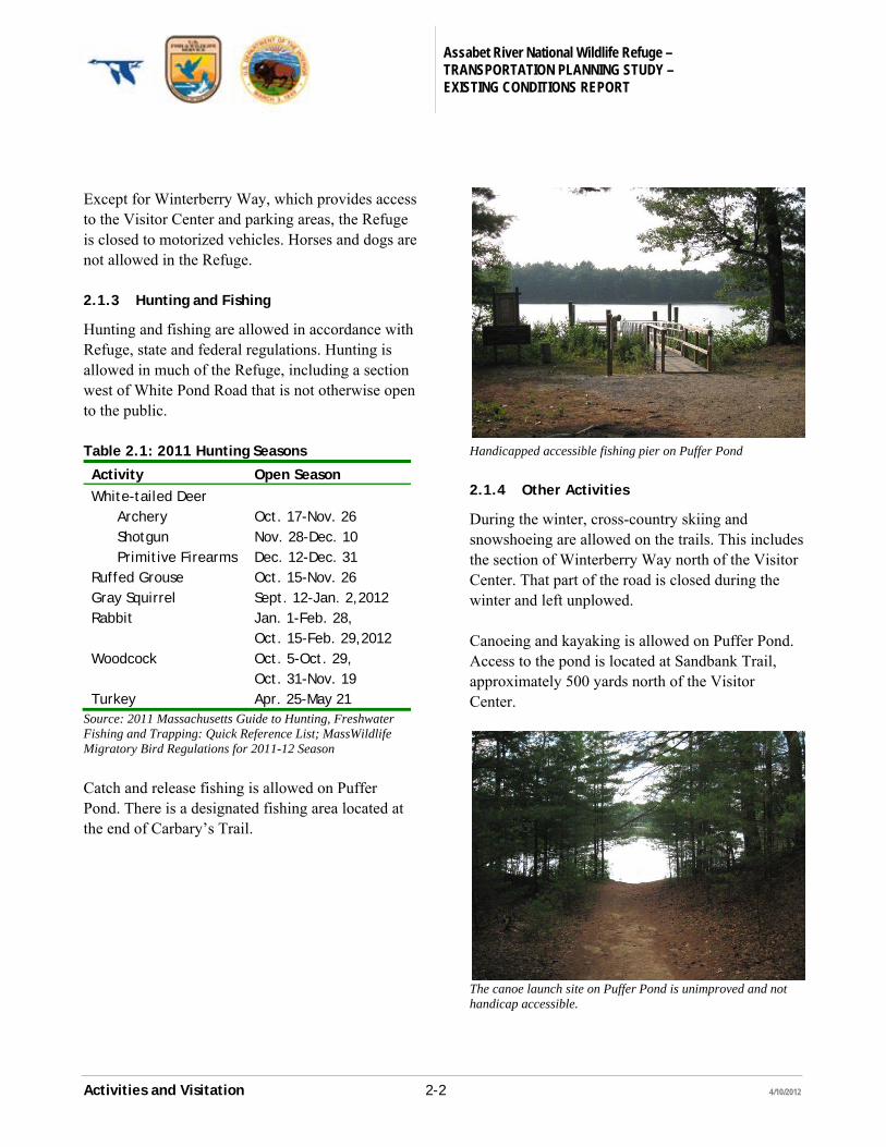
Catch and release fishing is allowed on Puffer Pond. There is a designated fishing area located at the end of Carbary’s Trail.
Handicapped accessible fishing pier on Puffer Pond
2.1.4 Other Activities
During the winter, cross-country skiing and snowshoeing are allowed on the trails. This includes the section of Winterberry Way north of the Visitor Center. That part of the road is closed during the winter and left unplowed. Canoeing and kayaking is allowed on Puffer Pond. Access to the pond is located at Sandbank Trail, approximately 500 yards north of the Visitor Center.
The canoe launch site on Puffer Pond is unimproved and not handicap accessible.
Assabet River National Wildlife Refuge – TRANSPORTATION PLANNING STUDY – EXISTING CONDITIONS REPORT
Activities and Visitation 2-3 4/10/2012
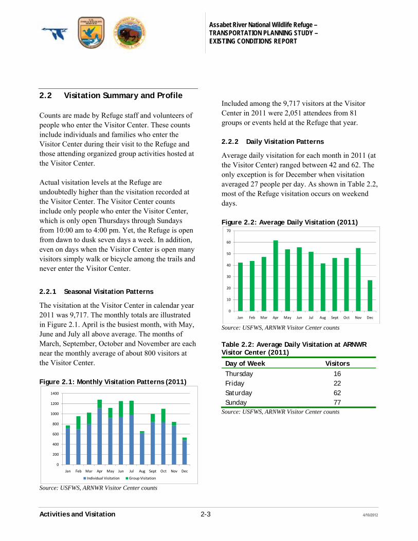
2.2 Visitation Summary and Profile
Counts are made by Refuge staff and volunteers of people who enter the Visitor Center. These counts include individuals and families who enter the Visitor Center during their visit to the Refuge and those attending organized group activities hosted at the Visitor Center. Actual visitation levels at the Refuge are undoubtedly higher than the visitation recorded at the Visitor Center. The Visitor Center counts include only people who enter the Visitor Center, which is only open Thursdays through Sundays from 10:00 am to 4:00 pm. Yet, the Refuge is open from dawn to dusk seven days a week. In addition, even on days when the Visitor Center is open many visitors simply walk or bicycle among the trails and never enter the Visitor Center.
2.2.1 Seasonal Visitation Patterns
The visitation at the Visitor Center in calendar year 2011 was 9,717. The monthly totals are illustrated in Figure 2.1. April is the busiest month, with May, June and July all above average. The months of March, September, October and November are each near the monthly average of about 800 visitors at the Visitor Center. Figure 2.1: Monthly Visitation Patterns (2011)
Source: USFWS, ARNWR Visitor Center counts
Included among the 9,717 visitors at the Visitor Center in 2011 were 2,051 attendees from 81 groups or events held at the Refuge that year. 2.2.2 Daily Visitation Patterns
Average daily visitation for each month in 2011 (at the Visitor Center) ranged between 42 and 62. The only exception is for December when visitation averaged 27 people per day. As shown in Table 2.2, most of the Refuge visitation occurs on weekend days. Figure 2.2: Average Daily Visitation (2011)
Source: USFWS, ARNWR Visitor Center counts
Table 2.2: Average Daily Visitation at ARNWR Visitor Center (2011)
Day of Week Visitors
Thursday 16 Friday 22 Saturday 62 Sunday 77
Source: USFWS, ARNWR Visitor Center counts
0
200
400
600
800
1000
1200
1400
Jan Feb Mar Apr May Jun Jul Aug Sept Oct Nov Dec
Individual Visitation Group Visitation
0
10
20
30
40
50
60
70
Jan Feb Mar Apr May Jun Jul Aug Sept Oct Nov Dec
Assabet River National Wildlife Refuge – TRANSPORTATION PLANNING STUDY – EXISTING CONDITIONS REPORT
Regional Demographic and Socioeconomic 3-1 4/10/2012
Characteristics
3 Regional Demographic and Socioeconomic Characteristics
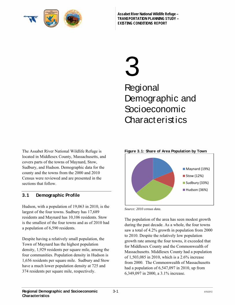
The Assabet River National Wildlife Refuge is located in Middlesex County, Massachusetts, and covers parts of the towns of Maynard, Stow, Sudbury, and Hudson. Demographic data for the county and the towns from the 2000 and 2010 Census were reviewed and are presented in the sections that follow.
3.1 Demographic Profile
Hudson, with a population of 19,063 in 2010, is the largest of the four towns. Sudbury has 17,689 residents and Maynard has 10,106 residents. Stow is the smallest of the four towns and as of 2010 had a population of 6,590 residents. Despite having a relatively small population, the Town of Maynard has the highest population density, 1,929 residents per square mile, among the four communities. Population density in Hudson is 1,656 residents per square mile. Sudbury and Stow have a much lower population density at 725 and 374 residents per square mile, respectively.
Figure 3.1: Share of Area Population by Town
Source: 2010 census data.
The population of the area has seen modest growth during the past decade. As a whole, the four towns saw a total of 4.2% growth in population from 2000 to 2010. Despite the relatively low population growth rate among the four towns, it exceeded that for Middlesex County and the Commonwealth of Massachusetts. Middlesex County had a population of 1,503,085 in 2010, which is a 2.6% increase from 2000. The Commonwealth of Massachusetts had a population of 6,547,097 in 2010, up from 6,349,097 in 2000, a 3.1% increase.
Maynard (19%)
Stow (12%)
Sudbury (33%)
Hudson (36%)
Assabet River National Wildlife Refuge – TRANSPORTATION PLANNING STUDY – EXISTING CONDITIONS REPORT
Regional Demographic and Socioeconomic 3-2 4/10/2012
Characteristics
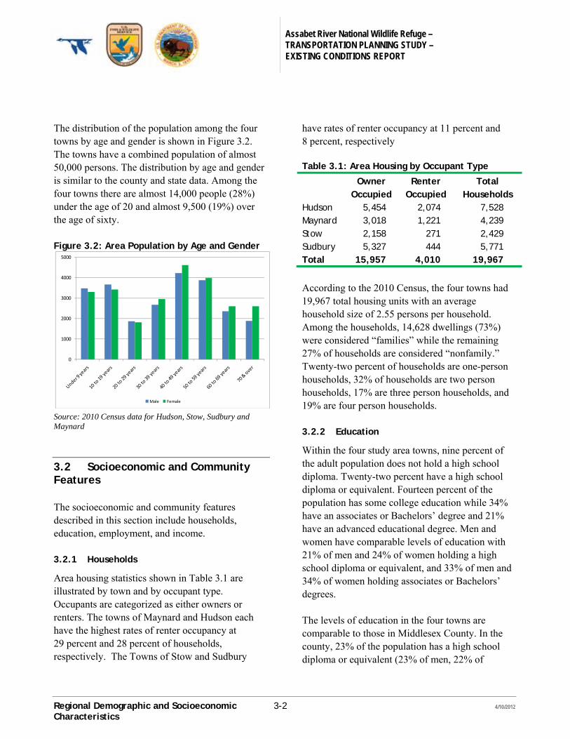
The distribution of the population among the four towns by age and gender is shown in Figure 3.2. The towns have a combined population of almost 50,000 persons. The distribution by age and gender is similar to the county and state data. Among the four towns there are almost 14,000 people (28%) under the age of 20 and almost 9,500 (19%) over the age of sixty. Figure 3.2: Area Population by Age and Gender
Source: 2010 Census data for Hudson, Stow, Sudbury and Maynard
3.2 Socioeconomic and Community Features
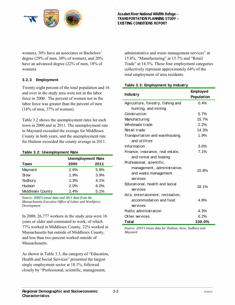
The socioeconomic and community features described in this section include households, education, employment, and income. 3.2.1 Households
Area housing statistics shown in Table 3.1 are illustrated by town and by occupant type. Occupants are categorized as either owners or renters. The towns of Maynard and Hudson each have the highest rates of renter occupancy at 29 percent and 28 percent of households, respectively. The Towns of Stow and Sudbury
have rates of renter occupancy at 11 percent and 8 percent, respectively Table 3.1: Area Housing by Occupant Type
Owner
Occupied Renter
Occupied Total
Households Hudson 5,454 2,074 7,528 Maynard 3,018 1,221 4,239 Stow 2,158 271 2,429 Sudbury 5,327 444 5,771 Total 15,957 4,010 19,967
According to the 2010 Census, the four towns had 19,967 total housing units with an average household size of 2.55 persons per household. Among the households, 14,628 dwellings (73%) were considered “families” while the remaining 27% of households are considered “nonfamily.” Twenty-two percent of households are one-person households, 32% of households are two person households, 17% are three person households, and 19% are four person households. 3.2.2 Education
Within the four study area towns, nine percent of the adult population does not hold a high school diploma. Twenty-two percent have a high school diploma or equivalent. Fourteen percent of the population has some college education while 34% have an associates or Bachelors’ degree and 21% have an advanced educational degree. Men and women have comparable levels of education with 21% of men and 24% of women holding a high school diploma or equivalent, and 33% of men and 34% of women holding associates or Bachelors’ degrees. The levels of education in the four towns are comparable to those in Middlesex County. In the county, 23% of the population has a high school diploma or equivalent (23% of men, 22% of
0
1000
2000
3000
4000
5000
Male Female
Assabet River National Wildlife Refuge – TRANSPORTATION PLANNING STUDY – EXISTING CONDITIONS REPORT
Regional Demographic and Socioeconomic 3-3 4/10/2012
Characteristics
women), 30% have an associates or Bachelors’ degree (29% of men, 30% of women), and 20% have an advanced degree (22% of men, 18% of women). 3.2.3 Employment
Twenty-eight percent of the total population and 16 and over in the study area were not in the labor force in 2000. The percent of women not in the labor force was greater than the percent of men (18% of men, 37% of women). Table 3.2 shows the unemployment rates for each town in 2000 and in 2011. The unemployment rate in Maynard exceeded the average for Middlesex County in both years, and the unemployment rate for Hudson exceeded the county average in 2011. Table 3.2: Unemployment Rate
Unemployment Rate Town 2000 2011
Maynard 2.6% 5.8% Stow 1.9% 3.9% Sudbury 1.3% 4.1% Hudson 2.0% 6.0% Middlesex County 2.4% 5.1%
Source: 2000 Census data and 2011 data from the Massachusetts Executive Office of Labor and Workforce Development
In 2000, 26,777 workers in the study area were 16 years or older and commuted to work; of which 77% worked in Middlesex County, 22% worked in Massachusetts but outside of Middlesex County, and less than two percent worked outside of Massachusetts. As shown in Table 3.3, the category of “Education, Health and Social Services” presented the largest single employment sector at 18.1%, followed closely by “Professional, scientific, management,
administrative and waste management services” at 15.8%, “Manufacturing” at 15.7% and “Retail Trade” at 14.3%. These four employment categories collectively represent approximately 64% of the total employment of area residents. Table 3.3: Employment by Industry
Industry Employed Population
Agriculture, forestry, fishing and hunting, and mining
0.4%
Construction 5.7% Manufacturing 15.7% Wholesale trade 2.2% Retail trade 14.3% Transportation and warehousing,
and utilities 1.9%
Information 3.6% Finance, insurance, real estate,
and rental and leasing 7.1%
Professional, scientific, management, administrative, and waste management services
15.8%
Educational, health and social services
18.1%
Arts, entertainment, recreation, accommodation and food services
4.8%
Public administration 4.3% Other services 6.2% Total 100.0%
Source: 2010 Census data for Hudson, Stow, Sudbury and Maynard
Assabet River National Wildlife Refuge – TRANSPORTATION PLANNING STUDY – EXISTING CONDITIONS REPORT
Regional Demographic and Socioeconomic 3-4 4/10/2012
Characteristics
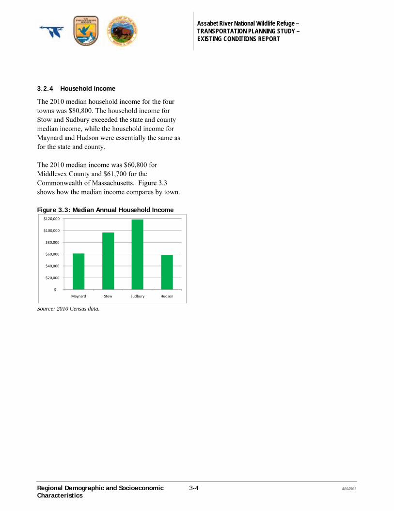
3.2.4 Household Income
The 2010 median household income for the four towns was $80,800. The household income for Stow and Sudbury exceeded the state and county median income, while the household income for Maynard and Hudson were essentially the same as for the state and county. The 2010 median income was $60,800 for Middlesex County and $61,700 for the Commonwealth of Massachusetts. Figure 3.3 shows how the median income compares by town. Figure 3.3: Median Annual Household Income
Source: 2010 Census data.
$‐
$20,000
$40,000
$60,000
$80,000
$100,000
$120,000
Maynard Stow Sudbury Hudson
Assabet River National Wildlife Refuge – TRANSPORTATION PLANNING STUDY – EXISTING CONDITIONS REPORT
Habitat and Cultural Resources 4-1 4/10/2012
4 Habitat and Cultural Resources
The following information regarding habitat and cultural resources in the Refuge is taken from the Assabet River National Wildlife Refuge Comprehensive Conservation Plan.
4.1 Habitat
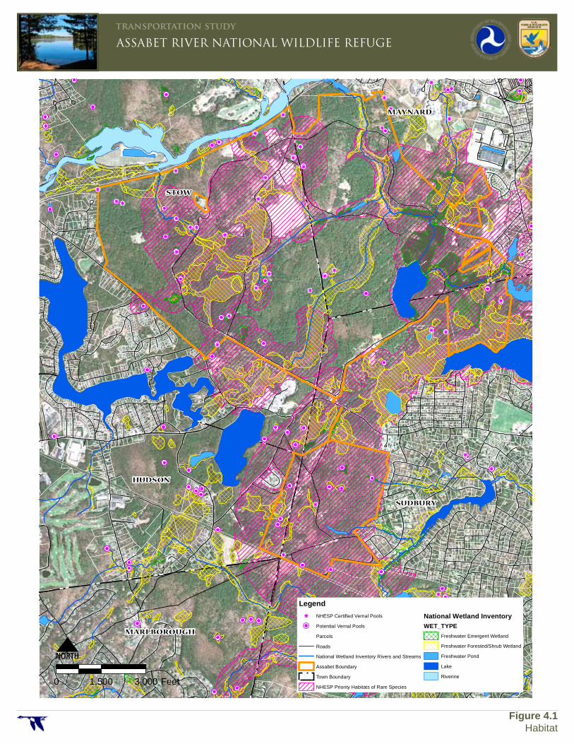
The Assabet River National Wildlife Refuge contains a diversity of wetland and upland habitat. The mix of habitat supports a wide variety of birds, mammals, reptiles and amphibians. In the 18th and 19th centuries, the Refuge lands were dominated by farms and pastures. Since then much of the area has succeeded back to forest. Most of the Refuge is now forested, with mixed white pine and oak hardwoods dominating. Only a few meadow areas remain. As shown on Figure 4.1, much of the Refuge, particularly in the north tract, is forested and emergent wetland habitat. Due principally to beaver activity, the amount of wetlands has increased since the property was transferred to the Fish and Wildlife Service.
The one-time Army Taylor Drop Zone is now the largest area of grassland habitat in the Refuge. The forested hill in the background was once pastureland.
The Refuge contains a significant amount of priority wildlife habitat. Approximately 50 vernal pools have been identified on the Refuge. The vernal pools are critical breeding habitat for amphibians. Large sections of the Refuge are designated as Priority Habitats of Rare Species under the Massachusetts Department of Fisheries and Wildlife’s Natural Heritage & Endangered Species Program. The entire Assabet River NWR has been designated as a Massachusetts Important Bird Area due to the habitat it provides to breeding, wintering and migratory birds.
STOW
HUDSON
MARLBOROUGH
SUDBURY
MAYNARD
0 1,500 3,000 Feet
LegendNHESP Certified Vernal Pools
Potential Vernal Pools
Parcels
Roads
National Wetland Inventory Rivers and Streams
Assabet Boundary
Town Boundary
NHESP Priority Habitats of Rare Species
National Wetland InventoryWET_TYPE
Freshwater Emergent Wetland
Freshwater Forested/Shrub Wetland
Freshwater Pond
Lake
Riverine
ASSABET RIVER NATIONAL WILDLIFE REFUGEtransportation study
Figure 4.1Habitat
Assabet River National Wildlife Refuge – TRANSPORTATION PLANNING STUDY – EXISTING CONDITIONS REPORT
Habitat and Cultural Resources 4-3 4/10/2012
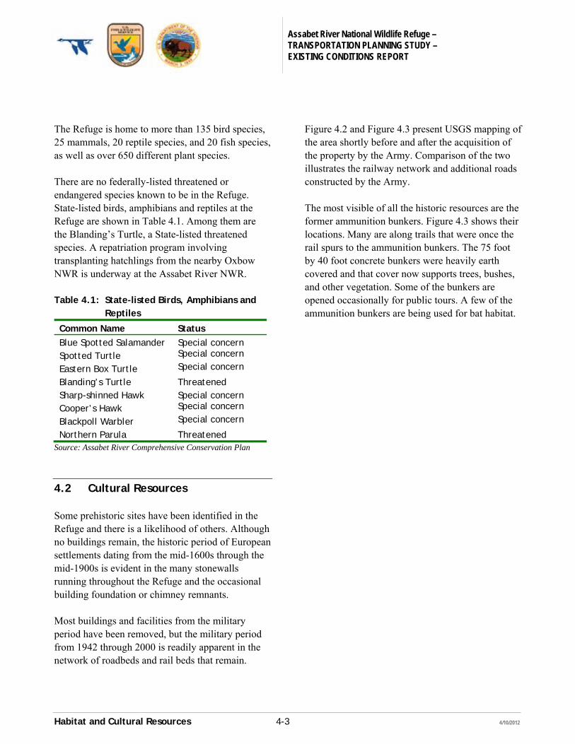
The Refuge is home to more than 135 bird species, 25 mammals, 20 reptile species, and 20 fish species, as well as over 650 different plant species. There are no federally-listed threatened or endangered species known to be in the Refuge. State-listed birds, amphibians and reptiles at the Refuge are shown in Table 4.1. Among them are the Blanding’s Turtle, a State-listed threatened species. A repatriation program involving transplanting hatchlings from the nearby Oxbow NWR is underway at the Assabet River NWR. Table 4.1: State-listed Birds, Amphibians and
Reptiles
Common Name Status
Blue Spotted Salamander Special concern Spotted Turtle Special concern
Eastern Box Turtle Special concern
Blanding’s Turtle Threatened Sharp-shinned Hawk Special concern Cooper’s Hawk Special concern
Blackpoll Warbler Special concern
Northern Parula Threatened Source: Assabet River Comprehensive Conservation Plan
4.2 Cultural Resources
Some prehistoric sites have been identified in the Refuge and there is a likelihood of others. Although no buildings remain, the historic period of European settlements dating from the mid-1600s through the mid-1900s is evident in the many stonewalls running throughout the Refuge and the occasional building foundation or chimney remnants. Most buildings and facilities from the military period have been removed, but the military period from 1942 through 2000 is readily apparent in the network of roadbeds and rail beds that remain.
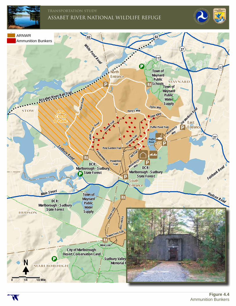
Figure 4.2 and Figure 4.3 present USGS mapping of the area shortly before and after the acquisition of the property by the Army. Comparison of the two illustrates the railway network and additional roads constructed by the Army. The most visible of all the historic resources are the former ammunition bunkers. Figure 4.3 shows their locations. Many are along trails that were once the rail spurs to the ammunition bunkers. The 75 foot by 40 foot concrete bunkers were heavily earth covered and that cover now supports trees, bushes, and other vegetation. Some of the bunkers are opened occasionally for public tours. A few of the ammunition bunkers are being used for bat habitat.
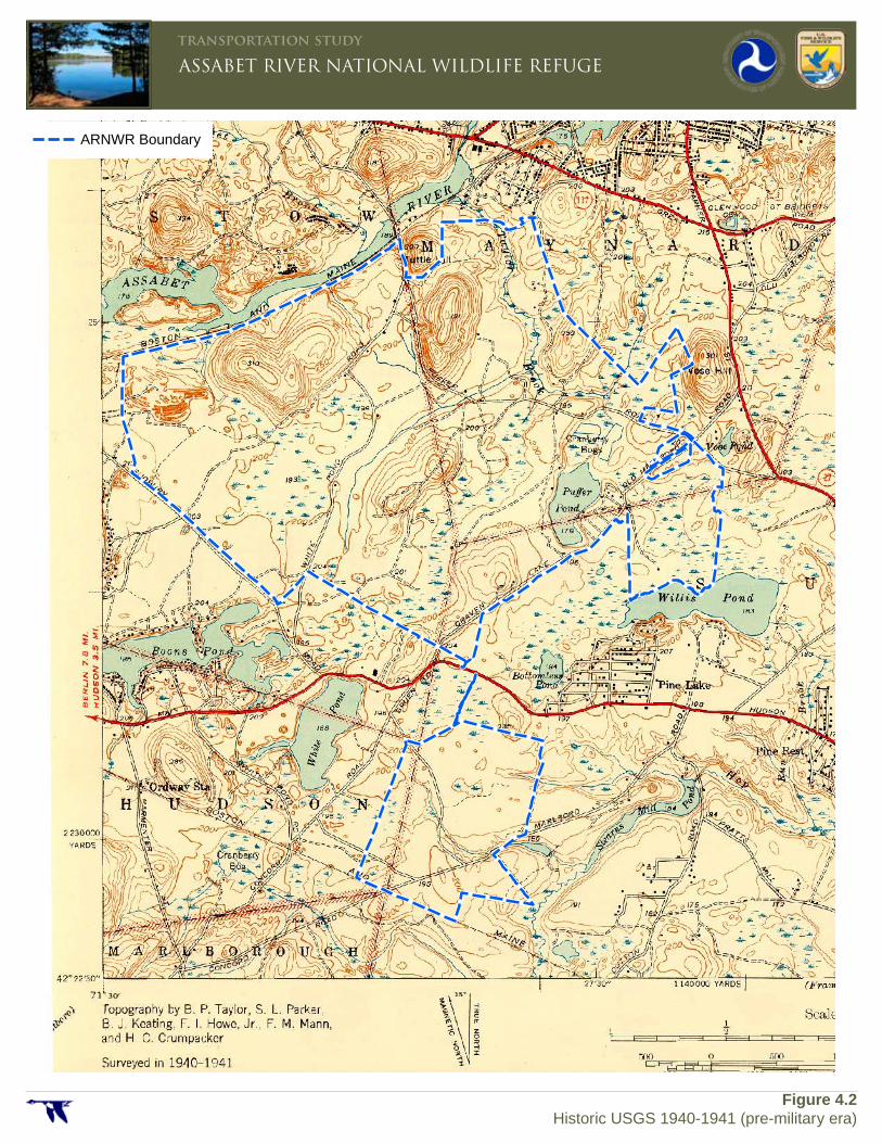
\\mawatr\ts\35010.05 ARNWR\GIS\Project\Historic_USGS.mxd
ASSABET RIVER NATIONAL WILDLIFE REFUGEtransportation study
Figure 4.2 Historic USGS 1940-1941 (pre-military era)
ARNWR Boundary
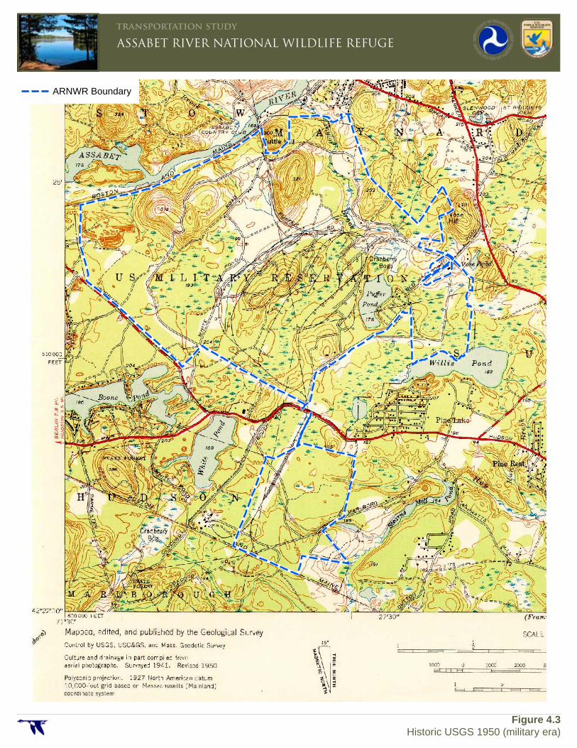
\\mawatr\ts\35010.05 ARNWR\GIS\Project\Historic_USGS.mxd
ASSABET RIVER NATIONAL WILDLIFE REFUGEtransportation study
Figure 4.3 Historic USGS 1950 (military era)
ARNWR Boundary
Fairbank Road
Hudson Road
Sudbury Road
Main Street
Old Marlboro Road
Assabet River Rail Trail
(Central Massachusetts Rail Trail)
Town ofMaynard
PublicSchools
Town ofMaynard
PublicWater
Supply
Town ofMaynard
PublicWater
Supply
DCR:Marlborough - Sudbury
State Forest
DCR:Marlborough - Sudbury
State Forest
DCR:Marlborough - Sudbury
State Forest
City of Marlborough:Desert Conservation Land
Sudbury Valley Trustees:Memorial Forest
Town of Sudbury:Hop Brook
Moore Road
Duto
n Roa
d
Towhee
Trail
Petapawag Trail
Tri-to
wn Trail
Otter Alley
Hill Trai
lPine Garden Trail
PowerlineTrail
Fish
er L
oop
Fisher Loop
Sweet Fern Trail
Mink Link
Puffer Pond Trail
Patro
l Roa
d
Pond
Whi
te
Road
Harry's WayTaylor Way
PufferPond
Winterberry
Way
Winterberry
Way
White Pond Road
62 62
117
27
27
117
STOW
HUDSON
MARLBOROUGH
SUDBURY
MAYNARD
ARNWRAmmunition Bunkers
�N
0 1/4 1/2 Mile
ASSABET RIVER NATIONAL WILDLIFE REFUGEtransportation study
Figure 4.4Ammunition Bunkers
NorthEntrance
EastEntrance
SouthEntrance
AreaClosed
to Public
Assabet River National Wildlife Refuge – TRANSPORTATION PLANNING STUDY – EXISTING CONDITIONS REPORT
Existing Transportation Conditions 5-1 4/10/2012
5 Existing Transportation Conditions
This chapter describes existing transportation conditions at the Assabet River National Wildlife Refuge. The evaluation covers external access, internal circulation and internal transportation infrastructure.
5.1 Adjacent Land Uses
Much of the Refuge is adjacent to other conservation properties. The other adjacent land uses are several single-family residential neighborhoods and two institutional properties. 5.1.1 Adjacent Conservation Lands
Figure 1.2, presented earlier, shows conservation lands adjacent to the Refuge. The north tract of the Refuge is bounded to the northwest by the Assabet River and the Assabet River Rail Trail, to the north by some Town of Maynard properties, and to the south by the Marlborough-Sudbury State Forest. Both the Town of Maynard and State Forest properties have walking trail systems that connect with the Refuge’s trail system.
The south tract of the Refuge is bounded to the north by a section for the Marlborough-Sudbury State Forest. The trail connection between the Refuge’s north and south tracts travels through the State Forest. The south tract of the Refuge is adjacent at the south boundary to three conservation areas. One is managed by the Town of Marlborough, one by the Town of Sudbury, and the third by the Sudbury Valley Trustees, a non-profit environmental organization. The south tract of the Refuge is also adjacent to the proposed Central Massachusetts Rail Trail, the property of which is owned by the Massachusetts Department of Conservation and Recreation. 5.1.2 Other Adjacent Lands
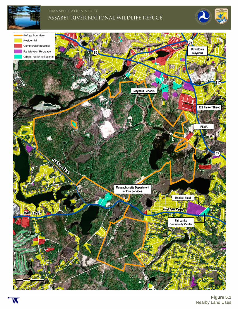
Figure 5.1 shows the various types of non-conservation land uses near to the Refuge. The highest density of land uses is to the north in Maynard. Downtown Maynard is approximately one mile from the Refuge’s North Entrance at White Pond Road.
Sudbury Road
Main StreetHudson Road
27
62
117
62
\\MAWATR\ts\35010.05 ARNWR\GIS\Project\LandUse.mxd
Participation Recreation
Urban Public/Institutional
Refuge Boundary
Commercial/Industrial
Residential
�N
0 1/4 1/2 Mile
ASSABET RIVER NATIONAL WILDLIFE REFUGEtransportation study
Figure 5.1Nearby Land Uses
Massachusetts Departmentof Fire Services
FEMA
Downtown Maynard
129 Parker Street
Maynard Schools
Haskell Field
Fairbanks Community Center
Assabet River National Wildlife Refuge – TRANSPORTATION PLANNING STUDY – EXISTING CONDITIONS REPORT
Existing Transportation Conditions 5-3 4/10/2012
To the east of the Refuge, in Sudbury, is primarily single-family housing. The density of housing in Stow, to the west and northwest of the Refuge, is much lower than in Maynard or Sudbury. There are two institutional properties that are adjacent to the Refuge. There is a Federal Emergency Management Agency (FEMA) facility at Refuge’s East Entrance on Old Marlboro Road. The Massachusetts Department of Fire Services campus is located adjacent to the Refuge’s Main Entrance on Hudson Road.
5.1.3 Future Development Projects
Given the large amount of conservation and other protected properties, and the established residential land uses in the area around the Refuge, there is little opportunity for future significant land development projects that might have a noticeable impact on the Refuge. The Massachusetts Department of Fire Services campus has expanded in recent years, but there are no active plans to expand further. The Federal Emergency Management Agency facility may add warehousing space in the future but this would have little impact on traffic. The development projects with the most direct impact on the Refuge may occur in Maynard. In 2010, the town rezoned a large office property in the downtown to allow retail and hotel uses, and up to 200 live-work residential units. There are no plans proposed for the development at this time, but the residential units in particular could have a strong relationship to the Refuge. Downtown Maynard is only one mile away from the Refuge via the Assabet River Rail Trail. The other potential development in Maynard is at 129 Parker Street (Route 27). This 50-acre commercial property is located less than one mile from the Refuge’s East
Entrance and has been vacant for approximately 15 years. Several years ago, the property was rezoned to allow mixed-use office, retail and residential uses. However, there are no current proposals for development being considered.
5.2 Entrances to the Refuge
The Refuge has three primary entrances, each with vehicle parking and all on the north tract (see Figure 1.2 for locations). Visitors can also enter the Refuge via several formal walking trail connections on both the south and north tracts of the Refuge. 5.2.1 Main Entrance
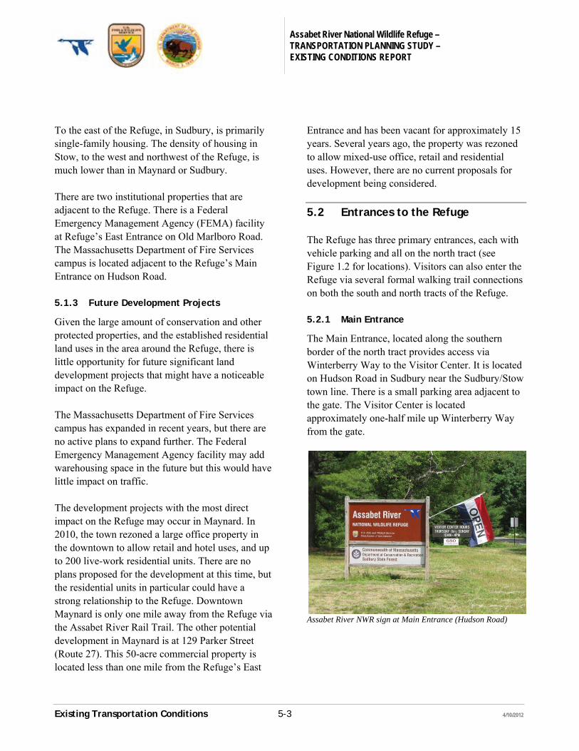
The Main Entrance, located along the southern border of the north tract provides access via Winterberry Way to the Visitor Center. It is located on Hudson Road in Sudbury near the Sudbury/Stow town line. There is a small parking area adjacent to the gate. The Visitor Center is located approximately one-half mile up Winterberry Way from the gate.
Assabet River NWR sign at Main Entrance (Hudson Road)
Assabet River National Wildlife Refuge – TRANSPORTATION PLANNING STUDY – EXISTING CONDITIONS REPORT
Existing Transportation Conditions 5-4 4/10/2012
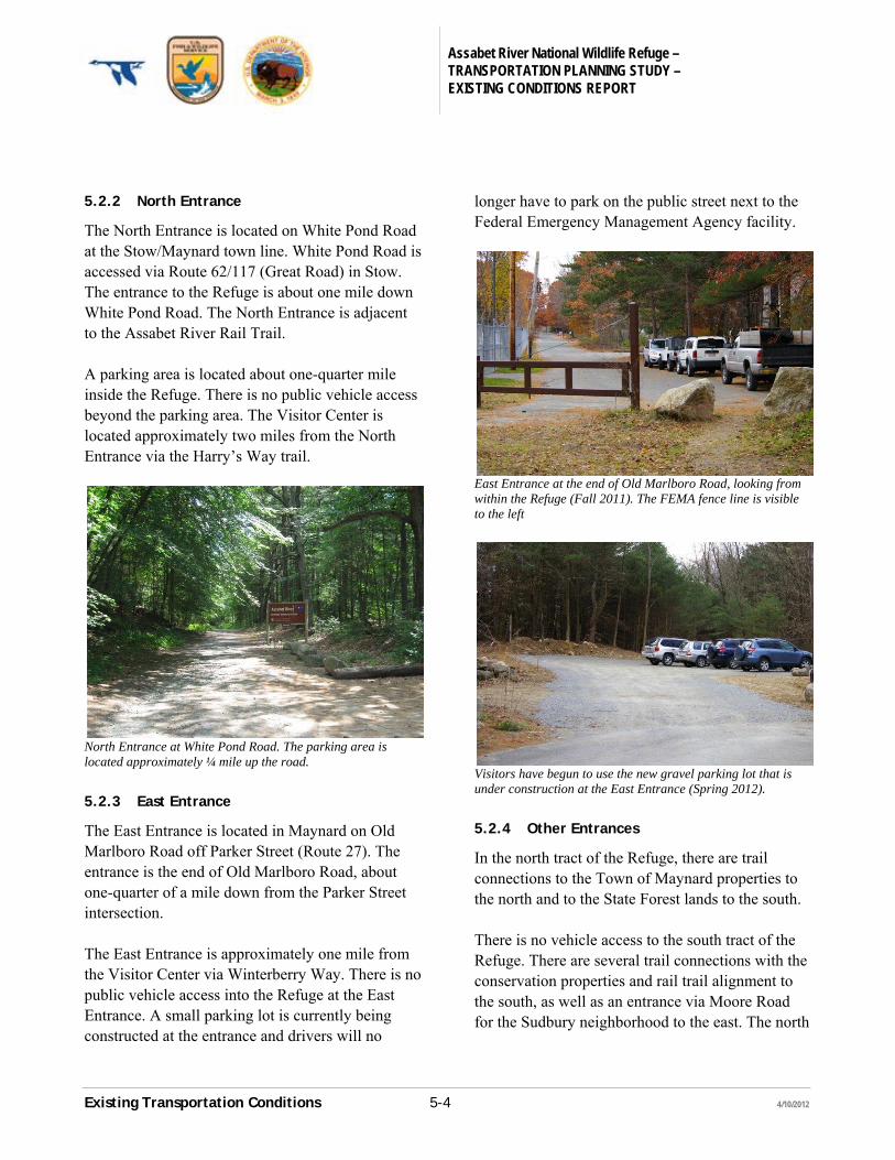
5.2.2 North Entrance
The North Entrance is located on White Pond Road at the Stow/Maynard town line. White Pond Road is accessed via Route 62/117 (Great Road) in Stow. The entrance to the Refuge is about one mile down White Pond Road. The North Entrance is adjacent to the Assabet River Rail Trail. A parking area is located about one-quarter mile inside the Refuge. There is no public vehicle access beyond the parking area. The Visitor Center is located approximately two miles from the North Entrance via the Harry’s Way trail.
North Entrance at White Pond Road. The parking area is located approximately ¼ mile up the road.
5.2.3 East Entrance
The East Entrance is located in Maynard on Old Marlboro Road off Parker Street (Route 27). The entrance is the end of Old Marlboro Road, about one-quarter of a mile down from the Parker Street intersection. The East Entrance is approximately one mile from the Visitor Center via Winterberry Way. There is no public vehicle access into the Refuge at the East Entrance. A small parking lot is currently being constructed at the entrance and drivers will no
longer have to park on the public street next to the Federal Emergency Management Agency facility.
East Entrance at the end of Old Marlboro Road, looking from within the Refuge (Fall 2011). The FEMA fence line is visible to the left
Visitors have begun to use the new gravel parking lot that is under construction at the East Entrance (Spring 2012). 5.2.4 Other Entrances
In the north tract of the Refuge, there are trail connections to the Town of Maynard properties to the north and to the State Forest lands to the south. There is no vehicle access to the south tract of the Refuge. There are several trail connections with the conservation properties and rail trail alignment to the south, as well as an entrance via Moore Road for the Sudbury neighborhood to the east. The north
Assabet River National Wildlife Refuge – TRANSPORTATION PLANNING STUDY – EXISTING CONDITIONS REPORT
Existing Transportation Conditions 5-5 4/10/2012
and south tracts of the Refuge are connected via a trail through the State Forest lands.
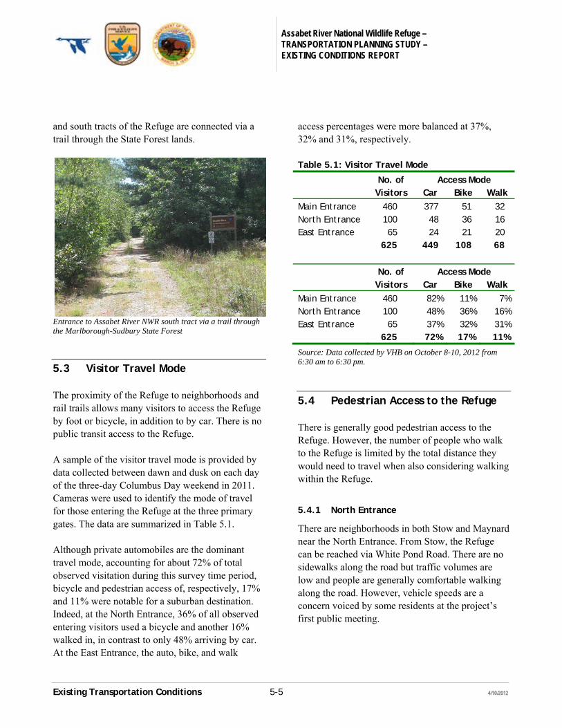
Entrance to Assabet River NWR south tract via a trail through the Marlborough-Sudbury State Forest
5.3 Visitor Travel Mode
The proximity of the Refuge to neighborhoods and rail trails allows many visitors to access the Refuge by foot or bicycle, in addition to by car. There is no public transit access to the Refuge. A sample of the visitor travel mode is provided by data collected between dawn and dusk on each day of the three-day Columbus Day weekend in 2011. Cameras were used to identify the mode of travel for those entering the Refuge at the three primary gates. The data are summarized in Table 5.1. Although private automobiles are the dominant travel mode, accounting for about 72% of total observed visitation during this survey time period, bicycle and pedestrian access of, respectively, 17% and 11% were notable for a suburban destination. Indeed, at the North Entrance, 36% of all observed entering visitors used a bicycle and another 16% walked in, in contrast to only 48% arriving by car. At the East Entrance, the auto, bike, and walk
access percentages were more balanced at 37%, 32% and 31%, respectively. Table 5.1: Visitor Travel Mode
No. of Access Mode Visitors Car Bike Walk
Main Entrance 460 377 51 32 North Entrance 100 48 36 16 East Entrance 65 24 21 20 625 449 108 68
No. of Access Mode Visitors Car Bike Walk
Main Entrance 460 82% 11% 7% North Entrance 100 48% 36% 16% East Entrance 65 37% 32% 31%
625 72% 17% 11%
Source: Data collected by VHB on October 8-10, 2012 from 6:30 am to 6:30 pm.
5.4 Pedestrian Access to the Refuge
There is generally good pedestrian access to the Refuge. However, the number of people who walk to the Refuge is limited by the total distance they would need to travel when also considering walking within the Refuge.
5.4.1 North Entrance
There are neighborhoods in both Stow and Maynard near the North Entrance. From Stow, the Refuge can be reached via White Pond Road. There are no sidewalks along the road but traffic volumes are low and people are generally comfortable walking along the road. However, vehicle speeds are a concern voiced by some residents at the project’s first public meeting.
Assabet River National Wildlife Refuge – TRANSPORTATION PLANNING STUDY – EXISTING CONDITIONS REPORT
Existing Transportation Conditions 5-6 4/10/2012
Pedestrian access from Maynard to the North Entrance is via a section of the Assabet River Rail Trail. The rail trail extends directly to downtown Maynard, one mile away, and passes through several established neighborhoods. 5.4.2 East Entrance
The East Entrance has pedestrian access from the small neighborhood along Old Marlboro Road. Other, larger neighborhoods are located north the Old Marlboro Road/Route 27 intersection, but there are currently no sidewalk connections. Fortunately, the Town of Maynard is planning to construct 1,200 feet of sidewalk on the east side of Route 27 between Old Marlboro Road and Vose Hill Road during 2012. This project will connect Old Marlboro Road to a sidewalk network stretching into downtown Maynard. 5.4.3 Main Entrance
The Main Entrance for the Refuge is located on Hudson Road. There is no sidewalk along Hudson Road west of the entrance, but there are very few residential properties within reasonable walking distance to the west. There is a considerable amount of single-family housing in Sudbury starting about a half-mile east of the Main Entrance. There is an extensive sidewalk network in those neighborhoods and there is a paved path along the south side of Hudson Road that terminates at the Refuge. Unlike the sidewalks within the residential areas, the path along Hudson Road near the Refuge is not maintained during the winter. 5.4.4 Sudbury Road
Sudbury Road runs along the southwest boundary of the Refuge’s north tract. There is a trail connection from Sudbury Road through the State
Forest that is within walking distance to a low-density neighborhood off Sudbury Road, but walking is not practical due to a lack of sidewalks and high vehicle speeds. 5.4.5 South Tract of Refuge
The south tract of the Refuge has an entrance at Moore Road that is accessible to pedestrians. Moore Road does not have any sidewalks but there are few vehicles on the road. Other pedestrian connections are via the trails among the conservation properties at the south end. The most important pedestrian access to the south tract is the trail from Hudson Road through the State Forest. Residents from nearby Sudbury neighborhoods can access the trail directly from the path along the south side of Hudson Road. Refuge visitors can walk from the north tract to the south tract via an unsignalized crosswalk on Hudson Road. During the public involvement process some people noted concerns with using the crosswalk due to the volume and speed of cars on Hudson Road, as well as vegetation obscuring walkers waiting to cross from the view of approaching drivers.
5.5 Bicycle Access to the Refuge
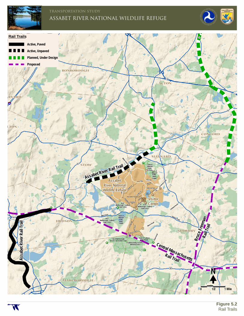
Bicycles are permitted only in the north tract of the Refuge. The pedestrian routes to the East, North, and Main Entrances are also used by bicyclists. More regional bicycle access will be available once nearby rail trails are fully constructed. There are three rail trails near the Refuge. The status and potential relationship to the Refuge are summarized below. The rail trails are shown on Figure 5.2.
Fairbank Road
Hudson Road
Sudbury Road
Main Street
Old Marlboro Road
White Pond Road Town ofMaynardPublic
SchoolsTown ofMaynardPublicWater
Supply
Town ofMaynardPublicWater
Supply
DCR:Marlborough - Sudbury
State Forest
DCR:Marlborough - Sudbury
State Forest
DCR:Marlborough - Sudbury
State Forest
City of Marlborough:Desert Conservation Land
Sudbury Valley Trustees:Memorial Forest
Town of Sudbury:Hop Brook
Moore Road
Duton
Roa
d
Towhee
Trail
Petapawag Trail
Tri-to
wn Trail
Otter Alley
Hill Tra
ilPine Garden Trail
PowerlineTrail
Fish
er L
oop
Fisher Loop
Sweet Fern Trail
Mink Link
Puffer Pond Trail
Patro
l Roa
d
Pond
Whi
te
Road
Harry's WayTaylor Way
PufferPond
Winterberry
Way
Winterberry
Way
STOW
ACTON
BOLTON
WAYLAND
HARVARD
HUDSON
BOXBOROUGH
FRAMINGHAM
MARLBOROUGH
SUDBURY
SOUTHBOROUGH
MAYNARD
CONCORD
20
20
20
495
90
495
2
62
2
85
126
30
30
27
111
111
117117
62
62
62
85
30
27
27
9
2A
111
117
0 1 2 Miles
Rail Trails
Active, Paved
Active, Unpaved
Planned, Under Design
Proposed
ASSABET RIVER NATIONAL WILDLIFE REFUGEtransportation study
Figure 5.2Rail Trails
�N
0 1/2 1 Mile
VisitorCenter
AssabetRiver NationalWildlife Refuge
Assabet River Rail Trail
Ass
abet
Riv
er R
ail T
rail
Central Massachusetts Rail Trail
Bruc
e Fr
eem
an
Rail
Trai
l
Assabet River National Wildlife Refuge – TRANSPORTATION PLANNING STUDY – EXISTING CONDITIONS REPORT
Existing Transportation Conditions 5-8 4/10/2012
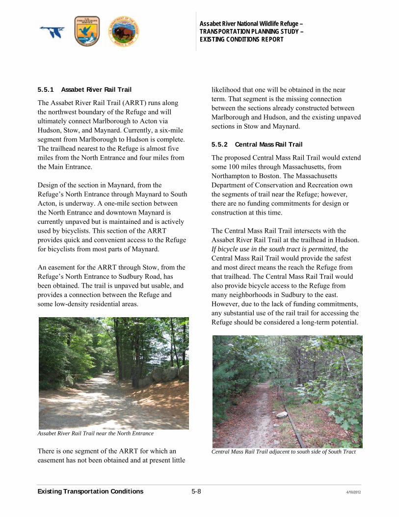
5.5.1 Assabet River Rail Trail
The Assabet River Rail Trail (ARRT) runs along the northwest boundary of the Refuge and will ultimately connect Marlborough to Acton via Hudson, Stow, and Maynard. Currently, a six-mile segment from Marlborough to Hudson is complete. The trailhead nearest to the Refuge is almost five miles from the North Entrance and four miles from the Main Entrance. Design of the section in Maynard, from the Refuge’s North Entrance through Maynard to South Acton, is underway. A one-mile section between the North Entrance and downtown Maynard is currently unpaved but is maintained and is actively used by bicyclists. This section of the ARRT provides quick and convenient access to the Refuge for bicyclists from most parts of Maynard. An easement for the ARRT through Stow, from the Refuge’s North Entrance to Sudbury Road, has been obtained. The trail is unpaved but usable, and provides a connection between the Refuge and some low-density residential areas.
Assabet River Rail Trail near the North Entrance There is one segment of the ARRT for which an easement has not been obtained and at present little
likelihood that one will be obtained in the near term. That segment is the missing connection between the sections already constructed between Marlborough and Hudson, and the existing unpaved sections in Stow and Maynard. 5.5.2 Central Mass Rail Trail
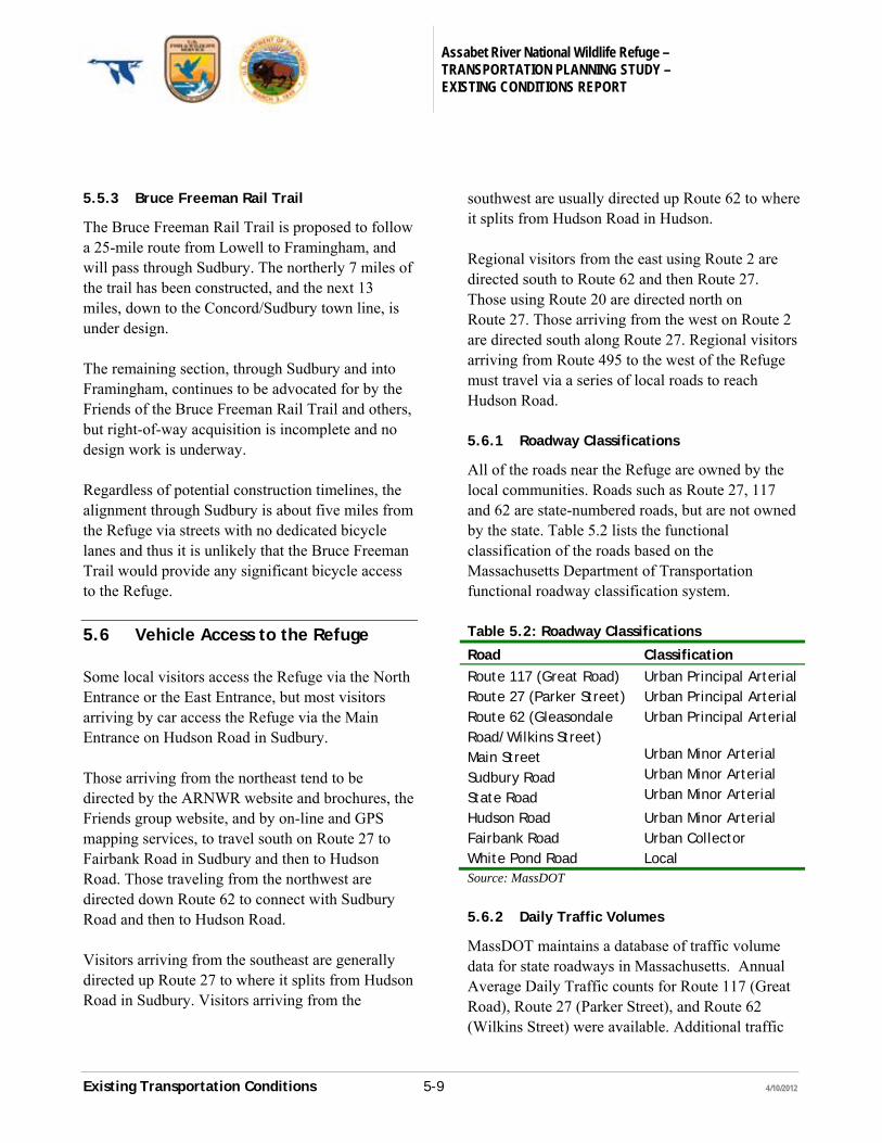
The proposed Central Mass Rail Trail would extend some 100 miles through Massachusetts, from Northampton to Boston. The Massachusetts Department of Conservation and Recreation own the segments of trail near the Refuge; however, there are no funding commitments for design or construction at this time. The Central Mass Rail Trail intersects with the Assabet River Rail Trail at the trailhead in Hudson. If bicycle use in the south tract is permitted, the Central Mass Rail Trail would provide the safest and most direct means the reach the Refuge from that trailhead. The Central Mass Rail Trail would also provide bicycle access to the Refuge from many neighborhoods in Sudbury to the east. However, due to the lack of funding commitments, any substantial use of the rail trail for accessing the Refuge should be considered a long-term potential.
Central Mass Rail Trail adjacent to south side of South Tract
Assabet River National Wildlife Refuge – TRANSPORTATION PLANNING STUDY – EXISTING CONDITIONS REPORT
Existing Transportation Conditions 5-9 4/10/2012
5.5.3 Bruce Freeman Rail Trail
The Bruce Freeman Rail Trail is proposed to follow a 25-mile route from Lowell to Framingham, and will pass through Sudbury. The northerly 7 miles of the trail has been constructed, and the next 13 miles, down to the Concord/Sudbury town line, is under design. The remaining section, through Sudbury and into Framingham, continues to be advocated for by the Friends of the Bruce Freeman Rail Trail and others, but right-of-way acquisition is incomplete and no design work is underway. Regardless of potential construction timelines, the alignment through Sudbury is about five miles from the Refuge via streets with no dedicated bicycle lanes and thus it is unlikely that the Bruce Freeman Trail would provide any significant bicycle access to the Refuge.
5.6 Vehicle Access to the Refuge
Some local visitors access the Refuge via the North Entrance or the East Entrance, but most visitors arriving by car access the Refuge via the Main Entrance on Hudson Road in Sudbury. Those arriving from the northeast tend to be directed by the ARNWR website and brochures, the Friends group website, and by on-line and GPS mapping services, to travel south on Route 27 to Fairbank Road in Sudbury and then to Hudson Road. Those traveling from the northwest are directed down Route 62 to connect with Sudbury Road and then to Hudson Road. Visitors arriving from the southeast are generally directed up Route 27 to where it splits from Hudson Road in Sudbury. Visitors arriving from the
southwest are usually directed up Route 62 to where it splits from Hudson Road in Hudson. Regional visitors from the east using Route 2 are directed south to Route 62 and then Route 27. Those using Route 20 are directed north on Route 27. Those arriving from the west on Route 2 are directed south along Route 27. Regional visitors arriving from Route 495 to the west of the Refuge must travel via a series of local roads to reach Hudson Road. 5.6.1 Roadway Classifications
All of the roads near the Refuge are owned by the local communities. Roads such as Route 27, 117 and 62 are state-numbered roads, but are not owned by the state. Table 5.2 lists the functional classification of the roads based on the Massachusetts Department of Transportation functional roadway classification system. Table 5.2: Roadway Classifications
Road Classification
Route 117 (Great Road) Urban Principal Arterial Route 27 (Parker Street) Urban Principal Arterial Route 62 (Gleasondale Road/Wilkins Street)
Urban Principal Arterial
Main Street Urban Minor Arterial
Sudbury Road Urban Minor Arterial
State Road Urban Minor Arterial
Hudson Road Urban Minor Arterial Fairbank Road Urban Collector White Pond Road Local Source: MassDOT
5.6.2 Daily Traffic Volumes
MassDOT maintains a database of traffic volume data for state roadways in Massachusetts. Annual Average Daily Traffic counts for Route 117 (Great Road), Route 27 (Parker Street), and Route 62 (Wilkins Street) were available. Additional traffic
Assabet River National Wildlife Refuge – TRANSPORTATION PLANNING STUDY – EXISTING CONDITIONS REPORT
Existing Transportation Conditions 5-10 4/10/2012
counts were conducted for this study on Sudbury Road, Hudson Road, and Winterberry Way. Weekday traffic As shown in Table 5.3, the weekday (two-way) traffic volumes on Hudson Road at the main entrance to the Refuge averages 9,600 vehicles. That is substantially higher than nearby on Route 62, and comparable to volumes nearby on Route 27. Weekday vehicle traffic into the Refuge is light, with an average of about 125 vehicle trips into and out of Winterberry Way. Table 5.3: Average Daily Traffic Volume
(Weekday)
Road Town ADT (year)
Maynard Road (Rte 27) Sudbury 10,200 (2004) Parker Street (Rte 27) Maynard 10,800 (2004) Great Road (Rte 117) Maynard 12,500 (2008) Wilkins Street (Rte 62) Hudson 5,000 (2008) Sudbury Road Stow 1,700 (2011) Hudson Road Sudbury 9,600 (2011) Winterberry Way ARNWR 125 (2011) Source: Traffic data from 2011 collected by VHB November 12-18, 2011. All other data from MassDOT.
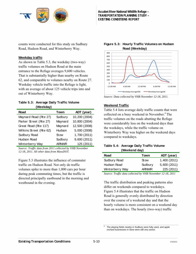
Figure 5.3 illustrates the influence of commuter traffic on Hudson Road. Not only do traffic volumes spike to more than 1,000 cars per hour during peak commuting times, but the traffic is directed principally eastbound in the morning and westbound in the evening.
Figure 5.3: Hourly Traffic Volumes on Hudson Road (Weekday)
Source: Data collected by VHB November 12-18, 2011.
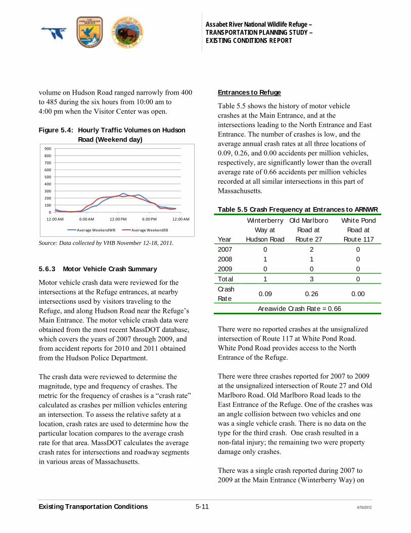
Weekend Traffic Table 5.4 lists average daily traffic counts that were collected on a busy weekend in November.6 The traffic volumes on the roads abutting the Refuge were considerably less on the weekend days than the weekdays, while the traffic volume on Winterberry Way was higher on the weekend days compared to weekdays. Table 5.4: Average Daily Traffic Volume
(Weekend day)
Road Town ADT (year)
Sudbury Road Stow 1,400 (2011) Hudson Road Sudbury 5,600 (2011) Winterberry Way ARNWR 225 (2011) Source: Traffic data collected by VHB November 12-18, 2011
The traffic distribution and peaking patterns also differ on weekends compared to weekdays. Figure 5.4 illustrates that the traffic on Hudson Road is generally evenly distributed by direction over the course of a weekend day and that the hourly volume is more consistent on a weekend day than on weekdays. The hourly (two-way) traffic
6 The playing fields nearby in Sudbury were fully used, and apple
orchard businesses in Stow were still very active.
0
100
200
300
400
500
600
700
800
900
12:00 AM 6:00 AM 12:00 PM 6:00 PM 12:00 AM
Weekday AverageWB Weekday AverageEB
Assabet River National Wildlife Refuge – TRANSPORTATION PLANNING STUDY – EXISTING CONDITIONS REPORT
Existing Transportation Conditions 5-11 4/10/2012
volume on Hudson Road ranged narrowly from 400 to 485 during the six hours from 10:00 am to 4:00 pm when the Visitor Center was open. Figure 5.4: Hourly Traffic Volumes on Hudson
Road (Weekend day)
Source: Data collected by VHB November 12-18, 2011. 5.6.3 Motor Vehicle Crash Summary
Motor vehicle crash data were reviewed for the intersections at the Refuge entrances, at nearby intersections used by visitors traveling to the Refuge, and along Hudson Road near the Refuge’s Main Entrance. The motor vehicle crash data were obtained from the most recent MassDOT database, which covers the years of 2007 through 2009, and from accident reports for 2010 and 2011 obtained from the Hudson Police Department. The crash data were reviewed to determine the magnitude, type and frequency of crashes. The metric for the frequency of crashes is a “crash rate” calculated as crashes per million vehicles entering an intersection. To assess the relative safety at a location, crash rates are used to determine how the particular location compares to the average crash rate for that area. MassDOT calculates the average crash rates for intersections and roadway segments in various areas of Massachusetts.
Entrances to Refuge
Table 5.5 shows the history of motor vehicle crashes at the Main Entrance, and at the intersections leading to the North Entrance and East Entrance. The number of crashes is low, and the average annual crash rates at all three locations of 0.09, 0.26, and 0.00 accidents per million vehicles, respectively, are significantly lower than the overall average rate of 0.66 accidents per million vehicles recorded at all similar intersections in this part of Massachusetts. Table 5.5 Crash Frequency at Entrances to ARNWR
Year
Winterberry Way at
Hudson Road
Old Marlboro Road at Route 27
White Pond Road at
Route 117
2007 0 2 0 2008 1 1 0 2009 0 0 0
Total 1 3 0
Crash Rate
0.09 0.26 0.00
Areawide Crash Rate = 0.66
There were no reported crashes at the unsignalized intersection of Route 117 at White Pond Road. White Pond Road provides access to the North Entrance of the Refuge. There were three crashes reported for 2007 to 2009 at the unsignalized intersection of Route 27 and Old Marlboro Road. Old Marlboro Road leads to the East Entrance of the Refuge. One of the crashes was an angle collision between two vehicles and one was a single vehicle crash. There is no data on the type for the third crash. One crash resulted in a non-fatal injury; the remaining two were property damage only crashes. There was a single crash reported during 2007 to 2009 at the Main Entrance (Winterberry Way) on
0
100
200
300
400
500
600
700
800
900
12:00 AM 6:00 AM 12:00 PM 6:00 PM 12:00 AM
Average WeekendWB Average WeekendEB
Assabet River National Wildlife Refuge – TRANSPORTATION PLANNING STUDY – EXISTING CONDITIONS REPORT
Existing Transportation Conditions 5-12 4/10/2012
Hudson Road. The crash was an angle crash that resulted in property damage only. It should be noted that the Visitor Center was not open during those years. However, a review of accident reports for 2010 and 2011 show no other crashes. Intersections Near the Refuge
Table 5.6 shows the history of motor vehicle crashes at four (unsignalized) intersections near the Refuge through which most visitors travel.
Sudbury Road at State Road is located ¾ of a mile west of the Main Entrance. Visitors arriving from the west travel through the intersection
Hudson Road at Route 27 is located about three miles from the Main Entrance and visitor from the south and east travel through the intersection.
Fairbank Road connects Route 27 to Hudson Road and is used by visitors arriving from north of the Refuge. Crash data for both intersections were reviewed.
All of the intersections have a crash rate that is less than the average for that area of Massachusetts. The number of accidents at the intersections ranges from one to three per year. Of the 26 crashes among the four intersections, only three involved a personal injury. Two of those occurred at the intersection of Route 27 at Fairbank Road, and one at the intersection of Route 27 (Maynard Road) at Hudson Road.
Table 5.6: Crash Frequency at Key Intersections
Year
Hudson Road at Fairbank
Road
Hudson Road at Maynard
Road
Maynard Road at Fairbank
Road
Sudbury Road at State Road
2007 3 6 1 2
2008 2 0 2 1
2009 2 3 4 0
Total 7 9 7 3
Crash Rate 0.63 0.52 0.59 0.27
Areawide Crash Rate = 0.66
Hudson Road/Sudbury Road/State Road Corridor
The Hudson Road/Sudbury Road/State Road corridor near the Main Entrance is a heavily traveled, two-lane road. Motor vehicle crash data for the corridor within one mile of the Main Entrance was reviewed. In the three years from 2007 to 2009 there were 16 crashes along the corridor to the west of the Main Entrance, and 23 crashes to the east. The crash rates were 1.96 and 2.03, respectively and both are below the average crash rate of 3.73 for similar road segments in that area of Massachusetts. There were no crashes reported within 1,000 feet of the Main Entrance. 5.6.3 Sight Distance at the Main Entrance
Intersection sight distance (ISD) and stopping sight distances (SSD) were measured at the Main Entrance intersection of Winterberry Way and Hudson Road. As shown in Table 5.7, all sight distances were within acceptable ranges. At this intersection, stopping sight distance is the distance required for a vehicle on Hudson Road to perceive a situation, react, and come to a complete stop. Intersection sight distance is the distance
Assabet River National Wildlife Refuge – TRANSPORTATION PLANNING STUDY – EXISTING CONDITIONS REPORT
Existing Transportation Conditions 5-13 4/10/2012
necessary for a driver exiting Winterberry Way onto Hudson Road to do so safely. Table 5.7: Sight Distances at the Main Entrance
Desirable
(feet) Observed
(feet)
Intersection Sight Distance Looking West 375 440 Looking East 430 1,250 Stopping Sight Distance Traveling Eastbound 290 420 Traveling Westbound 290 1,210
Note: Desirable sight distances are as per A Policy on Geometric Design of Highways and Streets (AASHTO, 2004) for the observed speed of 39 mph.
5.6.3 Planned Area Transportation Improvement Projects
The State Transportation Improvement Plan (STIP) was reviewed for projects planned near the Refuge. There are no roadway projects currently on the STIP that would likely have a noticeable impact on the traffic network near the Refuge.
5.7 Mobility and Transportation Infrastructure within the Refuge
The Refuge contains 15.4 miles of trails and roads open to the public, including 7.7 miles on which bicycles are allowed. There are 1.3 miles of road open to private vehicles and several miles of roads restricted for use by USFWS and two easement holders. In addition, most of the trails are occasionally, but routinely, traveled by USFWS motor vehicles for administrative and management purposes. 5.7.1 Parking
There are currently four designated public parking areas within the Refuge, one of which is being
expanded, and a fifth that is under construction. Once construction is complete in the spring of 2012 there will be 111 parking spaces at the Refuge. There is a 9-space parking lot at the Main Entrance, 48 spaces near the Visitor Center, and 15 spaces at the end of Winterberry Way near Carbary’s Trail. All three parking areas were constructed in 2009/2010 and are in excellent condition. The parking for the North Entrance has been a graveled area that could accommodate at least 15 cars. A new paved parking lot is under construction at the same site. The new lot will have 31 parking spaces. There had been no designated parking at the East Entrance. Visitors parked on street at the end of Old Marlboro Road, where there is room for about four cars. A new 8-space parking lot is under construction.
Assabet River National Wildlife Refuge – TRANSPORTATION PLANNING STUDY – EXISTING CONDITIONS REPORT
Existing Transportation Conditions 5-14 4/10/2012
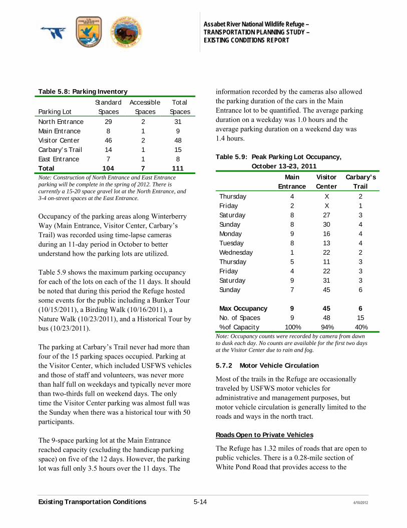
Table 5.8: Parking Inventory
Parking Lot
Standard Spaces
Accessible Spaces
Total Spaces
North Entrance 29 2 31 Main Entrance 8 1 9 Visitor Center 46 2 48 Carbary’s Trail 14 1 15 East Entrance 7 1 8 Total 104 7 111 Note: Construction of North Entrance and East Entrance parking will be complete in the spring of 2012. There is currently a 15-20 space gravel lot at the North Entrance, and 3-4 on-street spaces at the East Entrance.
Occupancy of the parking areas along Winterberry Way (Main Entrance, Visitor Center, Carbary’s Trail) was recorded using time-lapse cameras during an 11-day period in October to better understand how the parking lots are utilized. Table 5.9 shows the maximum parking occupancy for each of the lots on each of the 11 days. It should be noted that during this period the Refuge hosted some events for the public including a Bunker Tour (10/15/2011), a Birding Walk (10/16/2011), a Nature Walk (10/23/2011), and a Historical Tour by bus (10/23/2011). The parking at Carbary’s Trail never had more than four of the 15 parking spaces occupied. Parking at the Visitor Center, which included USFWS vehicles and those of staff and volunteers, was never more than half full on weekdays and typically never more than two-thirds full on weekend days. The only time the Visitor Center parking was almost full was the Sunday when there was a historical tour with 50 participants. The 9-space parking lot at the Main Entrance reached capacity (excluding the handicap parking space) on five of the 12 days. However, the parking lot was full only 3.5 hours over the 11 days. The
information recorded by the cameras also allowed the parking duration of the cars in the Main Entrance lot to be quantified. The average parking duration on a weekday was 1.0 hours and the average parking duration on a weekend day was 1.4 hours. Table 5.9: Peak Parking Lot Occupancy,
October 13–23, 2011
Main Entrance
Visitor Center
Carbary’s Trail
Thursday 4 X 2 Friday 2 X 1 Saturday 8 27 3 Sunday 8 30 4 Monday 9 16 4 Tuesday 8 13 4 Wednesday 1 22 2 Thursday 5 11 3 Friday 4 22 3 Saturday 9 31 3 Sunday 7 45 6 Max Occupancy 9 45 6 No. of Spaces 9 48 15 % of Capacity 100% 94% 40%
Note: Occupancy counts were recorded by camera from dawn to dusk each day. No counts are available for the first two days at the Visitor Center due to rain and fog.
5.7.2 Motor Vehicle Circulation
Most of the trails in the Refuge are occasionally traveled by USFWS motor vehicles for administrative and management purposes, but motor vehicle circulation is generally limited to the roads and ways in the north tract. Roads Open to Private Vehicles
The Refuge has 1.32 miles of roads that are open to public vehicles. There is a 0.28-mile section of White Pond Road that provides access to the
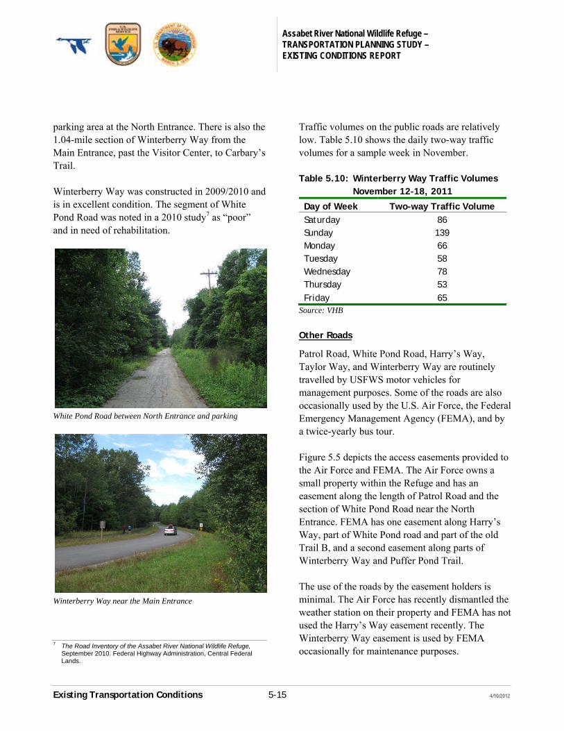
Assabet River National Wildlife Refuge – TRANSPORTATION PLANNING STUDY – EXISTING CONDITIONS REPORT
Existing Transportation Conditions 5-15 4/10/2012
parking area at the North Entrance. There is also the 1.04-mile section of Winterberry Way from the Main Entrance, past the Visitor Center, to Carbary’s Trail. Winterberry Way was constructed in 2009/2010 and is in excellent condition. The segment of White Pond Road was noted in a 2010 study7 as “poor” and in need of rehabilitation.
White Pond Road between North Entrance and parking
Winterberry Way near the Main Entrance
7 The Road Inventory of the Assabet River National Wildlife Refuge,
September 2010. Federal Highway Administration, Central Federal Lands.
Traffic volumes on the public roads are relatively low. Table 5.10 shows the daily two-way traffic volumes for a sample week in November. Table 5.10: Winterberry Way Traffic Volumes
November 12-18, 2011
Day of Week Two-way Traffic Volume Saturday 86 Sunday 139 Monday 66 Tuesday 58 Wednesday 78 Thursday 53 Friday 65
Source: VHB
Other Roads
Patrol Road, White Pond Road, Harry’s Way, Taylor Way, and Winterberry Way are routinely travelled by USFWS motor vehicles for management purposes. Some of the roads are also occasionally used by the U.S. Air Force, the Federal Emergency Management Agency (FEMA), and by a twice-yearly bus tour. Figure 5.5 depicts the access easements provided to the Air Force and FEMA. The Air Force owns a small property within the Refuge and has an easement along the length of Patrol Road and the section of White Pond Road near the North Entrance. FEMA has one easement along Harry’s Way, part of White Pond road and part of the old Trail B, and a second easement along parts of Winterberry Way and Puffer Pond Trail. The use of the roads by the easement holders is minimal. The Air Force has recently dismantled the weather station on their property and FEMA has not used the Harry’s Way easement recently. The Winterberry Way easement is used by FEMA occasionally for maintenance purposes.
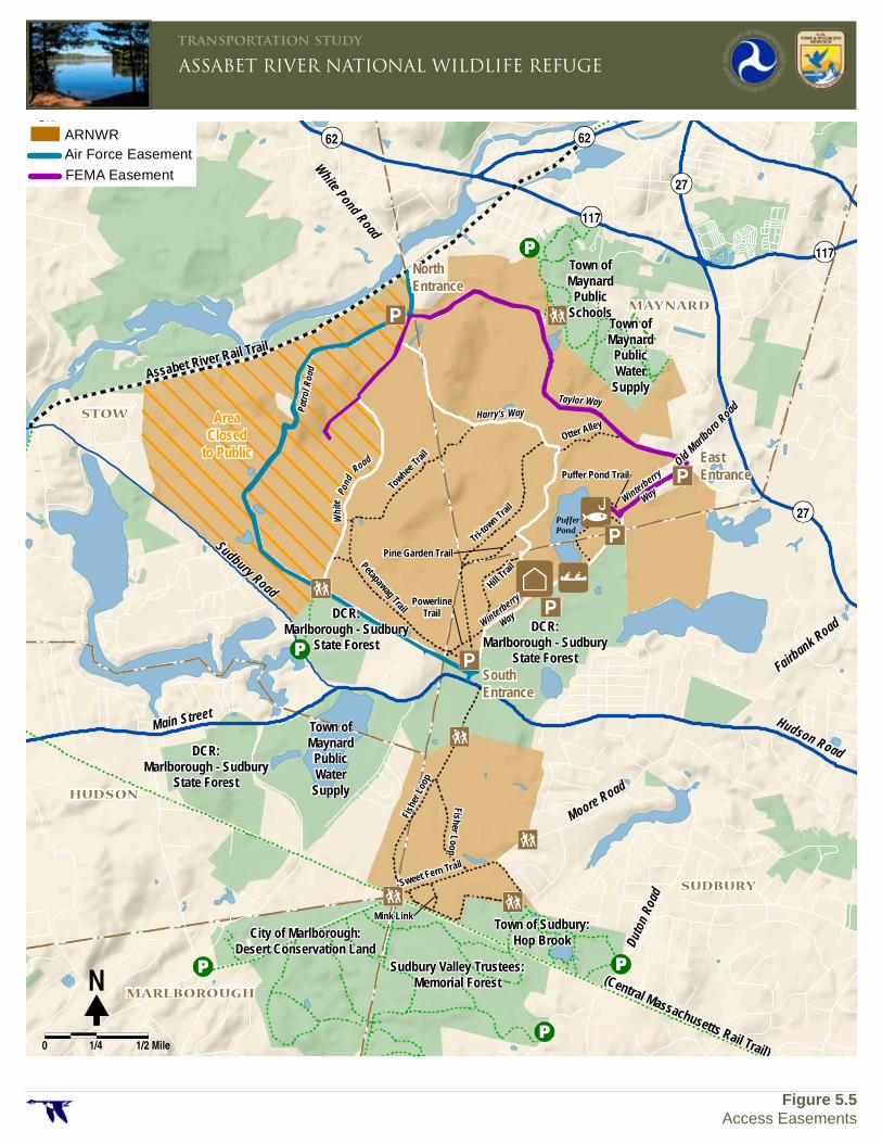
Fairbank Road
Hudson Road
Sudbury Road
Main Street
Old Marlboro Road
Assabet River Rail Trail
(Central Massachusetts Rail Trail)
Town ofMaynard
PublicSchools
Town ofMaynard
PublicWater
Supply
Town ofMaynard
PublicWater
Supply
DCR:Marlborough - Sudbury
State Forest
DCR:Marlborough - Sudbury
State Forest
DCR:Marlborough - Sudbury
State Forest
City of Marlborough:Desert Conservation Land
Sudbury Valley Trustees:Memorial Forest
Town of Sudbury:Hop Brook
Moore Road
Duto
n Roa
d
Towhee
Trail
Petapawag Trail
Tri-to
wn Trail
Otter Alley
Hill Trai
lPine Garden Trail
PowerlineTrail
Fish
er L
oop
Fisher Loop
Sweet Fern Trail
Mink Link
Puffer Pond Trail
Patro
l Roa
d
Pond
Whi
te
Road
Harry's WayTaylor Way
PufferPond
Winterberry
Way
Winterberry
Way
White Pond Road
62 62
117
27
27
117
STOW
HUDSON
MARLBOROUGH
SUDBURY
MAYNARD
ARNWRAir Force Easement
FEMA Easement
�N
0 1/4 1/2 Mile
ASSABET RIVER NATIONAL WILDLIFE REFUGEtransportation study
Figure 5.5Access Easements
NorthEntrance
EastEntrance
SouthEntrance
AreaClosed
to Public
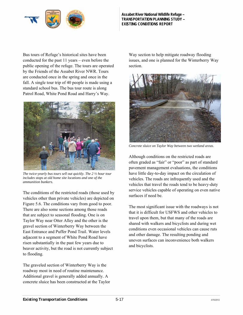
Assabet River National Wildlife Refuge – TRANSPORTATION PLANNING STUDY – EXISTING CONDITIONS REPORT
Existing Transportation Conditions 5-17 4/10/2012
Bus tours of Refuge’s historical sites have been conducted for the past 11 years – even before the public opening of the refuge. The tours are operated by the Friends of the Assabet River NWR. Tours are conducted once in the spring and once in the fall. A single tour trip of 40 people is made using a standard school bus. The bus tour route is along Patrol Road, White Pond Road and Harry’s Way.
The twice-yearly bus tours sell out quickly. The 2 ½ hour tour includes stops at old home site locations and one of the ammunition bunkers.
The conditions of the restricted roads (those used by vehicles other than private vehicles) are depicted on Figure 5.6. The conditions vary from good to poor. There are also some sections among those roads that are subject to seasonal flooding. One is on Taylor Way near Otter Alley and the other is the gravel section of Winterberry Way between the East Entrance and Puffer Pond Trail. Water levels adjacent to a segment of White Pond Road have risen substantially in the past few years due to beaver activity, but the road is not currently subject to flooding. The graveled section of Winterberry Way is the roadway most in need of routine maintenance. Additional gravel is generally added annually. A concrete sluice has been constructed at the Taylor
Way section to help mitigate roadway flooding issues, and one is planned for the Winterberry Way section.
Concrete sluice on Taylor Way between two wetland areas.
Although conditions on the restricted roads are often graded as “fair” or “poor” as part of standard pavement management evaluations, the conditions have little day-to-day impact on the circulation of vehicles. The roads are infrequently used and the vehicles that travel the roads tend to be heavy-duty service vehicles capable of operating on even native surfaces if need be. The most significant issue with the roadways is not that it is difficult for USFWS and other vehicles to travel upon them, but that many of the roads are shared with walkers and bicyclists and during wet conditions even occasional vehicles can cause ruts and other damage. The resulting ponding and uneven surfaces can inconvenience both walkers and bicyclists.
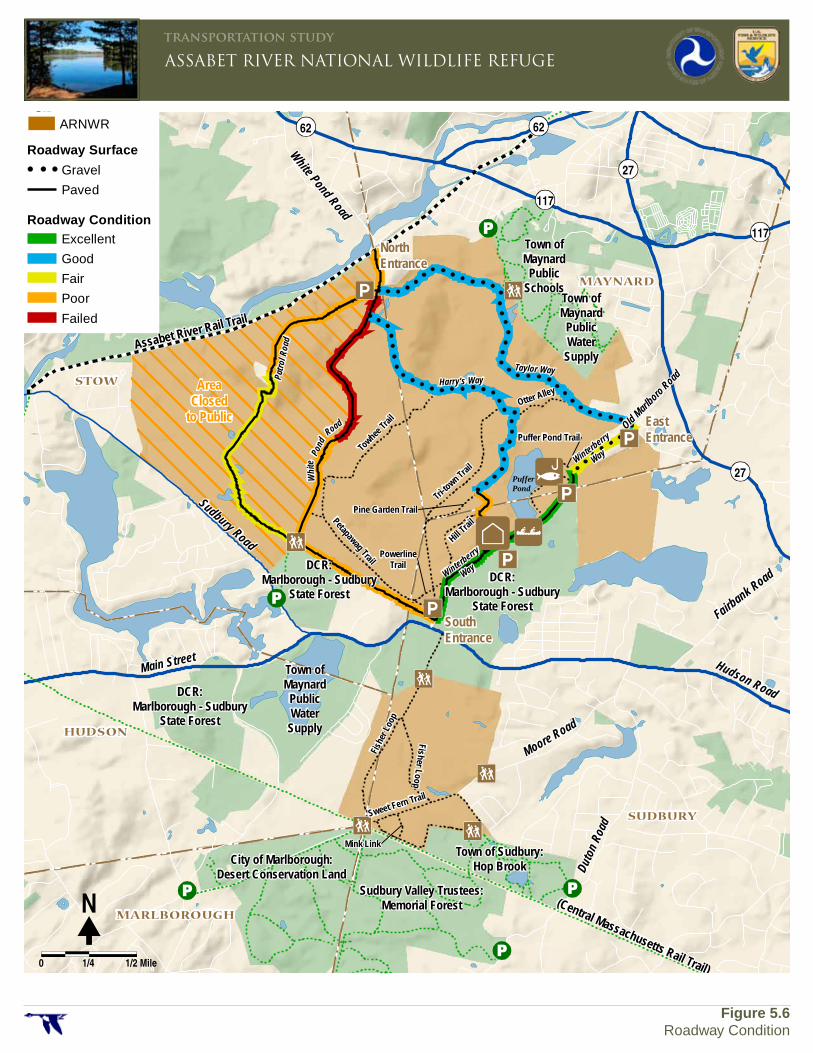
Fairbank Road
Hudson Road
Sudbury Road
Main Street
Old Marlboro Road
Assabet River Rail Trail
(Central Massachusetts Rail Trail)
Town ofMaynard
PublicSchools
Town ofMaynard
PublicWater
Supply
Town ofMaynard
PublicWater
Supply
DCR:Marlborough - Sudbury
State Forest
DCR:Marlborough - Sudbury
State Forest
DCR:Marlborough - Sudbury
State Forest
City of Marlborough:Desert Conservation Land
Sudbury Valley Trustees:Memorial Forest
Town of Sudbury:Hop Brook
Moore Road
Duto
n Roa
d
Towhee
Trail
Petapawag Trail
Tri-to
wn Trail
Otter Alley
Hill Trai
lPine Garden Trail
PowerlineTrail
Fish
er L
oop
Fisher Loop
Sweet Fern Trail
Mink Link
Puffer Pond Trail
Patro
l Roa
d
Pond
Whi
te
Road
Harry's WayTaylor Way
PufferPond
Winterberry
Way
Winterberry
Way
White Pond Road
62 62
117
27
27
117
STOW
HUDSON
MARLBOROUGH
SUDBURY
MAYNARD
ARNWR
Roadway SurfaceGravel
Paved
Excellent
Good
Fair
Poor
Failed
Roadway Condition
�N
0 1/4 1/2 Mile
ASSABET RIVER NATIONAL WILDLIFE REFUGEtransportation study
Figure 5.6 Roadway Condition
NorthEntrance
EastEntrance
SouthEntrance
AreaClosed
to Public
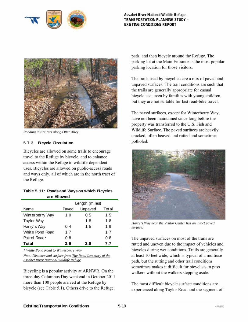
Assabet River National Wildlife Refuge – TRANSPORTATION PLANNING STUDY – EXISTING CONDITIONS REPORT
Existing Transportation Conditions 5-19 4/10/2012
Ponding in tire ruts along Otter Alley.
5.7.3 Bicycle Circulation
Bicycles are allowed on some trails to encourage travel to the Refuge by bicycle, and to enhance access within the Refuge to wildlife-dependent uses. Bicycles are allowed on public-access roads and ways only, all of which are in the north tract of the Refuge. Table 5.11: Roads and Ways on which Bicycles
are Allowed
Length (miles) Name Paved Unpaved Total
Winterberry Way 1.0 0.5 1.5 Taylor Way 1.8 1.8 Harry’s Way 0.4 1.5 1.9 White Pond Road 1.7 1.7 Patrol Road* 0.8 0.8 Total 3.9 3.8 7.7
* White Pond Road to Winterberry Way
Note: Distance and surface from The Road Inventory of the Assabet River National Wildlife Refuge.
Bicycling is a popular activity at ARNWR. On the three-day Columbus Day weekend in October 2011 more than 100 people arrived at the Refuge by bicycle (see Table 5.1). Others drive to the Refuge,
park, and then bicycle around the Refuge. The parking lot at the Main Entrance is the most popular parking location for those visitors. The trails used by bicyclists are a mix of paved and unpaved surfaces. The trail conditions are such that the trails are generally appropriate for casual bicycle use, even by families with young children, but they are not suitable for fast road-bike travel. The paved surfaces, except for Winterberry Way, have not been maintained since long before the property was transferred to the U.S. Fish and Wildlife Surface. The paved surfaces are heavily cracked, often heaved and rutted and sometimes potholed.
Harry’s Way near the Visitor Center has an intact paved surface.
The unpaved surfaces on most of the trails are rutted and uneven due to the impact of vehicles and bicycles during wet conditions. Trails are generally at least 10 feet wide, which is typical of a multiuse path, but the rutting and other trail conditions sometimes makes it difficult for bicyclists to pass walkers without the walkers stepping aside. The most difficult bicycle surface conditions are experienced along Taylor Road and the segment of
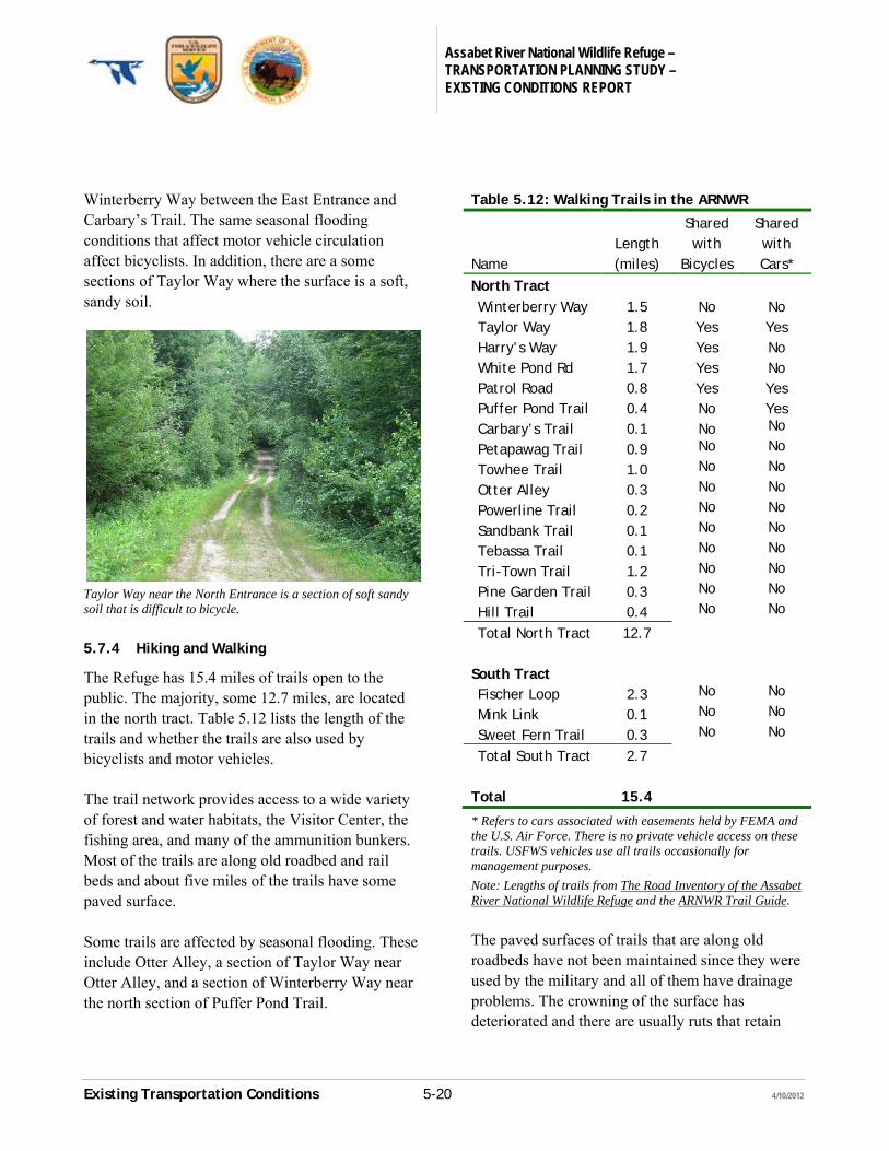
Assabet River National Wildlife Refuge – TRANSPORTATION PLANNING STUDY – EXISTING CONDITIONS REPORT
Existing Transportation Conditions 5-20 4/10/2012
Winterberry Way between the East Entrance and Carbary’s Trail. The same seasonal flooding conditions that affect motor vehicle circulation affect bicyclists. In addition, there are a some sections of Taylor Way where the surface is a soft, sandy soil.
Taylor Way near the North Entrance is a section of soft sandy soil that is difficult to bicycle.
5.7.4 Hiking and Walking
The Refuge has 15.4 miles of trails open to the public. The majority, some 12.7 miles, are located in the north tract. Table 5.12 lists the length of the trails and whether the trails are also used by bicyclists and motor vehicles. The trail network provides access to a wide variety of forest and water habitats, the Visitor Center, the fishing area, and many of the ammunition bunkers. Most of the trails are along old roadbed and rail beds and about five miles of the trails have some paved surface. Some trails are affected by seasonal flooding. These include Otter Alley, a section of Taylor Way near Otter Alley, and a section of Winterberry Way near the north section of Puffer Pond Trail.
Table 5.12: Walking Trails in the ARNWR
Name
Length (miles)
Shared with
Bicycles
Shared with Cars*
North Tract Winterberry Way 1.5 No No Taylor Way 1.8 Yes Yes Harry’s Way 1.9 Yes No White Pond Rd 1.7 Yes No Patrol Road 0.8 Yes Yes Puffer Pond Trail 0.4 No Yes Carbary’s Trail 0.1 No No
Petapawag Trail 0.9 No No
Towhee Trail 1.0 No No
Otter Alley 0.3 No No
Powerline Trail 0.2 No No
Sandbank Trail 0.1 No No
Tebassa Trail 0.1 No No
Tri-Town Trail 1.2 No No
Pine Garden Trail 0.3 No No
Hill Trail 0.4 No No
Total North Tract 12.7 South Tract Fischer Loop 2.3 No No
Mink Link 0.1 No No
Sweet Fern Trail 0.3 No No
Total South Tract 2.7 Total 15.4
* Refers to cars associated with easements held by FEMA and the U.S. Air Force. There is no private vehicle access on these trails. USFWS vehicles use all trails occasionally for management purposes.
Note: Lengths of trails from The Road Inventory of the Assabet River National Wildlife Refuge and the ARNWR Trail Guide.
The paved surfaces of trails that are along old roadbeds have not been maintained since they were used by the military and all of them have drainage problems. The crowning of the surface has deteriorated and there are usually ruts that retain
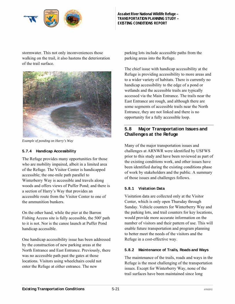
Assabet River National Wildlife Refuge – TRANSPORTATION PLANNING STUDY – EXISTING CONDITIONS REPORT
Existing Transportation Conditions 5-21 4/10/2012
stormwater. This not only inconveniences those walking on the trail, it also hastens the deterioration of the trail surface.
Example of ponding on Harry’s Way
5.7.4 Handicap Accessibility
The Refuge provides many opportunities for those who are mobility impaired, albeit in a limited area of the Refuge. The Visitor Center is handicapped accessible; the one-mile path parallel to Winterberry Way is accessible and travels along woods and offers views of Puffer Pond; and there is a section of Harry’s Way that provides an accessible route from the Visitor Center to one of the ammunition bunkers. On the other hand, while the pier at the Barron Fishing Access site is fully accessible, the 500′ path to it is not. Nor is the canoe launch at Puffer Pond handicap accessible. One handicap accessibility issue has been addressed by the construction of new parking areas at the North Entrance and East Entrance. Previously, there was no accessible path past the gates at those locations. Visitors using wheelchairs could not enter the Refuge at either entrance. The new
parking lots include accessible paths from the parking areas into the Refuge. The chief issue with handicap accessibility at the Refuge is providing accessibility to more areas and to a wider variety of habitats. There is currently no handicap accessibility to the edge of a pond or wetlands and the accessible trails are typically accessed via the Main Entrance. The trails near the East Entrance are rough, and although there are some segments of accessible trails near the North Entrance, they are not linked and there is no opportunity for a fully accessible loop.
5.8 Major Transportation Issues and Challenges at the Refuge
Many of the major transportation issues and challenges at ARNWR were identified by USFWS prior to this study and have been reviewed as part of the existing conditions work, and other issues have been identified during the existing conditions phase of work by stakeholders and the public. A summary of those issues and challenges follows. 5.8.1 Visitation Data
Visitation data are collected only at the Visitor Center, which is only open Thursday through Sunday. Vehicle counters for Winterberry Way and the parking lots, and trail counters for key locations, would provide more accurate information on the number of visitors and their pattern of use. This will enable future transportation and program planning to better meet the needs of the visitors and the Refuge in a cost-effective way. 5.8.2 Maintenance of Trails, Roads and Ways
The maintenance of the trails, roads and ways in the Refuge is the most challenging of the transportation issues. Except for Winterberry Way, none of the trail surfaces have been maintained since long
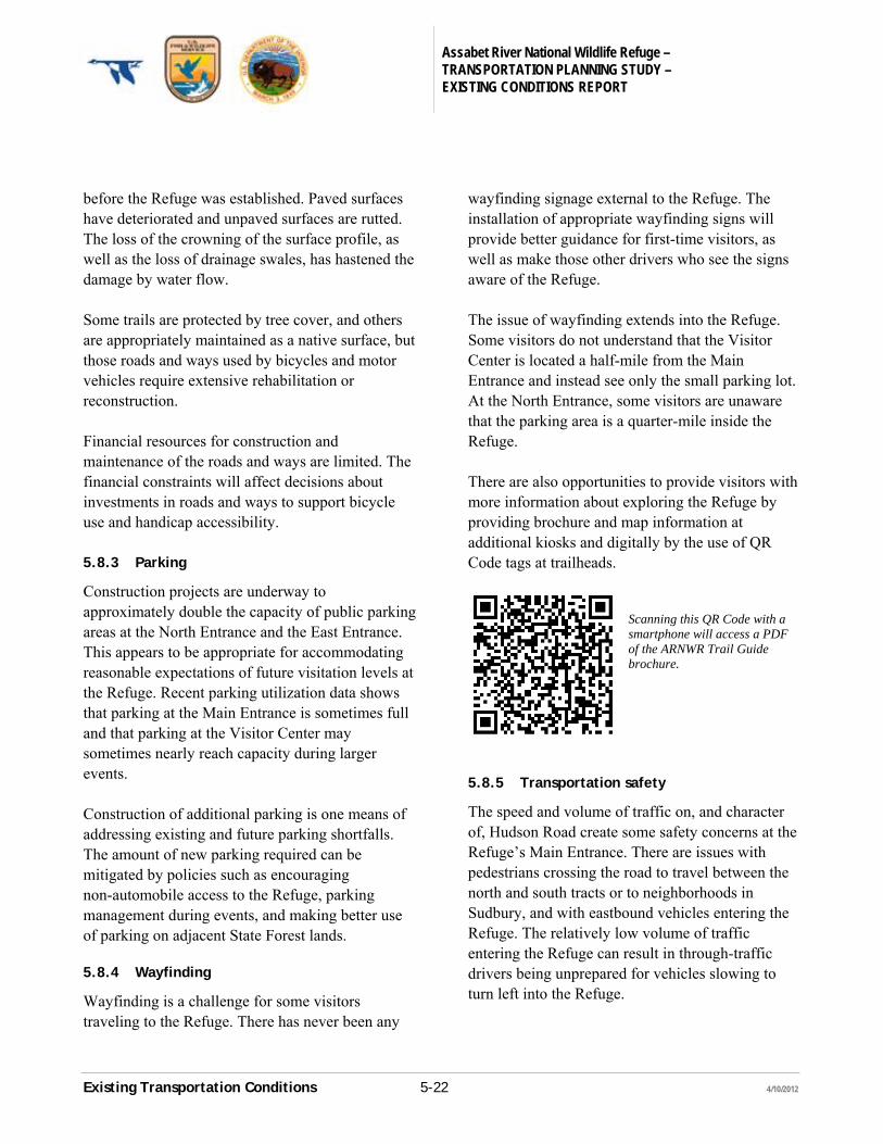
Assabet River National Wildlife Refuge – TRANSPORTATION PLANNING STUDY – EXISTING CONDITIONS REPORT
Existing Transportation Conditions 5-22 4/10/2012
before the Refuge was established. Paved surfaces have deteriorated and unpaved surfaces are rutted. The loss of the crowning of the surface profile, as well as the loss of drainage swales, has hastened the damage by water flow. Some trails are protected by tree cover, and others are appropriately maintained as a native surface, but those roads and ways used by bicycles and motor vehicles require extensive rehabilitation or reconstruction. Financial resources for construction and maintenance of the roads and ways are limited. The financial constraints will affect decisions about investments in roads and ways to support bicycle use and handicap accessibility. 5.8.3 Parking
Construction projects are underway to approximately double the capacity of public parking areas at the North Entrance and the East Entrance. This appears to be appropriate for accommodating reasonable expectations of future visitation levels at the Refuge. Recent parking utilization data shows that parking at the Main Entrance is sometimes full and that parking at the Visitor Center may sometimes nearly reach capacity during larger events. Construction of additional parking is one means of addressing existing and future parking shortfalls. The amount of new parking required can be mitigated by policies such as encouraging non-automobile access to the Refuge, parking management during events, and making better use of parking on adjacent State Forest lands. 5.8.4 Wayfinding
Wayfinding is a challenge for some visitors traveling to the Refuge. There has never been any
wayfinding signage external to the Refuge. The installation of appropriate wayfinding signs will provide better guidance for first-time visitors, as well as make those other drivers who see the signs aware of the Refuge. The issue of wayfinding extends into the Refuge. Some visitors do not understand that the Visitor Center is located a half-mile from the Main Entrance and instead see only the small parking lot. At the North Entrance, some visitors are unaware that the parking area is a quarter-mile inside the Refuge. There are also opportunities to provide visitors with more information about exploring the Refuge by providing brochure and map information at additional kiosks and digitally by the use of QR Code tags at trailheads.
Scanning this QR Code with a smartphone will access a PDF of the ARNWR Trail Guide brochure.
5.8.5 Transportation safety
The speed and volume of traffic on, and character of, Hudson Road create some safety concerns at the Refuge’s Main Entrance. There are issues with pedestrians crossing the road to travel between the north and south tracts or to neighborhoods in Sudbury, and with eastbound vehicles entering the Refuge. The relatively low volume of traffic entering the Refuge can result in through-traffic drivers being unprepared for vehicles slowing to turn left into the Refuge.
Assabet River National Wildlife Refuge – TRANSPORTATION PLANNING STUDY – EXISTING CONDITIONS REPORT
Existing Transportation Conditions 5-23 4/10/2012
The options for addressing safety concerns range from near-term projects of signage, lighting and maintenance of roadside vegetation, to long-term projects such as constructing a left-turn lane or relocating the entrance to the east. 5.8.6 Handicap Accessibility
Providing handicap accessibility to the canoe launch and the fishing area at Puffer Pond is a priority for the Refuge. There are also many other opportunities to enhance the experience at the Refuge for all those who are mobility impaired. Some of these opportunities may be achieved through policy changes such as where disabled hunters may take their cars. Others could be realized through education outreach programs oriented to those who are physically disabled. A mobility-assistance shuttle service would increase access within the Refuge for many visitors. Some opportunities can be achieved by physical improvements. Rehabilitation of the existing trails to eliminate ruts and uneven surfaces would benefit all persons with mobility disabilities. Some trails could be reconstructed to be fully handicap-accessible, particularly those in areas that provide access to a wider variety of habitats than provided the existing accessible trail network. 5.8.7 Community Connections
The Refuge benefits from the existing pedestrian and bicycle connections with nearby neighborhoods. They facilitate visitation while mitigating the need for additional on-site motor vehicle parking. The North Entrance and the Main Entrance have good pedestrian access, and a sidewalk is being constructed in 2012 by the Town of Maynard on Route 27 that will fill a missing link in the
neighborhood sidewalk network near the East Entrance. Bicycle access from Maynard and parts of Sudbury is also good and there are opportunities to improve bicycle access from other sections of Sudbury and from Stow and Hudson by connecting to regional rail trail projects. However, the most promising project, the proposed Central Mass Rail Trail, connects to the south tract and bicycling is not currently an allowed use in that part of the Refuge. 5.8.8 Educational Outreach
Educational outreach is an important objective of the Refuge and a significant part of the current visitations. Transportation strategies can support educational outreach efforts in a variety of direct and indirect ways. An electric charging station provides educational opportunities. A shuttle vehicle could be available to transport school groups to learning sites within the Refuge, or a scheduled shuttle service could be implemented to provide regular tours for all visitors.