Embed Size (px)
Citation preview
Journal of Environmental Management (1997) 50, 301–320
Assessing Floodplain Regulation in Glen Williams, Ontario, Canada
∗Dan Shrubsole, ∗Vicki J. Hammond, †Reid Kreutzwiser and†Ian Woodley
∗Department of Geography, University of Western Ontario, London, Ontario,Canada, N6A 5C2, and †Department of Geography, University of Guelph, Guelph,Ontario, Canada, N1G 2W1
Received 17 March 1996; accepted 23 January 1997
Concerns have been expressed about Ontario’s floodplain management policy.Specifically, it has been argued that the policy: (1) lacked an effectiveconceptual and practical basis; (2) did not clarify the issue of jurisdiction overriverine lands; (3) did not come to grips with financial arrangements; (4)provided inadequate enforcement procedures; and, (5) inadequately addressedcommunications problems. This paper reviews these issues through anexamination of the implementation of floodplain land use regulations in GlenWilliams, Ontario, Canada. Utilizing a mix of data sources available throughthe Credit Valley Conservation Authority office, questionnaires administered tofloodplain residents and interviews with relevant government officials, the studyconcludes that despite the continued presence of these concerns, the regulatoryprocess is working reasonably well. There is some concern regarding theinterpretation of the one-zone policy between 1984 and 1988. In the nearfuture, the ability of this and similiar regulatory efforts in the Province ofOntario could become more difficult with increased demands and fewerresources. Implications for future activities are noted. 1997 Academic Press Limited
Keywords: floodplain management, non-structural adjustments, floodplain landuse regulations, Ontario, conservation authorities, Credit River.
1. Introduction
In the late 1970s, the Ontario Government proposed significant changes to the province’sfloodplain management policy (Anon, 1977). Two cornerstones of the proposed policyplaced greater responsibility on municipalities, and provided more flexibility in regulatingfloodplain land uses through a two-zone policy concept. Gardner and Mitchell (1980)suggested that these changes inadequately dealt with five basic issues: (1) the conceptualand practical implications of the two-zone model; (2) jurisdiction and responsibilityover riverine lands; (3) financial arrangements which have favoured structural solutions;(4) enforcement procedures; and (5) communications within and among government.
0301–4797/97/070301+20 $25.00/0/ev970111 1997 Academic Press Limited
Assessing floodplain regulation302
Land use regulation continues to be a popular floodplain management approach,although one which has sometimes been too readily and uncritically adopted (Parkerand Penning-Rowsell, 1983; Wescoat, 1987). Bollens et al. (1988) noted that, despitethe widespread application of floodplain regulations in the United States, little evaluationhad been undertaken of their impact.
Where empirical study of environmental regulations, such as pollution controls, hasbeen undertaken, evidence of the efficacy of regulations is inconclusive (Burby, 1995).Drawbacks cited included the need for aggressive surveillance, unwillingness of thecourts to impose severe sanctions, and creation of a confrontational situation thatimpaired efforts to assist those who violate regulations because of a poor understandingof the regulatory process and its requirements. An evaluation of land use regulationsin the context of shoreline flood and erosion hazards in Ontario, Canada, found thatlack of awareness of regulations by property owners and inadequate sanctions impairedthe effectiveness of these regulations (Kreutzwiser and Slaats, 1994). Interestingly,support for regulations was greater among those property owners who had a goodunderstanding of the purpose of regulations.
Environmental regulations have come under greater scrutiny in recent years. Burby(1995) summarized the growing debate over the coercive application of regulationsrelative to more cooperative approaches that may involve negotiation and incentivesto encourage attainment of environmental objectives. Proponents of a more cooperativeapproach argue that this approach builds political support for environmental objectivesamong individuals and enterprises to whom regulations are targeted, and amongintermediary organizations, such as local municipalities. In a floodplain managementcontext, a shift from coercion to cooperation is evident in New South Wales, Australia.Under a stringent regulatory program between 1977 and 1984, municipalities enforceda two-zone flood policy. State sanctions for non-compliance included loss of subsidiesfor municipal infrastructure. In 1984, this policy was abandoned in favour of acooperative approach that specified flood management goals and left it to municipalitiesto find the most appropriate means of meeting these goals (Smith and Handmer, 1994).Given the growing debate over floodplain management, and the relative lack of empiricalinvestigations of regulatory approaches, it is instructive to consider an Ontario example.
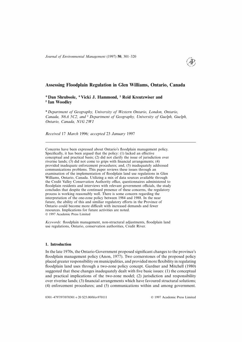
This article examines the implementation of floodplain land use regulations by theCredit Valley Conservation Authority (CVCA) in the hamlet of Glen Williams, whichis located within the municipality of Halton Hills, Ontario (Figure 1). The regulation(permit) files for Glen Williams for the period 1978 to 1989 were the main data source.Other relevant technical and planning documents were reviewed. Ontario base maps(1:2000) produced in 1982 and aerial photographs taken in 1990 were used to recordchanges in land uses and structures over the study period. Field visits and interviewswith homeowners and personnel from the CVCA, relevant provincial and local agencieswere conducted. To enhance the relevance of the research, changes to CVCA floodplainpolicies up to June 1995 are noted. The aim was to provide a better understanding ofthe strengths and weaknesses of regulation as an environmental management approach.
The paper is organized into three parts. First, conservation authorities and recentdevelopments in floodplain management policy are described. Second, the case studysite and relevant CVCA policies are outlined. Third, the five basic issues of floodplainmanagement which were noted by Gardner and Mitchell (1980) are used to examinemanagement practice in the Credit River valley. Conclusions and implications are notedin the final section.
D. Shrubsole et al. 303aaaaGeorgianBay
84° W
44° N
84° W 76° W
42° N
44° N
42° N
84° W 80° W 76° W
Credit RiverBasin
GLEN WILLIAMS
TORONTO
BRANTFORDLONDON
U.S.A
U.S.A.
LAKE ERIE
LAK
E H
UR
ON
0 200100
KilometresProduced by: The Cartographic Section, Dept. of Geography, U.W.O.
Province ofOntario
MapArea
N
LAKE ONTARIO
Figure 1. Credit River watershed.
2. Conservation authorities and recent floodplain policy developments
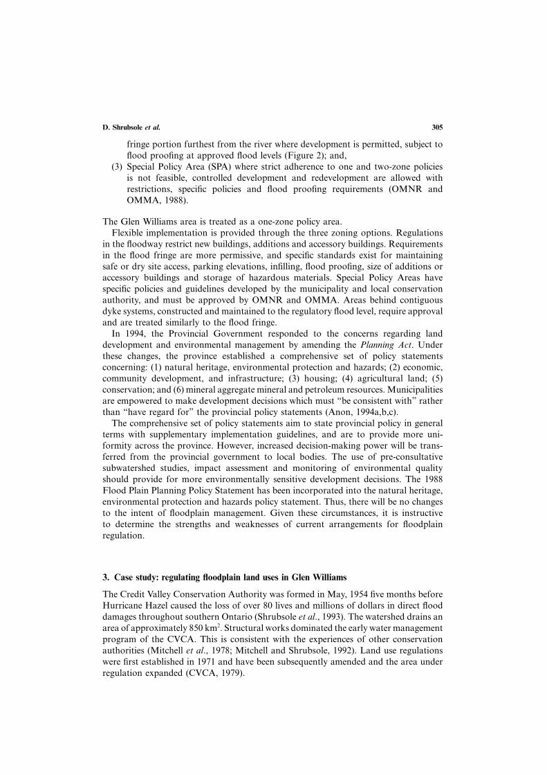
There are 38 conservation authorities in the province, with most located in themore heavily populated southern portions. While these agencies have been primarilyresponsible for floodplain management, other levels of government—municipal, pro-vincial and to a lesser extent federal—are also involved (Mitchell and Shrubsole, 1992;Shrubsole, 1996). The Ontario Ministry of Natural Resources (OMNR) is the provincialagency charged with administering the conservation authority program. The OntarioMinistry of Municipal Affairs (OMMA) oversees municipal planning activities. Thisfragmented arrangement led Gardner and Mitchell (1980, p. 125) to state that thedevelopment of floodplain management policy “must address the inter-related aspectsof jurisdictional and financial arrangements”. These researchers also reviewed thedevelopment of Ontario floodplain management until 1977. Since then, significantpolicy developments include the report of the Floodplain Management Review Com-mittee (1983), the adoption of the Flood Plain Planning Policy Statement (1988), andreforms to the Planning Act (1994). These items are discussed below.
In response to technical and administrative difficulties, and negative public perceptionstowards the implementation of floodplain regulations, the Minister of Natural Resourcesformed a Review Committee in September 1983. It concluded that managementactivities must be more responsive to local needs and circumstances (Anon, 1983). Onerecommendation, which was endorsed by the Minister, allows municipalities with theconsent of other participants to reduce the regulatory standard from the RegionalStorm to the 1:100 or historical flood event. Depending on the location within Ontario,different regulatory standards are used to define floodplains—Hurricane Hazel (1954),Timmins Storm (1961), and the 100-year flood. In the Credit River watershed, HurricaneHazel which delivered 21·11 cm of rainfall in 12 hours is used to determine regulatoryfloodlines.
Assessing floodplain regulation304
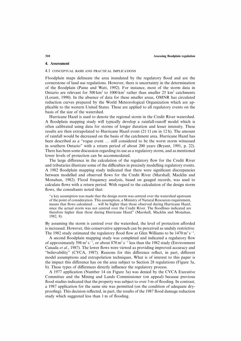
Regulatory flood plain
One-zone concept
Water level
Regulatory flood plain
Two-zone floodway-flood fringe concept
Water level
FloodwayFlood fringe
Floodfringe
Note: SPA allows for development in the floodway
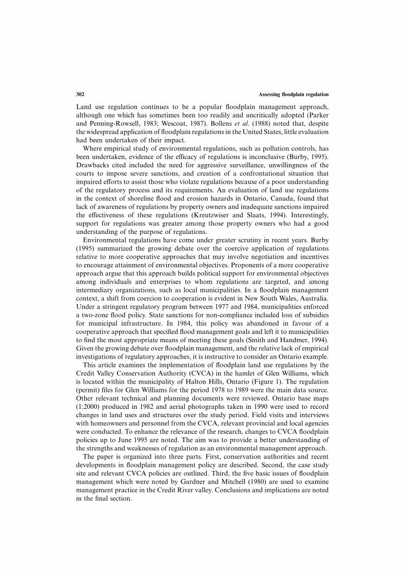
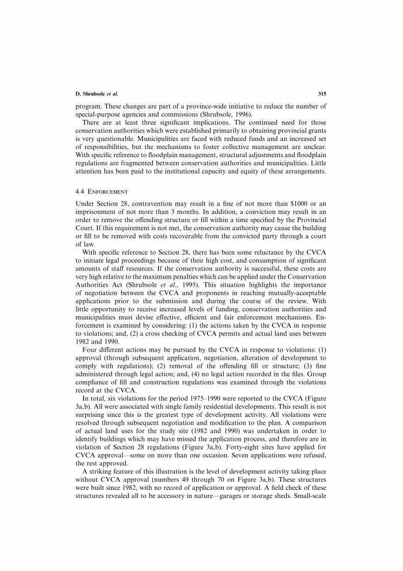
Figure 2. One-zone and two-zone concepts.
In 1983, amendments to the Planning Act provided for the circulation of planningdocuments to conservation authorities, directed provincial agencies to consult con-servation authorities on planning matters, and provided for the adoption of policystatements on municipal planning matters deemed to be of provincial interest. Fur-thermore, Section 3(5) stated that “in exercising any authority that affects any planningmatter the council of every municipality . . . shall have regard to policy statementsissued”.
In 1988, the Flood Plain Planning Policy Statement was adopted under Section 3 ofthe Planning Act (OMNR and OMMA, 1988). Its objectives are: (1) to prevent loss oflife; (2) to minimize property damage and social disruption; and (3) to encourage acoordinated approach to land and water management. Five principles are to be appliedin accomplishing these objectives. Policies must: (1) be based on an evaluation of allrelevant social, economic, physical and environmental factors; (2) must take placewithin an overall coordinated land use and watershed planning framework; (3) wheneverfeasible, existing developments within the floodplain are to be protected against majorflood losses; (4) not permit future land uses within the floodplain which will besusceptible to significant flood damages or which increase flood damages to existinguses; and (5) be developed and administered in a manner which promotes publicunderstanding and acceptance (OMNR and OMMA, 1988).
With respect to land use regulation, the policy allows for a municipality to utilizeone of three zoning options:
(1) one-zone concept whereby the entire floodplain is treated as one unit, with alldevelopment prohibited or restricted (Figure 2);
(2) two-zone concept whereby the floodplain is split into two sections; a floodwayadjacent to the river where development is prohibited or restricted; and a flood
D. Shrubsole et al. 305
fringe portion furthest from the river where development is permitted, subject toflood proofing at approved flood levels (Figure 2); and,
(3) Special Policy Area (SPA) where strict adherence to one and two-zone policiesis not feasible, controlled development and redevelopment are allowed withrestrictions, specific policies and flood proofing requirements (OMNR andOMMA, 1988).
The Glen Williams area is treated as a one-zone policy area.Flexible implementation is provided through the three zoning options. Regulations
in the floodway restrict new buildings, additions and accessory buildings. Requirementsin the flood fringe are more permissive, and specific standards exist for maintainingsafe or dry site access, parking elevations, infilling, flood proofing, size of additions oraccessory buildings and storage of hazardous materials. Special Policy Areas havespecific policies and guidelines developed by the municipality and local conservationauthority, and must be approved by OMNR and OMMA. Areas behind contiguousdyke systems, constructed and maintained to the regulatory flood level, require approvaland are treated similarly to the flood fringe.
In 1994, the Provincial Government responded to the concerns regarding landdevelopment and environmental management by amending the Planning Act. Underthese changes, the province established a comprehensive set of policy statementsconcerning: (1) natural heritage, environmental protection and hazards; (2) economic,community development, and infrastructure; (3) housing; (4) agricultural land; (5)conservation; and (6) mineral aggregate mineral and petroleum resources. Municipalitiesare empowered to make development decisions which must “be consistent with” ratherthan “have regard for” the provincial policy statements (Anon, 1994a,b,c).
The comprehensive set of policy statements aim to state provincial policy in generalterms with supplementary implementation guidelines, and are to provide more uni-formity across the province. However, increased decision-making power will be trans-ferred from the provincial government to local bodies. The use of pre-consultativesubwatershed studies, impact assessment and monitoring of environmental qualityshould provide for more environmentally sensitive development decisions. The 1988Flood Plain Planning Policy Statement has been incorporated into the natural heritage,environmental protection and hazards policy statement. Thus, there will be no changesto the intent of floodplain management. Given these circumstances, it is instructiveto determine the strengths and weaknesses of current arrangements for floodplainregulation.
3. Case study: regulating floodplain land uses in Glen Williams
The Credit Valley Conservation Authority was formed in May, 1954 five months beforeHurricane Hazel caused the loss of over 80 lives and millions of dollars in direct flooddamages throughout southern Ontario (Shrubsole et al., 1993). The watershed drains anarea of approximately 850 km2. Structural works dominated the early water managementprogram of the CVCA. This is consistent with the experiences of other conservationauthorities (Mitchell et al., 1978; Mitchell and Shrubsole, 1992). Land use regulationswere first established in 1971 and have been subsequently amended and the area underregulation expanded (CVCA, 1979).
Assessing floodplain regulation306
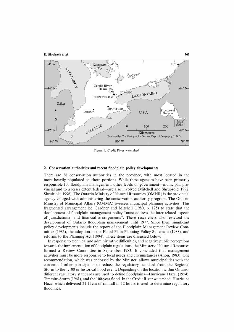
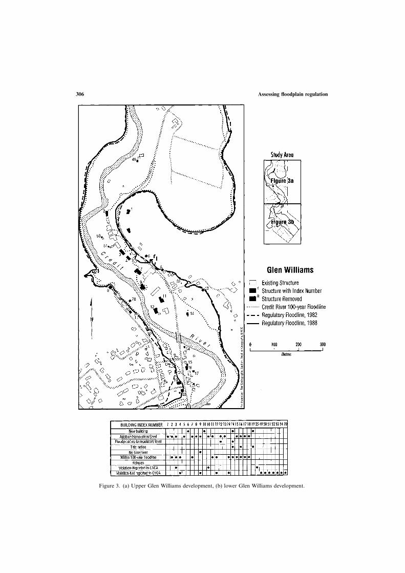
Figure 3. (a) Upper Glen Williams development, (b) lower Glen Williams development.
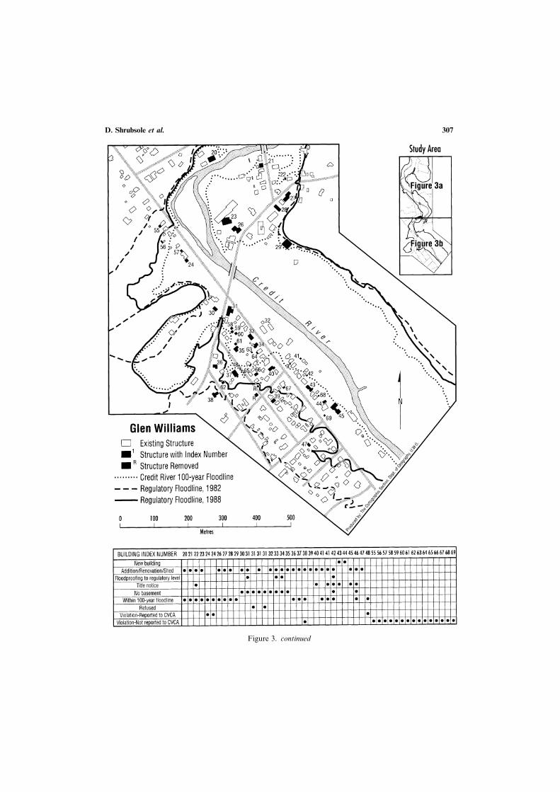
D. Shrubsole et al. 307
Figure 3. continued
Assessing floodplain regulation308
Located within Town of Halton Hills, the hamlet of Glen Williams was selected forintensive study (Figures 1 and 3). It has a long history of flooding from the CreditRiver which runs through the area. The last significant flood event occurred in 1980as a result of an ice jam (CVCA, 1980). It has also seen the application of both structuraland non-structural flood adjustments, including floodplain land use regulations. Despitethese efforts, a considerable flood hazard remains. The majority of houses within thehamlet lie within the regulatory flood elevation, and the estimated damage as a resultof a flood of this magnitude is over $3.1 million (1984 dollars) (Environment Canadaet al., 1987). Flood-prone areas within Glen Willliams have been designated as “hazardland” in the official plan (Halton Hills, 1987). Until the recent amendments to thePlanning Act, development in this area must have regard for the Provincial Flood PlainPlanning Policy Statement. It must now be consistent with that policy statement.
The primary provisions for implementing the floodplain land use regulations areestablished through the Conservation Authorities Act and the Planning Act (Shrubsoleet al., 1995). Specifically, Section 28 of the Conservation Authorities Act states that:
“an authority may make regulations applicable in the area under its jurisdiction, e)prohibiting or regulating or requiring the permission of the authority for the constructionof any building or structure in or on a pond or swamp or in any area susceptible to floodingduring a regional storm, and defining regional storms for the purposes of defining suchregulations; f) prohibiting or regulating or requiring the permission of the authority for theplacing or dumping of fill of any kind in any defined part of the area over which theauthority has jurisdiction in which in the opinion of the authority the control of floodingor pollution or the conversion of land may be affected by the placing or dumping of fill.”
The Planning Act outlines the municipal planning process. Appropriate policies toguide the use of floodplain lands are included in official plans and zoning by-laws.Direct implementation is delegated to local municipalities through the planning processwhich identifies the type of land use(s) to be permitted in an area. Section 28 of theConservation Authorities Act considers how those land uses may be accommodatedfrom a flood hazard perspective. This legislative approach typifies the fragmentationof responsibility noted by Gardner and Mitchell (1980).
Since 1971, the CVCA has administered and enforced Fill, Construction and Al-teration to Waterways Regulations as specified within Section 28 (CVCA, 1971). Theseregulations require that individuals must apply to the CVCA for: (1) the constructionof any structure within any area susceptible to flooding during a “Regional Storm”;(2) the placement or dumping of fill in a regulated area; and (3) any alteration to ariver, creek, stream or watercourse (CVCA, 1987). Within the study area, the one-zoneconcept for floodplain management was adopted (Figure 2). Three policy documents—Policies for the Establishment of Parking Facilities in the Flood Plain, Policies forAccess, and Policies for Floodproofing of Building and Structures strongly guidedimplementation during the study period. In 1994, these were consolidated in to a singledocument, Authority Policies on Flood Plain Management, in order to reduce policygaps, provide more consistent implementation, and simplify the process (CVCA, 1994).
The Provincial Policy Statement on Flood Plain Planning (1988) suggests that aconservation authority should provide for the orderly and equitable application offloodplain land use regulations. In this regard, the CVCA has determined that anynew development permitted within a regulated floodplain must be: (1) protected byappropriate floodproofing measures; and (2) ingress/egress for new buildings allow bothvehicular and pedestrian movement during a flood (CVCA, 1994, iv). In consideringwhether an application poses a significant threat to life and property, the CVCA
D. Shrubsole et al. 309
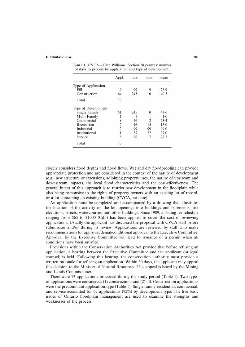
T 1. CVCA—Glen Williams. Section 28 permits: numberof days to process by application and type of development.
Appl. max. min. mean
Type of ApplicationFill 9 99 9 28·9Construction 64 245 0 40·5
Total 73
Type of DevelopmentSingle Family 51 245 0 43·6Multi Family 1 1 1 1·0Commercial 8 46 2 23·4Recreation 2 16 14 15·0Industrial 2 99 99 99·0Institutional 1 37 37 37·0Service 8 86 7 27·3
Total 73
closely considers flood depths and flood flows. Wet and dry floodproofing can provideappropriate protection and are considered in the context of the nature of development(e.g., new structure or extension), adjoining property uses, the nature of upstream anddownstream impacts, the local flood characteristics and the cost-effectiveness. Thegeneral intent of this approach is to restrict new development in the floodplain whilealso being responsive to the rights of property owners with an existing lot of record,or a lot containing an existing building (CVCA, no date).
An application must be completed and accompanied by a drawing that illustratesthe location of the activity on the lot, openings into buildings and basements, siteelevations, streets, watercourses, and other buildings. Since 1989, a sliding fee scheduleranging from $65 to $1000 (Cdn) has been applied to cover the cost of reviewingapplications. Usually the applicant has discussed the proposal with CVCA staff beforesubmission and/or during its review. Applications are reviewed by staff who makerecommendations for approval/denial/conditional approval to the Executive Committee.Approval by the Executive Committee will lead to issuance of a permit when allconditions have been satisfied.
Provisions within the Conservation Authorities Act provide that before refusing anapplication, a hearing between the Executive Committee and the applicant (or legalcounsel) is held. Following this hearing, the conservation authority must provide awritten rationale for refusing an application. Within 30 days, the applicant may appealthis decision to the Minister of Natural Resources. This appeal is heard by the Miningand Lands Commissioner.
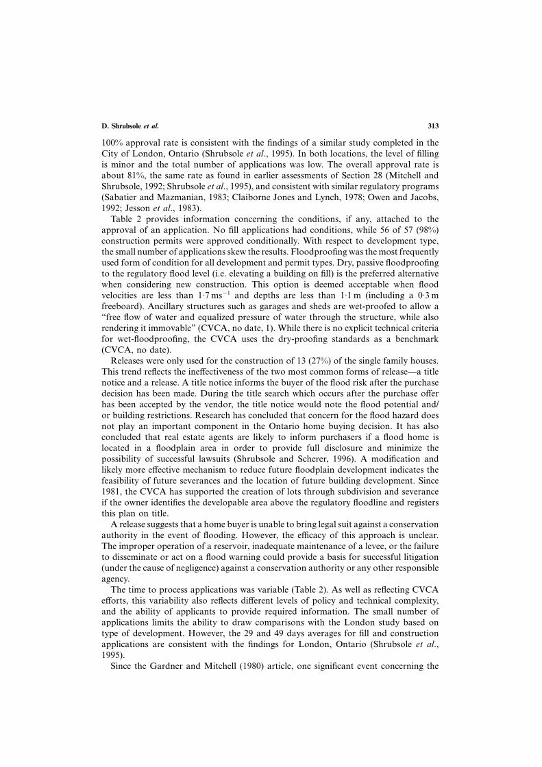
There were 73 applications processed during the study period (Table 1). Two typesof applications were considered: (1) construction, and (2) fill. Construction applicationswere the predominant application type (Table 1). Single family residential, commercial,and service accounted for 67 applications (92%) by development type. The five basicissues of Ontario floodplain management are used to examine the strengths andweaknesses of the process.
Assessing floodplain regulation310
4. Assessment
4.1
Floodplain maps delineate the area inundated by the regulatory flood and are thecornerstone of land use regulations. However, there is uncertainty in the determinationof the floodplain (Paine and Watt, 1992). For instance, most of the storm data inOntario are relevant for 500 km2 to 1000 km2 rather than smaller 25 km2 catchments(Lorant, 1990). In the absence of data for these smaller areas, OMNR has circulatedreduction curves prepared by the World Meteorological Organization which are ap-plicable to the western United States. These are applied to all regulatory events on thebasis of the size of the watershed.
Hurricane Hazel is used to denote the regional storm in the Credit River watershed.A floodplain mapping study will typically develop a rainfall-runoff model which isoften calibrated using data for storms of longer duration and lesser intensity. Theseresults are then extrapolated to Hurricane Hazel event (21·11 cm in 12 h). The amountof rainfall would be decreased on the basis of the catchment area. Hurricane Hazel hasbeen described as a “rogue event . . . still considered to be the worst storm witnessedin southern Ontario” with a return period of about 200 years (Bryant, 1991, p. 22).There has been some discussion regarding its use as a regulatory storm, and as mentionedlower levels of protection can be accommodated.
The large difference in the calculation of the regulatory flow for the Credit Riverand tributaries illustrate some of the difficulties in precisely modelling regulatory events.A 1982 floodplain mapping study indicated that there were significant discrepanciesbetween modelled and observed flows for the Credit River (Marshall, Macklin andMonahan, 1982). Flood frequency analysis, based on gauged records, was used tocalculate flows with a return period. With regard to the calculation of the design stormflows, the consultants noted that:
“a key assumption was made that the design storm was centred over the watershed upstreamof the point of consideration. This assumption, a Ministry of Natural Resources requirement,means that flows calculated . . . will be higher than those observed during Hurricane Hazel,since the actual storm was not centred over the Credit River. The floodlines indicated aretherefore higher than those during Hurricane Hazel” (Marshall, Macklin and Monahan,1982, 8).
By assuming the storm is centred over the watershed, the level of protection affordedis increased. However, this conservative approach can be perceived as unduly restrictive.The 1982 study estimated the regulatory flood flow at Glen Williams to be 1470 m3 s−1.
A second floodplain mapping study was completed and indicated a regulatory flowof approximately 598 m3 s−1, or about 870 m3 s−1 less than the 1982 study (EnvironmentCanada et al., 1987). The lower flows were viewed as providing improved accuracy and“believability” (CVCA, 1987). Reasons for this difference reflect, in part, differentmodel assumptions and extrapolation techniques. What is of interest to this paper isthe impact this difference has on the area subject to Section 28 regulations (Figure 3a,b). These types of differences directly influence the regulatory process.
A 1977 application (Number 14 on Figure 3a) was denied by the CVCA ExecutiveCommittee and the Mining and Lands Commissioner (on appeal) because previousflood studies indicated that the property was subject to over 3 m of flooding. In contrast,a 1987 application for the same site was permitted (on the condition of adequate dry-proofing). This decision reflected, in part, the results of the 1987 flood damage reductionstudy which suggested less than 1 m of flooding.
D. Shrubsole et al. 311
This situation highlights the uncertainty, flexibility and continual evolution of flood-plain management. Respondents from the CVCA and OMNR acknowledged that someflood-prone areas may be unregulated at present, and that others may be over-regulated.This situation could contribute to a lack of confidence in the accuracy of floodplainmapping studies. Improved technology, changing public perception towards the de-sirability and feasibility of regulation and other flood adjustments, and revisions toenabling legislation and policies can modify decision criteria. Since floodplain man-agement is a dynamic rather than static process, it will be necessary to effectively reviewand update floodplain areas on an ongoing basis. If other planning agencies, the realestate development sector and the public are insensitive to this dynamic property,conservation authorities could be perceived as lacking credibility (Shrubsole and Scherer,1996). These types of problems prompted Gardner and Mitchell (1980, p. 129) to suggestthat “utilization of flood fringe areas based on imperfect knowledge of the frequencyand magnitude of flooding in the context of change of watershed characteristics andclimatic conditions may be imprudent”. Since the recent reforms to the Planning Actindicate that municipal plans must better protect the natural environment rather thanspecific components (e.g., floodplains and wetlands), these types of problems couldbecome more common and complex.
A second important practical issue concerns the interpretation of the 1988 FloodPlain Planning Policy Statement. Specifically, what differences, if any, should beassociated with a one-zone and two-zone zoning approach (Figure 2) in areas like GlenWilliams that are already intensively developed. Clearly, the intent of the two-zoneconcept allows for intensification of land uses through rezoning and subdivisiondevelopment. The one-zone approach does not allow for intensification of uses. However,its principles refer to the need to consider social, economic, physical and environmentalfactors, and to develop policies within an overall coordinated land use and watershedplanning framework (OMNR and OMMA, 1988). Thus, it is reasonable to suggestthat the one-zone policy can support development which is consistent with existingdevelopment. What constitutes the difference between an intensification of land useand an extension of existing development lies in the eye of the beholder.
Some of the development which the CVCA has approved in Glen Williams, particularlybetween 1984 and 1988, could be viewed as being more consistent with a two-zonerather than a one-zone policy area. During this period, which is prior to the 1988 FloodPlain Planning Policy Statement, four new buildings were approved in the study area(Figure 3a). One was to replace a residence which had burnt (number 19). Issues relatedto slope stability were of primary concern in numbers 6 and 10. A field check indicatedthat the proposed home, retaining wall and filling were not pursued on number 6. Asnoted earlier, the fourth development (number 14) was denied a permit in 1977 andgranted one in 1987 because the 1987 flood damage reduction study indicated floodingof less than 1 m. However, this new development is located within the 100-yearfloodplain, and its approval appears to be inconsistent with the intent of the one-zonepolicy. Interviews with CVCA officials confirmed that the conservation authority hadinformally adopted a two-zone policy concept during the mid-1980s. The passage ofthe 1988 Flood Plain Planning Policy Statement and the consolidation of CVCAfloodplain management policy in 1994 are two key events which have clarified andimproved the application of regulations.
A third underlying premise of floodplain regulations is to limit flood risk potential.Generally, it is acknowledged that “most land use management methods are designedto intervene early in the development process and are not particularly useful in reducing
Assessing floodplain regulation312
T 2. CVCA—Glen Williams. Section 28 permit approvals and conditions by applicationand type of development.
Applica- Total Approved Release Flood-tions approved with condition proofing
no. % no. % no. % no. %
Type of ApplicationFill 9 8 89·0 8 100·0 0 4 50·0Construction 64 57 89·0 56 98·3 13 23·2 34 60·7
Total 73 65 64 13 38
Type of DevelopmentSingle Family 51 48 94·1 48 94·1 13 27·1 29 60·4Multi Family 1 1 100·0 1 100·0 0 1 100·0Commercial 8 6 75·0 5 83·3 0 1 20·0Recreation 2 0 0 0 0Industrial 2 1 50·0 1 50·0 0 1 50·0Institutional 1 1 100·0 1 100·0 0 1 100·0Service 8 8 100·0 8 100·0 0 4 50·0
Total 73 65 64 13 37
potential flood damages to existing land uses” (Burby and French, 1981, p. 294).However, further development in existing built-up areas through the conversion ofbuilding uses, and the construction of additions, sheds and decks increase flood damagepotential. Regulation should ensure that future development does not significantlyaccentuate off-site flood problems, or threaten public safety through increased waterdepths and velocities which would impede emergency access. To achieve these ends,regulations should consider a broad range of structures (e.g. mobile homes), propertyimprovements (e.g. decks, garages) and construction activities (e.g. fire rebuilding andrenovations) for both existing and proposed development. The CVCA (no date) hasdeveloped a range of dry-proofing and wet-proofing guidelines to limit the flood riskpotential, and allows for appropriate floodplain development. For instance, a com-mercial enterprise (number 31 on Figure 3b) which applied to expand its operationswas successful only when adequate floodproofing requirements were incorporated intothe construction plan. While the CVCA adopted the unofficial two-zone concept, theCVCA could be seen as being too responsive to development on the floodplain.However, a more balanced approach has been achieved since 1988.
4.2
In this paper, responsibility and jurisdiction were considered by selected indicators ofequity and efficiency. Approval rates, development types and liability for future flooddamages are issues selected for discussion.
Approval rates between application and development types is one measure of equity.Fill and construction permits were approved 89% of the time (Table 2). Approval ratesby development type ranged from 0% for recreational development to 100% for multi-family, institutional and service (Table 2). This variability reflects, in part, the verysmall number of multi-family, recreation, industrial and institutional applications. The
D. Shrubsole et al. 313
100% approval rate is consistent with the findings of a similar study completed in theCity of London, Ontario (Shrubsole et al., 1995). In both locations, the level of fillingis minor and the total number of applications was low. The overall approval rate isabout 81%, the same rate as found in earlier assessments of Section 28 (Mitchell andShrubsole, 1992; Shrubsole et al., 1995), and consistent with similar regulatory programs(Sabatier and Mazmanian, 1983; Claiborne Jones and Lynch, 1978; Owen and Jacobs,1992; Jesson et al., 1983).
Table 2 provides information concerning the conditions, if any, attached to theapproval of an application. No fill applications had conditions, while 56 of 57 (98%)construction permits were approved conditionally. With respect to development type,the small number of applications skew the results. Floodproofing was the most frequentlyused form of condition for all development and permit types. Dry, passive floodproofingto the regulatory flood level (i.e. elevating a building on fill) is the preferred alternativewhen considering new construction. This option is deemed acceptable when floodvelocities are less than 1·7 ms−1 and depths are less than 1·1 m (including a 0·3 mfreeboard). Ancillary structures such as garages and sheds are wet-proofed to allow a“free flow of water and equalized pressure of water through the structure, while alsorendering it immovable” (CVCA, no date, 1). While there is no explicit technical criteriafor wet-floodproofing, the CVCA uses the dry-proofing standards as a benchmark(CVCA, no date).
Releases were only used for the construction of 13 (27%) of the single family houses.This trend reflects the ineffectiveness of the two most common forms of release—a titlenotice and a release. A title notice informs the buyer of the flood risk after the purchasedecision has been made. During the title search which occurs after the purchase offerhas been accepted by the vendor, the title notice would note the flood potential and/or building restrictions. Research has concluded that concern for the flood hazard doesnot play an important component in the Ontario home buying decision. It has alsoconcluded that real estate agents are likely to inform purchasers if a flood home islocated in a floodplain area in order to provide full disclosure and minimize thepossibility of successful lawsuits (Shrubsole and Scherer, 1996). A modification andlikely more effective mechanism to reduce future floodplain development indicates thefeasibility of future severances and the location of future building development. Since1981, the CVCA has supported the creation of lots through subdivision and severanceif the owner identifies the developable area above the regulatory floodline and registersthis plan on title.
A release suggests that a home buyer is unable to bring legal suit against a conservationauthority in the event of flooding. However, the efficacy of this approach is unclear.The improper operation of a reservoir, inadequate maintenance of a levee, or the failureto disseminate or act on a flood warning could provide a basis for successful litigation(under the cause of negligence) against a conservation authority or any other responsibleagency.
The time to process applications was variable (Table 2). As well as reflecting CVCAefforts, this variability also reflects different levels of policy and technical complexity,and the ability of applicants to provide required information. The small number ofapplications limits the ability to draw comparisons with the London study based ontype of development. However, the 29 and 49 days averages for fill and constructionapplications are consistent with the findings for London, Ontario (Shrubsole et al.,1995).
Since the Gardner and Mitchell (1980) article, one significant event concerning the
Assessing floodplain regulation314
T 3. Section 28 application fee schedule.
$ 65·00 Projects on personal residential property$ 100·00 Municipal projects$ 500·00 Subdivisions less than 10 lots$1000·00 Subdivisions greater than 10 lots$ 200·00 Other
issue of jurisdiction pertained to a Provincial Court decision regarding an applicationmade in the City of London. The court determined that Section 28 regulations werenot applicable to renovation and reconstruction (Shrubsole et al., 1995). This decisionhas implications for the belief that floodplain regulations should limit flood riskpotential. Renovation is not considered to be within a conservation authority’s jur-isdiction, although it can increase the flood hazard potential. The 1988 Flood PlainPlanning Policy Statement and the Conservation Authorities Act do not refer to theissue of renovation, reconstruction after a fire, and the placement of mobile homes.Municipalities have exclusive jurisdiction over these activities. In the absence of a clearpolicy guideline, implementation is likely to be ad hoc and ineffective. The 1977floodplain management proposals and 1988 policy fail to clarify which agency isresponsible for damages in the event of a flood disaster. “Possibly municipalities shouldassume that responsibility too” (Gardner and Mitchell, 1980, p. 129).
4.3
Financial arrangements and fiscal realities have always influenced the selection andadequacy of alternative flood strategies (Mitchell and Shrubsole, 1992). Since the late1980s, conservation authorities have seen less funding from OMNR to support allaspects of the program. This has caused all conservation authorities to review programpriorities, and funding and delivery mechanisms. In 1989, the CVCA adopted anapplication fee in order to support the costs associated with Section 28 reviews (Table3). This decision was taken after surveying other conservation authorities and findingthat some provide this service free of charge, and there is variability in those which doapply fees. Under Section 21 of the Conservation Authorities Act, fees must reflectsupport cost (e.g. photocopying, stationery and postage), and not staff and legal costs.The latter are provided by provincial and municipal levies. With reduced provincialfunding, the responsibility for adequate funding will rest with municipalities and otherauthority operations (e.g. conservation areas, sale of forest products and gravel, leaseof other lands). Application fees cannot support the human resources required toimplement floodplain regulations.
After the 1996 budget year, the province will no longer fund Section 28 regulatoryreview. In November 1995, the new Provincial Government reduced conservationauthority funding from $33 million to $12 million per year, and narrowed the range ofprovincially supported activities to two—flood control and municipal taxes on landsof provincial environmental significance. All other resource management activities suchas floodplain regulations, plan review, water quality, tree planting, conservation services,outdoor education and recreation will no longer be supported. In addition, municipalitieswould be obliged to contribute funds to a conservation authority’s flood control
D. Shrubsole et al. 315
program. These changes are part of a province-wide initiative to reduce the number ofspecial-purpose agencies and commissions (Shrubsole, 1996).
There are at least three significant implications. The continued need for thoseconservation authorities which were established primarily to obtaining provincial grantsis very questionable. Municipalities are faced with reduced funds and an increased setof responsibilities, but the mechanisms to foster collective management are unclear.With specific reference to floodplain management, structural adjustments and floodplainregulations are fragmented between conservation authorities and municipalities. Littleattention has been paid to the institutional capacity and equity of these arrangements.
4.4 E
Under Section 28, contravention may result in a fine of not more than $1000 or animprisonment of not more than 3 months. In addition, a conviction may result in anorder to remove the offending structure or fill within a time specified by the ProvincialCourt. If this requirement is not met, the conservation authority may cause the buildingor fill to be removed with costs recoverable from the convicted party through a courtof law.
With specific reference to Section 28, there has been some reluctance by the CVCAto initiate legal proceedings because of their high cost, and consumption of significantamounts of staff resources. If the conservation authority is successful, these costs arevery high relative to the maximum penalties which can be applied under the ConservationAuthorities Act (Shrubsole et al., 1995). This situation highlights the importanceof negotiation between the CVCA and proponents in reaching mutually-acceptableapplications prior to the submission and during the course of the review. Withlittle opportunity to receive increased levels of funding, conservation authorities andmunicipalities must devise effective, efficient and fair enforcement mechanisms. En-forcement is examined by considering: (1) the actions taken by the CVCA in responseto violations; and, (2) a cross checking of CVCA permits and actual land uses between1982 and 1990.
Four different actions may be pursued by the CVCA in response to violations: (1)approval (through subsequent application, negotiation, alteration of development tocomply with regulations); (2) removal of the offending fill or structure; (3) fineadministered through legal action; and, (4) no legal action recorded in the files. Groupcompliance of fill and construction regulations was examined through the violationsrecord at the CVCA.
In total, six violations for the period 1975–1990 were reported to the CVCA (Figure3a,b). All were associated with single family residential developments. This result is notsurprising since this is the greatest type of development activity. All violations wereresolved through subsequent negotiation and modification to the plan. A comparisonof actual land uses for the study site (1982 and 1990) was undertaken in order toidentify buildings which may have missed the application process, and therefore are inviolation of Section 28 regulations (Figure 3a,b). Forty-eight sites have applied forCVCA approval—some on more than one occasion. Seven applications were refused,the rest approved.
A striking feature of this illustration is the level of development activity taking placewithout CVCA approval (numbers 49 through 70 on Figure 3a,b). These structureswere built since 1982, with no record of application or approval. A field check of thesestructures revealed all to be accessory in nature—garages or storage sheds. Small-scale
Assessing floodplain regulation316
development would be exempt from Section 28 and the requirements of the OntarioBuilding Code. The CVCA (1994) suggests that this type of ancillary structures be wet-floodproofed to the regulatory flood elevation. The field check indicates that this adviceis not acted on by property owners. This trend may reflect the high cost of floodproofingthese structures relative to the damage potential. In a general sense, this type ofdevelopment which increases the flood damage potential has also been found in someAmerican cities (Montz and Grundtfest, 1986).
The maps of development activity suggest that dry floodproofing to the regulatoryflood level is difficult to establish as a condition of approval for existing development(Figure 3a,b). If the proposal involves a minor addition to a house, it is not alwayspossible to dry floodproof a specific area joined to a main structure. In some cases,location in the one-zone area allows for construction, despite the fact that flood proofingmay not be possible. Wet floodproofing can “allow for free flow and equalized pressureof water through a structure, while also being rendered immovable” (CVCA, no date,1). As noted earlier, dry-floodproofing is acceptable up to a maximum of 1·7ms−1 anda flood depth of 1·1 m. A review of the applications indicates that the CVCA hasconsistently applied the depth criterion (on the basis of available floodplain mappingstudies). There is a lack of information to make any firm statements concerning thevelocity criterion. However, when velocity was a concern, it appears to be noted in thefile.
4.5
Another important participant in the regulatory process is the affected public. The 96single family residences located within the regulatory floodline delimited in the 1987floodplain mapping study were selected for study (Kreutzwiser et al., 1994). Contactwas eventually established with 84 of 96 homes, with 10 declining interviews. Whenasked whether their property was designated as a hazard land by the CVCA, 45 (61%)of respondents were aware of the designation; 29 (39%) were not. This point is interestingsince all respondents were located within the regulatory floodline (Figure 3a,b). Itshould be noted, however, that 35% of respondents had lived in Glen Williams for lessthan 10 years. Forty-seven percent of the respondents were aware of the CVCAsfloodplain land use regulations.
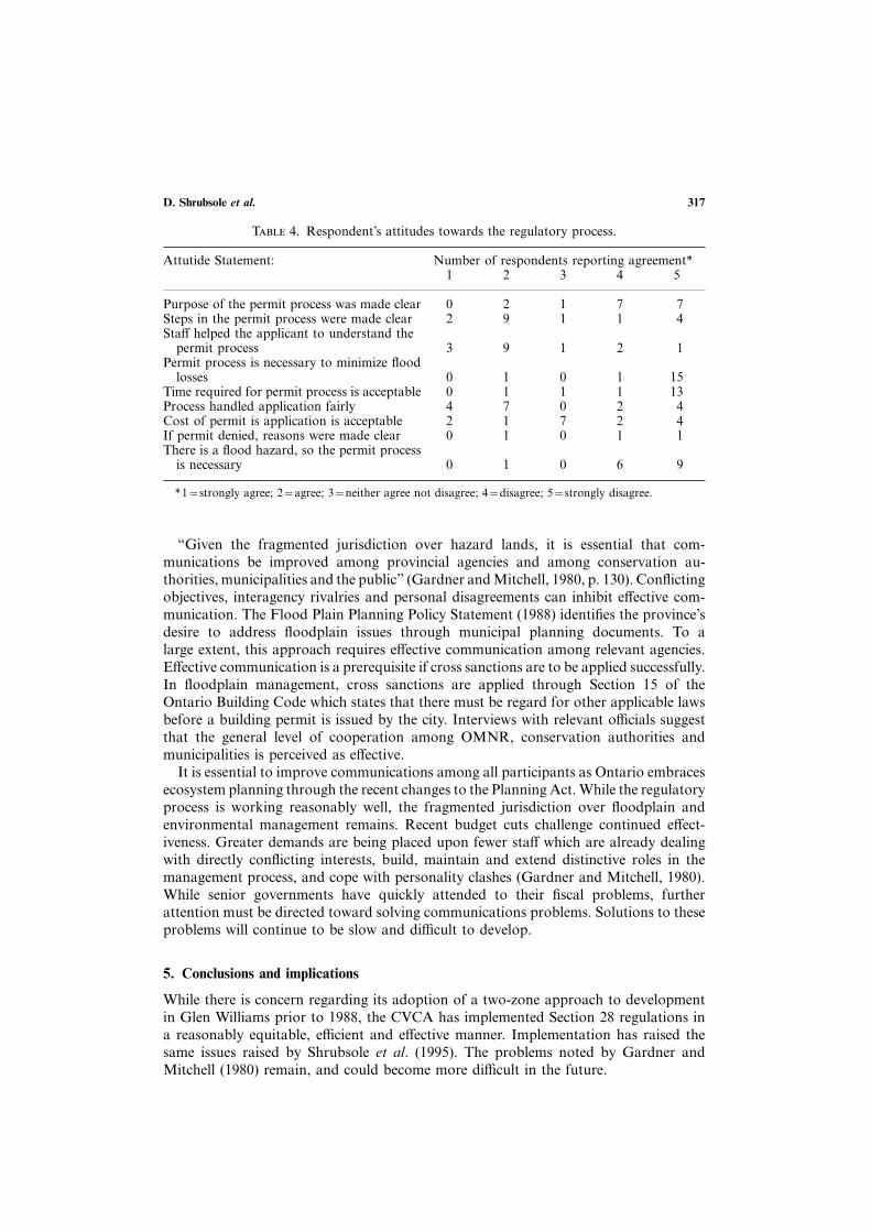
Of relevance to this paper were the 17 respondents who reported that they hadparticipated in the CVCAs permit process. Rows 1–9 of Table 4 display these re-spondents’ attitudes toward the CVCA permit process as measured by their level ofagreement with a series of statements. These statements concerned aspects of the permitprocess and its rationale. Few statements received overwhelming agreement, whileothers received strong disagreement. Residents agreed that the steps in the process wereclear and that the staff were helpful. Acceptance of fairness in decisions and costsincurred were split. The strongest criticisms indicated that the purpose of floodplainregulations were unclear, CVCA regulations were not necessary, and the time to processapplications was not acceptable.
Respondents with an accurate awareness of the purpose of the regulations programreported a higher level of satisfaction with the CVCA’s involvement in floodplainmanagement (Kreutzwiser et al., 1994). It is important for property owners to understandthe logic of regulatory programs in order to enhance compliance and enforcement.These findings highlight the need for effective information and education programs,and a competent and responsive professional staff.
D. Shrubsole et al. 317
T 4. Respondent’s attitudes towards the regulatory process.
Attutide Statement: Number of respondents reporting agreement∗1 2 3 4 5
Purpose of the permit process was made clear 0 2 1 7 7Steps in the permit process were made clear 2 9 1 1 4Staff helped the applicant to understand the
permit process 3 9 1 2 1Permit process is necessary to minimize flood
losses 0 1 0 1 15Time required for permit process is acceptable 0 1 1 1 13Process handled application fairly 4 7 0 2 4Cost of permit is application is acceptable 2 1 7 2 4If permit denied, reasons were made clear 0 1 0 1 1There is a flood hazard, so the permit process
is necessary 0 1 0 6 9
∗1=strongly agree; 2=agree; 3=neither agree not disagree; 4=disagree; 5=strongly disagree.
“Given the fragmented jurisdiction over hazard lands, it is essential that com-munications be improved among provincial agencies and among conservation au-thorities, municipalities and the public” (Gardner and Mitchell, 1980, p. 130). Conflictingobjectives, interagency rivalries and personal disagreements can inhibit effective com-munication. The Flood Plain Planning Policy Statement (1988) identifies the province’sdesire to address floodplain issues through municipal planning documents. To alarge extent, this approach requires effective communication among relevant agencies.Effective communication is a prerequisite if cross sanctions are to be applied successfully.In floodplain management, cross sanctions are applied through Section 15 of theOntario Building Code which states that there must be regard for other applicable lawsbefore a building permit is issued by the city. Interviews with relevant officials suggestthat the general level of cooperation among OMNR, conservation authorities andmunicipalities is perceived as effective.
It is essential to improve communications among all participants as Ontario embracesecosystem planning through the recent changes to the Planning Act. While the regulatoryprocess is working reasonably well, the fragmented jurisdiction over floodplain andenvironmental management remains. Recent budget cuts challenge continued effect-iveness. Greater demands are being placed upon fewer staff which are already dealingwith directly conflicting interests, build, maintain and extend distinctive roles in themanagement process, and cope with personality clashes (Gardner and Mitchell, 1980).While senior governments have quickly attended to their fiscal problems, furtherattention must be directed toward solving communications problems. Solutions to theseproblems will continue to be slow and difficult to develop.
5. Conclusions and implications
While there is concern regarding its adoption of a two-zone approach to developmentin Glen Williams prior to 1988, the CVCA has implemented Section 28 regulations ina reasonably equitable, efficient and effective manner. Implementation has raised thesame issues raised by Shrubsole et al. (1995). The problems noted by Gardner andMitchell (1980) remain, and could become more difficult in the future.
Assessing floodplain regulation318
Our understanding of the conceptual and technical aspects of floodplain managementhas progressed (Paine and Watt, 1992). On a practical level, the intent is to extendmunicipal planning activities to include the management of ecosystems. Achieving aneffective level of flexibility and adaptability to accommodate our changing appreciationof floodplain and other resources within the municipal planning system is an enduringchallenge. Collingridge (1983) offered some assistance in this area. He advocated thatwhen faced with uncertainty, decision makers should consider both “hedging” and“flexing” strategies. Hedging refers to choices which avoid the worst case scenario. Incases where ignorance is an issue, flexing strategies can better adapt to changingcircumstances and new information. Whichever approach is selected, effective moni-toring systems must be established. It is paradoxical that at a time when the need foreffective monitoring is increasing, federal constraints have contributed to a “crisispoint” in the management of surface water monitoring programs (Day et al., 1994).
Provincial planning reforms have placed greater responsibilities with municipalitiesover local resource management. While these have been more clearly stated, frag-mentation of catchments among municipalities, conservation authorities (where theywill continue to exist), and provincial agencies remains. The role of the province ineffectively guiding resource issues of provincial significance is unclear. Developing policyis one thing. Having municipalities which have a wide diversity of abilities andmotivations to implement it is another. In the short term, the development of effectiveindividual and community-based cooperative responses to the budget cuts will beintermittent and chaotic.
The division of structural and non-structural flood management responsibilitiesbetween conservation authorities and municipalities increases functional fragmentationwithin watersheds. If this option is implemented, collaborative mechanisms amongmunicipalities must be developed. In many ways, the present functions of conservationauthorities mirror those of one of its predecessors, the Grand River ConservationCommission (Shrubsole, 1992). Developing effective links between structural and non-structural adjustments was a challenge for that agency, and will become an increasedconcern for relevant participants under the present proposals.
The budget of November 1995 has significantly reduced the level of provincial supportto all resource agencies. With the province no longer supporting the review of Section28 regulations by conservation authorities, the desirability and feasibility of a municipallybased approach has not been systematically examined. It is unclear, in the face of thesefinancial constraints, how many medium and small municipalities in the province willcope. The contributory partnership which formed one of the six founding principles ofthe conservation authority program has been dramatically altered. Little attention hasbeen placed on examining the implications of this announcement and subsequentresponses. How will municipalities obtain the staff expertise to conduct this review?How and who will enforce and monitor floodplain and other environmental regulations?To what degree can user fees support staff and operating costs?
The current fiscal climate may have two major impacts on communication. On theone hand, some agencies may vigorously object to collaborative efforts in order toprotect “their turf”, and may set priorities with insufficient attention to public needs.On the other hand, the need for developing more effective collaborative mechanismsamong government and non-government participants may be required more thanever. Ontario’s experience with environmental planning at a municipal level has beenineffective (Richardson, 1994). The provincial government’s intent is to increase themunicipal responsibility, in part, by reducing the number of special-purpose agencies.
D. Shrubsole et al. 319
However, cost-effective solutions may require the development of new or renewedspecial-purpose bodies to deal with floodplains or other environmental issues. Hopefully,the collective leadership of government can legitimize the intent and practice offloodplain and environmental management in a constructive manner.
Funding from the Social Sciences and Humanities Research Council was greatly appreciated.
References
Anon (1977). A Discussion Paper on Floodplain Management Alternatives in Ontario. Toronto: OntarioMinistry of Natural Resources.
Anon (1983). Report. Toronto: Flood Plain Management Review Committee.Anon (1994a). Ontario’s New Planning System: Empowering Municipalities, Protecting the Environment,
Streamlining the Planning Process. Toronto: Ontario Ministry of Municipal Affairs.Anon (1994b). Comprehensive Set of Policy Statements. Toronto: Ontario Ministry of Municipal Affairs.Anon (1994c). Understanding Ontario’s Planning Reform. Toronto: Ontario Ministry of Municipal Affairs.Bollens, S.A., Kaiser, E. J. and Burby, R. J. (1988). Evaluating the effects of local floodplain management
policies on property owner behavior. Environmental Management 12, 311–325.Bryant, E. (1991). Natural Hazards. Cambridge: Cambridge University Press.Burby, R. J. (1995). Coercive versus cooperative pollution control: comparative case study of state programs
to reduce erosion and sedimentation in urban areas. Environmental Management 19, 359–370.Burby, R. and French, S. (1981). Coping with floods: the land use management paradox. Journal of the
American Planning Association 47, 289–300.Claiborne Jones, J. C. and Lynch, M. P. (1978). Local environmental management—can it work? a case
study of the Virginia Wetlands Act. Coastal Zone Management Journal 4, 127–150.Collindridge, D. (1983). Hedging and flexing: two ways of choosing under ignorance. Technological Forecasting
and Social Change 23, 161–172.Credit Valley Conservation Authority (1971). 1971 Annual Report. Meadowvale: Credit Valley Conservation
Authority.Credit Valley Conservation Authority (1979). 1979 Annual Report. Meadowvale: Credit Valley Conservation
Authority.Credit Valley Conservation Authority (1980). 1980 Annual Report. Meadowvale: Credit Valley Conservation
Authority.Credit Valley Conservation Authority (1987). 1987 Annual Report. Meadowvale: Credit Valley Conservation
Authority.Credit Valley Conservation Authority (1994). Authority Policies on Flood Plain Management. Meadowvale:
Credit Valley Conservation Authority.Credit Valley Conservation Authority (no date). Technical Guidelines for Floodproofing. Meadowvale: Credit
Valley Conservation Authority.Day, T. J., Pilon, P. J., Balshaw, M. and Alexander, J. (1994). Charting a new course for surface water
monitoring in Canada. In Water: A Resource in Transition (T.J. Day, E. Blais and N. Barnes eds) pp.237–244. Cambridge: Canadian Water Resources Association.
Environment Canada, Ministry of Natural Resources, Philips Planning & Engineering Ltd. (1987). CreditRiver Flood Damage Reduction Study. Mimeo.
Gardner, J. and Mitchell, B. (1980). Floodplain regulation in Ontario: an analysis of existing and proposedpolicy in the Grand and Credit River watershed. Journal of Environmental Management 11, 119–131.
Halton Hills (1987). Official Plan. Halton Hills: Town of Halton Hills.Jesson, S., Day, J. C. and Nelson, J. G. (1983). Assessing land use regulations in coastal wetlands: the case
of the Long Point Area, Lake Erie, Ontario. Coastal Zone Management Journal 1, 91–115.Kreutzwiser, R., Woodley, I. and Shrubsole, D. (1994). Perceptions of flood hazard and floodplain development
regulations in Glen Williams, Ontario. Canadian Water Resources Journal 19, 115–124.Kreutzwiser, R.D. and Slaats, M. J. (1994). The utility of evaluation research to land use regulations: the
case of Ontario shoreline development. Applied Geography 14, 169–181.Lorant, I. (1990). Are Ontario Floodplain regulatory storms too severe?. In Proceedings of the Floodplain
Management Conference. March 12–14, 1990. Toronto: Ontario Ministry of Natural Resources, En-vironment Canada and the Association of Conservation Authorities of Ontario.
Marshall, Macklin and Monahan (1982). Credit River Conservation Authority Fill Line and Floodplain MappingStudy of Credit River, Carolyn Creek, Silver Creek and Black Creek. Meadowvale: Credit River ConservationAuthority.
Mitchell, B., Gardner, J., Veale, B. and Cook, R. (1978). Physical adjustments and institutional arrangementsfor the urban flood hazard: Grand River watershed. Waterloo: University of Waterloo, Department ofGeography Publication Series Number 13.
Assessing floodplain regulation320
Mitchell, B. and Shrubsole, D. (1992). Ontario conservation authorities: myth and reality. Waterloo: Universityof Waterloo, Department of Geography Publication Series No. 35. 363 pp.
Montz, B. and Grundtfest, E. (1986). Changes in American urban floodplain occupancy since 1958: theexperience of nine cities. Applied Geography 6, 325–338.
OMNR and OMMA (1988). Flood Plain Planning Policy Statement. Toronto: OMNR and OMMA.Owen, C. R. and Jacobs, H. M. (1992). Wetland Protection as land use planning: the impact of Section 404
in Wisconsin, USA. Environmental Management 16, 345–353.Paine, J. D. and Watt, W. E. (1992). Uncertainty in floodplain delineation: recognition, evaluation and
reduction. In Resolving conflicts and uncertainty in water management (P. Shrubsole, ed.) pp 17.1–17.16.Canadian Water Resources Association, Cambridge, Ontario.
Parker, D. and Penning-Rowsell, E. (1983). Flood hazard research in Britain. Progress in Human Geography7, 182–202.
Richardson, N. R. (1994). Moving toward planning for sustainability: integrating environmental assessmentfor land use planning in Ontario. Plan Canada March, 18–23.
Sabatier, P. and Mazmanian, D. (1983). Can Regulation Work? Plenum Press, New York.Shrubsole, D. (1992). The Grand River Conservation Commission: history, activities and implications for
water management. Canadian Geographer 36, 221–236.Shrubsole, D. (1996). Ontario conservation authorities: principles, practice and challenges 50 years later.
Applied Geography 16, 319–335.Shrubsole, D. and Scherer, J. (1996). Floodplain regulation and the perceptions of the real estate sector: the
cases of Brantford and Cambridge, Ontario, Canada. Geoforum 27, 509–525.Shrubsole, D., Kreutzwiser, R., Mitchell, B., Dickinson, T. and Joy, D. (1993). The history of flood damages
in Ontario. Canadian Water Resources Journal 18, 133–143.Shrubsole, D., Hammond, V. and Green, M. (1995). Floodplain management in London, Ontario, Canada:
assessing Implementation of Section 28 of the Conservation Authorities Act. Environmental Management19, 703–717.
Smith, D. I. and Handmer, J. W. (1994). Urban flooding in Australia: policy development and implementation.Disasters 8, 105–117.
Wescoat, J. L. (1987). The practical range of choice in water resources geography. Progress in HumanGeography 11, 41–59.