Embed Size (px)
Citation preview
ISO-2 Project WIPP Independent Oversight – DE-AC30-06EW03005
ASSESSMENT OF WIPP HYDROLOGY & HYDROGEOLOGY
PROGRAMS
August 2010
ISO-2 Project Carlsbad, NM
PECOS MANAGEMENT SERVICES, INC.
PECOS MANAGEMENT SERVICES, INC. ISO-2 Project WIPP Independent Oversight – DE-AC30-06EW03005
Building Quality, Safety, and Integrity into Each Deliverable PECOS Document 10-002 – Page i
Use or disclosure of data contained on this sheet is subject to the restriction printed on the Table of Contents page of this report.
ASSESSMENT OF WIPP HYDROLOGY & HYDROGEOLOGY PROGRAMS
August 2010
TABLE OF CONTENTS
I. PURPOSE AND SCOPE .....................................................................................................1
II. BACKGROUND...................................................................................................................1
III. SUMMARY OF FINDINGS ...............................................................................................5
IV. CONCLUSIONS ...............................................................................................................12
VI. RECOMMENDATIONS...................................................................................................13
REPORT PREPARED BY ......................................................................................................13
REVIEWERS...........................................................................................................................13
REFERENCES ........................................................................................................................14
BIBLIOGRAPHY....................................................................................................................14
This report was prepared as an account of work sponsored by an agency of the United States Government. Neither the United States Government nor any agency thereof, nor PECOS Management Services, Inc, nor any of their employees, make any warranty, express or implied, or assume any liability or responsibility for the accuracy, completeness, or usefulness of any information, apparatus, product, or process disclosed in this report, or represent that its use would not infringe privately owned rights. Reference to any specific commercial product, process, or service by trade name, trademark, manufacturer, or otherwise does not necessarily constitute or imply its endorsement, recommendation, or favoring by the United States Government or any agency thereof. The views and opinions of the authors of this report do not necessarily state or reflect those of the United States Government or any agency thereof.
The contents of this publication may not be copied, reproduced, transmitted, displayed, distributed, altered, or otherwise used in whole or in part in any manner without prior written consent of PECOS Management Services, Inc.
PECOS MANAGEMENT SERVICES, INC. ISO-2 Project WIPP Independent Oversight – DE-AC30-06EW03005
Building Quality, Safety, and Integrity into Each Deliverable PECOS Document 10-002 – Page ii
Use or disclosure of data contained on this sheet is subject to the restriction printed on the Table of Contents page of this report.
ACRONYMS
BLM U.S. Bureau of Land Management
CCA Compliance Certification Application
CFR Code of Federal Regulations
CMUG Conceptual Model Uncertainty Group
CRA 2004 Compliance Recertification Application
CRA-2 2009 Compliance Recertification Application
DOE U.S. Department of Energy
EPA U.S. Environmental Protection Agency
HWFP Hazardous Waste Facility Permit
HYDRO Hydrology Appendix
NMED New Mexico Environment Department
NRC Nuclear Regulatory Commission
PA performance assessment
PECOS PECOS Management Services, Inc.
SNL Sandia National Laboratories
SSW shallow subsurface water
TRU transuranic
WIPP Waste Isolation Pilot Plant

PECOS MANAGEMENT SERVICES, INC. ISO-2 Project WIPP Independent Oversight – DE-AC30-06EW03005
Building Quality, Safety, and Integrity into Each Deliverable PECOS Document 10-002 – Page 1
Use or disclosure of data contained on this sheet is subject to the restriction printed on the Table of Contents page of this report.
ASSESSMENT OF WIPP HYDROLOGY
& HYDROGEOLOGY PROGRAMS
August 2010
I. PURPOSE AND SCOPE The Waste Isolation Pilot Plant (WIPP) is a repository for the permanent disposal of U.S. defense-related transuranic (TRU) waste. This report addresses the adequacy and effectiveness of hydrology and hydrogeology programs conducted prior to and during the operation of the WIPP; it also relates to issues of human health, safety, and environmental protection, and addresses shallow subsurface water (SSW) issues. In preparing this report, PECOS Management Services, Inc. (PECOS) has reviewed several papers published by the U.S. Department of Energy (DOE) and Sandia National Laboratories (SNL), the initial Compliance Certification Application (CCA), the 2004 Compliance Recertification Application (CRA), 2008 peer review documents, and the 2009 Compliance Recertification Application (CRA-2), including supporting documentation. Our reviewers have also taken into account questions raised by public reviewers and others. The purpose of this task is to assess the thoroughness, completeness, and adequacy of knowledge concerning hydrological and hydrogeological issues as it pertains to health and safety concerns, the WIPP site hydrology model, and more specifically, the performance assessment (PA) supporting the CRA-2. This task also identifies those aspects of hydrology and hydrogeology programs that should be continued.
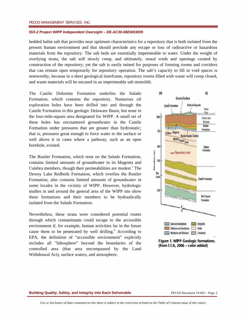
II. BACKGROUND Owned and operated by DOE, the WIPP is authorized by the Waste Isolation Pilot Plant Land Withdrawal Act (as amended), while the U.S. Environmental Protection Agency (EPA) monitors the facility and certifies its compliance under 40 CFR 191. Because some materials disposed at the WIPP are mixed wastes, the facility also operates under a Hazardous Waste Facility Permit (HWFP), which is monitored by the New Mexico Environment Department (NMED). In order to attain EPA certification and an HWFP issued by NMED, DOE was required to conduct extensive hydrogeologic investigations at the WIPP, which included descriptions of the geology of WIPP and the extensive subsurface investigations designed to establish the site's hydrogeology, as discussed in the following sections. DOE used resultant information from those investigations to demonstrate the compliance of WIPP with both EPA and state of New Mexico standards and regulations. Stratigraphy: The WIPP repository is located in the Delaware Basin and lies 2,150 feet below the surface (Figure 1). It is near the middle of the 2,000-foot-thick Salado Formation, a stratigraphic sequence of
PECOS MANAGEMENT SERVICES, INC. ISO-2 Project WIPP Independent Oversight – DE-AC30-06EW03005
Building Quality, Safety, and Integrity into Each Deliverable PECOS Document 10-002 – Page 2
Use or disclosure of data contained on this sheet is subject to the restriction printed on the Table of Contents page of this report.
bedded halite salt that provides near optimum characteristics for a repository that is both isolated from the present human environment and that should preclude any escape or loss of radioactive or hazardous materials from the repository. The salt beds are essentially impermeable to water. Under the weight of overlying strata, the salt will slowly creep, and ultimately, reseal voids and openings created by construction of the repository; yet the salt is easily mined for purposes of forming rooms and corridors that can remain open temporarily for repository operation. The salt’s capacity to fill in void spaces is noteworthy, because in a short geological timeframe, repository rooms filled with waste will creep closed, and waste materials will be encased in an impermeable salt monolith. The Castile Dolomite Formation underlies the Salado Formation, which contains the repository. Numerous oil exploration holes have been drilled into and through the Castile Formation in this geologic Delaware Basin, but none in the four-mile-square area designated for WIPP. A small set of these holes has encountered groundwater in the Castile Formation under pressures that are greater than hydrostatic; that is, pressures great enough to force water to the surface or well above it in cases where a pathway, such as an open borehole, existed. The Rustler Formation, which rests on the Salado Formation, contains limited amounts of groundwater in its Magenta and Culebra members, though their permeabilities are modest.1 The Dewey Lake Redbeds Formation, which overlies the Rustler Formation, also contains limited amounts of groundwater in some locales in the vicinity of WIPP. However, hydrologic studies in and around the general area of the WIPP site show these formations and their members to be hydraulically isolated from the Salado Formation. Nevertheless, these strata were considered potential routes through which contaminants could escape to the accessible environment if, for example, human activities far in the future cause them to be penetrated by well drilling.2 According to EPA, the definition of “accessible environment” explicitly includes all "lithosphere” beyond the boundaries of the controlled area (that area encompassed by the Land Withdrawal Act), surface waters, and atmosphere.
Figure 1. WIPP Geologic formations. (from CCA, 2006 – color added)
PECOS MANAGEMENT SERVICES, INC. ISO-2 Project WIPP Independent Oversight – DE-AC30-06EW03005
Building Quality, Safety, and Integrity into Each Deliverable PECOS Document 10-002 – Page 3
Use or disclosure of data contained on this sheet is subject to the restriction printed on the Table of Contents page of this report.
Hydrogeology: Hydrology and hydrogeology programs for WIPP were initiated in 1974 in concert with the development of conceptual models used to describe the hydrology of the WIPP site; these programs have been in a state of continuous development since then. Inasmuch as the primary goal in selecting the WIPP site as a repository was to isolate waste from circulating groundwater, early investigations focused on evaluating the potential for radioactive components present in the waste in WIPP to be released into a water-bearing geologic formation. The objective of those investigations was to determine geologic characteristics of the formations above and below the WIPP repository that influence the occurrence of free water. Investigators examined relevant hydrogeologic characteristics that included the formation's permeability and porosity, solution features, geologic structure (e.g., fractures and facies), hydraulic pressures, and characteristics affecting water chemistry. An ancillary part of those investigations involved evaluation of the potential dissolution of evaporites in geologic formations that would facilitate release and transport of radioactive contamination. This second objective was important because the effect of subsurface dissolution on regional topography and geomorphology was well known. Nash Draw, a runoff channel to the west of the WIPP site that drains south into the Pecos River, for instance, was cited in the CCA as a nearby expression of these phenomena. Major potential water-bearing formations at the WIPP (in decreasing geologic age) include the Bell Canyon and Castile formations located below the repository-containing Salado Formation and the Rustler Formation and Dewey Lake Redbeds above the Salado. Hydrologic properties of each WIPP site geologic formation—and in some cases, distinct geologic members within those formations—were derived through various techniques, including laboratory core studies, pumping tests, long-term monitoring, hydrostratigraphic-unit definitions, and in the case of the Castile, oil exploration drilling. None of the above formations contain nor will they transmit large quantities of groundwater. As previously noted, the above-mentioned investigations began with 47 monitoring wells established between the years of 1974 and 1978. Analysis of data from the related boreholes led to the conclusion that further investigations of the Bell Canyon formation units were unnecessary, since investigators had determined that associated rock properties and hydraulic gradients were not conducive to lateral transport. Of the two principal water-bearing formations above the WIPP repository, the Dewey Formation and the Rustler Formation, investigations led to the conclusion that the Dewey was not conducive to lateral transport, though it was partially saturated with perched groundwater. Within the Rustler Formation, however, two members, the Culebra and the Magenta, were identified as potential contaminant release pathways. As a result, hydrogeologic investigations focused on those two members, and additional boreholes and monitoring wells were completed in those members. As a result of these additional hydraulic investigations, by the mid 1980s, the Culebra member of the Rustler Formation was determined to be the most transmissive and likely route for radioactively-contaminated water to reach the accessible environment, despite the fact that its east-west transmissivity varied by six orders of magnitude. Consequently, DOE focused its hydrogeologic evaluations and modeling on the Culebra to support the licensing and permitting of WIPP and by 1988 had completed a network of 57 wells in the Culebra.3 By 1992, DOE and SNL hydrogeologists and geochemists had concluded that any radionuclides introduced into the Culebra would be absorbed onto the rock mass; however, DOE and EPA determined

PECOS MANAGEMENT SERVICES, INC. ISO-2 Project WIPP Independent Oversight – DE-AC30-06EW03005
Building Quality, Safety, and Integrity into Each Deliverable PECOS Document 10-002 – Page 4
Use or disclosure of data contained on this sheet is subject to the restriction printed on the Table of Contents page of this report.
there was insufficient evidence to dismiss the possibility of the existence of alternative transport pathways that would allow radioactivity to enter the uncontrolled environment. Therefore, additional field investigations and data collections began in 1992 and continued through 1994, leading to the development of a rigorous model in 1996. This model, used in the PA supporting the CCA,4 elicited major objections from stakeholders who disapproved of the hydrogeologic characterizations and conceptual models during the initial EPA certification of the WIPP. The stakeholders objected to the fact that the Rustler Formation, and particularly its Culebra and Magenta members, contained large dissolution chambers/pathways (karsts) that would result in an accelerated transport rate of the radioactive constituents contained in brines as they moved from the repository to potential receptors. As a result of the review of the hydrogeologic information provided in the CCA and subsequent EPA inspections of WIPP during the period 2002-2005, the EPA requested further testing using new wells in an effort to accomplish the following:
Verify sensitive areas Improve definition of halite margins Verify the correlation between overburden and transmissivity Confirm boundary conditions Identify high T-field connections
These investigations provide the basis for an updated and improved hydrology model supporting the CRA-2 as described in Summary of Selected Studies, under Section III, Summary Of Findings, below. SSW Accumulation: Shortly after the main WIPP complex opened, shallow subsurface groundwater was discovered directly below the complex in the Santa Rosa Sandstone and Dewey Lake Redbeds formations, which rest on the Rustler Formation. Though addressed in the CRA, this secondary groundwater issue is unrelated to the PA, so, it was determined to have no effect on the post-closure PA. Therefore, this SSW accumulation, which comprises a lens of saturation in the Santa Rosa Sandstone up to 30 feet thick that extends over an area of approximately 150 acres,5 was not included in the CRA-26. Semi-perched on the underlying low-permeability Dewey Lake Redbeds Formation, into which it leaks very slowly, this SSW lies 40 to 60 feet below ground surface, and its thickness has been relatively constant since 1998. The inferred source of the groundwater is the combined infiltration (recharge) from the Salt Storage Area, the Salt Pile Evaporation Pond, Detention Basin A, and Storm Water Retention Ponds 1 and 2. Water in these sources comes from rainfall on the salt pile and from runoff into the ponds from paved and roofed areas. Additional measures have been instituted to mitigate the infiltration of runoff into the SSW.

PECOS MANAGEMENT SERVICES, INC. ISO-2 Project WIPP Independent Oversight – DE-AC30-06EW03005
Building Quality, Safety, and Integrity into Each Deliverable PECOS Document 10-002 – Page 5
Use or disclosure of data contained on this sheet is subject to the restriction printed on the Table of Contents page of this report.
III. SUMMARY OF FINDINGS As discussed in detail in Appendix IGP of the CRA, brine saturation of the WIPP resulting in the dissolution of radionuclides and their subsequent release from the Salado Formation has long been recognized as the most probable transport pathway by which radioactive or hazardous materials might escape from the WIPP repository.7 In the CCA, DOE presents a hypothetical scenario known as the E1E2 scenario where, far in the future, through a sequence of events, radioactivity might escape from the WIPP repository. In this scenario, a future drill hole (E1) or borehole seeking oil or gas is drilled through the abandoned repository, through the Salado Formation, and into the underlying Castile, where it penetrates a high-pressure brine deposit. The brine then rises up the drill hole and enters the repository, dissolves radioactive material, and continues up, either through that borehole or a second borehole (E2), entering either or both the Culebra and Magenta members of the Rustler Formation. This brine containing radioactive contamination then flows down-gradient to the accessible environment. Through the PA, researchers use hydrology parameters—estimated using the hydrology conceptual model distribution functions—along with the probability of interception of a brine pocket, to evaluate whether or not this scenario will occur within the 10,000-year period. Since the 1960s, the Culebra Dolomite, the most transmissive member of the Rustler Formation, has been studied in detail by R.L. Beauheim, S.A. McKenna, and others8. Their findings and data have been modeled and used as input to the WIPP PA to provide a technically sound demonstration that the WIPP facility will not become a threat. The Hydrology Appendix (HYDRO-2009) of the CRA-2A contains a summary of all hydrology and hydrogeology studies. Various studies have also focused on the following topics: 1) the nature of Culebra and Magenta permeabilities; 2) the directions, as indicated by hydraulic gradients, that future groundwater flow might carry contaminants; 3) the likelihood of other water sources entering these members; and 4) the existence of reliable evidence indicating where these members might discharge hazardous materials to the surface or other accessible environment via springs or seeps.9 Inasmuch as these members only intersect surface features outside the boundary of the WIPP site, the effective, most restrictive accessible environment is direct access through boreholes to either of these members at the WIPP site boundary. Summary of Selected Studies: In response to EPA's request for more definitive information regarding hydrogeology in the vicinity of the WIPP following the initial certification of WIPP in 1999, a variety of sophisticated technical studies conducted from 2003 through 2007 explored the geologic, hydrologic, and hydrogeologic conditions that might result in future human health hazards if contaminants were transported from the WIPP site.10 Some of these studies confirm long-held assumptions and some offer new insight into the hydrological system. SNL hydrologists and geologists performed most of these studies in an effort to improve the conceptual models used to satisfy CCA requirements and to answer questions concerning the adequacy of that model. These studies provide the basis for the improved hydrology model included in the draft CRA-2 and supporting CRA-2 HYDRO Appendix. They also further support EPA conclusions rendered during the initial certification that karst formation in the Culebra member is not an issue. The following summary descriptions are derived from those studies.
PECOS MANAGEMENT SERVICES, INC. ISO-2 Project WIPP Independent Oversight – DE-AC30-06EW03005
Building Quality, Safety, and Integrity into Each Deliverable PECOS Document 10-002 – Page 6
Use or disclosure of data contained on this sheet is subject to the restriction printed on the Table of Contents page of this report.
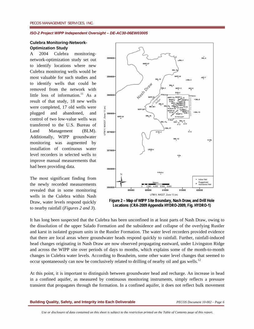
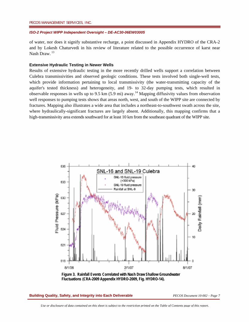
Culebra Monitoring-Network-Optimization Study A 2004 Culebra monitoring-network-optimization study set out to identify locations where new Culebra monitoring wells would be most valuable for such studies and to identify wells that could be removed from the network with little loss of information.11 As a result of that study, 18 new wells were completed, 17 old wells were plugged and abandoned, and control of two low-value wells was transferred to the U.S. Bureau of Land Management (BLM). Additionally, WIPP groundwater monitoring was augmented by installation of continuous water level recorders in selected wells to improve manual measurements that had been providing data. The most significant finding from the newly recorded measurements revealed that in some monitoring wells in the Culebra within Nash Draw, water levels respond quickly to nearby rainfall (Figures 2 and 3). It has long been suspected that the Culebra has been unconfined in at least parts of Nash Draw, owing to the dissolution of the upper Salado Formation and the subsidence and collapse of the overlying Rustler and karst in isolated gypsum units in the Rustler Formation. The water level recorders provided evidence that there are local areas where groundwater heads respond quickly to rainfall. Further, rainfall-induced head changes originating in Nash Draw are now observed propagating eastward, under Livingston Ridge and across the WIPP site over periods of days to months, which explains some of the month-to-month changes in Culebra water levels. According to Beauheim, some other water level changes that seemed to occur spontaneously can now be conclusively related to drilling of nearby oil and gas wells.12 At this point, it is important to distinguish between groundwater head and recharge. An increase in head in a confined aquifer, as measured by continuous monitoring instruments, simply reflects a pressure transient that propagates through the formation. In a confined aquifer, it does not reflect bulk movement
Figure 2 – Map of WIPP Site Boundary, Nash Draw, and Drill Hole Locations (CRA-2009 Appendix HYDRO-2009, Fig. HYDRO-1)
PECOS MANAGEMENT SERVICES, INC. ISO-2 Project WIPP Independent Oversight – DE-AC30-06EW03005
Building Quality, Safety, and Integrity into Each Deliverable PECOS Document 10-002 – Page 7
Use or disclosure of data contained on this sheet is subject to the restriction printed on the Table of Contents page of this report.
of water, nor does it signify substantive recharge, a point discussed in Appendix HYDRO of the CRA-2 and by Lokesh Chaturvedi in his review of literature related to the possible occurrence of karst near Nash Draw. 13 Extensive Hydraulic Testing in Newer Wells Results of extensive hydraulic testing in the more recently drilled wells support a correlation between Culebra transmissivities and observed geologic conditions. These tests involved both single-well tests, which provide information pertaining to local transmissivity (the water-transmitting capacity of the aquifer's tested thickness) and heterogeneity, and 19- to 32-day pumping tests, which resulted in observable responses in wells up to 9.5 km (5.9 mi) away.14 Mapping diffusivity values from observation well responses to pumping tests shows that areas north, west, and south of the WIPP site are connected by fractures. Mapping also illustrates a wide area that includes a northeast-to-southwest swath across the site, where hydraulically-significant fractures are largely absent. Additionally, this mapping confirms that a high-transmissivity area extends southward for at least 10 km from the southeast quadrant of the WIPP site.
Figure 3. Rainfall Events Correlated with Nash Draw Shallow Groundwater Fluctuations (CRA-2009 Appendix HYDRO-2009, Fig. HYDRO-14).
PECOS MANAGEMENT SERVICES, INC. ISO-2 Project WIPP Independent Oversight – DE-AC30-06EW03005
Building Quality, Safety, and Integrity into Each Deliverable PECOS Document 10-002 – Page 8
Use or disclosure of data contained on this sheet is subject to the restriction printed on the Table of Contents page of this report.
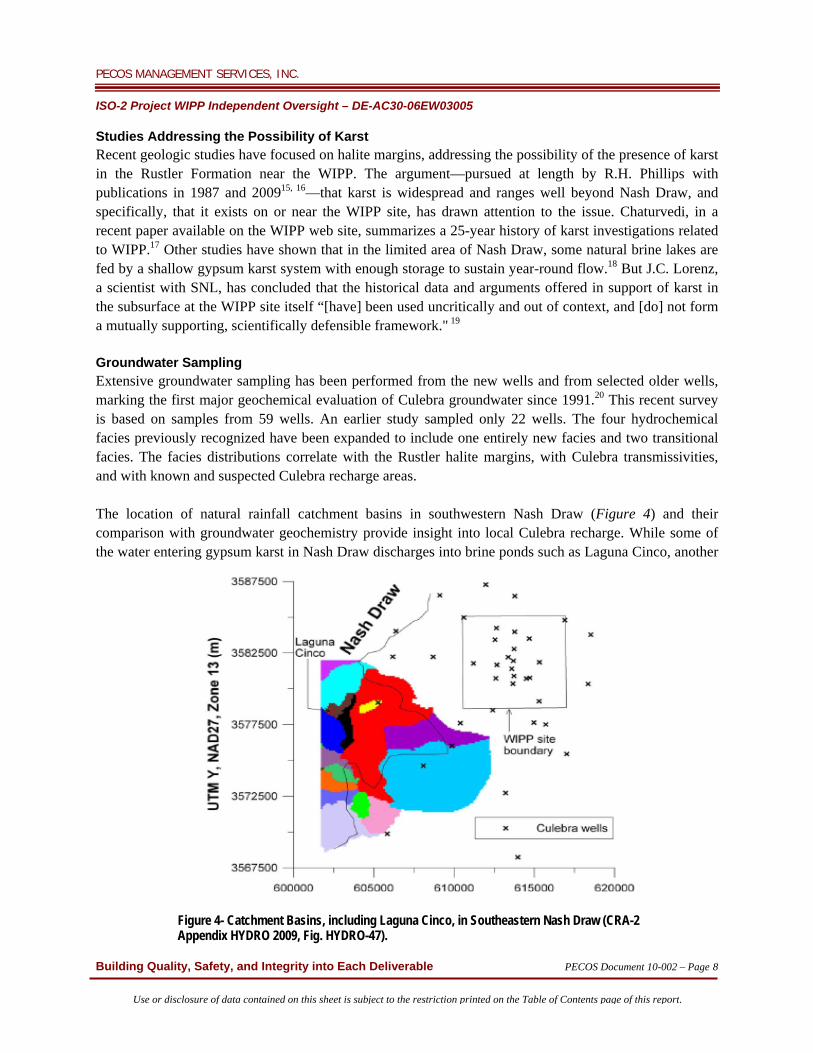
Studies Addressing the Possibility of Karst Recent geologic studies have focused on halite margins, addressing the possibility of the presence of karst in the Rustler Formation near the WIPP. The argument—pursued at length by R.H. Phillips with publications in 1987 and 200915, 16—that karst is widespread and ranges well beyond Nash Draw, and specifically, that it exists on or near the WIPP site, has drawn attention to the issue. Chaturvedi, in a recent paper available on the WIPP web site, summarizes a 25-year history of karst investigations related to WIPP.17 Other studies have shown that in the limited area of Nash Draw, some natural brine lakes are fed by a shallow gypsum karst system with enough storage to sustain year-round flow.18 But J.C. Lorenz, a scientist with SNL, has concluded that the historical data and arguments offered in support of karst in the subsurface at the WIPP site itself “[have] been used uncritically and out of context, and [do] not form a mutually supporting, scientifically defensible framework." 19 Groundwater Sampling Extensive groundwater sampling has been performed from the new wells and from selected older wells, marking the first major geochemical evaluation of Culebra groundwater since 1991.20 This recent survey is based on samples from 59 wells. An earlier study sampled only 22 wells. The four hydrochemical facies previously recognized have been expanded to include one entirely new facies and two transitional facies. The facies distributions correlate with the Rustler halite margins, with Culebra transmissivities, and with known and suspected Culebra recharge areas. The location of natural rainfall catchment basins in southwestern Nash Draw (Figure 4) and their comparison with groundwater geochemistry provide insight into local Culebra recharge. While some of the water entering gypsum karst in Nash Draw discharges into brine ponds such as Laguna Cinco, another
Figure 4- Catchment Basins, including Laguna Cinco, in Southeastern Nash Draw (CRA-2 Appendix HYDRO 2009, Fig. HYDRO-47).
PECOS MANAGEMENT SERVICES, INC. ISO-2 Project WIPP Independent Oversight – DE-AC30-06EW03005
Building Quality, Safety, and Integrity into Each Deliverable PECOS Document 10-002 – Page 9
Use or disclosure of data contained on this sheet is subject to the restriction printed on the Table of Contents page of this report.
portion must recharge groundwater that is in hydraulic communication with the Culebra locally, because the Culebra wells in Nash Draw show water level responses to major rainfall events. These responses, however, do not mean precipitation reaches the Culebra quickly. Rather, they indicate the Culebra is not completely confined, but must be in hydraulic communication with an unconfined aquifer in a higher unit that receives direct precipitation recharge. Eventually, some of this water must reach the Culebra, but it must first spend a considerable period in the Rustler gypsum beds to develop its very high concentration of total dissolved solids (TDS). Two modeling studies suggest that leakage from stratigraphic units above the Culebra is a plausible explanation for long-term rise in water levels observed on and around the WIPP site.21, 22 The Intrepid East potash mine tailings pile may be the primary leakage source north of the WIPP site, while natural recharge from the Culebra, where it is unconfined southwest of the site, could supply the leaking water ascribed to a southern borehole in one of the modeling studies. The studies showed that leakage through unconfirmed but realistic pathways is consistent with observed rising water levels. Peer Reviews, Technical Reviews, and Technical Exchanges ‒ Peer reviews of selected WIPP topics and activities, including the WIPP hydrogeology program, were conducted in the 1990s following Nuclear Regulatory Commission (NRC) peer review guidance and again in accordance with 40 CFR 194, following its promulgation in 1996. In addition, technical reviews of aspects of WIPP hydrogeology as well as technical exchanges between DOE and EPA were conducted to review the plans and progress of the hydrogeological program. Results of those peer reviews, technical reviews, and technical exchanges are summarized below.
One of the first peer reviews of the hydrogeological program was conducted in 1993 as a part of the review by the WIPP Conceptual Model Uncertainty Group (CMUG), an advisory group formed to provide guidance to the SNL WIPP PA effort.23 The CMUG recommended that the PA devote more effort to understanding the origins and evolution of the non-Salado environment, particularly its geology, geochemistry, and hydrology. Specific concerns were provided in four areas: 1) regional hydrology, recharge, and the effects of climate change; 2) geologic history, evolution, and structure over a range of scales; 3) geochemical evolution and composition of groundwater; and 4) alternative transport pathways. In direct response to CMUG recommendations, an in-house working group was formed in the spring of 1993 to reevaluate conceptual models for the PA and to prepare implementation plans for most recommendations provided by the CMUG. The full discussion of the CMUG recommendations and the DOE response is included in the CCA.
A Conceptual Models Peer Review was convened in April 1996. As discussed in the CRA, reviewers focused on the Culebra Hydrogeology conceptual model and concluded that while the model was inadequate to support numerical modeling, the inadequacy was inconsequential as it pertained to performance assessment; this due to the extensive hydrologic database, considered an adequate substitute for supporting numerical modeling. The peer review also evaluated the Salado
PECOS MANAGEMENT SERVICES, INC. ISO-2 Project WIPP Independent Oversight – DE-AC30-06EW03005
Building Quality, Safety, and Integrity into Each Deliverable PECOS Document 10-002 – Page 10
Use or disclosure of data contained on this sheet is subject to the restriction printed on the Table of Contents page of this report.
Interbeds conceptual model and determined that it was adequate. However, the reviewers concluded that though the units above the Salado conceptual model were inadequate, that deficiency had no impact on the PA.
Between April 2002 and March 2003, a peer review was convened to review changes to Salado Flow conceptual models. The Disposal System Geometry, Repository Fluid Flow, and Disturbed Rock Zone (DRZ) parameters related to the flow in the Salado used in the CCA had been revised to respond to changes invoked by EPA as well as to reflect knowledge gained since the CCA submission. The peer reviewers deemed the changes to be appropriate and made no recommendations for any modifications to the WIPP hydrogeological program. That report is included in the 2004 CRA.24
In 2002, the Environmental Evaluation Group, an independent oversight group for WIPP, prepared a technical review report that identified the following hydrogeological concerns they recommended be addressed in the 2004 recertification application: 1) a long-term PA requires accurate understanding and modeling of flow and potential actinide transport in the Culebra; 2) a finer modeling grid should be used and the flow code STAMMT-L substituted for MODFLOW; and 3) DOE should conclusively determine the source of water level increases in the Culebra formation and revise the conceptual model accordingly. These concerns were addressed in the CRA.
In July 2007, DOE hosted a peer review of SNL-proposed changes to the PA regarding new information on the DRZ and cuttings and cavings (CC). The proposed changes to the DRZ model might have had a minor effect on fluid flow from the repository post-closure, and changes to the CC model that raised the waste shear strength parameter would impact the dissolution of radionuclides into the brine in WIPP; but neither proposed change had an impact on the hydrogeological program for WIPP.
The DOE and EPA held a technical exchange meeting in November 2007 as a follow-up to the aborted July 2007 peer review to provide a forum for providing current status of hydrology projects related to WIPP. SNL presented a summary of the status of current studies, newly installed wells, updates to the conceptual model, and proposed changes to the CRA-2. Topics reviewed in detail included new information regarding the halite margins, age of groundwater, the T-field development and calibration process, and the effects of precipitation on the Culebra. While there appeared to be numerous changes in some of the hydraulic properties and assumptions, the consensus of the SNL staff was that none of the material presented would result in a significant change to the PA. EPA concurred with that conclusion. Nevertheless, DOE decided to proceed with the Culebra hydrogeology peer review, described below, which was subsequently performed for and included in the CRA-2. The independent Culebra hydrogeology peer review was conducted in August 2008 in accordance with provisions of 40 CFR 194.27(a)(1) to assess the validity of the proposed Culebra Hydrogeology Conceptual Model,25 which was described in the CRA-2. This peer review panel was tasked to determine
PECOS MANAGEMENT SERVICES, INC. ISO-2 Project WIPP Independent Oversight – DE-AC30-06EW03005
Building Quality, Safety, and Integrity into Each Deliverable PECOS Document 10-002 – Page 11
Use or disclosure of data contained on this sheet is subject to the restriction printed on the Table of Contents page of this report.
whether proposed changes to the conceptual model reasonably represented possible future states of the disposal system. The panel's review of proposed changes to the Culebra model also correlated hydraulic properties from well tests with geologic conditions; probabilistic modeling of specific areas of study (transmissivity, gypsum occurrence, and Salado dissolution); and modeling of groundwater flow through the Culebra member. While each of these subjects had been studied previously, justification for further study included the fact that since the CCA, new information to support the value of transmissivity fields within the Culebra member had been gathered and such previous information had been modified. The panel also identified certain key deficiencies in the proposed changes. First, revision to the current conceptual model does not indicate a consistent connection between the transmissivity fields, modeled flow patterns, and geochemistry. Second, the geochemical and geomechanical processes that correlate the depth, fracture filling, and transmissivity in the conceptual model are not fully understood. Third, vertical leakage through overlying strata to the Culebra member is not consistently modeled in the current basin-wide model and the transmissivity fields model. Presentations to the peer review panel also stated that hydrogeologic monitoring and studies are ongoing and are expected to continue until the project decommissioning phase begins, with emphasis on the effects of Culebra overburden thickness, upper Salado dissolution, and halite units above and below the Culebra member on the conceptual model, and associated mathematical modeling. While the peer review identified some areas of uncertainty related to the hydrogeology of the Culebra Formation, the final overall conclusion was that investigations and analyses met appropriate scientific standards. Further, none of the proposed changes or identified uncertainties regarding knowledge of the Culebra Formation hydraulic properties would adversely affect the PA, since the conditions or assumptions associated with these changes and uncertainties were already bounded by original assumptions. Nevertheless, the EPA required that the revised conceptual model be used in the CRA-2.
PECOS MANAGEMENT SERVICES, INC. ISO-2 Project WIPP Independent Oversight – DE-AC30-06EW03005
Building Quality, Safety, and Integrity into Each Deliverable PECOS Document 10-002 – Page 12
Use or disclosure of data contained on this sheet is subject to the restriction printed on the Table of Contents page of this report.
IV. CONCLUSIONS The hydrologic and hydrogeologic investigations used to select the environment in which to embed the WIPP Repository are thorough and complete as are those that support the design and impact analysis necessary to demonstrate present and future safe containment of radioactive waste resident in the repository. Further, the conceptual hydrology model and input parameters for quantitative modeling developed through those investigations are fundamentally correct and subsequently, have remained basic and unchanged—in some cases, they have been somewhat refined and improved. Further, the model and parameters have been determined to be adequate for the PA and to ensure the safety of future generations. PECOS accepts DOE's conclusions that the SSW accumulation within the WIPP site has stabilized within the boundaries of the site, and that under existing conditions, it will not expand beyond those boundaries. The current hydrological monitoring systems and programs in place at and in the vicinity of the WIPP adequately provide sufficient water quantity and quality data to fulfill future state assumptions contained in 40 CFR 194.25(b). Apparently, in order to ensure that the DOE WIPP Project hydrogeology and hydrology programs fulfill requirements of 40 CFR191, 40 CFR 194, and the HWFP, researchers and investigators have conducted studies that have repeatedly revisited the same or similar geologic and hydrogeologic issues—even though no new data have been presented to contradict original understanding and knowledge. In fact, many of the studies forming the basis of the CRA-2 seem to have been driven by issues that have not substantively changed in the five years since the last recertification application. As an example, the claim that there are karst features at or near the WIPP repository that markedly influence local recharge has been thoroughly investigated and effectively disproved. While such continued studies may be "justified" based on regulatory requirements, the extensive and continuing hydrogeological investigations also lead PECOS to the general opinion that the application of increasingly sophisticated quantitative analytical tests to hypothetical assumptions that are basically indeterminate or indefinable cannot be shown to increase safety and do not substantially add to the hydrogeological knowledge base for the WIPP area or for the overall science of hydrogeology. Since no substantial changes in the basic hydrogeologic or geologic understanding of the WIPP site or its surroundings have occurred since the original CCA was submitted in 1996, PECOS concludes that no noteworthy gaps exist in the conceptual model or quantitative knowledge of hydrogeologic and geologic conditions at the site.
PECOS MANAGEMENT SERVICES, INC. ISO-2 Project WIPP Independent Oversight – DE-AC30-06EW03005
Building Quality, Safety, and Integrity into Each Deliverable PECOS Document 10-002 – Page 13
Use or disclosure of data contained on this sheet is subject to the restriction printed on the Table of Contents page of this report.
V. RECOMMENDATIONS PECOS recommends that DOE base future hydrological programs for the WIPP facility on the following:
1) Continue ongoing groundwater monitoring program for the purpose of demonstrating compliance with the requirements of EPA certification and the state of New Mexico HWFP.
2) Unless monitoring results suggest the current model is inadequate, terminate future hydrogeologic and geochemical investigations primarily designed to develop ever more sophisticated geological definitions and hydrogeology models.
3) Discontinue support of further sampling or analytical work relating to allegations of significant karst terrain within the WIPP site boundary.
This recommendation by PECOS should be evaluated in the context of 40 CFR 194.25(b), "Future States Assumptions," which states:
In considering future states pursuant to this section, the Department [of Energy] shall document in any compliance application, to the extent practicable, effects of potential future hydrogeologic, geologic and climatic conditions on the disposal system over the regulatory time frame.
However, considering the numerous regulatory requirements associated with the hydrological program at WIPP, PECOS recognizes there are two different criteria that should be applied in developing any changes to the program. First, there are technical criteria, which are and should be evaluated by a joint scientific/technical committee of the technical staff of DOE and the regulatory agencies. Second, PECOS suggests that creation of a formal and highly qualified peer review panel would provide a rigorous technical evaluation of this recommendation for consideration by DOE, the EPA, and NMED in fulfilling their respective roles in WIPP recertification and HWFP renewal. The peer review should evaluate the question in the context of 40 CFR 194.25(b) criteria. Recognizing the roles and responsibilities of the regulatory agencies relative to the ongoing hydrogeological program, PECOS suggests that creation of a formal and highly qualified peer review panel could provide significant and strong support to DOE, EPA, and NMED in accepting and implementing our recommendations for modifying the hydrogeological program while still fulfilling their respective roles in permit compliance. REPORT PREPARED BY: Frank Titus, PhD, Staff Scientist REVIEWERS: Jerry Fox, PhD, PE, Project Director Christopher Timm, PE, Deputy Project Director and Quality Assurance Manager Bruce Thomson, PhD, PE, University of New Mexico
PECOS MANAGEMENT SERVICES, INC. ISO-2 Project WIPP Independent Oversight – DE-AC30-06EW03005
Building Quality, Safety, and Integrity into Each Deliverable PECOS Document 10-002 – Page 14
Use or disclosure of data contained on this sheet is subject to the restriction printed on the Table of Contents page of this report.
REFERENCES 1. DOE, Compliance Certification Application (CCA), Carlsbad, NM, 1996. 2. DOE Compliance Recertification Application (CRA), Section 6.3, Carlsbad, NM, 2004. 3. Richard Beauheim, "Collection and Integration of Geoscience Information to Revise the WIPP
Hydrology Conceptual Model, Sandia National Laboratories" (USA, AMIGO-3 Workshop, France, April 15-17, 2008).
4. Kurk L. Larson, "Development of the Conceptual Models for Conditions and Hydrology Used in the
1996 Performance Assessment for the Waste Isolation Pilot Plant," Sandia National Laboratories Report No. SAN 099-23315, May 2004.
5. Stephens, D.B., & Associates, Inc., "Water Budget Analysis of Shallow Subsurface Water at the
Waste Isolation Pilot Plant" (prepared for U.S. DOE Carlsbad Field Office, Carlsbad, NM, 2003). 6. DOE, CRA-2, 2008. 7. DOE, CRA, 2004. 8. R.L. Beauheim and S.A. McKenna, "Analysis Plan for Optimization and Minimization of the Culebra
Monitoring Network for the WIPP," AP-111, ERMS, 533092, Carlsbad, NM, Sandia National Laboratories, 2003.
9. S.A. McKenna, "Analysis Report AP-111, Culebra Water Level Network Monitoring Design,” AP-
111, ERMS 540477, Sandia National Laboratories, Carlsbad, NM, 2004.
10. McKenna, 2004. 11. DOE, Compliance Recertification Application, Appendix HYDRO-2009, Hydrologic Investigations,
Section HYDRO-6.6 Summary, Carlsbad, NM, 2009.
12. Beauheim, 2008. 13. Lokesh Chaturvedi, "The Karst and Related Issues at the Waste Isolation Pilot Plant," 2009. 14. M.B. Hilleshein and R.L. Beauheim, “Hydrologic Monitoring and Data Assessment,” Sandia
National Laboratories Technical Baseline Report, 2004-2005, ERMS 548259, Sandia National Laboratories Carlsbad, NM, 2007.
PECOS MANAGEMENT SERVICES, INC. ISO-2 Project WIPP Independent Oversight – DE-AC30-06EW03005
Building Quality, Safety, and Integrity into Each Deliverable PECOS Document 10-002 – Page 15
Use or disclosure of data contained on this sheet is subject to the restriction printed on the Table of Contents page of this report.
15. R.H. Phillips, "The Prospects for Regional Groundwater Contamination Due to Karst Landforms in Mescalero Caliche at the WIPP Site Near Carlsbad, New Mexico" (unpublished PhD dissertation, University of Oregon), 1987.
16. R.H. Phillips, "Proof of Rapid Rainwater Recharge at the WIPP Site," March 25, 2009.
17. Chaturvedi, 2009. 18. D.W. Powers, "Evaporate Karst Features and Processes at Nash Draw, Eddy County, NM," NMGS
Guidebook 57th Field Conference, Caves and Karst of Southeastern NM, 2006. 19. J.C. Lorenz, “Assessment of the Geological Evidence for Karst in the Rustler Formation at the WIPP
Site,” Caves and Karst of Southeastern New Mexico, 2006, pgs. 243–252 20. Beauheim, 2008.
21. T.S. Lowry and R.L. Beauheim, "Analysis Report: Task 2 of AP-110: Evaluation for Water-Level
Rise in the Culebra Due to Recharge from Refining Process Water Discharged onto Potash Tailings Piles," ERMS 536239, Sandia National Laboratories, Carlsbad, NM, 2004.
22. T.S. Lowry and R.L. Beauheim, "Analysis Report: Task 3 of AP-110: Evaluation for Water-Level
Rise in the Culebra Due to Leakage through poorly Plugged and Abandoned Potash Boreholes," ERMS 540187, Sandia National Laboratories, Carlsbad, NM, 2004.
23. DOE, CCA, 1996.
24. DOE, CRA, 2004. 25. J.A. Thies, A. Burgess, and T. Lowenstein, "Culebra Hydrogeology Conceptual Model Peer Review,"
DOE, September 24, 2008.
PECOS MANAGEMENT SERVICES, INC. ISO-2 Project WIPP Independent Oversight – DE-AC30-06EW03005
Building Quality, Safety, and Integrity into Each Deliverable PECOS Document 10-002 – Page 16
Use or disclosure of data contained on this sheet is subject to the restriction printed on the Table of Contents page of this report.
BIBLIOGRAPHY Beauheim, R. Analysis Plan for Evaluation and Recalibration of Culebra Transmissivity Fields. AP-114, Rev. 1. Sandia National Laboratories, Waste Isolation Pilot Plant, February 14, 2008. Beauheim, R. Conceptual Model Peer Review of Culebra Hydrology. Culebra Hydrogeology Conceptual Model Peer Review presentation, August 11-14, 2008.
Beauheim, R. Hydrologic Setting and Hydrological Investigations of the Culebra. Culebra Hydrogeology Conceptual Model Peer Review presentation, August 11-14, 2008. Beauheim, R. Status of Magenta Investigations. DOE/EPA meeting presentation (SNL), November 29, 2007. Beauheim, R. Summary of Conceptual Model and Supporting Field Evidence. Culebra Hydrogeology Conceptual Model Peer Review presentation, August 11-14, 2008. Beauheim, R. Summary of Culebra Hydrology Conceptual Model and Numerical Implementation. Culebra Hydrogeology Conceptual Model Peer Review presentation, August 11-14, 2008. Domski, P. Culebra Hydrochemistry. DOE/EPA meeting (Stoller), November 29, 2007. Domski, S.M. and R. Beauheim. Chemistry of the Culebra Waters. Culebra Hydrogeology Conceptual Model Peer Review presentation, August 11-14, 2008. Hart, D.B., Culebra T-field Calibration Process. DOE/EPA meeting presentation (SNL), November 29, 2007. Hillesheim, M.B. 2007. Culebra Response to Precipitation Events in the WIPP Vicinity. DOE/EPA meeting presentation (SNL), November 29, 2007. Holt, R.M. Geologically-Based Approach for Predicting Culebra Transmissivity. Culebra Hydrogeology Conceptual Model Peer Review presentation, August 11-14, 2008. Holt, R.M. Geologically-Based Approach for Predicting Culebra Transmissivity. DOE/EPA meeting presentation (University of Mississippi), November 29, 2007. Kanney, J. Overview of WIPP Performance Assessment. Culebra Hydrogeology Conceptual Model peer review presentation, August 11-14, 2008. L. Land, V.W. Lueth, W. Raatz, P. Boston, and D.L. Love, eds., 57th Annual Fall Field Conference Guidebook, Socorro, NM. McKenna, S. and D. Hart. T-Field Calibration Process. Culebra Hydrogeology Conceptual Model Peer Review presentation, August 11-14, 2008.
PECOS MANAGEMENT SERVICES, INC. ISO-2 Project WIPP Independent Oversight – DE-AC30-06EW03005
Building Quality, Safety, and Integrity into Each Deliverable PECOS Document 10-002 – Page 17
Use or disclosure of data contained on this sheet is subject to the restriction printed on the Table of Contents page of this report.
Powers, D. Halite Margins of the Permian Rustler Formation, Southeastern New Mexico. DOE/EPA meeting presentation (SNL), November 29, 2007. Powers, D.W. Geological Background for the Culebra Conceptual Model. Culebra Hydrogeology Conceptual Model Peer Review presentation, August 11-14, 2008. Roberts, R. Well-Test Analysis Results Culebra Wells. DOE/EPA Meeting (SNL), November 29, 2007. Roberts, R.M. Analysis of Culebra Hydraulic Tests Performed Between June 2006 and September 2007. Analysis Report for AP-070, ERMS# 547418, Carlsbad, NM: SNL, WIPP Records Center, 2007. Toll, N. Groundwater Age Dating at the Waste Isolation Pilot Plant, DOE/EPA meeting presentation (SNL), November 29, 2007.