Embed Size (px)
Citation preview
ATMOSPHERIC RIVERS STATE OF KNOWLEDGE REPORT
Atmospheric Rivers State of Knowledge Report
Pinna Sustainability
Table of Contents
1 Introduction .................................................................1
2 Our Current Understanding .........................................2
3 Enhancing Our Understanding ....................................4
4 Enhancing Our Response ............................................7
5 Stakeholders and Responsibilities ...........................10
Appendix A .....................................................................11
Appendix B .....................................................................12
Atmospheric Rivers State of Knowledge Report
Pinna Sustainability
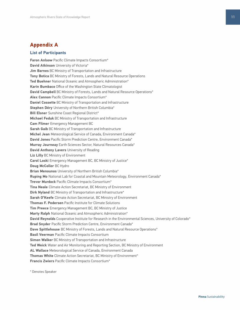
The Pacific Climate Impacts Consortium (PCIC) in partnership with the Pacific Institute for Climate Solutions (PICS), and the BC Ministry of Environment Climate Action Secretariat, hosted a one-day BC Atmospheric River Events: State of the Knowledge Workshop on the 7th of March, 2013. This workshop brought together a group of climate scientists, forecasters, emergency management professionals, and policy advisors from the North American Pacific West Coast and Yukon regions to take stock of current knowledge on atmospheric rivers (ARs), understand the risks of climate related extreme precipitation events, and identify gaps in knowledge for further study. This report summarizes the learning from this workshop and offers a concise overview of opportunities to enhance our knowledge of ARs in British Columbia. A full list of presenters and participants is included in Appendix A.
This paper serves as a summary of the proceedings of this event, and presents the current state of our knowledge in the following themes:
• Our Current Understanding
• Enhancing Our Understanding
• Enhancing Our Response
• Stakeholder Mapping
Beginning from a Position of StrengthBefore turning attention to emerging knowledge and opportunities, it is important to recognize the many achievements and successful partnerships currently working to protect our communities from extreme precipitation events. Our forecasting, and emergency preparedness communities are skilled at leveraging personal relationships and resources to predict and prepare for extreme weather. As reported at the
1 INTRODUCTIONworkshop, when Environment Canada forecasters issue a storm warning for a location on the west coast they are correct 85% of the time, and only 27% of storms occur without a storm warning being issued. This success in developing localized forecasts from global information is on par with other international forecasting bodies.
Successful relationships between forecasters and emergency preparedness practitioners are also apparent. Emergency managers report that while there is an increase of insurance claims and costs due to damage caused by extreme precipitation, there is a reported reduction in the loss of human life. These measures indicate that forecasters and emergency managers have become better able to remove human communities from harm’s way despite increased damages to property.
In addition to the partners who are directly involved with forecasting and response, governments and research institutes such as PCIC have also built successful relationships that nurture a greater understanding of BC’s climate and the impacts of climate change. These groups support a growing understanding of how our local climate is changing, improve our understanding of how these changes may have an impact on extreme weather, and organize this information in a way that helps decision makers prepare for and respond to extreme events. This information may be useful when planning for long-term trends in extreme events.
1
1 Zhu, Y., & Newell, RE. (1998) A Proposed Algorithm for Moisture Fluxes from Atmospheric Rivers, in Monthly Weather Review. v126. p725-735. 2 Ibid3 Dettinger, M., Ralph, M., Das, T., Neiman, P., and Cayan, D. (2011) Atmospheric Rivers, Floods and the Water Resources of California, in Water. v3. p455-478.
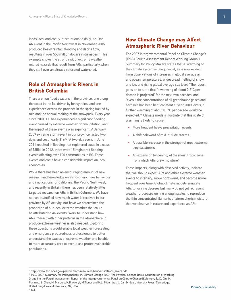
2 OUR CURRENT UNDERSTANDINGWhat is an Atmospheric River?The term atmospheric river was coined by Zhu and Newell (1998) and refers to long narrow streams of high water vapour concentrations in the atmosphere that move moisture from tropical regions towards the poles across the mid latitudes.1 Our understanding of these phenomena is still in development though some characteristics have been defined. On average, an AR is 400km wide and over 1000km long with between 3cm-6cm of water vapour (known as Vertical Integrated Water Vapour) in the middle of the stream.2 As shown on Figure 1, these long, thin filaments of moisture are propelled by strong winds traveling faster than 35 km/hr. ARs result in heavy precipitation when they confront mountainous terrain, such as those found on the west coast of North America.
Atmospheric rivers tend to occur in approximately 8 specific regions globally (Figure 2), and 90% of global water transfer by the atmosphere happens in these regions. There are only a few active ARs at any one time, and in the North American case, there are relatively few per season: between 12 and 24 in any one year. On average, an AR event will produce heavy precipitation for approximately 20 hours at a given location, but if stalled an event can last multiple days.
Importance of Atmospheric RiversThe scientific and extreme weather communities are interested in atmospheric rivers because of both the benefits they bring and the risks they pose. The transfer of fresh water from tropical regions has the benefit of building snowpack and recharging reservoirs with clean water. This benefits communities in many ways by providing improved access to potable water and
hydro electricity, and enhancing local biodiversity. As an example, a little over one third to half of California’s water supply is provided by ARs, and it is estimated that nearly one quarter of the water in the Pacific North West is transported via AR events.3
This bounty, however, is a double-edged sword. ARs also produce extreme weather that causes flooding,
Figure 1: Satellite Observations of an Atmospheric River, from Marty Ralph, NOAA
Figure 2: Global locations of Atmospheric River Behaviour, Zhu & Newell, 1998
Vertically integrated water vapor (equivalent depth of liquid water in cm)
2
Atmospheric Rivers State of Knowledge Report
Pinna Sustainability
4 http://www.esrl.noaa.gov/psd/outreach/resources/handouts/atmos_rivers.pdf5 IPCC, 2007: Summary for Policymakers. In: Climate Change 2007: The Physical Science Basis. Contribution of Working Group I to the Fourth Assessment Report of the Intergovernmental Panel on Climate Change [Solomon, S., D. Qin, M. Manning, Z. Chen, M. Marquis, K.B. Averyt, M.Tignor and H.L. Miller (eds.)]. Cambridge University Press, Cambridge, United Kingdom and New York, NY, USA.6 Ibid.
landslides, and costly interruptions to daily life. One AR event in the Pacific Northwest in November 2006 produced heavy rainfall, flooding and debris flow, resulting in over $50 million dollars in damages.4 This example shows the strong risk of extreme weather related hazards that result from ARs, particularly when they stall over an already saturated watershed.
Role of Atmospheric Rivers in British ColumbiaThere are two flood seasons in the province, one along the coast in the fall driven by heavy rains, and one experienced across the province in the spring fuelled by rain and the annual melting of the snowpack. Every year since 2001, BC has experienced a significant flooding event caused by extreme weather or precipitation, and the impact of these events was significant. A January 2009 extreme storm event in our province lasted two days and cost nearly $16M. A two-day event in June 2011 resulted in flooding that registered costs in excess of $85M. In 2012, there were 15 registered flooding events affecting over 100 communities in BC. These events and costs have a considerable impact on local economies.
While there has been an encouraging amount of new research and knowledge on atmospheric river behaviour and implications for California, the Pacific Northwest, and recently in Britain, there has been relatively little targeted research on ARs in British Columbia. We have not yet quantified how much water is received in our province by AR activity, nor have we determined the proportion of our local extreme weather that could be attributed to AR events. Work to understand how ARs interact with other patterns in the atmosphere to produce extreme weather is also needed. Exploring these questions would enable local weather forecasting and emergency preparedness professionals to better understand the causes of extreme weather and be able to more accurately predict events and protect vulnerable populations.
How Climate Change may Affect Atmospheric River BehaviourThe 2007 Intergovernmental Panel on Climate Change’s (IPCC) Fourth Assessment Report Working Group 1 Summary for Policy Makers states that a ”warming of the climate system is unequivocal, as is now evident from observations of increases in global average air and ocean temperatures, widespread melting of snow and ice, and rising global average sea level.” The report goes on to state that “a warming of about 0.2°C per decade is projected” for the next two decades, and “even if the concentrations of all greenhouse gases and aerosols had been kept constant at year 2000 levels, a further warming of about 0.1°C per decade would be expected.”5 Climate models illustrate that this scale of warming is likely to cause:
• More frequent heavy precipitation events
• A shift poleward of mid latitude storms
• A possible increase in the strength of most extreme tropical storms
• An expansion (widening) of the moist tropic zone from which ARs draw moisture6
These impacts, along with observed activity, indicate that we should expect ARs and other extreme weather events to intensify, move northward, and become more frequent over time. Global climate models simulate ARs to varying degrees but many do not yet represent weather processes on fine enough scales to reproduce the thin concentrated filaments of atmospheric moisture that we observe in nature and experience as ARs.
3
3 ENHANCING OUR UNDERSTANDING Meteorologists, forecasters and emergency managers could be better equipped to detect and predict the behaviours and impacts of extreme weather events. Local governments could also be better equipped to understand local risks and prepare in advance of extreme events. This section will explore how improved observations, forecasting and scenario planning could play a role in enhancing our understanding of extreme weather in British Columbia.
Enhancing Data CollectionIn British Columbia, meteorological data is currently gathered from non-uniformly distributed rainfall, temperature and wind-speed monitoring stations, and a very limited number of weather radars that cover only a small fraction of our mountainous province. This coverage allows for regional forecasting and emergency response planning, but lacks the finer grain detail that would enable meaningful local analysis. There are multiple data sets and/or detection systems that would greatly enhance our observational, forecasting and modelling abilities. These include:
1. Atmospheric River Observation (ARO) stations that measure moisture in the water column and its vertical and horizontal movement (flux). Understanding where high concentrations of vapour are, and how they move through the water column would improve synoptic analysis of extreme weather, and offer improved data for climate model analysis.
2. Additional meteorological stations to improve our ability to understand where heavy precipitation is occurring and the form in which it is falling. In addition to supporting the work of forecasters, this
would provide data to climatologists for monitoring change over time and for the production and verification of downscaled climate projections.
3. Small, local observational radars positioned to fill gaps in the coverage provided by the current network of observational radars. These gaps are created by the mountainous terrain of our province. This would enable forecasters to monitor events in localities currently unobserved by the regional radar system.
4. Soil moisture gauges to monitor soil saturation and augment our ability to predict consequences of extreme weather such as landslides and floods.
5. Additional stream flow gauges positioned in rivers at risk of flooding during extreme events to enable forecasters and emergency planners to correlate rainfall and stream flow, and more accurately predict flood events.
In addition to quantitative data, the public also has a role to play in collecting qualitative data to enhance our understanding of extreme weather events in our province. Local citizens experience the impacts of weather first hand, and can provide real-time weather reports to the forecasters and emergency preparedness professionals. Accessing this data would ‘truth’ the forecasts provided. The public can also provide local stories of the impacts on communities – of actions taken to prevent injury, resulting damage, and reconstruction experience. These stories would provide insight to understand intensity and impacts beyond that available via instruments, help to inform impact scenario planning, and contribute to a culture of preparedness across the province.
4
Atmospheric Rivers State of Knowledge Report
Pinna Sustainability
Learning From our Southern Neighbours
During the workshop, participants learned about
ongoing and potential AR research and communication
achievements, including:
• A potential ARO station demonstration pilot for
Vancouver Island
• Low cost data collection techniques
• Long range forecasting (MJO)
• Communication and outreach
• Investments in monitoring programs
• Use of social media
• Measuring AR characteristics with airborne drones
• ARkStorm analysis to provide a realistic, detailed
scenario of extreme winter storms, based on past
historical data.
Enhancing our Scientific Understanding of Atmospheric RiversOur understanding of extreme weather relies on our knowledge of how the atmosphere behaves generally, our ability to predict how the atmosphere will behave in the future and the hydrologic outcomes of these forces. Improving our understanding involves research on global and local synoptic patterns, continued development of forecasting model performance and sensitivity, as well as learning more about AR hydrological impacts specific to our region. These topics are expanded below.
1. Improving synoptic understanding: Forecasters at Environment Canada are conducting pattern recognition data analysis to enhance their ability to predict AR events in BC. This involves isolating British Columbian data from North American sets, and setting up a formalized method to determine the most characteristic synoptic patterns that have lead to AR events in the province. Improving our understanding of synoptic systems would provide forecasters a powerful tool to predict how specific
weather patterns seen offshore will play out when they hit the coast. Specific research questions that emerged from the workshop that aim to improve our synoptic understanding include:
1.1 How do regional variance and large-scale oscillation patterns influence the frequency and intensity of atmospheric rivers? More specifically, how does synoptic variability in the North Pacific affect the intensity, frequency, location and evolution of AR events over the short-term (days)?
1.2 How does intra-seasonal variability, such as that associated with the Madden-Julian Oscillation, in the Tropical Pacific, affect the intensity, frequency, location and evolution of AR events over the medium term (30-45 days)?
1.3 Our current understanding tells us that precipitation intensity in the Northern Pacific may increase by a factor of 2 between phases of the El Nino Southern-Oscillation (ENSO7). Is there a similar relationship between the ENSO and increased intensity or probability of atmospheric river events in the Northern Pacific?
2. Improving our forecasting models: Local forecasters are currently using ensemble forecasting techniques to improve deterministic and probabilistic weather predictions. This technique involves using the same meteorological data to run multiple models or ‘members’ at once. Forecasters then compare the outcomes of the various members in order to produce an improved probabilistic forecast and offer a more accurate prediction of future weather. Environment Canada is working to find a way to extract the probability of an AR event from their ensemble forecasts. Specific research could examine the appropriate variables (e.g., total precipitable water, total rainfall, wind speed, etc.) and thresholds to extract from the ensemble forecast in order to see and predict AR events in BC.
7 Zhang X., Wang, J., Zwiers, F., & Groisman, P.Ya. (2010) The influence of large-scale climate variability on winter maximum daily precipitation over North America, in Journal of Climate. v23. p2902-2915.
5
3. Improving our understanding of AR hydrology and impacts in BC: There is still uncertainty in the weather and climate community about whether it is important to classify an extreme rain event as an atmospheric river. Some basic questions about the hydrology of ARs would enable forecasters, emergency response practitioners and policy makers to contextualize an AR, and thereby plan for and respond to them more effectively. These questions include:
3.1 What percentage of extreme weather events in our province is caused by atmospheric rivers? Are AR events associated with the most extreme of extreme events in our province?
3.2 We understand that 90% of global water transfer occurs through atmospheric river events. How much water is conveyed via atmospheric river events into BC’s water cycle?
3.3 What is the financial impact of damages caused by atmospheric river events in British Columbia?
4. Improving our understanding of climate change and climate models: A long term commitment to understanding how local climate is changing, along with continued research as to how climate change will have an impact on local weather, would enhance our ability to identify trends and predict how AR activity may change with the changing climate. Continued work towards high-resolution regional climate models that include BC and a substantial part of the North Pacific Ocean would enable climatologists to identify future trends, and local communities to prepare for changes expected impacts of AR events.
Addressing the data and research questions outlined in this section would improve our skill and accuracy in forecasting, modeling, predicting and responding to ARs and extreme weather, further in advance of an AR event.
6
Atmospheric Rivers State of Knowledge Report
Pinna Sustainability
Preparing for ImpactsHaving sufficient high quality local data and an informed understanding of synoptic variability would greatly improve forecasters’ ability to foresee the development of extreme weather, and predict how extreme weather may have an impact on communities. Moving from weather forecasts to impact forecasts will require close collaboration between the partners. Activities discussed at the workshop are outlined below:
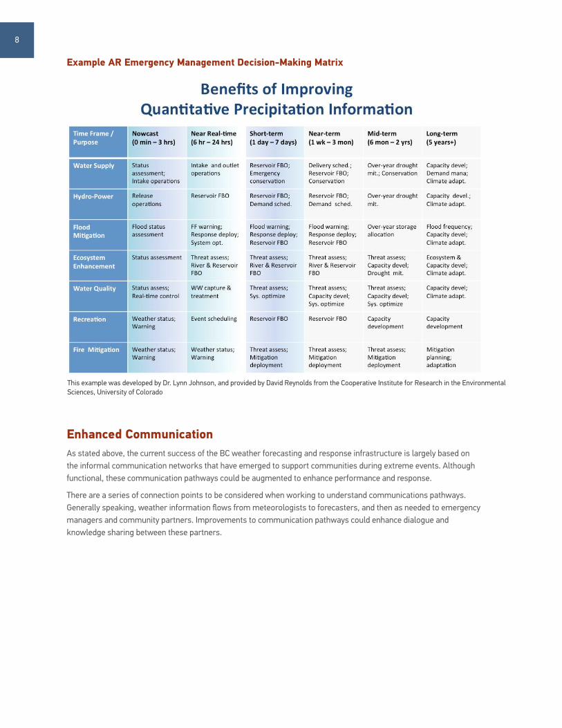
1. Implement a new decision-making matrix by collaborating with meteorologists, forecasters, emergency preparedness planners and local government representatives to enhance our ability to incorporate situational considerations into the forecasting process. Identifying vulnerabilities and emergency management needs in advance could reduce risks to communities. This would involve supplying forecasters with a decision-making matrix that contains an agreed upon set of localized risk minimization actions and lead-times in advance of an extreme weather event that are required to take these actions. This recommendation is a reflection of ongoing work being conducted in the United States to increase the lead times associated with warning vulnerable populations of extreme events. It has been shown that a 24-hour lead-time could reduce the cost of damages by 13%.8 An example of an AR emergency management decision-making matrix developed by Dr. Lynn Johnson is shown on page 8.
2. Undertake community level vulnerability assessment exercises to identify specific risks. This could include a mapping exercise with community planners and stakeholders to highlight
impacts of past events, vulnerable populations and infrastructure, and land-uses that are prone to weather-related hazards. Community members and emergency planners should also be asked to provide input on resource needs and appropriate timescales for emergency response.
3. Coordinate discussions to balance risk from prediction error with risk from potential impacts. This action would build on the vulnerability assessment and offer forecasters direct instructions on when (how far in advance, and under what conditions) to share uncertain weather warnings with managers of vulnerable populations. An outcome of this discussion could be subject-specific briefings for different audiences or end users, ensuring appropriate information is being shared at the appropriate time.
4. Build impact models that incorporate robust quantitative and qualitative data (as discussed in section 3) into localized extreme weather scenarios. Impact modelling precedents to consider include the Hazus Model scenario builder developed in the United States, with transferable lessons for Canadian extreme weather emergency planning. 9
5. Develop and run scenarios for major AR events on the BC coast. Bringing forecasters and responders together to work through a storm scenario similar to the ARKSTORM exercise conducted in the U.S. could improve preparedness and response in B.C. 10
4 ENHANCING OUR RESPONSE
8 Carswell, K., Pingell, N., & Ford, D. (2004) Quantifying the Benefit of a Flood Warning System9 This work is currently being adapted for Canadian communities by David Jones at NRCan.10 Dettinger, M., Ralph, M., Huges, M., Das, T., Neiman, P., et al. (2012) Design and quantification of an extreme winter storm scenario for emergency preparedness and planning exercises in California, in Nat Hazards. V60. p1085–1111.
7
Enhanced CommunicationAs stated above, the current success of the BC weather forecasting and response infrastructure is largely based on the informal communication networks that have emerged to support communities during extreme events. Although functional, these communication pathways could be augmented to enhance performance and response.
There are a series of connection points to be considered when working to understand communications pathways. Generally speaking, weather information flows from meteorologists to forecasters, and then as needed to emergency managers and community partners. Improvements to communication pathways could enhance dialogue and knowledge sharing between these partners.
Example AR Emergency Management Decision-Making Matrix
This example was developed by Dr. Lynn Johnson, and provided by David Reynolds from the Cooperative Institute for Research in the Environmental Sciences, University of Colorado
8
Atmospheric Rivers State of Knowledge Report
Pinna Sustainability
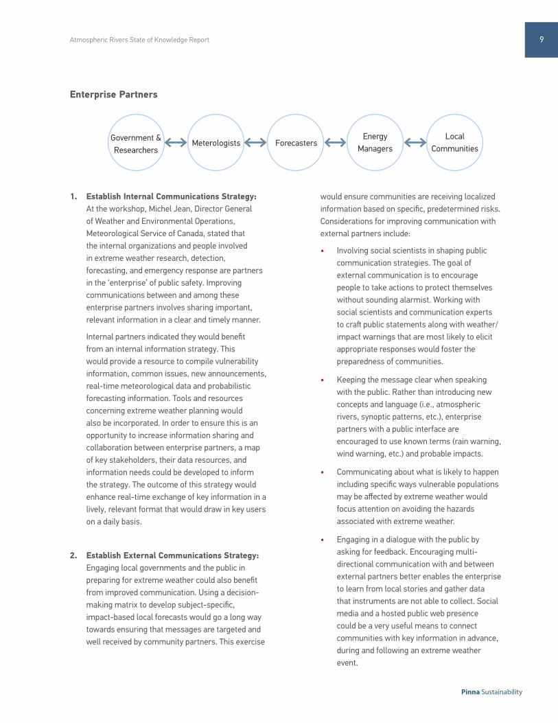
Government & Researchers
Meterologists ForecastersEnergy
ManagersLocal
Communities
Enterprise Partners
1. Establish Internal Communications Strategy: At the workshop, Michel Jean, Director General of Weather and Environmental Operations, Meteorological Service of Canada, stated that the internal organizations and people involved in extreme weather research, detection, forecasting, and emergency response are partners in the ‘enterprise’ of public safety. Improving communications between and among these enterprise partners involves sharing important, relevant information in a clear and timely manner.
Internal partners indicated they would benefit from an internal information strategy. This would provide a resource to compile vulnerability information, common issues, new announcements, real-time meteorological data and probabilistic forecasting information. Tools and resources concerning extreme weather planning would also be incorporated. In order to ensure this is an opportunity to increase information sharing and collaboration between enterprise partners, a map of key stakeholders, their data resources, and information needs could be developed to inform the strategy. The outcome of this strategy would enhance real-time exchange of key information in a lively, relevant format that would draw in key users on a daily basis.
2. Establish External Communications Strategy: Engaging local governments and the public in preparing for extreme weather could also benefit from improved communication. Using a decision-making matrix to develop subject-specific, impact-based local forecasts would go a long way towards ensuring that messages are targeted and well received by community partners. This exercise
would ensure communities are receiving localized information based on specific, predetermined risks. Considerations for improving communication with external partners include:
• Involving social scientists in shaping public communication strategies. The goal of external communication is to encourage people to take actions to protect themselves without sounding alarmist. Working with social scientists and communication experts to craft public statements along with weather/ impact warnings that are most likely to elicit appropriate responses would foster the preparedness of communities.
• Keeping the message clear when speaking with the public. Rather than introducing new concepts and language (i.e., atmospheric rivers, synoptic patterns, etc.), enterprise partners with a public interface are encouraged to use known terms (rain warning, wind warning, etc.) and probable impacts.
• Communicating about what is likely to happen including specific ways vulnerable populations may be affected by extreme weather would focus attention on avoiding the hazards associated with extreme weather.
• Engaging in a dialogue with the public by asking for feedback. Encouraging multi-directional communication with and between external partners better enables the enterprise to learn from local stories and gather data that instruments are not able to collect. Social media and a hosted public web presence could be a very useful means to connect communities with key information in advance, during and following an extreme weather event.
9
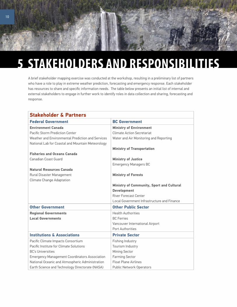
A brief stakeholder mapping exercise was conducted at the workshop, resulting in a preliminary list of partners who have a role to play in extreme weather prediction, forecasting and emergency response. Each stakeholder has resources to share and specific information needs. The table below presents an initial list of internal and external stakeholders to engage in further work to identify roles in data collection and sharing, forecasting and response.
Stakeholder & PartnersFederal Government BC GovernmentEnvironment CanadaPacific Storm Prediction CenterWeather and Environmental Prediction and ServicesNational Lab for Coastal and Mountain Meteorology
Fisheries and Oceans CanadaCanadian Coast Guard
Natural Resources CanadaRural Disaster ManagementClimate Change Adaptation
Ministry of EnvironmentClimate Action SecretariatWater and Air Monitoring and Reporting
Ministry of Transportation
Ministry of Justice Emergency Managers BC
Ministry of Forests
Ministry of Community, Sport and Cultural DevelopmentRiver Forecast Center Local Government Infrastructure and Finance
5 STAKEHOLDERS AND RESPONSIBILITIES
Other Government Other Public SectorRegional GovernmentsLocal Governments
Health AuthoritiesBC FerriesVancouver International AirportPort Authorities
Institutions & Associations Private SectorPacific Climate Impacts ConsortiumPacific Institute for Climate Solutions BC’s UniversitiesEmergency Management Coordinators AssociationNational Oceanic and Atmospheric Administration Earth Science and Technology Directorate (NASA)
Fishing IndustryTourism IndustryMining SectorFarming SectorFloat Plane AirlinesPublic Network Operators
10
Atmospheric Rivers State of Knowledge Report
Pinna Sustainability
Appendix AList of Participants
Faron Anlsow Pacific Climate Impacts Consortium*David Atkinson University of Victoria*Jim Barnes BC Ministry of Transportation and InfrastructureTony Botica BC Ministry of Forests, Lands and Natural Resource OperationsTed Buehner National Oceanic and Atmospheric Administration*Karin Bumbaco Office of the Washington State ClimatologistDavid Campbell BC Ministry of Forests, Lands and Natural Resource Operations*Alex Cannon Pacific Climate Impacts Consortium*Daniel Cossette BC Ministry of Transportation and InfrastructureStephen Déry University of Northern British Columbia*Bill Elsner Sunshine Coast Regional District*Michael Feduk BC Ministry of Transportation and InfrastructureCam Filmer Emergency Management BCSarah Gaib BC Ministry of Transportation and InfrastructureMichel Jean Meteorological Service of Canada, Environment Canada* David Jones Pacific Storm Prediction Centre, Environment Canada*Murray Journeay Earth Sciences Sector, Natural Resources Canada*David Anthony Lavers University of ReadingLiz Lilly BC Ministry of EnvironmentCarol Loski Emergency Management BC, BC Ministry of Justice*Doug McCollor BC Hydro Brian Menounos University of Northern British Columbia*Ruping Mo National Lab for Coastal and Mountain Meteorology, Environment Canada*Trevor Murdock Pacific Climate Impacts Consortium*Tina Neale Climate Action Secretariat, BC Ministry of Environment Dirk Nyland BC Ministry of Transportation and Infrastructure*Sarah O’Keefe Climate Action Secretariat, BC Ministry of EnvironmentThomas F. Pedersen Pacific Institute for Climate Solutions Tim Preece Emergency Management BC, BC Ministry of JusticeMarty Ralph National Oceanic and Atmospheric Administration*David Reynolds Cooperative Institute for Research in the Environmental Sciences, University of Colorado*Brad Snyder Pacific Storm Prediction Centre, Environment Canada*Dave Spittlehouse BC Ministry of Forests, Lands and Natural Resource Operations*Basil Veerman Pacific Climate Impacts ConsortiumSimon Walker BC Ministry of Transportation and InfrastructureTed Weick Water and Air Monitoring and Reporting Section, BC Ministry of EnvironmentAL Wallace Meteorological Service of Canada, Environment CanadaThomas White Climate Action Secretariat, BC Ministry of Environment*Francis Zwiers Pacific Climate Impacts Consortium*
* Denotes Speaker
11
March 6-7, 2013 — Laurel Point Inn, Victoria, BC
BC “ATMOSPHERIC RIVER” EVENTS:S T A T E O F T H E K N O W L E D G E W O R K S H O P
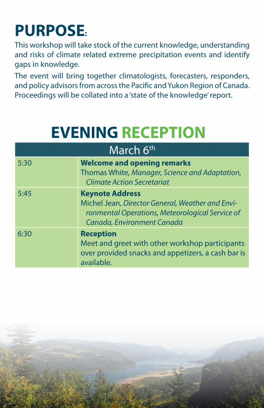
March 6th
5:30 Welcome and opening remarksThomas White, Manager, Science and Adaptation,
Climate Action Secretariat5:45 Keynote Address
Michel Jean, Director General, Weather and Envi-ronmental Operations, Meteorological Service of Canada, Environment Canada
6:30 ReceptionMeet and greet with other workshop participants over provided snacks and appetizers, a cash bar is available.
PURPOSE:This workshop will take stock of the current knowledge, understanding and risks of climate related extreme precipitation events and identify gaps in knowledge.The event will bring together climatologists, forecasters, responders, and policy advisors from across the Pacific and Yukon Region of Canada. Proceedings will be collated into a ‘state of the knowledge’ report.
EVENING RECEPTION
March 7th
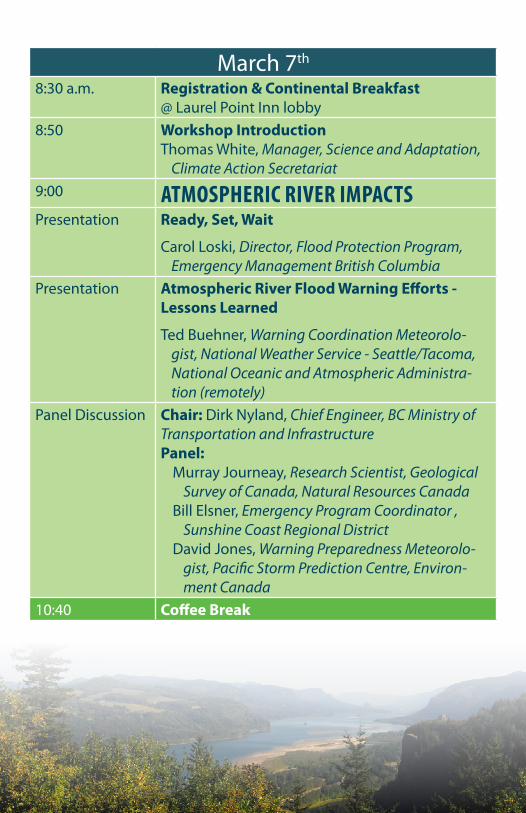
8:30 a.m. Registration & Continental Breakfast @ Laurel Point Inn lobby
8:50 Workshop IntroductionThomas White, Manager, Science and Adaptation,
Climate Action Secretariat9:00 ATMOSPHERIC RIVER IMPACTSPresentation Ready, Set, Wait
Carol Loski, Director, Flood Protection Program, Emergency Management British Columbia
Presentation Atmospheric River Flood Warning Efforts - Lessons Learned
Ted Buehner, Warning Coordination Meteorolo-gist, National Weather Service - Seattle/Tacoma, National Oceanic and Atmospheric Administra-tion (remotely)
Panel Discussion Chair: Dirk Nyland, Chief Engineer, BC Ministry of Transportation and Infrastructure Panel:
Murray Journeay, Research Scientist, Geological Survey of Canada, Natural Resources Canada
Bill Elsner, Emergency Program Coordinator , Sunshine Coast Regional District
David Jones, Warning Preparedness Meteorolo-gist, Pacific Storm Prediction Centre, Environ-ment Canada
10:40 Coffee Break
March 7th
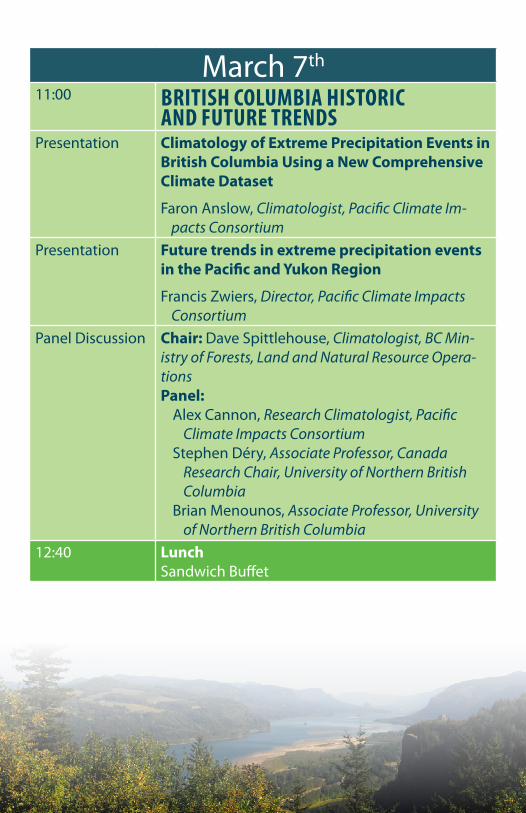
11:00 BRITISH COLUMBIA HISTORIC AND FUTURE TRENDS
Presentation Climatology of Extreme Precipitation Events in British Columbia Using a New Comprehensive Climate Dataset
Faron Anslow, Climatologist, Pacific Climate Im-pacts Consortium
Presentation Future trends in extreme precipitation events in the Pacific and Yukon Region
Francis Zwiers, Director, Pacific Climate Impacts Consortium
Panel Discussion Chair: Dave Spittlehouse, Climatologist, BC Min-istry of Forests, Land and Natural Resource Opera-tionsPanel:
Alex Cannon, Research Climatologist, Pacific Climate Impacts Consortium
Stephen Déry, Associate Professor, Canada Research Chair, University of Northern British Columbia
Brian Menounos, Associate Professor, University of Northern British Columbia
12:40 LunchSandwich Buffet
March 7th
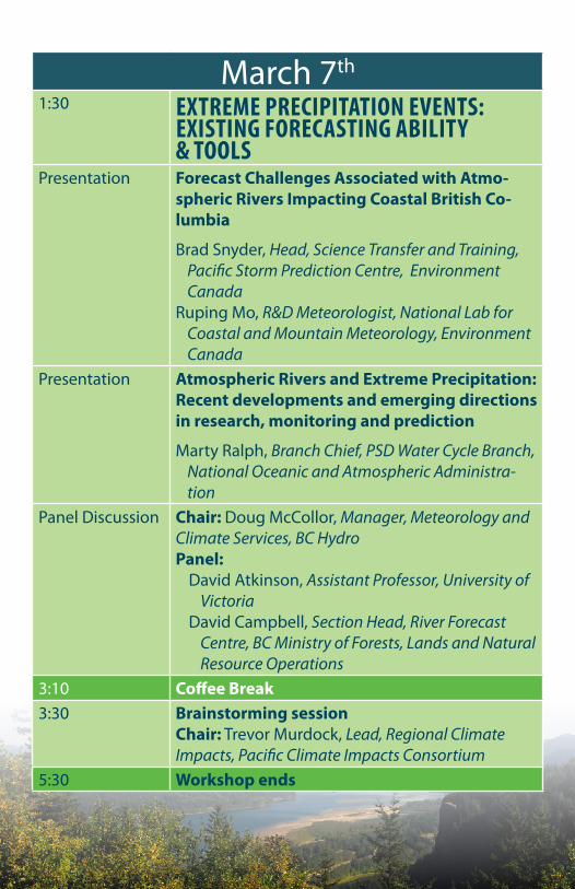
1:30 EXTREME PRECIPITATION EVENTS: EXISTING FORECASTING ABILITY & TOOLS
Presentation Forecast Challenges Associated with Atmo-spheric Rivers Impacting Coastal British Co-lumbia
Brad Snyder, Head, Science Transfer and Training, Pacific Storm Prediction Centre, Environment Canada
Ruping Mo, R&D Meteorologist, National Lab for Coastal and Mountain Meteorology, Environment Canada
Presentation Atmospheric Rivers and Extreme Precipitation: Recent developments and emerging directions in research, monitoring and prediction
Marty Ralph, Branch Chief, PSD Water Cycle Branch, National Oceanic and Atmospheric Administra-tion
Panel Discussion Chair: Doug McCollor, Manager, Meteorology and Climate Services, BC HydroPanel:
David Atkinson, Assistant Professor, University of Victoria
David Campbell, Section Head, River Forecast Centre, BC Ministry of Forests, Lands and Natural Resource Operations
3:10 Coffee Break3:30 Brainstorming session
Chair: Trevor Murdock, Lead, Regional Climate Impacts, Pacific Climate Impacts Consortium
5:30 Workshop ends

University House 1PO Box 1700 STN CSCUniversity of VictoriaVictoria, British ColumbiaCanada V8W 3R4
Phone: 250-721-6236Fax: 250-721-7217
pacificclimate.org