Embed Size (px)
Citation preview
ATOLL RESEARCH BULLETIN
NO. 406
CHAPTER 8
D.G. A
ISSUED BY NATIONAL MUSEUM OF NATURAL HISTORY
SMITHSONIAN INSTITUTION WASHINGTON, D.C., U.S.A.
FEBRUARY 1994
CHAPTER 8
ARIN S COCOS I
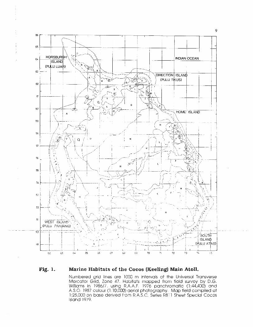
The rnarine environments of the main atoll of the Cocos (Keeling) Islands have been mapped at a field cornpilation scale of 1:25,000 scale using 1976 and 1987 aerial photography and field survey. Twenty two habitat units were recognized and mapped, with greater differentiation possible in the lagoon because of easier access and shallower depth. Qualitative descriptions of the habitats were made based on surface and SCUBA observations in the field.
The Cocos (Keeling) Islands, located in the north-east Indian Ocean, comprise a main atoll (96O E; 12O S) called here the Cocos atoll and consisting of 25 vegetated coral cays, and a northern atoll 27 km away, called North Keeling Island, which is now a single island atoll. The nearest other land mass is Christmas Island, 000 knn to the northeast and Java. 1200 km to the north. The islands were discovered (apparently not previously inhabited) in the early 17th century but were not settled until 1826 (Bunce 1988).
Various naturalists have visited the islands, including Charles Darwin on H.M.S. Beagle in 1836 (see A~Tnstrong 1551), just PO years after settlement. Of the hundreds of atolls seen by Darwin during the voyage, this was the only atoll which he explored on foot. The experience was significant in the development of his coral reef theory (Woodroffe et al. 1990). Faunal studies of the corals, echinoderms, molluscs, crustacea and fishes were made by Gibson-Hill in the 1940's but, save for one survey by Maes (1967) on molluscs and Colin (1977) on fishes, there were no modern studies of the marine environments and organisms prior to those contained in the present volume (Williams 1990).
* Applied Ecology Research Group, University of Canberra, P.O. Box 1 , Belconnen, ACT 26 16

Despite the various studies mentioned, no consistent overview of the marine habitats was able to be achieved until aerial photographic coverage was available. In this context, and that of an increasing need to better manage the atoll's marine living resources, the objective of this study was to describe and delineate the distribution of the major marine habitat types for both the lagoon, reef flat and outer reef slopes of the Cocos atoll. Difficulty of access prevented sub-tidal survey on North Keeling.
ETWODS
A preliminary photo-interpretation was done on panchromatic 1976 Royal Australian Air Force 1:44,400 complete coverage photography and this was used as a basis for field sampling. Location of sample sites attempted to include several examples of each of the photo-pattern units defined on the basis of tone, texture, bathymetry and location. The exact placement of field sites was able to be done with an accuracy of 100 m in most cases by reference to the photographs in the field. Over 50 sites were observed using
A for depths over about 8 m and on snorkel or waking for shallower areas and observations recorded on a data sheet.
Initially, fifteen different lagoon photo-patterns were described using the panchromatic photography. Further detail of the reef flats and of the outer reef was obtained from colour photographic coverage of the land areas only (1987 Australian Survey Office 1: 10,000). These included the location of the "drop-off", (i.e. the top of a Pleistocene cliff at 18 m depth), the presence of sand chutes and deposits on the outer reef slope, spurs and grooves, reef crest surge channels, aligned coral flats, seagrass beds, conglomerate platform (Woodroffe ct a!. 1990) and beach rock deposits (Russell & Mchtire 1965).
Some further refinement of the map units was done from a classified SPOT image taken in May 1987. This imagery enabled more consistent delineation of some of the shallow water habitats but did not provide as much detail in the deeper lagoon and outer reef slope zones. Seagrass beds of two species in the deeper lagoon were not detected on the classified image, although no specific training was attempted.
A description of each of the final mapping units is given below with cross referencing to map units (Table 1 ) a id grid references on Fig. 1. The descriptions include habitat structure and dominant organisms as observed nil the field. with other comments ot'i shntcture or function within and between habitats. Reef classification and terminology varies considerably between authors and, where possible, the terms used here follow those of Hopley (19x2). The marine areas of atolls and other reefs are commonly divided into three major zones. These are the seaward reef front which lies outside the line of breaking waves, the reef flat, which extends from the breakers to the shore or into the lagoon, and the lagoon itself. Each of these major units are further subdivided and described in the following scheme.
RESULTS
REEF FRONT
The reef front (unit A) on Cocos is marked by a major slope change, usually at 15- 18 m depth, and below this the slope is greater than 45 degrees to depths over 50 m. Above the abyssal slope there is a gentle terrace of about 50 In to 2 k ~ n width, rising gradually to the reef crest at approximately the mean low water mark. On aspects more exposed to the south-east trades, the terrace has a well-developed spur and groove (buttress) morphology, which in several locations on the west side appears almost to form a secondary reef front due to very large buttresses located beyond t'he reef crest. The buttress systems are most pronounced on the southern reef.
The reef terrace is the habitat of most abundant and diverse coral growth. In places the terrace has up to 60% cover, mainly of soft corals, whereas elsewhere there are sand deposits or very sparsely covered rock or sand slopes. Much of the wide terrace opposite the West Island settlement (grid reference 6251), for example. has a sparse coral cover on a hard basement, whereas the terrace further north (6256) is well covered in coral from the reef crest to the outer terrace.
Because of the water depth over the terrace there were few mappable features. These were:- the break of slope at ca. 18 in, the presence and orientation of buttresses (spurs and grooves) and the presence of large sand deposits on the terrace. Terrace sand deposits are most abundant on the leeward side of the atoll. Opposite the northern half of
est Island they form shore-parallel dunes at around 10 m depth (6257), usually lying between a buttress system and the coral-covered lower end of the terrace. Around Horsburgh lsland sand is abundant and often covers much of the terrace and flows into deeper water via sand chutes (6561).
THE REEF FLATS
This component of the reef is also very varied and grades into the lagoon habitat in the cnanneis between islands. The following units or features of thz reef flat have beer, mapped:-
- position of the coralgal crest and its surge channeis:
- sand and coral flats:
- aligned coral flats.
Components of the flats which were not able to be mapped mlere bouider zones and algal flats. The former are especially well developed on parts of the southern inter-island reef flat where the combination of southeast wind and southwest swell produce the highest wave energy conditions. This is also reflected in the greater development of buttress systems and surge channels along the southern reef front.
The structure of the coralgal crest also varies in relation to aspect. On the eastern and northern sides of the atoll it is poorly developed and very close (< 50 m) to the shore. Along the southern crest, calcareous red algae dominate and often form a honeycomb- like matrix that is exposed only during calm weather low tides. Along the western reef opposite West Island, the crest is dominated by seasonally varying stands of brown algae (mainly Turhirlaria sp.), or a turf of red algae growing on smooth rock or algal-encrusted
pavements. The crest exposed at the lowest tides is usually less than 10 m wide and rises 30-50 cm above the adjacent reef flat.
The reef crest has well-developed surge channels every 50-250 In, particularly along high-energy shores opposite islands. Associated with these channels are pockets of deeper water on the reef flat, these being possibly important in the movement of larger animals onto the reef flat, e.g. turtles, parrotfish and crayfish.
The reef flats opposite islands (unit B) are generally zoned landward from the crest with a sparse coral zone, then an algal zone (usually brown algae), then a sand or rock zone and in places an inshore seagrass bed on trapped sedi~nent. However, much variation exists and these zones are not always present nor clearly defined.
Beds dominated by the seagrass Thalassia henzpichii (unit E ) are developed on the inshore reef flat where sand has accumulated to about 5 cm or more depth and this usually occurs within 20 m of sandy beaches. In a few places sand has been trapped by exposed beach rock formations and this has enabled seazrass beds to develop.
The coral zone of the reef flats (unit C) is well developed in only two localities - at the northern end of est Island (6257) and the south-western side of Horsburgh Isiand (6563). In both locations there are reef flats dominated by hard branching corals and this may be attributable to both sites being of moderately low wave energy as well as experiencing a constant flow of fresh oceanic water that is relatively less turbid.
The aligned coral zone (unit D) is developed only on inter-island reef flats and usually extends from the crest into the lagoon to a point opposite the lagoon shores of the adjacent islands. The aligned corals are mostly hard ~nassive species orientated parallel with the current. This is a faunally rich area dominated by clams, echinoderms and holothurians. At the lagoon end of the aligned coral zone and where the water is deeper than a metre, there is sometimes a well-developed area of outcrops composed of massive hard corals, surrounded by sand sheets.
Beach rock deposits are comi11011 ainund i-hc bmwarc'l beaches of Cocos (Keeling) and when exposed they provide a protectlvc i.iimp,ii t to the ~oabtline. which they often parallel. In borne places they diverge f1om 'rhc s h o ~ r and so mdicate lecent changes in shoreline position.
THE LAGOON
proportion of its area covered by what appeal to be fields of collapse and/or solution dolines, co~ninonly known as "blue holes" (units K, E & M). These depressions vary in their size, shape and depth of their surrounding patch reefs. Other ~najor habitats mapped are the prograding sand sheets (unit F), opposite to and fed by the aligned coral zone; seagrass beds dominated rnainly by Thul~ssiu herrprAichii (unit H ) and with smaller areas of Syrirtgodium isoetifolilm (unit U ) and Tl~ulasso(lerl(1r-or? cilicrtimz (unit T); intertidal sand and ~ n u d flats (unit G); sand flats and shoals; coral flats and patch reefs.
The continuous supply of sand from the outer and inner reef flat produces extensive sediment fans (unit F, Fig. 2), which are size psopostional to the area of reef flat supplying them and the energy level of the coastline. The largest prograding sand sheets are the ones opposite the southern pass (between West and South Islands) and another fed by passes either side of Pulu Siput in the east. These deposits slope gently
down into the lagoon and slowly engulf lagoon patch reefs and blue holes. Their ~nargin with the aligned coral zone is not always distinct and it may be that the coral zone is extending slowly lagoonward across the sand sheet in places.
In their most active places the sand sheets appear almost devoid of surface life other than algal crusts, but in more stable locations there is a sparse covering of Thalassia hemprichii, Halimet~a (a sand-producing alga), Padina and Hydroclathrus (both brown algae). Areas of high bioturbation due to sea cucumbers and worms are also common. The spider shell, Lambis lambis, is locally abundant.
Thalassia hemprichii dominates the seagrass beds (unit H, Fig. 3) developed from the Low Water Mark to depths of about one metre, close inshore to all the islands except Direction and Horsburgh. There is some variation in the structure of the beds with water depth and distance f ro~n the shore. Closer inshore, Thuluss~u is dominant but forms a discontinuous cover due to wave effects. Shallow intertidal areas are do~ninated by the seagrass and algae such as Gracilariu and Acut~rhopho~-a, whilst subtidal areax have more coral and algal cover. 111 several places these seagrass beds (unit I, Fig. 3) show obvious lineation, and this represents overgrowth among the re~nnants of a prior aligned coral zone in places where a channel between ~slands has been closed off by storm activity. These sites a e off South Island (7151, 7353) and Wcst Ish11d.
The most conspicuous fauna of the inshore seagrass bed is the Portunici crab, Thalamita cretiutrr, which ~nakes shallow burrows. as does the ~nuch less common mud crab. Scylla serrata. The crabs appear to feed on burrowing bivalves and winkles, and numerous sinall fish shelter in the extensive crab burrow systems.
Syringotlium isoetifi)liwn (units U, V) is a more restricted seagrass growing at depths from 1-6 In on sand in relatively clear water, ~nainly at the northern end of Home and West Island and in the bay of Direction Island (6962). It grows with Thulussiu and various green algae including Ca&lpa spp. in the former shallow sites, but is almost mono-specific dominant at D~rection Island in 2-6 m of water.
Tl'lal(l,\sorderlrlr.otl c'iliut~birr, ;i large, ~obus t seagrasj, 21osnis nttached to rubble and lock. There is one large bed (amt T) of this species In the centsal uorthe~il lagoon in # m of water on jandy rubble, and s~naller patchej of thl\ species possibly occur on the outer reef south-easr of H-Ioisbu~gli Island. The speLlej ~ S O M ' I 111 thc lagoon in lawe circu1;ir '-. clumps. some of which appeai to be showing central dle-off and hence t a k l n ~ on an armulal shape. Small hard coral ourcrops occui wthin wnle o"ihexs beds
along the northeast shore of West Island and in Direction Island bay. None were seen near the Thulussodendrotl bed but it did show signs of grazing by large anirnals - possibly turtles.
Shoreward of the Thrrlassicr beds along the southern and eastern sides of the lagoon there are extensive intertidal sand and ~ n u d flats (unit G, Fig. 3). These are often demarcated fro111 the seagrass by a sandbank which is usually colonized by a line of the shrub Pemphis rrciddu. which thereby stabilizes the bank and forms a n~angrove-like vegetation. It is rather surprising that no nlangrovex have colonized these flats since such habitats are generally occupied by them on other reefs around the world. The finer sedi~nents tend to accumulate in the nmre sheltered inlets of the 1;goon side of the islands and generally where cument and wrive action is minimal. These form the ~najor habitat
for the fiddler crab Uca chlorophthalmus and Macrophthalmus verreauxi, which occur here in high numbers.
Major subtidal sand flats (unit Q) which are not directly associated with passes between islands occur northeast of West Island and south of Horsburgh Island. These locations are where sand is accumulated on the leeward lagoon margin and where it may eventually be carried to the outer reef. At West Island the sand flat has a highly mobile offshore sand bank (unit R) and there is major sand accretion onshore. The sand flat south of Horsburgh Island lies in a westerly current flow and is connected to the outer reef slope by a major sand chute which continues across the reef terrace.
Much of the central lagoon is a mosaic of "blue holes" of varying sizes and shapes and depth of surrounding patch reefs. Smaller, more discrete holes (unit K) occur towards the shallows and these ones are, in some cases, being filled by prograding sand sheets. Around the fringe of each depression there is a band of staghorn coral rubble which extends down the sides of the hole for about 2-5 m before passing into a sand slope going to as deep as 20 m. The water in the smaller holes is usually fairly turbid and the bottom is composed of sand and finer sediments.
In a few places large clumps of the foliose hard coral, Echinopoiu, were dominant on the edges of holes. These seemed to be more common in the small patch reefs developed in the middle of large holes (units E, M, Fig. 2) where turbidity was low. Away from the fringes of holes the coral cover is usually sparse and consists of the branching Acmpol-a and outcrops of massive corals such as Porites. Bivalve rnolluscs and holothurians are often abundant and there is, in places, a high degree of bioturbation, perhaps associated with areas of finer sediments. At least two species of mushroom corals also occur around these patch reefs.
Although several different blue hole morphologies have been mapped, sampling has not been sufficiently intense to determine whether there are significant biological differences. The main difference evident on photography is between small, iso-diametric holes which cover 10-30% of the area, through to the holes in deeper water which are large, irregular and occupy more than 80% of the area. 'Fhese sub-units tend to be 5eparated by east-west lines of shallow water (of unit J), these perhaps iepresenting f or-nner beachlines.
'I'he deeper central iagoon opposite Home Island appexs to sho~v a broad pattern of reticdate reefs (unit N) but without deep blue holes. Much of the bottom cover is very thick staghorn rubble, tightly interlaced and bonded by overgrowth of algae, particularly a Prrclitlcr sp. There are occasional sandy patches, as well as large mostly dead outcrops of Porites spp.
North of the previously described habitat is an extensive area (unit 0) composed of mainly dead outcrops of inassive corals with intervening sand patches. There are large areas of included sand flat on the eastern side and generally very small amounts of hard coral regrowth.
Well-developed coral flats lie between West Island and Horsbursh Island and, since there is no reef crest here, these lagoon flats at a depth of around X In merge into the outer reef terrace.
Between the seagrass beds on the east and west sides of the lagoon and the deeper habitats of the central lagoon, there is a large and variable shallow-water habitat (unit J )
with various mixtures of sand, algal and coral cover. The sandy substrate, which appears to be rather thin, is often strewn with fine coral and shell fragments and there may be a sparse cover of Thalassia and/or Caulerpa spp. Patches of very dense Halimeda cover occur and these are often overgrowing small coral boulders. A small black sea cucumber is very abundant here. Large skeins of the net-like alga Hydroclathrus drift along and accumulate on obstructions. Colonies of Porites occur, some forming microatolls of considerable size.
This project was completed in 1987 whilst the author was appointed as Environmental Resource Adviser to the Territory of Cocos (Keeling) Islands. I am grateful to the Cocos (Keeling) Islands Council for its interest in the project and for allowing access to all parts of the Territory; to the Administration of the T e ~ ~ i t o r y for providing field logistic support and to the members of the Cocos Dive Club and Amat Noor bin Anthoney for assistance in the field surveys. The Australian National Parks and Wildlife Service provided access to the classified SPOT satellite image.
Armstrong, P. 199 1. Under the Blue Vault of Heaven: A study qf Charles Darwin 's sojouix in the Cocos (Keeling) Islands. Indian Ocean Centre for Peace Studies,
estern Australia.
Bunce, P. 1988. The Cocos (Keeling) I s la~~ds . Australian Atolls in the Indian Ocean. Jacaranda, Milton, Queensland.
Colin, P.L. 1977. The reefs of Cocos-Keeling atoll, eastern Indian Ocean. Proc~edings. Third I t l~c~~tlu~ionul Corc;l Reef LSymposium. University of
Hopley, D. 1982. The Geonmi-pl~nlogy rhe Great Burrier De~~e1oi)rmwt of Cord Reefi. J. iley & Sons, New
aes, V. 1967. The littoral marine molluscs of Cocos-Keeling Islands (Indian Ocean). Procwciings ofthe Acodemny of Natural Scimcc? of Philadelphicj 1 1 9: 93-2 17.
Russell, R.J. and Mclntire, W.G. 1965. Southern hemisphere beach rock. Geogiuphicul Review 55: 17-45.
illiams, D.G. 1990. An annotated bibliography of the natural history of the Cocos (Keeling) Islands, Indian Ocean. Atoll Research Bulletin 33 1 : 1 - 17.
Woodroffe, C., McLean, R. & Wallensky, E. 1990. Darwin's coral atoll: geornorphology and recent development of the Cocos (Keeling) Islands, Indian Ocean. Nrrtiomlol Geographic Rescwrch 6: 262-275.

abitats of the Cocos ( eeling) Islands and their corresponding
Habitat Unit
Coral Terrace stipple areas indicate sand deposits
Q hatching indicates the approximate length, width and direction of major buttresses
Q outer solid line indicates lower depth limit of the outer terrace
Coral and Algal Flat includes areas of platform rock, beach rock and beaches reef crest (coralgal rim) shown as a dashed line surge channels shown as an arrowhead
Coral Flat - branched hard corals dominant
lines of Pernphis acidula on offshore sandbanks shown stippled
lat - on ~ r i o r alianed coral flat (Thalassia hemmichi13 " Coral and Algal Flat with sparse Thalassia hernprichii Blue Hole Mosaic 1 - small scattered sodl la metric depressions
ole Mosaic 2 - large, irregular depressions, prominent shallow coral rims
Algal-covered taghorn RubbBe \dth occasional sandy ~atches
Massive Coral Outcrops with sandy patches
Seagrass Bed (dense Thalassodendron cilicrf~irn) and occasional coral outcrops
ed (Syrinyodiurn isoefifoliurn) and occasional coral
Mixed Seagrass & Algal Bed (Syrinyodiun-I isoefifoliurn, Thalassia hemprichii, Halirneda spp., Caulerpa spp.)
abitats of the Goeos (
Numbered grid lines are 1000 m intervals of the Universal Transverse Mercator Grid, Zone 47. Habitats mapped from field survey by D.G. Williams in 198617, using R.A.A.F. 1976 panchromatic (1:44,400) and A.S.O. 1987 colour (1:10,000) aerial photography. Map field compiled at 1 :25,000 on base derived from R.A.S.C. Series R811 Sheet Special Cocos Island 1979.
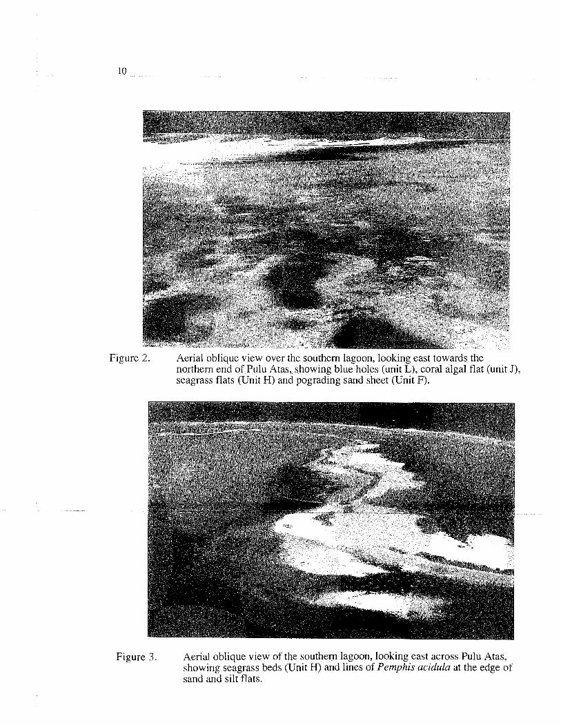
-e 2. Aerial oblique view over the southern lagoon, looking east towards the northern end of Pulu Atas, showing blue holes (unit L), coral algal flat (unit J), seagrass flats (Unit W) and pograding sand sheet (Unit F).
Fig y re 3. Aerial oblique view of the southem lagoon, looking east across Pulu Atas, showing seagrass beds (Unit W) and lines of Pemphis acidula at the edge of sand and silt flats.