Embed Size (px)
Citation preview
AUDIO ORIENTEERING – Navigating an Invisible Terrain
Noah Feehan
MIT Media Lab, Hyperinstruments
Group
20 Ames Street
Cambridge, MA 02139 [email protected]
Abstract
AUDIO ORIENTEERING is a collaborative performance
environment in which physical tokens are used to navigate
an invisible sonic landscape. In this paper, I describe the
hardware and software used to implement an audio terrain
with multiple interaction modes and sonic behaviors
mapped onto approximately one cubic meter of space.
After this successful proof-of-concept, I identify several
methods that will extend the system's responsiveness,
range, and accuracy.
Keywords: wii, 3-d positioning, audio terrain,
collaborative performance.
1. Introduction
This piece allows multiple users to explore an invisible
landscape using orientable physical tokens. Each user will
hold a wooden “Egg” containing sensors that track position
and orientation. The Egg’s position is superimposed onto a
pre-composed “terrain” of sound, revealing and concealing
various sonic “landmarks” as users move through the
space. The multiple-user model allows for many
modulations with relatively few landmarks. An Egg's
orientation will manipulate sonic parameters local to each
waypoint, so that while actions are repeatable, they are not
consistent across the space—for example, the same gesture
may have different results depending on the user's position
within the space.
2. Background
My practice explores the modalities and metaphors
surrounding the relationship of a body-in-space to an audio
source. Here, my interest lies in placing a group in a
context that causes them to think carefully about their
relationship in/to space, and how to modulate that
relationship. These explorations are rewarded with a
compelling and richly responsive audio output.
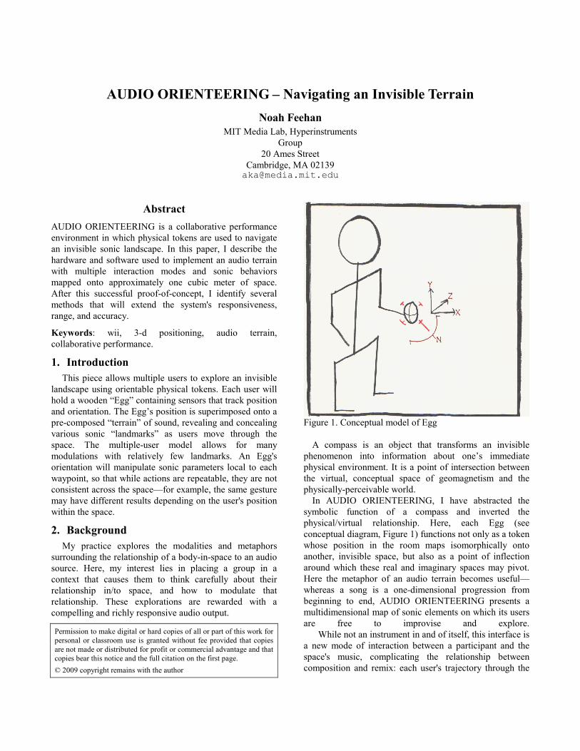
Figure 1. Conceptual model of Egg
A compass is an object that transforms an invisible
phenomenon into information about one’s immediate
physical environment. It is a point of intersection between
the virtual, conceptual space of geomagnetism and the
physically-perceivable world.
In AUDIO ORIENTEERING, I have abstracted the
symbolic function of a compass and inverted the
physical/virtual relationship. Here, each Egg (see
conceptual diagram, Figure 1) functions not only as a token
whose position in the room maps isomorphically onto
another, invisible space, but also as a point of inflection
around which these real and imaginary spaces may pivot.
Here the metaphor of an audio terrain becomes useful—
whereas a song is a one-dimensional progression from
beginning to end, AUDIO ORIENTEERING presents a
multidimensional map of sonic elements on which its users
are free to improvise and explore.
While not an instrument in and of itself, this interface is
a new mode of interaction between a participant and the
space's music, complicating the relationship between
composition and remix: each user's trajectory through the
Permission to make digital or hard copies of all or part of this work for
personal or classroom use is granted without fee provided that copies
are not made or distributed for profit or commercial advantage and that
copies bear this notice and the full citation on the first page.
© 2009 copyright remains with the author
space endlessly reconfigures a complete-but-asynchronous
original composition.
3. Implementation
AUDIO ORIENTEERING uses one MacBook Pro running
Processing 0135 and Ableton Live 7. This computer
receives orientation data from each Egg using the Zigbee
stack, a low-cost, high-bandwidth mesh networking
wireless protocol developed over the last two years. Three-
dimensional position data is captured by two Wii remotes
(called “Wiimotes”), inexpensive Bluetooth controllers
manufactured by Nintendo which contain IR cameras and
built-in blob detection hardware. To improve object-
tracking ability on the Wiimotes, each was outfitted with a
custom ring light of infrared LEDs.
In this iteration of the AUDIO ORIENTEERING
project, certain secondary features have not been
implemented. I will discuss these compromises and
features to be introduced in future iterations in Section 5.
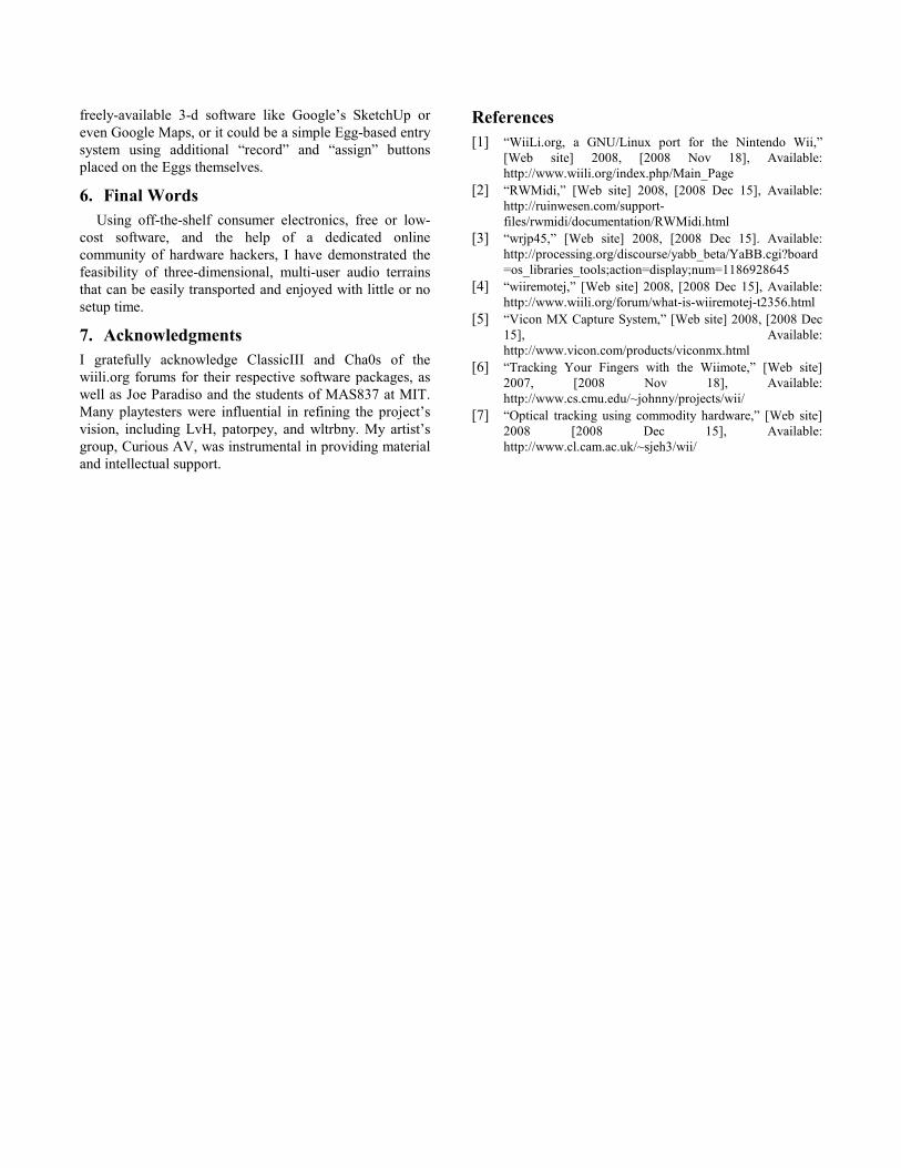
3.1 Hardware
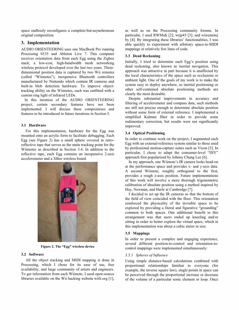
For this implementation, hardware for the Egg was
mounted onto an acrylic form to facilitate debugging. Each
Egg (see Figure 2) has a small sphere covered in retro-
reflective tape that serves as the main tracking point for the
Wiimotes as described in Section 3.4. In addition to the
reflective tape, each Egg contains an inexpensive 2-axis
accelerometer and a XBee wireless board.
Figure 2. The “Egg” wireless device
3.2 Software
All the object tracking and MIDI mapping is done in
Processing, which I chose for its ease of use, free
availability, and large community of artists and engineers.
To get information from each Wiimote, I used open-source
libraries available on the Wii hacking website wiili.org [1],
as well as on the Processing community forums. In
particular, I used RWMidi [2]; wrjp45 [3]; and wiiremotej
by [4]. By integrating these libraries’ functionalities, I was
able quickly to experiment with arbitrary space-to-MIDI
mappings in relatively few lines of code.
3.3 Dead Reckoning
Initially, I tried to determine each Egg’s position using
dead reckoning, also known as inertial navigation. This
approach was attractive in part because it is unaffected by
the local characteristics of the space such as occlusions or
ambient light. One of the goals of my work is to make the
system easy to deploy anywhere, so inertial positioning or
other self-contained absolute positioning methods are
clearly the most desirable.
Despite substantial improvements in accuracy and
filtering of accelerometer and compass data, such methods
are still not precise enough to determine absolute position
without some form of external reference. I implemented a
simplified Kalman filter in order to provide some
rudimentary correction, but results were not significantly
improved.
3.4 Optical Positioning
In order to continue work on the project, I augmented each
Egg with an external-reference system similar to those used
by professional motion-capture suites such as Vicon [5]. In
particular, I chose to adapt the consumer-level “DIY”
approach first popularized by Johnny Chung Lee [6].
In my approach, one Wiimote’s IR camera looks head-on
at the performance space and provides x- and y-axis data.
A second Wiimote, roughly orthogonal to the first,
provides a rough z-axis position. Future implementations
of this work will involve a more thorough trigonometric
calibration of absolute position using a method inspired by
Hay, Newman, and Harle at Cambridge [7].
I decided to set up the IR cameras so that the bottom of
the field of view coincided with the floor. This orientation
reinforced the physicality of the invisible space to be
explored by providing a literal and figurative “grounding”
common to both spaces. One additional benefit to this
arrangement was that users ended up kneeling and/or
sitting in order to better explore the virtual space, which in
this implementation was about a cubic meter in size.
3.5 Mappings
In order to present a complex and engaging experience,
several different position-to-control and orientation-to-
control mappings were implemented simultaneously:
3.5.1 Spheres of Influence
Using simple distance-based calculations combined with
proportional relationships familiar to everyone (for
example, the inverse square law), single points in space can
be perceived through the proportional increase or decrease
of the volume of a particular sonic element or loop. Once
inside this sphere of influence, the Egg’s orientation (pitch
and roll) became mapped to other qualitative changes in
the same sonic element—for example, once inside the
sphere of influence of a looped vibraphone sample, the
pitch of the Egg modulates the cutoff of a lowpass filter,
and the roll modulates a downsampling effect.
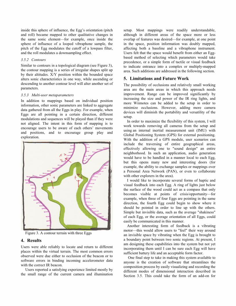
3.5.2 Contours
Similar to contours in a topological diagram (see Figure 3),
the contour mapping is a series of irregular shapes split up
by their altitudes. X/Y position within the bounded space
alters sonic characteristics in one way, while ascending or
descending to another contour level will alter another set of
parameters.
3.5.3 Multi-user metaparameters
In addition to mappings based on individual position
information, other sonic parameters are linked to aggregate
data gathered from all the Eggs in play. For example, when
Eggs are all pointing in a certain direction, different
modulations and sequences will be played than if they were
not aligned. The intent in this form of mapping is to
encourage users to be aware of each others’ movements
and positions, and to encourage group play and
exploration.
Figure 3. A contour terrain with three Eggs
4. Results
Users were able reliably to locate and return to different
places within the virtual terrain. The most common errors
observed were due either to occlusion of the beacon or to
software errors in binding incoming accelerometer data
with the correct IR beacon.
Users reported a satisfying experience limited mostly by
the small range of the current camera and illumination
setup. Most mappings were readily understandable,
although in different areas of the space more or less
overlap of features was desired—for example, at one point
in the space, position information was doubly mapped,
affecting both a bassline and a vibraphone instrument.
Users felt that the space would benefit from either an Egg-
based method of selecting which parameters would take
precedence, or a simple form of tactile or visual feedback
to indicate entrance into a complex or multiply-mapped
area. Such additions are addressed in the following section.
5. Limitations and Future Work
The possibility of occlusions and relatively small working
area are the main areas in which this approach needs
improvement. Range can be improved significantly by
increasing the size and power of the IR ring lights, and
more Wiimotes can be added to the setup in order to
minimize occlusions. However, adding more camera
devices will diminish the portability and versatility of the
setup.
In order to maximize the flexibility of this system, I will
work towards removing all cameras from the setup and
using an internal inertial measurement unit (IMU) with
Global Positioning System (GPS) for external positioning.
With the addition of a GPS module, user scenarios can
include the traversing of entire geographical areas,
effectively allowing one to "sound design" an entire
neighborhood. In such an application, audio generation
would have to be handled in a manner local to each Egg,
but this opens many new and interesting doors (for
example, the ability to exchange samples or mappings over
a Personal Area Network (PAN), or even to collaborate
with other explorers in the area).
I would like to incorporate several forms of haptic and
visual feedback into each Egg. A ring of lights just below
the surface of the wood could act as a compass that only
becomes visible at points of crisis/opportunity—for
example, when three of four Eggs are pointing in the same
direction, the fourth Egg could begin to show where it
should be pointed in order to line up with the others.
Simple but invisible data, such as the average "shakiness"
of each Egg, or the average orientation of all Eggs, could
easily be communicated in this manner.
Another interesting form of feedback is a vibrating
motor—this would allow users to "feel" their way around
an invisible space by vibrating when the Egg is brought to
a boundary point between two sonic regions. At present, I
am designing these capabilities into the system but not yet
incorporating them until I can be sure each Egg will have
sufficient battery life and an acceptable form factor.
One final step to take in making this system available to
anyone is the creation of software that streamlines the
composition process by easily visualizing and recording the
different modes of dimensional interaction described in
Section 3.5. This could take the form of an add-on for
freely-available 3-d software like Google’s SketchUp or
even Google Maps, or it could be a simple Egg-based entry
system using additional “record” and “assign” buttons
placed on the Eggs themselves.
6. Final Words
Using off-the-shelf consumer electronics, free or low-
cost software, and the help of a dedicated online
community of hardware hackers, I have demonstrated the
feasibility of three-dimensional, multi-user audio terrains
that can be easily transported and enjoyed with little or no
setup time.
7. Acknowledgments
I gratefully acknowledge ClassicIII and Cha0s of the
wiili.org forums for their respective software packages, as
well as Joe Paradiso and the students of MAS837 at MIT.
Many playtesters were influential in refining the project’s
vision, including LvH, patorpey, and wltrbny. My artist’s
group, Curious AV, was instrumental in providing material
and intellectual support.
References
[1] “WiiLi.org, a GNU/Linux port for the Nintendo Wii,” [Web site] 2008, [2008 Nov 18], Available:
http://www.wiili.org/index.php/Main_Page
[2] “RWMidi,” [Web site] 2008, [2008 Dec 15], Available: http://ruinwesen.com/support-
files/rwmidi/documentation/RWMidi.html
[3] “wrjp45,” [Web site] 2008, [2008 Dec 15]. Available: http://processing.org/discourse/yabb_beta/YaBB.cgi?board
=os_libraries_tools;action=display;num=1186928645
[4] “wiiremotej,” [Web site] 2008, [2008 Dec 15], Available: http://www.wiili.org/forum/what-is-wiiremotej-t2356.html
[5] “Vicon MX Capture System,” [Web site] 2008, [2008 Dec 15], Available:
http://www.vicon.com/products/viconmx.html
[6] “Tracking Your Fingers with the Wiimote,” [Web site] 2007, [2008 Nov 18], Available:
http://www.cs.cmu.edu/~johnny/projects/wii/
[7] “Optical tracking using commodity hardware,” [Web site] 2008 [2008 Dec 15], Available:
http://www.cl.cam.ac.uk/~sjeh3/wii/