Embed Size (px)
Citation preview
2011
U.S. Department of the InteriorU.S. Geological Survey
Bedrock Geologic Map of the Seward Peninsula, Alaska, and Accompanying Conodont DataBy Alison B. Till, Julie A. Dumoulin, Melanie B. Werdon, and Heather A. Bleick
Pamphlet to accompanyScientific Investigations Map 3131
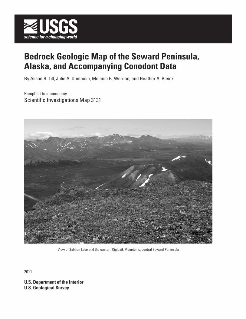
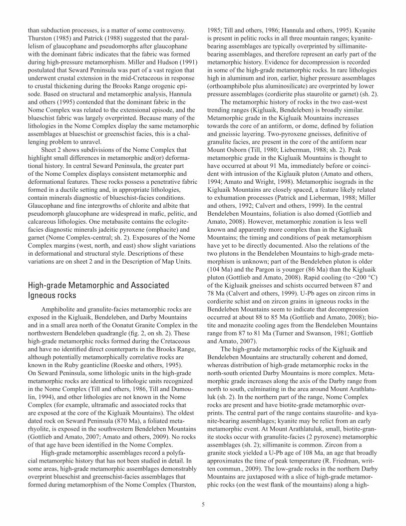
View of Salmon Lake and the eastern Kigluaik Mountains, central Seward Peninsula

i
ContentsIntroduction ....................................................................................................................................................1
Sources of data ....................................................................................................................................1Components of the map and accompanying materials .................................................................1
Geologic Summary ........................................................................................................................................1Major geologic components ..............................................................................................................1
York terrane ..................................................................................................................................2Grantley Harbor Fault Zone and contact between the York terrane and the Nome
Complex ..........................................................................................................................3Nome Complex ............................................................................................................................3High-grade metamorphic and associated igneous rocks ....................................................5Yukon-Koyukuk basin, Angayucham terrane, and the Kugruk Fault Zone ........................6Igneous rocks ..............................................................................................................................6
Tertiary and active deformation ........................................................................................................7Acknowledgments ........................................................................................................................................7Description of Map Units .............................................................................................................................7
Surficial Deposits .................................................................................................................................7Mesozoic and Cenozoic Igneous Rocks ..........................................................................................7York Terrane ........................................................................................................................................12
York Mountains Succession ....................................................................................................12Units with Uncertain Affinities ................................................................................................15
Grantley Harbor Fault Zone ..............................................................................................................17Nome Complex ...................................................................................................................................18
Layered Sequence ....................................................................................................................18Scattered Metacarbonate Rocks ...........................................................................................24Metaturbidites ...........................................................................................................................26
High-Grade Metamorphic and Associated Igneous Rocks ........................................................27Kugruk Fault Zone ..............................................................................................................................29
References Cited .........................................................................................................................................32Appendix .......................................................................................................................................................54
Introduction .........................................................................................................................................54Sources of data ..................................................................................................................................54Geologic implications ........................................................................................................................55
Nome Complex and Kugruk Fault Zone .................................................................................55York terrane and Grantley Harbor Fault Zone ......................................................................55
Figures1. Map of northern Alaska showing major geographic areas, geological provinces, and the
outline of the map area . .................................................................................................................22. Map of the Seward Peninsula, Alaska showing locations and names of Quaternary, Tertiary,
and Cretaceous igneous rocks. Cenozoic volcanic rocks, pale yellow; Late Cretaceous tin-bearing granites, orange; compositionally diverse Early and Late Cretaceous rocks, red ..................................................................................................................................map sheet 2
Tables1. Distribution of geologic units by quadrangle .....................................................................................402. Selected K-Ar, 40Ar/39Ar and Rb-Sr age determinations ..................................................................423. Selected U-Pb zircon analyses ............................................................................................................52A–1. Conodont data from the Seward Penninsula ................................................................................58A–2. Temperature ranges for Color Alteration Indices (CAIs) of conodonts . ...................................75
Sheets1. Preliminary bedrock geologic map of the Seward Peninsula, Alaska2. Tectonic, metamorphic, geochronologic, and geographic data for the Seward Peninsula,
Alaska

1
IntroductionThis 1:500,000-scale geologic map depicts the bedrock
geology of Seward Peninsula, western Alaska, on the North American side of the Bering Strait. The map encompasses all of the Teller, Nome, Solomon, and Bendeleben 1:250,000-scale quadrangles, and parts of the Shishmaref, Kotzebue, Candle, and Norton Bay 1:250,000-scale quadrangles (sh. 1; sh. 2).
Rolling, tundra-covered hills cover most of Seward Pen-insula; trees and shrubs are present only in limited areas in the southern and eastern parts of the peninsula. Broad lowlands underlie large areas in central and northern Seward Peninsula. Part of the central area and large areas in northernmost and east-ernmost Seward Peninsula are an extensive, unvegetated lava field. Four glacially carved mountain ranges, the York, Kigluaik, Bendeleben, and Darby Mountains, reach heights of 1,000-1,300 m (sh. 2); the highest point on the Peninsula, Mount Osborn, is in the Kigluaik Mountains. The York Mountains of western Seward Peninsula and hills adjacent to them on the east are underlain by bare, unvegetated carbonate rocks.
The map area covers 74,000 km2, an area slightly larger than West Virginia or Ireland.
Sources of Data
This geologic map is a compilation of published and unpublished geologic mapping and information derived from other published and unpublished sources. Published geologic maps at scales of 1:250,000, 1:63,360, and 1:50,000 were major sources and range in publication date from 1972 to 2005. More detailed studies, including theses, papers, and unpublished map-ping, represent work done between 1980 and 2008.
The amount of geologic detail available varies significantly across the area of the map, because of variations both in degree of study and in quality of bedrock exposure. Bedrock exposure, outside of the mountain ranges, is generally poor in the northern peninsula, and better in southern parts of the peninsula. The most detailed geologic mapping on the peninsula has been con-centrated in the York and Kigluaik Mountains, and the central Solomon quadrangle. The distribution of some metamorphic indicator minerals and conodont color alteration index (CAI) values presented on sheet 2 is limited by quality of exposure and amount of study in a given area.
Components of the Map and AccompanyingMaterials
The geologic map and related supplemental information are presented in two oversized sheets, this text, three tables, and an appendix. The appendix includes an explanatory text and two tables.
The geologic map, Correlation of Map Units, List of Map Units, and sources of data are shown on sheet 1. The geographic names referenced in the text, metamorphic/tectonic subdivisions of the map area, and selected metamorphic and thermal history data are shown on sheet 2. Metamorphic and thermal history
data are largely from the collections of the authors, but include all available information from government, industry, and aca-demic sources.
Table 1 shows the distribution of the map units on the nine 1:250,000-scale quadrangle maps of the map area, and aug-ments geographic information provided in the Description of Map Units.
Geochronologic data in tables 2 and 3 were compiled from the literature; a few unpublished ages were included. Results that were shown by researchers to be analytically sound and geologically meaningful have been included in the tables, while less sound results (for example, 40Ar/39Ar age spectra lacking plateaus, K-Ar analyses with poor radiogenic yield) have been excluded. In a few cases, results that did not meet these criteria have been included; statements in the “comments” column of the table indicate when and why this was done. All ages men-tioned in this report are listed in the tables.
The appendix includes discussion of sources and dis-tribution of conodont data and geologic implications of the data. Table A–1 lists the conodont data by 1:250,000-scale quadrangle. Table A–2 summarizes the temperature ranges thought to correspond to color-alteration index (CAI) values of conodonts.
Geologic time-scale age boundaries used are those of Gradstein and Ogg (2005).
Geologic Summary
Major Geologic Components
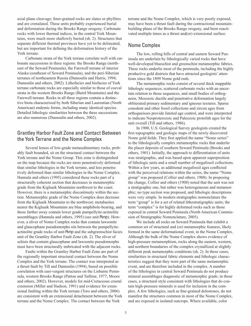
Most of Seward Peninsula is underlain by rocks that were part of a Late Proterozoic to early Paleozoic continental margin; remnants of that margin are also present in the Brooks Range. Rocks of the Chukotsk Peninsula, 85 km west of the Seward Peninsula, across Bering Strait (sh.1, 2), probably were part of the same continental margin as well (Dumoulin and others, 2002). The extensive high-pressure metamorphic rocks exposed in central Seward Peninsula (Nome Complex), the southern Brooks Range, and the Ruby geanticline are thought to record subduction of that continental margin during the Jurassic (Patton and Box, 1989; Christiansen and Snee, 1994; Roeske and others, 1995; Gottschalk and Snee, 1998) (fig. 1).
During the Early Cretaceous, contractional deformation ceased within the subduction zone, moved into the subjacent continental crust, and propagated to shallower levels. As a result, the continental margin was involved in a mountain-building episode, which involved thickening of the continental crust and movement of thrust sheets northward. We refer to this post-subduction contractional deformation of continental crust as the Brooks Range orogeny. Some exhumation of the Nome Complex blueschists by thrust faulting may have been part of this episode. Rocks in the York Mountains of Seward Peninsula likely experienced thrust faulting and shallow burial at this time, based on thermal indices (conodont color alteration indices; table A–2) from carbonate rocks and outcrop-scale structures in siliciclastic rocks.
2
Metamorphic fabrics in the Nome Complex have been related to subduction zone deformational processes (Thurston, 1985; Patrick, 1988) and extensional collapse of the Brooks Range orogen after the mountain building and crustal thick-ening episode (Hannula and others, 1995; Amato and others, 2002). 40Ar/39Ar and fission-track data indicate that significant cooling of the high-pressure metamorphic rocks now exposed on Seward Peninsula occurred in the period 120–70 Ma (Hannula and McWilliams, 1995; Dumitru and others, 1995); extensional deformation is thought to have occurred during that time span.
Amphibolite to granulite facies metamorphism overprinted the Nome Complex and other rocks during the mid-Cretaceous; at about the same time, a protracted period of magmatism began on Seward Peninsula and lasted until the end of the Cretaceous (fig. 2, on sh. 2). At least one suite of plutonic rocks formed in an island arc setting (Amato and Wright, 1997). During the Cenozoic, normal faulting created small mountain ranges and adjacent sedimentary basins, and mafic volcanic rocks accumu-lated in the central and northern parts of the peninsula.
In this text the term “metabasite” refers to metamorphosed mafic rocks of any nature, including originally intrusive and extrusive varieties.
Based on lithology, age, tectonic affinity, and metamor-phic history, rocks of Seward Peninsula are divided into several tectonic subdivisions, illustrated on sheet 2.
York TerraneRocks of western Seward Peninsula are mostly lower
Paleozoic and possibly older carbonate and siliciclastic rocks that retain primary sedimentary features except where they occur near granitic intrusions or where they are mica rich. We divide the York terrane into two parts: the “York Mountains suc-cession”, a relatively well-studied stratigraphic sequence found mainly in the central York Mountains, and “Units of uncertain affinities”, a group of relatively poorly understood rocks (sh. 1).
Thermal indicators, based on conodont color alteration index (CAI) values, show that the York terrane contains several provinces with different thermal histories, and therefore, differ-ent burial and tectonic histories (sh. 2, appendix 1). Some York terrane rocks are unmetamorphosed (most of the York Moun-tains succession), and some may have reached low greenschist facies conditions (Units with uncertain affinities). Siliciclastic rocks in units with higher thermal indices (units O<t, O<l) and a related unit (O<p) display open folds with a sub-horizontal
165° 155° 145°
70°
65°
RubyGeanticline
Yukon-KoyukukBasin
SewardPeninsula
Map area
Kugrukfault zone
CapeLisburne
North Slope
Brooks Range
Areas underlain largely by rocks that underwent Jurassic blueschist-facies metamorphism
Angayucham terrane and associated oceanic rocks
Figure 1. Map of northern Alaska showing major geographic area, geological provinces, and the outline of the map area.
3
axial plane cleavage; finer-grained rocks are slates or phyllites and are crenulated. These units probably experienced burial and deformation during the Brooks Range orogeny. Carbonate rocks with lower thermal indices, in the central York Moun-tains, were much more shallowly buried (sh. 2). Structures that separate different thermal provinces have yet to be delineated, but are important for defining the deformation history of the York terrane.
Carbonate strata of the York terrane correlate well with car-bonate successions in three regions: the Brooks Range (north-east of the Seward Peninsula), the Farewell terrane of interior Alaska (southeast of Seward Peninsula), and the peri-Siberian terranes of northeastern Russia (Dumoulin and Harris, 1994; Dumoulin and others, 2002). Lithofacies and biofacies of York terrane carbonate rocks are especially similar to those of coeval strata in the western Brooks Range (Baird Mountains) and the Farewell terrane. Rocks in all three regions contain a distinc-tive biota characterized by both Siberian and Laurentian (North American) endemic forms, including many identical species. Detailed lithologic similarities between the three successions are also numerous (Dumoulin and others, 2002).
Grantley Harbor Fault Zone and Contact Between the York Terrane and the Nome Complex
Several lenses of low-grade metasedimentary rocks, prob-ably fault bounded, sit on the structural contact between the York terrane and the Nome Group. This zone is distinguished on the map because the rocks are more penetratively deformed than similar lithologies in the York terrane, and less penetra-tively deformed than similar lithologies in the Nome Complex. Hannula and others (1995) considered these rocks part of a structurally coherent section that decreases in metamorphic grade from the Kigluaik Mountains northwest to the coast. However, there is a metamorphic discontinuity within the sec-tion. Metamorphic grade of the Nome Complex does decrease from the Kigluaik Mountains to the northwest; metabasites nearer the Kigluaik Mountains are blue amphibole-bearing, and those farther away contain lower grade pumpellyite-actinolite assemblages (Hannula and others, 1995) (see unit |np). How-ever, a sliver of Nome Complex rocks that contain lawsonite and glaucophane pseudomorphs sits between the pumpellyite-actinolite grade rocks of unit |np and the subgreenschist facies unit of the Grantley Harbor Fault Zone (sh. 2). The sliver of schists that contain glaucophane and lawsonite pseudomorphs must have been structurally imbricated with the adjacent rocks.
Faults within the Grantley Harbor Fault Zone are part of the regionally important structural contact between the Nome Complex and the York terrane. The contact was interpreted as a thrust fault by Till and Dumoulin (1994), based on possible correlation with east-vergent structures on the Lisburne Penin-sula, western Brooks Range (Patton and Tailleur, 1977; Moore and others, 2002). However, models for mid-Cretaceous crustal extension (Miller and Hudson, 1991) and evidence for exten-sional faulting within the York terrane (Toro and others, 2006) are consistent with an extensional detachment between the York terrane and the Nome Complex. The contact between the York
terrane and the Nome Complex, which is very poorly exposed, may have been a thrust fault during the contractional mountain-building phase of the Brooks Range orogeny, and been reacti-vated multiple times as a thrust and(or) extensional surface.
Nome ComplexThe low, rolling hills of central and eastern Seward Pen-
insula are underlain by lithologically varied rocks that have well-developed blueschist and greenschist metamorphic fabrics. These rocks underlie most of the peninsula, including the highly productive gold districts that have attracted geologists’ atten-tions since the 1899 Nome gold rush.
The metamorphic rocks consist of several thick mappable lithologic sequences, scattered carbonate rocks with an uncer-tain relation to those sequences, and small bodies of orthog-neiss. Mesozoic ductile and penetrative deformation largely obliterated primary sedimentary and igneous textures. Sparse conodont and other fossil collections and zircon ages from orthogneisses provide limited age control, and were interpreted to indicate Neoproterozoic and Paleozoic protolith ages for the unit overall (Till and others, 1986).
In 1900, U.S. Geological Survey geologists created the first topographic and geologic maps of the newly discovered Nome gold fields. They first applied the name “Nome series” to the lithologically complex metamorphic rocks that underlie the placer deposits of southern Seward Peninsula (Brooks and others, 1901). Initially, the approach to differentiation of units was stratigraphic, and was based upon apparent superposition of lithologic units and a small number of megafossil collections. Within a few years, as additional megafossil ages conflicted with the perceived relations within the series, the name “Nome group” was proposed (Collier and others, 1908). In proposing the change, Collier and others (1908) noted that the unit was not a stratigraphic one, but rather was heterogeneous and metamor-phic; no type section was proposed, and lithologic descriptions were very simple. In modern stratigraphic nomenclature the term “group” is for a set of related lithostratigraphic units; the term “complex” is for highly deformed rocks such as those exposed in central Seward Peninsula (North American Commis-sion of Stratigraphic Nomenclature, 2005).
We include all rocks on Seward Peninsula that exhibit a common set of structural and (or) metamorphic features, likely formed in the same deformational event, in the Nome Complex. Although the bulk of the Nome Complex shows evidence of high-pressure metamorphism, rocks along the eastern, western, and northern boundaries of the complex crystallized at slightly different peak metamorphic conditions (sh. 2). In these cases, similarities in structural fabric elements and lithologic charac-teristics suggest that they were part of the same metamorphic event, and are therefore included in the complex. A number of the lithologies in central Seward Peninsula do not produce mineral assemblages diagnostic of metamorphic grade; in those cases, a structural style consistent with lithologies that do con-tain high-pressure minerals is used for inclusion in the com-plex. A few lithologies, such as fine-grained dolostones, do not manifest the structures common in most of the Nome Complex, and are exposed in isolated outcrops. Where available, color
4
alteration index values (CAIs) of conodonts that are consistent with the conditions of high-pressure metamorphism were used to include these rocks.
We divide the Nome Complex into three parts (sh. 1). The designated “Layered sequence” consists of mappable lithologic units that occur in a consistent, layer-cake structural relation to one another over much of central Seward Peninsula. The des-ignated “Scattered metacarbonate rocks” consists of volumetri-cally minor dolostones and marbles that are widely distributed. Units that are exposed only on the north and southeast coasts of the peninsula (DObm, D_bm, D_ks) are included in the designated “Metaturbidites”.
The character of the lithologies in the Nome Complex is consistent with formation on a continental shelf and slope. Some carbonate rocks (units _d, Od, Sd, Ddm of Scattered metacarbonate rocks) contain sedimentary features, megafauna, and (or) microfauna typical of shallow water conditions. Other rocks show features that indicate they formed in slope and basinal environments (Metaturbidites units DObm, D_bm). Metasedimentary rocks that formed from combined carbonate, siliciclastic, and graphitic components are common; metasedi-mentary rocks composed of intermixed mafic, carbonate, and siliciclastic components are also widespread. Chemical charac-teristics of the mafic rocks in the Nome Complex indicate that they formed during rifting of a continental margin (Werdon and others, 2005a; Ayuso and Till, 2007).
The age of the Nome Complex protolith is known from microfossils, megafossils, U-Pb zircon analyses, and detrital zircon analyses. Cambrian, Ordovician, Silurian, and Devonian fossils were collected from carbonate rocks (Till and others, 1986). Small, Late Proterozoic orthogneiss bodies have been identified (Patrick and McClelland, 1995; Amato and Wright, 1998; Till and others, 2006), as well as several Middle Devo-nian metagranitic bodies (Till and others, 2006; Gottlieb and Amato, 2008; Amato and others, 2009). Detrital zircon analy-ses reveal that very little of the protolith of the complex was deposited before 600 Ma, and some metamorphosed siliciclas-tic rocks are likely Devonian or younger (Amato and others, 2003a; Amato, 2004; Till and others, 2006, 2007). Mafic rocks that formed during rifting of the continental margin have not been directly dated in the Nome Complex, but are thought to be Ordovician (see description of unit Ocs).
Penetrative ductile deformation and recrystallization of the sequence make geologic mapping and identification of the nature and precise age of the protolith extremely difficult. The presence of mafic boudins that contain blueschist-facies miner-als in the Nome Complex was first noted by Sainsbury and others (1970); Thurston (1985) documented blueschist-facies minerals in a variety of lithologies, showing that high pressure/low temperature metamorphism affected the entire Nome Com-plex. The Nome Complex, therefore, is a metamorphic complex initially formed during subduction of a continental margin. This indicates that lithologic units within the Nome Complex were removed from the surface of the subducting continental crust - but not necessarily in a way that retains their original strati-graphic relations. Based on available detrital zircon data, the structurally lowest parts of the Nome Complex are the youngest parts of its protolith (Till and others, 2006).
The metamorphic history of the Nome Complex is imper-fectly known, especially its history after peak high-pressure/low-temperature metamorphism. As is the case with many blueschist-facies metamorphic terranes, many lithologies in the Nome Complex do not contain mineral assemblages diagnostic of metamorphic grade. The same mineral assemblages may form, for example, at both high pressure (blueschist-facies) and low pressure (greenschist-facies) conditions. Further, greenschist- and blueschist-facies mineral assemblages can form at the same conditions in mafic rocks of slightly differ-ent compositions (Evans, 1990). Finally, in the Nome Complex greenschist-facies assemblages do overprint blueschist-facies minerals locally, but establishing the relation of greenschist assemblages to deformational events and the age of those events are challenging. Distinguishing the metamorphic history of the Nome Complex—especially the history after peak high-pressure metamorphism—has shown to be particularly difficult.
Based on thermobarometry and petrography, the metamor-phic pressure-temperature path of the Nome Complex traversed the lawsonite-stable part of blueschist facies and reached peak pressure in the epidote-stable part of blueschist facies/eclogite facies (Forbes and others, 1984; Thurston, 1985). Conditions of peak pressure were estimated at 460 °C, 12 kb (Patrick and Evans, 1989). Temperature peaked during exhumation in albite-epidote-amphibolite-facies. This pressure-temperature path is identical to that documented in the Schist belt in the southern Brooks Range (Till and others, 1988; Gottschalk, 1998) and is similar to that in the Ruby geanticline (Roeske and others, 1995) (fig. 1); the Nome Complex, Schist belt, and schists in the core of the Ruby geanticline probably formed during the same subduction episode.
Geochronologic studies to date have not clearly docu-mented the timing of the high-pressure event on Seward Penin-sula. Although Rb-Sr and K-Ar ages indicated a Jurassic age of metamorphism (Armstrong and others, 1986), 40Ar/39Ar plateau ages from white mica in the Nome Complex typically span the ages from 109 to 125 Ma (table 2); these ages are thought to represent minimum ages for blueschist-facies metamorphism (Hannula and McWilliams, 1995). The Rb-Sr ages are from essentially 2-point isochrons; therefore, their value is also limited. Sodic-calcic amphibole from a vein thought to have formed during decompression and heating of the Nome Com-plex yielded a 40Ar/39Ar plateau age of 138.6±1.0 Ma (Layer and Newberry, 2005; table 2); this age approximates the timing of peak temperature for the Nome Complex, and is a minimum age for peak pressure. White mica 40Ar/39Ar ages from meta-morphically correlative rocks in the Ruby geanticline place a minimum age of 144 Ma on the blueschist-facies event (Roeske and others, 1995), and blueschist-facies rocks of the southern Brooks Range are thought to have reached peak pressure during the Middle Jurassic (Christiansen and Snee, 1994; Gottschalk and Snee, 1998). Based on the age of the vein-filling sodic-calcic amphibole and correlative nature of high-pressure/low-temperature metamorphic events in the Brooks Range and Ruby geanticline, we believe that the Nome Complex reached peak pressure during the Jurassic.
The degree to which the dominant structural fabric in the Nome Complex is a product of exhumation processes, rather
5
than subduction processes, is a matter of some controversy. Thurston (1985) and Patrick (1988) suggested that the paral-lelism of glaucophane and pseudomorphs after glaucophane with the dominant fabric indicates that the fabric was formed during high-pressure metamorphism. Miller and Hudson (1991) postulated that Seward Peninsula was part of a vast region that underwent crustal extension in the mid-Cretaceous in response to crustal thickening during the Brooks Range orogenic epi-sode. Based on structural and metamorphic analysis, Hannula and others (1995) contended that the dominant fabric in the Nome Complex was related to the extensional episode, and the blueschist fabric was largely overprinted. Because many of the lithologies in the Nome Complex display the same metamorphic assemblages at blueschist or greenschist facies, this is a chal-lenging problem to unravel.
Sheet 2 shows subdivisions of the Nome Complex that highlight small differences in metamorphic and(or) deforma-tional history. In central Seward Peninsula, the greater part of the Nome Complex displays consistent metamorphic and deformational features. These rocks possess a penetrative fabric formed in a ductile setting and, in appropriate lithologies, contain minerals diagnostic of blueschist-facies conditions. Glaucophane and fine intergrowths of chlorite and albite that pseudomorph glaucophane are widespread in mafic, pelitic, and calcareous lithologies. One metabasite contains the eclogite-facies diagnostic minerals jadeitic pyroxene (omphacite) and garnet (Nome Complex-central; sh. 2). Exposures of the Nome Complex margins (west, north, and east) show slight variations in deformational and structural style. Descriptions of these variations are on sheet 2 and in the Description of Map Units.
High-grade Metamorphic and AssociatedIgneous rocks
Amphibolite and granulite-facies metamorphic rocks are exposed in the Kigluaik, Bendeleben, and Darby Mountains and in a small area north of the Oonatut Granite Complex in the northwestern Bendeleben quadrangle (fig. 2, on sh. 2). These high-grade metamorphic rocks formed during the Cretaceous and have no identified direct counterparts in the Brooks Range, although potentially metamorphically correlative rocks are known in the Ruby geanticline (Roeske and others, 1995). On Seward Peninsula, some lithologic units in the high-grade metamorphic rocks are identical to lithologic units recognized in the Nome Complex (Till and others, 1986, Till and Dumou-lin, 1994), and other lithologies are not known in the Nome Complex (for example, ultramafic and associated rocks that are exposed at the core of the Kigluaik Mountains). The oldest dated rock on Seward Peninsula (870 Ma), a foliated meta-rhyolite, is exposed in the southwestern Bendeleben Mountains (Gottlieb and Amato, 2007; Amato and others, 2009). No rocks of that age have been identified in the Nome Complex.
High-grade metamorphic assemblages record a polyfa-cial metamorphic history that has not been studied in detail. In some areas, high-grade metamorphic assemblages demonstrably overprint blueschist and greenschist-facies assemblages that formed during metamorphism of the Nome Complex (Thurston,
1985; Till and others, 1986; Hannula and others, 1995). Kyanite is present in pelitic rocks in all three mountain ranges; kyanite-bearing assemblages are typically overprinted by sillimanite-bearing assemblages, and therefore represent an early part of the metamorphic history. Evidence for decompression is recorded in some of the high-grade metamorphic rocks. In rare lithologies high in aluminum and iron, earlier, higher pressure assemblages (orthoamphibole plus aluminosilicate) are overprinted by lower pressure assemblages (cordierite plus staurolite or garnet) (sh. 2).
The metamorphic history of rocks in the two east-west trending ranges (Kigluaik, Bendeleben) is broadly similar. Metamorphic grade in the Kigluaik Mountains increases towards the core of an antiform, or dome, defined by foliation and gneissic layering. Two-pyroxene gneisses, definitive of granulite facies, are present in the core of the antiform near Mount Osborn (Till, 1980; Lieberman, 1988; sh. 2). Peak metamorphic grade in the Kigluaik Mountains is thought to have occurred at about 91 Ma, immediately before or coinci-dent with intrusion of the Kiglauik pluton (Amato and others, 1994; Amato and Wright, 1998). Metamorphic isograds in the Kigluaik Mountains are closely spaced, a feature likely related to exhumation processes (Patrick and Lieberman, 1988; Miller and others, 1992; Calvert and others, 1999). In the central Bendeleben Mountains, foliation is also domed (Gottlieb and Amato, 2008). However, metamorphic zonation is less well known and apparently more complex than in the Kigluaik Mountains; the timing and conditions of peak metamorphism have yet to be directly documented. Also the relations of the two plutons in the Bendeleben Mountains to high-grade meta-morphism is unknown; part of the Bendeleben pluton is older (104 Ma) and the Pargon is younger (86 Ma) than the Kigluaik pluton (Gottlieb and Amato, 2008). Rapid cooling (to <200 °C) of the Kigluaik gneisses and schists occurred between 87 and 78 Ma (Calvert and others, 1999). U-Pb ages on zircon rims in cordierite schist and on zircon grains in igneous rocks in the Bendeleben Mountains seem to indicate that decompression occurred at about 88 to 85 Ma (Gottlieb and Amato, 2008); bio-tite and monazite cooling ages from the Bendeleben Mountains range from 87 to 81 Ma (Turner and Swanson, 1981; Gottlieb and Amato, 2007).
The high-grade metamorphic rocks of the Kigluaik and Bendeleben Mountains are structurally coherent and domed, whereas distribution of high-grade metamorphic rocks in the north-south oriented Darby Mountains is more complex. Meta-morphic grade increases along the axis of the Darby range from north to south, culminating in the area around Mount Arathlatu-luk (sh. 2). In the northern part of the range, Nome Complex rocks are present and have biotite-grade metamorphic over-prints. The central part of the range contains staurolite- and kya-nite-bearing assemblages; kyanite may be relict from an early metamorphic event. At Mount Arathlatuluk, small, biotite-gran-ite stocks occur with granulite-facies (2 pyroxene) metamorphic assemblages (sh. 2); sillimanite is common. Zircon from a granite stock yielded a U-Pb age of 108 Ma, an age that broadly approximates the time of peak temperature (R. Friedman, writ-ten commun., 2009). The low-grade rocks in the northern Darby Mountains are juxtaposed with a slice of high-grade metamor-phic rocks (on the west flank of the mountains) along a high-
6
angle reverse fault; the age of the fault is not known. At the time of intrusion of the Darby pluton, the metamorphic rocks were in shallow (<5 kb) crustal settings; the Darby pluton has andalusite in its contact zone (sh. 2). The Darby pluton yielded two U-Pb zircon crystallization ages of 100 Ma (Amato, written commun., 2008; R. Friedman, written commun., 2009).
Although the three mountain ranges (Kigluaik, Bendele-ben, and Darby Mountains) appear to describe a small orocline, the ranges do not have the same exhumation history. The appar-ent orocline is due to the intersection of structures of different ages. Biotite cooling ages from the Kigluaik and Bendeleben Mountains range from 87 to 81 Ma; biotite cooling ages are older in the Darby Mountains, ranging from 102 to 90 Ma. Apatite fission-track analysis indicates that the Kigluaik and (by inference) Bendeleben Mountains were cooled and uplifted during the Tertiary (Eocene-Oligocene; Dumitru and others, 1995), whereas rocks in the northern Darby Mountains were at the surface during the early Eocene, as the Darby pluton (unit Kd) is basement to a small sedimentary basin of early Eocene age (Dickinson and others, 1987).
Yukon-Koyukuk Basin, Angayucham Terrane, and the Kugruk Fault Zone
The Yukon-Koyukuk basin sits along the eastern side of Seward Peninsula and contains Early Cretaceous subduction-related volcanic rocks and related marine sedimentary rocks. The basin is flanked on three sides by terranes with continen-tal affinity: Seward Peninsula on the west, Brooks Range on the north, and Ruby geanticline on the east (fig. 1). The basin is bordered by marine to non-marine conglomerates that are younger than the marine volcanic and sedimentary rocks within the basin and were derived from adjacent continental rocks (Patton and Box, 1989).
Along its eastern and northern boundaries, the Yukon-Koyukuk basin is separated from flanking continental rocks by a belt of mafic and ultramafic rocks and minor sedimentary rocks, the Angayucham terrane (Box and Patton, 1989). The Angayucham is thought to represent imbricated Devonian through Jurassic oceanic crust (Pallister and others, 1989). On the eastern and northern boundaries of the Yukon-Koyukuk basin, from the basin to its flanks, major units have the same structural stacking: marine volcanic and sedimentary rocks sit above younger, continentally derived conglomerates, which sit above oceanic rocks of the Angayucham terrane, which sit above schists with continental protoliths and high-pressure/low-temperature metamorphic assemblages.
Eastern Seward Peninsula lacks this simple structural stacking. Instead, the marine volcanic and sedimentary rocks of the basin are directly juxtaposed with schists of the Nome Com-plex, with no intervening oceanic rocks (sh. 2). The oceanic rocks sit west of the Yukon-Koyukuk basin as isolated slivers within a fault zone flanked by the Nome Complex. The fault zone spans eastern Seward Peninsula from north to south, and was named the Kugruk Fault Zone by Sainsbury (1974). Nome Complex rocks are within the fault zone and flank the fault zone on both sides. Sedimentary rocks related to the Yukon-Koyukuk
basin (the older part of unit TKs) are also caught as slivers within the fault zone.
The oceanic rocks of eastern Seward Peninsula are consid-ered part of the Angayucham terrane and consist of metabasalt, Jurassic tonalite, and minor serpentinite. Mafic rocks through-out the belt are metamorphosed to blueschist or greenschist facies; fabrics in these rocks are weak to mylonitic. Mafic rocks in the northern part of the Kugruk Fault Zone also retain minerals from an earlier metamorphic event that predated the blueschist-greenschist facies event, while mafic rocks in the southern part of the fault zone contain a single blueschist or greenschist metamorphic assemblage and relict igneous phases. The age of blueschist-facies metamorphism is unknown, and it differs in style and conditions from the blueschist-facies event in the Nome Complex. Although the metamorphic grade of basaltic rocks in the Angayucham terrane elsewhere is gener-ally prehnite-pumpellyite to low greenschist, blue amphiboles are known in correlative oceanic rocks on the flank of the Ruby geanticline (Dusel-Bacon and others, 1989; Roeske and McClelland, 1997).
Two sequences of sedimentary rocks, one likely mid-Cretaceous, the other Late Cretaceous and Tertiary in age, are present within the fault zone. One sequence is dominated by coarse conglomerate rich in locally derived clasts, including Paleozoic marbles and dolostones (most from the Nome Com-plex) and mylonitic metabasites from the Angayucham terrane (Till and others, 1986). Mid-Cretaceous sedimentary rocks of the adjacent parts of the Yukon-Koyukuk basin are also carbon-ate-rich (Nilsen, 1989; Patton and others, 2005), and are likely part of the same depositional sequence. Generally finer grained sedimentary sequences that have thick coal seams yielded Late Cretaceous and Tertiary pollen (Till and others, 1986; Dickinson and others, 1987).
Movement on the Kugruk Fault Zone may have recurred over a long time interval. The 100-Ma Darby pluton retains its intrusive contacts and is elongate parallel to the fault zone, suggesting that a structural control to the pluton’s shape existed during the Cretaceous. Results from a coal drilling program in the northern part of the Kugruk Fault Zone show that Nome Complex schists sit structurally above Tertiary sedimentary rocks, where the schists must have been placed by reverse fault-ing (Retherford and others, 1986). Therefore, the Kugruk Fault Zone also was active during the Tertiary.
Igneous RocksGranitoid rocks intruded the Nome Complex during the
Cretaceous (fig. 2, on sh. 2). Based on early reconnaissance work and K-Ar ages, three suites of plutons were recognized: an early alkalic group, 110 to 96 Ma; a calc-alkaline group, 95 to 80 Ma; and a tin granite group, 80 to 69 Ma (Till and others, 1986). These characterizations are in flux.
The alkalic rocks are part of a belt that extends east of Seward Peninsula into the Yukon-Koyukuk basin (Miller, 1989; Arth and others, 1989; Amato and Wright, 1998). The calc-alkalic plutons core the Kigluaik Mountains and are common on eastern Seward Peninsula (Till and others, 1986; Amato and Wright, 1998). Magmatism continued with intrusion of plutons
7
DESCRIPTION OF MAP UNITS
SURFICIAL DEPOSITSQs Surficial deposits, undivided (Quaternary)—Frost-rived rubble on slopes and broad low
ridges; glacial moraine; glacially deposited sand, gravel, and boulders; fluvial gravel and sand; marine and fluvial terrace deposits; wetlands
MESOZOIC AND CENOZOIC IGNEOUS ROCKSQlj Lost Jim Basalt (Holocene)—A single basaltic lava flow and associated vent deposits, undis-
rupted by frost brecciation, located in central Bendeleben quadrangle (fig. 2, on sh. 2). The dark gray-black vesicular olivine basalt in eastern part of the unit exhibits pahoehoe flow features and lava tubes. Maximum age is constrained to be less than 0.8 Ma based on strati-graphic position above unit QTv (Turner and Swanson, 1981)
QTv Weathered volcanic rocks, undivided (Quaternary and Tertiary)—Basalt lava flows, vent deposits, maar volcanoes and associated pyroclastic rocks exposed in northern, central, east-ern, and to a minor extent, southern Seward Peninsula (fig. 2, on sh. 2).
Less weathered rocks are slightly to strongly fragmented by frost riving and locally overlain by windblown silt. These rocks include alkali olivine basalt and olivine tholeiite. Alkalic rocks contain phenocrysts of olivine with plagioclase, augite, and spinel in the groundmass. Tholeiitic rocks contain plagioclase, phenocrysts with augite, hypersthene,
and alkalic dike swarms (Amato and others, 2003c; Gottlieb and Amato, 2008). During latest Cretaceous time, a suite of tin-bearing granites intruded both the Nome Complex and adjacent rocks in western Seward Peninsula (Hudson and Arth, 1983).
Magmatic events on Seward Peninsula are coeval with similar events on Saint Lawrence Island, Alaska, approximately 250 km southwest of Seward Peninsula, and in the Okhotsk-Chukotsk volcanic belt on the Russian side of Bering Strait, and formed in the same general tectonic regime (Amato and Wright, 1998; Miller and others, 2002; Amato and others, 2003b).
Better delineation of crystallization ages using U-Pb zircon geochronology and a deeper understanding of petrogenetic events using modern geochemical tools was initiated by Arth and others (1989) and Amato and others (1994). Continued study of the age and nature of petrogenetic events on Seward Peninsula is underway (for example, Amato and Wright, 1997; Gottlieb and Amato, 2008); the earlier delineation of plutonic suites is in the process of being revised.
In central, eastern, and northern Seward Peninsula, exten-sive plateau basalts, cinder cones, and very large maars formed during several episodes of volcanism as old as the Oligocene, and as young as the Holocene (Hopkins and others, 1971; Turner and Swanson, 1981).
Tertiary and Active Deformation
Geomorphologic, structural, and thermal data indicate active deformation on Seward Peninsula occurred in Tertiary to Recent times. Along the coastline south of the York Mountains, terraces were uplifted during the late Pleistocene (Sainsbury, 1967). Active normal faults, which are marked by sag ponds, offset streams, scarps and other features, bound the Kigluaik and Bendeleben Mountains (Kaufman, 1985; Plafker and others, 1994), and expose the high-grade metamorphic rocks. Apa-
tite fission-track data show that significant slip on these faults started in the Eocene (Dumitru and others, 1995). A transition from Nome Complex detritus to detritus that also includes high-grade minerals was recognized in wells drilled in Tertiary (Paleogene) offshore basins (Forbes and others, 1984; Tolson, 1987). Based on gravity data, basins sit below McCarthy Marsh, south of the Bendeleben Mountains, and the Imuruk basin, north of the Kigluaik Mountains (Barnes and Hudson, 1977; Barnes and Morin, 1988); these basins are likely the same age as those offshore.
Tertiary activity along the Kugruk Fault Zone included reverse faulting (Retherford and others, 1986) as well as early Eocene graben formation (Dickinson and others, 1987). Death Valley, in the northern Darby Mountains, is likely a Tertiary feature.
AcknowledgmentsWe are indebted to Anita G. Harris, who, with tremendous
dedication and perseverance, processed hundreds of kilograms of rock and picked through vast numbers of metamorphic grains to find the conodonts contained in Nome Complex carbonate rocks. We are thankful for her willingness to take on such rocks, and for her good humor in helping us understand them. We are grateful to Travis Hudson for suggesting that we concentrate early mapping efforts (in the 1980’s) in the western Solomon quadrangle. His advice was right on the mark—it is the area in which the internal structure of the Nome Complex was most easily identified. We also thank Dr. Hudson, as well as Timothy R. Carr and Jaime Toro, for contributing previously unpublished conodont data from the Teller quadrangle. Sincere thanks to Jeff Amato for providing unpublished geochronology data.
8
olivine, and spinel in the groundmass (Swanson and others, 1981). These less weathered vol-canic rocks underlie portions of the Lost Jim Basalt in central Bendeleben quadrangle, and include the Camille Basalt and Gosling Volcanics of Hopkins (1963), as well as small flows in valley centers on the south flank and south of the Bendeleben Mountains. Potassium-argon (K-Ar) determinations on basalt from Kugruk River canyon (Turner and Swanson, 1981) and from the northwest flank of the Bendeleben Mountains (Kaufman and Hopkins, 1985) indicate that the Gosling Volcanics were in part extruded between 0.9 and 0.8 Ma. The Camille Basalt is younger by an unknown amount of time. Equivalent to unit “Qv” of Till and others (1986). In southern Seward Peninsula, a small basaltic vent and associated flows yielded a 40Ar/39Ar whole rock age of approximately 0.8 Ma (Werdon and others, 2006).
Other volcanic rocks are thoroughly fragmented by frost action. These are the most widely distributed and voluminous volcanic rocks on the peninsula; they underly most of the Imuruk Lake lava plateau but are mapped only where exposed through an otherwise 1- to 6-m thick mantle of windblown silt. The rocks are mostly alkali olivine basalt with phenocrysts of olivine with plagioclase, augite, and spinel in the groundmass. Lesser olivine tholeiite contains plagioclase phenocrysts with augite, hypersthene, olivine, and spinel in the groundmass (Swanson and others, 1981). This part of the unit includes the Imuruk Volcanics of Hopkins (1963), which are between 2 and 5 Ma (Hopkins and others, 1971; Turner and Swanson, 1981). Flows of the Imuruk Volcanics were confined by modern valley systems that drained north from Imuruk Lake area and, as a result of subsequent stream incision, are exposed as bench remnants high on valley walls. South and east of Imuruk Lake, older volcanic rocks cap ridge tops. These older flows are between 26 and 29 Ma (Turner and Swanson, 1981). In southeastern Bendeleben quadrangle, basalt flows are interlayered with sedimentary rocks that have yielded early Eocene pollen (Dickinson and others, 1987). Equivalent to unit “QTv” of Till and others (1986).
The older volcanic units contain xenoliths of dunite, harzburgite, chromite, granite, and schist (Hopkins, 1963). Dunite xenoliths are most common, and reached 7–8 cm across. Granite and schist xenoliths are smaller (less than 2 cm across) and occur only where the volcanics erupted through granitic or metamorphic bedrock. Similar xenoliths in correla-tive volcanic rocks in western Alaska and on Saint Lawrence Island have had more detailed study (for example, Wirth and others, 2002).
The Late Quaternary Espenberg Maars, 30–50 km southwest of Cape Espenberg on northern Seward Peninsula, consist of four large craters ranging from 4 to 8 km in diameter surrounded by coeval tephra layers. These craters, known as Devil Mountain, Whitefish, North Killeak, and South Killeak Maars (fig. 2, on sh. 2), are each separate eruption craters excavating 100 to 300 m into Pleistocene sediments and lavas (Hopkins, 1988). The maars are surrounded by a thick blanket of pyroclastic surge and airfall tephra deposits. Cliffs around Devil Mountain Maar expose sequences of bedded surge deposits, airfall lapilli beds, scoria, massive pyroclastic flows and explosion breccia (Begét and others, 1996). This vol-caniclastic sediment is evidence that the Espenberg Maars were formed by highly explosive hydromagmatic eruptions through permafrost, which ultimately created the unusually large maar craters. Devil Mountain Maar is 8 km long by 6 km wide, as much as 200 m deep, and covers over 30 km2. It is the largest known maar on earth; the three other maars on Seward Peninsula are also larger than any previously described maar.
Mafic volcanic rocks of this unit are one of several Cenozoic volcanic fields in western Alaska that extend from northern Seward Peninsula to Saint Lawrence Island and the Pribi-lof Islands on the Bering Sea shelf (Moll-Stalcup, 1994); the Pribilof Islands are about 840 km south-southwest of Nome
TKv Felsic volcanic rocks (Tertiary and Cretaceous)—Rubble crop of volcanic rocks in northeast-ern part of the map area, in Bendeleben D–1 quadrangle (fig. 2, on sh. 2). Unit consists of two varieties of volcanic rock, both moderately to strongly limonite stained. One is a volca-nic flow or tuff that contains up to 4% phenocrysts in an aphanitic, devitrified groundmass. Phenocrysts are predominately sanidine with rare quartz and plagioclase. No mafic minerals are present, but morphology of rare aggregates of sericite, opaques and limonite suggest the former presence of biotite. The second type of volcanic rock is fragmental and contains schist, devitrified volcanics, and angular quartz fragments in a felsic(?), sericite-bearing matrix. It may be a volcanic flow breccia or vent breccia rock. Age of unit is unknown. Felsic tuffs on Saint Lawrence Island have yielded a K-Ar age of 39.3 Ma (Patton and Csejtey, 1980)
9
Ktg Tin-bearing granitic stocks (Late Cretaceous)—Stocks of biotite granite exposed in outcrop, rubble, and float in northwestern Seward Peninsula. Includes stocks at Cape Mountain, Brooks Mountain, Black Mountain, Ear Mountain, and the Oonatut Granite Complex (fig. 2, on sh. 2). The belt also includes bodies not exposed at the surface at Lost River Mines and Kougarok Mountain (fig. 2, on sh. 2). Stocks are dominantly biotite granite with lesser aplitic and pegmatitic phases (Hudson and Arth, 1983). Larger stocks, such as the Oonatut, are texturally zoned. Contacts with country rocks are sharply crosscutting, and contact aure-oles are narrow. Epizonal stocks have high 87Sr/86Sr initial ratios and elevated Th, U, Hf, and Ta (Hudson and Arth, 1983). Potassium-argon (K-Ar) biotite ages range from 69.2±2 to 80.2±3 Ma (Hudson and Arth, 1983). Tin lodes and placers are associated with the stocks (Reed and others, 1989). Tin and tungsten were commercially mined in Lost River area, western Teller quadrangle (Sainsbury, 1969b)
Kds Dikes and stocks (Cretaceous)—Dikes and rare stocks of a variety of compositions and ages mapped extensively in the York, Kigluaik, and Bendeleben Mountains, and near the Darby Mountains, but also present in the Nome Complex. Some, but not all, are shown on the map as small pink lines.
The oldest dike known is an analcime-biotite-nepheline syenite that intruded the Nome Complex in central Solomon quadrangle and yielded a biotite 40Ar/39Ar age of 107 Ma (Werdon and others, 2005a). A group of alkalic dikes, nepheline syenite and pseudoleucite porphyries, are exposed as frost-riven rubble in Solomon C–2, C–3 and D–3 quadrangles and intruded portions of the Kachauik pluton and adjacent marble. The dikes are up to 10 m wide and have strike lengths up to 900 m. They strike mostly to the northeast and are verti-cal. Syenite of the Kachauik pluton is highly radioactive adjacent to the dikes, containing up to 0.15% U3O8, 1.05% ThO2 and 2% rare earth elements (Miller and Bunker, 1976). Dikes yielded a K-Ar biotite age of 96.3±3 Ma (Berry and others, 1976).
Alkali feldspar granite to quartz monzodiorite pegmatite dikes and sills are common at the core of the Kigluaik Mountains, in the western Bendeleben Mountains, and in the Darby Mountains, but are not found in rocks of lower metamorphic grade. A foliated pegmatite dike that cut high-grade metamorphic rocks in the Bendeleben Mountains yielded a U-Pb zircon age of 99±2 Ma (Gottlieb and Amato, 2008).
Dark-brown- to orange-weathering alkalic diabase dikes are widespread on Seward Peninsula, but best documented in high-grade metamorphic rocks that underlie mountain ranges. Alkalic diabase dikes cut high-grade rocks and Cretaceous plutons in the Kigluaik and Bendeleben Mountains; dikes are up to 5 m across and yield 40Ar/39Ar ages of approxi-mately 83 Ma (Calvert and others, 1999; Amato and others, 2003c). Similar brown- to orange-weathering alkalic mafic dikes in the Nome Complex are exposed in scattered loca-tions on southern Seward Peninsula; in Solomon quadrangle, mafic dikes yielded 40Ar/39Ar ages of 80 to 84 Ma (Werdon and others, 2005a; Newberry and others, 2005; Werdon and others, 2006).
In the Bendeleben Mountains, light-tan- to orange-weathering, altered, porphyritic dikes, sills and small plugs of quartz latite are about the same age as the regionally wide-spread diabase dikes. In Bendeleben A–4 quadrangle, dikes are up to 12 m across and have aphanitic groundmass, feldspar and quartz phenocrysts, and altered mafic phenocrysts. Textures in dikes, sills and plugs indicate crystallization at shallower levels than the nearby granite bodies and pegmatite dikes. Gottlieb and Amato (2008) reported a U-Pb zircon age of 82±1 Ma for a hypabyssal porphyritic dike, likely from this group of dikes. Dikes may be, in part, equivalent to unit “Kql” (quartz latite porphyry) and unit “Khi” (hypabyssal intrusive rocks) mapped by Miller and others (1972), and the “rhyolites of the western Bendeleben Mountains” of Turner and Swanson (1981). Similar intermediate to felsic dikes are exposed in the southern Darby Mountains, but their age is unknown.
In western Nome quadrangle, biotite- and hornblende-bearing granitic dikes and lesser tourmaline-bearing pegmatite dikes cut folded and coarsely recystallized marble (unit |mm). K-Ar ages of 80.5±0.8 Ma (biotite) and 84.2±0.9 Ma (hornblende) from the dikes are cooling ages (N. Shew, written commun., 1993); the hornblende age more closely approximates the intrusive age
Kp Pargon pluton (Cretaceous)—Fine-grained equigranular, fine- to medium-grained seriate grano-diorite, monzodiorite, and locally monzogranite exposed in the western Bendeleben Moun-tains along the upper reaches of the Pargon River (fig. 2, on sh. 2). Granodiorite and quartz
10
monzonite are the dominant lithologies. Upper contact of the pluton is preserved locally. Pargon pluton yielded a U-Pb zircon age of 86±1 Ma (Gottlieb and Amato, 2008)
Kdi Kigluaik diorite (Cretaceous)—Fine- to medium-grained potassic mafic rocks of the lower part of the Kigluaik pluton, including biotite hornblende diorite, quartz diorite, granodiorite, tonalite, and gabbro, exposed in the western Kigluaik Mountains (fig. 2, on sh. 2; Amato and others, 1994; Amato and Miller, 2004). Geochemical and isotopic data indicate these mafic rocks are genetically related to the Kigluaik granite (unit Kg), the upper, more voluminous part of the pluton (Amato and Wright, 1997). Mineral thermometry indicates intrusion at pressures of 3–5 kb; together, units Kdi and Kg are thought to have formed in a subduction zone setting (Amato and Wright, 1997). Crystallization age of 90±1 Ma (Amato and Wright, 1998)
Kg Kigluaik granite (Cretaceous)—Fine- to medium-grained felsic rocks of the upper part of the Kigluaik pluton (fig. 2, on sh. 2), including leucocratic biotite granite and granodio-rite (Amato and Miller, 2004). Unit is more extensively exposed than the mafic root, the Kigluaik diorite (unit Kdi), and contains minor amounts of alkali feldspar granite and quartz syenite (Amato and others, 1994; Amato and Wright, 1997). Contact with the underlying mafic root (Kdi) is a 10- to 20-m-thick “mixing/mingling” zone characterized by mafic enclaves in a granitic matrix; textures suggest that unit is the same age as unit Kdi (Amato and Wright, 1997). The upper contact of unit with the overlying metamorphic rocks is locally exposed (Amato and Wright, 1997). Geochemical characteristics of units Kg and Kdi indicate formation in a subduction zone setting (Amato and Wright, 1997)
Ks Stocks, undifferentiated (Cretaceous)—Frost-riven outcrops, rubble fields, and float of felsic intrusive rocks at four localities align along a roughly north-south trend in Bendeleben C–3 and D–3 quadrangles (fig. 2, on sh. 2). The northernmost, Crossfox Butte stock, is monzo-granite to quartz monzonite with rare leucocratic syenite that contains several percent purple fluorite, muscovite, and minor scheelite. Country rock rubble around the stock consists of hornfelsed marble and calc-silicate rocks. A biotite K-Ar date of 91.5±2.8 Ma is considered suspect due to chloritization of the biotite (Till and others, 1986). The Asses Ears stock is monzogranite to syenogranite and strikingly porphyritic, with alkali feldspar phenocrysts 2 to 4 cm long. The Virginia Butte stock is quartz monzonite to syenite that yielded a biotite K-Ar date of 94.8±1.9 Ma (Till and others, 1986). The southernmost, Nimrod Hill stock, is monzonite but contains rare biotite-rich diorite. Hornblende from Nimrod Hill yielded a K-Ar age of 96.3±2 Ma (N. Shew, written commun., 1990). Aeromagnetic data suggest the stock extends west under Imuruk Lake and also suggest a possible connection with the Virginia Butte and Asses Ears stocks to the north (J. Cady, written commun., 1986)
Kku Kugruk pluton (Cretaceous)—Frost-riven rubble in northeast corner of Bendeleben C–2 quad-rangle (fig. 2, on sh. 2). Quartz monzonite to quartz monzodiorite. Green porphyritic rocks of approximately dioritic composition at the eastern margin of the pluton may be a border phase. Aeromagnetic data suggest that the pluton is larger than mapped (J. Cady, written commun., 1986). Biotite produced a K-Ar date of 94.8±2.8 Ma (Till and others, 1986)
Kwc Windy Creek pluton (Cretaceous)—Talus and frost-riven rubble at north end of the Darby Mountains in Bendeleben A–1 and A–2 quadrangles. Rock type is quartz monzonite that is locally cut by biotite granodiorite dikes (fig. 2, on sh. 2). Blocks or roof pendants of meta-morphic rocks are locally common, especially in western portion of the pluton. A large block of marble, schist and calc-silicate hornfels is contained within eastern portion of the pluton. Miller and others (1972) found boulders of nepheline syenite in streams that drain east side of the pluton. Portions of pluton are altered and veined. Alteration consists of limonite stain-ing, weak to strong sericitization of plagioclase, and variable chloritization and sericitization of hornblende. Two types of veins are present: (1) rare pieces of quartz vein material up to 15 cm across containing several percent fluorite, 1 to 2 percent molybdenite, and galena and sphalerite; and (2) thin, mostly <3 mm but up to 1 cm, veinlets containing quartz and pyrite±fluorite, molybdenite, scheelite and minor galena and sphalerite. Although these veinlets crosscut each other, they do not constitute a stockwork system. Yielded a horn-blende K-Ar age of 93.8±2.1 Ma (N. Shew, written commun., 1987), and a U-Pb zircon age of 96.5±0.2 (R.Friedman, written commun., 2009)
Kd Darby pluton (Cretaceous)—Elongate monzogranite, locally granodiorite pluton 80 km long and 3 to 8 km wide that extends along crest of the Darby Mountains in southeast part of the peninsula (fig. 2, on sh. 2). Outcrops are common in northern part of the pluton; frost-riven

11
rubble predominates elsewhere. Pluton is characterized by phenocrysts of alkali feldspar up to 5 cm long. Some gradual zonation of mineralogy: hornblende content decreases slightly to north; plagioclase content decreases slightly to north with a corresponding increase in alkali feldspar and quartz contents. Rounded or ellipsoidal inclusions of a mafic igneous rock are common. K-Ar ages range from 96.4±3 Ma to 90.5±1.5 (Miller and Bunker, 1976). Yielded a U-Pb zircon age of 100.1±0.1 (R.Friedman, written commun., 2009)
Kkd Diorite (Cretaceous)—Hybrid diorite of the Kachauik pluton; exposed in Solomon B–2 quad-rangle (fig. 2, on sh. 2). Unit is coarse grained and characterized by abundant biotite and may be a border phase of the monzonite-syenite (unit Kkms) of the Kachauik pluton (Miller and others, 1972)
Kkg Granodiorite (Cretaceous)—Granodiorite-quartz monzonite phase of the Kachauik pluton, exposed in frost-riven rubble, talus and outcrop in Solomon C–2 and D–2 quadrangles (fig. 2, on sh. 2). Unit is cut by aplite, quartz latite porphyry, lamprophyre and alkaline dikes (Miller and others, 1972)
Kkms Monzonite-syenite (Cretaceous)—Monzonite-syenite phase of the Kachauik pluton; exposed as frost-riven rubble, talus and outcrop in Solomon B–2, C–2 and D–2 quadrangles (fig. 2, on sh. 2). This phase is the most voluminous phase of the pluton, and is cut by aplite, quartz latite porphyry, lamprophyre, and alkaline dikes. K-Ar hornblende cooling age of 99.9±3 Ma (Miller and others, 1972; Miller and Bunker, 1976)
Kkgm Gneissic monzonite (Cretaceous)—Gneissic monzonite of the Kachauik pluton; exposed in Solomon C–2 quadrangle (fig. 2, on sh. 2). Unit has a gneissic to trachytoid texture, and may be a border phase of the monzonite-syenite (unit Kkms) of the Kachauik pluton (Miller and others, 1972)
Kbk Bendeleben and Kuzitrin plutons (Cretaceous)—Monzogranite and granodiorite; outcrop, talus, rubble, and some cirque headwall exposures in eastern Bendeleben Mountains in Bendeleben A–2, A–3, B–2 and B–3 quadrangles, and small rubble fields north of the range in Bendeleben C–3 quadrangle (fig. 2, on sh. 2). Known as two separate plutons, aeromagnetic data show that they are connected at depth, and they have similar chemistry, mineralogy, and cooling histories; they are lobes of the same large body. Contacts of both Bendeleben and Kuzitrin lobes with surrounding metamorphic rocks are not sharp, but rather are broad, several-kilometer-thick zones of mixed metamorphic and granitic rocks. Percentage of granitic rocks in contact zone decreases with distance from the two lobes. The Bendeleben lobe is monzogranite to quartz monzodiorite; contacts between these two phases do not appear to be gradational. Inclusions of plagioclase-biotite-pyroxene-quartz schist are locally common, and spectacular exposures of large inclusions or blocks of schist are present on northeast side of ridge in sec. 7, T. 3 S., R. 19 W. (Bendeleben A–2 quad-rangle). Varying degrees of assimilation of this schist may account for the mineralogical and lithological variations. The Kuzitrin lobe is predominantly monzogranite and less well exposed. A U-Pb zircon crystallization age of 104±1 Ma was obtained from a foliated part of western Bendeleben pluton (Gottlieb and Amato, 2008). Biotite from Bendeleben lobe yielded a K-Ar age of 81.1±2 (Miller and Bunker, 1976; location 61 on sh. 2); a biotite sample from Kuzitrin lobe (location 62 on sh. 2) yielded a K-Ar age of 83.0±1.4 Ma. The biotite ages record pluton cooling
Kdc Dry Canyon stock (Early Cretaceous)—Frost-riven rubble of nepheline syenite on west side of Darby Mountains in Solomon D–2 quadrangle (fig. 2, on sh. 2). Unit has a trachytoid fabric and yielded a K-Ar hornblende age of 108±3 Ma (Miller, 1972)
Kgr Granite and granodiorite (Early Cretaceous)—Equigranular biotite-hornblende quartz monzo-nite exposed along eastern boundary of map area in Candle quadrangle, at Granite Mountain and in the “J” shaped Quartz Creek pluton (fig. 2, on sh. 2). Quartz monzonite at the core of the zoned Granite Mountain body grades into adjacent rocks of unit Ksy; the two rock types are thought to be comagmatic. Monzonite of adjacent unit Ksy yielded a hornblende K-Ar age of 108.6±3 Ma (Miller, 1972). Both bodies of quartz monzonite are part of the “west-ern Yukon-Koyukuk plutonic suite” of Miller (1989), a potassic and ultrapotassic belt that extends from Seward Peninsula eastward into the Yukon-Koyukuk basin. Equivalent to unit “Kgr” of Patton and others (2005)
Ksy Syenite, monzonite, and nepheline syenite (Early Cretaceous)—Syenite, monzonite, and sub-ordinate quartz monzonite, monzodiorite, quartz syenite, nepheline syenite and related mafic alkaline rocks of Patton and others (2005); exposed along eastern boundary of map area, in
12
Candle quadrangle (fig. 2, on sh. 2). Part of the “western Yukon-Koyukuk plutonic suite” of Miller (1989), a potassic and ultrapotassic belt that extends from Seward Peninsula eastward into Yukon-Koyukuk basin. Hornblende K-Ar age of 108.6±3 Ma was obtained from the monzonite phase of Granite Mountain pluton (Miller, 1972). Equivalent to units “Ksy” and “Knsy” of Patton and others (2005)
Kv Andesite and basalt flows and volcaniclastic rocks (Early Cretaceous)—Andesite and basalt flows interbedded with volcaniclastic rocks and volcanic greywacke; exposed along eastern boundary of the map in Candle quadrangle (fig. 2, on sh. 2). Calcareous tuffs in upper part of the unit contain abundant shelly material, including abundant early Early Cretaceous (Ber-riasian and Valanginian) marine mollusks; unit yielded K-Ar ages ranging from 137 to 120 Ma (Patton and others, 2005). Equivalent to unit “Kv” of Patton and others (2005)
Kgu Granitic rocks, undifferentiated (Cretaceous)—Granitic dikes, sills and small plugs at widely scattered localities (fig. 2, on sh. 2). Most commonly these bodies occur within exposures of high-grade metamorphic rocks (unit |<h), but unit is also present in the Nome Complex and on islands off the south and west coasts of the peninsula. Unit includes small bodies of anatectic biotite granite in southern Darby Mountains at Mount Arathlatuluk (107.8±0.2 U-Pb zircon age), thought to be melts of the surrounding high-grade metamorphic rocks. Several bodies in western and easternmost Bendeleben Mountains intruded high-grade meta-morphic rocks; small granitic bodies intruded the Nome Complex north of Death Valley, just south of the east end of the Bendeleben Mountains, and in the northeast Bendeleben quadrangle, near the boundary between the Bendeleben and Candle quadrangles. Fairway Rock, a small island directly west of the peninsula near Little Diomede Island, is a porphy-ritic hypersthene-bearing granite, with orthoclase crystals up to 10 cm long that are locally aligned in a fabric (Shumway and Moore, 1964). Biotite from Fairway Rock yielded a K-Ar biotite age of 110.7±3 Ma, similar to ages to alkalic intrusives on Seward Peninsula (tables 2 and 3). Little Diomede Island, King Island, and Sledge Island are biotite-hornblende quartz monzonites or granites of unknown age (Sainsbury, 1972; Sainsbury and others, 1972). Extremely variable accessory mineralogy. Undated bodies are assumed also to be Cretaceous in age
YORK TERRANE
YORK MOUNTAINS SUCCESSIONDSl Limestone (Devonian and (or) Silurian)—Light-gray-weathering, medium-dark-gray lime-
stone exposed in a small, fault-bounded area in central Teller quadrangle. Lithofacies include cherty lime mudstone, peloidal wackestone, and lesser coralline packstone. Lower beds produced relatively long-ranging conodonts but upper beds yielded conodonts of middle Silurian (middle Wenlock) age and Silurian (probably middle to late Silurian) corals; the fauna indicates a warm, relatively shallow water, normal-marine depositional setting (table A–1; W. Oliver, unpub. fossil report, 1974; Till and Dumoulin, 1994). DSl has also yielded corals thought to be of probable Middle or Late Devonian age (Oliver and others, 1975); the age of this collection was later revised to late Silurian (late Ludlow)-early Late Devonian (Frasnian), probably late Silurian to Early Devonian, by A. Pedder (Dumoulin and Harris, 1994; Till and Dumoulin, 1994). This revised age is younger than that of any other definitively dated lower Paleozoic rocks in the York terrane. Lithology and age of unit broadly correlate with all or parts of units SOdl and SOul of the York ter-rane and units Sd, DOx (overlay), and Ddm of the Nome Complex. Equivalent to unit “Dl” of Sainsbury (1972)
SOdl Dark limestone (Silurian and Upper Ordovician)—Medium- to thick-bedded, light-brown to dark-gray limestone, dolomitic limestone, and dolostone, locally cherty, commonly very fossiliferous, exposed in a fault-bounded area in northeastern York Mountains (Teller quad-rangle; “section on Don River” of Sainsbury and others, 1971).
Ordovician rocks, at least 120 m thick, consist of wackestones and packstones, with peloids and skeletal grains in a micritic matrix. Fossils are Late Ordovician and include conodonts (table A–1; Dumoulin and Harris, 1994), corals (Oliver and others, 1975; R.J. Elias in Blodgett and others, 2002, p. 283), trilobites (Ormiston, 1978; Ormiston and Ross, 1979), and brachiopods, cephalopods, gastropods, ostracodes, pelecypods, and stromatoporoids (Sainsbury, 1969a; Sainsbury and others, 1971; Rohr, 1979, 1988; Potter,
13
1984; Rohr and Potter, 1987; Rohr and others, 2003). Rugose corals (Bighornia) indicate a possibly Richmondian age (Dumoulin and Harris, 1994).
The Silurian section, at least 220 m thick, consists mainly of mudstone and bioclastic wackestone and packstone and contains more dolostone than the Ordovician part of the unit. Shallowing-upward cycles, 5 to 8 m thick, occur throughout. Megafossils form local buildups and include corals (Oliver and others, 1975), stromatoporoids, bryozoans, and bra-chiopods of middle and late Silurian age (Sainsbury and others, 1971). Biostratigraphically diagnostic conodonts are of early and earliest late Silurian ages (table A–1; Dumoulin and Harris, 1994; Till and Dumoulin, 1994).
Features such as fenestral fabric, micritized bioclasts, algal lamination, conodont biofa-cies, and the abundance and diversity of corals and stromatoporoids all indicate that SOdl was deposited in warm, shallow to very shallow water in a locally restricted platform setting. Ordovician conodonts and megafossils include both Siberian and Laurentian (North Ameri-can) endemic forms (Dumoulin and Harris, 1994; Blodgett and others, 2002; Dumoulin and others, 2002). Silurian fossils are mainly cosmopolitan.
Unit SOdl is at least partly correlative with unit SOul; it is also partly correlative with, but much more fossiliferous than, Silurian metacarbonate rocks in units Sd and DOx (overlay) of this map. Faunas and lithofacies of SOdl correlate well with those from age-equivalent strata in the Baird Group (Tailleur and others, 1967; Dumoulin and Harris, 1994) and related units in western and central Brooks Range (units “DOb” and “DOc” of Till and others, 2008b) and of the Telsitna Formation and related rocks in the Farewell terrane of interior Alaska (Dumoulin and Harris, 1994; Dumoulin and others, 2002). SOdl is equiva-lent to units “SOdl” and “Sl” of Sainsbury (1969a, 1972)
SOul Limestone and dolostone, undifferentiated (Silurian and Ordovician)—Carbonate rocks equivalent to unit Ols and (or) unit SOdl, but less well studied than those units; exposed in three small fault-bounded areas in central part of the Teller quadrangle. The western and central exposures are limestone with corals of Late Ordovician (Sainsbury, 1969a,b; Sains-bury and others, 1971) or late Middle to early Late Ordovician (Oliver and others, 1975) age. The eastern exposure is near the eastern boundary of the York terrane and consists of very fine-grained, locally cherty, gray dolostone that contains long-ranging conodonts, domal to laminar stromatoporoids, and diverse tabulate and rugose corals of Silurian, prob-ably late Llandovery-Wenlock age (table A–1). Conodonts from this locality have a CAI value of 5, one of the highest known from the York terrane (table A–1). Equivalent to unit “Oum” of Sainsbury (1969a,b, 1972)
Ols Limestone and shale (Ordovician)—Thin- to medium-bedded, pale-orange- to pale-yellow-brown-weathering, medium-gray to black limestone, dolomitic limestone, and dolostone with local shale and chert nodules. Unit Ols forms subdued slopes within, north of, and east of the York Mountains; the unit is generally fault bounded, but locally depositionally overlies unit Ol. The lower 7 to 30 m of Ols is fissile black shale and lesser interbedded black limestone and dolomitic limestone that contains calcified and pyritized radiolarians and sponge spicules (T. Carr and T. Hudson, written commun, 1982; Dumoulin and Harris, 1994). Lower strata grade upward into flaggy, thin-bedded black limestone with shaly part-ings and soft-sediment deformation features, and then into thin-bedded, sparsely bioclastic limestone and dolostone that is graded, crossbedded, and bioturbated. Ols is at least 300 m thick (Dumoulin and Harris, 1994), and it appears to contain the Early-Middle Ordovi-cian boundary near its base (Dutro in Ross and others, 1982). The unit produced pandemic, cool-water conodonts of earliest Middle Ordovician (latest Arenig and earliest Llanvirn) age (table A–1; Dumoulin and Harris, 1994), as well as cephalopods, graptolites, gastropods, and trilobites (Ross, 1967; Sainsbury, 1969b; Dutro in Ross and others, 1982). The youngest beds in Ols occur in a small klippe, 0.5 km in diameter, west of the Mint River in the north-western York Mountains (unit “Odl” of Sainsbury, 1969b) and consist of medium-bedded, mottled to laminated, gray to brown lime mudstone and dolostone that contain conodonts, corals, and cephalopods of late Llanvirn age (Flower, 1968; Sainsbury, 1969b; Dumoulin and Harris, 1994). Bedforms, sedimentary structures, and faunas indicate that Ols was deposited in a shallowing-upward, basin to peri-platform environment; the youngest strata accumulated in a mid- to outer-platform setting (Dumoulin and Harris, 1994). Lithofacies and biofacies of Ols correlate well with those of deeper water Middle Ordovician strata in the western and central Brooks Range (unit “O<c” of Till and others, 2008b; Dumoulin and
14
Harris, 1994). Equivalent to units “Os” and “Oshd” of Sainsbury (1969a), “Olsh” and “Odl” of Sainsbury (1969b), and “Oshl” and “Oshd” of Sainsbury (1972)
Ol Limestone (Ordovician)—Mainly massive to thick-bedded, light-brownish-gray to medium-gray, fine-grained limestone with local chert nodules and lesser interbeds of argillaceous limestone and shale, widely exposed in and adjacent to the York Mountains in western and central Teller quadrangle. Unit Ol is at least 450 m thick (Dumoulin and Harris, 1994); it resembles unit Oal in containing 8- to 15-m-thick shallowing-upward cycles (Vandervoort, 1985) and locally abundant trace fossils, but differs in containing more megafossils and lacking quartzose grainstone and ripple marks. Common rock types include lime mudstone, bioclastic wackestone, and fine grained to very fine grained peloid and intraclast grainstone. The upper 70 m of the unit is a distinctive blue-gray-weathering, white to pinkish-gray lime mudstone with rare trilobite fragments. Most exposures of Ol are bounded by faults, but at a few localities it appears to grade upward into unit Olsh. Sainsbury (1969b) suggested that Ol conformably overlies unit Oal, but megafossil and conodont data suggest that the lower part of Ol may be coeval with much of unit Oal. Unit Ol is chiefly of Early Ordovician (early and middle Arenig) age. The tightest ages are based on conodonts and include collec-tions restricted to the Mac. dianae, Ac. deltatus-On. costatus, lower Oe. communis, and Re. andinus-T. laevis Zones (table A–1); the two youngest of these collections are from near the top of Ol and are definitively younger than any faunas recovered from unit Oal. Megafossils in Ol include brachiopods, cephalopods, echinoderm debris, gastropods, and trilobites (Ross, 1965; Flower, 1968; Sainsbury, 1969b). Graptolitic shale of early Arenig age (T. fruticosus Zone; C. Carter, 1994, unpub. fossil report) forms local lenses in Ol.
Lithofacies and biofacies indicate that Ol accumulated in a range of subtidal to supra-tidal environments within a deepening-upward regime (Dumoulin and Harris, 1994); overall, Ol appears to have formed in somewhat deeper water than unit Oal. Conodont assemblages in Ol include both Siberian and Laurentian (North American) endemic forms (Dumoulin and Harris, 1994; Dumoulin and others, 2002); trilobites have Siberian affinities (Ormiston and Ross, 1979). Unit Ol correlates well with older parts of unit Od in the Nome Complex and the Baird Group (Tailleur and others, 1967; Dumoulin and Harris, 1994) in the western Brooks Range (unit “DOb” of Till and others, 2008b), and with the Novi Mountain Forma-tion, lower Telsitna Formation, and related rocks in the Farewell terrane of interior Alaska (Dumoulin and Harris, 1994; Dumoulin and others, 2002). Equivalent to units “Ol” and “Olu” of Sainsbury (1969a,b, 1972)
Oal Argillaceous limestone and limestone (Ordovician)—Thin-bedded, argillaceous, silty and (or) dolomitic limestone, lesser massive micritic limestone, and local chert; rocks are light gray to medium gray and weather light gray to orange to tan. The unit is widely exposed in and adjacent to the York Mountains in western and central Teller quadrangle, and is at least 350 m thick (Dumoulin and Harris, 1994). Like unit Ol, it contains 8- to 15-m-thick shallowing-upward cycles (Vandervoort, 1985) and locally abundant trace fossils, but Oal is less fossiliferous than unit Ol and includes quartzose grainstone and ripple marks not seen in unit Ol. Common rock types in Oal are dolomitic, locally argillaceous lime mudstone and grainstone made up mainly of peloids and intraclasts with lesser bioclasts and ooids. Mud-supported strata are bioturbated, with bedding-plane feeding trails and subvertical burrows. Grain-supported rocks are planar to crossbedded with locally well developed oscillation and current ripples. Some grainstones contain 10 to 40 percent fine-sand- to silt-size non-carbon-ate grains, mainly quartz and lesser feldspar, with trace amounts of pyroxene, zircon, and leucoxene (Sainsbury, 1969b).
Most exposures of Oal are fault bounded, and its original depositional relations with other units in the York Mountains are uncertain. Sainsbury (1969b) reported that Oal con-formably underlies unit Ol, but megafossil and conodont data suggest that the upper part of Oal is coeval with much of unit Ol. Unit Oal is chiefly of Early Ordovician (Tremadoc-early Arenig) age; the tightest ages are based on conodonts (table A–1). The oldest conodonts represent the Ro. manitouensis Zone, and are older than any definitively dated faunas known from unit Ol. Younger collections in Oal, however, include those of Mac. dianae Zone age and overlap ages determined for unit Ol. Sparse megafossils in Oal include brachiopods, gastropods, and trilobite fragments (Sainsbury, 1969b); echinoderm debris, calcareous sponge spicules, and possible calcispheres were noted in thin sections. Various types of stromatolites occur locally and form biostromes as much as 5 m thick (Sainsbury, 1969b;
15
Vandervoort, 1985). Lithologic and fossil data indicate that Oal was deposited in a range of subtidal to
supratidal settings within a deepening-upward regime (Dumoulin and Harris, 1994); overall, Oal appears to have formed in somewhat shallower and more agitated water than unit Ol. Conodonts in Oal are scarcer and less diverse than in unit Ol, likely because Oal accu-mulated more rapidly and (or) suffered more terrigenous input. Conodont assemblages in Oal are mainly cosmopolitan but include a few Laurentian (North American) and Siberian endemic forms (Dumoulin and Harris, 1994; Dumoulin and others, 2002; J.E. Repetski, written commun., 2008).
Some rocks presently included in unit O<l are similar in lithofacies, biofacies, and age to Oal (Vandervoort, 1985; Till and Dumoulin, 1994). Unit Oal also correlates well with parts of unit Od in the Nome Complex, the Baird Group (Tailleur and others, 1967; Dumou-lin and Harris, 1994) in the western Brooks Range (unit “DOb” of Till and others, 2008b), and the Novi Mountain Formation, lower Telsitna Formation, and related rocks in the Fare-well terrane of interior Alaska (Dumoulin and Harris, 1994; Dumoulin and others, 2002). Equivalent to unit “Oal” of Sainsbury (1969a,b, 1972)
UNITS WITH UNCERTAIN AFFINITIES|l Limestone (Paleozoic)—Intensely deformed limestone that has yielded no fossils but is pre-
sumed to be of Paleozoic age (Sainsbury, 1972), exposed in several small outcrops in central Teller quadrangle, northeast of the York Mountains. Equivalent to western part of unit “|l” of Sainsbury (1972)
Ml Limestone, dolomitic limestone, and marble (Mississippian)—Intensely deformed and recrys-tallized medium-dark-gray carbonate rocks, locally cherty and intercalated with subordinate fine-grained siliciclastic strata, exposed on westernmost tip of Seward Peninsula (Teller quadrangle; Sainsbury, 1972). Unit has been intruded and locally highly altered by the Cape Mountain granite (unit Ktg) and associated tin-bearing fluids (Steidtmann and Cathcart, 1922). A poorly preserved coral fauna of probable Late Mississippian age was obtained from these rocks; it resembles that found in parts of the Lisburne Group (Schrader, 1902; Bowsher and Dutro, 1957) of northern Alaska (Steidtmann and Cathcart, 1922; W. Sando, unpub. fossil report, 1984). Some authors have correlated rocks of this unit with the Lisburne Group that is exposed north of Seward Peninsula at Cape Lisburne; Grantz and others (1991), for example, included both successions in their Tigara subterrane of the Arctic Alaska terrane. Sainsbury (1972) interpreted these rocks as having been thrust above the slate of the York region (unit O<t of this map). Equivalent to unit “Ml” of Sainsbury (1972)
|gb Metagabbro (Paleozoic)—Dark-green-to black-weathering massive bodies of metagabbro exposed in rubble crop and small blocky cliffs associated with units O<t, O<p, and O<l (Sainsbury, 1969b). Throughout the unit, igneous textures are retained in thin section. In central Teller quadrangle, east of the York Mountains, relict clinopyroxene grains are partially recrystallized to actinolite, but other igneous minerals are completely recrystal-lized to a metamorphic assemblage of epidote, albite, chlorite, and small amounts of calcite, titanite, opaque, and stilpnomelane. In western Teller quadrangle, igneous minerals are more completely retained but show undulatory extinction and are cut by brittle cracks; metamor-phic actinolite and chlorite occur on cracks and grain boundaries on or near clinopyroxene; small amounts of brown hornblende are considered late magmatic. Plagioclase is partially recrystallized to a very fine mat of brownish material, including sericite. Veins and veinlets of sericite and calcite are present in some samples. A U-Pb zircon crystallization age from one of these less recrystallized bodies, northwest of the York Mountains, is 539±11 Ma (table 3; Amato and others, 2009). A detrital zircon sample collected from unit O<t near the U-Pb zircon sample contains a probability distribution peak near this age (J. Toro, written commun., 2006, 2007), and may represent reworking of gabbroic or related volcanic mate-rial. Another sample of unit O<t, collected from one of its southernmost exposures along the shoreline, contained a single Ordovician conodont. Metagabbro bodies are mapped near that locality, which raises the possibility that there might be two ages of gabbro in unit O<t: the dated gabbros (earliest Cambrian), and a younger set (Ordovician or younger)
O<l Limestone and dolomitic limestone (Ordovician to Proterozoic)—Light-gray- to grayish-orange-weathering, medium-light-gray to medium-dark-gray limestone and dolomitic lime-stone that occurs widely in western, central, and northern parts of the Teller quadrangle. The
16
unit forms low outcrops and extensive areas of rubble and is locally intruded by gabbro (unit |gb of this map; Sainsbury, 1972). Most exposures of O<l are fault bounded, but in western Teller quadrangle, it may depositionally overlie unit O<t (Sainsbury, 1969b, 1972). Beds are even to irregular and mostly 2 to 30 cm thick. Much of the unit is parallel laminated, but crossbedding occurs locally and some intervals are bioturbated. Other sedimentary features include fenestral fabric and intraclast conglomerate with clasts as much as 5 cm long. Lime mudstone, in part dolomitic and (or) argillaceous, is the main lithology in O<l; quartz silt to very fine sand makes up as much as 20 percent of some samples. Minor to trace amounts of chert, zircon, pyroxene, and antigorite(?) also occur in silty lime mudstone, suggesting that mafic rocks contributed detritus to this unit (Sainsbury, 1969b). Grainstone, composed mainly of intraclasts, peloids and rare bioclasts, is a notable subordinate lithology.
Unit O<l contains rocks of more than one age. Sainsbury (1972) considered much of this unit to be Precambrian, but subsequent paleontological studies indicated that at least some strata are Ordovician. Unit O<l has produced dated fossil assemblages (mostly conodonts) at more than 10 localities (table A–1; T. Carr and T. Hudson, written commun., 1982; Vander-voort, 1985; Till and Dumoulin, 1994; Toro and others, 2006). A few collections consist only of poorly preserved conodonts, chitinozoans, or acrotretid brachiopods that merely indicate broad, mainly Paleozoic age ranges, but several conodont assemblages are tightly dated as early-middle Early Ordovician (table A–1) and correlate well with faunas from units Oal and Ol. The gabbro that intruded O<l, however, is earliest Cambrian (unit |gb; Amato and others, 2009), which constrains the age of at least part of the unit to Early Cambrian or older.
Metamorphic grade and degree of deformation vary within O<l. Some samples appear unmetamorphosed and undeformed in thin section, whereas other samples contain layers rich in metamorphic white mica, are recrystallized, and have a phyllitic or schistose fabric. CAI values of conodont collections from this unit are mostly 4–4.5, but are 5 and 6 at sev-eral localities (table A–1); these values indicate that host rocks reached temperatures of 190 to >360 °C (table A–2). Relations between variations in CAI values, metamorphic textures, and structural level have not been documented.
Lithofacies and biofacies of Ordovician strata in O<l match particularly well with those of unit Oal. Unit O<l also correlates with parts of unit Ol, the Baird Group (Tailleur and others, 1967; Dumoulin and Harris, 1994) in the western Brooks Range (unit “DOb” of Till and others, 2008b), and the Novi Mountain Formation, lower Telsitna Formation, and related rocks in the Farewell terrane (Dumoulin and Harris, 1994; Dumoulin and others, 2002). Equivalent to units “pOt” and “pOl” of Sainsbury (1969a), “pOal”, “pOa”, “pOl”, and “pOlu” of Sainsbury (1969b), and “Op_l”, “p_t”, “p_ld”, and part of unit “p_l” of Sains-bury (1972)
O<t Sandstone, siltstone, and limestone (Ordovician to Proterozoic)—Gray- to orange-weathering, gray to brown, locally calcareous sandstone to siltstone, interbedded with gray to black mudstone and local limestone, exposed in western Teller quadrangle. Beds are typically ≤5 cm thick (20 cm maximum). Outcrop features, which include climbing ripples, crossbeds, parallel and convolute laminae, and graded beds, suggest a turbidite origin. Sandstone is very fine to coarse grained; some beds contain black shale fragments 1 to 2 mm long. Sand and silt clasts are angular to subrounded and consist of quartz, feldspar, sedimentary and metamorphic lithic grains, mica, chlorite, and minor tourmaline and zircon. Limestone is fine grained, ferroan, and contains as much as 10 percent silt to medium-sand-size grains of quartz and feldspar. In thin section, samples of O<t appear recrystallized but only mildly deformed. Sainsbury (1969b, 1972) suggested that O<t depositionally underlies unit O<l; its contact with unit Ml is a fault.
Unit O<t likely includes rocks of more than one age. The unit was intruded by gabbro (unit |gb of this map; Sainsbury, 1972) that at one locality in the northeastern part of the outcrop belt of O<t has been dated as earliest Cambrian (Amato and others, 2009). However, southern exposures of O<t produced a single conodont of middle Early-Late Ordovician age at one site (table A–1; Till and Dumoulin, 1994) and conodont fragments of indeter-minate Cambrian-Triassic age at two other sites (table A–1; T. Carr and T. Hudson, writ-ten commun., 1982). A detrital zircon sample of sandstone from eastern exposures has a major peak in cumulative probability distribution at 550 Ma and several other notable peaks between 640 and 720 Ma (J. Toro, written commun., 2006, 2007). The 550 Ma peak may include zircons derived from the gabbros (unit |gb) or their volcanic equivalents. Unit O<t,
17
therefore, is in part Proterozoic (pre-intrusion of gabbros), and in part Ordovician or younger (based on fossil data).
Unit O<t could correlate, at least in part, with Middle Ordovician-Lower Silurian graptolitic argillite and turbidites (Iviagik Group of Martin, 1970) exposed south of Cape Lisburne (Grantz and others, 1983; Moore and others, 1994, 2002; Harris and others, 1995). Metasandstone in the Iviagik Group has a range of compositions (Dumoulin, 2001; Moore and others, 2002) that are broadly similar to those observed in O<t but the metasandstone differs in containing more chert, including grains of radiolarian chert not seen in O<t. Equivalent to parts of “pOs” of Sainsbury (1969b) and “p_s” of Sainsbury (1972)
O<p Phyllite (Ordovician to Proterozoic)—Fine-grained, mainly pelitic and (or) calcareous phyl-lite exposed in west-central Teller quadrangle. Unit crops out on creeks, weathers gray to grayish-brown, and is layered and locally finely laminated. The phyllitic foliation surface is crenulated. Gray-weathering material is sericite-rich; brown-weathering rocks are calcare-ous. In thin section, grain size, composition, and oriented lenses of sericite and opaques define foliation. Thin sericitic layers alternate with layers that contain interlocking crystals of calcite that are matrix to disseminated rounded to subrounded plagioclase and quartz grains. Locally, carbonate grains are stained with iron oxide. No fossils have been found, but O<p was intruded by gabbro (unit |gb of this map) that crystallized in the earliest Cam-brian (Amato and others, 2009). Unit |<t may be a more deformed and metamorphosed correlative of O<t. Equivalent to parts of units “pOs” of Sainsbury (1969a, b) and “p_s” of Sainsbury (1972)
GRANTLEY HARBOR FAULT ZONE|p Phyllite and argillite (Paleozoic)—Phyllite, argillite, and lesser metasiltstone and fine-grained
metacarbonate rocks exposed south and north of Grantley Harbor in central Teller quadran-gle. Outcrops consist of brownish-orange- to black-weathering, silvery-gray to black, locally carbonaceous phyllite to argillite, with interlayers and lenses of tan to green metasiltstone to semischist and dark gray to black, locally tannish-orange metacarbonate. Lithologies are interlayered on a scale of centimeters, with metacarbonate layers as thick as 1.5 m. These rocks have yielded sparse conodont fragments of indeterminate Ordovician-Triassic age (table A–1; T. Carr and T. Hudson, written commun., 1982, 1984) and contain rare relict bio-clasts, including probable recrystallized radiolarians and siliceous sponge spicules, observed in thin section. Unit |p in part resembles carbonaceous radiolarian-bearing rocks found in eastern exposures of unit DOx. Equivalent to part of unit “|b” of Hannula and others (1995) and parts of unit “p_s” and “p_nc” of Sainsbury (1972)
|<l Metalimestone (Paleozoic and Proterozoic?)—Thinly layered to laminated, orange-and gray-weathering, color-banded, white to dark-gray metalimestone exposed in a small area south of Grantley Harbor in south-central Teller quadrangle. Layers range from a few millimeters to 6 cm thick and reflect differences in composition and grain size. Darker layers are finer grained, more impure, and contain abundant organic material and white mica, whereas lighter layers are coarser grained and consist mostly of calcite and lesser silt-size quartz grains. The unit has a well-developed cleavage which is axial planar to tight to isoclinal folds, formed at low- or sub-greenschist facies conditions, and a second, lower temperature dissolution cleavage with associated tight folds (Hannula and others, 1995). Calcite-filled tension gashes are common (Hannula and others, 1995). No fossils have been positively identified, although a few forms noted in thin section could be relict bioclasts. Locally, this unit includes interlayers of red-weathering, green phyllite and appears to grade into unit |<t. Thinly interbedded lime mudstone and argillaceous limestone is the most likely proto-lith for |<l, which may be a more deformed and (or) metamorphosed correlative of unit Oal and (or) unit O<l. Equivalent to unit “|sl” of Hannula and others (1995) and a small part of unit “p_l” of Sainsbury (1972)
|<t Metasiltstone and phyllite (Paleozoic and Proterozoic?)—Metasiltstone, metasandstone, and phyllite that form a small exposure south of Grantley Harbor in central Teller quadrangle. The unit consists of intercalated grayish-green metasiltstone to medium-grained metasand-stone, in layers 1 cm to 1 m thick, grayish-green to silver phyllite and silty phyllite, and dark gray to black phyllitic shale. Percentage of these lithologies varies throughout the outcrop belt but metasiltstone and (or) metasandstone generally predominate. Some coarser grained layers appear to be graded, contain parallel laminae, and (or) show local cut-and-fill struc-
18
tures; shaly rip-up clasts as much as 4 cm long occur at several localities. Metasandstone and metasiltstone layers have a semischistose texture and consist mainly of quartz, calcite, and quartz-white mica aggregates (metamorphic lithic clasts?) in a matrix of white mica and chlorite; lesser clast types include feldspar, dolomite, and allanite(?). No fossils constrain the age of the unit, but lithofacies suggest they may be a more deformed equivalent of unit O<t. Equivalent to part of unit “|b” of Hannula and others (1995) and a small part of unit “p_s” of Sainsbury (1972)
NOME COMPLEX
LAYERED SEQUENCE|np Metagabbro and metasediments (Paleozoic?)—Massive hills, tors and rubble piles of metagab-
bro and poorly exposed metasedimentary rocks on west side of the Kigluaik Mountains. Metagabbro bodies form flat-topped hills generally less than a kilometer across; one body exposed along sea cliffs is 9 km long. Metasedimentary rocks are poorly exposed and include metagraywacke and tuffaceous metasediments. Original igneous and sedimentary features are preserved. In thin section, metagabbro is coarse grained and partially to com-pletely recrystallized to actinolite, epidote, chlorite, titanite, albite and quartz (Hannula and others, 1995; Till, unpub. data). The metagabbros are geochemically similar to metabasites from units Ocs and DOx (Ayuso and Till, 2007). The geometries of outcrop-scale structures are similar to those in the more completely recrystallized and deformed part of the Nome Complex. Hannula reported three pumpellyite and actinolite bearing samples from north-ern parts of the unit and one crossite-bearing sample from the central part, which indicates that metamorphic grade increases from northwest to southeast within the unit. The contact between units |np and Ocs to the southwest corresponds to the garnet isograd of Hannula and others (1995). Unit |np may be equivalent to unit Ocs. Equivalent to unit “|mvu” of Hannula and others (1995)
Ds Pelitic schist (Devonian?)—Tors of resistant, well-foliated quartz-rich schist. Pelitic rocks are the dominant lithology; calcareous schist is a minor component. Outcrop appearance of the pelitic schist is diagnostic of the unit, and shows 1- to 2-cm-thick bands of granular inter-locking quartz grains interlayered with micaceous schist. In thin section, major minerals include quartz, muscovite, chlorite, chloritoid, and locally graphite, glaucophane and garnet. Quartz-segregation layers parallel foliation and trace intrafolial isoclinal and chevron-style folds axial planar to the foliation. Minor lithologic variation may occur at outcrop scale, typically with relatively thin calc-schist layers in quartz-rich schist.
Four detrital zircon samples were collected; only one yielded sufficient zircons for analysis. The youngest zircon population contains Early to Middle Devonian grains (Till and others, 2006). At least part of the protolith of the unit is Devonian or younger.
Unit thickness is unknown. Typical examples of the unit crop out in northeast Solomon D–5 quadrangle. First described by Smith (1910). Equivalent to unit “p_st” of Sainsbury (1974) and unit “_p_s” of Till and others (1986), and unit “Ds” of Werdon and others (2005a,b) and Newberry and others (2005)
Dcs Pelitic, calcareous, and graphitic schist (Devonian)—Pelitic, calcareous, and graphitic litholo-gies interlayered on a scale of centimeters to meters, exposed in central Nome and Solomon quadrangles. Interlayering is gradational and intimate. The unit is composed predominantly of pale brown and gray weakly foliated to well-foliated schists dominated by plagioclase, calcite, quartz, white mica, and graphite. In the central Solomon quadrangle, where calcare-ous lithologies are subordinate to pelitic lithologies, the unit forms smooth rounded hills, or more commonly, is present in valleys and areas of subdued topography. Rarely forms outcrops; usually forms loose rubble on hills or in stream cuts; in low areas unit is cov-ered by tundra. Ridge-top outcrops and ridge-flanking tors are more common in the Nome quadrangle, but not abundant. The unit may be present but unrecognized in exposures of the Nome Complex north of Kigluaik and Bendeleben Mountains.
Pelitic rocks are light to dark gray weathering and contain pale-colored chloritoid, glau-cophane or pseudomorphs of chlorite and albite after glaucophane, and in rare cases, garnet; at some localities, micaceous laminae alternate with quartz-rich laminae. Accessory minerals include epidote, clinozoisite, apatite, tourmaline, sphene, graphite, ilmenite, pyrite, rutile, and zircon. Calcareous schist is light to dark brownish-gray and commonly contains plagioclase,
19
chloritoid, calcite, some dolomite, and rare garnet. Plagioclase commonly occurs as syn- and post-penetrative deformation metamorphic porphyroblasts. Accessory minerals include apa-tite, tourmaline, graphite, pyrite, rutile, and zircon. Gray-weathering, plagioclase-rich litholo-gies are interlayered with orange- or brown-weathering impure marble or calcareous schist in some localities, mica- and graphite-rich schists in other localities. Layers rich in chlorite and albite, with and without white mica and calcite, are generally less than 0.5 m thick.
The unit includes relatively thin, but widely distributed, layers of light to dark gray or pale orange weathering millimeter-scale color laminated marble. Marbles are slightly impure, most commonly with small concentrations or disseminations of quartz, white mica, and graphite; marbles also can include iron carbonate, iron oxide, and rare sulfide minerals. Less common, but also broadly distributed, are layers typically less than 20 cm thick of pale tan- to white-weathering metaquartzite with fine laminations defined by minor iron carbon-ate, iron oxide, and white mica.
Dark-gray- to black-weathering, graphitic metasiliceous rock, locally micaceous, con-tains millimeter-scale laminae enriched in graphite, white mica, and iron oxide, and occurs in layers meters to tens of meters thick; exposures are generally thinner than the graphitic metasiliceous layers in unit DOx.
In the Nome quadrangle, a dark-gray to black-weathering rock with white millimeter- to centimeter-thick lenses, layers, and irregular blobs of polycrystalline quartz forms layers a meter to several meters thick. Matrix to the quartz concentrations is typically rich in white mica, graphite, chlorite, and albite in varying abundances. Many exposures are resistant. Some of the polycrystalline quartz lenses and blobs trace intrafolial isoclinal folds; blobs on fold hinges are more equant. These features and other deformational characteristics of the Nome Complex are consistent with a protolith for Dcs that had quartz-rich alternating with mica-rich layers, although its present appearance is suggestive of a conglomerate. Unit Dcs is equivalent to the “lumpy schist” or unit “pCPzspm” of Bundtzen and others (1994).
A distinctive group of lithologies along the western margin of the unit in the Nome quadrangle coincides with a long, linear resistivity low and magnetic high (Burns and others, 2005a,b). Pale-green- and pale-gray-weathering, locally brown-weathering schists locally display millimeter- to centimeter-thick layers of sugary white quartz. Rocks typically are interlayered concentrations of quartz with lesser iron carbonate and epidote versus white mica, medium-dark colored chloritoid, and locally epidote, iron carbonate, and chlorite. Chloritoid grains may occur in polycrystalline lenses within white mica laminae. Epidote grains contain brown (allanite) cores. Brown-weathering layers are calcareous. This group of lithologies locally contains Zn-Pb mineralization. A lens of carbonate clast conglomerate, 10 to 15 m thick and ≥15 to 20 m long, sits between this group of distinctive lithologies and the thick pure marbles of unit DOx. The conglomerate is poorly sorted, matrix supported, interlayered with schist; its matrix is calcareous schist that contains abundant quartz and white mica. Clasts are rounded to angular, elongate to disc-shaped, and as much as 75 cm in maximum diameter. Most are light gray to beige dolostone and medium gray marble.
Many detrital zircon samples contain small populations of Middle and Late Devonian zircons and large populations of early-middle Silurian zircons as well as older populations (Till and others, 2006; Till and others, 2008a). Therefore, much or all of the unit is Devonian or younger. Thickness of unit is greater than 1.2 km.
A distinctive marble forms a small lens within or adjacent to Dcs in the Nome quadrangle. The marble is white to light gray, generally impure (5 to 15 percent quartz, 1 to 5 percent white mica), and typically contains sand- to pebble-size clasts of dark gray to black, organic-rich marble. Most clast-bearing intervals appear to be clast supported and some may be graded. Clasts are rounded to angular in shape, commonly laminated, and generally ≤2 cm in diameter; a few clasts may be as much as 12 cm long. The clast-bearing marble produced conodonts with CAI values of 5 at two localities (table A–1). One collection yielded a single element of Silurian(?) through Triassic age. The other collection, also a single conodont, is an Sb element of late Permian through Triassic (likely Triassic) age. Three possible scenarios that explain the presence of a Triassic marble in the otherwise Devonian and older Nome Complex include: (1) contamination of the conodont sample; (2) pre-metamorphic fault juxtaposition of Triassic and older rocks; and (3) a pre-metamorphic unconformable relation between Triassic and older rocks. The CAI value of this conodont is consistent with that of other Nome Complex rocks, and no rocks that could have produced
20
such contamination (that is, rocks of known Permian or Triassic age and high thermal level) were being processed in the laboratory at the time the Seward Peninsula sample was run (A. Harris, written commun., 2005). Thus, the clast-bearing (Triassic?) marble was juxtaposed with Dcs before or during Jurassic metamorphism or may be a rare remnant of rocks that sat unconformably atop protoliths of the Nome Complex before those protoliths were metamorphosed. Because of the uncertainties in the origin of this marble and its uniqueness, we choose not extend the protolith age of the Nome Complex to Triassic
DOx Mixed marble, graphitic metasiliceous rock, and schist (Devonian to Ordovician)—Inter-layered pure and impure marble, graphitic metasiliceous rock, pelitic schist, calc-schist, and mafic schist. Gray- and orange-weathering marble and dark gray-black-weathering graphitic metasiliceous rock are the most common lithologies in the unit, which is dominated locally by one or the other. Gray-weathering pure marble forms rounded ridgelines that extend along strike for several kilometers, and rounded hills of slabby, black graphitic metasiliceous rock can be recognized from great distances. The unit is defined by its position structurally below the Casadepaga schist (unit Ocs). Good exposures are rare; minor lithologies gener-ally do not crop out. Lithologies thicken and thin along strike on a scale of kilometers, a feature which may be depositional as well as structural.
In western Solomon quadrangle and Nome quadrangle, there is a consistent general stacking pattern of lithologies within DOx. The structurally upper part of the unit is com-posed of mixed schist and marble, including pelitic schist, gray marble, orange-weathering impure marble, black schistose marble, and black metasiliceous rock; these lithologies are interlayered on a scale of meters and decameters. The uppermost lithology is commonly an orange-weathering marble that varies from pure to impure on a scale of meters. Impurities include chlorite, quartz, tremolite, and albite; impure layers also include intraclasts, most 3 cm or less in diameter. One of the pure marble layers yielded Ordovician conodonts (see below). Other impure marbles in the upper part of DOx also contain intraclasts. Total thick-ness of the mixed schist and marble sequence varies from 250 m to over 2 km. The structur-ally lower parts of the unit are dominated by gray marble or black metasiliceous rock. Where the gray marble is dominant, it reaches thicknesses of 1–2 km and contains minor thin (less than 50 m) layers of metaquartzite, pelitic schist, and chlorite-albite schist. Where the black metasiliceous rock is dominant, it reaches thicknesses of around 500 m and is underlain by 10–30 m of gray marble interlayered with thin bands of pelitic schist.
Metabasites are found in both the mixed schist and marble sequence and within the thick, unit-dominating gray marble and black metasiliceous rock. These mafic rocks are boudins or layers of glaucophane-, epidote-, and garnet-bearing metabasite, or chlorite-, albite-, actinolite-bearing metabasite similar to those found in the Casadepaga schist. Within DOx, they occur in greatest volume south of Salmon Lake near the boundary between the Nome and Solomon quadrangles.
The gray-weathering pure marble is pale gray to white on the fresh surface, and com-posed of coarse crystalline calcite. The graphitic metasiliceous rock is generally homoge-neous, dark-gray or black, and compositionally limited to quartz, graphite, and very small amounts of white mica, albite, and chlorite. Graphite may be present in sufficient quantities to rub off on the hands. Locally a centimeter-thick banding of dark gray-black quartz-graph-ite schist and gray-black quartz-graphite-calcite schist are found.
In Nome quadrangle, DOx contains several small rubble patches of carbonate con-glomerate, as well as rubble and outcrops of light gray dolostone, locally mottled with orange, pink, or light brown, that retain relict sedimentary features. Conglomerate is matrix supported and contains rounded to angular clasts, as much as 8 cm long, of pale-orange to medium-gray dolostone; at one locality, the unit contains subordinate clasts of marble and quartz-white mica schist. The matrix is beige to orange pink or light brown dolomite with lesser quartz and white mica. Relict textures, seen in conglomerate clasts and in mottled dolostone rubble, include coated grains, crinoid ossicles, and possible brachiopod frag-ments.
In northwestern Solomon quadrangle, DOx contains an interval of dolostone-clast conglomerate as much as 100 to 200 m thick and 480 m in lateral extent. The conglomer-ate ranges from matrix-supported (1 to 10 percent clasts) to clast-supported (>80 percent clasts) and contains interlayers and (or) lenses of clast-free schist and dolostone. Clasts are rounded to irregular; most have a flattened, ovoidal shape but some are rod-like. Sorting is
21
poor; clasts range from a few millimeters to 70 cm in maximum dimension. Some clasts are finely laminated. Most clasts consist of light-gray- to rusty-weathering, very light gray, fine-grained ferric dolostone with minor amounts of quartz, white mica, and calcite. About 1 to 5 percent of clasts are medium light gray marble. The conglomerate matrix is quartz schist that also contains white mica, dolomite, chlorite, epidote, and chloritoid. A less extensive (sev-eral meters thick by 10 m long) but otherwise similar lens of dolostone-clast conglomerate occurs in unit Ocs in the Nome quadrangle. The dolostone clasts at both localities resemble, and may have been derived from, dolostone equivalent to that in unit _d.
The age range of DOx is not strictly known. Conodonts of Ordovician age were obtained from a pure layer in the impure marble at the structural top of DOx (in the Solo-mon quadrangle). Marble in the Nome quadrangle produced conodonts of early Paleozoic age (table A–1, T. Carr and T. Hudson, written commun., 1982, 1984). Recrystallized radio-larians collected in northern Darby Mountains in banded calcite-bearing graphitic metasili-ceous rock are of probable pre-Devonian age (B.K. Holdsworth, written commun., 1985).
In the Teller quadrangle, part of the unit (shown with the diagonal line overlay) is dis-tinct in age and lithology. Dolostone, dolomitic marble, and marble form an elongate belt, extending for almost 40 km, in the westernmost part of DOx in eastern Teller quadrangle; only the southern half of the belt has been examined. The unit forms rubble-covered hills; outcrops are rare. Dolostone is medium gray to dark gray and weathers light to medium gray, very pale orange, or dark yellow brown. Sedimentary structures include millimeter- to centimeter-scale parallel lamination and lesser color mottling that likely reflects bioturba-tion. Intraclasts (maximum 1 cm in diameter) and millimeter-scale burrows occur locally. In thin section, dolostone is mostly finely crystalline and non-ferroan; some samples contain minor amounts of fine-grained quartz and white mica, or rare clasts (bioclasts?). Marble is white to grayish black and has few relict sedimentary features other than locally well-developed parallel lamination. Conodonts of late Silurian-Devonian age have been recovered from two localities; a third locality produced a fauna of Silurian (late Llando-very-Ludlow) age (table A–1). Sedimentary structures and conodont biofacies suggest a warm, shallow-water depositional setting. Faunal and lithofacies data indicate that these rocks may correlate, at least in part, with unit Sd in the Nome Complex. Correlation with units Ddm and SOdl and SOul (York terrane) is also possible, although these units contain more abundant megafossils than DOx with diagonal line overlay. Shallow-water Silurian rocks also occur widely in the Brooks Range. Units that contain such strata and could cor-relate, at least in part, with DOx (overlay) include units “DOb” (Baird Group), “DOc”, and “DSc” of Till and others (2008b); Silurian lithofacies in unit “DSc” are an especially good match. Unit DOx (with overlay pattern) is equivalent to parts of units “|m” and “p_n” of Sainsbury (1972).
Three detrital zircon samples have been collected from DOx in southern Seward Pen-insula. One yielded largely Neoproterozoic zircons, another yielded zircon populations as young as Silurian, and the third yielded a robust population of Middle and Early Devonian zircons (Amato, written commun., 2008). Apparently, at least part of DOx must be Devonian or younger.
On the eastern edge of the map area, on the boundary of Norton Bay and Candle quadrangles, exposures of metasedimentary rocks include calcareous, pelitic, and quartz-rich lithologies. These rocks have not been studied in detail; some may ultimately prove to have histories separate from the Nome Complex. These rocks are equivalent to units “|<us” and “}|q” of Patton and others (2005).
Unit DOx is between 0.8 to 1.5 km thick, and best exposed in eastern Solomon D–5 quadrangle and in east-central Solomon D–6 quadrangle. The unit includes parts of units “p_s” and “slate of the York region” of Sainsbury (1974)
Dg Granitic orthogneiss (Devonian)—Fine-grained, very light gray to orange-weathering, well-foliated, white to light tan schist of granitic to tonalitic composition that forms the rounded, frost-riven slopes of Kiwalik Mountain and one small body in northern Darby Mountains. Commonly forms weathered boulders 0.5–1 m across. Crops out rarely; where foliation can be measured, it is parallel to the foliation in the surrounding schist. Contact crosses lithologic layering in surrounding schist. Layers and boudins of the orthogneiss which have chilled margins are commonly found in country rock close to the contact. Quartz, albite, K-feldspar, and white mica are the most common constituents. Accessory minerals include
22
biotite, epidote, fluorite, magnetite and calcite. The unit yielded a U-Pb zircon age of 391±3 Ma (J. Aleinikoff, written commun., 2005; Till and others, 2006). A small body associated with unit DOx in the northern Darby Mountains yielded an age of 390±4 Ma (Toro, written commun., 2006); a foliated body with a similar age was found in the high-grade metamor-phic rocks of Bendeleben Mountains (Gottlieb and Amato, 2008). Middle Devonian granitic orthogneiss (also approximately 390 Ma) is known in eastern Brooks Range in a metamor-phic belt with a similar history to the Nome Complex (Aleinikoff and others, 1993; Moore and others, 1997). Granitic orthogneiss with similar, but less well-defined age, is present in central Brooks Range and southern Ruby geanticline (Toro and others, 2002; Patton and others, 1987; Roeske and others, 1995)
Df Felsic schist (Devonian)—Light-orange to light-green-weathering, fine- to coarse-grained quartz-feldspar white mica schist. Crops out on the southwest flank of Kiwalik Mountain as platey rubble-crop of millimeter-scale laminated, very fine grained schist. Rarely, acces-sory black tourmaline lies in plane of foliation. Stream gravels along strike to the northwest of the rubble crop include a rock which has the appearance of a flattened matrix-supported conglomerate or fragmental volcanic, composed of clasts and matrix of the major minerals listed above. Clasts show greatly varying grain size and internal textures. U-Pb zircon age from laminated schist on the flank of Kiwalik Mountain is 391±5 Ma (J. Aleinikoff, writ-ten commun., 2005; Till and others, 2006); the fact that the schist contains a single zircon population supports an igneous protolith for the unit. The contact between Df and other parts of the Nome Complex may be a fault. Two metafelsites of essentially identical age were identified in eastern Brooks Range, where metafelsites occur in sections of rocks less meta-morphosed than the Nome Complex (Aleinikoff and others, 1993; Moore and others, 1997)
Ocs Casadepaga Schist (Ordovician)—Light-green, silvery green and greenish-brown mafic, feld-spathic, and calcareous schist. Typically occurs as frost-riven slabs and flakes that underlie rounded hills and dark-greenish-black tors and rubble piles several meters across. Tors of metabasite, abundant plagioclase porphyroblasts in dark-green, chlorite-rich schist, and the quartz-poor nature of the rocks are characteristic of this unit. The most common litholo-gies are dominated by components of mafic, feldspathic, and calcareous composition that are intermixed and interlayered on a scale of tens of centimeters; the layering may occur in repetitive couplets.
Medium- to pale-grayish-green-weathering pelitic schists are common. Plagioclase, chlorite, white mica, and quartz in subequal amounts dominate; epidote, carbonate, and glaucophane (or pseudomorphs of chlorite and plagioclase after glaucophane) are typical. Titanite (sphene), rutile, and sulfides are present in minor amounts. Based on major ele-ment chemistry, the protoliths were shales and graywackes (Werdon and others, 2005a). Carbonate-rich schists or layers are typically buff or pale brown weathering and tend to be more recessive in outcrop than other lithologies. Carbonate layers are rare and thin and include both pure and impure varieties; they weather pale brown, black, or gray. Dark-green-weathering schists are rich in chlorite, epidote, actinolite, and plagioclase, and represent metamorphosed mafic material. Dark-green-weathering chlorite-rich schists spotted with white equant plagioclase grains typically contain few to no calcium-bearing phases. These are probably mafic rocks that were altered or weathered previous to metamorphism.
Boudins, lenses and layers of fine- to coarse-grained, massive metabasite comprise the greenish-black tors. In thin section these rocks are found to be composed of glaucophane, actinolite, chlorite, epidote, garnet, albite, white mica, titanite, and locally quartz, Fe-carbonate, pyroxene, and barroisite. Coarser grained varieties have textures suggestive of a coarse-grained gabbroic protolith. Mafic schist layers in the surrounding rocks have mineral assemblages similar to the metabasite pods. The metabasites comprise two compositional groups (Werdon and others, 2005a,c). One group has weakly developed arc-like signatures (for example, slight Nb depletion in spidergrams) reflecting crustal contamination; the second group exhibits features associated with enriched mantle (E-MORB) and alkaline intercontinental rifts (no Nb depletion, small positive Ti anomalies in spidergrams) (Ayuso and Till, 2007). Metabasites from unit DOx fall into the same two compositional groups. The chemical characteristics are thought to indicate a tectonic setting related to the early stages of continental, rift-related magmatism (Ayuso and Till, 2007).
In western Solomon quadrangle, the contact between Ocs and the overlying impure marble unit (Oim) is exposed. Near the contact, on all sides of a synform cored by Oim, a
23
thin (few meters – tens of meters) layer of black weathering, platey, fine grained and finely laminated quartz-graphite schist is present. The amount of graphite in the rock is variable, though it is always black-weathering; thin laminae of lenses (mm- to cm-scale) that are more quartz-rich are common. Graphite is present as fine disseminated material in the quartz-rich matrix, as well as in lozenges several millimeters across. White mica is disseminated and minor. Semi-quantitative spectrographic analyses of a few samples from this layer show elevated values of Mo, V, Ag, and Zn (B. Gamble, written commun., 1985). Thin layers of mafic schist separate the graphitic layer from the overlying impure marble.
No direct evidence exists for the depositional age of Ocs. Seven detrital zircon samples collected from widely distributed parts of the unit contain very similar grain populations. Most grains fall into the range of 600–700 Ma; several samples contain small populations of Ordovician or Cambrian grains (Amato and others, 2003a; Till and others, 2006; 2008a). Depositional age of the unit must be younger than 600 Ma (latter part of the Neoprotero-zoic), and is likely Ordovician or younger. Werdon and others (2005a) considered the unit to be Cambrian in age, based on an Rb-Sr isochron. The samples included in the isochron are a mix of mafic and pelitic rocks, so their assumption that the samples shared the same initial strontium isotopic composition is likely not correct; the isochron represents a mixing line between mafic and sedimentary protoliths.
Unit Ocs is assigned an Ordovician age based on detrital zircon geochronology and on the occurrence in both this and the impure marble unit (Oim) of both metabasite schist layers and unfoliated metabasite pods. The protoliths of both units apparently contained pyroclastic or redeposited mafic material as well as intrusive mafic rocks. Metabasite layers indicate that production of mafic material was at latest syn-depositional – not simply post-depositional. We postulate that units Oim and Ocs were formed in the same basin. Because the impure marble unit yielded Early through Middle Ordovician conodonts, we believe that basin was formed during the Ordovician.
The unit is 0.6 to 1.6 km thick and is best exposed in southeastern Solomon D–5 quad-rangle, north of the Nome-Council road; in central Solomon D–5 quadrangle; and in east-central Solomon D–6 quadrangle. The Casadepaga schist was named and first described by Smith (1910). Partially equivalent to the “slate of the York region” of Sainsbury (1974), and unit “p_qms” of Miller and others (1972); equivalent to unit “Ocs” of Till and others (1986)
Oim Impure chlorite marble (Ordovician)—Buff- to orange-weathering, chlorite-, white mica-, and albite-bearing calcite marble that underlies rounded hills. Rare outcrops show well-foliated impure marble to calcareous schist. Impurities are most commonly chlorite and albite. Lenses (up to a meter across) and fine layers of chlorite and albite are diagnostic of the unit, and trace foliation and folds. Chlorite-albite lenses and layers are more abundant near the base of the unit; pods of fine-grained metabasite are also more common in the lower part of the unit. The pods can be recognized in the field as piles of massive, medium-gray rubble several meters across; one is 0.5 km across. Intraclasts occur in some exposures and are typically composed of black calcite and no more than 4 cm in diameter. Most commonly they are a minor component of the rock, but locally are concentrated in centimeters-thick layers. In rare instances the unit may include layers of pure marble or orange-weathering dark-gray dolostone. The unit is a minimum of 1.2 km thick. Conodonts of Early through Middle Ordovician age have been obtained from a dolostone lens in the upper part of the unit in Solomon D–6 quadrangle (84ATi281, table A–1). Excellent exposures of the unit can be found in central Solomon D–6 quadrangle. Equivalent to units “p_sm” of Miller and others (1972); “p_l” of Sainsbury (1974); and “Oim” and “|im” of Till and others (1986). In western Solomon quadrangle, the contact of Oim with underlying unit Ocs is marked by a lens of graphitic siliceous rock a few meters thick. Outcrops are black. Quartz and graphite vary in relative concentration, and yield a finely laminated appearance. Fine white mica and sulfide minerals are present in minor amounts. Semi-quantitative spectrographic analysis of these rocks shows they contain elevated amounts of Mo, Ag, Zn, and V
<n Metagranitic rocks (Late Proterozoic)—Pale-gray to pale-greenish-tan, locally green-weath-ering rubble crop and outcrop of small granitic, granodioritic, and tonalitic orthogneiss bodies. Weakly foliated to well-foliated, fine- to coarse-grained, with foliation defined by weak to strong alignment of micas. Coarsest grained varieties may contain lozenge-shaped feldspar grains and thin, millimeter-thick lenses of quartz that also parallel foliation. Plagio-clase, quartz, ± microcline are dominant phases; chlorite, biotite, and white mica are minor
24
phases, and are associated with epidote, garnet, and calcite at some localities. Accessory phases include opaque oxides, zircon, apatite, allanite, and titanite. Phengitic white mica compositions in microcline-bearing orthogneiss bodies are consistent with crystallization at blueschist-facies conditions (Evans and Patrick, 1987). In outcrop, foliation parallels surrounding schists of the Nome Complex; the metagranitic rocks were apparently folded in with metasedimentary rocks of the Nome Complex during the Mesozoic. Detrital zircons from metasedimentary rocks of unit Ocs collected immediately adjacent to a body of <n in east-central Nome quadrangle include a significant 600-Ma population, younger than the metagranitic rock (669±5 Ma, table 3; locality 3, sh. 2) (Till and others, 2006). Late Pro-terozoic intrusive age based on several U-Pb zircon analyses that range from approximately 665 to 685 Ma (including errors) (table 3; Patrick and McClelland, 1995; Amato and Wright, 1998; Till and others, 2006). Equivalent to parts of unit “pCPzg” of Bundtzen and others (1994) and unit “pCdog” and parts of unit “pCPzuog” of Amato and Miller (2004)
SCATTERED METACARBONATE ROCKS|m Marble, undivided (Paleozoic)—Generally light-gray-weathering, white to medium-gray,
medium to coarsely crystalline marble that forms rubble-covered hills and small outcrops that are widely but sparsely distributed through the map area. Marble is dominantly pure, but locally contains as much as 10 percent quartz, white mica, and (or) albite. At several locali-ties in the western Bendeleben and Solomon quadrangles, |m contains conodonts, stro-matoporoids and (or) colonial and rugose corals of Ordovician through Devonian or Silurian to Devonian age; combined age constraints from megafossils and microfossils at one locality suggest an age of Middle Devonian (table A–1; Till and others, 1986). Unit |m likely includes rocks of several different ages. It correlates at least in part with Ddm but lacks the lithologic features diagnostic of that unit; some parts of |m may be as old as Ordovician (table A–1). Occurrences that have yielded no fossils are assumed to be Paleozoic based on physical proximity to strata of known Paleozoic age. The relation of |m to rocks of the Nome Complex is uncertain; it is most commonly spatially associated with unit Ds. Equiva-lent to unit “|m” of Till and others (1986)
|d Dolostone, undivided (Paleozoic)—Generally light-colored, fine-grained, featureless dolostone that forms rubble-covered hills sparsely distributed through the map area. This unit likely includes rocks of several ages. Conodont faunas, obtained at seven localities, are mostly long ranging but one collection, in eastern Bendeleben quadrangle, may be Early Mississippian; another, in northwestern Solomon quadrangle, is middle Silurian-Early Devonian; and a third, in western Candle quadrangle, could be Ordovician (table A–1; Till and others, 1986). Occurrences that lack fossils are assumed to be Paleozoic based on physical proximity to strata of known Paleozoic age. Some rocks mapped as |d at Cape Deceit in the Kotzebue quadrangle may be part of unit DObm (T. Ryherd, written commun., 1985; Ryherd and Paris, 1985). Unit |d may also include strata correlative with units _d, Od, Sd, and (or) Ddm that lack lithologic or faunal features diagnostic of these units. The relation of |d to rocks of the Nome Complex is uncertain. Equivalent to unit “|d” of Till and others (1986), and, in Candle and Norton Bay quadrangles, to part of “|cs” of Patton and others (2005)
|mm Marble of the Moon Mountains (Paleozoic)—Pale-gray- to white-weathering, coarsely crystal-line calcite marble exposed only in western Nome quadrangle, in an area informally called the Moon Mountains (sh. 2) due to lack of vegetation. The marble has a layered appearance due to variations in grain size; layering is folded. Folds are cut by biotite-hornblende granitic dikes and lesser tourmaline-bearing pegmatites (see unit Kds for ages); gossan is spatially associated with the dikes. Overall large grain size of calcite in the marble is larger than typi-cally found in unit |m
Ddm Dolostone, metalimestone, and marble (Devonian)—Medium- to dark-gray-weathering, dark-gray to black dolostone, metalimestone and marble, with minor associated chert, that typically weathers to fist-sized rubble but forms outcrops along river banks or sea cliffs. Unit Ddm is widely but sparsely distributed through the map area; it crops out in the northwest-ern and eastern Bendeleben quadrangle and the central and eastern Solomon quadrangle; it is best exposed in sea cliffs in the Solomon C–1 quadrangle. Outcrops are not foliated, but are strongly fractured, commonly brecciated, and may be veined with coarse-crystalline calcite or dolomite. Unit Ddm consists of fine-grained, mostly non-ferroan or slightly ferroan dolo-mite and subordinate fine- to coarse-crystalline calcite. Dolostone is the dominant lithology
25
in eastern exposures; metalimestone and marble predominate in western and central expo-sures. Relict sedimentary structures include zebra dolomite, fenestral fabric, and millimeter-scale (algal?) laminations. Thin section textures, where not obscured by recrystallization and dolomitization, are bioclastic and peloidal packstones and wackestones. Early to earliest Late Devonian conodonts have been found in 20 collections; tightest ages are earliest Emsian and latest Emsian-earliest Eifelian (table A–1). A megafauna of late Early, Middle, and early Late Devonian age consists of tabular and rugose corals, stromatoporoids, bra-chiopods, and rare bryozoans. Megafauna, microfauna, and sedimentary features all denote a warm, relatively shallow water depositional setting. Age and spatial relations suggest that Ddm may have been unconformably deposited on older parts of the Nome Complex, specifi-cally units DOx and D_bm. Lithofacies and faunal data indicate that Ddm correlates well with the youngest strata in the Baird Group (Tailleur and others, 1967; Dumoulin and Harris, 1994) and related rocks in western and central Brooks Range (units “DOb” and “DOc” of Till and others, 2008b) and may also correlate with the Beaucoup Formation (Dutro and others, 1979) and related rocks found throughout the Brooks Range (units “Dl” and “Dmu” of Till and others, 2008b). Equivalent to unit “Ddm” of Till and others (1986) and partly equivalent to unit “Ddl” of Miller and others (1972)
Sd Dolostone (Silurian)—Light-gray- to tan-weathering, light- to dark-gray, fine-grained, fer-roan dolostone that forms two small rubble-covered hills, one in southeastern Bendeleben quadrangle and the other in southeastern Solomon quadrangle. At the northern locality, the main lithology occurs with lesser amounts of black dolostone and black marble. Color mottling, likely due to bioturbation, is notable at the southern occurrence. Other features of unit include possible fenestral fabric and relict bioclasts. Gray dolostone at both localities yielded conodont faunas of middle-late Silurian age (table A–1). Sedimentary structures and conodont biofacies indicate a shallow, warm-water depositional environment. Several other lithologically similar dolostones in southeastern Bendeleben and northeastern Solomon quadrangles contain Silurian-Early Devonian conodonts; these occurrences are presently mapped as unit |d but may, at least in part, belong to Sd. Shallow-water Silurian strata that correlate, at least in part, with Sd include units DOx (overlay) in the Nome Complex, SOdl and SOul in the York terrane, and the Baird Group (Tailleur and others, 1967; Dumoulin and Harris, 1994) and related units in the western and central Brooks Range (units “DOb” and “DOc” of Till and others, 2008b). Equivalent to unit “Sd” (northern locality) and part of unit “|d” (southern locality) of Till and others (1986)
Od Dolostone (Ordovician)—Light-gray- to pink- to tan-weathering, gray to tan dolostone that forms small areas of rubble crop in tundra and local cliffs along river banks. Unit is best exposed along several rivers in northeastern Bendeleben quadrangle, but also crops out at isolated localities in northwestern and southeastern Bendeleben quadrangle and northwest-ern Solomon quadrangle. Depositional relations between Od and other units are nowhere preserved, but map patterns suggest possible associations with units Oim and Ddm. Unit Od consists of fine-grained, mostly non-ferroan dolomite. Relict sedimentary features include: distinct color-mottling, reflecting an original partly bioturbated fabric; zebra dolomite, sug-gestive of evaporitic supratidal conditions; fenestral fabric, which generally occurs in tidal flat or shallow subtidal environments; and probable oncolites, which also indicate a shallow-water depositional environment. Conodont faunas represent at least three distinct ages: two discrete intervals in the Early Ordovician, and early to middle Middle Ordovician (table A–1). Most of the assemblages represent shallow to very shallow, warm-water biofacies, but one collection of middle to late Early Ordovician age from the Bendeleben D–2 quadrangle denotes a cooler and (or) deeper water setting (table A–1). A single collection of poorly preserved corals has also been obtained (Till and others, 1986). Most conodonts in Od are cosmopolitan forms, but Siberian and Laurentian (North American) endemics occur in a few collections (Dumoulin and others, 2002). The older (Early Ordovician) part of Od correlates with much of units Oal, Ol, and O<l in the York terrane; Middle Ordovician strata in Od are coeval with, but represent shallower water facies than, unit Ols in the York terrane. Od also correlates well in age and lithology with Early and Middle Ordovician rocks of the Baird Group (Tailleur and others, 1967; Dumoulin and Harris, 1994) in the western Brooks Range (unit “DOb” of Till and others, 2008b). Od strata that contain cooler and (or) deeper water biofacies resemble coeval deeper water rocks in unit “O<c” (Till and others, 2008b) in the Baird Mountains quadrangle. Equivalent to unit “Od” of Till and others (1986)
26
_d Dolostone (Cambrian)—Gray- to orange-weathering, light-gray or medium-gray to pinkish-orange dolostone that forms hilltop rubble patches and subcrop on several small knobs in the northwestern Solomon quadrangle. The dolostone is non-ferroan to moderately ferroan and locally contains a few percent quartz and white mica. Structurally underlying the dolostone is a section of schist and marble several tens of meters thick. The upper third consists of quartz-white mica schist and chloritic marble; the lower two thirds is mostly marble con-taining about 10 percent quartz, white mica, and chlorite. The orange-weathering dolostone contains lapworthellids (table A–1), a phosphatic microfossil indicative of Early (to possible early Middle) Cambrian age and a shallow-water depositional environment. Unit _d cor-relates precisely with the oldest part of unit D_bm, which also contains lapworthellids, and may correlate with part of unit “O<c” (Till and others, 2008b) in the western Brooks Range. Equivalent to unit “_d” of Till and others (1986)
METATURBIDITESD_bm Black marble (Devonian to Cambrian)—Dark-gray to black marble and subordinate fis-
sile impure marble, calcareous schist, and mafic schist that crops out in eastern Solomon and western Norton Bay quadrangles. Unit is best exposed in sea cliffs along Norton Bay and forms rubble covered hills inland. Marble layers are 1 to 20 cm thick, with rhythmic alternations of purer, coarse-crystalline and more impure, fine-crystalline layers. Common green-weathering mafic dikes, sills, and plugs, 0.5 to 2 m across, intrude the carbonate strata; preserved contact metamorphic effects include bleached carbonate rocks and albite-, chlorite-, epidote- and tourmaline-bearing skarn assemblages. Mafic rocks consist of fine-grained chlorite, actinolite, albite, and white mica; glaucophane inclusions are found in the albite. Commonly, mafic minerals form layers and are disseminated in the fine crystal-line carbonate rock, suggesting that some mafic volcanism accompanied deposition of the carbonate strata. All of the mafic volcanic rocks were affected by regional metamorphism, as were the carbonate rocks. Marble protoliths were likely carbonate turbidites and periplat-form ooze.
Seven conodont faunas were obtained from six localities in D_bm (table A–1). Two faunas are middle to early late Silurian (Wenlock-Ludlow), one is middle Early Devonian (Siegenian), and one is late Silurian to Early Devonian. Two faunas from westernmost expo-sures of D_bm are considerably older: one middle Early through Late Ordovician and the other Early Cambrian. Thus, there is a gap of over 100 million years between the oldest and youngest faunas. At least three explanations can be invoked for this faunal distribution. If all conodont collections represent depositional ages, then the unit may represent two episodes of deposition of lithologically similar material—one Early Cambrian, one Late Ordovician-Early Devonian, separated by a long interval of non-deposition. Or, deposition may have extended more or less continuously from Cambrian into Devonian time—present fossil col-lections from D_bm are few and future collections may eliminate the apparent hiatus. Alter-nately, some or all of the conodont collections could be reworked, and the depositional age of the entire unit could be late Silurian-Early Devonian or younger. In this case, the western faunas would represent material eroded from an older (Cambrian and Ordovician) carbonate platform source; the eastern faunas could represent erosion from a younger source or faunas contemporaneous with deposition.
Unit D_bm may be a more deformed equivalent of unit DObm, and it is intercalated with, and possibly a facies equivalent of, unit D_ks. It is lithologically similar to, and may be partly coeval with, Silurian carbonate and siliciclastic turbidites in the west-central Brooks Range (unit “Spl” of Till and others, 2008b). The easternmost exposures of D_bm include some outcrops of unit Ddm that are too small to be mapped separately. Equivalent to unit “D_bm” of Till and others (1986), and partly equivalent to unit “Dld” of Miller and others (1972) and units “|cs”, “|<us”, and “|<ss” of Patton and others (2005)
D_ks Calcareous schist of Kwiniuk Mountain (Devonian to Cambrian)—Dark-brownish-gray, rust-spotted, well-foliated, medium-grained schist composed predominantly of quartz, calcite, white mica, chlorite, plagioclase, and graphite. Locally shows millimeter-scale dark/light layering. Rusted spots (weathered iron carbonate?) up to 0.5 cm across are locally abundant. Fresh surfaces are gray. Interlayered on a meter to kilometer scale with units DObm and D_bm; age assigned to this unit based on that intimate relation. On Kotzebue Sound, unit is exposed in beach cliffs at Sullivan Bluffs (15 km west of Cape Deceit), where it shows relict
27
crossbedding and graded bedding, and contains abundant pyrite. Equivalent to unit “D_ks” of Till and others (1986)
DObm Black metalimestone and marble (Devonian to Ordovician)—Dark-gray to black metalime-stone and marble and subordinate dolostone exposed on sea cliffs on Kotzebue Sound. Rocks weather gray to yellowish-brown, commonly have fissile partings, and are well layered. Layers range from 2 to 50 cm thick, with rhythmic alternation of thicker, coarse-crystalline and thinner, fine-crystalline layers. Relict sedimentary structures include graded bedding, flame structures, loaded bed bottoms, channelized beds, and imbricated rip-up clasts. Three kilometers west of Cape Deceit, a 15- to 20-m-thick interval of dominantly matrix-supported carbonate breccia, with rounded and angular clasts as much as 5 m in diameter, occurs in the section, as well as thinner (≤1 m thick) intervals of carbonate-clast breccia. Local solution collapse features occur, and dedolomitization textures were seen in thin sections. Subordinate argillite, phyllite, and radiolarian chert are found about 2.4 km west of Cape Deceit; quartz-graphite schist and impure marble (containing as much as 20% graphite, quartz, albite, and white mica) are abundant in the western exposures.
Unit DObm has yielded tightly dated fossil collections of Middle Ordovician through late Silurian age and some longer ranging collections that could be as young as Devonian (table A–1; Ryherd and Paris, 1987). The argillite-dominated interval west of Cape Deceit contains abundant Middle and Late Ordovician graptolite assemblages as well as Ordovician conodonts (Ryherd and Paris, 1987; Harris and others, 1995; Ryherd and others, 1995; Dumoulin and others, 2002). Higher in the unit, a continuous section of allodapic carbonate rocks, at least several hundred meters thick, produced a middle to late Silurian (Wenlock to Ludlow) conodont succession (table A–1; Dumoulin and others, 2002). Several conodont collections from eastern exposures of the unit could be as young as Devonian (table A–1). Well-layered metalimestone containing redeposited(?) rugose and colonial corals of Middle to Late Devonian age have been described from Willow Bay, 20 km east of Cape Deceit (Kotzebue A–1 quadrangle); these rocks may be part of DObm (T. Ryherd, written commun., 1985).
Two small gabbroic plugs intrude DObm west of Cape Deceit. The plugs show relict ophitic textures and are partially recrystallized to a low-grade metamorphic assemblage of actinolite, epidote, and garnet. CAI values of conodont assemblages in this unit range from 5.5–7 (table A–1) and may reflect the presence of hydrothermal fluids.
Unit DObm represents periplatform ooze, turbidites, and debris flow deposits derived from a carbonate platform that accumulated in slope and basinal environments (Dumoulin and Till, 1985; Ryherd and Paris, 1985, 1987; Harris and others, 1995; Dumoulin and others, 2002). It correlates, at least in part, with unit D_bm and is intercalated with, and possibly a facies equivalent of, unit D_ks. DObm is lithologically similar to, and at least partly coeval with, Silurian carbonate and siliciclastic turbidites in the west-central Brooks Range (unit “Spl” of Till and others, 2008b). It also correlates in part with Middle Ordovician-lower Silurian graptolitic argillite and quartz-rich turbidites of the Iviagik Group of Martin (1970) that are exposed south of Cape Lisburne (Grantz and others, 1983; Moore and others, 1994, 2002; Harris and others, 1995). Equivalent to unit “DObm” of Till and others (1986), and partly equivalent to units “Ml?”, “p_l”, and “|m” of Hudson (1977) and the Deceit Forma-tion of Ryherd and Paris (1987)
HIGH-GRADE METAMORPHIC AND ASSOCIATED IGNEOUS ROCKS|<h High-grade metasedimentary and metaigneous rocks (Paleozoic and Proterozoic)—Brown,
light-brown, reddish-brown, black, and gray-weathering schist and gneiss exposed in the Kigluaik, Bendeleben, and Darby Mountains. Highest grade metamorphic assemblages are upper amphibolite to granulite grade; assemblages in all three ranges record multiple meta-morphic events. Metamorphic foliations range from gneissic to schistose; locally, foliation is lacking and crystallization of metamorphic minerals appears to be static (Till and others, 1986; Lieberman, 1988; Calvert and others, 1999). Lithologically variable on a scale of cen-timeters and meters, the unit includes pelitic, semi-pelitic, quartzose, calcareous, aluminous, mafic, ultramafic, and graphitic schist and gneiss. Dominant lithologies vary within each mountain range. Till and others (1986) recognized sequences of rocks lithologically similar to those mapped within the Nome Complex in western Bendeleben and northern Darby Moun-
28
tains. Thurston (1985), Patrick and Lieberman (1988), Hannula and others (1995) and Calvert and others (1999) showed that the high-grade metamorphic event in the Kigluaik Mountains overprinted blueschist-facies assemblages in the Nome Complex. At least part of |<h, per-haps a significant part, was originally blueschist-facies rocks of the Nome Complex.
Metamorphic foliations and lithologic layering in the Kigluaik Mountains define a dome, with highest-grade rocks in its core. The earliest-formed metamorphic assemblages known in the range are found at the base of the section, below Mount Osborn. There, garnets in pelitic rocks locally contain kyanite inclusions (Lieberman, 1988); garnet lherzolite occurs as large, meter-scale xenoliths in pegmatite and is present in abundance in glacial moraine (Till, 1980, 1981; Lieberman and Till, 1987). Garnet lherzolite is stable at eclogite facies (Evans, 1977; Spear, 1993). The dominant metamorphic fabric in the Kigluaiks post-dates this high-pressure event and contains peak granulite-facies assemblages. Garnets in lherzolite are partially overprinted by spinel-bearing assemblages stable at granulite facies. Two-pyroxene semipelitic and mafic gneiss, diagnostic of the facies, are also found in the core of the range (Till and Dumoulin, 1994). Most of the rocks in the range crystallized at temperatures above the second sillimanite isograd (above the temperature stability of mus-covite; sh. 2; Amato and Miller, 2004). Metamorphic grade decreases towards the flanks of the dome, where biotite-grade metamorphic assemblages overprint low-grade metamorphic assemblages of the Nome Complex (Thurston, 1985; Hannula and others, 1995; Amato and Miller, 2004). Metamorphic isograds along the flanks of the dome are closely spaced (Till, 1980; Patrick and Lieberman, 1988; Miller and others, 1992; Amato and Miller, 2004).
Metamorphic foliations in the Bendeleben Mountains define a dome that spans the area between the large, ovoid pluton in the eastern part of the range and the smaller, irregularly shaped pluton in the west part of the range; the dome coincides with sillimanite-bearing peak thermal assemblages (Gottlieb and Amato, 2008). West of the dome, southwest of Mount Bendeleben, kyanite-bearing assemblages predate sillimanite-bearing assemblages in pelitic rocks (sh. 2; Till and Dumoulin, 1994; Till, unpub. data). Kyanite-bearing assemblages are apparently the oldest in the range.
Metamorphic rocks in the Darby Mountains lack any domal structure; instead, map-scale folds of lithologic sequences with near-vertical axial planes are present where rocks exhibit higher-grade assemblages (Till and others, 1986). In the northern Darby Mountains, units of the low-grade Nome Complex are shallowly-dipping and partially overprinted by biotite-grade metamorphic assemblages (Till and others, 1986). Southward along the crest of the range, kyanite- and staurolite-bearing assemblages occur. Kyanite is texturally older and may be relict of an earlier metamorphic event. Farther south, the appearance of sil-limanite and locally sillimanite plus K-feldspar in pelitic schists indicates an increase in metamorphic grade. Metamorphic grade culminates near Mount Arathlatuluk. There, rare two pyroxene schists are diagnostic of granulite facies, and small granitic bodies appear to be anatectic melts (sh. 2). The anatectic granites were formed around 108 Ma (R. Friedman, written commun., 2009). A fault-bounded block of high-grade rocks on the western flank of the Darby range contains similar high-grade metamorphic assemblages (formed above the second-sillimanite isograd) (sh. 2).
In all three mountain ranges, decompression post-dated the thermal peak, and is recorded in aluminum- and iron-rich metasedimentary rocks. In these volumetrically minor but sig-nificant rocks, assemblages containing sillimanite or kyanite (± hercynite spinel) and ortho-amphibole were overprinted by assemblages containing cordierite and staurolite or garnet (sh. 2). Corona or symplectite textures are common in these rocks. The aluminosilicate plus orthoamphibole assemblage is stable at moderate to high pressures, above about 5 kb, and the cordierite-bearing assemblage is stable at low pressures, below about 5 kb (Spear, 1993). While decompression assemblages apparently formed at about 82 Ma in the Bendeleben range (Gottlieb and Amato, 2008), similar assemblages in the Darby range are probably older: the 100-Ma Darby pluton cross-cuts the metamorphic gradient in the Darby range; andalusite formed in its contact aureole (sh. 2). Andalusite forms at pressures lower than 4 kb.
These high-grade metamorphic rocks are equivalent to generalized units “|p_h”, “|p_g”, “|p_g” and units representing upgraded Nome Complex “Oimh”, “Ocsh”, “O_xh” and “_p_sh” of Till and others (1986)
|<m Marble (Paleozoic to Proterozoic?)—Light-gray-weathering, coarse-grained pure and impure marble interlayered with unit |<h. Commonly massive, though locally meter-thick layers
29
are separated by thin (centimeter-scale) layers of fine-grained impurities. Thin sections show equilibrium metamorphic textures involving calcite, dolomite, phlogopite, tremolite, quartz, scapolite, diopside, and graphite. Equivalent to unit “|p_m” of Till and others (1986)
|<g Gneiss and orthogneiss (Paleozoic? and Proterozoic?)—Light-brownish-gray, light-orange to gray biotite-plagioclase-quartz gneiss and granitic orthogneiss and minor metasedimentary rocks exposed in rubble crop north of the Oonatut Granite Complex, northwest Bendeleben quadrangle (Hudson, 1979). Fabric in the gneiss is defined by discontinuous layers and lenses of plagioclase and quartz and discontinuous concentrations of biotite. Orthogneiss is fine grained, homogeneous in texture, with foliation defined by aligned and segregated muscovite and minor biotite. Calcite marble layers, less than 10 cm thick, are folded in with the orthogneiss at one locality. Minor hornblende-plagioclase-titanite amphibolite and pelitic metasedimentary rocks are found in southern part of the unit, and close to the Oonatut Granite Complex the metasedimentary rocks contain porphyroblasts of andalusite (Till, unpub. data). Contacts with the Nome Complex are thought to be structural (Hudson, 1979). Equivalent to units “p_gn” and “p_gog” of Hudson (1979)
<o Orthogneiss (Proterozoic)—Pale-gray-, tan- and orangish-tan-weathering outcrops and rubble fields of foliated and unfoliated metagranitic rocks that form a large, tabular, concordant body within high-grade rocks of the Kigluaik Mountains. Called the “Thompson Creek orthogneiss” after exposures in Nome D–1 quadrangle (Till, 1980; Amato and Miller, 2004), the rock is syenogranite to monzogranite in composition (Streckeisen, 1976). Potassium-feldspar, plagioclase, and biotite are locally aligned in foliation; quartz and biotite lenses or layers up to a centimeter thick also parallel foliation. Allanite is locally 1 to 2 percent of the rock and is zoned with brown cores and orange rims; accessory zircon is also present. Quartz amphibolite layers that are parallel to metamorphic foliation in the orthogneiss are 1–2 m thick. Amato and Miller (2004) show the Thompson Creek orthogneiss on both the north and south flank of the antiform in the core of the Kigluaik Mountains (their unit “pCtog”). Orthogneiss yielded U-Pb zircon ages of 555±15 Ma (Amato and Wright, 1998) and 565±6 Ma (Amato, 2004)
<v Metavolcanic rocks (Proterozoic)—Foliated lens- to sill-shaped bodies in western Bendeleben Mountains exposed in outcrop and rubble fields. Unit is up to 50 m thick. Very fine grain size and variation in abundance and relative proportion of biotite and hornblende suggest a volcanic protolith (Amato and others, 2009). Foliation is defined by the parallel alignment of biotite and feldspar. Grain size varies from layer to layer locally. Contacts and internal folia-tion are conformable to the foliation of the enclosing metamorphic rocks where exposed. These are the oldest dated rocks on Seward Peninsula, having yielded a U-Pb zircon age of 870 Ma (Gottlieb and Amato, 2007, 2008; Amato and others, 2009)
KUGRUK FAULT ZONETKs Carbonate-rich conglomerate and sandstone; mudstone, siltstone and coal (Tertiary and
Cretaceous)—Two separate sedimentary sequences, of broadly different age: tan to light-gray siltstone, sandstone, and pebbly sandstone, and light-gray-weathering conglomerate composed mostly of marble, metalimestone, and dolostone clasts, probably of mid-Creta-ceous age; and a separate sequence of gray and brown siltstone, mudstone, sandstone, coal, and minor conglomerate of Late Cretaceous and Tertiary age. Both sequences are exposed in narrow slices along the Kugruk Fault Zone. Mid-Cretaceous carbonate-rich sandstone and siltstone are found in southeastern and east-central parts of the Bendeleben quadrangle; con-glomerate is found in these areas as well but also forms scattered outcrops in southeastern Solomon and southwestern Norton Bay quadrangles, where it is the dominant lithology. The younger sequence is poorly exposed in northeastern and southeastern Bendeleben quadran-gle; it has been explored for coal and uranium (Retherford and others, 1986; Dickinson and others, 1987).
The older sequence, carbonate-rich sedimentary rocks, is better exposed. Carbonate-rich sandstone and siltstone typically occur as rubble-covered hills but are best exposed in river-cliff outcrops in Bendeleben C–2 quadrangle. Rocks are friable to well indurated, calcite cemented, and form beds 5 to 60 cm thick; sedimentary structures include graded bedding, channels, small scale ripples, and crossbeds. Some fine-grained layers are rich in carbonaceous plant debris and coal seams are locally well developed. Most samples consist of poorly to moderately well sorted, angular to rounded grains. Clasts appear to
30
have been derived primarily from adjacent metamorphic rocks; clast lithologies include marble, dolostone, plagioclase, monocrystalline and polycrystalline quartz, volcanic rocks (with felsitic and lathwork textures), blueschist-facies metabasite, radiolarian chert, phyllite, quartz-mica schist, and amphibolite. Carbonate clasts predominate at most localities.
Conglomerate, associated with minor sandstone and pebbly sandstone, forms rounded knobs up to 25 m high and more extensive areas of rubble crop. Bedding is rarely evident, but sandy interbeds and crude grading are locally present. Rocks are very poorly sorted and have a matrix of calcite cement and carbonate sand. Cobbles are sub-rounded to rounded; maximum clast diameter at outcrops studied ranges from 52 to 72 cm. Pebble counts indi-cate that carbonate clast content varies from a low of 81 percent in Bendeleben C–2 quad-rangle to a high of 98 percent in Bendeleben A–1 quadrangle. Marble and metalimestone versus dolostone ratios range from 1:2 in Bendeleben A–1 quadrangle to 3:1 in Bendeleben C–2 quadrangle. Non-carbonate clasts include chert, monocrystalline and polycrystalline quartz, quartz-mica schist, chlorite schist, and various greenstone lithologies that were likely derived from the adjacent unit }|m.
Two small outcrops of mafic clast conglomerate underlie carbonate conglomerate in Bendeleben C–2 quadrangle. Sorting in these rocks is poor; clasts are rounded to angular and as much as 30 cm in diameter. Clasts are mainly metavolcanic rocks, some of which contain blue amphibole; subordinate clast lithologies include radiolarian chert, marble, quartz, and quartz-mica schist.
The calcareous sediments are locally intruded by sills (too small to show on this map) of probable Tertiary or Cretaceous age; the sediments are unmetamorphosed but deformed and vertical beds occur locally. No fossils constrain the depositional age of the conglomerates, but ages of some clasts have been determined. Carbonate clasts from six localities yielded 21 conodont collections, 19 of which have CAI values of 5–6 (table A–1). Relatively well-constrained clast ages are mainly Silurian and Devonian; the tightest ages are Middle to Late Ordovician, early to middle Silurian, middle to late Silurian (Wenlock-Ludlow), late Early Devonian (late Emsian), and Middle Devonian. Conodont biofacies of several of the Silurian clasts indicate a high-energy, shallow-water depositional setting (Till and others, 1986). The lithofacies, thermal level, age, and biofacies of the carbonate clasts correlate well with those of units Od, Sd, and Ddm; thus, carbonate cobbles in TKs most likely were derived largely from these units. Carbonate clasts of Silurian age and shallow-water biofacies appear to be volumetrically over-represented relative to the present areal distribution of such rocks. The carbonate-rich clastic rocks of TKs may have been deposited in a series of small alluvial fans.
The mid-Cretaceous carbonate-rich sedimentary sequences exposed east of Seward Peninsula in the Yukon-Koyukuk basin (Nilsen, 1989; Patton and others, 2005) are thought to be correlative with the carbonate-rich sedimentary rocks of unit TKs.
The younger sequence in TKs is exposed in creek bottoms in Bendeleben D–1 quadran-gle and in a small area south of Death Valley, in Bendeleben A–1 quadrangle. In the northern locality, lignite, up to 30 m thick, is interbedded with siltstone, mudstone, and sandstone along a strike length of almost three-quarters of a mile, based on drilling results; bedding is steeply dipping (Retherford and others, 1986). Pollen assemblages of Late Cretaceous and Tertiary (Eocene to early Miocene?) ages have been found in finer grained parts of the sequence (Till and others, 1986; Haga, in Retherford and others, 1986). Drilling results show that schists of the Nome Complex sit structurally above parts of the sequence (Retherford and others, 1986).
In southeastern Bendeleben quadrangle, the younger sequence is also exposed in a small area south of Death Valley. Early Eocene and younger sedimentary and basaltic rocks accumulated in a small graben and are interleaved with basaltic rocks (Dickinson and others, 1987). Sandstone, mudstone, conglomerate and coal beds up to 55 m thick were documented in drill core. Sandstones in the core host an epigenetic and supergene uranium deposit (Dick-inson and others, 1987). A similar sequence of sedimentary and volcanic rocks probably underlies Death Valley.
Unit is equivalent to units “Kc” of Miller and others (1972), “Klcg” of Sainsbury (1974), “TKs” and “TKc” of Till and others (1986), and “Kcc” of Patton and others (2005); also partly equivalent to units “Kss”, “Kls”, and “TKs” of Sainsbury (1974)
Jt Spruce Creek tonalite (Jurassic)—Tan-weathering, recessive, quartz-poor, plagioclase-rich intrusive rock. Rubble along middle to upper portions of Spruce Creek, in the headwaters
31
of the Kugruk River in Bendeleben B–2 and B–3 quadrangles, is 50 to 70 percent plagio-clase, 5 percent hornblende, and 25 to 45 percent quartz. Alkali feldspar is absent. A more hornblende-rich (30 percent), quartz-free dioritic variety is locally present. Hornblende is preserved only in northernmost exposures of the stock, along west banks of the creek. Else-where, no primary mafic minerals are present; hornblende is altered to mixtures of chlorite, opaque minerals, and epidote. An odd textural variety of the stock was found in one locality. Approximately 70 percent of this rock consists of concentrically radiating, spherulite-like intergrowths of plagioclase and quartz, often surrounding cores or nucleus grains of quartz or plagioclase, 0.7 to 1.7 mm in diameter. Several small exposures of an intrusive similar to the tonalite, thought to be fault slivers, are found along an unnamed stream that flows into the Kugruk River in the northwest corner of Bendeleben C–1 quadrangle. Tonalite yielded a U-Pb zircon age of 163±3 Ma (J. Aleinikoff, written commun., 1987; Till and Dumoulin, 1994). Equivalent to unit “}|t” of Till and others (1986)
}|m Metamorphosed mafic rocks and serpentinite (Mesozoic and Paleozoic?)— Tectonic assem-blage of metagabbro, metabasalt, amphibolite, serpentinite, and minor chert, exposed in rubble fields and poor outcrops along the trend of the Kugruk Fault Zone. Mafic rocks include minor unmetamorphosed (but altered) rocks, rocks with relict igneous textures and a single metamorphic overprint, and rocks that have experienced more than one metamorphic event. Pumpellyite- and prehnite-bearing veins that cross foliation are common in many lithologies.
In outcrop, singly metamorphosed mafic rocks are light to medium green, medium and grayish green, massive to finely color laminated. The degree of deformation varies within the unit. In thin section, metamorphic minerals statically overprint igneous textures, are weakly to well-aligned in a foliation, or the rock texture is mylonitic, with undulose extinction, grain size reduction, and microboudinage. Metagabbros and metabasalts typi-cally retain porphyroclasts of igneous clinopyroxene that have rims of actinolite or blue amphibole. Mineral assemblages reflect a variety of metamorphic facies: actinolite-epidote-chlorite-plagioclase, blue amphibole-lawsonite(?)-chlorite, blue amphibole-epidote-chlorite, and blue amphibole-pumpellyite-chlorite. These greenschist-, lawsonite-blueschist-, epidote blueschist-, and transitional blueschist-pumpellyite-actinolite-facies rocks occur over the length of the fault zone and are intermixed. The presence of multiple facies may reflect compositional variation in the mafic rocks rather than significant differences in metamorphic history. The boundaries among these facies come close to intersecting at temperatures of about 275–350 °C and pressures of 6–8 kb and variations in bulk rock composition shift the boundaries in pressure-temperature space (Evans, 1990). These rocks may have formed at generally similar conditions.
There are two groups of multiply metamorphosed rocks. Amphibolites composed of coarse actinolite overprinted by finer grained greenschist-facies assemblages are minor but widespread. In the northern part of the fault zone (Bendeleben D–1 and Kotzebue A–1 quad-rangles) mafic rocks display evidence of an albite-epidote amphibolite facies event over-printed by a lower grade event. Blue-green amphibole, epidote, and albite, with and without garnet, occur in equilibrium metamorphic textures. These albite-epidote-amphibolite-facies assemblages are slightly to significantly overprinted by epidote-blueschist or greenschist assemblages, largely on mineral rims or cracks. The later metamorphic event is likely the same event that affected mafic rocks in the unit farther south.
Rubble crop of light-green-weathering, dark-greenish-black serpentinite is found in two large lenses in eastern Solomon quadrangle and in smaller bodies, up to 30 m across, in beach cliffs on Kotzebue Sound. The southern lens is the largest and is closely associated with outcrops of mylonitic metabasite.
Rare subcrop of dark rusty-brown-weathering volcaniclastic rocks occurs in Bendele-ben B–2 quadrangle; rocks are fine- to medium-grained and composed of unsorted sub-rounded to angular clasts of aphanitic to porphyritic basalt. Basalt textures are variable; grain size, mineralogy, and vesicularity vary from clast to clast. Associated with these rocks are lesser light-gray- to orange-weathering, very fine grained porphyritic felsic rocks. Quartz and plagioclase phenocrysts sit in a slightly recrystallized, fine-grained matrix; disseminated iron oxides impart the orange color.
Unit }|m is equivalent of unit “Pmv” of Miller and others (1972), unit “Jv” of Sains-bury (1974), and combined units “}|m”, “}|b”, and “}|s” of Till and others (1986)
32
References CitedAleinikoff, J.N., Moore, T.E., Walter, M., and Nokleberg, W.J.,
1993, U-Pb ages of zircon, monazite, and sphene from Devonian metagranites and metafelsites, central Brooks Range, Alaska, in Dusel-Bacon, C., and Till, A.B., eds., Geologic studies in Alaska by the U.S. Geological Survey in 1992: U.S. Geological Survey Bulletin 2068, p. 59–70.
Amato, J.M., 2004, Crystalline basement ages, detrital zircon ages, and metamorphic ages from Seward Peninsula: Implications for Proterozoic and Cambrian—Ordovician paleogeographic reconstructions of the Arctic—Alaska ter-rane [abs.]: Geological Society of America Abstracts with Programs, 2004 Denver, Colo. Annual meeting, November 7–10, 2004, v. 36, no. 5, p. 22.
Amato, J.M., and Miller, E.L., 2004, Geologic map and sum-mary of the evolution of the Kigluaik Mountains gneiss dome, Seward Peninsula, Alaska, in Whitney, D.L., Teys-sier, C., and Siddoway, C.S., eds., Gneiss domes in orog-eny: Geological Society of America Special Paper 380, p. 295–306, 1 sheet, scale 1:63,360.
Amato, J.M., Miller, E.L., Calvert, A.T., Toro, J., and Wright, J.E., 2003b, Potassic magmatism on St. Lawrence Island, Alaska, and Cape Dezhnev, northeast Russia: evidence for Early Cretaceous subduction in the Bering Strait region, in Clautice, K.H., and Davis, P.K., eds., Short notes on Alaska geology 2003: Alaska Division of Geological and Geophysical Surveys Professional Report 120A, p. 1–20.
Amato, J.M., Miller, E.L., and Gehrels, George, 2003a, Lower Paleozoic through Archean detrital zircon ages from metasedimentary rocks of the Nome Group, Seward Pen-insula, Alaska [abs.]: EOS Transactions of the American Geophysical Union, v. 84, no. 46, abstract T31F-0891.
Amato, J.M., Miller, E.L., and Hannula, K.A., 2002, Orthogonal flow directions in extending continental crust: an example from the Kigluaik gneiss dome, Seward Peninsula, Alaska, in Miller, E.L., Grantz, A., and Klemperer, S., eds., Tec-tonic evolution of the Bering Shelf-Chukchi Sea-Arctic margin and adjacent landmasses: Geological Society of America Special Paper 360, p. 133–146.
Amato, J.M., Miller, E.L., Wright, J.E., and McIntosh, W.C., 2003c, Dike swarms on Seward Peninsula, Alaska, and their implications for the kinematics of Cretaceous exten-sion in the Bering Strait region: Canadian Journal of Earth Sciences, v. 40, no. 6, p. 865–886.
Amato, J.M., Toro, J., Miller, E.L., and Gehrels, G.E., 2006, Late Proterozoic magmatism in Alaska and its implications for paleogeographic reconstructions of the Arctic Alaska-Chukotka Plate [abs.]: Geological Society of America Abstracts with Programs, 2006 Cordilleran Section, May 8–10, 2006, v. 38, no. 5, p. 13.
Amato, J.M., Toro, J., Miller, E.L., Gehrels, G.E., Farmer, G.L., Gottlieb, E.S., and Till, A.B., 2009, Late Proterozoic-Paleozoic evolution of the Arctic Alaska Chukotka terrane based on U-Pb igneous and detrital zircon ages—Implica-tions for Neoproterozoic paleogeographic reconstructions:
Geological Society of America Bulletin, v. 121, no. 9/10, p. 1219–1235.
Amato, J.M., and Wright, J.E., 1997, Potassic mafic magmatism in the Kigluaik gneiss dome, northern Alaska—a geochem-ical study of arc magmatism in an extensional tectonic setting: Journal of Geophysical Research, v. 102, no. B4, p. 8065–8084.
Amato, J.M., and Wright, J.E., 1998, Geochronologic inves-tigations of magmatism and metamorphism within the Kigluaik Mountains gneiss dome, Seward Peninsula, Alaska, in Clough, J.G., and Larson, F., eds., Short notes on Alaskan geology, 1997: Alaska Division of Geological and Geophysical Surveys Professional Report 118, p. 1–21.
Amato, J.M., Wright, J.E., Gans, P.B., and Miller, E.L., 1994, Magmatically induced metamorphism and deformation in the Kigluaik gneiss dome, Seward Peninsula, Alaska: Tectonics, v. 13, no. 3, p. 515–527.
Armstrong, R.L., Harakal, J.E., Forbes, R.B., Evans, B.W., and Thurston, S.P., 1986, Rb-Sr and K-Ar study of metamor-phic rocks of the Seward Peninsula and southern Brooks Range, Alaska, in Evans, B.W., and Brown, E.H., eds., Blueschists and eclogites: Geological Society of America Memoir 164, p. 184–203.
Arth, J.G., Criss, R.E., Zmuda, C.C., Foley, N.K., Patton, W.W., Jr., and Miller, T.P., 1989, Remarkable isotopic and trace element trends in potassic through sodic Cretaceous plu-tons of the Yukon-Koyukuk basin, Alaska, and the nature of the lithosphere beneath the Koyukuk terrane: Journal of Geophysical Research, v. 94, no. B11, p. 15,957–15,968.
Ayuso, R.A., and Till, Alison B., 2007, Geochemical and Nd-Pb isotopic evolution of metabasites from attenuated conti-nental lithosphere, Nome Group, Seward Peninsula, Alaska [abs.]: Geological Society of America Abstracts with Programs, v. 39, no. 6, p. 489.
Barnes, D.F., and Hudson, T., 1977 [1978], Bouguer gravity map of Seward Peninsula, Alaska: U.S. Geological Survey Open-File Report 77-796-C, 1 sheet.
Barnes, D.F., and Morin R.L., 1988, Results of a gravity survey of McCarthy’s Marsh, Seward Peninsula, Alaska: U.S. Geological Survey Open-File Report 88-0546, 12 p., 2 sheets, scale 1:63,360.
Begét, J.E., Hopkins, D.M., and Charron, S.D., 1996, The larg-est known Maars on Earth, Seward Peninsula, Northwest Alaska: Arctic, v. 49, no. 1, p. 62–69.
Berry, A.L., Dalrymple, G.B., Lanphere, M.A., and Von Essen J.C., 1976, Summary of miscellaneous potassium-argon age measurements, U.S. Geological Survey, Menlo Park, California, for the Years 1972–74: U.S. Geological Survey Circular 727, p. 1–13.
Bird, K.J., Burruss, R.C., and Pawlewicz, M.J., 1999, Thermal maturity, in ANWR [Arctic National Wildlife Refuge] Assessment Team, [U.S. Geological Survey], eds., The oil and gas resource potential of the 1002 Area, Arctic National Wildlife Refuge, Alaska: U.S. Geological Survey Open-File Report 98-34, p. V1–V64.
Blodgett, R.B., Rohr, D.M., and Boucot, A.J., 2002, Paleozoic linkages between some Alaskan accreted terranes and Siberia based on megafossils, in Miller, E.L., Grantz, A.,
33
and Klemperer, S.L., eds., Tectonic evolution of the Bering Shelf-Chukchi Sea-Arctic margin and adjacent landmasses: Boulder, Colo., Geological Society of America Special Paper 360, p. 273–290.
Bowsher, A.L., and Dutro, J.T., Jr., 1957, The Paleozoic section in the Shainin Lake area, central Brooks Range, Alaska: U.S. Geological Survey Professional Paper 303-A, 39 p.
Box, S.E., and Patton, W.W., Jr., 1989, Igneous history of the Koyukuk terrane, western Alaska—constraints on the origin, evolution, and ultimate collision of an accreted island arc terrane: Journal of Geophysical Research, v. 94, no. B11, p. 15,843–15,867.
Bradley, D.C., McClelland, W.S., Wooden, J.L., Till, A.B., Roeske, S.M., Miller, M.L., Karl, S.M., Abbott, J.G., 2007, Detrital zircon geochronology of some Neoproterozoic to Triassic rocks in interior Alaska, in Ridgway, K.D., Trop, J.M., Glen, J.M.G., and O’Neill, J.M., eds., Growth of a collisional continental margin—Crustal evolution of south-central Alaska: Geological Society of America Special Paper, v. 431, p. 155–189.
Brooks, A.H., Richardson, G.B., Collier, A.J., and Menden-hall, W.C., 1901, Reconnaissances in the Cape Nome and Norton Bay regions, Alaska, in 1900 [Cape Nome and Norton Bay, Alaska: A reconnaissance of the Cape Nome and adjacent gold fields of Seward Peninsula Alaska, in 1900]: Washington, [D.C.], [U.S.] Government Printing Office, U.S. Geological Survey [Other Special Book], 222 p., 17 pls.
Bundtzen, T.K., Reger, R.D., Laird, G.M., Pinney, D.S., Clau-tice, K.H., Liss, S.A., and Cruse, G.R., 1994, Progress report on the geology and mineral resources of the Nome mining district: Alaska Division of Geological and Geo-physical Surveys Public-Data File 94-39, 21 p., 2 sheets, scale 1:63,360.
Burns, L.E., Fugro Airborne Surveys Corp., and Stevens Explo-ration Management Corp., 2005a, Total magnetic field of the Nome mining district, Seward Peninsula, Alaska: Alaska Division of Geological and Geophysical Surveys Geophysical Report 2004-6-1A, 1 sheet, 1:63,360.
Burns, L.E., Fugro Airborne Surveys Corp., and Stevens Exploration Management Corp., 2005b, 7200 Hz coplanar apparent resistivity of the Nome mining district, Seward Peninsula, Alaska: Alaska Division of Geological and Geo-physical Surveys Geophysical Report 2004-6-2A, 1 sheet, scale 1:63,360.
Calvert, A.T., Gans, P.B., and Amato, J.M., 1999, Diapiric ascent and cooling of a sillimanite gneiss dome revealed by 40Ar/39Ar thermochronology—the Kigluaik Moun-tains, Seward Peninsula, Alaska, in Ring, U., Brandon, M.T., Lister, G.S., and Willett, S.D., eds., Exhumation processes—normal faulting, ductile flow and erosion: London, Geological Society, Special Publications, v. 154, p. 205–232.
Christiansen, P.P., and Snee, L.W., 1994, Structure, metamor-phism, and geochronology of the Cosmos Hills and Ruby ridge, Brooks Range schist belt, Alaska: Tectonics, v. 13, p. 191–213.
Collier, A.J., Hess, F.L., Smith, P.S., and Brooks, A.H., 1908,
The gold placers of parts of Seward Peninsula including the Nome, Council, Kougarok, Port Clarence, and Good-hope Precincts: U.S. Geological Survey Bulletin 328, 343 p., 1 sheet, scale 1:250,000.
Dalrymple, G.B., 1979, Critical tables for conversion of K-Ar ages from old to new constants: Geology, v. 7, p. 558–560.
Dickinson, K.A., Cunningham, K.D., and Ager, T.A., 1987, Geology and origin of the Death Valley uranium deposit, Seward Peninsula, Alaska: Economic Geology, v. 82, p. 1558–1574.
Dumitru, T.A., Miller, E.L., O’Sullivan, P.B., Amato, J.M., Hannula, K.A., Calvert, A.T., Gans, P.B., 1995, Cretaceous to recent extension in the Bering Strait region, Alaska: Tectonics, v. 14, no. 3, p. 549–563.
Dumoulin, J.A., 2001, Lithologies of the basement com-plex (Devonian and older) in the National Petroleum Reserve—Alaska, in Houseknecht, D.W., ed., NPRA Core Workshop; Petroleum Plays and Systems in the National Petroleum Reserve—Alaska: Society of Economic Pale-ontologists and Mineralogists, SEPM Core Workshop, v. 21, p. 201–214.
Dumoulin, J.A., and Harris, A.G., 1994, Depositional frame-work and regional correlation of pre-Carboniferous meta-carbonate rocks of the Snowden Mountain area, central Brooks Range, northern Alaska: U.S. Geological Survey Professional Paper 1545, 74 p.
Dumoulin, J.A., Harris, A.G., Gagiev, M., Bradley, D.C., and Repetski, J.E., 2002, Lithostratigraphic, conodont, and other faunal links between lower Paleozoic strata in north-ern and central Alaska and northeastern Russia, in Miller, E.L., Grantz, A., and Klemperer, S.L., eds., Tectonic evolu-tion of the Bering Shelf-Chukchi Sea-Arctic margin and adjacent landmasses: Boulder, Colo., Geological Society of America Special Paper 360, p. 291–312.
Dumoulin, J.A., and Till, A.B., 1985, Seacliff exposures of metamorphosed carbonate and schist, northern Seward Peninsula, in Bartsch-Winkler, S., and Reed, K.M., eds., The United States Geological Survey in Alaska; accom-plishments during 1983: U.S. Geological Survey Circular 945, p. 18–22.
Dusel-Bacon, C., Brosgé, W.P., Till, A.B., Doyle, E.O., May-field, C.F., Reiser, H.N., and Miller, T.P., 1989, Distribu-tion, facies, ages, and proposed tectonic associations of regionally metamorphosed rocks in northern Alaska: U.S. Geological Survey Professional Paper 1497-A, p. A1–A44, 2 sheets, scale 1:1,000,000.
Dutro, J.T., Jr., Brosgé, W.P., Reiser, H.N., and Detterman, R.L., 1979, Beaucoup Formation, a new Upper Devonian strati-graphic unit in the central Brooks Range, Alaska, in Sohl, N.F., and Wright, W.B., Changes in stratigraphic nomen-clature by the U.S. Geological Survey, 1978: U.S. Geologi-cal Survey Bulletin 1482–A, p. A62–A69.
Epstein, A.G., Epstein, J.B., and Harris, L.D., 1977, Conodont color alteration–an index to organic metamorphism: U.S. Geological Survey Professional Paper 995, 27 p.
Evans, B.W., 1977, Metamorphism of alpine peridotite and serpentinite: Annual Review Earth Planetary Science, v. 5, p. 397–447.
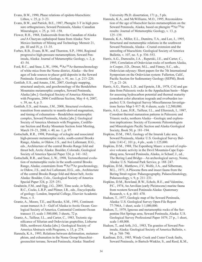
34
Evans, B.W., 1990, Phase relations of epidote-blueschists: Lithos, v. 25, p. 3–23.
Evans, B.W., and Patrick, B.E., 1987, Phengite 3-T in high pres-sure orthogneisses, Seward Peninsula, Alaska: Canadian Mineralogist, v. 25, p. 141–158.
Flower, R.H., 1968, Endoceroids from the Canadian of Alaska and A Chazyan cephalopod fauna from Alaska: New Mexico Institute of Mining and Technology Memoir 21, pts. III and IV, p. 13–35.
Forbes, R.B., Evans, B.W., and Thurston, S.P., 1984, Regional progressive high-pressure metamorphism, Seward Pen-insula, Alaska: Journal of Metamorphic Geology, v. 2, p. 43–54.
Ford, R.C., and Snee, L.W., 1996, 40Ar/39Ar thermochronology of white mica from the Nome district, Alaska—the first ages of lode sources to placer gold deposits in the Seward Peninsula: Economic Geology, v. 91, no. 1, p. 213–220.
Gottlieb, E.S., and Amato, J.M., 2007, Geologic mapping, structural analysis, and geochronology of the Bendeleben Mountains metamorphic complex, Seward Peninsula, Alaska [abs.]: Geological Society of America Abstracts with Programs, 2006 Cordilleran Section, May 4–6, 2007, v. 39, no. 4, p. 5.
Gottlieb, E.S., and Amato, J.M., 2008, Structural evolution, transition from anatectic to mantle-derived magmatism, and timing of exhumation—Bendeleben metamorphic complex, Seward Peninsula, Alaska [abs.]: Geological Society of America Abstracts with Programs, Cordille-ran Section and Rocky Mountain Section Joint Meeting, March 19–21, 2008, v. 40, no. 1, p. 97.
Gottschalk, R.R., 1998, Petrology of eclogite and associated high-pressure metamorphic rocks, south-central Brooks Range, Alaska, in Oldow, J.S., and Avé Lallemant, H.G., eds., Architecture of the central Brooks Range fold and thrust belt, Arctic Alaska: Boulder, Colorado, Geological Society of America Special Paper 324, p. 141–162.
Gottschalk, R.R., and Snee, L.W., 1998, Tectonothermal evolu-tion of metamorphic rocks in the south-central Brooks Range, Alaska; constraints from 40Ar/39Ar geochronology, in Oldow, J.S., and Avé Lallemant, H.G., eds., Architecture of the central Brooks Range fold and thrust belt, Arctic Alaska: Boulder, Colo., Geological Society of America Special Paper 324, p. 225–251.
Gradstein, F.M., and Ogg, J.G., 2005, Time scale, in Selley, R.C., Cocks, L.R.P., and Plimer, I.R., eds., Encyclopedia of geology: London, Imperial College, Elsevier Academic Press, v. 5.
Grantz, A., Moore, T.E., and Roeske, S.M., 1991, Continent-ocean transect A-3—Gulf of Alaska to Arctic Ocean: Geo-logical Society of America, Centennial Continent-Ocean transect 15, scale 1:500,000, 3 sheets, 72 p.
Grantz, A., Tailleur, I.L., and Carter, C., 1983, Tectonic sig-nificance of Silurian and Ordovician graptolites, Lisburne Hills, northwest Alaska [abs.]: Geological Society of America Abstracts with Programs, v. 15, p. 274.
Hannula, K.A., 1993, Relations between deformation, metamor-phism, and exhumation in the Nome Group blueschist–greenschist terrane, Seward Peninsula, Alaska: Stanford
University Ph.D. dissertation, 171 p., 5 pls.Hannula, K.A., and McWilliams, M.O., 1995, Reconsidera-
tion of the age of blueschist facies metamorphism on the Seward Peninsula, Alaska, based on phengite 40Ar/39Ar results: Journal of Metamorphic Geology, v. 13, p. 125–139.
Hannula, K.A., Miller, E.L., Dumitru, T.A., and Lee, J., 1995, Structural and metamorphic relations in the southwest Seward Peninsula, Alaska—Crustal extension and the unroofing of blueschists: Geological Society of America Bulletin, v. 107, no. 5, p. 536–553.
Harris, A.G., Dumoulin, J.A. , Repetski, J.E., and Carter, C., 1995, Correlation of Ordovician rocks of northern Alaska, in Cooper, J.D., Droser, M.L., and Finney, S.C., eds., Ordovician odyssey: Short papers for the 7th International Symposium on the Ordovician system: Fullerton, Calif., Pacific Section for Sedimentary Geology (SEPM), Book 77, p. 21–26.
Harris, A.G., Harris, L.D., and Epstein, J.B., 1978, CAI and gas data from Paleozoic rocks in the Appalachian basin—Maps for assessing hydrocarbon potential and thermal maturity (conodont color alteration isograds and overburden iso-pachs): U.S. Geological Survey Miscellaneous Investiga-tions Series Map I–917–B, 4 sheets, scale 1:2,500,000.
Harris, A.G., Lane, H.R., Tailleur, I.L., and Ellersieck, I., 1987, Conodont thermal maturation patterns in Paleozoic and Triassic rocks, northern Alaska—Geologic and explora-tion implications: Society of Economic Paleontologists and Mineralogists Pacific Section and Alaska Geological Society, Book 50, p. 181–194.
Hopkins, D.M., 1963, Geology of the Imuruk Lake area, Seward Peninsula, Alaska: U.S. Geological Survey Bul-letin 1141-C, 101 p., 4 pls., scale 1:125,000.
Hopkins, D.M., 1988, The Espenberg Maars: a record of explo-sive volcanic activity in the Devil Mountain-Cape Espe-nberg area, Seward Peninsula, Alaska, in Schaaf, J., ed., The Bering Land Bridge—An archeological survey, Nome, Alaska: U.S. National Park Service, p. 188–247.
Hopkins, D.M., Matthews, J.V., Wolfe, J.A., and Silberman, M.L., 1971, A Pliocene flora and insect fauna from the Bering Strait region: Palaeogeography, Palaeoclimatology, Palaeoecology, v. 9, p. 211–231.
Hopkins, D.M., Rowland, R.W., Echols, R.E., and Valentine, P.C., 1974, An Anvilian (early Pleistocene) marine fauna from western Seward Peninsula Alaska: Quaternary Research, v. 4, p. 441–470.
Hudson, T., 1977, Geologic map of the Seward Peninsula, Alaska: U.S. Geological Survey Open-File Report 77-796A, 1 sheet, scale 1:1,000,000.
Hudson, T., 1979, Igneous and metamorphic rocks of the Ser-pentine Hot Springs area, Seward Peninsula, Alaska: U.S. Geological Survey Professional Paper 1079, 27 p., 1 sheet, scale 1:48,000.
Hudson, T., and Arth, J.G., 1983, Tin granites of Seward Pen-insula, Alaska: Geological Society of America Bulletin, v. 94, p. 768–790.
Kaufman, D.S., 1985, Windy Creek and Crater Creek faults, Seward Peninsula, in Bartsch-Winkler, S., and Reed, K.M.,
35
eds., The United States Geological Survey in Alaska; accomplishments during 1983: U.S. Geological Survey Circular 945, p. 18–22.
Kaufman, D.S., and Hopkins, D.M., 1985, Late Cenozoic radio-metric dates, Seward and Baldwin Peninsulas, and adjacent continental shelf, Alaska: U.S. Geological Survey Open-File Report 85-374, 27 p.
Kaufman, D.S., Walter, R.C., Brigham-Grette, J., and Hopkins, D.M., 1991, Middle Pleistocene age of the Nome River glaciations, northwestern Alaska: Quaternary Research, v. 36, p. 277–293.
Layer, P.W., and Newberry, R.J., 2004, A long-term effort to determine 40Ar/39Ar ages of Alaskan mineral depos-its: Unpublished final report for USGS MRERP grant 04HQGR0163; accessed September 20, 2009, at http://minerals.usgs.gov/mrerp/reports/Layer_Report-04HQGR0163.pdf.
Lieberman, J.E., 1988, Metamorphic and structural studies of the Kigluaik Mountains western Alaska: Seattle, Wash., University of Washington, Ph.D. dissertation, 192 p., 53 figs.
Lieberman, J.E., and Till, A.B., 1987, Possible crustal origin of garnet lherzolite—evidence from the Kigluaik Mountains, Alaska [abs.]: Geological Society of America Abstracts with Programs, v. 19, p. 746.
Martin, A.J., 1970, Structure and tectonic history of the western Brooks Range, De Long Mountains and Lisburne Hills, Northern Alaska: Geological Society of America Bulletin, v. 81, p. 3605–3622.
Miller, E.L., Calvert, A.T., and Little, T.A., 1992, Strain-col-lapsed metamorphic isograds in a sillimanite gneiss dome, Seward Peninsula, Alaska: Geology, v. 20, p. 487–490.
Miller, E.L., Gelman, M., Parfenov, L., and Hourigan, J., 2002, Tectonic setting of Mesozoic magmatism—A compari-son between northeastern Russia and the North American Cordillera, in Miller, E.L., Grantz, A., and Klemperer, S.L., eds., Tectonic evolution of the Bering Shelf-Chukchi Sea-Arctic margin and adjacent landmasses: Geological Society of America Special Paper 360, p. 313–332.
Miller, E.L., and Hudson, T.L., 1991, Mid-Cretaceous exten-sional fragmentation of a Jurassic-Early Cretaceous com-pressional orogen, Alaska: Tectonics, v. 10, p. 781–796.
Miller, E.L., Ireland, T.R., Klemperer, S.L., Wirth, K.R., Akinin, V.V., and Brocher, T.M., 2002, Constraints on the age of formation of seismically reflective middle and lower crust beneath the Bering Shelf—SHRIMP zircon dating of xeno-liths from Saint Lawrence Island, in Miller, E.L., Grantz, A., and Klemperer, S.L., eds., Tectonic evolution of the Bering Shelf-Chukchi Sea-Arctic margin and adjacent landmasses: Geological Society of America Special Paper 360, p. 195–208.
Miller, T.P., 1972, Potassium-rich alkaline intrusive rocks of western Alaska: Geological Society of America Bulletin, v. 83, no. 7, p. 2111–2128.
Miller, T.P., 1989, Contrasting plutonic rock suites of the Yukon-Koyukuk basin and the Ruby Geanticline, Alaska: Journal of Geophysical Research, v. 94, no. B11, p. 15,969–15,987.
Miller, T.P., and Bunker, C.M., 1976, A reconnaissance study of the uranium and thorium contents of plutonic rocks of the southeastern Seward Peninsula, Alaska: U.S. Geological Survey Journal of Research, v. 4, no. 3, p. 367–377.
Miller, T.P., Grybeck, D.G., Elliott, R.L., and Hudson, T., 1972, Preliminary geologic map of the eastern Solomon and southeastern Bendeleben quadrangles, eastern Seward Pen-insula, Alaska: U.S. Geological Survey Open-File Report no. 1767, 11 p., 2 sheets, scale 1:250,000.
Moll-Stalcup, E.J., 1994, Latest Cretaceous and Cenozoic magmatism in mainland Alaska, in Plafker, G., and Berg, H.C., eds., Geology of Alaska, Geology of North America (GNA-G1), v. G-1, p. 589–619.
Moore, T.E., Dumitru, T.A., Adams, K.E., Witebsky, S.N., Harris, A.G., 2002, Origin of the Lisburne Hills-Herald Arch structural belt—Stratigraphic, structural, and fission-track evidence from the Cape Lisburne area, northwestern Alaska, in Miller, E.L., Grantz, A., and Klemperer, S.L., eds., Tectonic evolution of the Bering Shelf-Chukchi Sea-Arctic margin and adjacent landmasses: Geological Society of America Special Paper 360, p. 77–109.
Moore, T.E., Wallace, W.K., Bird, K.J., Karl, S.M., Mull, C.G., and Dillon, J.T., 1994, The geology of Northern Alaska, in Plafker, G., and Berg, H.C., eds., The Geology of Alaska: Boulder, Colo., Geological Society of America, The Geol-ogy of North America, v. G-1, p. 49–140.
Moore, T.E., Wallace, W.K., Mull, C.G., Adams, K.E., Plafker, G., and Nokleberg, W.J., 1997, Crustal implications of bedrock geology along the Trans-Alaska Crustal Transect (TACT) in the Brooks Range, northern Alaska: Journal of Geophysical Research, v. 102, p. 20,645–20,684.
Newberry, R.J., Werdon, M.B., Stevens, D.S.P., Athey, J.E., and Szumigala, D.J., 2005, Geologic map of the Council area, Solomon D-4 and Bendeleben A-4 quadrangles, Seward Peninsula, Alaska: Alaska Division of Geological and Geo-physical Surveys Report of Investigation 2005-1D, 1 sheet, scale 1:50,000.
Nilsen, T.H., 1989, Stratigraphy and sedimentology of the mid-Cretaceous deposits of the Yukon-Koyukuk Basin, west central Alaska: Journal of Geophysical Research, v. 94, no. B11, p. 15,925–15,940.
North American Commission of Stratigraphic Nomenclature (NACSN), 2005, North American Stratigraphic Code: American Association of Petroleum Geologists (AAPG) Bulletin, v. 89, no. 11, p. 1547–1591, (http://ngmdb.usgs.gov/Info/NACSN/Code2/code2.html).
Oliver, W.A., Jr., Merriam, C.W., and Churkin, M., Jr., 1975, Ordovician, Silurian, and Devonian corals of Alaska: U.S. Geological Survey Professional Paper 823-B, p. 13–44.
Ormiston, A.R., 1978, Monorakos (Trilobita) from the Ordovi-cian of the Seward Peninsula, Alaska: Journal of Paleontol-ogy, v. 52, p. 345–352.
Ormiston, A.R., and Ross, R.J., Jr., 1979, Monorakos in the Ordovician of Alaska and its zoogeographic significance, in Gray, J., and Boucot, A.J., eds., Historical biogeography, plate tectonics, and the changing environment: Corvallis, Oregon State University Press, p. 53–59.
Pallister, J.S., Budahn, J.R., and Murchey, B.L., 1989, Pillow
36
basalts of the Angayucham Terrane—Oceanic plateau and island crust accreted to the Brooks Range: Journal of Geo-physical Research, v. 94, p. 15,901–15,923.
Patrick, B.E., 1988, Synmetamorphic structural evolution of the Seward Peninsula blueschist terrane, Alaska: Journal of Structural Geology, v. 10, p. 555–565.
Patrick, B.E., and Evans, B.W., 1989, Metamorphic evolution of the Seward Peninsula blueschist terrane, Alaska: Journal of Petrology, v. 30, p. 531–556.
Patrick, B.E., Evans, B.W., Dumoulin, J.A., and Harris, A.G., 1985, A comparison of carbonate mineral and conodont color alteration index thermometry, Seward Peninsula, Alaska [abs.]: Geological Society of America Abstracts with Program, v. 17, no. 6, p. 399.
Patrick, B.E., and Lieberman, J.E., 1988, Thermal overprint of blueschists of the Seward Peninsula: The Lepontine [Alps] in Alaska: Geology, v. 16, p. 1,100–1,103.
Patrick, B.E., and McClelland, W.C., 1995, Late Proterozoic granitic magmatism on Seward Peninsula and a Barentian origin for Arctic Alaska-Chukotka: Geology, v. 23, no. 1, p. 81–84.
Patton, W.W., Jr., 1967, Regional geologic map of the Candle Quadrangle, Alaska: U.S. Geological Survey Miscella-neous Investigation 492, 1 sheet, scale 1:250,000.
Patton, W.W., Jr., and Box S.E., 1989, Tectonic setting of the Yukon-Koyukuk basin and its borderlands, Western Alaska: Journal of Geophysical Research, v. 94, no. B11, p. 15,807–15,820.
Patton, W.W., Jr., and Csejtey, B., Jr., 1980, Geologic map of St. Lawrence Island, Alaska: U.S. Geological Survey Miscel-laneous Investigations Series Map I–1203, 1 sheet, scale 1:250,000.
Patton, W.W., Jr., Stern, T.W., Arth, J.G., and Carlson, C., 1987, New U/Pb ages from granite and granite gneiss in the Ruby Geanticline and southern Brooks Range, Alaska: Journal of Geology, v. 95, no. 1, p. 118–126.
Patton, W.W., Jr., and Tailleur, I.L., 1977, Evidence in the Bering Strait region for differential movement between North America and Eurasia: Geological Society of America Bulletin, v. 88, p. 1298–1304.
Patton, W.W., Jr., Wilson, F.H., Labay, K.A., and Shew, N., 2005, Digital data for the reconnaissance geologic map of the Yukon-Koyukuk Basin, Alaska: U.S. Geologi-cal Survey Open-File Report 2005-1341, 2 sheets, scale 1:500,000.
Plafker, G., Gilpin, L.M., and Lahr, J.C., 1994, Neotectonic map of Alaska, in Plafker, G., and Berg, H.C., eds., Geology of Alaska: Boulder, Colo., Geological Society of America, Geology of North America (GNA-G1), v. G-1, plate 12, scale 1:2,500,000.
Pollock, S.M., 1982, Structure, petrology and metamorphic his-tory of the Nome Group blueschist terrane, Salmon Lake area, Seward Peninsula, Alaska: Seattle, University of Washington, Masters thesis, 221 p., 2 sheets, scale 36,680.
Potter, A.W., 1984, Paleobiogeographical relations of Late Ordovician brachiopods from the York and Nixon Fork terranes, Alaska [abs.]: Geological Society of America Abstracts with Programs, v. 16, no. 6, p. 626.
Reed, B.L., Menzie, W.D., McDermott, W.D., Root, D.H., Scott, W., and Drew L.J., 1989, Undiscovered lode tin resources of the Seward Peninsula, Alaska: Economic Geology, v. 84, p. 1936–1947.
Rejebian, V.A., Harris, A.G., and Huebner, J.S., 1987, Con-odont color and textural alteration—An index to regional metamorphism, contact metamorphism, and hydrothermal alteration: Geological Society of America Bulletin, v. 99, p. 471–479.
Retherford, R.M., Hinderman, T.K., and Hawley, C.C., eds., 1986, Preliminary feasibility study of a coal mine at Chi-cago Creek: Alaska Division of Geological and Geophysi-cal Surveys, Public-data File 86-25, 172 p., 2 sheets, scale 1:2,400.
Roeske, S.M., Dusel-Bacon, C., Aleinikoff, J.N., Snee, L.W., and Lanphere, M.A., 1995, Metamorphic and structural history of continental crust at a Mesozoic collisional margin, the Ruby Terrane, central Alaska: Journal of Meta-morphic Geology, v. 113, no. 1, p. 25–40.
Roeske, S.M., and McClelland, W.C., 1997, Preservation of the subduction zone boundary between the Ruby Terrane and Tozitna Terrane, West-Central Alaska [abs.]: Geological Society of America Abstracts with Programs, v. 29, no. 5, p. 60.
Rohr, D.M., 1979, Geographic distribution of the Ordovician gastropod Maclurites, in Gray, J., and Boucot, A.J., eds., Historical biogeography, plate tectonics, and the changing environment: Corvallis, Oregon State University Press, p. 45–52.
Rohr, D.M., 1988, Upper Ordovician gastropods from the Seward Peninsula, Alaska: Journal of Paleontology, v. 62, p. 551–565.
Rohr, D.M., Fryda, J., and Blodgett, R.B., 2003, Alaskadis-cus, a new bellerophontoidean gastropod from the Upper Ordovician of the York and Farewell terranes of Alaska, in Clautice, K.H., and Davis, P.K., eds., Short notes on Alaska geology 2003: Alaska Division of Geological and Geo-physical Surveys Professional Report 120, p. 95–99.
Rohr, D.M., and Potter, A.W., 1987, Rousseauspira—A new gastropod operculum from the Ordovician of Alaska and California: Journal of Paleontology, v. 61, no. 2, p. 284–289.
Ross, R.J., Jr., 1965, Early Ordovician trilobites from the Seward Peninsula, Alaska: Journal of Paleontology, v. 39, no. 1, p. 17–20.
Ross, R.J., Jr., 1967, Anomalograptus from the Seward Penin-sula, Alaska: Journal of Paleontology, v. 41, p. 1276–1278.
Ross, R.J., Jr., Adler, F.J., Amsden, T.W., Bergstrom, D., Berg-strom, S.M., Carter, Claire, Churkin, Michael, Cressman, E.A., Derby, J.R., Dutro, J.T., Jr., Ethington, R.L., Finney, S.C., Fisher, D.W., Fisher, J.H., Harris, A.G., Hintze, L.F., Ketner, K.B., Kolota, D.L., Landing, Ed, Newman, R.B., Sweet, W.C., Pojeta, John, Jr., Potter, A.W., Rader, E.K., Repetski, J.E., Shaver, R.H., Thompson, T.L., and Webers, G.F., 1982, The Ordovician System in the United States; Correlation chart and explanatory notes: International Union of Geological Sciences Publication 12, 73 p., 3 sheets.
37
Ryherd, T.J., Carter, C., and Churkin, M., Jr., 1995, Middle through Upper Ordovician graptolite biostratigraphy of the Deceit Formation, northern Seward Peninsula, Alaska [abs.]: Geological Society of America Abstracts with Pro-grams, v. 27, no. 5, p. 75.
Ryherd, T.J., and Paris, C.E., 1985, Lower Paleozoic carbonate slope sequence, northern Seward Peninsula, Alaska [abs.]: American Association of Petroleum Geologists Bulletin, v. 69, no. 4, p. 667.
Ryherd, T.J., and Paris, C.E., 1987, Ordovician through Silurian carbonate base-of-slope apron sequence, northern Seward Peninsula, Alaska [abs.], in Tailleur, I.L., and Weimer, Paul, eds., Alaskan North Slope geology: Bakersfield, Calif., Pacific Section, Society of Economic Paleontolo-gists and Mineralogists, Book 50, p. 347-348.
Sainsbury, C.L., 1967, Upper Pleistocene features in the Bering Strait area: U.S. Geological Survey Professional Paper 575-D, p. 203–213.
Sainsbury, C.L., 1969a, Geologic map of the Teller B-4 and southern part of the Teller C-4 quadrangles, western Seward Peninsula, Alaska: U.S. Geological Survey Miscel-laneous Investigations Map I–572, scale 1:63,360.
Sainsbury, C.L., 1969b, Geology and ore deposits of the central York Mountains, Seward Peninsula, Alaska: U.S. Geologi-cal Survey Bulletin 1287, 101 p., 6 sheets.
Sainsbury, C.L., 1972, Geologic map of the Teller quadrangle, western Seward Peninsula, Alaska: U.S. Geological Survey Miscellaneous Investigations Map I-685, 4 p., scale 1:250,000.
Sainsbury, C.L., 1974, Geologic map of the Bendeleben 1:250,000 quadrangle, Seward Peninsula Alaska: Golden, Colo., Air Samplex, 31 p., 1 sheet, scale 1:250,000. [Pre-pared in cooperation with the U.S. Bureau of Mines, U.S. Geological Survey, and The Mapmakers].
Sainsbury, C.L., Coleman, R.G., and Kachadoorian, R., 1970, Blueschist facies rocks of the Seward Peninsula, Alaska: U.S. Geological Survey Professional Paper 700-B, p. 33–42.
Sainsbury, C.L., Dutro, J.T., Jr., and Churkin, M., 1971, The Ordovician-Silurian boundary in the York Mountains, western Seward Peninsula, Alaska: U.S. Geological Survey Professional Paper 750-C, p. C52–C57.
Sainsbury, C.L., Hummel, C.L., and Hudson, T., 1972, Recon-naissance geologic map of the Nome quadrangles, Seward Peninsula, Alaska: U.S. Geological Survey Open-File Report 543, 22 p., 1 sheet, scale 1:250,000.
Schrader, F.C., 1902, Geologic section of the Rocky Mountains in northern Alaska: Geological Society of America Bul-letin, v. 13, p. 233–252.
Shumway, G., Moore, D.G., and Dowling, G.B., 1964, Fairway rock in Bering Strait, in Miller, R.L., ed., Papers in marine geology—Shepard Commemorative Volume: New York, Macmillan and Company, p. 401-407.
Smith, P.S., 1910, Geology and mineral resources of the Solomon and Casadepaga quadrangles, Seward Peninsula, Alaska: U.S. Geological Survey Bulletin 433, 234 p.
Spear, F.S., 1993, Metamorphic phase equilibria and pressure-temperature-time paths: Mineralogical Society of America,
Monograph, p. 351.Steidtmann, E., and Cathcart, S.H., 1922, Geology of the York
tin deposits, Alaska: U.S. Geological Survey Bulletin 733, 130 p.
Streckeisen, A., 1976, To each plutonic rock its proper name: Earth Science Reviews, v. 12, p. 1–33.
Sturnick, M.A., 1984, Metamorphic petrology, geothermo-barometry and geochronology of the eastern Kigluaik Mountains, Seward Peninsula, Alaska: Fairbanks, Univer-sity of Alaska, Masters thesis, 175 p.
Swanson, S.E., Turner, D.L., Forbes, R.B., and Hopkins, D.M., 1981, Petrology and geochronology of Tertiary and qua-ternary basalts from the Seward Peninsula, western Alaska Alaska [abs.]: Geologic Survey of America Abstracts with Programs, v. 13, no. 7, p. 563.
Tailleur, I.L., Brosgé, W.P., and Reiser, H.N., 1967 [1968], Palinspastic analysis of Devonian rocks in northwestern Alaska, in Oswald, D.H., ed., International symposium on the Devonian system, v. 2: Calgary, Alberta Society of Petroleum Geologists, p. 1345-1361.
Thurston, S.P., 1985, Structure, petrology, and metamorphic his-tory of the Nome Group blueschist terrane, Salmon Lake area, Seward Peninsula, Alaska: Geological Society of America Bulletin, v. 96, p. 600–617.
Till, A.B., 1980, Crystalline rocks of the Kigluaik Mountains, Seward Peninsula, Alaska: Seattle, Wash., University of Washington, Masters thesis, 92 p.
Till, A.B., 1981, Alpine-type garnet lherzolite from the Kigluaik Mountains, Seward Peninsula, Alaska [abs.]: Geologic Society of America Abstracts with Programs, Cordilleran Section, March 25–27, 1981, v. 13, no. 2, p. 110.
Till, A.B., Aleinikoff, J.N., Amato, J.M., and Harris, A.G., 2006, New paleontologic and geochronologic protolith ages for the paleocontinental margin of Arctic Alaska [abs.]: Geo-logical Society of America Abstracts with Programs, v. 38, no. 5, p. 13.
Till, A.B., Amato, J.M., Aleinikoff, J.N., Dumoulin, J.A., and Bleick, H.A., 2008a, Application of detrital zircon analy-sis to identify protolith age, basin evolution, potential correlatives, and provenance of penetratively deformed blueschist-facies metasedimentary rocks, northern Alaska [abs.], in Garver, J.I., and Montaria, M.J., eds., Proceed-ings from the 11th international conference on thermochro-nometry, Anchorage, Alaska, September 15–19, 2008, p. 236–238, accessed August 1, 2009, at http://minerva.union.edu/ft2008/
Till, A.B., and Dumoulin, J.A., 1994, Seward Peninsula—Geol-ogy of Seward Peninsula and Saint Lawrence Island, in Plafker, G., and Berg, H.C., eds., The geology of Alaska: Boulder, Colo., Geological Society of America, The Geol-ogy of North America, v. G-1, p. 141–152.
Till, A.B., Dumoulin, J.A., Gamble, B.M., Kaufman, D.S., and Carroll, P.I., 1986, Preliminary geologic map and fossil data, Solomon, Bendeleben, and southern Kotzebue quad-rangles, Seward Peninsula, Alaska: U.S. Geological Survey Open-File Report 86-276, 74 p., 3 sheets, scale 1:250,000.
Till, A.B., Dumoulin, J.A., Harris, A.G., Moore, T.E., Bleick, H.A., and Siwiec, B., 2008b, Bedrock geologic map of
38
the southern Brooks Range, Alaska, and accompanying conodont data: U.S. Geological Survey Open-File Report 2008–1149, 88 p., 2 sheets, sheet 1, scale 1:500,000; sheet 2, scale 1:600,000.
Till, A.B., Schmidt, J.M., and Nelson, S.W., 1988, Thrust involvement of metamorphic rocks, southwestern Brooks Range, Alaska: Geology, v. 16, p. 930–933.
Till, A.B., Slack, J.F., Ayuso, R.A., Shanks, W.C., III, Dumou-lin, J.A., Amato, J.M., Aleinikoff, J.N., and Bleick, H.A., 2007, Setting and origin of base-metal sulfide deposits in the Nome Group, central Seward Peninsula, Alaska [abs.]: Alaska Miners Association 2007 Convention and Trade Show, p. 10, accessed April 6, 2009, at http://www.alaska-miners.org/abstracts2007.pdf
Tolson, R.B., 1987, Structure and stratigraphy of the Hope Basin, southern Chukchi Sea, Alaska, in Scholl, D.W., Grantz, A., and Vedder, J.G., eds., Geology and resource potential of the continental margin of western North America and adjacent ocean basins, Beaufort Sea to Baja California: Houston, Tex., Circum-Pacific Council for Energy and Mineral Resources, p. 59–72.
Toro, J., Burnette, L., Amato, J., Repetski, J.E., and Gehrels, G., 2006, The Mint River fault—an extensional detachment in the York Mountains, Seward Peninsula, Alaska [abs.]: Geological Society of America Abstracts with Programs, v. 38, no. 5, p. 84–85.
Toro, J., Gans, P.B., McClelland, W.C., and Dumitru, T.A., 2002, Deformation and exhumation of the Mount Igikpak region, central Brooks Range, Alaska, in Miller, E.L., Grantz, A., and Klemperer, S.L., eds., Tectonic evolution of the Bering Shelf-Chukchi Sea-Arctic Margin and adja-cent landmasses: Geological Society of America Special Paper 360, p. 111–132.
Turner, D.L., Grybeck, D., and Wilson, F.H., [1975?], Radio-metric dates from Alaska—A 1975 compilation: Alaska Division of Geological and Geophysical Surveys Special Report 10, 64 p.
Turner, D.L., and Swanson, S.E., 1981, Continental rifting—A new tectonic model for the central Seward Peninsula, in Wescott, E., and Turner, D.L., eds., Geothermal reconnais-sance survey of the central Seward Peninsula, Alaska: Uni-versity of Alaska, Geophysical Institute, Report prepared for the Division of Geothermal Energy of the U.S. Depart-ment of Energy, Report 284, p. 7–36.
Vandervoort, D.J., 1985, Stratigraphy, paleoenvironment, and diagenesis of the Lower Ordovician York Mountain car-bonates, Seward Peninsula, Alaska: Baton Rouge, Louisi-ana, Louisiana State University, Masters thesis, 141 p.
Watts, K.F., Harris, A.G., Carlson, R.C., Eckstein, M.K., Gru-zlovic, P.D., Imm, T.A., Krumhardt, A.P., Lasota, D.K.,
Morgan, S.K., Enos, Paul, Goldstein, R., Dumoulin, J.A., and Mamet, B., 1994, Analysis of reservoir heterogeneities due to shallowing-upward cycles in carbonate rocks of the Upper Mississippian and Pennsylvanian Wahoo Limestone of northeastern Alaska: Department of Energy Report, Contract DE-AC22-89BC14471, 433 p.
Webby, B.D., Cooper, R.A., Bergström, S.M., and Paris, Flo-rentin, 2004, Stratigraphic framework and time slices, in Webby, B.D., Paris, Florentin, Droser, M.L., and Percival, I.G., eds., The great Ordovician biodiversification event: New York, Columbia University Press, p. 41–47.
Werdon, M.B., Newberry, R.J., Szumigala, D.J., Athey, J.E., Freeman, L.K., and Layer, P.W., 2006, Geologic mapping and mineral investigations in the Casadepaga River-Bluff area and implications for the southern Seward Peninsula, Alaska [abs.]: Alaska Miners Association 2006 Annual Convention and Trade Show, p. 3–5, accessed September 20, 2009, at http://www.alaskaminers.org/abstracts2006.pdf
Werdon, M.B., Stevens, D.S.P., Newberry, R.J., Szumigala, D.J., Athey, J.E., and Hicks, S.A., 2005a, Explanatory booklet to accompany geologic, bedrock, and surficial maps of the Big Hurrah and Council areas, Seward Penin-sula, Alaska: Alaska Division of Geological and Geophysi-cal Surveys Report of Investigation 2005-1, 24 p.
Werdon, M.B., Stevens, D.S.P., Newberry, R.J., Szumigala, D.J., Athey, J.E., and Hicks, S.A., 2005b, Geologic map of the Big Hurrah area, northern half of the Solomon C-5 quadrangle, Seward Peninsula, Alaska: Alaska Division of Geological and Geophysical Surveys Report of Investiga-tion 2005-1A, 1 sheet, scale 1:50,000.
Werdon, M.B., Szumigala, D.J., Newberry, R.J., Athey, J.E., and Hicks, S.A., 2005c, Major-oxide, minor-oxide, trace-element, geochemical, and non-carbonate carbon data from rocks collected in the Solomon, Bendeleben, and Nome quadrangles, Seward Peninsula, Alaska in 2003 and 2004: Alaska Division of Geological and Geophysical Surveys Raw Data File 2005-2, 46 p.
Wilson, F.H., Shew, Nora, and Du Bois, G.D., 1994, Map and table showing isotopic age data in Alaska, in Plafker, G. and Berg, H.C., eds., The geology of Alaska: Boulder, Colo., Geological Society of America, The Geology of North America, v. G-1, Plate 8; 1 sheet, scale 1:2,500,000.
Wirth, K.R., Grandy, J., Kelley, K., and Sadofsky, S., 2002, Evolution of crust and mantle beneath the Bering Sea region: Evidence from xenoliths and late Cenozoic basalts, in Miller, E.L., Grantz, A., and Klemperer, S.L., eds., Tectonic evolution of the Bering Shelf-Chukchi Sea-Arctic margin and adjacent landmasses: Geological Society of America Special Paper 306, p. 167–193.

39
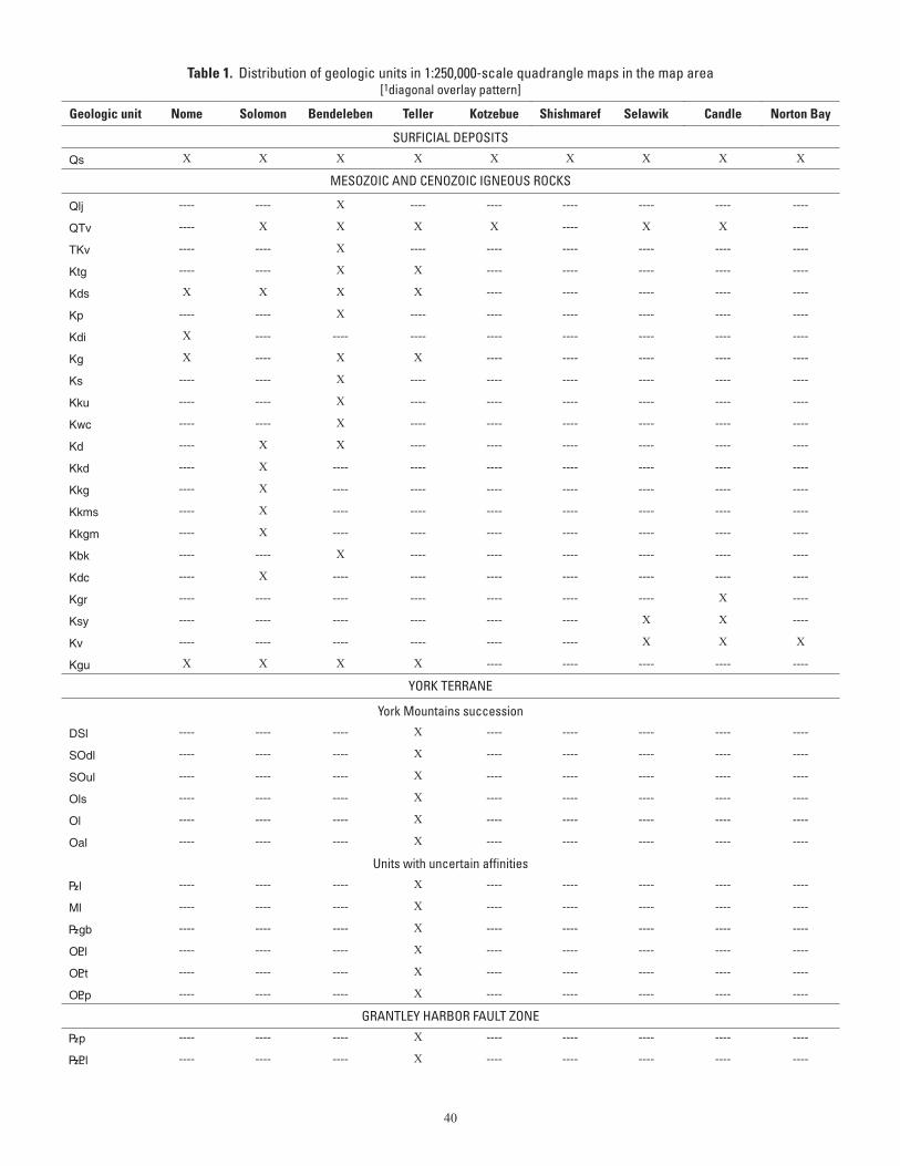
40
Table 1. Distribution of geologic units in 1:250,000-scale quadrangle maps in the map area [1diagonal overlay pattern]
Geologic unit Nome Solomon Bendeleben Teller Kotzebue Shishmaref Selawik Candle Norton Bay
SURFICIAL DEPOSITS
Qs X X X X X X X X X
MESOZOIC AND CENOZOIC IGNEOUS ROCKS
Qlj ---- ---- X ---- ---- ---- ---- ---- ----
QTv ---- X X X X ---- X X ----
TKv ---- ---- X ---- ---- ---- ---- ---- ----
Ktg ---- ---- X X ---- ---- ---- ---- ----
Kds X X X X ---- ---- ---- ---- ----
Kp ---- ---- X ---- ---- ---- ---- ---- ----
Kdi X ---- ---- ---- ---- ---- ---- ---- ----
Kg X ---- X X ---- ---- ---- ---- ----
Ks ---- ---- X ---- ---- ---- ---- ---- ----
Kku ---- ---- X ---- ---- ---- ---- ---- ----
Kwc ---- ---- X ---- ---- ---- ---- ---- ----
Kd ---- X X ---- ---- ---- ---- ---- ----
Kkd ---- X ---- ---- ---- ---- ---- ---- ----
Kkg ---- X ---- ---- ---- ---- ---- ---- ----
Kkms ---- X ---- ---- ---- ---- ---- ---- ----
Kkgm ---- X ---- ---- ---- ---- ---- ---- ----
Kbk ---- ---- X ---- ---- ---- ---- ---- ----
Kdc ---- X ---- ---- ---- ---- ---- ---- ----
Kgr ---- ---- ---- ---- ---- ---- ---- X ----
Ksy ---- ---- ---- ---- ---- ---- X X ----
Kv ---- ---- ---- ---- ---- ---- X X X
Kgu X X X X ---- ---- ---- ---- ----
YORK TERRANE
York Mountains succession
DSl ---- ---- ---- X ---- ---- ---- ---- ----
SOdl ---- ---- ---- X ---- ---- ---- ---- ----
SOul ---- ---- ---- X ---- ---- ---- ---- ----
Ols ---- ---- ---- X ---- ---- ---- ---- ----
Ol ---- ---- ---- X ---- ---- ---- ---- ----
Oal ---- ---- ---- X ---- ---- ---- ---- ----
Units with uncertain affinities
|l ---- ---- ---- X ---- ---- ---- ---- ----
Ml ---- ---- ---- X ---- ---- ---- ---- ----
|gb ---- ---- ---- X ---- ---- ---- ---- ----
O<l ---- ---- ---- X ---- ---- ---- ---- ----
O<t ---- ---- ---- X ---- ---- ---- ---- ----
O<p ---- ---- ---- X ---- ---- ---- ---- ----
GRANTLEY HARBOR FAULT ZONE
|p ---- ---- ---- X ---- ---- ---- ---- ----
|<l ---- ---- ---- X ---- ---- ---- ---- ----
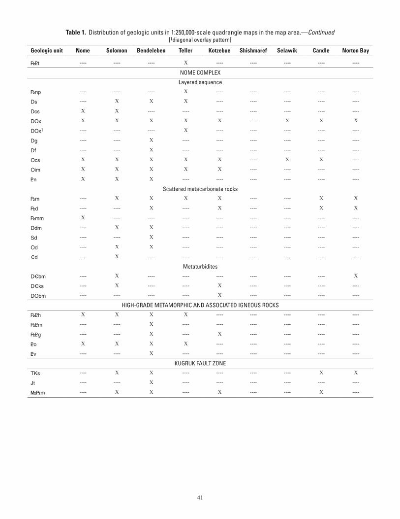
41
Table 1. Distribution of geologic units in 1:250,000-scale quadrangle maps in the map area.—Continued[1diagonal overlay pattern]
Geologic unit Nome Solomon Bendeleben Teller Kotzebue Shishmaref Selawik Candle Norton Bay
|<t ---- ---- ---- X ---- ---- ---- ---- ----
NOME COMPLEX
Layered sequence
|np ---- ---- ---- X ---- ---- ---- ---- ----
Ds ---- X X X ---- ---- ---- ---- ----
Dcs X X ---- ---- ---- ---- ---- ---- ----
DOx X X X X X ---- X X X
DOx1 ---- ---- ---- X ---- ---- ---- ---- ----
Dg ---- ---- X ---- ---- ---- ---- ---- ----
Df ---- ---- X ---- ---- ---- ---- ---- ----
Ocs X X X X X ---- X X ----
Oim X X X X X ---- ---- ---- ----
<n X X X ---- ---- ---- ---- ---- ----
Scattered metacarbonate rocks
|m ---- X X X X ---- ---- X X
|d ---- ---- X ---- X ---- ---- X X
|mm X ---- ---- ---- ---- ---- ---- ---- ----
Ddm ---- X X ---- ---- ---- ---- ---- ----
Sd ---- ---- X ---- ---- ---- ---- ---- ----
Od ---- X X ---- ---- ---- ---- ---- ----
_d ---- X ---- ---- ---- ---- ---- ---- ----
Metaturbidites
D_bm ---- X ---- ---- ---- ---- ---- ---- X
D_ks ---- X ---- ---- X ---- ---- ---- ----
DObm ---- ---- ---- ---- X ---- ---- ---- ----
HIGH-GRADE METAMORPHIC AND ASSOCIATED IGNEOUS ROCKS
|<h X X X X ---- ---- ---- ---- ----
|<m ---- ---- X ---- ---- ---- ---- ---- ----
|<g ---- ---- X ---- X ---- ---- ---- ----
<o X X X X ---- ---- ---- ---- ----
<v ---- ---- X ---- ---- ---- ---- ---- ----
KUGRUK FAULT ZONE
TKs ---- X X ---- ---- ---- ---- X X
Jt ---- ---- X ---- ---- ---- ---- ---- ----
}|m ---- X X ---- X ---- ---- X ----
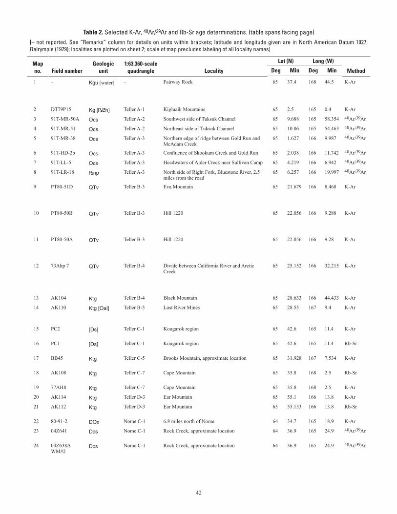
42
Table 2. Selected K-Ar, 40Ar/39Ar and Rb-Sr age determinations. (table spans facing page)[– not reported. See “Remarks” column for details on units within brackets; latitude and longitude given are in North American Datum 1927;Dalrymple (1979); localities are plotted on sheet 2; scale of map precludes labeling of all locality names]
ages determined prior to 1976 have been recalculated and noted in the Remarks column to reflect recommended 1976 IUGS constants using
Mapno.
Field number
Geologicunit
1:63,360-scalequadrangle
Locality
Lat (N) Long (W) Method
Mineral
Age(Ma)
Error(Ma)
Rock type
Reference
RemarksDeg Min Deg Min
1 – Kgu [water] – Fairway Rock 65 37.4 168 44.5 K-Ar Biotite 110.7 3 Granite Shumway and others, 1964 Age recalculated with 1976 constants; authors' reported age 108 ± 3.0 Ma; sample is from an outcrop of Kgu that is too small to show at map scale; given the latitude and longitude the sample plots on the shoreline in the water
2 DT79P15 Kg [|<h] Teller A-1 Kigluaik Mountains 65 2.5 165 0.4 K-Ar Biotite 83.4 2.5 Gneissic granite Turner and Swanson, 1981 Location from Wilson and others (1994)
3 91T-MR-50A Ocs Teller A-2 Southwest side of Tuksuk Channel 65 9.688 165 58.354 40Ar/39Ar White mica 124.3 0.3 Schist Hannula and McWilliams, 1995 Age given is authors' reported weighted mean plateau age
4 91T-MR-51 Ocs Teller A-2 Northeast side of Tuksuk Channel 65 10.06 165 54.463 40Ar/39Ar White mica 114.8 0.7 Schist Hannula and McWilliams, 1995 Age given is authors' reported weighted mean plateau age
5 91T-MR-38 Ocs Teller A-3 Northern edge of ridge between Gold Run and McAdam Creek
65 1.627 166 9.987 40Ar/39Ar White mica 118.1 0.3 Schist Hannula and McWilliams, 1995 Age given is authors' reported weighted mean plateau age
6 91T-HD-2b Ocs Teller A-3 Confluence of Skookum Creek and Gold Run 65 2.038 166 11.742 40Ar/39Ar White mica 116.2 0.3 Schist Hannula and McWilliams, 1995 Age given is authors' reported weighted mean plateau age
7 91T-LL-5 Ocs Teller A-3 Headwaters of Alder Creek near Sullivan Camp 65 4.219 166 6.942 40Ar/39Ar White mica 120.5 0.2 Schist Hannula and McWilliams, 1995 Age given is authors' reported weighted mean plateau age
8 91T-LR-18 |np Teller A-3 North side of Right Fork, Bluestone River, 2.5 miles from the road
65 6.257 166 19.997 40Ar/39Ar White mica 119.9 0.3 Schist Hannula and McWilliams, 1995 Age given is authors' reported weighted mean plateau age
9 PT80-51D QTv Teller B-3 Eva Mountain 65 21.679 166 8.468 K-Ar Whole-rock 2.6 0.2 Basalt Turner and Swanson, 1981 Authors' comments: sample is a volcanic neck from the basalt flows; authors' reported location of sample is north of Teller at "Eva Mountain." Latitude and longitude were not reported and were determined based on authors' description and fig. 8
10 PT80-50B QTv Teller B-3 Hill 1220 65 22.056 166 9.288 K-Ar Whole-rock 2.5 0.3 Basalt Turner and Swanson, 1981 Authors' comments: sample is a volcanic neck from the basalt flows; authors reported location of sample is north of Teller at "Hill 1220." Latitude and longitude were not reported and were determined based on authors' description and fig. 8
11 PT80-50A QTv Teller B-3 Hill 1220 65 22.056 166 9.28 K-Ar Whole-rock 2.7 0.2 Basalt Turner and Swanson, 1981 Authors' comments: sample is a volcanic neck from the basalt flows; authors reported location of sample is north of Teller at "Hill 1220." Latitude and longitude were not reported and were determined based on authors' description and fig. 8
12 73Ahp 7 QTv Teller B-4 Divide between California River and Arctic Creek
65 25.152 166 32.215 K-Ar Whole-rock 2.92 0.14 Basalt Hopkins and others,1974 Age recalculated with 1976 constants; authors' reported age 2.84 ± 0.14 Ma; authors' reported location of the sample is "the divide between California River and Arctic Creek." Latitude and lon-gitude were not reported and were determined based on authors' description, fig. 3, and additional description on p. 447
13 AK104 Ktg Teller B-4 Black Mountain 65 28.633 166 44.433 K-Ar Biotite 79.1 2.9 Granite Hudson and Arth, 1983 Location based on authors' table 1
14 AK110 Ktg [Oal] Teller B-5 Lost River Mines 65 28.55 167 9.4 K-Ar Biotite 80.2 3 Granite Hudson and Arth, 1983 Sample is from an outcrop of Ktg that is too small to show at map scale; given the latitude and longitude the sample plots in Oal
15 PC2 [Ds] Teller C-1 Kougarok region 65 42.6 165 11.4 K-Ar Mica 70.2 - Granite Puchner, C.C., written commun., 1986
Sample is from drill core that is in Ds at the surface
16 PC1 [Ds] Teller C-1 Kougarok region 65 42.6 165 11.4 Rb-Sr - 72 - Porphyritic biotite granite
Puchner, C.C., written commun., 1986
Sample is from drill core that is in Ds at the surface
17 BB45 Ktg Teller C-5 Brooks Mountain, approximate location 65 31.928 167 7.534 K-Ar Biotite 77 3 Granite Sainsbury, 1969b Age recalculated with 1976 constants; Author's reported age 75.1 ± 3.0 Ma; sample number is given in Turner and others, 1975
18 AK108 Ktg Teller C-7 Cape Mountain 65 35.8 168 2.5 Rb-Sr Whole-rock (multiple)
72.5 2 Granite Hudson and Arth, 1983 Whole rock / isochron age; location based on authors' table 1
19 77AH8 Ktg Teller C-7 Cape Mountain 65 35.8 168 2.5 K-Ar Biotite 78.8 2.9 Granite Hudson and Arth, 1983 Location based on authors' table 1
20 AK114 Ktg Teller D-3 Ear Mountain 65 55.1 166 13.8 K-Ar Biotite 76.7 2.8 Granite Hudson and Arth, 1983 Location based on authors' table 1
21 AK112 Ktg Teller D-3 Ear Mountain 65 55.133 166 13.8 Rb-Sr Whole-rock (multiple)
73.1 1.6 Granite Hudson and Arth, 1983 Whole rock / isochron age; location based on authors' table 1
22 80-91-2 DOx Nome C-1 6.8 miles north of Nome 64 34.7 165 18.9 K-Ar Phengite 162 6 Pelitic schist Armstrong and others, 1986 Authors' reported comments: low-grade pelitic schist
23 04Z641 Dcs Nome C-1 Rock Creek, approximate location 64 36.9 165 24.9 40Ar/39Ar White mica 102.3 0.7 Vein Layer and Newberry, 2004 Age given is the authors' reported plateau age; sample is from drill core
24 04Z638A WM#2
Dcs Nome C-1 Rock Creek, approximate location 64 36.9 165 24.9 40Ar/39Ar White mica 112.3 0.8 Vein Layer and Newberry, 2004 Age given is the authors' reported plateau age; sample is from drill core
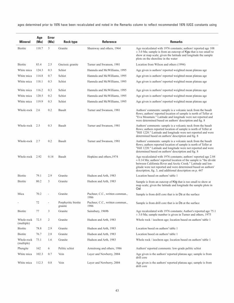
43
Table 2. Selected K-Ar, 40Ar/39Ar and Rb-Sr age determinations. (table spans facing page)[– not reported. See “Remarks” column for details on units within brackets; latitude and longitude given are in North American Datum 1927;Dalrymple (1979); localities are plotted on sheet 2; scale of map precludes labeling of all locality names]
ages determined prior to 1976 have been recalculated and noted in the Remarks column to reflect recommended 1976 IUGS constants using
Mapno.
Field number
Geologicunit
1:63,360-scalequadrangle
Locality
Lat (N) Long (W) Method
Mineral
Age(Ma)
Error(Ma)
Rock type
Reference
RemarksDeg Min Deg Min
1 – Kgu [water] – Fairway Rock 65 37.4 168 44.5 K-Ar Biotite 110.7 3 Granite Shumway and others, 1964 Age recalculated with 1976 constants; authors' reported age 108 ± 3.0 Ma; sample is from an outcrop of Kgu that is too small to show at map scale; given the latitude and longitude the sample plots on the shoreline in the water
2 DT79P15 Kg [|<h] Teller A-1 Kigluaik Mountains 65 2.5 165 0.4 K-Ar Biotite 83.4 2.5 Gneissic granite Turner and Swanson, 1981 Location from Wilson and others (1994)
3 91T-MR-50A Ocs Teller A-2 Southwest side of Tuksuk Channel 65 9.688 165 58.354 40Ar/39Ar White mica 124.3 0.3 Schist Hannula and McWilliams, 1995 Age given is authors' reported weighted mean plateau age
4 91T-MR-51 Ocs Teller A-2 Northeast side of Tuksuk Channel 65 10.06 165 54.463 40Ar/39Ar White mica 114.8 0.7 Schist Hannula and McWilliams, 1995 Age given is authors' reported weighted mean plateau age
5 91T-MR-38 Ocs Teller A-3 Northern edge of ridge between Gold Run and McAdam Creek
65 1.627 166 9.987 40Ar/39Ar White mica 118.1 0.3 Schist Hannula and McWilliams, 1995 Age given is authors' reported weighted mean plateau age
6 91T-HD-2b Ocs Teller A-3 Confluence of Skookum Creek and Gold Run 65 2.038 166 11.742 40Ar/39Ar White mica 116.2 0.3 Schist Hannula and McWilliams, 1995 Age given is authors' reported weighted mean plateau age
7 91T-LL-5 Ocs Teller A-3 Headwaters of Alder Creek near Sullivan Camp 65 4.219 166 6.942 40Ar/39Ar White mica 120.5 0.2 Schist Hannula and McWilliams, 1995 Age given is authors' reported weighted mean plateau age
8 91T-LR-18 |np Teller A-3 North side of Right Fork, Bluestone River, 2.5 miles from the road
65 6.257 166 19.997 40Ar/39Ar White mica 119.9 0.3 Schist Hannula and McWilliams, 1995 Age given is authors' reported weighted mean plateau age
9 PT80-51D QTv Teller B-3 Eva Mountain 65 21.679 166 8.468 K-Ar Whole-rock 2.6 0.2 Basalt Turner and Swanson, 1981 Authors' comments: sample is a volcanic neck from the basalt flows; authors' reported location of sample is north of Teller at "Eva Mountain." Latitude and longitude were not reported and were determined based on authors' description and fig. 8
10 PT80-50B QTv Teller B-3 Hill 1220 65 22.056 166 9.288 K-Ar Whole-rock 2.5 0.3 Basalt Turner and Swanson, 1981 Authors' comments: sample is a volcanic neck from the basalt flows; authors reported location of sample is north of Teller at "Hill 1220." Latitude and longitude were not reported and were determined based on authors' description and fig. 8
11 PT80-50A QTv Teller B-3 Hill 1220 65 22.056 166 9.28 K-Ar Whole-rock 2.7 0.2 Basalt Turner and Swanson, 1981 Authors' comments: sample is a volcanic neck from the basalt flows; authors reported location of sample is north of Teller at "Hill 1220." Latitude and longitude were not reported and were determined based on authors' description and fig. 8
12 73Ahp 7 QTv Teller B-4 Divide between California River and Arctic Creek
65 25.152 166 32.215 K-Ar Whole-rock 2.92 0.14 Basalt Hopkins and others,1974 Age recalculated with 1976 constants; authors' reported age 2.84 ± 0.14 Ma; authors' reported location of the sample is "the divide between California River and Arctic Creek." Latitude and lon-gitude were not reported and were determined based on authors' description, fig. 3, and additional description on p. 447
13 AK104 Ktg Teller B-4 Black Mountain 65 28.633 166 44.433 K-Ar Biotite 79.1 2.9 Granite Hudson and Arth, 1983 Location based on authors' table 1
14 AK110 Ktg [Oal] Teller B-5 Lost River Mines 65 28.55 167 9.4 K-Ar Biotite 80.2 3 Granite Hudson and Arth, 1983 Sample is from an outcrop of Ktg that is too small to show at map scale; given the latitude and longitude the sample plots in Oal
15 PC2 [Ds] Teller C-1 Kougarok region 65 42.6 165 11.4 K-Ar Mica 70.2 - Granite Puchner, C.C., written commun., 1986
Sample is from drill core that is in Ds at the surface
16 PC1 [Ds] Teller C-1 Kougarok region 65 42.6 165 11.4 Rb-Sr - 72 - Porphyritic biotite granite
Puchner, C.C., written commun., 1986
Sample is from drill core that is in Ds at the surface
17 BB45 Ktg Teller C-5 Brooks Mountain, approximate location 65 31.928 167 7.534 K-Ar Biotite 77 3 Granite Sainsbury, 1969b Age recalculated with 1976 constants; Author's reported age 75.1 ± 3.0 Ma; sample number is given in Turner and others, 1975
18 AK108 Ktg Teller C-7 Cape Mountain 65 35.8 168 2.5 Rb-Sr Whole-rock (multiple)
72.5 2 Granite Hudson and Arth, 1983 Whole rock / isochron age; location based on authors' table 1
19 77AH8 Ktg Teller C-7 Cape Mountain 65 35.8 168 2.5 K-Ar Biotite 78.8 2.9 Granite Hudson and Arth, 1983 Location based on authors' table 1
20 AK114 Ktg Teller D-3 Ear Mountain 65 55.1 166 13.8 K-Ar Biotite 76.7 2.8 Granite Hudson and Arth, 1983 Location based on authors' table 1
21 AK112 Ktg Teller D-3 Ear Mountain 65 55.133 166 13.8 Rb-Sr Whole-rock (multiple)
73.1 1.6 Granite Hudson and Arth, 1983 Whole rock / isochron age; location based on authors' table 1
22 80-91-2 DOx Nome C-1 6.8 miles north of Nome 64 34.7 165 18.9 K-Ar Phengite 162 6 Pelitic schist Armstrong and others, 1986 Authors' reported comments: low-grade pelitic schist
23 04Z641 Dcs Nome C-1 Rock Creek, approximate location 64 36.9 165 24.9 40Ar/39Ar White mica 102.3 0.7 Vein Layer and Newberry, 2004 Age given is the authors' reported plateau age; sample is from drill core
24 04Z638A WM#2
Dcs Nome C-1 Rock Creek, approximate location 64 36.9 165 24.9 40Ar/39Ar White mica 112.3 0.8 Vein Layer and Newberry, 2004 Age given is the authors' reported plateau age; sample is from drill core
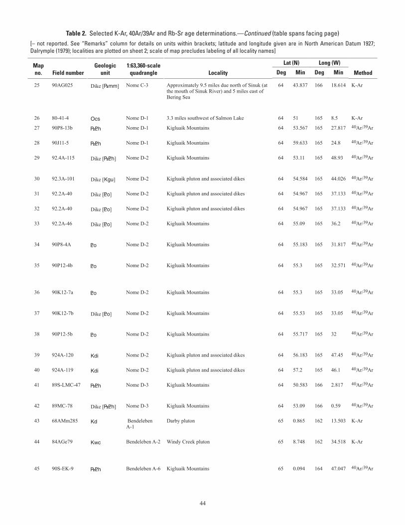
44
Table 2. Selected K-Ar, 40Ar/39Ar and Rb-Sr age determinations.—Continued (table spans facing page)[– not reported. See “Remarks” column for details on units within brackets; latitude and longitude given are in North American Datum 1927;Dalrymple (1979); localities are plotted on sheet 2; scale of map precludes labeling of all locality names]
ages determined prior to 1976 have been recalculated and noted in the Remarks column to reflect recommended 1976 IUGS constants using
Mapno.
Field number
Geologicunit
1:63,360-scalequadrangle
Locality
Lat (N) Long (W) Method
Mineral
Age(Ma)
Error(Ma)
Rock type
Reference
RemarksDeg Min Deg Min
25 90AG025 Dike [|mm] Nome C-3 Approximately 9.5 miles due north of Sinuk (at the mouth of Sinuk River) and 5 miles east of Bering Sea
64 43.837 166 18.614 K-Ar Biotite 80.5 0.8 Granitic Shew, N., written commun., 1993 Analyst's reported location is on "one of the many northwest trend-ing ridges (boundary of section 5 and 8, T9S, R38W Kateel River meridian); elevation about 450 feet;" analyst's reported latitude and longitude: 64° 43' 50" N and 166° 18' 30" W; sample is from a granitic dike in |mm that is too small to show at map scale
26 80-41-4 Ocs Nome D-1 3.3 miles southwest of Salmon Lake 64 51 165 8.5 K-Ar Phengite 141 5 Schist Armstrong and others, 1986 Authors' reported comments: low-grade pelitic schist
27 90P8-13b |<h Nome D-1 Kigluaik Mountains 64 53.567 165 27.817 40Ar/39Ar White mica 83.7 0.5 Metapelite or orthogneiss
Calvert and others, 1999 Age given is authors' reported plateau age; authors reported "white mica separates from metapelite and orthogneiss"
28 90J11-5 |<h Nome D-1 Kigluaik Mountains 64 59.633 165 24.8 40Ar/39Ar Biotite 83.9 0.4 Orthogneiss or paraorthogneiss
Calvert and others, 1999 Age given is authors' reported plateau age; authors reported "biotites from orthogneisses and paraorthogneisses"
29 92.4A-115 Dike [|<h] Nome D-2 Kigluaik Mountains 64 53.11 165 48.93 40Ar/39Ar Whole rock 83.3 0.9 Diabase dikes Amato and others, 2003c Age given is the authors' reported weighted mean plateau age; sample is from a diabase dike in |<h that is too small to show at map scale
30 92.3A-101 Dike [Kgu] Nome D-2 Kigluaik pluton and associated dikes 64 54.584 165 44.026 40Ar/39Ar Biotite 82.5 0.3 Dike Calvert and others, 1999 Age given is authors' reported plateau age; location given is based on authors' fig. 4
31 92.2A-40 Dike [<o] Nome D-2 Kigluaik pluton and associated dikes 64 54.967 165 37.133 40Ar/39Ar Hornblende 82.8 0.4 Dike Calvert and others, 1999 Age given is authors' reported plateau age; location given is from authors' table 1; authors' reported sample number: 922A-40
32 92.2A-40 Dike [<o] Nome D-2 Kigluaik pluton and associated dikes 64 54.967 165 37.133 40Ar/39Ar Biotite 82.1 0.3 Dike Calvert and others, 1999 Age given is authors' reported plateau age; location given is from authors' table 1
33 92.2A-46 Dike [<o] Nome D-2 Kigluaik Mountains 64 55.09 165 36.2 40Ar/39Ar Whole rock 81.3 0.6 Diabase dikes Amato and others, 2003c Age given is the authors' reported weighted mean plateau age; sample is from a diabase dike in <o that is too small to show at map scale
34 90P8-4A <o Nome D-2 Kigluaik Mountains 64 55.183 165 31.817 40Ar/39Ar Biotite 83.9 0.4 Orthogneiss or paraorthogneiss
Calvert and others, 1999 Age given is authors' reported plateau age; authors reported "bio-tites from orthogneisses and paraorthogneisses;" Location given is from authors' table 1
35 90P12-4b <o Nome D-2 Kigluaik Mountains 64 55.3 165 32.571 40Ar/39Ar Hornblende 86.4 0.7 Amphibolite Calvert and others, 1999 Age given is authors' reported plateau age; authors reported the sample is from a "penetratively deformed amphibolite;" authors' reported location of 60° 8' 4" and –165° 31' 49" is mislocated; location given is based on authors' fig. 4
36 90K12-7a <o Nome D-2 Kigluaik Mountains 64 55.3 165 33.05 40Ar/39Ar Hornblende 86.1 0.4 Amphibolite Calvert and others, 1999 Age given is authors' reported plateau age; authors reported the sample is from a "penetratively deformed amphibolite;" location given is from authors' table 1
37 90K12-7b Dike [<o] Nome D-2 Kigluaik Mountains 64 55.53 165 33.05 40Ar/39Ar Biotite 83.6 0.8 Diabase dikes Amato and others, 2003c Age given is the authors' reported weighted mean plateau age; sample is from a diabase dike outcrop in <o that is too small to show at map scale
38 90P12-5b <o Nome D-2 Kigluaik Mountains 64 55.717 165 32 40Ar/39Ar Hornblende 85.6 0.4 Granodioritic orthogneiss
Calvert and others, 1999 Age given is authors' reported plateau age; authors reported the sample is from a "melt-filled extension fracture along a syntec-tonic shear band in a granodioritic orthogneiss"
39 924A-120 Kdi Nome D-2 Kigluaik pluton and associated dikes 64 56.183 165 47.45 40Ar/39Ar Hornblende 82 0.3 Mafic phase igne-ous rock
Calvert and others, 1999 Age given is authors' reported plateau age; location given is from authors' table 1
40 924A-119 Kdi Nome D-2 Kigluaik pluton and associated dikes 64 57.2 165 46.1 40Ar/39Ar Hornblende 82.2 0.3 Mafic phase igne-ous rock
Calvert and others, 1999 Age given is authors' reported plateau age; location given is from authors' table 1
41 89S-LMC-47 |<h Nome D-3 Kigluaik Mountains 64 50.583 166 2.817 40Ar/39Ar White mica 83.1 0.5 Metapelite or orthogneiss
Calvert and others, 1999 Age given is authors' reported plateau age; authors reported "white mica separates from metapelite and orthogneiss"; location given is from authors' table 1
42 89MC-78 Dike [|<h] Nome D-3 Kigluaik Mountains 64 53.09 166 0.59 40Ar/39Ar Whole rock 79.2 0.3 Diabase dike Amato and others, 2003c Age given is a weighted mean plateau age; sample is from a diabase dike in |<h that is too small to show at map scale
43 68AMm285 Kd Bendeleben A-1
Darby pluton 65 0.865 162 13.503 K-Ar Biotite 94.4 2.9 Quartz monzonite Miller and others, 1972; Miller and Bunker, 1976
Age recalculated with 1976 constants; authors' reported age 92.1 ± 2.8 Ma; reported latitude and longitude 65° 01' N and 162° 11' W
44 84AGe79 Kwc Bendeleben A-2 Windy Creek pluton 65 8.748 162 34.518 K-Ar Hornblende 93.8 2.1 Monzogranite Shew, N., written commun., 1987 Analyst reported that the sample is "an intrusive between Windy Creek and an unnamed northern tributary of Mosquito Creek. Sample was collected from the flat portion of ridge, approxi-mately 490 meters south of peak 2764"
45 90S-EK-9 |<h Bendeleben A-6 Kigluaik Mountains 65 0.094 164 47.047 40Ar/39Ar Biotite 83.8 1.1 Orthogneiss or paraorthogneiss
Calvert and others, 1999 Age given is authors' reported plateau age; authors' reported "bio-tites from orthogneisses and paraorthogneisses;" location given is based on authors' fig. 4
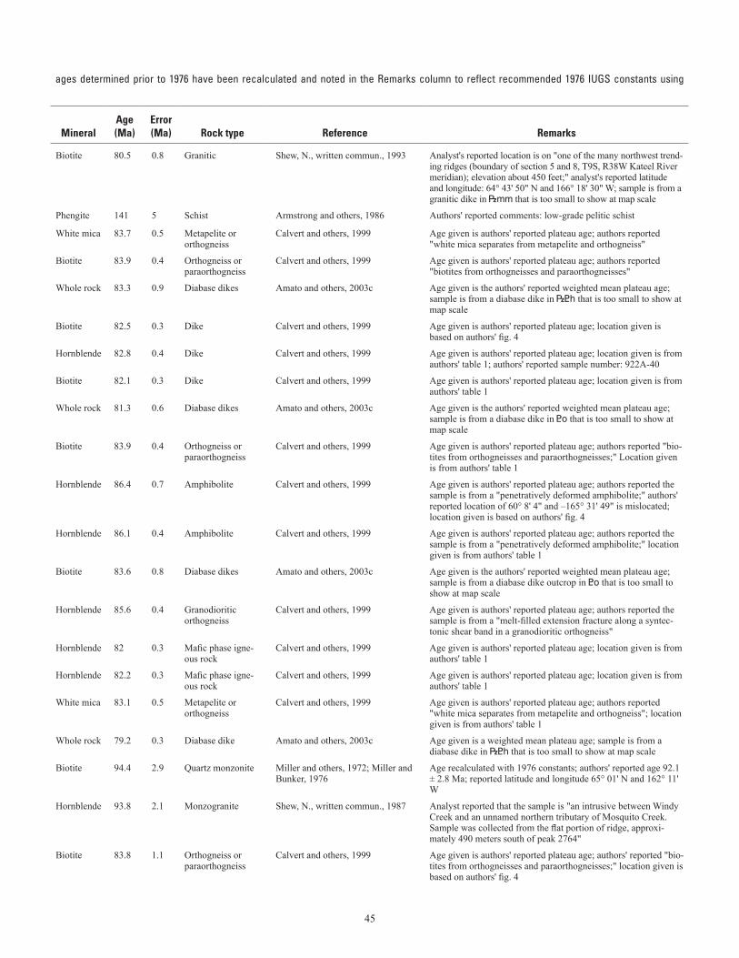
45
Table 2. Selected K-Ar, 40Ar/39Ar and Rb-Sr age determinations.—Continued (table spans facing page)[– not reported. See “Remarks” column for details on units within brackets; latitude and longitude given are in North American Datum 1927;Dalrymple (1979); localities are plotted on sheet 2; scale of map precludes labeling of all locality names]
ages determined prior to 1976 have been recalculated and noted in the Remarks column to reflect recommended 1976 IUGS constants using
Mapno.
Field number
Geologicunit
1:63,360-scalequadrangle
Locality
Lat (N) Long (W) Method
Mineral
Age(Ma)
Error(Ma)
Rock type
Reference
RemarksDeg Min Deg Min
25 90AG025 Dike [|mm] Nome C-3 Approximately 9.5 miles due north of Sinuk (at the mouth of Sinuk River) and 5 miles east of Bering Sea
64 43.837 166 18.614 K-Ar Biotite 80.5 0.8 Granitic Shew, N., written commun., 1993 Analyst's reported location is on "one of the many northwest trend-ing ridges (boundary of section 5 and 8, T9S, R38W Kateel River meridian); elevation about 450 feet;" analyst's reported latitude and longitude: 64° 43' 50" N and 166° 18' 30" W; sample is from a granitic dike in |mm that is too small to show at map scale
26 80-41-4 Ocs Nome D-1 3.3 miles southwest of Salmon Lake 64 51 165 8.5 K-Ar Phengite 141 5 Schist Armstrong and others, 1986 Authors' reported comments: low-grade pelitic schist
27 90P8-13b |<h Nome D-1 Kigluaik Mountains 64 53.567 165 27.817 40Ar/39Ar White mica 83.7 0.5 Metapelite or orthogneiss
Calvert and others, 1999 Age given is authors' reported plateau age; authors reported "white mica separates from metapelite and orthogneiss"
28 90J11-5 |<h Nome D-1 Kigluaik Mountains 64 59.633 165 24.8 40Ar/39Ar Biotite 83.9 0.4 Orthogneiss or paraorthogneiss
Calvert and others, 1999 Age given is authors' reported plateau age; authors reported "biotites from orthogneisses and paraorthogneisses"
29 92.4A-115 Dike [|<h] Nome D-2 Kigluaik Mountains 64 53.11 165 48.93 40Ar/39Ar Whole rock 83.3 0.9 Diabase dikes Amato and others, 2003c Age given is the authors' reported weighted mean plateau age; sample is from a diabase dike in |<h that is too small to show at map scale
30 92.3A-101 Dike [Kgu] Nome D-2 Kigluaik pluton and associated dikes 64 54.584 165 44.026 40Ar/39Ar Biotite 82.5 0.3 Dike Calvert and others, 1999 Age given is authors' reported plateau age; location given is based on authors' fig. 4
31 92.2A-40 Dike [<o] Nome D-2 Kigluaik pluton and associated dikes 64 54.967 165 37.133 40Ar/39Ar Hornblende 82.8 0.4 Dike Calvert and others, 1999 Age given is authors' reported plateau age; location given is from authors' table 1; authors' reported sample number: 922A-40
32 92.2A-40 Dike [<o] Nome D-2 Kigluaik pluton and associated dikes 64 54.967 165 37.133 40Ar/39Ar Biotite 82.1 0.3 Dike Calvert and others, 1999 Age given is authors' reported plateau age; location given is from authors' table 1
33 92.2A-46 Dike [<o] Nome D-2 Kigluaik Mountains 64 55.09 165 36.2 40Ar/39Ar Whole rock 81.3 0.6 Diabase dikes Amato and others, 2003c Age given is the authors' reported weighted mean plateau age; sample is from a diabase dike in <o that is too small to show at map scale
34 90P8-4A <o Nome D-2 Kigluaik Mountains 64 55.183 165 31.817 40Ar/39Ar Biotite 83.9 0.4 Orthogneiss or paraorthogneiss
Calvert and others, 1999 Age given is authors' reported plateau age; authors reported "bio-tites from orthogneisses and paraorthogneisses;" Location given is from authors' table 1
35 90P12-4b <o Nome D-2 Kigluaik Mountains 64 55.3 165 32.571 40Ar/39Ar Hornblende 86.4 0.7 Amphibolite Calvert and others, 1999 Age given is authors' reported plateau age; authors reported the sample is from a "penetratively deformed amphibolite;" authors' reported location of 60° 8' 4" and –165° 31' 49" is mislocated; location given is based on authors' fig. 4
36 90K12-7a <o Nome D-2 Kigluaik Mountains 64 55.3 165 33.05 40Ar/39Ar Hornblende 86.1 0.4 Amphibolite Calvert and others, 1999 Age given is authors' reported plateau age; authors reported the sample is from a "penetratively deformed amphibolite;" location given is from authors' table 1
37 90K12-7b Dike [<o] Nome D-2 Kigluaik Mountains 64 55.53 165 33.05 40Ar/39Ar Biotite 83.6 0.8 Diabase dikes Amato and others, 2003c Age given is the authors' reported weighted mean plateau age; sample is from a diabase dike outcrop in <o that is too small to show at map scale
38 90P12-5b <o Nome D-2 Kigluaik Mountains 64 55.717 165 32 40Ar/39Ar Hornblende 85.6 0.4 Granodioritic orthogneiss
Calvert and others, 1999 Age given is authors' reported plateau age; authors reported the sample is from a "melt-filled extension fracture along a syntec-tonic shear band in a granodioritic orthogneiss"
39 924A-120 Kdi Nome D-2 Kigluaik pluton and associated dikes 64 56.183 165 47.45 40Ar/39Ar Hornblende 82 0.3 Mafic phase igne-ous rock
Calvert and others, 1999 Age given is authors' reported plateau age; location given is from authors' table 1
40 924A-119 Kdi Nome D-2 Kigluaik pluton and associated dikes 64 57.2 165 46.1 40Ar/39Ar Hornblende 82.2 0.3 Mafic phase igne-ous rock
Calvert and others, 1999 Age given is authors' reported plateau age; location given is from authors' table 1
41 89S-LMC-47 |<h Nome D-3 Kigluaik Mountains 64 50.583 166 2.817 40Ar/39Ar White mica 83.1 0.5 Metapelite or orthogneiss
Calvert and others, 1999 Age given is authors' reported plateau age; authors reported "white mica separates from metapelite and orthogneiss"; location given is from authors' table 1
42 89MC-78 Dike [|<h] Nome D-3 Kigluaik Mountains 64 53.09 166 0.59 40Ar/39Ar Whole rock 79.2 0.3 Diabase dike Amato and others, 2003c Age given is a weighted mean plateau age; sample is from a diabase dike in |<h that is too small to show at map scale
43 68AMm285 Kd Bendeleben A-1
Darby pluton 65 0.865 162 13.503 K-Ar Biotite 94.4 2.9 Quartz monzonite Miller and others, 1972; Miller and Bunker, 1976
Age recalculated with 1976 constants; authors' reported age 92.1 ± 2.8 Ma; reported latitude and longitude 65° 01' N and 162° 11' W
44 84AGe79 Kwc Bendeleben A-2 Windy Creek pluton 65 8.748 162 34.518 K-Ar Hornblende 93.8 2.1 Monzogranite Shew, N., written commun., 1987 Analyst reported that the sample is "an intrusive between Windy Creek and an unnamed northern tributary of Mosquito Creek. Sample was collected from the flat portion of ridge, approxi-mately 490 meters south of peak 2764"
45 90S-EK-9 |<h Bendeleben A-6 Kigluaik Mountains 65 0.094 164 47.047 40Ar/39Ar Biotite 83.8 1.1 Orthogneiss or paraorthogneiss
Calvert and others, 1999 Age given is authors' reported plateau age; authors' reported "bio-tites from orthogneisses and paraorthogneisses;" location given is based on authors' fig. 4
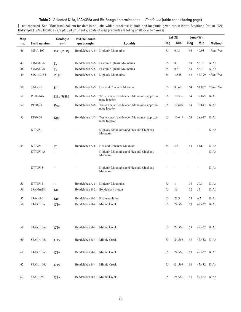
46
Table 2. Selected K-Ar, 40Ar/39Ar and Rb-Sr age determinations.—Continued (table spans facing page)[– not reported. See “Remarks” column for details on units within brackets; latitude and longitude given are in North American Datum 1927;Dalrymple (1979); localities are plotted on sheet 2; scale of map precludes labeling of all locality names]
ages determined prior to 1976 have been recalculated and noted in the Remarks column to reflect recommended 1976 IUGS constants using
Mapno.
Field number
Geologicunit
1:63,360-scalequadrangle
Locality
Lat (N) Long (W) Method
Mineral
Age(Ma)
Error(Ma)
Rock type
Reference
RemarksDeg Min Deg Min
46 92NA-107 Dike [|<h] Bendeleben A-6 Kigluaik Mountains 65 0.43 164 49.95 40Ar/39Ar Whole rock 82.4 1.3 Diabase dike Amato and others, 2003c Age given is the authors' reported weighted mean plateau age; sample is from a diabase dike in |<h that is too small to show at map scale
47 83MS119b <o Bendeleben A-6 Eastern Kigluaik Mountains 65 0.8 164 56.7 K-Ar Biotite 84.9 2.5 Mafic gneiss Sturnick, 1984 Location based on author's table 1
48 83MS119b <o Bendeleben A-6 Eastern Kigluaik Mountains 65 0.8 164 56.7 K-Ar Hornblende 85.6 2.6 Mafic gneiss Sturnick, 1984 Location based on author's table 1
49 89S-MC-54 |<h Bendeleben A-6 Kigluaik Mountains 65 1.548 164 47.799 40Ar/39Ar White mica 83 0.8 Metapelite or orthogneiss
Calvert and others, 1999 Age given is authors' reported plateau age; authors' reported "white mica separates from metapelite and orthogneiss;" Loca-tion given is based on authors' sample location in fig. 4
50 90-Hens <n Bendeleben A-6 Hen and Chickens Mountain 65 8.067 164 51.067 40Ar/39Ar Biotite 84.7 0.2 Orthogneiss or paraorthogneiss
Calvert and others, 1999 Age given is authors' reported plateau age; authors' reported "biotites from orthogneisses and paraorthogneisses"
51 PS80-14A Dike [|<h] Bendeleben A-6 Westernmost Bendeleben Mountains, approxi-mate location
65 10.536 164 39.075 K-Ar Whole-rock 74.9 3 Basalt dike Turner and Swanson, 1981 Authors' reported comments: basalt dike intruding Precambrian basement; location approximated based on authors' fig. 5
52 PT80-28 Kgu Bendeleben A-6 Westernmost Bendeleben Mountains, approxi-mate location
65 10.649 164 38.617 K-Ar Whole-rock 74.5 2.8 Rhyolite Turner and Swanson, 1981 Authors' reported comments: small dike / plug of vesicular rhyolite intruding Precambrian basement; location given is based on authors' fig. 5
53 PT80-30 Kgu Bendeleben A-6 Westernmost Bendeleben Mountains, approxi-mate location
65 10.649 164 38.617 K-Ar Whole-rock 69 2.6 Rhyolite Turner and Swanson, 1981 Authors' reported comments: small dike / plug of vesicular rhyolite intruding Precambrian basement; location given is based on authors' fig. 5
DT79P1 - - Kigluaik Mountains and Hen and Chickens Mountain
- - - - K-Ar Biotite 83.9 2.5 Schist Turner and Swanson, 1981 Authors' reported location of the samples is "metamorphic and igneous intrusive rocks from the Kigluaik Mountains and Hen and Chickens Mountain." Latitude and longitude were not reported
54 DT79P4 <n Bendeleben A-6 Hen and Chickens Mountain 65 8.3 164 54.6 K-Ar Hornblende 84.9 2.6 Amphibolite Turner and Swanson, 1981 Location from Wilson and others (1994)
DT79P11A - - Kigluaik Mountains and Hen and Chickens Mountain
- - - - K-Ar Biotite 81.4 2.4 Pelitic gneiss Turner and Swanson, 1981 Authors' reported location of the samples is "metamorphic and igneous intrusive rocks from the Kigluaik Mountains and Hen and Chickens Mountain." Latitude and longitude were not reported
DT79P13 - - Kigluaik Mountains and Hen and Chickens Mountain
- - - - K-Ar Biotite 87 2.6 Gneissic granite Turner and Swanson, 1981 Authors' reported location of the samples is "metamorphic and igneous intrusive rocks from the Kigluaik Mountains and Hen and Chickens Mountain." Latitude and longitude were not reported
55 DT79P14 - Bendeleben A-6 Kigluaik Mountains 65 1 164 59.1 K-Ar Biotite 83 2.5 Granodiorite Turner and Swanson, 1981 Location from Wilson and others (1994)
56 68AMm280 Kbk Bendeleben B-2 Bendeleben pluton 65 16 162 55 K-Ar Biotite 81.8 2.5 Quartz monzonite Miller and others, 1972; Miller and Bunker, 1976
Age recalculated with 1976 constants; authors' reported age 79.8 ± 2.4 Ma
57 83AGe90 Kbk Bendeleben B-3 Kuzitrin pluton 65 23.3 163 6.2 K-Ar Biotite 83 1.4 Monzogranite Till and others, 1986 Location based on authors' table 2
58 84AKn106 QTv Bendeleben B-4 Minnie Creek 65 24.566 163 47.432 K-Ar Plagioclase 0.81 0.09 Basalt Kaufman and others, 1991 Location given based on authors' fig. 2, on sh. 2 and reported location on "the right bank of Minnie Creek, where the river is diverted westward by the lava"; age was first reported in Kaufman and Hopkins (1985) with reported location 65° 31' and –164° 09'; that location appears to be incorrect based on location given in Kaufman and others (1991) fig. 2, on sh. 2
59 84AKn106a QTv Bendeleben B-4 Minnie Creek 65 24.566 163 47.432 K-Ar Whole rock 0.024 0.11 Basalt Kaufman and others, 1991 Location given based on authors' fig. 2, on sh. 2 and reported location on "the right bank of Minnie Creek, where the river is diverted westward by the lava"
60 84AKn106a QTv Bendeleben B-4 Minnie Creek 65 24.566 163 47.432 K-Ar Whole rock 0.1 0.16 Basalt Kaufman and others, 1991 Location given based on authors' fig. 2, on sh. 2 and reported location on "the right bank of Minnie Creek, where the river is diverted westward by the lava"
61 84AKn106c QTv Bendeleben B-4 Minnie Creek 65 24.566 163 47.432 K-Ar Whole rock 0.717 0.11 Basalt Kaufman and others, 1991 Location given based on authors' fig. 2, on sh. 2 and reported location on "the right bank of Minnie Creek, where the river is diverted westward by the lava"
62 84AKn106c QTv Bendeleben B-4 Minnie Creek 65 24.566 163 47.432 K-Ar Whole rock 0.719 0.13 Basalt Kaufman and others, 1991 Location given based on authors' fig. 2, on sh. 2 and reported location on "the right bank of Minnie Creek, where the river is diverted westward by the lava"
63 87AHP26 QTv Bendeleben B-4 Minnie Creek 65 24.566 163 47.432 K-Ar Whole rock 0.797 0.06 Basalt Kaufman and others, 1991 Location given based on authors' fig. 2, on sh. 2 and reported location on "the right bank of Minnie Creek, where the river is diverted westward by the lava"
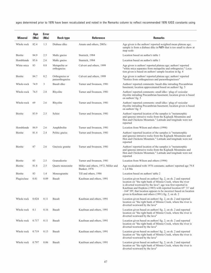
47
Table 2. Selected K-Ar, 40Ar/39Ar and Rb-Sr age determinations.—Continued (table spans facing page)[– not reported. See “Remarks” column for details on units within brackets; latitude and longitude given are in North American Datum 1927;Dalrymple (1979); localities are plotted on sheet 2; scale of map precludes labeling of all locality names]
ages determined prior to 1976 have been recalculated and noted in the Remarks column to reflect recommended 1976 IUGS constants using
Mapno.
Field number
Geologicunit
1:63,360-scalequadrangle
Locality
Lat (N) Long (W) Method
Mineral
Age(Ma)
Error(Ma)
Rock type
Reference
RemarksDeg Min Deg Min
46 92NA-107 Dike [|<h] Bendeleben A-6 Kigluaik Mountains 65 0.43 164 49.95 40Ar/39Ar Whole rock 82.4 1.3 Diabase dike Amato and others, 2003c Age given is the authors' reported weighted mean plateau age; sample is from a diabase dike in |<h that is too small to show at map scale
47 83MS119b <o Bendeleben A-6 Eastern Kigluaik Mountains 65 0.8 164 56.7 K-Ar Biotite 84.9 2.5 Mafic gneiss Sturnick, 1984 Location based on author's table 1
48 83MS119b <o Bendeleben A-6 Eastern Kigluaik Mountains 65 0.8 164 56.7 K-Ar Hornblende 85.6 2.6 Mafic gneiss Sturnick, 1984 Location based on author's table 1
49 89S-MC-54 |<h Bendeleben A-6 Kigluaik Mountains 65 1.548 164 47.799 40Ar/39Ar White mica 83 0.8 Metapelite or orthogneiss
Calvert and others, 1999 Age given is authors' reported plateau age; authors' reported "white mica separates from metapelite and orthogneiss;" Loca-tion given is based on authors' sample location in fig. 4
50 90-Hens <n Bendeleben A-6 Hen and Chickens Mountain 65 8.067 164 51.067 40Ar/39Ar Biotite 84.7 0.2 Orthogneiss or paraorthogneiss
Calvert and others, 1999 Age given is authors' reported plateau age; authors' reported "biotites from orthogneisses and paraorthogneisses"
51 PS80-14A Dike [|<h] Bendeleben A-6 Westernmost Bendeleben Mountains, approxi-mate location
65 10.536 164 39.075 K-Ar Whole-rock 74.9 3 Basalt dike Turner and Swanson, 1981 Authors' reported comments: basalt dike intruding Precambrian basement; location approximated based on authors' fig. 5
52 PT80-28 Kgu Bendeleben A-6 Westernmost Bendeleben Mountains, approxi-mate location
65 10.649 164 38.617 K-Ar Whole-rock 74.5 2.8 Rhyolite Turner and Swanson, 1981 Authors' reported comments: small dike / plug of vesicular rhyolite intruding Precambrian basement; location given is based on authors' fig. 5
53 PT80-30 Kgu Bendeleben A-6 Westernmost Bendeleben Mountains, approxi-mate location
65 10.649 164 38.617 K-Ar Whole-rock 69 2.6 Rhyolite Turner and Swanson, 1981 Authors' reported comments: small dike / plug of vesicular rhyolite intruding Precambrian basement; location given is based on authors' fig. 5
DT79P1 - - Kigluaik Mountains and Hen and Chickens Mountain
- - - - K-Ar Biotite 83.9 2.5 Schist Turner and Swanson, 1981 Authors' reported location of the samples is "metamorphic and igneous intrusive rocks from the Kigluaik Mountains and Hen and Chickens Mountain." Latitude and longitude were not reported
54 DT79P4 <n Bendeleben A-6 Hen and Chickens Mountain 65 8.3 164 54.6 K-Ar Hornblende 84.9 2.6 Amphibolite Turner and Swanson, 1981 Location from Wilson and others (1994)
DT79P11A - - Kigluaik Mountains and Hen and Chickens Mountain
- - - - K-Ar Biotite 81.4 2.4 Pelitic gneiss Turner and Swanson, 1981 Authors' reported location of the samples is "metamorphic and igneous intrusive rocks from the Kigluaik Mountains and Hen and Chickens Mountain." Latitude and longitude were not reported
DT79P13 - - Kigluaik Mountains and Hen and Chickens Mountain
- - - - K-Ar Biotite 87 2.6 Gneissic granite Turner and Swanson, 1981 Authors' reported location of the samples is "metamorphic and igneous intrusive rocks from the Kigluaik Mountains and Hen and Chickens Mountain." Latitude and longitude were not reported
55 DT79P14 - Bendeleben A-6 Kigluaik Mountains 65 1 164 59.1 K-Ar Biotite 83 2.5 Granodiorite Turner and Swanson, 1981 Location from Wilson and others (1994)
56 68AMm280 Kbk Bendeleben B-2 Bendeleben pluton 65 16 162 55 K-Ar Biotite 81.8 2.5 Quartz monzonite Miller and others, 1972; Miller and Bunker, 1976
Age recalculated with 1976 constants; authors' reported age 79.8 ± 2.4 Ma
57 83AGe90 Kbk Bendeleben B-3 Kuzitrin pluton 65 23.3 163 6.2 K-Ar Biotite 83 1.4 Monzogranite Till and others, 1986 Location based on authors' table 2
58 84AKn106 QTv Bendeleben B-4 Minnie Creek 65 24.566 163 47.432 K-Ar Plagioclase 0.81 0.09 Basalt Kaufman and others, 1991 Location given based on authors' fig. 2, on sh. 2 and reported location on "the right bank of Minnie Creek, where the river is diverted westward by the lava"; age was first reported in Kaufman and Hopkins (1985) with reported location 65° 31' and –164° 09'; that location appears to be incorrect based on location given in Kaufman and others (1991) fig. 2, on sh. 2
59 84AKn106a QTv Bendeleben B-4 Minnie Creek 65 24.566 163 47.432 K-Ar Whole rock 0.024 0.11 Basalt Kaufman and others, 1991 Location given based on authors' fig. 2, on sh. 2 and reported location on "the right bank of Minnie Creek, where the river is diverted westward by the lava"
60 84AKn106a QTv Bendeleben B-4 Minnie Creek 65 24.566 163 47.432 K-Ar Whole rock 0.1 0.16 Basalt Kaufman and others, 1991 Location given based on authors' fig. 2, on sh. 2 and reported location on "the right bank of Minnie Creek, where the river is diverted westward by the lava"
61 84AKn106c QTv Bendeleben B-4 Minnie Creek 65 24.566 163 47.432 K-Ar Whole rock 0.717 0.11 Basalt Kaufman and others, 1991 Location given based on authors' fig. 2, on sh. 2 and reported location on "the right bank of Minnie Creek, where the river is diverted westward by the lava"
62 84AKn106c QTv Bendeleben B-4 Minnie Creek 65 24.566 163 47.432 K-Ar Whole rock 0.719 0.13 Basalt Kaufman and others, 1991 Location given based on authors' fig. 2, on sh. 2 and reported location on "the right bank of Minnie Creek, where the river is diverted westward by the lava"
63 87AHP26 QTv Bendeleben B-4 Minnie Creek 65 24.566 163 47.432 K-Ar Whole rock 0.797 0.06 Basalt Kaufman and others, 1991 Location given based on authors' fig. 2, on sh. 2 and reported location on "the right bank of Minnie Creek, where the river is diverted westward by the lava"
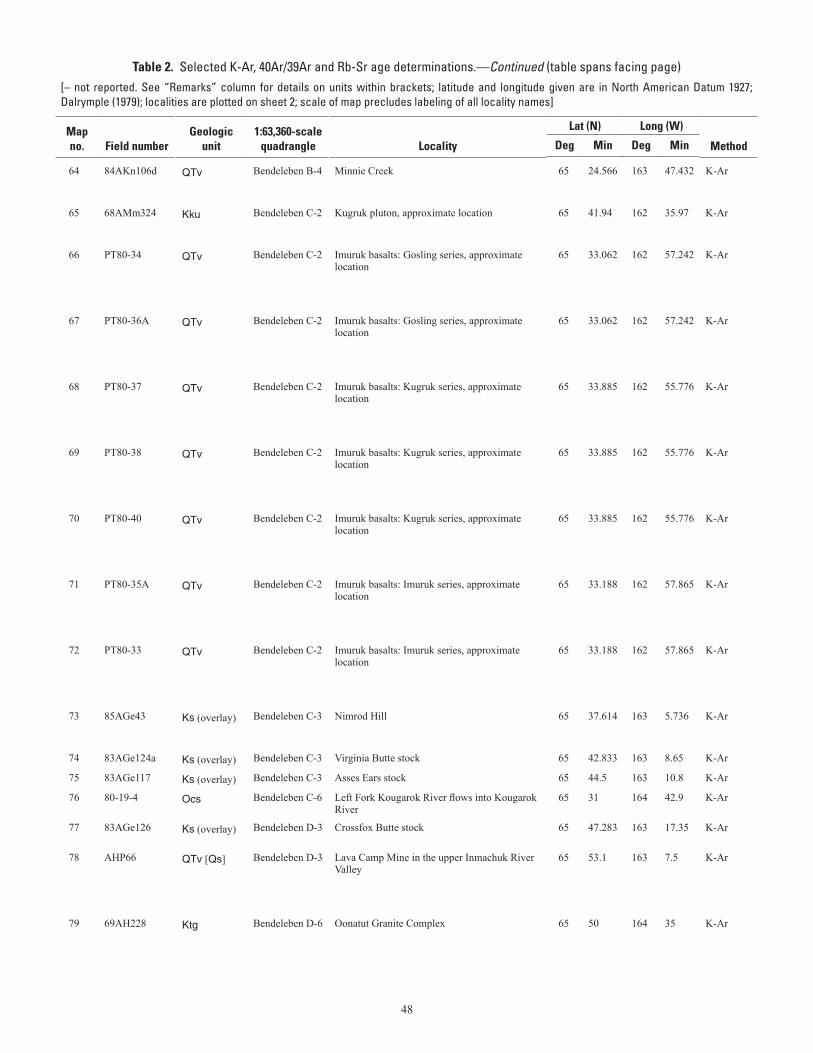
48
Table 2. Selected K-Ar, 40Ar/39Ar and Rb-Sr age determinations.—Continued (table spans facing page)[– not reported. See “Remarks” column for details on units within brackets; latitude and longitude given are in North American Datum 1927;Dalrymple (1979); localities are plotted on sheet 2; scale of map precludes labeling of all locality names]
ages determined prior to 1976 have been recalculated and noted in the Remarks column to reflect recommended 1976 IUGS constants using
Mapno.
Field number
Geologicunit
1:63,360-scalequadrangle
Locality
Lat (N) Long (W) Method
Mineral
Age(Ma)
Error(Ma)
Rock type
Reference
RemarksDeg Min Deg Min
64 84AKn106d QTv Bendeleben B-4 Minnie Creek 65 24.566 163 47.432 K-Ar Whole rock 1.748 0.57 Basalt Kaufman and others, 1991 Location given based on authors' fig. 2, on sh. 2 and reported location on "the right bank of Minnie Creek, where the river is diverted westward by the lava"
65 68AMm324 Kku Bendeleben C-2 Kugruk pluton, approximate location 65 41.94 162 35.97 K-Ar Biotite 94.8 2.8 Quartz monzonite to quartz monzo-diorite
Till and others, 1986 Location based on authors' table 2
66 PT80-34 QTv Bendeleben C-2 Imuruk basalts: Gosling series, approximate location
65 33.062 162 57.242 K-Ar Whole-rock 0.82 0.08 Basalt Turner and Swanson, 1981 Authors' reported location of sample is "Imuruk basalts: Gosling series" after Hopkins' (1963) Gosling volcanics. Latitude and longitude were not reported. Based on Turner's and Swanson's description, location was approximated using Hopkins' (1963) fig. 9
67 PT80-36A QTv Bendeleben C-2 Imuruk basalts: Gosling series, approximate location
65 33.062 162 57.242 K-Ar Whole-rock 0.91 0.09 Basalt Turner and Swanson, 1981 Authors' reported location of sample is "Imuruk basalts: Gosling series" after Hopkins' (1963) Gosling volcanics. Latitude and longitude were not reported. Based on Turner's and Swanson's description, location was approximated using Hopkins' (1963) fig. 9
68 PT80-37 QTv Bendeleben C-2 Imuruk basalts: Kugruk series, approximate location
65 33.885 162 55.776 K-Ar Whole-rock 26.4 1.4 Basalt Turner and Swanson, 1981 Authors' reported location of sample is "Imuruk basalts: Kugruk series" after Hopkins' (1963) Kugruk volcanics. Latitude and longitude were not reported and were determined based on the type locality in the canyon of the Kugruk River, 3 miles east of Imuruk Lake (Hopkins, 1963, fig. 9 and p. C48)
69 PT80-38 QTv Bendeleben C-2 Imuruk basalts: Kugruk series, approximate location
65 33.885 162 55.776 K-Ar Whole-rock 28.1 1.4 Basalt Turner and Swanson, 1981 Authors' reported location of sample is "Imuruk basalts: Kugruk series" after Hopkins' (1963) Kugruk volcanics. Latitude and longitude were not reported and were determined based on the type locality in the canyon of the Kugruk River, 3 miles east of Imuruk Lake (Hopkins, 1963, fig. 9 and p. C48)
70 PT80-40 QTv Bendeleben C-2 Imuruk basalts: Kugruk series, approximate location
65 33.885 162 55.776 K-Ar Whole-rock 28.8 1.8 Basalt Turner and Swanson, 1981 Authors' reported location of sample is "Imuruk basalts: Kugruk series" after Hopkins' (1963) Kugruk volcanics. Latitude and longitude were not reported and were determined based on the type locality in the canyon of the Kugruk River, 3 miles east of Imuruk Lake (Hopkins, 1963, fig. 9 and p. C48)
71 PT80-35A QTv Bendeleben C-2 Imuruk basalts: Imuruk series, approximate location
65 33.188 162 57.865 K-Ar Whole-rock 2.2 0.2 Basalt Turner and Swanson, 1981 Authors' reported location of sample is "Imuruk basalts: Imuruk series" after Hopkins' (1963) Kugruk volcanics. Latitude and longitude were not reported and were determined based on the type locality in the canyon of the Kugruk River, 3 miles east of Imuruk Lake (Hopkins, 1963, fig. 9 and p. C48)
72 PT80-33 QTv Bendeleben C-2 Imuruk basalts: Imuruk series, approximate location
65 33.188 162 57.865 K-Ar Whole-rock 2.2 0.2 Basalt Turner and Swanson, 1981 Authors' reported location of sample is "Imuruk basalts: Imuruk series" after Hopkins' (1963) Kugruk volcanics. Latitude and longitude were not reported and were determined based on the type locality in the canyon of the Kugruk River, 3 miles east of Imuruk Lake (Hopkins, 1963, fig. 9 and p. C48)
73 85AGe43 Ks (overlay) Bendeleben C-3 Nimrod Hill 65 37.614 163 5.736 K-Ar Hornblende 96.3 2 Monzonite Shew, N., written commun., 1990 Analyst's reported location of sample is "small ridge NW [north-west] of x2995 (summit of Mount Arathlatuluk); sample collected from flat section of ridge, approx. 1/3 mile from the summit"
74 83AGe124a Ks (overlay) Bendeleben C-3 Virginia Butte stock 65 42.833 163 8.65 K-Ar Biotite 94.8 1.9 Syenite Till and others, 1986 Location based on authors' table 2
75 83AGe117 Ks (overlay) Bendeleben C-3 Asses Ears stock 65 44.5 163 10.8 K-Ar Biotite 96.2 1.6 Monzogranite Till and others, 1986 Location based on authors' table 2
76 80-19-4 Ocs Bendeleben C-6 Left Fork Kougarok River flows into Kougarok River
65 31 164 42.9 K-Ar Phengite 156 5 Pelitic schist Armstrong and others, 1986 Authors' reported comments: low-grade pelitic schist
77 83AGe126 Ks (overlay) Bendeleben D-3 Crossfox Butte stock 65 47.283 163 17.35 K-Ar Biotite 91.5 2.8 Monzogranite to quartz monzonite
Till and others, 1986 Authors' reported comments: some biotite was chloritized, and this age should be considered suspect
78 AHP66 QTv [Qs] Bendeleben D-3 Lava Camp Mine in the upper Inmachuk River Valley
65 53.1 163 7.5 K-Ar Whole-rock 5.83 0.2 Basalt Hopkins and others, 1971 Age recalculated with 1976 constants; authors' reported age 5.7 ± 0.2 Ma; authors' reported comments: sample collected from the roof of the Lava Camp Mine tholeiitic basalt; sample number provided by authors' as AHP66 in table 2 is a subsample of 66AHP 22 (stated in authors' table 1).
79 69AH228 Ktg Bendeleben D-6 Oonatut Granite Complex 65 50 164 35 K-Ar Biotite 69.2 2 Granite Hudson, 1979 Age recalculated with 1976 constants; author's reported age 67.5 ± 2 Ma; latitude and longitude not reported; location of sample is approximate
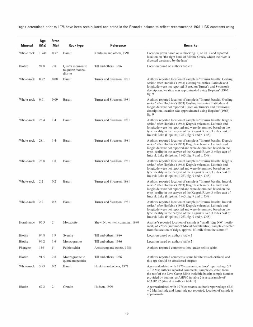
49
Table 2. Selected K-Ar, 40Ar/39Ar and Rb-Sr age determinations.—Continued (table spans facing page)[– not reported. See “Remarks” column for details on units within brackets; latitude and longitude given are in North American Datum 1927;Dalrymple (1979); localities are plotted on sheet 2; scale of map precludes labeling of all locality names]
ages determined prior to 1976 have been recalculated and noted in the Remarks column to reflect recommended 1976 IUGS constants using
Mapno.
Field number
Geologicunit
1:63,360-scalequadrangle
Locality
Lat (N) Long (W) Method
Mineral
Age(Ma)
Error(Ma)
Rock type
Reference
RemarksDeg Min Deg Min
64 84AKn106d QTv Bendeleben B-4 Minnie Creek 65 24.566 163 47.432 K-Ar Whole rock 1.748 0.57 Basalt Kaufman and others, 1991 Location given based on authors' fig. 2, on sh. 2 and reported location on "the right bank of Minnie Creek, where the river is diverted westward by the lava"
65 68AMm324 Kku Bendeleben C-2 Kugruk pluton, approximate location 65 41.94 162 35.97 K-Ar Biotite 94.8 2.8 Quartz monzonite to quartz monzo-diorite
Till and others, 1986 Location based on authors' table 2
66 PT80-34 QTv Bendeleben C-2 Imuruk basalts: Gosling series, approximate location
65 33.062 162 57.242 K-Ar Whole-rock 0.82 0.08 Basalt Turner and Swanson, 1981 Authors' reported location of sample is "Imuruk basalts: Gosling series" after Hopkins' (1963) Gosling volcanics. Latitude and longitude were not reported. Based on Turner's and Swanson's description, location was approximated using Hopkins' (1963) fig. 9
67 PT80-36A QTv Bendeleben C-2 Imuruk basalts: Gosling series, approximate location
65 33.062 162 57.242 K-Ar Whole-rock 0.91 0.09 Basalt Turner and Swanson, 1981 Authors' reported location of sample is "Imuruk basalts: Gosling series" after Hopkins' (1963) Gosling volcanics. Latitude and longitude were not reported. Based on Turner's and Swanson's description, location was approximated using Hopkins' (1963) fig. 9
68 PT80-37 QTv Bendeleben C-2 Imuruk basalts: Kugruk series, approximate location
65 33.885 162 55.776 K-Ar Whole-rock 26.4 1.4 Basalt Turner and Swanson, 1981 Authors' reported location of sample is "Imuruk basalts: Kugruk series" after Hopkins' (1963) Kugruk volcanics. Latitude and longitude were not reported and were determined based on the type locality in the canyon of the Kugruk River, 3 miles east of Imuruk Lake (Hopkins, 1963, fig. 9 and p. C48)
69 PT80-38 QTv Bendeleben C-2 Imuruk basalts: Kugruk series, approximate location
65 33.885 162 55.776 K-Ar Whole-rock 28.1 1.4 Basalt Turner and Swanson, 1981 Authors' reported location of sample is "Imuruk basalts: Kugruk series" after Hopkins' (1963) Kugruk volcanics. Latitude and longitude were not reported and were determined based on the type locality in the canyon of the Kugruk River, 3 miles east of Imuruk Lake (Hopkins, 1963, fig. 9 and p. C48)
70 PT80-40 QTv Bendeleben C-2 Imuruk basalts: Kugruk series, approximate location
65 33.885 162 55.776 K-Ar Whole-rock 28.8 1.8 Basalt Turner and Swanson, 1981 Authors' reported location of sample is "Imuruk basalts: Kugruk series" after Hopkins' (1963) Kugruk volcanics. Latitude and longitude were not reported and were determined based on the type locality in the canyon of the Kugruk River, 3 miles east of Imuruk Lake (Hopkins, 1963, fig. 9 and p. C48)
71 PT80-35A QTv Bendeleben C-2 Imuruk basalts: Imuruk series, approximate location
65 33.188 162 57.865 K-Ar Whole-rock 2.2 0.2 Basalt Turner and Swanson, 1981 Authors' reported location of sample is "Imuruk basalts: Imuruk series" after Hopkins' (1963) Kugruk volcanics. Latitude and longitude were not reported and were determined based on the type locality in the canyon of the Kugruk River, 3 miles east of Imuruk Lake (Hopkins, 1963, fig. 9 and p. C48)
72 PT80-33 QTv Bendeleben C-2 Imuruk basalts: Imuruk series, approximate location
65 33.188 162 57.865 K-Ar Whole-rock 2.2 0.2 Basalt Turner and Swanson, 1981 Authors' reported location of sample is "Imuruk basalts: Imuruk series" after Hopkins' (1963) Kugruk volcanics. Latitude and longitude were not reported and were determined based on the type locality in the canyon of the Kugruk River, 3 miles east of Imuruk Lake (Hopkins, 1963, fig. 9 and p. C48)
73 85AGe43 Ks (overlay) Bendeleben C-3 Nimrod Hill 65 37.614 163 5.736 K-Ar Hornblende 96.3 2 Monzonite Shew, N., written commun., 1990 Analyst's reported location of sample is "small ridge NW [north-west] of x2995 (summit of Mount Arathlatuluk); sample collected from flat section of ridge, approx. 1/3 mile from the summit"
74 83AGe124a Ks (overlay) Bendeleben C-3 Virginia Butte stock 65 42.833 163 8.65 K-Ar Biotite 94.8 1.9 Syenite Till and others, 1986 Location based on authors' table 2
75 83AGe117 Ks (overlay) Bendeleben C-3 Asses Ears stock 65 44.5 163 10.8 K-Ar Biotite 96.2 1.6 Monzogranite Till and others, 1986 Location based on authors' table 2
76 80-19-4 Ocs Bendeleben C-6 Left Fork Kougarok River flows into Kougarok River
65 31 164 42.9 K-Ar Phengite 156 5 Pelitic schist Armstrong and others, 1986 Authors' reported comments: low-grade pelitic schist
77 83AGe126 Ks (overlay) Bendeleben D-3 Crossfox Butte stock 65 47.283 163 17.35 K-Ar Biotite 91.5 2.8 Monzogranite to quartz monzonite
Till and others, 1986 Authors' reported comments: some biotite was chloritized, and this age should be considered suspect
78 AHP66 QTv [Qs] Bendeleben D-3 Lava Camp Mine in the upper Inmachuk River Valley
65 53.1 163 7.5 K-Ar Whole-rock 5.83 0.2 Basalt Hopkins and others, 1971 Age recalculated with 1976 constants; authors' reported age 5.7 ± 0.2 Ma; authors' reported comments: sample collected from the roof of the Lava Camp Mine tholeiitic basalt; sample number provided by authors' as AHP66 in table 2 is a subsample of 66AHP 22 (stated in authors' table 1).
79 69AH228 Ktg Bendeleben D-6 Oonatut Granite Complex 65 50 164 35 K-Ar Biotite 69.2 2 Granite Hudson, 1979 Age recalculated with 1976 constants; author's reported age 67.5 ± 2 Ma; latitude and longitude not reported; location of sample is approximate
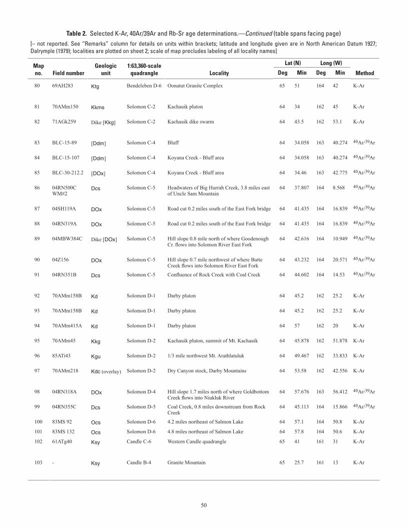
50
Table 2. Selected K-Ar, 40Ar/39Ar and Rb-Sr age determinations.—Continued (table spans facing page)[– not reported. See “Remarks” column for details on units within brackets; latitude and longitude given are in North American Datum 1927;Dalrymple (1979); localities are plotted on sheet 2; scale of map precludes labeling of all locality names]
ages determined prior to 1976 have been recalculated and noted in the Remarks column to reflect recommended 1976 IUGS constants using
Mapno.
Field number
Geologicunit
1:63,360-scalequadrangle
Locality
Lat (N) Long (W) Method
Mineral
Age(Ma)
Error(Ma)
Rock type
Reference
RemarksDeg Min Deg Min
80 69AH283 Ktg Bendeleben D-6 Oonatut Granite Complex 65 51 164 42 K-Ar Biotite 71.1 2 Granite Hudson, 1979 Age recalculated with 1976 constants; author's reported age 69.4 ± 2 Ma; latitude and longitude not reported; location of sample is approximate
81 70AMm150 Kkms Solomon C-2 Kachauik pluton 64 34 162 45 K-Ar Hornblende 99.3 3 Monzonite Miller and others, 1972 Age recalculated with 1976 constants; authors' reported age 97.5 ± 3 Ma
82 71AGk259 Dike [Kkg] Solomon C-2 Kachauik dike swarm 64 43.5 162 53.1 K-Ar Biotite 96.2 3 Nepheline syenite dike
Miller and others, 1972 Age recalculated with 1976 constants; authors' reported age 93.9 ± 3.0 Ma; sample is from an outcrop of a nepheline syenite dike in Kkg that is too small to show at map scale
83 BLC-15-89 [Ddm] Solomon C-4 Bluff 64 34.058 163 40.274 40Ar/39Ar White mica 109.1 0.7 Quartz-muscovite schist
Ford and Snee, 1996 Age given is the authors' reported plateau age; sample is from drill core that is in Ddm at the surface
84 BLC-15-107 [Ddm] Solomon C-4 Koyana Creek - Bluff area 64 34.058 163 40.274 40Ar/39Ar White mica 109.6 0.2 Quartz-muscovite schist
Ford and Snee, 1996 Age given is the authors' reported plateau age; sample is from drill core that is in Ddm at the surface
85 BLC-30-212.2 [DOx] Solomon C-4 Koyana Creek - Bluff area 64 34.46 163 42.775 40Ar/39Ar White mica 109.1 0.2 Auriferous veins Ford and Snee, 1996 Age given is the authors' reported plateau age; sample is from drill core that is in DOx at the surface
86 04RN500C WM#2
Dcs Solomon C-5 Headwaters of Big Hurrah Creek, 3.8 miles east of Uncle Sam Mountain
64 37.807 164 8.568 40Ar/39Ar White mica 117.7 1 Quartz-plagioclase-ankerite-white mica vein/breccia
Layer and Newberry, 2004 Age given is the authors' reported plateau age; location given in Werdon and others, 2005c
87 04SH119A DOx Solomon C-5 Road cut 0.2 miles south of the East Fork bridge 64 41.435 164 16.839 40Ar/39Ar Biotite 107.2 0.6 Alkalic dike Layer and Newberry, 2004 Age given is the authors' reported plateau age; location given in Werdon and others, 2005c
88 04RN319A DOx Solomon C-5 Road cut 0.2 miles south of the East Fork bridge 64 41.435 164 16.839 40Ar/39Ar White mica 107.5 0.7 Quartz-white mica vein
Layer and Newberry, 2004 Age given is the authors' reported plateau age; location given in Werdon and others, 2005c
89 04MBW384C Dike [DOx] Solomon C-5 Hill slope 0.8 mile north of where Goodenough Cr. flows into Solomon River East Fork
64 42.616 164 10.949 40Ar/39Ar Biotite 83.9 0.3 Mafic dike Layer and Newberry, 2004 Age given is the authors' reported plateau age; authors' reported comments: unrelated to mineralization; location given by M. Werdon, written commun., 2008
90 04Z156 DOx Solomon C-5 Hill slope 0.7 mile northwest of where Butte Creek flows into Solomon River East Fork
64 43.232 164 20.571 40Ar/39Ar White mica 112.8 0.3 Vein Layer and Newberry, 2004 Age given is the authors' reported plateau age; location given by Werdon, M., written commun., 2008
91 04RN351B Dcs Solomon C-5 Confluence of Rock Creek with Coal Creek 64 44.602 164 14.53 40Ar/39Ar White mica 107.7 0.6 Quartz-ankerite-white mica-plagio-clase vein
Layer and Newberry, 2004 Age given is the authors' reported plateau age; location given in Werdon and others, 2005c
92 70AMm158B Kd Solomon D-1 Darby pluton 64 45.2 162 25.2 K-Ar Biotite 90.5 1.5 Quartz monzonite Miller and others, 1972 Age recalculated with 1976 constants; authors' reported age 88.3 ± 1.5 Ma
93 70AMm158B Kd Solomon D-1 Darby pluton 64 45.2 162 25.2 K-Ar Hornblende 94.6 2.7 Quartz monzonite Miller and others, 1972 Age recalculated with 1976 constants; authors' reported age 92.8 ± 2.6 Ma
94 70AMm415A Kd Solomon D-1 Darby pluton 64 57 162 20 K-Ar Biotite 96.4 3 Quartz monzonite Miller and Bunker, 1976 Age recalculated with 1976 constants; authors' reported age 94.0 ± 3 Ma
95 70AMm45 Kkg Solomon D-2 Kachauik pluton, summit of Mt. Kachauik 64 45.878 162 51.878 K-Ar Hornblende 88.2 3 Quartz monzonite Miller and Bunker, 1976 Age recalculated with 1976 constants; authors' reported age 86.1 ± 3 Ma
96 85ATi43 Kgu Solomon D-2 1/3 mile northwest Mt. Arathlatuluk 64 49.467 162 33.833 K-Ar Biotite 102.6 1.4 Granite Till, A., unpub. data Collector's comments: biotite granite that contains sillimanite and garnet along with biotite
97 70AMm218 Kdc (overlay) Solomon D-2 Dry Canyon stock, Darby Mountains 64 53.58 162 42.556 K-Ar Hornblende 108 3 Foyaite Miller, 1972 Age recalculated with 1976 constants; author's reported age 105 ± 3 Ma; authors' reported latitude and longitude 64° 53' N and 162° 42' W
98 04RN318A DOx Solomon D-4 Hill slope 1.7 miles north of where Goldbottom Creek flows into Niukluk River
64 57.676 163 56.412 40Ar/39Ar Amphibole 138.6 1 Vein Layer and Newberry, 2005 Age given is the authors' reported plateau age; location given by Werdon, M., written commun., 2008
99 04RN355C Dcs Solomon D-5 Coal Creek, 0.8 miles downstream from Rock Creek
64 45.113 164 15.866 40Ar/39Ar White mica 106.5 0.8 Quartz-plagioclase-white mica vein
Layer and Newberry, 2005 Age given is the authors' reported plateau age; location given in Werdon and others, 2005c
100 83MS 92 Ocs Solomon D-6 4.2 miles northeast of Salmon Lake 64 57.1 164 50.8 K-Ar Muscovite 156.4 4.7 Albitic schist Sturnick, 1984 Location based on author's table 1
101 83MS 132 Ocs Solomon D-6 4.8 miles northeast of Salmon Lake 64 57.8 164 50.6 K-Ar Muscovite 152.2 4.6 Albitic schist Sturnick, 1984 Location based on author's table 1
102 61ATg40 Ksy Candle C-6 Western Candle quadrangle 65 41 161 31 K-Ar Hornblende 105 5 Quartz monzonite Patton, 1967 Age recalculated with 1976 constants; author's reported age 102 ± 5 Ma; author's reported latitude and longitude of 65° 41 and 161° 31' is assumed to be an approximate location
103 - Ksy Candle B-4 Granite Mountain 65 25.7 161 13 K-Ar Hornblende 108.6 3 Monzonite Miller, 1972 Age recalculated with 1976 constants; author's reported age 106 ± 3 Ma; authors' reported latitude and longitude 65° 27' N and 161° 13' W is assumed to be approximate location
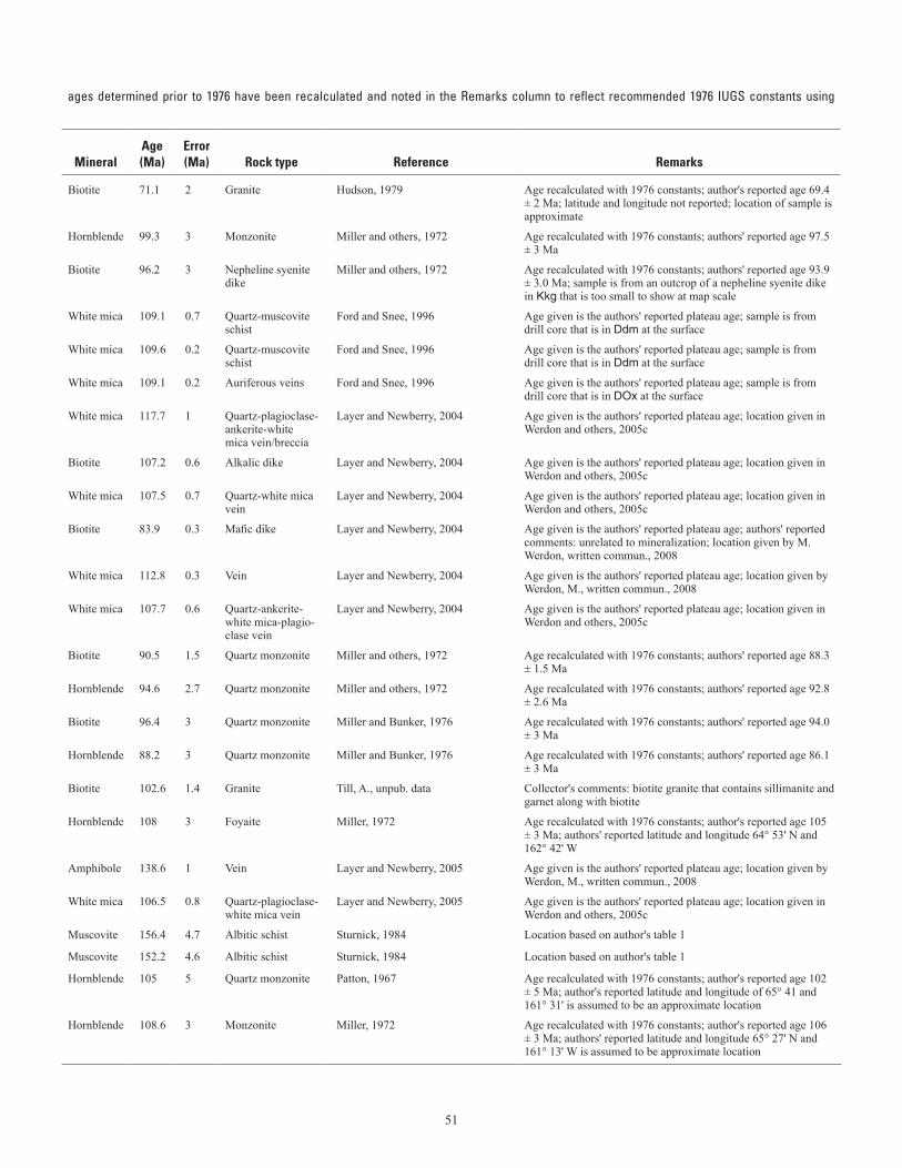
51
Table 2. Selected K-Ar, 40Ar/39Ar and Rb-Sr age determinations.—Continued (table spans facing page)[– not reported. See “Remarks” column for details on units within brackets; latitude and longitude given are in North American Datum 1927;Dalrymple (1979); localities are plotted on sheet 2; scale of map precludes labeling of all locality names]
ages determined prior to 1976 have been recalculated and noted in the Remarks column to reflect recommended 1976 IUGS constants using
Mapno.
Field number
Geologicunit
1:63,360-scalequadrangle
Locality
Lat (N) Long (W) Method
Mineral
Age(Ma)
Error(Ma)
Rock type
Reference
RemarksDeg Min Deg Min
80 69AH283 Ktg Bendeleben D-6 Oonatut Granite Complex 65 51 164 42 K-Ar Biotite 71.1 2 Granite Hudson, 1979 Age recalculated with 1976 constants; author's reported age 69.4 ± 2 Ma; latitude and longitude not reported; location of sample is approximate
81 70AMm150 Kkms Solomon C-2 Kachauik pluton 64 34 162 45 K-Ar Hornblende 99.3 3 Monzonite Miller and others, 1972 Age recalculated with 1976 constants; authors' reported age 97.5 ± 3 Ma
82 71AGk259 Dike [Kkg] Solomon C-2 Kachauik dike swarm 64 43.5 162 53.1 K-Ar Biotite 96.2 3 Nepheline syenite dike
Miller and others, 1972 Age recalculated with 1976 constants; authors' reported age 93.9 ± 3.0 Ma; sample is from an outcrop of a nepheline syenite dike in Kkg that is too small to show at map scale
83 BLC-15-89 [Ddm] Solomon C-4 Bluff 64 34.058 163 40.274 40Ar/39Ar White mica 109.1 0.7 Quartz-muscovite schist
Ford and Snee, 1996 Age given is the authors' reported plateau age; sample is from drill core that is in Ddm at the surface
84 BLC-15-107 [Ddm] Solomon C-4 Koyana Creek - Bluff area 64 34.058 163 40.274 40Ar/39Ar White mica 109.6 0.2 Quartz-muscovite schist
Ford and Snee, 1996 Age given is the authors' reported plateau age; sample is from drill core that is in Ddm at the surface
85 BLC-30-212.2 [DOx] Solomon C-4 Koyana Creek - Bluff area 64 34.46 163 42.775 40Ar/39Ar White mica 109.1 0.2 Auriferous veins Ford and Snee, 1996 Age given is the authors' reported plateau age; sample is from drill core that is in DOx at the surface
86 04RN500C WM#2
Dcs Solomon C-5 Headwaters of Big Hurrah Creek, 3.8 miles east of Uncle Sam Mountain
64 37.807 164 8.568 40Ar/39Ar White mica 117.7 1 Quartz-plagioclase-ankerite-white mica vein/breccia
Layer and Newberry, 2004 Age given is the authors' reported plateau age; location given in Werdon and others, 2005c
87 04SH119A DOx Solomon C-5 Road cut 0.2 miles south of the East Fork bridge 64 41.435 164 16.839 40Ar/39Ar Biotite 107.2 0.6 Alkalic dike Layer and Newberry, 2004 Age given is the authors' reported plateau age; location given in Werdon and others, 2005c
88 04RN319A DOx Solomon C-5 Road cut 0.2 miles south of the East Fork bridge 64 41.435 164 16.839 40Ar/39Ar White mica 107.5 0.7 Quartz-white mica vein
Layer and Newberry, 2004 Age given is the authors' reported plateau age; location given in Werdon and others, 2005c
89 04MBW384C Dike [DOx] Solomon C-5 Hill slope 0.8 mile north of where Goodenough Cr. flows into Solomon River East Fork
64 42.616 164 10.949 40Ar/39Ar Biotite 83.9 0.3 Mafic dike Layer and Newberry, 2004 Age given is the authors' reported plateau age; authors' reported comments: unrelated to mineralization; location given by M. Werdon, written commun., 2008
90 04Z156 DOx Solomon C-5 Hill slope 0.7 mile northwest of where Butte Creek flows into Solomon River East Fork
64 43.232 164 20.571 40Ar/39Ar White mica 112.8 0.3 Vein Layer and Newberry, 2004 Age given is the authors' reported plateau age; location given by Werdon, M., written commun., 2008
91 04RN351B Dcs Solomon C-5 Confluence of Rock Creek with Coal Creek 64 44.602 164 14.53 40Ar/39Ar White mica 107.7 0.6 Quartz-ankerite-white mica-plagio-clase vein
Layer and Newberry, 2004 Age given is the authors' reported plateau age; location given in Werdon and others, 2005c
92 70AMm158B Kd Solomon D-1 Darby pluton 64 45.2 162 25.2 K-Ar Biotite 90.5 1.5 Quartz monzonite Miller and others, 1972 Age recalculated with 1976 constants; authors' reported age 88.3 ± 1.5 Ma
93 70AMm158B Kd Solomon D-1 Darby pluton 64 45.2 162 25.2 K-Ar Hornblende 94.6 2.7 Quartz monzonite Miller and others, 1972 Age recalculated with 1976 constants; authors' reported age 92.8 ± 2.6 Ma
94 70AMm415A Kd Solomon D-1 Darby pluton 64 57 162 20 K-Ar Biotite 96.4 3 Quartz monzonite Miller and Bunker, 1976 Age recalculated with 1976 constants; authors' reported age 94.0 ± 3 Ma
95 70AMm45 Kkg Solomon D-2 Kachauik pluton, summit of Mt. Kachauik 64 45.878 162 51.878 K-Ar Hornblende 88.2 3 Quartz monzonite Miller and Bunker, 1976 Age recalculated with 1976 constants; authors' reported age 86.1 ± 3 Ma
96 85ATi43 Kgu Solomon D-2 1/3 mile northwest Mt. Arathlatuluk 64 49.467 162 33.833 K-Ar Biotite 102.6 1.4 Granite Till, A., unpub. data Collector's comments: biotite granite that contains sillimanite and garnet along with biotite
97 70AMm218 Kdc (overlay) Solomon D-2 Dry Canyon stock, Darby Mountains 64 53.58 162 42.556 K-Ar Hornblende 108 3 Foyaite Miller, 1972 Age recalculated with 1976 constants; author's reported age 105 ± 3 Ma; authors' reported latitude and longitude 64° 53' N and 162° 42' W
98 04RN318A DOx Solomon D-4 Hill slope 1.7 miles north of where Goldbottom Creek flows into Niukluk River
64 57.676 163 56.412 40Ar/39Ar Amphibole 138.6 1 Vein Layer and Newberry, 2005 Age given is the authors' reported plateau age; location given by Werdon, M., written commun., 2008
99 04RN355C Dcs Solomon D-5 Coal Creek, 0.8 miles downstream from Rock Creek
64 45.113 164 15.866 40Ar/39Ar White mica 106.5 0.8 Quartz-plagioclase-white mica vein
Layer and Newberry, 2005 Age given is the authors' reported plateau age; location given in Werdon and others, 2005c
100 83MS 92 Ocs Solomon D-6 4.2 miles northeast of Salmon Lake 64 57.1 164 50.8 K-Ar Muscovite 156.4 4.7 Albitic schist Sturnick, 1984 Location based on author's table 1
101 83MS 132 Ocs Solomon D-6 4.8 miles northeast of Salmon Lake 64 57.8 164 50.6 K-Ar Muscovite 152.2 4.6 Albitic schist Sturnick, 1984 Location based on author's table 1
102 61ATg40 Ksy Candle C-6 Western Candle quadrangle 65 41 161 31 K-Ar Hornblende 105 5 Quartz monzonite Patton, 1967 Age recalculated with 1976 constants; author's reported age 102 ± 5 Ma; author's reported latitude and longitude of 65° 41 and 161° 31' is assumed to be an approximate location
103 - Ksy Candle B-4 Granite Mountain 65 25.7 161 13 K-Ar Hornblende 108.6 3 Monzonite Miller, 1972 Age recalculated with 1976 constants; author's reported age 106 ± 3 Ma; authors' reported latitude and longitude 65° 27' N and 161° 13' W is assumed to be approximate location
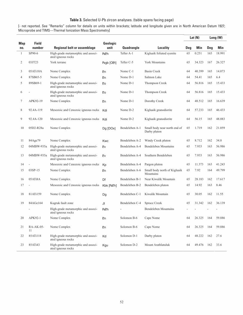
52
Table 3. Selected U-Pb zircon analyses. (table spans facing page)[- not reported. See “Remarks” column for details on units within brackets; latitude and longitude given are in North American Datum 1927;Microprobe and TIMS—Thermal Ionization Mass Spectrometry]
localities are plotted on sheet 2; scale of map precludes labeling of all locality names; in the Remarks column, SHRIMP—Sensitive High-Resolution Ion
Mapno.
Field
number
Regional belt or assemblage
Geologic
unit
Quadrangle
Locality
Lat (N) Long (W) Mineral
dated
Interpretedage(Ma)
Interpretedage error
(Ma) 2-sigma
Rock type
Reference
Remarks
Deg
Min Deg Min1 SP90-6 High-grade metamorphic and associ-
ated igneous rocks|<h Teller A-1 Kigluaik foliated syenite 65 0.251 165 18.991 Zircon 110 5 Metasyenite Amato and Wright, 1998 Analysis by W. McClelland; Location approximated
from fig. 2, on sh. 2 in Amato and Wright, 1998
2 03JT23 York terrane |gb [O<t] Teller C-5 York Mountains 65 34.323 167 26.327 Zircon 541 6 Gabbro Amato and others, 2006 Location provided by collector; Sample is from a |gb outcrop that is too small to show at map scale
3 05ATi10A Nome Complex <n Nome C-1 Basin Creek 64 40.399 165 14.073 Zircon 669 5 Orthogneiss Till and others, 2006 Latitude and longitude based on 05ATi10(A-D)
4 87SB65-5 Nome Complex <n Nome D-1 Salmon Lake 64 54.41 165 6.4 Zircon 678 4 Felsic orthogneiss Amato and Wright, 1998 Age analysis by TIMS
5 89SB69-1 High-grade metamorphic and associ-ated igneous rocks
<o Nome D-1 Thompson Creek 64 56.816 165 15.433 Zircon 555 15 Orthogneiss Amato and Wright, 1998 Age analysis by TIMS
6 - High-grade metamorphic and associ-ated igneous rocks
<o Nome D-1 Thompson Creek 64 56.816 165 15.433 Zircon 565 6 Orthogneiss Amato, 2004 Author reports 565 ± 6 Ma is the average of three 206Pb/238U ages; Age analysis by SHRIMP
7 APK92-19 Nome Complex <n Nome D-1 Dorothy Creek 64 48.512 165 16.639 Zircon 681 3 Orthogneiss Patrick and McClelland, 1995 Location approximated from a map in Patrick and McClelland, 1995
8 92.4A-119 Mesozoic and Cenozoic igneous rocks Kdi Nome D-2 Kigluaik granodiorite 64 57.233 165 46.433 Zircon 89 1 Hornblende biotite granodiorite
Amato and Wright, 1998 Age analysis by TIMS; Location provided by authors
9 92.4A-120 Mesozoic and Cenozoic igneous rocks Kdi Nome D-2 Kigluaik granodiorite 64 56.15 165 48.083 Zircon 91 1 Hornblende biotite granodiorite
Amato and Wright, 1998 Age analysis by TIMS; Location provided by authors
10 05D2-R28a Nome Complex Dg [DOx] Bendeleben A-1 Small body near north end of Darby pluton
65 1.719 162 21.059 Zircon 390 3 Orthogneiss Jeff Amato, written comm. 2008 Age analysis by SHRIMP; Location provided by collector; Sample is from a small body of Dg that is too small to show at map scale
11 84Age79 Nome Complex Kwc Bendeleben A-2 Windy Creek pluton 65 8.712 162 34.8 Zircon 96.5 0.2 Quartz monzonite Richard Friedman, written comm., 2009 Age analysis by TIMS
12 04MBW-935a High-grade metamorphic and associ-ated igneous rocks
<v Bendeleben A-4 Bendeleben Mountains 65 7.933 163 56.986 Zircon 870 6 Metarhyolite Gottlieb and Amato, 2007 Authors' written comm. 2008: rock type is metar-hyolite; Age analysis by SHRIMP
13 04MBW-935a High-grade metamorphic and associ-ated igneous rocks
<v Bendeleben A-4 Southern Bendeleben 65 7.933 163 56.986 Monazite 86 1 Metarhyolite Gottlieb and Amato, 2007 Authors' reported comments: cooling age and rock type is metarhyolite; Age analysis by SHRIMP
14 - Mesozoic and Cenozoic igneous rocks Kp Bendeleben A-4 Pargon pluton 65 11.373 163 41.243 Zircon 86 1 Granite Gottlieb and Amato, 2008 Approximate location; Age analysis by SHRIMP
15 03SP-15 Nome Complex <n Bendeleben A-6 Small body north of Kigluaik Mountains
65 7.92 164 49.799 Zircon 687 9 Orthogneiss Jeff Amato, written comm. 2008 Age analysis by SHRIMP
16 05ATi8A Nome Complex Df Bendeleben B-1 Near Kiwalik Mountain 65 28.183 162 17.617 Zircon 392 5 Metafelsite Till and others, 2006 Latitude and longitude based on 05ATi8(A-D)
17 - Mesozoic and Cenozoic igneous rocks Kbk [|<h] Bendeleben B-2 Bendeleben pluton 65 14.92 163 8.46 Zircon 104 1 Foliated biotite granite
Gottlieb and Amato, 2008 Age analysis by SHRIMP; sample is from margin of Bendeleben pluton as mapped by collector
18 81ATi159 Nome Complex Dg Bendeleben C-1 Kiwalik Mountain 65 30.05 162 11.55 Zircon 391 3 Granitic orthog-neiss
Till and others, 2006 Location is the same as 05ATi7
19 84AGe164 Kugruk fault zone Jt Bendeleben C-4 Spruce Creek 65 31.342 162 36.139 Zircon 163 3 Tonalite John Aleinikoff, written comm., 1986 –
- High-grade metamorphic and associ-ated igneous rocks
|<h - Bendeleben Mountains - - - - Zircon 390 - Foliated biotite granite
Gottlieb and Amato, 2008 Sample location not given; Age analysis by SHRIMP
20 APK92-1 Nome Complex <n Solomon B-6 Cape Nome 64 26.325 164 59.886 Zircon 676 15 Orthogneiss Patrick and McClelland, 1995 Location approximated from figure 2 in Patrick and McClelland, 1995
21 RA-AK-05-11
Nome Complex <n Solomon B-6 Cape Nome 64 26.325 164 59.886 Zircon 669 5 Orthogneiss John Aleinikoff, written comm., 2005 –
22 85ATi118 High-grade metamorphic and associ-ated igneous rocks
Kd Solomon D-1 Darby pluton 64 48.222 162 27.6 Zircon 100.1 0.1 Monzogranite Richard Friedman, written comm., 2009 Age analysis by TIMS
23 85ATi43 High-grade metamorphic and associ-ated igneous rocks
Kgu Solomon D-2 Mount Arathlatuluk 64 49.476 162 33.6 Zircon 107.8 0.2 Granite Richard Friedman, written comm., 2009 Age analysis by TIMS
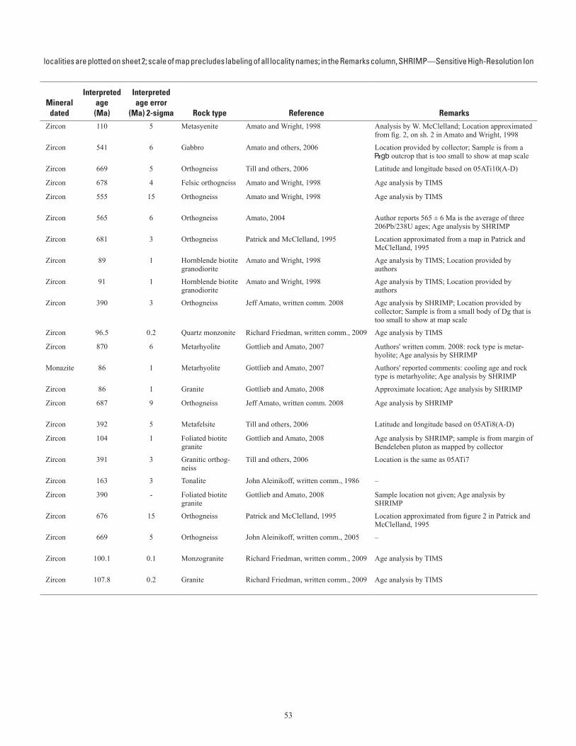
53
Table 3. Selected U-Pb zircon analyses. (table spans facing page)[- not reported. See “Remarks” column for details on units within brackets; latitude and longitude given are in North American Datum 1927;Microprobe and TIMS—Thermal Ionization Mass Spectrometry]
localities are plotted on sheet 2; scale of map precludes labeling of all locality names; in the Remarks column, SHRIMP—Sensitive High-Resolution Ion
Mapno.
Field
number
Regional belt or assemblage
Geologic
unit
Quadrangle
Locality
Lat (N) Long (W) Mineral
dated
Interpretedage(Ma)
Interpretedage error
(Ma) 2-sigma
Rock type
Reference
Remarks
Deg
Min Deg Min1 SP90-6 High-grade metamorphic and associ-
ated igneous rocks|<h Teller A-1 Kigluaik foliated syenite 65 0.251 165 18.991 Zircon 110 5 Metasyenite Amato and Wright, 1998 Analysis by W. McClelland; Location approximated
from fig. 2, on sh. 2 in Amato and Wright, 1998
2 03JT23 York terrane |gb [O<t] Teller C-5 York Mountains 65 34.323 167 26.327 Zircon 541 6 Gabbro Amato and others, 2006 Location provided by collector; Sample is from a |gb outcrop that is too small to show at map scale
3 05ATi10A Nome Complex <n Nome C-1 Basin Creek 64 40.399 165 14.073 Zircon 669 5 Orthogneiss Till and others, 2006 Latitude and longitude based on 05ATi10(A-D)
4 87SB65-5 Nome Complex <n Nome D-1 Salmon Lake 64 54.41 165 6.4 Zircon 678 4 Felsic orthogneiss Amato and Wright, 1998 Age analysis by TIMS
5 89SB69-1 High-grade metamorphic and associ-ated igneous rocks
<o Nome D-1 Thompson Creek 64 56.816 165 15.433 Zircon 555 15 Orthogneiss Amato and Wright, 1998 Age analysis by TIMS
6 - High-grade metamorphic and associ-ated igneous rocks
<o Nome D-1 Thompson Creek 64 56.816 165 15.433 Zircon 565 6 Orthogneiss Amato, 2004 Author reports 565 ± 6 Ma is the average of three 206Pb/238U ages; Age analysis by SHRIMP
7 APK92-19 Nome Complex <n Nome D-1 Dorothy Creek 64 48.512 165 16.639 Zircon 681 3 Orthogneiss Patrick and McClelland, 1995 Location approximated from a map in Patrick and McClelland, 1995
8 92.4A-119 Mesozoic and Cenozoic igneous rocks Kdi Nome D-2 Kigluaik granodiorite 64 57.233 165 46.433 Zircon 89 1 Hornblende biotite granodiorite
Amato and Wright, 1998 Age analysis by TIMS; Location provided by authors
9 92.4A-120 Mesozoic and Cenozoic igneous rocks Kdi Nome D-2 Kigluaik granodiorite 64 56.15 165 48.083 Zircon 91 1 Hornblende biotite granodiorite
Amato and Wright, 1998 Age analysis by TIMS; Location provided by authors
10 05D2-R28a Nome Complex Dg [DOx] Bendeleben A-1 Small body near north end of Darby pluton
65 1.719 162 21.059 Zircon 390 3 Orthogneiss Jeff Amato, written comm. 2008 Age analysis by SHRIMP; Location provided by collector; Sample is from a small body of Dg that is too small to show at map scale
11 84Age79 Nome Complex Kwc Bendeleben A-2 Windy Creek pluton 65 8.712 162 34.8 Zircon 96.5 0.2 Quartz monzonite Richard Friedman, written comm., 2009 Age analysis by TIMS
12 04MBW-935a High-grade metamorphic and associ-ated igneous rocks
<v Bendeleben A-4 Bendeleben Mountains 65 7.933 163 56.986 Zircon 870 6 Metarhyolite Gottlieb and Amato, 2007 Authors' written comm. 2008: rock type is metar-hyolite; Age analysis by SHRIMP
13 04MBW-935a High-grade metamorphic and associ-ated igneous rocks
<v Bendeleben A-4 Southern Bendeleben 65 7.933 163 56.986 Monazite 86 1 Metarhyolite Gottlieb and Amato, 2007 Authors' reported comments: cooling age and rock type is metarhyolite; Age analysis by SHRIMP
14 - Mesozoic and Cenozoic igneous rocks Kp Bendeleben A-4 Pargon pluton 65 11.373 163 41.243 Zircon 86 1 Granite Gottlieb and Amato, 2008 Approximate location; Age analysis by SHRIMP
15 03SP-15 Nome Complex <n Bendeleben A-6 Small body north of Kigluaik Mountains
65 7.92 164 49.799 Zircon 687 9 Orthogneiss Jeff Amato, written comm. 2008 Age analysis by SHRIMP
16 05ATi8A Nome Complex Df Bendeleben B-1 Near Kiwalik Mountain 65 28.183 162 17.617 Zircon 392 5 Metafelsite Till and others, 2006 Latitude and longitude based on 05ATi8(A-D)
17 - Mesozoic and Cenozoic igneous rocks Kbk [|<h] Bendeleben B-2 Bendeleben pluton 65 14.92 163 8.46 Zircon 104 1 Foliated biotite granite
Gottlieb and Amato, 2008 Age analysis by SHRIMP; sample is from margin of Bendeleben pluton as mapped by collector
18 81ATi159 Nome Complex Dg Bendeleben C-1 Kiwalik Mountain 65 30.05 162 11.55 Zircon 391 3 Granitic orthog-neiss
Till and others, 2006 Location is the same as 05ATi7
19 84AGe164 Kugruk fault zone Jt Bendeleben C-4 Spruce Creek 65 31.342 162 36.139 Zircon 163 3 Tonalite John Aleinikoff, written comm., 1986 –
- High-grade metamorphic and associ-ated igneous rocks
|<h - Bendeleben Mountains - - - - Zircon 390 - Foliated biotite granite
Gottlieb and Amato, 2008 Sample location not given; Age analysis by SHRIMP
20 APK92-1 Nome Complex <n Solomon B-6 Cape Nome 64 26.325 164 59.886 Zircon 676 15 Orthogneiss Patrick and McClelland, 1995 Location approximated from figure 2 in Patrick and McClelland, 1995
21 RA-AK-05-11
Nome Complex <n Solomon B-6 Cape Nome 64 26.325 164 59.886 Zircon 669 5 Orthogneiss John Aleinikoff, written comm., 2005 –
22 85ATi118 High-grade metamorphic and associ-ated igneous rocks
Kd Solomon D-1 Darby pluton 64 48.222 162 27.6 Zircon 100.1 0.1 Monzogranite Richard Friedman, written comm., 2009 Age analysis by TIMS
23 85ATi43 High-grade metamorphic and associ-ated igneous rocks
Kgu Solomon D-2 Mount Arathlatuluk 64 49.476 162 33.6 Zircon 107.8 0.2 Granite Richard Friedman, written comm., 2009 Age analysis by TIMS
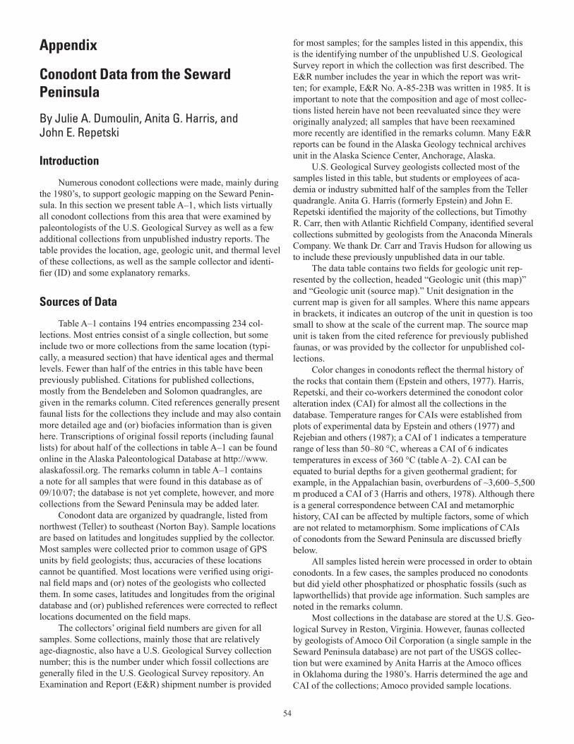
54
Appendix
Conodont Data from the SewardPeninsula
By Julie A. Dumoulin, Anita G. Harris, andJohn E. Repetski
Introduction
Numerous conodont collections were made, mainly during the 1980’s, to support geologic mapping on the Seward Penin-sula. In this section we present table A–1, which lists virtually all conodont collections from this area that were examined by paleontologists of the U.S. Geological Survey as well as a few additional collections from unpublished industry reports. The table provides the location, age, geologic unit, and thermal level of these collections, as well as the sample collector and identi-fier (ID) and some explanatory remarks.
Sources of Data
Table A–1 contains 194 entries encompassing 234 col-lections. Most entries consist of a single collection, but some include two or more collections from the same location (typi-cally, a measured section) that have identical ages and thermal levels. Fewer than half of the entries in this table have been previously published. Citations for published collections, mostly from the Bendeleben and Solomon quadrangles, are given in the remarks column. Cited references generally present faunal lists for the collections they include and may also contain more detailed age and (or) biofacies information than is given here. Transcriptions of original fossil reports (including faunal lists) for about half of the collections in table A–1 can be found online in the Alaska Paleontological Database at http://www.alaskafossil.org. The remarks column in table A–1 contains a note for all samples that were found in this database as of 09/10/07; the database is not yet complete, however, and more collections from the Seward Peninsula may be added later.
Conodont data are organized by quadrangle, listed from northwest (Teller) to southeast (Norton Bay). Sample locations are based on latitudes and longitudes supplied by the collector. Most samples were collected prior to common usage of GPS units by field geologists; thus, accuracies of these locations cannot be quantified. Most locations were verified using origi-nal field maps and (or) notes of the geologists who collected them. In some cases, latitudes and longitudes from the original database and (or) published references were corrected to reflect locations documented on the field maps.
The collectors’ original field numbers are given for all samples. Some collections, mainly those that are relatively age-diagnostic, also have a U.S. Geological Survey collection number; this is the number under which fossil collections are generally filed in the U.S. Geological Survey repository. An Examination and Report (E&R) shipment number is provided
for most samples; for the samples listed in this appendix, this is the identifying number of the unpublished U.S. Geological Survey report in which the collection was first described. The E&R number includes the year in which the report was writ-ten; for example, E&R No. A-85-23B was written in 1985. It is important to note that the composition and age of most collec-tions listed herein have not been reevaluated since they were originally analyzed; all samples that have been reexamined more recently are identified in the remarks column. Many E&R reports can be found in the Alaska Geology technical archives unit in the Alaska Science Center, Anchorage, Alaska.
U.S. Geological Survey geologists collected most of the samples listed in this table, but students or employees of aca-demia or industry submitted half of the samples from the Teller quadrangle. Anita G. Harris (formerly Epstein) and John E. Repetski identified the majority of the collections, but Timothy R. Carr, then with Atlantic Richfield Company, identified several collections submitted by geologists from the Anaconda Minerals Company. We thank Dr. Carr and Travis Hudson for allowing us to include these previously unpublished data in our table.
The data table contains two fields for geologic unit rep-resented by the collection, headed “Geologic unit (this map)” and “Geologic unit (source map).” Unit designation in the current map is given for all samples. Where this name appears in brackets, it indicates an outcrop of the unit in question is too small to show at the scale of the current map. The source map unit is taken from the cited reference for previously published faunas, or was provided by the collector for unpublished col-lections.
Color changes in conodonts reflect the thermal history of the rocks that contain them (Epstein and others, 1977). Harris, Repetski, and their co-workers determined the conodont color alteration index (CAI) for almost all the collections in the database. Temperature ranges for CAIs were established from plots of experimental data by Epstein and others (1977) and Rejebian and others (1987); a CAI of 1 indicates a temperature range of less than 50–80 °C, whereas a CAI of 6 indicates temperatures in excess of 360 °C (table A–2). CAI can be equated to burial depths for a given geothermal gradient; for example, in the Appalachian basin, overburdens of ~3,600–5,500 m produced a CAI of 3 (Harris and others, 1978). Although there is a general correspondence between CAI and metamorphic history, CAI can be affected by multiple factors, some of which are not related to metamorphism. Some implications of CAIs of conodonts from the Seward Peninsula are discussed briefly below.
All samples listed herein were processed in order to obtain conodonts. In a few cases, the samples produced no conodonts but did yield other phosphatized or phosphatic fossils (such as lapworthellids) that provide age information. Such samples are noted in the remarks column.
Most collections in the database are stored at the U.S. Geo-logical Survey in Reston, Virginia. However, faunas collected by geologists of Amoco Oil Corporation (a single sample in the Seward Peninsula database) are not part of the USGS collec-tion but were examined by Anita Harris at the Amoco offices in Oklahoma during the 1980’s. Harris determined the age and CAI of the collections; Amoco provided sample locations.
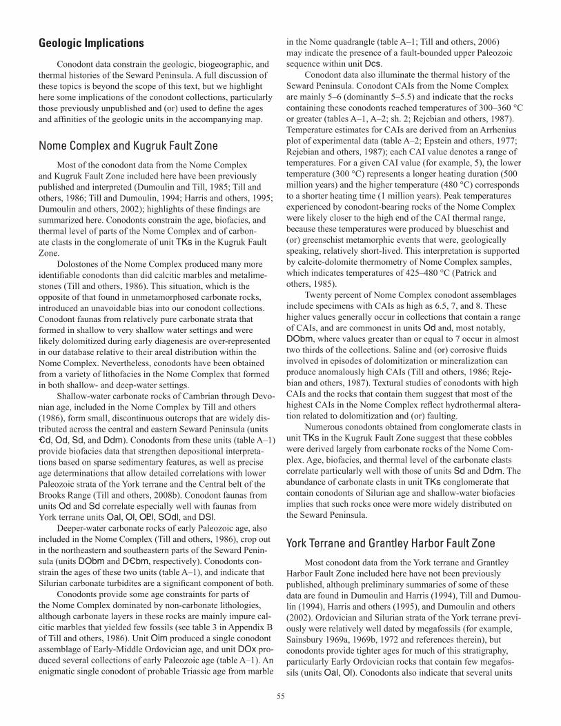
55
Geologic Implications
Conodont data constrain the geologic, biogeographic, and thermal histories of the Seward Peninsula. A full discussion of these topics is beyond the scope of this text, but we highlight here some implications of the conodont collections, particularly those previously unpublished and (or) used to define the ages and affinities of the geologic units in the accompanying map.
Nome Complex and Kugruk Fault ZoneMost of the conodont data from the Nome Complex
and Kugruk Fault Zone included here have been previously published and interpreted (Dumoulin and Till, 1985; Till and others, 1986; Till and Dumoulin, 1994; Harris and others, 1995; Dumoulin and others, 2002); highlights of these findings are summarized here. Conodonts constrain the age, biofacies, and thermal level of parts of the Nome Complex and of carbon-ate clasts in the conglomerate of unit TKs in the Kugruk Fault Zone.
Dolostones of the Nome Complex produced many more identifiable conodonts than did calcitic marbles and metalime-stones (Till and others, 1986). This situation, which is the opposite of that found in unmetamorphosed carbonate rocks, introduced an unavoidable bias into our conodont collections. Conodont faunas from relatively pure carbonate strata that formed in shallow to very shallow water settings and were likely dolomitized during early diagenesis are over-represented in our database relative to their areal distribution within the Nome Complex. Nevertheless, conodonts have been obtained from a variety of lithofacies in the Nome Complex that formed in both shallow- and deep-water settings.
Shallow-water carbonate rocks of Cambrian through Devo-nian age, included in the Nome Complex by Till and others (1986), form small, discontinuous outcrops that are widely dis-tributed across the central and eastern Seward Peninsula (units _d, Od, Sd, and Ddm). Conodonts from these units (table A–1) provide biofacies data that strengthen depositional interpreta-tions based on sparse sedimentary features, as well as precise age determinations that allow detailed correlations with lower Paleozoic strata of the York terrane and the Central belt of the Brooks Range (Till and others, 2008b). Conodont faunas from units Od and Sd correlate especially well with faunas from York terrane units Oal, Ol, O<l, SOdl, and DSl.
Deeper-water carbonate rocks of early Paleozoic age, also included in the Nome Complex (Till and others, 1986), crop out in the northeastern and southeastern parts of the Seward Penin-sula (units DObm and D_bm, respectively). Conodonts con-strain the ages of these two units (table A–1), and indicate that Silurian carbonate turbidites are a significant component of both.
Conodonts provide some age constraints for parts of the Nome Complex dominated by non-carbonate lithologies, although carbonate layers in these rocks are mainly impure cal-citic marbles that yielded few fossils (see table 3 in Appendix B of Till and others, 1986). Unit Oim produced a single conodont assemblage of Early-Middle Ordovician age, and unit DOx pro-duced several collections of early Paleozoic age (table A–1). An enigmatic single conodont of probable Triassic age from marble
in the Nome quadrangle (table A–1; Till and others, 2006) may indicate the presence of a fault-bounded upper Paleozoic sequence within unit Dcs.
Conodont data also illuminate the thermal history of the Seward Peninsula. Conodont CAIs from the Nome Complex are mainly 5–6 (dominantly 5–5.5) and indicate that the rocks containing these conodonts reached temperatures of 300–360 °C or greater (tables A–1, A–2; sh. 2; Rejebian and others, 1987). Temperature estimates for CAIs are derived from an Arrhenius plot of experimental data (table A–2; Epstein and others, 1977; Rejebian and others, 1987); each CAI value denotes a range of temperatures. For a given CAI value (for example, 5), the lower temperature (300 °C) represents a longer heating duration (500 million years) and the higher temperature (480 °C) corresponds to a shorter heating time (1 million years). Peak temperatures experienced by conodont-bearing rocks of the Nome Complex were likely closer to the high end of the CAI thermal range, because these temperatures were produced by blueschist and (or) greenschist metamorphic events that were, geologically speaking, relatively short-lived. This interpretation is supported by calcite-dolomite thermometry of Nome Complex samples, which indicates temperatures of 425–480 °C (Patrick and others, 1985).
Twenty percent of Nome Complex conodont assemblages include specimens with CAIs as high as 6.5, 7, and 8. These higher values generally occur in collections that contain a range of CAIs, and are commonest in units Od and, most notably, DObm, where values greater than or equal to 7 occur in almost two thirds of the collections. Saline and (or) corrosive fluids involved in episodes of dolomitization or mineralization can produce anomalously high CAIs (Till and others, 1986; Reje-bian and others, 1987). Textural studies of conodonts with high CAIs and the rocks that contain them suggest that most of the highest CAIs in the Nome Complex reflect hydrothermal altera-tion related to dolomitization and (or) faulting.
Numerous conodonts obtained from conglomerate clasts in unit TKs in the Kugruk Fault Zone suggest that these cobbles were derived largely from carbonate rocks of the Nome Com-plex. Age, biofacies, and thermal level of the carbonate clasts correlate particularly well with those of units Sd and Ddm. The abundance of carbonate clasts in unit TKs conglomerate that contain conodonts of Silurian age and shallow-water biofacies implies that such rocks once were more widely distributed on the Seward Peninsula.
York Terrane and Grantley Harbor Fault ZoneMost conodont data from the York terrane and Grantley
Harbor Fault Zone included here have not been previously published, although preliminary summaries of some of these data are found in Dumoulin and Harris (1994), Till and Dumou-lin (1994), Harris and others (1995), and Dumoulin and others (2002). Ordovician and Silurian strata of the York terrane previ-ously were relatively well dated by megafossils (for example, Sainsbury 1969a, 1969b, 1972 and references therein), but conodonts provide tighter ages for much of this stratigraphy, particularly Early Ordovician rocks that contain few megafos-sils (units Oal, Ol). Conodonts also indicate that several units
56
considered Precambrian by Sainsbury (1972) are at least partly of Ordovician age (such as rocks included in units O<l and O<t of this map). Questions that might profitably be addressed in the future using detailed conodont sampling include the age range and geographic distribution of Ordovician strata within com-posite units such as O<l and O<t, and the amount of age overlap between units Oal and Ol.
Most rock units in the Grantley Harbor Fault Zone that were sampled for conodonts were barren. However, unit Pzp produced a few fragmentary conodonts that indicate an Ordo-vician-Triassic age (table A–1; T. Carr and T. Hudson, written commun., 1982, 1984).
Conodonts contribute greatly to our understanding of the paleobiogeography of the York terrane. Conodont assem-blages from several units, most notably Ol and SOdl, include both Siberian and Laurentian (North American) endemic forms, a pattern that is also seen in megafaunas from these rocks (Dumoulin and Harris, 1994; Blodgett and others, 2002; Dumoulin and others, 2002). Similar mixed biogeographic affinities characterize conodonts in unit Od of the Nome Com-plex, the Baird Group and related rocks in the Central belt of the Brooks Range, and lower Paleozoic strata of the Farewell terrane in interior Alaska. These faunal correlations, along with detailed lithofacies matches between coeval strata in these suc-cessions, suggest that lower Paleozoic rocks on Seward Penin-sula, in the Brooks Range, and in the Farewell terrane may once have been part of a single continental fragment situated between Siberia and Laurentia (Dumoulin and others, 2002).
Conodont CAIs from the York terrane generally are lower than those from the Nome Complex and define three thermal provinces (table A–1; sh. 2). The first province consists of out-crops of units Oal, Ol, and Ols between lat 65°23.9’ and 65°33’ N. and long 167°14’ and 167°23’ W. (Teller B–5 and C–5 quad-rangles) that have CAIs mainly of 2–2.5. These values indicate temperatures of 60–150 °C (table A–2) and demonstrate that
these York terrane rocks are still within the oil window; a CAI of 3, denoting temperatures of 120–190 °C, approximates the thermal limit of oil preservation (Bird and others, 1999). The second province contains rocks with slightly higher CAIs (3–3.5); these rocks are located in the Don River area (Teller B–4 quadrangle), and consist mainly of unit SOdl. CAIs elsewhere in the York terrane are mostly 4–4.5 and delineate a third province; these values are found in units Oal, Ol, and Ols where they occur outside of the first province, as well as unit DSl and much of unit O<l.
Higher CAIs of 5–6, equivalent to those found in the Nome Complex, occur in a few conodont assemblages from the York terrane (table A–1). Some higher values likely reflect contact metamorphic effects associated with intrusion of Cretaceous dikes and plutons (for example, a few outcrops of units Oal and Ol in the Teller B–5 and C–5 quadrangles; Toro and others, written commun., 2006). Other high CAIs occur near the west-ern edge of the York terrane (unit SOul in the Teller C–2 quad-rangle). Lastly, CAIs greater than or equal to 5 characterize all three conodont assemblages obtained from unit O<t and several assemblages from unit O<l. Recrystallization and schistose to semi-schistose fabrics characterize most of unit O<t and parts of unit O<l; these rocks may be part of a more deformed and (or) mildly metamorphosed structural plate that underlies parts of the York terrane (Toro and others, 2006).
As outlined above, CAIs from the York terrane are not simply correlated with unit age—that is, older rocks do not have consistently higher CAIs than younger rocks. Thus, these CAIs were most likely not produced by simple burial metamorphism. Instead, York terrane thermal data may reflect tectonic burial by thrust sheets, as has been proposed to explain CAI patterns in the western Brooks Range (Harris and others, 1987). Additional conodont sampling, in concert with detailed structural studies, could help define the composition and extent of discrete thrust sheets within the York terrane.

57
58
Table A–1. Conodont data from the Seward Peninsula. (table spans facing page)[Ages listed have not been revised to reflect all changes in stratigraphic terminology that have occurred since the ages given here were Ordovician conodont zonation, Series, and Stage usage herein follows that given in Harris and others (1995). Geologic unit (source map) from cited to map units of Till and others (1986). For Teller quadrangle, source map units refer to map units of Sainsbury (1972) if unspecified; (69b) indicates a column. Alaska Paleontological Database found online at http://www.alaskafossil.org. E&R, Examination and Report by USGS paleontologist;on sheet 2; see table A-2 for temperature ranges for CAI values]
determined. For example, the Middle/Upper Ordovician boundary has been revised downward considerably (see, for example, Webby and others, 2004).reference (if published) or provided by collector. For Bendeleben, Candle, Kotzebue, Norton Bay, and Solomon quadrangles, source map units refermap unit of Sainsbury (1969b). Unit in bracket (for example, [Ols]) indicates outcrop too small to show on map, or other issue explained in remarksID, conodont fauna identifier; N.D., not determined; USGS no., number under which collection is filed in USGS repository. Localities are plotted
Lat (N)
Long (W)
Geologic unit
ColorAlterationIndex (CAI)
Field no. Quadrangle
Deg
Min
Deg
Min Age
(This map)(Source
map)
Min
Max USGS no.E&R
shipment no.Sample
collectorSample
ID RemarksAS-001 Teller A-3 65 14.37 166 18.54 Ordovician-Triassic |p p_s 5 5 – – Anaconda Carr Sample collected by Anaconda Minerals Co. from graphitic shale; location
approximate. Conodonts identified by T. Carr, Atlantic Richfield Co., 1982, 1984.
AS-031 Teller B-2 65 19.96 165 47.57 early Paleozoic DOx p_nl 7 7 – – Anaconda Carr Sample collected by Anaconda Minerals Co.; location approximate. Conodonts identified by T. Carr, Atlantic Richfield Co., 1982, 1984.
07AD11A Teller B-3 65 21.49 166 24.72 middle Early Ordovician ("Low Diversity Interval") O<l p_l 4-4.5 4.5 12111-CO – Dumoulin Harris, Repetski Sample re-examined by J.E. Repetski, 8/10.
AS-004 through -007 Teller B-3 65 22.45 166 27.54 Early-early Middle Ordovician O<l p_l 5 5 – – Anaconda Carr Samples (4) collected by Anaconda Minerals Co.; location approximate. Conodonts identified by T. Carr, Atlantic Richfield Co., 1982, 1984.
85AKn12 Teller B-4 65 24 166 35.8 latest Early Ordovician-earliest Middle Ordovician (Reutterodus andinus Zone to Tripodus laevis Zone)
Ol Ol 3.5 4 10018-CO A-85-23A Kaufman Harris Entry in Alaska Paleontological Database.
6-30-85D, C Teller B-4 65 25.9 166 34.2 middle Early Ordovician (Macerodus dianae Zone to Acodus deltatus-Oneotodus costatus Zone)
Ol Ol 4 4 10215-CO, 10216-CO
A-85-23F Harris Harris, Repetski Samples re-examined by J.E. Repetski, 2/08. Entries in Alaska Paleontological Database.
7-21-84C-F Teller B-4 65 29.68 166 55.34 Late Ordovician SOdl SOdl 3.5 3.5 10241-CO through 10244-CO
A-85-23H Harris Harris Age revised by A.G. Harris in 1995. Entries in Alaska Paleontological Database. All 4 samples are from measured section 84ADn118 near the Don River. Section started at lat/long given here, and ended at lat/long given for samples 7-22-84B through J. Precise locations were not determined for each sample.
7-21-84G Teller B-4 65 29.68 166 55.34 Late Ordovician SOdl SOdl 3 3 10245-CO A-85-23H Harris Harris Age revised by A.G. Harris in 1995. Entry in Alaska Paleontological Database. Sample from measured section 84ADn118 near the Don River.
7-21-84H Teller B-4 65 29.68 166 55.34 latest Ordovician (Gamachian)-early Silurian (age constrained by overlying samples)
SOdl SOdl 3 3 – A-85-23H Harris Harris Entry in Alaska Paleontological Database. Sample from measured section 84ADn118 near the Don River.
7-21-84I-K Teller B-4 65 29.68 166 55.34 Very probably early Silurian SOdl SOdl or Sl 3 3 11242-SD through 11244-SD
A-85-23H Harris Harris Entries in Alaska Paleontological Database. All 3 samples from measured section 84ADn118 near the Don River.
7-22-84A Teller B-4 65 29.68 166 55.34 early Silurian (earliest Llandovery-Llandovery C5) SOdl SOdl or Sl 3 3 11245-SD A-85-23H Harris Harris Entry in Alaska Paleontological Database. Sample from measured section 84ADn118 near the Don River.
7-22-84B, C, E, F Teller B-4 65 29.91 166 55.75 early late Silurian (Ludlow) SOdl Sl 3 3 11246-SD through 11249-SD
A-85-23H Harris Harris Entries in Alaska Paleontological Database. All 4 samples from measured section 84ADn118 near the Don River.
7-22-84G Teller B-4 65 29.91 166 55.75 early late Silurian (Ludlow, probably early Ludlow) SOdl Sl 3 3 11250-SD A-85-23H Harris Harris Entry in Alaska Paleontological Database. Sample from measured section 84ADn118 near the Don River.
7-22-84H-J Teller B-4 65 29.91 166 55.75 early late Silurian (Ludlow)-Middle Devonian SOdl Sl 3 3 11251-SD through 11253-SD
A-85-23H Harris Harris Entries in Alaska Paleontological Database. All 3 samples from measured section 84ADn118 near the Don River.
68ADu27 Teller B-4 65 29.8 166 56 middle-early late Silurian (latest Wenlock-early Ludlow)
SOdl Sl 3 3 8345-SD A-84-14 Dutro Harris Entry in Alaska Paleontological Database. From measured section near the Don River.
68ADu19, 25 Teller B-4 65 29.8 166 56 middle Silurian (late Wenlock); age constrained by co-occurring and (or) overlying megafossils
SOdl Sl 3 3 8337-SD, 8343-SD
A-84-14 Dutro Harris Entries in Alaska Paleontological Database. From measured section near the Don River.
68ADu18 Teller B-4 65 29.8 166 56 Late Ordovician; age constrained by underlying samples
SOdl SOdl 3 3 D2036-CO A-84-14 Dutro Harris Entry in Alaska Paleontological Database. From measured section near the Don River.
7-21-84A Teller B-4 65 29.85 166 55.88 early Silurian SOdl Sl 3 3 11254-SD A-85-23H Harris Harris Entry in Alaska Paleontological Database.
7-21-84B Teller B-4 65 29.85 166 55.88 probably early Silurian SOdl Sl 3 3 11255-SD A-85-23H Harris Harris Entry in Alaska Paleontological Database.
03JT25 Teller B-5 65 23.9 167 16.75 middle Early Ordovician (Macerodus dianae or A. deltatus-O. costatus Zone)
Oal Oal 2.5 2.5 11971-CO – Toro Repetski Sample from massive micritic limestone.
7-23-84A-H, K Teller B-5 65 24.5 167 17.6 middle Early Ordovician ("Low Diversity Interval" to Macerodus dianae Zone)
Oal Oal 4 4 10231-CO through 10239-CO
A-85-23G Harris Repetski Samples re-examined by J.E. Repetski, 2/08. Entries in Alaska Paleontological Database. All 9 samples are from a measured section along Koteebue Creek.
7-3-85I Teller B-5 65 24.3 167 0.8 Early Ordovician (Rossodus manitouensis Zone to Macerodus dianae Zone)
Ol Ol 4 4 10230-SD A-85-23F Harris Harris, Repetski Sample re-examined by J.E. Repetski, 2/08. Entry in Alaska Paleontological Database.
03JT26 Teller B-5 65 24.74 167 16.7 Early (but not earliest) Ordovician; Rossodus mani-touensis Zone or younger
Oal Oal 2.5 3 11972-CO – Toro Repetski Sample from brown-gray, massive, medium-bedded micritic liimestone.
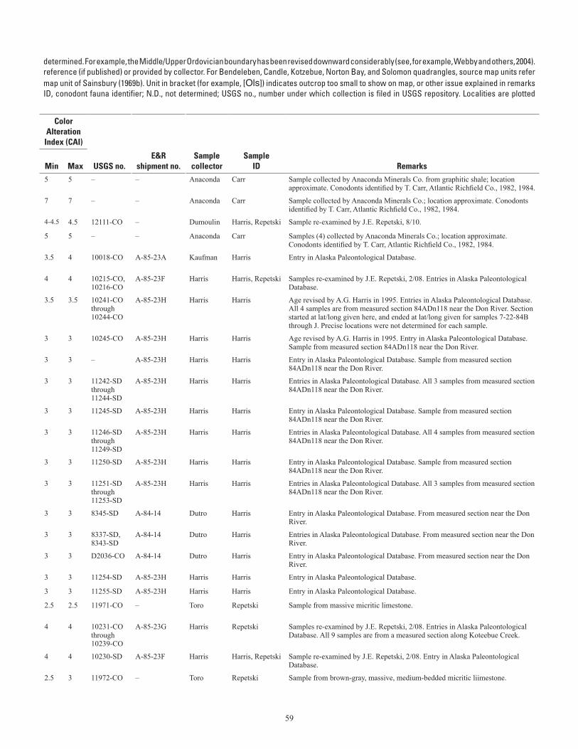
59
Table A–1. Conodont data from the Seward Peninsula. (table spans facing page)[Ages listed have not been revised to reflect all changes in stratigraphic terminology that have occurred since the ages given here were Ordovician conodont zonation, Series, and Stage usage herein follows that given in Harris and others (1995). Geologic unit (source map) from cited to map units of Till and others (1986). For Teller quadrangle, source map units refer to map units of Sainsbury (1972) if unspecified; (69b) indicates a column. Alaska Paleontological Database found online at http://www.alaskafossil.org. E&R, Examination and Report by USGS paleontologist;on sheet 2; see table A-2 for temperature ranges for CAI values]
determined. For example, the Middle/Upper Ordovician boundary has been revised downward considerably (see, for example, Webby and others, 2004).reference (if published) or provided by collector. For Bendeleben, Candle, Kotzebue, Norton Bay, and Solomon quadrangles, source map units refermap unit of Sainsbury (1969b). Unit in bracket (for example, [Ols]) indicates outcrop too small to show on map, or other issue explained in remarksID, conodont fauna identifier; N.D., not determined; USGS no., number under which collection is filed in USGS repository. Localities are plotted
Lat (N)
Long (W)
Geologic unit
ColorAlteration
Index (CAI)
Field no. Quadrangle
Deg
Min
Deg
Min Age
(This map)(Source
map)
Min
Max USGS no.E&R
shipment no.Sample
collectorSample
ID RemarksAS-001 Teller A-3 65 14.37 166 18.54 Ordovician-Triassic |p p_s 5 5 – – Anaconda Carr Sample collected by Anaconda Minerals Co. from graphitic shale; location
approximate. Conodonts identified by T. Carr, Atlantic Richfield Co., 1982, 1984.
AS-031 Teller B-2 65 19.96 165 47.57 early Paleozoic DOx p_nl 7 7 – – Anaconda Carr Sample collected by Anaconda Minerals Co.; location approximate. Conodonts identified by T. Carr, Atlantic Richfield Co., 1982, 1984.
07AD11A Teller B-3 65 21.49 166 24.72 middle Early Ordovician ("Low Diversity Interval") O<l p_l 4-4.5 4.5 12111-CO – Dumoulin Harris, Repetski Sample re-examined by J.E. Repetski, 8/10.
AS-004 through -007 Teller B-3 65 22.45 166 27.54 Early-early Middle Ordovician O<l p_l 5 5 – – Anaconda Carr Samples (4) collected by Anaconda Minerals Co.; location approximate. Conodonts identified by T. Carr, Atlantic Richfield Co., 1982, 1984.
85AKn12 Teller B-4 65 24 166 35.8 latest Early Ordovician-earliest Middle Ordovician (Reutterodus andinus Zone to Tripodus laevis Zone)
Ol Ol 3.5 4 10018-CO A-85-23A Kaufman Harris Entry in Alaska Paleontological Database.
6-30-85D, C Teller B-4 65 25.9 166 34.2 middle Early Ordovician (Macerodus dianae Zone to Acodus deltatus-Oneotodus costatus Zone)
Ol Ol 4 4 10215-CO, 10216-CO
A-85-23F Harris Harris, Repetski Samples re-examined by J.E. Repetski, 2/08. Entries in Alaska Paleontological Database.
7-21-84C-F Teller B-4 65 29.68 166 55.34 Late Ordovician SOdl SOdl 3.5 3.5 10241-CO through 10244-CO
A-85-23H Harris Harris Age revised by A.G. Harris in 1995. Entries in Alaska Paleontological Database. All 4 samples are from measured section 84ADn118 near the Don River. Section started at lat/long given here, and ended at lat/long given for samples 7-22-84B through J. Precise locations were not determined for each sample.
7-21-84G Teller B-4 65 29.68 166 55.34 Late Ordovician SOdl SOdl 3 3 10245-CO A-85-23H Harris Harris Age revised by A.G. Harris in 1995. Entry in Alaska Paleontological Database. Sample from measured section 84ADn118 near the Don River.
7-21-84H Teller B-4 65 29.68 166 55.34 latest Ordovician (Gamachian)-early Silurian (age constrained by overlying samples)
SOdl SOdl 3 3 – A-85-23H Harris Harris Entry in Alaska Paleontological Database. Sample from measured section 84ADn118 near the Don River.
7-21-84I-K Teller B-4 65 29.68 166 55.34 Very probably early Silurian SOdl SOdl or Sl 3 3 11242-SD through 11244-SD
A-85-23H Harris Harris Entries in Alaska Paleontological Database. All 3 samples from measured section 84ADn118 near the Don River.
7-22-84A Teller B-4 65 29.68 166 55.34 early Silurian (earliest Llandovery-Llandovery C5) SOdl SOdl or Sl 3 3 11245-SD A-85-23H Harris Harris Entry in Alaska Paleontological Database. Sample from measured section 84ADn118 near the Don River.
7-22-84B, C, E, F Teller B-4 65 29.91 166 55.75 early late Silurian (Ludlow) SOdl Sl 3 3 11246-SD through 11249-SD
A-85-23H Harris Harris Entries in Alaska Paleontological Database. All 4 samples from measured section 84ADn118 near the Don River.
7-22-84G Teller B-4 65 29.91 166 55.75 early late Silurian (Ludlow, probably early Ludlow) SOdl Sl 3 3 11250-SD A-85-23H Harris Harris Entry in Alaska Paleontological Database. Sample from measured section 84ADn118 near the Don River.
7-22-84H-J Teller B-4 65 29.91 166 55.75 early late Silurian (Ludlow)-Middle Devonian SOdl Sl 3 3 11251-SD through 11253-SD
A-85-23H Harris Harris Entries in Alaska Paleontological Database. All 3 samples from measured section 84ADn118 near the Don River.
68ADu27 Teller B-4 65 29.8 166 56 middle-early late Silurian (latest Wenlock-early Ludlow)
SOdl Sl 3 3 8345-SD A-84-14 Dutro Harris Entry in Alaska Paleontological Database. From measured section near the Don River.
68ADu19, 25 Teller B-4 65 29.8 166 56 middle Silurian (late Wenlock); age constrained by co-occurring and (or) overlying megafossils
SOdl Sl 3 3 8337-SD, 8343-SD
A-84-14 Dutro Harris Entries in Alaska Paleontological Database. From measured section near the Don River.
68ADu18 Teller B-4 65 29.8 166 56 Late Ordovician; age constrained by underlying samples
SOdl SOdl 3 3 D2036-CO A-84-14 Dutro Harris Entry in Alaska Paleontological Database. From measured section near the Don River.
7-21-84A Teller B-4 65 29.85 166 55.88 early Silurian SOdl Sl 3 3 11254-SD A-85-23H Harris Harris Entry in Alaska Paleontological Database.
7-21-84B Teller B-4 65 29.85 166 55.88 probably early Silurian SOdl Sl 3 3 11255-SD A-85-23H Harris Harris Entry in Alaska Paleontological Database.
03JT25 Teller B-5 65 23.9 167 16.75 middle Early Ordovician (Macerodus dianae or A. deltatus-O. costatus Zone)
Oal Oal 2.5 2.5 11971-CO – Toro Repetski Sample from massive micritic limestone.
7-23-84A-H, K Teller B-5 65 24.5 167 17.6 middle Early Ordovician ("Low Diversity Interval" to Macerodus dianae Zone)
Oal Oal 4 4 10231-CO through 10239-CO
A-85-23G Harris Repetski Samples re-examined by J.E. Repetski, 2/08. Entries in Alaska Paleontological Database. All 9 samples are from a measured section along Koteebue Creek.
7-3-85I Teller B-5 65 24.3 167 0.8 Early Ordovician (Rossodus manitouensis Zone to Macerodus dianae Zone)
Ol Ol 4 4 10230-SD A-85-23F Harris Harris, Repetski Sample re-examined by J.E. Repetski, 2/08. Entry in Alaska Paleontological Database.
03JT26 Teller B-5 65 24.74 167 16.7 Early (but not earliest) Ordovician; Rossodus mani-touensis Zone or younger
Oal Oal 2.5 3 11972-CO – Toro Repetski Sample from brown-gray, massive, medium-bedded micritic liimestone.
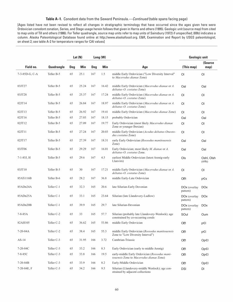
60
Table A–1. Conodont data from the Seward Peninsula.—Continued (table spans facing page)[Ages listed have not been revised to reflect all changes in stratigraphic terminology that have occurred since the ages given here were Ordovician conodont zonation, Series, and Stage usage herein follows that given in Harris and others (1995). Geologic unit (source map) from cited to map units of Till and others (1986). For Teller quadrangle, source map units refer to map units of Sainsbury (1972) if unspecified; (69b) indicates a column. Alaska Paleontological Database found online at http://www.alaskafossil.org. E&R, Examination and Report by USGS paleontologist;on sheet 2; see table A-2 for temperature ranges for CAI values]
determined. For example, the Middle/Upper Ordovician boundary has been revised downward considerably (see, for example, Webby and others, 2004).reference (if published) or provided by collector. For Bendeleben, Candle, Kotzebue, Norton Bay, and Solomon quadrangles, source map units refermap unit of Sainsbury (1969b). Unit in bracket (for example, [Ols]) indicates outcrop too small to show on map, or other issue explained in remarksID, conodont fauna identifier; N.D., not determined; USGS no., number under which collection is filed in USGS repository. Localities are plotted
Lat (N)
Long (W)
Geologic unit
ColorAlteration
Index (CAI)
Field no. Quadrangle
Deg
Min
Deg
Min Age
(This map)(Source
map)
Min
Max USGS no.E&R
shipment no.Sample
collectorSample
ID Remarks
7-3-85D-G, C-A Teller B-5 65 25.1 167 1.5 middle Early Ordovician ("Low Diversity Interval" to Macerodus dianae Zone)
Ol Ol 4 4 10223-CO through 10229-CO
A-85-23F Harris Harris, Repetski Samples re-examined by J.E. Repetski, 2/08. Entries in Alaska Paleontological Database. All 7 samples are from a measured section between the Don and Lost Rivers.
03JT27 Teller B-5 65 25.24 167 16.42 middle Early Ordovician (Macerodus dianae or A. deltatus-O. costatus Zone)
Oal Oal 2.5 2.5 11973-CO – Toro Repetski Sample from thin-bedded, platy, argillaceous limestone with trace fossils.
03JT28 Teller B-5 65 25.37 167 17.24 middle Early Ordovician (Macerodus dianae or A. deltatus-O. costatus Zone)
Ol Ol 2.5 2.5 11974-CO – Toro Repetski Sample from thick-bedded gray limestone with discontinuous partings.
02JT14 Teller B-5 65 26.84 167 18.97 middle Early Ordovician (Macerodus dianae or A. deltatus-O. costatus Zone)
Ol Ol 2 2.5 11959-CO – Toro Repetski Sample from thin-bedded gray limestone.
02JT13 Teller B-5 65 26.92 167 19.41 middle Early Ordovician (Macerodus dianae Zone) Ol Ol 2 2 11958-CO – Toro Repetski Sample from thin-bedded gray limestone.
02JT16 Teller B-5 65 27.03 167 18.15 probably Ordovician Oal Oal ~6.5 ~6.5 11960-CO – Toro Repetski Sample from thin-bedded, tan-weathering limestone.
02JT12 Teller B-5 65 27.09 167 19.77 Early Ordovician (most likely Macerodus dianae Zone or younger Ibexian)
Ol Ol 2 2 11957-CO – Toro Repetski Sample from thick-bedded gray-brown limestone.
02JT11 Teller B-5 65 27.24 167 20.03 middle Early Ordovician (Acodus deltatus-Oneoto-dus costatus Zone)
Ol Ol 2 2 11956-CO – Toro Repetski Sample from thin-bedded gray limestone.
02JT17 Teller B-5 65 27.39 167 18.31 early Early Ordovician (Rossodus manitouensis Zone)
Oal Oal 5 5.5 11961-CO – Toro Repetski Sample from thin-bedded, orange-weathering limestone.
03JT06 Teller B-5 65 29.29 167 16.01 Early Ordovician; most likely M. dianae or A. deltatus-O. costatus Zone.
Oal Oal 2 2.5 11964-CO – Toro Repetski Sample from brownish-red micritic limestone.
7-1-85J, H Teller B-5 65 29.6 167 4.5 earliest Middle Ordovician (latest Arenig-early Llanvirn)
Ols Oshl, Olsh (69b)
4 4 10221-CO, 10222-CO
A-85-23F Harris Harris, Repetski Age revised by A.G. Harris in 1995. Entries in Alaska Paleontological Database. Trilobites on strike with higher sample are of Llanvirn age (Ross, 1965; Sains-bury, 1969b).
03JT10 Teller B-5 65 30 167 17.21 middle Early Ordovician (Macerodus dianae or A. deltatus-O. costatus Zone)
Ol Ol 2 2.5 11966-CO – Toro Repetski Sample from medium- to thick-bedded gray micritic limestone.
85ATi116B Teller B-6 65 28.2 167 36.8 middle Early-Late Ordovician O<t p_s 5.5 5.5 10212-CO A-85-23D Dumoulin, Till
Harris –
85ADn24A Teller C-1 65 32.3 165 20.6 late Silurian-Early Devonian DOx (overlay pattern)
DOx 5.5 5.5 11306-SD A-85-23J Dumoulin Harris Entry in Alaska Paleontological Database.
85ADn25A Teller C-1 65 33.1 165 23.64 Silurian (late Llandovery-Ludlow) DOx (overlay pattern)
DOx 6 7 11399-SD A-85-23K Dumoulin Harris Age revised by A.G. Harris in 1994.
85ADn20B Teller C-1 65 39.9 165 29.7 late Silurian-Devonian DOx (overlay pattern)
DOx 5 5.5 11231-SD A-85-23E Dumoulin Harris –
7-8-85A Teller C-2 65 33 165 57.7 Silurian (probably late Llandovery-Wenlock); age constrained by co-occurring corals
SOul Oum 5 5 10979-SD A-85-23E Harris Harris –
82AH105 Teller C-2 65 36.62 165 53.86 middle Early Ordovician O<l p_l 4 4 – – Anaconda Carr Sample collected by Anaconda Minerals Co.; location approximate. Conodonts identified by T. Carr, Atlantic Richfield Co., 1982.
7-20-84A Teller C-2 65 38.4 165 55.3 middle Early Ordovician (Rossodus manitouensis Zone to "Low Diversity Interval")
O<l p_l 4.5 4.5 9917-CO A-85-10 Harris Repetski Sample re-examined by J.E. Repetski, 2/08. Entry in Alaska Paleontological Database.
AS-14 Teller C-3 65 31.95 166 3.72 Cambrian-Triassic O<l Op_l 6 6 – – Anaconda Carr Sample collected by Anaconda Minerals Co.; location approximate. Conodonts identified by T. Carr, Atlantic Richfield Co., 1982.
7-20-84C Teller C-3 65 33.2 166 8.3 Early Ordovician (early to middle Arenig) O<l Op_l 4 4 10587-CO A-87-9 Harris Harris –
7-8-85C Teller C-3 65 33.8 166 19.5 early-middle Early Ordovician (Rossodus mani-touensis Zone to Macerodus dianae Zone)
O<l Op_l 4 4.5 10214-CO A-85-23E Harris Harris –
7-20-84B Teller C-3 65 33.9 166 8.2 Early-Middle Ordovician O<l Op_l 4 4 10586-CO A-87-9 Harris Harris –
7-20-84E, F Teller C-3 65 34.2 166 9.5 Silurian (Llandovery-middle Wenlock); age con-strained by adjacent collections
DSl Dl 4 4 11534-SD, 11535-SD
A-87-8A Harris Harris –
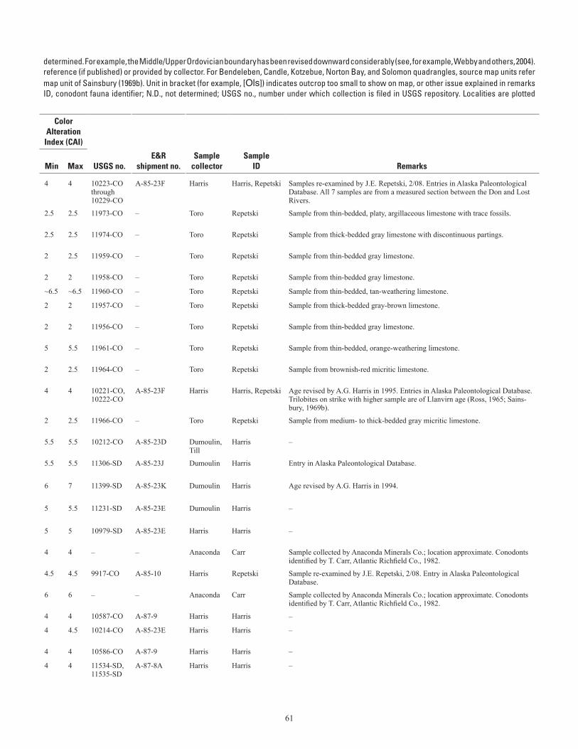
61
Table A–1. Conodont data from the Seward Peninsula.—Continued (table spans facing page)[Ages listed have not been revised to reflect all changes in stratigraphic terminology that have occurred since the ages given here were Ordovician conodont zonation, Series, and Stage usage herein follows that given in Harris and others (1995). Geologic unit (source map) from cited to map units of Till and others (1986). For Teller quadrangle, source map units refer to map units of Sainsbury (1972) if unspecified; (69b) indicates a column. Alaska Paleontological Database found online at http://www.alaskafossil.org. E&R, Examination and Report by USGS paleontologist;on sheet 2; see table A-2 for temperature ranges for CAI values]
determined. For example, the Middle/Upper Ordovician boundary has been revised downward considerably (see, for example, Webby and others, 2004).reference (if published) or provided by collector. For Bendeleben, Candle, Kotzebue, Norton Bay, and Solomon quadrangles, source map units refermap unit of Sainsbury (1969b). Unit in bracket (for example, [Ols]) indicates outcrop too small to show on map, or other issue explained in remarksID, conodont fauna identifier; N.D., not determined; USGS no., number under which collection is filed in USGS repository. Localities are plotted
Lat (N)
Long (W)
Geologic unit
ColorAlteration
Index (CAI)
Field no. Quadrangle
Deg
Min
Deg
Min Age
(This map)(Source
map)
Min
Max USGS no.E&R
shipment no.Sample
collectorSample
ID Remarks
7-3-85D-G, C-A Teller B-5 65 25.1 167 1.5 middle Early Ordovician ("Low Diversity Interval" to Macerodus dianae Zone)
Ol Ol 4 4 10223-CO through 10229-CO
A-85-23F Harris Harris, Repetski Samples re-examined by J.E. Repetski, 2/08. Entries in Alaska Paleontological Database. All 7 samples are from a measured section between the Don and Lost Rivers.
03JT27 Teller B-5 65 25.24 167 16.42 middle Early Ordovician (Macerodus dianae or A. deltatus-O. costatus Zone)
Oal Oal 2.5 2.5 11973-CO – Toro Repetski Sample from thin-bedded, platy, argillaceous limestone with trace fossils.
03JT28 Teller B-5 65 25.37 167 17.24 middle Early Ordovician (Macerodus dianae or A. deltatus-O. costatus Zone)
Ol Ol 2.5 2.5 11974-CO – Toro Repetski Sample from thick-bedded gray limestone with discontinuous partings.
02JT14 Teller B-5 65 26.84 167 18.97 middle Early Ordovician (Macerodus dianae or A. deltatus-O. costatus Zone)
Ol Ol 2 2.5 11959-CO – Toro Repetski Sample from thin-bedded gray limestone.
02JT13 Teller B-5 65 26.92 167 19.41 middle Early Ordovician (Macerodus dianae Zone) Ol Ol 2 2 11958-CO – Toro Repetski Sample from thin-bedded gray limestone.
02JT16 Teller B-5 65 27.03 167 18.15 probably Ordovician Oal Oal ~6.5 ~6.5 11960-CO – Toro Repetski Sample from thin-bedded, tan-weathering limestone.
02JT12 Teller B-5 65 27.09 167 19.77 Early Ordovician (most likely Macerodus dianae Zone or younger Ibexian)
Ol Ol 2 2 11957-CO – Toro Repetski Sample from thick-bedded gray-brown limestone.
02JT11 Teller B-5 65 27.24 167 20.03 middle Early Ordovician (Acodus deltatus-Oneoto-dus costatus Zone)
Ol Ol 2 2 11956-CO – Toro Repetski Sample from thin-bedded gray limestone.
02JT17 Teller B-5 65 27.39 167 18.31 early Early Ordovician (Rossodus manitouensis Zone)
Oal Oal 5 5.5 11961-CO – Toro Repetski Sample from thin-bedded, orange-weathering limestone.
03JT06 Teller B-5 65 29.29 167 16.01 Early Ordovician; most likely M. dianae or A. deltatus-O. costatus Zone.
Oal Oal 2 2.5 11964-CO – Toro Repetski Sample from brownish-red micritic limestone.
7-1-85J, H Teller B-5 65 29.6 167 4.5 earliest Middle Ordovician (latest Arenig-early Llanvirn)
Ols Oshl, Olsh (69b)
4 4 10221-CO, 10222-CO
A-85-23F Harris Harris, Repetski Age revised by A.G. Harris in 1995. Entries in Alaska Paleontological Database. Trilobites on strike with higher sample are of Llanvirn age (Ross, 1965; Sains-bury, 1969b).
03JT10 Teller B-5 65 30 167 17.21 middle Early Ordovician (Macerodus dianae or A. deltatus-O. costatus Zone)
Ol Ol 2 2.5 11966-CO – Toro Repetski Sample from medium- to thick-bedded gray micritic limestone.
85ATi116B Teller B-6 65 28.2 167 36.8 middle Early-Late Ordovician O<t p_s 5.5 5.5 10212-CO A-85-23D Dumoulin, Till
Harris –
85ADn24A Teller C-1 65 32.3 165 20.6 late Silurian-Early Devonian DOx (overlay pattern)
DOx 5.5 5.5 11306-SD A-85-23J Dumoulin Harris Entry in Alaska Paleontological Database.
85ADn25A Teller C-1 65 33.1 165 23.64 Silurian (late Llandovery-Ludlow) DOx (overlay pattern)
DOx 6 7 11399-SD A-85-23K Dumoulin Harris Age revised by A.G. Harris in 1994.
85ADn20B Teller C-1 65 39.9 165 29.7 late Silurian-Devonian DOx (overlay pattern)
DOx 5 5.5 11231-SD A-85-23E Dumoulin Harris –
7-8-85A Teller C-2 65 33 165 57.7 Silurian (probably late Llandovery-Wenlock); age constrained by co-occurring corals
SOul Oum 5 5 10979-SD A-85-23E Harris Harris –
82AH105 Teller C-2 65 36.62 165 53.86 middle Early Ordovician O<l p_l 4 4 – – Anaconda Carr Sample collected by Anaconda Minerals Co.; location approximate. Conodonts identified by T. Carr, Atlantic Richfield Co., 1982.
7-20-84A Teller C-2 65 38.4 165 55.3 middle Early Ordovician (Rossodus manitouensis Zone to "Low Diversity Interval")
O<l p_l 4.5 4.5 9917-CO A-85-10 Harris Repetski Sample re-examined by J.E. Repetski, 2/08. Entry in Alaska Paleontological Database.
AS-14 Teller C-3 65 31.95 166 3.72 Cambrian-Triassic O<l Op_l 6 6 – – Anaconda Carr Sample collected by Anaconda Minerals Co.; location approximate. Conodonts identified by T. Carr, Atlantic Richfield Co., 1982.
7-20-84C Teller C-3 65 33.2 166 8.3 Early Ordovician (early to middle Arenig) O<l Op_l 4 4 10587-CO A-87-9 Harris Harris –
7-8-85C Teller C-3 65 33.8 166 19.5 early-middle Early Ordovician (Rossodus mani-touensis Zone to Macerodus dianae Zone)
O<l Op_l 4 4.5 10214-CO A-85-23E Harris Harris –
7-20-84B Teller C-3 65 33.9 166 8.2 Early-Middle Ordovician O<l Op_l 4 4 10586-CO A-87-9 Harris Harris –
7-20-84E, F Teller C-3 65 34.2 166 9.5 Silurian (Llandovery-middle Wenlock); age con-strained by adjacent collections
DSl Dl 4 4 11534-SD, 11535-SD
A-87-8A Harris Harris –
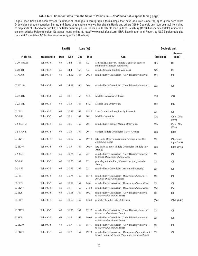
62
Table A–1. Conodont data from the Seward Peninsula.—Continued (table spans facing page)[Ages listed have not been revised to reflect all changes in stratigraphic terminology that have occurred since the ages given here were Ordovician conodont zonation, Series, and Stage usage herein follows that given in Harris and others (1995). Geologic unit (source map) from cited to map units of Till and others (1986). For Teller quadrangle, source map units refer to map units of Sainsbury (1972) if unspecified; (69b) indicates a column. Alaska Paleontological Database found online at http://www.alaskafossil.org. E&R, Examination and Report by USGS paleontologist;on sheet 2; see table A-2 for temperature ranges for CAI values]
determined. For example, the Middle/Upper Ordovician boundary has been revised downward considerably (see, for example, Webby and others, 2004).reference (if published) or provided by collector. For Bendeleben, Candle, Kotzebue, Norton Bay, and Solomon quadrangles, source map units refermap unit of Sainsbury (1969b). Unit in bracket (for example, [Ols]) indicates outcrop too small to show on map, or other issue explained in remarksID, conodont fauna identifier; N.D., not determined; USGS no., number under which collection is filed in USGS repository. Localities are plotted
Lat (N)
Long (W)
Geologic unit
ColorAlteration
Index (CAI)
Field no. Quadrangle
Deg
Min
Deg
Min Age
(This map)(Source
map)
Min
Max USGS no.E&R
shipment no.Sample
collectorSample
ID Remarks
7-20-84G, H Teller C-3 65 34.4 166 9.2 Silurian (Llandovery-middle Wenlock); age con-strained by adjacent collections
DSl Dl 4 4 11536-SD, 11537-SD
A-87-8A Harris Harris –
7-20-84I Teller C-3 65 34.4 166 9.2 middle Silurian (middle Wenlock) DSl Dl 4 4 11538-SD A-87-8A Harris Harris –
07AD9Z Teller C-3 65 34.62 166 20.33 middle Early Ordovician ("Low Diversity Interval") O<l Ol 4 4.5 12109-CO – Dumoulin Harris, Repetski These rocks mapped as small, fault-bounded area of Ol by Sainsbury (1972). Age and lithofacies most like those of unit Oal, however. Sample re-examined by J.E. Repetski, 8/10.
07AD10A Teller C-3 65 34.69 166 20.4 middle Early Ordovician ("Low Diversity Interval") O<l Ol 4 4.5 12110-CO – Dumoulin Harris, Repetski These rocks mapped as small, fault-bounded area of Ol by Sainsbury (1972). Age and lithofacies most like those of unit Oal, however. Sample re-examined by J.E. Repetski, 8/10.
7-22-84K Teller C-4 65 30.1 166 55.2 Middle Ordovician-Silurian Ol? Ol? 3 4 – A-87-9 Harris Harris These rocks mapped by Sainsbury (1969a) as Ol, but lithofacies and conodonts more like those of unit SOdl.
7-22-84L Teller C-4 65 31.3 166 54.2 Middle-Late Ordovician Ol? Ol? 3 3.5 10588-CO A-87-9 Harris Harris These rocks mapped by Sainsbury (1969a) as Ol, but lithofacies and conodonts more like those of unit SOdl.
03JT12 Teller C-5 65 30.59 167 18.87 Late Cambrian through early Paleozoic Ol Ol ~5.0 ~5.0 11968-CO – Toro Repetski –
7-5-85A Teller C-5 65 30.6 167 20.1 Middle Ordovician Ols Oshl, Olsh (69b)
2 2 10203-CO A-85-23B Harris Harris From measured section near the Mint River. USGS no. was incorrect in original E&R.
7-5-85B, C Teller C-5 65 30.6 167 20.1 middle Early-earliest Middle Ordovician Ols Oshl, Olsh (69b)
2 2 10204-CO, 10205-CO
A-85-23B Harris Harris From measured section near the Mint River. USGS no. was incorrect in original E&R.
7-5-85D, E Teller C-5 65 30.6 167 20.1 earliest Middle Ordovician (latest Arenig) Ols Olsh 2 2 10206-CO, 10207-CO
A-85-23B Harris Harris From measured section near the Mint River. USGS no. was incorrect in original E&R.
93BK44 Teller C-5 65 30.67 167 19.79 late Early Ordovician (middle Arenig; lower Oe. communis Zone)
Ol Ol (at/near top of unit)
2 2.5 11160-CO O-94-21 Kennedy Harris, Repetski Sample re-examined by Repetski, 2/08.
93BK46 Teller C-5 65 30.7 167 20.59 late Early to early Middle Ordovician (middle-late Arenig)
Ols Olsh (69b) 2 2 11161-CO O-94-21 Kennedy Harris, Repetski Sample re-examined by Repetski, 2/08.
7-5-85H Teller C-5 65 30.75 167 22 middle Early Ordovician ("Low Diversity Interval" to lower Macerodus dianae Zone)
Ol Ol 2 2 10208-CO A-85-23B Harris Harris Sample re-examined by J.E. Repetski, 6/09. From measured section near the Mint River. USGS no. was incorrect in original E&R.
7-5-85I Teller C-5 65 30.75 167 22 probably middle Early Ordovician (early middle Arenig)
Ol Ol 2 2 10209-CO A-85-23B Harris Harris From measured section near the Mint River. USGS no. was incorrect in original E&R.
7-5-85F Teller C-5 65 30.75 167 22 middle Early Ordovician (early middle Arenig) Ol Ol 2 2 10210-CO A-85-23B Harris Harris From measured section near the Mint River. USGS no. was incorrect in original E&R.
03JT11 Teller C-5 65 30.78 167 18.48 middle Early Ordovician (Macerodus dianae or A. deltatus-O. costatus Zone)
Ol Ol 2 2 11967-CO – Toro Repetski Sample from medium- to thick-bedded gray micritic limestone.
02JT33 Teller C-5 65 30.87 167 14.61 middle Early Ordovician (Macerodus dianae Zone) Ol Ol 2 2 11962-CO – Toro Repetski Sample from fossiliferous gray limestone.
93BK47 Teller C-5 65 31.1 167 21.52 middle Early Ordovician (Macerodus dianae Zone) Oal Oal 2 2.5 11162-CO O-94-21 Kennedy Harris, Repetski Sample re-examined by J.E. Repetski, 2/08.
93BK8 Teller C-5 65 31.05 167 19.2 middle Early Ordovician ("Low Diversity Interval" to Macerodus dianae Zone)
Ol Ol 2 2 11149-CO O-94-21 Kennedy Harris, Repetski Sample re-examined by J.E. Repetski, 2/08.
03JT07 Teller C-5 65 30.69 167 13.69 probably Middle-Late Ordovician [Ols] Olsh (69b) N.D. N.D. 11965-CO – Toro Repetski Sample from brown, smooth, dolomitic limestone. Fauna consists of numerous, mostly fragmental chitinozoans; age based on examination of these by A. Achab, 2/08. Sample is from an outcrop of Ols too small to show on map.
93BK39 Teller C-5 65 31.53 167 22.57 middle Early Ordovician ("Low Diversity Interval" to Macerodus dianae Zone)
Ol Ol 2.5 2.5 11159-CO O-94-21 Kennedy Harris, Repetski Sample re-examined by J.E. Repetski, 2/08.
93BK9 Teller C-5 65 31.7 167 19.09 middle Early Ordovician ("Low Diversity Interval" to Macerodus dianae Zone)
Ol Ol 2 2.5 11150-CO O-94-21 Kennedy Harris, Repetski Sample re-examined by J.E. Repetski, 2/08.
93BK10 Teller C-5 65 31.7 167 18.71 middle Early Ordovician ("Low Diversity Interval" to Macerodus dianae Zone)
Ol Ol 2 2 11151-CO O-94-21 Kennedy Harris, Repetski Sample re-examined by J.E. Repetski, 2/08.
93BK22 Teller C-5 65 31.7 167 19.13 middle Early Ordovician (Macerodus dianae Zone to lowest Acodus deltatus-Oneotodus costatus Zone)
Ol Ol 2 2.5 11155-CO O-94-21 Kennedy Harris, Repetski Sample re-examined by J.E. Repetski, 2/08.
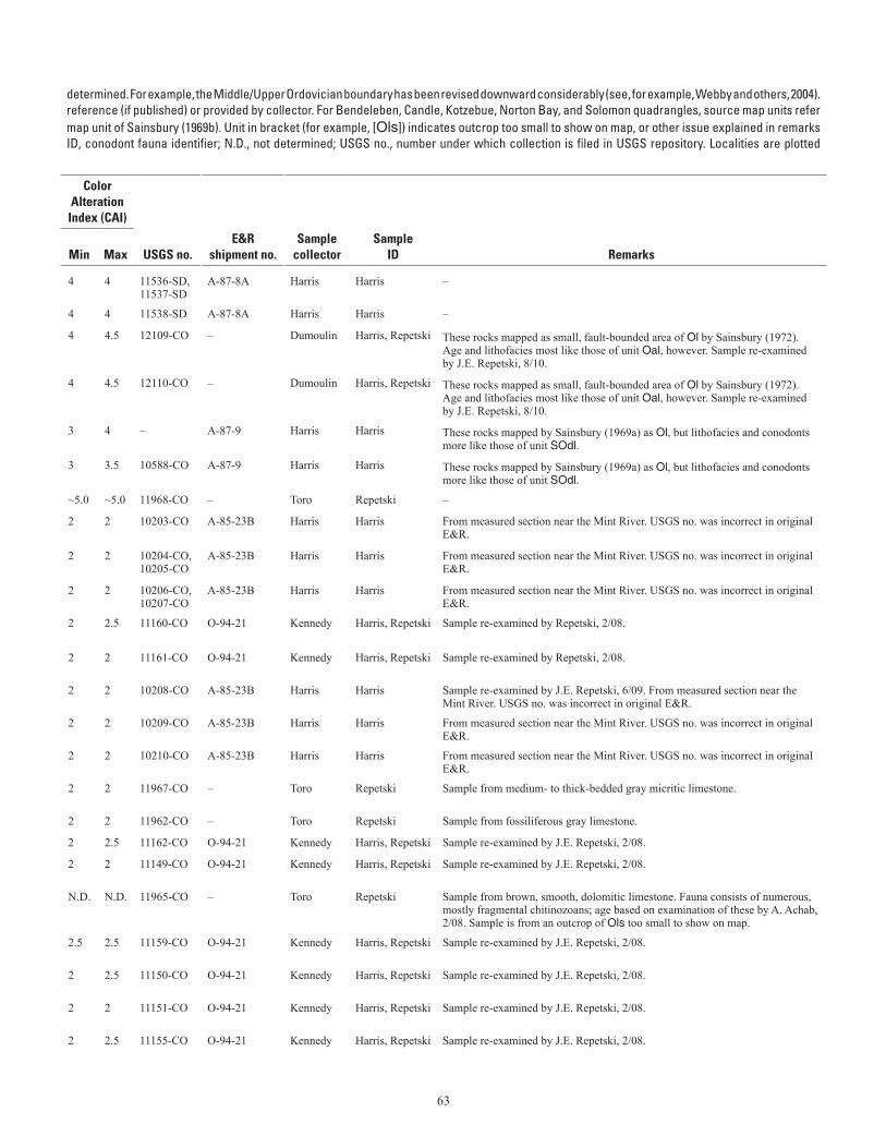
63
Table A–1. Conodont data from the Seward Peninsula.—Continued (table spans facing page)[Ages listed have not been revised to reflect all changes in stratigraphic terminology that have occurred since the ages given here were Ordovician conodont zonation, Series, and Stage usage herein follows that given in Harris and others (1995). Geologic unit (source map) from cited to map units of Till and others (1986). For Teller quadrangle, source map units refer to map units of Sainsbury (1972) if unspecified; (69b) indicates a column. Alaska Paleontological Database found online at http://www.alaskafossil.org. E&R, Examination and Report by USGS paleontologist;on sheet 2; see table A-2 for temperature ranges for CAI values]
determined. For example, the Middle/Upper Ordovician boundary has been revised downward considerably (see, for example, Webby and others, 2004).reference (if published) or provided by collector. For Bendeleben, Candle, Kotzebue, Norton Bay, and Solomon quadrangles, source map units refermap unit of Sainsbury (1969b). Unit in bracket (for example, [Ols]) indicates outcrop too small to show on map, or other issue explained in remarksID, conodont fauna identifier; N.D., not determined; USGS no., number under which collection is filed in USGS repository. Localities are plotted
Lat (N)
Long (W)
Geologic unit
ColorAlteration
Index (CAI)
Field no. Quadrangle
Deg
Min
Deg
Min Age
(This map)(Source
map)
Min
Max USGS no.E&R
shipment no.Sample
collectorSample
ID Remarks
7-20-84G, H Teller C-3 65 34.4 166 9.2 Silurian (Llandovery-middle Wenlock); age con-strained by adjacent collections
DSl Dl 4 4 11536-SD, 11537-SD
A-87-8A Harris Harris –
7-20-84I Teller C-3 65 34.4 166 9.2 middle Silurian (middle Wenlock) DSl Dl 4 4 11538-SD A-87-8A Harris Harris –
07AD9Z Teller C-3 65 34.62 166 20.33 middle Early Ordovician ("Low Diversity Interval") O<l Ol 4 4.5 12109-CO – Dumoulin Harris, Repetski These rocks mapped as small, fault-bounded area of Ol by Sainsbury (1972). Age and lithofacies most like those of unit Oal, however. Sample re-examined by J.E. Repetski, 8/10.
07AD10A Teller C-3 65 34.69 166 20.4 middle Early Ordovician ("Low Diversity Interval") O<l Ol 4 4.5 12110-CO – Dumoulin Harris, Repetski These rocks mapped as small, fault-bounded area of Ol by Sainsbury (1972). Age and lithofacies most like those of unit Oal, however. Sample re-examined by J.E. Repetski, 8/10.
7-22-84K Teller C-4 65 30.1 166 55.2 Middle Ordovician-Silurian Ol? Ol? 3 4 – A-87-9 Harris Harris These rocks mapped by Sainsbury (1969a) as Ol, but lithofacies and conodonts more like those of unit SOdl.
7-22-84L Teller C-4 65 31.3 166 54.2 Middle-Late Ordovician Ol? Ol? 3 3.5 10588-CO A-87-9 Harris Harris These rocks mapped by Sainsbury (1969a) as Ol, but lithofacies and conodonts more like those of unit SOdl.
03JT12 Teller C-5 65 30.59 167 18.87 Late Cambrian through early Paleozoic Ol Ol ~5.0 ~5.0 11968-CO – Toro Repetski –
7-5-85A Teller C-5 65 30.6 167 20.1 Middle Ordovician Ols Oshl, Olsh (69b)
2 2 10203-CO A-85-23B Harris Harris From measured section near the Mint River. USGS no. was incorrect in original E&R.
7-5-85B, C Teller C-5 65 30.6 167 20.1 middle Early-earliest Middle Ordovician Ols Oshl, Olsh (69b)
2 2 10204-CO, 10205-CO
A-85-23B Harris Harris From measured section near the Mint River. USGS no. was incorrect in original E&R.
7-5-85D, E Teller C-5 65 30.6 167 20.1 earliest Middle Ordovician (latest Arenig) Ols Olsh 2 2 10206-CO, 10207-CO
A-85-23B Harris Harris From measured section near the Mint River. USGS no. was incorrect in original E&R.
93BK44 Teller C-5 65 30.67 167 19.79 late Early Ordovician (middle Arenig; lower Oe. communis Zone)
Ol Ol (at/near top of unit)
2 2.5 11160-CO O-94-21 Kennedy Harris, Repetski Sample re-examined by Repetski, 2/08.
93BK46 Teller C-5 65 30.7 167 20.59 late Early to early Middle Ordovician (middle-late Arenig)
Ols Olsh (69b) 2 2 11161-CO O-94-21 Kennedy Harris, Repetski Sample re-examined by Repetski, 2/08.
7-5-85H Teller C-5 65 30.75 167 22 middle Early Ordovician ("Low Diversity Interval" to lower Macerodus dianae Zone)
Ol Ol 2 2 10208-CO A-85-23B Harris Harris Sample re-examined by J.E. Repetski, 6/09. From measured section near the Mint River. USGS no. was incorrect in original E&R.
7-5-85I Teller C-5 65 30.75 167 22 probably middle Early Ordovician (early middle Arenig)
Ol Ol 2 2 10209-CO A-85-23B Harris Harris From measured section near the Mint River. USGS no. was incorrect in original E&R.
7-5-85F Teller C-5 65 30.75 167 22 middle Early Ordovician (early middle Arenig) Ol Ol 2 2 10210-CO A-85-23B Harris Harris From measured section near the Mint River. USGS no. was incorrect in original E&R.
03JT11 Teller C-5 65 30.78 167 18.48 middle Early Ordovician (Macerodus dianae or A. deltatus-O. costatus Zone)
Ol Ol 2 2 11967-CO – Toro Repetski Sample from medium- to thick-bedded gray micritic limestone.
02JT33 Teller C-5 65 30.87 167 14.61 middle Early Ordovician (Macerodus dianae Zone) Ol Ol 2 2 11962-CO – Toro Repetski Sample from fossiliferous gray limestone.
93BK47 Teller C-5 65 31.1 167 21.52 middle Early Ordovician (Macerodus dianae Zone) Oal Oal 2 2.5 11162-CO O-94-21 Kennedy Harris, Repetski Sample re-examined by J.E. Repetski, 2/08.
93BK8 Teller C-5 65 31.05 167 19.2 middle Early Ordovician ("Low Diversity Interval" to Macerodus dianae Zone)
Ol Ol 2 2 11149-CO O-94-21 Kennedy Harris, Repetski Sample re-examined by J.E. Repetski, 2/08.
03JT07 Teller C-5 65 30.69 167 13.69 probably Middle-Late Ordovician [Ols] Olsh (69b) N.D. N.D. 11965-CO – Toro Repetski Sample from brown, smooth, dolomitic limestone. Fauna consists of numerous, mostly fragmental chitinozoans; age based on examination of these by A. Achab, 2/08. Sample is from an outcrop of Ols too small to show on map.
93BK39 Teller C-5 65 31.53 167 22.57 middle Early Ordovician ("Low Diversity Interval" to Macerodus dianae Zone)
Ol Ol 2.5 2.5 11159-CO O-94-21 Kennedy Harris, Repetski Sample re-examined by J.E. Repetski, 2/08.
93BK9 Teller C-5 65 31.7 167 19.09 middle Early Ordovician ("Low Diversity Interval" to Macerodus dianae Zone)
Ol Ol 2 2.5 11150-CO O-94-21 Kennedy Harris, Repetski Sample re-examined by J.E. Repetski, 2/08.
93BK10 Teller C-5 65 31.7 167 18.71 middle Early Ordovician ("Low Diversity Interval" to Macerodus dianae Zone)
Ol Ol 2 2 11151-CO O-94-21 Kennedy Harris, Repetski Sample re-examined by J.E. Repetski, 2/08.
93BK22 Teller C-5 65 31.7 167 19.13 middle Early Ordovician (Macerodus dianae Zone to lowest Acodus deltatus-Oneotodus costatus Zone)
Ol Ol 2 2.5 11155-CO O-94-21 Kennedy Harris, Repetski Sample re-examined by J.E. Repetski, 2/08.
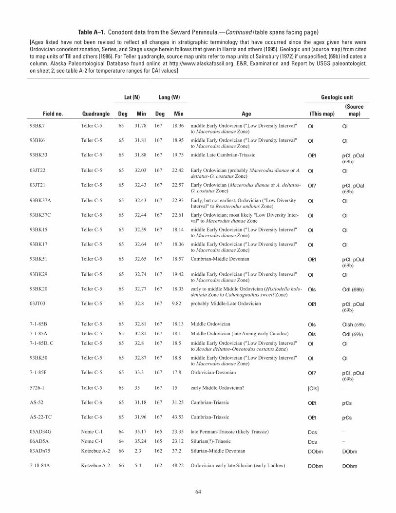
64
Table A–1. Conodont data from the Seward Peninsula.—Continued (table spans facing page)[Ages listed have not been revised to reflect all changes in stratigraphic terminology that have occurred since the ages given here were Ordovician conodont zonation, Series, and Stage usage herein follows that given in Harris and others (1995). Geologic unit (source map) from cited to map units of Till and others (1986). For Teller quadrangle, source map units refer to map units of Sainsbury (1972) if unspecified; (69b) indicates a column. Alaska Paleontological Database found online at http://www.alaskafossil.org. E&R, Examination and Report by USGS paleontologist;on sheet 2; see table A-2 for temperature ranges for CAI values]
determined. For example, the Middle/Upper Ordovician boundary has been revised downward considerably (see, for example, Webby and others, 2004).reference (if published) or provided by collector. For Bendeleben, Candle, Kotzebue, Norton Bay, and Solomon quadrangles, source map units refermap unit of Sainsbury (1969b). Unit in bracket (for example, [Ols]) indicates outcrop too small to show on map, or other issue explained in remarksID, conodont fauna identifier; N.D., not determined; USGS no., number under which collection is filed in USGS repository. Localities are plotted
Lat (N)
Long (W)
Geologic unit
ColorAlteration
Index (CAI)
Field no. Quadrangle
Deg
Min
Deg
Min Age
(This map)(Source
map)
Min
Max USGS no.E&R
shipment no.Sample
collectorSample
ID Remarks
93BK7 Teller C-5 65 31.78 167 18.96 middle Early Ordovician ("Low Diversity Interval" to Macerodus dianae Zone)
Ol Ol 2 2 11148-CO O-94-21 Kennedy Harris, Repetski Sample re-examined by J.E. Repetski, 2/08.
93BK6 Teller C-5 65 31.81 167 18.95 middle Early Ordovician ("Low Diversity Interval" to Macerodus dianae Zone)
Ol Ol 2 2 11147-CO O-94-21 Kennedy Harris, Repetski Sample re-examined by J.E. Repetski, 2/08.
93BK33 Teller C-5 65 31.88 167 19.75 middle Late Cambrian-Triassic O<l p_l, pOal (69b)
2 4 – O-94-21 Kennedy Harris, Repetski Sample re-examined by J.E. Repetski, 2/08; indeterminate conodont fragment.
03JT22 Teller C-5 65 32.03 167 22.42 Early Ordovician (probably Macerodus dianae or A. deltatus-O. costatus Zone)
Ol Ol 2 2.5 11970-CO – Toro Repetski Sample from medium- to thick-bedded, tan-weathering limestone with trace fossils.
03JT21 Teller C-5 65 32.43 167 22.57 Early Ordovician (Macerodus dianae or A. deltatus-O. costatus Zone)
Ol? p_l, pOal (69b)
2 2 11969-CO – Toro Repetski Sample from medium- to thin-bedded, orange-weathering limestone. Rocks mapped by Sainsbury (1972) as p_l, but thermal level more like that of unit Ol.
93BK37A Teller C-5 65 32.43 167 22.93 Early, but not earliest, Ordovician ("Low Diversity Interval" to Reutterodus andinus Zone)
Ol Ol 2.5 2.5 11157-CO O-94-21 Kennedy Harris, Repetski Sample re-examined by J.E. Repetski, 2/08.
93BK37C Teller C-5 65 32.44 167 22.61 Early Ordovician; most likely "Low Diversity Inter-val" to Macerodus dianae Zone
Ol Ol 2 3 11158-CO O-94-21 Kennedy Harris, Repetski Sample re-examined by J.E. Repetski, 2/08.
93BK15 Teller C-5 65 32.59 167 18.14 middle Early Ordovician ("Low Diversity Interval" to Macerodus dianae Zone)
Ol Ol 2 2 11152-CO O-94-21 Kennedy Harris, Repetski Sample re-examined by J.E. Repetski, 2/08.
93BK17 Teller C-5 65 32.64 167 18.06 middle Early Ordovician ("Low Diversity Interval" to Macerodus dianae Zone)
Ol Ol 2 2 11153-CO O-94-21 Kennedy Harris, Repetski Sample re-examined by J.E. Repetski, 2/08.
93BK51 Teller C-5 65 32.65 167 18.57 Cambrian-Middle Devonian O<l p_l, pOul (69b)
N.D. N.D. – O-94-21 Kennedy Harris, Repetski Fauna consists of acrotretid brachiopod fragment.
93BK29 Teller C-5 65 32.74 167 19.42 middle Early Ordovician ("Low Diversity Interval" to Macerodus dianae Zone)
Ol Ol 2.5 2.5 11156-CO O-94-21 Kennedy Harris, Repetski Sample re-examined by J.E. Repetski, 2/08.
93BK20 Teller C-5 65 32.77 167 18.03 early to middle Middle Ordovician (Histiodella holo-dentata Zone to Cahabagnathus sweeti Zone)
Ols Odl (69b) 2 2 11154-CO O-94-21 Kennedy Harris, Repetski Sample re-examined by J.E. Repetski, 2/08.
03JT03 Teller C-5 65 32.8 167 9.82 probably Middle-Late Ordovician O<l p_l, pOal (69b)
N.D. N.D. 11963-CO – Toro Repetski Sample from dark-gray metalimestone with thin argillite bands. Fauna consists of 2 chitinozoans and 1 possible gastropod fragment; age based on examination of chitinozoans by A. Achab, 2/08.
7-1-85B Teller C-5 65 32.81 167 18.13 Middle Ordovician Ols Olsh (69b) 2 2.5 10219-CO A-85-23F Harris Harris, Repetski Entry in Alaska Paleontological Database.
7-1-85A Teller C-5 65 32.81 167 18.1 Middle Ordovician (late Arenig-early Caradoc) Ols Odl (69b) 1.5 2 10220-CO A-85-23F Harris Harris, Repetski Entry in Alaska Paleontological Database.
7-1-85D, C Teller C-5 65 32.8 167 18.5 middle Early Ordovician ("Low Diversity Interval" to Acodus deltatus-Oneotodus costatus Zone)
Ol Ol 2.5 3 10217-CO, 10218-CO
A-85-23F Harris Harris, Repetski Entries in Alaska Paleontological Database.
93BK50 Teller C-5 65 32.87 167 18.8 middle Early Ordovician ("Low Diversity Interval" to Macerodus dianae Zone)
Ol Ol 2 2.5 11163-CO O-94-21 Kennedy Harris, Repetski Sample re-examined by J.E. Repetski, 2/08.
7-1-85F Teller C-5 65 33.3 167 17.8 Ordovician-Devonian Ol? p_l, pOul (69b)
2 3 – A-85-23F Harris Harris, Repetski Entry in Alaska Paleontological Database. Rocks mapped by Sainsbury (1972) as p_l, but thermal level more like that of unit Ol.
5726-1 Teller C-5 65 35 167 15 early Middle Ordovician? [Ols] – 2 2 – – AMOCO Harris Sample likely slightly mislocated or taken from float in riverbed; probably from nearby Odl or Olsh of Sainsbury (1969b).
AS-52 Teller C-6 65 31.18 167 31.25 Cambrian-Triassic O<t p_s 6 6 – – Anaconda Carr Sample collected by Anaconda Minerals Co.; location approximate. Conodonts identified by T. Carr, Atlantic Richfield Co., 1982.
AS-22-TC Teller C-6 65 31.96 167 43.53 Cambrian-Triassic O<t p_s 6 6 – – Anaconda Carr Sample from gray carbonate layer, collected by Anaconda Minerals Co.; location approximate. Conodonts identified by T. Carr, Atlantic Richfield Co., 1982.
05AD34G Nome C-1 64 35.17 165 23.35 late Permian-Triassic (likely Triassic) Dcs – 5 5 Mes. 35059 WRMTA-05-1 Dumoulin Harris Till and others (2006). See Dcs unit description for discussion of this collection.
06AD5A Nome C-1 64 35.24 165 23.12 Silurian(?)-Triassic Dcs – 5 5 – WRMTA-06-1 Dumoulin Harris –
83ADn75 Kotzebue A-2 66 2.3 162 37.2 Silurian-Middle Devonian DObm DObm 5.5 6 10896-SD A-83-42C Dumoulin Harris Dumoulin and Till (1985); Till and others (1986). Entry in Alaska Paleontologi-cal Database.
7-18-84A Kotzebue A-2 66 5.4 162 48.22 Ordovician-early late Silurian (early Ludlow) DObm DObm 5.5 5.5 – A-87-8 Harris Harris Sample from base of ~380-m-thick measured section west of Cape Deceit.
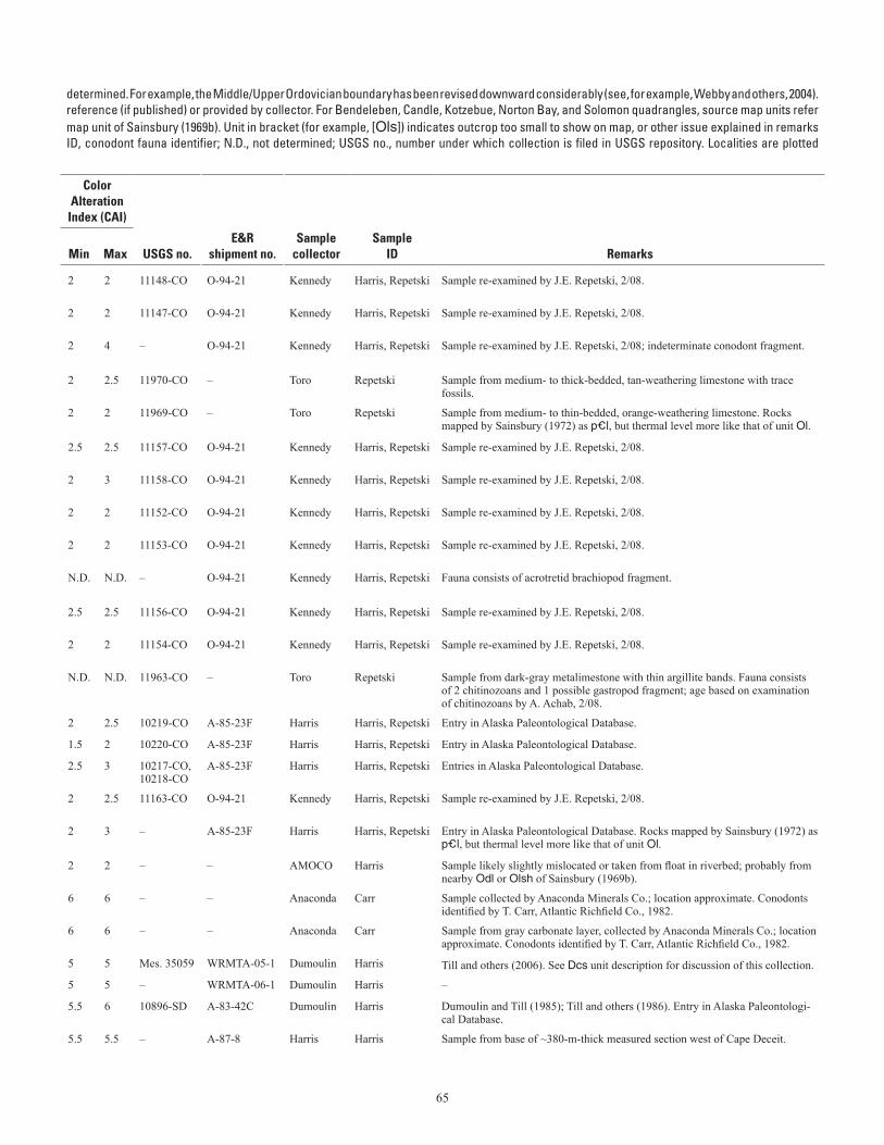
65
Table A–1. Conodont data from the Seward Peninsula.—Continued (table spans facing page)[Ages listed have not been revised to reflect all changes in stratigraphic terminology that have occurred since the ages given here were Ordovician conodont zonation, Series, and Stage usage herein follows that given in Harris and others (1995). Geologic unit (source map) from cited to map units of Till and others (1986). For Teller quadrangle, source map units refer to map units of Sainsbury (1972) if unspecified; (69b) indicates a column. Alaska Paleontological Database found online at http://www.alaskafossil.org. E&R, Examination and Report by USGS paleontologist;on sheet 2; see table A-2 for temperature ranges for CAI values]
determined. For example, the Middle/Upper Ordovician boundary has been revised downward considerably (see, for example, Webby and others, 2004).reference (if published) or provided by collector. For Bendeleben, Candle, Kotzebue, Norton Bay, and Solomon quadrangles, source map units refermap unit of Sainsbury (1969b). Unit in bracket (for example, [Ols]) indicates outcrop too small to show on map, or other issue explained in remarksID, conodont fauna identifier; N.D., not determined; USGS no., number under which collection is filed in USGS repository. Localities are plotted
Lat (N)
Long (W)
Geologic unit
ColorAlteration
Index (CAI)
Field no. Quadrangle
Deg
Min
Deg
Min Age
(This map)(Source
map)
Min
Max USGS no.E&R
shipment no.Sample
collectorSample
ID Remarks
93BK7 Teller C-5 65 31.78 167 18.96 middle Early Ordovician ("Low Diversity Interval" to Macerodus dianae Zone)
Ol Ol 2 2 11148-CO O-94-21 Kennedy Harris, Repetski Sample re-examined by J.E. Repetski, 2/08.
93BK6 Teller C-5 65 31.81 167 18.95 middle Early Ordovician ("Low Diversity Interval" to Macerodus dianae Zone)
Ol Ol 2 2 11147-CO O-94-21 Kennedy Harris, Repetski Sample re-examined by J.E. Repetski, 2/08.
93BK33 Teller C-5 65 31.88 167 19.75 middle Late Cambrian-Triassic O<l p_l, pOal (69b)
2 4 – O-94-21 Kennedy Harris, Repetski Sample re-examined by J.E. Repetski, 2/08; indeterminate conodont fragment.
03JT22 Teller C-5 65 32.03 167 22.42 Early Ordovician (probably Macerodus dianae or A. deltatus-O. costatus Zone)
Ol Ol 2 2.5 11970-CO – Toro Repetski Sample from medium- to thick-bedded, tan-weathering limestone with trace fossils.
03JT21 Teller C-5 65 32.43 167 22.57 Early Ordovician (Macerodus dianae or A. deltatus-O. costatus Zone)
Ol? p_l, pOal (69b)
2 2 11969-CO – Toro Repetski Sample from medium- to thin-bedded, orange-weathering limestone. Rocks mapped by Sainsbury (1972) as p_l, but thermal level more like that of unit Ol.
93BK37A Teller C-5 65 32.43 167 22.93 Early, but not earliest, Ordovician ("Low Diversity Interval" to Reutterodus andinus Zone)
Ol Ol 2.5 2.5 11157-CO O-94-21 Kennedy Harris, Repetski Sample re-examined by J.E. Repetski, 2/08.
93BK37C Teller C-5 65 32.44 167 22.61 Early Ordovician; most likely "Low Diversity Inter-val" to Macerodus dianae Zone
Ol Ol 2 3 11158-CO O-94-21 Kennedy Harris, Repetski Sample re-examined by J.E. Repetski, 2/08.
93BK15 Teller C-5 65 32.59 167 18.14 middle Early Ordovician ("Low Diversity Interval" to Macerodus dianae Zone)
Ol Ol 2 2 11152-CO O-94-21 Kennedy Harris, Repetski Sample re-examined by J.E. Repetski, 2/08.
93BK17 Teller C-5 65 32.64 167 18.06 middle Early Ordovician ("Low Diversity Interval" to Macerodus dianae Zone)
Ol Ol 2 2 11153-CO O-94-21 Kennedy Harris, Repetski Sample re-examined by J.E. Repetski, 2/08.
93BK51 Teller C-5 65 32.65 167 18.57 Cambrian-Middle Devonian O<l p_l, pOul (69b)
N.D. N.D. – O-94-21 Kennedy Harris, Repetski Fauna consists of acrotretid brachiopod fragment.
93BK29 Teller C-5 65 32.74 167 19.42 middle Early Ordovician ("Low Diversity Interval" to Macerodus dianae Zone)
Ol Ol 2.5 2.5 11156-CO O-94-21 Kennedy Harris, Repetski Sample re-examined by J.E. Repetski, 2/08.
93BK20 Teller C-5 65 32.77 167 18.03 early to middle Middle Ordovician (Histiodella holo-dentata Zone to Cahabagnathus sweeti Zone)
Ols Odl (69b) 2 2 11154-CO O-94-21 Kennedy Harris, Repetski Sample re-examined by J.E. Repetski, 2/08.
03JT03 Teller C-5 65 32.8 167 9.82 probably Middle-Late Ordovician O<l p_l, pOal (69b)
N.D. N.D. 11963-CO – Toro Repetski Sample from dark-gray metalimestone with thin argillite bands. Fauna consists of 2 chitinozoans and 1 possible gastropod fragment; age based on examination of chitinozoans by A. Achab, 2/08.
7-1-85B Teller C-5 65 32.81 167 18.13 Middle Ordovician Ols Olsh (69b) 2 2.5 10219-CO A-85-23F Harris Harris, Repetski Entry in Alaska Paleontological Database.
7-1-85A Teller C-5 65 32.81 167 18.1 Middle Ordovician (late Arenig-early Caradoc) Ols Odl (69b) 1.5 2 10220-CO A-85-23F Harris Harris, Repetski Entry in Alaska Paleontological Database.
7-1-85D, C Teller C-5 65 32.8 167 18.5 middle Early Ordovician ("Low Diversity Interval" to Acodus deltatus-Oneotodus costatus Zone)
Ol Ol 2.5 3 10217-CO, 10218-CO
A-85-23F Harris Harris, Repetski Entries in Alaska Paleontological Database.
93BK50 Teller C-5 65 32.87 167 18.8 middle Early Ordovician ("Low Diversity Interval" to Macerodus dianae Zone)
Ol Ol 2 2.5 11163-CO O-94-21 Kennedy Harris, Repetski Sample re-examined by J.E. Repetski, 2/08.
7-1-85F Teller C-5 65 33.3 167 17.8 Ordovician-Devonian Ol? p_l, pOul (69b)
2 3 – A-85-23F Harris Harris, Repetski Entry in Alaska Paleontological Database. Rocks mapped by Sainsbury (1972) as p_l, but thermal level more like that of unit Ol.
5726-1 Teller C-5 65 35 167 15 early Middle Ordovician? [Ols] – 2 2 – – AMOCO Harris Sample likely slightly mislocated or taken from float in riverbed; probably from nearby Odl or Olsh of Sainsbury (1969b).
AS-52 Teller C-6 65 31.18 167 31.25 Cambrian-Triassic O<t p_s 6 6 – – Anaconda Carr Sample collected by Anaconda Minerals Co.; location approximate. Conodonts identified by T. Carr, Atlantic Richfield Co., 1982.
AS-22-TC Teller C-6 65 31.96 167 43.53 Cambrian-Triassic O<t p_s 6 6 – – Anaconda Carr Sample from gray carbonate layer, collected by Anaconda Minerals Co.; location approximate. Conodonts identified by T. Carr, Atlantic Richfield Co., 1982.
05AD34G Nome C-1 64 35.17 165 23.35 late Permian-Triassic (likely Triassic) Dcs – 5 5 Mes. 35059 WRMTA-05-1 Dumoulin Harris Till and others (2006). See Dcs unit description for discussion of this collection.
06AD5A Nome C-1 64 35.24 165 23.12 Silurian(?)-Triassic Dcs – 5 5 – WRMTA-06-1 Dumoulin Harris –
83ADn75 Kotzebue A-2 66 2.3 162 37.2 Silurian-Middle Devonian DObm DObm 5.5 6 10896-SD A-83-42C Dumoulin Harris Dumoulin and Till (1985); Till and others (1986). Entry in Alaska Paleontologi-cal Database.
7-18-84A Kotzebue A-2 66 5.4 162 48.22 Ordovician-early late Silurian (early Ludlow) DObm DObm 5.5 5.5 – A-87-8 Harris Harris Sample from base of ~380-m-thick measured section west of Cape Deceit.
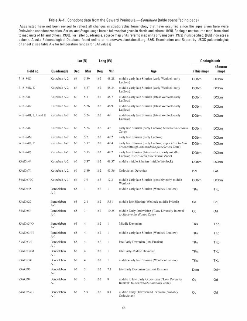
66
Table A–1. Conodont data from the Seward Peninsula.—Continued (table spans facing page)[Ages listed have not been revised to reflect all changes in stratigraphic terminology that have occurred since the ages given here were Ordovician conodont zonation, Series, and Stage usage herein follows that given in Harris and others (1995). Geologic unit (source map) from cited to map units of Till and others (1986). For Teller quadrangle, source map units refer to map units of Sainsbury (1972) if unspecified; (69b) indicates a column. Alaska Paleontological Database found online at http://www.alaskafossil.org. E&R, Examination and Report by USGS paleontologist;on sheet 2; see table A-2 for temperature ranges for CAI values]
determined. For example, the Middle/Upper Ordovician boundary has been revised downward considerably (see, for example, Webby and others, 2004).reference (if published) or provided by collector. For Bendeleben, Candle, Kotzebue, Norton Bay, and Solomon quadrangles, source map units refermap unit of Sainsbury (1969b). Unit in bracket (for example, [Ols]) indicates outcrop too small to show on map, or other issue explained in remarksID, conodont fauna identifier; N.D., not determined; USGS no., number under which collection is filed in USGS repository. Localities are plotted
Lat (N)
Long (W)
Geologic unit
ColorAlteration
Index (CAI)
Field no. Quadrangle
Deg
Min
Deg
Min Age
(This map)(Source
map)
Min
Max USGS no.E&R
shipment no.Sample
collectorSample
ID Remarks
7-18-84C Kotzebue A-2 66 5.39 162 48.28 middle-early late Silurian (early Wenlock-early Ludlow)
DObm DObm 5.5 5.5 11533-SD A-87-8 Harris Harris Sample 171 m above base of Cape Deceit measured section.
7-18-84D, E Kotzebue A-2 66 5.37 162 48.34 middle-early late Silurian (early Wenlock-early Ludlow)
DObm DObm 5.5 6 11520-SD, 11521-SD
A-87-8 Harris Harris Samples 196 and 217 m above base of Cape Deceit measured section.
7-18-84F Kotzebue A-2 66 5.3 162 48.7 middle-early late Silurian (latest Wenlock-early Ludlow)
DObm DObm 5.5 7 11522-SD A-87-8 Harris Harris Sample 233 m above base of Cape Deceit measured section; collection consists of normal marine cosmopolites.
7-18-84G Kotzebue A-2 66 5.26 162 48.9 middle-early late Silurian (latest Wenlock-early Ludlow)
DObm DObm 5.5 6 11523-SD A-87-8 Harris Harris Sample 265 m above base of Cape Deceit measured section.
7-18-84H, I, J, and K Kotzebue A-2 66 5.24 162 49 middle-early late Silurian (latest Wenlock-early Ludlow)
DObm DObm 5.5 7 11524-SD through 11527-SD
A-87-8 Harris Harris Samples 271 m (H, I), 289 m (J), and 320 m (K) above base of Cape Deceit measured section.
7-18-84L Kotzebue A-2 66 5.24 162 49 early late Silurian (early Ludlow; Ozarkodina crassa Zone)
DObm DObm 5.5 7 11528-SD A-87-8 Harris Harris Sample 320.5 m above base of Cape Deceit measured section.
7-18-84M Kotzebue A-2 66 5.2 162 49.2 early late Silurian (early Ludlow) DObm DObm 5.5 7 11529-SD A-87-8 Harris Harris Sample 332 m above base of Cape Deceit measured section.
7-18-84O, P Kotzebue A-2 66 5.17 162 49.4 early late Silurian (early Ludlow; upper Ozarkodina crassa through Ancoradella ploeckensis Zone)
DObm DObm 5.5 7 11530-SD, 11531-SD
A-87-8 Harris Harris Samples 348 and 358.5 m above base of Cape Deceit measured section.
7-18-84Q Kotzebue A-2 66 5.13 162 49.7 early late Silurian (latest early to early middle Ludlow; Ancoradella ploeckensis Zone)
DObm DObm 5.5 7 11532-SD A-87-8 Harris Harris Sample 378 m above base of Cape Deceit measured section.
83ADn44 Kotzebue A-2 66 5.37 162 48.37 middle middle Silurian (middle Wenlock) DObm DObm 5.5 7.5 10907-SD A-83-42C Dumoulin Harris Dumoulin and Till (1985); Till and others (1986). Entry in Alaska Paleontologi-cal Database.
83ADn74 Kotzebue A-2 66 5.89 162 45.36 Ordovician-Devonian |d |d 7 7 – A-83-42C Dumoulin Harris Dumoulin and Till (1985); Till and others (1986). Entry in Alaska Paleontologi-cal Database.
84ADn79C Kotzebue A-3 66 3.9 163 12.3 middle-early late Silurian (possibly early-middle Wenlock)
DObm DObm 5.5 6 11062-SD A-84-37A Dumoulin Harris Till and others (1986). Entry in Alaska Paleontological Database.
82ADu45 Bendeleben A-1
65 1 162 1 middle-early late Silurian (Wenlock-Ludlow) TKs TKc 5 5 10725-SD A-83-9 Dumoulin Harris Till and others (1986); age revised by A.G. Harris in 1995. Entry in Alaska Pale-ontological Database. Sample is a clast from the conglomerate; species associa-tion indicates relatively high energy, shallow-water depositional setting.
83ADn27 Bendeleben A-1
65 2.1 162 5.51 middle-late Silurian (Wenlock-middle Pridoli) Sd Sd 5.5 6 10904-SD A-83-42C Dumoulin Harris Till and others (1986). Entry in Alaska Paleontological Database. Species asso-ciation indicates shallow, warm-water depositional setting.
84ADn54 Bendeleben A-1
65 3 162 10.25 middle Early Ordovician ("Low Diversity Interval" to Macerodus dianae Zone)
Od Od 5.5 7 9897-CO A-84-37D Dumoulin Harris, Repetski Till and others (1986); age revised by A.G. Harris in 1995, and confirmed by J.E. Repetski in 2008. Entry in Alaska Paleontological Database. Species association is characteristic of normal marine conditions.
83ADn34O Bendeleben A-1
65 4 162 1 Middle Devonian TKs TKc 5.5 6 10903-SD A-83-42C Dumoulin Harris Till and others (1986). Entry in Alaska Paleontological Database. Sample is a clast in the conglomerate.
83ADn34H Bendeleben A-1
65 4 162 1 middle-early late Silurian (Wenlock-Ludlow) TKs TKc 5.5 5.5 – A-83-42C Dumoulin Harris Till and others (1986); age revised by A.G. Harris in 1995. Entry in Alaska Pale-ontological Database. Sample is a clast in the conglomerate.
83ADn34I Bendeleben A-1
65 4 162 1 late Early Devonian (late Emsian) TKs TKc 5 5 10891-SD A-83-42F Dumoulin Harris Till and others (1986). Entry in Alaska Paleontological Database. Sample is a clast in the conglomerate.
83ADn34M Bendeleben A-1
65 4 162 1 late Early-Middle Devonian TKs TKc 5.5 5.5 10892-SD A-83-42C, F Dumoulin Harris Till and others (1986). Entry in Alaska Paleontological Database. Sample is a clast in the conglomerate.
83ADn34L Bendeleben A-1
65 4 162 1 middle-early late Silurian (Wenlock-Ludlow) TKs TKc 5 5 – A-83-42C Dumoulin Harris Till and others (1986); age revised by A.G. Harris in 1995. Entry in Alaska Pale-ontological Database. Sample is a clast in the conglomerate.
83ACl96 Bendeleben A-1
65 5 162 7.1 late Early Devonian (earliest Emsian) Ddm Ddm 5.5 5.5 10893-SD A-83-42C,A-84-50C
Carroll Harris Till and others (1986). Entry in Alaska Paleontological Database.
83ACl94 Bendeleben A-1
65 5 162 8 middle to late Early Ordovician ("Low Diversity Interval" to Reutterodus andinus Zone)
Od Od 5.5 6 9800-CO A-83-42C Carroll Harris, Repetski Till and others (1986); sample re-examined and age confirmed by J.E. Repetski, 2/08. Entry in Alaska Paleontological Database. Species association indicates warm, shallow-water biofacies.
84ADn57B Bendeleben A-1
65 5.9 162 8.1 middle Early Ordovician-Devonian (probably Ordovician)
Od Od 7 7 – A-84-37C Dumoulin Harris Till and others (1986). Entry in Alaska Paleontological Database.
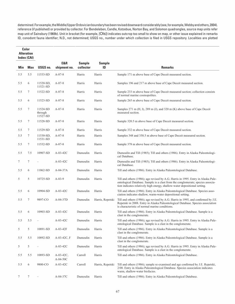
67
Table A–1. Conodont data from the Seward Peninsula.—Continued (table spans facing page)[Ages listed have not been revised to reflect all changes in stratigraphic terminology that have occurred since the ages given here were Ordovician conodont zonation, Series, and Stage usage herein follows that given in Harris and others (1995). Geologic unit (source map) from cited to map units of Till and others (1986). For Teller quadrangle, source map units refer to map units of Sainsbury (1972) if unspecified; (69b) indicates a column. Alaska Paleontological Database found online at http://www.alaskafossil.org. E&R, Examination and Report by USGS paleontologist;on sheet 2; see table A-2 for temperature ranges for CAI values]
determined. For example, the Middle/Upper Ordovician boundary has been revised downward considerably (see, for example, Webby and others, 2004).reference (if published) or provided by collector. For Bendeleben, Candle, Kotzebue, Norton Bay, and Solomon quadrangles, source map units refermap unit of Sainsbury (1969b). Unit in bracket (for example, [Ols]) indicates outcrop too small to show on map, or other issue explained in remarksID, conodont fauna identifier; N.D., not determined; USGS no., number under which collection is filed in USGS repository. Localities are plotted
Lat (N)
Long (W)
Geologic unit
ColorAlteration
Index (CAI)
Field no. Quadrangle
Deg
Min
Deg
Min Age
(This map)(Source
map)
Min
Max USGS no.E&R
shipment no.Sample
collectorSample
ID Remarks
7-18-84C Kotzebue A-2 66 5.39 162 48.28 middle-early late Silurian (early Wenlock-early Ludlow)
DObm DObm 5.5 5.5 11533-SD A-87-8 Harris Harris Sample 171 m above base of Cape Deceit measured section.
7-18-84D, E Kotzebue A-2 66 5.37 162 48.34 middle-early late Silurian (early Wenlock-early Ludlow)
DObm DObm 5.5 6 11520-SD, 11521-SD
A-87-8 Harris Harris Samples 196 and 217 m above base of Cape Deceit measured section.
7-18-84F Kotzebue A-2 66 5.3 162 48.7 middle-early late Silurian (latest Wenlock-early Ludlow)
DObm DObm 5.5 7 11522-SD A-87-8 Harris Harris Sample 233 m above base of Cape Deceit measured section; collection consists of normal marine cosmopolites.
7-18-84G Kotzebue A-2 66 5.26 162 48.9 middle-early late Silurian (latest Wenlock-early Ludlow)
DObm DObm 5.5 6 11523-SD A-87-8 Harris Harris Sample 265 m above base of Cape Deceit measured section.
7-18-84H, I, J, and K Kotzebue A-2 66 5.24 162 49 middle-early late Silurian (latest Wenlock-early Ludlow)
DObm DObm 5.5 7 11524-SD through 11527-SD
A-87-8 Harris Harris Samples 271 m (H, I), 289 m (J), and 320 m (K) above base of Cape Deceit measured section.
7-18-84L Kotzebue A-2 66 5.24 162 49 early late Silurian (early Ludlow; Ozarkodina crassa Zone)
DObm DObm 5.5 7 11528-SD A-87-8 Harris Harris Sample 320.5 m above base of Cape Deceit measured section.
7-18-84M Kotzebue A-2 66 5.2 162 49.2 early late Silurian (early Ludlow) DObm DObm 5.5 7 11529-SD A-87-8 Harris Harris Sample 332 m above base of Cape Deceit measured section.
7-18-84O, P Kotzebue A-2 66 5.17 162 49.4 early late Silurian (early Ludlow; upper Ozarkodina crassa through Ancoradella ploeckensis Zone)
DObm DObm 5.5 7 11530-SD, 11531-SD
A-87-8 Harris Harris Samples 348 and 358.5 m above base of Cape Deceit measured section.
7-18-84Q Kotzebue A-2 66 5.13 162 49.7 early late Silurian (latest early to early middle Ludlow; Ancoradella ploeckensis Zone)
DObm DObm 5.5 7 11532-SD A-87-8 Harris Harris Sample 378 m above base of Cape Deceit measured section.
83ADn44 Kotzebue A-2 66 5.37 162 48.37 middle middle Silurian (middle Wenlock) DObm DObm 5.5 7.5 10907-SD A-83-42C Dumoulin Harris Dumoulin and Till (1985); Till and others (1986). Entry in Alaska Paleontologi-cal Database.
83ADn74 Kotzebue A-2 66 5.89 162 45.36 Ordovician-Devonian |d |d 7 7 – A-83-42C Dumoulin Harris Dumoulin and Till (1985); Till and others (1986). Entry in Alaska Paleontologi-cal Database.
84ADn79C Kotzebue A-3 66 3.9 163 12.3 middle-early late Silurian (possibly early-middle Wenlock)
DObm DObm 5.5 6 11062-SD A-84-37A Dumoulin Harris Till and others (1986). Entry in Alaska Paleontological Database.
82ADu45 Bendeleben A-1
65 1 162 1 middle-early late Silurian (Wenlock-Ludlow) TKs TKc 5 5 10725-SD A-83-9 Dumoulin Harris Till and others (1986); age revised by A.G. Harris in 1995. Entry in Alaska Pale-ontological Database. Sample is a clast from the conglomerate; species associa-tion indicates relatively high energy, shallow-water depositional setting.
83ADn27 Bendeleben A-1
65 2.1 162 5.51 middle-late Silurian (Wenlock-middle Pridoli) Sd Sd 5.5 6 10904-SD A-83-42C Dumoulin Harris Till and others (1986). Entry in Alaska Paleontological Database. Species asso-ciation indicates shallow, warm-water depositional setting.
84ADn54 Bendeleben A-1
65 3 162 10.25 middle Early Ordovician ("Low Diversity Interval" to Macerodus dianae Zone)
Od Od 5.5 7 9897-CO A-84-37D Dumoulin Harris, Repetski Till and others (1986); age revised by A.G. Harris in 1995, and confirmed by J.E. Repetski in 2008. Entry in Alaska Paleontological Database. Species association is characteristic of normal marine conditions.
83ADn34O Bendeleben A-1
65 4 162 1 Middle Devonian TKs TKc 5.5 6 10903-SD A-83-42C Dumoulin Harris Till and others (1986). Entry in Alaska Paleontological Database. Sample is a clast in the conglomerate.
83ADn34H Bendeleben A-1
65 4 162 1 middle-early late Silurian (Wenlock-Ludlow) TKs TKc 5.5 5.5 – A-83-42C Dumoulin Harris Till and others (1986); age revised by A.G. Harris in 1995. Entry in Alaska Pale-ontological Database. Sample is a clast in the conglomerate.
83ADn34I Bendeleben A-1
65 4 162 1 late Early Devonian (late Emsian) TKs TKc 5 5 10891-SD A-83-42F Dumoulin Harris Till and others (1986). Entry in Alaska Paleontological Database. Sample is a clast in the conglomerate.
83ADn34M Bendeleben A-1
65 4 162 1 late Early-Middle Devonian TKs TKc 5.5 5.5 10892-SD A-83-42C, F Dumoulin Harris Till and others (1986). Entry in Alaska Paleontological Database. Sample is a clast in the conglomerate.
83ADn34L Bendeleben A-1
65 4 162 1 middle-early late Silurian (Wenlock-Ludlow) TKs TKc 5 5 – A-83-42C Dumoulin Harris Till and others (1986); age revised by A.G. Harris in 1995. Entry in Alaska Pale-ontological Database. Sample is a clast in the conglomerate.
83ACl96 Bendeleben A-1
65 5 162 7.1 late Early Devonian (earliest Emsian) Ddm Ddm 5.5 5.5 10893-SD A-83-42C,A-84-50C
Carroll Harris Till and others (1986). Entry in Alaska Paleontological Database.
83ACl94 Bendeleben A-1
65 5 162 8 middle to late Early Ordovician ("Low Diversity Interval" to Reutterodus andinus Zone)
Od Od 5.5 6 9800-CO A-83-42C Carroll Harris, Repetski Till and others (1986); sample re-examined and age confirmed by J.E. Repetski, 2/08. Entry in Alaska Paleontological Database. Species association indicates warm, shallow-water biofacies.
84ADn57B Bendeleben A-1
65 5.9 162 8.1 middle Early Ordovician-Devonian (probably Ordovician)
Od Od 7 7 – A-84-37C Dumoulin Harris Till and others (1986). Entry in Alaska Paleontological Database.
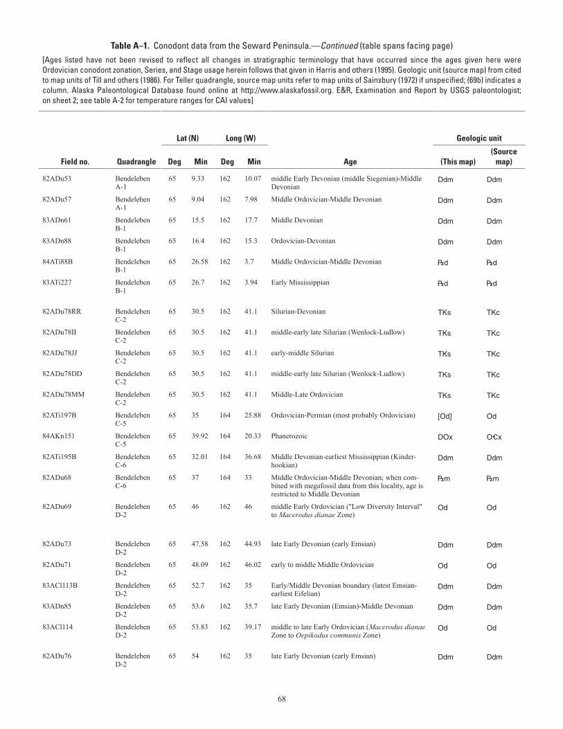
68
Table A–1. Conodont data from the Seward Peninsula.—Continued (table spans facing page)[Ages listed have not been revised to reflect all changes in stratigraphic terminology that have occurred since the ages given here were Ordovician conodont zonation, Series, and Stage usage herein follows that given in Harris and others (1995). Geologic unit (source map) from cited to map units of Till and others (1986). For Teller quadrangle, source map units refer to map units of Sainsbury (1972) if unspecified; (69b) indicates a column. Alaska Paleontological Database found online at http://www.alaskafossil.org. E&R, Examination and Report by USGS paleontologist;on sheet 2; see table A-2 for temperature ranges for CAI values]
determined. For example, the Middle/Upper Ordovician boundary has been revised downward considerably (see, for example, Webby and others, 2004).reference (if published) or provided by collector. For Bendeleben, Candle, Kotzebue, Norton Bay, and Solomon quadrangles, source map units refermap unit of Sainsbury (1969b). Unit in bracket (for example, [Ols]) indicates outcrop too small to show on map, or other issue explained in remarksID, conodont fauna identifier; N.D., not determined; USGS no., number under which collection is filed in USGS repository. Localities are plotted
Lat (N)
Long (W)
Geologic unit
ColorAlteration
Index (CAI)
Field no. Quadrangle
Deg
Min
Deg
Min Age
(This map)(Source
map)
Min
Max USGS no.E&R
shipment no.Sample
collectorSample
ID Remarks
82ADu53 Bendeleben A-1
65 9.33 162 10.07 middle Early Devonian (middle Siegenian)-Middle Devonian
Ddm Ddm 5 5 10723-SD A-83-9 Dumoulin Harris Till and others (1986). Entry in Alaska Paleontological Database.
82ADu57 Bendeleben A-1
65 9.04 162 7.98 Middle Ordovician-Middle Devonian Ddm Ddm 7 7 – A-83-9 Dumoulin Harris Till and others (1986). Entry in Alaska Paleontological Database.
83ADn61 Bendeleben B-1
65 15.5 162 17.7 Middle Devonian Ddm Ddm 5.5 5.5 10908-SD A-83-42C Dumoulin Harris Till and others (1986). Entry in Alaska Paleontological Database.
83ADn88 Bendeleben B-1
65 16.4 162 15.3 Ordovician-Devonian Ddm Ddm 5 5.5 – A-83-42C Dumoulin Harris Till and others (1986). Entry in Alaska Paleontological Database.
84ATi88B Bendeleben B-1
65 26.58 162 3.7 Middle Ordovician-Middle Devonian |d |d 8 8 – A-84-37C Till Harris Till and others (1986). Entry in Alaska Paleontological Database.
83ATi227 Bendeleben B-1
65 26.7 162 3.94 Early Mississippian |d |d 5.5 5.5 29218-PC A-83-42F Till Harris Till and others (1986); age revised by A.G. Harris in 1995. Entry in Alaska Pale-ontological Database. A recollection at this locality (84ATi88B) yielded older conodonts; see Till and others (1986) for discussion.
82ADu78RR Bendeleben C-2
65 30.5 162 41.1 Silurian-Devonian TKs TKc 4.5 4.5 10902-SD A-83-42C Dumoulin Harris Till and others (1986). Entry in Alaska Paleontological Database. Sample is a clast in the conglomerate.
82ADu78II Bendeleben C-2
65 30.5 162 41.1 middle-early late Silurian (Wenlock-Ludlow) TKs TKc 5 5.5 10894-SD A-83-42C Dumoulin Harris Till and others (1986). Entry in Alaska Paleontological Database. Sample is a clast in the conglomerate.
82ADu78JJ Bendeleben C-2
65 30.5 162 41.1 early-middle Silurian TKs TKc 5 6 10901-SD A-83-42C Dumoulin Harris Till and others (1986). Entry in Alaska Paleontological Database. Sample is a clast in the conglomerate.
82ADu78DD Bendeleben C-2
65 30.5 162 41.1 middle-early late Silurian (Wenlock-Ludlow) TKs TKc 5 5 10909-SD A-83-42C Dumoulin Harris Till and others (1986); age revised by A.G. Harris in 1995. Entry in Alaska Pale-ontological Database. Sample is a clast in the conglomerate.
82ADu78MM Bendeleben C-2
65 30.5 162 41.1 Middle-Late Ordovician TKs TKc 5.5 5.5 9799-CO A-83-42C Dumoulin Harris Till and others (1986). Entry in Alaska Paleontological Database. Sample is a clast in the conglomerate.
82ATi197B Bendeleben C-5
65 35 164 25.88 Ordovician-Permian (most probably Ordovician) [Od] Od 5 5 – A-83-10 Till Harris Till and others (1986). Entry in Alaska Paleontological Database. Sample is from an outcrop of Od too small to show on map.
84AKn151 Bendeleben C-5
65 39.92 164 20.33 Phanerozoic DOx O_x N.D. N.D. – A-85-15 Kaufman Harris Till and others (1986). Entry in Alaska Paleontological Database. Collection consists of phosphatic, non-conodont skeletal fragments.
82ATi195B Bendeleben C-6
65 32.01 164 36.68 Middle Devonian-earliest Mississippian (Kinder-hookian)
Ddm Ddm 5.5 5.5 – A-83-10 Till Harris Till and others (1986). Entry in Alaska Paleontological Database.
82ADu68 Bendeleben C-6
65 37 164 33 Middle Ordovician-Middle Devonian; when com-bined with megafossil data from this locality, age is restricted to Middle Devonian
|m |m 5.5 5.5 – A-83-9 Dumoulin Harris Till and others (1986). Entry in Alaska Paleontological Database.
82ADu69 Bendeleben D-2
65 46 162 46 middle Early Ordovician ("Low Diversity Interval" to Macerodus dianae Zone)
Od Od 5.5 7 9611-CO A-83-9 Dumoulin Harris, Repetski Till and others (1986); age revised by A.G. Harris in 1995; sample re-examined and age confirmed by J.E. Repetski in 2008. Entry in Alaska Paleontological Database. Species association is characteristic of very shallow, warm-water depositional setting.
82ADu73 Bendeleben D-2
65 47.58 162 44.93 late Early Devonian (early Emsian) Ddm Ddm 5 6.5 10727-SD A-83-9 Dumoulin Harris Till and others (1986). Entry in Alaska Paleontological Database.
82ADu71 Bendeleben D-2
65 48.09 162 46.02 early to middle Middle Ordovician Od Od 6 7 9612-CO A-83-9 Dumoulin Harris Till and others (1986); sample re-examined and age revised by J.E. Repetski in 2008. Entry in Alaska Paleontological Database.
83ACl113B Bendeleben D-2
65 52.7 162 35 Early/Middle Devonian boundary (latest Emsian-earliest Eifelian)
Ddm Ddm 5 5 10900-SD A-83-42C Carroll Harris Till and others (1986). Entry in Alaska Paleontological Database. Shallow-water species association.
83ADn85 Bendeleben D-2
65 53.6 162 35.7 late Early Devonian (Emsian)-Middle Devonian Ddm Ddm 5 5.5 10910-SD A-83-42C Dumoulin Harris Till and others (1986). Entry in Alaska Paleontological Database.
83ACl114 Bendeleben D-2
65 53.83 162 39.17 middle to late Early Ordovician (Macerodus dianae Zone to Oepikodus communis Zone)
Od Od 5 5 9679-CO A-83-42A Carroll Harris, Repetski Till and others (1986); sample re-examined and age confirmed by J.E. Repetski in 2008. Entry in Alaska Paleontological Database. Species association is charac-teristic of the North Atlantic Province early to middle Arenig cool-water faunas.
82ADu76 Bendeleben D-2
65 54 162 35 late Early Devonian (early Emsian) Ddm Ddm 5 5.5 10729-SD A-83-9 Dumoulin Harris Till and others (1986). Entry in Alaska Paleontological Database.
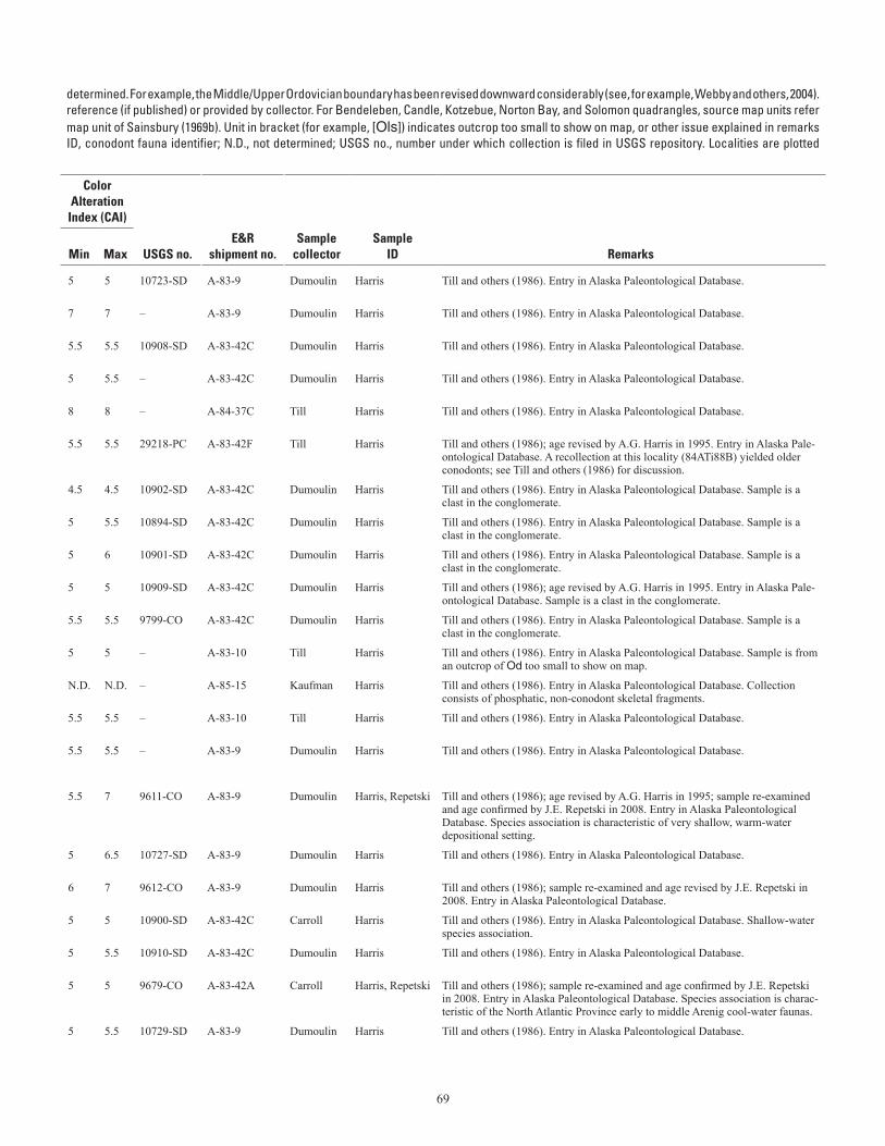
69
Table A–1. Conodont data from the Seward Peninsula.—Continued (table spans facing page)[Ages listed have not been revised to reflect all changes in stratigraphic terminology that have occurred since the ages given here were Ordovician conodont zonation, Series, and Stage usage herein follows that given in Harris and others (1995). Geologic unit (source map) from cited to map units of Till and others (1986). For Teller quadrangle, source map units refer to map units of Sainsbury (1972) if unspecified; (69b) indicates a column. Alaska Paleontological Database found online at http://www.alaskafossil.org. E&R, Examination and Report by USGS paleontologist;on sheet 2; see table A-2 for temperature ranges for CAI values]
determined. For example, the Middle/Upper Ordovician boundary has been revised downward considerably (see, for example, Webby and others, 2004).reference (if published) or provided by collector. For Bendeleben, Candle, Kotzebue, Norton Bay, and Solomon quadrangles, source map units refermap unit of Sainsbury (1969b). Unit in bracket (for example, [Ols]) indicates outcrop too small to show on map, or other issue explained in remarksID, conodont fauna identifier; N.D., not determined; USGS no., number under which collection is filed in USGS repository. Localities are plotted
Lat (N)
Long (W)
Geologic unit
ColorAlteration
Index (CAI)
Field no. Quadrangle
Deg
Min
Deg
Min Age
(This map)(Source
map)
Min
Max USGS no.E&R
shipment no.Sample
collectorSample
ID Remarks
82ADu53 Bendeleben A-1
65 9.33 162 10.07 middle Early Devonian (middle Siegenian)-Middle Devonian
Ddm Ddm 5 5 10723-SD A-83-9 Dumoulin Harris Till and others (1986). Entry in Alaska Paleontological Database.
82ADu57 Bendeleben A-1
65 9.04 162 7.98 Middle Ordovician-Middle Devonian Ddm Ddm 7 7 – A-83-9 Dumoulin Harris Till and others (1986). Entry in Alaska Paleontological Database.
83ADn61 Bendeleben B-1
65 15.5 162 17.7 Middle Devonian Ddm Ddm 5.5 5.5 10908-SD A-83-42C Dumoulin Harris Till and others (1986). Entry in Alaska Paleontological Database.
83ADn88 Bendeleben B-1
65 16.4 162 15.3 Ordovician-Devonian Ddm Ddm 5 5.5 – A-83-42C Dumoulin Harris Till and others (1986). Entry in Alaska Paleontological Database.
84ATi88B Bendeleben B-1
65 26.58 162 3.7 Middle Ordovician-Middle Devonian |d |d 8 8 – A-84-37C Till Harris Till and others (1986). Entry in Alaska Paleontological Database.
83ATi227 Bendeleben B-1
65 26.7 162 3.94 Early Mississippian |d |d 5.5 5.5 29218-PC A-83-42F Till Harris Till and others (1986); age revised by A.G. Harris in 1995. Entry in Alaska Pale-ontological Database. A recollection at this locality (84ATi88B) yielded older conodonts; see Till and others (1986) for discussion.
82ADu78RR Bendeleben C-2
65 30.5 162 41.1 Silurian-Devonian TKs TKc 4.5 4.5 10902-SD A-83-42C Dumoulin Harris Till and others (1986). Entry in Alaska Paleontological Database. Sample is a clast in the conglomerate.
82ADu78II Bendeleben C-2
65 30.5 162 41.1 middle-early late Silurian (Wenlock-Ludlow) TKs TKc 5 5.5 10894-SD A-83-42C Dumoulin Harris Till and others (1986). Entry in Alaska Paleontological Database. Sample is a clast in the conglomerate.
82ADu78JJ Bendeleben C-2
65 30.5 162 41.1 early-middle Silurian TKs TKc 5 6 10901-SD A-83-42C Dumoulin Harris Till and others (1986). Entry in Alaska Paleontological Database. Sample is a clast in the conglomerate.
82ADu78DD Bendeleben C-2
65 30.5 162 41.1 middle-early late Silurian (Wenlock-Ludlow) TKs TKc 5 5 10909-SD A-83-42C Dumoulin Harris Till and others (1986); age revised by A.G. Harris in 1995. Entry in Alaska Pale-ontological Database. Sample is a clast in the conglomerate.
82ADu78MM Bendeleben C-2
65 30.5 162 41.1 Middle-Late Ordovician TKs TKc 5.5 5.5 9799-CO A-83-42C Dumoulin Harris Till and others (1986). Entry in Alaska Paleontological Database. Sample is a clast in the conglomerate.
82ATi197B Bendeleben C-5
65 35 164 25.88 Ordovician-Permian (most probably Ordovician) [Od] Od 5 5 – A-83-10 Till Harris Till and others (1986). Entry in Alaska Paleontological Database. Sample is from an outcrop of Od too small to show on map.
84AKn151 Bendeleben C-5
65 39.92 164 20.33 Phanerozoic DOx O_x N.D. N.D. – A-85-15 Kaufman Harris Till and others (1986). Entry in Alaska Paleontological Database. Collection consists of phosphatic, non-conodont skeletal fragments.
82ATi195B Bendeleben C-6
65 32.01 164 36.68 Middle Devonian-earliest Mississippian (Kinder-hookian)
Ddm Ddm 5.5 5.5 – A-83-10 Till Harris Till and others (1986). Entry in Alaska Paleontological Database.
82ADu68 Bendeleben C-6
65 37 164 33 Middle Ordovician-Middle Devonian; when com-bined with megafossil data from this locality, age is restricted to Middle Devonian
|m |m 5.5 5.5 – A-83-9 Dumoulin Harris Till and others (1986). Entry in Alaska Paleontological Database.
82ADu69 Bendeleben D-2
65 46 162 46 middle Early Ordovician ("Low Diversity Interval" to Macerodus dianae Zone)
Od Od 5.5 7 9611-CO A-83-9 Dumoulin Harris, Repetski Till and others (1986); age revised by A.G. Harris in 1995; sample re-examined and age confirmed by J.E. Repetski in 2008. Entry in Alaska Paleontological Database. Species association is characteristic of very shallow, warm-water depositional setting.
82ADu73 Bendeleben D-2
65 47.58 162 44.93 late Early Devonian (early Emsian) Ddm Ddm 5 6.5 10727-SD A-83-9 Dumoulin Harris Till and others (1986). Entry in Alaska Paleontological Database.
82ADu71 Bendeleben D-2
65 48.09 162 46.02 early to middle Middle Ordovician Od Od 6 7 9612-CO A-83-9 Dumoulin Harris Till and others (1986); sample re-examined and age revised by J.E. Repetski in 2008. Entry in Alaska Paleontological Database.
83ACl113B Bendeleben D-2
65 52.7 162 35 Early/Middle Devonian boundary (latest Emsian-earliest Eifelian)
Ddm Ddm 5 5 10900-SD A-83-42C Carroll Harris Till and others (1986). Entry in Alaska Paleontological Database. Shallow-water species association.
83ADn85 Bendeleben D-2
65 53.6 162 35.7 late Early Devonian (Emsian)-Middle Devonian Ddm Ddm 5 5.5 10910-SD A-83-42C Dumoulin Harris Till and others (1986). Entry in Alaska Paleontological Database.
83ACl114 Bendeleben D-2
65 53.83 162 39.17 middle to late Early Ordovician (Macerodus dianae Zone to Oepikodus communis Zone)
Od Od 5 5 9679-CO A-83-42A Carroll Harris, Repetski Till and others (1986); sample re-examined and age confirmed by J.E. Repetski in 2008. Entry in Alaska Paleontological Database. Species association is charac-teristic of the North Atlantic Province early to middle Arenig cool-water faunas.
82ADu76 Bendeleben D-2
65 54 162 35 late Early Devonian (early Emsian) Ddm Ddm 5 5.5 10729-SD A-83-9 Dumoulin Harris Till and others (1986). Entry in Alaska Paleontological Database.
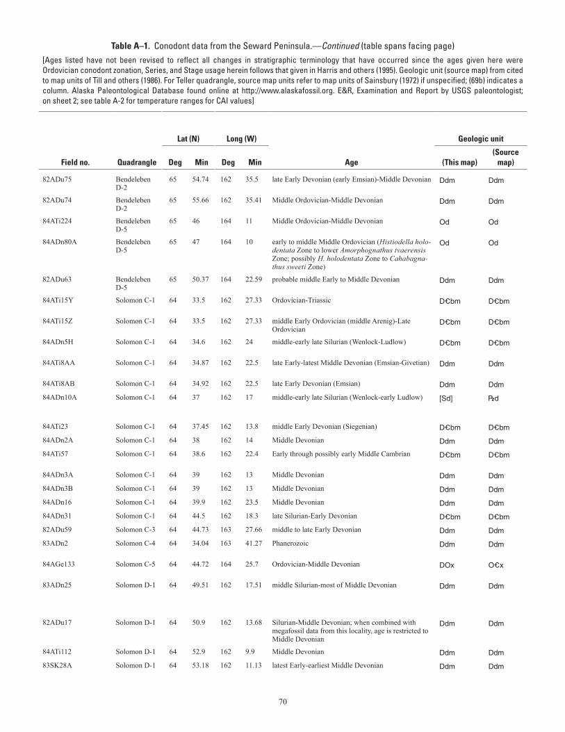
70
Table A–1. Conodont data from the Seward Peninsula.—Continued (table spans facing page)[Ages listed have not been revised to reflect all changes in stratigraphic terminology that have occurred since the ages given here were Ordovician conodont zonation, Series, and Stage usage herein follows that given in Harris and others (1995). Geologic unit (source map) from cited to map units of Till and others (1986). For Teller quadrangle, source map units refer to map units of Sainsbury (1972) if unspecified; (69b) indicates a column. Alaska Paleontological Database found online at http://www.alaskafossil.org. E&R, Examination and Report by USGS paleontologist;on sheet 2; see table A-2 for temperature ranges for CAI values]
determined. For example, the Middle/Upper Ordovician boundary has been revised downward considerably (see, for example, Webby and others, 2004).reference (if published) or provided by collector. For Bendeleben, Candle, Kotzebue, Norton Bay, and Solomon quadrangles, source map units refermap unit of Sainsbury (1969b). Unit in bracket (for example, [Ols]) indicates outcrop too small to show on map, or other issue explained in remarksID, conodont fauna identifier; N.D., not determined; USGS no., number under which collection is filed in USGS repository. Localities are plotted
Lat (N)
Long (W)
Geologic unit
ColorAlteration
Index (CAI)
Field no. Quadrangle
Deg
Min
Deg
Min Age
(This map)(Source
map)
Min
Max USGS no.E&R
shipment no.Sample
collectorSample
ID Remarks
82ADu75 Bendeleben D-2
65 54.74 162 35.5 late Early Devonian (early Emsian)-Middle Devonian Ddm Ddm 5 5 10728-SD A-83-9 Dumoulin Harris Till and others (1986). Entry in Alaska Paleontological Database.
82ADu74 Bendeleben D-2
65 55.66 162 35.41 Middle Ordovician-Middle Devonian Ddm Ddm 5 5.5 – A-83-9 Dumoulin Harris Till and others (1986). Entry in Alaska Paleontological Database.
84ATi224 Bendeleben D-5
65 46 164 11 Middle Ordovician-Middle Devonian Od Od 5 5 – A-85-15 Till Harris Till and others (1986). Entry in Alaska Paleontological Database.
84ADn80A Bendeleben D-5
65 47 164 10 early to middle Middle Ordovician (Histiodella holo-dentata Zone to lower Amorphognathus tvaerensis Zone; possibly H. holodentata Zone to Cahabagna-thus sweeti Zone)
Od Od 8 8 9889-CO A-84-37A Dumoulin Harris Till and others (1986); sample re-examined and age revised by J.E. Repetski in 2008. Entry in Alaska Paleontological Database. Species association is character-istic of a rather shallow and warm-water biofacies.
82ADu63 Bendeleben D-5
65 50.37 164 22.59 probable middle Early to Middle Devonian Ddm Ddm 5.5 5.5 – A-83-9 Dumoulin Harris Till and others (1986). Entry in Alaska Paleontological Database.
84ATi15Y Solomon C-1 64 33.5 162 27.33 Ordovician-Triassic D_bm D_bm 6 6 – A-85-23I Till Harris Till and others (1986). Entry in Alaska Paleontological Database. Sample taken from black marble in 5–10 cm thick layers.
84ATi15Z Solomon C-1 64 33.5 162 27.33 middle Early Ordovician (middle Arenig)-Late Ordovician
D_bm D_bm 5.5 5.5 10213-CO A-85-23D Dumoulin Harris Till and others (1986). Sample taken a few feet north of 15Y from black marble in 1–5 cm thick layers.
84ADn5H Solomon C-1 64 34.6 162 24 middle-early late Silurian (Wenlock-Ludlow) D_bm D_bm 5 6 11058-SD A-84-37A, C Dumoulin Harris Till and others (1986); age revised by A.G. Harris in 1995. Entry in Alaska Paleontological Database.
84ATi8AA Solomon C-1 64 34.87 162 22.5 late Early-latest Middle Devonian (Emsian-Givetian) Ddm Ddm 5 5.5 10996-SD A-84-37 Till, Dumoulin
Harris Till and others (1986). Entry in Alaska Paleontological Database.
84ATi8AB Solomon C-1 64 34.92 162 22.5 late Early Devonian (Emsian) Ddm Ddm 5 5.5 10997-SD A-84-37 Till Harris Till and others (1986). Entry in Alaska Paleontological Database.
84ADn10A Solomon C-1 64 37 162 17 middle-early late Silurian (Wenlock-early Ludlow) [Sd] |d 5.5 5.5 11031-SD A-84-37B Dumoulin Harris Till and others (1986); age revised by A.G. Harris in 1995. Entry in Alaska Paleontological Database. Sample is from an outcrop of Sd too small to show on map.
84ATi23 Solomon C-1 64 37.45 162 13.8 middle Early Devonian (Siegenian) D_bm D_bm 5 5 11173-SD A-85-23C Till Harris Till and others (1986). Entry in Alaska Paleontological Database.
84ADn2A Solomon C-1 64 38 162 14 Middle Devonian Ddm Ddm 5 5 10993-SD A-84-37 Dumoulin Harris Till and others (1986). Entry in Alaska Paleontological Database.
84ATi57 Solomon C-1 64 38.6 162 22.4 Early through possibly early Middle Cambrian D_bm D_bm 5 5 10060-CO A-85-23C Till Harris Till and others (1986). Entry in Alaska Paleontological Database. The phosphatic microfossil Lapworthella indicates a shallow-water depositional environment.
84ADn3A Solomon C-1 64 39 162 13 Middle Devonian Ddm Ddm 5 5.5 11030-SD A-84-37B Dumoulin Harris Till and others (1986). Entry in Alaska Paleontological Database.
84ADn3B Solomon C-1 64 39 162 13 Middle Devonian Ddm Ddm 5 5.5 10994-SD A-84-37 Dumoulin Harris Till and others (1986). Entry in Alaska Paleontological Database.
84ADn16 Solomon C-1 64 39.9 162 23.5 Middle Devonian Ddm Ddm 5 5.5 10995-SD A-84-37 Dumoulin Harris Till and others (1986). Entry in Alaska Paleontological Database.
84ADn31 Solomon C-1 64 44.5 162 18.3 late Silurian-Early Devonian D_bm D_bm 5 5.5 11059-SD A-84-37A Dumoulin Harris Till and others (1986). Entry in Alaska Paleontological Database.
82ADu59 Solomon C-3 64 44.73 163 27.66 middle to late Early Devonian Ddm Ddm 5 6 10726-SD A-83-9 Dumoulin Harris Till and others (1986). Entry in Alaska Paleontological Database.
83ADn2 Solomon C-4 64 34.04 163 41.27 Phanerozoic Ddm Ddm N.D. N.D. – A-83-42F Dumoulin Harris Till and others (1986). Entry in Alaska Paleontological Database. Collection consists of a pyritized and phosphatized spine steinkern.
84AGe133 Solomon C-5 64 44.72 164 25.7 Ordovician-Middle Devonian DOx O_x 6 6 – A-85-15 Gamble, Dumoulin
Harris Till and others (1986). Entry in Alaska Paleontological Database.
83ADn25 Solomon D-1 64 49.51 162 17.51 middle Silurian-most of Middle Devonian Ddm Ddm 5 5 10745-SD A-83-42C Dumoulin Harris Till and others (1986). Entry in Alaska Paleontological Database. Stromatopo-roids and corals from this locality are of early Late Devonian (Frasnian) age; the conodonts may be redeposited, or may have been collected from an older stratigraphic horizon than the megafossil-bearing rocks.
82ADu17 Solomon D-1 64 50.9 162 13.68 Silurian-Middle Devonian; when combined with megafossil data from this locality, age is restricted to Middle Devonian
Ddm Ddm 5.5 5.5 10724-SD A-83-9 Dumoulin Harris Till and others (1986). Entry in Alaska Paleontological Database.
84ATi112 Solomon D-1 64 52.9 162 9.9 Middle Devonian Ddm Ddm 5 5.5 11057-SD A-84-37A Till Harris Till and others (1986). Entry in Alaska Paleontological Database.
83SK28A Solomon D-1 64 53.18 162 11.13 latest Early-earliest Middle Devonian Ddm Ddm 5 5.5 10897-SD A-83-42C Karl Harris Till and others (1986). Entry in Alaska Paleontological Database.
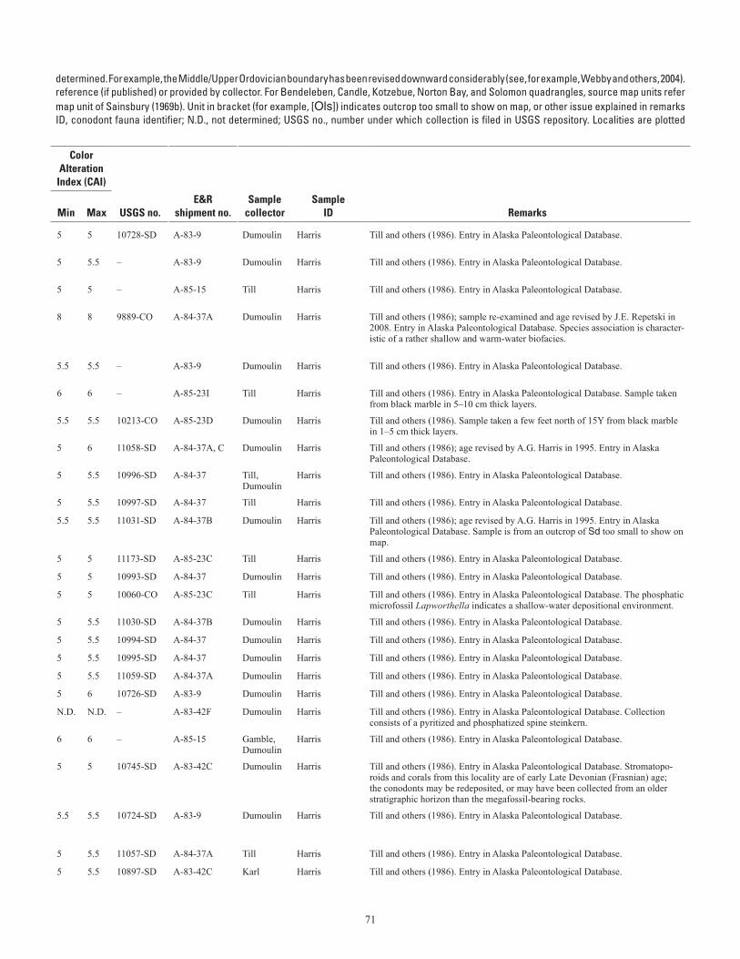
71
Table A–1. Conodont data from the Seward Peninsula.—Continued (table spans facing page)[Ages listed have not been revised to reflect all changes in stratigraphic terminology that have occurred since the ages given here were Ordovician conodont zonation, Series, and Stage usage herein follows that given in Harris and others (1995). Geologic unit (source map) from cited to map units of Till and others (1986). For Teller quadrangle, source map units refer to map units of Sainsbury (1972) if unspecified; (69b) indicates a column. Alaska Paleontological Database found online at http://www.alaskafossil.org. E&R, Examination and Report by USGS paleontologist;on sheet 2; see table A-2 for temperature ranges for CAI values]
determined. For example, the Middle/Upper Ordovician boundary has been revised downward considerably (see, for example, Webby and others, 2004).reference (if published) or provided by collector. For Bendeleben, Candle, Kotzebue, Norton Bay, and Solomon quadrangles, source map units refermap unit of Sainsbury (1969b). Unit in bracket (for example, [Ols]) indicates outcrop too small to show on map, or other issue explained in remarksID, conodont fauna identifier; N.D., not determined; USGS no., number under which collection is filed in USGS repository. Localities are plotted
Lat (N)
Long (W)
Geologic unit
ColorAlteration
Index (CAI)
Field no. Quadrangle
Deg
Min
Deg
Min Age
(This map)(Source
map)
Min
Max USGS no.E&R
shipment no.Sample
collectorSample
ID Remarks
82ADu75 Bendeleben D-2
65 54.74 162 35.5 late Early Devonian (early Emsian)-Middle Devonian Ddm Ddm 5 5 10728-SD A-83-9 Dumoulin Harris Till and others (1986). Entry in Alaska Paleontological Database.
82ADu74 Bendeleben D-2
65 55.66 162 35.41 Middle Ordovician-Middle Devonian Ddm Ddm 5 5.5 – A-83-9 Dumoulin Harris Till and others (1986). Entry in Alaska Paleontological Database.
84ATi224 Bendeleben D-5
65 46 164 11 Middle Ordovician-Middle Devonian Od Od 5 5 – A-85-15 Till Harris Till and others (1986). Entry in Alaska Paleontological Database.
84ADn80A Bendeleben D-5
65 47 164 10 early to middle Middle Ordovician (Histiodella holo-dentata Zone to lower Amorphognathus tvaerensis Zone; possibly H. holodentata Zone to Cahabagna-thus sweeti Zone)
Od Od 8 8 9889-CO A-84-37A Dumoulin Harris Till and others (1986); sample re-examined and age revised by J.E. Repetski in 2008. Entry in Alaska Paleontological Database. Species association is character-istic of a rather shallow and warm-water biofacies.
82ADu63 Bendeleben D-5
65 50.37 164 22.59 probable middle Early to Middle Devonian Ddm Ddm 5.5 5.5 – A-83-9 Dumoulin Harris Till and others (1986). Entry in Alaska Paleontological Database.
84ATi15Y Solomon C-1 64 33.5 162 27.33 Ordovician-Triassic D_bm D_bm 6 6 – A-85-23I Till Harris Till and others (1986). Entry in Alaska Paleontological Database. Sample taken from black marble in 5–10 cm thick layers.
84ATi15Z Solomon C-1 64 33.5 162 27.33 middle Early Ordovician (middle Arenig)-Late Ordovician
D_bm D_bm 5.5 5.5 10213-CO A-85-23D Dumoulin Harris Till and others (1986). Sample taken a few feet north of 15Y from black marble in 1–5 cm thick layers.
84ADn5H Solomon C-1 64 34.6 162 24 middle-early late Silurian (Wenlock-Ludlow) D_bm D_bm 5 6 11058-SD A-84-37A, C Dumoulin Harris Till and others (1986); age revised by A.G. Harris in 1995. Entry in Alaska Paleontological Database.
84ATi8AA Solomon C-1 64 34.87 162 22.5 late Early-latest Middle Devonian (Emsian-Givetian) Ddm Ddm 5 5.5 10996-SD A-84-37 Till, Dumoulin
Harris Till and others (1986). Entry in Alaska Paleontological Database.
84ATi8AB Solomon C-1 64 34.92 162 22.5 late Early Devonian (Emsian) Ddm Ddm 5 5.5 10997-SD A-84-37 Till Harris Till and others (1986). Entry in Alaska Paleontological Database.
84ADn10A Solomon C-1 64 37 162 17 middle-early late Silurian (Wenlock-early Ludlow) [Sd] |d 5.5 5.5 11031-SD A-84-37B Dumoulin Harris Till and others (1986); age revised by A.G. Harris in 1995. Entry in Alaska Paleontological Database. Sample is from an outcrop of Sd too small to show on map.
84ATi23 Solomon C-1 64 37.45 162 13.8 middle Early Devonian (Siegenian) D_bm D_bm 5 5 11173-SD A-85-23C Till Harris Till and others (1986). Entry in Alaska Paleontological Database.
84ADn2A Solomon C-1 64 38 162 14 Middle Devonian Ddm Ddm 5 5 10993-SD A-84-37 Dumoulin Harris Till and others (1986). Entry in Alaska Paleontological Database.
84ATi57 Solomon C-1 64 38.6 162 22.4 Early through possibly early Middle Cambrian D_bm D_bm 5 5 10060-CO A-85-23C Till Harris Till and others (1986). Entry in Alaska Paleontological Database. The phosphatic microfossil Lapworthella indicates a shallow-water depositional environment.
84ADn3A Solomon C-1 64 39 162 13 Middle Devonian Ddm Ddm 5 5.5 11030-SD A-84-37B Dumoulin Harris Till and others (1986). Entry in Alaska Paleontological Database.
84ADn3B Solomon C-1 64 39 162 13 Middle Devonian Ddm Ddm 5 5.5 10994-SD A-84-37 Dumoulin Harris Till and others (1986). Entry in Alaska Paleontological Database.
84ADn16 Solomon C-1 64 39.9 162 23.5 Middle Devonian Ddm Ddm 5 5.5 10995-SD A-84-37 Dumoulin Harris Till and others (1986). Entry in Alaska Paleontological Database.
84ADn31 Solomon C-1 64 44.5 162 18.3 late Silurian-Early Devonian D_bm D_bm 5 5.5 11059-SD A-84-37A Dumoulin Harris Till and others (1986). Entry in Alaska Paleontological Database.
82ADu59 Solomon C-3 64 44.73 163 27.66 middle to late Early Devonian Ddm Ddm 5 6 10726-SD A-83-9 Dumoulin Harris Till and others (1986). Entry in Alaska Paleontological Database.
83ADn2 Solomon C-4 64 34.04 163 41.27 Phanerozoic Ddm Ddm N.D. N.D. – A-83-42F Dumoulin Harris Till and others (1986). Entry in Alaska Paleontological Database. Collection consists of a pyritized and phosphatized spine steinkern.
84AGe133 Solomon C-5 64 44.72 164 25.7 Ordovician-Middle Devonian DOx O_x 6 6 – A-85-15 Gamble, Dumoulin
Harris Till and others (1986). Entry in Alaska Paleontological Database.
83ADn25 Solomon D-1 64 49.51 162 17.51 middle Silurian-most of Middle Devonian Ddm Ddm 5 5 10745-SD A-83-42C Dumoulin Harris Till and others (1986). Entry in Alaska Paleontological Database. Stromatopo-roids and corals from this locality are of early Late Devonian (Frasnian) age; the conodonts may be redeposited, or may have been collected from an older stratigraphic horizon than the megafossil-bearing rocks.
82ADu17 Solomon D-1 64 50.9 162 13.68 Silurian-Middle Devonian; when combined with megafossil data from this locality, age is restricted to Middle Devonian
Ddm Ddm 5.5 5.5 10724-SD A-83-9 Dumoulin Harris Till and others (1986). Entry in Alaska Paleontological Database.
84ATi112 Solomon D-1 64 52.9 162 9.9 Middle Devonian Ddm Ddm 5 5.5 11057-SD A-84-37A Till Harris Till and others (1986). Entry in Alaska Paleontological Database.
83SK28A Solomon D-1 64 53.18 162 11.13 latest Early-earliest Middle Devonian Ddm Ddm 5 5.5 10897-SD A-83-42C Karl Harris Till and others (1986). Entry in Alaska Paleontological Database.
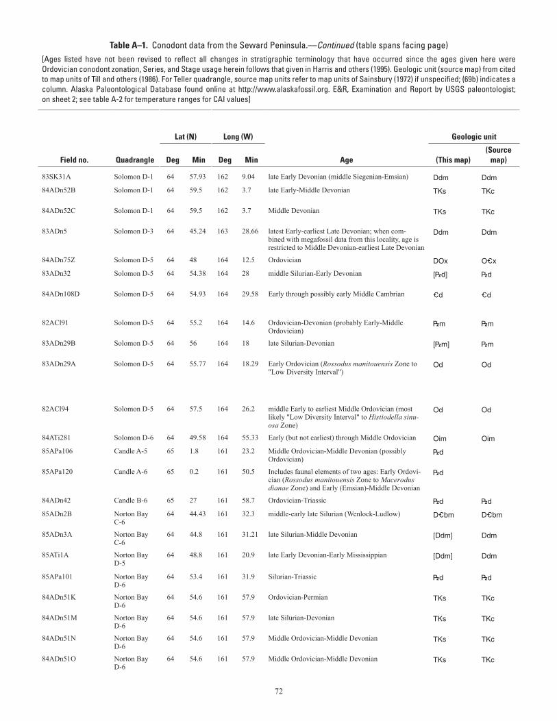
72
Table A–1. Conodont data from the Seward Peninsula.—Continued (table spans facing page)[Ages listed have not been revised to reflect all changes in stratigraphic terminology that have occurred since the ages given here were Ordovician conodont zonation, Series, and Stage usage herein follows that given in Harris and others (1995). Geologic unit (source map) from cited to map units of Till and others (1986). For Teller quadrangle, source map units refer to map units of Sainsbury (1972) if unspecified; (69b) indicates a column. Alaska Paleontological Database found online at http://www.alaskafossil.org. E&R, Examination and Report by USGS paleontologist;on sheet 2; see table A-2 for temperature ranges for CAI values]
determined. For example, the Middle/Upper Ordovician boundary has been revised downward considerably (see, for example, Webby and others, 2004).reference (if published) or provided by collector. For Bendeleben, Candle, Kotzebue, Norton Bay, and Solomon quadrangles, source map units refermap unit of Sainsbury (1969b). Unit in bracket (for example, [Ols]) indicates outcrop too small to show on map, or other issue explained in remarksID, conodont fauna identifier; N.D., not determined; USGS no., number under which collection is filed in USGS repository. Localities are plotted
Lat (N)
Long (W)
Geologic unit
ColorAlteration
Index (CAI)
Field no. Quadrangle
Deg
Min
Deg
Min Age
(This map)(Source
map)
Min
Max USGS no.E&R
shipment no.Sample
collectorSample
ID Remarks
83SK31A Solomon D-1 64 57.93 162 9.04 late Early Devonian (middle Siegenian-Emsian) Ddm Ddm 5 5.5 10898-SD A-83-42C Karl Harris Till and others (1986). Entry in Alaska Paleontological Database.
84ADn52B Solomon D-1 64 59.5 162 3.7 late Early-Middle Devonian TKs TKc 5.5 5.5 11060-SD A-84-37A Dumoulin Harris Till and others (1986). Entry in Alaska Paleontological Database. Sample is a clast in the conglomerate.
84ADn52C Solomon D-1 64 59.5 162 3.7 Middle Devonian TKs TKc 5.5 6 11061-SD A-84-37A Dumoulin Harris Till and others (1986). Entry in Alaska Paleontological Database. Sample is a clast in the conglomerate.
83ADn5 Solomon D-3 64 45.24 163 28.66 latest Early-earliest Late Devonian; when com-bined with megafossil data from this locality, age is restricted to Middle Devonian-earliest Late Devonian
Ddm Ddm 5.5 5.5 10895-SD A-83-42C Dumoulin Harris Till and others (1986). Entry in Alaska Paleontological Database.
84ADn75Z Solomon D-5 64 48 164 12.5 Ordovician DOx O_x 5.5 6 10059-CO A-85-23C Dumoulin Harris Till and others (1986). Entry in Alaska Paleontological Database.
83ADn32 Solomon D-5 64 54.38 164 28 middle Silurian-Early Devonian [|d] |d 5 5 10906-SD A-83-42C Dumoulin Harris Till and others (1986). Entry in Alaska Paleontological Database. Sample is from an outcrop of |d too small to show on map.
84ADn108D Solomon D-5 64 54.93 164 29.58 Early through possibly early Middle Cambrian _d _d N.D. N.D. 9937-CO A-85-15 Dumoulin Harris Till and others (1986). Entry in Alaska Paleontological Database. Collection consists of the phosphatic microfossil Lapworthella, which indicates a shallow-water depositional setting.
82ACl91 Solomon D-5 64 55.2 164 14.6 Ordovician-Devonian (probably Early-Middle Ordovician)
|m |m 5 6 – A-83-9 Carroll Harris Till and others (1986). Entry in Alaska Paleontological Database.
83ADn29B Solomon D-5 64 56 164 18 late Silurian-Devonian [|m] |m 5.5 6.5 10905-SD A-83-42C Dumoulin Harris Till and others (1986). Entry in Alaska Paleontological Database. Sample is from an outcrop of |m too small to show on map.
83ADn29A Solomon D-5 64 55.77 164 18.29 Early Ordovician (Rossodus manitouensis Zone to "Low Diversity Interval")
Od Od 4 4 9801-CO A-83-42C Dumoulin Harris Till and others (1986); age revised by J.E. Repetski, 2/08. Entry in Alaska Paleontological Database. The CAI of this collection is lower than values from other collections in the Nome Complex. The collection may represent laboratory contamination, or a remnant of a structurally higher thrust sheet. Species associa-tion indicates a warm, shallow-water depositional setting.
82ACl94 Solomon D-5 64 57.5 164 26.2 middle Early to earliest Middle Ordovician (most likely "Low Diversity Interval" to Histiodella sinu-osa Zone)
Od Od 5.5 5.5 9610-CO A-83-9 Carroll Harris Till and others (1986); sample re-examined and age confirmed by J.E. Repetski, 2/08. Entry in Alaska Paleontological Database.
84ATi281 Solomon D-6 64 49.58 164 55.33 Early (but not earliest) through Middle Ordovician Oim Oim 7 7 9938-CO A-85-15 Till Harris Till and others (1986). Entry in Alaska Paleontological Database.
85APa106 Candle A-5 65 1.8 161 23.2 Middle Ordovician-Middle Devonian (possibly Ordovician)
|d ~5.0 ~5.0 – A-86-16 Patton, Dumoulin
Denkler Entry in Alaska Paleontological Database.
85APa120 Candle A-6 65 0.2 161 50.5 Includes faunal elements of two ages: Early Ordovi-cian (Rossodus manitouensis Zone to Macerodus dianae Zone) and Early (Emsian)-Middle Devonian
|d 6 6 – A-85-23D Patton, Dumoulin
Harris Collection may have sampled two rock types of different age, or older conodonts may have been reworked into a younger rock.
84ADn42 Candle B-6 65 27 161 58.7 Ordovician-Triassic |d |d 5 5 – A-84-37C Dumoulin Harris Till and others (1986). Entry in Alaska Paleontological Database.
85ADn2B Norton Bay C-6
64 44.43 161 32.3 middle-early late Silurian (Wenlock-Ludlow) D_bm D_bm 5.5 6 11229-SD A-85-23D Dumoulin Harris Till and others (1986); age revised by A.G. Harris in 1995.
85ADn3A Norton Bay C-6
64 44.8 161 31.21 late Silurian-Middle Devonian [Ddm] Ddm 5 5 11230-SD A-85-23D Dumoulin Harris Sample is from an outcrop of Ddm too small to show on map.
85ATi1A Norton Bay D-5
64 48.8 161 20.9 late Early Devonian-Early Mississippian [Ddm] Ddm ~5.0 ~5.0 – A-86-16 Till Denkler Entry in Alaska Paleontological Database. Sample is from an outcrop of Ddm too small to show on map.
85APa101 Norton Bay D-6
64 53.4 161 31.9 Silurian-Triassic |d |d 5 5 – A-86-16 Patton, Dumoulin
Denkler Entry in Alaska Paleontological Database.
84ADn51K Norton Bay D-6
64 54.6 161 57.9 Ordovician-Permian TKs TKc 5.5 6 – A-85-15 Dumoulin Harris Till and others (1986). Entry in Alaska Paleontological Database. Sample is a clast in the conglomerate.
84ADn51M Norton Bay D-6
64 54.6 161 57.9 late Silurian-Devonian TKs TKc 5.5 5.5 11134-SD A-85-15 Dumoulin Harris Till and others (1986). Entry in Alaska Paleontological Database. Sample is a clast in the conglomerate.
84ADn51N Norton Bay D-6
64 54.6 161 57.9 Middle Ordovician-Middle Devonian TKs TKc 5 5.5 – A-84-37B Dumoulin Harris Till and others (1986). Entry in Alaska Paleontological Database. Sample is a clast in the conglomerate.
84ADn51O Norton Bay D-6
64 54.6 161 57.9 Middle Ordovician-Middle Devonian TKs TKc 5 5.5 – A-84-37A Dumoulin Harris Till and others (1986). Entry in Alaska Paleontological Database. Sample is a clast in the conglomerate.
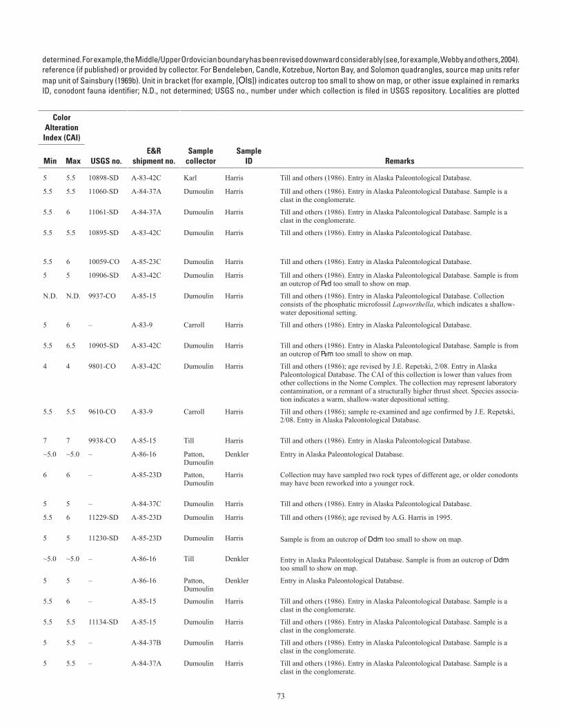
73
Table A–1. Conodont data from the Seward Peninsula.—Continued (table spans facing page)[Ages listed have not been revised to reflect all changes in stratigraphic terminology that have occurred since the ages given here were Ordovician conodont zonation, Series, and Stage usage herein follows that given in Harris and others (1995). Geologic unit (source map) from cited to map units of Till and others (1986). For Teller quadrangle, source map units refer to map units of Sainsbury (1972) if unspecified; (69b) indicates a column. Alaska Paleontological Database found online at http://www.alaskafossil.org. E&R, Examination and Report by USGS paleontologist;on sheet 2; see table A-2 for temperature ranges for CAI values]
determined. For example, the Middle/Upper Ordovician boundary has been revised downward considerably (see, for example, Webby and others, 2004).reference (if published) or provided by collector. For Bendeleben, Candle, Kotzebue, Norton Bay, and Solomon quadrangles, source map units refermap unit of Sainsbury (1969b). Unit in bracket (for example, [Ols]) indicates outcrop too small to show on map, or other issue explained in remarksID, conodont fauna identifier; N.D., not determined; USGS no., number under which collection is filed in USGS repository. Localities are plotted
Lat (N)
Long (W)
Geologic unit
ColorAlteration
Index (CAI)
Field no. Quadrangle
Deg
Min
Deg
Min Age
(This map)(Source
map)
Min
Max USGS no.E&R
shipment no.Sample
collectorSample
ID Remarks
83SK31A Solomon D-1 64 57.93 162 9.04 late Early Devonian (middle Siegenian-Emsian) Ddm Ddm 5 5.5 10898-SD A-83-42C Karl Harris Till and others (1986). Entry in Alaska Paleontological Database.
84ADn52B Solomon D-1 64 59.5 162 3.7 late Early-Middle Devonian TKs TKc 5.5 5.5 11060-SD A-84-37A Dumoulin Harris Till and others (1986). Entry in Alaska Paleontological Database. Sample is a clast in the conglomerate.
84ADn52C Solomon D-1 64 59.5 162 3.7 Middle Devonian TKs TKc 5.5 6 11061-SD A-84-37A Dumoulin Harris Till and others (1986). Entry in Alaska Paleontological Database. Sample is a clast in the conglomerate.
83ADn5 Solomon D-3 64 45.24 163 28.66 latest Early-earliest Late Devonian; when com-bined with megafossil data from this locality, age is restricted to Middle Devonian-earliest Late Devonian
Ddm Ddm 5.5 5.5 10895-SD A-83-42C Dumoulin Harris Till and others (1986). Entry in Alaska Paleontological Database.
84ADn75Z Solomon D-5 64 48 164 12.5 Ordovician DOx O_x 5.5 6 10059-CO A-85-23C Dumoulin Harris Till and others (1986). Entry in Alaska Paleontological Database.
83ADn32 Solomon D-5 64 54.38 164 28 middle Silurian-Early Devonian [|d] |d 5 5 10906-SD A-83-42C Dumoulin Harris Till and others (1986). Entry in Alaska Paleontological Database. Sample is from an outcrop of |d too small to show on map.
84ADn108D Solomon D-5 64 54.93 164 29.58 Early through possibly early Middle Cambrian _d _d N.D. N.D. 9937-CO A-85-15 Dumoulin Harris Till and others (1986). Entry in Alaska Paleontological Database. Collection consists of the phosphatic microfossil Lapworthella, which indicates a shallow-water depositional setting.
82ACl91 Solomon D-5 64 55.2 164 14.6 Ordovician-Devonian (probably Early-Middle Ordovician)
|m |m 5 6 – A-83-9 Carroll Harris Till and others (1986). Entry in Alaska Paleontological Database.
83ADn29B Solomon D-5 64 56 164 18 late Silurian-Devonian [|m] |m 5.5 6.5 10905-SD A-83-42C Dumoulin Harris Till and others (1986). Entry in Alaska Paleontological Database. Sample is from an outcrop of |m too small to show on map.
83ADn29A Solomon D-5 64 55.77 164 18.29 Early Ordovician (Rossodus manitouensis Zone to "Low Diversity Interval")
Od Od 4 4 9801-CO A-83-42C Dumoulin Harris Till and others (1986); age revised by J.E. Repetski, 2/08. Entry in Alaska Paleontological Database. The CAI of this collection is lower than values from other collections in the Nome Complex. The collection may represent laboratory contamination, or a remnant of a structurally higher thrust sheet. Species associa-tion indicates a warm, shallow-water depositional setting.
82ACl94 Solomon D-5 64 57.5 164 26.2 middle Early to earliest Middle Ordovician (most likely "Low Diversity Interval" to Histiodella sinu-osa Zone)
Od Od 5.5 5.5 9610-CO A-83-9 Carroll Harris Till and others (1986); sample re-examined and age confirmed by J.E. Repetski, 2/08. Entry in Alaska Paleontological Database.
84ATi281 Solomon D-6 64 49.58 164 55.33 Early (but not earliest) through Middle Ordovician Oim Oim 7 7 9938-CO A-85-15 Till Harris Till and others (1986). Entry in Alaska Paleontological Database.
85APa106 Candle A-5 65 1.8 161 23.2 Middle Ordovician-Middle Devonian (possibly Ordovician)
|d ~5.0 ~5.0 – A-86-16 Patton, Dumoulin
Denkler Entry in Alaska Paleontological Database.
85APa120 Candle A-6 65 0.2 161 50.5 Includes faunal elements of two ages: Early Ordovi-cian (Rossodus manitouensis Zone to Macerodus dianae Zone) and Early (Emsian)-Middle Devonian
|d 6 6 – A-85-23D Patton, Dumoulin
Harris Collection may have sampled two rock types of different age, or older conodonts may have been reworked into a younger rock.
84ADn42 Candle B-6 65 27 161 58.7 Ordovician-Triassic |d |d 5 5 – A-84-37C Dumoulin Harris Till and others (1986). Entry in Alaska Paleontological Database.
85ADn2B Norton Bay C-6
64 44.43 161 32.3 middle-early late Silurian (Wenlock-Ludlow) D_bm D_bm 5.5 6 11229-SD A-85-23D Dumoulin Harris Till and others (1986); age revised by A.G. Harris in 1995.
85ADn3A Norton Bay C-6
64 44.8 161 31.21 late Silurian-Middle Devonian [Ddm] Ddm 5 5 11230-SD A-85-23D Dumoulin Harris Sample is from an outcrop of Ddm too small to show on map.
85ATi1A Norton Bay D-5
64 48.8 161 20.9 late Early Devonian-Early Mississippian [Ddm] Ddm ~5.0 ~5.0 – A-86-16 Till Denkler Entry in Alaska Paleontological Database. Sample is from an outcrop of Ddm too small to show on map.
85APa101 Norton Bay D-6
64 53.4 161 31.9 Silurian-Triassic |d |d 5 5 – A-86-16 Patton, Dumoulin
Denkler Entry in Alaska Paleontological Database.
84ADn51K Norton Bay D-6
64 54.6 161 57.9 Ordovician-Permian TKs TKc 5.5 6 – A-85-15 Dumoulin Harris Till and others (1986). Entry in Alaska Paleontological Database. Sample is a clast in the conglomerate.
84ADn51M Norton Bay D-6
64 54.6 161 57.9 late Silurian-Devonian TKs TKc 5.5 5.5 11134-SD A-85-15 Dumoulin Harris Till and others (1986). Entry in Alaska Paleontological Database. Sample is a clast in the conglomerate.
84ADn51N Norton Bay D-6
64 54.6 161 57.9 Middle Ordovician-Middle Devonian TKs TKc 5 5.5 – A-84-37B Dumoulin Harris Till and others (1986). Entry in Alaska Paleontological Database. Sample is a clast in the conglomerate.
84ADn51O Norton Bay D-6
64 54.6 161 57.9 Middle Ordovician-Middle Devonian TKs TKc 5 5.5 – A-84-37A Dumoulin Harris Till and others (1986). Entry in Alaska Paleontological Database. Sample is a clast in the conglomerate.
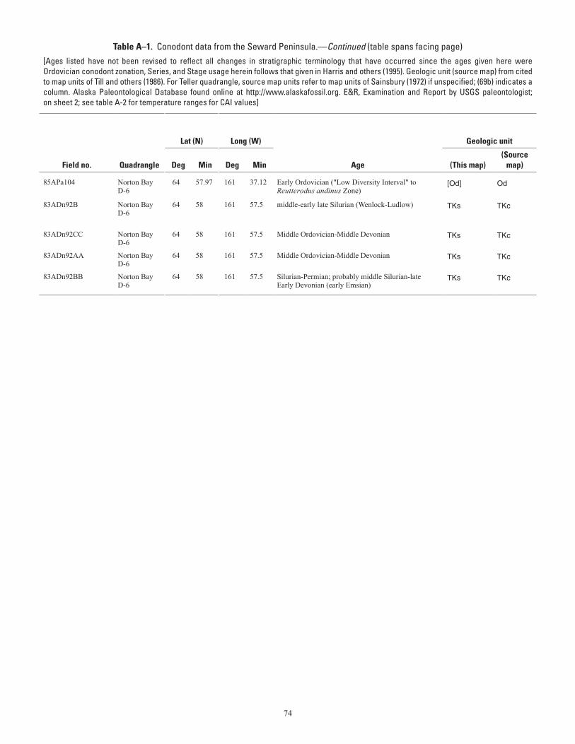
74
Table A–1. Conodont data from the Seward Peninsula.—Continued (table spans facing page)[Ages listed have not been revised to reflect all changes in stratigraphic terminology that have occurred since the ages given here were Ordovician conodont zonation, Series, and Stage usage herein follows that given in Harris and others (1995). Geologic unit (source map) from cited to map units of Till and others (1986). For Teller quadrangle, source map units refer to map units of Sainsbury (1972) if unspecified; (69b) indicates a column. Alaska Paleontological Database found online at http://www.alaskafossil.org. E&R, Examination and Report by USGS paleontologist;on sheet 2; see table A-2 for temperature ranges for CAI values]
determined. For example, the Middle/Upper Ordovician boundary has been revised downward considerably (see, for example, Webby and others, 2004).reference (if published) or provided by collector. For Bendeleben, Candle, Kotzebue, Norton Bay, and Solomon quadrangles, source map units refermap unit of Sainsbury (1969b). Unit in bracket (for example, [Ols]) indicates outcrop too small to show on map, or other issue explained in remarksID, conodont fauna identifier; N.D., not determined; USGS no., number under which collection is filed in USGS repository. Localities are plotted
Lat (N)
Long (W)
Geologic unit
ColorAlteration
Index (CAI)
Field no. Quadrangle
Deg
Min
Deg
Min Age
(This map)(Source
map)
Min
Max USGS no.E&R
shipment no.Sample
collectorSample
ID Remarks
85APa104 Norton Bay D-6
64 57.97 161 37.12 Early Ordovician ("Low Diversity Interval" to Reutterodus andinus Zone)
[Od] Od ~5.0 ~5.0 10312-CO A-86-16 Patton, Dumoulin
Denkler Entry in Alaska Paleontological Database. Sample is from an outcrop of Od too small to show on map.
83ADn92B Norton Bay D-6
64 58 161 57.5 middle-early late Silurian (Wenlock-Ludlow) TKs TKc 5 5.5 10836-SD A-83-42B Dumoulin Harris Till and others (1986); age revised by A.G. Harris in 1995. Entry in Alaska Pale-ontological Database. Sample is a clast in the conglomerate; species association indicates relatively high energy, shallow-water depositional setting.
83ADn92CC Norton Bay D-6
64 58 161 57.5 Middle Ordovician-Middle Devonian TKs TKc 5 5.5 – A-84-37A Dumoulin Harris Till and others (1986). Entry in Alaska Paleontological Database. Sample is a clast in the conglomerate.
83ADn92AA Norton Bay D-6
64 58 161 57.5 Middle Ordovician-Middle Devonian TKs TKc 5 5.5 – A-85-15 Dumoulin Harris Till and others (1986). Entry in Alaska Paleontological Database. Sample is a clast in the conglomerate.
83ADn92BB Norton Bay D-6
64 58 161 57.5 Silurian-Permian; probably middle Silurian-late Early Devonian (early Emsian)
TKs TKc 6 7 – A-85-15 Dumoulin Harris Till and others (1986). Entry in Alaska Paleontological Database. Sample is a clast in the conglomerate.
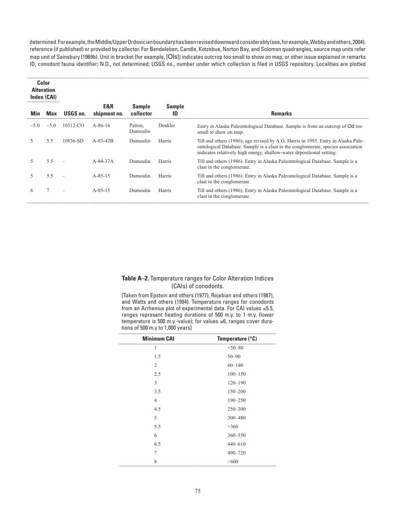
75
Table A–1. Conodont data from the Seward Peninsula.—Continued (table spans facing page)[Ages listed have not been revised to reflect all changes in stratigraphic terminology that have occurred since the ages given here were Ordovician conodont zonation, Series, and Stage usage herein follows that given in Harris and others (1995). Geologic unit (source map) from cited to map units of Till and others (1986). For Teller quadrangle, source map units refer to map units of Sainsbury (1972) if unspecified; (69b) indicates a column. Alaska Paleontological Database found online at http://www.alaskafossil.org. E&R, Examination and Report by USGS paleontologist;on sheet 2; see table A-2 for temperature ranges for CAI values]
determined. For example, the Middle/Upper Ordovician boundary has been revised downward considerably (see, for example, Webby and others, 2004).reference (if published) or provided by collector. For Bendeleben, Candle, Kotzebue, Norton Bay, and Solomon quadrangles, source map units refermap unit of Sainsbury (1969b). Unit in bracket (for example, [Ols]) indicates outcrop too small to show on map, or other issue explained in remarksID, conodont fauna identifier; N.D., not determined; USGS no., number under which collection is filed in USGS repository. Localities are plotted
Lat (N)
Long (W)
Geologic unit
ColorAlteration
Index (CAI)
Field no. Quadrangle
Deg
Min
Deg
Min Age
(This map)(Source
map)
Min
Max USGS no.E&R
shipment no.Sample
collectorSample
ID Remarks
85APa104 Norton Bay D-6
64 57.97 161 37.12 Early Ordovician ("Low Diversity Interval" to Reutterodus andinus Zone)
[Od] Od ~5.0 ~5.0 10312-CO A-86-16 Patton, Dumoulin
Denkler Entry in Alaska Paleontological Database. Sample is from an outcrop of Od too small to show on map.
83ADn92B Norton Bay D-6
64 58 161 57.5 middle-early late Silurian (Wenlock-Ludlow) TKs TKc 5 5.5 10836-SD A-83-42B Dumoulin Harris Till and others (1986); age revised by A.G. Harris in 1995. Entry in Alaska Pale-ontological Database. Sample is a clast in the conglomerate; species association indicates relatively high energy, shallow-water depositional setting.
83ADn92CC Norton Bay D-6
64 58 161 57.5 Middle Ordovician-Middle Devonian TKs TKc 5 5.5 – A-84-37A Dumoulin Harris Till and others (1986). Entry in Alaska Paleontological Database. Sample is a clast in the conglomerate.
83ADn92AA Norton Bay D-6
64 58 161 57.5 Middle Ordovician-Middle Devonian TKs TKc 5 5.5 – A-85-15 Dumoulin Harris Till and others (1986). Entry in Alaska Paleontological Database. Sample is a clast in the conglomerate.
83ADn92BB Norton Bay D-6
64 58 161 57.5 Silurian-Permian; probably middle Silurian-late Early Devonian (early Emsian)
TKs TKc 6 7 – A-85-15 Dumoulin Harris Till and others (1986). Entry in Alaska Paleontological Database. Sample is a clast in the conglomerate.
Table A–2. Temperature ranges for Color Alteration Indices (CAIs) of conodonts.
[Taken from Epstein and others (1977), Rejebian and others (1987), and Watts and others (1994). Temperature ranges for conodonts from an Arrhenius plot of experimental data. For CAI values ≤5.5, ranges represent heating durations of 500 m.y. to 1 m.y. (lower temperature is 500 m.y.-value); for values ≥6, ranges cover dura-tions of 500 m.y to 1,000 years]
Minimum CAI Temperature (°C)1 <50–80
1.5 50–90
2 60–140
2.5 100–150
3 120–190
3.5 150–200
4 190–250
4.5 250–300
5 300–480
5.5 >360
6 360–550
6.5 440–610
7 490–720
8 >600