Embed Size (px)
Citation preview
22589256_5.docx
BEFORE A BOARD OF INQUIRY MACKAYS TO PEKA PEKA EXPRESSWAY PROPOSAL
UNDER the Resource Management Act 1991
IN THE MATTER OF applications for resource
consents and a notice of requirement in relation to the MacKays to Peka Peka Expressway Proposal
BY New Zealand Transport
Agency
STATEMENT OF EVIDENCE OF BRYDON NICHOLAS HUGHES
ON BEHALF OF THE KAPITI COAST DISTRICT COUNCIL
Groundwater
DATE: 5 October 2012
Barristers & Solicitors
D J S Laing / M G Conway Telephone: +64-4-499 4599 Facsimile: +64-4-472 6986 E-mail: [email protected] DX SX11174 PO Box 2402 Wellington

Page 2
22589256_5.docx
1. INTRODUCTION
1.1 My full name is Brydon Nicholas Hughes.
1.2 I am currently Director of Liquid Earth Limited, an independent hydrogeological and
water resource management consultancy I own and operate.
1.3 I hold a Master of Science degree with first class honours in engineering geology from
the University of Canterbury, conferred in 1992. I have 18 years’ experience in
groundwater resource management and investigations both while employed by
Regional Councils, and more recently in private consultancy. I have presented
evidence at a number of Council and Environment Court Hearings. I am an accredited
hearings commissioner under the Ministry for the Environment’s Making Good
Decisions Programme.
1.4 Between 1995 and 1999 I was employed as Groundwater Scientist by the Wellington
Regional Council. This role involved the development and implementation of
groundwater monitoring and investigation programs across the Kapiti Coast area as
well as input to the groundwater management provisions of the Regional Freshwater
Plan (RFP).
1.5 At the current time I am involved with a project for the Greater Wellington Regional
Council updating the conceptual groundwater model for the Kapiti Coast as part of a
project to review groundwater allocation and management for the upcoming review of
the RFP. During 2005/06 I also provided input on groundwater impacts for a review of
land development impacts on stormwater management for the Kapiti Coast District
Council (Council) (SKM, 2006).
1.6 I am authorised by the Council to present this evidence on its behalf.
1.7 I have read and am familiar with the Code of Conduct for Expert Witnesses in the
Environment Court Practice Note 2011. I agree to comply with that Code. Other than
where I state that I am relying on the advice of another person, this evidence is within
my area of expertise. I have not omitted to consider material facts known to me that
might alter or detract from the opinions that I express.
Page 3
22589256_5.docx
2. SCOPE OF EVIDENCE
2.1 My evidence will address the following matters:
(a) the overall nature of the hydrogeological setting including the occurrence of
groundwater-dependant ecosystems;
(b) issues raised in the Council's submission regarding the effects of the proposed
Expressway on the shallow groundwater resource and hydraulically connected
surface water bodies (wetlands and streams);
(c) comments on the proposed Groundwater Level Management Plan (GLMP)
including proposed monitoring and mitigation options;
(d) issues raised in the Council's submission relating to contaminated land; and
(e) measures to avoid or mitigate potential adverse effects associated with
contaminated land during Expressway construction and operation.
3. EXECUTIVE SUMMARY
3.1 The proposed Expressway alignment traverses the coastal plain between MacKays
Crossing and Peka Peka. This area is underlain by a shallow, spatially extensive
unconfined aquifer system hosted in Holocene sand deposits along the coastal margin.
The Holocene sand aquifer is primarily recharged by infiltration of local rainfall and is
hydraulically connected to numerous small streams and wetlands on the coastal plain.
The aquifer system is also utilised extensively for small scale abstraction to provide
garden water supplies for residents in Paraparaumu and Waikanae.
3.2 Construction of the Expressway has the potential to result in localised changes in
groundwater level and flow paths in the Holocene sand aquifer. Construction of the
Expressway may result in changes to the natural hydraulic properties of the Holocene
sand aquifer, potentially disrupting the natural flow of groundwater towards the coast.
Where permeability of the natural aquifer materials is reduced, ponding may occur to
the east of the Expressway alignment accompanied by a corresponding reduction in
groundwater levels on the downgradient (west) side. Conversely an increase in
permeability may result in a more widespread decline in groundwater levels.
Groundwater levels may also be affected by activities such as dewatering or the
construction of stormwater treatment and attenuation structures.
Page 4
22589256_5.docx
3.3 While the potential magnitude of changes in natural groundwater levels and flow paths
resulting from expressway construction is relatively minor, the expressway alignment
passes close to several significant wetland areas which are potentially sensitive to small
changes in groundwater level under both ‘average’ and ‘extreme’ conditions.
3.4 While extensive investigation and modelling has been undertaken to quantify potential
effects arising from Expressway construction, due to the heterogeneity of the
hydrogeological environment an element of uncertainty remains regarding the absolute
magnitude of effects likely to result. To address this uncertainty and enable an adaptive
management approach to construction, a Groundwater Level Management Plan has
been developed which outlines a monitoring regime intended to quantify actual effects.
This document includes triggers for initiating various management interventions if actual
effects exceed those predicted.
3.5 Overall, I support the GLMP approach as a pragmatic approach to enable Expressway
construction to occur in a manner which ensures adverse effects on groundwater are
appropriately mitigated. However, I propose some amendments to the proposed
monitoring and mitigation options to ensure potential effects can be adequately
characterised, particularly in terms of significant wetland areas.
3.6 The proposed Expressway alignment crosses a number of sites where soil or
groundwater contamination has been identified. I support the management approach
proposed for these sites in the Contaminated Soils and Groundwater Management Plan
to ensure risks to human health and the environment are appropriately mitigated.
However, I recommend that additional monitoring is undertaken downstream of the
Otaihanga Landfill to ensure that Expressway construction does not result in any
changes to existing groundwater or surface water quality.
4. MATTERS RAISED IN SUBMISSION
4.1 The Council's submission raised a number of issues related to the potential impacts of
the proposed Expressway on the groundwater resource including:
(a) potential hydrological disturbance of groundwater-dependent ecosystems in
close proximity to the Expressway alignment due to changes in the natural
hydrogeological environment associated with construction and operation of the
Expressway; and
Page 5
22589256_5.docx
(b) the adequacy of proposed baseline monitoring and characterisation of
wetlands to enable reliable assessment of potential short and long-term effects
on wetlands through the GLMP.
4.2 The submission also raised concerns relating to the management of Land and
Groundwater Contamination effects including the potential for construction activities to
alter the existing treatment system utilised at the Otaihanga Landfill increasing the
potential for offsite effects.
5. HYDROGEOLOGICAL ENVIRONMENT
5.1 The groundwater resources of the Kapiti Coast form an integral component of the
overall hydrological system and have a significant role in sustaining freshwater
ecosystems in riverine and wetland habitats. Due to the heterogeneous geological
environment, the nature and extent of hydrological interaction between groundwater,
streams and wetlands is typically complex and often location-specific. The following
section provides a summary of the key considerations in terms of the hydrogeological
environment of relevance to the proposed project.
5.2 These geological materials host a spatially extensive groundwater resource which can
be subdivided into three basic hydrogeological settings:
(a) a shallow unconfined Holocene (Q11) sand aquifer along the seaward margin
of the coastal plain;
(b) shallow, moderate to highly permeable unconfined aquifers hosted in recent
(Q1) alluvium adjacent to rivers and streams draining the Tararua Range; and
(c) semi-confined and confined aquifers occurring within the late Quaternary
fluvioglacial outwash gravel deposits (Q2 to Q8) underlying a majority of the
coastal plain.
5.3 The proposed Expressway alignment primarily overlies the Holocene sand aquifer,
although it crosses the Quaternary gravel (Q1) aquifer as it traverses the Waikanae
River floodplain. Potential interaction with deeper semi-confined and confined aquifers
is primarily restricted to abstraction from the Parata (Q4) gravel deposits for
construction water supply.
1 The Q1, Q2 etc notations relate to oxygen isotope stages which are utilised to define geological timescales over the late Quaternary Period.
Page 6
22589256_5.docx
Holocene Sand Aquifer 5.4 The Holocene sand aquifer underlies a majority of the proposed Expressway alignment.
This aquifer system consists of fine to medium sand and organic material (peat) with
occasional gravel layers. These materials extend to the west of the prominent
postglacial marine terrace which can be traced from Otaki to Paraparaumu and reflect
accumulation of sediments along the coastal margin over the Holocene Period (last
~6,500 years). The materials comprise a heterogenous mix of coarser sand and gravel
accumulated along the coastal margin, aeolian (dune) sand and organic materials
accumulated in poorly drained interdune and back dune areas.
5.5 The Holocene sand materials host a spatially extensive unconfined aquifer which
exhibits low permeability due to the fine-grained texture of the sand and organic
materials. Typical hydraulic conductivity values in the sand deposits are less than
2 m/day and may be significantly lower in organic materials. In contrast, the recent (Q1)
alluvial materials underlying the Waikanae River floodplain exhibit hydraulic conductivity
values in excess of 200 m/day.
5.6 The water table typically occurs within 1 to 2 metres of the land surface across the
coastal plain, although it may vary locally reflecting the topography of larger dunes
toward the seaward margin of the coastal plain. Piezometric survey data show
groundwater flows in a westerly direction across the coastal plain approximately
perpendicular to the coast.
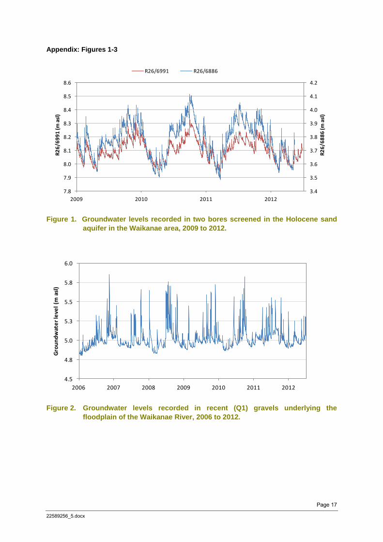
5.7 The aquifer system is predominantly recharged by rainfall infiltration. Figure 1 shows
groundwater level hydrographs from two piezometers monitored by Greater Wellington
Regional Council (GWRC) located north of Waikanae at the Nga Manu and Te
Harakeke wetlands respectively. The plot shows groundwater levels respond rapidly to
recharge following individual rainfall events then recede more slowly as water is
progressively drained from the aquifer system. The overall seasonal variation of
between 0.4 and 0.5 metres appears to track the frequency and magnitude of rainfall
events with maximum levels generally occurring in late winter or spring and minimum
levels in autumn. This hydrograph response is similar to that observed in other
monitoring sites screened in the Holocene sand aquifer along the Kapiti Coast.
5.8 A different hydrograph response is observed in the shallow alluvial (Q1) gravel
materials underlying the Waikanae River floodplain. As shown in Figure 2, groundwater
levels in this area respond rapidly to variations in stage height in the Waikanae River
Page 7
22589256_5.docx
indicating a high level of hydraulic connection with surface water. The rapid decline in
groundwater levels following each recharge event is interpreted to reflect discharge
back to the Waikanae River or to the Waimeha Stream through the permeable gravel
materials.
Wetland Hydrology 5.9 Wetlands form a highly valued hydrological environment on the Kapiti Coast and occur
along, or in close proximity to, the proposed expressway alignment.
5.10 Allen (2010) undertook a hydrological investigation of the Te Hapua wetland which lies
to the north of Peka Peka Road. This wetland complex is similar in nature to those
occurring in the vicinity of the proposed Expressway alignment. The study identified
two characteristic types of wetlands:
(a) Fens - low-lying areas where the water table occurs above the surrounding
land surface forming areas of standing water. These wetlands are
characterised as ‘discharge’ wetlands which receive throughflow from the
surrounding unconfined aquifer and lose water via direct evaporation and
transpiration from vegetation. Water levels in fens tend to be similar or slightly
lower than the surrounding water table and fluctuate rapidly in response to
groundwater level variations.
(b) Swamps - low-lying areas between larger dunes which collect runoff from the
surrounding land. Due to the accumulation of organic material and fine
sediment these areas tend to have low (vertical) permeability allowing water to
pond following significant rainfall events. Water levels in swamps are typically
perched above the surrounding water table and show a different pattern of
temporal variation in response to rainfall.
5.11 Data collected by Allen (2010) showed groundwater levels are typically 35 to 150
millimetres higher than the water table in swamps (although groundwater levels may
rise above standing water levels for a short period following heavy rainfall). Standing
water levels in fens were observed to range between 5 and 90 millimetres lower than
the surrounding water table. The study also noted that the recharge/discharge
characteristics may vary spatially within individual wetlands and also in response to
temporal changes in groundwater levels.
Page 8
22589256_5.docx
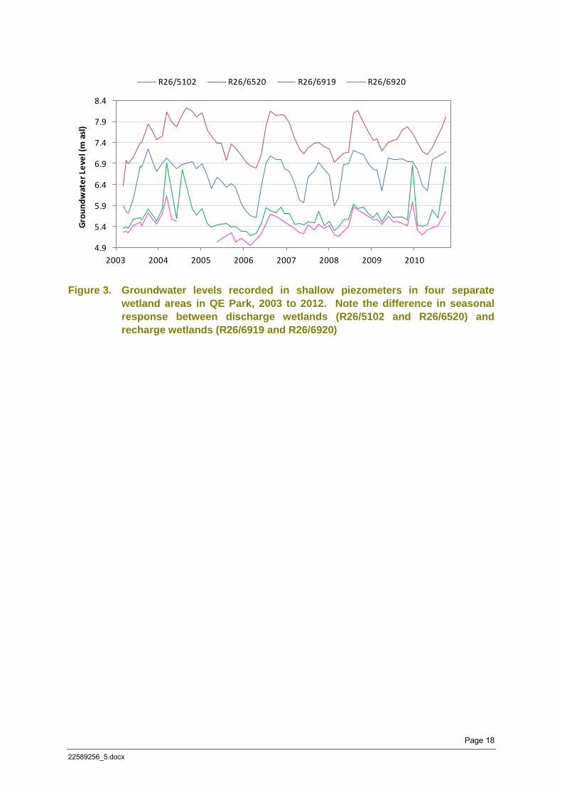
5.12 The difference in hydraulic response between individual wetland areas is illustrated in
Figure 3. This figure shows a plot of water levels recorded in four shallow piezometers
installed in separate wetland areas in Queen Elizabeth Park near MacKays Crossing.
The data exhibit temporal water level variation in two piezometers (R26/6520 and
R26/6920) which follows the general pattern observed in the Holocene sand aquifer
across much of the Kapiti Coast. In contrast, the remaining two piezometers show
relatively stable levels punctuated by rapid, short-terms increases following significant
rainfall events.
5.13 The differences in temporal water levels response observed in closely spaced wetlands
are interpreted to reflect the presence of both recharge and discharge wetlands in close
proximity (within a 250 metre radius at the MacKays Crossing site). The potential
occurrence of both recharge and discharge wetlands along the proposed Expressway
alignment is noted in the Assessment of Groundwater Effects (Technical Report 21).
The differences in hydrology between these wetland types means the potential
response to changes in groundwater levels cannot be assumed to be the same in all
individual wetlands.
5.14 Overall, available data suggest the hydrology of individual wetland areas on the Kapiti
Coast is complex, reflecting the influence of topography as well as the hydraulic
properties of underlying soil materials. Of particular note is the potential for wetland
areas to be affected in different ways by construction and operation of the Expressway.
Discharge wetlands are hydraulically connected to the surrounding unconfined aquifer
and so are susceptible to changes in local changes in groundwater levels resulting from
activities which alter the local aquifer water balance (e.g. dewatering, compaction or
replacement of peat, stormwater drainage etc). In contrast, recharge wetlands are
more likely to be affected by changes to surface drainage patterns resulting from
alteration of natural landforms (e.g. reductions in catchment area or topographical
modifications).
5.15 As a consequence, care needs to be taken to ensure that assessment of potential
effects takes into account both the heterogeneity of the geological environment as well
as the potential local-scale variability of natural interaction between groundwater and
surface water resources.
Page 9
22589256_5.docx
6. EFFECTS ON GROUNDWATER
6.1 The Assessment of Environmental Effects (AEE) identifies a number of aspects of the
project which have the potential to result in localised changes to groundwater levels and
flow paths. These include:
(a) cuts below the water table requiring short-term dewatering;
(b) loss of recharge due to an increase in impervious area;
(c) excavation and replacement of sand with peat (thereby altering the rate of
natural groundwater throughflow);
(d) surcharging of peat to accelerate ground settlement (with a consequent
reduction in the permeability of the peat material);
(e) abstraction of groundwater for construction-related activities; and
(f) alteration of natural groundwater levels associated with construction of
stormwater attenuation/treatment wetlands, swales and flood storage areas.
6.2 Additional activities which have the potential to effect groundwater include:
(a) Realignment of natural stream channels; and
(b) Changes in the contributing catchment area for recharge wetlands
6.3 These activities have the potential to:
(a) alter water levels in hydraulically connected waterbodies (particularly
wetlands) and existing bores utilised for water supply;
(b) reduce baseflow discharge to rivers and streams; and
(c) divert or alter natural groundwater flow paths potentially changing the nature of
groundwater throughflow and contaminant migration pathways.
6.4 Technical Report 23 of the AEE outlines an assessment of potential effects on
groundwater associated with Expressway construction. This assessment is primarily
Page 10
22589256_5.docx
based on the application of numerical modelling to predict potential effects on
groundwater. While I largely support the approach adopted by the applicant to assess
potential effects on groundwater, I note the following aspects that warrant further
attention:
(a) The assessment relies extensively on the application of numerical modelling to
predict the likely impacts on Expressway construction. Due to the
heterogeneous nature of the geological environment and limitations of the
spatial resolution of data available to construct and calibrate the model(s)
there is an element of uncertainly in overall model predictions which is not
necessarily reflected in the certainty of conclusions regarding the overall
magnitude of potential effects.
For example, Technical Report 21 (Appendix F, Figure F4) outlines calibration
statistics for the various models utilised in the assessment. With the exception
of the Otaihanga Landfill model, the standard (RMS) error of the remaining
models is listed at between 0.3 to 0.9 metres, which in many cases is larger
than the predicted magnitude of effects and of a similar order to the observed
seasonal variation in groundwater levels.
(b) The hydrology of individual wetlands is not well characterised, particularly with
regard to their interconnection with shallow groundwater levels and the likely
impact of changes in groundwater levels (in the case of discharge wetlands) or
contributing catchments (in the case of recharge wetlands) on wetland
ecology. As noted in the Ecological Impact Assessment (Technical
Report 26):
‘While specialist investigations have been undertaken.......there remains
some uncertainty as to the hydrological interconnectedness of peat and
thus the nature and scale of any associated effects of construction on
wetlands in close proximity to the proposed expressway route’.
In particular, there is a degree of disconnection between the predicted
magnitude of changes in groundwater levels (Technical Report 21) which is
described as ‘less than minor’ or ‘negligible’ and the Ecological Impact
Assessment, which characterises the predicted drawdown as potentially
having an effect ranging from ‘low’ to ‘very high’ in terms of aquatic habitat loss
and modification (Technical Report 26, Table 40).
Page 11
22589256_5.docx
6.5 Given the acknowledged uncertainties inherent in numerical groundwater modeling at a
local scale, and the incomplete knowledge of wetland hydrology, I consider it
appropriate that a precautionary approach is adopted to managing potential adverse
effects associated with Expressway construction. This should include hydrological
characterization and monitoring of wetlands identified in the Ecological Impact
Assessment as potentially susceptible to changes in groundwater level.
6.6 In order to address uncertainties inherent in the assessment of effects on groundwater,
the Applicant has developed a GLMP (Proposed Condition G.29). This document
outlines a water level and discharge monitoring program intended to:
(a) establish baseline groundwater level and baseflow conditions prior to
commencement of Expressway construction; and
(b) quantify effects on groundwater levels and baseflow resulting from
Expressway construction.
6.7 The GLMP specifies a maximum departure from ‘natural’ groundwater level conditions
in terms of ‘alert’ and ‘trigger’ levels which, if exceeded, initiate various management
actions ranging from an increased frequency of monitoring to changes in construction
methodology.
6.8 I support the proposed GLMP approach as an appropriate means to ensure
environmental effects are consistent with predictions made in the AEE and to enable
adaptive management of the project during the construction and post-construction
phases. However, I recommend some modifications/amendments to the GLMP to
address specific issues including:
(a) NZTA should undertake investigations to improve resolution of the hydrological
function of individual wetlands, particularly in terms of natural water level
variation and hydraulic connection to the water table (i.e. identification of
recharge/discharge characteristics). The hydrological regime of each high-
value wetland needs to be characterised in order to set critical thresholds to
trigger mitigation actions, and to design effective mitigation methodologies.
(b) The need to establish an adequate baseline to differentiate natural variation in
water levels from changes associated with Expressway construction. This
Page 12
22589256_5.docx
may require regular monitoring of groundwater levels for a period in excess of
the period (1 year prior to construction) specified in the GLMP and be assisted
by continuous (automated) monitoring of groundwater levels at key locations
along the Expressway alignment. Monitoring should be extended to include
standing water levels in wetlands.
(c) The need to continue water level monitoring for an extended period following
Expressway construction to adequately characterise medium to long-term
effects on groundwater levels. For example, while effects on ‘average’ levels
may become apparent over a relatively short period, variations during more
extreme climate conditions that may be of particular significance in terms of
wetland ecology may only occur over the medium term.
(d) Further development of proposed mitigation options in the GLMP to address
the potential for long term post-construction hydrological disturbances to
wetlands in addition to the current focus on the construction phase effects.
Mitigation options should be further developed to ensure construction
methodologies adjacent to vulnerable wetlands are designed to avoid wetland
disturbance and adverse effects on hydrology (including recharge wetlands).
6.9 I note conditions GD.1 to GD.8 contained in the evidence of Ms Williams go some way
to addressing issues related to the duration of monitoring and the potential for effects on
wetland ecology. However, I still consider it necessary that provision be made in the
GLMP for the hydrological characterisation of individual wetlands prior to construction
and the automatic monitoring of groundwater level and/or stage height in or adjacent to
high value wetland areas. I also recommend that provision be made for input from
Council into the development and review of the monitoring program.
6.10 While acknowledging uncertainties inherent in modelled groundwater level changes
associated with Expressway construction and abstraction of groundwater for
construction-related activities, I concur with the conclusion reached in the Assessment
of Groundwater Effects that Expressway construction is unlikely to have an adverse
effect on existing groundwater users due to the relatively small magnitude of drawdown
compared to the overall saturated aquifer thickness.
7. STREAM REALIGNMENT
7.1 The proposed construction involved realignment of several streams which cross the
Expressway alignment. In a majority of cases the proposed channel modifications
Page 13
22589256_5.docx
would appear to present a relatively low potential to significantly alter stream hydrology
and surrounding groundwater levels. However, in the case of the Waimeha Stream
(which crosses the Expressway alignment adjacent to Te Moana Road, Waikanae), the
potential exists for excavation of the channel to alter stream hydrology, at least on a
temporary basis. This effect is not specifically addressed in the AEE.
7.2 The Waimeha Stream originates along the former channel of the ‘Waimeha River’, a
channel of the Waikanae River which flowed in a north-west direction across the coastal
plain prior to being diverted into the Waikanae River by channel works during the late
1890s (Welch, 2004). Discharge in the Waimeha Stream is inferred to represent
drainage of groundwater throughflow from the Waikanae River occurring within
permeable gravels along the course of this historical river channel.
7.3 Available gauging data indicate an increase in flow in the Waimeha Stream of
approximately 150 L/s between Park Avenue and Te Moana Road. As with a majority
of spring-fed streams of this type, the rate of flow varies according to the head
difference between stream stage and surrounding groundwater level and is moderated
by the accumulation of fine sediment (referred to as the ‘clogging layer’) which restricts
the rate of groundwater inflow through the stream bed.
7.4 Construction of the Expressway requires both temporary and permanent diversion of
sections of the Waimeha Stream into a new (excavated) channel while construction is
undertaken to provide optimum alignment in terms of the proposed Expressway layout.
Due to the absence of clogging layer materials the excavated channel, at least during
the initial period following diversion, will have a different hydraulic connection to the
surrounding aquifer, potentially increasing baseflow discharge with a consequent
reduction in surrounding groundwater levels.
7.5 While effects of stream realignment may be short-term (until the streambed clogging
layer re-accumulates) I recommend that regular gauging of Waimeha Stream and
monitoring (possibly automatic) of groundwater levels in nearby piezometer 2010/BH07
be specifically included in the GLMP along with identified mitigation options should
effects be of a significant magnitude and/or extended duration.
8. CONTAMINATED LAND
8.1 As part of the Assessment of Land and Groundwater Contamination Effects (Technical
Report 23) an investigation was undertaken to identify and characterise areas of
potential soil and groundwater contamination along the proposed Expressway route.
Page 14
22589256_5.docx
Results of this investigation identified four sites which showed contaminant
concentrations in soil or groundwater exceeding background concentrations and the
relevant environmental or human health guideline values. It will be important to ensure
that during construction and operation of the proposed Expressway these sites are
managed in an appropriate manner to ensure risks to human health and the
environment are appropriately mitigated.
8.2 NZTA proposes to manage construction activities which may impact on contaminated
land in accordance with a Contaminated Soils and Groundwater Management Plan
(Proposed Condition G.32) and undertake specific investigations on four areas of land
that are proposed to be utilised for stormwater treatment (Condition 33).
8.3 Overall, I support the proposed approach to managing potential soil and groundwater
contamination with the exception of that proposed for the Otaihanga Landfill site.
Otaihanga Landfill 8.4 At the current time discharge from the Otaihanga Landfill is collected by a drain which
runs around the toe of the landfill. This drain intercepts shallow groundwater flow and
conveys surface runoff via a wetland area before final discharge off-site. Construction
of the Expressway will reduce the size of the wetland area potentially reducing the
effectiveness of this feature in terms of treating runoff from the landfill site, particularly
during periods of high flow. Changes in groundwater level as a result of Expressway
construction may also alter the position of the water table underlying the landfill. Such
changes could potentially alter the chemical characteristics of drainage water as well as
the volume of water flowing in the toe drain.
8.5 While recognising that there may be existing effects on groundwater and surface water
quality associated with the Otaihanga Landfill, the Council seeks to ensure that any
such existing effects are not exacerbated as a result of changes to local hydrology and
groundwater flow or loss of existing ‘wetland treatment’ areas resulting from
Expressway construction.
Page 15
22589256_5.docx
8.6 The amended Contaminated Soils and Groundwater Management Plan included in
evidence of Dr Kerry Laing proposes to undertake limited surface and groundwater
quality monitoring at the Otaihanga Landfill. While I support this monitoring, I
recommend the following additions/amendments:
(a) That an additional surface water monitoring site is added downstream of the
Expressway alignment to ensure construction activities do not materially alter
overall surface water quality draining from the site.
(b) Groundwater sampling from the two bores (BH306 and BH307) located near
the toe of the landfill should be undertaken from the shallower screened
interval as the deeper piezometers proposed for sampling (7 to 10 metres bgl)
may not be ideally situated to determine representative effects on groundwater
quality in the absence of a strong vertical hydraulic gradient, particularly in
response to localised variations in groundwater throughflow and flow paths
occurring at shallow depths. Samples should be analysed for a representative
range of cations, anions, nutrients and (dissolved) metals.
(c) Monitoring should commence sufficiently in advance of construction
(recommended 2 years) to provide a reliable baseline to determine any post-
construction effects and continue for a period of at least two years following
construction or until any trends identified post-construction can be reliably
determined.
(d) If sampling indicates any significant departure from the baseline (particularly
parameter concentrations approaching relevant guideline values or consent
limits) which can be attributed to Expressway construction, provision should be
made to provide additional treatment to surface runoff or shallow groundwater
throughflow before exiting the landfill site.
9. CONCLUSION
9.1 Construction of the proposed Expressway has the potential to alter groundwater levels
and flows in the unconfined aquifer on a local scale. While the magnitude of these
changes is likely to be relatively small, they may be sufficient to result in changes to the
hydrology and ecology of high value wetlands along the proposed alignment.
9.2 In order to ensure effects on the nature environment are appropriately mitigated, some
relatively minor amendments to the proposed GLMP are sought. These amendments
Page 16
22589256_5.docx
primarily relate to adequate characterisation of the existing environment, the duration,
frequency and location of monitoring and the inclusion of appropriate mitigation options.
Brydon Hughes Hydrogeologist 5 October 2012 References Allen, W.C., 2010; Hydrological characteristics of the Te Hapua wetland complex: The potential
influence of groundwater level, bore abstraction and climate change on wetland surface
water levels. MSc Thesis, Victoria University of Wellington, April 2010.
SKM, 2006; Review of Development Impacts on Stormwater Management. Report prepared for
Kapiti Coast District Council, February 2006.
Page 17
22589256_5.docx
Appendix: Figures 1-3
Figure 1. Groundwater levels recorded in two bores screened in the Holocene sand
aquifer in the Waikanae area, 2009 to 2012.
Figure 2. Groundwater levels recorded in recent (Q1) gravels underlying the
floodplain of the Waikanae River, 2006 to 2012.
3.4
3.5
3.6
3.7
3.8
3.9
4.0
4.1
4.2
7.8
7.9
8.0
8.1
8.2
8.3
8.4
8.5
8.6
2009 2010 2011 2012
R2
6/6
88
6 (m
asl
)
R2
6/6
99
1 (m
asl
)
R26/6991 R26/6886
4.5
4.8
5.0
5.3
5.5
5.8
6.0
2006 2007 2008 2009 2010 2011 2012
Gro
un
dw
ate
r le
vel
(m a
sl)
Page 18
22589256_5.docx
Figure 3. Groundwater levels recorded in shallow piezometers in four separate
wetland areas in QE Park, 2003 to 2012. Note the difference in seasonal
response between discharge wetlands (R26/5102 and R26/6520) and
recharge wetlands (R26/6919 and R26/6920)
4.9
5.4
5.9
6.4
6.9
7.4
7.9
8.4
2003 2004 2005 2006 2007 2008 2009 2010
Gro
un
dw
ate
r Le
vel (
m a
sl)
R26/5102 R26/6520 R26/6919 R26/6920