Embed Size (px)
Citation preview

Statement of evidence of Matiu Park (terrestrial ecology and
herpetofauna) for the NZ Transport Agency
Dated: 5 September 2012
REFERENCE: John Hassan ([email protected])
Suzanne Janissen ([email protected])
Before a Board of Inquiry MacKays to Peka Peka Expressway Proposal
under: the Resource Management Act 1991
in the matter of: Notice of requirement for designation and resource
consent applications by the NZ Transport Agency for the
MacKays to Peka Peka Expressway Proposal
applicant: NZ Transport Agency
Requiring Authority
042590992/1503706
TABLE OF CONTENTS
QUALIFICATIONS AND EXPERIENCE ..................................................... 3
SCOPE OF EVIDENCE ............................................................................ 4
EXECUTIVE SUMMARY .......................................................................... 5
BACKGROUND AND ROLE ...................................................................... 8
ACTIVITIES SINCE LODGEMENT............................................................ 9
SUMMARY OF METHODOLOGIES AND FIELD WORK ................................ 9
Scoping and study area definition ............................................................ 10
Terrestrial vegetation investigations ......................................................... 10
Herpetofauna investigations ................................................................... 11
Ecological value .................................................................................... 12
Project Shaping .................................................................................... 13
Impact Mitigation .................................................................................. 13
Development of construction and post construction monitoring ..................... 14
THE EXISTING ENVIRONMENT AND ECOLOGICAL EVALUATION ........... 14
Terrestrial Vegetation and Habitats .......................................................... 15
Herpetofauna ....................................................................................... 16
PROJECT SHAPING ............................................................................. 17
ASSESSMENT OF THE EFFECTS ON ECOLOGICAL VALUES ..................... 18
Direct Construction Effects ..................................................................... 19
Indirect Construction Effects ................................................................... 21
Operational Effects ................................................................................ 23
Summary ............................................................................................ 24
MITIGATION, MONITORING AND MANAGEMENT OF ADVERSE EFFECTS 24
Terrestrial and Wetland Vegetation .......................................................... 25
Potential changes to wetland hydrology .................................................... 28
Sediment discharge to Te Harakeke/Kawakahia Wetland ............................. 29
Lizards and macroinvertebrates ............................................................... 29
Potential positive effects/benefits ............................................................ 30
PROPOSED CONDITIONS AND ECOLOGICAL MANAGEMENT PLAN ......... 30
Wetland hydrology ................................................................................ 31
Effects on terrestrial vegetation (including wetlands) .................................. 31
Mitigation planting (including wetlands) .................................................... 31
Lizards ................................................................................................ 32
042590992/1503706
Ecological Management Plan (EMP) .......................................................... 32
RESPONSE TO SECTION 149G(3) KEY ISSUES REPORTS ...................... 32
KCDC Key Issues Report ........................................................................ 32
GWRC Key Issues Report ....................................................................... 33
RESPONSE TO SUBMISSIONS ............................................................. 35
General opposition ................................................................................ 35
Department of Conservation (DOC) .......................................................... 35
Greater Wellington Regional Council ......................................................... 38
Kāpiti Coast District Council .................................................................... 40
Nga Manu Nature Reserve ...................................................................... 44
El Rancho ............................................................................................ 44
Takamore Trust and Te Runanga o Ati Awa ki Whararongotai ....................... 45
Raumati South Residents Association Inc. ................................................. 45
Western Link Road (WLR) comparison ...................................................... 46
Importance of wetlands ......................................................................... 47
Wetland hydrology ................................................................................ 48
Effects on other areas of ecological value .................................................. 49
Ecological values in and around Poplar Ave, Raumati South .......................... 50
Flood storage areas and stormwater treatment wetlands ............................. 51
Management Plans and adaptive management ........................................... 51
CONCLUSIONS ................................................................................... 51
ANNEXURE A: DETAILED DESCRIPTIONS OF TERRESTRIAL AND WETLAND ENVIRONMENTS POTENTIALLY
AFFECTED ................................................................................................................ 53
ANNEXURE B: MAP 1 - STUDY AREA ................................................................................ 54
ANNEXURE C: PROPOSED RESOURCE CONSENT CONDITIONS ................................................... 55
ANNEXURE D: POLICY 22 OF THE PROPOSED REGIONAL POLICY STATEMENT FOR THE WELLINGTON
REGION .................................................................................................................. 64
ANNEXURE E: WETLAND CONDITION MONITORING SHEETS MISSING FROM TECHNICAL REPORT 27 ...... 66
ANNEXURE F: PROPOSED AREAS OF WETLAND MITIGATION..................................................... 67
ANNEXURE G: 1987 AERIAL PHOTOGRAPH OF KIWI POND LOCATION ......................................... 68
3
042590992/1503706
STATEMENT OF EVIDENCE OF MATIU PARK FOR THE NZ
TRANSPORT AGENCY
QUALIFICATIONS AND EXPERIENCE
1 My full name is Matiu Corrigill Park.
2 I am currently an Associate Principal and Senior Ecologist / Planner
of Boffa Miskell Limited (BML) in Wellington. I hold a Bachelor of
Science in Ecology from Otago University, and a Masters in
Environmental and Resource Planning from Massey University.
3 I have worked in the fields of ecology, planning, research and
environmental policy for 14 years. From 1997 to 2000, I was self
employed in a range of ecological roles, including field survey and
site inventories, restoration planning, research and assessment of
effects. From 2002 to 2006, I was a policy advisor in the
Environment Group of the Ministry of Transport, where I was the
Ministry‟s primary advisor on Resource Management Act 1991 (RMA)
matters from 2004 to 2006. I joined BML in January 2007.
4 I have undertaken a range of ecological assessments across the
North Island, ranging from small-scale residential property
development, through to large-scale subdivisions and major
infrastructure projects. This work has involved biological and
ecological surveys, descriptions of natural values, assessments of
ecological significance, water quality monitoring and the evaluation
of environmental effects on terrestrial and freshwater ecology.
5 My professional memberships include the New Zealand Planning
Institute (graduate) and the New Zealand Ecological Society.
6 My relevant experience includes:
6.1 Assisting with the vegetation survey, field mapping
components, project scoping and ecological constraints of
the Transmission Gully Project.
6.2 Assisting with the development of ecological impact
assessments for various large-scale Plan Changes and
residential subdivisions on the Kāpiti Coast, a number of
which are close to, or traversed by the MacKays to Peka
Peka Expressway Proposal (the Project), including Ngarara
Plan Change (PC80), Waikanae North Plan Change (PC79),
Meadows Precinct Plan Change (PC83) and the Bristed Block
subdivision. I have also worked on a number of ecological
restoration plans on the Kāpiti Coast, including plans for the
Waikanae River and the Wharemauku Stream for Kāpiti
Coast District Council / Kapakapanui Environmental Group
and Paraparaumu Airport Limited.
4
042590992/1503706
6.3 Working on a number of other large-scale construction
projects in the Wellington Region, including the Project West
Wind Windfarm for Meridian Energy where I assisted with
and reported on construction and post-construction
monitoring. This work involved assisting with monitoring
and reporting on construction effects on freshwater
systems.
7 My evidence is given in support of the Notice of Requirement (NoR)
and applications for resource consent lodged with the Environmental
Protection Authority (EPA) by the NZ Transport Agency (NZTA) for
the construction, maintenance and operation of the Project.
8 I am familiar with the area that the Project covers and the State
highway and local roading network in the vicinity of the Project.
9 I am the Project Ecologist and ecology team leader. I have been
involved with the Project since the initial scoping and design phase.
10 I was the primary author of the Ecological Impact Assessment
(EIA),1 the Terrestrial Vegetation and Habitats (including Wetlands)
report2 and the draft Ecological Management Plan (EMP),3 all of
which form part of the Assessment of Environmental Effects (AEE)
lodged in support of the Project.
11 I have read the Code of Conduct for Expert Witnesses as contained
in the Environment Court Consolidated Practice Note (2011), and I
agree to comply with it as if this Inquiry were before the
Environment Court. My qualifications as an expert are set out
above. I confirm that the issues addressed in this brief of evidence
are within my area of expertise. I have not omitted to consider
material facts known to me that might alter or detract from the
opinions expressed.
SCOPE OF EVIDENCE
12 My evidence will deal with the following:
12.1 Executive Summary;
12.2 Background and role;
12.3 Activities since lodgement;
12.4 Summary of methodologies and field work;
1 Technical Report 26.
2 Technical Report 27.
3 Appendix M to the Construction Environmental Management Plan (CEMP).
5
042590992/1503706
12.5 Summary description of the existing environment and
survey results;
12.6 Explanation of the project shaping process;
12.7 Assessment of effects on ecological values;
12.8 Proposed mitigation;
12.9 Proposed conditions and the draft EMP;
12.10 Response to section 149G(3) key issues reports;
12.11 Response to submissions; and
12.12 Conclusions.
13 In addition to outlining the overall flora and wetland values of the
Project area and how the actual or potential adverse effects of the
Project on these values will be avoided or mitigated, my terrestrial
ecological evidence draws upon and summarises the results of the
herpetofauna assessment undertaken by Mr Jonathan Ruffell. In
conjunction with the peer reviewer (Mr Simon Chapman of BML), I
approved the Herpetofauna Technical Report4 for release, providing
inputs from both a strategic overview and technical perspective. I
assisted with the fieldwork for the Project and have assisted and
carried out herpetofauna studies in the past.
14 I note that my statement closely relates to the other ecology
evidence of Mr Stephen Fuller and Drs Leigh Bull, Vaughan
Keesing and Sharon De Luca prepared for this Inquiry.
EXECUTIVE SUMMARY
15 Being the Project Ecologist, I have been involved in the design and
assessment of the Project since 2009. Combined with my local
knowledge of the ecological conditions of the Kāpiti Coast
environment through which the Project traverses, I consider that I
have a comprehensive understanding of the ecology along the
alignment, the physical effects that construction of the route is likely
to have on the ecology, and the efforts that have been undertaken to
minimise these ecological impacts.
16 The considerable Project shaping that has occurred in the design and
assessment phases has focused primarily on the avoidance of
adverse effects on important ecological values where that could
reasonably be achieved. The proposed alignment is, in my view, a
considerable improvement in ecological terms over the current
4 Technical Report 28.
6
042590992/1503706
Western Link Road designation. Considering the property,
geotechnical and hydrological constraints involved, I am confident
that all practicable opportunities for the avoidance of ecological
effects have been fully explored.
17 A range of standard methodologies were used to identify and
describe terrestrial vegetation, flora, fauna and their habitats. These
methodologies and the general approach to our terrestrial
investigations were discussed with a number of statutory agencies,
including the Department of Conservation (DOC), Greater Wellington
Regional Council (GWRC) and Kāpiti Coast District Council (KCDC).
18 I am confident that all indigenous plant communities (including
wetlands) and all common species of sensitive indigenous fauna
likely to occur within the alignment have been identified and
described. However, given the ephemeral nature of many of the
wetlands traversed by the Project, I acknowledge that some
individual species of cryptic flora and fauna may be present but were
either dormant at the time of survey, or in such low numbers that
standard sampling techniques will not record them. Best attempts to
locate these species were made, including seasonal investigations
focused on preferred habitats.
19 In those few locations where the alignment could not avoid areas of
ecological value or potentially important habitats for flora and fauna
due to property and other design constraints, I believe all reasonable
efforts have been made to minimise the extent of loss, and to
identify further opportunities for minimising ecological effects
through the detailed design process and through further
understanding of the habitats of these individual species.
20 Overall, I consider that the avoidance or minimisation of ecological
effects through the Project shaping and design phases has reduced
the scale of effects on valued terrestrial flora and fauna to the point
that they can be appropriately mitigated. In particular:
20.1 With a small number of exceptions, the proposed alignment
is almost entirely located within a modified pastoral
environment with limited habitat value for indigenous flora
and fauna.
20.2 As a result of the Project shaping process, all remnant
forest and high value wetlands have been avoided.
20.3 Within the 164 ha Project footprint,5 only 5.6 ha of
indigenous vegetation requires clearance, of which 3.8 ha is
5 The Project footprint refers to the earthworks extent for the road including the road
surface and associated cuts and fills and permanent stormwater treatment devices,
but does not include temporary works such as site offices, laydown and storage areas and construction sediment devices.
7
042590992/1503706
kanuka forest or regenerating broadleaved forest or low
scrub. The remaining 1.8 ha is modified indigenous wetland
vegetation. In terms of the Foxton Ecological District (with
an area of 103,764 ha), this amounts to 0.005% of loss.
20.4 In those locations where areas of ecological value will be
lost or modified by the Project, the scale of adverse
ecological effect has been quantified and appropriate levels
of mitigation determined based on the value of each site.
20.5 Mitigation has been designed in discussion with the DOC,
KCDC and GWRC to reflect the historical vegetation patterns
of the Kāpiti Coast. Appropriate sites for mitigation have
been identified within and adjacent to the proposed
designation, and methods for protection of fauna and
reinstatement of habitat, where appropriate, have been
described.
20.6 Outside the Project footprint (and potentially beyond the
designation boundaries in the case of some wetland areas)
there is some risk that additional vegetation and habitat
may be affected as a result of hydrological changes
associated with construction earthworks. Although these
potential effects have been quantified, as much as possible,
through hydrological and groundwater modelling and
monitoring, uncertainty remains. As a result, an adaptive
management framework is recommended to identify and
manage any potential effects.
20.7 A draft EMP was prepared to describe the methods to be
used to manage the site during construction to ensure
potential effects are appropriately monitored and controlled.
The EMP also outlines the areas of ecological value along
the route and the potential effects - as well as the type of
monitoring required before, during and after construction.
This Plan is still in draft form and requires completion and
certification by GWRC before construction commences.
20.8 The ecological team has also assisted in the development of
a broad range of consent conditions to give effect to the
recommendations in the EIA6 and the EMP.
21 There will be some short term ecological effects associated with
vegetation clearance and habitat disturbance through the
construction phase. However, the retirement and re-vegetation that
is proposed for ecological and landscape mitigation, as well as the
treatment proposals associated with hydrological and stormwater
6 Technical Report 26.
8
042590992/1503706
management, will, in my opinion, result in long-term ecological
benefits for the ecology of the Kāpiti Coast District.
22 I have reviewed submissions lodged on the Project in relation to
terrestrial ecology and herpetofauna. Nothing raised in those
submissions causes me to depart from the conclusions reached in my
technical assessments of the Project.
BACKGROUND AND ROLE
23 As noted earlier, I am the Project Ecologist and ecology team leader.
In addition to my specific areas of expertise, I have also taken a lead
role in the other ecological investigations and reporting undertaken,
including coordinating input from freshwater, marine, herpetofauna,
and avifauna ecologists into the EIA. The ecology team consists of:
23.1 Mr Stephen Fuller: ecological oversight and peer review;
23.2 Mr Pat Enright: rare plants (botanical species lists in
Technical Report 27);
23.3 Mr Jonathan Ruffell: herpetofauna (Technical Report 28);
23.4 Dr Leigh Bull: avifauna studies (Technical Report 29);
23.5 Dr Vaughan Keesing: freshwater and aquatic (Technical
Report 30); and
23.6 Dr Sharon De Luca: coastal and marine (Technical
Report 31).
24 Technical Reports 27-31 detail and discuss the results of the desktop
and field studies and assessments of values for each ecological
component. The findings of these Reports are then drawn together
in an overarching EIA (Technical Report 26).
25 As Project Ecologist, I was the author of the initial scoping study
which set out the ecological constraints. I assisted with much of the
fieldwork, discussed research methods and fieldwork results, and
reviewed the analysis for the ecological technical reports. I was
directly responsible for development of Technical Report 27
(Terrestrial Vegetation and Habitats including Wetlands), and was
the lead author of the EIA (working with Mr Fuller and Drs Keesing,
De Luca and Bull), and of the draft EMP (Appendix M to the
Construction Environmental Management Plan (CEMP)).
26 Through my involvement in the Project, I have been involved in
regular site visits, as well as numerous meetings with and
presentations to stakeholders, including DOC, GWRC, the Queen
Elizabeth II Trust, KCDC, and Friends of Waikanae River.
9
042590992/1503706
27 I have also consulted with Te Ati Awa ki Whakarongotai on the
potential ecological effects of the Project. Their involvement
influenced the proposed mitigation and restoration within areas of
cultural importance.
28 I was present at several public open days where I discussed the
ecological aspects of the Project with affected residents, members of
interest groups and the wider community.
29 I have been fully involved with the wider Alliance team during the
Project shaping and design process, including the review of
alternatives, and the Multi-Criteria Assessment (MCA) process used
to determine the preferred alignment of the proposed Expressway.
30 I also coordinated a number of meetings with GWRC, DOC and KCDC
staff on opportunities and approaches in relation to ecological
mitigation to ensure the proposed approach to mitigation is
consistent with the objectives of those agencies.
31 I have been involved in the development of proposed consent
conditions for the ecological components of the Project.
ACTIVITIES SINCE LODGEMENT
32 Since lodgement, some errors have been identified in the Technical
Reports and I have provided the necessary corrections as follows
(missing text shown underlined):
32.1 Section 2.3.2 of Technical Report 27 should read as follows:
“The locations of each of these botanical surveys are shown
in Figure 2 and detailed lists of vascular plants at each
location are included in Appendix 27.J Combined plant
species list for MacKays to Peka Peka and surrounds.”
32.2 Section 2.3.3 of Technical Report 27 should read as follows:
“The locations of each of these wetland condition
assessments are shown in Figure 2 and each wetland plot
sheet is attached as Appendix 27.H: Wetland Condition
Monitoring Sheets.”
32.3 Appendix 27.H Wetland Condition Monitoring Sheets was
missing from Technical Report 27, which instead illustrated
a number of site photographs (which included wetland
monitoring locations). The correct Appendix 27.H is now
attached as Annexure E to this evidence.
SUMMARY OF METHODOLOGIES AND FIELD WORK
33 The specific methodologies for each component of the ecological
investigations are described in detail in the relevant Technical
10
042590992/1503706
Reports (listed previously), and are summarised in the Ecological
Impact Assessment (Technical Report 26).7 I will outline the key
points of the methods used in the investigation, analysis and
assessment of the terrestrial ecology and herpetofauna components,
and in the overall EIA.
Scoping and study area definition
34 At the start of the Project a scoping phase was used to determine
the extent of matters that would have to be covered in the ecological
assessments.
35 Scoping of the statutory context was carried out in conjunction with
the planning team to determine the statutory framework against
which the Project would be judged.
36 The full ecology team then identified the range and scale of activities
involved in the construction and operation of the proposed
Expressway that could affect the environment. This included
considering the activities which might have direct or indirect effects
on ecological values.
37 The Project‟s “zone of influence”, was then identified to determine
the area over which ecological investigations were to be carried out.
The “study area” for ecological investigations encompassed all land,
water bodies and receiving environments that could potentially be
affected by the Project and included all catchments that are crossed
by the proposed Alignment. The Ecological Study Area has a total
area of 10,808 ha.8
Terrestrial vegetation investigations9
38 An initial desktop review of relevant literature was carried out and
used to produce maps of historical and current vegetation cover and
to identify the potential occurrence of rare or threatened plant
communities or species within the study area. Discussions were
undertaken with relevant experts, including DOC, GWRC and KCDC
officers as well as local botanists as part of this initial process. Field
investigations were then carried out to confirm the desktop
information and to fill in gaps.
39 Vegetation was mapped along the existing Western Link Road
corridor and within other areas of route options associated with the
proposed alignment. Maps of vegetation types were initially
prepared on high-resolution aerial photography before field
investigation confirmed and described each community.
7 Sections 1, 2 and 3 of Technical Report 26.
8 A map showing the Study Area is contained in Technical Report 27 (Figure 3,
page 25), and is provided as Annexure B for ease of reference.
9 Further detail on methodology is contained in Technical Report 27 at Sections 2.1 to 2.5.
11
042590992/1503706
40 Vegetation within the proposed designation was described in terms
of dominant canopy species, height and structure of vegetation.
Following more detailed route selection, wetland condition
monitoring plots10 were developed and surveyed in all wetland
habitats identified as potentially at risk from vegetation clearance or
hydrological changes. These monitoring plots were used to refine
the wetland descriptions and provide background monitoring
information.
41 A number of botanical surveys were undertaken for plant species of
conservation interest at key areas of indigenous vegetation or
habitat identified during desktop surveys. Botanical surveys were
undertaken over a range of seasons to ensure seasonal species were
picked up, particularly within wetlands within the alignment.
42 Identified plant communities were assessed and mapped as having
high, medium or low value or significance with reference to various
matters including:
42.1 The Land Environments of New Zealand (LENZ) threat
classes for indigenous vegetation and habitats;
42.2 Priority habitats described in the Wellington Conservancy
Conservation Management Strategy (CMS); and
42.3 National Priorities for Protecting Rare and Threatened
Indigenous Biodiversity (MFE 2007).11
43 I am confident that the indigenous plant communities (including
wetlands) and common species of sensitive indigenous fauna likely
to occur within the alignment have been identified and described.
However, given the ephemeral nature of many of the wetlands
traversed by the Project, I acknowledge that some individual species
of cryptic flora and fauna may be present but were either dormant at
the time of survey, or in such low numbers that standard sampling
techniques will not record them. Best attempts to locate these
species were made, including seasonal investigations focused on
preferred habitats.
Herpetofauna investigations
44 As described in Technical Report 28,12 DOC‟s herpetofauna database
was searched for all records of herpetofauna detected within 10 km
of the proposed alignment since 1980. This was supplemented by a
10 Refer Section 2.3.3 and Appendix 27.H in Technical Report 27.
11 The National Policy Statement on Indigenous Biodiversity, the NZTA‟s Environmental
Plan (June 2008) and recent case law on criteria for assessing significance were also
considered. See Section 2.5 of Technical Report 27.
12 Refer Section 3 of Technical Report 28.
12
042590992/1503706
review of high resolution aerial imagery and preliminary vegetation
maps to identify likely habitat areas for field investigations.
45 On-site investigations comprised a review of all areas of potential
habitat, a drive-through to assess herpetofauna habitat quality,
nocturnal searches for arboreal geckos in potential habitats along
bush, wetland and shrubland edges and areas of scattered treeland
using spotlights in the evening, and use of artificial refuges in areas
of good lizard habitat.
46 Observations of terrestrial macroinvertebrate communities/habitats
were also recorded opportunistically during other fieldwork (e.g.,
logs and other debris were searched for any fauna present).
47 Analysis of herpetofauna data involved description (including threat
status) and mapping of species found, identification of the species
relative abundance in relation to the habitats which they utilise or
are reliant upon, and their sensitivity to potential Project impacts.
48 Three sampling methods were used over a period of 5 months
between late September 2010 and mid-February 2011. Diurnal
searches were undertaken in scrub and shrubland edges, grasslands
and debris such as logs and corrugated iron which could be lifted by
hand. Nocturnal searches using spotlights for arboreal geckos were
conducted in all areas identified as providing habitat along and in
general proximity of the Alignment during the evening over 8 spring
and summer nights. Spotlighting was targeted towards areas where
woody vegetation (especially native shrubland or forest) was
present. Two hundred and twenty artificial refuges were also
distributed across the study area in areas that were considered to
represent the best of the lizard habitat present within the Alignment
(rank grassland, forest, shrubland-grassland interfaces).
Ecological value
49 The overall ecological value of sites and habitats was assessed taking
into account terrestrial vegetation, abundance and distribution of
species, and assessments of habitat value. The methods for this
valuation are summarised in Section 3.6 of Technical Report 26.13
Ecological impact assessment
50 The Institute of Ecology and Environmental Management (UK)
guidelines for assessment of ecological impacts were used as the
basis of our assessment.14 This assessment took into account:
50.1 Whether an impact would be adverse or beneficial;
13 Different methods were used for the different ecological components.
14 IEEM. (2006). Guidelines for Ecological Impact Assessment in the United Kingdom. Institute of Ecology and Environmental Management.
13
042590992/1503706
50.2 The extent of the impact (that is, its scale);
50.3 The duration of the impact (whether permanent, long-term or
short-term);
50.4 The sensitivity of the receptor or receiving environment; and
50.5 Comparison with legal requirements, policies and standards
and significance assessment.
51 Together these matters provided a scale of magnitude of impact.
The significance of the impact on a site or species was then derived
from the assessment of impact magnitude combined with the
assessment of ecological value.15
52 Based on this analysis, the acceptability of the predicted impacts and
the necessity to remedy or mitigate was then considered.
Project Shaping
53 The Project shaping process was based on the use of MCA, a
decision-making tool that is described in more detail in the evidence
of Dr Bentley and Mr Schofield.
54 Project shaping was an iterative process, commencing with analysing
a wide range of alignment and design options and continuing
through the design phase.
55 A number of key decisions were made through Project shaping that
led to avoidance or a significant reduction of a number of potential
ecological effects. The ecological input into that process is described
in more detail later in my evidence.
Impact Mitigation
56 Once Project shaping had identified the preferred alignment and
design, the Project ecologists worked with the Project team to
consider various opportunities to remedy or mitigate effects through
detailed design and site management, and identifying necessary
mitigation for residual effects.
57 The extent of mitigation was calculated conservatively, based on all
vegetation within the Project footprint being lost, though some areas
may be avoided once detailed design is complete.
58 Identification of mitigation opportunities for terrestrial ecology was
carried out with the wider ecology team, as well as other disciplines
within the Project team, to enable an integrated package of
15 This is summarised in Section 3.7, Section 8 and Section 9 of Technical Report 26.
14
042590992/1503706
mitigation measures to be developed. A number of stakeholders16
were involved in discussions around mitigation options for terrestrial
vegetation and wetland loss.
59 After mitigation measures had been developed and integrated into
the Project design, the residual adverse effects of Project on sites or
places were assessed.
Development of construction and post construction
monitoring
60 A monitoring programme was then developed to enable an
assessment to be made for the success of the mitigation necessary
during and post construction.
61 This monitoring is described in the draft EMP. However, since
lodgement additional work has been undertaken (refer Dr Keesing’s
evidence), and further work will be required to finalise this plan
before commencement of work. This is discussed later in my
evidence and in the evidence of Mr Fuller.
THE EXISTING ENVIRONMENT AND ECOLOGICAL EVALUATION
62 The Project is located within the Foxton Ecological District, which is
defined by the dune topography and associated vegetation.17 Wind
is a dominating feature of the climate, with strong north-westerly
winds common, affecting the dune landscape, vegetation and land
uses. Historically, a great part of the Foxton Ecological District
would have been swamp forest dominated by kahikatea and pukatea
with rimu and swamp maire. These original forests are now reduced
to several small remnants, less than 5% of the surface area is
predominantly indigenous vegetation.
63 The Ecological District historically contained extensive dune wetlands
and lakes, and connecting waterways. Major drainage works for
farming has resulted in the loss of most of these natural lakes and
wetland systems throughout the area, and many streams have been
channelised. Dune lakes and peat swamps now account for only a
small part of the Ecological District.18
16 Kāpiti Coast District Council, Greater Wellington Regional Council and the Department
of Conservation.
17 Section 3 of Technical Report 27 provides further detail on the ecological context of the Kāpiti Coast, relevant climate, geology and topography, waterbodies (3.4),
wetlands (3.5), and groundwater and hydrology.
18 Ravine, D.A. 1992: Foxton Ecological District, Survey report for the Protected Natural Areas Programme. Published by the Department of Conservation, Wanganui.
15
042590992/1503706
Terrestrial Vegetation and Habitats
64 Table 6 in Technical Report 27 summarises the vegetation recorded
within the proposed designation and the Project footprint.19 The
great majority of the Project footprint lies in a highly modified
pastoral landscape (70%), with plantation forestry or exotic forest
and trees (16%). Approximately 9% of the proposed alignment is in
pioneer shrublands, scrub and low forest and 4% of the proposed
designation is classed as urban.
65 Regenerating indigenous forest makes up less than 0.5% of the
vegetation communities potentially affected, and indigenous
wetlands comprise approximately 1.2% of the Project footprint. No
forest remnants are contained within the Project footprint. Figures 9
a – d of Technical Report 27 show the distribution of vegetation
communities within the proposed designation.
66 Only one plant species that has a national threat classification was
found in close proximity to the proposed designation – this was
Korthalsella salicornioides, which was found within a modified
manuka wetland just north of Ngarara Road.20
67 The overall ecological value of sites and habitats was assessed taking
into account terrestrial vegetation, abundance and distribution of
species, and assessments of habitat value. The methods for this
valuation are summarised in Section 3.6 of Technical Report 26.21
68 Table 10 in Technical Report 27 lists the assessed rank of each of the
major vegetation communities in close proximity to the alignment in
terms of negligible, low, moderate, or high value. In summary:
68.1 5 terrestrial sites (including wetlands) are scored as having
high ecological value;22
68.2 15 sites of terrestrial vegetation and habitat of moderate
value;23 and
19 The proposed designation has an area of 316ha and defines the maximum extent of
direct ecological effects. The Project footprint has an area of 164ha and refers to the earthworks extent for the road including both the road surface, associated cuts and
fills and permanent stormwater treatment devices (but does not include temporary works such as site offices, laydown and storage areas and construction sediment
devices).
20 Refer section 3.11 of Technical Report 27.
21 Different methods were used for the different ecological components.
22 From south to north these are: Waikanae Estuary Scientific Reserve, Te
Harakeke/Kawakahia Wetland; Kawakahia Swamp Forest; Nga Manu Nature Reserve; and Ngarara Bush.
23 131 Raumati South Peatlands; Raumati Wetland; Sovereign Way/Crown Hill Ecosite;
Southern Otaihanga Wetland; Northern Otaihanga Wetland; El Rancho Wetland (Weggery); El Rancho Wetland (West); El Rancho Wetland (Takamore); Osbournes
16
042590992/1503706
68.3 11 sites or areas of vegetation are of low ecological value
including modified wetlands, regenerating shrublands and
riparian margins.24
69 A number of sites within close proximity to the Project have some
degree of protection through reserve or covenant status. In
addition, following a significant natural area survey, KCDC identified
a number of high/moderate value sites, which are managed under
the rules of the District Plan.25
70 Tables 4 and 5 of Technical Report 27 list all the above sites which
are currently protected or listed in Regional and District Plans and
which are crossed or lie in close proximity to the proposed
alignment. Table 5 of Technical Report 27 also includes a number of
sites of ecological value based on our personal observations that
were not identified in earlier DOC or council inventories. In total
11 protected natural areas (PNAs) are listed in Table 4, and a further
21 sites of ecological value (but without formal protection) (SNAs)
are listed in Table 5.
71 Table 10 then combines all protected natural areas, identified sites of
significant vegetation, habitats of indigenous flora and fauna, and
plant communities, and provides a significance assessment for
each.26 In total, 32 sites are identified. Their position in relation to
the proposed designation is shown in Figures 12a – 12d.27
72 I have set out descriptions (including photographs) of the terrestrial
and wetland environments potentially affected by the Project as
Annexure A.
Herpetofauna
73 Section 4 of Technical Report 28 discusses the lizard habitat species
present along the proposed alignment.
74 Table 1 of Technical Report 28 lists the five species of endemic lizard
that could potentially occur along the proposed alignment. Of these
species only the common skink was recorded by our surveys. It was
recorded at almost all sites where long, thick grass was present, and
not seen in any other sampled habitats. No geckos were found
Swamp (West); Ti Kouka Wetland; Ngarara Wetland; Raumati Road Kanuka;
Otaihanga Landfill Mahoe; Otaihanga Landfill Kanuka; and Ngarara Farm Mahoe.
24 Queen Elizabeth Park peatlands, Kiwi Pond, Andrews Pond Scientific Reserve,
Meadows Trust Carex Wetland, Middle Otaihanga Wetland, Open water and Juncus south of Waikanae River, Tuku Rakau Wetland, Osbournes Swamp, Ngarara Dune
Depressions, Waikanae River Riparian and Tuku Rakau Forest.
25 Refer Part I Heritage Register: Table E: Ecological Sites (areas of significant
indigenous vegetation and significant habitats of indigenous flora).
26 Pages 65-67.
27 Technical Report 27.
17
042590992/1503706
during the survey and there were no observations of gecko skin
sloughs.
75 Native frogs are locally extinct. A wide variety of common terrestrial
invertebrates were detected during various ecological investigations,
though none of conservation concern.28
PROJECT SHAPING
76 The Project shaping process is described in Technical Report 26,
(Section 7). The process was carried out as part of the Project
design to identify, among other things, opportunities to avoid or
reduce adverse ecological effects. The base scenario for the
Expressway alignment was the existing Western Link Road
designation, a route with potentially significant ecological impacts.
The Project shaping process identified many opportunities to avoid
significant wetland and terrestrial vegetation habitats including 11
ecological sites scheduled in the Kāpiti Coast District Plan, as well as
a number of waterbodies29 and areas of terrestrial habitat.30 In
summary this work resulted in:
76.1 A considerable reduction in the number of wetlands and
wetland habitat traversed by the proposed alignment, and
avoidance of all wetlands with high ecological value;
76.2 The majority of the Raumati Manuka Wetland and El Rancho
Wetland (Weggery) (KCDC Ecosite K170) were avoided and
the design footprint was reduced to minimise vegetation
loss through the Southern and Northern Otaihanga
Wetlands;
76.3 Large areas of Queen Elizabeth (Regional) Park identified as
having ecological restoration potential were avoided,
ensuring that GWRC‟s goals for the future restoration of
that part of the Park can be attained; and
76.4 Reductions in the amount of dryland indigenous vegetation
potentially affected in a number of key areas.
28 One specimen of Peripatus novae-zelandiae was located in the compacted sand under
a recently fallen pine tree within the Otaihanga Mountain Bike Area. While this species does not currently have a threat status, its taxonomy is under review.
29 Including ten ecologically significant wetlands located within the existing WLR designation: Poplar Avenue Wetlands; Raumati South Peatlands; Raumati Manuka
Wetland; El Rancho Wetland (West); El Rancho Wetland (Takamore); Osbourne
Swamp West wetland; Osbourne‟s Swamp (QEII covenant); Kawakahia/Te Harakeke
Wetland (QE II covenant); Ti Kouka wetland (QEII covenant); and Ngarara Wetland east of Ngarara Road.
30 These areas include Raumati Road Kanuka; Otaihanga Kanuka forest; Waikanae River
Riparian; Tuku Rakau Forest; Ngarara Farm Mahoe; and Kakariki Stream riparian vegetation.
18
042590992/1503706
77 Later phases of the Project shaping process focused on the design of
the proposed Expressway. My involvement with these phases
focused on the following aspects:
77.1 The design and location of stormwater treatment wetlands,
flood storage areas and landscape and visual mitigation
were developed in accordance with good ecological design
practices to ensure that there will be good quality water
treatment combined with, where appropriate, ecological
potential as habitat for indigenous flora and fauna;
77.2 Bridges were the preferred form of crossings over the main
waterways as opposed to culverts, to address flood flows
and ensure optimal ecological connections and promote
riparian vegetation; and
77.3 Ecological input being provided into the landscape and
visual mitigation design to seek to maintain and improve
existing ecological areas as far as possible through
restoration planting and edge buffering.31
78 A detailed summary of the design decisions providing ecological
benefit are outlined in Technical Report 26, Table 23.
79 Further avoidance or reduction of adverse effects may be possible in
some locations during the detailed design stage – or through site
management – where areas of high or moderate value vegetation
and habitats lie within the Project footprint and designation
boundaries. For example, a reduction in the clearance of the
wetland vegetation and kanuka forest at Otaihanga may be achieved
through detailed design.
ASSESSMENT OF THE EFFECTS ON ECOLOGICAL VALUES
80 In this section of my evidence, I summarise the key potential and
actual ecological effects of the Project on terrestrial vegetation,
habitats, and plant and animal species where total avoidance could
not be achieved. These effects are discussed in detail in Section 8
(Construction Impacts) and Section 9 (Operational Impacts) of
Technical Report 26.32
81 I note that a number of key decisions were made through Project
shaping that led to avoidance or a significant reduction of a number
of potential ecological effects.
31 For example, landscape planting that takes into account areas of high bird movement
in the vicinity of Nga Manu Nature Reserve and Te Harakeke/Kawakahia Wetland.
32 The criteria used to assess the magnitude and significance of an effect on a site or place are set out in Section 8 (page 97) and Section 3.7.
19
042590992/1503706
Direct Construction Effects
Terrestrial vegetation and habitat
82 The potential direct impacts of construction include:
82.1 Permanent loss of terrestrial habitat, including wetlands and
species beneath the Project footprint;
82.2 Temporary disturbance of terrestrial vegetation through
related construction activities;
82.3 Loss and modification of aquatic habitat through culverting
and diversions of streams; and
82.4 Disturbance and displacement of terrestrial fauna through
construction activities.
83 Table 25 presents the assessment of the magnitude of impact to
potentially affected vegetation as a percentage of the total
vegetation loss at each site.33 Table 26 then combines the
assessment of ecological value with magnitude of effect to assess
impact significance (without mitigation).34
84 In summary, 5.6 ha of indigenous vegetation (excluding blackberry
and gorse shrubland and Juncus-dominated wet pasture) lies
beneath the Project footprint and would be permanently removed at
the construction stage. This includes potential loss of:
84.1 Two sites which comprise kanuka forest (totalling 0.52 ha),
for which the potential loss is of “very high” significance;
84.2 0.53 ha of wetland vegetation at the Northern Otaihanga
Wetland which is of “high” significance;
84.3 0.55 ha of the Southern Otaihanga Wetland and 0.86 ha of
the Ngarara Mahoe Forest which is of “moderate”
significance.35
85 I consider that mitigation is required for these losses, and I discuss
this later in my evidence.
86 For all other sites or vegetation communities, the effects were
assessed to be neutral, low or very low. Despite this assessment, I
consider that some mitigation is necessary in some cases,
particularly where the vegetation comprised indigenous wetland
habitat or habitat for native fauna or rare native plants. Mitigation is
not recommended for the loss of wet pasture, or for loss of pioneer
33 Page 104 of Technical Report 26.
34 Pages 104-105.
35 Table 26, Page 116.
20
042590992/1503706
shrubland and scrub communities dominated by exotic weed species
(gorse and blackberry).
Rare Plants
87 Only one rare plant species was recorded during the study. The
uncommon dwarf mistletoe Korthalsella salicornioides grows in an
area of wetland vegetation immediately adjacent to the proposed
designation.36 The dozen or so scattered manuka trees on which this
parasitic species grows are considered to be a sufficient distance
(approximately 80 m) from construction that adverse effects can be
avoided. This can be achieved by marking the locations to be
avoided prior to vegetation clearance, and educating contractors.37
Therefore, no additional mitigation is required.
Lizards and invertebrates
88 The common skink was relatively common in areas of rank pasture
that will be reduced by the proposed earthworks. There is also the
possibility that other cryptic species of lizard are present but at
levels that prevent observation.
89 No threatened or at risk species of macro-invertebrates were
recorded during the study. One invertebrate species of scientific
interest, Peripatus novae-zelandiae, was observed at one location
within the proposed alignment.
90 Overall, the Project will have a relatively large adverse effect on the
abundance of common skinks in the short-term, but is unlikely to
impact on populations within the Kāpiti District generally. The new
habitat created as part of the Project through landscaping, combined
with increased areas of rank grassland, is expected to provide
equivalent areas of suitable habitat for lizard and invertebrate
species to re-populate in the short to medium term.
91 While construction effects on residual lizard populations could be
reduced by trapping and relocation of lizards prior to construction (as
initially recommended in the EMP), there are insufficient ecological
grounds as well as a number of risks associated with capture and
relocation.38 I consider the most practical and cost-effective
approach would be to create new lizard and invertebrate habitat
through ecological and landscape planting and provision of micro-
36 Refer further detail in section 3.11 of Technical Report 27, section 8.1.3 of Technical
Report 26.
37 This is provided for in the EMP (Table 5) which recommends the demarcation of high
value vegetation prior to construction.
38 Refer Technical Report 28, section 6.
21
042590992/1503706
habitat39 (such as cut kanuka discs) in key areas to encourage
repopulation through immigration from neighbouring habitats.
Indirect Construction Effects
Dust, fire and invasive weeds
92 The potential indirect effects of construction on vegetation and
habitats include dust, fire and issues related to weed introduction,
either via vehicles or with topsoil and aggregates.
93 The risk level associated with these potential effects cannot be
quantified, but can be managed through industry accepted
construction methods. Given the propensity of invasive weed growth
on the Kāpiti Coast, guidelines for weed management have been
incorporated in the EMP and Landscape Management Plan. As much
of the Project construction is within sand and peat, there is a low risk
of dust to indigenous vegetation and habitats.
Groundwater take40
94 A total maximum groundwater take of less than 900,000 m3 is
proposed from bores in the deeper Parata aquifer at various
locations along the length of the proposed Expressway.
95 The groundwater team has advised that changes to the groundwater
budget are unlikely to be discernible with groundwater levels
expected to recover to 80% of pre-construction levels within 1 day of
ceasing pumping.41 This is discussed in the evidence of
Ms Williams.
96 On that basis I am comfortable that there will not be adverse effects
of groundwater take on wetlands. However, potential changes to
wetlands resulting from construction should be considered and then
addressed during any monitoring of wetland hydrology that is carried
out.42
Groundwater recharge
97 The groundwater team has estimated that the groundwater
contribution to rivers and streams may reduce by up to 1.5% peak
as a result of the construction water take over the limited period of
that take (a number of months).43 This assessment however
assumed that the bores were pumping 24 hours per day and
39 Refer Anderson, P, Bell, T, Chapman, S & Corbett K. 2012. SRARNZ New Zealand
Lizards Conservation Toolkit. A resource for conservation management of the lizards
of New Zealand.
40 Refer Section 8.2.2 of Technical Report 26.
41 Technical Report 21, sections 5.4 and 5.5.
42 Refer Section of CEMP Appendix I and Condition G.29 (Groundwater (Level)
Management Plan) and proposed Conditions G.34 (Environmental Management Plan),
G.38 and G.40 (Ecological Monitoring – General).
43 Refer section 5.5 of Technical Report 21, Assessment of Groundwater Effects.
22
042590992/1503706
therefore did not consider recovery that occurs during periods of
lesser (during or following rainfall) or no pumping (at night).44 It is
my understanding that the actual reduction during construction is
therefore likely to be about half of this.45
98 The groundwater team concludes that overall river and stream flows
will not be significantly affected. This is because the groundwater
that would have discharged directly to the water body will still be
discharged to that same water body after interception and treatment
of water in stormwater ponds of swales.
Sediment discharge
99 Sediment discharge is discussed in Section 8.2.4 of Technical
Report 26. The potential ecological effects associated with sediment
discharge on freshwater and marine ecosystems from the Project are
addressed in the evidence of Drs Keesing and De Luca. However,
the Project also has some potential for sediment discharge to impact
on wetland vegetation and habitat.
100 The Erosion and Sediment Control Plan46 and the CEMP recognise the
generally flat nature of the Project area, which comprises
predominantly sand and peat with high infiltration rates and
groundwater levels. I understand that these factors mean that the
sediment generation and eventual sediment yields will be low.
101 However, the ecology team has concluded that there is a small
potential risk of sediment entering and accumulating in Te
Harakeke/Kawakahia wetland via the Ngarara streams.47 Infilling of
stream beds could lead to flooding and dispersal of sediments
beyond the stream banks which may impact on wetland vegetation.
102 While I consider the risk of adverse effects to be small, construction
monitoring and adaptive management are recommended. I discuss
these mechanisms later in my evidence.
Indigenous vegetation outside of the Project footprint
103 In addition to the loss of approximately 5.6 ha of indigenous
vegetation within the Project footprint, I have also considered the
potential loss of modification to a further 7.4 ha of similar vegetation
arising from earthworks and construction activities within the
designation.
104 While much of this 7.4 ha is unlikely to be affected (as it only arises
as a result of the proposed designation following property boundaries
44 Refer section 5.5 of Technical Report 21, Assessment of Groundwater Effects.
45 From discussion with Ms Williams.
46 Appendix H to the CEMP.
47 Refer Section 8.2.4 of Technical Report 26.
23
042590992/1503706
which include larger areas of indigenous vegetation – e.g. Otaihanga
Kanuka Forest), following detailed design, some additional mitigation
may be required for any loss of indigenous vegetation outside the
Project footprint consistent with the mitigation outlined in Technical
Report 26.
Operational Effects
105 The potential effects on terrestrial ecology of the proposed
Expressway once in operation relate to potential effects on wetland
hydrology and groundwater recharge.48
Drawdown or damming
106 There is potential for significant adverse effects on wetland
hydrology where surface and groundwater flows are impeded by
impermeability of road foundations to overland or subsurface flows,
leading to either a drawdown or damming of groundwater. There is
also potential for reduced inflows of water to wetlands through the
capture and transport of rainfall away from wetlands by stormwater
drains, and the effect of formation of stormwater and flood detention
ponds along the alignment on groundwater levels.
107 The Assessment of Groundwater Effects49 concludes that actual
effects on water levels in wetlands overlying the peat as a result of
these drawdowns are anticipated to be negligible.50
108 The assessment also concludes that groundwater drawdown, caused
by construction of the Expressway and stormwater devices, can be
expected to result in a negligible reduction in the volume of
groundwater discharging to surface water bodies and/or a negligible
increase in the amount of water in surface water bodies that is lost
through their beds to the groundwater system.51
109 However, even small changes in wetland hydrology can have an
effect on species presence and distribution and so this remains a
concern. This has been discussed at length with the hydrology and
civil engineering teams to explore design options that will reduce or
eliminate this risk. As uncertainty remains over the extent and
magnitude of potential hydrological effects, a monitoring and
adaptive management approach is recommended in relation to these
effects, this is discussed further in my evidence.
48 Refer Section 9.1 of Technical Report 26.
49 Technical Report 21.
50 Technical Report 21 at Sections 5.1 – 5.3. The assessment focussed specifically on
6 ecologically valued wetlands that lie in close proximity to the proposed alignment.
51 Ibid at Section 5.5.
24
042590992/1503706
Summary
110 In summary, the key adverse effects on terrestrial ecological values
requiring mitigation or monitoring are:
110.1 The permanent loss of 5.6 ha of indigenous vegetation
within the Project Footprint;
110.2 The potential short term loss of sedentary species
(e.g. lizards) when their habitat is removed;
110.3 The potential sedimentation effects on Te Harakeke/
Kawakahia wetland associated with earthworks during the
construction phase;
110.4 The potential effects on wetland hydrology associated with
road construction impeding or disrupting groundwater
flows; and
110.5 The potential loss or modification to a further 7.4 ha of
indigenous vegetation within the designation due to
earthworks and construction activities.
MITIGATION, MONITORING AND MANAGEMENT OF ADVERSE
EFFECTS
111 A detailed discussion of mitigation proposed for potential direct and
indirect impacts of the construction and operation phases of the
Project is presented in Section 11 of Technical Report 26 and in
Appendix M.B of the EMP.
112 Overall, with the exception of those potential effects that cannot yet
be quantified (e.g. wetland hydrology), I consider that the potential
adverse ecological effects of the Project will be reduced to neutral
after all of the proposed ecological mitigation is carried out.
113 As discussed further below, an adaptive management approach is
proposed as mitigation for a number of potential adverse effects in
relation to terrestrial ecology. The concept of adaptive management
is discussed generally in the evidence of Mr Schofield and more
specifically in relation to ecology by Mr Fuller. Adaptive
management is also described in section 11.7.1 of Technical
Report 26, and more specifically in section 4.2 of the EMP.
114 When the additional ecological benefits associated with the
landscape and amenity planting are taken into account, I consider
the Project will result in long term positive benefits to the ecology of
the Kāpiti Coast.
25
042590992/1503706
115 In this section of my evidence, I will summarise the mitigation
proposed in relation to:
115.1 Terrestrial and wetland vegetation;
115.2 Wetland hydrology;
115.3 Sediment discharge to Te Harakeke/Kawakahia wetland;
and
115.4 Lizards and macroinvertebrates.
Terrestrial and Wetland Vegetation52
116 When determining the extent of adverse effects of the Project, it was
assumed that all vegetation within the Project footprint would be
lost, even though some of it may not be affected. Provision was also
made for potential effects on wetland vegetation outside the Project
footprint (including outside the designation) associated with potential
hydrological changes resulting from construction and operation.
117 There is no national standard or guideline for calculating mitigation
for vegetation loss, although it is generally recognised that 1 for 1
revegetation is not sufficient where high value plant communities are
lost. Based on the results of the ecological investigations
undertaken and our knowledge of the indigenous ecosystems of the
Foxton Ecological District, the following “environmental
compensation ratios” (ECR) were developed (in consultation with
DOC, GWRC and KCDC) to calculate an appropriate level of
mitigation for terrestrial vegetation loss:
117.1 Kanuka forest (x 2);
117.2 Regenerating broadleaf scrub and low forest (including
riparian margins) (x 2);
117.3 Mature indigenous forest (x 3); and
117.4 Indigenous wetlands (x 3).
118 To ensure in-situ, measurable conservation outcomes that can
reasonably be expected to result in no net loss (and preferably a net
gain of biodiversity), larger areas of vegetation should be planted for
those communities that are less common (e.g. indigenous wetlands),
and which will take longer to reach their existing condition or
maturity (e.g. mature forest).
119 The ECRs developed for the Project are consistent with the mitigation
ratios recommended for similar types of vegetation and habitat in
52 Refer Sections 11.1 and 11.2 of Technical Report 26.
26
042590992/1503706
the Foxton Ecological District affected by the adjacent Transmission
Gully Project.53
120 Using the ECRs above, 7.6 ha of re-vegetation is required to
compensate for the 3.8 ha of dryland vegetation that will be lost
within the Project footprint.54 In addition, 5.4 ha of wetland
restoration is required to compensate for the loss of 1.8 ha of
wetland vegetation within the Project Footprint.55
121 Because the extent and location of these areas may change as a
result of detailed design, some additional mitigation may be required
for any additional loss of indigenous vegetation not allowed for in our
calculations. The EMP sets out measures to minimise any additional
loss or modification. However, I also consider a consent condition is
needed to ensure the mitigation calculations are reviewed in the
event of additional vegetation loss. This is shown in (new) proposed
Condition G.34c)x.; see Annexure C of my evidence.
122 The ecology team in conjunction with other experts56 has also
identified the locations where the ecological mitigation should be
carried out and how the sites should be managed. In consultation
with KCDC, DOC and GWRC, a number of potential sites for
terrestrial mitigation were considered and assessed in terms of their
existing values and the potential benefits of such mitigation at those
sites. It was agreed that there was a preference to focus mitigation
for terrestrial vegetation and wetland loss and modification within
the Study Area in areas that currently lack formal protection.57
Wherever possible, the mitigation proposed for new wetland planting
or restoration will incorporate the transplanting of existing wetland
plants from affected adjacent wetlands.
123 This has resulted in a focus on wetland restoration work at the
following sites adjacent to the proposed Expressway:
123.1 Raumati Manuka Wetland;
123.2 Otaihanga wetlands;
53 Refer paragraphs 458 – 464 of the TGP Decision.
54 Refer Table 45 in Technical Report 26 (page 134).
55 Refer Table 46 in Technical Report 26 (page 136).
56 Including Alliance landscape architects, hydrological and stormwater engineers, geo-technical and groundwater engineers and property specialists.
57 All of the proposed terrestrial vegetation mitigation will occur within the proposed
designation footprint, except for the mitigation proposed at the Waikanae Oxidation Ponds.
27
042590992/1503706
123.3 El Rancho wetlands58;
123.4 Ngarara Wetland.59
124 In addition, wetland mitigation is proposed at the decommissioned
Waikanae Oxidation Ponds to support planned restoration of these
ponds.60
125 The total area of the proposed terrestrial and wetland ecological
mitigation is 13 ha (comprising 5.4 ha of wetland planting61 and
7.6 ha of dryland planting62). These areas are identified in Figures
10a – 10d of Technical Report 26 and shown in Figures 2 – 6 within
Appendix 7.A of Technical Report 7. Annexure F of my evidence
illustrates the terrestrial mitigation areas proposed.
126 In addition, the inclusion of several existing wetlands and areas of
terrestrial vegetation within the permanent designation is proposed.
These areas are: the Raumati Manuka Wetland, the residual areas of
the Otaihanga Southern, Central and Northern wetlands63 and the
Otaihanga Mahoe and Kanuka Forest areas.
127 In addition to the 13 ha of planting required as terrestrial ecological
mitigation above, I note that an additional 65.3 ha of indigenous
vegetation planting is proposed along the Expressway alignment for
landscape mitigation or stormwater management. This planting has
not been included in my calculations of ecological mitigation, but will
provide additional ecological benefit. It comprises:
127.1 12.6 ha of mass indigenous planted flood storage areas;64
58 The wider El Rancho wetland area, a registered wāhi tapu, is the subject of a
proposed Historic Reserve Designation (Reserves Act 1977). Wetland enhancement
and revegetation is proposed in this area as part of this designation, though this does not form part of the ecological mitigation outlined in Technical Report 26. The
restoration of this area is addressed in the evidence of Mr Kamo and Mr Schofield.
59 The mitigation treatments proposed for each wetland are described in Section 11.2.4
of Technical Report 26; Tables 5, 7 and 8 of the EMP (Appendix M to the Construction Environmental Management Plan (CEMP)); and in Condition G.34 [Ecological
Management Plan].
60 Restoration of this area involves importing approximately 76,000 m3 and 114,000 m3
of peat from the construction earthworks along the Expressway Alignment to raise the bed of the ponds (currently 2-3m deep) and create islands and shallows which
would then be planted as wetland habitat.
61 Based on 0.4 ha at Otaihanga Central Wetland, 1.2 ha at WWTP wetland and 3.8 ha
at the decommissioned Waikanae Oxidation Ponds.
62 Based on mass indigenous planting and mass indigenous planting with tree
enrichment in specific areas of the landscape and visual mitigation planting within the Designation.
63 Refer sections 3.7.2, 7.3, 7.6, 11.2.4 of Technical Report 26.
64 Refer to the Assessment of Hydrological and Stormwater Effects - Technical Report 22, and to the evidence of Mr Graham Levy and to the Assessment of
28
042590992/1503706
127.2 2.5 ha of indigenous wetland planted stormwater treatment
wetlands;65 and
127.3 50.2 ha of mass indigenous planted and tree enrichment
terrestrial planting areas (landscape and visual).66
128 Mitigation planting and management will be guided by the principles
set out in the draft EMP and Landscape Management Plan67 and
Conditions G.34 and G.38 and the development of more detailed
planting plans for each area of mitigation. The development of the
site specific ecological restoration plans is discussed by Mr Fuller.
129 In summary, direct mitigation for adverse effects on terrestrial
ecological values is proposed at a small discrete number of locations,
using a range of different restoration treatments.68
Potential changes to wetland hydrology
130 As discussed earlier, maintaining groundwater flows during and after
construction and providing for the continuation of seasonal
fluctuations will be critical to ensuring the ongoing health and
functioning of the wetlands within and in close proximity to the
Project. This is particularly important in areas where wetlands are
located within more extensive and connected areas of peat.
131 While the Assessment of Groundwater Effects (Technical Report 21)
has established that any adverse hydrological effects on wetlands
will diminish rapidly with distance and will be negligible beyond
100m, I consider there may be some measurable adverse effects on
the hydrology of wetlands that abut or are severed by the Project.
Because the scale and extent of these effects cannot be precisely
defined, I recommended an adaptive management approach.69 The
adaptive management framework will include the identification of
appropriate management triggers as well as a range of potential
mechanisms to remedy potential changes in wetland hydrology.
132 In relation to wetlands, the primary focus of adaptive management is
to ensure that any potential hydrological changes on these wetlands
will be adequately monitored to detect any negative changes. This
Landscape and Visual Effects – Technical Report 7, and to the evidence of
Mr Boyden Evans.
65 Ibid.
66 As discussed by Mr Boyden Evans.
67 Refer sections 3.3.2, 3.3.3 and 4.3 of the EMP.
68 These sites are listed in Figures 10a – 10d of Technical Report 26 and shown in Figures 2 - 6 of Technical Report 7 (Landscape and Visual Assessment), and shown in
Annexure F of my evidence.
69 Adaptive management is described generally in section 11.7.1 of Technical Report 26 and section 4.2 of the draft EMP.
29
042590992/1503706
will enable remedial action can be taken, preferably at the earliest
opportunity.
133 In conjunction with the Assessment of Groundwater Effects
(Technical Report 21) and the draft Groundwater (Level)
Management Plan (CEMP Appendix I), I have recommended the use
of piezometers and an adaptive management framework at the
following wetlands:
133.1 Raumati Manuka Wetlands;
133.2 Crown Hill and other small wetlands;
133.3 Otaihanga Wetlands;
133.4 El Rancho Wetland;
133.5 Te Harakeke/Kawakahia Wetland; and
133.6 Te Kouka Wetland and Nga Manu Nature Reserve.
134 Further detail on the adaptive management options for each of these
wetlands is outlined in Technical Report 26, in section 11.4 and is
also discussed more generally in section 4.3 of the EMP. I note that
proposed condition G.40 provides for the adaptive management
approach in relation to potential ecological effects, and proposed
condition G.29 incorporates the Groundwater (Level) Management
Plan.
Sediment discharge to Te Harakeke/Kawakahia Wetland
135 As noted earlier, it is not possible to predict the scale and extent of
effects of the possible sediment discharge to the Te Harakeke/
Kawakahia Wetland. I therefore recommend that an adaptive
management regime be implemented to ensure construction
sediment entering Te Harakeke/Kawakahia Wetland is minimised.70
Lizards and macroinvertebrates
136 I recommend that prior to any construction in the vicinity of the
El Rancho wetland, a series of tracks should be cut through the scrub
within the Project footprint to allow the area to be searched for
arboreal lizards. Consistent with good practice, any arboreal lizards
will be translocated to the adjacent El Rancho Wetland (Takamore).
Permits to trap and translocate lizards will be required from DOC
under the Wildlife Act 1953 prior to construction.
137 I do not believe any further mitigation is required. However, I note
that the proposed landscape and amenity planting will result in the
70 More detail on the adaptive management approach for this Wetland is outlined in
Technical Report 26, Section 11.5.
30
042590992/1503706
creation of habitat suitable for lizards in a number of locations71
including a number of open environments with abundant refuges on
the edge of plantings and the incorporation of ground tier species
appropriate for lizard species. Provision of micro-habitat (such as
cut kanuka discs) within some planted areas will provide basking and
refugia for lizard species.
Potential positive effects/benefits
138 Overall, in considering the scale of ecological mitigation and
landscape planting proposed for the Project, I consider the actions
that will be undertaken within the designation boundaries will result
in a range of positive effects on ecological values.
139 The planted stormwater treatment wetlands and flood storage areas
will provide additional benefit for native flora and fauna by improving
connections with adjacent waterbodies and by contributing to the
long-term maintenance of wetland values consistent with historical
vegetation patterns of the Kāpiti Coast.
140 The retirement of areas, combined with the restoration and
revegetation of other areas, along sections of the Alignment (as part
of a combination of ecological, hydrological, landscape, amenity, and
acoustic mitigation) will, in the longer term, result in a vegetated
habitat located within a recognised wildlife corridor.
141 Further, the extensive studies carried out as part of the Project
investigations have improved knowledge and understanding of the
local flora, fauna and habitats. This knowledge and science can be
fed directly into management of adjoining areas under control of
other agencies and community groups.
PROPOSED CONDITIONS AND ECOLOGICAL MANAGEMENT
PLAN
142 The Project application contained a set of proposed consent
conditions.72 A number of the proposed conditions relate to the
mitigation and management of potential effects on terrestrial flora,
fauna and habitats. Overall, I consider that the issues identified in
my assessment of effects on terrestrial flora, fauna and habitats
have been covered appropriately and adequately by these proposed
conditions.
143 In this section of my evidence, I will address those conditions
relevant to my areas of expertise. A full list of the terrestrial
ecology-related conditions is appended to this statement as
Annexure C.
71 Refer Assessment of Landscape and Visual Effects – Technical Report 7, Volume 3.
72 Refer Chapters 32 and 33 of the AEE.
31
042590992/1503706
Wetland hydrology
144 Provision is provided for the maintenance and protection of wetland
hydrology through proposed conditions G.14, G.20 - G.26, G.29,
G.34(c) and G.38 which ensure background information is gathered,
sets out monitoring requirements (as outlined in Annexure C). In
addition, proposed Condition G.39 requires all ecological monitoring
required under the EMP to be managed by a suitably qualified and
experienced ecologist and to be provided to DOC and KCDC for
information. Proposed Condition G.40 establishes the adaptive
management approach to responding to ecological effects on wetland
hydrology and other components.
Effects on terrestrial vegetation (including wetlands)
145 As stated earlier in my evidence, no adverse effects on terrestrial
vegetation outside the Project are anticipated. Potential adverse
effects on vegetation outside the Project footprint are therefore
managed through Condition G.7 which provides for a review of
conditions to deal with any unanticipated adverse effects on the
environment and to review the adequacy of any monitoring plans. I
have also proposed an amendment to Condition G.34 to require that
the EMP specify ECRs to provide mitigation should there be any
adverse effects on indigenous vegetation outside the Project
footprint.
146 Proposed Condition G.11 requires contractors to be briefed on the
values of any significant areas of vegetation and the methods used
to protect them during construction. Similarly, proposed
Conditions G.20 to G.26 outline the avoidance, remediation and
mitigation of adverse effects on terrestrial vegetation associated with
construction. Finally, proposed Condition E.9 requires ecological
involvement in the event of a failure of erosion and sediment control
devices or during storm events.
Mitigation planting (including wetlands)
147 To ensure the terrestrial mitigation (including wetlands) will be
undertaken, proposed Conditions G.15 to G.18 require all works to
be carried out in general accordance with the EMP. Proposed
Condition G.34 ensures that mitigation requirements are undertaken
and monitored to ensure success is achieved consistent with the
objectives. Proposed Condition G.35 requires that a suitably
qualified and experienced ecologist shall prepare the EMP in a
manner that implements the principles and outcomes sought by the
EIA. Proposed Condition G.38 also requires that ecological
monitoring is to be carried out in accordance with the EMP, including
baseline information on vegetation and wetlands.
148 The landscape and visual and other planting is addressed in the
evidence of Mr Evans.
32
042590992/1503706
Lizards
149 Re-establishing affected lizard habitat and minimising lizard mortality
resulting from construction is also addressed by the EMP under
proposed Condition G.34.
Ecological Management Plan (EMP)
150 The proposed consent conditions require the preparation of a
number of management plans. They provide guidance on what the
plans are to cover and the standards that management of the issues
covered by the plans needs to achieve. The key plan for the
management of adverse effects on terrestrial ecology is the EMP.
The EMP and other related environmental management plans are
discussed in the evidence of Mr Fuller. The adaptive management
related conditions are discussed by Mr Fuller and Mr Schofield.
RESPONSE TO SECTION 149G(3) KEY ISSUES REPORTS
151 The Key Issues Reports prepared by KCDC and GWRC raised several
issues relating to terrestrial ecological which I will address in this
section of my evidence.
KCDC Key Issues Report
152 At pages 8-9, the KCDC Report states that:
“Many of the 30+ ecologically significant areas within or
immediately adjacent to the proposed Expressway will be
adversely affected to some degree, particularly by earthworks
during the construction phase.”
153 This is incorrect. As outlined earlier in my evidence and in Technical
Report 26, a total of 32 areas of indigenous vegetation were
identified within or in close proximity to the Project that were
considered to have ecological value (PNAs and SNAs). Of these
32 areas of ecological value, the Project would avoid all 4 areas of
high ecological value, as well as avoid 8 of the 15 sites of moderate
ecological value.73 Most notably, of the 25 identified indigenous
wetlands of ecological value located within or in close proximity to
the Project footprint, all but 4 have been avoided (all of which are of
medium value).
154 KCDC also raise an issue regarding the assumptions around effects
on groundwater and the potential for irreversible impacts on
naturally occurring wetlands (page 9). As noted in my assessment,
and in the Assessment of Groundwater Effects,74 monitoring the
impact on groundwater after construction of the proposed
Expressway is a key issue in terms of potential ecological effects.75
73 Refer Sections 6.9.1 and 6.9.5 of Technical Report 26.
74 Technical Report 21.
75 Refer Sections 9.1 and 11,7.1 of Technical Report 26.
33
042590992/1503706
The proposed conditions in relation to monitoring and adaptive
management through the EMP and Groundwater [Level]
Management Plan76 specifically deal with this issue for the wetlands
most closely linked with the Project.
GWRC Key Issues Report
Possible further resource consents required
155 The GWRC Key Issues Report noted that additional resource
consents may be required for the restoration-related works in the
following wetlands:77
155.1 In the case of the Ngarara Wetland, the proposed planting
is outside of the physical wetland area and is limited to
edge planting and landscape treatment to buffer the
wetland core and minimise potential edge effects on North
Island fernbird.78 I understand no resource consent will be
required for the intended work.79
155.2 Similarly, the proposed restoration of the Otaihanga Central
Wetland is intended to improve the values of an existing
highly modified low-value wetland by re-using wetland
plants that would otherwise be lost from the adjacent
Otaihanga Southern and Northern wetlands. I understand
no resource consent will be required for the intended work.
155.3 In terms of the decommissioned Waikanae Oxidation Ponds,
the mitigation works proposed here provide an opportunity
to dispose of large quantities of peat quite close to the
northern section of the alignment. Ecologically, it is an
excellent option as it was the missing section of the largest
remaining dune lake wetland in the lower North Island (Te
Harakeke/Kawakahia Wetland) and it was located within a
recognised „ecological corridor‟ – in the area between the
coast and Nga Manu Nature Reserve. KCDC has recently
approved a management plan for this area80 which was
consistent with the infilling of the oxidation ponds. The
work proposed is in accordance with the KCDC approved
management plan and will be carried out in an artificially
created concrete pond. The Project team therefore do not
consider that resource consent will be required for the
proposed works.
76 Refer Conditions G.29 (Groundwater [Level] Management Plan), G.34 (Ecological
Management Plan) and G.40 (Adaptive Management).
77 Refer paragraphs 132 and 218 of GWRC Key Issues Report.
78 Refer section 11.2.4 of Technical Report 26.
79 See evidence of Mr Schofield.
80 Pharazyn Reserve Landscape and Ecological Restoration Plan, Wildlands Consultants. 2011 Contract Report No. 2527, prepared for Kāpiti Coast District Council, June 2011.
34
042590992/1503706
Protection of the Te Harakeke/Kawakahia Wetland
156 At paragraph 194 of its Key Issues Report, GWRC stated that the
protection of the ecological values of the Te Harakeke / Kawakahia
Wetland, the Waikanae Estuary and the adjacent marine reserve is a
key issue. As I have outlined throughout my evidence and
assessment, ensuring the protection of these particular areas of high
ecological value has been an important component of ecological
involvement and Project design.
157 In terms of the Te Harakeke / Kawakahia Wetland, substantial
attention has gone into the design of stormwater management in the
catchment upstream of this wetland, including the provision of
additional tertiary treatment devices (wet treatment swales and
stormwater wetlands) as well as additional erosion and sediment
control devices through the construction phase. The evidence of Mr
Ridley outlines the additional protection mechanisms proposed in
this area. Dr De Luca and Mr Ridley discuss the protection of the
Waikanae Estuary environment.
Reclamation of Wetlands
158 Paragraphs 213-216 of the GWRC Key Issues Report identify that the
partial reclamation of four wetlands associated with the Expressway,
as well as potential hydrological effects on wetlands, are a key issue
for GWRC.
159 I agree that the partial reclamation of these wetlands is a key issue
and as a result a range of mitigation measures are proposed for this
loss, including restoration planting outside of the designation at the
former Waikanae Oxidation Ponds as outlined in Annexure F of my
evidence.
160 I note that in paragraph 214, the GWRC Report incorrectly states
that 0.35 ha of kanuka will be lost as part of the approximately 2 ha
Raumati Manuka Wetland. In total, only 0.03 ha of this wetland will
be lost as part of Expressway construction, and this may be
minimised further through detailed design of the cycleway through
this area.
Mitigation for loss of wetland and freshwater habitat
161 GWRC raises an issue regarding the mitigation for loss of wetland
habitat.81 GWRC states that the rationale behind the proposed
mitigation ratio used is not clear, and seeks that the amount of
mitigation for wetland loss should be determined in a manner
consistent with the Board of Inquiry decision for Transmission Gully.
162 As I have outlined earlier in my evidence, there is no national
standard or guideline for calculating mitigation for vegetation loss.
Accordingly, the ratio proposed to mitigate for wetland loss for this
81 Paragraph 217 of Key Issues Report.
35
042590992/1503706
Project is the same as that used for the Transmission Gully Project -
i.e. a mitigation ratio of 3 for 1. This means a total of 5.4 ha of
wetland restoration for the loss of 1.8 ha of wetland vegetation. The
mitigation proposed is also related directly to the wetland values
affected by an activity, which includes the transplanting of wetland
plants from affected areas.
163 As outlined earlier in my evidence (paragraph 127 above), an
additional 65.3 ha of indigenous vegetation planting is also proposed
along the Expressway alignment that will also provide some
ecological benefit. Of this 65.3 ha, approximately 15.1 ha will
comprise wetland planting.82 This scale of wetland planting
significantly exceeds our calculated requirements for ecological
mitigation.
Review of planting success
164 Paragraph 234 of the GWRC Key Issues Report raises an issue that
the Landscape Management Plan (LMP) should include a review of
success of the wetland and riparian mitigation planting. The matter
of success of landscape planting has been the subject of discussions
between the landscape and ecological teams to ensure it meets the
needs of the ecological mitigation requirements. This is addressed
by Mr Evans and I am in agreement with his approach.
RESPONSE TO SUBMISSIONS
General opposition
165 A number of submitters have opposed the Project on general
environmental grounds, citing adverse impacts on the environment
and flora and fauna but without further detail.83 I consider that
Technical Report 26 and my evidence provides detailed information
responsive to these more general submissions and consequently do
not propose to address each individually.
166 In terms of more substantive terrestrial matters raised by
submitters, I will firstly address the stakeholder submissions
(including submissions from DOC, GWRC and KCDC). I have then
addressed the more general matters of opposition.
Department of Conservation (DOC)
167 DOC‟s submission, while neutral on the application, supported the
approach taken by NZTA in deciding the location of the Project to
avoid areas of significant wetlands and indigenous vegetation on the
Kāpiti Coast.
82 This 35ha comprises approximately 18.9 ha of planted flood storage areas, 2.1 ha of
planted stormwater treatment wetlands and 14 ha of planted wet swales.
83 For example, Submitter 016 [Jamie Bull], Submitter 0124 [Vicki Schlieder Bunch],
Submitter 0172 [Mr Krzysztof Zajaczkowski and Ms Aleka Beaumont], Submitter 0398 [Martin Cooke-Willis] and Submitter 0404 [Rachel Mackay].
36
042590992/1503706
168 Relevant to my area of expertise, DOC raises concerns regarding:
168.1 The potential effects on significant freshwater habitats and
species, in particular the potential effects on groundwater
flows to wetland and surface water ecosystems; and
168.2 The adequacy of proposed conditions and management
plans for wetland and surface water monitoring and
mitigation.84
169 I consider that DOC‟s concerns are broadly consistent with the
concerns outlined in my assessment in relation to wetland hydrology
and my recommended approach to adaptive management. I also
agree with DOC that, given the uncertainty regarding potential
effects and the high ecological values of the adjacent wetlands, very
careful attention needs to be given to the ongoing management of
potential effects and mitigation success.
170 DOC identified the following five wetlands as being of particular
concern due to their high value:
170.1 the Waikanae River Mouth and Waimanu Lagoons;
170.2 Te Harakeke/Kawakahia Wetland;
170.3 Kawakahia Swamp Forest;
170.4 Nga Manu Nature Reserve; and
170.5 Ngarara Bush.
171 DOC suggested that a greater focus of effort on monitoring these
wetlands should be incorporated into the conditions.
172 I have discussed these concerns with Ms Williams who has advised
that these wetlands are not at risk of changes to groundwater levels
(most are far from the works85). While I do not consider that
mitigation or ecological monitoring is required in relation to potential
hydrogeological effects in these wetlands, I note that monitoring will
take place close to the Expressway between the Expressway and the
wetlands.86
84 DOC submission, Attachment 1.
85 Refer Technical Report 26, Section 21 Wetland Hydrology.
86 A number of KCDC‟s public water supply wells currently abstract water close to these
areas identified by DOC, for example KB5 and KB6 adjacent to Ngarara Bush. Ms
Williams informs me that the variation in groundwater level resulting from these takes would mask the small changes anticipated from the Project.
37
042590992/1503706
173 I also note that hydrogeological and ecological monitoring is being
carried out at a number of wetlands not identified by DOC, but which
are in closer proximity to the Project and which also have ecological
value. This monitoring requirement is summarised in the draft EMP
(Table 7) and detailed in the Groundwater (Level) Management
Plan.87 I note that any changes to the high value wetlands identified
by DOC would be monitored through the large number of monitoring
bores in this wider area.
174 DOC seeks the establishment of a “Hydrology and Wetland Ecology
Review Panel”. I consider that this is unnecessary as I have already
largely carried out the reviews that DOC suggests such a panel
would carry out. Further, the review of data suggested by DOC
would add an additional layer of complexity into the environmental
management process set out in the Groundwater (Level)
Management Plan and the EMP. In accordance with proposed
Conditions G.29 and G.34, these Plans are to be lodged with GWRC
for certification prior to commencement of construction. Prior to
lodgement of the EMP (and CEMP), comment from KCDC must be
sought and either of these parties will have the opportunity to seek
advice from any other party.88 Proposed condition GD.589 identifies
that groundwater level monitoring data be reviewed by both a
hydrogeologist and an ecologist and I consider that this would
provide for sufficient consideration of potential effects.
175 DOC also submitted that the proposed pre and post-construction
monitoring for wetland and surface water monitoring was of
insufficient duration to establish a baseline and to determine whether
or not effects associated with the Project become evident and are
attributable to the Project. The proposed groundwater monitoring
conditions currently provide for 3 years post-construction
monitoring.90 However I support DOC‟s submission to extend the
wetland hydrogeology post-construction monitoring to 5 years
following construction to ensure any Project-related effects are
suitably addressed, given the sensitivity of these wetland
environments.
176 Based on the advice of Ms Williams, I do not consider that an
additional 12 months of pre-construction monitoring, as sought in
DOC‟s submission, is required. Proposed Condition G.38(a) provides
for 1 year of pre-construction monitoring and as most of the
proposed groundwater level monitoring piezometers are already
installed, a longer record will be achieved for many sites.
87 CEMP Appendix 1 Groundwater (Level) Management Plan.
88 Proposed Conditions G.37 and G.23.
89 Set out in Annexure B of Ms Williams‟ evidence.
90 Condition GD.7 set out in Annexure B of Ms Williams‟ evidence.
38
042590992/1503706
177 DOC has also requested a number of conditions related to
groundwater level monitoring. I have discussed my response to
these above, and with Ms Williams. I am in agreement with Ms
Williams’ response to DOC on these issues and support the
amended conditions outlined in Annexure B of her evidence.
178 Finally, I note that I agree with DOC‟s submission91 that the von Post
Index is a useful tool to assist with wetland hydrology monitoring. I
can confirm that this Index has been used as part of the wetland
condition monitoring92 already undertaken as part of the Project to
assist baseline wetland hydrological monitoring in the potentially
affected wetlands.93
Greater Wellington Regional Council
179 GWRC94 generally supported the proposal, raising only a small
number of issues relating to terrestrial ecology. GWRC‟s submission
was very broad and I understood that it was to be read in
conjunction with the GWRC‟s earlier Key Issues Report. I have
addressed the issues raised by that Report earlier in my evidence.
180 On 22 August 2012, the GWRC produced a without prejudice
Discussion Document to provide further detail on the matters raised
in its submission. I will next address matters in that Document
relevant to my area of expertise.
Criteria for assessment of ecological significance /
significance of wetlands
181 GWRC raised an issue that the criteria for assessment of ecological
significance do not appear to match Policy 22 of the proposed RPS,
and do not reflect national priorities outlined in the National Priorities
for Protecting Rare and Threatened Native Biodiversity of Private
Land.95 I disagree with this statement.
182 As outlined in my overview of the methodology by which the ecology
team undertook the assessments of ecological significance in
Technical Report 2796 and Technical Report 26, Policy 22 of the
proposed RPS formed the basis for our assessment, as did the
National Priorities for Protecting Rare and Threatened Native
Biodiversity on Private Land and recent and developing case law.97 I 91 Attachment 1, page 3.
92 Refer Clarkson, B.R, Sorrell, B.K, Reeves, P.N, Champion, P.D., Partridge, T.R, & Clarkson, B.E. 2003. Handbook for Monitoring Wetland Condition. A Ministry for the
Environment Sustainable Management Fund Project (5105).
93 As highlighted earlier, I note that wetland condition monitoring sheets undertaken
were not included in the lodged version of Technical Report 27.
94 Submitter 0684.
95 Refer section 8 of GWRC Discussion Document.
96 Refer section 2.5.1 Assessment of Ecological Significance.
97 Ibid.
39
042590992/1503706
also note that my assessment was being undertaken at the time
Mr Fuller and I were assisting GWRC on developing a list of
regionally significant wetlands for the Wellington Region. That also
informed our assessment of ecological value for the wetlands in the
Project study area.
183 GWRC states that the assessment of ecological value in the
application includes “consideration of level of habitat modification
and condition” and goes on to state that this “is not consistent with
the interpretation of Policy 22, which identifies all remaining
wetlands as being significant, regardless of condition”.98 This is
incorrect. Firstly, the level of habitat modification or condition did
not form part of my assessment of ecological significance as outlined
in Section 4 of Technical Report 27 (particularly Table 10) and in
Section 3.6 of Technical Report 26 (Table 2). Secondly, I do not
consider Policy 22 of the proposed RPS identifies all remaining
wetlands as being significant. For ease of reference, a copy of
Policy 22 is attached in Annexure D.
184 Similarly, I disagree with GWRC‟s submission that the proposal may
have failed to identify all areas of significant ecological value. As
illustrated in the ecological technical reports, the investigations
undertaken as part of developing the ecological assessment were
substantial, particularly for wetlands - given the likelihood of rare or
threatened species in these areas. I have personally viewed each
area of terrestrial vegetation (including wetlands) either traversed by
or located in close proximity to the Project, some of which I have
visited on numerous occasions. Many of these visits took place with
specialist ecologists over multiple seasons - and also included
observations during other projects the ecological team had been
involved in. Further, the extensive consultation with statutory
agencies, including GWRC, was aimed at ensuring no areas of
potential ecological value were avoided during these investigations.99
Other consents – wetland restoration
185 In Section 15.2, GWRC refers to the potential need for additional
consents to restore various wetlands associated with mitigation for
wetland loss. In particular, it states:
“The need for consents will be dependent on the detail associated with
the works. If this mitigation forms an integral part of the proposal, the
necessary consents should be applied for concurrently so that there is
certainty that this scope/nature and scale of the mitigation proposed can
be implemented.
98 Refer section 8 of GWRC Discussion Document.
99 I note that GWRC has raised issues in relation to mitigation and offsetting
(Section 9). For completeness, this matter is addressed in the evidence of Mr Fuller.
40
042590992/1503706
Further information is sought to clarify the scope and nature of the
mitigation works, the consents required for the works and alternative
options for mitigation should the remediation of oxidation ponds not be a
feasible option.”
186 I have addressed this matter in paragraph 155 of my statement.
Kāpiti Coast District Council
187 KCDC100generally supported the avoidance of wetland and indigenous
vegetation and habitat as part of the Project development. KCDC
also supports the use of stormwater treatment wetlands, although
not as mitigation for the effects on natural wetlands. KCDC has
raised a number of matters relating to terrestrial ecology, many of
which reiterated those matters which I have already addressed in
response to KCDC‟s Key Issues Report above. I will now address
what I consider to be KCDC‟s outstanding concerns relating to
terrestrial ecology, as raised in its submission.101
Ecological significance of wetlands and vegetation
188 At paragraph 22 of its submission, KCDC submits that the AEE
downplays the ecological significance of wetlands and indigenous
vegetation affected by the Project. I disagree with this statement.
Technical Reports 26 and 27 provide a consistent – and indeed
cautious - approach to quantifying the ecological values and
significance of these areas.
189 KCDC also states in its submission that “…the decision and conditions
need to reflect the more conservative findings and views of the
ecological impact assessment…” The work undertaken for the
Project used a best practice combination of existing ecological
information, statements of government priorities for the habitats
potentially affected and detailed information gathered from field
assessments and surveys.
190 I also disagree with KCDC‟s statement (in paragraph 23) that the
Raumati Manuka Wetland, the southern and northern Otaihanga
wetlands and El Rancho wetland are each of regional ecological
significance.
191 Of these wetlands, only the El Rancho Wetland (Weggery) was
identified and scheduled in the Kāpiti Coast District Plan (KCDC
K170) as being of regional importance. Neither the Otaihanga
Southern Wetland, Otaihanga Northern Wetland nor the Raumati
Manuka Wetland were identified in KCDC‟s ecological survey.102
100 Submitter number 0682.
101 In particular, Section 4 (paras 16-43).
102 Refer Wildlands Consultants. 2003. Kapiti Coast District Council 2002-2003 Ecological Sites Survey. Contact Report No.662. Prepared for Kāpiti Coast District Council.
41
042590992/1503706
192 As I have noted earlier, in 2011 Mr Fuller and I undertook work for
GWRC to update the schedule of wetlands to be protected in the
upcoming revision of the Regional Freshwater Plan. In considering
all the values of the wetlands identified in the Wellington Region,
only the El Rancho wetland was considered to meet the agreed
criteria as being regionally significant.
193 KCDC noted that „artificial stormwater wetlands‟ are not a
replacement of the destruction of naturally formed wetlands and
should not be used as mitigation for the effects on natural
wetlands.103 I disagree with this statement.
193.1 Firstly, in our assessment we have not relied on stormwater
treatment wetlands in our calculations of ecological
mitigation.
193.2 Secondly, KCDC does not make a distinction between
„stormwater treatment wetlands‟ and „planted flood storage
areas‟ in its statement. The ecological assessment has
relied on the use of a small number of planted flood storage
areas as ecological mitigation sites which we believe is
appropriate.
193.3 Thirdly, it is our view that with appropriate design and
management, both of these created systems can provide
ecological benefit in terms of habitat for a range of flora and
fauna. However, I acknowledge that care must be taken
when considering these systems as part of a mitigation
package.
194 I note, in particular, that aerial photos of the Raumati Manuka
Wetland indicate the entire wetland was modified by earthworks over
its full extent in 1987.
Ecological offset ratios
195 KCDC raises concerns in relation to the „offset ratios‟ proposed to
arrive at the total area of re-vegetation and restoration, noting that
these are less than used elsewhere in New Zealand and are not
consistent with international practice.104 This matter is addressed in
the evidence of Mr Fuller (who disagrees with KCDC).
196 I note in particular that KCDC claims that it has adopted an offset
model in its own consenting processes with the methodology
requiring a significantly higher offset ratio than NZTA proposes to
use for this Project.105 During the development of the Project, we
have discussed the proposed quantity of mitigation with KCDC on
103 Refer paragraph 18 of Submission 0682.
104 Refer paragraphs 25-28 of Submission 0682.
105 Refer paragraph 26 of Submission 0682.
42
042590992/1503706
numerous occasions. It is disappointing that we were never
informed of the KCDC offset model, nor were any issues raised by
KCDC with the ratios we have used to determine the proposed
mitigation. I have discussed the justification for the offset ratios
used for the Project earlier in my evidence (paragraphs 116 to 121
above).
Hydrological impacts on wetlands
197 KCDC notes that the construction of the Project is likely to have
adverse effects on water levels and the hydrology of the wetlands
along the route, citing potential effects on the Raumati Manuka
Wetland, the Otaihanga wetlands and the Ngarara Wetland as being
of particular concern.106 As outlined in Technical Report 26, I agree
with KCDC and the many other submitters that the long-term
hydraulic effects on wetlands located in close proximity to the Project
remain uncertain. I have responded to this in response to DOC‟s
submission above.
Additional protection and restoration of wetlands
198 KCDC also seeks a condition that NZTA provide additional protection
and restoration of wetlands and buffers both within and outside of
the designation.107 KCDC‟s submission does not provide detail on
this condition, nor identify appropriate mechanisms and/or locations.
199 I agree that additional conditions are required to ensure the long-
term protection and management of these mitigation sites. Mr
Fuller sets out these proposed conditions in his evidence.
Effects on indigenous flora and fauna
200 KCDC submits that impacts on indigenous fauna (e.g. native lizard
populations) and flora (e.g. dwarf mistletoe) have not been
adequately considered and need to be addressed through consent
conditions.108 I disagree with this statement.
201 Firstly, the only lizard species detected through substantial search
effort was the common skink, a common species of lizard that was
abundant along the alignment, particularly in areas of rank pasture.
While there is a possibility that other cryptic species of lizard are
present (but at levels that prevent observation), other than within
the manuka vegetation at the El Rancho Wetland (Weggery), I do
not consider additional conditions or mitigation responses are
necessary for lizards.
202 In terms of KCDC‟s concerns regarding indigenous flora (i.e. dwarf
mistletoe), I consider that potential effects on this „At risk‟ species is
sufficiently addressed by the requirement to avoid this area of
106 Refer paragraph 30 of submission 0682.
107 Refer paragraph 36(b) of submission 0682.
108 Refer paragraphs 37 and 39 of submission 0682.
43
042590992/1503706
vegetation. As outlined in my assessment109 and paragraph 87 of
my evidence, this particular population of Korthalsella salicornioides
(dwarf mistletoe) is located 100m from the edge of the Project
footprint within the privately-owned Ngarara Wetland. The
avoidance of this species through the identification of the location of
this population, education of contractors and the planting of
buffering vegetation is specifically set out my assessment110 and the
EMP. Adaptive management is also proposed in the Ngarara Wetland
to ensure any potential adverse effects are established and
addressed through adaptive management.111
Pest control for ecological and restoration plantings
203 The control of animal and plant pests112 is addressed in the evidence
of Mr Evans, as it is a standard requirement of planting
maintenance.
Groundwater
204 KCDC‟s submission highlighted the close linkages between the
groundwater and ecological sections of the AEE and largely
supported the proposed water level monitoring pre-project and post-
construction. However, KCDC sought that the processes and
methodologies for mitigation and monitoring of hydrological/hydro-
geological disturbance of wetland systems require refinement and
expansion.113 KCDC also seeks refinement of the monitoring
methodologies proposed, in particular more intensive proactive
monitoring in vulnerable areas is required – and for a longer time
period.
205 As outlined above, I agree with KCDC that surface water,
groundwater and ecological matters are closely linked. I note that
the condition GD.5 proposed by Ms Williams requires review of
groundwater level monitoring data by both a hydrogeologist and an
ecologist allowing for the integrated consideration of effects sought
by both DOC and KCDC. As set out in Ms Williams’ evidence, a
group of the conditions she had proposed for monitoring of
groundwater (conditions GD.1 to GD.8) had been inadvertently left
out of the lodged conditions, but are now attached to her evidence at
Annexure B. I consider the conditions proposed satisfactorily
address the matters sought by KCDC and DOC and ensure a better
alignment between the EMP and GMP. I agree further that cross-
referencing between the GMP and EMP should be made.
109 Refer paragraph 5.2.3 of Technical Report 26.
110 Refer paragraph 8.13 of Technical Report 26.
111 Refer section 9.1 of Technical Report 26.
112 Refer paragraph 39(b) and 40 of Submission 0682. This matter was also raised by
Submitter 0707 [Raumati South Residents Association Inc].
113 Refer paragraphs 61 – 66 of Submission 0682.
44
042590992/1503706
Sediment control and erosion
206 KCDC supports the areas identified for particular attention in relation
to sediment control and erosion, but seek that several wetlands of
value warrant closer attention, including El Rancho Takamore Trust
Wetland, Raumati Manuka Wetland and the Otaihanga Wetland.114
KCDC‟s concerns in relation to sediment control and erosion are
discussed in the evidence of Mr Graeme Ridley.
Nga Manu Nature Reserve
207 The submission from Nga Manu Nature Reserve (Nga Manu)
(Submitter 0090) supported the application in part, subject to a
number of concerns being satisfied. Ruth McKenzie, the adjacent
landowner beside Nga Manu, also submitted in support of Nga
Manu‟s submission and raised similar issues (submission 0046).
208 Firstly, in terms of stormwater management, Nga Manu and Ms
McKenzie were concerned about the ongoing management of the
large flood storage areas proposed to ensure these areas do not
deteriorate into weed-infested stagnant ponds. I agree with Nga
Manu and Ms McKenzie that the long-term management of these
areas is essential to their success. This is addressed in the
six months of defects and liability and four years of plant
maintenance outlined in Technical Report 7115 and in the evidence of
Mr Evans.116 Given their excellent knowledge and interest in
wetland and riparian planting, I support Nga Manu being involved in
an advisory role in the long-term management of these areas, and I
consider that this should be provided for in the EMP before it is sent
to GWRC for certification.
209 A number of other submitters raised concerns regarding potential
effects of the Project on Nga Manu.117 I consider that my
assessment and the associated ecological technical reports
adequately consider and address potential ecological effects on Nga
Manu.
El Rancho
210 El Rancho (Submitter 477) opposed those consents relating to
vegetation clearance, reclamation of wetlands and construction on
bore holes as well as the water permits. El Rancho also raised a
115 Refer section 7.22 of Technical Report 7.
116 I note that 5 years is the length of time noted by Submitter 0059 [Friends of the Waikanae River] that new plantings will require maintenance. I note the conditions
as lodged referred to a three year maintenance period, however the maintenance
periods proposed are for two years maintenance for terrestrial planting and four
years for wetlands, see conditions DC.57 and WS.5 dicussed further in the evidence of Mr Evans.
117 Including Submitter 0357 [Catherine Keno], Submitter 0496 [Wendy Frost],
Submitter 0293 [Dr Joy Anderton and Ms Jill Abigail] and Submitter 0669 [Bianca Begovich].
45
042590992/1503706
number of ecological issues relating to wetland hydrology, including
in regard to the El Rancho Wetland (Weggery) (KCDC Ecosite K170).
211 Through the Project shaping and MCA process, considerable
attention was given to avoiding and minimising potential adverse
effects on the El Rancho wetland complex and wāhi tapu area. As
illustrated in Figure 9D of Technical Report 26, the Project will result
in approximately 10% loss of the 3.9 ha El Rancho Wetland
(Weggery). While I assessed this as a moderate effect, when all
other physical and property constraints were taken into account, I
consider this loss to be a vast improvement ecologically when
compared with the Western Link Road designation which would have
resulted in the loss of at least 50% of this wetland, as well as the
loss of the other El Rancho and adjacent Osbournes wetlands (all of
which have been avoided by the Project).
212 As addressed in relation to DOC‟s submission, I consider the matter
of potential effects on wetland hydrology associated with the Project
can be suitably addressed through the proposed conditions and
adaptive management.
Takamore Trust and Te Runanga o Ati Awa ki Whararongotai
213 The Takamore Trust (Submitter 0703) opposed the application in
part, citing general environmental and ecological impacts through
the “Takamore waahi tapu precinct”.118 Takamore also raised
general mitigation considerations in relation to environmental
rehabilitation that are addressed in the statements of Mr Evans and
Mr Kamo.
214 Te Runanga o Ati Awa ki Whararongotai (Submitter 0708) submitted
more generally that the Runanga‟s preference would be for an
alternative expressway route that reduces the environmental effects
on the natural environment. I have addressed these more general
matters raised in my response to other submissions.
Raumati South Residents Association Inc.119
215 The Association raises a number of matters relating to terrestrial
ecology, including concerns regarding the destruction of the Raumati
Manuka Wetland; the creation of a stormwater wetland in place of
the existing natural wetland; and the „offset‟ ratios proposed. Many
of these concerns duplicate those made by KCDC‟s submission which
I have addressed earlier in my evidence.
216 In terms of the Association‟s more specific concerns, I reiterate that
the Raumati Manuka Wetland will not be „destroyed‟ by the Project –
in fact only approximately 0.03 ha (15%) will be affected. As
118 Refer section 5.3 of The Takamore Trust Cultural Impact Assessment appended to
Submission 0703.
119 Submitter 707.
46
042590992/1503706
illustrated in Figure 9A in Technical Report 26, much of this loss
relates to the requirement for a cycleway/walkway though this area.
This may be able to be minimised through the use of boardwalks
through detailed design.
217 In terms of the Association‟s concerns regarding the creation of
stormwater wetlands in place of existing wetland, while unclear, I
have assumed that this relates to either proposed flood storage area
OB adjacent to the Raumati Manuka Wetland to the north of the
Project or proposed flood storage area OC adjacent to the south of
this wetland. Both these areas are for the sole purpose of flood
storage capacity and have been designed to minimise potential
effects on the Raumati Manuka Wetland. These areas are addressed
in more detail in the evidence of Mr Levy. Mr Fuller addresses the
matter of „offset‟ ratios in his evidence.
218 The Association also raises loss of kanuka forest as a concern,
including at Raumati Road. As noted in Technical Report 26, we
have ascribed a high ecological value for kanuka forest and
recommended a 3:1 mitigation ration for the loss of this vegetation
community. With the exception of the Otaihanga Kanuka Forest, it is
notable all dryland vegetation affected by the Project has
regenerated since 1966 (based on historic aerial photos of this area).
219 I have addressed those matters relating to wetland hydrology earlier
in my evidence in response to DOC‟s submission. However, in
response to the Association‟s concerns regarding an absence of
hydrological monitoring proposed in the Poplar Ave Wetland, I can
confirm that I based my assessment of this risk on the results of
groundwater modelling, discussions with the Groundwater Team and
Technical Report 21.120 Based on this assessment and the
approximately 800m distance between this wetland and the Project,
I did not consider this wetland to be at risk of hydrological changes
from the Project.
Western Link Road (WLR) comparison
220 A number of submitters121 have expressed their preference for the
WLR over the Project as having less ecological impacts. I disagree
with these submissions. As I outlined in Technical Report 26,122 the
Project is considered to have substantially reduced ecological
impacts on terrestrial ecology when compared with the designated
120 Assessment of Groundwater Effects.
121 Including Submitter 0008 [Kathleen Hunter],Submitter 0477 [El Rancho], Submitter
0328 [Mrs Prue Sisarich ], Submitter 0329 [Dr Christine Lenk], Submitter 0337 [Mrs
Elizabeth Laing], Submitter 0340 [Te Ra School], Submitter 0354 [Dr April Walker],
Submitter 0372 [Suzanne Vere-Jones], Submitter 0389 [Steven and Kathleen
Ransley], Submitter 0492 [Brent Cherry], Submitter 0510 [Stacey Gasson],
Submitter 0572 [Alliance for a Sustainable Kaptiti], Submitter 0589 [Richard Starke]
and Submitter 0676 [Roger Brittain].
122 Refer sections 7.2 and 7.3 of Technical Report 26.
47
042590992/1503706
WLR. Most notably, the Project avoids 10 ecologically significant
wetlands that would have been significantly affected by the WLR (9
of these wetlands being ecological sites scheduled in the Kāpiti Coast
District Plan). The Project also minimises vegetation and habitat loss
at a number of areas of dryland vegetation that would have been
lost as part of the WLR.
221 In addition to minimising as far as practicable impacts on areas of
terrestrial vegetation, the Project also sought to minimise affects on
areas of ecological restoration potential, such as Queen Elizabeth
Park. Further, as outlined in my assessment, the proposed
landscape and visual planting and other planted areas will contribute
to, and ultimately enhance, the biodiversity of the Kāpiti Coast.
Importance of wetlands
222 Various submitters123 opposed consents for water permits to divert
groundwater from wetlands adjacent to the Project, land use consent
for the partial reclamation of wetlands in the vicinity of the Project
and land use consent to remove vegetation in the beds of various
watercourses and wetlands, citing the importance of wetlands and
maintaining the natural ecology. Other submitters suggested that
insufficient investigations as to the ecological values of wetlands had
been undertaken.124 Similarly, other submitters sought that
potential effects on wetlands be kept to a minimum and
appropriately monitored through consent conditions.125 Submitter
0735126 noted that the construction of new wetlands cannot replace
the complex ecosystems which have evolved over a long period of
time in the original swampy areas.
223 As outlined in Technical Report 26, the Project has sought to
minimise wetland habitat loss and associated effects on these areas
through the design process,127 and this is reflected through the
mitigation proposed. In addition, a number of consent conditions are
proposed128 to ensure any potential adverse effects on wetlands and
habitat are picked up by monitoring during and for some period after
construction.
123 Including Submitter 016 [Ms Jamie Bull], Submitter 0150 [Dr Kelly Hare], Submitter
0270 [Mr Bob Gregory], Submitter 0309 [Ms Loretta Pomare], Submitter 0318 [Charles Richard], Submitter 0536 [Kathleen Pivac], Submitter 0611 [Kent Duston].
124 Including Submitter 0251 [Mr William Mansfield].
125 Including Submitter 0256 [Mr James Dryburgh] and Submitter 0289 [Maria Gyles].
126 Jenny Scott.
127 Submitter 0656 [Anna Carter] was one of a number of submitters who acknowledged
that the Project had largely avoided a number of wetlands that would have been
compromised by the WLR.
128 These conditions are discussed in paragraph 144 earlier.
48
042590992/1503706
224 Other submitters raised concerns regarding the mitigation for loss of
wetlands.129 I have addressed mitigation for loss of wetlands earlier
in my evidence and this matter is discussed further in the evidence
of Mr Fuller.
225 Submitter 0718 [Derek Schulz] raised concern regarding the lack of
consideration to the ecological values given in the assessment of
Kiwi Pond (which the submitter refers to as the Raumati Beach Dune
Lake), a seasonally flooded area just south of the Wharemauku
Stream.130 I reiterate my assessment in Technical Report 27 that
Kiwi Pond was included in my assessment as a „large area of
seasonally wet pasture that provides occasional wildlife habitat‟.131
This approximately 1.8ha pond was also assessed for its ecological
significance and scored low overall. These low value sites were still
acknowledged as providing ecological benefits.132
226 Mr Schulz states that Kiwi Pond is a dune lake that has “survived the
considerable land transformations that have occurred in this area
and that it continues to function as it must have done over the
millennia”. I disagree with this statement. A review of 1956, 1966
and 1987 aerial photos of this area demonstrate that there was no
wetland or pond present in the current location of Kiwi Pond, even
during wet periods – confirming that this pond was created by flood
embankments for the Wharemauku Stream post-1987.133 However,
it is important to note that this large area (approximately 5.3 ha) is
proposed to comprise planted flood storage area with predominantly
wetland plants and areas of open water. This will provide improved
habitat.
227 Mr Schulz also questioned the methodology of the ecological
investigations, stating the ecology team relied on earlier reports
commissioned for KCDC. I disagree with this statement and I
consider the ecology team‟s approach was robust and consistent with
best practice. The Wildlands Reports referred to by Mr Schulz (and
the basis for KCDC‟s scheduled sites) were an important part of our
assessment.
Wetland hydrology
228 A number of submitters raised concerns at the potential impacts on
wetlands adjacent to the Project resulting from construction and
129 Including Submitter 0327 [Neil Saxby and Barbara Moutier].
130 Similarly, Submitter 0470 [Ruth Love], Submitter 0606 [Wayne Love ], Submitter 0607 [Kath Saint], Submitter 709 [Errelyn Jone ] raised similar issues.
131 Refer Table 5 of Technical Report 27.
132 Refer section 4.7.3 of Technical Report 27.
133 Attached to my evidence as Annexure G.
49
042590992/1503706
groundwater diversion.134 I agree with many of these submitters
that the hydrology of these wetlands and the associated
groundwater interactions is complex - and this is reflected in my
assessment and the proposed consent conditions.135 I have
addressed this matter in some detail in response to DOC‟s
submission earlier in my evidence.
Effects on other areas of ecological value
229 A number of submitters raised general concerns that the Project
would adversely affect the many restoration projects undertaken in
the Kāpiti District.136 For example, Submitter 0662137 was concerned
that the Project would impact on the wetland restoration
partnerships close to Poplar Ave wetland and future restoration
projects in this area. As discussed earlier in my evidence, and in the
evidence of Mr Evans, the scale of landscaping mitigation planting
and the incorporation of Raumati Manuka Wetland and other
wetlands within the designation will go some way to ensuring the
long-term health and functioning of these wetlands consistent with
the long-term restoration objectives of the wider community.
230 Other submitters raised more specific issues about potential adverse
effects on areas of ecological value near the Project. For example,
Mr David Hare138 raised particular concerns regarding the potential
effects on the QEII covenanted remnant swamp forest of Ngarara
Bush. As outlined in Technical Report 26, Ngarara Bush was
identified as having high ecological value and was assessed on this
basis. I note that a number of KCDC‟s public water supply wells
currently abstract water close to Ngarara Bush (KB5 and KB6). Ms
Williams advises that the variation in groundwater level resulting
from these takes would mask the small changes anticipated from the
Expressway.
231 Save Kapiti Incorporated139 raised a concern regarding the loss or
compromising of the relatively few remnant indigenous vegetation
areas remaining on the Kapiti Coast, among other general ecological
concerns. As has already been noted, no remnant indigenous
vegetation is located within the Project footprint.
134 Including Submitter 072 [Ms Dinah Hawkin], Submitter 0293 [Dr Joy Anderton and
Ms Jill Abigail], Submitter 0350 [Ms Marion Sherley], Submitter 0656 [Anna Carter]
and Submitter 0347 [Alan and Mrs Ann Parsonage].
135 Refer Proposed Conditions G29, G34, G38 and G40 in relation to the GWMP and EMP and adaptive management.
136 Including Submitter 0293 [Dr Joy Anderton and Ms Jill Abigail], Submitter 0346 [John Downie,], Submitter 0354 [Dr April Walker], Submitter 0496 [Wendy Frost],
Submitter 0616 [Dr Diane Connal], Submitter 0699 [Joanna Davies] and Submitter 0712 [Pam Strike].
137 Ms Eleanor Staple.
138 Submitter 0207.
139 Submitter 0505.
50
042590992/1503706
232 A number of submitters also raised concerns regarding the loss of
exotic flora and fauna, including the loss of established gardens, a
rare orchard140 and effects on honey bees and monarch butterflies.141
I have considered significant areas of indigenous vegetation and
habitat for indigenous fauna as required under section 6(c) RMA. I
note that Mr Evans has identified established areas of exotic
vegetation in conjunction with my field mapping to be retained along
the Project.
Ecological values in and around Poplar Ave, Raumati South
233 A number of submitters142 stated that the ecological value and
significance of the area at the southern end of the Project have not
been investigated by NZTA – citing that this is an area of unique
biodiversity, of native trees, plants and magnificent stands of mature
trees up to 100 years old. I can confirm that I visited this area,
including walking through much of this area with residents and Dr
Bentley. While there are a number of scattered native trees
present, my site visit and a review of historical aerial photographs
confirms all the trees present today have established since
residential housing in this area post-1950s. My field assessment and
mapping of this area did not identify any vegetation or habitat I
considered to comprise significant indigenous vegetation.
234 Related to this matter and those submitters supporting the WLR as
having reduced ecological effects, a number of submitters suggested
the Project would have reduced ecological effects if located further
west along Poplar Ave.143 As outlined in Technical Reports 26 and
27, this area contains a large, ecologically significant wetland – the
Raumati South Peatlands. This 11.1 ha manuka-dominated wetland
is considered to comprise significant indigenous vegetation under
section 6(a) RMA and it was considered accordingly during the MCA
process.144 In addition to being a KCDC District Plan scheduled
Ecosite (K131), this wetland also provides habitat for locally
uncommon plant species, including species at the southern limit of
the Wellington Conservancy.
140 Submitter 0621 [Nicola Easthope].
141 Including Submitter 0309 [Ms Loretta Pomare], Submitter 0542 [Highway Occupants Group], Submitter 0437 [Andrew and Lynnette Pritchard], Submitter 0622 [Ms Beth
Lindsay] and Submitter 0659 [Christopher Benge].
142 Including Submitter 0542 [Highway Occupants Group], Submitter 0609 [Diane
Benge] and Submitter 0622 [Ms Beth Lindsay].
143 Including Submitter 0230 [Fourways Enterprises], Submitter 0542 [Highway
Occupants Group], Submitter 0390 [Graham McCall], Submitter 0437 [Andrew and Lynnette Pritchard], Submiiter 0650 [Tony Brown] and Submitter 0654 [Brent McKay
and Ms Tordis Flath].
144 This decision-making tool is described in more detail in the evidence of Dr Bentley and Mr Schofield.
51
042590992/1503706
Flood storage areas and stormwater treatment wetlands
235 A number of submitters raise concerns around the ecological benefits
and long-term management of the flood storage areas and
stormwater treatment wetlands.145 In terms of the management of
these areas, ecological input into the design and long-term
maintenance of these areas will reduce the risks of stagnant water
and odours.
236 Anna Carter146 submitted that even without the Project, the
restoration of the Waikanae River and the former Waikanae
Oxidation Ponds would have occurred, given these areas have
restoration plans. Ms Carter stated that the mitigation works
proposed are not new works and therefore cannot be considered
mitigation. I disagree with this statement, particularly in light of
KCDC‟s submission that the management plan for the former
Waikanae Oxidation Ponds is currently under review.
Management Plans and adaptive management
237 A number of submitters raised general concerns regarding the
management plans and the concept of adaptive management,147
stating a lack of confidence in these plans working. These issues are
covered in the evidence of Mr Fuller.
CONCLUSIONS
238 Expert ecological involvement has formed an important component
of the proposed Expressway design and alignment. As a result, the
most ecologically significant areas have either been avoided or the
potential scale of effects on these areas minimised as far as possible.
There have also been a large number of other smaller changes of
alignment or design that have all contributed to an improved
environmental result.
239 Most notably, the Project avoids a large number of statutorily
recognised or ecologically significant wetlands and areas of
indigenous vegetation and habitat along its length.
240 Where the alignment could not avoid areas of ecological value or
important habitats for flora and fauna, all reasonable efforts have
been made to minimise the extent of loss, and to identify further
opportunities for minimising effects through the detailed design
process that will follow.
145 Including Submitter 0293 [Dr Joy Anderton and Ms Jill Abigail] and Submitter 0309
[Ms Loretta Pomare], Submitter 0656 [Anna Carter], Submitter 0682 [KCDC], Submitter 0621 [Nicola Easthope], Submitter 0662 [Ms Eleanor Staple], Submitter
0675 [Dr Marie O‟Sullivan] and Submitter 0725 [Rachel Elizabeth Palmer].
146 Submitter 0656.
147 Including Submitter 0309 [Ms Loretta Pomare].
52
042590992/1503706
241 The nature of the study area has meant that some areas of
indigenous vegetation and wetland will be lost beneath the
Expressway or will be affected by other construction activities.
These activities will lead, at least in the short term, to significant and
unavoidable impacts on terrestrial habitats and their associated
fauna.
242 I have considered the magnitude and significance of these residual
impacts and recommended a number of mitigation measures to
address these effects. As a result of the mitigation now proposed,
there are anticipated to be some long-term ecological benefits in a
number of locations on the Kāpiti Coast. A number of areas of
significant indigenous vegetation will also be enhanced and assured
permanent protection within the final designation. Overall, assuming
the proposed mitigation is established, most ecological effects are
considered to be minor.
243 To ensure these benefits will occur, ecologists were involved in the
development of the Ecological Management Plan that describes the
methods for monitoring and managing the effects of construction.
_______________________
Matiu Park
5 September 2012

53
042590992/1503706
ANNEXURE A: DETAILED DESCRIPTIONS OF TERRESTRIAL AND
WETLAND ENVIRONMENTS POTENTIALLY AFFECTED
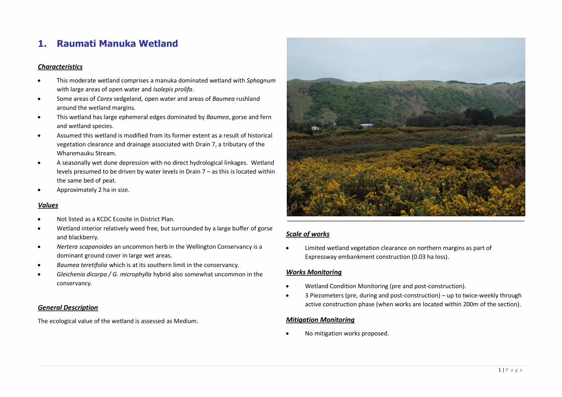
1 | P a g e
1. Raumati Manuka Wetland
Characteristics
This moderate wetland comprises a manuka dominated wetland with Sphagnum
with large areas of open water and Isolepis prolifa.
Some areas of Carex sedgeland, open water and areas of Baumea rushland
around the wetland margins.
This wetland has large ephemeral edges dominated by Baumea, gorse and fern
and wetland species.
Assumed this wetland is modified from its former extent as a result of historical
vegetation clearance and drainage associated with Drain 7, a tributary of the
Wharemauku Stream.
A seasonally wet dune depression with no direct hydrological linkages. Wetland
levels presumed to be driven by water levels in Drain 7 – as this is located within
the same bed of peat.
Approximately 2 ha in size.
Values
Not listed as a KCDC Ecosite in District Plan.
Wetland interior relatively weed free, but surrounded by a large buffer of gorse
and blackberry.
Nertera scapanoides an uncommon herb in the Wellington Conservancy is a
dominant ground cover in large wet areas.
Baumea teretifolia which is at its southern limit in the conservancy.
Gleichenia dicarpa / G. microphylla hybrid also somewhat uncommon in the
conservancy.
General Description
The ecological value of the wetland is assessed as Medium.
Scale of works
Limited wetland vegetation clearance on northern margins as part of
Expressway embankment construction (0.03 ha loss).
Works Monitoring
Wetland Condition Monitoring (pre and post-construction).
3 Piezometers (pre, during and post-construction) – up to twice-weekly through
active construction phase (when works are located within 200m of the section).
Mitigation Monitoring
No mitigation works proposed.
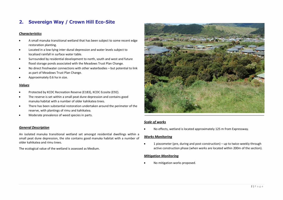
2 | P a g e
2. Sovereign Way / Crown Hill Eco-Site
Characteristics
A small manuka transitional wetland that has been subject to some recent edge
restoration planting.
Located in a low-lying inter-dunal depression and water levels subject to
localised rainfall in surface water table.
Surrounded by residential development to north, south and west and future
flood storage ponds associated with the Meadows Trust Plan Change.
No direct freshwater connections with other waterbodies – but potential to link
as part of Meadows Trust Plan Change.
Approximately 0.6 ha in size.
Values
Protected by KCDC Recreation Reserve (E183), KCDC Ecosite (E92).
The reserve is set within a small peat dune depression and contains good
manuka habitat with a number of older kahikatea trees.
There has been substantial restoration undertaken around the perimeter of the
reserve, with plantings of rimu and kahikatea.
Moderate prevalence of weed species in parts.
General Description
An isolated manuka transitional wetland set amongst residential dwellings within a small peat dune depression, the site contains good manuka habitat with a number of older kahikatea and rimu trees.
The ecological value of the wetland is assessed as Medium.
Scale of works
No effects, wetland is located approximately 125 m from Expressway.
Works Monitoring
1 piezometer (pre, during and post-construction) – up to twice-weekly through
active construction phase (when works are located within 200m of the section).
Mitigation Monitoring
No mitigation works proposed.
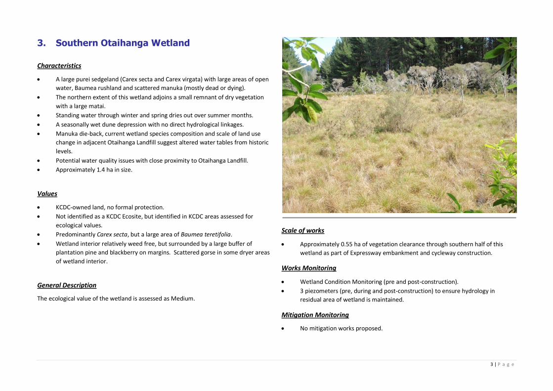
3 | P a g e
3. Southern Otaihanga Wetland
Characteristics
A large purei sedgeland (Carex secta and Carex virgata) with large areas of open
water, Baumea rushland and scattered manuka (mostly dead or dying).
The northern extent of this wetland adjoins a small remnant of dry vegetation
with a large matai.
Standing water through winter and spring dries out over summer months.
A seasonally wet dune depression with no direct hydrological linkages.
Manuka die-back, current wetland species composition and scale of land use
change in adjacent Otaihanga Landfill suggest altered water tables from historic
levels.
Potential water quality issues with close proximity to Otaihanga Landfill.
Approximately 1.4 ha in size.
Values
KCDC-owned land, no formal protection.
Not identified as a KCDC Ecosite, but identified in KCDC areas assessed for
ecological values.
Predominantly Carex secta, but a large area of Baumea teretifolia.
Wetland interior relatively weed free, but surrounded by a large buffer of
plantation pine and blackberry on margins. Scattered gorse in some dryer areas
of wetland interior.
General Description
The ecological value of the wetland is assessed as Medium.
Scale of works
Approximately 0.55 ha of vegetation clearance through southern half of this
wetland as part of Expressway embankment and cycleway construction.
Works Monitoring
Wetland Condition Monitoring (pre and post-construction).
3 piezometers (pre, during and post-construction) to ensure hydrology in
residual area of wetland is maintained.
Mitigation Monitoring
No mitigation works proposed.
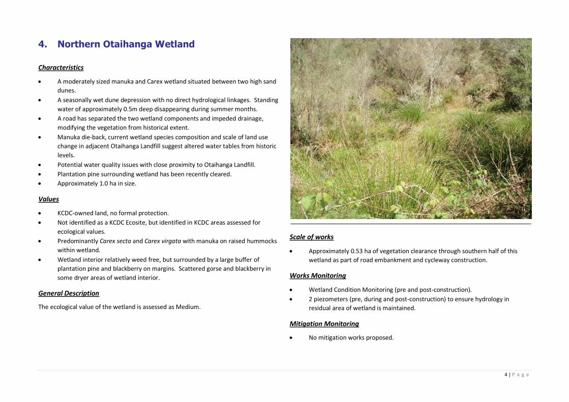
4 | P a g e
4. Northern Otaihanga Wetland
Characteristics
A moderately sized manuka and Carex wetland situated between two high sand
dunes.
A seasonally wet dune depression with no direct hydrological linkages. Standing
water of approximately 0.5m deep disappearing during summer months.
A road has separated the two wetland components and impeded drainage,
modifying the vegetation from historical extent.
Manuka die-back, current wetland species composition and scale of land use
change in adjacent Otaihanga Landfill suggest altered water tables from historic
levels.
Potential water quality issues with close proximity to Otaihanga Landfill.
Plantation pine surrounding wetland has been recently cleared.
Approximately 1.0 ha in size.
Values
KCDC-owned land, no formal protection.
Not identified as a KCDC Ecosite, but identified in KCDC areas assessed for
ecological values.
Predominantly Carex secta and Carex virgata with manuka on raised hummocks
within wetland.
Wetland interior relatively weed free, but surrounded by a large buffer of
plantation pine and blackberry on margins. Scattered gorse and blackberry in
some dryer areas of wetland interior.
General Description
The ecological value of the wetland is assessed as Medium.
Scale of works
Approximately 0.53 ha of vegetation clearance through southern half of this
wetland as part of road embankment and cycleway construction.
Works Monitoring
Wetland Condition Monitoring (pre and post-construction).
2 piezometers (pre, during and post-construction) to ensure hydrology in
residual area of wetland is maintained.
Mitigation Monitoring
No mitigation works proposed.
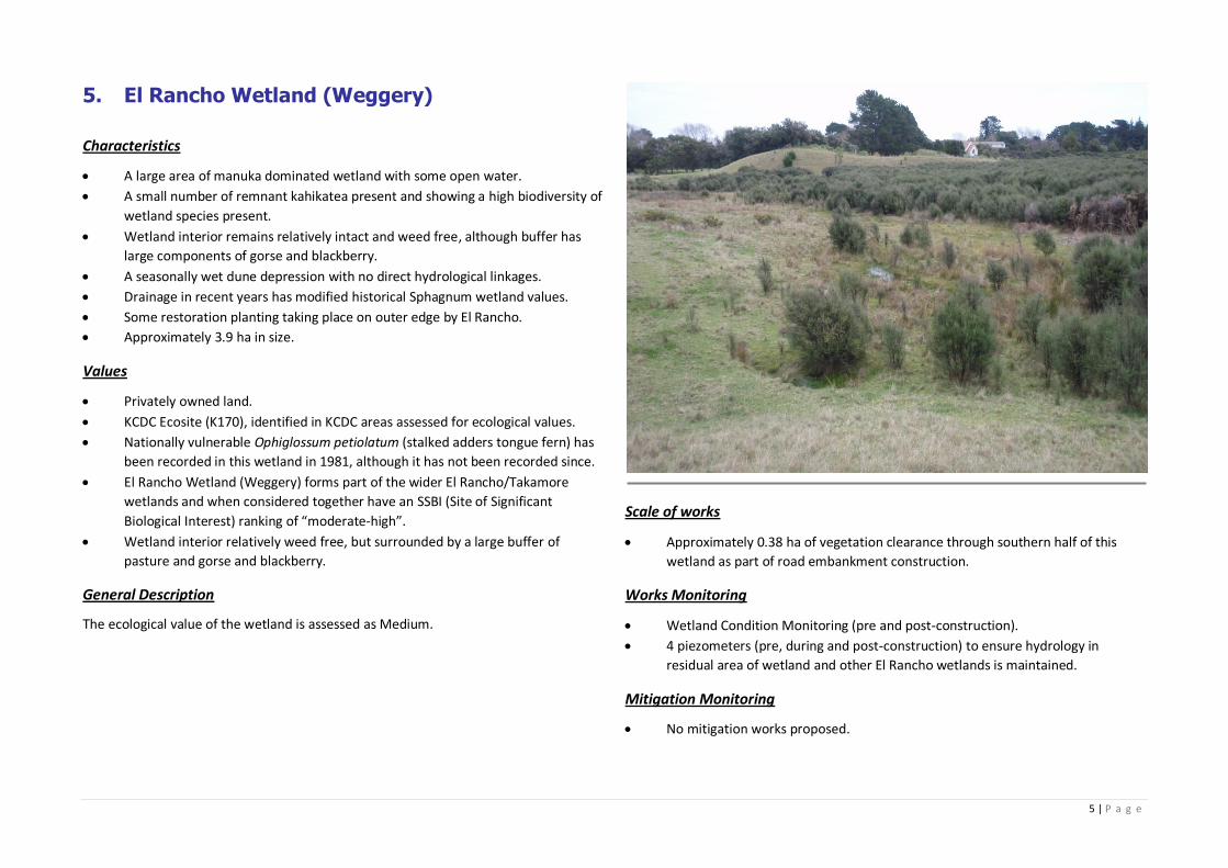
5 | P a g e
5. El Rancho Wetland (Weggery)
Characteristics
A large area of manuka dominated wetland with some open water.
A small number of remnant kahikatea present and showing a high biodiversity of
wetland species present.
Wetland interior remains relatively intact and weed free, although buffer has
large components of gorse and blackberry.
A seasonally wet dune depression with no direct hydrological linkages.
Drainage in recent years has modified historical Sphagnum wetland values.
Some restoration planting taking place on outer edge by El Rancho.
Approximately 3.9 ha in size.
Values
Privately owned land.
KCDC Ecosite (K170), identified in KCDC areas assessed for ecological values.
Nationally vulnerable Ophiglossum petiolatum (stalked adders tongue fern) has
been recorded in this wetland in 1981, although it has not been recorded since.
El Rancho Wetland (Weggery) forms part of the wider El Rancho/Takamore
wetlands and when considered together have an SSBI (Site of Significant
Biological Interest) ranking of “moderate‐high”.
Wetland interior relatively weed free, but surrounded by a large buffer of
pasture and gorse and blackberry.
General Description
The ecological value of the wetland is assessed as Medium.
Scale of works
Approximately 0.38 ha of vegetation clearance through southern half of this
wetland as part of road embankment construction.
Works Monitoring
Wetland Condition Monitoring (pre and post-construction).
4 piezometers (pre, during and post-construction) to ensure hydrology in
residual area of wetland and other El Rancho wetlands is maintained.
Mitigation Monitoring
No mitigation works proposed.
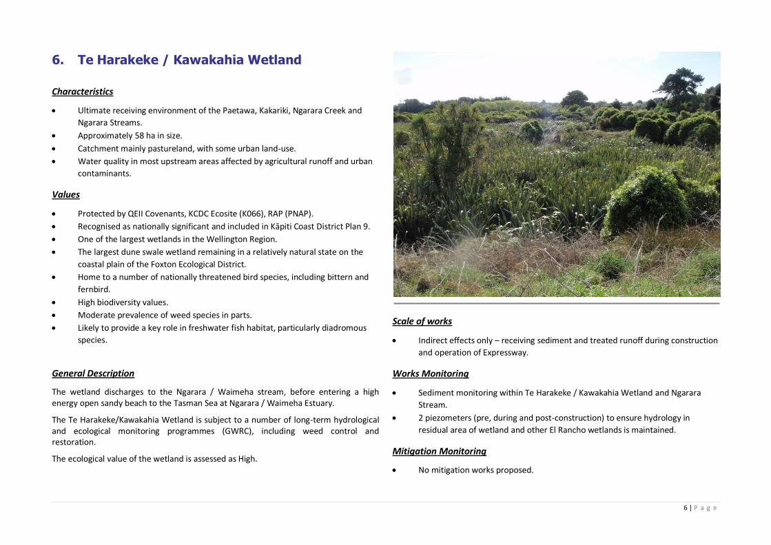
6 | P a g e
6. Te Harakeke / Kawakahia Wetland
Characteristics
Ultimate receiving environment of the Paetawa, Kakariki, Ngarara Creek and
Ngarara Streams.
Approximately 58 ha in size.
Catchment mainly pastureland, with some urban land-use.
Water quality in most upstream areas affected by agricultural runoff and urban
contaminants.
Values
Protected by QEII Covenants, KCDC Ecosite (K066), RAP (PNAP).
Recognised as nationally significant and included in Kāpiti Coast District Plan 9.
One of the largest wetlands in the Wellington Region.
The largest dune swale wetland remaining in a relatively natural state on the
coastal plain of the Foxton Ecological District.
Home to a number of nationally threatened bird species, including bittern and
fernbird.
High biodiversity values.
Moderate prevalence of weed species in parts.
Likely to provide a key role in freshwater fish habitat, particularly diadromous
species.
General Description
The wetland discharges to the Ngarara / Waimeha stream, before entering a high energy open sandy beach to the Tasman Sea at Ngarara / Waimeha Estuary.
The Te Harakeke/Kawakahia Wetland is subject to a number of long-term hydrological and ecological monitoring programmes (GWRC), including weed control and restoration.
The ecological value of the wetland is assessed as High.
Scale of works
Indirect effects only – receiving sediment and treated runoff during construction
and operation of Expressway.
Works Monitoring
Sediment monitoring within Te Harakeke / Kawakahia Wetland and Ngarara
Stream.
2 piezometers (pre, during and post-construction) to ensure hydrology in
residual area of wetland and other El Rancho wetlands is maintained.
Mitigation Monitoring
No mitigation works proposed.
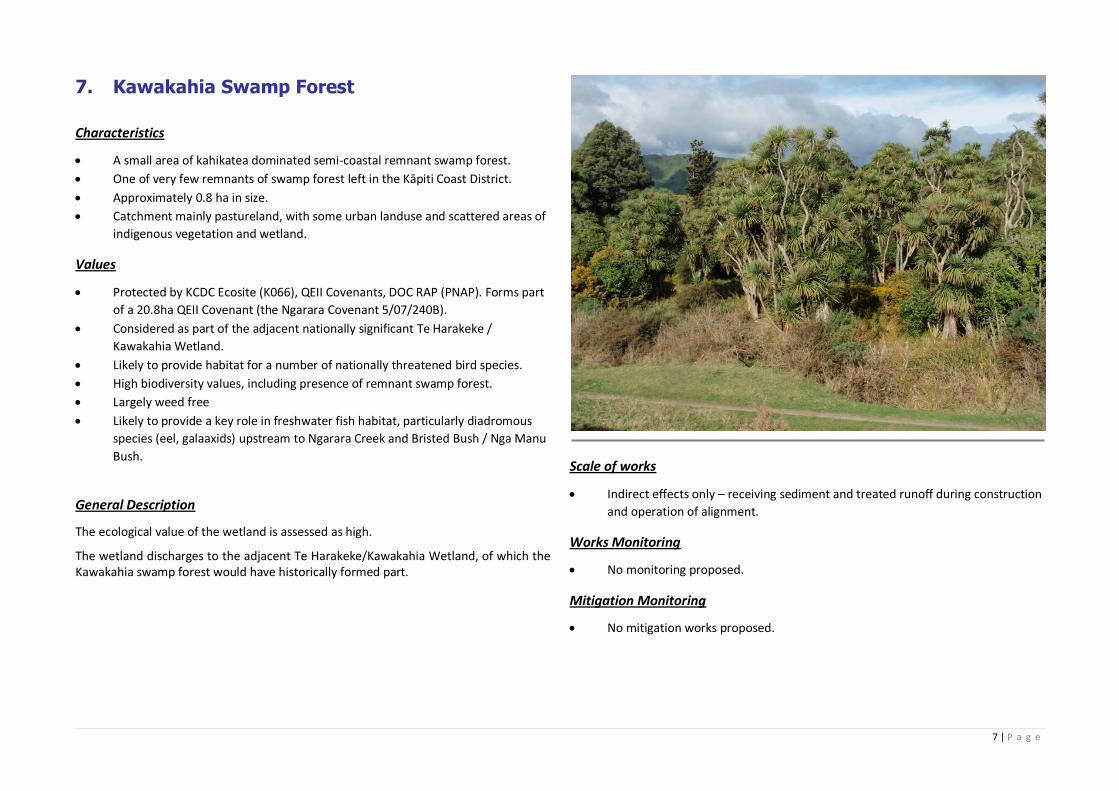
7 | P a g e
7. Kawakahia Swamp Forest
Characteristics
A small area of kahikatea dominated semi‐coastal remnant swamp forest.
One of very few remnants of swamp forest left in the Kāpiti Coast District.
Approximately 0.8 ha in size.
Catchment mainly pastureland, with some urban landuse and scattered areas of
indigenous vegetation and wetland.
Values
Protected by KCDC Ecosite (K066), QEII Covenants, DOC RAP (PNAP). Forms part
of a 20.8ha QEII Covenant (the Ngarara Covenant 5/07/240B).
Considered as part of the adjacent nationally significant Te Harakeke /
Kawakahia Wetland.
Likely to provide habitat for a number of nationally threatened bird species.
High biodiversity values, including presence of remnant swamp forest.
Largely weed free
Likely to provide a key role in freshwater fish habitat, particularly diadromous
species (eel, galaaxids) upstream to Ngarara Creek and Bristed Bush / Nga Manu
Bush.
General Description
The ecological value of the wetland is assessed as high.
The wetland discharges to the adjacent Te Harakeke/Kawakahia Wetland, of which the Kawakahia swamp forest would have historically formed part.
Scale of works
Indirect effects only – receiving sediment and treated runoff during construction
and operation of alignment.
Works Monitoring
No monitoring proposed.
Mitigation Monitoring
No mitigation works proposed.
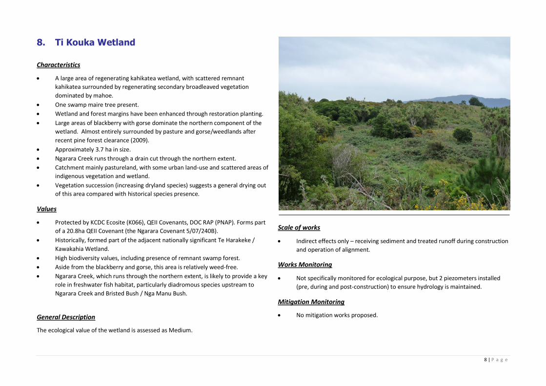
8 | P a g e
8. Ti Kouka Wetland
Characteristics
A large area of regenerating kahikatea wetland, with scattered remnant
kahikatea surrounded by regenerating secondary broadleaved vegetation
dominated by mahoe.
One swamp maire tree present.
Wetland and forest margins have been enhanced through restoration planting.
Large areas of blackberry with gorse dominate the northern component of the
wetland. Almost entirely surrounded by pasture and gorse/weedlands after
recent pine forest clearance (2009).
Approximately 3.7 ha in size.
Ngarara Creek runs through a drain cut through the northern extent.
Catchment mainly pastureland, with some urban land-use and scattered areas of
indigenous vegetation and wetland.
Vegetation succession (increasing dryland species) suggests a general drying out
of this area compared with historical species presence.
Values
Protected by KCDC Ecosite (K066), QEII Covenants, DOC RAP (PNAP). Forms part
of a 20.8ha QEII Covenant (the Ngarara Covenant 5/07/240B).
Historically, formed part of the adjacent nationally significant Te Harakeke /
Kawakahia Wetland.
High biodiversity values, including presence of remnant swamp forest.
Aside from the blackberry and gorse, this area is relatively weed‐free.
Ngarara Creek, which runs through the northern extent, is likely to provide a key
role in freshwater fish habitat, particularly diadromous species upstream to
Ngarara Creek and Bristed Bush / Nga Manu Bush.
General Description
The ecological value of the wetland is assessed as Medium.
Scale of works
Indirect effects only – receiving sediment and treated runoff during construction
and operation of alignment.
Works Monitoring
Not specifically monitored for ecological purpose, but 2 piezometers installed
(pre, during and post-construction) to ensure hydrology is maintained.
Mitigation Monitoring
No mitigation works proposed.
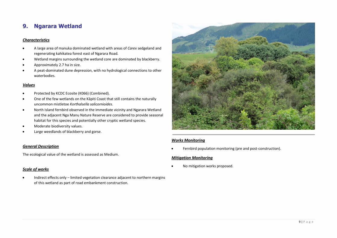
9 | P a g e
9. Ngarara Wetland
Characteristics
A large area of manuka dominated wetland with areas of Carex sedgeland and
regenerating kahikatea forest east of Ngarara Road.
Wetland margins surrounding the wetland core are dominated by blackberry.
Approximately 2.7 ha in size.
A peat-dominated dune depression, with no hydrological connections to other
waterbodies.
Values
Protected by KCDC Ecosite (K066) (Combined).
One of the few wetlands on the Kāpiti Coast that still contains the naturally
uncommon mistletoe Korthalsella salicornioides.
North Island fernbird observed in the immediate vicinity and Ngarara Wetland
and the adjacent Nga Manu Nature Reserve are considered to provide seasonal
habitat for this species and potentially other cryptic wetland species.
Moderate biodiversity values.
Large weedlands of blackberry and gorse.
General Description
The ecological value of the wetland is assessed as Medium.
Scale of works
Indirect effects only – limited vegetation clearance adjacent to northern margins
of this wetland as part of road embankment construction.
Works Monitoring
Fernbird population monitoring (pre and post-construction).
Mitigation Monitoring
No mitigation works proposed.
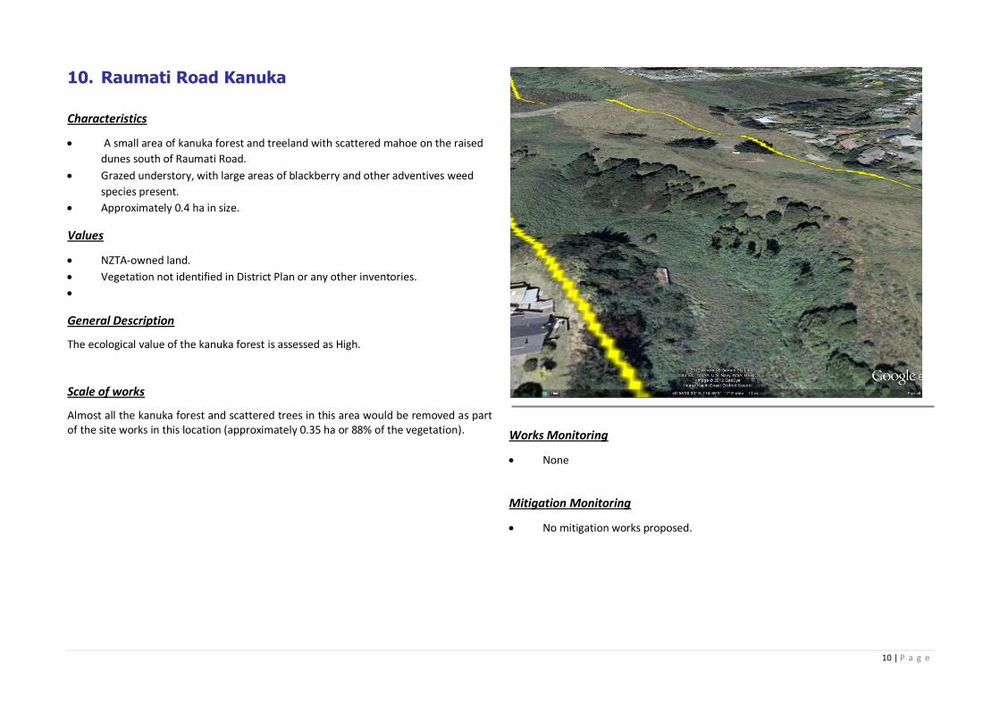
10 | P a g e
10. Raumati Road Kanuka
Characteristics
A small area of kanuka forest and treeland with scattered mahoe on the raised
dunes south of Raumati Road.
Grazed understory, with large areas of blackberry and other adventives weed
species present.
Approximately 0.4 ha in size.
Values
NZTA-owned land.
Vegetation not identified in District Plan or any other inventories.
General Description
The ecological value of the kanuka forest is assessed as High.
Scale of works
Almost all the kanuka forest and scattered trees in this area would be removed as part of the site works in this location (approximately 0.35 ha or 88% of the vegetation).
Works Monitoring
None
Mitigation Monitoring
No mitigation works proposed.
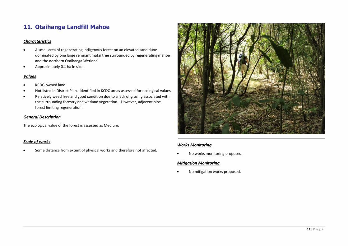
11 | P a g e
11. Otaihanga Landfill Mahoe
Characteristics
A small area of regenerating indigenous forest on an elevated sand dune
dominated by one large remnant matai tree surrounded by regenerating mahoe
and the northern Otaihanga Wetland.
Approximately 0.1 ha in size.
Values
KCDC-owned land.
Not listed in District Plan. Identified in KCDC areas assessed for ecological values
Relatively weed free and good condition due to a lack of grazing associated with
the surrounding forestry and wetland vegetation. However, adjacent pine
forest limiting regeneration.
General Description
The ecological value of the forest is assessed as Medium.
Scale of works
Some distance from extent of physical works and therefore not affected.
Works Monitoring
No works monitoring proposed.
Mitigation Monitoring
No mitigation works proposed.
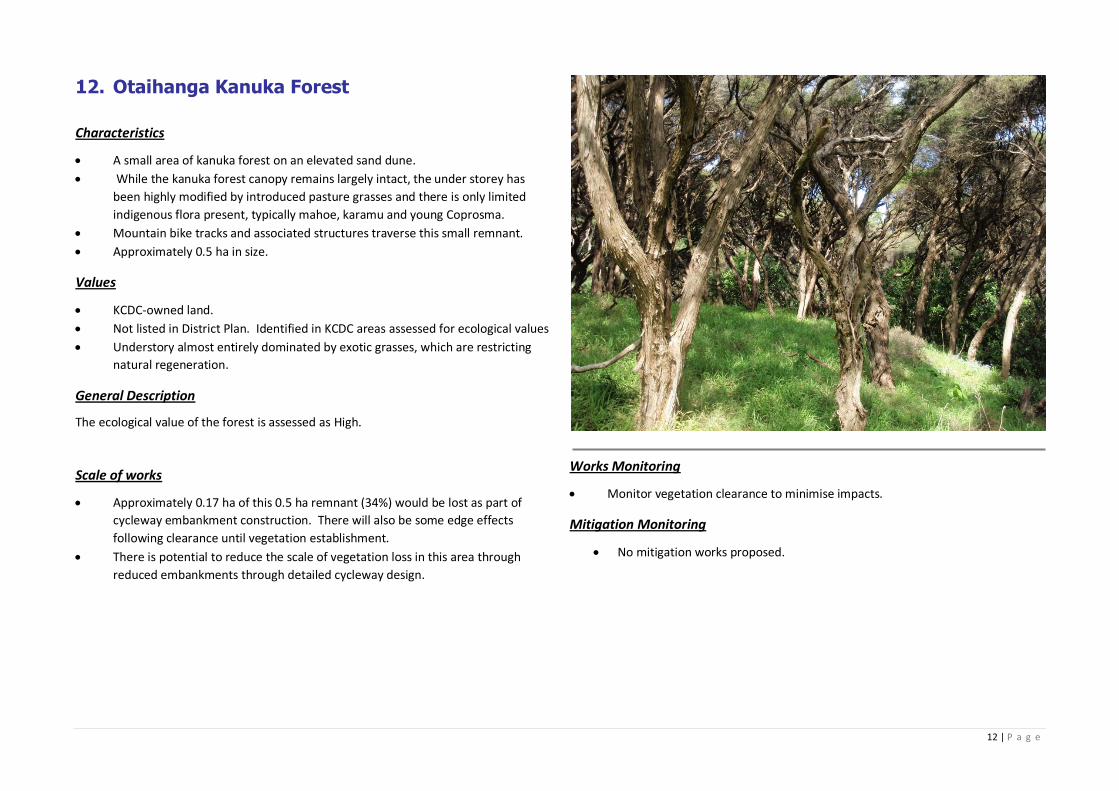
12 | P a g e
12. Otaihanga Kanuka Forest
Characteristics
A small area of kanuka forest on an elevated sand dune.
While the kanuka forest canopy remains largely intact, the under storey has
been highly modified by introduced pasture grasses and there is only limited
indigenous flora present, typically mahoe, karamu and young Coprosma.
Mountain bike tracks and associated structures traverse this small remnant.
Approximately 0.5 ha in size.
Values
KCDC-owned land.
Not listed in District Plan. Identified in KCDC areas assessed for ecological values
Understory almost entirely dominated by exotic grasses, which are restricting
natural regeneration.
General Description
The ecological value of the forest is assessed as High.
Scale of works
Approximately 0.17 ha of this 0.5 ha remnant (34%) would be lost as part of
cycleway embankment construction. There will also be some edge effects
following clearance until vegetation establishment.
There is potential to reduce the scale of vegetation loss in this area through
reduced embankments through detailed cycleway design.
Works Monitoring
Monitor vegetation clearance to minimise impacts.
Mitigation Monitoring
No mitigation works proposed.
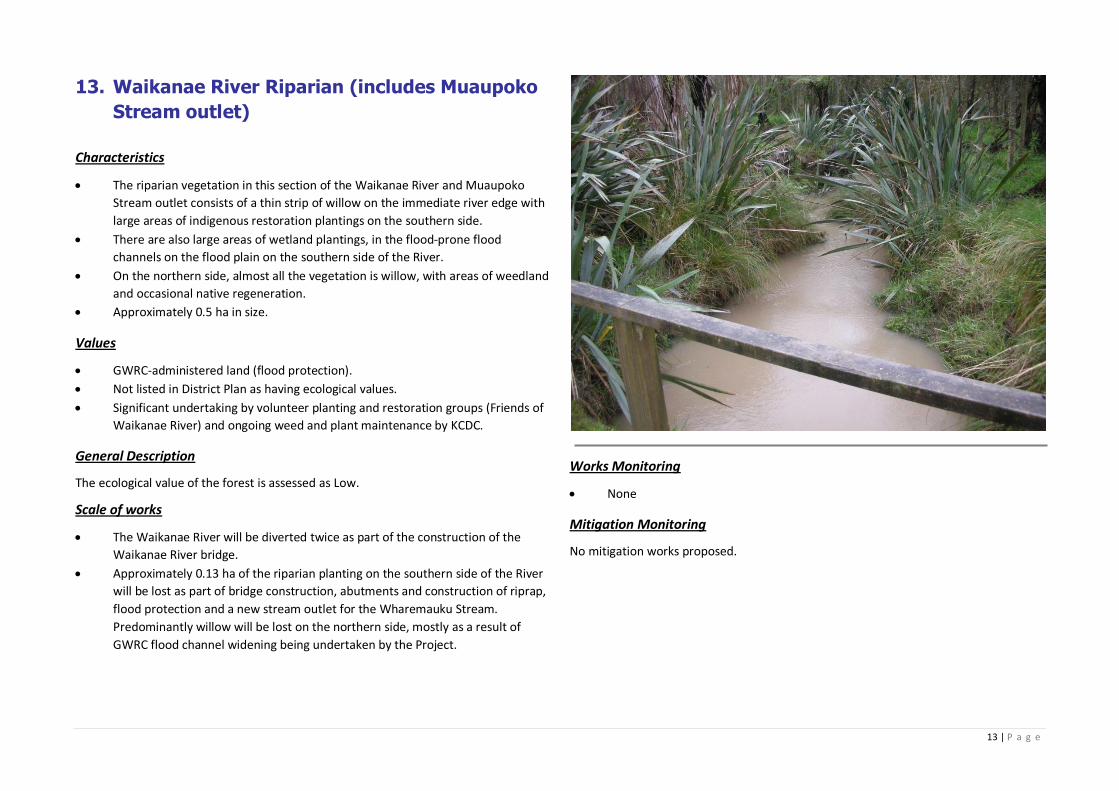
13 | P a g e
13. Waikanae River Riparian (includes Muaupoko
Stream outlet)
Characteristics
The riparian vegetation in this section of the Waikanae River and Muaupoko
Stream outlet consists of a thin strip of willow on the immediate river edge with
large areas of indigenous restoration plantings on the southern side.
There are also large areas of wetland plantings, in the flood‐prone flood
channels on the flood plain on the southern side of the River.
On the northern side, almost all the vegetation is willow, with areas of weedland
and occasional native regeneration.
Approximately 0.5 ha in size.
Values
GWRC-administered land (flood protection).
Not listed in District Plan as having ecological values.
Significant undertaking by volunteer planting and restoration groups (Friends of
Waikanae River) and ongoing weed and plant maintenance by KCDC.
General Description
The ecological value of the forest is assessed as Low.
Scale of works
The Waikanae River will be diverted twice as part of the construction of the
Waikanae River bridge.
Approximately 0.13 ha of the riparian planting on the southern side of the River
will be lost as part of bridge construction, abutments and construction of riprap,
flood protection and a new stream outlet for the Wharemauku Stream.
Predominantly willow will be lost on the northern side, mostly as a result of
GWRC flood channel widening being undertaken by the Project.
Works Monitoring
None
Mitigation Monitoring
No mitigation works proposed.
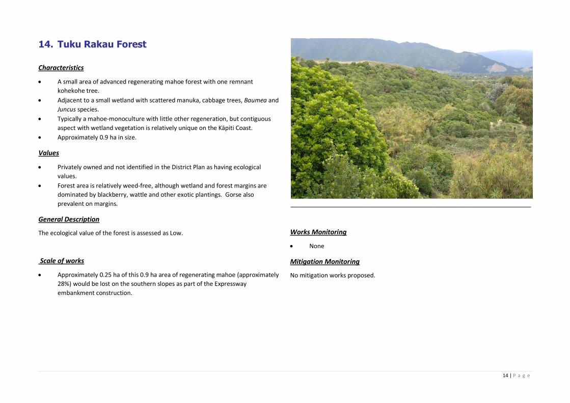
14 | P a g e
14. Tuku Rakau Forest
Characteristics
A small area of advanced regenerating mahoe forest with one remnant
kohekohe tree.
Adjacent to a small wetland with scattered manuka, cabbage trees, Baumea and
Juncus species.
Typically a mahoe-monoculture with little other regeneration, but contiguous
aspect with wetland vegetation is relatively unique on the Kāpiti Coast.
Approximately 0.9 ha in size.
Values
Privately owned and not identified in the District Plan as having ecological
values.
Forest area is relatively weed-free, although wetland and forest margins are
dominated by blackberry, wattle and other exotic plantings. Gorse also
prevalent on margins.
General Description
The ecological value of the forest is assessed as Low.
Scale of works
Approximately 0.25 ha of this 0.9 ha area of regenerating mahoe (approximately
28%) would be lost on the southern slopes as part of the Expressway
embankment construction.
Works Monitoring
None
Mitigation Monitoring
No mitigation works proposed.
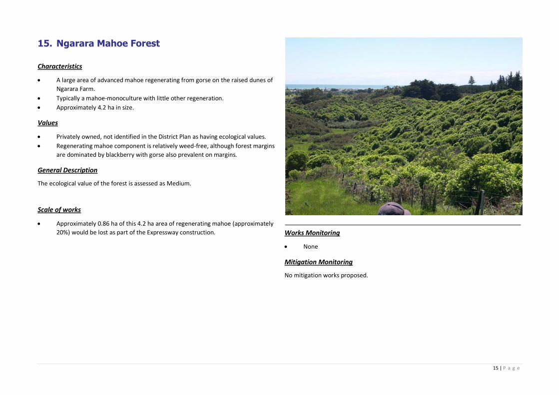
15 | P a g e
15. Ngarara Mahoe Forest
Characteristics
A large area of advanced mahoe regenerating from gorse on the raised dunes of
Ngarara Farm.
Typically a mahoe-monoculture with little other regeneration.
Approximately 4.2 ha in size.
Values
Privately owned, not identified in the District Plan as having ecological values.
Regenerating mahoe component is relatively weed-free, although forest margins
are dominated by blackberry with gorse also prevalent on margins.
General Description
The ecological value of the forest is assessed as Medium.
Scale of works
Approximately 0.86 ha of this 4.2 ha area of regenerating mahoe (approximately
20%) would be lost as part of the Expressway construction.
Works Monitoring
None
Mitigation Monitoring
No mitigation works proposed.

54
042590992/1503706
ANNEXURE B: MAP 1 - STUDY AREA
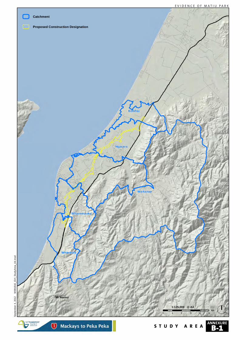
#0Mt Wainui
Ngarara
Waikanae
Wharemauku
Whareroa
Kowhai
Catchment
Proposed Construction Designation
Septe
mber
4, 20
12
W09
181E
_EVI
_Stud
yArea
_A4.m
xd
E V I D E N C E O F M A T I U P A R K
0 1 2 3 4 5km
1:125,000 @ A4
S T U D Y A R E AANNEXURE
B-1
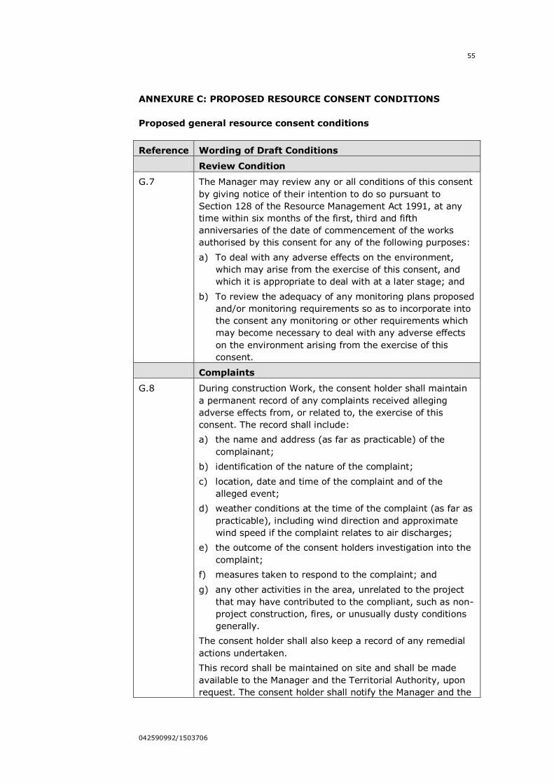
55
042590992/1503706
ANNEXURE C: PROPOSED RESOURCE CONSENT CONDITIONS
Proposed general resource consent conditions
Reference Wording of Draft Conditions
Review Condition
G.7 The Manager may review any or all conditions of this consent
by giving notice of their intention to do so pursuant to
Section 128 of the Resource Management Act 1991, at any
time within six months of the first, third and fifth
anniversaries of the date of commencement of the works
authorised by this consent for any of the following purposes:
a) To deal with any adverse effects on the environment,
which may arise from the exercise of this consent, and
which it is appropriate to deal with at a later stage; and
b) To review the adequacy of any monitoring plans proposed
and/or monitoring requirements so as to incorporate into
the consent any monitoring or other requirements which
may become necessary to deal with any adverse effects
on the environment arising from the exercise of this
consent.
Complaints
G.8 During construction Work, the consent holder shall maintain
a permanent record of any complaints received alleging
adverse effects from, or related to, the exercise of this
consent. The record shall include:
a) the name and address (as far as practicable) of the
complainant;
b) identification of the nature of the complaint;
c) location, date and time of the complaint and of the
alleged event;
d) weather conditions at the time of the complaint (as far as
practicable), including wind direction and approximate
wind speed if the complaint relates to air discharges;
e) the outcome of the consent holders investigation into the
complaint;
f) measures taken to respond to the complaint; and
g) any other activities in the area, unrelated to the project
that may have contributed to the compliant, such as non-
project construction, fires, or unusually dusty conditions
generally.
The consent holder shall also keep a record of any remedial
actions undertaken.
This record shall be maintained on site and shall be made
available to the Manager and the Territorial Authority, upon
request. The consent holder shall notify the Manager and the
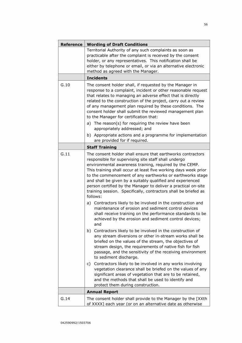
56
042590992/1503706
Reference Wording of Draft Conditions
Territorial Authority of any such complaints as soon as
practicable after the complaint is received by the consent
holder, or any representatives. This notification shall be
either by telephone or email, or via an alternative electronic
method as agreed with the Manager.
Incidents
G.10 The consent holder shall, if requested by the Manager in
response to a complaint, incident or other reasonable request
that relates to managing an adverse effect that is directly
related to the construction of the project, carry out a review
of any management plan required by these conditions. The
consent holder shall submit the reviewed management plan
to the Manager for certification that:
a) The reason(s) for requiring the review have been
appropriately addressed; and
b) Appropriate actions and a programme for implementation
are provided for if required.
Staff Training
G.11 The consent holder shall ensure that earthworks contractors
responsible for supervising site staff shall undergo
environmental awareness training, required by the CEMP.
This training shall occur at least five working days week prior
to the commencement of any earthworks or earthworks stage
and shall be given by a suitably qualified and experienced
person certified by the Manager to deliver a practical on-site
training session. Specifically, contractors shall be briefed as
follows:
a) Contractors likely to be involved in the construction and
maintenance of erosion and sediment control devices
shall receive training on the performance standards to be
achieved by the erosion and sediment control devices;
and
b) Contractors likely to be involved in the construction of
any stream diversions or other in-stream works shall be
briefed on the values of the stream, the objectives of
stream design, the requirements of native fish for fish
passage, and the sensitivity of the receiving environment
to sediment discharge.
c) Contractors likely to be involved in any works involving
vegetation clearance shall be briefed on the values of any
significant areas of vegetation that are to be retained,
and the methods that shall be used to identify and
protect them during construction.
Annual Report
G.14 The consent holder shall provide to the Manager by the [XXth
of XXXX] each year (or on an alternative date as otherwise
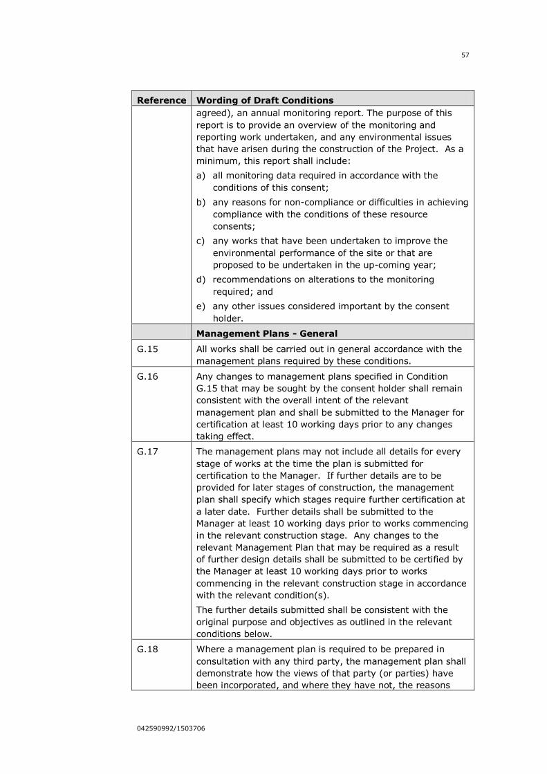
57
042590992/1503706
Reference Wording of Draft Conditions
agreed), an annual monitoring report. The purpose of this
report is to provide an overview of the monitoring and
reporting work undertaken, and any environmental issues
that have arisen during the construction of the Project. As a
minimum, this report shall include:
a) all monitoring data required in accordance with the
conditions of this consent;
b) any reasons for non-compliance or difficulties in achieving
compliance with the conditions of these resource
consents;
c) any works that have been undertaken to improve the
environmental performance of the site or that are
proposed to be undertaken in the up-coming year;
d) recommendations on alterations to the monitoring
required; and
e) any other issues considered important by the consent
holder.
Management Plans - General
G.15 All works shall be carried out in general accordance with the
management plans required by these conditions.
G.16 Any changes to management plans specified in Condition
G.15 that may be sought by the consent holder shall remain
consistent with the overall intent of the relevant
management plan and shall be submitted to the Manager for
certification at least 10 working days prior to any changes
taking effect.
G.17 The management plans may not include all details for every
stage of works at the time the plan is submitted for
certification to the Manager. If further details are to be
provided for later stages of construction, the management
plan shall specify which stages require further certification at
a later date. Further details shall be submitted to the
Manager at least 10 working days prior to works commencing
in the relevant construction stage. Any changes to the
relevant Management Plan that may be required as a result
of further design details shall be submitted to be certified by
the Manager at least 10 working days prior to works
commencing in the relevant construction stage in accordance
with the relevant condition(s).
The further details submitted shall be consistent with the
original purpose and objectives as outlined in the relevant
conditions below.
G.18 Where a management plan is required to be prepared in
consultation with any third party, the management plan shall
demonstrate how the views of that party (or parties) have
been incorporated, and where they have not, the reasons
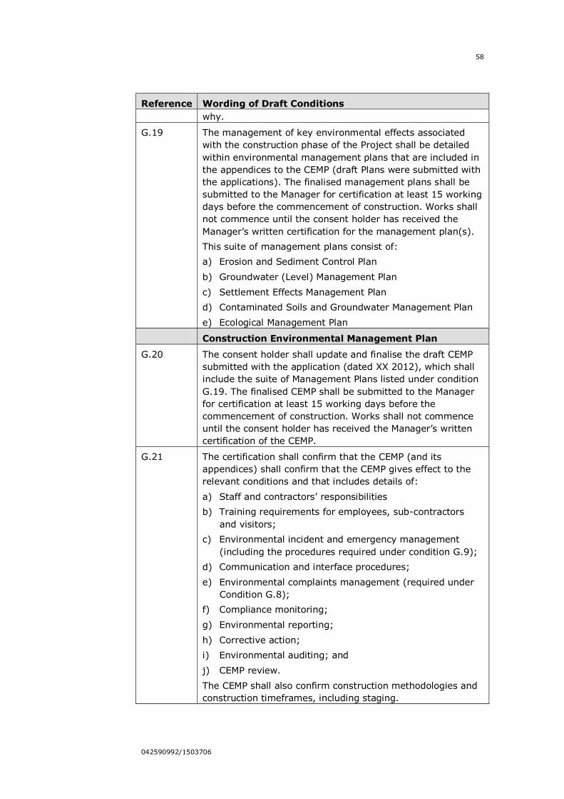
58
042590992/1503706
Reference Wording of Draft Conditions
why.
G.19 The management of key environmental effects associated
with the construction phase of the Project shall be detailed
within environmental management plans that are included in
the appendices to the CEMP (draft Plans were submitted with
the applications). The finalised management plans shall be
submitted to the Manager for certification at least 15 working
days before the commencement of construction. Works shall
not commence until the consent holder has received the
Manager‟s written certification for the management plan(s).
This suite of management plans consist of:
a) Erosion and Sediment Control Plan
b) Groundwater (Level) Management Plan
c) Settlement Effects Management Plan
d) Contaminated Soils and Groundwater Management Plan
e) Ecological Management Plan
Construction Environmental Management Plan
G.20 The consent holder shall update and finalise the draft CEMP
submitted with the application (dated XX 2012), which shall
include the suite of Management Plans listed under condition
G.19. The finalised CEMP shall be submitted to the Manager
for certification at least 15 working days before the
commencement of construction. Works shall not commence
until the consent holder has received the Manager‟s written
certification of the CEMP.
G.21 The certification shall confirm that the CEMP (and its
appendices) shall confirm that the CEMP gives effect to the
relevant conditions and that includes details of:
a) Staff and contractors‟ responsibilities
b) Training requirements for employees, sub-contractors
and visitors;
c) Environmental incident and emergency management
(including the procedures required under condition G.9);
d) Communication and interface procedures;
e) Environmental complaints management (required under
Condition G.8);
f) Compliance monitoring;
g) Environmental reporting;
h) Corrective action;
i) Environmental auditing; and
j) CEMP review.
The CEMP shall also confirm construction methodologies and
construction timeframes, including staging.
59
042590992/1503706
Reference Wording of Draft Conditions
G.22 The CEMP shall confirm final project details, staging of work,
and sufficient engineering design information to ensure that
the Project remains within the limits and standards approved
under this consent and that the construction activities avoid,
remedy or mitigate adverse effects on the environment in
accordance with the conditions of this consent. The CEMP
shall identify where design information for a particular stage
will be submitted at a later stage(s), in accordance with
condition G.17.
G.23 At least 15 working days before submitting the CEMP to
GWRC for certification the consent holder shall submit a copy
of the draft final CEMP required by Condition G.20 to KCDC
for comment. Any comments received shall be supplied to
the Manager when the CEMP is submitted, along with a clear
explanation of where any comments have not been
incorporated and the reasons why.
G.24 The CEMP shall be implemented and maintained throughout
the entire construction period, and updated if further design
information is provided
G.25 A copy of the CEMP shall be held on each construction site at
all times and be available for inspection by GWRC.
G.26 If the CEMP (including any of its constituent management
plans) required to be revised as a result of any updated or
new design information, the changes shall be certified by the
Manager in accordance with the relevant condition. The
revisions shall be submitted for certification at least 10
working days before the commencement of works in that part
of the Project to which the information relates.
Groundwater (Level) Management Plan
G.29 The consent holder shall finalise, submit and implement
through the CEMP, the Groundwater (Level) Management
Plan (GMP) to be submitted to the Manager for certification at
least 15 working days prior to works commencing. The
purpose of the management plan is to address the minimum
standards, outline the best practicable options for
groundwater management and procedures to minimise the
effects on groundwater levels.
The GWMP shall include information regarding:
i. the schedule of groundwater monitoring bores identifying
piezometer depth, screen length and geological unit;
ii. the locations of groundwater monitoring bores shown on
plans;
iii. the locations of monitoring stations on the Wharemauku
Stream and Drain 5;
iv. monitoring frequency;
60
042590992/1503706
Reference Wording of Draft Conditions
v. monitoring methods;
vi. reporting requirements;
vii. alert and action programmes;
viii. response management; and
ix. review procedures.
Ecological Management Plan
G.34 a) The consent holder shall finalise, submit and implement
through the CEMP, the Ecological Management Plan
(EMP). The EMP shall be submitted to the Manager for
certification at least 15 working days prior to works
commencing. The purpose of the Plan is to outline the
ecological management programme to protect, reduce
and remediate impacts on the environment during the
construction phase of the Project. This EMP shall also
document the permanent mitigation measures, such as
restoration planting, and the mechanisms by which to
develop relevant mitigation and restoration plans for
terrestrial and freshwater habitat.
b) The EMP shall detail the monitoring to be undertaken pre-
construction, during construction and post-construction
as outlined below in Condition G.38-G.40.
c) The EMP shall provide information on how the following
outcomes will be achieved:
i. Minimise loss of valued vegetation and habitats;
ii. Minimise construction effects on freshwater and the
marine environments;
iii. Minimise effects on identified wetlands resulting
from hydrological changes to water tables;
iv. Minimise effects on fish during stream works;
v. Minimise disturbance of nationally threatened or at-
risk birds (as listed by the most up to date
Department of Conservation threat classification
lists) during breeding periods;
vi. Re-establish affected lizard habitat and minimise
lizard mortality resulting from construction of the
Project;
vii. Carry out monitoring in a manner that will confirm
that adverse effects are as predicted; any
exceedance is identified; and appropriate actions are
undertaken to rectify;
viii. Ensures that mitigation requirements are undertaken
and monitored to ensure success is achieved;
ix. Carry out monitoring in a manner that confirms that
mitigation meets objectives; and
61
042590992/1503706
Reference Wording of Draft Conditions
x. Ensure that in the event of additional vegetation or
habitat loss outside of the Project footprint,
mitigation calculations are consistent with the
Environmental Compensation Ratios outlined in the
EMP.
G.35 The EMP shall be prepared by suitably qualified and
experienced ecologist, and shall implement the principles and
outcomes sought by the Ecological Impact Assessments
(Technical Reports 26 – 31). The EMP shall be prepared in
accordance with:
a) NZTA‟s Environmental Plan;
b) The Conservation Management Strategy for the
Wellington Conservancy; and
c) The Greater Wellington Pest Management Strategy
(2009).
G.36 The EMP shall be consistent with the Landscape Management
Plan (LMP) that is required to be certified by KCDC under the
designation conditions.
G.37 At least 15 working days before submitting the EMP to GWRC
for certification the Consent Holder shall submit a copy of the
draft EMP required by Condition G.34 to KCDC for comment.
Any comments received shall be supplied to the Manager
when the EMP is submitted, along with a clear explanation of
where any comments have not been incorporated and the
reasons why.
Ecological Monitoring – General
G.38 Monitoring shall be carried out in accordance with the EMP as
required by Condition G.34 in order to:
a) collect baseline information on vegetation, wetlands,
freshwater and marine ecology for 1 year prior to
construction work starting;
b) collect ecological information on vegetation, wetlands,
freshwater and marine ecology during construction work;
c) collect ecological information on vegetation, wetlands,
freshwater and marine ecology for 2 years post
construction works completion.
G.39 All ecological monitoring required under the EMP shall be
managed by a suitably qualified and experienced ecologist.
The results of all monitoring carried out pursuant to the EMP
shall be:
a) available for inspection during normal office hours where
such data is available;
b) submitted to the Manager at quarterly intervals for
certification that the appropriate monitoring has been
undertaken;
62
042590992/1503706
Reference Wording of Draft Conditions
c) submitted to the Director-General of Conservation and
KCDC for information; and
d) summarised and submitted as part of the annual report
required under Condition G.14.
G.40 An Adaptive Management approach shall be taken to
responding to ecological effects as outlined in the EMP. The
Adaptive Management monitoring shall seek to:
a) Provide a level of baseline information of pre-construction
vegetation, wetlands, freshwater and marine habitats in
order to develop „trigger‟ levels;
b) Undertake monitoring during construction to observe
whether „trigger‟ levels are exceeded and to determine
the effectiveness of the environmental management
methods; and
c) In the event that trigger levels are exceeded an Adaptive
Management approach shall be enlisted that will seek to:
i. Investigate a plausible cause-effect association with
the Project; should the event be linked to the project
the following steps will be undertaken:
A. Identify the on-site practice that is generating
the effect;
B. Seek to alter the operational measure in
consultation with GWRC;
C. Undertake further monitoring to assess the
effectiveness of the altered on-site practice.
ii. If the trigger level exceedance is not attributable to
works associated with the Project, the consent
holder shall not be held liable for any remediation or
mitigation works;
iii. Trigger level exceedances during construction should
be treated as management triggers and not
compliance triggers in the first instance.
Proposed resource consent conditions for earthworks and
discharges to land
Erosion and Sediment Control Monitoring
E.9 In the event of either a failure of erosion and sediment control
devices or where a storm event exceeds the design volume of
the device, and where the discharge is to a perennial or
intermittent freshwater body, wetland or estuarine/marine
environment, a suitably qualified ecologist(s) shall be notified
within 24 hours, who shall then inspect the relevant area to
determine whether significant adverse effects on the affected
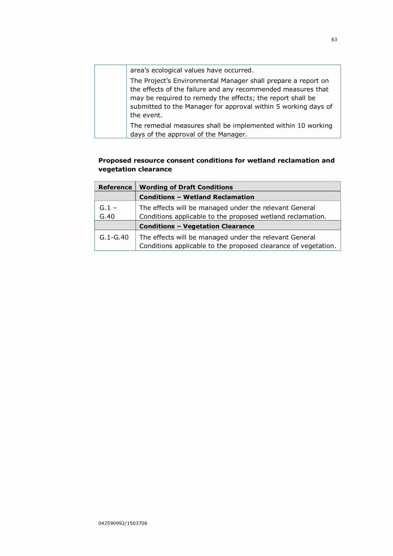
63
042590992/1503706
area‟s ecological values have occurred.
The Project‟s Environmental Manager shall prepare a report on
the effects of the failure and any recommended measures that
may be required to remedy the effects; the report shall be
submitted to the Manager for approval within 5 working days of
the event.
The remedial measures shall be implemented within 10 working
days of the approval of the Manager.
Proposed resource consent conditions for wetland reclamation and
vegetation clearance
Reference Wording of Draft Conditions
Conditions – Wetland Reclamation
G.1 –
G.40
The effects will be managed under the relevant General
Conditions applicable to the proposed wetland reclamation.
Conditions – Vegetation Clearance
G.1-G.40 The effects will be managed under the relevant General
Conditions applicable to the proposed clearance of vegetation.
64
042590992/1503706
ANNEXURE D: POLICY 22 OF THE PROPOSED REGIONAL POLICY
STATEMENT FOR THE WELLINGTON REGION148
Policy 22: Identifying indigenous ecosystems and habitats with
significant indigenous biodiversity values – district and regional
plans
District and regional plans shall identify indigenous ecosystems and
habitats with significant indigenous biodiversity values that meet one or
more of the following criteria:
(a) Representativeness: high representativeness values are given to
particular ecosystems and habitats that were once typical and
commonplace in a district or in the region, and:
(i) are no longer commonplace (less than about 30% remaining); or
(ii) are poorly represented in existing protected areas (less than
about 20% legally protected).
(h) Rarity: the ecosystem or habitat has biological physical features that
are scarce or threatened in a local, regional or national context. This can
include individual species, rare and distinctive biological communities and
physical features that are unusual or rare.
(c) Diversity: the ecosystem or habitat has a natural diversity of ecological
units, ecosystems, species and physical features within an area.
(d) Ecological context of an area: the ecosystem or habitat:
(i) enhances connectivity or otherwise buffers representative, rare
or diverse indigenous ecosystems and habitats; or
(ii) provides seasonal or core habitat for protected or threatened
indigenous species.
(d) Tangata whenua values: the ecosystem or habitat contains
characteristics of special spiritual, historical or cultural significance to
tangata whenua, identified in accordance with tikanga Maori.
Explanation
Policy 22 sets out criteria as guidance that must be considered in
identifying indigenous ecosystems and habitats with significant biodiversity
148 Changes shown in underline indicate changes resulting from submissions, dated
October 2010.
65
042590992/1503706
values. These criteria need to be considered in all assessments but the
relevance of each will depend on the individual cases.
Policy 22 will ensure that significant biodiversity values are identified in
district and regional plans in a consistent way. Wellington Regional
Council, and district and city councils are required to assess indigenous
ecosystems and habitats against all the criteria. To be identified as having
significant biodiversity values, an indigenous ecosystem or habitat must fit
one or more of the listed criteria.
Regional plans will identify indigenous ecosystems and habitats with
significant biodiversity values in the coastal marine area, wetlands and the
beds of lakes and rivers. District plans will identify indigenous ecosystems
and habitats with significant biodiversity values for all land, except the
coastal marine area and the beds of lakes and rivers.
66
042590992/1503706
ANNEXURE E: WETLAND CONDITION MONITORING SHEETS
MISSING FROM TECHNICAL REPORT 27
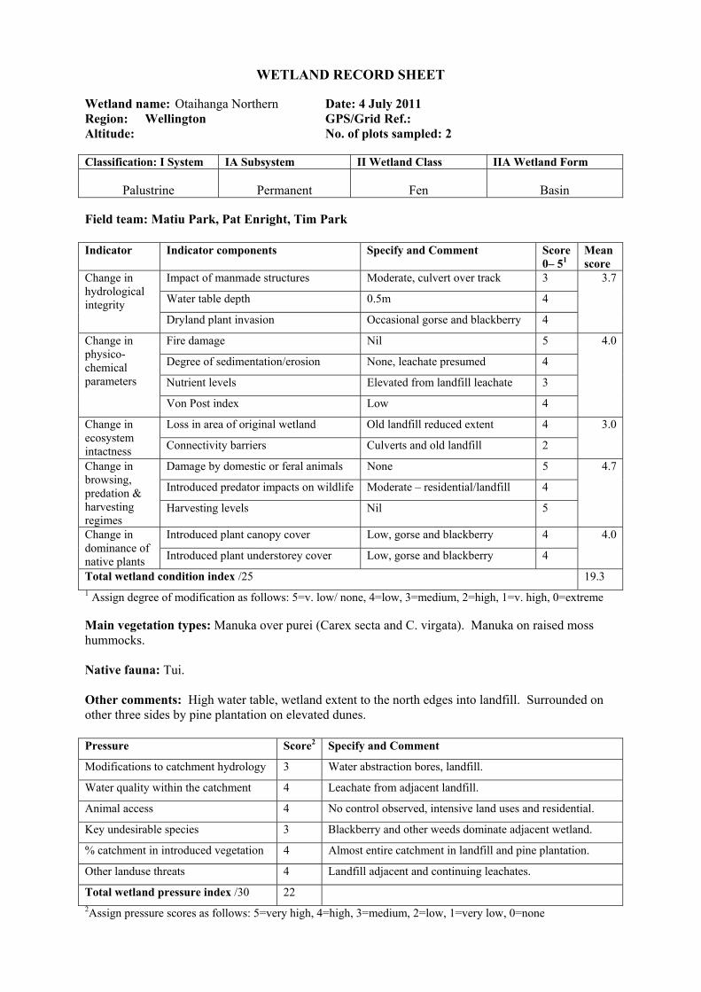
WETLAND RECORD SHEET
Wetland name: Otaihanga Northern Date: 4 July 2011 Region: Wellington GPS/Grid Ref.: Altitude: No. of plots sampled: 2 Classification: I System IA Subsystem II Wetland Class IIA Wetland Form
Palustrine Permanent Fen Basin
Field team: Matiu Park, Pat Enright, Tim Park Indicator Indicator components Specify and Comment Score
0– 51 Mean score
Change in hydrological integrity
Impact of manmade structures Moderate, culvert over track 3 3.7
Water table depth 0.5m 4
Dryland plant invasion Occasional gorse and blackberry 4
Change in physico-chemical parameters
Fire damage Nil 5 4.0
Degree of sedimentation/erosion None, leachate presumed 4
Nutrient levels Elevated from landfill leachate 3
Von Post index Low 4
Change in ecosystem intactness
Loss in area of original wetland Old landfill reduced extent 4 3.0
Connectivity barriers Culverts and old landfill 2
Change in browsing, predation & harvesting regimes
Damage by domestic or feral animals None 5 4.7
Introduced predator impacts on wildlife Moderate – residential/landfill 4
Harvesting levels Nil 5
Change in dominance of native plants
Introduced plant canopy cover Low, gorse and blackberry 4 4.0
Introduced plant understorey cover Low, gorse and blackberry 4
Total wetland condition index /25 19.3 1 Assign degree of modification as follows: 5=v. low/ none, 4=low, 3=medium, 2=high, 1=v. high, 0=extreme Main vegetation types: Manuka over purei (Carex secta and C. virgata). Manuka on raised moss hummocks. Native fauna: Tui. Other comments: High water table, wetland extent to the north edges into landfill. Surrounded on other three sides by pine plantation on elevated dunes. Pressure Score2 Specify and Comment
Modifications to catchment hydrology 3 Water abstraction bores, landfill.
Water quality within the catchment 4 Leachate from adjacent landfill.
Animal access 4 No control observed, intensive land uses and residential.
Key undesirable species 3 Blackberry and other weeds dominate adjacent wetland.
% catchment in introduced vegetation 4 Almost entire catchment in landfill and pine plantation.
Other landuse threats 4 Landfill adjacent and continuing leachates.
Total wetland pressure index /30 22 2Assign pressure scores as follows: 5=very high, 4=high, 3=medium, 2=low, 1=very low, 0=none
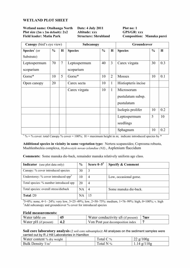
WETLAND PLOT SHEET
Wetland name: Otaihanga North Date: 4 July 2011 Plot no: 1 Plot size (2m x 2m default): 2x2 Altitude: xxx GPS/GR: xxx Field leader: Matiu Park Structure: Shrubland Composition: Manuka purei
Canopy (bird’s eye view) Subcanopy Groundcover
Species1 (or
Substrate)
% H Species % H Species % H
Leptospermum
scoparium
70 7 Leptospermum
scoparium
40 3 Carex virgata 30 0.3
Gorse* 10 5 Gorse* 10 2 Mosses 10 0.1
Open canopy 20 Carex secta 10 1 Histiopteris incise
Carex virgata 10 1 Microsorum
pustulatum subsp.
pustulatum
Isolepis prolifer 10 0.2
Leptospermum
seedlings
5 10
Sphagnum 10 0.2 1 % = % cover: total Canopy % cover = 100%; H = maximum height in m; indicate introduced species by * Additional species in vicinity in same vegetation type: Nertera scapanoides; Coprosma robusta, Muehlenbeckia complexa, Hydrocotyle novae-zelandiae (NZ)., Asplenium flaccidum Comments: Some manuka die-back, remainder manuka relatively uniform age class. Indicator (use plot data only) % Score 0–52 Specify & Comment
Canopy: % cover introduced species 30 3
Understorey: % cover introduced spp3 10 4 Low, occasional gorse.
Total species: % number introduced spp 20 4
Total species: overall stress/dieback NA 4 Some manuka die-back.
Total /20 NA 15 25=0%: none, 4=1– 24%: very low, 3=25–49%; low, 2=50–75%: medium, 1=76–99%: high, 0=100%; v. high 3Add subcanopy and groundcover % cover for introduced species Field measurements: Water table cm 45 Water conductivity uS (if present) 7mv Water pH (if present) 4.2 Von Post peat decomposition index 7 Soil core laboratory analysis (2 soil core subsamples): All analyses on the sediment samples were carried out by R J Hill Laboratories in Hamilton Water content % dry weight Total C % 22 g/100g Bulk Density T/m3 Total N % 1.14 g/110g
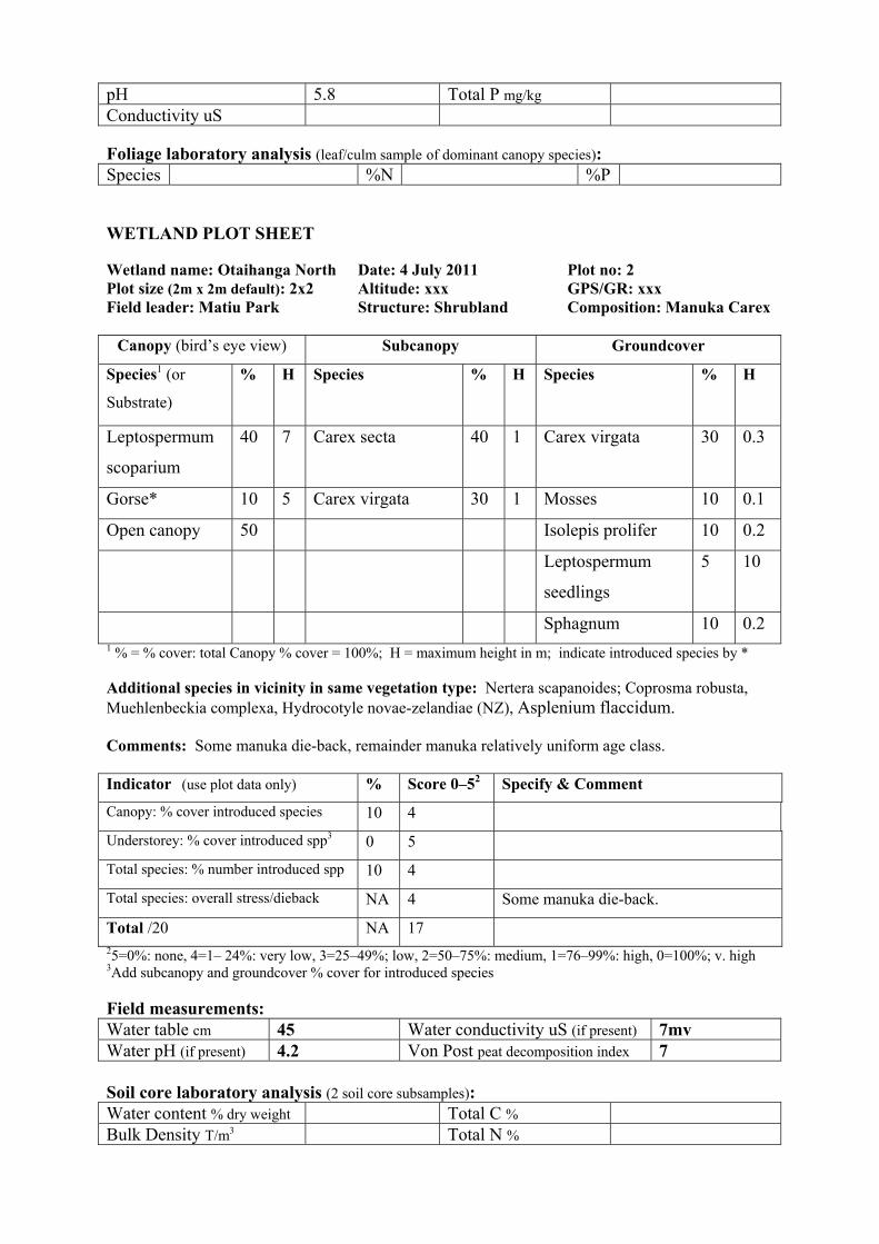
pH 5.8 Total P mg/kg Conductivity uS Foliage laboratory analysis (leaf/culm sample of dominant canopy species): Species %N %P WETLAND PLOT SHEET
Wetland name: Otaihanga North Date: 4 July 2011 Plot no: 2 Plot size (2m x 2m default): 2x2 Altitude: xxx GPS/GR: xxx Field leader: Matiu Park Structure: Shrubland Composition: Manuka Carex
Canopy (bird’s eye view) Subcanopy Groundcover
Species1 (or
Substrate)
% H Species % H Species % H
Leptospermum
scoparium
40 7 Carex secta 40 1 Carex virgata 30 0.3
Gorse* 10 5 Carex virgata 30 1 Mosses 10 0.1
Open canopy 50 Isolepis prolifer 10 0.2
Leptospermum
seedlings
5 10
Sphagnum 10 0.2 1 % = % cover: total Canopy % cover = 100%; H = maximum height in m; indicate introduced species by * Additional species in vicinity in same vegetation type: Nertera scapanoides; Coprosma robusta, Muehlenbeckia complexa, Hydrocotyle novae-zelandiae (NZ), Asplenium flaccidum. Comments: Some manuka die-back, remainder manuka relatively uniform age class. Indicator (use plot data only) % Score 0–52 Specify & Comment
Canopy: % cover introduced species 10 4
Understorey: % cover introduced spp3 0 5
Total species: % number introduced spp 10 4
Total species: overall stress/dieback NA 4 Some manuka die-back.
Total /20 NA 17 25=0%: none, 4=1– 24%: very low, 3=25–49%; low, 2=50–75%: medium, 1=76–99%: high, 0=100%; v. high 3Add subcanopy and groundcover % cover for introduced species Field measurements: Water table cm 45 Water conductivity uS (if present) 7mv Water pH (if present) 4.2 Von Post peat decomposition index 7 Soil core laboratory analysis (2 soil core subsamples): Water content % dry weight Total C % Bulk Density T/m3 Total N %

pH Total P mg/kg Conductivity uS Foliage laboratory analysis (leaf/culm sample of dominant canopy species): Species %N %P
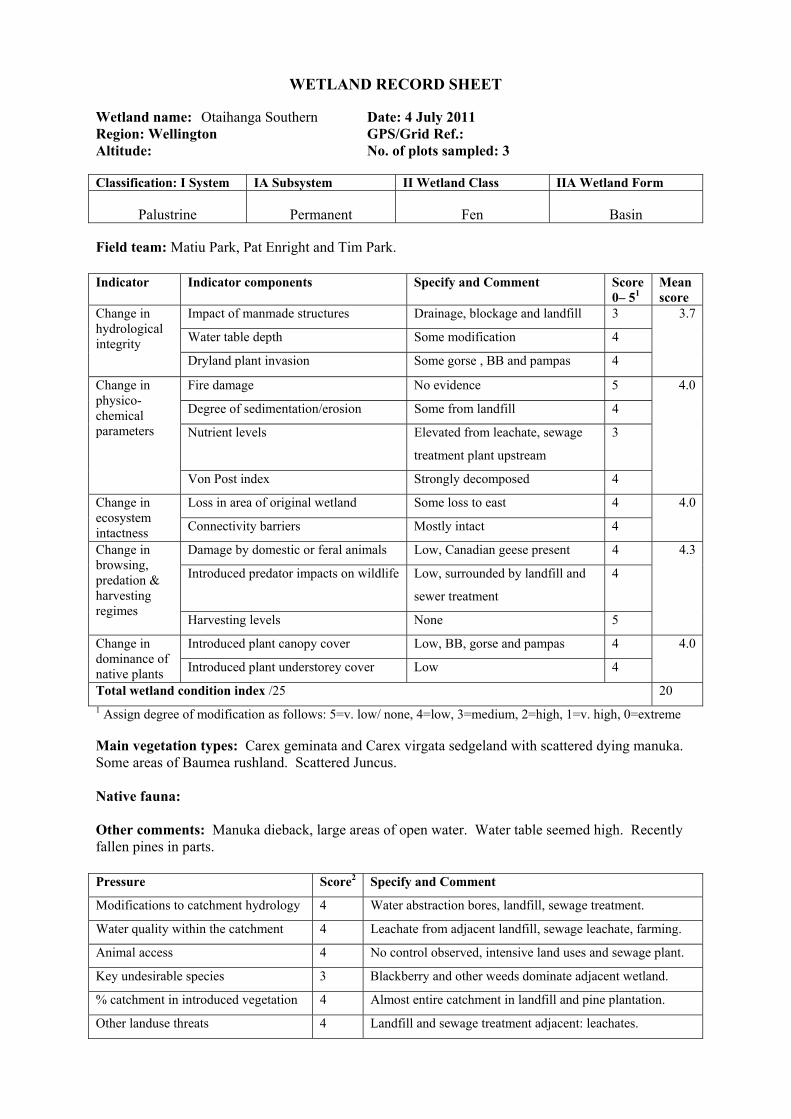
WETLAND RECORD SHEET
Wetland name: Otaihanga Southern Date: 4 July 2011 Region: Wellington GPS/Grid Ref.: Altitude: No. of plots sampled: 3 Classification: I System IA Subsystem II Wetland Class IIA Wetland Form
Palustrine Permanent Fen Basin
Field team: Matiu Park, Pat Enright and Tim Park. Indicator Indicator components Specify and Comment Score
0– 51 Mean score
Change in hydrological integrity
Impact of manmade structures Drainage, blockage and landfill 3 3.7
Water table depth Some modification 4
Dryland plant invasion Some gorse , BB and pampas 4
Change in physico-chemical parameters
Fire damage No evidence 5 4.0
Degree of sedimentation/erosion Some from landfill 4
Nutrient levels Elevated from leachate, sewage
treatment plant upstream
3
Von Post index Strongly decomposed 4
Change in ecosystem intactness
Loss in area of original wetland Some loss to east 4 4.0
Connectivity barriers Mostly intact 4
Change in browsing, predation & harvesting regimes
Damage by domestic or feral animals Low, Canadian geese present 4 4.3
Introduced predator impacts on wildlife Low, surrounded by landfill and
sewer treatment
4
Harvesting levels None 5
Change in dominance of native plants
Introduced plant canopy cover Low, BB, gorse and pampas 4 4.0
Introduced plant understorey cover Low 4
Total wetland condition index /25 20 1 Assign degree of modification as follows: 5=v. low/ none, 4=low, 3=medium, 2=high, 1=v. high, 0=extreme Main vegetation types: Carex geminata and Carex virgata sedgeland with scattered dying manuka. Some areas of Baumea rushland. Scattered Juncus. Native fauna: Other comments: Manuka dieback, large areas of open water. Water table seemed high. Recently fallen pines in parts. Pressure Score2 Specify and Comment
Modifications to catchment hydrology 4 Water abstraction bores, landfill, sewage treatment.
Water quality within the catchment 4 Leachate from adjacent landfill, sewage leachate, farming.
Animal access 4 No control observed, intensive land uses and sewage plant.
Key undesirable species 3 Blackberry and other weeds dominate adjacent wetland.
% catchment in introduced vegetation 4 Almost entire catchment in landfill and pine plantation.
Other landuse threats 4 Landfill and sewage treatment adjacent: leachates.
Total wetland pressure index /30 23 2Assign pressure scores as follows: 5=very high, 4=high, 3=medium, 2=low, 1=very low, 0=none WETLAND PLOT SHEET
Wetland name: Otaihanga South Date: 4 July 2011 Plot no: 1 Plot size (2m x 2m default): 2x2 Altitude: GPS/GR: Field leader: Matiu Park Structure: Rushland Composition: Baumea
Canopy (bird’s eye view) Subcanopy Groundcover
Species1 (or Substrate) % H Species % H Species % H
Baumea teretifolia 80 1.8 Hypolepis ambigua 30 0.5
Hypolepis ambigua 10 1.3 Blackberry* 5 0.5
Blackberry* 10 1.0 1 % = % cover: total Canopy % cover = 100%; H = maximum height in m; indicate introduced species by * Additional species in vicinity in same vegetation type: Austroderia fulvida, Leptospermum scoparium, Carex virgata, Carex secta, blackberry*, gorse*, Pinus radiata*, Isolepis prolifer, Sphagnum. Comments: Unusually high water table. Manuka die-back observed.
Indicator (use plot data only) % Score 0–52 Specify & Comment
Canopy: % cover introduced species 10 4 Blackberry.
Understorey: % cover introduced spp3 5 4 Blackberry
Total species: % number introduced spp 10 4
Total species: overall stress/dieback NA 4 Manuka die-back, open water.
Total /20 NA 16 25=0%: none, 4=1– 24%: very low, 3=25–49%; low, 2=50–75%: medium, 1=76–99%: high, 0=100%; v. high 3Add subcanopy and groundcover % cover for introduced species Field measurements: Water table cm 60 Water conductivity uS (if present) 7MV Water pH (if present) 4.08 Von Post peat decomposition index 7 Soil core laboratory analysis (2 soil core subsamples): All analyses on the sediment samples were carried out by R J Hill Laboratories in Hamilton Water content % dry weight Total C % 25 g / 100g Bulk Density T/m3 Total N % 1.16 g / 100g pH 5.0 Total P mg/kg Conductivity uS Foliage laboratory analysis (leaf/culm sample of dominant canopy species): Species %N %P
WETLAND PLOT SHEET
Wetland name: Otaihanga South Date: 4 July 2011 Plot no: 2 Plot size (2m x 2m default): 2x2 Altitude: GPS/GR: Field leader: Matiu Park Structure: Sedgeland Composition: Carex
Canopy (bird’s eye view) Subcanopy Groundcover
Species1 (or Substrate) % H Species % H Species % H
Carex virgata 30 1.5 Hypolepis ambigua 30 0.5
Carex secta 10 1.5 Isolepis prolifer 10 0.1
Open water 60 1 % = % cover: total Canopy % cover = 100%; H = maximum height in m; indicate introduced species by * Additional species in vicinity in same vegetation type: Austrodaria fulvida, Leptospermum scoparium, Baumea teretifolia, bracken, blackberry*, gorse*, Pinus radiata*, pampas*, Sphagnum. Comments: Unusually high water table. Manuka die-back observed. Some dead pines nearby (fallen). Presumed to historically have been manuka over purei prior to water table modification.
Indicator (use plot data only) % Score 0–52 Specify & Comment
Canopy: % cover introduced species 0 5
Understorey: % cover introduced spp3 0 5
Total species: % number introduced spp 0 5
Total species: overall stress/dieback NA 4 Manuka die-back, open water.
Total /20 NA 19 25=0%: none, 4=1– 24%: very low, 3=25–49%; low, 2=50–75%: medium, 1=76–99%: high, 0=100%; v. high 3Add subcanopy and groundcover % cover for introduced species Field measurements: Water table cm 50 Water conductivity uS (if present) 7MV Water pH (if present) 4.08 Von Post peat decomposition index 7 Soil core laboratory analysis (2 soil core subsamples): Water content % dry weight Total C % Bulk Density T/m3 Total N % pH Total P mg/kg Conductivity uS Foliage laboratory analysis (leaf/culm sample of dominant canopy species): Species %N %P
WETLAND PLOT SHEET
Wetland name: Otaihanga South Date: 4 July 2011 Plot no: 3 Plot size (2m x 2m default): 2x2 Altitude: GPS/GR: Field leader: Matiu Park Structure: Sedgeland Composition: Carex
Canopy (bird’s eye view) Subcanopy Groundcover
Species1 (or Substrate) % H Species % H Species % H
Open water 40 Hypolepis
ambigua
30 0.5
Carex virgate 20 1.5 Isolepis prolifer 10 0.1
Carex secta 40 1.5 Bidens frondosa* 20
Bidens frondosa* 10 1.2
Juncus effusus 10 1.2 1 % = % cover: total Canopy % cover = 100%; H = maximum height in m; indicate introduced species by * Additional species in vicinity in same vegetation type: Isolepis prolifer, Persicaria decipiens, blackberry*, Bidens, Juncus pallidus, Juncus edgariae, Yorkshire fog*, Hypolepis ambigua, Azolla filiculoides, gorse*, Leptospermum scoparium, bracken, Pinus radiata*, pampas*, Sphagnum. Comments: Unusually high water table. Manuka die-back. Some dead pines nearby (fallen).
Indicator (use plot data only) % Score 0–52 Specify & Comment
Canopy: % cover introduced species 10 4
Understorey: % cover introduced spp3 10 4 Bidens, but BB nearby.
Total species: % number introduced spp 10 4
Total species: overall stress/dieback NA 4 Manuka die-back, open water.
Total /20 NA 16 25=0%: none, 4=1– 24%: very low, 3=25–49%; low, 2=50–75%: medium, 1=76–99%: high, 0=100%; v. high 3Add subcanopy and groundcover % cover for introduced species Field measurements: Water table cm 30 Water conductivity uS (if present) 7MV Water pH (if present) 4.08 Von Post peat decomposition index 7 Soil core laboratory analysis (2 soil core subsamples): Water content % dry weight Total C % Bulk Density T/m3 Total N % pH Total P mg/kg Conductivity uS Foliage laboratory analysis (leaf/culm sample of dominant canopy species): Species %N %P
WETLAND RECORD SHEET
Wetland name: Otaihanga Central Date: 4 July 2011 Region: Wellington GPS/Grid Ref.: Altitude: No. of plots sampled: 1 Classification: I System IA Subsystem II Wetland Class IIA Wetland Form
Palustrine Permanent Fen Basin
Field team: Matiu Park, Pat Enright, Tim Park. Indicator Indicator components Specify and Comment Score
0– 51 Mean score
Change in hydrological integrity
Impact of manmade structures Culvert and landfill and sediment 1 0.7
Water table depth Major changes 1
Dryland plant invasion High, throughout 0
Change in physico-chemical parameters
Fire damage None 5 1.8
Degree of sedimentation/erosion High 1
Nutrient levels High – landfill leachate
throughout
0
Von Post index Fine silts and muds 1
Change in ecosystem intactness
Loss in area of original wetland Substantial area lost beneath
landfill
3 2.5
Connectivity barriers Very low (landfill, pines, houses) 2
Change in browsing, predation & harvesting regimes
Damage by domestic or feral animals Low, Canadian geese, possum 4 4.0
Introduced predator impacts on wildlife Moderate – residential, landfill 3
Harvesting levels None 5
Change in dominance of native plants
Introduced plant canopy cover Dominanted by exotic species 1 1.0
Introduced plant understorey cover Dominated by exotic species 1
Total wetland condition index /25 9.9 1 Assign degree of modification as follows: 5=v. low/ none, 4=low, 3=medium, 2=high, 1=v. high, 0=extreme Main vegetation types: Blackberry* and inkweed* with mahoe and occasional Carex secta. Native fauna: NIL Other comments: Highly modified from landfill leachate, modified drainage and sedimentation. Dryer plant species becoming established in weedland (mahoe, Dicksonia, Muehlenbeckia). Green goddess lily* (invasive) Pressure Score2 Specify and Comment
Modifications to catchment hydrology 5 Water abstraction
Water quality within the catchment 5 Leachate from adjacent landfill exits to wetland
Animal access 4 No control observed, intensive land uses and sewage plant.
Key undesirable species 3 Blackberry and other weeds dominate adjacent wetland.
% catchment in introduced vegetation 4 Almost entire catchment in landfill and pine plantation.
Other landuse threats 4 Landfill leachate, contaminated stream feeding wetland.
Total wetland pressure index /30 25 2Assign pressure scores as follows: 5=very high, 4=high, 3=medium, 2=low, 1=very low, 0=none WETLAND PLOT SHEET
Wetland name: Otaihanga Central Date: 4 July 2011 Plot no: 1 Plot size (2m x 2m default): 2x2 Altitude: GPS/GR: Field leader: Matiu Park Structure: Scrub Composition: Blackberry
Canopy (bird’s eye view) Subcanopy Groundcover
Species1 (or Substrate) % H Species % H Species % H
Blackberry 40 1.5 Asplenium
oblongifolium
4 0.4 Ranunculus
repens
70 0.
2
Muehlenbeckia
complexa
30 1.5 Mahoe 10 0.6 Apium
nodiflorum*
5 0.
2
Carex virgata 10 1.5 Histiopteris incisa 10 0.7 Asplenium
oblongifolium
Solanum
chenopodioides*
20 1.2 Solanum
chenopodioides*
10 0.8 Histiopteris
incisa
Bare ground 50 Moss 1 % = % cover: total Canopy % cover = 100%; H = maximum height in m; indicate introduced species by * Additional species in vicinity in same vegetation type: Green goddess*, Dicksonia squarrosa, inkweed*, Pinus radiata*, gorse*, Galium aparine*, climbing dock*, Ranunculus sceleratus* and Solanum nigrum*. Comments: Landfill leachate obvious, water discoloured and anoxic odour prevalent. Water table modified with no standing water present other than small stream.
Indicator (use plot data only) % Score 0–52 Specify & Comment
Canopy: % cover introduced species 80 1
Understorey: % cover introduced spp3 70 2
Total species: % number introduced spp 70 2
Total species: overall stress/dieback NA 1
Total /20 NA 6 25=0%: none, 4=1– 24%: very low, 3=25–49%; low, 2=50–75%: medium, 1=76–99%: high, 0=100%; v. high 3Add subcanopy and groundcover % cover for introduced species Field measurements: Water table cm Ground level Water conductivity uS (if present) 10MV Water pH (if present) 7.32 Von Post peat decomposition index 8 Soil core laboratory analysis (2 soil core subsamples): All analyses on the sediment samples were carried out by R J Hill Laboratories in Hamilton

Water content % dry weight Total C % 17.5g / 100g Bulk Density T/m3 Total N % 1.46g / 100g pH 7.5 Total P mg/kg Conductivity uS Foliage laboratory analysis (leaf/culm sample of dominant canopy species): Species %N %P
WETLAND RECORD SHEET
Wetland name: El Rancho Wetland Date: 4 July 2011 Region: Wellington GPS/Grid Ref.: Altitude: No. of plots sampled: 2 Classification: I System IA Subsystem II Wetland Class IIA Wetland Form
Palustrine Permanent Fen Basin
Field team: Matiu Park, Pat Enright, Tim Park Indicator Indicator components Specify and Comment Score
0– 51 Mean score
Change in hydrological integrity
Impact of manmade structures Drains cut through interior of
wetland.
3 3.0
Water table depth Altered through drainage, and
evidence of lowering of water
levels.
2
Dryland plant invasion Gorse and blackberry and other
weeds common.
4
Change in physico-chemical parameters
Fire damage None 5 4.8
Degree of sedimentation/erosion None 5
Nutrient levels None 5
Von Post index Dark water with some peat
escape.
4
Change in ecosystem intactness
Loss in area of original wetland Some loss of historical wetlands
extent in this location
4 3.0
Connectivity barriers Some connectivity barriers, with
loss of vegetation and weeds
dominant.
2
Change in browsing, predation & harvesting regimes
Damage by domestic or feral animals Some browsing on edge of
wetland by stock.
3 3.7
Introduced predator impacts on wildlife Low, but adjacent to residential
areas
4
Harvesting levels Some mowing and grazing in
southern edge.
4
Change in dominance of native plants
Introduced plant canopy cover Low 4 4.0
Introduced plant understorey cover Low, some blackberry and gorse. 4
Total wetland condition index /25 18.4 1 Assign degree of modification as follows: 5=v. low/ none, 4=low, 3=medium, 2=high, 1=v. high, 0=extreme Main vegetation types: First plot in vicinity of Expressway Alignment was mossfield and artificially induced moss and exotic grassland. Second plot, in main wetland was a manuka wetland. Native fauna: Other comments: Heavily grazed by cattle and sheep. Low water table with artificial drain in
vicinity of wetland. No visible water. A large area of wetland edge adjacent to Plot 1 had recently been sprayed as part of gas pipeline maintenance. Pressure Score2 Specify and Comment
Modifications to catchment hydrology 2 Evidence of reducing water tables over years across El
Rancho wetlands. Main wetland and surrounds historically
drained (and more recently?).
Water quality within the catchment 1 Some pressures from El Rancho stock and residential areas.
Animal access 4 Currently heavily grazed in this location.
Key undesirable species 3 Catchment has a high number of undesirable species present,
including close proximity to weedy Waikanae River
corridor.
% catchment in introduced vegetation 4 Most of the catchment modified and in pasture or blackberry
and gorse.
Other landuse threats 3 Gas pipeline, access from El Rancho etc.
Total wetland pressure index /30 17 2Assign pressure scores as follows: 5=very high, 4=high, 3=medium, 2=low, 1=very low, 0=none
WETLAND PLOT SHEET
Wetland name: El Rancho Weggery Date: 4 July 2011 Plot no: 1 Plot size (2m x 2m default): 2x2 Altitude: GPS/GR: Field leader: Matiu Park Structure: Mossfield Composition:
Canopy (bird’s eye view) Subcanopy Groundcover
Species1 (or Substrate) % H Species % H Species % H
Creeping bent 40 .20
Leptostigma setulosa 10 .20
Eleocharis gracilis 15 .20
Euchiton involucratus 5
Gonocarpus micranthus 5
Paspalum dilatatum* 5
Leptospermum scoparium 5
Centella uniflora 5 1 % = % cover: total Canopy % cover = 100%; H = maximum height in m; indicate introduced species by * Additional species in vicinity in same vegetation type: Juncus edgariae, Calluna vulgaris, manuka, gorse, Lotus pedunculatus, Luzula picta var. picta, Galium*, Juncus sarophorus, Baumea teretifolia. Comments: Heavily grazed and drained. Mossfields, Carex sedgeland and Baumea rushland observed to be induced by stock pressures. Risk that removal of stock would revert back to exotic pastures or blackberry, similar to adjacent stock-free perimeters of surrounding wetlands. .
Indicator (use plot data only) % Score 0–52 Specify & Comment
Canopy: % cover introduced species 50 2 Mostly mosses and grazed pasture grass.
Understorey: % cover introduced spp3 50 2 As above
Total species: % number introduced spp 50 2
Total species: overall stress/dieback NA 3 Grazing
Total /20 NA 9 25=0%: none, 4=1– 24%: very low, 3=25–49%; low, 2=50–75%: medium, 1=76–99%: high, 0=100%; v. high 3Add subcanopy and groundcover % cover for introduced species Field measurements: Water table cm Groundwater Water conductivity uS (if present) 12 MV Water pH (if present) 6.37 (in drain) Von Post peat decomposition index 7 Soil core laboratory analysis (2 soil core subsamples): Water content % dry weight Total C % Bulk Density T/m3 Total N % pH Total P mg/kg Conductivity uS Foliage laboratory analysis (leaf/culm sample of dominant canopy species): Species %N %P
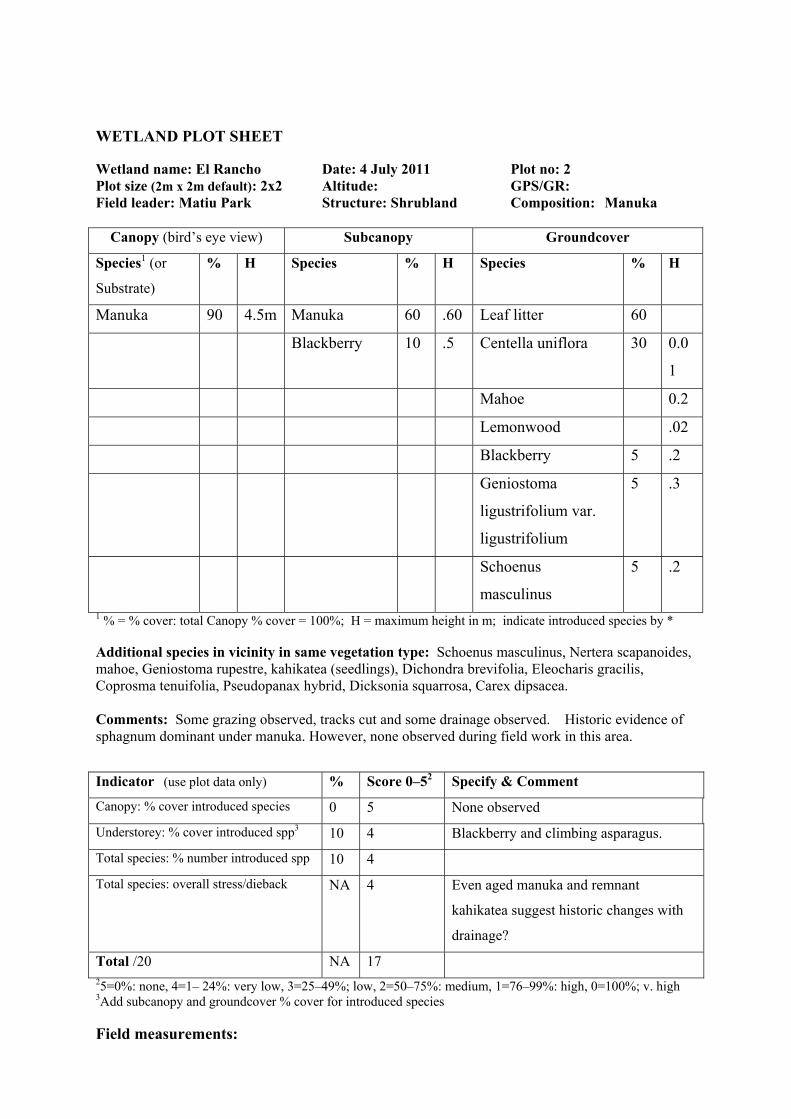
WETLAND PLOT SHEET
Wetland name: El Rancho Date: 4 July 2011 Plot no: 2 Plot size (2m x 2m default): 2x2 Altitude: GPS/GR: Field leader: Matiu Park Structure: Shrubland Composition: Manuka
Canopy (bird’s eye view) Subcanopy Groundcover
Species1 (or
Substrate)
% H Species % H Species % H
Manuka 90 4.5m Manuka 60 .60 Leaf litter 60
Blackberry 10 .5 Centella uniflora 30 0.0
1
Mahoe 0.2
Lemonwood .02
Blackberry 5 .2
Geniostoma
ligustrifolium var.
ligustrifolium
5 .3
Schoenus
masculinus
5 .2
1 % = % cover: total Canopy % cover = 100%; H = maximum height in m; indicate introduced species by * Additional species in vicinity in same vegetation type: Schoenus masculinus, Nertera scapanoides, mahoe, Geniostoma rupestre, kahikatea (seedlings), Dichondra brevifolia, Eleocharis gracilis, Coprosma tenuifolia, Pseudopanax hybrid, Dicksonia squarrosa, Carex dipsacea. Comments: Some grazing observed, tracks cut and some drainage observed. Historic evidence of sphagnum dominant under manuka. However, none observed during field work in this area.
Indicator (use plot data only) % Score 0–52 Specify & Comment
Canopy: % cover introduced species 0 5 None observed
Understorey: % cover introduced spp3 10 4 Blackberry and climbing asparagus.
Total species: % number introduced spp 10 4
Total species: overall stress/dieback NA 4 Even aged manuka and remnant
kahikatea suggest historic changes with
drainage?
Total /20 NA 17 25=0%: none, 4=1– 24%: very low, 3=25–49%; low, 2=50–75%: medium, 1=76–99%: high, 0=100%; v. high 3Add subcanopy and groundcover % cover for introduced species Field measurements:

Water table cm Groundwater Water conductivity uS (if present) 12 MV Water pH (if present) 6.37 (in drain) Von Post peat decomposition index 7 Soil core laboratory analysis (2 soil core subsamples): Water content % dry weight Total C % Bulk Density T/m3 Total N % pH Total P mg/kg Conductivity uS Foliage laboratory analysis (leaf/culm sample of dominant canopy species): Species %N %P

67
042590992/1503706
ANNEXURE F: PROPOSED AREAS OF WETLAND MITIGATION
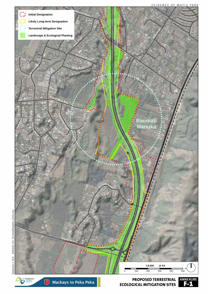
! ! ! ! ! ! ! !! !
!!!
!!!!!
!!!!!!
!!
!!
!!
!!
!!
!!
!!
!!
!!
!!
!!
!!!!!!
!!!!!!
!!
!!!!!!!!!!!!!!!!!!
!!
!!!!!!
!!!!!
!!
!!
!!
!!
!!
!!
!!
!!
!!
!!
!!
!!
!!!!!
!!!!!!!
!! ! ! ! ! ! ! ! !
RaumatiManuka
Rimu Roa
d
Matai R
oad
Hillcr
est Road
Fincham Road
Lorna Irene Dri ve
Raumati Road
Harry Shaw Way
SH 1
Hillc res t Road
Dale
Road
Gavin Road
Rata Road
Poplar Avenue
Leinster Aven ue
PROPOSED TERRESTRIALECOLOGICAL MITIGATION SITES
Initial Designation
Likely Long-term Designation! !
!
!!!
!
! Terrestrial Mitigation Site
Landscape & Ecological Planting
Septe
mber
4, 20
12
W091
81E_
EVI_T
erres
trialM
itigati
on_A
4mb.m
xd
E V I D E N C E O F M A T I U P A R K
0 100 200 300 400 500m
1:8,500 @ A4
ANNEXURE
F-1
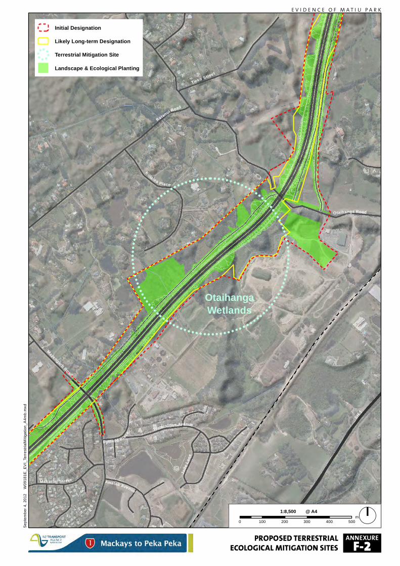
! ! ! ! ! ! ! ! !!
!!
!!!!
!!!!
!!
!!
!!
!!
!!
!!
!!
!!
!!
!!
!!
!!!!
!!!!!!
!!!!!!!!!!!!!!!!!
!!
!!!!!
!!!!!!
!!
!!
!!
!!
!!
!!
!!
!!
!!
!!
!!!!
!!!!!
!!
!!
! ! ! ! ! ! !
OtaihangaWetlands
Fytfield P la ce
Makarini Street
Waterstone Avenue
Awatea Avenue
Otaihanga Road
Jade
Lane
Ratanui Road
Mazengarb Road
Tieko Street
Kil lalea Place
SH 1
PROPOSED TERRESTRIALECOLOGICAL MITIGATION SITES
Initial Designation
Likely Long-term Designation! !
!
!!!
!
! Terrestrial Mitigation Site
Landscape & Ecological Planting
Septe
mber
4, 20
12
W091
81E_
EVI_T
erres
trialM
itigati
on_A
4mb.m
xd
E V I D E N C E O F M A T I U P A R K
0 100 200 300 400 500m
1:8,500 @ A4
ANNEXURE
F-2
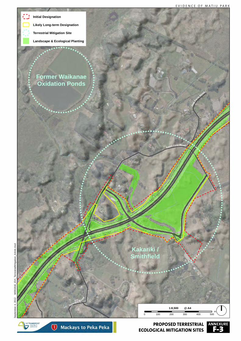
! ! ! ! ! ! ! ! ! ! !! !
!!
!!
!!!!!!
!!!!!!!!!
!!
!!
!!
!!
!!
!!
!!
!!
!!
!!
!!
!!
!!
!!
!!
!!!!!!!
!!!!!!!!!
!!
!!!!!!!!!!!!!!!!!!!!!!
!!!
!!!
!!!!!!!
!!!!!!!
!!
!!
!!
!!
!!
!!
!!
!!
!!
!!
!!
!!
!!
!!
!!
!!
!!!!!!!
!!!!!!!!
!!
!! ! ! ! ! ! ! ! ! ! ! !
! ! ! ! ! ! !!
!!!
!!!!
!!
!!
!!
!!
!!
!!
!!
!!!
!!!!
!!!!!!!!!!!!!
!!!!
!!!!
!!
!!
!!
!!
!!
!!
!!
!!!
!!!!
!! ! ! ! ! !
Kakariki /Smithfield
Former WaikanaeOxidation Ponds
Ngarara Road
Smithfield Road
End Far
m Road
PROPOSED TERRESTRIALECOLOGICAL MITIGATION SITES
Initial Designation
Likely Long-term Designation! !
!
!!!
!
! Terrestrial Mitigation Site
Landscape & Ecological Planting
Septe
mber
4, 20
12
W091
81E_
EVI_T
erres
trialM
itigati
on_A
4mb.m
xd
E V I D E N C E O F M A T I U P A R K
0 100 200 300 400 500m
1:8,500 @ A4
ANNEXURE
F-3
68
042590992/1503706
ANNEXURE G: AERIAL PHOTOGRAPH OF KIWI POND LOCATION
DATED 1987
(Source: New Zealand Aerial Mapping O/N: 25783; Survey Number: 8790;
Flying Date: 20 Nov 1987 & 2 Jan 1988; Original Neg Scale: 1:25000).
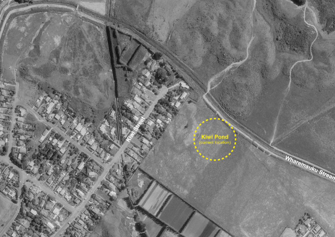


![RETAINING WALL ADDENDUM - Land Transport …...RETAINING WALL ADDENDUM Site Specific Management Plan 008 - [sectors 480/510] MacKays to Peka Peka Expressway 17 AUGUST 2015 - CERTIFIED](https://img.pdfslide.net/doc/110x75/5ea606ec71263a4a077c6a3d/retaining-wall-addendum-land-transport-retaining-wall-addendum-site-specific.jpg)