Embed Size (px)
Citation preview
BITTERROOT RESOURCES LTDGEOLOGY AND EXPLORATION OF THE
UPPER PENINSULA PROJECTS MICHIGAN, USA
November 25, 2003
Prepared by:Dave Billard, P.Geo.
Cypress Geoservices Ltd.115 Bottomley Ave. North
Saskatoon, Sk.
2
TABLE OF CONTENTS
1.0 SUMMARY.........................................................................................................................................3
2.0 INTRODUCTION AND TERMS OF REFERENCE......................................................................5
3.0 PROPERTY DESCRIPTIONS AND LOCATION..........................................................................5
3.1 LOCATION AND LANDS ......................................................................................................................53.2 OWNERSHIP AND STATUS...................................................................................................................5
4.0 PHYSIOGRAPHY, ACCESSIBILITY AND RESOURCES ..........................................................6
5.0 HISTORY............................................................................................................................................6
6.0 GEOLOGICAL SETTING ................................................................................................................7
7.0 DEPOSIT TYPES ...............................................................................................................................8
8.0 MINERALIZATION..........................................................................................................................9
9.0 EXPLORATION...............................................................................................................................10
9.1 INTRODUCTION ................................................................................................................................109.2 TARGET A........................................................................................................................................109.3 TARGET B........................................................................................................................................119.4 TARGET C........................................................................................................................................11
10.0 SAMPLING METHOD AND APPROACH...................................................................................11
11.0 SAMPLE PREPARATION, ANALYSIS AND SECURITY.........................................................12
12.0 INTERPRETATION AND CONCLUSIONS.................................................................................12
13.0 RECOMMENDATIONS..................................................................................................................13
14.0 REFERENCES..................................................................................................................................13
15.0 CERTIFICATION............................................................................................................................14
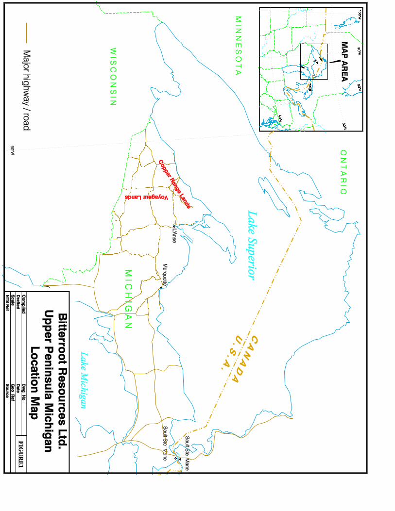
LIST OF FIGURESFigure 1 Location Map .............................................................................. After text
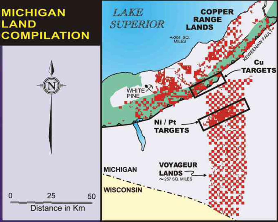
Figure 2 Michigan Land Compilation ....................................................... After text
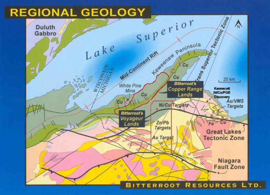
Figure 3 Regional Geology ....................................................................... After text
3
BITTERROOT RESOURCES LTDGEOLOGY AND EXPLORATION OF THE
UPPER PENINSULA PROJECTS MICHIGAN, USA
1.0 SUMMARYThe Michigan properties of Bitterroot Resources Ltd. comprise approximately 461square miles within Ontonagon, Houghton, Baraga and Iron Counties of the UpperPeninsula of Michigan. The lands are subdivided into 2 general packages, theVoyageur Lands (257 square miles) and the Copper Range Lands (204 squaremiles). Bitterroot owns 100% of the mineral rights on these Copper Range andVoyageur Lands, and also has additional leases or prospecting permits with the USBureau of Land Management, State of Michigan and private owners. BitterrootResources has entered into an option/joint venture agreement with CamecoCorporation whereby Cameco may earn a 65% interest in the northern half of theVoyageur Lands and adjacent areas by incurring expenditures of $23.6-million over18 years.
The bedrock of the Upper Peninsula is composed of Archean, Lower Proterozoic,Middle Proterozoic, and Paleozoic rocks, covered by varying thickness of recentglacial deposits. Late Archean foliated and layered granitic rocks are unconformablyoverlain by Early Proterozoic greywacke and slate of the Michigamme Formation ofthe Marquette Range Supergroup, which has been affected by the Penokean orogeny.The Middle Proterozoic rocks in the map area are volcanic and sedimentary stratacomposing the Keweenawan Supergroup and lesser intrusive rocks emplaced inthem. These rocks were deposited in and marginal to the Midcontinent rift system atabout 1100 Ma. The lower part of the section is predominantly continental floodbasalts intruded by rhyolite domes, gabbroic intrusions and diabase dykes and withmany interflow sedimentary units. The upper part of the Keweenawan Supergroup ispredominantly continental fluvial and lacustrine sediments of the Oronto Group.These include the transitional Copper Harbor Conglomerate, lacustrine NonesuchFormation and fluvial Freda Sandstone. The feldspathic Jacobsville sandstone ismainly exposed southeast of the Keweenaw fault and along the south shore of LakeSuperior. The final phase in the formation of the Midcontinent rift system is a periodof regional compression and formation of major thrust faults including theKeweenaw fault.
The Upper Peninsula of Michigan hosts the famous Keweenawan native copperdeposits, which are the product of a regional hydrothermal system in the volcanicstratigraphy. Mineral exploration in the 1970's discovered a suite of predominantlysulphide copper deposits in the Portage Lake Volcanics that consist of chalcociteand minor native copper. The deposits resemble the native copper lodes in that themineralization is concentrated in brecciated flow tops and are probably geneticallyrelated. The basal beds of the Nonesuch Formation carry anomalous concentrationsof copper and host the past-producing White Pine mine. Keweenawan-aged layeredmafic complexes also exist in the region, beneath the Jacobsville Sandstone. In1997, drilling by Bitterroot Resources Ltd. identified significant platinum group
4
element mineralization at the Echo Lake layered mafic intrusion. In addition,Kennecott Exploration has recently made a significant Ni/Cu/PGE discovery in theYellow Dog peridotite dykes, located 40 km northwest of Marquette, Michigan.
Despite the long history of copper and iron mining and exploration in the UpperPeninsula, the Voyageur Lands are at a relatively early stage of exploration. In the124 years prior to Bitterroot’s acquisition of Voyageur Lands Corporation in early1997, the mineral rights had been held by the decendants of one individual and hadseen almost no mineral exploration. The Voyageur Lands cover a diverseassemblage of Proterozoic sedimentary and volcanic rocks and have good potentialto host a variety of deposit types and commodities, including Ni, Cu, PGEs, Au, Uand Zn.
The geological setting and +100 year history of mineral exploration and minedevelopment on the Copper Range lands suggests that they are prospective for theidentification of new copper deposits using modern geological information andgeophysical techniques. There are over 100 past-producing copper mines, pits andprospects located within and adjacent to the Copper Range lands. The Copper RangeLands cover several prospective mineralized horizons. These include the NonsuchShale, which hosts the White Pine sedimentary redbed copper deposit (+500 milliontonnes @ 1.1% Cu) and the Portage Lake volcanics and interflow conglomerates,which host the world’s largest native copper deposits along strike and northeast ofthe Copper Range Lands in the Keweenaw peninsula. Approximately five milliontonnes of native copper were produced in the Keweenaw peninsula between 1845and 1968. In addition, these lithlogies have been subjected to a variety of intrusiveevents and faulting, which makes them potentially favourable hosts for sulphideCu/Au/Ag mineralization.The Copper Range Lands have been subjected to verylimited exploration drilling since the 1960s and have never been tested with modernairborne electromagnetic surveys. Many areas with favourable geology have neverbeen explored due to the presence of glacial overburden.
In the Voyageur Lands area, Bitterroot has been able to identify significant potentialfor Pt-Pd-Au mineralization in the Echo Lake layered mafic intrusion. Limitedexploration drilling (855 metres in four holes) funded by Cameco Corporation in thesummer of 2003 did not indentify new mineralization on the Voyageur Lands,however it did provide valuable geological and geochemical information for futureexploration programs.
Preliminary work on Bitterroot's Copper Range Lands should consist of 1,000 linekm of modern airborne EM and Magnetic (GEOTEM) surveys over portions of thearea, at a cost of approximately $120,000. The extent of follow-up groundelectromagnetic surveys and drilling would be dependant on its results. Work on theVoyageur Lands should consist of reinterpretation of seismic data, HLEM surveys,geological mapping and diamond drilling in the Target A area, at a total cost of$130,000.
5
2.0 INTRODUCTION AND TERMS OF REFERENCEThe terms of reference for the purposes of this report are the Michigan mineralproperties referred to as the Voyageur Lands and Copper Range Lands in the UpperPeninsula of Michigan.
This technical report has been prepared upon request from Bitterroot Resources Ltd.as a regulatory requirement for the filing of an Annual Information Form (AIF) Thisreport is a technical evaluation of base and precious metals potential of the claims.
This report has been compiled from a report accompanying USGS Map I-2696 byW.F. Cannon and S.W. Nicholson, confidential background reports obtained fromBitterroot Resources Ltd. and observations of the author made during supervision ofa drilling program carried out from July 8 to 31, 2003.
3.0 PROPERTY DESCRIPTIONS AND LOCATION3.1 Location and Lands
Bitterroot’s Michigan properties comprise a land package of mineral rightscovering approximately 461 square miles within Ontonogan, Houghton, Baragaand Iron Counties of the Upper Peninsula of Michigan. The lands are subdividedinto 2 general packages, the Voyageur Lands, comprising approximately 257square miles, generally located in Iron, Houghton, Ontonagan and Baraga Countiesand the Copper Range Lands, comprising approximately 204 square miles,generally located in Ontonogan and Houghton Counties (figure 1). The propertiescomprise contiguous and non-contiguous lands under primarily private mineralownership, with lesser State of Michigan leases and US bureau of LandManagement prospecting permits.
3.2 Ownership and Status
Bitterroot Resources Ltd. owns 100% of the mineral rights on the Copper Rangeand Voyageur Lands. On the Copper Range Lands, Bitterroot owns the mineralrights on 173 square miles and controls the remaining 31 square miles under a 99-year lease with Copmead Inc. which expires July 31, 2091. The Copper Rangelands are subject to a 2% net smelter royalty (NSR) payable to Copper RangeCompany, 1% of which Bitterrot can buy for US$1,000,000. No other back inrights or royalties exist on the Copper Range Lands. In addition to these propertiesthe company also has acquired prospecting permits from the US Bureau of LandManagement (approximately 2,100 acres) and mineral leases with the State ofMichigan (>1700 acres). in various locations around and within the project areas.
The northern half of the Voyageur Lands are currently subject to an optionagreement with Cameco Corporation whereby Cameco may earn a 65% interest inthe properties by incurring total expenditures of $23.6-million over a period of 18years. Cameco must incur initial expenditures of $250,000 prior to Dec. 31, 2003,and will be required to spend a total of $600,000 prior to Dec. 31, 2004, to
6
maintain the right to exercise the option. Accelerating cash payments and workcommittments are required throughout the remainder of the agreement.
The surface rights are owned by a variety of entities, including the State ofMichigan, the United States Government (US Forest Service and BLM), privateindividuals and corporate entities. Exploration permits can be required prior toworking on these lands, depending on the nature of the underlying mineralsreservation. These permits are obtained through the Michigan Department ofEnvironmental Quality, Michigan Department of Natural Resources, US ForestService and the BLM, depending on the location and surface and mineralsownership.
Since the area of interest is large and the development history long and complex, itis difficult to verify or ascertain the presence of environmental liabilities on thelands. To the knowledge of the author, no known liabilities exist on the properties.
4.0 PHYSIOGRAPHY, ACCESSIBILITY AND RESOURCESThe UP properties are highly accessible by road. Several paved highways cross theregion in addition to a variety of USFS, County, and private roadways and trails.
The terrain is relatively flat, periodically cut by mature river channels and for themost part covered by recent glacial deposits, with elevation in the range of 400 to700 metres. In the Copper Range Lands, the terrain is more rugged and has areaswith significant basalt outcrop ridges exposed. The region is covered by a variety offorest types and ages ranging from old growth hardwood and pine forests, secondgrowth aspen and birch forest and recently logged areas, in addition to agriculturalland. The climate is typical of the Great Lakes region of North America withrelatively humid warm summers and temperate to cold winter conditions with heavyaccumulations of snow due to the proximity to Lake Superior.
The property may be worked year round and significant infrastructure andcommunity resources exist throughout the area despite the sparse population.Forestry, mining, tourism (hunting, fishing and snowmobiling) and farming are themain sources of employment.
5.0 HISTORYThe exploration history of the Copper Range Lands is long and varied, dating backto the mid 1800's when significant occurrences of copper were identified on theKeweenaw Peninsula. Significant copper production was achieved from the WhitePine, Calumet-Hecla and Kearsarge deposits of copper-redbed and volcanicaffinities. In addition, the Upper Peninsula is famous for its historical and ongoingiron ore production in Marquette County.
Prior to Bitterroot's exploration activities, neither the Copper Range Lands or theVoyageur Lands had been systematically explored using modern geophysicaltechniques and exploration models. In 1996 and 1997, the Company completedairborne geophysical surveys over the Copper Range Lands (5000 line-km) andVoyageur Lands (2060 line-km). This work identified several prospective areas for
7
sulphide copper, Ni/Cu/PGE and precious metals deposits. In 1997, Bitterrootdrilled 10,728 feet in five core holes to test nickel/copper/platinum/palladium targetsin the northern portion of the Voyageur Lands. Hole 97-03 intersected ten flat-lyinganomalous platinum/palladium/gold-bearing horizons within a layered maficintrusion. The highest grade interval contains 1.01 grams/tonne Pt+Pd+Au over17.8 feet within a 69.8 foot interval grading 0.52 grams/tonne Pt+Pd+Au, starting ata depth of 3242 feet.
In 1999 and 2000, a regional geophysical, geochemical and geological datacompilation program was carried out. In 2000, ground-based time domainelectromagnetic surveys were completed on eight targets. In 2001, Bitterrootentered into an option/joint venture agreement with Kennecoff ExplorationCompany covering nickel/copper/platinum/palladium targets within an 82 square kmarea of interest, immediately east of the Voyageur Lands. KEC drilled one 137metre-long hole into the target. The hole intersected a gabbro dike approximately 26metres thick. These results did not fall within the narrow parameters of Kennecoff'snickel exploration model and it withdrew from the option.
6.0 GEOLOGICAL SETTINGThe bedrock of the Upper Peninsula is composed of Archean, Lower Proterozoic,Middle Proterozoic, and Paleozoic rocks, covered by varying thickness of glacialdeposits. Early Proterozoic metasedimentary rocks of the Michigamme Formationunconformably overly the Archean and consist of a thick sequence of greywacke andslate, commonly in graded bedded turbidite layers. These rocks are part of theBaraga Group, which constitutes the upper part of the Marquette Range Supergroup.The Michigamme strata were deposited in the foreland basin of the Penokean orogennorth of a series of accreting island arcs dated at roughly 1850 Ma. TheMichigamme strata were folded about east-northeast trending axes during thePenokean orogeny.
The Middle Proterozoic rocks in the map area are volcanic and sedimentary stratacomposing the Keweenawan Supergroup and lesser intrusive rocks emplaced inthem. These rocks were deposited in and marginal to the Midcontinent rift system atabout 1100 Ma.
The lower part of the Keweenawan Supergroup is predominantly continental floodbasalts with lesser andesite and rhyolite that was erupted during a time span of about15 million years (1109-1094 Ma) during crustal extension and the formation of riftgrabens. The oldest Keweenawan rocks in the map area are the basalts and basalticandesite flows of the Siemens Creek Volcanics of the Powder Mill Group. Theseflows mark a sudden onset of widespread flood basalt volcanism along the southernflank of the rift. The most voluminous volcanic rocks in the area are the PortageLake Volcanics, a suite of dominantly high-aluminum continental tholeiitic floodbasalts with lesser andesite and rhyolite. On the Keweenaw Peninsula the formationranges from 3 to 5 km thick. Several small extrusive rhyolite domes with localashfall units occur in the stratigraphic interval as do several intrusive rhyolite bodieswhich either cut across basalt flows or form sills between flows. An 1111 Ma
8
layered intrusion known as the Echo Lake gabbro, is completely buried by about 300m of Jacobsville Sandstone. Elsewhere, dikes of diabase are common and cut bothearly flows and older basement rocks. The dikes were emplaced mostly in the earlierstages of rift evolution, probably roughly synchronous with eruption of the PowderMill Volcanics. Interlayered with the basalt flows throughout the Portage LakeVolcanics are many interflow sedimentary units. Most are conglomerates or lesscommonly sandstone, derived from older rift-related units.
The upper part of the Keweenawan Supergroup is predominantly sedimentary rocksdeposited in a thermally subsiding successor basin centered over the slightly olderextensional rift basin. At about 1094 Ma the rate of extension, rift basin formation,and basaltic volcanism began to diminish. Through the ensuing 7 million years therift system evolved into a sedimentary basin. A great thickness of continental fluvialand lacustrine sediments accumulated and volcanism was nearly absent.Collectively, these sedimentary rocks compose the Oronto Group. The CopperHarbor Conglomerate is the basal unit, deposited during the transition period. It iscomposed of both fluvial deposits and lesser interbedded basalt and andesite flows.At the top of the Copper Harbor Conglomerate there is an abrupt change tolacustrine deposits of the Nonesuch Formation. The Nonesuch is composed ofseveral hundred metres of massive to laminated siltstone and shale and fine-grainedsandstones. The return to continental fluvial sedimentation is marked by theoverlying lithic arenites of the Freda Sandstone. By this point in the rift history,streams draining to the basin appear to have originated outside of the rift and wereeroding Early Proterozoic and Archean terranes as well as middle Proterozoicvolcanic rocks along the rift flanks. An additional sedimentary unit, the Jacobsvillesandstone, lies southeast of the Keweenaw fault. From an erosional edge on thesouth and east, the Jacobsville thickens northwestward toward the Keweenaw faultreaching a thickness of 3 km. The Jacobsville is mostly feldspathic sandstone, aconsiderably more mature unit than the Oronto Group. The relation of theKeweenaw fault to the northwestern limit of the original Jacobsville depositionalbasin is not entirely clear. However, most evidence points to deposition duringuplift on the Keweenaw fault and related faults. The final phase in the formation ofthe Midcontinent rift system is a period of regional compression and formation ofmajor thrust faults. This compression resulted in inversion of the central graben ofthe rift. This steeply to moderately northwest-dipping Keweenaw fault thrust thePortage Lake Volcanics and the overlying Oronto Group rocks, part of the centralgraben sequence, over the Jacobsville Sandstone. Other related faults also occurwithin the Portage Lake Volcanics and the Jacobsville Sandstone.
7.0 DEPOSIT TYPESThe Copper Range Lands cover part of the famous Keweenaw native copper district,containing the world's largest concentration of metallic (native) copper. Nearly 5billion kg of copper was produced from the area between 1845 and 1968. The nativecopper deposits are the product of a regional hydrothermal system that precipitatedthe metal and a characteristic suite of alteration minerals in permeable channel waysand structures in the volcanic section. Most of the copper deposits are stratabound
9
and lie along brecciated, amygdular flow tops and in thin interflow sedimentaryrocks. A much smaller amount of copper is in veins and shear zones oriented nearlynormal to bedding. Although the district is now inactive, substantial amounts ofmineralized rock are known to remain in many of the deposits, mostly in deepextensions of partly mined orebodies. About 35 million tons of identified ore areestimated to remain in 20 deposits at grades ranging from 0.5 to 1.9 percent copper.
Mineral exploration in the Keweenaw peninsula (northeast of the Copper RangeLands) by Inco and Homestake Mining Company in the 1970's discovered a suite ofcopper deposits in the Portage Lake Volcanics that consist of chalcocite and minornative copper. These deposits were further explored and delineated in the early1990's. Five deposits near the northeastern end of the Keweenaw Peninsula range insize from about 100,000 tons to about 4.5 million tons and have average grades from1.8 to 4.0 percent copper. The deposits resemble the native copper amygdular lodesin that the mineralization is concentrated in brecciated flow tops. The inclusion ofsome native copper within the chalcocite concentrations indicates that the chalcocitedeposits are probably genetically related to the nearby native copper deposits. Theyare found adjacent to felsic (rhyolite or dacite) intrusions in stratigraphically deeperparts the Portage Lake Volcanic sequence and immediately east of the most prolificpart of the native copper district. In the area of the Copper Range Lands, chalcociteand oxide copper occurs in a similar setting, around a felsic intrusion in astructurally complex zone, suggesting the potential for chalcocite mineralizationassociated with unexplored felsic intrusions.
Basal beds of the Nonesuch Formation also carry anomalous concentrations ofcopper, mostly in chalcocite, over a large region of northern Michigan. At the WhitePine mine (500 million tonnes @ 1.1% Cu), copper from the Nonesuch wasproduced for more than 40 years. A large copper resource is known to exist indowndip extensions of the White Pine orebody, mostly east of the mine. In the1960’s, exploration drilling by Copper Range Company on arbitrary 8-kilometrecentres along 80 kilometres following the trace of the Nonesuch Formationintersected chalcocite mineralization with copper grades greater than 0.2 percent.However, both the thickness of the mineralized zone and the average copper grade issubstantially less than near the White Pine mine. This arbitrarily-spaced drilling wasnot targeting structures which offset the favourable volcanic and sedimentarystratigraphy, which are now known to be an important component of the geneticmodel.
Layered mafic complexes also exist in the region beneath the Jacobsville Sandstonewhere Bitterroot Resources Ltd. identified significant platinum group elementmineralization at the Echo Lake intrusive. In addition, Kennecott Exploration hasrecently made a significant Ni/Cu/PGE discovery in the Keweenawan Yellow Dogperidotite dykes, 40 km northwest of Marquette, Michigan.
8.0 MINERALIZATIONKnown mineralization on the Voyageur Lands is primarily restricted to the northernregions in the Echo Lake intrusion. In 1997, drilling in this area intersected layered
10
intrusive rocks ranging in composition from anorthositic gabbro to olivine gabbro,troctolite and peridotite. Bitterroot intersected a 69.8 foot interval grading 0.52grams/tonne Pt+Pd+Au, including 1.01 grams/tonne Pt+Pd+Au over 17.8 feetbeginning at 3242 feet within the Echo Lake intrusion. The geophysical signature ofthe intrusion and the orientation of flat-lying platinum-bearing horizon suggests thatthis target continues for approximately ten kilometres of untested strike length.
Within and adjacent to the area of the Copper Range Lands, there are over 100documented pits, shafts and adits which were excavated by miners andexplorationists during the past 150 years. The majority were excavated to mine ortest outcropping native copper mineralization, although several encounteredchalcocite and copper oxides.
9.0 EXPLORATIONDuring the winter of 2003, Bitterroot’s contractor completed a 2.7 line-kmHorizontal Loop EM (HLEM) survey on the Voyageur Lands. The intent of thesurvey was to better define four airborne GEOTEM conductors and locate drilltargets. The HLEM work was carried out by consulting geophysicist Rodney Ikola,with data collected at frequencies of 3555, 1777, 888 and 444 hertz, with coilseparation varying dependent on the expected depth to the basement. Initialinterpretation of the data was done by Mr. Ikola and confirmed by Mr. Garnet Wood,P.Geo. of Cameco Corporation. In the opinion of the author, the work was carriedout with a high degree of competence.
On the Copper Range Lands, in 1997, Bitterroot’s contractor Airmag Surveys Inc.flew an aeromagnetic survey of the area between the towns of White Pine andHoughton, Michigan. Targets identified by this survey and a 1996 GEOTEM surveyremain untested due to past funding constraints.
9.1 Introduction
In July 2003 Bitterroot tested four HLEM targets with an 855-metre diamonddrilling program. Four holes were drilled by Idea Drilling of Virginia, Minnesota.The program was supported entirely by road.The drill holes were geologicallylogged in a descriptive fashion and the core stored in a covered, locked storagefacility in Ishpeming, Michigan. Dave Billard, P.Geo. of Cypress Geoservices Ltd,performed supervision of the drilling program, geological logging, sample collectionand preparation. The drilling took place in three target areas on and adjacent to theVoyageur Lands. The details of the drilling are described below.
9.2 Target A
The Target A conductive trend strikes 0650 and has an excellent HLEM responseunder Jacobsville sandstone cover.Drill hole A-01 was drilled at an angle of -800 totest the Target A conductor at vertical depth of approximately 60 metres. The holeintersected 28 metres of overburden, followed by 10.2 metres of Jacobsvillesandstone and intersected the unconformity at 38.2 metres. Below theunconformity, this drill hole intersected hematized Michigamme metasediments
11
with local faulting. No major mineralised zones were intersected, but thegeochemistry may indicate the presence of a nearby hydrothermal system.
Drill hole A-02 was drilled at an angle of -650 from the same location as A-01, inorder to test the faulted metasediments. The hole intersected weakly bleachedJacobsville sandstone from the base of the overburden at 30.4 m, down to theJacobsville-Michigamme unconformity at 42.9m. The Michigamme metasedimentsconsist of hematised and graphitic metasediments
9.3 Target B
The target B anomaly was interpreted to be a good conductor and was consideredto be a high priority geophysical target underlying the Jacobsville sandstone.HoleB-01 was the only hole drilled on this target. It was designed to test a conductor ata vertical depth of 70 metres. It was drilled grid north at an angle of -700. The holewas collared in an area of deep overburden and did not intersect bed rock until adepth of 85.2 metres, where it intersected Michigamme Group metasediments.
9.4 Target C
Target C is a relatively broad conductor with an interpreted dip of approximately60 to 70 degrees to the south within the Jacobsville cover rocks. Drill hole C-01was the only hole drilled on the target. It was designed to intersect the interpretedconductor at a depth of approximately 100 metres and was drilled grid north at anangle of -80. The hole intersected 44.6 metres of overburden and Jacobsvillesandstone down to 449.7 metres. Below an unconformity, the hole intersectedstrongly hematised, paleoweathered basalt which became moderately hematisedand chloritic down section to 466.4 metres depth. Below this, the drill holeintersected massive basalt with some geochemically anomalous copper values.
10.0 SAMPLING METHOD AND APPROACHDue to the reconnaissance nature of the drilling, the program was driven to a largeextent from a geochemical perspective. To that end, the core was systematicallysampled in the following manner.
• Sandstone Composite – several representative (6 to 7 chips, 1-2 cm each) chipsof sandstone were taken and bagged together throughout each 5 metre interval ofsandstone in A-01 and A-02, and each 10 metre interval in C-01. The purpose ofthese samples is to provide a basic "snapshot" of the geochemical signature of theoverlying sandstone, The sandstone is porous and permeable and subject toinjections of hydrothermal fluids, the presence of which may aid in the identificationof potentially mineralized systems. These samples are therefore used as a vectoringfactor. No composites were collected in drill hole B-01, as no sandstone wasintersected in that hole. These samples were subjected to geochemical analysis.
• Basement Samples - A representative sample of basement rock was collected atapproximately 10 metre intervals or more often if warranted by lithology ormineralogy. The samples were typically 10 to 20 cm in length and were subjected togeochemical analysis.
12
• Spot Samples – selected sections of sandstone and basement core werelongitudinally split and sent for geochemical analysis based on their economic orgeochemical possibilities. These samples were subjected to geochemical analysis.
• PIMA Samples – a representative chip of core from each 10 metre interval wascollected for SWIR (Short Wave Infra Red) spectroscopy. SWIR is performed on thesamples as a geochemical screening tool, to assist in identifying prospective claygeochemistry of potential mineralizing systems.
11.0 SAMPLE PREPARATION, ANALYSIS AND SECURITYAll sample collection and preparation was performed by the Qualified Person, DaveBillard, P.Geo. prior to shipment to the laboratory and the core and samples werekept under the care and control of the Qualified Person at all times.
All geochemical samples were sent to the Saskatchewan Research Council (SRC), aCCRMP- Standards Council of Canada certified analytical laboratory, for analysis.
The samples were digested using partial (HNO3/HCl) and total (HF/ HNO3/HclO4)digestions and then analysed using a 60 element, ICP package. This packageprovides results for all the major elements including Cu, Ni, Pb, Zn, Co, Ag as wellas pathfinder elements (B, Sb, As, Bi, Ge, Hg, Mo, Se, Te, V, Ba, Be, Cd, Ce, Cr,Dy Eb, Eu, Gd, Ga, Ha, La, Li, Mn, Ne, Pr, Sm, Sc, Sr, Ta, Tb, Th, Sn, U, W, V, Yb,Yb, Zr) and the major oxides (K, N, Al, Ca, Mg, Mn, P). Samples are run in lots of20, consisting of 18 samples, one standard and one repeat. Due to thereconnaissance nature of the drilling program, no additional check sampling wasundertaken
SWIR data was collected using an Integrated Spectronics PIMA II short wave infrared spectrometer. Once the representative spectra were collected, the results wereprocessed through Integrated Spectronics’ Pimaview 3.1 software and proportionatemixtures of clay species (and sub species) were determined. This procedure wascarried out at the Cypress Geoservices Ltd. facilities in Saskatoon.
In the author's opinion all sampling, sample preparation, sample security andanalytical procedures were done to a high standard.
12.0 INTERPRETATION AND CONCLUSIONSThe Voyageur Lands and Copper Range Lands of Bitterroot Resources Ltd. hostseveral early-stage exploration targets and have potential to host many differenttypes of mineralization.
The geological setting and history of mineral exploration and mine development onthe Copper Range Lands is prospective for the identification of new copper depositsin the region. Although extensive exploration was conducted in the area throughoutits mining history and has been renewed sporadically since, large portions arerelatively unexplored within and peripheral to the MidContinent rift system. Thelands lie along several prospective mineralised horizons including the NonsuchShale (White Pine host) and Portage Lake volcanics (native copper and sulphidecopper deposits). These lithlogies have been subjected to a variety of felsic through
13
ultramafic intrusive events and long term reactivated faulting, which makes themprospective for the discovery of till-covered Cu/Au/Ag sulphide deposits and nativecopper zones. With the use of modern airborne geophysical techniques (GEOTEM)and recently developed geological concepts, the probability of identifying newdeposits in this region is considered high.
In the Voyageur Lands area, in 1997, Bitterroot was able to identify significantpotential for Pt-Pd-Au mineralization in the Echo Lake Intrusion. The explorationcarried out during the 2003 field program was not successful in indentifying newunconformity-hosted mineralization on the Voyageur Lands, however, it did providea geological and geochemical framework for future exploration programs. Thedrilling did identify anomalous base metals values in the Michigammemetasediments (Target A) as well as in Keweenanwan volcanics (Target C). Inaddition, the drilling carried out to date on the Target C area provided evidence forsignificant fault offsets accompanied by hydrothermal alteration in the area.
13.0 RECOMMENDATIONSIn the opinion of the author, additional work is warranted on Bitterroot Resources'Copper Range Lands and Voyageur Lands in the Upper Peninsula of Michigan.
Preliminary work on Bitterroot's Copper Range Lands should consist of modernairborne geophysics over portions of the company's lands. This survey would consistof approximately 1,000 line km of GEOTEM (airborne EM and Magnetics) over themain areas of interest. A program of this magnitude would cost in the order of$120,000. Follow up work to this program would be dependant on results.
On the Voyageur Lands and adjacent areas, the next phase of work should consist ofreinterpreting company-owned seismic data, an additional 5 line-km of HLEMsurveys geological mapping and 500 metres of diamond drilling in the Target Aarea. The cost of this program is expected to be $130,000.
14.0 REFERENCES
Cannon, W.F. and Nicholson, S.W., 2001Geologic Map of the Keweenaw Peninsula andAdjacent Area, Michigan. U.S. Department of theInterior, U.S. Geological Survey, Map I-2696 andaccompanying text.
Johnson, R.C, 1998 Regional Geology and Target Identification forUnconformity-Type Uranium Deposits: UpperPeninsula of Michigan, confidential report by TransSuperior Resources Inc. for Cameco Corporation
14
15.0 CERTIFICATION
I, David L. Billard, P.Geo. of 115 Bottomley Avenue North, of the City of Saskatoon inthe province of Saskatchewan hereby certify that:
1. My occupation is that of Consulting Geologist and that I am President and owner ofCypress Geoservices Ltd. a geological consulting firm based in Saskatoon, specialisingin mineral exploration, operating under Association of Professional Engineers andGeoscientists of Saskatchewan Certificate of Authorization No. C1049.
2. I am a “Qualified Person” for the purposes of National Instrument 43-101.
3. I am a Professional Geoscientist in good standing with Association of ProfessionalEngineers and Geoscientists of Saskatchewan (APEGS No.10372) and the Associationof Professional Engineers and Geoscientists of Manitoba (APEGM No. 23492G)
4. I obtained my B.Sc. in Geology at the University of Saskatchewan in 1984 and havecontinuously practised in the field of mineral exploration in western Canada and theUnited States since that time.
5. I last visited the properties from July 8 to 31, 2003 during which time I supervised adiamond drilling program on the Voyageur Lands and made site tours of severallocalities in the Copper Range Lands.
6. I have compiled this report from public and confidential geological reports, as well asfrom personal observations made on site and am responsible for this report in itsentirety.
7. I am not aware of any material change or material fact with respect to the subjectmatter of this report that is not reflected in this report.
8. That I am independent of the issuer as defined by National Instrument 43-101.
9. That I have had no prior involvement with the property.
10. That I have read National Instrument 43-101 and Form 43-101F1 and that this reporthas been prepared in compliance with the Instrument and Form as I understand it.
11. I consent to the filing of the Technical Report with any stock exchange and otherregulatory authority and any publication by them for regulatory purposes, includingelectronic publication in the company files on their websites accessible by the public,of the technical report.