Embed Size (px)
Citation preview

1
2
Town Centre
Government Education Facility (Primary)Passive Open Space
Existing Urban Area
Major Arterial Road (South Gipps Highway)
Precinct Structure Plan AreaUrban Growth Boundary
Active Open Space/Playing Fields
Connector Street (27m)
Access Street - Level 2 (22m)
Waterway / Drainage / Waterbodies / WetlandsTree Reserve along Browns Roads
Defendable space - RBGC Perimeter
Key Access Street - Level 1Ridge Line
Connector Street (with Landscape and trail 32m)
Key Access Street - Level 1 (with Landscape and trail 24m)
Access Street - Level 2 (with Landscape and trail 28m)
Non Urban Land
Arterial Road - Craig Rd. / Browns Rd. (2 - 4 lane)
Neighbourhood Housing Zone
Interface Housing Zone (A, B & C)
Village Housing Zone
Other Undeveloped Land Within UGB
Wetland retarding basin located outsidePrecinct subject to Melbourne Water PAO
Heritage site / Open Space (Aboriginal)Scattered Trees
Eastern 5m of Smiths Lane road reserve used for Active
Open Space
Council Community Facility
Encumbered - No POS Credit
RBGC Potential Pedestrian Access Point subject to
RBGC approval.
3 Flexibility for Connector Road Location. Refer PSP Section TBC
Land subject to EPBC Act (Commonwealth)Determination - Refer PSP Section / Appendix X TBC
4 Alternative for interim access to initial stages of
development via a local street. Refer PSP Section TBC
5 Potential for intersection to shift South. Refer PSP Section TBC
Conservation Open Space (NVPP Requirement)
Conservation area set aside subject to VCATenforcement order (in addition to NVPP requirements)
Waterway modification works minimised
Potential Mixed use
A
A
DA
B
1
ROYAL BOTANICGARDENSCRANBOURNE
BALLARTO ROAD
BROWNS ROAD
DEVONMEADOWS
JUNCTIONVILLAGE
SOUTH GIPPSLAND HIGHWAY
CR
AIG
RO
AD
BOTA
NIC
D
RIV
E
STAGE 1 (UnderDevelopment)
STAGE 4 (PossibleFuture)
WAL
TER
WAY
SMIT
HS
LAN
E
MAD
ELYN
CT
FLET
CH
ER R
OAD
KELL
Y R
OAD
FIO
NA
DR
IVE
DEV
ON
RO
AD
CRANBOURNEEAST
New Road-Casey Blvd
CRANBOURNE SOUTH
Proposed
1
C
B
D
B
A B
2
.
3.4
5
Scale: 1:12,500 @ A3, N.T.S. @ A4Date: Dec 20120 100 200
500m
50
Future Urban Structure Planbotanic ridge precinct structure plan
Plan 2 BOTANIC RIDGE NATIVE VEGETATION PRECINCT PLANDECEMBER 2012
THIS PAGE IS INTENTIONALLY LEFT BLANK
BOTANIC RIDGE NATIVE VEGETATION PRECINCT PLAN
ii
CONTENTS1.0 INTRODUCTION 3
2.0 PURPOSE 3
3.0 VEGETATION PROTECTION OBJECTIVES TO BE ACHIEVED 3
4.0 THE NATIVE VEGETATION TO BE PROTECTED 44.1 General Requirements for Native Vegetation to be Protected 4
5.0 NATIVE VEGETATION THAT CAN BE REMOVED, DESTROYED OR LOPPED 55.1 Conditions for Removal of Native Vegetation 55.2 Requirements for Removal of Native Vegetation 55.3 Offset Calculations 55.4 Procedures for the Collection of any Payments 5
6.0 REFERENCE DOCUMENTS 6
7.0 ACRONYMS 6
PLANS
NVPP Map 1: Area to which the Native Vegetation Precinct Plan applies 2
NVPP Map 2: Native Vegetation to be Protected and Removed 7
NVPP Map 2a: Native Vegetation to be Protected and Removed 8
NVPP Map 2b Native Vegetation to be Protected and Removed 9
NVPP Map 2c: Native Vegetation to be Protected and Removed 10
TABLES
NVPP Table 1: Habitat Zones of Native Vegetation to be protected 11
NVPP Table 2: Scattered Trees to be protected 13
NVPP Table 3: Habitat Zones of Native Vegetation which can be removed 14
NVPP Table 4: Scattered Trees which can be removed, destroyed or lopped 18
NVPP Table 5: Offset Requirements for Habitat Zones which can be removed 20
NVPP Table 6: Offset Requirements for Scattered Trees which can be removed 23
BOTANIC RIDGE NATIVE VEGETATION PRECINCT PLAN
1
Botanic Ridge NVPP Boundary
Property Boundary & PSP Property Number
Watercourse
20
Dam / Waterbody
Conservation area set aside subject to VCATenforcement order (in addition to NVPP requirements)
ROYAL BOTANICGARDENS
CRANBOURNE
BALLARTO ROAD
BROWNS ROAD = R2
DEVONMEADOWS
JUNCTIONVILLAGE
SOUTH GIPPSLAND HIGHWAY
CR
AIG
R
OAD
= R
5
BALLARTO ROAD
BOTA
NIC
D
RIV
E =
R4
SMIT
HS
LAN
E
MAD
ELYN
CT
WAL
TER
WAY
FLET
CH
ER R
OAD
KELL
Y R
OAD
FIO
NA
DR
IVE
DEV
ON
RO
AD
SMIT
HS
LAN
E =
R1
UNNAMED ROAD RESERVE R = 3
Wylies C
reek Branch G
Wylies Creek Branch A
Christies Creek Branch C2 Christies Creek Branch A
Scale: 1:15,000 @ A31:7,500 @ A1
0 100m 300m50 200m
25
26
2421
2322
2019
17
1
2
3
45
6
7
8
9 10
11
1214
13
15
16
18
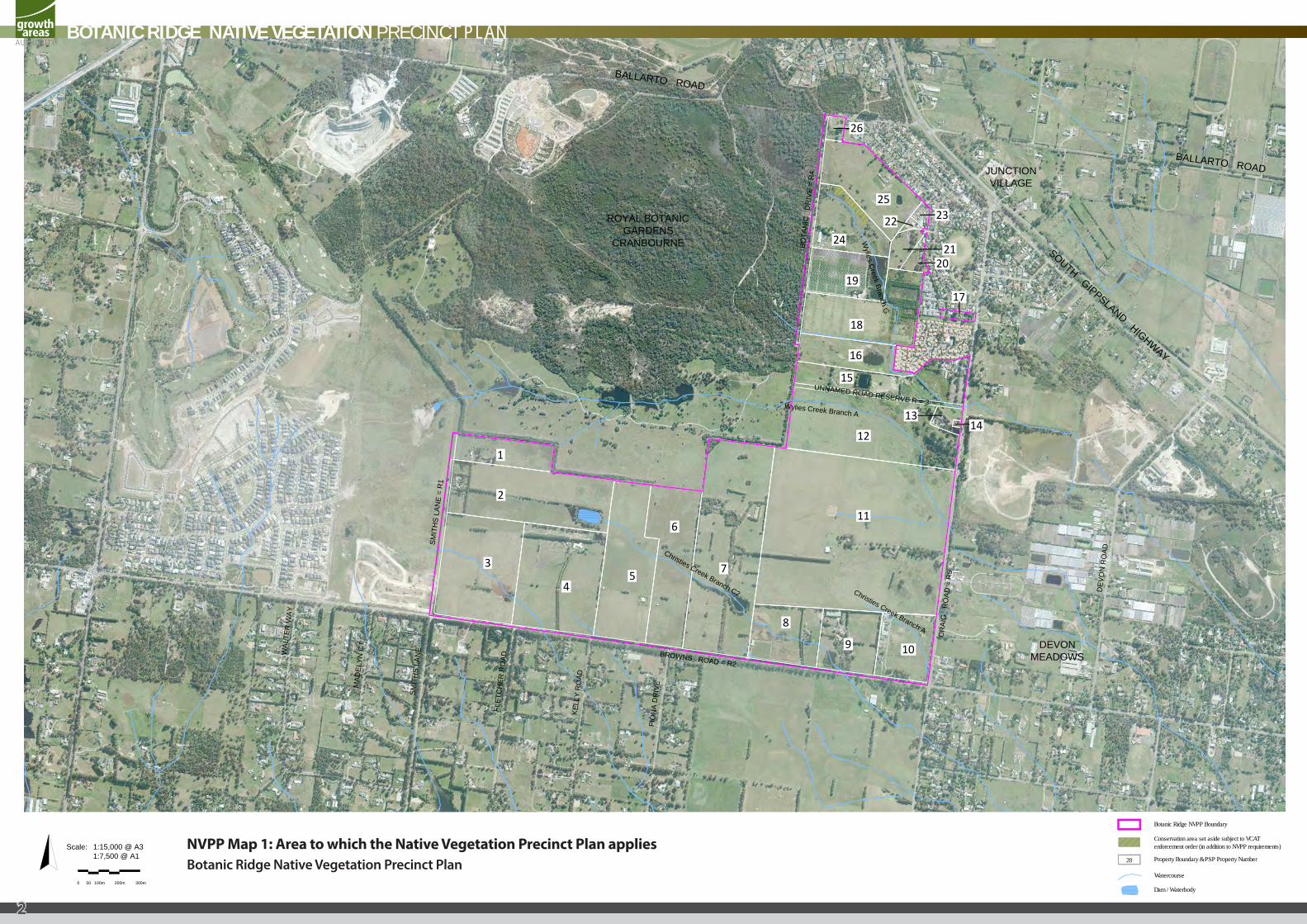
NVPP Map 1: Area to which the Native Vegetation Precinct Plan appliesBotanic Ridge Native Vegetation Precinct Plan
BOTANIC RIDGE NATIVE VEGETATION PRECINCT PLAN
2
1.0 INTRODUCTION
This is the Botanic Ridge Native Vegetation Precinct Plan (NVPP) listed under the Schedule to Clause 52.16 of the Casey Planning Scheme and incorporated into the Casey Planning Scheme pursuant to Clause 81.01.
The removal, destruction or lopping of native vegetation in accordance with this NVPP, does not require a permit provided conditions and requirements specified in this NVPP are met.
The NVPP applies to all land within the Botanic Ridge NVPP Boundary shown on NVPP Map 1.
The Botanic Ridge NVPP area contains no Matters of National Environmental Significance (Ecological Communities or flora species) listed under the Environment Protection and Biodiversity Conservation Act 1999. Therefore, there are no obligations relating to ecological communities or flora species associated with development in order to comply with the 8 July 2010 approval to take the controlled action, ‘all actions associated with urban development, undertaken in accordance with the endorsed program report Delivering Melbourne’s Newest Sustainable Communities, Victorian Government, December 2009 (the Program), within the 28 precincts identified on page 17 (Map 7).’ under Section 146B of the Environment Protection and Biodiversity Conservation Act 1999 (Commonwealth) in this NVPP.
2.0 PURPOSE
The purpose of the Botanic Ridge Native Vegetation Precinct Plan is to:
• Apply a holistic, landscape wide approach to retention and removal of native vegetation, within the Botanic Ridge NVPP area as identified on NVPP Map 1.
• Specify the native vegetation to be protected and the native vegetation that can be removed, destroyed or lopped.
• Ensure that areas set aside to protect native vegetation are managed to conserve ecological values in accordance with the Botanic Ridge Precinct Structure Plan.
• Ensure native vegetation specified to be protected is consistent with conserving the ecological values of these areas and is in accordance with Melbourne’s Strategic Assessment (under Part 10 of the Environmental Protection and Biodiversity Conservation Act 1999) and Victoria’s Native Vegetation Management – a Framework for Action, DSE 2002.
• Set out the works or other necessary actions required to offset the removal, destruction or lopping of native vegetation.
• Streamline the planning approvals process through a precinct wide landscape approach to native vegetation protection and management.
3.0 VEGETATION PROTECTION OBJECTIVES TO BE ACHIEVED
• To protect and manage the long-term health and habitat value of the native vegetation specified ‘to be protected’ on NVPP Maps 2, 2a, 2b and 2c.
• To manage the native vegetation to be protected for conservation purposes and allow for passive recreation on the edge of habitat zones and conservation areas, where appropriate, without damaging native vegetation.
• To protect and manage native vegetation identified ‘to be protected’ as they represent the genetic lineage of site-adapted local plant species and communities, provide existing habitat for indigenous fauna species, function to link habitat across the landscape, and provide a focus for revegetation activities.
BOTANIC RIDGE NATIVE VEGETATION PRECINCT PLAN
3
4.0 THE NATIVE VEGETATION TO BE PROTECTED
The native vegetation ‘to be protected’ is described in NVPP Tables 1 and 2 and shown on NVPP Maps 2, 2a, 2b and 2c to this Plan. Removal of this vegetation is not in accordance with this NVPP.
4.1 GENERAL REQUIREMENTS FOR NATIVE VEGETATION TO BE PROTECTED
Certain native vegetation has been identified ‘to be protected’ on the basis of a landscape wide approach to retention and removal of native vegetation across the NVPP area rather than a site by site approach.
Decisions relating to the removal of certain individual trees and/or areas of native vegetation have been made in a holistic manner taking into account scattered trees and habitat zones which are proposed to be protected.
Ad hoc removal of native vegetation which is identified for protection may undermine this holistic and landscape wide approach to the preparation of this NVPP.
Protection of habitat zones must maintain the habitat scores provided in NVPP Table 1. Fire prevention measures should not result in reduction of these scores unless otherwise allowed for in this NVPP.
Habitat Zones 9, 10, 11, 12, 147a, 148, 149, 150 and 151a are located within the ‘defendable space’ zone adjacent to the Royal Botanic Gardens Cranbourne. Vegetation within the defendable space zone must be managed when a dwelling is constructed in accordance with standard fire protection requirements. In this case, the understorey is allowed to be cleared to satisfy these fire reduction requirements. The NVPP reflects these outcomes and requires:
• Protection of 100% of the tree canopy cover (refer to NVPP Table 1);
• 100% loss associated with the removal of the understorey (refer to NVPP Table 3); and
• Offsets to be provided prior to the removal of the understorey (refer to NVPP Table 5).
In this NVPP the protection area of a tree (including a tree in a habitat zone or scattered tree) refers to an area twice the canopy diameter at its widest point.
Protection of a scattered tree means that the protection area must be:
• Protected from adverse impacts, grazing, burning, and soil disturbance;
• Managed to retain fallen timber, control weeds, and provide intervention and/or management if necessary to ensure adequate natural regeneration or planting can occur; and
• Protected from earthworks, compaction during construction, or adverse modification of existing drainage patterns.
These protection measures may be varied if adequate justification is provided and agreed in writing by the Department of Sustainability and Environment.
Any buildings and works are to be located outside a protection area of a scattered tree or habitat zone at an appropriate buffer distance. Buildings and works provided within 50 metres of native vegetation (including scattered trees and habitat zones) shown as ‘to be protected’ must be constructed and designed to ensure that the native vegetation is protected from adverse impacts during construction or pressure from trampling either before or after construction unless otherwise agreed in writing by the Department of Sustainability and Environment.
To minimise the risk to trees identified which are identified in this NVPP as ‘scattered trees to be protected’ having to be removed at a later time, areas accessible to the public including playgrounds, barbeques etc are to be located to avoid falling branches from protected vegetation.
BOTANIC RIDGE NATIVE VEGETATION PRECINCT PLAN
4
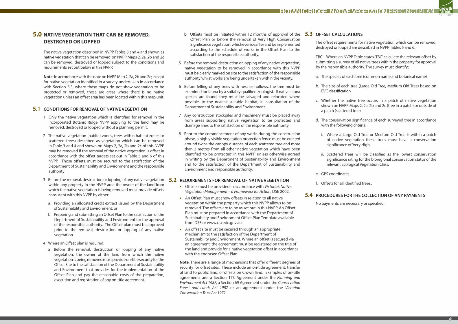
5.0 NATIVE VEGETATION THAT CAN BE REMOVED, DESTROYED OR LOPPED
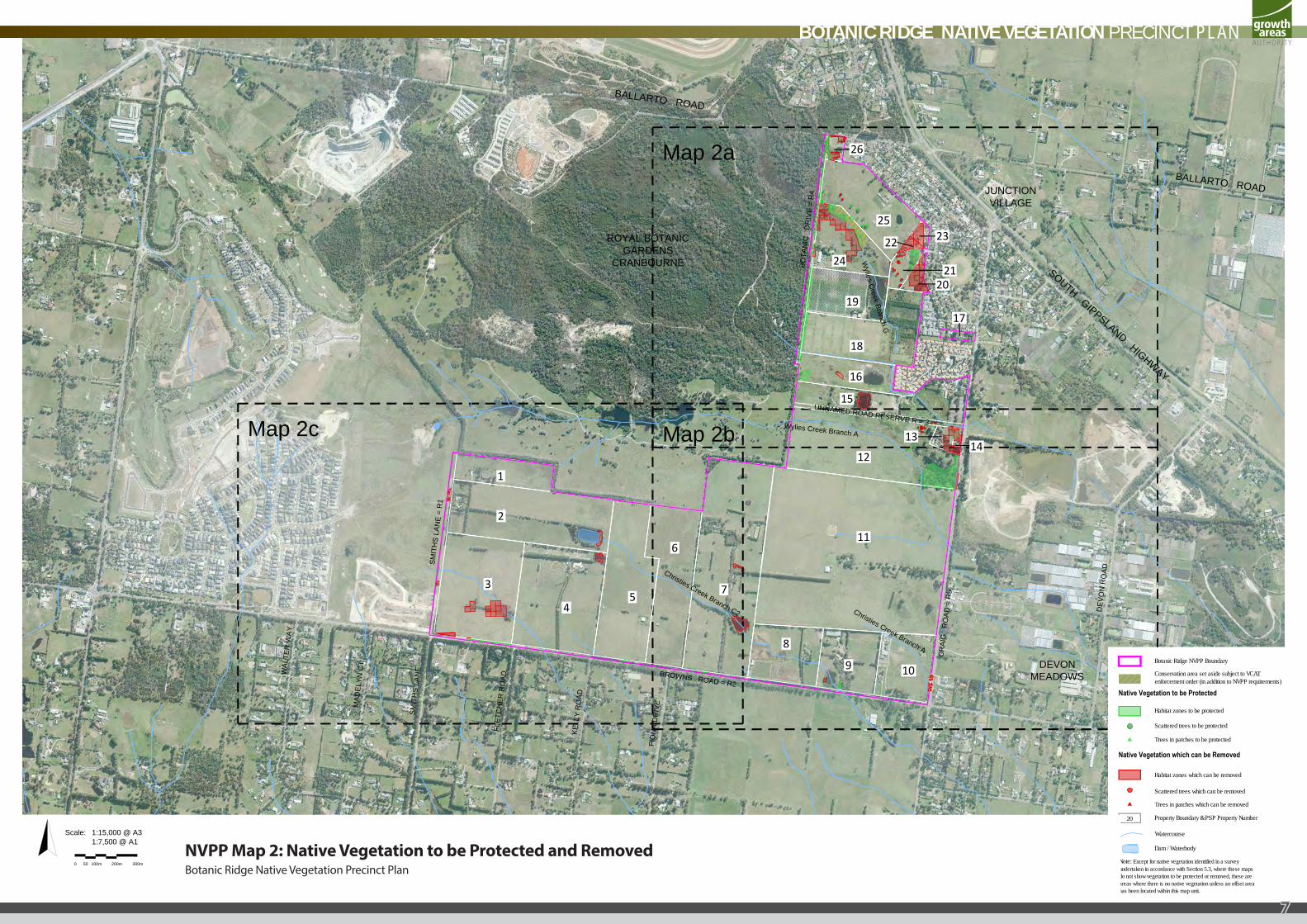
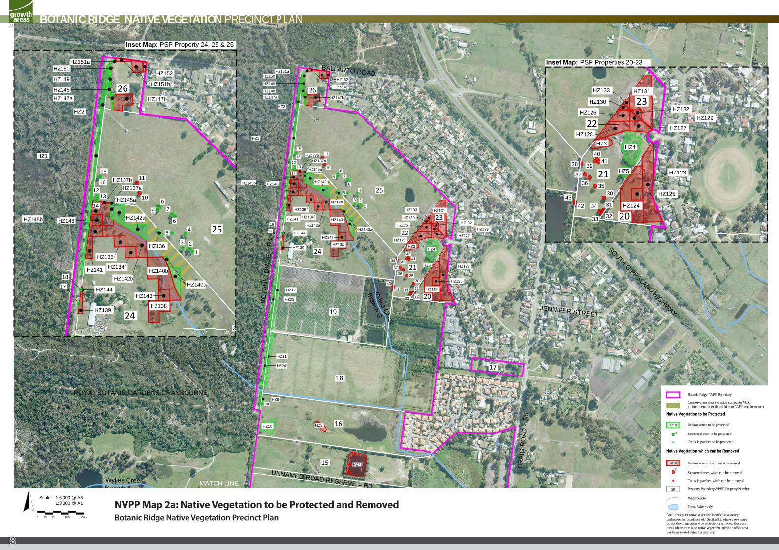
The native vegetation described in NVPP Tables 3 and 4 and shown as native vegetation that ‘can be removed’ on NVPP Maps 2, 2a, 2b and 2c can be removed, destroyed or lopped subject to the conditions and requirements set out below in this NVPP.
Note: In accordance with the note on NVPP Map 2, 2a, 2b and 2c; except for native vegetation identified in a survey undertaken in accordance with Section 5.3, where these maps do not show vegetation to be protected or removed, these are areas where there is no native vegetation unless an offset area has been located within this map unit.
5.1 CONDITIONS FOR REMOVAL OF NATIVE VEGETATION
1 Only the native vegetation which is identified for removal in the incorporated Botanic Ridge NVPP applying to the land may be removed, destroyed or lopped without a planning permit.
2 The native vegetation (habitat zones, trees within habitat zones or scattered trees) described as vegetation which ‘can be removed’ in Table 3 and 4 and shown on Maps 2, 2a, 2b and 2c of this NVPP may be removed if the removal of the native vegetation is offset in accordance with the offset targets set out in Table 5 and 6 of this NVPP. Those offsets must be secured to the satisfaction of the Department of Sustainability and Environment and the responsible authority
3 Before the removal, destruction or lopping of any native vegetation within any property in the NVPP area the owner of the land from which the native vegetation is being removed must provide offsets consistent with this NVPP by either:
a Providing an allocated credit extract issued by the Department of Sustainability and Environment; or
b Preparing and submitting an Offset Plan to the satisfaction of the Department of Sustainability and Environment for the approval of the responsible authority. The Offset plan must be approved prior to the removal, destruction or lopping of any native vegetation.
4 Where an Offset plan is required:a Before the removal, destruction or lopping of any native
vegetation, the owner of the land from which the native vegetation is being removed must provide on-title security for the Offset Site to the satisfaction of the Department of Sustainability and Environment that provides for the implementation of the Offset Plan and pay the reasonable costs of the preparation, execution and registration of any on-title agreement.
b Offsets must be initiated within 12 months of approval of the Offset Plan or before the removal of Very High Conservation Significance vegetation, whichever is earlier and be implemented according to the schedule of works in the Offset Plan to the satisfaction of the responsible authority.
5 Before the removal, destruction or lopping of any native vegetation, native vegetation to be removed in accordance with this NVPP must be clearly marked on site to the satisfaction of the responsible authority whilst works are being undertaken within the vicinity.
6 Before felling of any trees with nest or hollows, the tree must be examined for fauna by a suitably qualified zoologist. If native fauna species are found, they must be salvaged and relocated where possible, to the nearest suitable habitat, in consultation of the Department of Sustainability and Environment.
7 Any construction stockpiles and machinery must be placed away from areas supporting native vegetation to be protected and drainage lines to the satisfaction of the responsible authority.
8 Prior to the commencement of any works during the construction phase, a highly visible vegetation protection fence must be erected around twice the canopy distance of each scattered tree and more than 2 metres from all other native vegetation which have been identified ‘to be protected’ in this NVPP unless otherwise agreed in writing by the Department of Sustainability and Environment and to the satisfaction of the Department of Sustainability and Environment and responsible authority.
5.2 REQUIREMENTS FOR REMOVAL OF NATIVE VEGETATION • Offsets must be provided in accordance with Victoria’s Native
Vegetation Management – a Framework for Action, DSE 2002.
• An Offset Plan must show offsets in relation to all native vegetation within the property which this NVPP allows to be removed. The offsets are to be as set out in this NVPP. An Offset Plan must be prepared in accordance with the Department of Sustainability and Environment Offset Plan Template available from DSE or www.dse.vic.gov.au.
• An offset site must be secured through an appropriate mechanism to the satisfaction of the Department of Sustainability and Environment. Where an offset is secured via an agreement, the agreement must be registered on the title of the land and provide for a native vegetation offset in accordance with the endorsed Offset Plan.
Note: There are a range of mechanisms that offer different degrees of security for offset sites. These include an on-title agreement, transfer of land to public land, or offsets on Crown land. Examples of on-title agreements are: a Section 173 Agreement under the Planning and Environment Act 1987, a Section 69 Agreement under the Conservation Forest and Lands Act 1987 or an agreement under the Victorian Conservation Trust Act 1972.
5.3 OFFSET CALCULATIONS
The offset requirements for native vegetation which can be removed, destroyed or lopped are described in NVPP Tables 5 and 6.
TBC – Where an NVPP Table states ‘TBC’ calculate the relevant offset by submitting a survey of all native trees within the property for approval by the responsible authority. The survey must identify:
a. The species of each tree (common name and botanical name)
b. The size of each tree (Large Old Tree, Medium Old Tree) based on EVC classification
c. Whether the native tree occurs in a patch of native vegetation shown on NVPP Maps 2, 2a, 2b and 2c (tree in a patch) or outside of a patch (scattered tree)
d. The conservation significance of each surveyed tree in accordance with the following criteria:
i. Where a Large Old Tree or Medium Old Tree is within a patch of native vegetation these trees must have a conservation significance of ‘Very High’.
ii. Scattered trees will be classified as the lowest conservation significance rating for the bioregional conservation status of the relevant Ecological Vegetation Class.
e. GPS coordinates.
f. Offsets for all identified trees..
5.4 PROCEDURES FOR THE COLLECTION OF ANY PAYMENTS
No payments are necessary or specified.
BOTANIC RIDGE NATIVE VEGETATION PRECINCT PLAN
5
6.0 REFERENCE DOCUMENTS
Arboricultural Assessment Stages 2 & 3 Botanic Ridge: Cranbourne Development Precinct, (Tree Logic Pty Ltd, 15 October 2010).
Delivering Melbourne’s Newest Sustainable Communities’, (Department of Planning and Community Development, December 2009).
Draft Biodiversity Conservation Strategy for Melbourne’s Growth Areas, (Department of Sustainability and Environment, November 2011).
Port Phillip and Westernport Native Vegetation Plan, (Port Phillip and Westernport Catchment Management Authority, 2006).
Revised Biodiversity Assessment Report: Flora and Fauna Assessment and Mapping, Precinct Structure Plan Area 10 - Botanic Ridge, (Practical Ecology, 20 July 2010).
Time Stamping Native Vegetation Data, (Department of Sustainability and Environment, December 2011).
7.0 ACRONYMS
EPBC Act - Environment Protection and Biodiversity Conservation Act 1999
EVC – Ecological Vegetation Class
DHW - Damp Heathy Woodland
GW - Grassy Woodland
HW - Heathy Woodland
Ha – Hectares
HHa – Habitat Hectares
HZ – Habitat Zone
LOT – Large Old Tree
MOT – Medium Old Tree
NVPP – Native Vegetation Precinct Plan
PGW - Plains Grassy Woodland
SRW – Swampy Riparian Woodland
SS – Swamp Scrub
SW - Sedge Wetland
VLOT – Very Large Old Tree
WF - Wetland Formation
BOTANIC RIDGE NATIVE VEGETATION PRECINCT PLAN
6
Habitat zones to be protected
Trees in patches which can be removed
Habitat zones which can be removed
Trees in patches to be protected
Watercourse
Botanic Ridge NVPP Boundary
20
Scattered trees to be protected
Scattered trees which can be removed
Property Boundary & PSP Property Number
Dam / Waterbody
Note: Except for native vegetation identified in a surveyundertaken in accordance with Section 5.3, where these mapsdo not show vegetation to be protected or removed, these areareas where there is no native vegetation unless an offset areahas been located within this map unit.
Native Vegetation to be Protected
Native Vegetation which can be Removed
Conservation area set aside subject to VCATenforcement order (in addition to NVPP requirements)
Map 2c
Map 2a
Map 2b
ROYAL BOTANICGARDENS
CRANBOURNE
BALLARTO ROAD
BROWNS ROAD = R2
DEVONMEADOWS
JUNCTIONVILLAGE
SOUTH GIPPSLAND HIGHWAY
CR
AIG
R
OAD
= R
5
BALLARTO ROAD
BOTA
NIC
D
RIV
E =
R4
SMIT
HS
LAN
E
MAD
ELYN
CT
WAL
TER
WAY
FLET
CH
ER R
OAD
KELL
Y R
OAD
FIO
NA
DR
IVE
DEV
ON
RO
AD
SMIT
HS
LAN
E =
R1
UNNAMED ROAD RESERVE R = 3
Wylies C
reek Branch GWylies Creek Branch A
Christies Creek Branch C2 Christies Creek Branch A
Scale: 1:15,000 @ A31:7,500 @ A1
0 100m 300m50 200m
25
26
2421
2322
2019
17
1
2
3
45
6
7
8
9 10
11
1214
13
15
16
18
NVPP Map 2: Native Vegetation to be Protected and RemovedBotanic Ridge Native Vegetation Precinct Plan
BOTANIC RIDGE NATIVE VEGETATION PRECINCT PLAN
7
Botanic Ridge NVPP Boundary
40
Habitat zones to be protected
Trees in patches which can be removed
Habitat zones which can be removed
Trees in patches to be protected
40
Watercourse
20
Scattered trees to be protected
Scattered trees which can be removed
Property Boundary & PSP Property Number
Dam / Waterbody
Native Vegetation to be Protected
Native Vegetation which can be Removed
HZ10
HZ10
Conservation area set aside subject to VCATenforcement order (in addition to NVPP requirements)
Note: Except for native vegetation identified in a surveyundertaken in accordance with Section 5.3, where these mapsdo not show vegetation to be protected or removed, these areareas where there is no native vegetation unless an offset areahas been located within this map unit.
MATCH LINE
ROYAL BOTANIC GARDENS CRANBOURNE
SOUTH GIPPSLAND HIGHWAY
JUNCTION VILLAGE
DEVON MEADOWS
CR
AIG
RO
AD =
R5
JENNIFER STREET
BALLARTO ROAD
BOTA
NIC
DR
IVE
= R
4
BALLARTO ROAD
Wylies Creek
Branch G
Wylies CreekBranch A
UNNAMED ROAD RESERVE = R3
25
26
24
21
23
22
20
19
17
12
1413
15
16
18
HZ127
HZ129HZ140a
HZ140b
HZ143
HZ138
HZ134
HZ135
HZ141
HZ146HZ145b
HZ145a
HZ137aHZ137b
HZ142a
HZ136
HZ132
HZ1
HZ144
HZ139
HZ133 HZ131
HZ126
HZ130
HZ128
HZ123
HZ125
HZ124HZ12
HZ23
HZ11
HZ24
HZ3HZ4
HZ5
HZ9
HZ8
HZ7
HZ115
HZ117
HZ122
HZ118HZ116
HZ119
HZ120HZ121
2827
4748
4645
21202223 24
26
25
19
15
1612
13
14
11
108
9 7
645
3 21
18
17
4041
3938
3736 35
30
31
32
34
33
4243
29
HZ10
HZ142b
HZ2
HZ147a HZ147b
HZ148
HZ149
HZ150HZ151a
HZ151b
HZ152
25
26
24
HZ140a
HZ140b
HZ143
HZ138
HZ134
HZ135
HZ141
HZ146HZ145b
HZ145a
HZ137aHZ137b
HZ142a
HZ136
HZ1
HZ144
HZ139
15
1612
13
14
11
108
9 7
645
3 21
18
17
38
HZ142b
HZ2
HZ147a HZ147b
HZ148
HZ149
HZ150HZ151a
HZ151b
HZ152
25
21
23
22
20
HZ127
HZ129HZ132
HZ133 HZ131
HZ126
HZ130
HZ128
HZ123
HZ125
HZ124
HZ3HZ4
HZ5
4041
3938
3736 35
30
31
32
34
33
4243
Scale: 1:6,000 @ A31:3,000 @ A1
0 50 100m 150m25
Inset Map: PSP Property 24, 25 & 26
Inset Map: PSP Properties 20-23
0 25 50 100
500 25 100
NVPP Map 2a: Native Vegetation to be Protected and RemovedBotanic Ridge Native Vegetation Precinct Plan
BOTANIC RIDGE NATIVE VEGETATION PRECINCT PLAN
8
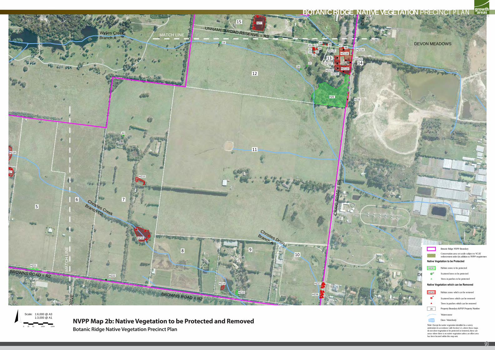
Botanic Ridge NVPP Boundary
40
Habitat zones to be protected
Trees in patches which can be removed
Habitat zones which can be removed
Trees in patches to be protected
40
Watercourse
20
Scattered trees to be protected
Scattered trees which can be removed
Property Boundary & PSP Property Number
Dam / Waterbody
Native Vegetation to be Protected
Native Vegetation which can be Removed
HZ10
HZ10
Conservation area set aside subject to VCATenforcement order (in addition to NVPP requirements)
Note: Except for native vegetation identified in a surveyundertaken in accordance with Section 5.3, where these mapsdo not show vegetation to be protected or removed, these areareas where there is no native vegetation unless an offset areahas been located within this map unit.
MATCH LINE
MA
TCH
LIN
E
DEVON MEADOWS
CR
AIG
RO
AD =
R5
CR
AIG
RO
AD =
R5
BROWNS ROAD = R2
FIO
NA
DR
IVE
DEVON MEADOWS
Wylies CreekBranch A
Christies Creek
Branch C2
Christies Drain
Branch A
UNNAMED ROAD RESERVE = R3
56 7
8 910
11
12
1413
15
BROWNS ROAD = R2
HZ7
HZ115
HZ117
HZ122
HZ118HZ116
HZ27
HZ26HZ13
HZ14
HZ16
HZ22
HZ15
44
HZ25
HZ119
HZ120HZ121
HZ6
2827
4748
4645
21202223 24
26
25
HZ21
HZ17
HZ19
19
Scale: 1:6,000 @ A31:3,000 @ A1
0 50 100m 150m25
NVPP Map 2b: Native Vegetation to be Protected and RemovedBotanic Ridge Native Vegetation Precinct Plan
BOTANIC RIDGE NATIVE VEGETATION PRECINCT PLAN
9
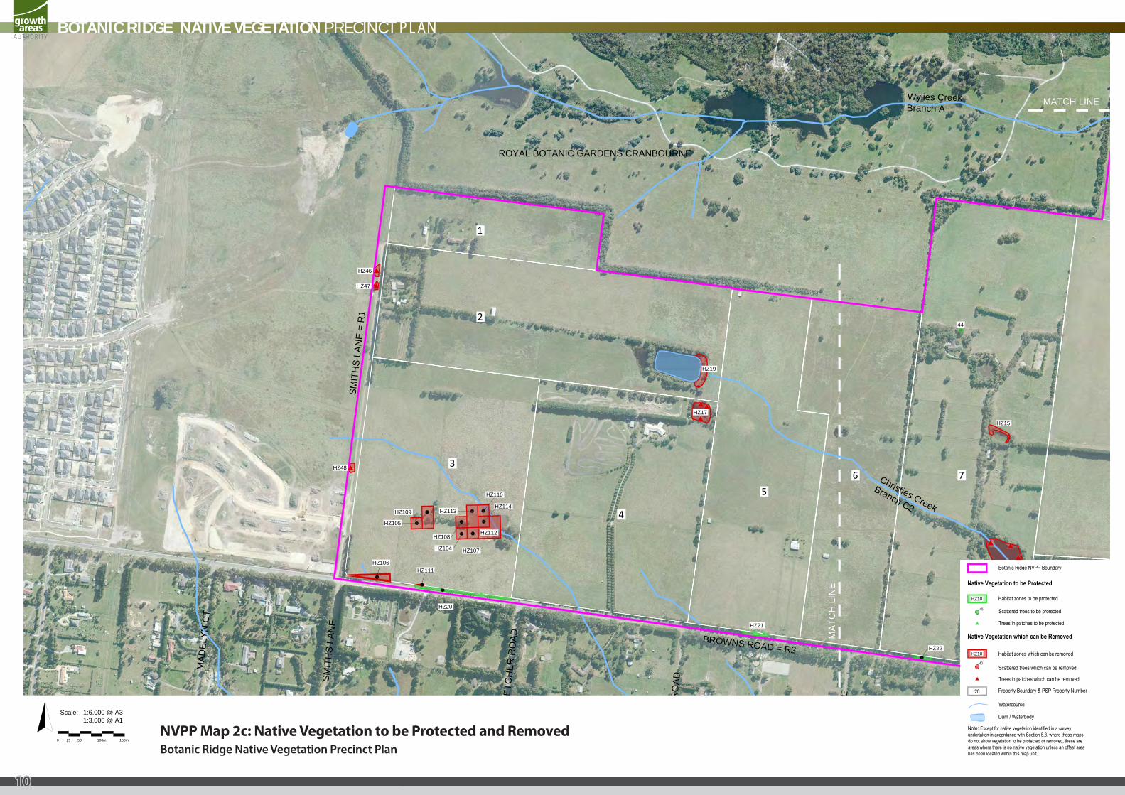
Botanic Ridge NVPP Boundary
40
Habitat zones to be protected
Trees in patches which can be removed
Habitat zones which can be removed
Trees in patches to be protected
40
Watercourse
20
Scattered trees to be protected
Scattered trees which can be removed
Property Boundary & PSP Property Number
Dam / Waterbody
Native Vegetation to be Protected
Native Vegetation which can be Removed
HZ10
HZ10
Note: Except for native vegetation identified in a surveyundertaken in accordance with Section 5.3, where these mapsdo not show vegetation to be protected or removed, these areareas where there is no native vegetation unless an offset areahas been located within this map unit.
MATCH LINE
MA
TCH
LIN
E
BROWNS ROAD = R2
SMIT
HS
LAN
E
FLET
CH
ER R
OAD
KELL
Y R
OAD
FIO
NA
DR
IVE
ROYAL BOTANIC GARDENS CRANBOURNE
MAD
ELYN
CT
Wylies CreekBranch A
Christies Creek
Branch C2
SMIT
HS
LAN
E =
R1
1
2
3
4
56 7
8
BROWNS ROAD = R2
HZ16
HZ22
HZ15
44
HZ21
HZ110
HZ114
HZ112
HZ107HZ104
HZ108
HZ113HZ109
HZ105
HZ106HZ111
HZ20
HZ48
HZ46
HZ47
HZ17
HZ19
Scale: 1:6,000 @ A31:3,000 @ A1
0 50 100m 150m25NVPP Map 2c: Native Vegetation to be Protected and RemovedBotanic Ridge Native Vegetation Precinct Plan
BOTANIC RIDGE NATIVE VEGETATION PRECINCT PLAN
10
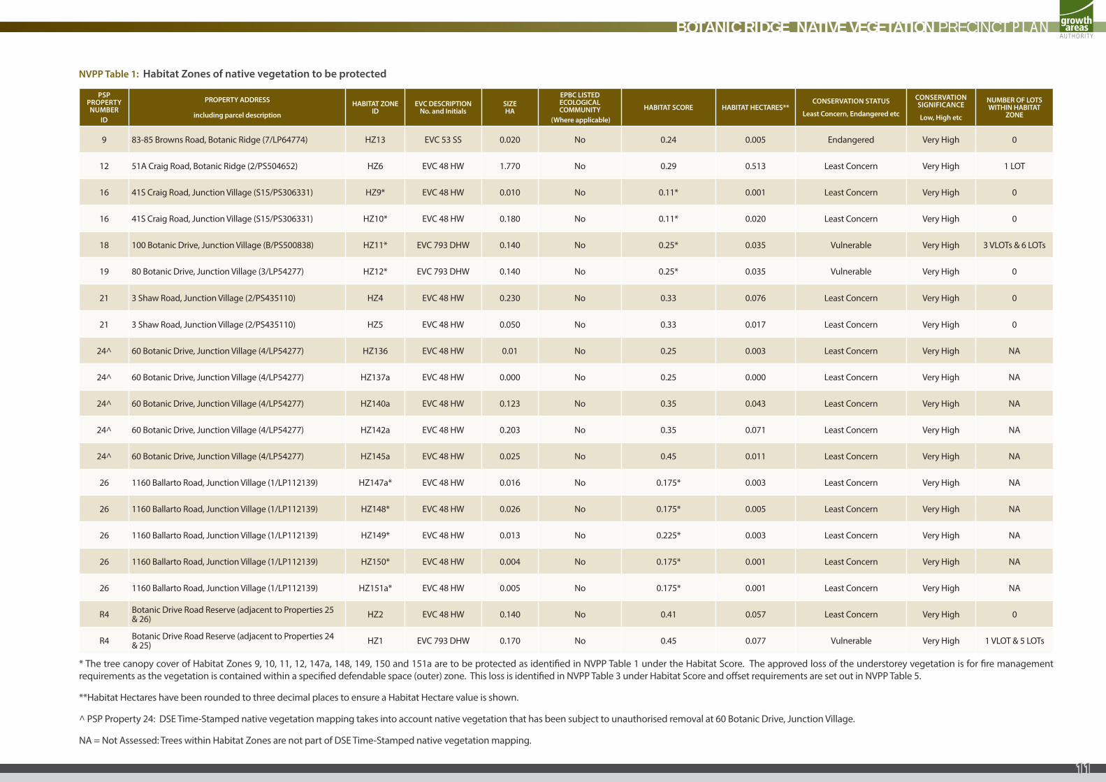
NVPP Table 1: Habitat Zones of native vegetation to be protected
PSP PROPERTY NUMBER
ID
PROPERTY ADDRESS
including parcel description
HABITAT ZONE ID
EVC DESCRIPTION No. and Initials
SIZE HA
EPBC LISTED ECOLOGICAL COMMUNITY
(Where applicable)
HABITAT SCORE HABITAT HECTARES**CONSERVATION STATUS
Least Concern, Endangered etc
CONSERVATION SIGNIFICANCE
Low, High etc
NUMBER OF LOTS WITHIN HABITAT
ZONE
9 83-85 Browns Road, Botanic Ridge (7/LP64774) HZ13 EVC 53 SS 0.020 No 0.24 0.005 Endangered Very High 0
12 51A Craig Road, Botanic Ridge (2/PS504652) HZ6 EVC 48 HW 1.770 No 0.29 0.513 Least Concern Very High 1 LOT
16 41S Craig Road, Junction Village (S15/PS306331) HZ9* EVC 48 HW 0.010 No 0.11* 0.001 Least Concern Very High 0
16 41S Craig Road, Junction Village (S15/PS306331) HZ10* EVC 48 HW 0.180 No 0.11* 0.020 Least Concern Very High 0
18 100 Botanic Drive, Junction Village (B/PS500838) HZ11* EVC 793 DHW 0.140 No 0.25* 0.035 Vulnerable Very High 3 VLOTs & 6 LOTs
19 80 Botanic Drive, Junction Village (3/LP54277) HZ12* EVC 793 DHW 0.140 No 0.25* 0.035 Vulnerable Very High 0
21 3 Shaw Road, Junction Village (2/PS435110) HZ4 EVC 48 HW 0.230 No 0.33 0.076 Least Concern Very High 0
21 3 Shaw Road, Junction Village (2/PS435110) HZ5 EVC 48 HW 0.050 No 0.33 0.017 Least Concern Very High 0
24^ 60 Botanic Drive, Junction Village (4/LP54277) HZ136 EVC 48 HW 0.01 No 0.25 0.003 Least Concern Very High NA
24^ 60 Botanic Drive, Junction Village (4/LP54277) HZ137a EVC 48 HW 0.000 No 0.25 0.000 Least Concern Very High NA
24^ 60 Botanic Drive, Junction Village (4/LP54277) HZ140a EVC 48 HW 0.123 No 0.35 0.043 Least Concern Very High NA
24^ 60 Botanic Drive, Junction Village (4/LP54277) HZ142a EVC 48 HW 0.203 No 0.35 0.071 Least Concern Very High NA
24^ 60 Botanic Drive, Junction Village (4/LP54277) HZ145a EVC 48 HW 0.025 No 0.45 0.011 Least Concern Very High NA
26 1160 Ballarto Road, Junction Village (1/LP112139) HZ147a* EVC 48 HW 0.016 No 0.175* 0.003 Least Concern Very High NA
26 1160 Ballarto Road, Junction Village (1/LP112139) HZ148* EVC 48 HW 0.026 No 0.175* 0.005 Least Concern Very High NA
26 1160 Ballarto Road, Junction Village (1/LP112139) HZ149* EVC 48 HW 0.013 No 0.225* 0.003 Least Concern Very High NA
26 1160 Ballarto Road, Junction Village (1/LP112139) HZ150* EVC 48 HW 0.004 No 0.175* 0.001 Least Concern Very High NA
26 1160 Ballarto Road, Junction Village (1/LP112139) HZ151a* EVC 48 HW 0.005 No 0.175* 0.001 Least Concern Very High NA
R4 Botanic Drive Road Reserve (adjacent to Properties 25 & 26) HZ2 EVC 48 HW 0.140 No 0.41 0.057 Least Concern Very High 0
R4 Botanic Drive Road Reserve (adjacent to Properties 24 & 25) HZ1 EVC 793 DHW 0.170 No 0.45 0.077 Vulnerable Very High 1 VLOT & 5 LOTs
* The tree canopy cover of Habitat Zones 9, 10, 11, 12, 147a, 148, 149, 150 and 151a are to be protected as identified in NVPP Table 1 under the Habitat Score. The approved loss of the understorey vegetation is for fire management requirements as the vegetation is contained within a specified defendable space (outer) zone. This loss is identified in NVPP Table 3 under Habitat Score and offset requirements are set out in NVPP Table 5.
**Habitat Hectares have been rounded to three decimal places to ensure a Habitat Hectare value is shown.
^ PSP Property 24: DSE Time-Stamped native vegetation mapping takes into account native vegetation that has been subject to unauthorised removal at 60 Botanic Drive, Junction Village.
NA = Not Assessed: Trees within Habitat Zones are not part of DSE Time-Stamped native vegetation mapping.
BOTANIC RIDGE NATIVE VEGETATION PRECINCT PLAN
11
PSP PROPERTY NUMBER
ID
PROPERTY ADDRESS
including parcel description
HABITAT ZONE ID
EVC DESCRIPTION No. and Initials
SIZE HA
EPBC LISTED ECOLOGICAL COMMUNITY
(Where applicable)
HABITAT SCORE HABITAT HECTARES**CONSERVATION STATUS
Least Concern, Endangered etc
CONSERVATION SIGNIFICANCE
Low, High etc
NUMBER OF LOTS WITHIN HABITAT
ZONE
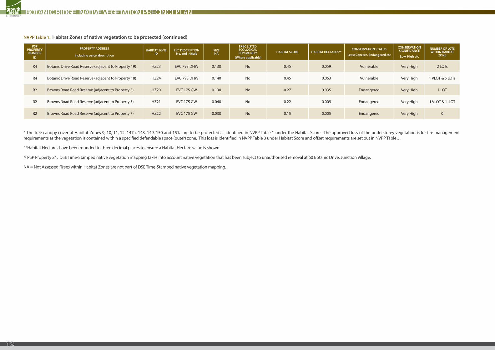
R4 Botanic Drive Road Reserve (adjacent to Property 19) HZ23 EVC 793 DHW 0.130 No 0.45 0.059 Vulnerable Very High 2 LOTs
R4 Botanic Drive Road Reserve (adjacent to Property 18) HZ24 EVC 793 DHW 0.140 No 0.45 0.063 Vulnerable Very High 1 VLOT & 5 LOTs
R2 Browns Road Road Reserve (adjacent to Property 3) HZ20 EVC 175 GW 0.130 No 0.27 0.035 Endangered Very High 1 LOT
R2 Browns Road Road Reserve (adjacent to Property 5) HZ21 EVC 175 GW 0.040 No 0.22 0.009 Endangered Very High 1 VLOT & 1 LOT
R2 Browns Road Road Reserve (adjacent to Property 7) HZ22 EVC 175 GW 0.030 No 0.15 0.005 Endangered Very High 0
* The tree canopy cover of Habitat Zones 9, 10, 11, 12, 147a, 148, 149, 150 and 151a are to be protected as identified in NVPP Table 1 under the Habitat Score. The approved loss of the understorey vegetation is for fire management requirements as the vegetation is contained within a specified defendable space (outer) zone. This loss is identified in NVPP Table 3 under Habitat Score and offset requirements are set out in NVPP Table 5.
**Habitat Hectares have been rounded to three decimal places to ensure a Habitat Hectare value is shown.
^ PSP Property 24: DSE Time-Stamped native vegetation mapping takes into account native vegetation that has been subject to unauthorised removal at 60 Botanic Drive, Junction Village.
NA = Not Assessed: Trees within Habitat Zones are not part of DSE Time-Stamped native vegetation mapping.
NVPP Table 1: Habitat Zones of native vegetation to be protected (continued)
BOTANIC RIDGE NATIVE VEGETATION PRECINCT PLAN
12
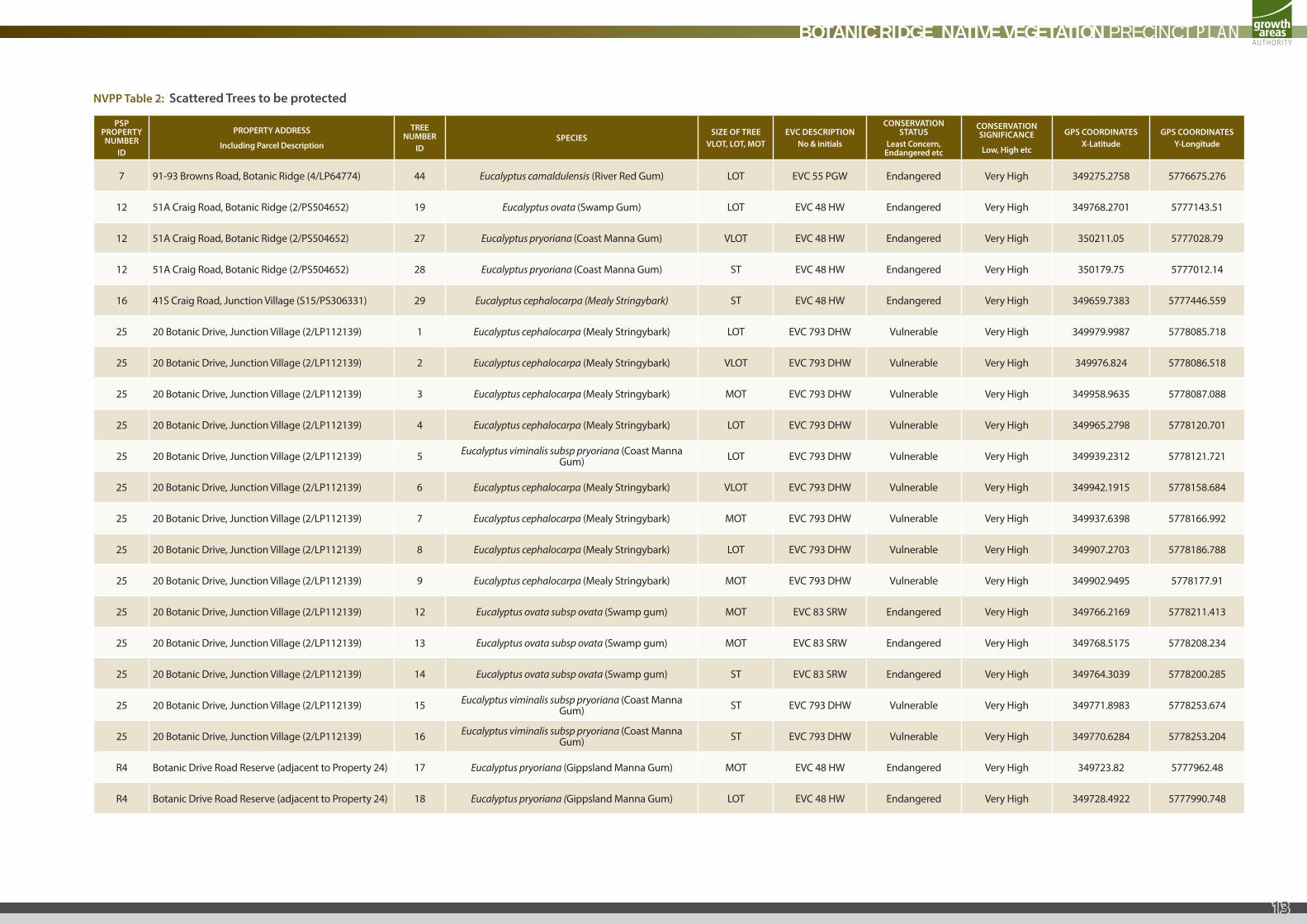
NVPP Table 2: Scattered Trees to be protected
PSP PROPERTY NUMBER
ID
PROPERTY ADDRESS
Including Parcel Description
TREE NUMBER
IDSPECIES
SIZE OF TREEVLOT, LOT, MOT
EVC DESCRIPTIONNo & initials
CONSERVATION STATUS
Least Concern, Endangered etc
CONSERVATION SIGNIFICANCE
Low, High etc
GPS COORDINATESX-Latitude
GPS COORDINATESY-Longitude
7 91-93 Browns Road, Botanic Ridge (4/LP64774) 44 Eucalyptus camaldulensis (River Red Gum) LOT EVC 55 PGW Endangered Very High 349275.2758 5776675.276
12 51A Craig Road, Botanic Ridge (2/PS504652) 19 Eucalyptus ovata (Swamp Gum) LOT EVC 48 HW Endangered Very High 349768.2701 5777143.51
12 51A Craig Road, Botanic Ridge (2/PS504652) 27 Eucalyptus pryoriana (Coast Manna Gum) VLOT EVC 48 HW Endangered Very High 350211.05 5777028.79
12 51A Craig Road, Botanic Ridge (2/PS504652) 28 Eucalyptus pryoriana (Coast Manna Gum) ST EVC 48 HW Endangered Very High 350179.75 5777012.14
16 41S Craig Road, Junction Village (S15/PS306331) 29 Eucalyptus cephalocarpa (Mealy Stringybark) ST EVC 48 HW Endangered Very High 349659.7383 5777446.559
25 20 Botanic Drive, Junction Village (2/LP112139) 1 Eucalyptus cephalocarpa (Mealy Stringybark) LOT EVC 793 DHW Vulnerable Very High 349979.9987 5778085.718
25 20 Botanic Drive, Junction Village (2/LP112139) 2 Eucalyptus cephalocarpa (Mealy Stringybark) VLOT EVC 793 DHW Vulnerable Very High 349976.824 5778086.518
25 20 Botanic Drive, Junction Village (2/LP112139) 3 Eucalyptus cephalocarpa (Mealy Stringybark) MOT EVC 793 DHW Vulnerable Very High 349958.9635 5778087.088
25 20 Botanic Drive, Junction Village (2/LP112139) 4 Eucalyptus cephalocarpa (Mealy Stringybark) LOT EVC 793 DHW Vulnerable Very High 349965.2798 5778120.701
25 20 Botanic Drive, Junction Village (2/LP112139) 5 Eucalyptus viminalis subsp pryoriana (Coast Manna Gum) LOT EVC 793 DHW Vulnerable Very High 349939.2312 5778121.721
25 20 Botanic Drive, Junction Village (2/LP112139) 6 Eucalyptus cephalocarpa (Mealy Stringybark) VLOT EVC 793 DHW Vulnerable Very High 349942.1915 5778158.684
25 20 Botanic Drive, Junction Village (2/LP112139) 7 Eucalyptus cephalocarpa (Mealy Stringybark) MOT EVC 793 DHW Vulnerable Very High 349937.6398 5778166.992
25 20 Botanic Drive, Junction Village (2/LP112139) 8 Eucalyptus cephalocarpa (Mealy Stringybark) LOT EVC 793 DHW Vulnerable Very High 349907.2703 5778186.788
25 20 Botanic Drive, Junction Village (2/LP112139) 9 Eucalyptus cephalocarpa (Mealy Stringybark) MOT EVC 793 DHW Vulnerable Very High 349902.9495 5778177.91
25 20 Botanic Drive, Junction Village (2/LP112139) 12 Eucalyptus ovata subsp ovata (Swamp gum) MOT EVC 83 SRW Endangered Very High 349766.2169 5778211.413
25 20 Botanic Drive, Junction Village (2/LP112139) 13 Eucalyptus ovata subsp ovata (Swamp gum) MOT EVC 83 SRW Endangered Very High 349768.5175 5778208.234
25 20 Botanic Drive, Junction Village (2/LP112139) 14 Eucalyptus ovata subsp ovata (Swamp gum) ST EVC 83 SRW Endangered Very High 349764.3039 5778200.285
25 20 Botanic Drive, Junction Village (2/LP112139) 15 Eucalyptus viminalis subsp pryoriana (Coast Manna Gum) ST EVC 793 DHW Vulnerable Very High 349771.8983 5778253.674
25 20 Botanic Drive, Junction Village (2/LP112139) 16 Eucalyptus viminalis subsp pryoriana (Coast Manna Gum) ST EVC 793 DHW Vulnerable Very High 349770.6284 5778253.204
R4 Botanic Drive Road Reserve (adjacent to Property 24) 17 Eucalyptus pryoriana (Gippsland Manna Gum) MOT EVC 48 HW Endangered Very High 349723.82 5777962.48
R4 Botanic Drive Road Reserve (adjacent to Property 24) 18 Eucalyptus pryoriana (Gippsland Manna Gum) LOT EVC 48 HW Endangered Very High 349728.4922 5777990.748
BOTANIC RIDGE NATIVE VEGETATION PRECINCT PLAN
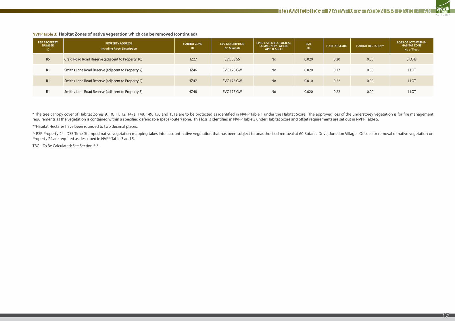
13
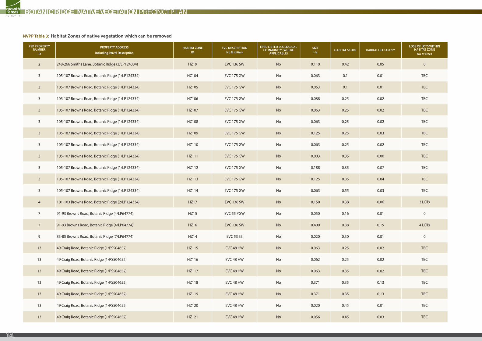
NVPP Table 3: Habitat Zones of native vegetation which can be removed
PSP PROPERTY NUMBER
ID
PROPERTY ADDRESS
Including Parcel Description
HABITAT ZONEID
EVC DESCRIPTIONNo & initials
EPBC LISTED ECOLOGICAL COMMUNITY (WHERE
APPLICABLE)
SIZEHa
HABITAT SCORE HABITAT HECTARES**LOSS OF LOTS WITHIN
HABITAT ZONENo of Trees
2 248-266 Smiths Lane, Botanic Ridge (3/LP124334) HZ19 EVC 136 SW No 0.110 0.42 0.05 0
3 105-107 Browns Road, Botanic Ridge (1/LP124334) HZ104 EVC 175 GW No 0.063 0.1 0.01 TBC
3 105-107 Browns Road, Botanic Ridge (1/LP124334) HZ105 EVC 175 GW No 0.063 0.1 0.01 TBC
3 105-107 Browns Road, Botanic Ridge (1/LP124334) HZ106 EVC 175 GW No 0.088 0.25 0.02 TBC
3 105-107 Browns Road, Botanic Ridge (1/LP124334) HZ107 EVC 175 GW No 0.063 0.25 0.02 TBC
3 105-107 Browns Road, Botanic Ridge (1/LP124334) HZ108 EVC 175 GW No 0.063 0.25 0.02 TBC
3 105-107 Browns Road, Botanic Ridge (1/LP124334) HZ109 EVC 175 GW No 0.125 0.25 0.03 TBC
3 105-107 Browns Road, Botanic Ridge (1/LP124334) HZ110 EVC 175 GW No 0.063 0.25 0.02 TBC
3 105-107 Browns Road, Botanic Ridge (1/LP124334) HZ111 EVC 175 GW No 0.003 0.35 0.00 TBC
3 105-107 Browns Road, Botanic Ridge (1/LP124334) HZ112 EVC 175 GW No 0.188 0.35 0.07 TBC
3 105-107 Browns Road, Botanic Ridge (1/LP124334) HZ113 EVC 175 GW No 0.125 0.35 0.04 TBC
3 105-107 Browns Road, Botanic Ridge (1/LP124334) HZ114 EVC 175 GW No 0.063 0.55 0.03 TBC
4 101-103 Browns Road, Botanic Ridge (2/LP124334) HZ17 EVC 136 SW No 0.150 0.38 0.06 3 LOTs
7 91-93 Browns Road, Botanic Ridge (4/LP64774) HZ15 EVC 55 PGW No 0.050 0.16 0.01 0
7 91-93 Browns Road, Botanic Ridge (4/LP64774) HZ16 EVC 136 SW No 0.400 0.38 0.15 4 LOTs
9 83-85 Browns Road, Botanic Ridge (7/LP64774) HZ14 EVC 53 SS No 0.020 0.30 0.01 0
13 49 Craig Road, Botanic Ridge (1/PS504652) HZ115 EVC 48 HW No 0.063 0.25 0.02 TBC
13 49 Craig Road, Botanic Ridge (1/PS504652) HZ116 EVC 48 HW No 0.062 0.25 0.02 TBC
13 49 Craig Road, Botanic Ridge (1/PS504652) HZ117 EVC 48 HW No 0.063 0.35 0.02 TBC
13 49 Craig Road, Botanic Ridge (1/PS504652) HZ118 EVC 48 HW No 0.371 0.35 0.13 TBC
13 49 Craig Road, Botanic Ridge (1/PS504652) HZ119 EVC 48 HW No 0.371 0.35 0.13 TBC
13 49 Craig Road, Botanic Ridge (1/PS504652) HZ120 EVC 48 HW No 0.020 0.45 0.01 TBC
13 49 Craig Road, Botanic Ridge (1/PS504652) HZ121 EVC 48 HW No 0.056 0.45 0.03 TBC
BOTANIC RIDGE NATIVE VEGETATION PRECINCT PLAN
14
PSP PROPERTY NUMBER
ID
PROPERTY ADDRESS
Including Parcel Description
HABITAT ZONEID
EVC DESCRIPTIONNo & initials
EPBC LISTED ECOLOGICAL COMMUNITY (WHERE
APPLICABLE)
SIZEHa
HABITAT SCORE HABITAT HECTARES**LOSS OF LOTS WITHIN
HABITAT ZONENo of Trees
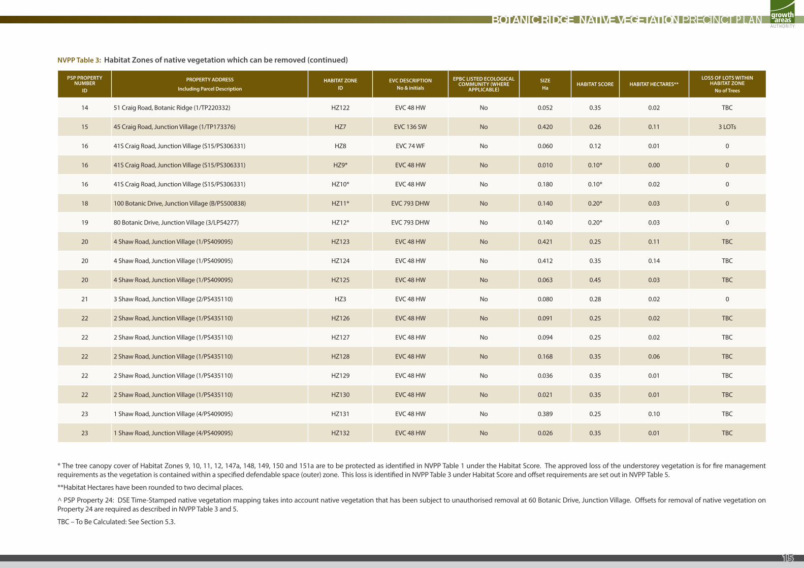
14 51 Craig Road, Botanic Ridge (1/TP220332) HZ122 EVC 48 HW No 0.052 0.35 0.02 TBC
15 45 Craig Road, Junction Village (1/TP173376) HZ7 EVC 136 SW No 0.420 0.26 0.11 3 LOTs
16 41S Craig Road, Junction Village (S15/PS306331) HZ8 EVC 74 WF No 0.060 0.12 0.01 0
16 41S Craig Road, Junction Village (S15/PS306331) HZ9* EVC 48 HW No 0.010 0.10* 0.00 0
16 41S Craig Road, Junction Village (S15/PS306331) HZ10* EVC 48 HW No 0.180 0.10* 0.02 0
18 100 Botanic Drive, Junction Village (B/PS500838) HZ11* EVC 793 DHW No 0.140 0.20* 0.03 0
19 80 Botanic Drive, Junction Village (3/LP54277) HZ12* EVC 793 DHW No 0.140 0.20* 0.03 0
20 4 Shaw Road, Junction Village (1/PS409095) HZ123 EVC 48 HW No 0.421 0.25 0.11 TBC
20 4 Shaw Road, Junction Village (1/PS409095) HZ124 EVC 48 HW No 0.412 0.35 0.14 TBC
20 4 Shaw Road, Junction Village (1/PS409095) HZ125 EVC 48 HW No 0.063 0.45 0.03 TBC
21 3 Shaw Road, Junction Village (2/PS435110) HZ3 EVC 48 HW No 0.080 0.28 0.02 0
22 2 Shaw Road, Junction Village (1/PS435110) HZ126 EVC 48 HW No 0.091 0.25 0.02 TBC
22 2 Shaw Road, Junction Village (1/PS435110) HZ127 EVC 48 HW No 0.094 0.25 0.02 TBC
22 2 Shaw Road, Junction Village (1/PS435110) HZ128 EVC 48 HW No 0.168 0.35 0.06 TBC
22 2 Shaw Road, Junction Village (1/PS435110) HZ129 EVC 48 HW No 0.036 0.35 0.01 TBC
22 2 Shaw Road, Junction Village (1/PS435110) HZ130 EVC 48 HW No 0.021 0.35 0.01 TBC
23 1 Shaw Road, Junction Village (4/PS409095) HZ131 EVC 48 HW No 0.389 0.25 0.10 TBC
23 1 Shaw Road, Junction Village (4/PS409095) HZ132 EVC 48 HW No 0.026 0.35 0.01 TBC
NVPP Table 3: Habitat Zones of native vegetation which can be removed (continued)
* The tree canopy cover of Habitat Zones 9, 10, 11, 12, 147a, 148, 149, 150 and 151a are to be protected as identified in NVPP Table 1 under the Habitat Score. The approved loss of the understorey vegetation is for fire management requirements as the vegetation is contained within a specified defendable space (outer) zone. This loss is identified in NVPP Table 3 under Habitat Score and offset requirements are set out in NVPP Table 5.
**Habitat Hectares have been rounded to two decimal places.
^ PSP Property 24: DSE Time-Stamped native vegetation mapping takes into account native vegetation that has been subject to unauthorised removal at 60 Botanic Drive, Junction Village. Offsets for removal of native vegetation on Property 24 are required as described in NVPP Table 3 and 5.
TBC – To Be Calculated: See Section 5.3.
BOTANIC RIDGE NATIVE VEGETATION PRECINCT PLAN
15
PSP PROPERTY NUMBER
ID
PROPERTY ADDRESS
Including Parcel Description
HABITAT ZONEID
EVC DESCRIPTIONNo & initials
EPBC LISTED ECOLOGICAL COMMUNITY (WHERE
APPLICABLE)
SIZEHa
HABITAT SCORE HABITAT HECTARES**LOSS OF LOTS WITHIN
HABITAT ZONENo of Trees
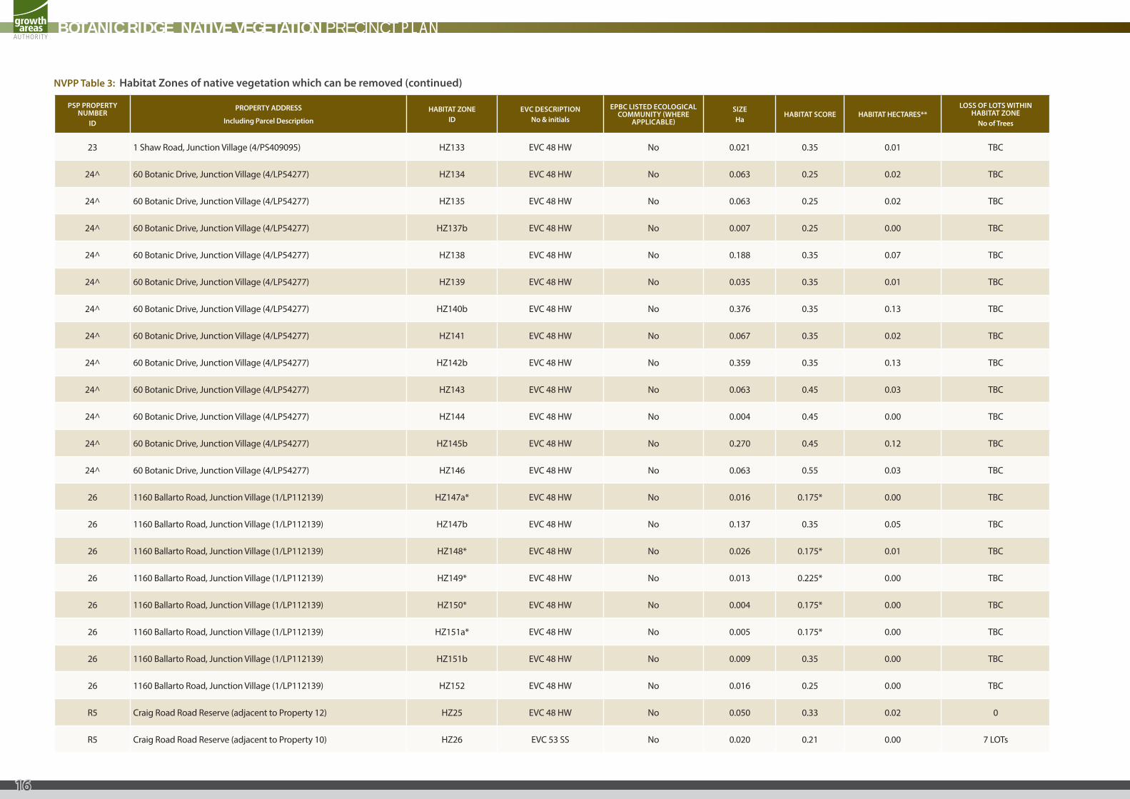
23 1 Shaw Road, Junction Village (4/PS409095) HZ133 EVC 48 HW No 0.021 0.35 0.01 TBC
24^ 60 Botanic Drive, Junction Village (4/LP54277) HZ134 EVC 48 HW No 0.063 0.25 0.02 TBC
24^ 60 Botanic Drive, Junction Village (4/LP54277) HZ135 EVC 48 HW No 0.063 0.25 0.02 TBC
24^ 60 Botanic Drive, Junction Village (4/LP54277) HZ137b EVC 48 HW No 0.007 0.25 0.00 TBC
24^ 60 Botanic Drive, Junction Village (4/LP54277) HZ138 EVC 48 HW No 0.188 0.35 0.07 TBC
24^ 60 Botanic Drive, Junction Village (4/LP54277) HZ139 EVC 48 HW No 0.035 0.35 0.01 TBC
24^ 60 Botanic Drive, Junction Village (4/LP54277) HZ140b EVC 48 HW No 0.376 0.35 0.13 TBC
24^ 60 Botanic Drive, Junction Village (4/LP54277) HZ141 EVC 48 HW No 0.067 0.35 0.02 TBC
24^ 60 Botanic Drive, Junction Village (4/LP54277) HZ142b EVC 48 HW No 0.359 0.35 0.13 TBC
24^ 60 Botanic Drive, Junction Village (4/LP54277) HZ143 EVC 48 HW No 0.063 0.45 0.03 TBC
24^ 60 Botanic Drive, Junction Village (4/LP54277) HZ144 EVC 48 HW No 0.004 0.45 0.00 TBC
24^ 60 Botanic Drive, Junction Village (4/LP54277) HZ145b EVC 48 HW No 0.270 0.45 0.12 TBC
24^ 60 Botanic Drive, Junction Village (4/LP54277) HZ146 EVC 48 HW No 0.063 0.55 0.03 TBC
26 1160 Ballarto Road, Junction Village (1/LP112139) HZ147a* EVC 48 HW No 0.016 0.175* 0.00 TBC
26 1160 Ballarto Road, Junction Village (1/LP112139) HZ147b EVC 48 HW No 0.137 0.35 0.05 TBC
26 1160 Ballarto Road, Junction Village (1/LP112139) HZ148* EVC 48 HW No 0.026 0.175* 0.01 TBC
26 1160 Ballarto Road, Junction Village (1/LP112139) HZ149* EVC 48 HW No 0.013 0.225* 0.00 TBC
26 1160 Ballarto Road, Junction Village (1/LP112139) HZ150* EVC 48 HW No 0.004 0.175* 0.00 TBC
26 1160 Ballarto Road, Junction Village (1/LP112139) HZ151a* EVC 48 HW No 0.005 0.175* 0.00 TBC
26 1160 Ballarto Road, Junction Village (1/LP112139) HZ151b EVC 48 HW No 0.009 0.35 0.00 TBC
26 1160 Ballarto Road, Junction Village (1/LP112139) HZ152 EVC 48 HW No 0.016 0.25 0.00 TBC
R5 Craig Road Road Reserve (adjacent to Property 12) HZ25 EVC 48 HW No 0.050 0.33 0.02 0
R5 Craig Road Road Reserve (adjacent to Property 10) HZ26 EVC 53 SS No 0.020 0.21 0.00 7 LOTs
NVPP Table 3: Habitat Zones of native vegetation which can be removed (continued)
BOTANIC RIDGE NATIVE VEGETATION PRECINCT PLAN
16
PSP PROPERTY NUMBER
ID
PROPERTY ADDRESS
Including Parcel Description
HABITAT ZONEID
EVC DESCRIPTIONNo & initials
EPBC LISTED ECOLOGICAL COMMUNITY (WHERE
APPLICABLE)
SIZEHa
HABITAT SCORE HABITAT HECTARES**LOSS OF LOTS WITHIN
HABITAT ZONENo of Trees
R5 Craig Road Road Reserve (adjacent to Property 10) HZ27 EVC 53 SS No 0.020 0.20 0.00 5 LOTs
R1 Smiths Lane Road Reserve (adjacent to Property 2) HZ46 EVC 175 GW No 0.020 0.17 0.00 1 LOT
R1 Smiths Lane Road Reserve (adjacent to Property 2) HZ47 EVC 175 GW No 0.010 0.22 0.00 1 LOT
R1 Smiths Lane Road Reserve (adjacent to Property 3) HZ48 EVC 175 GW No 0.020 0.22 0.00 1 LOT
* The tree canopy cover of Habitat Zones 9, 10, 11, 12, 147a, 148, 149, 150 and 151a are to be protected as identified in NVPP Table 1 under the Habitat Score. The approved loss of the understorey vegetation is for fire management requirements as the vegetation is contained within a specified defendable space (outer) zone. This loss is identified in NVPP Table 3 under Habitat Score and offset requirements are set out in NVPP Table 5.
**Habitat Hectares have been rounded to two decimal places.
^ PSP Property 24: DSE Time-Stamped native vegetation mapping takes into account native vegetation that has been subject to unauthorised removal at 60 Botanic Drive, Junction Village. Offsets for removal of native vegetation on Property 24 are required as described in NVPP Table 3 and 5.
TBC – To Be Calculated: See Section 5.3.
NVPP Table 3: Habitat Zones of native vegetation which can be removed (continued)
BOTANIC RIDGE NATIVE VEGETATION PRECINCT PLAN
17
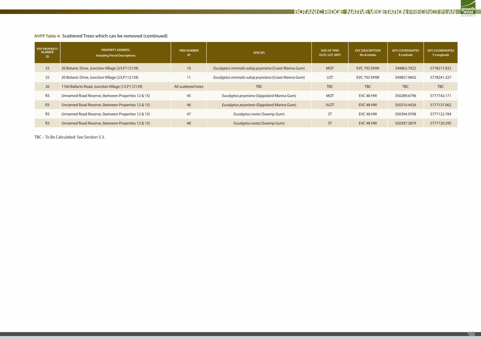
NVPP Table 4: Scattered Trees which can be removed
PSP PROPERTY NUMBER
ID
PROPERTY ADDRESS
Including Parcel Descriptions
TREE NUMBERID
SPECIESSIZE OF TREE
VLOT, LOT, MOTEVC DESCRIPTION
No & initialsGPS COORDINATES
X-LatitudeGPS COORDINATES
Y-Longitude
3 105-107 Browns Road, Botanic Ridge (1/LP124334) All scattered trees TBC TBC TBC TBC TBC
12 51A Craig Road, Botanic Ridge (2/PS504652) 20 Eucalyptus pryoriana (Coast Manna Gum) LOT EVC 48 HW 350241.95 5777120.92
12 51A Craig Road, Botanic Ridge (2/PS504652) 21 Eucalyptus pryoriana (Coast Manna Gum) MOT EVC 48 HW 350246.12 5777119.54
12 51A Craig Road, Botanic Ridge (2/PS504652) 22 Eucalyptus pryoriana (Coast Manna Gum) ST EVC 48 HW 350245.89 5777117
12 51A Craig Road, Botanic Ridge (2/PS504652) 23 Eucalyptus pryoriana (Coast Manna Gum) ST EVC 48 HW 350243.8 5777112.59
12 51A Craig Road, Botanic Ridge (2/PS504652) 24 Eucalyptus pryoriana (Coast Manna Gum) MOT EVC 48 HW 350248.9 5777110.97
12 51A Craig Road, Botanic Ridge (2/PS504652) 25 Eucalyptus pryoriana (Coast Manna Gum) LOT EVC 48 HW 350248.28 5777096.15
12 51A Craig Road, Botanic Ridge (2/PS504652) 26 Eucalyptus pryoriana (Coast Manna Gum) ST EVC 48 HW 350259.95 5777116.19
13 49 Craig Road, Botanic Ridge (1/PS504652) All scattered trees TBC TBC TBC TBC TBC
14 51 Craig Road, Botanic Ridge (1/TP220332) All scattered trees TBC TBC TBC TBC TBC
20 4 Shaw Road, Junction Village (1/PS409095) All scattered trees TBC TBC TBC TBC TBC
21 3 Shaw Road, Junction Village (2/PS435110) 30 Eucalyptus cephalocarpa (Mealy Stringybark) ST EVC 793 DHW 350149.1787 5777828.291
21 3 Shaw Road, Junction Village (2/PS435110) 31 Eucalyptus cephalocarpa (Mealy Stringybark) MOT EVC 793 DHW 350147.043 5777801.546
21 3 Shaw Road, Junction Village (2/PS435110) 32 Eucalyptus cephalocarpa (Mealy Stringybark) ST EVC 793 DHW 350148.1314 5777799.537
21 3 Shaw Road, Junction Village (2/PS435110) 33 Eucalyptus cephalocarpa (Mealy Stringybark) ST EVC 793 DHW 350142.1202 5777798.957
21 3 Shaw Road, Junction Village (2/PS435110) 34 Eucalyptus cephalocarpa (Mealy Stringybark) ST EVC 793 DHW 350139.6135 5777800.626
21 3 Shaw Road, Junction Village (2/PS435110) 35 Eucalyptus cephalocarpa (Mealy Stringybark) ST EVC 793 DHW 350128.1105 5777853.926
21 3 Shaw Road, Junction Village (2/PS435110) 36 Eucalyptus cephalocarpa (Mealy Stringybark) LOT EVC 793 DHW 350116.3932 5777875.431
21 3 Shaw Road, Junction Village (2/PS435110) 37 Eucalyptus cephalocarpa (Mealy Stringybark) ST EVC 793 DHW 350107.1661 5777883.24
21 3 Shaw Road, Junction Village (2/PS435110) 38 Eucalyptus cephalocarpa (Mealy Stringybark) MOT EVC 793 DHW 350100.1571 5777905.775
21 3 Shaw Road, Junction Village (2/PS435110) 39 Eucalyptus cephalocarpa (Mealy Stringybark) MOT EVC 793 DHW 350131.8789 5777908.365
21 3 Shaw Road, Junction Village (2/PS435110) 40 Eucalyptus cephalocarpa (Mealy Stringybark) ST EVC 793 DHW 350135.2184 5777916.133
21 3 Shaw Road, Junction Village (2/PS435110) 41 Eucalyptus cephalocarpa (Mealy Stringybark) ST EVC 793 DHW 350139.4815 5777911.204
21 3 Shaw Road, Junction Village (2/PS435110) 42 Eucalyptus cephalocarpa (Mealy Stringybark) LOT EVC 793 DHW 350084.0447 5777819.263
21 3 Shaw Road, Junction Village (2/PS435110) 43 Not applicable MOT dead 350084.6384 5777822.832
22 2 Shaw Road, Junction Village (1/PS435110) All scattered trees TBC TBC TBC TBC TBC
23 1 Shaw Road, Junction Village (4/PS409095) All scattered trees TBC TBC TBC TBC TBC
24 60 Botanic Drive, Junction Village (4/LP54277) All scattered trees TBC TBC TBC TBC TBC
BOTANIC RIDGE NATIVE VEGETATION PRECINCT PLAN
18
PSP PROPERTY NUMBER
ID
PROPERTY ADDRESS
Including Parcel Descriptions
TREE NUMBERID
SPECIESSIZE OF TREE
VLOT, LOT, MOTEVC DESCRIPTION
No & initialsGPS COORDINATES
X-LatitudeGPS COORDINATES
Y-Longitude
25 20 Botanic Drive, Junction Village (2/LP112139) 10 Eucalyptus viminalis subsp pryoriana (Coast Manna Gum) MOT EVC 793 DHW 349862.7922 5778217.832
25 20 Botanic Drive, Junction Village (2/LP112139) 11 Eucalyptus viminalis subsp pryoriana (Coast Manna Gum) LOT EVC 793 DHW 349857.9602 5778241.327
26 1160 Ballarto Road, Junction Village (1/LP112139) All scattered trees TBC TBC TBC TBC TBC
R3 Unnamed Road Reserve, (between Properties 12 & 15) 45 Eucalyptus pryoriana (Gippsland Manna Gum) MOT EVC 48 HW 350289.6796 5777142.171
R3 Unnamed Road Reserve, (between Properties 12 & 15) 46 Eucalyptus pryoriana (Gippsland Manna Gum) VLOT EVC 48 HW 350310.4426 5777137.062
R3 Unnamed Road Reserve, (between Properties 12 & 15) 47 Eucalyptus ovata (Swamp Gum) ST EVC 48 HW 350394.9708 5777122.784
R3 Unnamed Road Reserve, (between Properties 12 & 15) 48 Eucalyptus ovata (Swamp Gum) ST EVC 48 HW 350397.2879 5777120.295
TBC – To Be Calculated: See Section 5.3.
NVPP Table 4: Scattered Trees which can be removed (continued)
BOTANIC RIDGE NATIVE VEGETATION PRECINCT PLAN
19
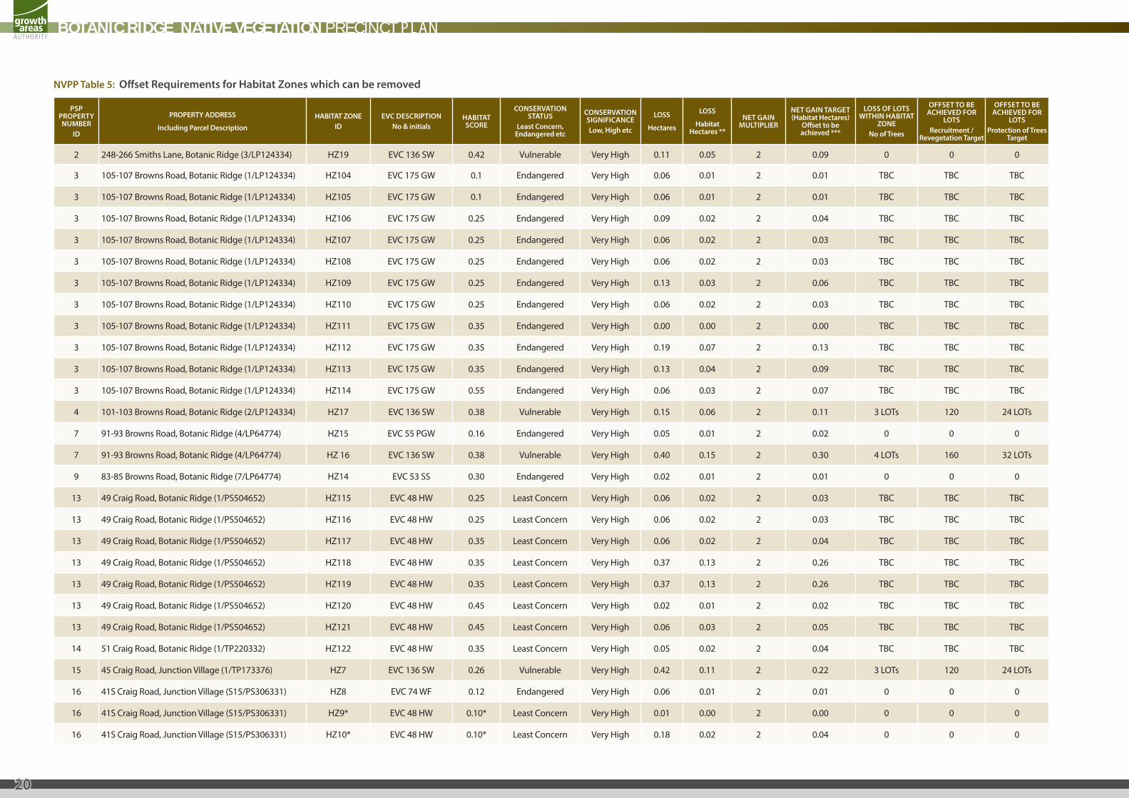
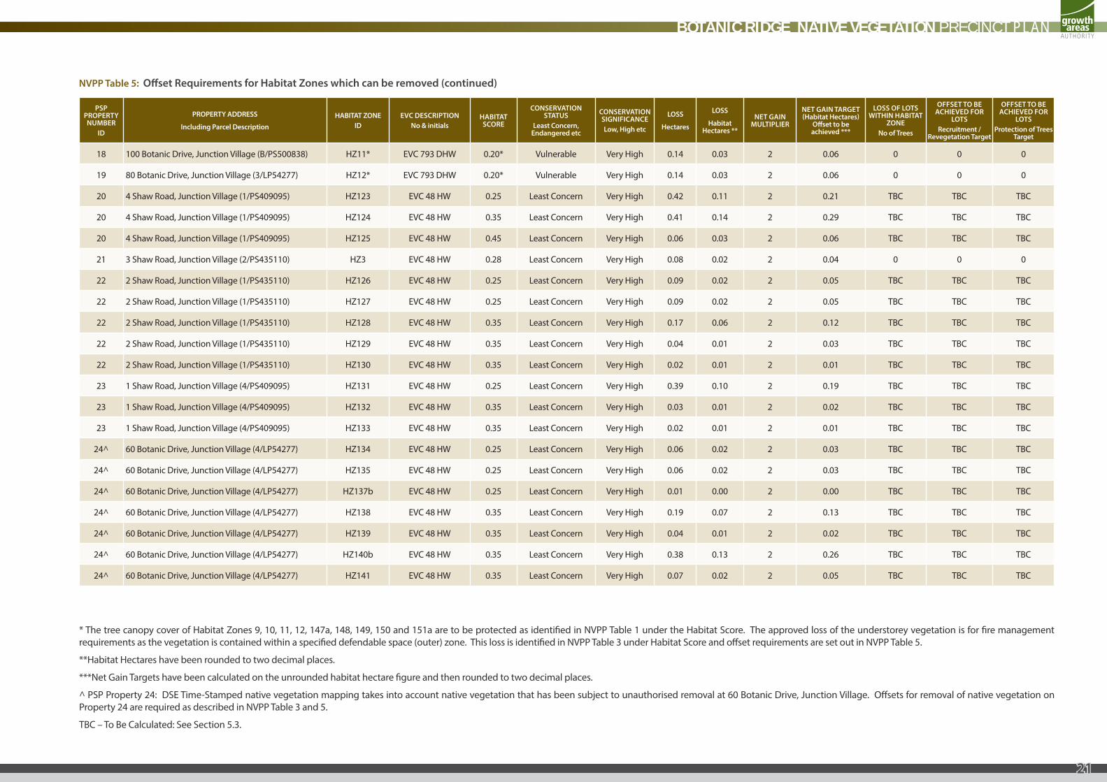
NVPP Table 5: Offset Requirements for Habitat Zones which can be removed
PSP PROPERTY NUMBER
ID
PROPERTY ADDRESS
Including Parcel Description
HABITAT ZONEID
EVC DESCRIPTIONNo & initials
HABITAT SCORE
CONSERVATION STATUS
Least Concern, Endangered etc
CONSERVATION SIGNIFICANCELow, High etc
LOSS
Hectares
LOSS
Habitat Hectares **
NET GAIN MULTIPLIER
NET GAIN TARGET (Habitat Hectares)
Offset to be achieved ***
LOSS OF LOTS WITHIN HABITAT
ZONENo of Trees
OFFSET TO BE ACHIEVED FOR
LOTSRecruitment /
Revegetation Target
OFFSET TO BE ACHIEVED FOR
LOTSProtection of Trees
Target
2 248-266 Smiths Lane, Botanic Ridge (3/LP124334) HZ19 EVC 136 SW 0.42 Vulnerable Very High 0.11 0.05 2 0.09 0 0 0
3 105-107 Browns Road, Botanic Ridge (1/LP124334) HZ104 EVC 175 GW 0.1 Endangered Very High 0.06 0.01 2 0.01 TBC TBC TBC
3 105-107 Browns Road, Botanic Ridge (1/LP124334) HZ105 EVC 175 GW 0.1 Endangered Very High 0.06 0.01 2 0.01 TBC TBC TBC
3 105-107 Browns Road, Botanic Ridge (1/LP124334) HZ106 EVC 175 GW 0.25 Endangered Very High 0.09 0.02 2 0.04 TBC TBC TBC
3 105-107 Browns Road, Botanic Ridge (1/LP124334) HZ107 EVC 175 GW 0.25 Endangered Very High 0.06 0.02 2 0.03 TBC TBC TBC
3 105-107 Browns Road, Botanic Ridge (1/LP124334) HZ108 EVC 175 GW 0.25 Endangered Very High 0.06 0.02 2 0.03 TBC TBC TBC
3 105-107 Browns Road, Botanic Ridge (1/LP124334) HZ109 EVC 175 GW 0.25 Endangered Very High 0.13 0.03 2 0.06 TBC TBC TBC
3 105-107 Browns Road, Botanic Ridge (1/LP124334) HZ110 EVC 175 GW 0.25 Endangered Very High 0.06 0.02 2 0.03 TBC TBC TBC
3 105-107 Browns Road, Botanic Ridge (1/LP124334) HZ111 EVC 175 GW 0.35 Endangered Very High 0.00 0.00 2 0.00 TBC TBC TBC
3 105-107 Browns Road, Botanic Ridge (1/LP124334) HZ112 EVC 175 GW 0.35 Endangered Very High 0.19 0.07 2 0.13 TBC TBC TBC
3 105-107 Browns Road, Botanic Ridge (1/LP124334) HZ113 EVC 175 GW 0.35 Endangered Very High 0.13 0.04 2 0.09 TBC TBC TBC
3 105-107 Browns Road, Botanic Ridge (1/LP124334) HZ114 EVC 175 GW 0.55 Endangered Very High 0.06 0.03 2 0.07 TBC TBC TBC
4 101-103 Browns Road, Botanic Ridge (2/LP124334) HZ17 EVC 136 SW 0.38 Vulnerable Very High 0.15 0.06 2 0.11 3 LOTs 120 24 LOTs
7 91-93 Browns Road, Botanic Ridge (4/LP64774) HZ15 EVC 55 PGW 0.16 Endangered Very High 0.05 0.01 2 0.02 0 0 0
7 91-93 Browns Road, Botanic Ridge (4/LP64774) HZ 16 EVC 136 SW 0.38 Vulnerable Very High 0.40 0.15 2 0.30 4 LOTs 160 32 LOTs
9 83-85 Browns Road, Botanic Ridge (7/LP64774) HZ14 EVC 53 SS 0.30 Endangered Very High 0.02 0.01 2 0.01 0 0 0
13 49 Craig Road, Botanic Ridge (1/PS504652) HZ115 EVC 48 HW 0.25 Least Concern Very High 0.06 0.02 2 0.03 TBC TBC TBC
13 49 Craig Road, Botanic Ridge (1/PS504652) HZ116 EVC 48 HW 0.25 Least Concern Very High 0.06 0.02 2 0.03 TBC TBC TBC
13 49 Craig Road, Botanic Ridge (1/PS504652) HZ117 EVC 48 HW 0.35 Least Concern Very High 0.06 0.02 2 0.04 TBC TBC TBC
13 49 Craig Road, Botanic Ridge (1/PS504652) HZ118 EVC 48 HW 0.35 Least Concern Very High 0.37 0.13 2 0.26 TBC TBC TBC
13 49 Craig Road, Botanic Ridge (1/PS504652) HZ119 EVC 48 HW 0.35 Least Concern Very High 0.37 0.13 2 0.26 TBC TBC TBC
13 49 Craig Road, Botanic Ridge (1/PS504652) HZ120 EVC 48 HW 0.45 Least Concern Very High 0.02 0.01 2 0.02 TBC TBC TBC
13 49 Craig Road, Botanic Ridge (1/PS504652) HZ121 EVC 48 HW 0.45 Least Concern Very High 0.06 0.03 2 0.05 TBC TBC TBC
14 51 Craig Road, Botanic Ridge (1/TP220332) HZ122 EVC 48 HW 0.35 Least Concern Very High 0.05 0.02 2 0.04 TBC TBC TBC
15 45 Craig Road, Junction Village (1/TP173376) HZ7 EVC 136 SW 0.26 Vulnerable Very High 0.42 0.11 2 0.22 3 LOTs 120 24 LOTs
16 41S Craig Road, Junction Village (S15/PS306331) HZ8 EVC 74 WF 0.12 Endangered Very High 0.06 0.01 2 0.01 0 0 0
16 41S Craig Road, Junction Village (S15/PS306331) HZ9* EVC 48 HW 0.10* Least Concern Very High 0.01 0.00 2 0.00 0 0 0
16 41S Craig Road, Junction Village (S15/PS306331) HZ10* EVC 48 HW 0.10* Least Concern Very High 0.18 0.02 2 0.04 0 0 0
BOTANIC RIDGE NATIVE VEGETATION PRECINCT PLAN
20
PSP PROPERTY NUMBER
ID
PROPERTY ADDRESS
Including Parcel Description
HABITAT ZONEID
EVC DESCRIPTIONNo & initials
HABITAT SCORE
CONSERVATION STATUS
Least Concern, Endangered etc
CONSERVATION SIGNIFICANCELow, High etc
LOSS
Hectares
LOSS
Habitat Hectares **
NET GAIN MULTIPLIER
NET GAIN TARGET (Habitat Hectares)
Offset to be achieved ***
LOSS OF LOTS WITHIN HABITAT
ZONENo of Trees
OFFSET TO BE ACHIEVED FOR
LOTSRecruitment /
Revegetation Target
OFFSET TO BE ACHIEVED FOR
LOTSProtection of Trees
Target
18 100 Botanic Drive, Junction Village (B/PS500838) HZ11* EVC 793 DHW 0.20* Vulnerable Very High 0.14 0.03 2 0.06 0 0 0
19 80 Botanic Drive, Junction Village (3/LP54277) HZ12* EVC 793 DHW 0.20* Vulnerable Very High 0.14 0.03 2 0.06 0 0 0
20 4 Shaw Road, Junction Village (1/PS409095) HZ123 EVC 48 HW 0.25 Least Concern Very High 0.42 0.11 2 0.21 TBC TBC TBC
20 4 Shaw Road, Junction Village (1/PS409095) HZ124 EVC 48 HW 0.35 Least Concern Very High 0.41 0.14 2 0.29 TBC TBC TBC
20 4 Shaw Road, Junction Village (1/PS409095) HZ125 EVC 48 HW 0.45 Least Concern Very High 0.06 0.03 2 0.06 TBC TBC TBC
21 3 Shaw Road, Junction Village (2/PS435110) HZ3 EVC 48 HW 0.28 Least Concern Very High 0.08 0.02 2 0.04 0 0 0
22 2 Shaw Road, Junction Village (1/PS435110) HZ126 EVC 48 HW 0.25 Least Concern Very High 0.09 0.02 2 0.05 TBC TBC TBC
22 2 Shaw Road, Junction Village (1/PS435110) HZ127 EVC 48 HW 0.25 Least Concern Very High 0.09 0.02 2 0.05 TBC TBC TBC
22 2 Shaw Road, Junction Village (1/PS435110) HZ128 EVC 48 HW 0.35 Least Concern Very High 0.17 0.06 2 0.12 TBC TBC TBC
22 2 Shaw Road, Junction Village (1/PS435110) HZ129 EVC 48 HW 0.35 Least Concern Very High 0.04 0.01 2 0.03 TBC TBC TBC
22 2 Shaw Road, Junction Village (1/PS435110) HZ130 EVC 48 HW 0.35 Least Concern Very High 0.02 0.01 2 0.01 TBC TBC TBC
23 1 Shaw Road, Junction Village (4/PS409095) HZ131 EVC 48 HW 0.25 Least Concern Very High 0.39 0.10 2 0.19 TBC TBC TBC
23 1 Shaw Road, Junction Village (4/PS409095) HZ132 EVC 48 HW 0.35 Least Concern Very High 0.03 0.01 2 0.02 TBC TBC TBC
23 1 Shaw Road, Junction Village (4/PS409095) HZ133 EVC 48 HW 0.35 Least Concern Very High 0.02 0.01 2 0.01 TBC TBC TBC
24^ 60 Botanic Drive, Junction Village (4/LP54277) HZ134 EVC 48 HW 0.25 Least Concern Very High 0.06 0.02 2 0.03 TBC TBC TBC
24^ 60 Botanic Drive, Junction Village (4/LP54277) HZ135 EVC 48 HW 0.25 Least Concern Very High 0.06 0.02 2 0.03 TBC TBC TBC
24^ 60 Botanic Drive, Junction Village (4/LP54277) HZ137b EVC 48 HW 0.25 Least Concern Very High 0.01 0.00 2 0.00 TBC TBC TBC
24^ 60 Botanic Drive, Junction Village (4/LP54277) HZ138 EVC 48 HW 0.35 Least Concern Very High 0.19 0.07 2 0.13 TBC TBC TBC
24^ 60 Botanic Drive, Junction Village (4/LP54277) HZ139 EVC 48 HW 0.35 Least Concern Very High 0.04 0.01 2 0.02 TBC TBC TBC
24^ 60 Botanic Drive, Junction Village (4/LP54277) HZ140b EVC 48 HW 0.35 Least Concern Very High 0.38 0.13 2 0.26 TBC TBC TBC
24^ 60 Botanic Drive, Junction Village (4/LP54277) HZ141 EVC 48 HW 0.35 Least Concern Very High 0.07 0.02 2 0.05 TBC TBC TBC
NVPP Table 5: Offset Requirements for Habitat Zones which can be removed (continued)
* The tree canopy cover of Habitat Zones 9, 10, 11, 12, 147a, 148, 149, 150 and 151a are to be protected as identified in NVPP Table 1 under the Habitat Score. The approved loss of the understorey vegetation is for fire management requirements as the vegetation is contained within a specified defendable space (outer) zone. This loss is identified in NVPP Table 3 under Habitat Score and offset requirements are set out in NVPP Table 5.
**Habitat Hectares have been rounded to two decimal places.
***Net Gain Targets have been calculated on the unrounded habitat hectare figure and then rounded to two decimal places.
^ PSP Property 24: DSE Time-Stamped native vegetation mapping takes into account native vegetation that has been subject to unauthorised removal at 60 Botanic Drive, Junction Village. Offsets for removal of native vegetation on Property 24 are required as described in NVPP Table 3 and 5.
TBC – To Be Calculated: See Section 5.3.
BOTANIC RIDGE NATIVE VEGETATION PRECINCT PLAN
21
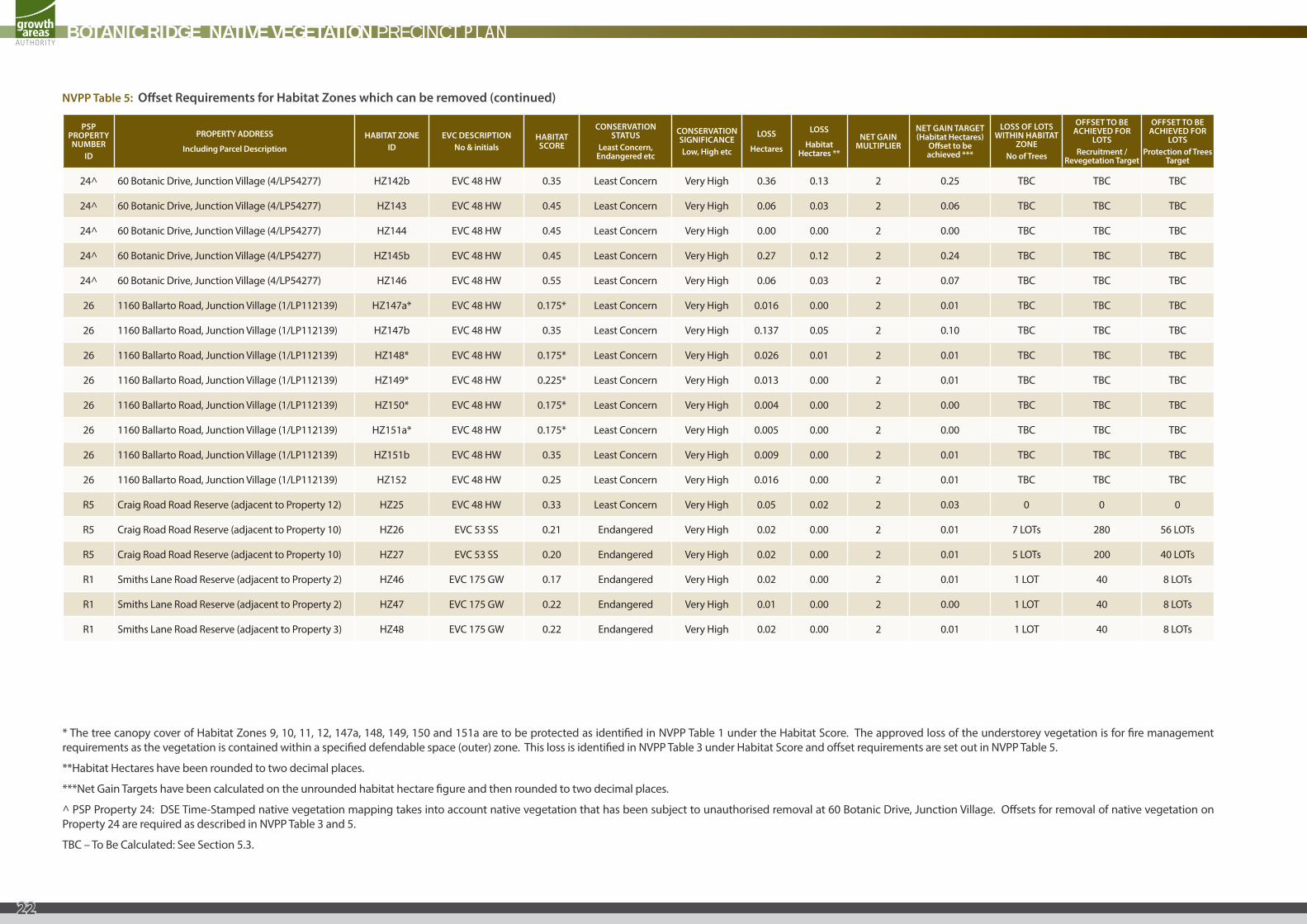
PSP PROPERTY NUMBER
ID
PROPERTY ADDRESS
Including Parcel Description
HABITAT ZONEID
EVC DESCRIPTIONNo & initials
HABITAT SCORE
CONSERVATION STATUS
Least Concern, Endangered etc
CONSERVATION SIGNIFICANCELow, High etc
LOSS
Hectares
LOSS
Habitat Hectares **
NET GAIN MULTIPLIER
NET GAIN TARGET (Habitat Hectares)
Offset to be achieved ***
LOSS OF LOTS WITHIN HABITAT
ZONENo of Trees
OFFSET TO BE ACHIEVED FOR
LOTSRecruitment /
Revegetation Target
OFFSET TO BE ACHIEVED FOR
LOTSProtection of Trees
Target
24^ 60 Botanic Drive, Junction Village (4/LP54277) HZ142b EVC 48 HW 0.35 Least Concern Very High 0.36 0.13 2 0.25 TBC TBC TBC
24^ 60 Botanic Drive, Junction Village (4/LP54277) HZ143 EVC 48 HW 0.45 Least Concern Very High 0.06 0.03 2 0.06 TBC TBC TBC
24^ 60 Botanic Drive, Junction Village (4/LP54277) HZ144 EVC 48 HW 0.45 Least Concern Very High 0.00 0.00 2 0.00 TBC TBC TBC
24^ 60 Botanic Drive, Junction Village (4/LP54277) HZ145b EVC 48 HW 0.45 Least Concern Very High 0.27 0.12 2 0.24 TBC TBC TBC
24^ 60 Botanic Drive, Junction Village (4/LP54277) HZ146 EVC 48 HW 0.55 Least Concern Very High 0.06 0.03 2 0.07 TBC TBC TBC
26 1160 Ballarto Road, Junction Village (1/LP112139) HZ147a* EVC 48 HW 0.175* Least Concern Very High 0.016 0.00 2 0.01 TBC TBC TBC
26 1160 Ballarto Road, Junction Village (1/LP112139) HZ147b EVC 48 HW 0.35 Least Concern Very High 0.137 0.05 2 0.10 TBC TBC TBC
26 1160 Ballarto Road, Junction Village (1/LP112139) HZ148* EVC 48 HW 0.175* Least Concern Very High 0.026 0.01 2 0.01 TBC TBC TBC
26 1160 Ballarto Road, Junction Village (1/LP112139) HZ149* EVC 48 HW 0.225* Least Concern Very High 0.013 0.00 2 0.01 TBC TBC TBC
26 1160 Ballarto Road, Junction Village (1/LP112139) HZ150* EVC 48 HW 0.175* Least Concern Very High 0.004 0.00 2 0.00 TBC TBC TBC
26 1160 Ballarto Road, Junction Village (1/LP112139) HZ151a* EVC 48 HW 0.175* Least Concern Very High 0.005 0.00 2 0.00 TBC TBC TBC
26 1160 Ballarto Road, Junction Village (1/LP112139) HZ151b EVC 48 HW 0.35 Least Concern Very High 0.009 0.00 2 0.01 TBC TBC TBC
26 1160 Ballarto Road, Junction Village (1/LP112139) HZ152 EVC 48 HW 0.25 Least Concern Very High 0.016 0.00 2 0.01 TBC TBC TBC
R5 Craig Road Road Reserve (adjacent to Property 12) HZ25 EVC 48 HW 0.33 Least Concern Very High 0.05 0.02 2 0.03 0 0 0
R5 Craig Road Road Reserve (adjacent to Property 10) HZ26 EVC 53 SS 0.21 Endangered Very High 0.02 0.00 2 0.01 7 LOTs 280 56 LOTs
R5 Craig Road Road Reserve (adjacent to Property 10) HZ27 EVC 53 SS 0.20 Endangered Very High 0.02 0.00 2 0.01 5 LOTs 200 40 LOTs
R1 Smiths Lane Road Reserve (adjacent to Property 2) HZ46 EVC 175 GW 0.17 Endangered Very High 0.02 0.00 2 0.01 1 LOT 40 8 LOTs
R1 Smiths Lane Road Reserve (adjacent to Property 2) HZ47 EVC 175 GW 0.22 Endangered Very High 0.01 0.00 2 0.00 1 LOT 40 8 LOTs
R1 Smiths Lane Road Reserve (adjacent to Property 3) HZ48 EVC 175 GW 0.22 Endangered Very High 0.02 0.00 2 0.01 1 LOT 40 8 LOTs
NVPP Table 5: Offset Requirements for Habitat Zones which can be removed (continued)
* The tree canopy cover of Habitat Zones 9, 10, 11, 12, 147a, 148, 149, 150 and 151a are to be protected as identified in NVPP Table 1 under the Habitat Score. The approved loss of the understorey vegetation is for fire management requirements as the vegetation is contained within a specified defendable space (outer) zone. This loss is identified in NVPP Table 3 under Habitat Score and offset requirements are set out in NVPP Table 5.
**Habitat Hectares have been rounded to two decimal places.
***Net Gain Targets have been calculated on the unrounded habitat hectare figure and then rounded to two decimal places.
^ PSP Property 24: DSE Time-Stamped native vegetation mapping takes into account native vegetation that has been subject to unauthorised removal at 60 Botanic Drive, Junction Village. Offsets for removal of native vegetation on Property 24 are required as described in NVPP Table 3 and 5.
TBC – To Be Calculated: See Section 5.3.
BOTANIC RIDGE NATIVE VEGETATION PRECINCT PLAN
22
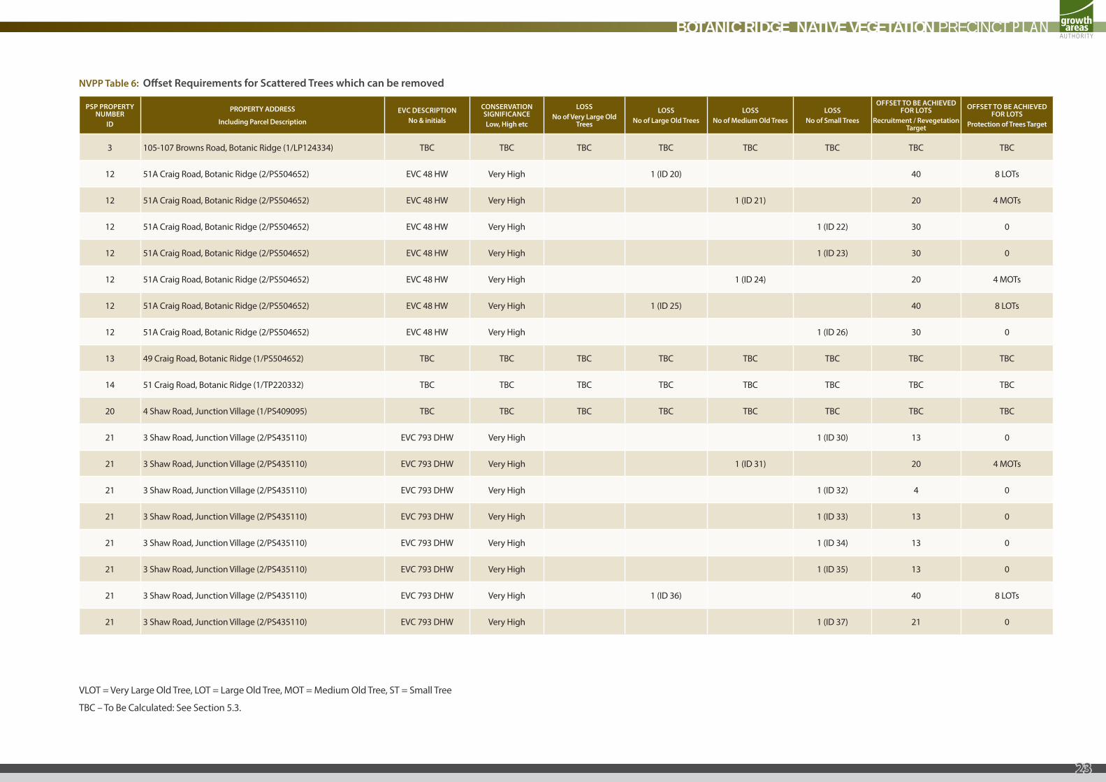
NVPP Table 6: Offset Requirements for Scattered Trees which can be removed
PSP PROPERTY NUMBER
ID
PROPERTY ADDRESS
Including Parcel Description
EVC DESCRIPTIONNo & initials
CONSERVATION SIGNIFICANCELow, High etc
LOSSNo of Very Large Old
Trees
LOSSNo of Large Old Trees
LOSSNo of Medium Old Trees
LOSSNo of Small Trees
OFFSET TO BE ACHIEVED FOR LOTS
Recruitment / Revegetation Target
OFFSET TO BE ACHIEVED FOR LOTS
Protection of Trees Target
3 105-107 Browns Road, Botanic Ridge (1/LP124334) TBC TBC TBC TBC TBC TBC TBC TBC
12 51A Craig Road, Botanic Ridge (2/PS504652) EVC 48 HW Very High 1 (ID 20) 40 8 LOTs
12 51A Craig Road, Botanic Ridge (2/PS504652) EVC 48 HW Very High 1 (ID 21) 20 4 MOTs
12 51A Craig Road, Botanic Ridge (2/PS504652) EVC 48 HW Very High 1 (ID 22) 30 0
12 51A Craig Road, Botanic Ridge (2/PS504652) EVC 48 HW Very High 1 (ID 23) 30 0
12 51A Craig Road, Botanic Ridge (2/PS504652) EVC 48 HW Very High 1 (ID 24) 20 4 MOTs
12 51A Craig Road, Botanic Ridge (2/PS504652) EVC 48 HW Very High 1 (ID 25) 40 8 LOTs
12 51A Craig Road, Botanic Ridge (2/PS504652) EVC 48 HW Very High 1 (ID 26) 30 0
13 49 Craig Road, Botanic Ridge (1/PS504652) TBC TBC TBC TBC TBC TBC TBC TBC
14 51 Craig Road, Botanic Ridge (1/TP220332) TBC TBC TBC TBC TBC TBC TBC TBC
20 4 Shaw Road, Junction Village (1/PS409095) TBC TBC TBC TBC TBC TBC TBC TBC
21 3 Shaw Road, Junction Village (2/PS435110) EVC 793 DHW Very High 1 (ID 30) 13 0
21 3 Shaw Road, Junction Village (2/PS435110) EVC 793 DHW Very High 1 (ID 31) 20 4 MOTs
21 3 Shaw Road, Junction Village (2/PS435110) EVC 793 DHW Very High 1 (ID 32) 4 0
21 3 Shaw Road, Junction Village (2/PS435110) EVC 793 DHW Very High 1 (ID 33) 13 0
21 3 Shaw Road, Junction Village (2/PS435110) EVC 793 DHW Very High 1 (ID 34) 13 0
21 3 Shaw Road, Junction Village (2/PS435110) EVC 793 DHW Very High 1 (ID 35) 13 0
21 3 Shaw Road, Junction Village (2/PS435110) EVC 793 DHW Very High 1 (ID 36) 40 8 LOTs
21 3 Shaw Road, Junction Village (2/PS435110) EVC 793 DHW Very High 1 (ID 37) 21 0
VLOT = Very Large Old Tree, LOT = Large Old Tree, MOT = Medium Old Tree, ST = Small Tree
TBC – To Be Calculated: See Section 5.3.
BOTANIC RIDGE NATIVE VEGETATION PRECINCT PLAN
23
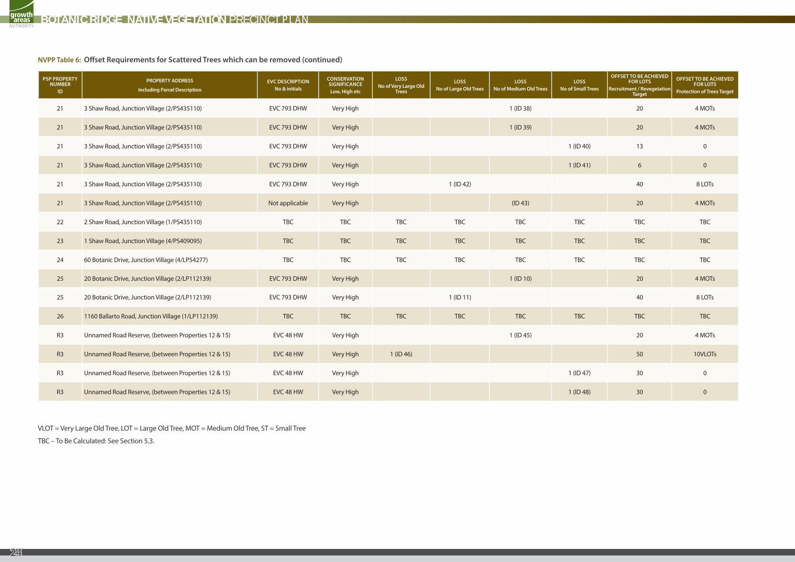
PSP PROPERTY NUMBER
ID
PROPERTY ADDRESS
Including Parcel Description
EVC DESCRIPTIONNo & initials
CONSERVATION SIGNIFICANCELow, High etc
LOSSNo of Very Large Old
Trees
LOSSNo of Large Old Trees
LOSSNo of Medium Old Trees
LOSSNo of Small Trees
OFFSET TO BE ACHIEVED FOR LOTS
Recruitment / Revegetation Target
OFFSET TO BE ACHIEVED FOR LOTS
Protection of Trees Target
21 3 Shaw Road, Junction Village (2/PS435110) EVC 793 DHW Very High 1 (ID 38) 20 4 MOTs
21 3 Shaw Road, Junction Village (2/PS435110) EVC 793 DHW Very High 1 (ID 39) 20 4 MOTs
21 3 Shaw Road, Junction Village (2/PS435110) EVC 793 DHW Very High 1 (ID 40) 13 0
21 3 Shaw Road, Junction Village (2/PS435110) EVC 793 DHW Very High 1 (ID 41) 6 0
21 3 Shaw Road, Junction Village (2/PS435110) EVC 793 DHW Very High 1 (ID 42) 40 8 LOTs
21 3 Shaw Road, Junction Village (2/PS435110) Not applicable Very High (ID 43) 20 4 MOTs
22 2 Shaw Road, Junction Village (1/PS435110) TBC TBC TBC TBC TBC TBC TBC TBC
23 1 Shaw Road, Junction Village (4/PS409095) TBC TBC TBC TBC TBC TBC TBC TBC
24 60 Botanic Drive, Junction Village (4/LP54277) TBC TBC TBC TBC TBC TBC TBC TBC
25 20 Botanic Drive, Junction Village (2/LP112139) EVC 793 DHW Very High 1 (ID 10) 20 4 MOTs
25 20 Botanic Drive, Junction Village (2/LP112139) EVC 793 DHW Very High 1 (ID 11) 40 8 LOTs
26 1160 Ballarto Road, Junction Village (1/LP112139) TBC TBC TBC TBC TBC TBC TBC TBC
R3 Unnamed Road Reserve, (between Properties 12 & 15) EVC 48 HW Very High 1 (ID 45) 20 4 MOTs
R3 Unnamed Road Reserve, (between Properties 12 & 15) EVC 48 HW Very High 1 (ID 46) 50 10VLOTs
R3 Unnamed Road Reserve, (between Properties 12 & 15) EVC 48 HW Very High 1 (ID 47) 30 0
R3 Unnamed Road Reserve, (between Properties 12 & 15) EVC 48 HW Very High 1 (ID 48) 30 0
NVPP Table 6: Offset Requirements for Scattered Trees which can be removed (continued)
VLOT = Very Large Old Tree, LOT = Large Old Tree, MOT = Medium Old Tree, ST = Small Tree
TBC – To Be Calculated: See Section 5.3.
BOTANIC RIDGE NATIVE VEGETATION PRECINCT PLAN
24
BOTANIC RIDGE NATIVE VEGETATION PRECINCT PLAN
25

Growth Areas Authority Level 29, 35 Collins Street MELBOURNE VIC 3000www.gaa.vic.gov.au
partners in creating new communities