Embed Size (px)
Citation preview
Copyrights C Statistics Botswana 2014
BOTSWANA ENVIRONMENT STATISTICS: HUMAN SETTLEMENTS REPORT 2013
Statistics Botswana. Private Bag 0024 BotswanaTel: (267) 367 1300. Fax: (267) 395 2201. Email: [email protected] Website: www.cso.gov.bw
STATISTICS BOTSWANA
2 BOTSWANA ENVIRONMENT STATISTICS: HUMAN SETTLEMENTS REPORT 2013 Statistics Botswana
Published by
Statistics BotswanaPrivate Bag 0024, Gaborone
Phone: 3671300Email: [email protected]
Copyright Reserved © 2014
Extracts may be published ifSources are duly acknowledged
Statistics Botswana BOTSWANA ENVIRONMENT STATISTICS: HUMAN SETTLEMENTS REPORT 2013 3
PREFACE
Statistics Botswana, through the Environment Statistics Unit, presents the first edition of the Botswana Environment Statistics: Human Settlements Report. The report provides the latest available statistics and trends analysis on the environment in which people live and work, with particular reference to living conditions and environmental health. Data used in this report are secondary and were drawn from previous Population and Housing Censuses as well as reports from various Government departments and other organisations.
The Framework for Development of Environmental Statistics (FDES) developed by the United Nations Statistical Division was used in preparing this report. The statistical information provided in this report is intended for use by decision-makers in Government, the private sector and civic society for the management and improvement of conditions related to human settlements, shelter conditions, safe water, sanitation and health. The management of these conditions is important, particularly in light of the rapid urbanization, increasing pollution, environmental degradation and the likely effects of climate change on Botswana, which when put together, can set the country back in the journey towards the attainment of Vision 2016 and the UN Millennium Development Goals.
I would like to thank all data providers that worked cooperatively with Statistics Botswana’s Environment Statistics Unit in the production of this report, and encourage their continued support in the future.
...............................................Anna MajelantleStatistician GeneralApril 2014
4 BOTSWANA ENVIRONMENT STATISTICS: HUMAN SETTLEMENTS REPORT 2013 Statistics Botswana
TABLE OF CONTENTS
1.0 INTRODUCTION....................................................................................................................................................91.1 THE CONCEPT OF HUMAN SETTLEMENTS............................................................................................................9
2.0 HUMAN SETTLEMENTS........................................................................................................................................102.1 POPULATION......................................................................................................................................................102.1.1 POPULATION SIZE AND GROWTH......................................................................................................................102.1.2 SEX RATIO............................................................................................................................................................112.1.3 POPULATION DENSITY........................................................................................................................................142.2 ACCESS TO WATER, SANITATION AND ENERGY..............................................................................................162.2.1 ENERGY SOURCES.............................................................................................................................................162.2.2 WATER SOURCES................................................................................................................................................202.2.3 ACCESS TO SANITATION...................................................................................................................................242.2.3.1 Toilet Facility.......................................................................................................................................................242.2.3.2 Waste Collection and Disposal.......................................................................................................................272.3 HOUSING CONDITIONS.....................................................................................................................................402.3.1 HOUSING UNITS BY TYPE....................................................................................................................................402.3.2 HOUSEHOLD SIZE................................................................................................................................................432.3.3 POPULATION IN ZONES VULNERABLE TO NATURAL EXTREME EVENTS...........................................................462.3.4 FLOOD OCCURRENCES....................................................................................................................................492.4 ENVIRONMENTAL CONCERNS...........................................................................................................................512.4.1 TRANSPORT.........................................................................................................................................................512.4.1.1 Extent of roadways...........................................................................................................................................512.4.1.2 Vehicles Stock...................................................................................................................................................522.4.1.3 Road Accidents................................................................................................................................................552.4.1.4 Road Casualties................................................................................................................................................562.4.1.4 Civil Aviation......................................................................................................................................................56
3.0 ENVIRONMENTAL HEALTH SECTION.................................................................................................................573.1 AIRBORNE DISEASES AND CONDITIONS..........................................................................................................573.1.1 TUBERCULOSIS (TB).............................................................................................................................................583.2 WATER RELATED DISEASES AND CONDITIONS.................................................................................................653.2.1 DIARRHOEA........................................................................................................................................................653.2.1.1 Diarrhoea Mortality...........................................................................................................................................673.2.1.2 Types of diarrhoea............................................................................................................................................693.2.1.3 Incidence...........................................................................................................................................................693.3 VECTOR BORNE DISEASES.................................................................................................................................713.3.1 MALARIA.............................................................................................................................................................713.3.2 MORTALITY..........................................................................................................................................................733.4 HEALTH PROBLEMS ASSOCIATED WITH EXCESSIVE UV RADIATION EXPOSURE.............................................753.5 TOXIC SUBSTANCE AND NUCLEAR RADIATION DISEASES AND CONDITIONS..............................................803.5.1 PNEUMONIA.......................................................................................................................................................803.5.2 MORTALITY..........................................................................................................................................................82
REFERENCES....................................................................................................................................................................84
Statistics Botswana BOTSWANA ENVIRONMENT STATISTICS: HUMAN SETTLEMENTS REPORT 2013 5
LIST OF TABLES
Table 2.1a Population by Census District and Sex between the 1991, 2001 and 2011 Censuses.........................12Table 2.1b Population Density by Census District between the 1991, 2001 and 2011 Censuses...........................15Table 2.2a Proportions of Households in Urban and Rural by Principal Energy Source for Lighting in 1991, 2001 & 2011 Censuses............................................................................................................................................................17Table 2.2b Distribution of Households in Urban and Rural by Principal Energy Source for Lighting in 1991, 2001 & 2011 Censuses............................................................................................................................................................18Table 2.2c Proportions of Households in Urban and Rural by Principal Energy Source for Cooking in 1981, 1991, 2001 & 2011 Censuses...................................................................................................................................................19Table 2.2d Distribution of Households in Urban and Rural by Principal Energy Source for Cooking in 1981, 1991, 2001 & 2011 Censuses...................................................................................................................................................19Table 2.2e Proportions of Households in Urban and Rural by Principal Energy Source for Heating in 2001 & 2011 Censuses........................................................................................................................................................................20Table 2.2f Distribution of Households in Urban and Rural by Principal Energy Source for Space Heating in 2001 & 2011 Censuses............................................................................................................................................................21Table 2.2g: Household Using Piped/Tapped, Bouser/Tanker & Borehole as Water Sources by Residence and District between the 2001 and 2011 Censuses...........................................................................................................22Table 2.2h: Number of Households by Water Supply & Region during the 1991, 2001 & 2011 Censuses............23Table 2.2i: Proportions of Households by Water Supply & Region during the 1991, 2001 & 2011 Censuses........23Table 2.2j: Household Using Improved Sanitation Facility by District between the 2001 and 2011 Censuses ...25Table 2.2k: Distribution of Households by Improved Sanitation Facility & Region between the 2001 and 2011 Censuses........................................................................................................................................................................26Table 2.2l: Distribution of Households by Mode of Waste Disposal and Urban District during 2011 Census.......29Table 2.2m: Proportion of Households by Mode of Waste Disposal and Urban District during 2011 Census......30Table 2.2n: Distribution of Households by Mode of Waste Disposal and Rural District during 2011 Census.......32Table 2.2o: Proportion of Households by Mode of Waste Disposal and Rural District during 2011 Census.........33Table 2.2p: Distribution of Households by Mode of Waste Disposal and Urban District during 2001 Census.....35Table 2.2q: Proportion of Households by Mode of Waste Disposal and Urban District during 2001 Census......36Table 2.2r: Distribution of Households by Mode of Waste Disposal and Rural District during 2011 Census........38Table 2.2s: Proportion of Households by Mode of Waste Disposal and Rural District during 2011 Census.........39Table 2.3a: Distribution of Housing Units by Housing Type 1991, 2001 & 2011 Censuses........................................41Table 2.3b: Percent distribution of housing units by housing type 1991, 2001 & 2011 Censuses..........................41Table 2.3c: Distribution of housing in rural and urban areas by housing type, 1991, 2001 and 2011 Censuses .........................................................................................................................................................................................42Table 2.3d: Percent Distribution of housing in rural and urban areas by housing type, 1991, 2001 and 2011 Censuses.........................................................................................................................................................................43Table 2.3e: Distribution of Number of Households by Type of Housing Unit and Number of Rooms, 2011.........44Table 2.3f: Distribution of Number of Households by Size of Household and Number of Rooms: Urban and Rural Areas, 2011.....................................................................................................................................................................44Table 2.3g: Proportion of population in zones vulnerable to particular health issues, natural extreme events, 1991& 2001 Censuses....................................................................................................................................................47Table 2.3h: Natural Disasters Incidents, 2010 - 2013...................................................................................................50Table 2.4a: Extent of Roadways Maintained by Central Government (Km) by Type, 2000-2012........................51Table 2.4b: Percentage (%) Distribution of Extent of Roadways Maintained by Central Government (Km) by Type, 2000-2012.............................................................................................................................................................52Table 2.4c: National vehicle Stock- Total Registered Vehicles, 2002-2012.............................................................53Table 2.4d: Privately Owned Vehicles- Total Registrations by Year & Type, 2003-2012.........................................54Table 2.4e: Motor Vehicle First Registrations by Type of Vehicle, 2001 - 2013........................................................54Table 2.4f: Number of Road Accidents by Type of Road Surface, 2007-2012 ......................................................55Table 2.4g: Road Casualties by Year & Type of casualty, 2002-2012......................................................................56Table 2.4h: Aircraft Movement by Month and Type of Movement, January -Dec 2011, 2012 & 2013...............57Table 2.4i: Air Passenger Movement by Month and Type, January -Dec 2011, 2012 & 2013...............................57Table 3.1a Tuberculosis prevalence in Botswana 1997 to 2011 (notification rates per 100,000)..........................58Table 3.1b Tuberculosis cases by district and year 2007 – 2011...............................................................................59Table 3.1c Tuberculosis prevalence (per 100,000) for districts 2007 – 2011 (based on districts projected population figures).....................................................................................................60Table 3.1d Pulmonary Tuberculosis new and repeat outpatient attendances by district (2006)........................61Table 3.1e Pulmonary TB new and repeat outpatient attendances by district 2008............................................63Table 3.1f Proportion of new tuberculosis attendances to population (per 100,000) in 2006 and 2008 by district...................................................................................................................64Table 3.2a Acute Diarrhoea cases under and over 5 years old (1995 to 2003)....................................................66
6 BOTSWANA ENVIRONMENT STATISTICS: HUMAN SETTLEMENTS REPORT 2013 Statistics Botswana
Table 3.2b Diarrhoea cases and prevalence 1997 to 2003.....................................................................................67Table 3.2c Acute Diarrhoea deaths (1990 – 2003)....................................................................................................67Table 3.2c Types of Diarrhoea cases 2004 – 2006, 2008 and 2009..........................................................................69Table 3.3a Malaria cases in Botswana (1995 – 2009)................................................................................................71Table 3.3b Malaria cases by district (2003, 2004, 2006, 2008 and 2009).................................................................72Table 3.3c Malaria deaths (1990 – 2009)....................................................................................................................73Table 3.3d Malaria death rate in Botswana (1991 to 2011).....................................................................................74Table 3.4a Cancer cases in Botswana.......................................................................................................................75Table 3.4b Registered cancer cases and deaths (1998-2008)................................................................................76Table 3.4c Cancer cases by district (1998 - 2008).....................................................................................................77Table 3.4d Top 15 recorded cancers by primary site (1998 – 2008)........................................................................78Table 3.4e Cancer cases by type of cancer (primary site) for selected cancers (1998 – 2008).........................79Table 3.5a Botswana cases of Pneumonia 2003, 2004, 2006, 2008 and 2009........................................................80Table 3.5b Pneumonia cases 2003, 2004, 2006, 2008 and 2009..............................................................................81Table 3.5c Prevalence of Pneumonia in Botswana (per 100,000)........................................................................82Table 3.5d Pneumonia deaths by district 2003 and 2004.......................................................................................83
Statistics Botswana BOTSWANA ENVIRONMENT STATISTICS: HUMAN SETTLEMENTS REPORT 2013 7
LIST OF FIGURES
Figure 2.1a Sex Ratio during 1991, 2001 & 2011 Censuses.........................................................................................14 Figure 2.1b Population Density by Cities/Towns between the 1991, 2001 and 2011 Censuses...............................16Figure 2.2a Households in Urban and Rural by Selected Principal Energy Source for Lighting in 1991, 2001 & 2011 Censuses...............................................................................................................................................................18 Figure 2.2b Households in Urban and Rural by Principal Energy Source for Cooking in 1981, 1991, 2001 & 2011 Censuses ........................................................................................................................................................................20 Figure 2.2c Households in Urban and Rural by Principal Energy Source for Heating in 2001 & 2011 Censuses........................................................................................................................................................................21 Figure 2.2d: Households by Water Supply (Piped, Bouser & Borehole) & Regionduring the 1991, 2001 & 2011 Censuses .......................................................................................................................................................................23 Figure 2.2e: Proportion of Households with Access to Improved Water through Piped/tapped Water by District, 1991, 2001 & 2011 Censuses..........................................................................................................................................24 Figure 2.2f: Household Using Improved Sanitation Facility in Urban Cities & Towns between the 2001 and 2011 Censuses........................................................................................................................................................................26 Figure 2.2g: Proportion of Households by Improved Sanitation Facility for Urban Cities & Towns Region between the 2001 & 2011 Censuses............................................................................................................................................27 Figure 2.2h: Proportion of Households by Improved Sanitation Facility for Urban & Rural Districts between the 2001 & 2011 Censuses...................................................................................................................................................27 Figure 2.2i: Proportion of Households by Mode of Waste Disposal and Urban District during 2001 & 2011 Censuses........................................................................................................................................................................31 Figure 2.2j: Proportion of Households by Mode of Waste Disposal in Cities & Towns during 2011 Census ..................................................................................................................................................................................................31Figure 2.2k: Proportion of Households by Mode of Waste Disposal in Rural Administrative Districts during 2011 Census ...........................................................................................................................................................................34 Figure 2.2l: Proportion of Households by Mode of Waste Disposal in All Urban Districts during 2001 & 2011 Censuses .......................................................................................................................................................................37Figure 2.2m: Proportion of Households by Mode of Waste Disposal in Cities & Towns during 2001 Census .................................................................................................................................................................................................37 Figure 2.2n: Proportion of Households by Mode of Waste Disposal and Rural District during 2001 & 2011 Censuses........................................................................................................................................................................40 Figure 2.3a: Distribution of housing units by housing type 1991, 2001 and 2011 Censuses ..................................42 Figure 2.3b: Number of Households by Size of Household and Number of Rooms: Urban Areas, 2011 ................45 Figure 2.3c: Number of Households by Size of Household and Number of Rooms: Rural Areas, 2011 ......................45Figure 2.3d: Distribution of Individuals & Household Affected by Incident, Year& District 2010 - 2013 .....................50 Figure 2.4a: Extent of Roadways Maintained by Central Government (Km) by Type, 2000-2012 ............................52 Figure 2.4b: National Vehicle Stock-Total Registered Vehicles, 2003-2012............................................................53Figure 2.4c: Privately Owned Vehicles- Total Registrations by Year & Type, 2003-2012........................................54 Figure 2.4d: Motor Vehicle First Registrations by Type of Vehicle, 2001 – 2013 .....................................................55 Figure 2.4e: Percentage Contribution of Road Accidents by Type of Road Surface to the Total Road Accidents, 2007-2002....................................................................................................................................................55 Figure 2.4f: Road Casualties by Year & Type of casualty, 2002-2012......................................................................56 Figure 3.1a Tuberculosis prevalence in Botswana (Notification rates per 100,000) .............................................59Figure 3.1b Tuberculosis cases by district 2007 - 2011 ..............................................................................................60Figure 3.1c Districts Tuberculosis prevalence 2007 – 2011 (based on projected populations and notifications for the period)...............................................................................................................................................................61Figure 3.1d Pulmonary TB percentage proportion of new to repeat outpatient attendances by district 2006............................................................................................................................................................................................62Figure 3.1e Pulmonary TB numbers of new and repeat outpatient attendances by district 2006 .....................62Figure 3.1f Pulmonary TB percentage proportion of new to repeat outpatient attendances by district 2008.............................................................................................................................................................................................63Figure 3.1g Pulmonary TB numbers of new and repeat outpatient attendances by district 2008 .........................64Figure 3.1h Proportion of new tuberculosis attendances to population (per 100,000) in 2006 and 2008 by district .........................................................................................................................................................................................65 Figure 3.2a Acute Diarrhoea cases in children under 5 years old (1995 to 2003) ............................................... 66Figure 3.2b Acute Diarrhoea cases in over 5 year olds (1997 to 2003).................................................................. 66 Figure 3.2c Diarrhoea cases in Botswana 1997 to 2003............................................................................................66Figure 3.2d Prevalence of Diarrhoea (1997 – 2003)................................................................................................. 67Figure 3.2e Acute Diarrhoea deaths for under five year olds (1990 – 2003)......................................................... 68Figure 3.2f Acute Diarrhoea deaths for five years old and over (1990 – 2003)......................................................68Figure 3.2g Total Acute Diarrhoea deaths (1990 – 2003).........................................................................................68
8 BOTSWANA ENVIRONMENT STATISTICS: HUMAN SETTLEMENTS REPORT 2013 Statistics Botswana
Figure 3.2h Acute Diarrhoea death rate per 100, 000 of population (1991 – 2003)..............................................69 Figure 3.2i Types of Diarrhoea cases (2004, 2005, 2006, 2008 and 2009)................................................................69Figure 3.2j Diarrhoea new and repeat outpatient attendances by district 2006................................................. 70Figure 3.2k Diarrhoea new and repeat outpatient attendances by district 2008 .............................................. 70Figure 3.2l Diarrhoea new and repeat outpatient attendances by district 2009................................................. 70Figure 3.3a Malaria cases in Botswana (1995 – 2009) ............................................................................................. 72Figure 3.3b Malaria deaths (1990 – 2009) .................................................................................................................. 73Figure 3.3c Malaria death rate per 100 000...............................................................................................................74Figure 3.3d Malaria deaths and death rate ............................................................................................................ 75Figure 3.4a Cancer cases in Botswana..................................................................................................................... 76Figure 3.4b Registered cancer cases and deaths (1998-2008)...............................................................................76Figure 3.4c Cancer cases by district 1998 - 2008 ...................................................................................................... 78Figure 3.4d Top 15 recorded cancers by primary site (1998 – 2008).......................................................................78Figure 3.4e Skin cancer cases by district (1998 – 2008)..............................................................................................80Figure 3.5a Pneumonia cases by district 2003, 2004, 2006, 2008 and 2009 .............................................................81Figure 3.5b Pneumonia cases by district 2004, 2006, 2008 and 2009 (exclusion of year 2003) ............................82
Statistics Botswana BOTSWANA ENVIRONMENT STATISTICS: HUMAN SETTLEMENTS REPORT 2013 9
1.0 INTRODUCTION
1.1 The concept of human settlements
According to the United Nations (1988), human settlements are a main component of the Action Plan for the Human Environment. The Action Plan informs planning and management of human settlements for environmental quality. The United Nations Conference on Human Settlements (Habitat) described the concept of human settlements as thus;
"The fabric of human settlements consists of physical elements and services to which these elements provide the material support. The physical components comprise shelter, i.e. the superstructures of different shape, size, type and materials erected by mankind for security, privacy and protection from the elements and for his singularity within a community: and infrastructure, i.e. the complex networks designed to deliver to or remove from the shelter people, goods, energy or information. Services cover those required by a community for the fulfilment of its functions as a social body, such as education, health, culture, welfare, recreation and nutrition (UN, 1988)."
Human settlements and environmental health constitute component five (5) of the United Nations Framework for Development of Environment Statistics (UNFDES).
‘It comprises statistics on the environment in which humans live and work, particularly with regard to living conditions and environmental health. These statistics are important for the management and improvement of conditions related to human settlements, shelter conditions, safe water, sanitation, and health, particularly in the context of rapid urbanization, increasing pollution, environmental degradation, disasters, extreme events, and climate change,’ (UNSD, 2013).
The sub-component on human settlements includes relevant statistics on basic services and infrastructure of human settlements. Human settlements refer to the totality of the human community, including people living in large cities, towns or villages. They refer to the human population that resides in a settlement, the physical elements (e.g., shelter and infrastructure), services (e.g., water, sanitation, waste removal, energy and transport), and the exposure of humans to potentially deleterious environmental conditions (UNSD, 2013).
United Nations Statistical Division (UNSD) further states that Environmental health which is the second sub-component on human settlement is defined by the World Health Organisation (WHO) as “those aspects of the human health and disease that are determined by factors in the environment. It also refers to the theory and practice of assessing and controlling factors in the environment that can potentially affect health” (WHO, 2012; cited in UNSD, 2013). According to UNSD (2013), the full scope of environmental health as defined by the WHO goes beyond the scope of the FDES. The FDES excludes indoor air pollution and the associated impacts on human health.
The purpose of this report is to provide available statistics and trends analysis on the environment in which people live and work, zeroing into both the living conditions and environmental health.
10 BOTSWANA ENVIRONMENT STATISTICS: HUMAN SETTLEMENTS REPORT 2013 Statistics Botswana
HUMAN SETTLEMENTS
This section of the human settlement report presents sub-component on human settlement. The topics dis-cussed under the sub-component on human settlement are as follows; (i) Urban and rural population; (ii) Access to water, sanitation and energy; (iii) Housing conditions; (iv) Environmental concerns specific to urban settlements.
2.1 Population
Total population of Botswana by census district, urban and rural areas are provided in this sub-section. More-over, the breakdown of this sub-section is as thus; population size by sex, annual growth, intercensal increase, and population density by district.
2.1.1 Population Size and Growth
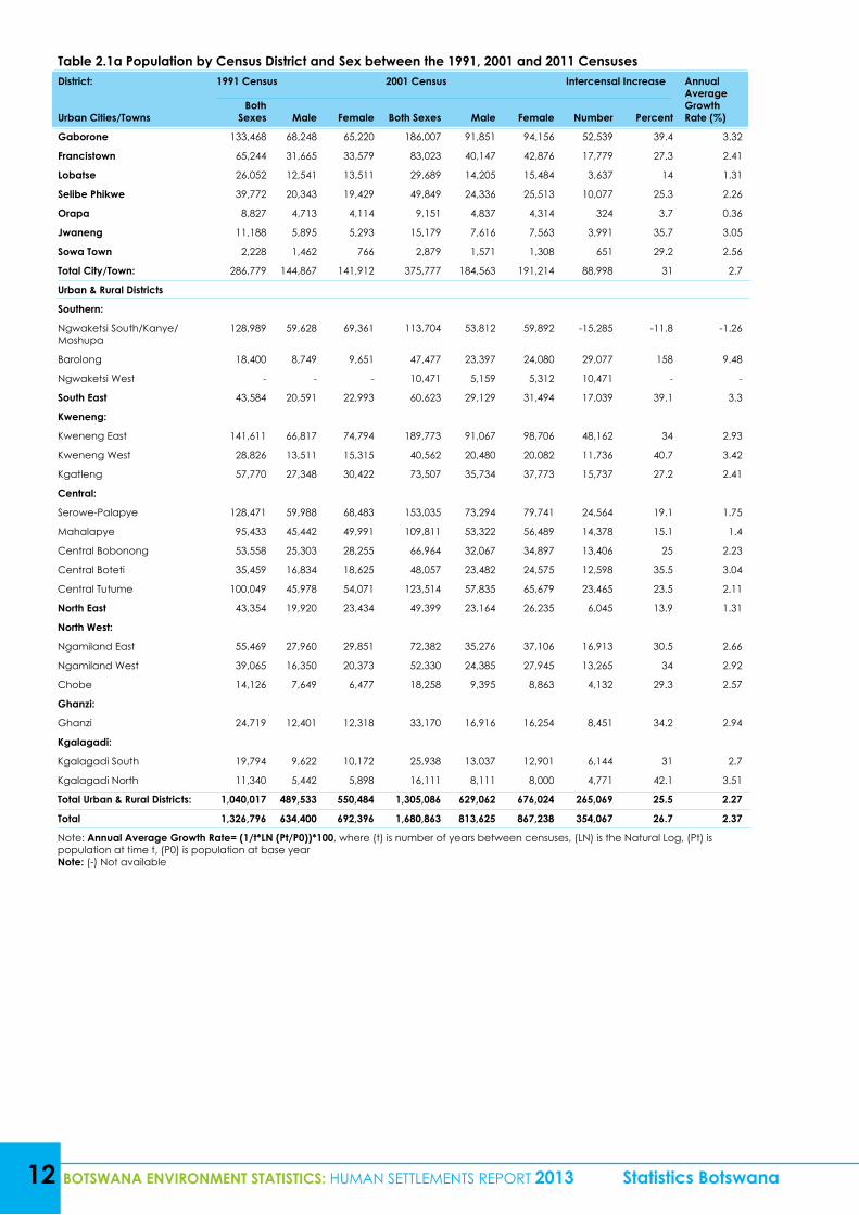
The population of the Republic of Botswana experienced an intercensal increase of 26.7 percent between 1991(1,326,796) and 2001(1,680,863) censuses (Table 2.1a). During the same period, Botswana’s annual av-erage growth rate stood at 2.37 percent. Furthermore, Gaborone district had a high intercensal increase of 39.4 percent followed by Kweneng East district with 34.0 percent. Barolong district on the other hand had an exceptionally high intercensal increase most probably as a result of reclassification of some settlements be-tween districts. However, the only district which experienced a negative intercensal increase was Ngwaketsi South/Kanye/Moshupa with -11.8 percent.
Table 2.1a further shows that during the 2001 and 2011 censuses; the population of Botswana experienced an intercensal increase of 20.5 percent (annual average growth rate of 1.86 percent). The results clearly show that the annual growth rate of Botswana has been declining during the past twenty years and this might be influenced by the go-slow in natural increase and net migration. For example, Letamo, et al (2013: 14) adds that “previous censuses show that fertility has been declining since the 1980s. Total Fertility Rate (TFR) was 6.6 children per woman in 1981 and decreased to 4.2 in 1991, 3.3 in 2001 and 2.8 in 2011.”Mortality rate on the other hand fluctuated during the past forty years. Even though the Crude Death Rate (CDR) is not the best mortality measure, it declined from 13.7 in 1971 to 11.5 in 1991 and increased to 12.4 in 2001 then declined to 6.35 in 2011 (Majelantle, 2013).According to Gwebu, et al (2013: 22), “one of the dangers to industrialization and economic diversification is the small and shrinking population size. Gwebu and colleagues further argued that a decline in fertility and low life expectancy are a threat to the realisation of a critical population mass for sustained industrialization and economic growth”.
Population intercensal increase by district reveals that South East had the highest increase of 40.2 percent followed by Kweneng East district with 35.3percent between 2001 and 2011. This might be attributable to the fact that most of the people who cannot afford to buy or rent houses in Gaborone opt to reside in the outskirts of the capital city where rentals and house prices are reasonable. Furthermore, Gaborone already has one of the highest population densities in the country and as a result the population spills into the catchment areas. Among the towns Sowa and Gaborone had the highest increases.
In spite of the fact that the country experienced a positive (low) intercensal population increase (between 2001 and 2011 censuses), Lobatse and Selibe Phikwe districts experienced a negative increase at -2.3 percent and -0.9 percent respectively (Table 2.1a). Selibe Phikwe in particular has been affected by the gloomy pros-pects of the BCL mines, as a result residents and investors relocated to places where their businesses can be sustained. On realising the likely impacts of the closure of BCL mines, the government of Botswana came up with Selebi Phikwe Economic Diversification Unit (SPEDU) Regional Development Agency in order to diversify the regional economy from mining. ‘SPEDU was set up to ensure a long term survival of Selebi Phikwe and the surrounding regions beyond the closure of the BCL mine and smelter through initiatives which may bring sustainable new employment and investment to the region and hence an improved economic and social base.’http://www.finance.gov.bw/index.php?option=com_content1&parent_id=216&pparent=264&id=266
The population growth has implications on density and its consequences (See Section 2.1.3) particularly on areas with high population like Gaborone.
Statistics Botswana BOTSWANA ENVIRONMENT STATISTICS: HUMAN SETTLEMENTS REPORT 2013 11
2.1.2 Sex Ratio
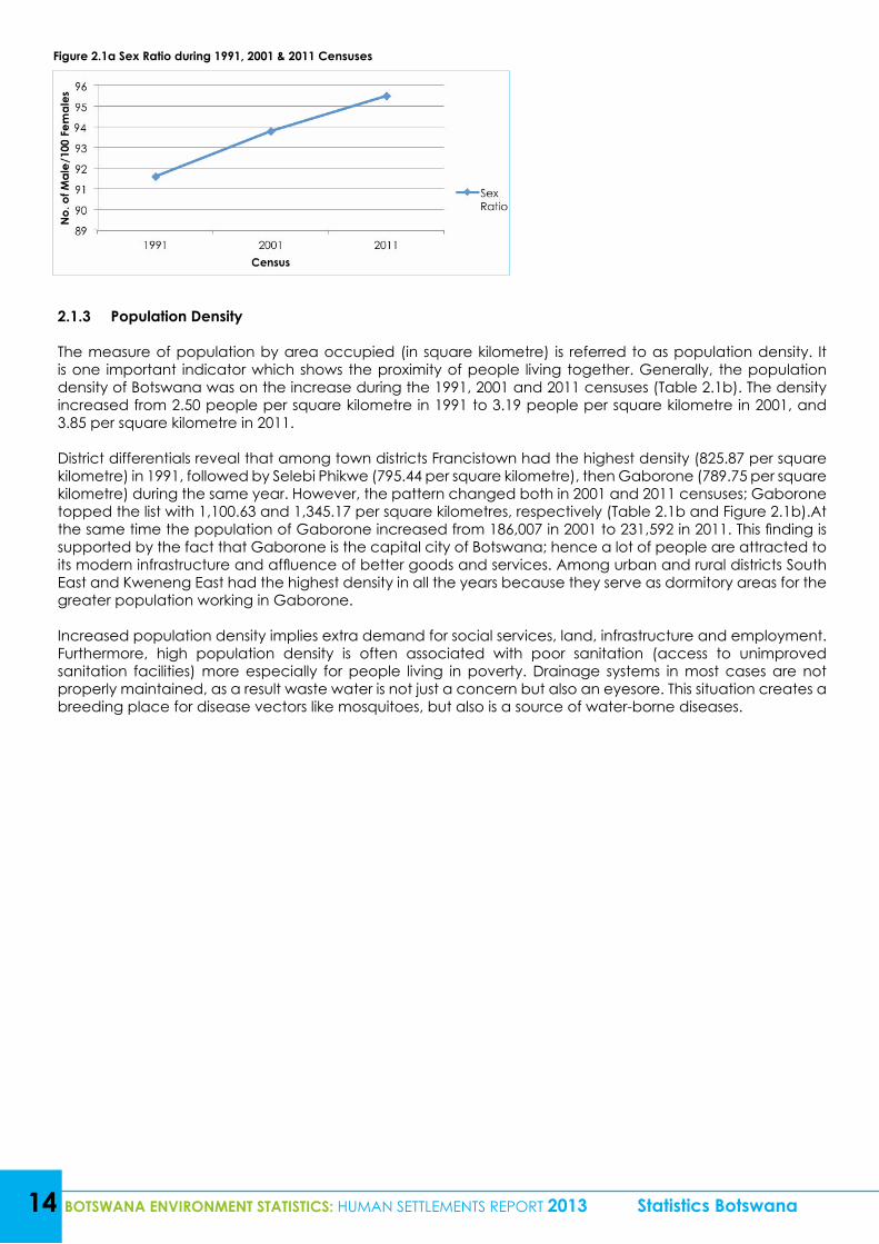
Sex Ratio, which is the degree of balance between females and males, is also presented in this sub-section. It is given by the ratio of males to females in the population per 100. Generally the Sex Ratio in Botswana is low though it has been experiencing a slight increase during the 1991, 2001 and 2011 censuses, with 91.6, 93.8 and 95.5 males per 100 females respectively (Figure 2.1a). Results reveal that in most districts males are fewer than females.
12 BOTSWANA ENVIRONMENT STATISTICS: HUMAN SETTLEMENTS REPORT 2013 Statistics Botswana
Table 2.1a Population by Census District and Sex between the 1991, 2001 and 2011 CensusesDistrict: 1991 Census 2001 Census Intercensal Increase Annual
Average Growth Rate (%)Urban Cities/Towns
Both Sexes Male Female Both Sexes Male Female Number Percent
Gaborone 133,468 68,248 65,220 186,007 91,851 94,156 52,539 39.4 3.32
Francistown 65,244 31,665 33,579 83,023 40,147 42,876 17,779 27.3 2.41
Lobatse 26,052 12,541 13,511 29,689 14,205 15,484 3,637 14 1.31
Selibe Phikwe 39,772 20,343 19,429 49,849 24,336 25,513 10,077 25.3 2.26
Orapa 8,827 4,713 4,114 9,151 4,837 4,314 324 3.7 0.36
Jwaneng 11,188 5,895 5,293 15,179 7,616 7,563 3,991 35.7 3.05
Sowa Town 2,228 1,462 766 2,879 1,571 1,308 651 29.2 2.56
Total City/Town: 286,779 144,867 141,912 375,777 184,563 191,214 88,998 31 2.7
Urban & Rural Districts
Southern:
Ngwaketsi South/Kanye/Moshupa
128,989 59,628 69,361 113,704 53,812 59,892 -15,285 -11.8 -1.26
Barolong 18,400 8,749 9,651 47,477 23,397 24,080 29,077 158 9.48
Ngwaketsi West - - - 10,471 5,159 5,312 10,471 - -
South East 43,584 20,591 22,993 60,623 29,129 31,494 17,039 39.1 3.3
Kweneng:
Kweneng East 141,611 66,817 74,794 189,773 91,067 98,706 48,162 34 2.93
Kweneng West 28,826 13,511 15,315 40,562 20,480 20,082 11,736 40.7 3.42
Kgatleng 57,770 27,348 30,422 73,507 35,734 37,773 15,737 27.2 2.41
Central:
Serowe-Palapye 128,471 59,988 68,483 153,035 73,294 79,741 24,564 19.1 1.75
Mahalapye 95,433 45,442 49,991 109,811 53,322 56,489 14,378 15.1 1.4
Central Bobonong 53,558 25,303 28,255 66,964 32,067 34,897 13,406 25 2.23
Central Boteti 35,459 16,834 18,625 48,057 23,482 24,575 12,598 35.5 3.04
Central Tutume 100,049 45,978 54,071 123,514 57,835 65,679 23,465 23.5 2.11
North East 43,354 19,920 23,434 49,399 23,164 26,235 6,045 13.9 1.31
North West:
Ngamiland East 55,469 27,960 29,851 72,382 35,276 37,106 16,913 30.5 2.66
Ngamiland West 39,065 16,350 20,373 52,330 24,385 27,945 13,265 34 2.92
Chobe 14,126 7,649 6,477 18,258 9,395 8,863 4,132 29.3 2.57
Ghanzi:
Ghanzi 24,719 12,401 12,318 33,170 16,916 16,254 8,451 34.2 2.94
Kgalagadi:
Kgalagadi South 19,794 9,622 10,172 25,938 13,037 12,901 6,144 31 2.7
Kgalagadi North 11,340 5,442 5,898 16,111 8,111 8,000 4,771 42.1 3.51
Total Urban & Rural Districts: 1,040,017 489,533 550,484 1,305,086 629,062 676,024 265,069 25.5 2.27
Total 1,326,796 634,400 692,396 1,680,863 813,625 867,238 354,067 26.7 2.37
Note: Annual Average Growth Rate= (1/t*LN (Pt/P0))*100, where (t) is number of years between censuses, (LN) is the Natural Log, (Pt) is population at time t, (P0) is population at base yearNote: (-) Not available
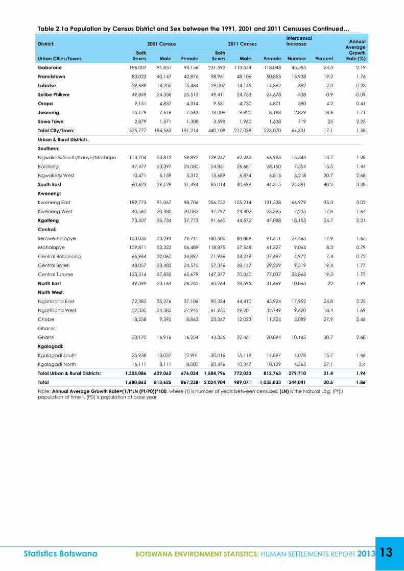
Table 2.1a Population by Census District and Sex between the 1991, 2001 and 2011 Censuses Continued…
District: 2001 Census 2011 CensusIntercensal Increase Annual
Average Growth
Rate (%)Urban Cities/TownsBoth
Sexes Male FemaleBoth
Sexes Male Female Number Percent
Gaborone 186,007 91,851 94,156 231,592 113,544 118,048 45,585 24.5 2.19
Francistown 83,023 40,147 42,876 98,961 48,106 50,855 15,938 19.2 1.76
Lobatse 29,689 14,205 15,484 29,007 14,145 14,862 -682 -2.3 -0.23
Selibe Phikwe 49,849 24,336 25,513 49,411 24,733 24,678 -438 -0.9 -0.09
Orapa 9,151 4,837 4,314 9,531 4,730 4,801 380 4.2 0.41
Jwaneng 15,179 7,616 7,563 18,008 9,820 8,188 2,829 18.6 1.71
Sowa Town 2,879 1,571 1,308 3,598 1,960 1,638 719 25 2.23
Total City/Town: 375,777 184,563 191,214 440,108 217,038 223,070 64,331 17.1 1.58
Urban & Rural Districts
Southern:
Ngwaketsi South/Kanye/Moshupa 113,704 53,812 59,892 129,247 62,262 66,985 15,543 13.7 1.28
Barolong 47,477 23,397 24,080 54,831 26,681 28,150 7,354 15.5 1.44
Ngwaketsi West 10,471 5,159 5,312 13,689 6,874 6,815 3,218 30.7 2.68
South East 60,623 29,129 31,494 85,014 40,699 44,315 24,391 40.2 3.38
Kweneng:
Kweneng East 189,773 91,067 98,706 256,752 125,214 131,538 66,979 35.3 3.02
Kweneng West 40,562 20,480 20,082 47,797 24,402 23,395 7,235 17.8 1.64
Kgatleng 73,507 35,734 37,773 91,660 44,572 47,088 18,153 24.7 2.21
Central:
Serowe-Palapye 153,035 73,294 79,741 180,500 88,889 91,611 27,465 17.9 1.65
Mahalapye 109,811 53,322 56,489 118,875 57,548 61,327 9,064 8.3 0.79
Central Bobonong 66,964 32,067 34,897 71,936 34,249 37,687 4,972 7.4 0.72
Central Boteti 48,057 23,482 24,575 57,376 28,147 29,229 9,319 19.4 1.77
Central Tutume 123,514 57,835 65,679 147,377 70,340 77,037 23,863 19.3 1.77
North East 49,399 23,164 26,235 60,264 28,595 31,669 10,865 22 1.99
North West:
Ngamiland East 72,382 35,276 37,106 90,334 44,410 45,924 17,952 24.8 2.22
Ngamiland West 52,330 24,385 27,945 61,950 29,201 32,749 9,620 18.4 1.69
Chobe 18,258 9,395 8,863 23,347 12,023 11,324 5,089 27.9 2.46
Ghanzi:
Ghanzi 33,170 16,916 16,254 43,355 22,461 20,894 10,185 30.7 2.68
Kgalagadi:
Kgalagadi South 25,938 13,037 12,901 30,016 15,119 14,897 4,078 15.7 1.46
Kgalagadi North 16,111 8,111 8,000 20,476 10,347 10,129 4,365 27.1 2.4
Total Urban & Rural Districts: 1,305,086 629,062 676,024 1,584,796 772,033 812,763 279,710 21.4 1.94
Total 1,680,863 813,625 867,238 2,024,904 989,071 1,035,833 344,041 20.5 1.86
Note: Annual Average Growth Rate=(1/t*LN (Pt/P0))*100, where (t) is number of years between censuses, (LN) is the Natural Log, (Pt)is population at time t, (P0) is population at base year
Statistics Botswana BOTSWANA ENVIRONMENT STATISTICS: HUMAN SETTLEMENTS REPORT 2013 13
14 BOTSWANA ENVIRONMENT STATISTICS: HUMAN SETTLEMENTS REPORT 2013 Statistics Botswana
Figure 2.1a Sex Ratio during 1991, 2001 & 2011 Censuses
2.1.3 Population Density
The measure of population by area occupied (in square kilometre) is referred to as population density. It is one important indicator which shows the proximity of people living together. Generally, the population density of Botswana was on the increase during the 1991, 2001 and 2011 censuses (Table 2.1b). The density increased from 2.50 people per square kilometre in 1991 to 3.19 people per square kilometre in 2001, and 3.85 per square kilometre in 2011.
District differentials reveal that among town districts Francistown had the highest density (825.87 per square kilometre) in 1991, followed by Selebi Phikwe (795.44 per square kilometre), then Gaborone (789.75 per square kilometre) during the same year. However, the pattern changed both in 2001 and 2011 censuses; Gaborone topped the list with 1,100.63 and 1,345.17 per square kilometres, respectively (Table 2.1b and Figure 2.1b).At the same time the population of Gaborone increased from 186,007 in 2001 to 231,592 in 2011. This finding is supported by the fact that Gaborone is the capital city of Botswana; hence a lot of people are attracted to its modern infrastructure and affluence of better goods and services. Among urban and rural districts South East and Kweneng East had the highest density in all the years because they serve as dormitory areas for the greater population working in Gaborone.
Increased population density implies extra demand for social services, land, infrastructure and employment. Furthermore, high population density is often associated with poor sanitation (access to unimproved sanitation facilities) more especially for people living in poverty. Drainage systems in most cases are not properly maintained, as a result waste water is not just a concern but also an eyesore. This situation creates a breeding place for disease vectors like mosquitoes, but also is a source of water-borne diseases.
Statistics Botswana BOTSWANA ENVIRONMENT STATISTICS: HUMAN SETTLEMENTS REPORT 2013 15
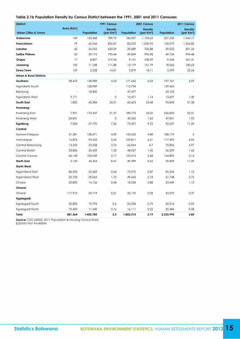
Table 2.1b Population Density by Census District between the 1991, 2001 and 2011 Censuses
District:Area (Km2)
1991 Census 2001 Census 2011 Census
Urban Cities & Towns PopulationDensity
(per Km2) PopulationDensity
(per Km2) PopulationDensity
(per Km2)
Gaborone 169 133,468 789.75 186,007 1,100.63 227,333 1,345.17
Francistown 79 65,244 825.87 83,023 1,050.92 100,079 1,266.82
Lobatse 42 26,052 620.29 29,689 706.88 29,032 691.24
Selibe Phikwe 50 39,772 795.44 49,849 996.98 49,724 994.48
Orapa 17 8,827 519.24 9,151 538.29 9,544 561.41
Jwaneng 100 11,188 111.88 15,179 151.79 18,063 180.63
Sowa Town 159 2,228 14.01 2,879 18.11 3,599 22.64
Urban & Rural Districts
Southern: 28,470 128,989 4.53 171,652 6.03 197,767 6.95
Ngwaketsi South - 128,989 - 113,704 - 129,462 -
Barolong - 18,400 - 47,477 - 55,103 -
Ngwaketsi West 9,171 - 0 10,471 1.14 13,697 1.49
South East 1,800 43,584 24.21 60,623 33.68 92,843 51.58
Kweneng:
Kweneng East 7,901 170,437 21.57 189,773 24.02 256,833 32.51
Kweneng West 24,841 - 0 40,562 1.63 47,841 1.93
Kgatleng 7,960 57,770 7.26 73,507 9.23 92,247 11.59
Central:
Serowe-Palapye 31,381 128,471 4.09 153,035 4.88 188,174 6
Mahalapye 16,876 95,433 5.65 109,811 6.51 117,492 6.96
Central Bobonong 14,242 53,558 3.76 66,964 4.7 70,806 4.97
Central Boteti 33,806 35,459 1.05 48,057 1.42 56,209 1.66
Central Tutume 46,140 100,049 2.17 123,514 2.68 144,895 3.14
North East 5,120 43,354 8.47 49,399 9.65 59,829 11.69
North West:
Ngamiland East 86,400 55,469 0.64 75,070 0.87 96,356 1.12
Ngamiland West 22,730 39,065 1.72 49,642 2.18 61,748 2.72
Chobe 20,800 14,126 0.68 18,258 0.88 23,449 1.13
Ghanzi:
Ghanzi 117,910 24,719 0.21 33,170 0.28 43,370 0.37
Kgalagadi:
Kgalagadi South 32,800 19,794 0.6 25,938 0.79 30,016 0.92
Kgalagadi North 72,400 11,340 0.16 16,111 0.22 20,484 0.28
Total 581,364 1,455,785 2.5 1,852,515 3.19 2,235,995 3.85
Source: CSO (2003); 2011 Population & Housing Census Data(-) Data Not Available
16 BOTSWANA ENVIRONMENT STATISTICS: HUMAN SETTLEMENTS REPORT 2013 Statistics Botswana
Figure 2.1b Population Density by Cities/Towns between the 1991, 2001 and 2011 Censuses
2.2 Access to Water, Sanitation and Energy
Discussions under this sub-item includes information on population using improved drinking water sources, improved sanitation, and access to sustainable and clean energy (electricity) in urban and rural areas. Having access to these basic services leads to an improved standard of living, this in turn leads to sustainable use of the environment. For example, increased use of electricity and reduced consumption of fuel-wood implies that fewer trees are cut for energy, and this paves the way for the attainment of Millennium Development Goal 7 on environmental sustainability.
2.2.1 Energy Sources
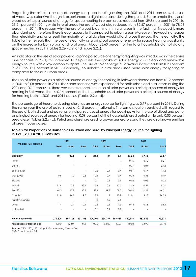
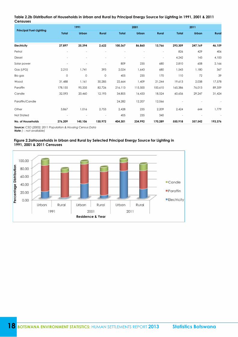
Access to energy sources used for cooking, heating and lighting by urban and rural areas during the 2001 and 2011 censuses and where possible 1991 census is presented in Tables 2.2a – 2.2b. More emphasis is given to the use of electricity as it is regarded as sustainable and clean energy. It is clear from Tables 2.2 (both a and b) that the dominant source of energy for household lighting in Botswana during the 1991 and 2001 censuses was paraffin, both in urban and rural areas. In spite of the dominance of paraffin as a principal source of energy for lighting, the proportion of households using the same source was on the decrease. For example, in urban areas the proportion decreased from 65.7 percent in 1991 to 49.2 percent in 2001 and further down to 21.26 percent in 2011. The drop in paraffin usage in 2011 might be attributable to the interventions on electrifications of villages and other settlements by government, for example, “The Renewable Energy Rural Electrification Programme for Botswana.” The aim of the project was to increase the use of solar energy for cooking and lighting through the provision of solar home systems. The project was started in 2005 and was supposed to be functional till December 2013. The national implementing partners were the Department of Energy Affairs, Botswana Power Corporation (BPC Lesedi) and United Nations Development Programme (UNDP).
During the 1991, 2001 and 2011 censuses rural areas also experienced a decrease in the use of paraffin as a principal source of energy for lighting, from 63.1 percent in 1991 to 59.2 percent in 2001, then 46.2 percent in 2011. However, the situation changed in 2011 for urban areas when electricity became the dominant source of energy for lighting with 69.13 percent. As for the rural areas, the use of paraffin as a dominant source persisted during the 2011 census.
Tables 2.2c – 2.2d provide information on the proportion of all households in urban and rural areas by principal energy source for cooking during the 1991, 2001 and 2011 censuses. The tables show that wood/charcoal were mostly used during the three censuses, that is, both in urban and rural areas, followed by gas (LPG). The use of wood/charcoal in rural areas was over 77 percent during the review period; however overall use of wood for cooking was gradually declining. The use of electricity experienced a significant increase for both urban and rural areas. In urban areas the use of electricity as a principal source of energy for cooking increased from 4.80 percent in 1991 to 7.60 percent in 2001 then to 23.56 percent in 2011. This is a good development because a significant increase in the use of electricity over other sources which emit a lot of carbon contributes to the reduction on the emission of greenhouse gases (GHGs).
Statistics Botswana BOTSWANA ENVIRONMENT STATISTICS: HUMAN SETTLEMENTS REPORT 2013 17
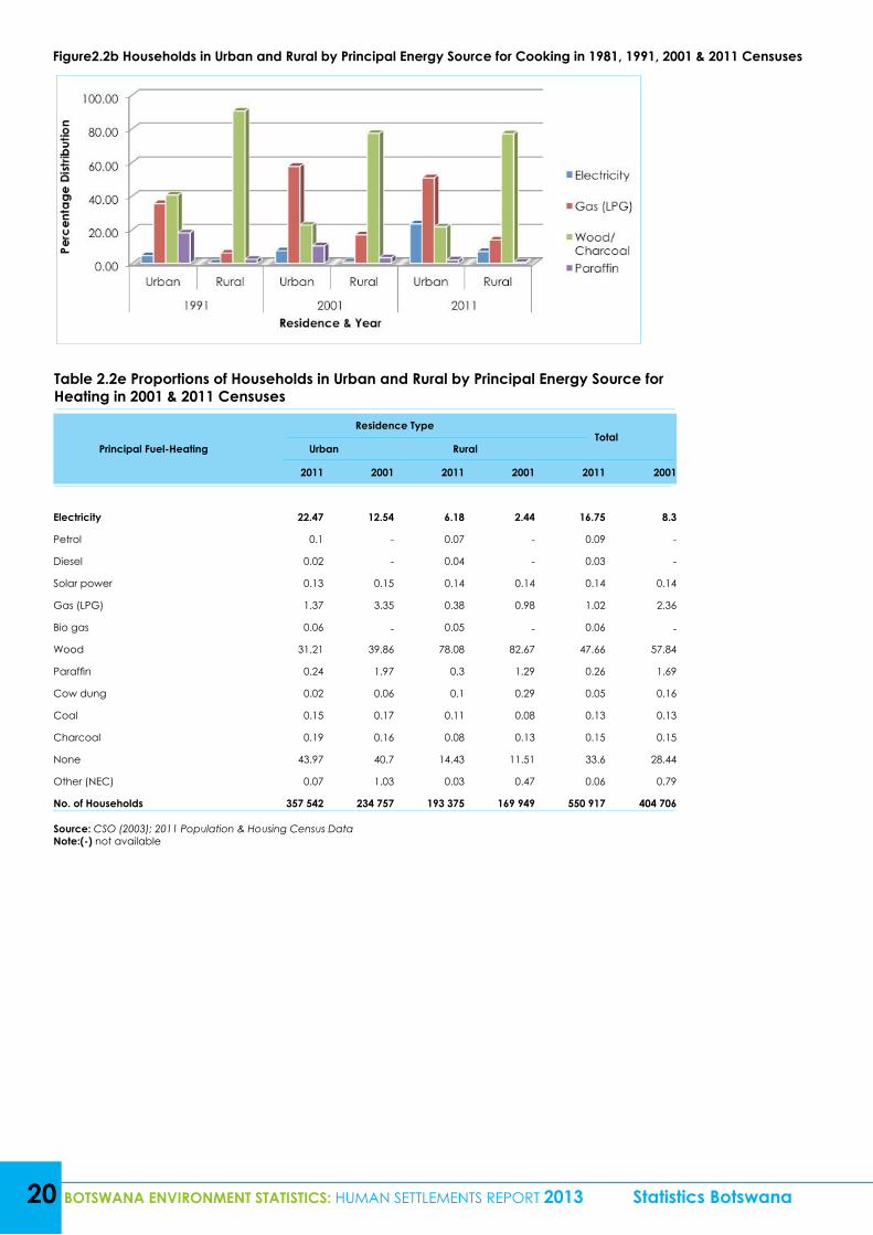
Regarding the principal source of energy for space heating during the 2001 and 2011 censuses, the use of wood was extensive though it experienced a slight decrease during the period. For example the use of wood as principal source of energy for space heating in urban areas reduced from 39.86 percent in 2001 to 31.21 percent in 2011, while in rural areas the use of wood also reduced from 82.67 percent in 2001 to 78.08 percent in 2011. The reason why the use of wood is dominant in rural areas is the fact that firewood is more abundant and therefore there is easy access to it compared to urban areas. Moreover, firewood is cheaper than electricity and as a result the majority of rural dwellers would afford to use firewood than electricity. The table further reveals that the use of electricity as a principal source of energy for space heating was slightly on the increase for both urban and rural areas. About 33.60 percent of the total households did not do any space heating in 2011(Tables 2.2e - 2.2f and Figure 2.2c).
An indicator on the use of solar power as a principal source of energy for lighting was introduced in the census questionnaire in 2001; this intended to help assess the uptake of solar energy as a clean and renewable energy source with a low carbon footprint. The use of solar energy in Botswana increased from 0.20 percent in 2001 to 0.51 percent in 2011. Generally, households in rural areas used more solar energy for lighting as compared to those in urban areas.
The use of solar power as a principal source of energy for cooking in Botswana decreased from 0.19 percent in 2001 to 0.08 percent in 2011. The same scenario was experienced for both urban and rural areas during the 2001 and 2011 censuses. There was no difference in the use of solar power as a principal source of energy for heating in Botswana, that is, 0.14 percent of the households used solar power as a principal source of energy for heating both in 2001 and 2011 census (Tables 2.2c - d).
The percentage of households using diesel as an energy source for lighting was 0.77 percent in 2011. During the same year the use of petrol stood at 0.15 percent nationally. The same situation persisted with regard to the use of both diesel and petrol as principal sources of energy for cooking. As for the use of diesel and petrol as principal sources of energy for heating, 0.09 percent of the households used petrol while only 0.03 percent used diesel (Tables 2.2a - c). Petrol and diesel are used to power generators and they are also known emitters of greenhouse gases.
Table 2.2a Proportions of Households in Urban and Rural by Principal Energy Source for Lighting in 1991, 2001 & 2011 Censuses
Principal Fuel-Lighting1991 2001 2011
Total Urban Rural Total Urban Rural Total Urban Rural
Electricity 10.1 17.5 2 24.8 37 8.1 53.24 69.13 23.87
Petrol - - - - - - 0.15 0.12 0.21
Diesel - - - - - - 0.77 0.04 2.12
Solar power - - - 0.2 0.1 0.4 0.51 0.17 1.12
Gas (LPG) 0.8 1.2 0.3 0.5 0.7 0.4 0.28 0.33 0.19
Bio gas - - - 0.1 0.1 0.1 0.02 0.02 0.02
Wood 11.4 0.8 23.1 5.6 0.6 12.5 3.56 0.57 9.09
Paraffin 64.5 65.7 63.1 53.4 49.2 59.2 30.02 21.26 46.21
Candle 11.8 14.1 9.3 8.6 7 10.9 11.01 8.18 16.25
Paraffin/Candle - - - 6 5.2 7.1 - - -
Other 1.4 0.7 2.1 0.6 0.1 1.3 0.44 0.18 0.92
Not Stated - - - 0.1 0.1 0.2 - - -
No. of Households 276,209 145,106 131,103 404,706 234,757 169,949 550,918 357,542 193,376
Percentage of Households 100.0 52.50. 47.5 100.0 58.00 42.00 100.0 64.90 35.10
Source: CSO (2003); 2011 Population & Housing Census DataNote (- : not available)
18 BOTSWANA ENVIRONMENT STATISTICS: HUMAN SETTLEMENTS REPORT 2013 Statistics Botswana
Table 2.2b Distribution of Households in Urban and Rural by Principal Energy Source for Lighting in 1991, 2001 & 2011 Censuses
Principal Fuel-Lighting1991 2001 2011
Total Urban Rural Total Urban Rural Total Urban Rural
Electricity 27,897 25,394 2,622 100,367 86,860 13,766 293,309 247,169 46,159
Petrol - - - - - - 826 429 406
Diesel - - - - - - 4,242 143 4,100
Solar power - - - 809 235 680 2,810 608 2,166
Gas (LPG) 2,210 1,741 393 2,024 1,643 680 1,543 1,180 367
Bio gas 0 0 0 405 235 170 110 72 39
Wood 31,488 1,161 30,285 22,664 1,409 21,244 19,613 2,038 17,578
Paraffin 178,155 95,335 82,726 216,113 115,500 100,610 165,386 76,013 89,359
Candle 32,593 20,460 12,193 34,805 16,433 18,524 60,656 29,247 31,424
Paraffin/Candle 24,282 12,207 12,066 - - -
Other 3,867 1,016 2,753 2,428 235 2,209 2,424 644 1,779
Not Stated - - - 405 235 340 - - -
No. of Households 276,209 145,106 130,972 404,301 234,992 170,289 550,918 357,542 193,376
Source: CSO (2003); 2011 Population & Housing Census DataNote (- : not available)
Figure 2.2aHouseholds in Urban and Rural by Selected Principal Energy Source for Lighting in 1991, 2001 & 2011 Censuses
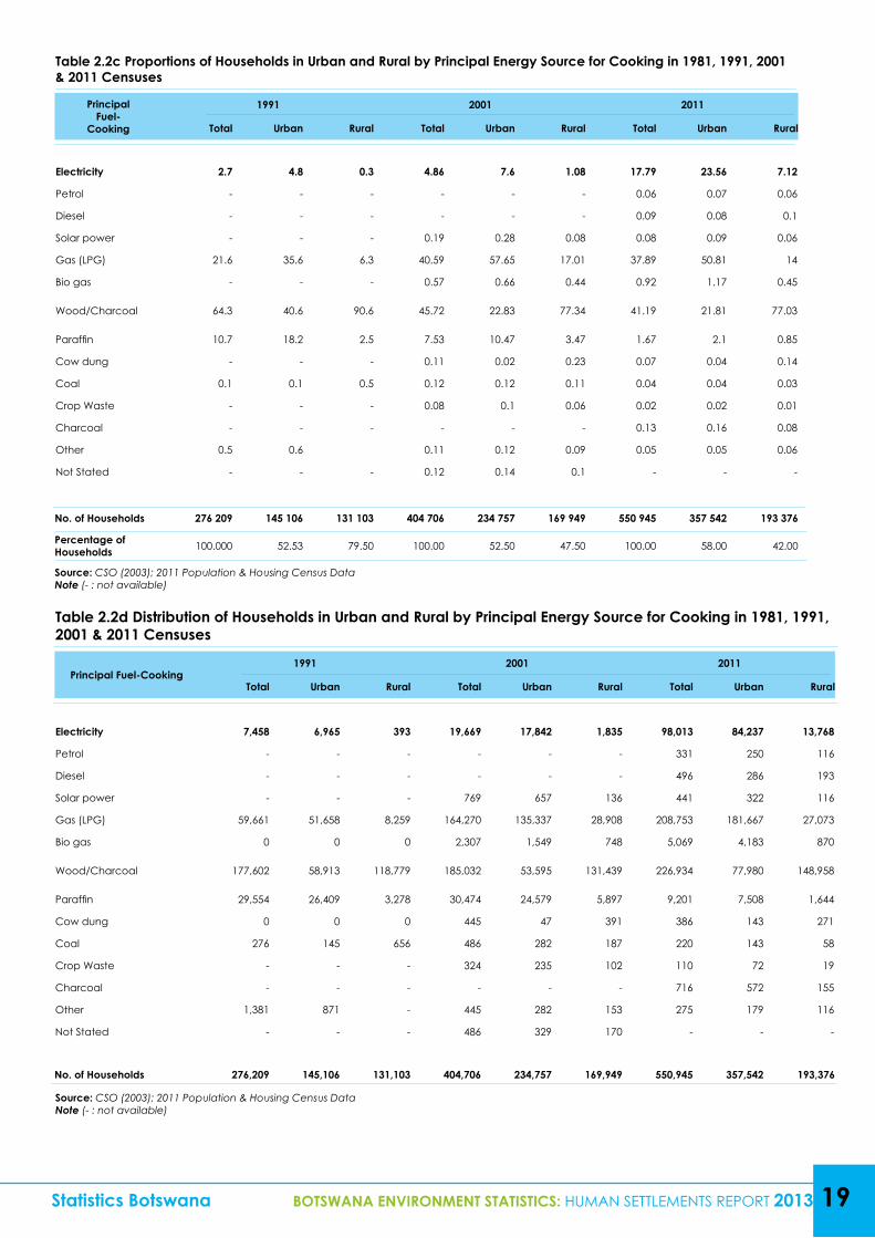
Table 2.2c Proportions of Households in Urban and Rural by Principal Energy Source for Cooking in 1981, 1991, 2001 & 2011 Censuses
Principal Fuel-
Cooking
1991 2001 2011
Total Urban Rural Total Urban Rural Total Urban Rural
Electricity 2.7 4.8 0.3 4.86 7.6 1.08 17.79 23.56 7.12
Petrol - - - - - - 0.06 0.07 0.06
Diesel - - - - - - 0.09 0.08 0.1
Solar power - - - 0.19 0.28 0.08 0.08 0.09 0.06
Gas (LPG) 21.6 35.6 6.3 40.59 57.65 17.01 37.89 50.81 14
Bio gas - - - 0.57 0.66 0.44 0.92 1.17 0.45
Wood/Charcoal 64.3 40.6 90.6 45.72 22.83 77.34 41.19 21.81 77.03
Paraffin 10.7 18.2 2.5 7.53 10.47 3.47 1.67 2.1 0.85
Cow dung - - - 0.11 0.02 0.23 0.07 0.04 0.14
Coal 0.1 0.1 0.5 0.12 0.12 0.11 0.04 0.04 0.03
Crop Waste - - - 0.08 0.1 0.06 0.02 0.02 0.01
Charcoal - - - - - - 0.13 0.16 0.08
Other 0.5 0.6 0.11 0.12 0.09 0.05 0.05 0.06
Not Stated - - - 0.12 0.14 0.1 - - -
No. of Households 276 209 145 106 131 103 404 706 234 757 169 949 550 945 357 542 193 376
Percentage of Households 100.000 52.53 79.50 100.00 52.50 47.50 100.00 58.00 42.00
Source: CSO (2003); 2011 Population & Housing Census DataNote (- : not available)
Statistics Botswana BOTSWANA ENVIRONMENT STATISTICS: HUMAN SETTLEMENTS REPORT 2013 19
Table 2.2d Distribution of Households in Urban and Rural by Principal Energy Source for Cooking in 1981, 1991, 2001 & 2011 Censuses
Principal Fuel-Cooking1991 2001 2011
Total Urban Rural Total Urban Rural Total Urban Rural
Electricity 7,458 6,965 393 19,669 17,842 1,835 98,013 84,237 13,768
Petrol - - - - - - 331 250 116
Diesel - - - - - - 496 286 193
Solar power - - - 769 657 136 441 322 116
Gas (LPG) 59,661 51,658 8,259 164,270 135,337 28,908 208,753 181,667 27,073
Bio gas 0 0 0 2,307 1,549 748 5,069 4,183 870
Wood/Charcoal 177,602 58,913 118,779 185,032 53,595 131,439 226,934 77,980 148,958
Paraffin 29,554 26,409 3,278 30,474 24,579 5,897 9,201 7,508 1,644
Cow dung 0 0 0 445 47 391 386 143 271
Coal 276 145 656 486 282 187 220 143 58
Crop Waste - - - 324 235 102 110 72 19
Charcoal - - - - - - 716 572 155
Other 1,381 871 - 445 282 153 275 179 116
Not Stated - - - 486 329 170 - - -
No. of Households 276,209 145,106 131,103 404,706 234,757 169,949 550,945 357,542 193,376
Source: CSO (2003); 2011 Population & Housing Census DataNote (- : not available)
20 BOTSWANA ENVIRONMENT STATISTICS: HUMAN SETTLEMENTS REPORT 2013 Statistics Botswana
Figure2.2b Households in Urban and Rural by Principal Energy Source for Cooking in 1981, 1991, 2001 & 2011 Censuses
Table 2.2e Proportions of Households in Urban and Rural by Principal Energy Source for Heating in 2001 & 2011 Censuses
Principal Fuel-Heating
Residence TypeTotal
Urban Rural
2011 2001 2011 2001 2011 2001
Electricity 22.47 12.54 6.18 2.44 16.75 8.3
Petrol 0.1 - 0.07 - 0.09 -
Diesel 0.02 - 0.04 - 0.03 -
Solar power 0.13 0.15 0.14 0.14 0.14 0.14
Gas (LPG) 1.37 3.35 0.38 0.98 1.02 2.36
Bio gas 0.06 - 0.05 - 0.06 -
Wood 31.21 39.86 78.08 82.67 47.66 57.84
Paraffin 0.24 1.97 0.3 1.29 0.26 1.69
Cow dung 0.02 0.06 0.1 0.29 0.05 0.16
Coal 0.15 0.17 0.11 0.08 0.13 0.13
Charcoal 0.19 0.16 0.08 0.13 0.15 0.15
None 43.97 40.7 14.43 11.51 33.6 28.44
Other (NEC) 0.07 1.03 0.03 0.47 0.06 0.79
No. of Households 357 542 234 757 193 375 169 949 550 917 404 706
Source: CSO (2003); 2011 Population & Housing Census DataNote:(-) not available
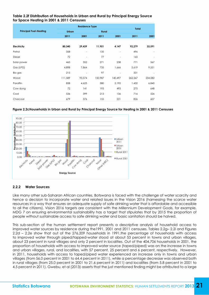
Table 2.2f Distribution of Households in Urban and Rural by Principal Energy Source for Space Heating in 2001 & 2011 Censuses
Principal Fuel-Heating
Residence TypeTotal
Urban Rural
2011 2001 2011 2001 2011 2001
Electricity 80,340 29,439 11,951 4,147 92,279 33,591
Petrol 358 - 135 - 496 -
Diesel 72 - 77 - 165 -
Solar power 465 352 271 238 771 567
Gas (LPG) 4,898 7,864 735 1,666 5,619 9,551
Bio gas 215 - 97 - 331 -
Wood 111,589 93,574 150,987 140,497 262,567 234,082
Paraffin 858 4,625 580 2,192 1,432 6,840
Cow dung 72 141 193 493 275 648
Coal 536 399 213 136 716 526
Charcoal 679 376 155 221 826 607
Statistics Botswana BOTSWANA ENVIRONMENT STATISTICS: HUMAN SETTLEMENTS REPORT 2013 21
Figure 2.2cHouseholds in Urban and Rural by Principal Energy Source for Heating in 2001 & 2011 Censuses
2.2.2 Water Sources
Like many other sub-Saharan African countries, Botswana is faced with the challenge of water scarcity and hence a decision to incorporate water and related issues in the Vision 2016 (harnessing the scarce water resources in a way that ensures an adequate supply of safe drinking water that is affordable and accessible to all the citizens). Vision 2016 targets are consistent with the Millennium Development Goals, for example, MDG 7 on ensuring environmental sustainability has a target that stipulates that by 2015 the proportion of people without sustainable access to safe drinking water and basic sanitation should be halved.
This sub-section of the human settlement report presents a descriptive analysis of household access to improved water sources by residence during the1991, 2001 and 2011 censuses. Tables 2.2g– 2.2i and Figures 2.2d – 2.2e show that out of the 276,209 households in 1991,the percentage of households with access to improved water through piped/tapped-water stood at about 53 percent in towns and urban villages, about 23 percent in rural villages and only 2 percent in localities. Out of the 404,706 households in 2001, the proportion of households with access to improved water source (taped/piped) was on the increase in towns and urban villages, rural, and localities, with 57 percent, 25 percent and 6 percent, respectively. However, in 2011, households with access to taped/piped water experienced an increase only in towns and urban villages (from 56.0 percent in 2001 to 64.4 percent in 2011), while a percentage decrease was observed both in rural villages (from 25.0 percent in 2001 to 21.6 percent in 2011) and localities (from 5.8 percent in 2001 to 4.5 percent in 2011). Gwebu, et al (2013) asserts that the just mentioned finding might be attributed to a large
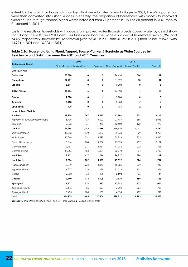
22 BOTSWANA ENVIRONMENT STATISTICS: HUMAN SETTLEMENTS REPORT 2013 Statistics Botswana
extent by the growth in household numbers that were located in rural villages in 2001, like Mmopane, but were then converted into urban villages. Generally, the proportion of households with access to improved water source through tapped/piped water increased from 77 percent in 1991 to 88 percent in 2001 then to 91 percent in 2011.
Lastly, the results on households with access to improved water through piped/tapped water by district show that during the 2001 and 2011 censuses Gaborone had the highest number of households with 58,359 and 74,456 respectively, followed by Francistown (with 22,981 in 2001 and 31,199 in 2011) then Selibe Phikwe (with 14,994 in 2001 and 16,023 in 2011).
Table 2.2g: Household Using Piped/Tapped, Bowser/Tanker & Borehole as Water Sources by Residence and District between the 2001 and 2011 Censuses
Residence & District:2001 2011
Piped/Tapped Bowser/tanker Borehole Piped/Tapped Bowser/tanker Borehole
Cities & Towns
Gaborone 58,378 0 0 74,456 364 37
Francistown 22,981 0 0 31,199 13 31
Lobatse 8,511 0 0 9,202 0 5
Selibe Phikwe 14,994 6 0 16,023 1 18
Orapa 2,578 0 0 3,288 0 0
Jwaneng 4,658 0 0 5,438 7 0
Sowa Town 979 0 0 1,183 2 5
Urban & Rural Districts
Southern: 19,778 347 2,247 42,909 829 3,115
Ngwaketsi South/Kanye/Moshupa 8,409 125 1,602 27,458 388 2,043
Barolong 9,393 61 456 12,500 122 799
Central: 45,464 1,295 10,098 124,474 2,077 12,950
Serowe-Palapye 11,983 372 3,237 39,863 579 3,955
Mahalapye 10,068 231 1,899 25,916 235 2,660
Central Bobonong 5,364 208 1,237 15,125 237 2,101
Central Boteti 3,993 331 1,431 11,258 232 1,525
Central Tutume 14,056 153 2,294 32,312 794 2,709
North East 9,631 427 146 14,817 386 217
North West: 9,336 939 4,569 29,599 524 1,752
Ngamiland East 3,019 234 1,363 18,086 299 1,232
Ngamiland West 6,317 236 484 11,513 159 376
Chobe 2,002 64 235 6,590 66 144
Ghanzi: 3,440 178 1,108 2,570 189 1,623
Kgalagadi: 6,521 136 813 11,792 623 1,014
Kgalagadi South 3,116 36 624 6,794 324 724
Kgalagadi North 3,405 100 189 49,98 297 290
Total: 354,925 3,685 20,804 498,729 6,283 27,037
Source: Central Statistics Office (2003) and 2011 Population & Housing Census Data
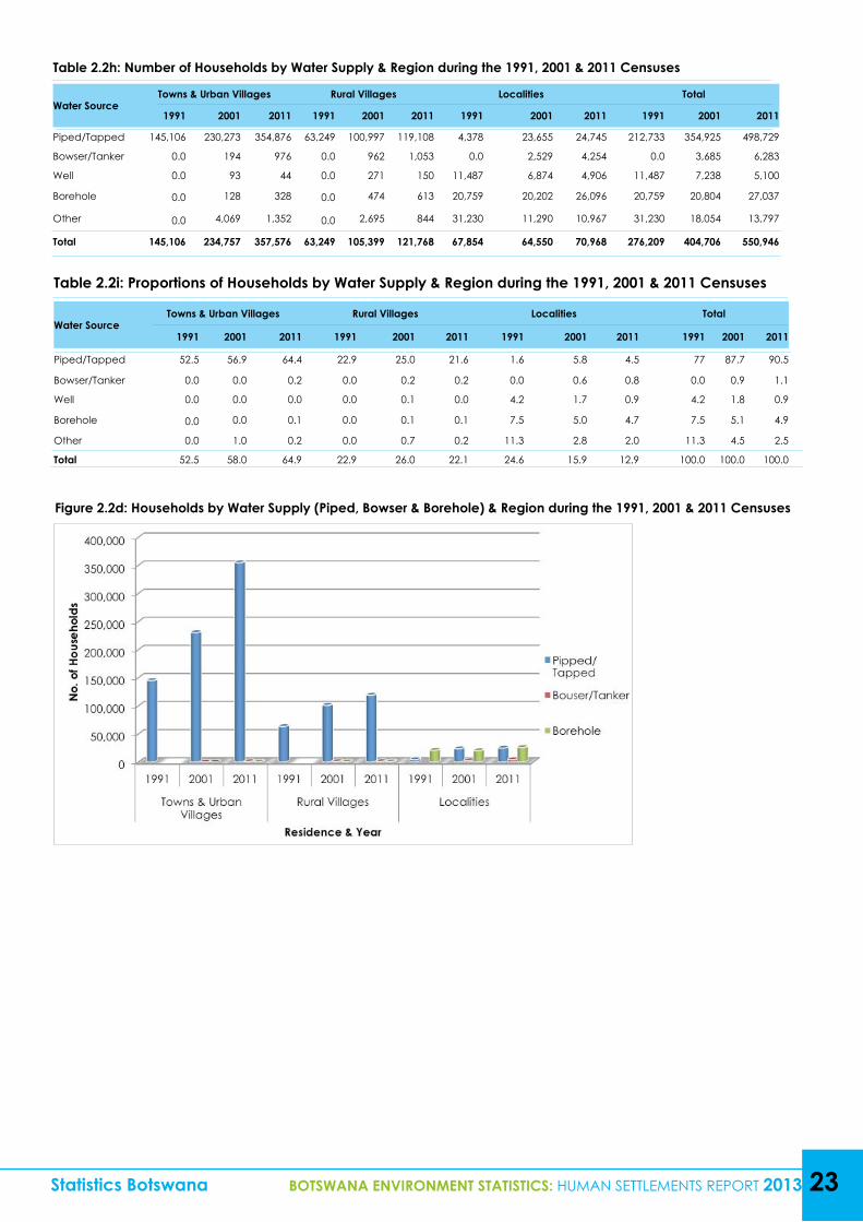
Table 2.2i: Proportions of Households by Water Supply & Region during the 1991, 2001 & 2011 Censuses
Water SourceTowns & Urban Villages Rural Villages Localities Total
1991 2001 2011 1991 2001 2011 1991 2001 2011 1991 2001 2011
Piped/Tapped 52.5 56.9 64.4 22.9 25.0 21.6 1.6 5.8 4.5 77 87.7 90.5
Bowser/Tanker 0.0 0.0 0.2 0.0 0.2 0.2 0.0 0.6 0.8 0.0 0.9 1.1
Well 0.0 0.0 0.0 0.0 0.1 0.0 4.2 1.7 0.9 4.2 1.8 0.9
Borehole 0.0 0.0 0.1 0.0 0.1 0.1 7.5 5.0 4.7 7.5 5.1 4.9
Other 0.0 1.0 0.2 0.0 0.7 0.2 11.3 2.8 2.0 11.3 4.5 2.5
Total 52.5 58.0 64.9 22.9 26.0 22.1 24.6 15.9 12.9 100.0 100.0 100.0
Table 2.2h: Number of Households by Water Supply & Region during the 1991, 2001 & 2011 Censuses
Water SourceTowns & Urban Villages Rural Villages Localities Total
1991 2001 2011 1991 2001 2011 1991 2001 2011 1991 2001 2011
Piped/Tapped 145,106 230,273 354,876 63,249 100,997 119,108 4,378 23,655 24,745 212,733 354,925 498,729
Bowser/Tanker 0.0 194 976 0.0 962 1,053 0.0 2,529 4,254 0.0 3,685 6,283
Well 0.0 93 44 0.0 271 150 11,487 6,874 4,906 11,487 7,238 5,100
Borehole 0.0 128 328 0.0 474 613 20,759 20,202 26,096 20,759 20,804 27,037
Other 0.0 4,069 1,352 0.0 2,695 844 31,230 11,290 10,967 31,230 18,054 13,797
Total 145,106 234,757 357,576 63,249 105,399 121,768 67,854 64,550 70,968 276,209 404,706 550,946
Statistics Botswana BOTSWANA ENVIRONMENT STATISTICS: HUMAN SETTLEMENTS REPORT 2013 23
Figure 2.2d: Households by Water Supply (Piped, Bowser & Borehole) & Region during the 1991, 2001 & 2011 Censuses
24 BOTSWANA ENVIRONMENT STATISTICS: HUMAN SETTLEMENTS REPORT 2013 Statistics Botswana
Figure 2.2e: Proportion of Households with Access to Improved Water through Piped/tapped Water by District, 1991, 2001 & 2011 Censuses
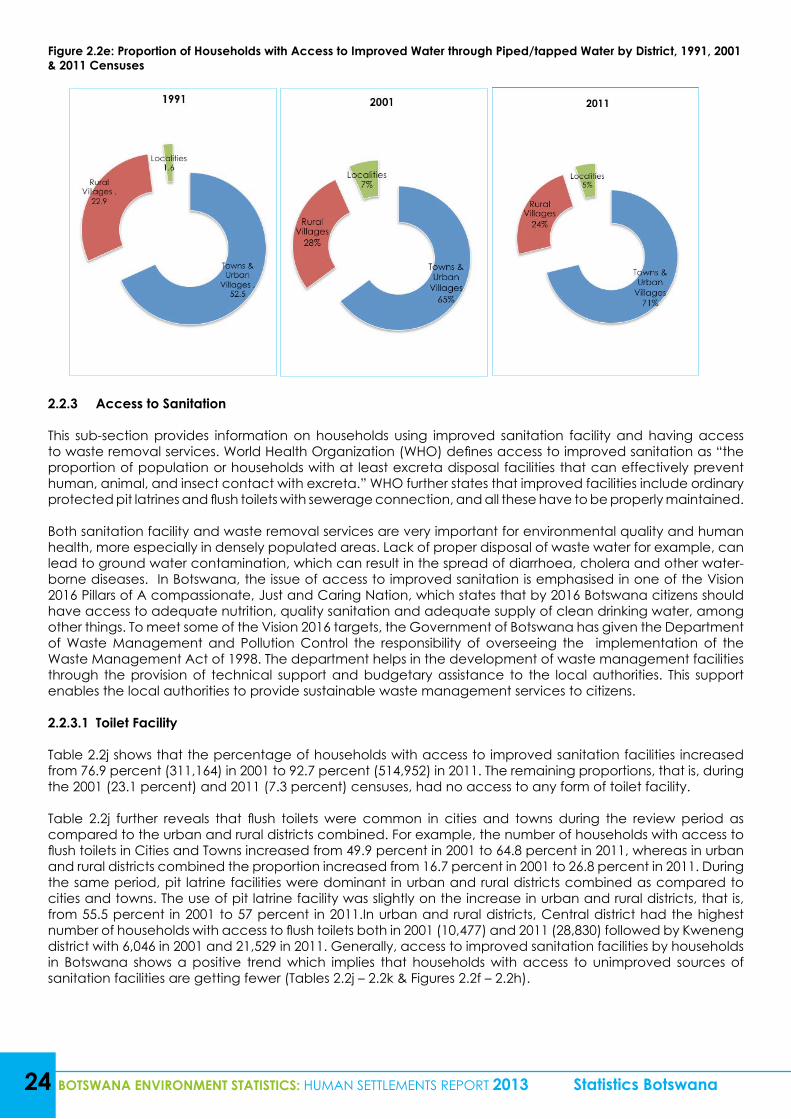
2.2.3 Access to Sanitation
This sub-section provides information on households using improved sanitation facility and having access to waste removal services. World Health Organization (WHO) defines access to improved sanitation as “the proportion of population or households with at least excreta disposal facilities that can effectively prevent human, animal, and insect contact with excreta.” WHO further states that improved facilities include ordinary protected pit latrines and flush toilets with sewerage connection, and all these have to be properly maintained.
Both sanitation facility and waste removal services are very important for environmental quality and human health, more especially in densely populated areas. Lack of proper disposal of waste water for example, can lead to ground water contamination, which can result in the spread of diarrhoea, cholera and other water-borne diseases. In Botswana, the issue of access to improved sanitation is emphasised in one of the Vision 2016 Pillars of A compassionate, Just and Caring Nation, which states that by 2016 Botswana citizens should have access to adequate nutrition, quality sanitation and adequate supply of clean drinking water, among other things. To meet some of the Vision 2016 targets, the Government of Botswana has given the Department of Waste Management and Pollution Control the responsibility of overseeing the implementation of the Waste Management Act of 1998. The department helps in the development of waste management facilities through the provision of technical support and budgetary assistance to the local authorities. This support enables the local authorities to provide sustainable waste management services to citizens.
2.2.3.1 Toilet Facility
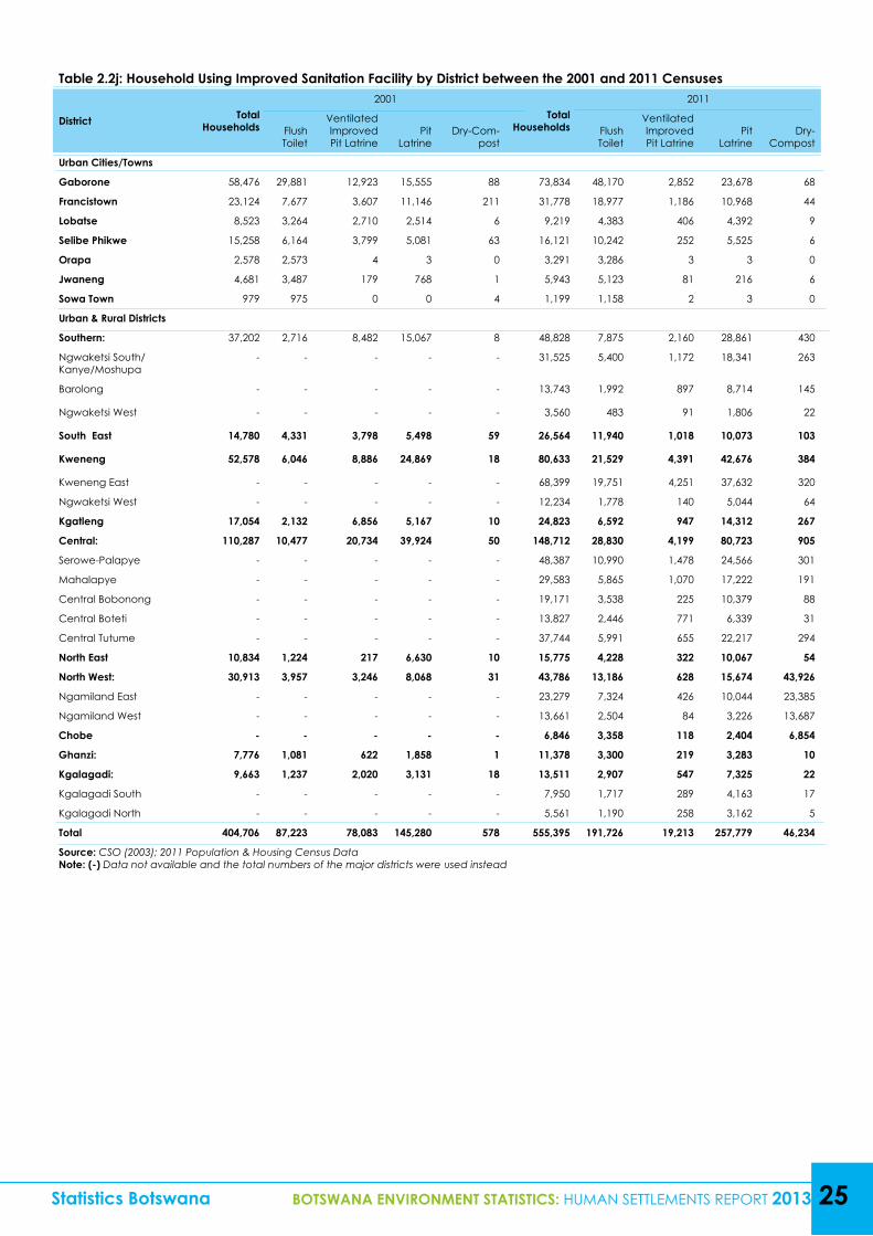
Table 2.2j shows that the percentage of households with access to improved sanitation facilities increased from 76.9 percent (311,164) in 2001 to 92.7 percent (514,952) in 2011. The remaining proportions, that is, during the 2001 (23.1 percent) and 2011 (7.3 percent) censuses, had no access to any form of toilet facility.
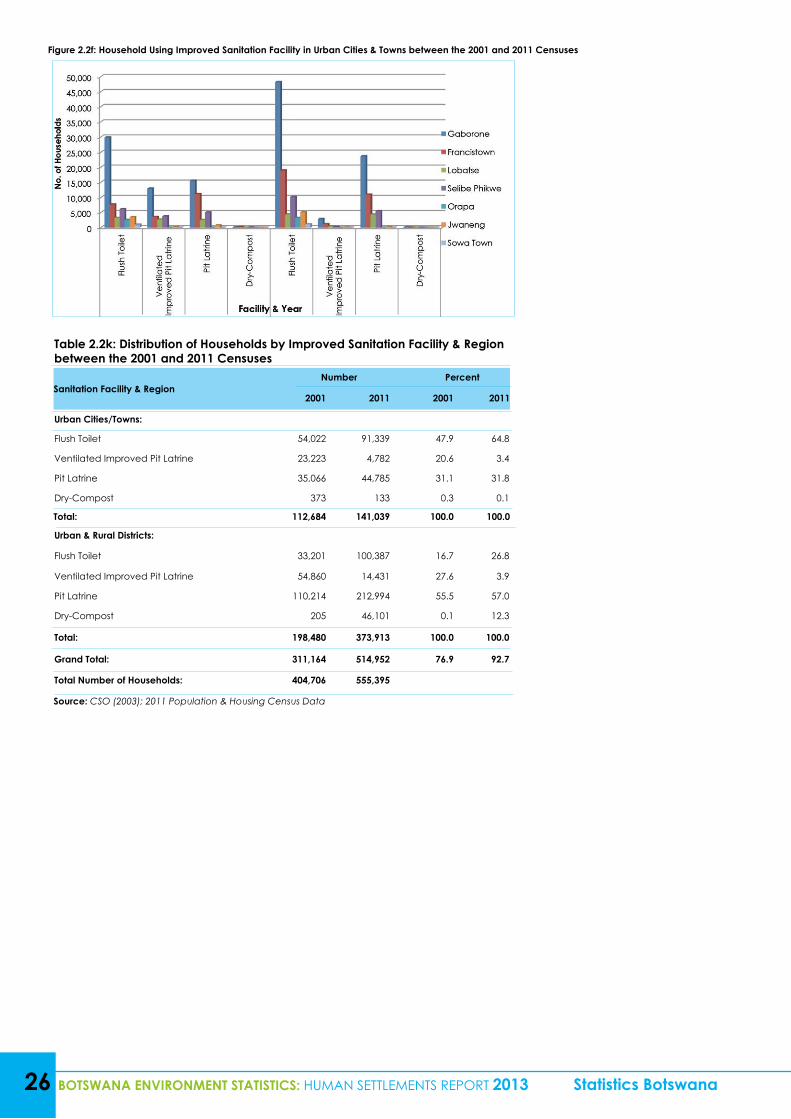
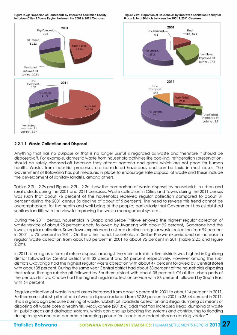
Table 2.2j further reveals that flush toilets were common in cities and towns during the review period as compared to the urban and rural districts combined. For example, the number of households with access to flush toilets in Cities and Towns increased from 49.9 percent in 2001 to 64.8 percent in 2011, whereas in urban and rural districts combined the proportion increased from 16.7 percent in 2001 to 26.8 percent in 2011. During the same period, pit latrine facilities were dominant in urban and rural districts combined as compared to cities and towns. The use of pit latrine facility was slightly on the increase in urban and rural districts, that is, from 55.5 percent in 2001 to 57 percent in 2011.In urban and rural districts, Central district had the highest number of households with access to flush toilets both in 2001 (10,477) and 2011 (28,830) followed by Kweneng district with 6,046 in 2001 and 21,529 in 2011. Generally, access to improved sanitation facilities by households in Botswana shows a positive trend which implies that households with access to unimproved sources of sanitation facilities are getting fewer (Tables 2.2j – 2.2k & Figures 2.2f – 2.2h).
Statistics Botswana BOTSWANA ENVIRONMENT STATISTICS: HUMAN SETTLEMENTS REPORT 2013 25
Table 2.2j: Household Using Improved Sanitation Facility by District between the 2001 and 2011 Censuses
District Total Households
2001Total
Households
2011
Flush Toilet
Ventilated Improved Pit Latrine
Pit Latrine
Dry-Com-post
Flush Toilet
Ventilated Improved Pit Latrine
Pit Latrine
Dry-Compost
Urban Cities/Towns
Gaborone 58,476 29,881 12,923 15,555 88 73,834 48,170 2,852 23,678 68
Francistown 23,124 7,677 3,607 11,146 211 31,778 18,977 1,186 10,968 44
Lobatse 8,523 3,264 2,710 2,514 6 9,219 4,383 406 4,392 9
Selibe Phikwe 15,258 6,164 3,799 5,081 63 16,121 10,242 252 5,525 6
Orapa 2,578 2,573 4 3 0 3,291 3,286 3 3 0
Jwaneng 4,681 3,487 179 768 1 5,943 5,123 81 216 6
Sowa Town 979 975 0 0 4 1,199 1,158 2 3 0
Urban & Rural Districts
Southern: 37,202 2,716 8,482 15,067 8 48,828 7,875 2,160 28,861 430
Ngwaketsi South/Kanye/Moshupa
- - - - - 31,525 5,400 1,172 18,341 263
Barolong - - - - - 13,743 1,992 897 8,714 145
Ngwaketsi West - - - - - 3,560 483 91 1,806 22
South East 14,780 4,331 3,798 5,498 59 26,564 11,940 1,018 10,073 103
Kweneng 52,578 6,046 8,886 24,869 18 80,633 21,529 4,391 42,676 384
Kweneng East - - - - - 68,399 19,751 4,251 37,632 320
Ngwaketsi West - - - - - 12,234 1,778 140 5,044 64
Kgatleng 17,054 2,132 6,856 5,167 10 24,823 6,592 947 14,312 267
Central: 110,287 10,477 20,734 39,924 50 148,712 28,830 4,199 80,723 905
Serowe-Palapye - - - - - 48,387 10,990 1,478 24,566 301
Mahalapye - - - - - 29,583 5,865 1,070 17,222 191
Central Bobonong - - - - - 19,171 3,538 225 10,379 88
Central Boteti - - - - - 13,827 2,446 771 6,339 31
Central Tutume - - - - - 37,744 5,991 655 22,217 294
North East 10,834 1,224 217 6,630 10 15,775 4,228 322 10,067 54
North West: 30,913 3,957 3,246 8,068 31 43,786 13,186 628 15,674 43,926
Ngamiland East - - - - - 23,279 7,324 426 10,044 23,385
Ngamiland West - - - - - 13,661 2,504 84 3,226 13,687
Chobe - - - - - 6,846 3,358 118 2,404 6,854
Ghanzi: 7,776 1,081 622 1,858 1 11,378 3,300 219 3,283 10
Kgalagadi: 9,663 1,237 2,020 3,131 18 13,511 2,907 547 7,325 22
Kgalagadi South - - - - - 7,950 1,717 289 4,163 17
Kgalagadi North - - - - - 5,561 1,190 258 3,162 5
Total 404,706 87,223 78,083 145,280 578 555,395 191,726 19,213 257,779 46,234
Source: CSO (2003); 2011 Population & Housing Census DataNote: (-) Data not available and the total numbers of the major districts were used instead
26 BOTSWANA ENVIRONMENT STATISTICS: HUMAN SETTLEMENTS REPORT 2013 Statistics Botswana
Figure 2.2f: Household Using Improved Sanitation Facility in Urban Cities & Towns between the 2001 and 2011 Censuses
Table 2.2k: Distribution of Households by Improved Sanitation Facility & Region between the 2001 and 2011 Censuses
Sanitation Facility & Region Number Percent
2001 2011 2001 2011
Urban Cities/Towns:
Flush Toilet 54,022 91,339 47.9 64.8
Ventilated Improved Pit Latrine 23,223 4,782 20.6 3.4
Pit Latrine 35,066 44,785 31.1 31.8
Dry-Compost 373 133 0.3 0.1
Total: 112,684 141,039 100.0 100.0
Urban & Rural Districts:
Flush Toilet 33,201 100,387 16.7 26.8
Ventilated Improved Pit Latrine 54,860 14,431 27.6 3.9
Pit Latrine 110,214 212,994 55.5 57.0
Dry-Compost 205 46,101 0.1 12.3
Total: 198,480 373,913 100.0 100.0
Grand Total: 311,164 514,952 76.9 92.7
Total Number of Households: 404,706 555,395
Source: CSO (2003); 2011 Population & Housing Census Data
Statistics Botswana BOTSWANA ENVIRONMENT STATISTICS: HUMAN SETTLEMENTS REPORT 2013 27
Figure 2.2g: Proportion of Households by Improved Sanitation Facility for Urban Cities & Towns Region between the 2001 & 2011 Censuses
Figure 2.2h: Proportion of Households by Improved Sanitation Facility for Urban & Rural Districts between the 2001 & 2011 Censuses
2.2.1.1 Waste Collection and Disposal
Anything that has no purpose or that is no longer useful is regarded as waste and therefore it should be disposed-off. For example, domestic waste from household activities like cooking, refrigeration (preservation) should be safely disposed-off because they attract bacteria and germs which are not good for human health. Wastes from industrial processes are considered hazardous and can be toxic in most cases. The Government of Botswana has put measures in place to encourage safe disposal of waste and these include the development of sanitary landfills, among others.
Tables 2.2l – 2.2s and Figures 2.2i – 2.2n show the comparison of waste disposal by households in urban and rural districts during the 2001 and 2011 censuses. Waste collection in Cities and Towns during the 2011 census was such that about 76 percent of the households received regular collection compared to about 81 percent during the 2001 census (a decline of about of 5 percent). The need to reverse this trend cannot be overemphasised, for the health and well-being of the people, particularly that Government has established sanitary landfills with the view to improving the waste management system.
During the 2011 census, households in Orapa and Selibe Phikwe enjoyed the highest regular collection of waste service of about 95 percent each; followed by Jwaneng with about 92 percent, Gaborone had the lowest regular collection. Sowa Town experienced a steep decline in regular waste collection from 99 percent in 2001 to 75 percent in 2011. On the other hand, households in Selibe Phikwe experienced an increase in regular waste collection from about 80 percent in 2001 to about 95 percent in 2011(Table 2.2q and Figure 2.2m).
In 2011, burning as a form of refuse disposal amongst the main administrative districts was highest in Kgatleng district followed by Central district with 32 percent and 26 percent respectively. However among the sub-districts Okavango had the highest regular waste collection with about 47 percent followed by Central Boteti with about 38 percent. During the same year Central district had about 38 percent of the households disposing their refuse through rubbish pit followed by Southern district with about 35 percent. Of all the urban parts of the census districts, Chobe had the highest regular collection service with 86 percent followed by South East with 64 percent.
Regular collection of waste in rural areas increased from about 6 percent in 2001 to about 14 percent in 2011. Furthermore, rubbish pit method of waste disposal reduced from 57.86 percent in 2001 to 36.44 percent in 2011. This is a good sign because burning of waste, rubbish pit, roadside collection and illegal dumping as means of disposing off waste pose a health risk. Modukanele (2013: 6) adds that “an increased illegal dumping of waste in public areas and drainage systems, which can end up blocking the systems and contributing to flooding during rainy season and become a breeding ground for insects and rodent disease causing vector.”
28 BOTSWANA ENVIRONMENT STATISTICS: HUMAN SETTLEMENTS REPORT 2013 Statistics Botswana
It is evident from Table 2.2s and Figure 2.2n that the most dominant methods of waste disposal in rural areas during the 2001 census was rubbish pit followed by roadside collection and then burning with 57.86 percent, 15.33 percent and 9.87 percent respectively. During the 2011 census, rubbish pit method of disposing waste dominated in the rural areas constituting 36.44 percent of the entire households, followed by burning with 32.39 percent, then regular collection with 13.49 percent.
Statistics Botswana BOTSWANA ENVIRONMENT STATISTICS: HUMAN SETTLEMENTS REPORT 2013 29
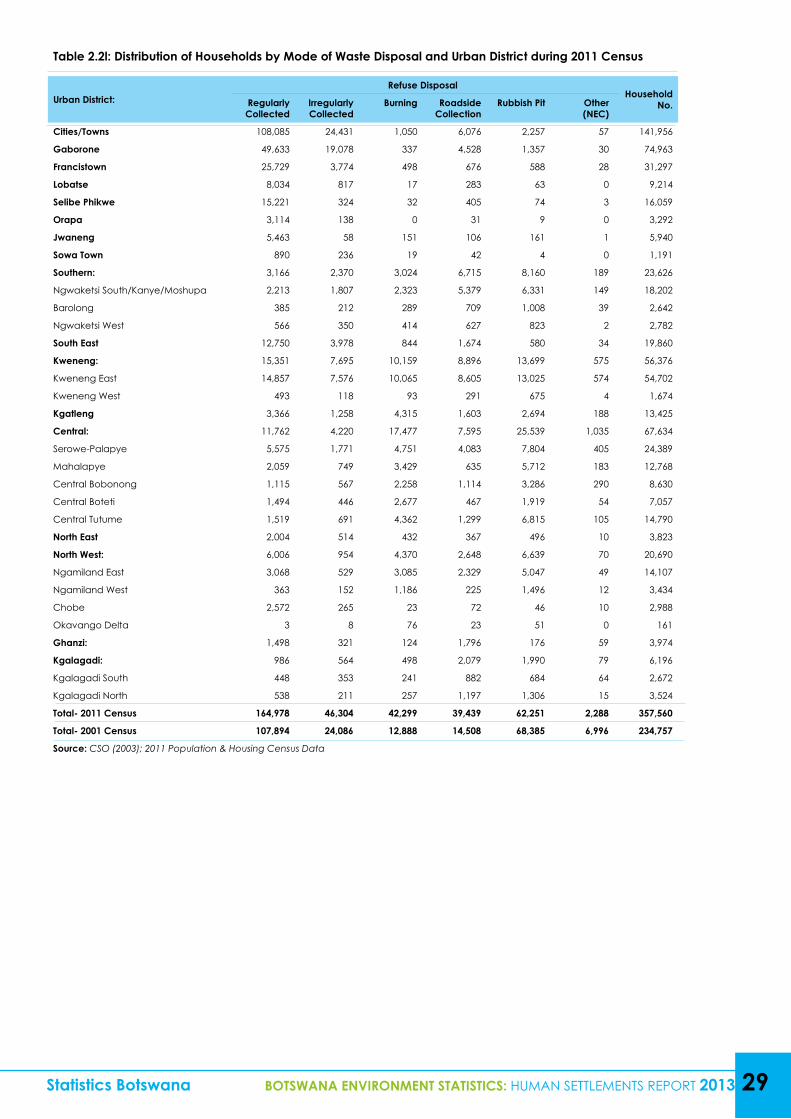
Table 2.2l: Distribution of Households by Mode of Waste Disposal and Urban District during 2011 Census
Urban District:Refuse Disposal
Household No.Regularly
CollectedIrregularly Collected
Burning Roadside Collection
Rubbish Pit Other (NEC)
Cities/Towns 108,085 24,431 1,050 6,076 2,257 57 141,956
Gaborone 49,633 19,078 337 4,528 1,357 30 74,963
Francistown 25,729 3,774 498 676 588 28 31,297
Lobatse 8,034 817 17 283 63 0 9,214
Selibe Phikwe 15,221 324 32 405 74 3 16,059
Orapa 3,114 138 0 31 9 0 3,292
Jwaneng 5,463 58 151 106 161 1 5,940
Sowa Town 890 236 19 42 4 0 1,191
Southern: 3,166 2,370 3,024 6,715 8,160 189 23,626
Ngwaketsi South/Kanye/Moshupa 2,213 1,807 2,323 5,379 6,331 149 18,202
Barolong 385 212 289 709 1,008 39 2,642
Ngwaketsi West 566 350 414 627 823 2 2,782
South East 12,750 3,978 844 1,674 580 34 19,860
Kweneng: 15,351 7,695 10,159 8,896 13,699 575 56,376
Kweneng East 14,857 7,576 10,065 8,605 13,025 574 54,702
Kweneng West 493 118 93 291 675 4 1,674
Kgatleng 3,366 1,258 4,315 1,603 2,694 188 13,425
Central: 11,762 4,220 17,477 7,595 25,539 1,035 67,634
Serowe-Palapye 5,575 1,771 4,751 4,083 7,804 405 24,389
Mahalapye 2,059 749 3,429 635 5,712 183 12,768
Central Bobonong 1,115 567 2,258 1,114 3,286 290 8,630
Central Boteti 1,494 446 2,677 467 1,919 54 7,057
Central Tutume 1,519 691 4,362 1,299 6,815 105 14,790
North East 2,004 514 432 367 496 10 3,823
North West: 6,006 954 4,370 2,648 6,639 70 20,690
Ngamiland East 3,068 529 3,085 2,329 5,047 49 14,107
Ngamiland West 363 152 1,186 225 1,496 12 3,434
Chobe 2,572 265 23 72 46 10 2,988
Okavango Delta 3 8 76 23 51 0 161
Ghanzi: 1,498 321 124 1,796 176 59 3,974
Kgalagadi: 986 564 498 2,079 1,990 79 6,196
Kgalagadi South 448 353 241 882 684 64 2,672
Kgalagadi North 538 211 257 1,197 1,306 15 3,524
Total- 2011 Census 164,978 46,304 42,299 39,439 62,251 2,288 357,560
Total- 2001 Census 107,894 24,086 12,888 14,508 68,385 6,996 234,757
Source: CSO (2003); 2011 Population & Housing Census Data
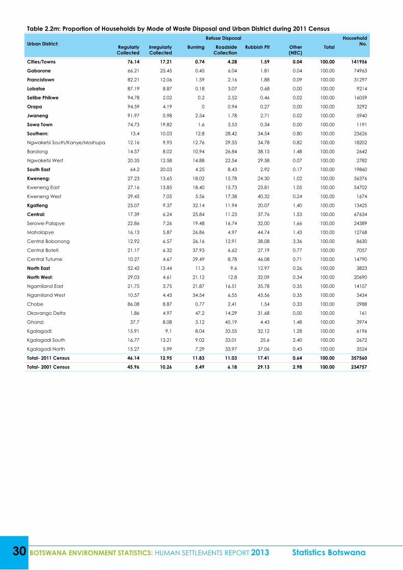
30 BOTSWANA ENVIRONMENT STATISTICS: HUMAN SETTLEMENTS REPORT 2013 Statistics Botswana
Table 2.2m: Proportion of Households by Mode of Waste Disposal and Urban District during 2011 Census
Urban District:Refuse Disposal Household
No.Regularly Collected
Irregularly Collected
Burning Roadside Collection
Rubbish Pit Other (NEC)
Total
Cities/Towns 76.14 17.21 0.74 4.28 1.59 0.04 100.00 141956
Gaborone 66.21 25.45 0.45 6.04 1.81 0.04 100.00 74963
Francistown 82.21 12.06 1.59 2.16 1.88 0.09 100.00 31297
Lobatse 87.19 8.87 0.18 3.07 0.68 0.00 100.00 9214
Selibe Phikwe 94.78 2.02 0.2 2.52 0.46 0.02 100.00 16059
Orapa 94.59 4.19 0 0.94 0.27 0.00 100.00 3292
Jwaneng 91.97 0.98 2.54 1.78 2.71 0.02 100.00 5940
Sowa Town 74.73 19.82 1.6 3.53 0.34 0.00 100.00 1191
Southern: 13.4 10.03 12.8 28.42 34.54 0.80 100.00 23626
Ngwaketsi South/Kanye/Moshupa 12.16 9.93 12.76 29.55 34.78 0.82 100.00 18202
Barolong 14.57 8.02 10.94 26.84 38.15 1.48 100.00 2642
Ngwaketsi West 20.35 12.58 14.88 22.54 29.58 0.07 100.00 2782
South East 64.2 20.03 4.25 8.43 2.92 0.17 100.00 19860
Kweneng: 27.23 13.65 18.02 15.78 24.30 1.02 100.00 56376
Kweneng East 27.16 13.85 18.40 15.73 23.81 1.05 100.00 54702
Kweneng West 29.45 7.05 5.56 17.38 40.32 0.24 100.00 1674
Kgatleng 25.07 9.37 32.14 11.94 20.07 1.40 100.00 13425
Central: 17.39 6.24 25.84 11.23 37.76 1.53 100.00 67634
Serowe-Palapye 22.86 7.26 19.48 16.74 32.00 1.66 100.00 24389
Mahalapye 16.13 5.87 26.86 4.97 44.74 1.43 100.00 12768
Central Bobonong 12.92 6.57 26.16 12.91 38.08 3.36 100.00 8630
Central Boteti 21.17 6.32 37.93 6.62 27.19 0.77 100.00 7057
Central Tutume 10.27 4.67 29.49 8.78 46.08 0.71 100.00 14790
North East 52.42 13.44 11.3 9.6 12.97 0.26 100,00 3823
North West: 29.03 4.61 21.12 12.8 32.09 0.34 100.00 20690
Ngamiland East 21.75 3.75 21.87 16.51 35.78 0.35 100.00 14107
Ngamiland West 10.57 4.43 34.54 6.55 43.56 0.35 100.00 3434
Chobe 86.08 8.87 0.77 2.41 1.54 0.33 100.00 2988
Okavango Delta 1.86 4.97 47.2 14.29 31.68 0.00 100.00 161
Ghanzi: 37.7 8.08 3.12 45.19 4.43 1.48 100.00 3974
Kgalagadi: 15.91 9.1 8.04 33.55 32.12 1.28 100.00 6196
Kgalagadi South 16.77 13.21 9.02 33.01 25.6 2.40 100.00 2672
Kgalagadi North 15.27 5.99 7.29 33.97 37.06 0.43 100.00 3524
Total- 2011 Census 46.14 12.95 11.83 11.03 17.41 0.64 100.00 357560
Total- 2001 Census 45.96 10.26 5.49 6.18 29.13 2.98 100.00 234757
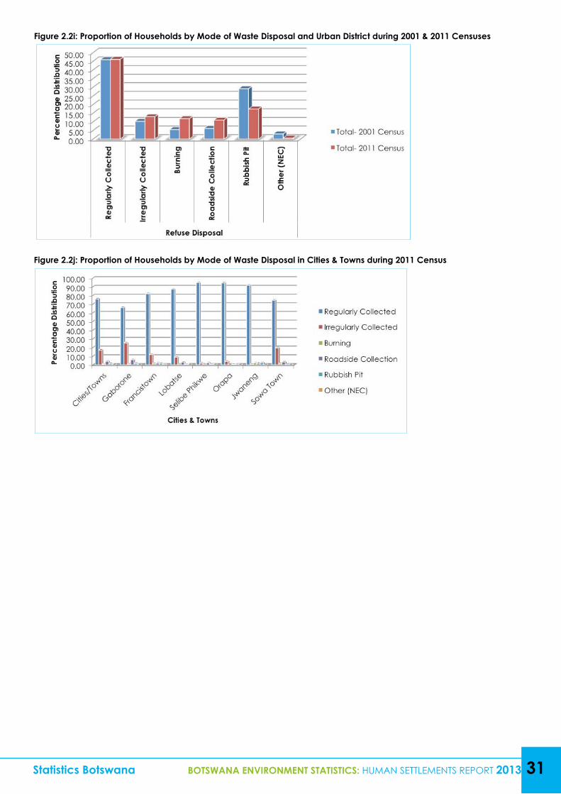
Statistics Botswana BOTSWANA ENVIRONMENT STATISTICS: HUMAN SETTLEMENTS REPORT 2013 31
Figure 2.2i: Proportion of Households by Mode of Waste Disposal and Urban District during 2001 & 2011 Censuses
Figure 2.2j: Proportion of Households by Mode of Waste Disposal in Cities & Towns during 2011 Census
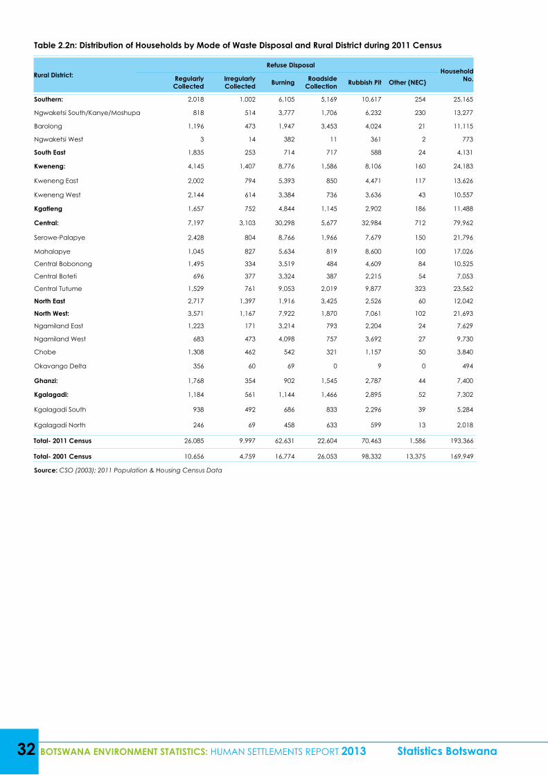
32 BOTSWANA ENVIRONMENT STATISTICS: HUMAN SETTLEMENTS REPORT 2013 Statistics Botswana
Table 2.2n: Distribution of Households by Mode of Waste Disposal and Rural District during 2011 Census
Rural District:Refuse Disposal
Household No.Regularly
CollectedIrregularly Collected Burning Roadside
Collection Rubbish Pit Other (NEC)
Southern: 2,018 1,002 6,105 5,169 10,617 254 25,165
Ngwaketsi South/Kanye/Moshupa 818 514 3,777 1,706 6,232 230 13,277
Barolong 1,196 473 1,947 3,453 4,024 21 11,115
Ngwaketsi West 3 14 382 11 361 2 773
South East 1,835 253 714 717 588 24 4,131
Kweneng: 4,145 1,407 8,776 1,586 8,106 160 24,183
Kweneng East 2,002 794 5,393 850 4,471 117 13,626
Kweneng West 2,144 614 3,384 736 3,636 43 10,557
Kgatleng 1,657 752 4,844 1,145 2,902 186 11,488
Central: 7,197 3,103 30,298 5,677 32,984 712 79,962
Serowe-Palapye 2,428 804 8,766 1,966 7,679 150 21,796
Mahalapye 1,045 827 5,634 819 8,600 100 17,026
Central Bobonong 1,495 334 3,519 484 4,609 84 10,525
Central Boteti 696 377 3,324 387 2,215 54 7,053
Central Tutume 1,529 761 9,053 2,019 9,877 323 23,562
North East 2,717 1,397 1,916 3,425 2,526 60 12,042
North West: 3,571 1,167 7,922 1,870 7,061 102 21,693
Ngamiland East 1,223 171 3,214 793 2,204 24 7,629
Ngamiland West 683 473 4,098 757 3,692 27 9,730
Chobe 1,308 462 542 321 1,157 50 3,840
Okavango Delta 356 60 69 0 9 0 494
Ghanzi: 1,768 354 902 1,545 2,787 44 7,400
Kgalagadi: 1,184 561 1,144 1,466 2,895 52 7,302
Kgalagadi South 938 492 686 833 2,296 39 5,284
Kgalagadi North 246 69 458 633 599 13 2,018
Total- 2011 Census 26,085 9,997 62,631 22,604 70,463 1,586 193,366
Total- 2001 Census 10,656 4,759 16,774 26,053 98,332 13,375 169,949
Source: CSO (2003); 2011 Population & Housing Census Data
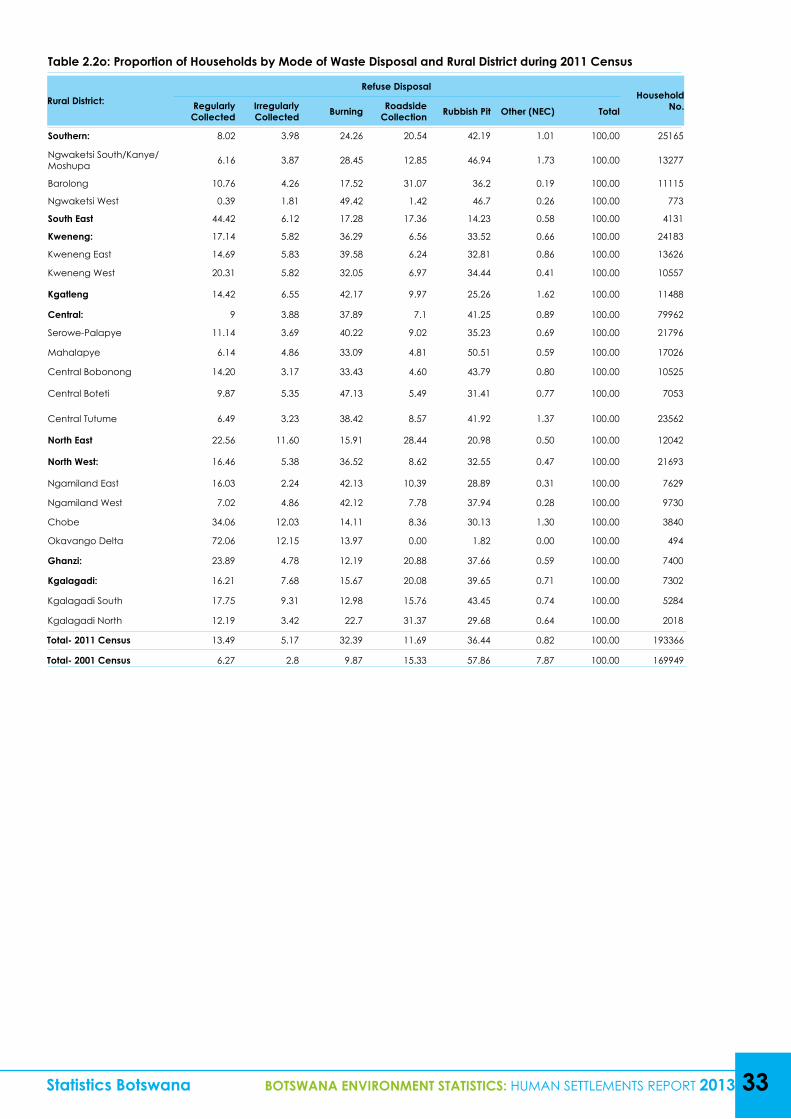
Table 2.2o: Proportion of Households by Mode of Waste Disposal and Rural District during 2011 Census
Rural District:Refuse Disposal
Household No.Regularly
CollectedIrregularly Collected Burning Roadside
Collection Rubbish Pit Other (NEC) Total
Southern: 8.02 3.98 24.26 20.54 42.19 1.01 100,00 25165
Ngwaketsi South/Kanye/Moshupa 6.16 3.87 28.45 12.85 46.94 1.73 100.00 13277
Barolong 10.76 4.26 17.52 31.07 36.2 0.19 100.00 11115
Ngwaketsi West 0.39 1.81 49.42 1.42 46.7 0.26 100.00 773
South East 44.42 6.12 17.28 17.36 14.23 0.58 100.00 4131
Kweneng: 17.14 5.82 36.29 6.56 33.52 0.66 100.00 24183
Kweneng East 14.69 5.83 39.58 6.24 32.81 0.86 100.00 13626
Kweneng West 20.31 5.82 32.05 6.97 34.44 0.41 100.00 10557
Kgatleng 14.42 6.55 42.17 9.97 25.26 1.62 100.00 11488
Central: 9 3.88 37.89 7.1 41.25 0.89 100.00 79962
Serowe-Palapye 11.14 3.69 40.22 9.02 35.23 0.69 100.00 21796
Mahalapye 6.14 4.86 33.09 4.81 50.51 0.59 100.00 17026
Central Bobonong 14.20 3.17 33.43 4.60 43.79 0.80 100.00 10525
Central Boteti 9.87 5.35 47.13 5.49 31.41 0.77 100.00 7053
Central Tutume 6.49 3.23 38.42 8.57 41.92 1.37 100.00 23562
North East 22.56 11.60 15.91 28.44 20.98 0.50 100.00 12042
North West: 16.46 5.38 36.52 8.62 32.55 0.47 100.00 21693
Ngamiland East 16.03 2.24 42.13 10.39 28.89 0.31 100.00 7629
Ngamiland West 7.02 4.86 42.12 7.78 37.94 0.28 100.00 9730
Chobe 34.06 12.03 14.11 8.36 30.13 1.30 100.00 3840
Okavango Delta 72.06 12.15 13.97 0.00 1.82 0.00 100.00 494
Ghanzi: 23.89 4.78 12.19 20.88 37.66 0.59 100.00 7400
Kgalagadi: 16.21 7.68 15.67 20.08 39.65 0.71 100.00 7302
Kgalagadi South 17.75 9.31 12.98 15.76 43.45 0.74 100.00 5284
Kgalagadi North 12.19 3.42 22.7 31.37 29.68 0.64 100.00 2018
Total- 2011 Census 13.49 5.17 32.39 11.69 36.44 0.82 100.00 193366
Total- 2001 Census 6.27 2.8 9.87 15.33 57.86 7.87 100.00 169949
Statistics Botswana BOTSWANA ENVIRONMENT STATISTICS: HUMAN SETTLEMENTS REPORT 2013 33
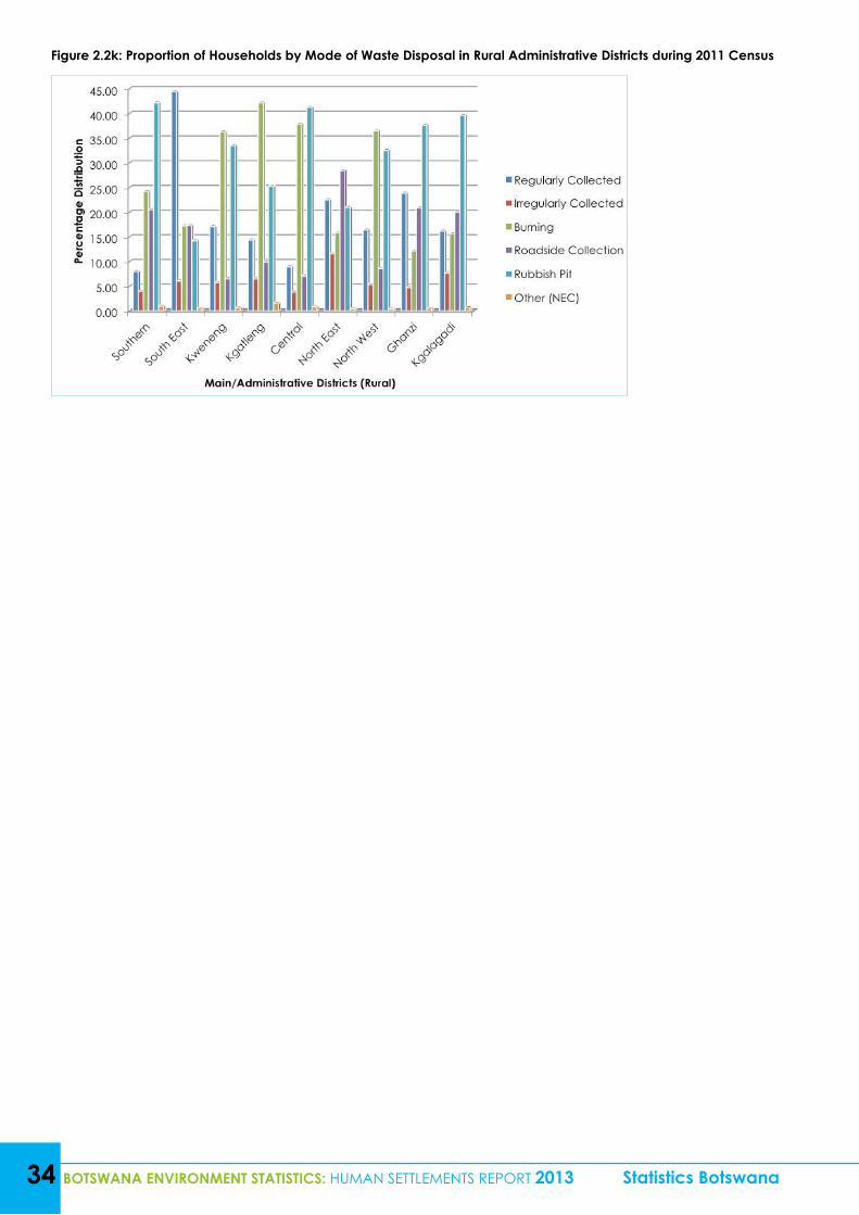
34 BOTSWANA ENVIRONMENT STATISTICS: HUMAN SETTLEMENTS REPORT 2013 Statistics Botswana
Figure 2.2k: Proportion of Households by Mode of Waste Disposal in Rural Administrative Districts during 2011 Census
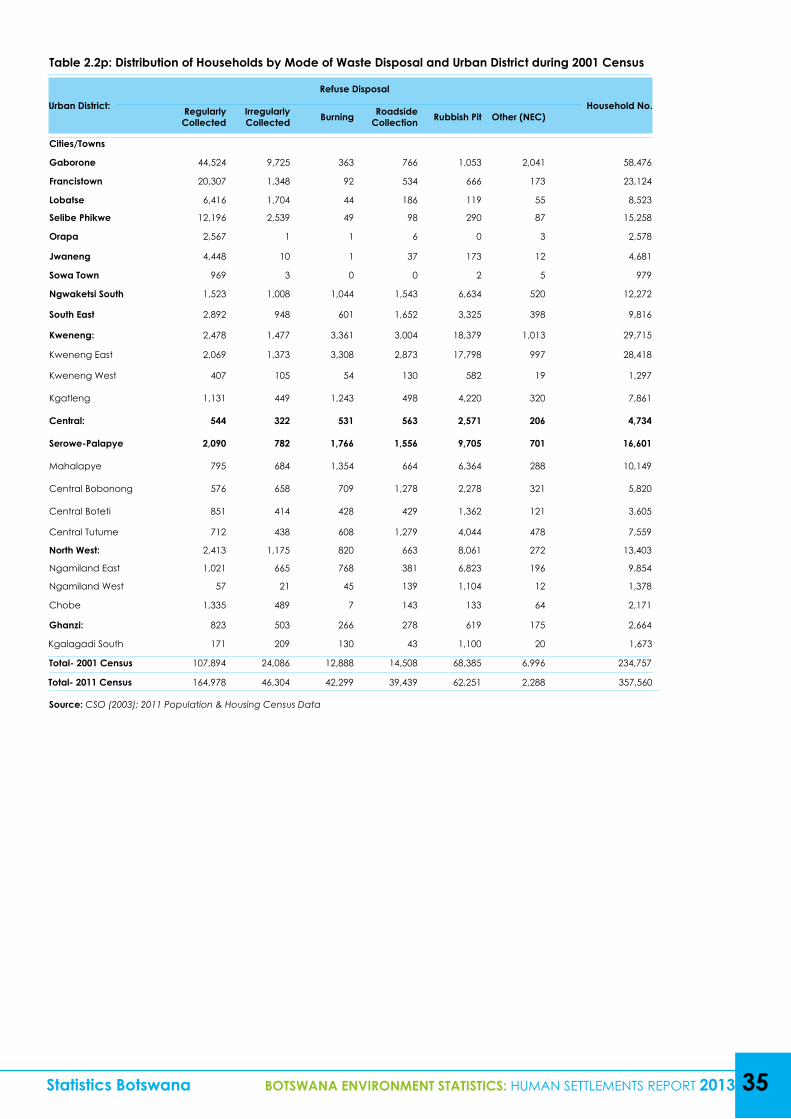
Statistics Botswana BOTSWANA ENVIRONMENT STATISTICS: HUMAN SETTLEMENTS REPORT 2013 35
Table 2.2p: Distribution of Households by Mode of Waste Disposal and Urban District during 2001 Census
Urban District:
Refuse Disposal
Household No.Regularly Collected
Irregularly Collected Burning Roadside
Collection Rubbish Pit Other (NEC)
Cities/Towns
Gaborone 44,524 9,725 363 766 1,053 2,041 58,476
Francistown 20,307 1,348 92 534 666 173 23,124
Lobatse 6,416 1,704 44 186 119 55 8,523
Selibe Phikwe 12,196 2,539 49 98 290 87 15,258
Orapa 2,567 1 1 6 0 3 2,578
Jwaneng 4,448 10 1 37 173 12 4,681
Sowa Town 969 3 0 0 2 5 979
Ngwaketsi South 1,523 1,008 1,044 1,543 6,634 520 12,272
South East 2,892 948 601 1,652 3,325 398 9,816
Kweneng: 2,478 1,477 3,361 3,004 18,379 1,013 29,715
Kweneng East 2,069 1,373 3,308 2,873 17,798 997 28,418
Kweneng West 407 105 54 130 582 19 1,297
Kgatleng 1,131 449 1,243 498 4,220 320 7,861
Central: 544 322 531 563 2,571 206 4,734
Serowe-Palapye 2,090 782 1,766 1,556 9,705 701 16,601
Mahalapye 795 684 1,354 664 6,364 288 10,149
Central Bobonong 576 658 709 1,278 2,278 321 5,820
Central Boteti 851 414 428 429 1,362 121 3,605
Central Tutume 712 438 608 1,279 4,044 478 7,559
North West: 2,413 1,175 820 663 8,061 272 13,403
Ngamiland East 1,021 665 768 381 6,823 196 9,854
Ngamiland West 57 21 45 139 1,104 12 1,378
Chobe 1,335 489 7 143 133 64 2,171
Ghanzi: 823 503 266 278 619 175 2,664
Kgalagadi South 171 209 130 43 1,100 20 1,673
Total- 2001 Census 107,894 24,086 12,888 14,508 68,385 6,996 234,757
Total- 2011 Census 164,978 46,304 42,299 39,439 62,251 2,288 357,560
Source: CSO (2003); 2011 Population & Housing Census Data
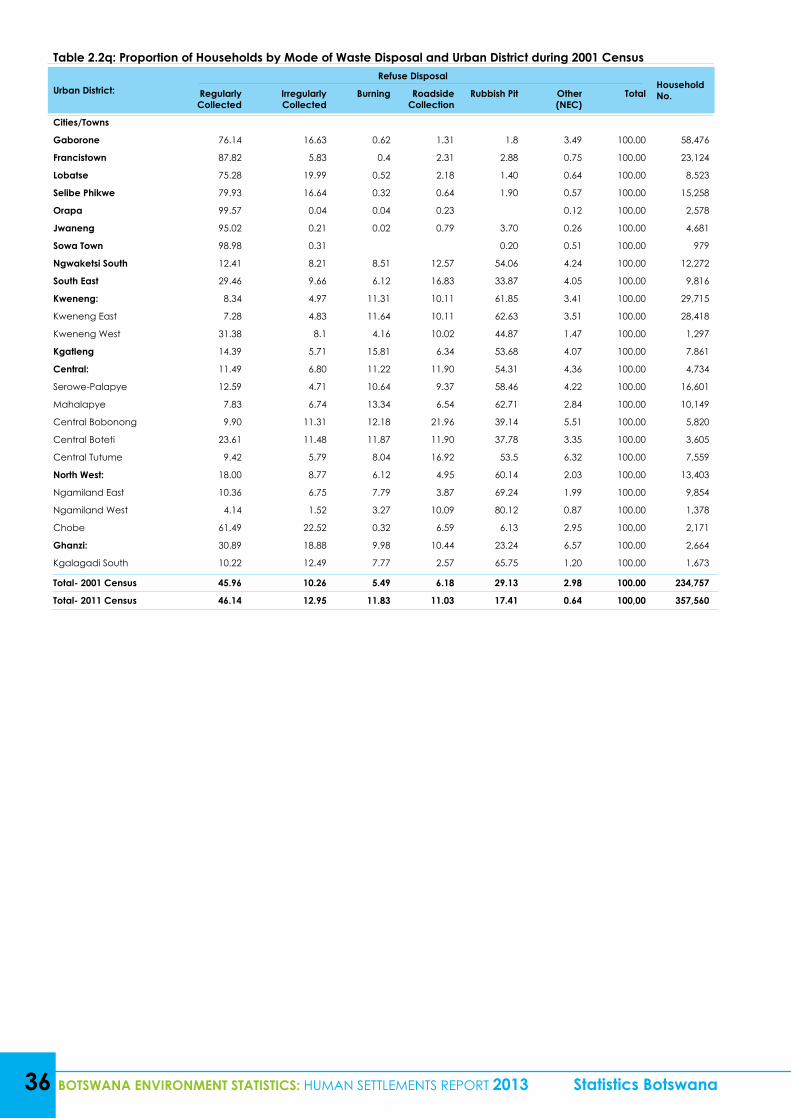
Table 2.2q: Proportion of Households by Mode of Waste Disposal and Urban District during 2001 Census
Urban District:Refuse Disposal
Household No.Regularly
CollectedIrregularly Collected
Burning Roadside Collection
Rubbish Pit Other (NEC)
Total
Cities/Towns
Gaborone 76.14 16.63 0.62 1.31 1.8 3.49 100.00 58,476
Francistown 87.82 5.83 0.4 2.31 2.88 0.75 100.00 23,124
Lobatse 75.28 19.99 0.52 2.18 1.40 0.64 100.00 8,523
Selibe Phikwe 79.93 16.64 0.32 0.64 1.90 0.57 100.00 15,258
Orapa 99.57 0.04 0.04 0.23 0.12 100.00 2,578
Jwaneng 95.02 0.21 0.02 0.79 3.70 0.26 100.00 4,681
Sowa Town 98.98 0.31 0.20 0.51 100.00 979
Ngwaketsi South 12.41 8.21 8.51 12.57 54.06 4.24 100.00 12,272
South East 29.46 9.66 6.12 16.83 33.87 4.05 100.00 9,816
Kweneng: 8.34 4.97 11.31 10.11 61.85 3.41 100.00 29,715
Kweneng East 7.28 4.83 11.64 10.11 62.63 3.51 100.00 28,418
Kweneng West 31.38 8.1 4.16 10.02 44.87 1.47 100.00 1,297
Kgatleng 14.39 5.71 15.81 6.34 53.68 4.07 100.00 7,861
Central: 11.49 6.80 11.22 11.90 54.31 4.36 100.00 4,734
Serowe-Palapye 12.59 4.71 10.64 9.37 58.46 4.22 100.00 16,601
Mahalapye 7.83 6.74 13.34 6.54 62.71 2.84 100.00 10,149
Central Bobonong 9.90 11.31 12.18 21.96 39.14 5.51 100.00 5,820
Central Boteti 23.61 11.48 11.87 11.90 37.78 3.35 100.00 3,605
Central Tutume 9.42 5.79 8.04 16.92 53.5 6.32 100.00 7,559
North West: 18.00 8.77 6.12 4.95 60.14 2.03 100.00 13,403
Ngamiland East 10.36 6.75 7.79 3.87 69.24 1.99 100.00 9,854
Ngamiland West 4.14 1.52 3.27 10.09 80.12 0.87 100.00 1,378
Chobe 61.49 22.52 0.32 6.59 6.13 2.95 100.00 2,171
Ghanzi: 30.89 18.88 9.98 10.44 23.24 6.57 100.00 2,664
Kgalagadi South 10.22 12.49 7.77 2.57 65.75 1.20 100.00 1,673
Total- 2001 Census 45.96 10.26 5.49 6.18 29.13 2.98 100.00 234,757
Total- 2011 Census 46.14 12.95 11.83 11.03 17.41 0.64 100,00 357,560
36 BOTSWANA ENVIRONMENT STATISTICS: HUMAN SETTLEMENTS REPORT 2013 Statistics Botswana
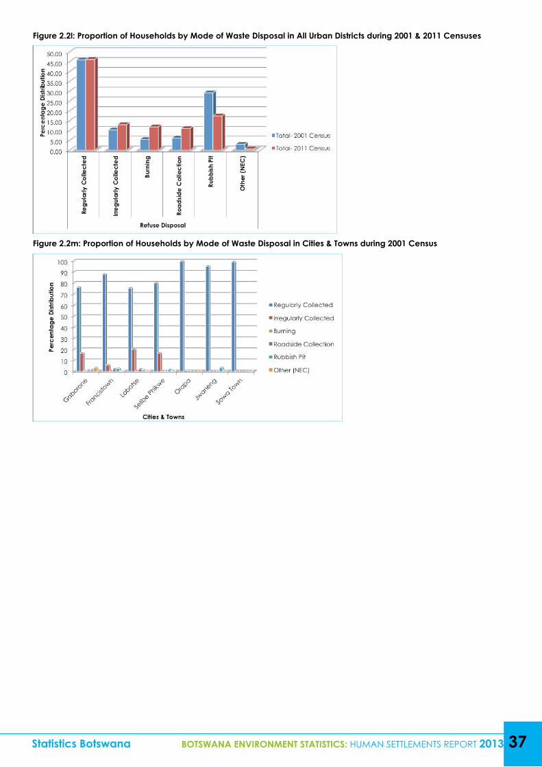
Statistics Botswana BOTSWANA ENVIRONMENT STATISTICS: HUMAN SETTLEMENTS REPORT 2013 37
Figure 2.2l: Proportion of Households by Mode of Waste Disposal in All Urban Districts during 2001 & 2011 Censuses
Figure 2.2m: Proportion of Households by Mode of Waste Disposal in Cities & Towns during 2001 Census
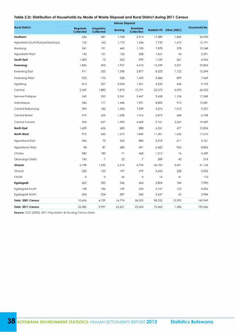
38 BOTSWANA ENVIRONMENT STATISTICS: HUMAN SETTLEMENTS REPORT 2013 Statistics Botswana
Table 2.2r: Distribution of Households by Mode of Waste Disposal and Rural District during 2011 Census
Rural District:Refuse Disposal
Household No.Regularly Collected
Irregularly Collected Burning Roadside
Collection Rubbish Pit Other (NEC)
Southern: 636 481 1,768 2,914 17,289 1,842 24,930
Ngwaketsi South/Kanye/Moshupa 152 160 1,172 1,546 7,750 1,412 12,191
Barolong 341 191 460 1,100 7,878 378 10,348
Ngwaketsi West 142 131 135 268 1,661 54 2,391
South East 1,400 73 362 999 1,769 361 4,964
Kweneng: 1,836 503 1,957 4,310 12,239 2,021 22,863
Kweneng East 911 333 1,598 2,877 8,553 1,122 15,394
Kweneng West 925 170 358 1,432 3,686 899 7,469
Kgatleng 813 327 2,034 1,351 4,232 436 9,193
Central: 2,569 1,883 7,873 12,791 35,373 6,070 66,553
Serowe-Palapye 545 250 2,341 3,467 9,658 1,106 17,368
Mahalapye 346 171 1,446 1,901 8,800 915 13,581
Central Bobonong 394 182 1,433 1,939 4,276 1,013 9,237
Central Boteti 319 625 1,258 1,016 2,872 668 6,758
Central Tutume 965 657 1,390 4,469 9,761 2,367 19,609
North East 1,609 626 683 888 6,551 477 10,834
North West: 972 343 1,310 1,849 11,401 1,635 17,510
Ngamiland East 346 70 533 883 3,318 611 5,761
Ngamiland West 98 87 683 491 6,482 965 8,806
Chobe 382 180 71 468 1,312 16 2,429
Okavango Delta 145 7 23 7 289 43 514
Ghanzi: 2,198 1,232 2,510 4,790 36,702 3,691 51,124
Ghanzi 220 123 197 479 3,655 328 5,002
CKGR 0 0 54 0 15 41 110
Kgalagadi: 602 390 546 464 5,804 184 7,990
Kgalagadi South 148 186 159 224 3,167 122 4,006
Kgalagadi North 454 204 387 240 2,637 62 3,984
Total- 2001 Census 10,656 4,759 16,774 26,053 98,332 13,392 169,949
Total- 2011 Census 26,085 9,997 62,631 22,604 70,463 1,586 193,366
Source: CSO (2003); 2011 Population & Housing Census Data
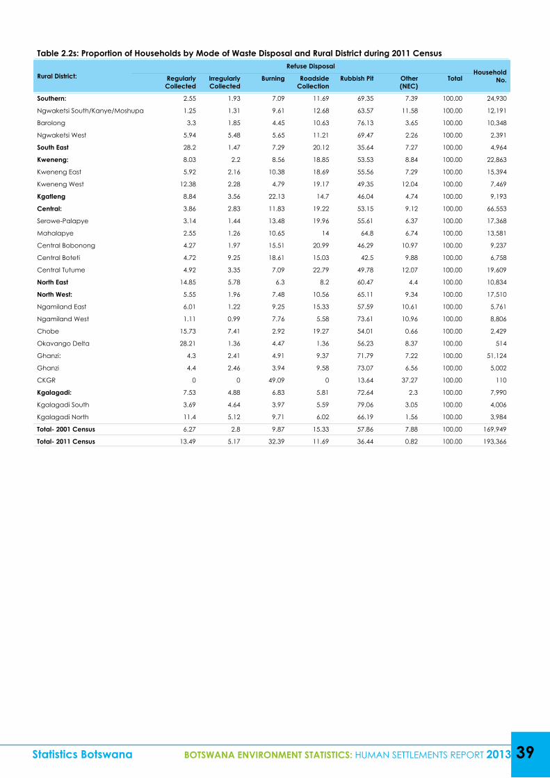
Table 2.2s: Proportion of Households by Mode of Waste Disposal and Rural District during 2011 Census
Rural District:Refuse Disposal
Household No.Regularly
CollectedIrregularly Collected
Burning Roadside Collection
Rubbish Pit Other (NEC)
Total
Southern: 2.55 1.93 7.09 11.69 69.35 7.39 100.00 24,930
Ngwaketsi South/Kanye/Moshupa 1.25 1.31 9.61 12.68 63.57 11.58 100.00 12,191
Barolong 3.3 1.85 4.45 10.63 76.13 3.65 100.00 10,348
Ngwaketsi West 5.94 5.48 5.65 11.21 69.47 2.26 100.00 2,391
South East 28.2 1.47 7.29 20.12 35.64 7.27 100.00 4,964
Kweneng: 8.03 2.2 8.56 18.85 53.53 8.84 100.00 22,863
Kweneng East 5.92 2.16 10.38 18.69 55.56 7.29 100.00 15,394
Kweneng West 12.38 2.28 4.79 19.17 49.35 12.04 100.00 7,469
Kgatleng 8.84 3.56 22.13 14.7 46.04 4.74 100.00 9,193
Central: 3.86 2.83 11.83 19.22 53.15 9.12 100.00 66,553
Serowe-Palapye 3.14 1.44 13.48 19.96 55.61 6.37 100.00 17,368
Mahalapye 2.55 1.26 10.65 14 64.8 6.74 100.00 13,581
Central Bobonong 4.27 1.97 15.51 20.99 46.29 10.97 100.00 9,237
Central Boteti 4.72 9.25 18.61 15.03 42.5 9.88 100.00 6,758
Central Tutume 4.92 3.35 7.09 22.79 49.78 12.07 100.00 19,609
North East 14.85 5.78 6.3 8.2 60.47 4.4 100.00 10,834
North West: 5.55 1.96 7.48 10.56 65.11 9.34 100.00 17,510
Ngamiland East 6.01 1.22 9.25 15.33 57.59 10.61 100.00 5,761
Ngamiland West 1.11 0.99 7.76 5.58 73.61 10.96 100.00 8,806
Chobe 15.73 7.41 2.92 19.27 54.01 0.66 100.00 2,429
Okavango Delta 28.21 1.36 4.47 1.36 56.23 8.37 100.00 514
Ghanzi: 4.3 2.41 4.91 9.37 71.79 7.22 100.00 51,124
Ghanzi 4.4 2.46 3.94 9.58 73.07 6.56 100.00 5,002
CKGR 0 0 49.09 0 13.64 37.27 100.00 110
Kgalagadi: 7.53 4.88 6.83 5.81 72.64 2.3 100.00 7,990
Kgalagadi South 3.69 4.64 3.97 5.59 79.06 3.05 100.00 4,006
Kgalagadi North 11.4 5.12 9.71 6.02 66.19 1.56 100.00 3,984
Total- 2001 Census 6.27 2.8 9.87 15.33 57.86 7.88 100.00 169,949
Total- 2011 Census 13.49 5.17 32.39 11.69 36.44 0.82 100.00 193,366
Statistics Botswana BOTSWANA ENVIRONMENT STATISTICS: HUMAN SETTLEMENTS REPORT 2013 39
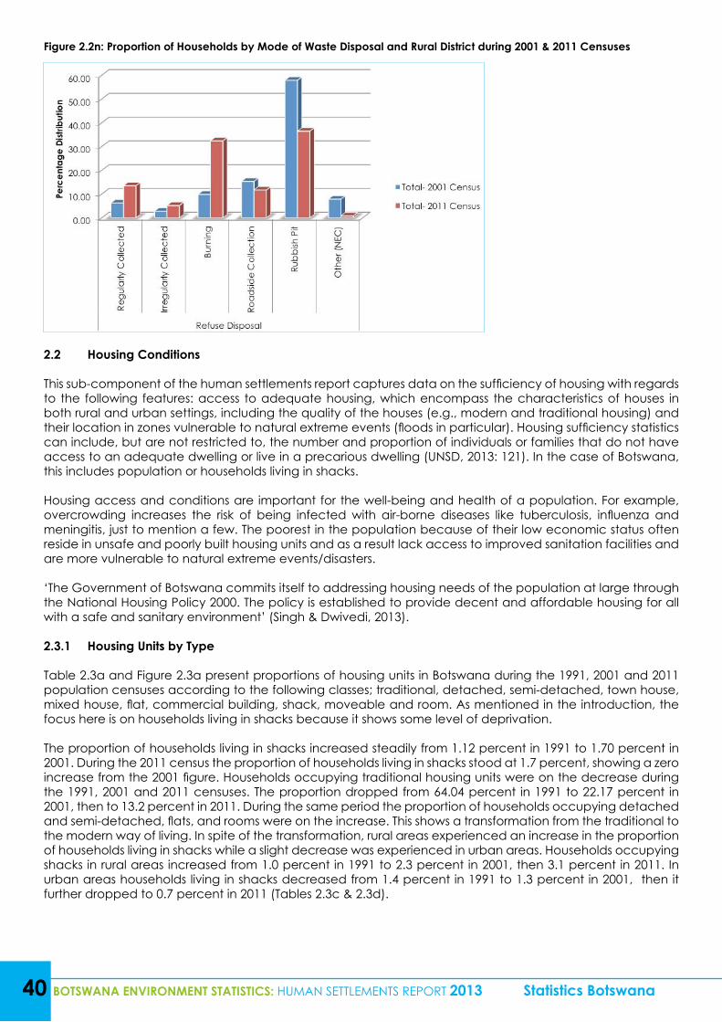
40 BOTSWANA ENVIRONMENT STATISTICS: HUMAN SETTLEMENTS REPORT 2013 Statistics Botswana
Figure 2.2n: Proportion of Households by Mode of Waste Disposal and Rural District during 2001 & 2011 Censuses
2.2 Housing Conditions
This sub-component of the human settlements report captures data on the sufficiency of housing with regards to the following features: access to adequate housing, which encompass the characteristics of houses in both rural and urban settings, including the quality of the houses (e.g., modern and traditional housing) and their location in zones vulnerable to natural extreme events (floods in particular). Housing sufficiency statistics can include, but are not restricted to, the number and proportion of individuals or families that do not have access to an adequate dwelling or live in a precarious dwelling (UNSD, 2013: 121). In the case of Botswana, this includes population or households living in shacks.
Housing access and conditions are important for the well-being and health of a population. For example, overcrowding increases the risk of being infected with air-borne diseases like tuberculosis, influenza and meningitis, just to mention a few. The poorest in the population because of their low economic status often reside in unsafe and poorly built housing units and as a result lack access to improved sanitation facilities and are more vulnerable to natural extreme events/disasters.
‘The Government of Botswana commits itself to addressing housing needs of the population at large through the National Housing Policy 2000. The policy is established to provide decent and affordable housing for all with a safe and sanitary environment’ (Singh & Dwivedi, 2013).
2.3.1 Housing Units by Type
Table 2.3a and Figure 2.3a present proportions of housing units in Botswana during the 1991, 2001 and 2011 population censuses according to the following classes; traditional, detached, semi-detached, town house, mixed house, flat, commercial building, shack, moveable and room. As mentioned in the introduction, the focus here is on households living in shacks because it shows some level of deprivation.
The proportion of households living in shacks increased steadily from 1.12 percent in 1991 to 1.70 percent in 2001. During the 2011 census the proportion of households living in shacks stood at 1.7 percent, showing a zero increase from the 2001 figure. Households occupying traditional housing units were on the decrease during the 1991, 2001 and 2011 censuses. The proportion dropped from 64.04 percent in 1991 to 22.17 percent in 2001, then to 13.2 percent in 2011. During the same period the proportion of households occupying detached and semi-detached, flats, and rooms were on the increase. This shows a transformation from the traditional to the modern way of living. In spite of the transformation, rural areas experienced an increase in the proportion of households living in shacks while a slight decrease was experienced in urban areas. Households occupying shacks in rural areas increased from 1.0 percent in 1991 to 2.3 percent in 2001, then 3.1 percent in 2011. In urban areas households living in shacks decreased from 1.4 percent in 1991 to 1.3 percent in 2001, then it further dropped to 0.7 percent in 2011 (Tables 2.3c & 2.3d).
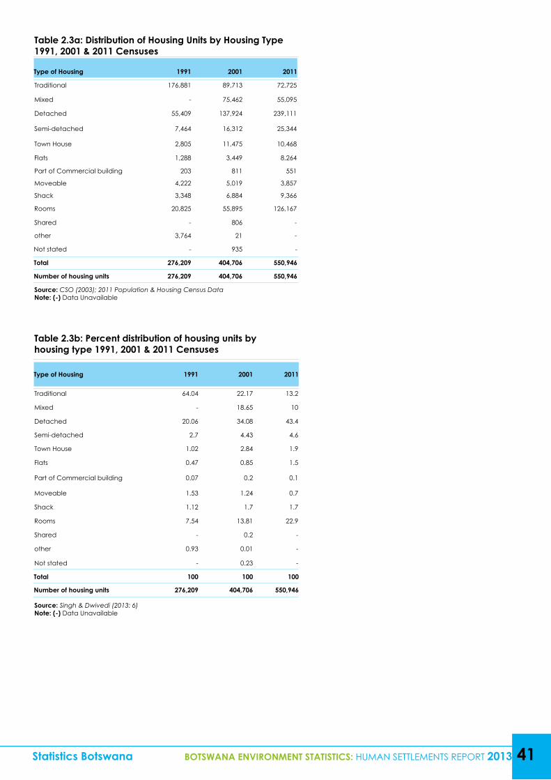
Table 2.3b: Percent distribution of housing units by housing type 1991, 2001 & 2011 Censuses
Type of Housing 1991 2001 2011
Traditional 64.04 22.17 13.2
Mixed - 18.65 10
Detached 20.06 34.08 43.4
Semi-detached 2.7 4.43 4.6
Town House 1.02 2.84 1.9
Flats 0.47 0.85 1.5
Part of Commercial building 0.07 0.2 0.1
Moveable 1.53 1.24 0.7
Shack 1.12 1.7 1.7
Rooms 7.54 13.81 22.9
Shared - 0.2 -
other 0.93 0.01 -
Not stated - 0.23 -
Total 100 100 100
Number of housing units 276,209 404,706 550,946
Source: Singh & Dwivedi (2013: 6)Note: (-) Data Unavailable
Statistics Botswana BOTSWANA ENVIRONMENT STATISTICS: HUMAN SETTLEMENTS REPORT 2013 41
Table 2.3a: Distribution of Housing Units by Housing Type 1991, 2001 & 2011 Censuses
Type of Housing 1991 2001 2011
Traditional 176,881 89,713 72,725
Mixed - 75,462 55,095
Detached 55,409 137,924 239,111
Semi-detached 7,464 16,312 25,344
Town House 2,805 11,475 10,468
Flats 1,288 3,449 8,264
Part of Commercial building 203 811 551
Moveable 4,222 5,019 3,857
Shack 3,348 6,884 9,366
Rooms 20,825 55,895 126,167
Shared - 806 -
other 3,764 21 -
Not stated - 935 -
Total 276,209 404,706 550,946
Number of housing units 276,209 404,706 550,946
Source: CSO (2003); 2011 Population & Housing Census DataNote: (-) Data Unavailable
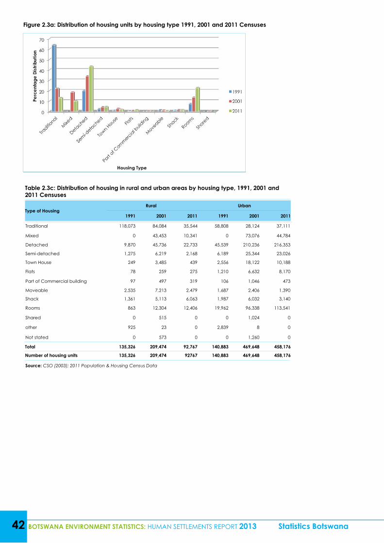
Table 2.3c: Distribution of housing in rural and urban areas by housing type, 1991, 2001 and 2011 Censuses
Type of HousingRural Urban
1991 2001 2011 1991 2001 2011
Traditional 118,073 84,084 35,544 58,808 28,124 37,111
Mixed 0 43,453 10,341 0 73,076 44,784
Detached 9,870 45,736 22,733 45,539 210,236 216,353
Semi-detached 1,275 6,219 2,168 6,189 25,344 23,026
Town House 249 3,485 439 2,556 18,122 10,188
Flats 78 259 275 1,210 6,632 8,170
Part of Commercial building 97 497 319 106 1,046 473
Moveable 2,535 7,213 2,479 1,687 2,406 1,390
Shack 1,361 5,113 6,063 1,987 6,032 3,140
Rooms 863 12,304 12,406 19,962 96,338 113,541
Shared 0 515 0 0 1,024 0
other 925 23 0 2,839 8 0
Not stated 0 573 0 0 1,260 0
Total 135,326 209,474 92,767 140,883 469,648 458,176
Number of housing units 135,326 209,474 92767 140,883 469,648 458,176
Source: CSO (2003); 2011 Population & Housing Census Data
42 BOTSWANA ENVIRONMENT STATISTICS: HUMAN SETTLEMENTS REPORT 2013 Statistics Botswana
Figure 2.3a: Distribution of housing units by housing type 1991, 2001 and 2011 Censuses
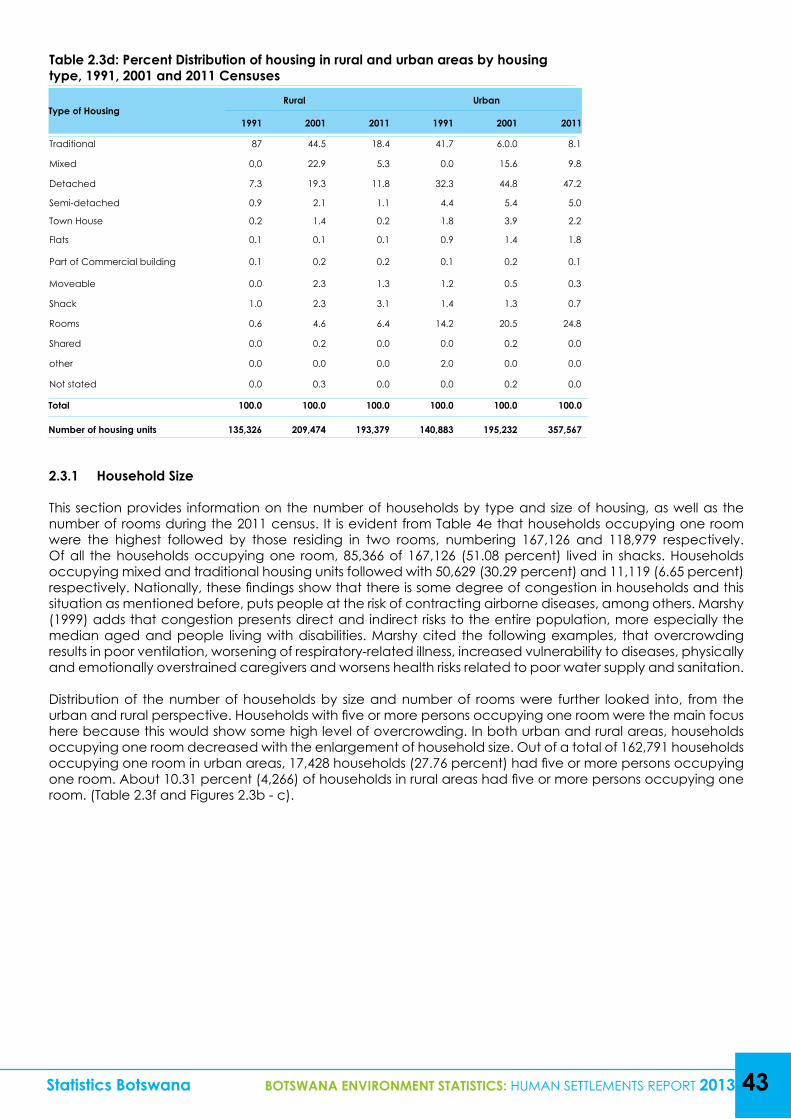
Table 2.3d: Percent Distribution of housing in rural and urban areas by housing type, 1991, 2001 and 2011 Censuses
Type of HousingRural Urban
1991 2001 2011 1991 2001 2011
Traditional 87 44.5 18.4 41.7 6.0.0 8.1
Mixed 0,0 22.9 5.3 0.0 15.6 9.8
Detached 7.3 19.3 11.8 32.3 44.8 47.2
Semi-detached 0.9 2.1 1.1 4.4 5.4 5.0
Town House 0.2 1.4 0.2 1.8 3.9 2.2
Flats 0.1 0.1 0.1 0.9 1.4 1.8
Part of Commercial building 0.1 0.2 0.2 0.1 0.2 0.1
Moveable 0.0 2.3 1.3 1.2 0.5 0.3
Shack 1.0 2.3 3.1 1.4 1.3 0.7
Rooms 0.6 4.6 6.4 14.2 20.5 24.8
Shared 0.0 0.2 0.0 0.0 0.2 0.0
other 0.0 0.0 0.0 2.0 0.0 0.0
Not stated 0.0 0.3 0.0 0.0 0.2 0.0
Total 100.0 100.0 100.0 100.0 100.0 100.0
Number of housing units 135,326 209,474 193,379 140,883 195,232 357,567
Statistics Botswana BOTSWANA ENVIRONMENT STATISTICS: HUMAN SETTLEMENTS REPORT 2013 43
2.3.1 Household Size
This section provides information on the number of households by type and size of housing, as well as the number of rooms during the 2011 census. It is evident from Table 4e that households occupying one room were the highest followed by those residing in two rooms, numbering 167,126 and 118,979 respectively. Of all the households occupying one room, 85,366 of 167,126 (51.08 percent) lived in shacks. Households occupying mixed and traditional housing units followed with 50,629 (30.29 percent) and 11,119 (6.65 percent) respectively. Nationally, these findings show that there is some degree of congestion in households and this situation as mentioned before, puts people at the risk of contracting airborne diseases, among others. Marshy (1999) adds that congestion presents direct and indirect risks to the entire population, more especially the median aged and people living with disabilities. Marshy cited the following examples, that overcrowding results in poor ventilation, worsening of respiratory-related illness, increased vulnerability to diseases, physically and emotionally overstrained caregivers and worsens health risks related to poor water supply and sanitation.
Distribution of the number of households by size and number of rooms were further looked into, from the urban and rural perspective. Households with five or more persons occupying one room were the main focus here because this would show some high level of overcrowding. In both urban and rural areas, households occupying one room decreased with the enlargement of household size. Out of a total of 162,791 households occupying one room in urban areas, 17,428 households (27.76 percent) had five or more persons occupying one room. About 10.31 percent (4,266) of households in rural areas had five or more persons occupying one room. (Table 2.3f and Figures 2.3b - c).
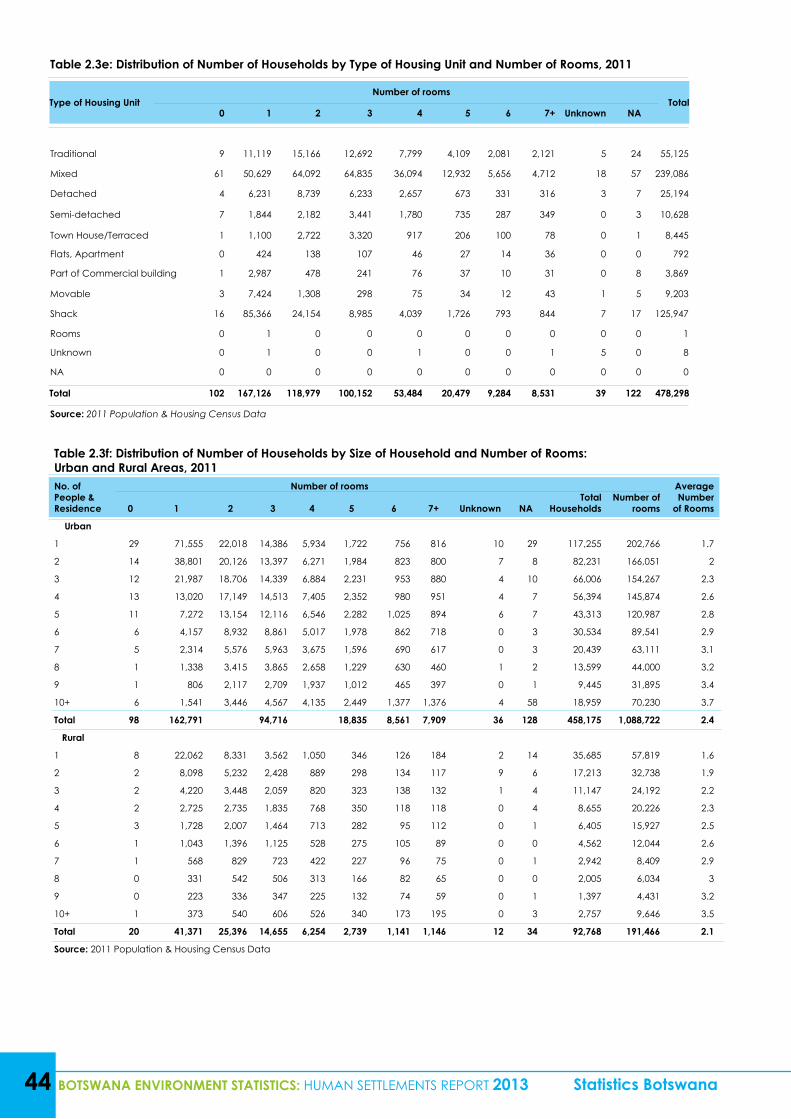
Table 2.3f: Distribution of Number of Households by Size of Household and Number of Rooms: Urban and Rural Areas, 2011No. of People & Residence
Number of roomsTotal
HouseholdsNumber of
rooms
Average Number
of Rooms0 1 2 3 4 5 6 7+ Unknown NA
Urban
1 29 71,555 22,018 14,386 5,934 1,722 756 816 10 29 117,255 202,766 1.7
2 14 38,801 20,126 13,397 6,271 1,984 823 800 7 8 82,231 166,051 2
3 12 21,987 18,706 14,339 6,884 2,231 953 880 4 10 66,006 154,267 2.3
4 13 13,020 17,149 14,513 7,405 2,352 980 951 4 7 56,394 145,874 2.6
5 11 7,272 13,154 12,116 6,546 2,282 1,025 894 6 7 43,313 120,987 2.8
6 6 4,157 8,932 8,861 5,017 1,978 862 718 0 3 30,534 89,541 2.9
7 5 2,314 5,576 5,963 3,675 1,596 690 617 0 3 20,439 63,111 3.1
8 1 1,338 3,415 3,865 2,658 1,229 630 460 1 2 13,599 44,000 3.2
9 1 806 2,117 2,709 1,937 1,012 465 397 0 1 9,445 31,895 3.4
10+ 6 1,541 3,446 4,567 4,135 2,449 1,377 1,376 4 58 18,959 70,230 3.7
Total 98 162,791 94,716 18,835 8,561 7,909 36 128 458,175 1,088,722 2.4
Rural
1 8 22,062 8,331 3,562 1,050 346 126 184 2 14 35,685 57,819 1.6
2 2 8,098 5,232 2,428 889 298 134 117 9 6 17,213 32,738 1.9
3 2 4,220 3,448 2,059 820 323 138 132 1 4 11,147 24,192 2.2
4 2 2,725 2,735 1,835 768 350 118 118 0 4 8,655 20,226 2.3
5 3 1,728 2,007 1,464 713 282 95 112 0 1 6,405 15,927 2.5
6 1 1,043 1,396 1,125 528 275 105 89 0 0 4,562 12,044 2.6
7 1 568 829 723 422 227 96 75 0 1 2,942 8,409 2.9
8 0 331 542 506 313 166 82 65 0 0 2,005 6,034 3
9 0 223 336 347 225 132 74 59 0 1 1,397 4,431 3.2
10+ 1 373 540 606 526 340 173 195 0 3 2,757 9,646 3.5
Total 20 41,371 25,396 14,655 6,254 2,739 1,141 1,146 12 34 92,768 191,466 2.1
Source: 2011 Population & Housing Census Data
44 BOTSWANA ENVIRONMENT STATISTICS: HUMAN SETTLEMENTS REPORT 2013 Statistics Botswana
Table 2.3e: Distribution of Number of Households by Type of Housing Unit and Number of Rooms, 2011
Type of Housing UnitNumber of rooms
Total0 1 2 3 4 5 6 7+ Unknown NA
Traditional 9 11,119 15,166 12,692 7,799 4,109 2,081 2,121 5 24 55,125
Mixed 61 50,629 64,092 64,835 36,094 12,932 5,656 4,712 18 57 239,086
Detached 4 6,231 8,739 6,233 2,657 673 331 316 3 7 25,194
Semi-detached 7 1,844 2,182 3,441 1,780 735 287 349 0 3 10,628
Town House/Terraced 1 1,100 2,722 3,320 917 206 100 78 0 1 8,445
Flats, Apartment 0 424 138 107 46 27 14 36 0 0 792
Part of Commercial building 1 2,987 478 241 76 37 10 31 0 8 3,869
Movable 3 7,424 1,308 298 75 34 12 43 1 5 9,203
Shack 16 85,366 24,154 8,985 4,039 1,726 793 844 7 17 125,947
Rooms 0 1 0 0 0 0 0 0 0 0 1
Unknown 0 1 0 0 1 0 0 1 5 0 8
NA 0 0 0 0 0 0 0 0 0 0 0
Total 102 167,126 118,979 100,152 53,484 20,479 9,284 8,531 39 122 478,298
Source: 2011 Population & Housing Census Data
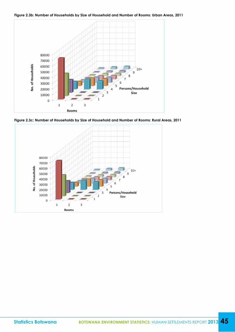
Statistics Botswana BOTSWANA ENVIRONMENT STATISTICS: HUMAN SETTLEMENTS REPORT 2013 45
Figure 2.3b: Number of Households by Size of Household and Number of Rooms: Urban Areas, 2011
Figure 2.3c: Number of Households by Size of Household and Number of Rooms: Rural Areas, 2011
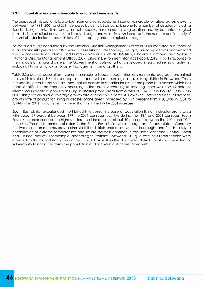
46 BOTSWANA ENVIRONMENT STATISTICS: HUMAN SETTLEMENTS REPORT 2013 Statistics Botswana
2.3.1 Population in zones vulnerable to natural extreme events
The purpose of this section is to provide information on population in zones vulnerable to natural extreme events between the 1991, 2001 and 2011 censuses by district. Botswana is prone to a number of disasters, including floods, drought, veldt fires, pests, animal diseases, environmental degradation and hydro-meteorological hazards. The principal ones include floods, drought and veldt fires. An increase in the number and intensity of natural disaster incidents result in loss of life, property and ecological damage.
“A detailed study conducted by the National Disaster Management Office in 2008 identified a number of disasters and risks prevalent in Botswana. These risks include flooding, drought, animal epidemics and wild land fires, motor vehicle accidents, and human epidemics such as HIV/AIDS, Cholera, Diarrhoea, and Malaria” (National Disaster Management Office, 2009; Cited in Environment Statistics Report, 2012: 119). In response to the impacts of natural disasters, the Government of Botswana has developed integrated series of activities including National Policy on Disaster Management, among others.
Table 2.3g depicts population in zones vulnerable to floods, drought, fires, environmental degradation, animal or insect infestation, insect over-population and hydro-meteorological hazards by district in Botswana. This is a crude indicator because it assumes that all persons in a particular district are prone to a hazard which has been identified to be frequently occurring in that area. According to Table 4g there was a 25.49 percent intercensal increase of population living in disaster prone areas from a total of 1,040,017 in 1991 to 1,305,086 in 2001. This gives an annual average growth rate of about 2.27 percent. However, Botswana’s annual average growth rate of population living in disaster prone areas increased by 1.94 percent from 1,305,086 in 2001 to 1,584,794 in 2011, which is slightly lower than that the 1991 – 2001 increase.
South East district experienced the highest intercensal increase of population living in disaster prone area with about 39 percent between 1991 to 2001 censuses. Just like during the 1991 and 2001 censuses, South East district experienced the highest intercensal increase of about 40 percent between the 2001 and 2011 censuses. The most common disasters in the South East district were drought and floods-related. Generally the two most common hazards in almost all the districts under review include drought and floods. Lastly, a combination of extreme temperatures and severe storms is common in the North West and Central (Boteti and Tutume) districts. For example, according to Statistics Botswana (2013), a total of 300 households were affected by floods and storm rain on the 10th of April 2010 in the North West district. This shows the extent of vulnerability to natural hazards the population of North West district are faced with.
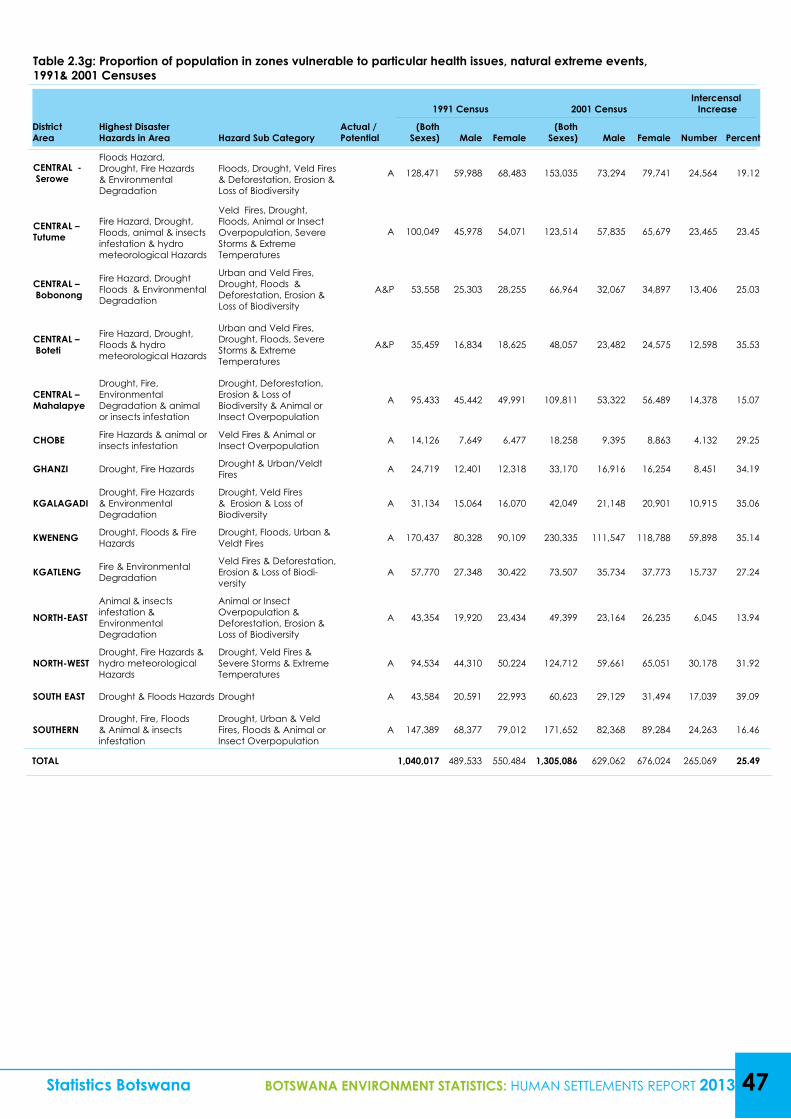
Statistics Botswana BOTSWANA ENVIRONMENT STATISTICS: HUMAN SETTLEMENTS REPORT 2013 47
Table 2.3g: Proportion of population in zones vulnerable to particular health issues, natural extreme events, 1991& 2001 Censuses
DistrictArea
Highest Disaster Hazards in Area Hazard Sub Category
Actual / Potential
1991 Census 2001 Census Intercensal Increase
(Both Sexes) Male Female
(Both Sexes) Male Female Number Percent
CENTRAL - Serowe
Floods Hazard, Drought, Fire Hazards & Environmental Degradation
Floods, Drought, Veld Fires & Deforestation, Erosion & Loss of Biodiversity
A 128,471 59,988 68,483 153,035 73,294 79,741 24,564 19.12
CENTRAL – Tutume
Fire Hazard, Drought, Floods, animal & insects infestation & hydro meteorological Hazards
Veld Fires, Drought, Floods, Animal or Insect Overpopulation, Severe Storms & Extreme Temperatures
A 100,049 45,978 54,071 123,514 57,835 65,679 23,465 23.45
CENTRAL – Bobonong
Fire Hazard, Drought Floods & Environmental Degradation
Urban and Veld Fires, Drought, Floods & Deforestation, Erosion & Loss of Biodiversity
A&P 53,558 25,303 28,255 66,964 32,067 34,897 13,406 25.03
CENTRAL – Boteti
Fire Hazard, Drought, Floods & hydro meteorological Hazards
Urban and Veld Fires, Drought, Floods, Severe Storms & Extreme Temperatures
A&P 35,459 16,834 18,625 48,057 23,482 24,575 12,598 35.53
CENTRAL –Mahalapye
Drought, Fire, Environmental Degradation & animal or insects infestation
Drought, Deforestation, Erosion & Loss of Biodiversity & Animal or Insect Overpopulation
A 95,433 45,442 49,991 109,811 53,322 56,489 14,378 15.07
CHOBE Fire Hazards & animal or insects infestation
Veld Fires & Animal or Insect Overpopulation A 14,126 7,649 6,477 18,258 9,395 8,863 4,132 29.25
GHANZI Drought, Fire Hazards Drought & Urban/Veldt Fires A 24,719 12,401 12,318 33,170 16,916 16,254 8,451 34.19
KGALAGADI Drought, Fire Hazards & Environmental Degradation
Drought, Veld Fires & Erosion & Loss of Biodiversity
A 31,134 15,064 16,070 42,049 21,148 20,901 10,915 35.06
KWENENG Drought, Floods & Fire Hazards
Drought, Floods, Urban & Veldt Fires A 170,437 80,328 90,109 230,335 111,547 118,788 59,898 35.14
KGATLENG Fire & Environmental Degradation
Veld Fires & Deforestation, Erosion & Loss of Biodi-versity
A 57,770 27,348 30,422 73,507 35,734 37,773 15,737 27.24
NORTH-EAST
Animal & insects infestation & Environmental Degradation
Animal or Insect Overpopulation & Deforestation, Erosion & Loss of Biodiversity
A 43,354 19,920 23,434 49,399 23,164 26,235 6,045 13.94
NORTH-WEST Drought, Fire Hazards & hydro meteorological Hazards
Drought, Veld Fires & Severe Storms & Extreme Temperatures
A 94,534 44,310 50,224 124,712 59,661 65,051 30,178 31.92
SOUTH EAST Drought & Floods Hazards Drought A 43,584 20,591 22,993 60,623 29,129 31,494 17,039 39.09
SOUTHERN Drought, Fire, Floods & Animal & insects infestation
Drought, Urban & Veld Fires, Floods & Animal or Insect Overpopulation
A 147,389 68,377 79,012 171,652 82,368 89,284 24,263 16.46
TOTAL 1,040,017 489,533 550,484 1,305,086 629,062 676,024 265,069 25.49
48 BOTSWANA ENVIRONMENT STATISTICS: HUMAN SETTLEMENTS REPORT 2013 Statistics Botswana
Table2.3g: Proportion of population in zones vulnerable to particular health issues, natural extreme events, 2001& 2011 Censuses Continued…
DistrictArea
Highest Disaster Hazards in Area
Hazard Sub Category
Actual / Potential
2001 Census 2011 Census Intercensal
IncreaseAnnual
Aver-age
Growth Rate
(%) (Both
Sexes) Male Female (Both
Sexes) Male Female NumberPer-cent
CENTRAL - Serowe
Floods Hazard, Drought, Fire Hazards & Environmental Degradation
Floods, Drought, Veld Fires & Deforestation, Erosion & Loss of Biodiversity
A 153,035 73,294 79,741 180,500 88,889 91,611 27,465 17.95 1.65
CENTRAL – Tutume
Fire Hazard, Drought, Floods, animal & insects infestation & hydro meteorological Hazards
Veld Fires, Drought, Floods, Animal or Insect Overpopulation, Severe Storms & Extreme Temperatures
A 123,514 57,835 65,679 147,377 70,340 77,037 23,863 19.32 1.77
CENTRAL – Bobonong
Fire Hazard, Drought Floods & Environmental Degradation
Urban and Veld Fires, Drought, Floods & Deforestation, Erosion & Loss of Biodiversity
A&P 66,964 32,067 34,897 71,936 34,249 37,687 4,972 7.42 0.72
CENTRAL –Boteti
Fire Hazard, Drought, Floods & hydro meteorological Hazards
Urban and Veld Fires, Drought, Floods, Severe Storms & Extreme Temperatures
A&P 48,057 23,482 24,575 57,376 28,147 29,229 9,319 19.39 1.77
CENTRAL –Mahalapye
Drought, Fire, Environmental Degradation & animal or insects infestation
Drought, Deforestation, Erosion & Loss of Biodiversity & Animal or Insect Overpopulation
A 109,811 53,322 56,489 118,875 57,548 61,327 9,064 8.25 0.79
CHOBE Fire Hazards & animal or insects infestation
Veld Fires & Animal or Insect Overpopulation
A 18,258 9,395 8,863 23,347 12,023 11,324 5,089 27.87 2.46
GHANZI Drought, Fire Hazards
Drought & Urban/Veldt Fires A 33,170 16,916 16,254 43,355 22,461 20,894 10,185 30.71 2.68
KGALAGADI Drought, Fire Hazards & Environmental Degradation
Drought, Veld Fires & Erosion & Loss of Biodiversity A 42,049 21,148 20,901 50,492 25,466 25,026 8,443 20.08 1.83
KWENENG Drought, Floods & Fire Hazards
Drought, Floods, Urban & Veldt Fires A 230,335 111,547 118,788 304,549 149,616 154,933 74,214 32.22 2.79
KGATLENG Fire & Environmental Degradation
Veld Fires & Deforestation, Erosion & Loss of Biodiversity
A 73,507 35,734 37,773 91,660 44,572 47,088 18,153 24.7 2.21
NORTH-EAST Animal & insects infestation & Environmental Degradation
Animal or Insect Overpopulation & Deforestation, Erosion & Loss of Biodiversity
A 49,399 23,164 26,235 60,264 28,595 31,669 10,865 21.99 1.99
NORTH-WEST
Drought, Fire Hazards & hydro meteorological Hazards
Drought, Veld Fires & Severe Storms & Extreme Temperatures
A 124,712 59,661 65,051 152,284 73,611 78,673 27,572 22.11 2
SOUTH EAST Drought & Floods Hazards
Drought A 60,623 29,129 31,494 85,014 40699 44315 24,391 40.23 3.38
SOUTHERN Drought, Fire, Floods & Animal & insects infestation
Drought, Urban & Veld Fires, Floods & Animal or Insect Overpopulation
A 171,652 82,368 89,284 197,767 95,817 101,950 26,115 15.21 1.42
TOTAL 1,305,086 629,062 676,024 1,584,796 772,033 812,763 279,710 21.43 1.94
Source: NDMO; 2011 Population & Housing Census Data
Statistics Botswana BOTSWANA ENVIRONMENT STATISTICS: HUMAN SETTLEMENTS REPORT 2013 49
2.3.3 Flood Occurrences
Information on flood and storm occurrence by year, location, number of households and individuals affected, and assistance given is presented in this sub-section. Flooding usually takes place in a situation where water overflows in a dry place or within existing water bodies. On the other hand a “storm” is defined as a violent disturbance of the atmosphere with strong winds, and usually rain, thunder, lightning, or snow (Statistics Botswana, 2013: 119). A combination of both storms and floods occurrence are common in Botswana, and they are destructive by nature.
Table 2.3hand Figures 2.3d – 2.3e show natural disasters incidents during the years 2010 –2013 by district, individuals affected and assistance given. It is evident from the table that Ngamiland district experienced more floods than any other district during the year 2010. The floods affected ten villages, and within those villages 168 households and 800 individuals were victims of the disaster. Furthermore, a total of 235 tents were issued to the victims of the 2010 floods in Ngamiland district to provide temporary shelter. Maun alone had a total of 568 individuals displaced by storm rains in 2010. In 2012, storm rains in Mahalapye sub-district affected329households, displacing 1,756 people. As a result, a total of 119 tents and 322 food baskets were issued to the victims. During the year 2010 a total of 212 people in 32 households were affected by a combination of hailstorms and heavy rains in Kgatleng district in 2010. In 2013 alone, the most occurring incident was the hailstorm.
Out of a total of 164 households affected by natural disasters in 2013, 137 (83.54 percent) were hit by hailstorm while the remaining 27 (16.46 percent) were affected by storm rains. Kgatleng district was the hardest hit with 81 households (49.39 percent) and 242 individuals affected, resulting in 32 tents and 27 food baskets provided for relief.
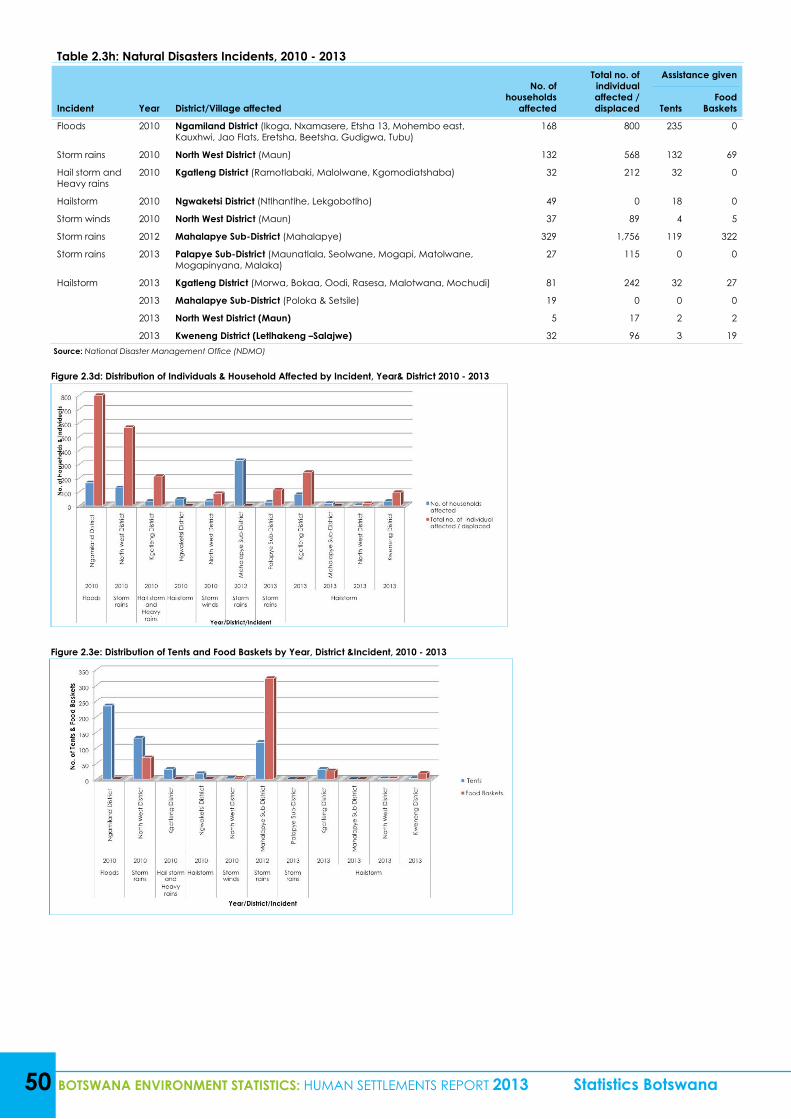
Table 2.3h: Natural Disasters Incidents, 2010 - 2013
Incident Year District/Village affected
No. of households
affected
Total no. of individual affected / displaced
Assistance given
TentsFood
Baskets
Floods 2010 Ngamiland District (Ikoga, Nxamasere, Etsha 13, Mohembo east, Kauxhwi, Jao Flats, Eretsha, Beetsha, Gudigwa, Tubu)
168 800 235 0
Storm rains 2010 North West District (Maun) 132 568 132 69
Hail storm and Heavy rains
2010 Kgatleng District (Ramotlabaki, Malolwane, Kgomodiatshaba) 32 212 32 0
Hailstorm 2010 Ngwaketsi District (Ntlhantlhe, Lekgobotlho) 49 0 18 0
Storm winds 2010 North West District (Maun) 37 89 4 5
Storm rains 2012 Mahalapye Sub-District (Mahalapye) 329 1,756 119 322
Storm rains 2013 Palapye Sub-District (Maunatlala, Seolwane, Mogapi, Matolwane, Mogapinyana, Malaka)
27 115 0 0
Hailstorm 2013 Kgatleng District (Morwa, Bokaa, Oodi, Rasesa, Malotwana, Mochudi) 81 242 32 27
2013 Mahalapye Sub-District (Poloka & Setsile) 19 0 0 0
2013 North West District (Maun) 5 17 2 2
2013 Kweneng District (Letlhakeng –Salajwe) 32 96 3 19
50 BOTSWANA ENVIRONMENT STATISTICS: HUMAN SETTLEMENTS REPORT 2013 Statistics Botswana
Figure 2.3d: Distribution of Individuals & Household Affected by Incident, Year& District 2010 - 2013
Figure 2.3e: Distribution of Tents and Food Baskets by Year, District &Incident, 2010 - 2013
Source: National Disaster Management Office (NDMO)
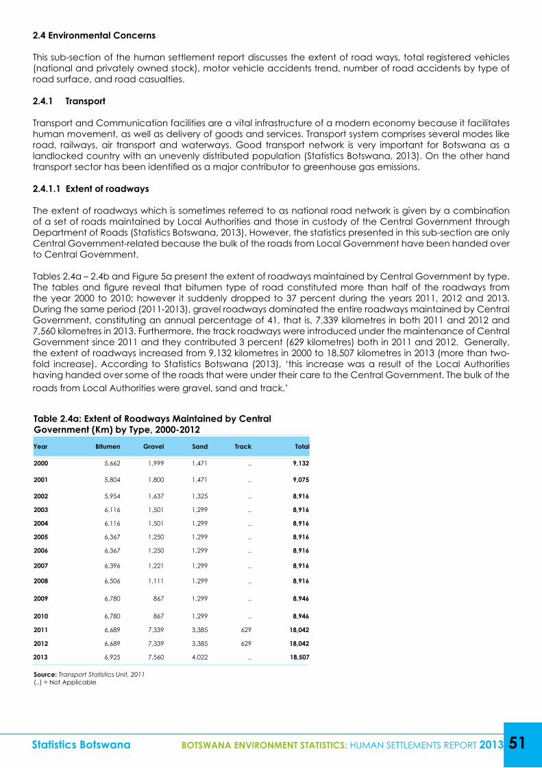
Statistics Botswana BOTSWANA ENVIRONMENT STATISTICS: HUMAN SETTLEMENTS REPORT 2013 51
2.4 Environmental Concerns
This sub-section of the human settlement report discusses the extent of road ways, total registered vehicles (national and privately owned stock), motor vehicle accidents trend, number of road accidents by type of road surface, and road casualties.
2.4.1 Transport
Transport and Communication facilities are a vital infrastructure of a modern economy because it facilitates human movement, as well as delivery of goods and services. Transport system comprises several modes like road, railways, air transport and waterways. Good transport network is very important for Botswana as a landlocked country with an unevenly distributed population (Statistics Botswana, 2013). On the other hand transport sector has been identified as a major contributor to greenhouse gas emissions.
2.4.1.1 Extent of roadways
The extent of roadways which is sometimes referred to as national road network is given by a combination of a set of roads maintained by Local Authorities and those in custody of the Central Government through Department of Roads (Statistics Botswana, 2013). However, the statistics presented in this sub-section are only Central Government-related because the bulk of the roads from Local Government have been handed over to Central Government.
Tables 2.4a – 2.4b and Figure 5a present the extent of roadways maintained by Central Government by type. The tables and figure reveal that bitumen type of road constituted more than half of the roadways from the year 2000 to 2010; however it suddenly dropped to 37 percent during the years 2011, 2012 and 2013. During the same period (2011-2013), gravel roadways dominated the entire roadways maintained by Central Government, constituting an annual percentage of 41, that is, 7,339 kilometres in both 2011 and 2012 and 7,560 kilometres in 2013. Furthermore, the track roadways were introduced under the maintenance of Central Government since 2011 and they contributed 3 percent (629 kilometres) both in 2011 and 2012. Generally, the extent of roadways increased from 9,132 kilometres in 2000 to 18,507 kilometres in 2013 (more than two-fold increase). According to Statistics Botswana (2013), ‘this increase was a result of the Local Authorities having handed over some of the roads that were under their care to the Central Government. The bulk of the roads from Local Authorities were gravel, sand and track.’
Table 2.4a: Extent of Roadways Maintained by Central Government (Km) by Type, 2000-2012Year Bitumen Gravel Sand Track Total
2000 5,662 1,999 1,471 .. 9,132
2001 5,804 1,800 1,471 .. 9,075
2002 5,954 1,637 1,325 .. 8,916
2003 6,116 1,501 1,299 .. 8,916
2004 6,116 1,501 1,299 .. 8,916
2005 6,367 1,250 1,299 .. 8,916
2006 6,367 1,250 1,299 .. 8,916
2007 6,396 1,221 1,299 .. 8,916
2008 6,506 1,111 1,299 .. 8,916
2009 6,780 867 1,299 .. 8,946
2010 6,780 867 1,299 .. 8,946
2011 6,689 7,339 3,385 629 18,042
2012 6,689 7,339 3,385 629 18,042
2013 6,925 7,560 4,022 .. 18,507
Source: Transport Statistics Unit, 2011(..) = Not Applicable
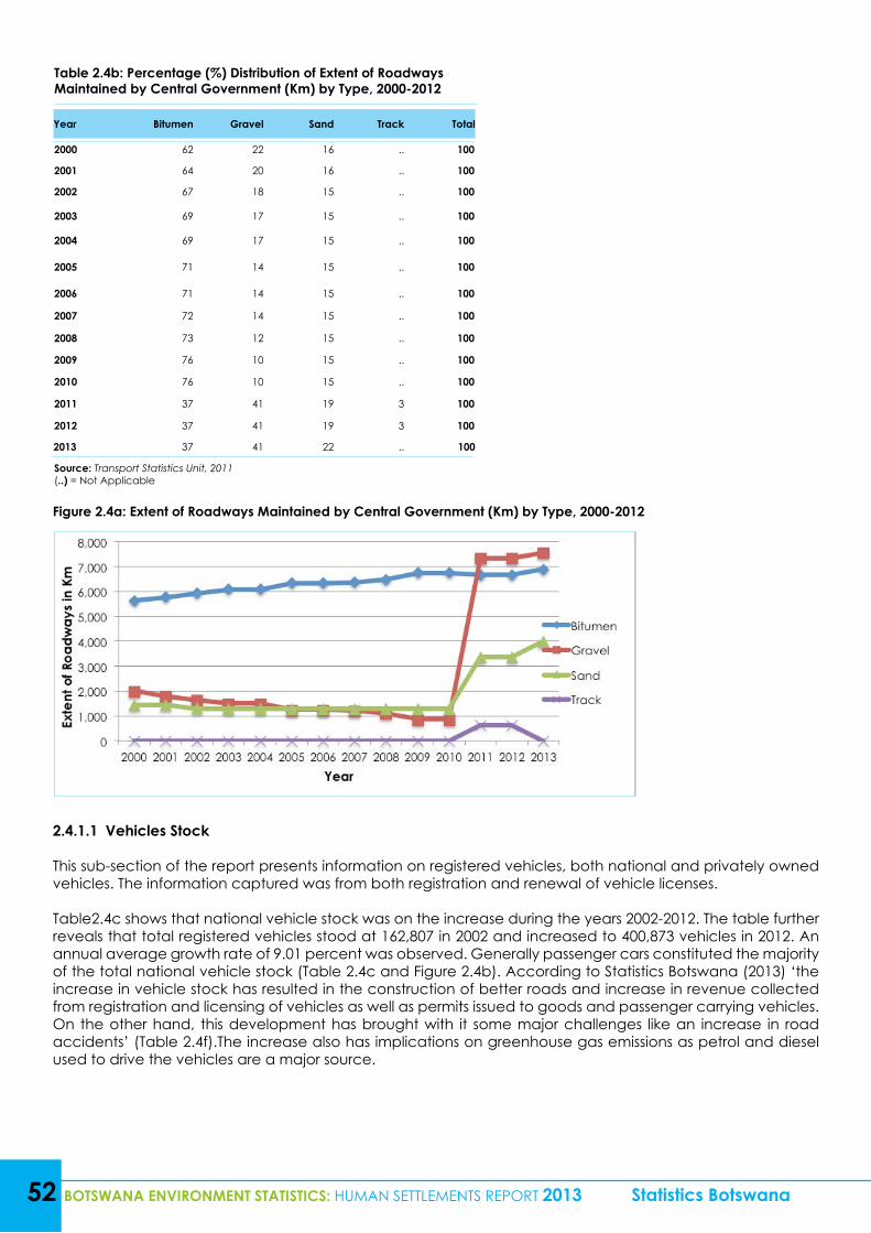
52 BOTSWANA ENVIRONMENT STATISTICS: HUMAN SETTLEMENTS REPORT 2013 Statistics Botswana
Table 2.4b: Percentage (%) Distribution of Extent of Roadways Maintained by Central Government (Km) by Type, 2000-2012
Year Bitumen Gravel Sand Track Total
2000 62 22 16 .. 100
2001 64 20 16 .. 100
2002 67 18 15 .. 100
2003 69 17 15 .. 100
2004 69 17 15 .. 100
2005 71 14 15 .. 100
2006 71 14 15 .. 100
2007 72 14 15 .. 100
2008 73 12 15 .. 100
2009 76 10 15 .. 100
2010 76 10 15 .. 100
2011 37 41 19 3 100
2012 37 41 19 3 100
2013 37 41 22 .. 100
Source: Transport Statistics Unit, 2011(..) = Not Applicable
Figure 2.4a: Extent of Roadways Maintained by Central Government (Km) by Type, 2000-2012
2.4.1.1 Vehicles Stock
This sub-section of the report presents information on registered vehicles, both national and privately owned vehicles. The information captured was from both registration and renewal of vehicle licenses. Table2.4c shows that national vehicle stock was on the increase during the years 2002-2012. The table further reveals that total registered vehicles stood at 162,807 in 2002 and increased to 400,873 vehicles in 2012. An annual average growth rate of 9.01 percent was observed. Generally passenger cars constituted the majority of the total national vehicle stock (Table 2.4c and Figure 2.4b). According to Statistics Botswana (2013) ‘the increase in vehicle stock has resulted in the construction of better roads and increase in revenue collected from registration and licensing of vehicles as well as permits issued to goods and passenger carrying vehicles. On the other hand, this development has brought with it some major challenges like an increase in road accidents’ (Table 2.4f).The increase also has implications on greenhouse gas emissions as petrol and diesel used to drive the vehicles are a major source.
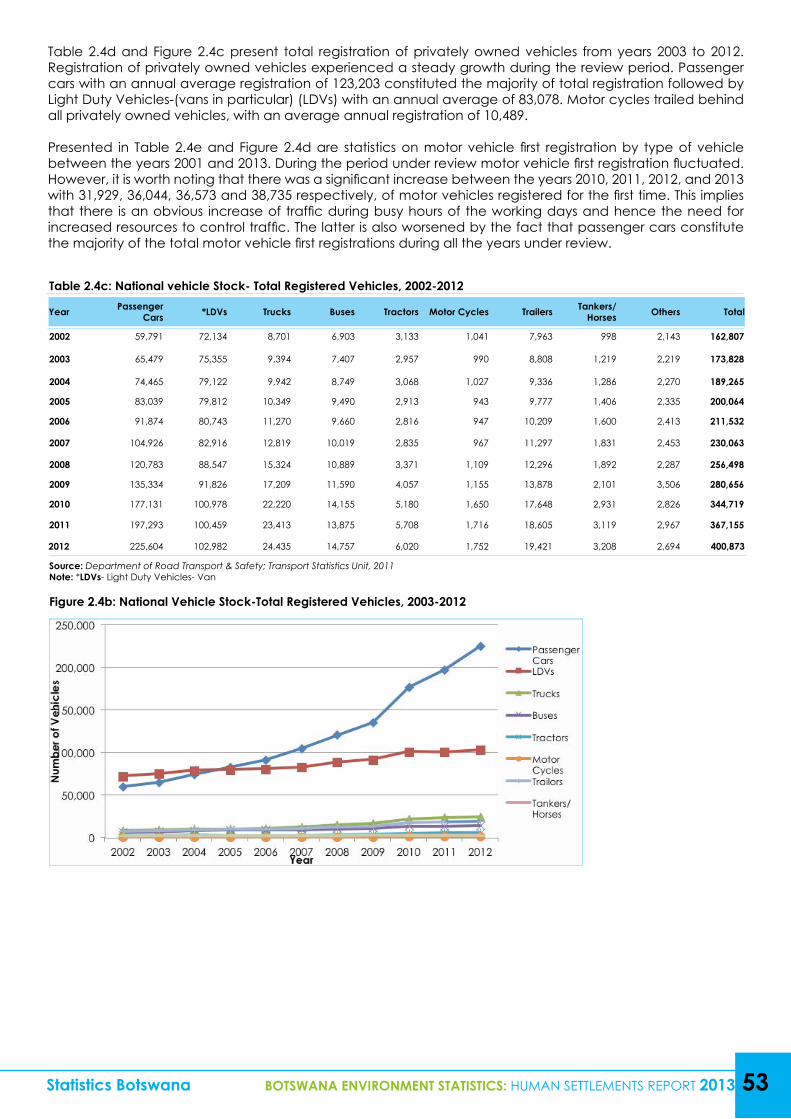
Statistics Botswana BOTSWANA ENVIRONMENT STATISTICS: HUMAN SETTLEMENTS REPORT 2013 53
Table 2.4d and Figure 2.4c present total registration of privately owned vehicles from years 2003 to 2012. Registration of privately owned vehicles experienced a steady growth during the review period. Passenger cars with an annual average registration of 123,203 constituted the majority of total registration followed by Light Duty Vehicles-(vans in particular) (LDVs) with an annual average of 83,078. Motor cycles trailed behind all privately owned vehicles, with an average annual registration of 10,489.
Presented in Table 2.4e and Figure 2.4d are statistics on motor vehicle first registration by type of vehicle between the years 2001 and 2013. During the period under review motor vehicle first registration fluctuated. However, it is worth noting that there was a significant increase between the years 2010, 2011, 2012, and 2013 with 31,929, 36,044, 36,573 and 38,735 respectively, of motor vehicles registered for the first time. This implies that there is an obvious increase of traffic during busy hours of the working days and hence the need for increased resources to control traffic. The latter is also worsened by the fact that passenger cars constitute the majority of the total motor vehicle first registrations during all the years under review.
Table 2.4c: National vehicle Stock- Total Registered Vehicles, 2002-2012
Year Passenger Cars *LDVs Trucks Buses Tractors Motor Cycles Trailers Tankers/
Horses Others Total
2002 59,791 72,134 8,701 6,903 3,133 1,041 7,963 998 2,143 162,807
2003 65,479 75,355 9,394 7,407 2,957 990 8,808 1,219 2,219 173,828
2004 74,465 79,122 9,942 8,749 3,068 1,027 9,336 1,286 2,270 189,265
2005 83,039 79,812 10,349 9,490 2,913 943 9,777 1,406 2,335 200,064
2006 91,874 80,743 11,270 9,660 2,816 947 10,209 1,600 2,413 211,532
2007 104,926 82,916 12,819 10,019 2,835 967 11,297 1,831 2,453 230,063
2008 120,783 88,547 15,324 10,889 3,371 1,109 12,296 1,892 2,287 256,498
2009 135,334 91,826 17,209 11,590 4,057 1,155 13,878 2,101 3,506 280,656
2010 177,131 100,978 22,220 14,155 5,180 1,650 17,648 2,931 2,826 344,719
2011 197,293 100,459 23,413 13,875 5,708 1,716 18,605 3,119 2,967 367,155
2012 225,604 102,982 24,435 14,757 6,020 1,752 19,421 3,208 2,694 400,873
Source: Department of Road Transport & Safety; Transport Statistics Unit, 2011Note: *LDVs- Light Duty Vehicles- Van
Figure 2.4b: National Vehicle Stock-Total Registered Vehicles, 2003-2012
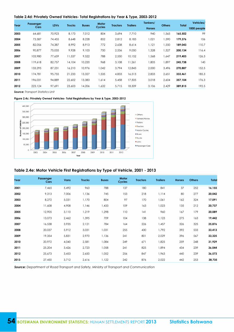
54 BOTSWANA ENVIRONMENT STATISTICS: HUMAN SETTLEMENTS REPORT 2013 Statistics Botswana
Table 2.4d: Privately Owned Vehicles- Total Registrations by Year & Type, 2003-2012
Year Passenger Cars LDVs Trucks Buses Motor
Cycles Tractors TrailersTankers/
Others TotalVehicles/
Horses 1000 people
2003 64,681 70,923 8,173 7,012 804 3,694 7,710 940 1,565 165,502 99
2004 73,587 74,455 8,648 8,228 852 2,812 8,183 1,021 1,590 179,376 106
2005 82,056 74,387 8,992 8,913 772 2,638 8,614 1,121 1,550 189,043 110.7
2006 90,877 75,035 9,928 9,103 750 2,536 9,050 1,328 1,527 200,134 116.4
2007 103,980 77,659 11,537 9,522 788 2,550 10,152 1,568 1,647 219,403 126.3
2008 119,618 82,757 14,104 10,220 968 3,108 11,261 1,805 1,897 245,738 140
2009 133,295 87,231 16,210 10,976 1,042 3,794 12,843 2,000 3,496 270,887 152.5
2010 174,781 95,755 21,233 13,327 1,535 4,833 16,513 2,833 2,651 333,461 185.3
2011 196,031 94,889 22,602 13,383 1,614 5,458 17,505 3,018 2,604 357,104 176.3
2012 223,124 97,691 23,603 14,206 1,632 5,715 18,309 3,106 2,429 389,815 192.5
Source: Transport Statistics Unit
Figure 2.4c: Privately Owned Vehicles- Total Registrations by Year & Type, 2003-2012
Table 2.4e: Motor Vehicle First Registrations by Type of Vehicle, 2001 - 2013
Year Passenger Cars Vans Trucks Buses Motor
Cycles Tractors Trailers Horses Others Total
2001 7,465 5,492 963 788 137 180 841 37 252 16,155
2002 9,313 7,006 1,136 745 153 218 1,114 80 277 20,042
2003 8,272 5,031 1,170 804 97 170 1,061 162 324 17,091
2004 11,608 4,908 1,146 1,433 109 163 1,023 135 212 20,737
2005 12,905 3,110 1,219 1,298 110 141 960 167 179 20,089
2006 13,073 2,462 1,395 709 104 138 1,123 275 163 19,442
2007 16,538 3,935 2,121 784 164 226 1,457 326 325 25,876
2008 20,037 5,912 3,031 1,031 255 430 1,792 392 533 33,413
2009 19,354 5,831 2,970 1,136 241 801 2,029 396 567 33,325
2010 20,972 4,040 2,581 1,084 249 671 1,825 259 248 31,929
2011 25,204 3,426 2,723 1,058 241 825 1,894 434 239 36,044
2012 25,673 3,453 2,650 1,052 256 847 1,963 440 239 36,573
2013 27,450 3,712 2,616 1,122 242 876 2,022 442 253 38,735
Source: Department of Road Transport and Safety, Ministry of Transport and Communication
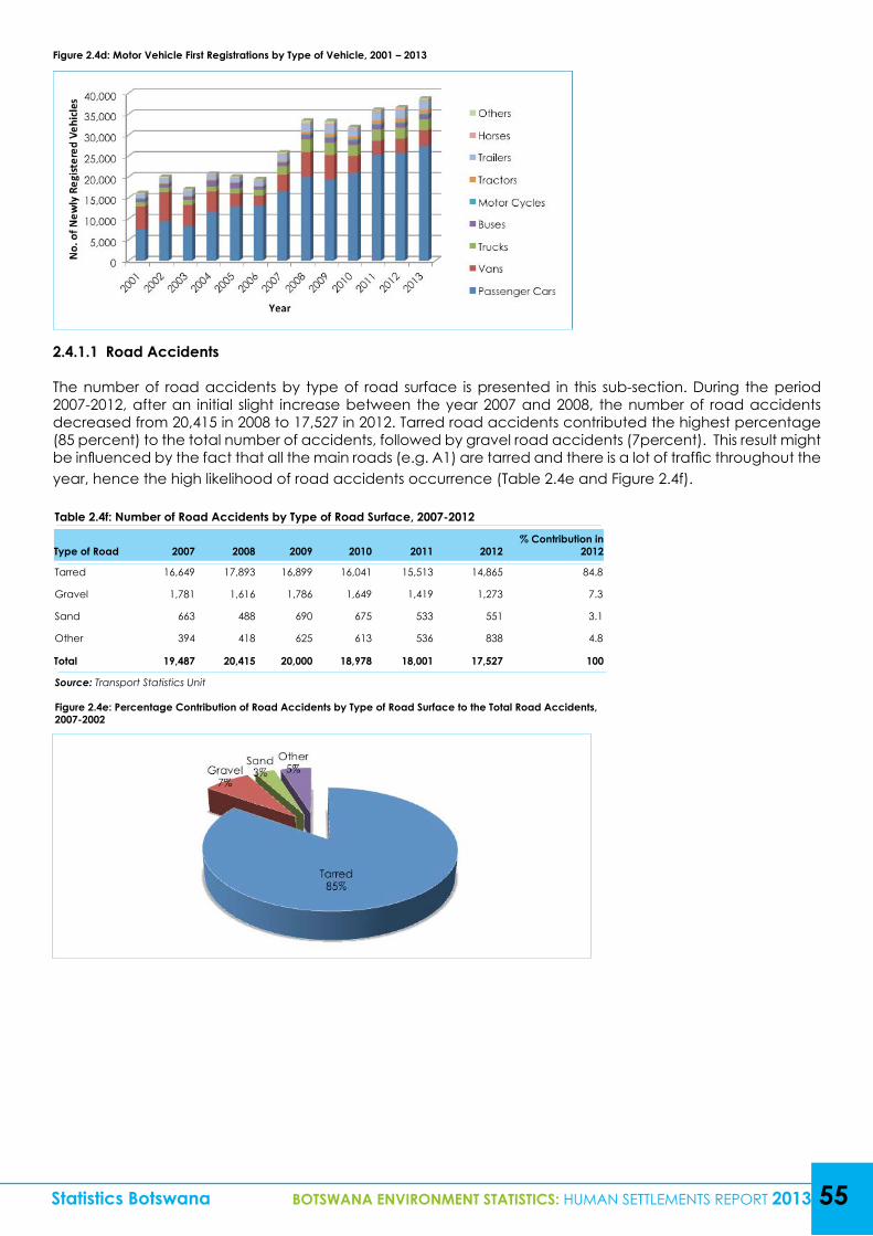
Table 2.4f: Number of Road Accidents by Type of Road Surface, 2007-2012
Type of Road 2007 2008 2009 2010 2011 2012% Contribution in
2012
Tarred 16,649 17,893 16,899 16,041 15,513 14,865 84.8
Gravel 1,781 1,616 1,786 1,649 1,419 1,273 7.3
Sand 663 488 690 675 533 551 3.1
Other 394 418 625 613 536 838 4.8
Total 19,487 20,415 20,000 18,978 18,001 17,527 100
Source: Transport Statistics Unit
Figure 2.4e: Percentage Contribution of Road Accidents by Type of Road Surface to the Total Road Accidents, 2007-2002
Statistics Botswana BOTSWANA ENVIRONMENT STATISTICS: HUMAN SETTLEMENTS REPORT 2013 55
Figure 2.4d: Motor Vehicle First Registrations by Type of Vehicle, 2001 – 2013
2.4.1.1 Road Accidents
The number of road accidents by type of road surface is presented in this sub-section. During the period 2007-2012, after an initial slight increase between the year 2007 and 2008, the number of road accidents decreased from 20,415 in 2008 to 17,527 in 2012. Tarred road accidents contributed the highest percentage (85 percent) to the total number of accidents, followed by gravel road accidents (7percent). This result might be influenced by the fact that all the main roads (e.g. A1) are tarred and there is a lot of traffic throughout the year, hence the high likelihood of road accidents occurrence (Table 2.4e and Figure 2.4f).
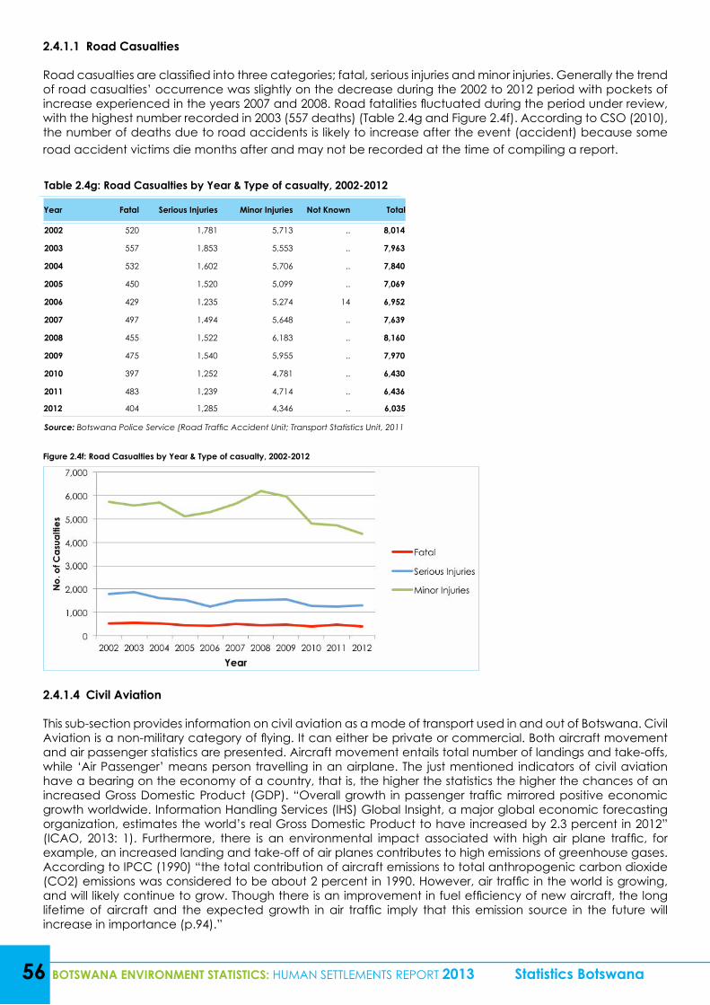
56 BOTSWANA ENVIRONMENT STATISTICS: HUMAN SETTLEMENTS REPORT 2013 Statistics Botswana
2.4.1.1 Road Casualties
Road casualties are classified into three categories; fatal, serious injuries and minor injuries. Generally the trend of road casualties’ occurrence was slightly on the decrease during the 2002 to 2012 period with pockets of increase experienced in the years 2007 and 2008. Road fatalities fluctuated during the period under review, with the highest number recorded in 2003 (557 deaths) (Table 2.4g and Figure 2.4f). According to CSO (2010), the number of deaths due to road accidents is likely to increase after the event (accident) because some road accident victims die months after and may not be recorded at the time of compiling a report.
Table 2.4g: Road Casualties by Year & Type of casualty, 2002-2012
Year Fatal Serious Injuries Minor Injuries Not Known Total
2002 520 1,781 5,713 .. 8,014
2003 557 1,853 5,553 .. 7,963
2004 532 1,602 5,706 .. 7,840
2005 450 1,520 5,099 .. 7,069
2006 429 1,235 5,274 14 6,952
2007 497 1,494 5,648 .. 7,639
2008 455 1,522 6,183 .. 8,160
2009 475 1,540 5,955 .. 7,970
2010 397 1,252 4,781 .. 6,430
2011 483 1,239 4,714 .. 6,436
2012 404 1,285 4,346 .. 6,035
Source: Botswana Police Service (Road Traffic Accident Unit; Transport Statistics Unit, 2011
Figure 2.4f: Road Casualties by Year & Type of casualty, 2002-2012
2.4.1.4 Civil Aviation
This sub-section provides information on civil aviation as a mode of transport used in and out of Botswana. Civil Aviation is a non-military category of flying. It can either be private or commercial. Both aircraft movement and air passenger statistics are presented. Aircraft movement entails total number of landings and take-offs, while ‘Air Passenger’ means person travelling in an airplane. The just mentioned indicators of civil aviation have a bearing on the economy of a country, that is, the higher the statistics the higher the chances of an increased Gross Domestic Product (GDP). “Overall growth in passenger traffic mirrored positive economic growth worldwide. Information Handling Services (IHS) Global Insight, a major global economic forecasting organization, estimates the world’s real Gross Domestic Product to have increased by 2.3 percent in 2012” (ICAO, 2013: 1). Furthermore, there is an environmental impact associated with high air plane traffic, for example, an increased landing and take-off of air planes contributes to high emissions of greenhouse gases. According to IPCC (1990) “the total contribution of aircraft emissions to total anthropogenic carbon dioxide (CO2) emissions was considered to be about 2 percent in 1990. However, air traffic in the world is growing, and will likely continue to grow. Though there is an improvement in fuel efficiency of new aircraft, the long lifetime of aircraft and the expected growth in air traffic imply that this emission source in the future will increase in importance (p.94).”
Table 2.4i: Air Passenger Movement by Month and Type, January -Dec 2011, 2012 & 2013
2011 2012 2013
Quarter International Domestic Total International Domestic Total International Domestic Total
Q1 90,447 74,083 164,530 87,164 77,018 164,182 88,220 77,117 165,337
Q2 106,507 94,509 201,016 98,857 94,364 193,221 100,534 91,329 191,863
Q3 113,459 108,299 221,758 109,466 104,075 213,541 112,325 114,206 226,531
Q4 103,147 98,010 201,157 104,156 89,872 194,028 105,359 94,561 199,920
Total 413,560 374,901 788,461 399,643 365,329 764,972 406,438 377,213 783,651
Source: Civil Aviation Authority of Botswana
Statistics Botswana BOTSWANA ENVIRONMENT STATISTICS: HUMAN SETTLEMENTS REPORT 2013 57
Table 2.4h shows that total aircraft movement (international and domestic) reduced from 82,799 in 2011 to 80,164 in 2012 then increased to 86,363 in 2013. On the other hand, air passenger movement also followed the same pattern, decreasing from 788,461 in 2011 to 764,972 in 2012 then increasing to 783,651 in 2013 (Table 2.4i). The increase in both air passenger movement and aircraft movement followed the same pattern as that of the country’s Real GDP, implying that they also contributed to the growth of the economy.
Table 2.4h: Aircraft Movement by Month and Type of Movement, January -Dec 2011, 2012 & 20132011 2012 2013
Quarter International Domestic Total International Domestic Total International Domestic Total
Q1 4,136 11,194 15,330 3,718 11,600 15,318 4,193 13,533 17,726
Q2 5,494 15,966 21,460 4,638 16,391 21,029 4,696 17,291 21,987
Q3 5,796 19,592 25,388 5,108 19,318 24,426 5,399 19,482 24,881
Q4 4,538 16,083 20,621 4,421 14,970 19,391 4,536 17,233 21,769
Total 19,964 62,835 82,799 17,885 62,279 80,164 18,824 67,539 86,363
Source: Civil Aviation Authority of Botswana
3.0 ENVIRONMENTAL HEALTH SECTION
The second sub-component of the fifth Component of the Framework for the Development of Environmental Statistics (FDES) is on environmental health. Environmental health refers to aspects of the human health and disease that are determined by factors in the environment (United Nations Statistics Division; 2013). Anthropogenic activity results in changes in environmental conditions which in turn have an impact on human health. The assimilative capacity and the resilience of the environment to impacts caused by human habitation can influence the health of human settlements and that of the natural environment (United Nations Statistics Division; 2013).
This part of the report looks into the human health aspects of environmental health, the effects in the causative relationship between environmental conditions and human health. While it is determined that environmental conditions will have an impact on human health, the causal relationship between the two aspects is not always immediately apparent when cases of human health problems are investigated. This report does not purport that the disease cases observed herein were solely the result of environmental conditions, or that they are to any extent determined by any known environmental conditions. The current data availability of environmental indicators limits such correlation analysis as to confidently determine the causes of the trends in disease cases. This report therefore acts as the first step towards the systematic collection of data on diseases that are identified as largely determined by environmental factors and conditions. This is facilitated by the existence of health data in the health sector. Trends in environmental diseases are herein observed.
3.1 Airborne Diseases and Conditions
This includes all airborne diseases and conditions that are caused or worsened by exposure to unhealthy levels of pollutants in the air, such as particulate matter and sulphur dioxide or trioxide (FDES;2013). Examples given by the FDES are of upper and lower respiratory disease, obstructive pulmonary disease, asthma and allergic rhinitis. In the medical fraternity, airborne diseases are those that spread by droplet infection, when an infected individual sneezes or coughs and releases droplets into the air, which are
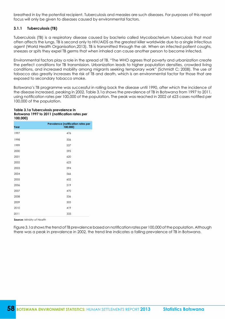
58 BOTSWANA ENVIRONMENT STATISTICS: HUMAN SETTLEMENTS REPORT 2013 Statistics Botswana
breathed in by the potential recipient. Tuberculosis and measles are such diseases. For purposes of this report focus will only be given to diseases caused by environmental factors.
3.1.1 Tuberculosis (TB)
Tuberculosis (TB) is a respiratory disease caused by bacteria called Mycobacterium tuberculosis that most often affects the lungs. TB is second only to HIV/AIDS as the greatest killer worldwide due to a single infectious agent (World Health Organisation,2013). TB is transmitted through the air. When an infected patient coughs, sneezes or spits they expel TB germs that when inhaled can cause another person to become infected.
Environmental factors play a role in the spread of TB. “The WHO agrees that poverty and urbanization create the perfect conditions for TB transmission. Urbanization leads to higher population densities, crowded living conditions, and increased mobility among migrants seeking temporary work” (Schmidt C; 2008). The use of tobacco also greatly increases the risk of TB and death, which is an environmental factor for those that are exposed to secondary tobacco smoke.
Botswana’s TB programme was successful in rolling back the disease until 1990, after which the incidence of the disease increased, peaking in 2002. Table 3.1a shows the prevalence of TB in Botswana from 1997 to 2011, using notification rates per 100,000 of the population. The peak was reached in 2002 at 623 cases notified per 100,000 of the population.
Table 3.1a Tuberculosis prevalence in Botswana 1997 to 2011 (notification rates per 100,000)
YearPrevalence (notification rates per
100,000)
1997 476
1998 506
1999 537
2000 595
2001 620
2002 623
2003 594
2004 566
2005 602
2006 519
2007 470
2008 536
2009 505
2010 419
2011 333
Source: Ministry of Health
Figure 3.1a shows the trend of TB prevalence based on notification rates per 100,000 of the population. Although there was a peak in prevalence in 2002, the trend line indicates a falling prevalence of TB in Botswana.
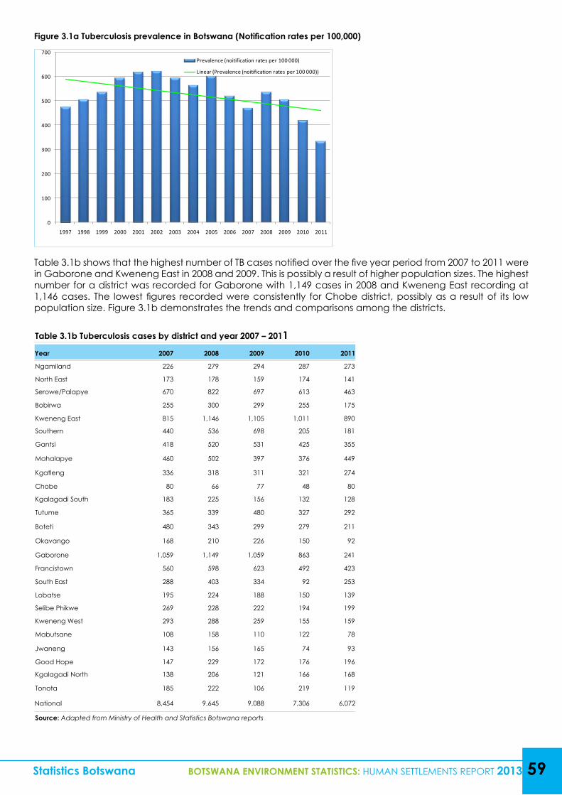
Table 3.1b Tuberculosis cases by district and year 2007 – 2011Year 2007 2008 2009 2010 2011
Ngamiland 226 279 294 287 273
North East 173 178 159 174 141
Serowe/Palapye 670 822 697 613 463
Bobirwa 255 300 299 255 175
Kweneng East 815 1,146 1,105 1,011 890
Southern 440 536 698 205 181
Gantsi 418 520 531 425 355
Mahalapye 460 502 397 376 449
Kgatleng 336 318 311 321 274
Chobe 80 66 77 48 80
Kgalagadi South 183 225 156 132 128
Tutume 365 339 480 327 292
Boteti 480 343 299 279 211
Okavango 168 210 226 150 92
Gaborone 1,059 1,149 1,059 863 241
Francistown 560 598 623 492 423
South East 288 403 334 92 253
Lobatse 195 224 188 150 139
Selibe Phikwe 269 228 222 194 199
Kweneng West 293 288 259 155 159
Mabutsane 108 158 110 122 78
Jwaneng 143 156 165 74 93
Good Hope 147 229 172 176 196
Kgalagadi North 138 206 121 166 168
Tonota 185 222 106 219 119
National 8,454 9,645 9,088 7,306 6,072
Source: Adapted from Ministry of Health and Statistics Botswana reports
Statistics Botswana BOTSWANA ENVIRONMENT STATISTICS: HUMAN SETTLEMENTS REPORT 2013 59
Table 3.1b shows that the highest number of TB cases notified over the five year period from 2007 to 2011 were in Gaborone and Kweneng East in 2008 and 2009. This is possibly a result of higher population sizes. The highest number for a district was recorded for Gaborone with 1,149 cases in 2008 and Kweneng East recording at 1,146 cases. The lowest figures recorded were consistently for Chobe district, possibly as a result of its low population size. Figure 3.1b demonstrates the trends and comparisons among the districts.
Figure 3.1a Tuberculosis prevalence in Botswana (Notification rates per 100,000)
0
100
200
300
400
500
600
700
1997 1998 1999 2000 2001 2002 2003 2004 2005 2006 2007 2008 2009 2010 2011
Prevalence (noitification rates per 100 000)
Linear (Prevalence (noitification rates per 100 000))
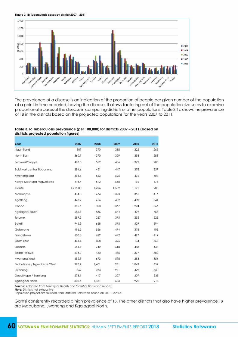
60 BOTSWANA ENVIRONMENT STATISTICS: HUMAN SETTLEMENTS REPORT 2013 Statistics Botswana
Figure 3.1b Tuberculosis cases by district 2007 - 2011
The prevalence of a disease is an indication of the proportion of people per given number of the population at a point in time or period, having the disease. It allows factoring out of the population size so as to examine proportionate cases of the disease in comparing districts or other populations. Table 3.1c shows the prevalence of TB in the districts based on the projected populations for the years 2007 to 2011.
Table 3.1c Tuberculosis prevalence (per 100,000) for districts 2007 – 2011 (based on districts projected population figures)
Year 2007 2008 2009 2010 2011
Ngamiland 301 370 388 322 265
North East 360.1 370 329 358 288
Serowe/Palapye 426.8 519 436 379 283
Bobirwa/ central Bobonong 384.6 451 447 378 257
Kweneng East 398.8 553 525 472 409
Kanye Moshupa /Ngwaketse 418.4 512 668 196 173
Gantsi 1,215.80 1,496 1,509 1,191 980
Mahalapye 434.3 474 373 351 416
Kgatleng 443.7 416 402 409 344
Chobe 395.6 320 367 224 366
Kgalagadi South 686.1 836 574 479 458
Tutume 289.5 267 375 252 223
Boteti 945.5 668 575 529 394
Gaborone 496.3 526 474 378 103
Francistown 600.8 629 642 497 419
South East 441.4 608 496 134 363
Lobatse 651.1 742 618 488 447
Selibe Phikwe 534.7 450 435 377 382
Kweneng West 692.5 673 598 353 356
Mabutsane / Ngwaketse West 970.7 1,401 961 1,049 659
Jwaneng 869 933 971 429 530
Good Hope / Barolong 273.1 417 307 307 335
Kgalagadi North 802.5 1,181 683 922 918
Source: Adapted from Ministry of Health and Statistics Botswana reportsNote: Districts not exhaustivePopulation projections sourced from Statistics Botswana based on 2001 Census
Gantsi consistently recorded a high prevalence of TB. The other districts that also have higher prevalence TB are Mabutsane, Jwaneng and Kgalagadi North.
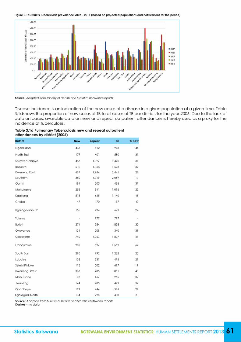
Table 3.1d Pulmonary Tuberculosis new and repeat outpatient attendances by district (2006)District New Repeat all % new
Ngamiland 436 512 948 46
North East 179 401 580 31
Serowe/Palapye 463 1,027 1,490 31
Bobirwa 510 1,068 1,578 32
Kweneng East 697 1,744 2,441 29
Southern 350 1,719 2,069 17
Gantsi 181 305 486 37
Mahalapye 255 841 1,096 23
Kgatleng 515 625 1,140 45
Chobe 47 70 117 40
Kgalagadi South 155 494 649 24
Tutume - 777 777 -
Boteti 274 584 858 32
Okavango 131 209 340 39
Gaborone 740 1,067 1,807 41
Francistown 962 597 1,559 62
South East 290 992 1,282 23
Lobatse 138 337 475 29
Selebi Phikwe 115 502 617 19
Kweneng West 366 485 851 43
Mabutsane 98 167 265 37
Jwaneng 144 285 429 34
Goodhope 122 444 566 22
Kgalagadi North 134 296 430 31
Source: Adapted from Ministry of Health and Statistics Botswana reportsDashes = no data
Disease incidence is an indication of the new cases of a disease in a given population at a given time. Table 3.1dshows the proportion of new cases of TB to all cases of TB per district, for the year 2006. Due to the lack of data on cases, available data on new and repeat outpatient attendances is hereby used as a proxy for the incidence of tuberculosis.
Statistics Botswana BOTSWANA ENVIRONMENT STATISTICS: HUMAN SETTLEMENTS REPORT 2013 61
Figure 3.1cDistricts Tuberculosis prevalence 2007 – 2011 (based on projected populations and notifications for the period)
Source: Adapted from Ministry of Health and Statistics Botswana reports
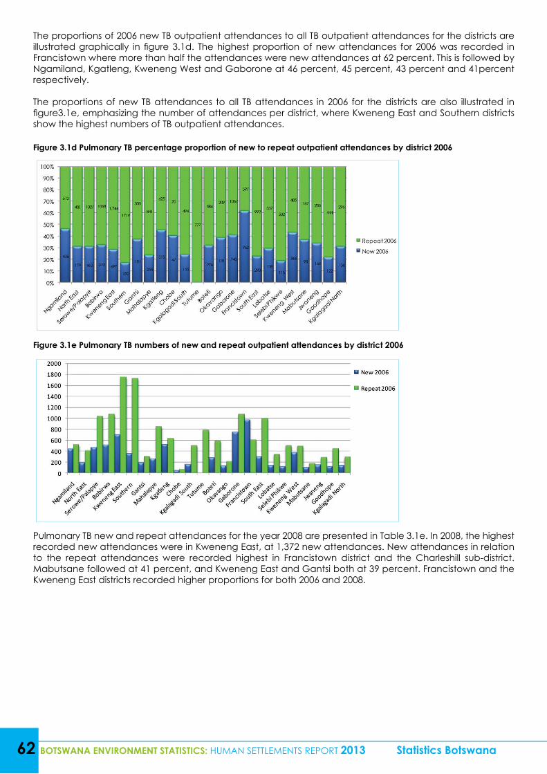
62 BOTSWANA ENVIRONMENT STATISTICS: HUMAN SETTLEMENTS REPORT 2013 Statistics Botswana
The proportions of 2006 new TB outpatient attendances to all TB outpatient attendances for the districts are illustrated graphically in figure 3.1d. The highest proportion of new attendances for 2006 was recorded in Francistown where more than half the attendances were new attendances at 62 percent. This is followed by Ngamiland, Kgatleng, Kweneng West and Gaborone at 46 percent, 45 percent, 43 percent and 41percent respectively.
The proportions of new TB attendances to all TB attendances in 2006 for the districts are also illustrated in figure3.1e, emphasizing the number of attendances per district, where Kweneng East and Southern districts show the highest numbers of TB outpatient attendances.
Figure 3.1d Pulmonary TB percentage proportion of new to repeat outpatient attendances by district 2006
Figure 3.1e Pulmonary TB numbers of new and repeat outpatient attendances by district 2006
Pulmonary TB new and repeat attendances for the year 2008 are presented in Table 3.1e. In 2008, the highest recorded new attendances were in Kweneng East, at 1,372 new attendances. New attendances in relation to the repeat attendances were recorded highest in Francistown district and the Charleshill sub-district. Mabutsane followed at 41 percent, and Kweneng East and Gantsi both at 39 percent. Francistown and the Kweneng East districts recorded higher proportions for both 2006 and 2008.
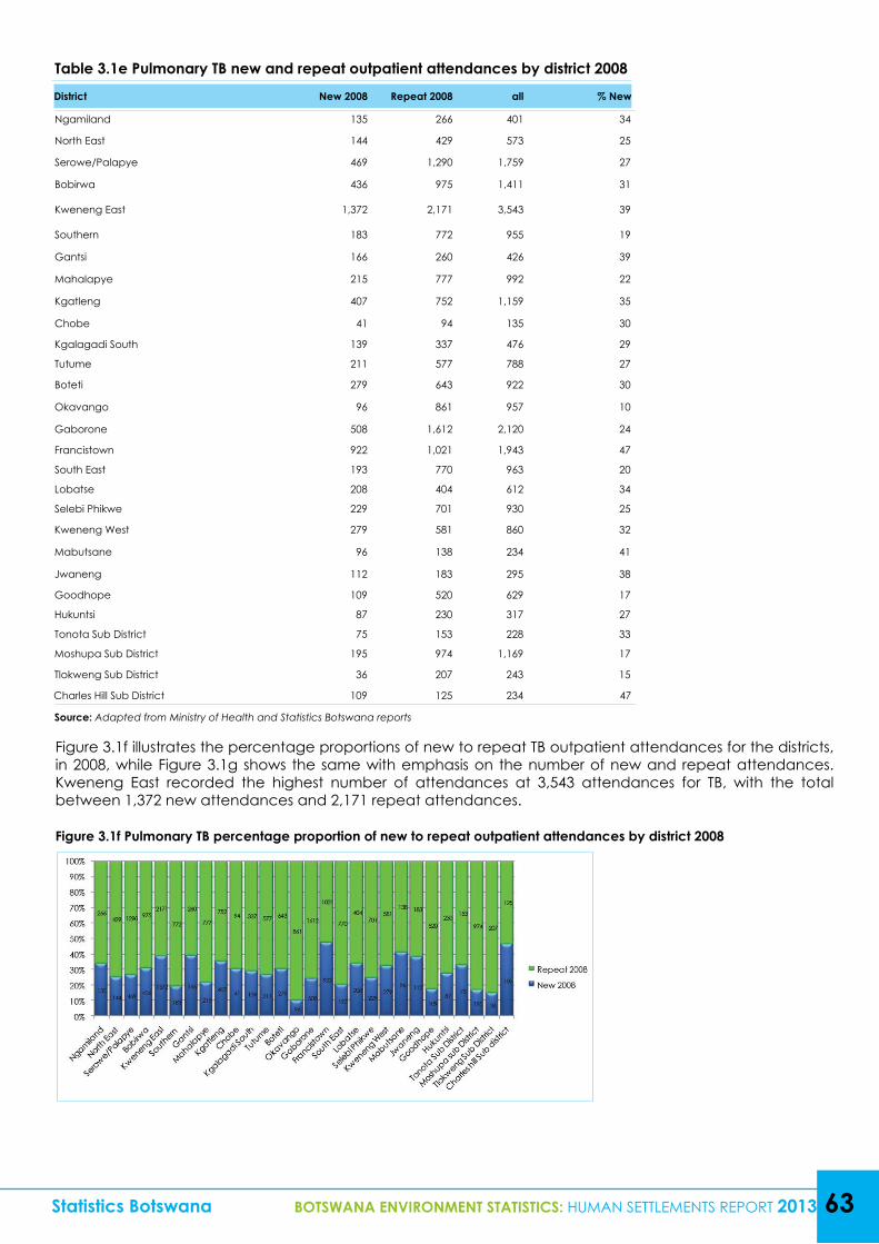
Statistics Botswana BOTSWANA ENVIRONMENT STATISTICS: HUMAN SETTLEMENTS REPORT 2013 63
Table 3.1e Pulmonary TB new and repeat outpatient attendances by district 2008District New 2008 Repeat 2008 all % New
Ngamiland 135 266 401 34
North East 144 429 573 25
Serowe/Palapye 469 1,290 1,759 27
Bobirwa 436 975 1,411 31
Kweneng East 1,372 2,171 3,543 39
Southern 183 772 955 19
Gantsi 166 260 426 39
Mahalapye 215 777 992 22
Kgatleng 407 752 1,159 35
Chobe 41 94 135 30
Kgalagadi South 139 337 476 29
Tutume 211 577 788 27
Boteti 279 643 922 30
Okavango 96 861 957 10
Gaborone 508 1,612 2,120 24
Francistown 922 1,021 1,943 47
South East 193 770 963 20
Lobatse 208 404 612 34
Selebi Phikwe 229 701 930 25
Kweneng West 279 581 860 32
Mabutsane 96 138 234 41
Jwaneng 112 183 295 38
Goodhope 109 520 629 17
Hukuntsi 87 230 317 27
Tonota Sub District 75 153 228 33
Moshupa Sub District 195 974 1,169 17
Tlokweng Sub District 36 207 243 15
Charles Hill Sub District 109 125 234 47
Source: Adapted from Ministry of Health and Statistics Botswana reports
Figure 3.1f illustrates the percentage proportions of new to repeat TB outpatient attendances for the districts, in 2008, while Figure 3.1g shows the same with emphasis on the number of new and repeat attendances. Kweneng East recorded the highest number of attendances at 3,543 attendances for TB, with the total between 1,372 new attendances and 2,171 repeat attendances.
Figure 3.1f Pulmonary TB percentage proportion of new to repeat outpatient attendances by district 2008
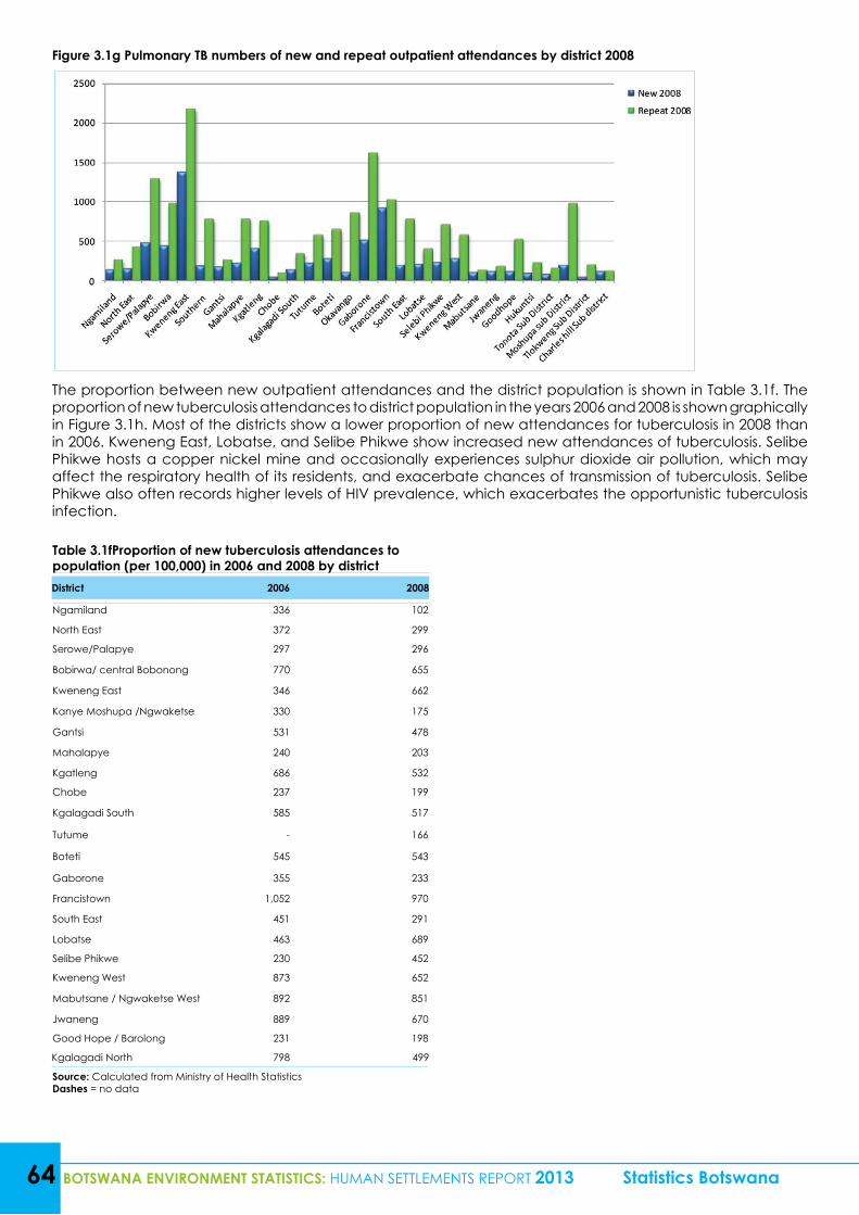
64 BOTSWANA ENVIRONMENT STATISTICS: HUMAN SETTLEMENTS REPORT 2013 Statistics Botswana
Figure 3.1g Pulmonary TB numbers of new and repeat outpatient attendances by district 2008
The proportion between new outpatient attendances and the district population is shown in Table 3.1f. The proportion of new tuberculosis attendances to district population in the years 2006 and 2008 is shown graphically in Figure 3.1h. Most of the districts show a lower proportion of new attendances for tuberculosis in 2008 than in 2006. Kweneng East, Lobatse, and Selibe Phikwe show increased new attendances of tuberculosis. Selibe Phikwe hosts a copper nickel mine and occasionally experiences sulphur dioxide air pollution, which may affect the respiratory health of its residents, and exacerbate chances of transmission of tuberculosis. Selibe Phikwe also often records higher levels of HIV prevalence, which exacerbates the opportunistic tuberculosis infection.
Table 3.1fProportion of new tuberculosis attendances to population (per 100,000) in 2006 and 2008 by districtDistrict 2006 2008
Ngamiland 336 102
North East 372 299
Serowe/Palapye 297 296
Bobirwa/ central Bobonong 770 655
Kweneng East 346 662
Kanye Moshupa /Ngwaketse 330 175
Gantsi 531 478
Mahalapye 240 203
Kgatleng 686 532
Chobe 237 199
Kgalagadi South 585 517
Tutume - 166
Boteti 545 543
Gaborone 355 233
Francistown 1,052 970
South East 451 291
Lobatse 463 689
Selibe Phikwe 230 452
Kweneng West 873 652
Mabutsane / Ngwaketse West 892 851
Jwaneng 889 670
Good Hope / Barolong 231 198
Kgalagadi North 798 499
Source: Calculated from Ministry of Health StatisticsDashes = no data
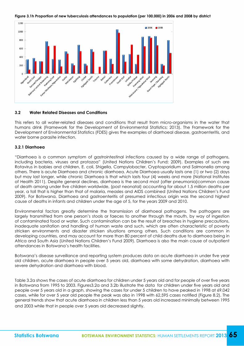
Statistics Botswana BOTSWANA ENVIRONMENT STATISTICS: HUMAN SETTLEMENTS REPORT 2013 65
Figure 3.1h Proportion of new tuberculosis attendances to population (per 100,000) in 2006 and 2008 by district
3.2 Water Related Diseases and Conditions
This refers to all water-related diseases and conditions that result from micro-organisms in the water that humans drink (Framework for the Development of Environmental Statistics; 2013). The Framework for the Development of Environmental Statistics (FDES) gives the examples of diarrhoeal disease, gastroenteritis, and water borne parasite infection.
3.2.1 Diarrhoea
“Diarrhoea is a common symptom of gastrointestinal infections caused by a wide range of pathogens, including bacteria, viruses and protozoa” (United Nations Children’s Fund; 2009). Examples of such are Rotavirus in babies and children, E. coli, Shigella, Campylobacter, Cryptosporidium and Salmonella among others. There is acute Diarrhoea and chronic diarrhoea. Acute Diarrhoea usually lasts one (1) or two (2) days but may last longer, while chronic Diarrhoea is that which lasts four (4) weeks and more (National Institutes of Health 2011). Despite general declines, diarrhoea is the second most (after pneumonia)common cause of death among under five children worldwide, (post neonatal) accounting for about 1.5 million deaths per year, a toll that is higher than that of malaria, measles and AIDS combined (United Nations Children’s Fund 2009). For Botswana, Diarrhoea and gastroenteritis of presumed infectious origin was the second highest cause of deaths in infants and children under the age of 5, for the years 2009 and 2010.
Environmental factors greatly determine the transmission of diarrhoeal pathogens. The pathogens are largely transmitted from one person’s stools or faeces to another through the mouth, by way of ingestion of contaminated food or water. Such contamination can be the result of breaches in hygiene precautions, inadequate sanitation and handling of human waste and such, which are often characteristic of poverty stricken environments and disaster stricken situations among others. Such conditions are common in developing countries, and may account for more than 80 percent of child deaths due to diarrhoea being in Africa and South Asia (United Nations Children’s Fund 2009). Diarrhoea is also the main cause of outpatient attendances in Botswana’s health facilities.
Botswana’s disease surveillance and reporting system produces data on acute diarrhoea in under five year old children, acute diarrhoea in people over 5 years old, diarrhoea with some dehydration, diarrhoea with severe dehydration and diarrhoea with blood.
Table 3.2a shows the cases of acute diarrhoea for children under 5 years old and for people of over five years in Botswana from 1995 to 2003. Figures3.2a and 3.2b illustrate the data for children under five years old and people over 5 years old in a graph, showing the cases for under 5 children to have peaked in 1998 at 69,042 cases, while for over 5 year old people the peak was also in 1998 with 62,595 cases notified (Figure 8.2). The general trends show that acute diarrhoea in children less than 5 years old increased minimally between 1995 and 2003 while that in people over 5 years old decreased slightly.
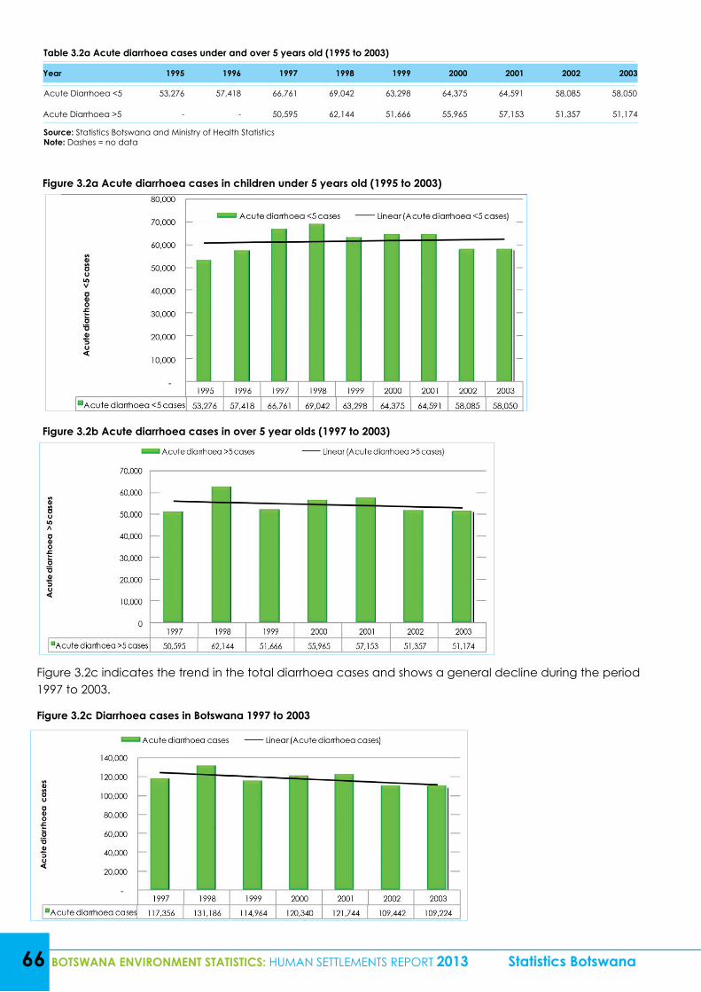
66 BOTSWANA ENVIRONMENT STATISTICS: HUMAN SETTLEMENTS REPORT 2013 Statistics Botswana
Table 3.2a Acute diarrhoea cases under and over 5 years old (1995 to 2003)
Year 1995 1996 1997 1998 1999 2000 2001 2002 2003
Acute Diarrhoea <5 53,276 57,418 66,761 69,042 63,298 64,375 64,591 58,085 58,050
Acute Diarrhoea >5 - - 50,595 62,144 51,666 55,965 57,153 51,357 51,174
Source: Statistics Botswana and Ministry of Health StatisticsNote: Dashes = no data
Figure 3.2a Acute diarrhoea cases in children under 5 years old (1995 to 2003)
Figure 3.2b Acute diarrhoea cases in over 5 year olds (1997 to 2003)
Figure 3.2c indicates the trend in the total diarrhoea cases and shows a general decline during the period 1997 to 2003.
Figure 3.2c Diarrhoea cases in Botswana 1997 to 2003
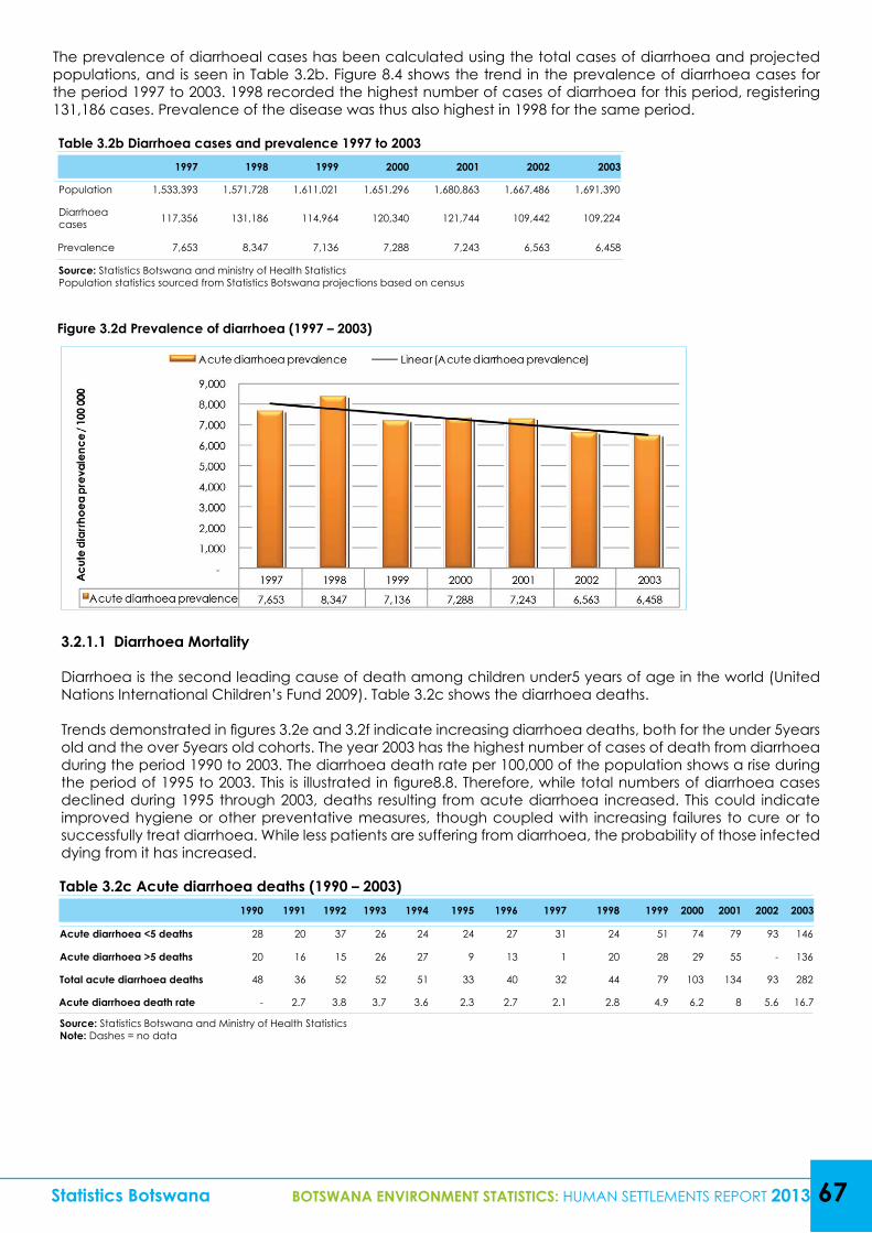
Table 3.2c Acute diarrhoea deaths (1990 – 2003)1990 1991 1992 1993 1994 1995 1996 1997 1998 1999 2000 2001 2002 2003
Acute diarrhoea <5 deaths 28 20 37 26 24 24 27 31 24 51 74 79 93 146
Acute diarrhoea >5 deaths 20 16 15 26 27 9 13 1 20 28 29 55 - 136
Total acute diarrhoea deaths 48 36 52 52 51 33 40 32 44 79 103 134 93 282
Acute diarrhoea death rate - 2.7 3.8 3.7 3.6 2.3 2.7 2.1 2.8 4.9 6.2 8 5.6 16.7
Source: Statistics Botswana and Ministry of Health StatisticsNote: Dashes = no data
Table 3.2b Diarrhoea cases and prevalence 1997 to 20031997 1998 1999 2000 2001 2002 2003
Population 1,533,393 1,571,728 1,611,021 1,651,296 1,680,863 1,667,486 1,691,390
Diarrhoea cases 117,356 131,186 114,964 120,340 121,744 109,442 109,224
Prevalence 7,653 8,347 7,136 7,288 7,243 6,563 6,458
Source: Statistics Botswana and ministry of Health StatisticsPopulation statistics sourced from Statistics Botswana projections based on census
Statistics Botswana BOTSWANA ENVIRONMENT STATISTICS: HUMAN SETTLEMENTS REPORT 2013 67
Figure 3.2d Prevalence of diarrhoea (1997 – 2003)
The prevalence of diarrhoeal cases has been calculated using the total cases of diarrhoea and projected populations, and is seen in Table 3.2b. Figure 8.4 shows the trend in the prevalence of diarrhoea cases for the period 1997 to 2003. 1998 recorded the highest number of cases of diarrhoea for this period, registering 131,186 cases. Prevalence of the disease was thus also highest in 1998 for the same period.
3.2.1.1 Diarrhoea Mortality
Diarrhoea is the second leading cause of death among children under5 years of age in the world (United Nations International Children’s Fund 2009). Table 3.2c shows the diarrhoea deaths.
Trends demonstrated in figures 3.2e and 3.2f indicate increasing diarrhoea deaths, both for the under 5years old and the over 5years old cohorts. The year 2003 has the highest number of cases of death from diarrhoea during the period 1990 to 2003. The diarrhoea death rate per 100,000 of the population shows a rise during the period of 1995 to 2003. This is illustrated in figure8.8. Therefore, while total numbers of diarrhoea cases declined during 1995 through 2003, deaths resulting from acute diarrhoea increased. This could indicate improved hygiene or other preventative measures, though coupled with increasing failures to cure or to successfully treat diarrhoea. While less patients are suffering from diarrhoea, the probability of those infected dying from it has increased.
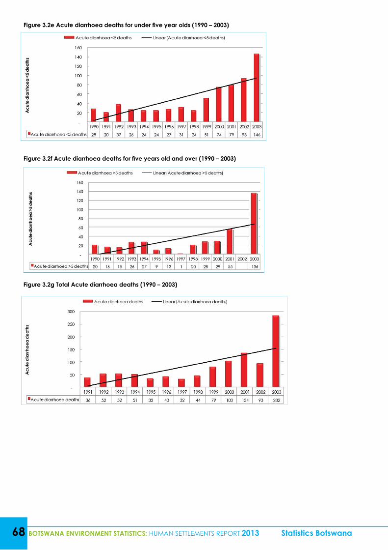
68 BOTSWANA ENVIRONMENT STATISTICS: HUMAN SETTLEMENTS REPORT 2013 Statistics Botswana
Figure 3.2e Acute diarrhoea deaths for under five year olds (1990 – 2003)
Figure 3.2f Acute diarrhoea deaths for five years old and over (1990 – 2003)
Figure 3.2g Total Acute diarrhoea deaths (1990 – 2003)
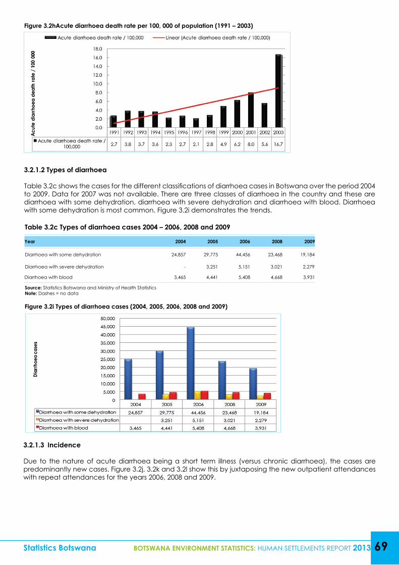
Statistics Botswana BOTSWANA ENVIRONMENT STATISTICS: HUMAN SETTLEMENTS REPORT 2013 69
Figure 3.2hAcute diarrhoea death rate per 100, 000 of population (1991 – 2003)
Figure 3.2i Types of diarrhoea cases (2004, 2005, 2006, 2008 and 2009)
3.2.1.2 Types of diarrhoea
Table 3.2c shows the cases for the different classifications of diarrhoea cases in Botswana over the period 2004 to 2009. Data for 2007 was not available. There are three classes of diarrhoea in the country and these are diarrhoea with some dehydration, diarrhoea with severe dehydration and diarrhoea with blood. Diarrhoea with some dehydration is most common. Figure 3.2i demonstrates the trends.
Table 3.2c Types of diarrhoea cases 2004 – 2006, 2008 and 2009
Year 2004 2005 2006 2008 2009
Diarrhoea with some dehydration 24,857 29,775 44,456 23,468 19,184
Diarrhoea with severe dehydration - 3,251 5,151 3,021 2,279
Diarrhoea with blood 3,465 4,441 5,408 4,668 3,931
Source: Statistics Botswana and Ministry of Health StatisticsNote: Dashes = no data
3.2.1.3 Incidence
Due to the nature of acute diarrhoea being a short term illness (versus chronic diarrhoea), the cases are predominantly new cases. Figure 3.2j, 3.2k and 3.2l show this by juxtaposing the new outpatient attendances with repeat attendances for the years 2006, 2008 and 2009.
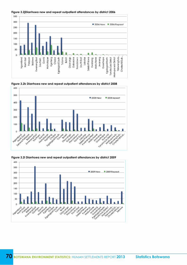
70 BOTSWANA ENVIRONMENT STATISTICS: HUMAN SETTLEMENTS REPORT 2013 Statistics Botswana
Figure 3.2jDiarrhoea new and repeat outpatient attendances by district 2006
Figure 3.2k Diarrhoea new and repeat outpatient attendances by district 2008
Figure 3.2l Diarrhoea new and repeat outpatient attendances by district 2009
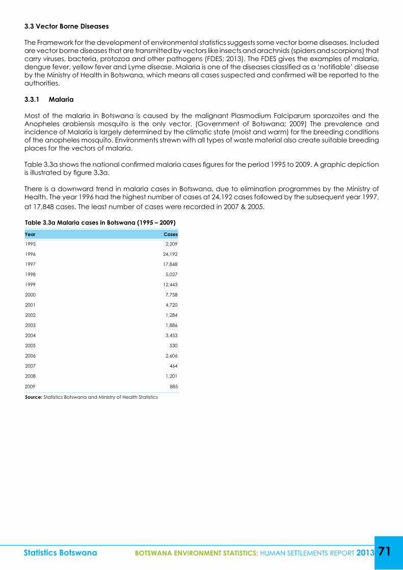
Statistics Botswana BOTSWANA ENVIRONMENT STATISTICS: HUMAN SETTLEMENTS REPORT 2013 71
3.3 Vector Borne Diseases
The Framework for the development of environmental statistics suggests some vector borne diseases. Included are vector borne diseases that are transmitted by vectors like insects and arachnids (spiders and scorpions) that carry viruses, bacteria, protozoa and other pathogens (FDES; 2013). The FDES gives the examples of malaria, dengue fever, yellow fever and Lyme disease. Malaria is one of the diseases classified as a ‘notifiable’ disease by the Ministry of Health in Botswana, which means all cases suspected and confirmed will be reported to the authorities.
3.3.1 Malaria
Most of the malaria in Botswana is caused by the malignant Plasmodium Falciparum sporozoites and the Anopheles arabiensis mosquito is the only vector. (Government of Botswana; 2009) The prevalence and incidence of Malaria is largely determined by the climatic state (moist and warm) for the breeding conditions of the anopheles mosquito. Environments strewn with all types of waste material also create suitable breeding places for the vectors of malaria.
Table 3.3a shows the national confirmed malaria cases figures for the period 1995 to 2009. A graphic depiction is illustrated by figure 3.3a.
There is a downward trend in malaria cases in Botswana, due to elimination programmes by the Ministry of Health. The year 1996 had the highest number of cases at 24,192 cases followed by the subsequent year 1997, at 17,848 cases. The least number of cases were recorded in 2007 & 2005.
Table 3.3a Malaria cases in Botswana (1995 – 2009)
Year Cases
1995 2,209
1996 24,192
1997 17,848
1998 5,027
1999 12,443
2000 7,758
2001 4,720
2002 1,284
2003 1,886
2004 3,453
2005 530
2006 2,606
2007 464
2008 1,201
2009 885
Source: Statistics Botswana and Ministry of Health Statistics
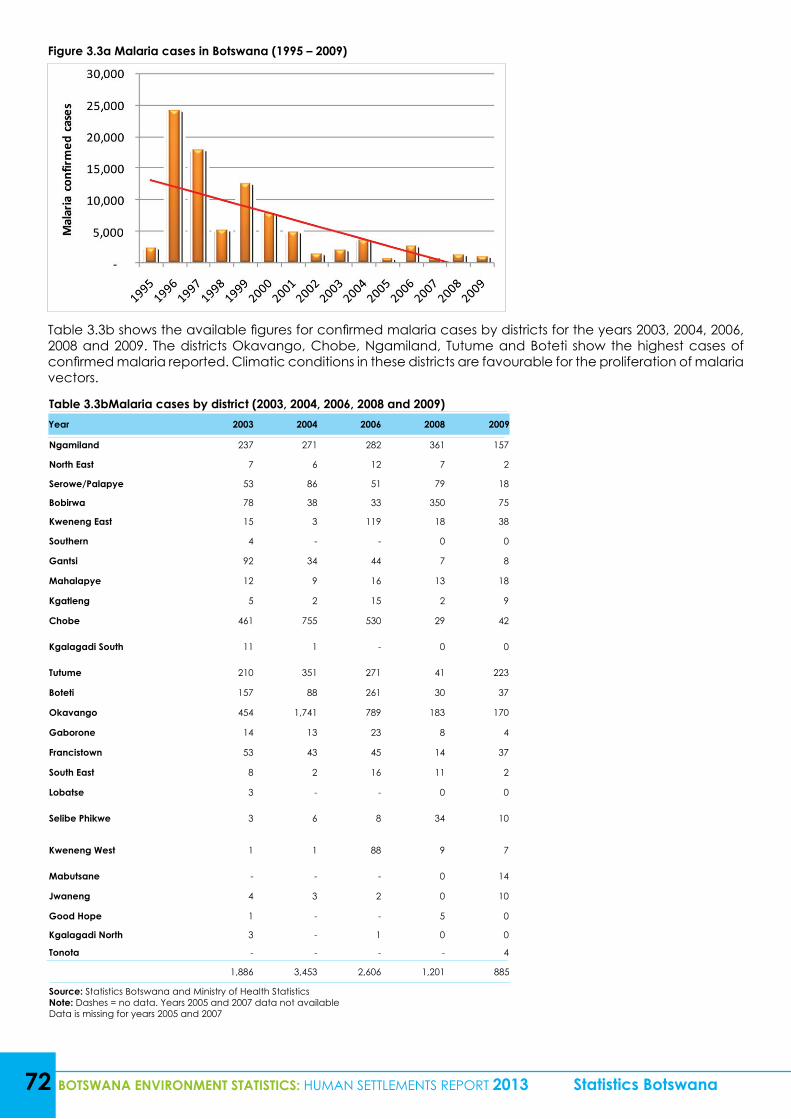
72 BOTSWANA ENVIRONMENT STATISTICS: HUMAN SETTLEMENTS REPORT 2013 Statistics Botswana
Figure 3.3a Malaria cases in Botswana (1995 – 2009)
Table 3.3b shows the available figures for confirmed malaria cases by districts for the years 2003, 2004, 2006, 2008 and 2009. The districts Okavango, Chobe, Ngamiland, Tutume and Boteti show the highest cases of confirmed malaria reported. Climatic conditions in these districts are favourable for the proliferation of malaria vectors.
Table 3.3bMalaria cases by district (2003, 2004, 2006, 2008 and 2009)Year 2003 2004 2006 2008 2009
Ngamiland 237 271 282 361 157
North East 7 6 12 7 2
Serowe/Palapye 53 86 51 79 18
Bobirwa 78 38 33 350 75
Kweneng East 15 3 119 18 38
Southern 4 - - 0 0
Gantsi 92 34 44 7 8
Mahalapye 12 9 16 13 18
Kgatleng 5 2 15 2 9
Chobe 461 755 530 29 42
Kgalagadi South 11 1 - 0 0
Tutume 210 351 271 41 223
Boteti 157 88 261 30 37
Okavango 454 1,741 789 183 170
Gaborone 14 13 23 8 4
Francistown 53 43 45 14 37
South East 8 2 16 11 2
Lobatse 3 - - 0 0
Selibe Phikwe 3 6 8 34 10
Kweneng West 1 1 88 9 7
Mabutsane - - - 0 14
Jwaneng 4 3 2 0 10
Good Hope 1 - - 5 0
Kgalagadi North 3 - 1 0 0
Tonota - - - - 4
1,886 3,453 2,606 1,201 885
Source: Statistics Botswana and Ministry of Health StatisticsNote: Dashes = no data. Years 2005 and 2007 data not availableData is missing for years 2005 and 2007
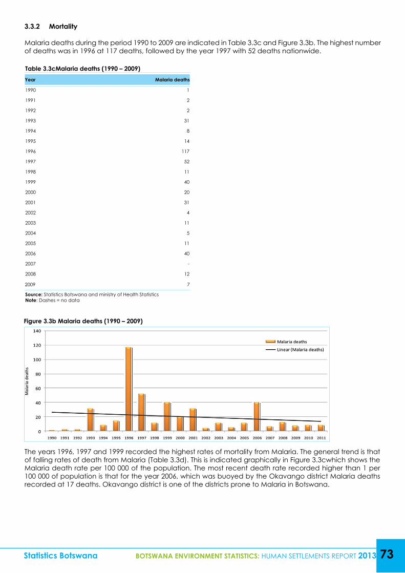
Table 3.3cMalaria deaths (1990 – 2009)Year Malaria deaths
1990 1
1991 2
1992 2
1993 31
1994 8
1995 14
1996 117
1997 52
1998 11
1999 40
2000 20
2001 31
2002 4
2003 11
2004 5
2005 11
2006 40
2007 -
2008 12
2009 7
Source: Statistics Botswana and ministry of Health StatisticsNote: Dashes = no data
Statistics Botswana BOTSWANA ENVIRONMENT STATISTICS: HUMAN SETTLEMENTS REPORT 2013 73
Figure 3.3b Malaria deaths (1990 – 2009)
3.3.2 Mortality
Malaria deaths during the period 1990 to 2009 are indicated in Table 3.3c and Figure 3.3b. The highest number of deaths was in 1996 at 117 deaths, followed by the year 1997 with 52 deaths nationwide.
The years 1996, 1997 and 1999 recorded the highest rates of mortality from Malaria. The general trend is that of falling rates of death from Malaria (Table 3.3d). This is indicated graphically in Figure 3.3cwhich shows the Malaria death rate per 100 000 of the population. The most recent death rate recorded higher than 1 per 100 000 of population is that for the year 2006, which was buoyed by the Okavango district Malaria deaths recorded at 17 deaths. Okavango district is one of the districts prone to Malaria in Botswana.
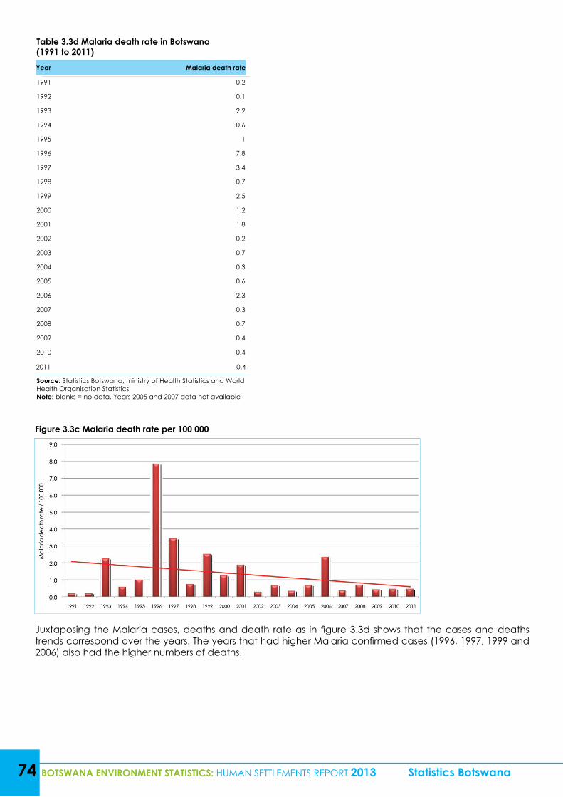
74 BOTSWANA ENVIRONMENT STATISTICS: HUMAN SETTLEMENTS REPORT 2013 Statistics Botswana
Table 3.3d Malaria death rate in Botswana (1991 to 2011)Year Malaria death rate
1991 0.2
1992 0.1
1993 2.2
1994 0.6
1995 1
1996 7.8
1997 3.4
1998 0.7
1999 2.5
2000 1.2
2001 1.8
2002 0.2
2003 0.7
2004 0.3
2005 0.6
2006 2.3
2007 0.3
2008 0.7
2009 0.4
2010 0.4
2011 0.4
Source: Statistics Botswana, ministry of Health Statistics and World Health Organisation StatisticsNote: blanks = no data. Years 2005 and 2007 data not available
Figure 3.3c Malaria death rate per 100 000
Juxtaposing the Malaria cases, deaths and death rate as in figure 3.3d shows that the cases and deaths trends correspond over the years. The years that had higher Malaria confirmed cases (1996, 1997, 1999 and 2006) also had the higher numbers of deaths.
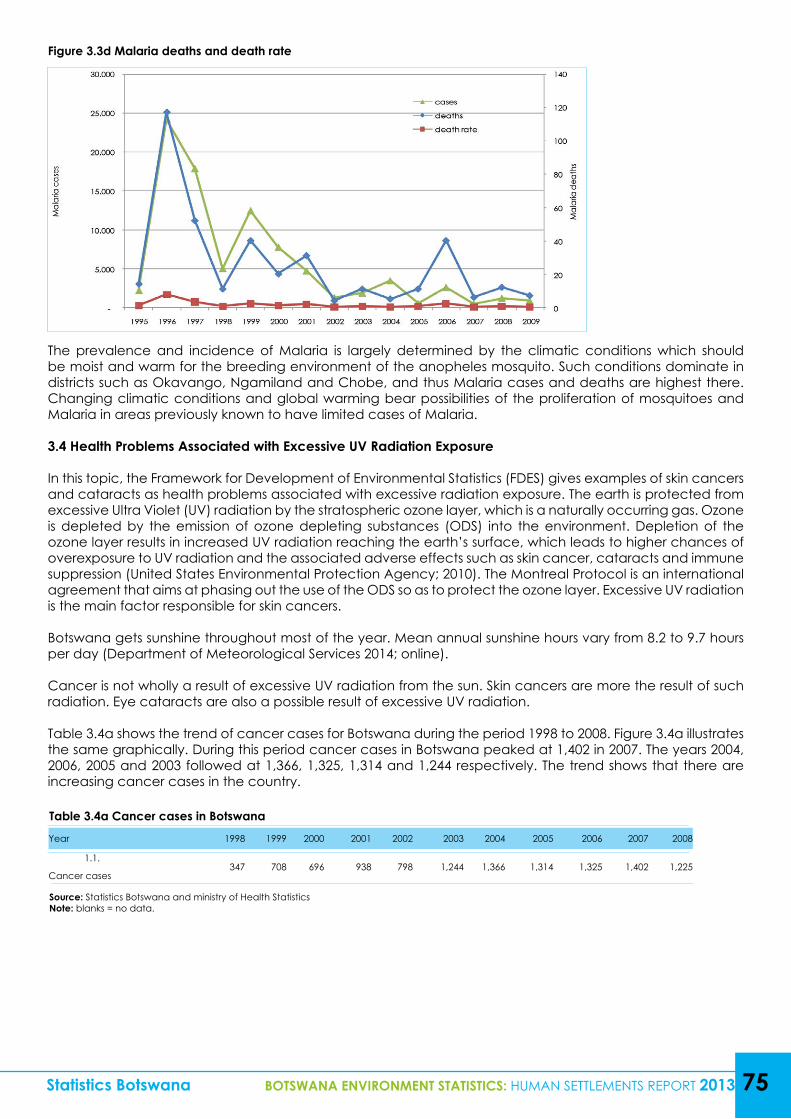
Statistics Botswana BOTSWANA ENVIRONMENT STATISTICS: HUMAN SETTLEMENTS REPORT 2013 75
Figure 3.3d Malaria deaths and death rate
The prevalence and incidence of Malaria is largely determined by the climatic conditions which should be moist and warm for the breeding environment of the anopheles mosquito. Such conditions dominate in districts such as Okavango, Ngamiland and Chobe, and thus Malaria cases and deaths are highest there. Changing climatic conditions and global warming bear possibilities of the proliferation of mosquitoes and Malaria in areas previously known to have limited cases of Malaria.
3.4 Health Problems Associated with Excessive UV Radiation Exposure
In this topic, the Framework for Development of Environmental Statistics (FDES) gives examples of skin cancers and cataracts as health problems associated with excessive radiation exposure. The earth is protected from excessive Ultra Violet (UV) radiation by the stratospheric ozone layer, which is a naturally occurring gas. Ozone is depleted by the emission of ozone depleting substances (ODS) into the environment. Depletion of the ozone layer results in increased UV radiation reaching the earth’s surface, which leads to higher chances of overexposure to UV radiation and the associated adverse effects such as skin cancer, cataracts and immune suppression (United States Environmental Protection Agency; 2010). The Montreal Protocol is an international agreement that aims at phasing out the use of the ODS so as to protect the ozone layer. Excessive UV radiation is the main factor responsible for skin cancers.
Botswana gets sunshine throughout most of the year. Mean annual sunshine hours vary from 8.2 to 9.7 hours per day (Department of Meteorological Services 2014; online).
Cancer is not wholly a result of excessive UV radiation from the sun. Skin cancers are more the result of such radiation. Eye cataracts are also a possible result of excessive UV radiation.
Table 3.4a shows the trend of cancer cases for Botswana during the period 1998 to 2008. Figure 3.4a illustrates the same graphically. During this period cancer cases in Botswana peaked at 1,402 in 2007. The years 2004, 2006, 2005 and 2003 followed at 1,366, 1,325, 1,314 and 1,244 respectively. The trend shows that there are increasing cancer cases in the country.
Table 3.4a Cancer cases in Botswana
Year 1998 1999 2000 2001 2002 2003 2004 2005 2006 2007 2008
1.1. 347 708 696 938 798 1,244 1,366 1,314 1,325 1,402 1,225
Cancer cases
Source: Statistics Botswana and ministry of Health StatisticsNote: blanks = no data.
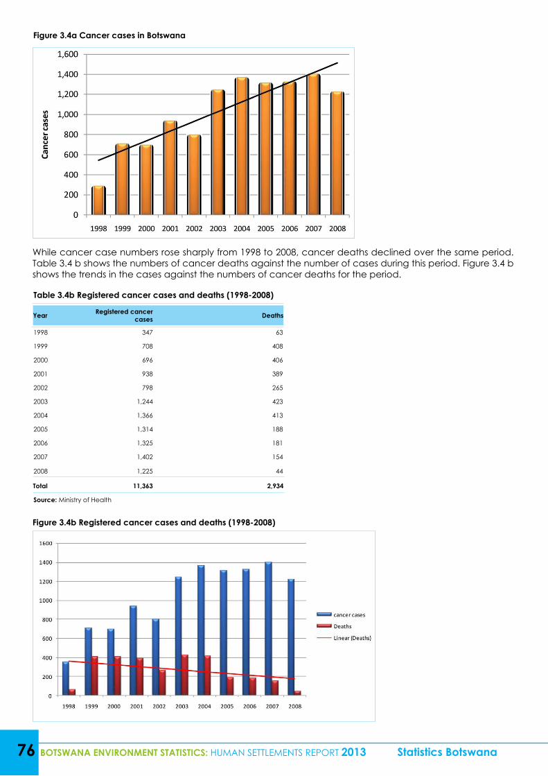
76 BOTSWANA ENVIRONMENT STATISTICS: HUMAN SETTLEMENTS REPORT 2013 Statistics Botswana
Figure 3.4a Cancer cases in Botswana
Figure 3.4b Registered cancer cases and deaths (1998-2008)
While cancer case numbers rose sharply from 1998 to 2008, cancer deaths declined over the same period. Table 3.4 b shows the numbers of cancer deaths against the number of cases during this period. Figure 3.4 b shows the trends in the cases against the numbers of cancer deaths for the period.
Table 3.4b Registered cancer cases and deaths (1998-2008)
Year Registered cancer cases Deaths
1998 347 63
1999 708 408
2000 696 406
2001 938 389
2002 798 265
2003 1,244 423
2004 1,366 413
2005 1,314 188
2006 1,325 181
2007 1,402 154
2008 1,225 44
Total 11,363 2,934
Source: Ministry of Health
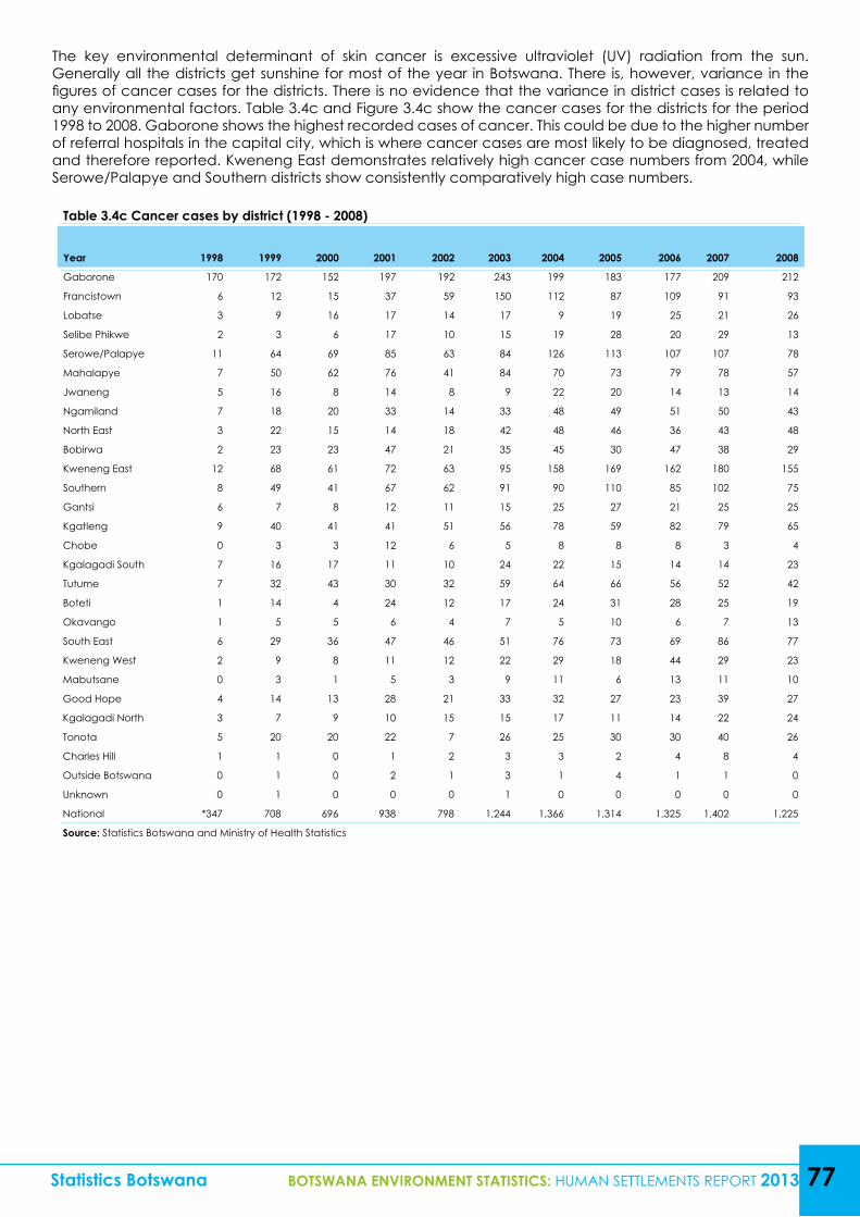
Statistics Botswana BOTSWANA ENVIRONMENT STATISTICS: HUMAN SETTLEMENTS REPORT 2013 77
The key environmental determinant of skin cancer is excessive ultraviolet (UV) radiation from the sun. Generally all the districts get sunshine for most of the year in Botswana. There is, however, variance in the figures of cancer cases for the districts. There is no evidence that the variance in district cases is related to any environmental factors. Table 3.4c and Figure 3.4c show the cancer cases for the districts for the period 1998 to 2008. Gaborone shows the highest recorded cases of cancer. This could be due to the higher number of referral hospitals in the capital city, which is where cancer cases are most likely to be diagnosed, treated and therefore reported. Kweneng East demonstrates relatively high cancer case numbers from 2004, while Serowe/Palapye and Southern districts show consistently comparatively high case numbers.
Table 3.4c Cancer cases by district (1998 - 2008)
Year 1998 1999 2000 2001 2002 2003 2004 2005 2006 2007 2008
Gaborone 170 172 152 197 192 243 199 183 177 209 212
Francistown 6 12 15 37 59 150 112 87 109 91 93
Lobatse 3 9 16 17 14 17 9 19 25 21 26
Selibe Phikwe 2 3 6 17 10 15 19 28 20 29 13
Serowe/Palapye 11 64 69 85 63 84 126 113 107 107 78
Mahalapye 7 50 62 76 41 84 70 73 79 78 57
Jwaneng 5 16 8 14 8 9 22 20 14 13 14
Ngamiland 7 18 20 33 14 33 48 49 51 50 43
North East 3 22 15 14 18 42 48 46 36 43 48
Bobirwa 2 23 23 47 21 35 45 30 47 38 29
Kweneng East 12 68 61 72 63 95 158 169 162 180 155
Southern 8 49 41 67 62 91 90 110 85 102 75
Gantsi 6 7 8 12 11 15 25 27 21 25 25
Kgatleng 9 40 41 41 51 56 78 59 82 79 65
Chobe 0 3 3 12 6 5 8 8 8 3 4
Kgalagadi South 7 16 17 11 10 24 22 15 14 14 23
Tutume 7 32 43 30 32 59 64 66 56 52 42
Boteti 1 14 4 24 12 17 24 31 28 25 19
Okavango 1 5 5 6 4 7 5 10 6 7 13
South East 6 29 36 47 46 51 76 73 69 86 77
Kweneng West 2 9 8 11 12 22 29 18 44 29 23
Mabutsane 0 3 1 5 3 9 11 6 13 11 10
Good Hope 4 14 13 28 21 33 32 27 23 39 27
Kgalagadi North 3 7 9 10 15 15 17 11 14 22 24
Tonota 5 20 20 22 7 26 25 30 30 40 26
Charles Hill 1 1 0 1 2 3 3 2 4 8 4
Outside Botswana 0 1 0 2 1 3 1 4 1 1 0
Unknown 0 1 0 0 0 1 0 0 0 0 0
National *347 708 696 938 798 1,244 1,366 1,314 1,325 1,402 1,225
Source: Statistics Botswana and Ministry of Health Statistics
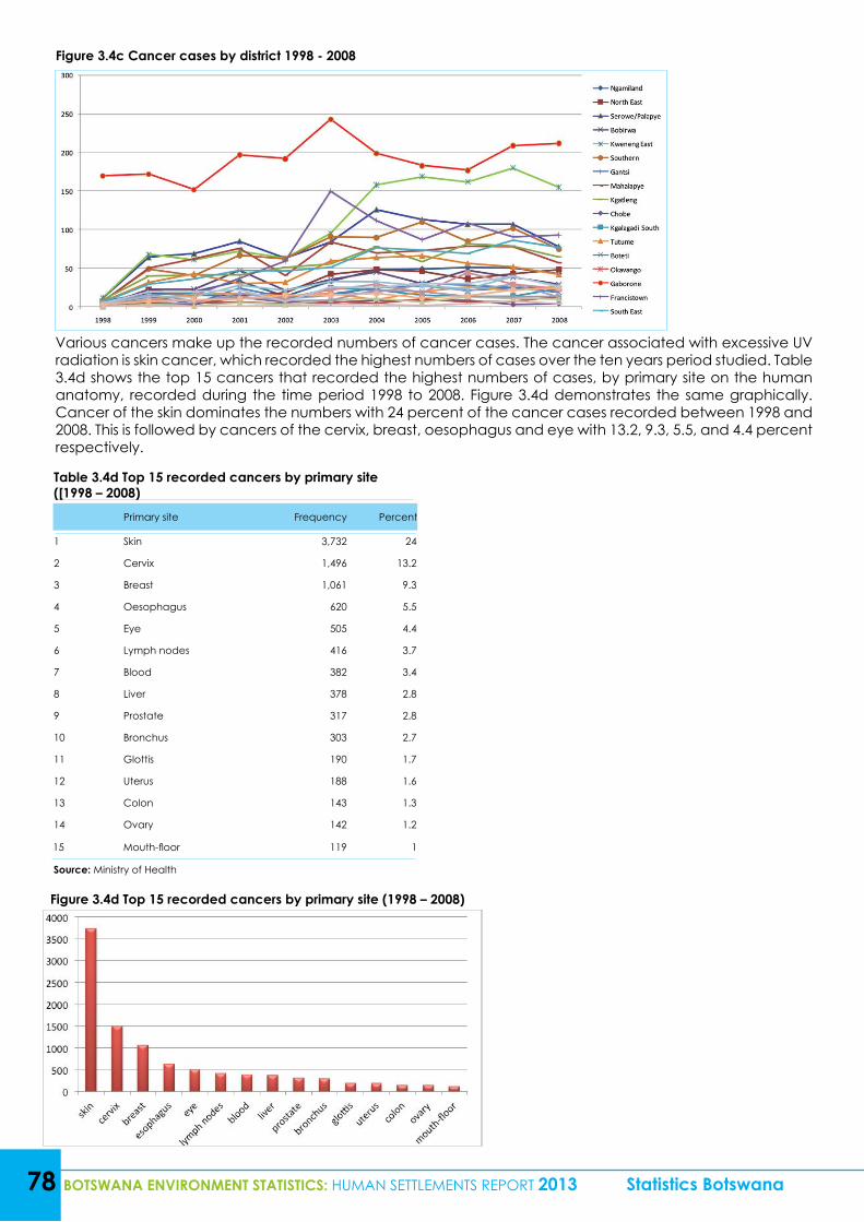
78 BOTSWANA ENVIRONMENT STATISTICS: HUMAN SETTLEMENTS REPORT 2013 Statistics Botswana
Figure 3.4c Cancer cases by district 1998 - 2008
Figure 3.4d Top 15 recorded cancers by primary site (1998 – 2008)
Various cancers make up the recorded numbers of cancer cases. The cancer associated with excessive UV radiation is skin cancer, which recorded the highest numbers of cases over the ten years period studied. Table 3.4d shows the top 15 cancers that recorded the highest numbers of cases, by primary site on the human anatomy, recorded during the time period 1998 to 2008. Figure 3.4d demonstrates the same graphically. Cancer of the skin dominates the numbers with 24 percent of the cancer cases recorded between 1998 and 2008. This is followed by cancers of the cervix, breast, oesophagus and eye with 13.2, 9.3, 5.5, and 4.4 percent respectively.
Table 3.4d Top 15 recorded cancers by primary site ([1998 – 2008)
Primary site Frequency Percent
1 Skin 3,732 24
2 Cervix 1,496 13.2
3 Breast 1,061 9.3
4 Oesophagus 620 5.5
5 Eye 505 4.4
6 Lymph nodes 416 3.7
7 Blood 382 3.4
8 Liver 378 2.8
9 Prostate 317 2.8
10 Bronchus 303 2.7
11 Glottis 190 1.7
12 Uterus 188 1.6
13 Colon 143 1.3
14 Ovary 142 1.2
15 Mouth-floor 119 1
Source: Ministry of Health
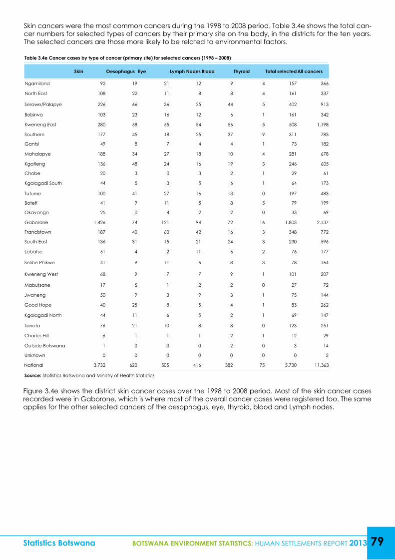
Table 3.4e Cancer cases by type of cancer (primary site) for selected cancers (1998 – 2008)
Skin Oesophagus Eye Lymph Nodes Blood Thyroid Total selected All cancers
Ngamiland 92 19 21 12 9 4 157 366
North East 108 22 11 8 8 4 161 337
Serowe/Palapye 226 66 36 25 44 5 402 913
Bobirwa 103 23 16 12 6 1 161 342
Kweneng East 280 58 55 54 56 5 508 1,198
Southern 177 45 18 25 37 9 311 783
Gantsi 49 8 7 4 4 1 73 182
Mahalapye 188 34 27 18 10 4 281 678
Kgatleng 136 48 24 16 19 3 246 605
Chobe 20 3 0 3 2 1 29 61
Kgalagadi South 44 5 3 5 6 1 64 173
Tutume 100 41 27 16 13 0 197 483
Boteti 41 9 11 5 8 5 79 199
Okavango 25 0 4 2 2 0 33 69
Gaborone 1,426 74 121 94 72 16 1,803 2,137
Francistown 187 40 60 42 16 3 348 772
South East 136 31 15 21 24 3 230 596
Lobatse 51 4 2 11 6 2 76 177
Selibe Phikwe 41 9 11 6 8 3 78 164
Kweneng West 68 9 7 7 9 1 101 207
Mabutsane 17 5 1 2 2 0 27 72
Jwaneng 50 9 3 9 3 1 75 144
Good Hope 40 25 8 5 4 1 83 262
Kgalagadi North 44 11 6 5 2 1 69 147
Tonota 76 21 10 8 8 0 123 251
Charles Hill 6 1 1 1 2 1 12 29
Outside Botswana 1 0 0 0 2 0 3 14
Unknown 0 0 0 0 0 0 0 2
National 3,732 620 505 416 382 75 5,730 11,363
Source: Statistics Botswana and Ministry of Health Statistics
Statistics Botswana BOTSWANA ENVIRONMENT STATISTICS: HUMAN SETTLEMENTS REPORT 2013 79
Skin cancers were the most common cancers during the 1998 to 2008 period. Table 3.4e shows the total can-cer numbers for selected types of cancers by their primary site on the body, in the districts for the ten years. The selected cancers are those more likely to be related to environmental factors.
Figure 3.4e shows the district skin cancer cases over the 1998 to 2008 period. Most of the skin cancer cases recorded were in Gaborone, which is where most of the overall cancer cases were registered too. The same applies for the other selected cancers of the oesophagus, eye, thyroid, blood and Lymph nodes.
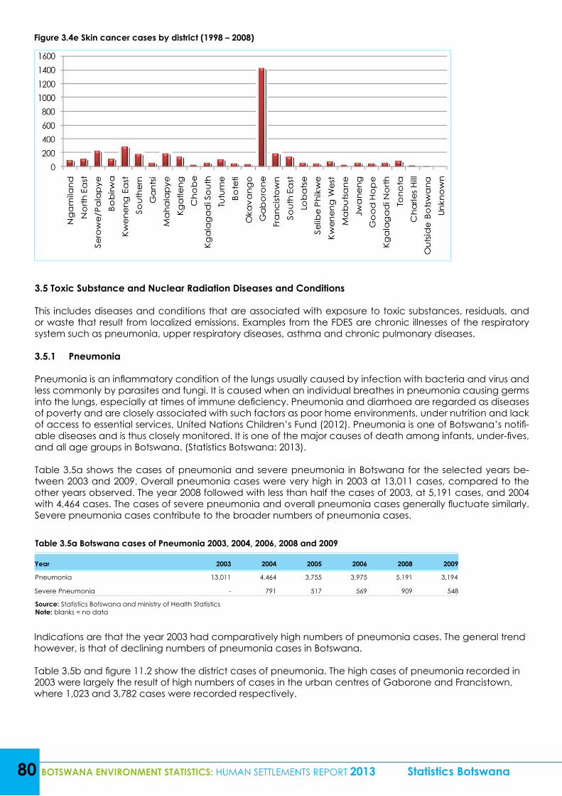
80 BOTSWANA ENVIRONMENT STATISTICS: HUMAN SETTLEMENTS REPORT 2013 Statistics Botswana
Figure 3.4e Skin cancer cases by district (1998 – 2008)
3.5 Toxic Substance and Nuclear Radiation Diseases and Conditions
This includes diseases and conditions that are associated with exposure to toxic substances, residuals, and or waste that result from localized emissions. Examples from the FDES are chronic illnesses of the respiratory system such as pneumonia, upper respiratory diseases, asthma and chronic pulmonary diseases.
3.5.1 Pneumonia
Pneumonia is an inflammatory condition of the lungs usually caused by infection with bacteria and virus and less commonly by parasites and fungi. It is caused when an individual breathes in pneumonia causing germs into the lungs, especially at times of immune deficiency. Pneumonia and diarrhoea are regarded as diseases of poverty and are closely associated with such factors as poor home environments, under nutrition and lack of access to essential services, United Nations Children’s Fund (2012). Pneumonia is one of Botswana’s notifi-able diseases and is thus closely monitored. It is one of the major causes of death among infants, under-fives, and all age groups in Botswana. (Statistics Botswana: 2013).
Table 3.5a shows the cases of pneumonia and severe pneumonia in Botswana for the selected years be-tween 2003 and 2009. Overall pneumonia cases were very high in 2003 at 13,011 cases, compared to the other years observed. The year 2008 followed with less than half the cases of 2003, at 5,191 cases, and 2004 with 4,464 cases. The cases of severe pneumonia and overall pneumonia cases generally fluctuate similarly. Severe pneumonia cases contribute to the broader numbers of pneumonia cases.
Table 3.5a Botswana cases of Pneumonia 2003, 2004, 2006, 2008 and 2009
Year 2003 2004 2005 2006 2008 2009
Pneumonia 13,011 4,464 3,755 3,975 5,191 3,194
Severe Pneumonia - 791 517 569 909 548
Source: Statistics Botswana and ministry of Health StatisticsNote: blanks = no data
Indications are that the year 2003 had comparatively high numbers of pneumonia cases. The general trend however, is that of declining numbers of pneumonia cases in Botswana.
Table 3.5b and figure 11.2 show the district cases of pneumonia. The high cases of pneumonia recorded in 2003 were largely the result of high numbers of cases in the urban centres of Gaborone and Francistown, where 1,023 and 3,782 cases were recorded respectively.
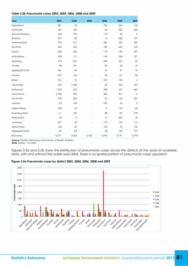
Statistics Botswana BOTSWANA ENVIRONMENT STATISTICS: HUMAN SETTLEMENTS REPORT 2013 81
Table 3.5b Pneumonia cases 2003, 2004, 2006, 2008 and 2009
Year 2003 2004 2005 2006 2008 2009
Ngamiland 881 45 - 225 456 165
North East 327 100 - 46 322 220
Serowe/Palapye 460 199 - 119 45 0
Bobirwa 879 82 - 13 382 197
Kweneng East 796 751 - 420 335 326
Southern 603 353 - 189 435 103
Gantsi 205 344 - 179 190 297
Mahalapye 638 171 - 145 234 197
Kgatleng 374 201 - 433 437 29
Chobe 88 101 - 69 28 19
Kgalagadi South 461 124 - 47 27 18
Tutume 437 164 - 42 131 30
Boteti 216 76 - 318 183 4
Okavango 269 1,048 - 64 262 187
Gaborone 1,023 675 - 398 421 447
Francistown 3,782 229 - 460 301 0
South East 375 262 - 47 123 227
Lobatse 95 140 - 275 56 0
Selibe Phikwe 478 65 - 9 123 42
Kweneng West 111 130 - 88 143 279
Mabutsane 43 3 - 19 220 78
Jwaneng 251 43 - 173 106 116
Good Hope 120 20 - 139 92 106
Kgalagadi North 99 82 - 58 139 107
Botswana 13,011 4,464 3,755 3,975 5,191 3,194
Source: Statistics Botswana and ministry of Health StatisticsNote: blanks = no data
Figures 3.5a and 3.5b show the distribution of pneumonia cases across the districts of the years of available data, with and without the outlier year 2003. There is no spatial pattern of pneumonia cases apparent.
Figure 3.5a Pneumonia cases by district 2003, 2004, 2006, 2008 and 2009
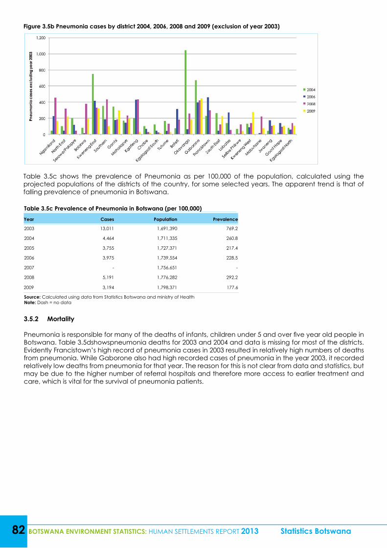
82 BOTSWANA ENVIRONMENT STATISTICS: HUMAN SETTLEMENTS REPORT 2013 Statistics Botswana
Figure 3.5b Pneumonia cases by district 2004, 2006, 2008 and 2009 (exclusion of year 2003)
Table 3.5c shows the prevalence of Pneumonia as per 100,000 of the population, calculated using the projected populations of the districts of the country, for some selected years. The apparent trend is that of falling prevalence of pneumonia in Botswana.
Table 3.5c Prevalence of Pneumonia in Botswana (per 100,000)Year Cases Population Prevalence
2003 13,011 1,691,390 769.2
2004 4,464 1,711,335 260.8
2005 3,755 1,727,371 217.4
2006 3,975 1,739,554 228.5
2007 - 1,756,651 -
2008 5,191 1,776,282 292.2
2009 3,194 1,798,371 177.6
Source: Calculated using data from Statistics Botswana and ministry of HealthNote: Dash = no data
3.5.2 Mortality
Pneumonia is responsible for many of the deaths of infants, children under 5 and over five year old people in Botswana. Table 3.5dshowspneumonia deaths for 2003 and 2004 and data is missing for most of the districts. Evidently Francistown’s high record of pneumonia cases in 2003 resulted in relatively high numbers of deaths from pneumonia. While Gaborone also had high recorded cases of pneumonia in the year 2003, it recorded relatively low deaths from pneumonia for that year. The reason for this is not clear from data and statistics, but may be due to the higher number of referral hospitals and therefore more access to earlier treatment and care, which is vital for the survival of pneumonia patients.
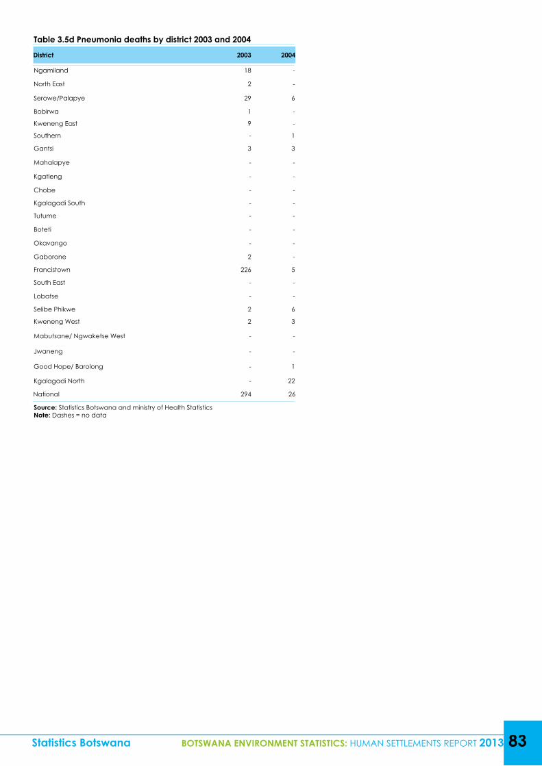
Table 3.5d Pneumonia deaths by district 2003 and 2004
District 2003 2004
Ngamiland 18 -
North East 2 -
Serowe/Palapye 29 6
Bobirwa 1 -
Kweneng East 9 -
Southern - 1
Gantsi 3 3
Mahalapye - -
Kgatleng - -
Chobe - -
Kgalagadi South - -
Tutume - -
Boteti - -
Okavango - -
Gaborone 2 -
Francistown 226 5
South East - -
Lobatse - -
Selibe Phikwe 2 6
Kweneng West 2 3
Mabutsane/ Ngwaketse West - -
Jwaneng - -
Good Hope/ Barolong - 1
Kgalagadi North - 22
National 294 26
Source: Statistics Botswana and ministry of Health StatisticsNote: Dashes = no data
Statistics Botswana BOTSWANA ENVIRONMENT STATISTICS: HUMAN SETTLEMENTS REPORT 2013 83
84 BOTSWANA ENVIRONMENT STATISTICS: HUMAN SETTLEMENTS REPORT 2013 Statistics Botswana
REFERENCES
Centers for Disease Control and Prevention (2012). “Epidemiology and Prevention of Vaccine-Preventable Diseases.” Atkinson W, Hamborsky J, Wolfe S, eds. 12th ed., second printing, Public Health Foundation, Washington DC
Central Statistics Office (2011), “Botswana Transport and Communications Statistics – 2010,” Ministry of Transport and Communication, Government Printing
Charles W. Schmidt (2008) Linking TB and the Environment: An Overlooked Mitigation Strategy in Journal Environ Health Perspectives. 2008 November; 116(11): A478–A485 online http://www.ncbi.nlm.nih.gov/pmc/articles/PMC2592293/
Gwebu, T.D., Baakile, T., & Mphetolang, G., (2013), “Population Distribution, Structure, Density & Policy Implications in Botswana”2011 Population and Census Dissemination Conference Proceedings, 9-12 December 2013, Fair Grounds, Gaborone, Botswana
International Civil Aviation Organization (2013) “Annual Report of the Council 2012,” Doc 1001.
Intergovernmental Panel on Climate Change (1990), “Good Practice Guidance and Uncertainty Management in National Greenhouse Gas Inventories; Aircraft Emissions,”
Letamo, G., & Bainame, K. (2013),“Fertility Levels and Trends” 2011 Population and Census Dissemination Conference Proceedings, 9-12 December 2013, Fair Grounds, Gaborone, Botswana
Majelantle, R., (2013),“Adult Mortality Levels and Trends in Botswana” 2011 Population and Census Dissemination Conference Proceedings, 9-12 December 2013, Fair Grounds, Gaborone, Botswana
Marshy, M. (1999), “Social and Psychological Effects of Overcrowding in Palestinian Refugee Camps in the West Bank and Gaza - Literature Review and Preliminary Assessment of the Problem” prepared for the INTERNATIONAL DEVELOPMENT RESEARCH CENTRE (http://prrn.mcgill.ca/research/papers/marshy.htm)
Modukanele, B., (2013), “Waste Collection and Disposal in Census Districts (2011 Census)” 2011 Population and Census Dissemination Conference Proceedings, 9-12 December 2013, Fair Grounds, Gaborone, Botswana
Republic of Botswana, Department of Road Transport and Safety- Ministry of Transport and Communication
Statistics Botswana (2013) “Botswana Transport and Infrastructure Statistics–2011” Government printing
Statistics Botswana (2013) “Gross Domestic Product,” No: 2013/24
Statistics Botswana, Census Unit, Gaborone, Botswana
Statistics Botswana (2013) Botswana-Causes of Mortality Stats Brief, Statistics Botswana, Gaborone.
United Nations (1988) “Concepts and Methods of Environmental Statistics; Human Settlements-A Technical Report” Series F No. 51
United Nations Children’s Fund (2012) Pneumonia and Diarrhoea. Tackling the deadliest diseases for the world’s poorest children, UNICEF, New York.
United states Environmental Protection Agency (2010) Ozone Layer Depletion, USEPA, Washington D.C.
United Nations Statistics Division (2013) “Framework for the Development of Environment Statistics (FDES)-Department of Economic and Social Affairs, Statistics Division, United Nations http://unstats.un.org/unsd/statcom/doc13/BG-FDES-Environment.pdf
World Health Organisation (2012), “Health Topics–Environmental Health,”http://www.who.int/topics/environmental_health/en

Statistics Botswana BOTSWANA ENVIRONMENT STATISTICS: HUMAN SETTLEMENTS REPORT 2013 85