Embed Size (px)
Citation preview
Bringing geoheritage underwater: methodological
approaches to evaluation and mapping
Alessio Rovere, Matteo Vacchi, Valeriano Parravicini, Carla Morri, Carlo Nike Bianchi,
Marco Firpo
Dipartimento per lo Studio del Territorio e delle sue Risorse
Università degli Studi di Genova
Corso Europa 26
I - Genova
E-Mail: [email protected]
In Regolini-Bissig G., Reynard E. (Eds) (2010). Mapping Geoheritage, Lausanne, Institut de
géographie, Géovisions n°35, pp. 65-80.
Rovere, A., Morri, C., Bianchi, C. N., & Firpo, M. (2010). Bringing geoheritage underwater: methodological approaches to evaluation and mapping. Dans G. Regolini-Bissig & E. Reynard (Éds), Mapping Geoheritage (pp. 65–80). Lausanne: Université, Institut de géographie.

Bringing geoheritage underwater: methodological approaches to evaluation and mapping - 67 -
1. Introduction
The valorisation of the natural heritage (here intended as the complex of biotic and abiotic elements of nature worthy of conservation) assumed a growing importance in the last years, leading to place biodiversity and geodiversity concepts side by side (Brilha, 2002). This in turn channelled efforts to protect not only biotopes, but also the associated physical landscape or environment through the identification of geo-sites or geomorphosites (Panizza & Piacente, 1993; Panizza, 2001; Reynard, 2004, 2005). In the field of abiotic heritage evaluation, various methods have been pro-posed for the recognition of scientific and additional values of relevant geological and geomorphological sites (Panizza, 2001; Coratza & Giusti, 2005; Pereira et al., 2007; Reynard et al., 2007; Serrano & Ruiz Flaño, 2007; Zouros, 2007). Natural heri-tage studies cover most types of environments, from mountain and subterranean areas to plains and coasts. Nevertheless, while many approaches to valorisation of natural heritage are reported for emerged shorelines (e.g. Carobene & Firpo, 2005; Zouros, 2007), research on coastal submerged areas (Orrù & Ulzega, 1988; Orrù et al., 2005) still lacks common schemes and approaches when compared with studies dealing with marine ecological resources (Bianchi, 2007 and reference therein).
Inspired from a methodological approach developed in France for the evaluation of terrestrial natural spaces in the framework of the EU Habitat Directive (Bardat et al., 1997), the Regional Activity Centre for Specially Protected Areas RAC SPA (UNEP) (Relini, 2000) obtained evaluation indexes for 148 ecological units (biocenoses, asso-ciations or facies), which correspond to the main marine habitats of the Mediterranean Sea. The combination of these criteria led to the realisation, in the last decade, of marine territorial cartographies in some Italian protected areas (Bianchi, 2007, and references therein). From these experiences, Bianchi (2007) defined “marine natural emergences” as species, habitats or landforms of high conservation interest, achieving the result of a territorial cartography displaying these three typolo-gies of marine natural emergences. Applying this approach, Rovere et al. (2007a) argued that “adding the abiotic values to the biotic ones appears of importance in the evaluation of the natural heritage”, but pointed out the discrepancy between the definition of biological and ecological values and the abiotic ones, the former being codified, the latter lacking common evaluation schemes.
The development of underwater abiotic heritage assessment approaches demands for a greater effort with respect to the terrestrial environment (e.g. costs of boats and SCUBA equipment) and faces several limits, such as logistics of field activity (time and depth limitations for diving) and adverse environmental conditions (e.g. scarce visibili-ty due to reduced water transparency). These limits are flanked by the conceptual dif-ficulty, for administrators and policy managers, to conceive the marine environment as “territory” (Bianchi, 2007), as its perception is low with respect to the terrestrial environment and the tools for its management are not always defined. Due to these considerations, evaluation of scientific and additional values of abiotic heritage
- 68 - A. Rovere et al.
should be coupled with the evaluation of the inherent accessibility to users of the underwater natural heritage due to the aquatic medium itself (need of swimming skills or diving licenses to access sites).
Approaches to the valorisation of the underwater abiotic heritage should be deve-loped using several distinct but interrelated kinds of inputs. Firstly, direct and indirect surveys, together with published information, provide the baseline maps to imple-ment the conceptual framework for the evaluation of the abiotic heritage. Secondly, a conceptual framework, comprising of the categories and criteria to assign values to the landforms inside a given area, has to be developed and applied. Merging the baseline data and the conceptual framework into georeferenced databases will allow maps of the abiotic heritage to be obtained. Thirdly, accessibility values must be considered, as they represent the potential use of the heritage values, and accessibili-ty maps need, therefore, to be produced. Finally, the abiotic heritage maps should be integrated with other information, such as ecological and socio-economical values or environmental degradation and risk assessment in order to obtain a complete territo-rial cartography, which is the base for the management of the natural heritage as a whole (Bianchi, 2007).
In this study, we propose a methodological approach that integrates the inputs men-tioned above. In particular, the direct surveying techniques and the conceptual fra-mework for the evaluation of the abiotic marine heritage together with its accessibili-ty to use will be applied to a case study in the Isola di Bergeggi, a recently established Marine Protected Area (MPA) in Liguria (Italy).
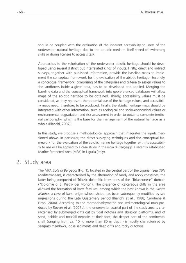
2. Study areaThe MPA Isola di Bergeggi (Fig. 1), located in the central part of the Ligurian Sea (NW Mediterranean), is characterised by the alternation of sandy and rocky coastlines, the latter being composed of Triassic dolomitic limestones of the “Brianzonese” domain (“Dolomie di S. Pietro dei Monti”). The presence of calcareous cliffs in the area allowed the formation of karst features, among which the best known is the Grotta Marina, a cave of karst origin whose shape has been subsequently modified by sea ingressions during the Late Quaternary period (Bianchi et al., 1988; Carobene & Firpo, 2004). According to the morphobathymetric and sedimentological map pro-duced by Rovere et al. (2007b), the underwater coastal part of the study area is cha-racterised by submerged cliffs cut by tidal notches and abrasion platforms, and of sand, pebble and rockfall deposits at their foot; the deeper part of the continental shelf (ranging from ca. 10 to more than 80 m depth) is mostly characterised by seagrass meadows, loose sediments and deep cliffs and rocky outcrops.
Bringing geoheritage underwater: methodological approaches to evaluation and mapping - 69 -
Fig. 1 Location of the study area with direct and indirect surveys.
- 70 - A. Rovere et al.
3. Methods
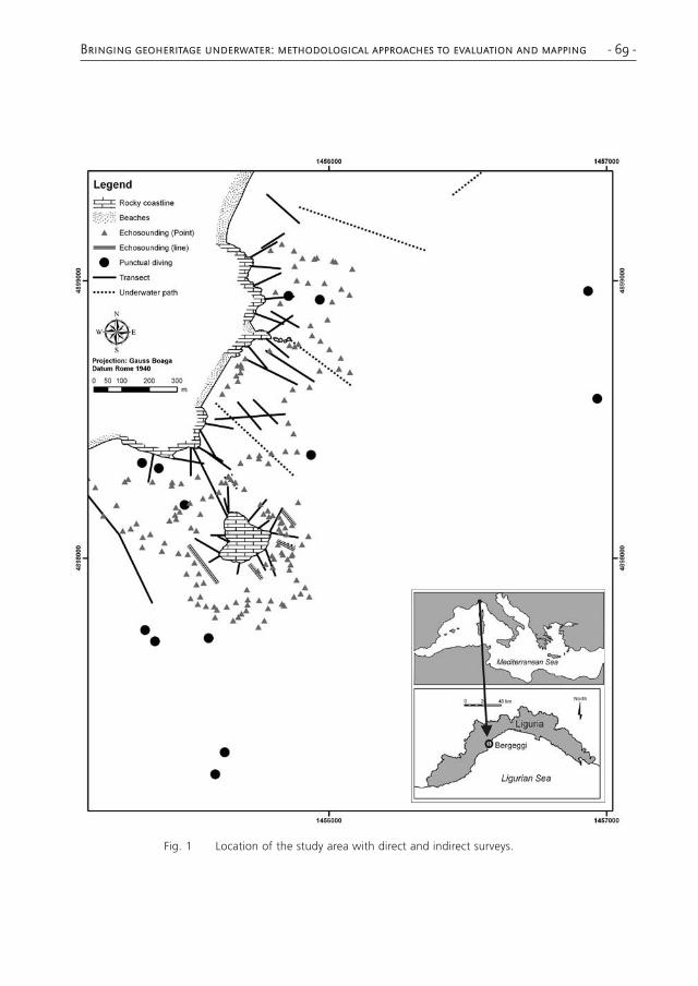
Assessment of the underwater abiotic heritage was carried out using both indirect and direct surveys (Fig. 1). Indirect surveys consist in remote sensing techniques for mapping marine bottoms (aerial photography, satellite images and acoustic records from side scan, single or multi beam sonars). In general, these techniques have the advantage of mapping larger areas than direct surveys, allowing us to obtain georefe-renced data at landscape scale useful for providing the cartographical basis for detailed mapping. Indirect surveys made in the study area included echo sounding (points or lines), as well as data from side scan sonar sonograms and aerial and pho-tographs (Diviacco & Coppo, 2006). Nevertheless, in coastal marine environments, implementation of indirect surveys with direct ones is needed because of some critical issues dealing mainly with the interpretation and ground-truthing of aerial images and geophysical surveys and with the need for detail. Depth transects, underwater paths and punctual surveys were, therefore, carried out using scuba diving tech-niques (Bianchi et al., 2004). Depth transects consist of marked lines positioned on the bottom, along which the topography, relevant morphologies and types of sedi-ments are measured. Underwater paths are similar to transects, except that they are done without reference lines and the distances are estimated with Personal Diving Sonar (PDS) and compass navigation. Underwater paths are the simplest type of poly-gonal survey, a method that proved to be efficient in mapping submerged shoals and caves (Colantoni, 2007).
In order to evaluate abiotic heritage and accessibility, the study area was divided into territorial units (hereafter called TU), defined as parts of the territory that: i) should give a sufficiently detailed territorial information; ii) can be compared from the point of view of the value and function that they have in the framework of environmental evaluation; iii) can be easily and uniformly represented in a GIS, allowing the building of relational databases to extract information for territorial management (Bianchi, 2007). These units are typically submultiples of the UTM grid, and can have various dimensions according to both the scale of baseline maps and the objectives of the study (in general, maps for environmental decisions require higher scales than those for environmental planning). In this study, the dimension of the TUs was set to 100 × 100 m due to the high detail (1:2000) of the baseline maps: the morphobathy-metric and sedimentological map (Rovere et al., 2007b), the marine biocenose map (Parravicini et al., 2007a), and the marine emergence map (Parravicini et al., 2007b).
The Total Abiotic Heritage values (hereafter referred to as TAH) were divided into two categories: scientific and additional (Reynard et al., 2007). Scientific values are refer-red to as the sum of the geomorphological significances that a process or landform may assume in terms of four subcategories: integrity (INT), representativeness (REP), rarity (RAR) and paleogeographic value (PAL). Additional values refer to the aspects that have a link with a process or landform, but that cannot be directly ascribed to the field of geomorphological sciences. The subcategories identified for these values
Bringing geoheritage underwater: methodological approaches to evaluation and mapping - 71 -
are: cultural (CULT), ecological (ECOL), economic (ECON) and aesthetical (AEST). These subcategories were described and adopted in terrestrial environments by Reynard et al. (2007).
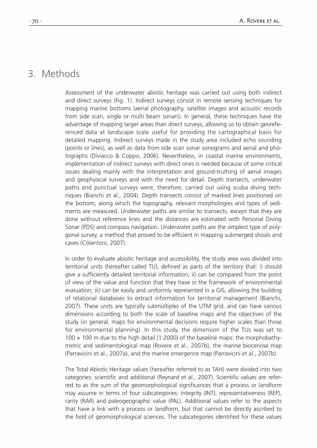
The TAH values of each TU were assigned as follows (Tab. 1, 2):
• for each subcategory, a score was assigned to each landform, ranging from 1 to 5;
• additional and scientific values were obtained for each landform ave-raging the scores of the relative subcategories (Tab.1, 2);
• the TAH value of a landform was obtained averaging the scores of its additional and scientific values;
• the values at TU level were obtained by averaging the relative values of the landforms contained in the TU (Fig. 2);
• the TAH values at TU level were re-classified into five classes, which were represented into thematic maps as different colours of the TUs (Fig. 3);
• the accessibility of a TU was similarly scored in five classes (Tab. 3) ranging from 1 (high accessibility) to 5 (low accessibility). In the TUs where more than one value of accessibility was eligible, it was decided to retain the lower accessibility value allowing for the use of the higher abiotic heritage value (see Fig. 2 for an example).
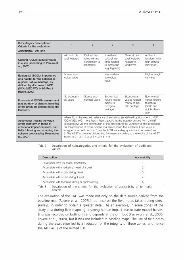
Subcategory description / Criteria for the evaluation 1 2 3 4 5
SCIENTIFIC VALUES
Integrity (INT): state of conservation of a given landform
Bad conserva-tion due to both natural and human causes
Bad conserva-tion due to human causes
Damage can occur in some parts of the landform but landscape integrity is pre-served
Good conser-vation due to human inter-vention
Good conser-vation due to natural condi-tions
Representativeness (REP): exemplarity of a given landform
No exemplarity Bad example of process or landform
Fair example of process or landform
Good example of process or landform
Reference site (in scientific literature) for the description of a process or landform
Rareness (RAR): rareness of a given landform at national, international or global level
Common or rare only at local scale
Rare at region-al scale
Rare at nation-al scale
Rare at inter-national (e.g. continental) scale
Rare at global scale (e.g. few examples worldwide)
Paleogeographical (PAL): importance of a given landform in defining proc-esses or environments that have characterised the Earth history
No paleogeo-graphic value
Scarce paleo-geographic significance
Good repre-sentation of a paleoprocess
Good repre-sentation of a paleoenviron-ment
Good repre-sentation of a paleoprocess and a paleo-environment
Tab.1 Description of subcategories and criteria for the evaluation of scientific values.
- 72 - A. Rovere et al.
Subcategory description / Criteria for the evaluation
1 2 3 4 5
ADDITIONAL VALUES
Cultural (CULT): cultural values in a site (according to Pereira et al., 2007)
Without cul-tural features
Cultural fea-tures with no connection to landforms
Immaterial cultural fea-tures related to landforms (e.g. legends)
Material cul-tural features related to landforms
Anthropic landform with high cultural relevance
Ecological (ECOL): importance of a habitat for the national or regional natural heritage, as defined by document UNEP (OCA)/MED WG 149/5 Rev.1 (Relini, 2000)
Scarce eco-logical value
Intermediate ecological value
High ecologi-cal value
Economical (ECON): assessment (e.g. number of visitors, benefits) of the products generated by the landform.
No economi-cal value
Scarce eco-nomical value
Economical values related mainly to biological heritage
Economical values related mainly to abi-otic heritage
Economical values related to natural (biotic and abiotic) herit-age
Aesthetical (AEST): the value of the landform in terms of emotional impact on users, par-tially following and adapting the scheme proposed by Reynard et al., 2007
Where Ec is the aesthetic relevance of an habitat (as defined by document UNEP (OCA)/MED WG 149/5 Rev.1: Relini, 2000); Int the integrity derived from the INT subcategory; Ver the contribution of the landform to the verticality of the landscape; Str the presence of three-dimensional structures in the landform. Each value is assigned a score from 1 to 5, so the AEST subcategory can vary between 0 and 5. The AEST score was divided into 5 classes according to the results of the AEST index: 1: 0-1 2: 1-2 3: 2-3 4: 3-4 5: 4-5
Tab. 2 Description of subcategories and criteria for the evaluation of additional values.
Description Accessibility
Accessible from the coast, snorkelling 1
Accessible with snorkelling, need of a boat 2
Accessible with scuba diving I level 3
Accessible with scuba diving II level 4
Accessible with technical diving or speleo diving 5
Tab. 3 Description of the criteria for the evaluation of accessibility of territorial parcels.
The evaluation of the TAH was made not only on the data source derived from the baseline map (Rovere et al., 2007b), but also on the field notes taken during direct surveys, in order to obtain a greater detail. As an example, in some zones of the study area during field mapping, a strong human impact due to date mussel harves-ting was recorded on both cliffs and deposits at the cliff foot (Parravicini et al., 2006; Rovere et al., 2009), but it was not included in baseline maps. The use of field notes during the evaluation led to a reduction of the integrity of these zones, and hence the TAH value of the related TUs.
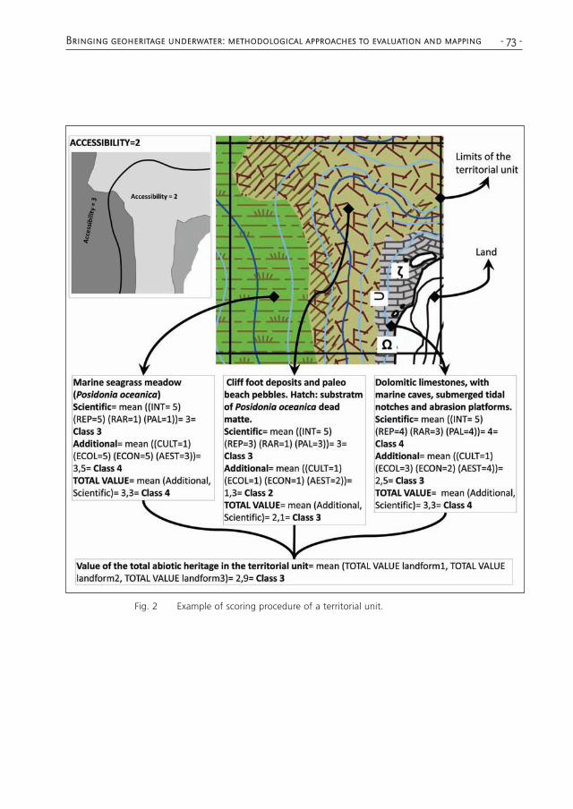
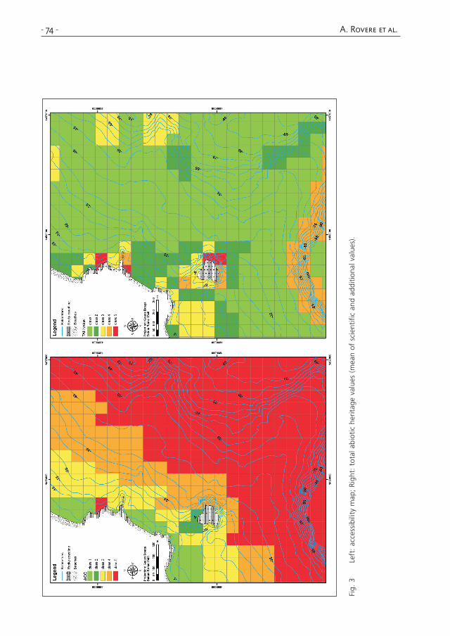
Bringing geoheritage underwater: methodological approaches to evaluation and mapping - 73 -
Fig. 2 Example of scoring procedure of a territorial unit.
- 74 - A. Rovere et al.
Fig.
3
Left
: ac
cess
ibili
ty m
ap;
Righ
t: t
otal
abi
otic
her
itage
val
ues
(mea
n of
sci
entif
ic a
nd a
dditi
onal
val
ues)
.
Bringing geoheritage underwater: methodological approaches to evaluation and mapping - 75 -
4. Results and discussion
This study produced two main orders of results. The first one is represented by the refinement of the methodological approach, which was adapted in part from similar terrestrial studies dealing with the valorisation and conservation of geomorphosites, and in part from parallel approaches for the evaluation of ecological values. The second order is represented by the direct implications for the valorisation, conserva-tion, and, finally, management of the MPA Isola di Bergeggi.
4.1 Methodological approach
Although indirect survey techniques were essential for the realisation of a cartogra-phic basis (e.g. bathymetry, limits of Posidonia oceanica meadows), data from direct surveys proved invaluable to obtain the details for the comprehension and spatial representation of the morphologies. The availability, during the evaluation procedure, of the dataset obtained from direct surveys also helped in assigning values to each landform. In general, this consideration suggests that direct surveys must be planned not only with the typical aims of a geomorphological survey (e.g. description of land-forms, processes) but also taking into account their successive use for the TAH eva-luation, and should, therefore, include data, which usually are not surveyed (e.g. the integrity and the cultural values associated to a landform).
A major problem with the evaluation of TAH is subjectivity, which can also affect the choice of the number and typology of subcategories. In fact, while the distinction in categories that can be ascribed to the “scientific” and “additional” ones adopted here is well established in literature, different authors propose various supplementary subca-tegories to the ones adopted in this study (e.g. Zouros, 2007 and reference therein). This is a key point in the evaluation of TAH, and can be solved using three approaches. The first is a bottom-up approach, where an expert board is asked to determine subca-tegories and criteria, based on the comparison of many specific study cases. The second is a top-down approach, where an expert board is asked to determine, a priori, which are the subcategories and criteria to give to each landform in a hypothetical condition, independently from local contexts, and then test the definitions in study cases. The third is a no-uniformity approach, implying that it is simply impossible (or too difficult and time-consuming) to choose a common evaluation scheme for the eva-luation of abiotic heritage in the marine environment and, even if the division into categories of “scientific” and “additional” values is maintained, the choice and evalua-tion of subcategories should be done following site-dependent considerations.
None of these approaches can be considered as the best, but they are intertwined and could represent three different steps in the evaluation of TAH. In fact, studies using no-uniformity approaches in different environments may provide the base for bottom-up choice of subcategories and criteria, which should necessarily be revised, implemented and generalised by expert boards, in a top-down perspective in order to
- 76 - A. Rovere et al.
enhance and improve further studies dealing with TAH and the comparison between different areas.
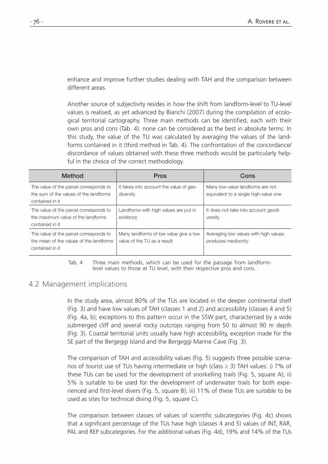
Another source of subjectivity resides in how the shift from landform-level to TU-level values is realised, as yet advanced by Bianchi (2007) during the compilation of ecolo-gical territorial cartography. Three main methods can be identified, each with their own pros and cons (Tab. 4): none can be considered as the best in absolute terms. In this study, the value of the TU was calculated by averaging the values of the land-forms contained in it (third method in Tab. 4). The confrontation of the concordance/discordance of values obtained with these three methods would be particularly help-ful in the choice of the correct methodology.
Method Pros Cons
The value of the parcel corresponds to
the sum of the values of the landforms
contained in it
It takes into account the value of geo-
diversity
Many low-value landforms are not
equivalent to a single high-value one
The value of the parcel corresponds to
the maximum value of the landforms
contained in it
Landforms with high values are put in
evidence
It does not take into account geodi-
versity
The value of the parcel corresponds to
the mean of the values of the landforms
contained in it
Many landforms of low value give a low
value of the TU as a result
Averaging low values with high values
produces mediocrity
Tab. 4 Three main methods, which can be used for the passage from landform-level values to those at TU level, with their respective pros and cons.
4.2 Management implications
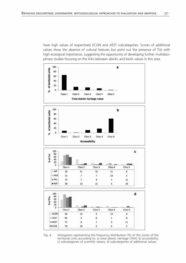
In the study area, almost 80% of the TUs are located in the deeper continental shelf (Fig. 3) and have low values of TAH (classes 1 and 2) and accessibility (classes 4 and 5) (Fig. 4a, b); exceptions to this pattern occur in the SSW part, characterised by a wide submerged cliff and several rocky outcrops ranging from 50 to almost 90 m depth (Fig. 3). Coastal territorial units usually have high accessibility, exception made for the SE part of the Bergeggi Island and the Bergeggi Marine Cave (Fig. 3).
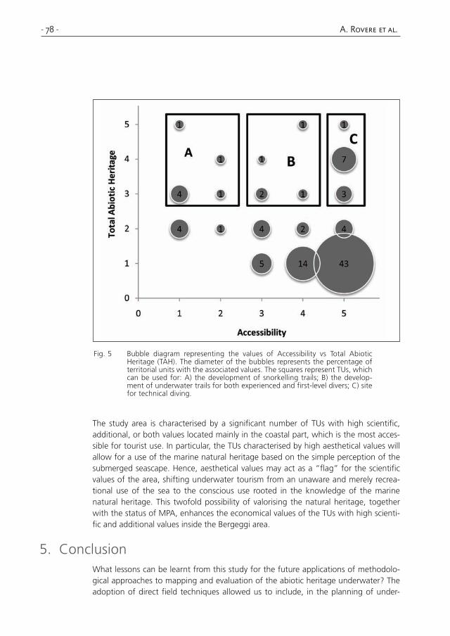
The comparison of TAH and accessibility values (Fig. 5) suggests three possible scena-rios of tourist use of TUs having intermediate or high (class ≥ 3) TAH values: i) 7% of these TUs can be used for the development of snorkelling trails (Fig. 5, square A); ii) 5% is suitable to be used for the development of underwater trails for both expe-rienced and first-level divers (Fig. 5, square B); iii) 11% of these TUs are suitable to be used as sites for technical diving (Fig. 5, square C).
The comparison between classes of values of scientific subcategories (Fig. 4c) shows that a significant percentage of the TUs have high (classes 4 and 5) values of INT, RAR, PAL and REP subcategories. For the additional values (Fig. 4d), 19% and 14% of the TUs
Bringing geoheritage underwater: methodological approaches to evaluation and mapping - 77 -
have high values of respectively ECON and AEST subcategories. Scores of additional values show the absence of cultural features but point out the presence of TUs with high ecological importance, suggesting the opportunity of developing further multidisci-plinary studies focusing on the links between abiotic and biotic values in this area.
Fig. 4 Histograms representing the frequency distribution (%) of the scores of the territorial units according to: a) total abiotic heritage (TAH); b) accessibility; c) subcategories of scientific values; d) subcategories of additional values.
- 78 - A. Rovere et al.
Fig. 5 Bubble diagram representing the values of Accessibility vs Total Abiotic Heritage (TAH). The diameter of the bubbles represents the percentage of territorial units with the associated values. The squares represent TUs, which can be used for: A) the development of snorkelling trails; B) the develop-ment of underwater trails for both experienced and first-level divers; C) site for technical diving.
The study area is characterised by a significant number of TUs with high scientific, additional, or both values located mainly in the coastal part, which is the most acces-sible for tourist use. In particular, the TUs characterised by high aesthetical values will allow for a use of the marine natural heritage based on the simple perception of the submerged seascape. Hence, aesthetical values may act as a “flag” for the scientific values of the area, shifting underwater tourism from an unaware and merely recrea-tional use of the sea to the conscious use rooted in the knowledge of the marine natural heritage. This twofold possibility of valorising the natural heritage, together with the status of MPA, enhances the economical values of the TUs with high scienti-fic and additional values inside the Bergeggi area.
5. ConclusionWhat lessons can be learnt from this study for the future applications of methodolo-gical approaches to mapping and evaluation of the abiotic heritage underwater? The adoption of direct field techniques allowed us to include, in the planning of under-
Bringing geoheritage underwater: methodological approaches to evaluation and mapping - 79 -
water geomorphological surveys, the assessment of values related to the submerged abiotic heritage. A common methodological approach is needed to define which are the subcategories and the criteria to adopt for the evaluation of abiotic heritage values. This is a critical point and each of the solutions discussed (top-down, bottom-up or no-uniformity) have their own pros and cons, but, in all cases, would be effec-tive in reducing the subjectivity of the evaluation. At present, studies on different environments with different subcategories and criteria are being carried out, provi-ding the “no-uniformity base”, but an effort should be done in the near future to generalise the results of these studies and to adopt common schemes for the evalua-tion of TAH. Once a common evaluation scheme is chosen and adopted, common criteria will be necessary to shift from the assignment of values at landform level to that at TU level (sum, maximum, mean). The methodology developed and applied in this study represents the first attempt to face, and try to solve, these issues.
In perspective, the methodological approach proposed in this study proved to be effi-cient in providing indications for the assessment and evaluation of the marine abiotic heritage. Once integrated with input from other disciplines (such as biology and eco-logy), the proper valorisation of the abiotic components will concur to define a com-plete conceptual framework to be adopted for the management of underwater natu-ral heritage as a whole.
ReferencesBardat J., Bensettiti F., Hindermeyer X. (1997). Approche méthodologique de l’évaluation
d’espaces naturels: exemple de l’application de la directive habitats en France,
Ecologie, 28(1), 45-59.
Bianchi C.N. (2007). Dalla cartografia bionomica alla cartografia territoriale, ovvero dalla cono-
scenza alla gestione delle aree marine protette, Biologia Marina Mediterranea, 14(2),
22-51.
Bianchi C.N., Cevasco M.G., Diviacco G., Morri C. (1988). Primi risultati di una ricerca ecologica
sulla grotta marina di Bergeggi (Savona), Bollettino dei Musei e degli Istituti Biologici
dell’Università di Genova, 52, 267-293.
Bianchi C.N., Ardizzone G.D., Belluscio A., Colantoni P., Diviacco G., Morri C., Tunesi L. (2004).
Benthic cartography, Biologia Marina Mediterranea, 11(1), 347-370.
Brilha J. (2002). Geoconservation and protected areas, Environmental Conservation, 29, 273-
276.
Carobene L., Firpo M. (2004). Tyrrhenian levels in the sea cave of Bergeggi (Liguria, Italy), 32nd
International Geological Conference, Florence, Abstract volume.
Carobene L., Firpo M. (2005). Conservazione e valorizzazione dei geositi costieri in Liguria:
l’esempio del tratto di costa tra Varazze e Cogoleto. In Terranova R., Brandolini
P., Firpo M. (Eds), La valorizzazione dello spazio fisico come via alla salvaguardia
ambientale, Bologna, Patròn Editore, 87-102.
Colantoni, P. (2007). L’immersione scientifica. Tecniche di indagine subacquea, Imola, La
Mandragora.
- 80 - A. Rovere et al.
Coratza P., Giusti C. (2005). Methodological proposal for the assessment of the scientific quality
of geomorphosites, Il Quaternario, 18(1), 307-313.
Diviacco G., Coppo S. (2006). Atlante degli habitat marini della Liguria, Genova, Regione Liguria.
Orrù P., Ulzega A. (1988). Rilevamento geomorfologico costiero e sottomarino applicato alla
definizione delle risorse ambientali (Golfo di Orosei, Sardegna orientale), Memorie
della Società Geologica Italiana, 37, 123-131.
Orrù P., Panizza V., Ulzega A. (2005). Submerged geomorphosites in the marine protected areas
of Sardinia (Italy): assessment and improvement, Il Quaternario, 18(1), 167-174.
Panizza M. (2001). Geomorphosites: concepts, methods and example of geomorphological sur-
vey, Chinese Science Bulletin, 46, 4-6.
Panizza M., Piacente S. (1993). Geomorphological asset evaluation, Zeitschrift für Geomorphologie
N.F., 87, 13-18.
Parravicini V., Rovere A., Donato M., Morri C., Bianchi C.N. (2006). A method to measure three-
dimensional substratum rugosity for ecological studies: an example from the date-
mussel fishery desertification in the north-western Mediterranean, Journal of the
Marine Biological Association of the U.K., 86, 5103/1-2.
Parravicini V., Montefalcone M., Lasagna R., Rovere A., Morri C., Bianchi C.N. (2007a). Carta
delle biocenosi marine, Comune di Bergeggi (SV).
Parravicini V., Rovere A., Firpo M., Morri C., Bianchi C.N. (2007b). Carta delle emergenze marine,
Comune di Bergeggi (SV).
Pereira P., Pereira D., Caetano Alves M.I. (2007). Geomorphosite assessment in the Montesinho
Natural Park (Portugal), Geographica Helvetica, 62, 159-168.
Relini G. (2000). Nuovi contributi per la conservazione della biodiversità marina in Mediterraneo,
Biologia Marina Mediterranea, 7(3), 173-211.
Reynard E. (2004). Geosites. In Goudie A. (Ed.). Encyclopedia of geomorphology, London,
Routledge, 440.
Reynard E. (2005). Geomorphological sites, public policies and property rights. Conceptualisation
and examples from Switzerland, Il Quaternario, 18(1), 321-330.
Reynard E., Fontana G., Kozlik L., Scapozza C. (2007). A method for assessing “scientific” and
“additional values” of geomorphosites, Geographica Helvetica, 62, 148-158.
Rovere A., Parravicini V., Firpo M., Morri C., Albertelli G., Bianchi C.N. (2007a). Emergenze natu-
ralistiche dell’Area Marina Protetta di Bergeggi (SV): integrazione di aspetti biologici,
ecologici e geomorfologici, Biologia Marina Mediterranea, 14(2), 20-21.
Rovere A., Firpo M., Parravicini V., Morri C., Bianchi C.N. (2007b). Carta morfobatimetrica e
sedimentologica, Comune di Bergeggi (SV).
Rovere A., Bellati S., Parravicini V., Firpo M., Morri C., Bianchi C.N. (2009). Abiotic and biotic
links work two ways: effects on the deposit at the cliff foot induced by mechani-
cal action of date mussel harvesting (Lithophaga lithophaga), Estuaries and Coasts,
32(2), 333-339.
Serrano E., Ruiz Flaño P. (2007). Geodiversity. A theoretical and applied concept, Geographica
Helvetica, 62, 140-147.
Zouros N. (2007). Geomorphosite assessment and management in protected areas of Greece.
The case of the Lesvos island coastal geomorphosites, Geographica Helvetica, 62,
169-180.