Embed Size (px)
Citation preview
BSc Modules, Course of Studies Geodesy and Navigation GUN V7/2013
gunb_module_EN.doc Seite 1 / 69
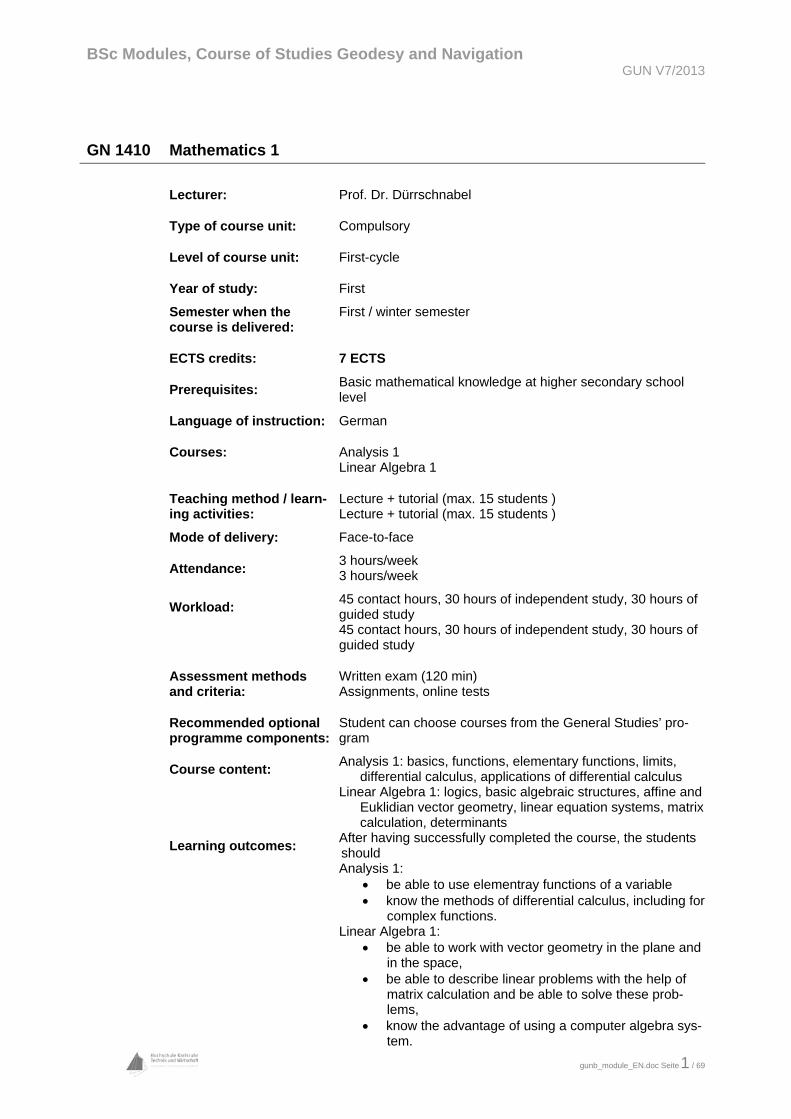
GN 1410 Mathematics 1
Lecturer: Prof. Dr. Dürrschnabel
Type of course unit: Compulsory
Level of course unit: First-cycle
Year of study:
Semester when the course is delivered:
First
First / winter semester
ECTS credits: 7 ECTS
Prerequisites: Basic mathematical knowledge at higher secondary school level
Language of instruction: German
Courses: Analysis 1 Linear Algebra 1
Teaching method / learn-ing activities:
Mode of delivery:
Lecture + tutorial (max. 15 students ) Lecture + tutorial (max. 15 students )
Face-to-face
Attendance:
Workload:
3 hours/week 3 hours/week
45 contact hours, 30 hours of independent study, 30 hours of guided study 45 contact hours, 30 hours of independent study, 30 hours of guided study
Assessment methods and criteria:
Written exam (120 min) Assignments, online tests
Recommended optional programme components:
Student can choose courses from the General Studies’ pro-gram
Course content: Analysis 1: basics, functions, elementary functions, limits,
differential calculus, applications of differential calculus Linear Algebra 1: logics, basic algebraic structures, affine and
Euklidian vector geometry, linear equation systems, matrix calculation, determinants
Learning outcomes: After having successfully completed the course, the students should Analysis 1:
be able to use elementray functions of a variable know the methods of differential calculus, including for
complex functions. Linear Algebra 1:
be able to work with vector geometry in the plane and in the space,
be able to describe linear problems with the help of matrix calculation and be able to solve these prob-lems,
know the advantage of using a computer algebra sys-tem.
BSc Modules, Course of Studies Geodesy and Navigation GUN V7/2013
gunb_module_EN.doc Seite 2 / 69
Work placements: n/a
Recommended reading: T. Arens, F. Hettlich et. al: Mathematik, Springer Spektrum, 2011 G. Bärwolff. Höhere Mathematik für Naturwissenschaftler und Ingenieure; Springer Spektrum, 2008 K. Dürrschnabel: Mathematik für Ingenieure; Springer Vie-weg, 2012 S. Goebbels, S. Ritter: Mathematik verstehen und anwen-den; Springer Spektrum, 2013 A. Fetzer, H. Fränkel: Mathematik 1; Springer, 2012 L. Papula: Mathematik für Ingenieure und Naturwissen-schaftler; vol. 1 and vol. 2; Springer Vieweg, 2014 and 2012 T. Rießinger: Mathematik für Ingenieure; Springer, 2013 J. Stewart: Calculus; Thomson Publishing, 2011 T. Westermann: Mathematik für Ingenieure; Springer, 2011 Internet / Multimedia: material and online tests can be found on the HsKA ILIAS server
BSc Modules, Course of Studies Geodesy and Navigation GUN V7/2013
gunb_module_EN.doc Seite 3 / 69
GN 1420 Computer Science
Lecturer: Prof. Dr. Bürg, Prof. Dr. Dürrschnabel
Type of course unit: Compulsory
Level of course unit: First-cycle
Year of study:
Semester when the course is delivered:
First
First / winter semester
ECTS credits: 5 ECTS
Prerequisites: Recommended: basic knowledge how to operate and use a computer
Language of instruction: German
Courses: Basics of Computer Science
Algorithms and Data Structures
Data Communication
Teaching method / learn-ing activities:
Mode of delivery:
Lectures
Face-to-face
Attendance:
Workload:
2 hours/week 2 hours/week 1 hour/week
30 contact hours, 30 hours of independent study 30 contact hours, 30 hours of independent study 15 contact hours, 15 hours of independent study
Assessment methods and criteria:
Written exam (90 min)
Recommended optional programme components:
Student can choose courses from the General Studies’ pro-gram
Course content: Basics of Computer Science: This lecture provides theoretical
basic knowledge in computer science: historical develop-ment, construction and functionality of computers, operat-ing systems, Boolean algebra, circuits, representation of data in the computer, encryption, information exchange between person and computer, design of computer lan-guages, software engineering
Algorithms and Data Structures 1: This course provides de-tailed knowledge in dealing with algorithms and data struc-tures. The teaching contents are: Formulation of algo-rithms, abstract data types, object orientation, concrete data structures (stacks, queues, linear lists, trees, hash structures, graphs), fundamental development methods, performance of algorithms, estimate calculation, analysis of algorithms from the fields of sorting, searching and op-timizing.
Data Communication: This lecture provides knowledge on the

BSc Modules, Course of Studies Geodesy and Navigation GUN V7/2013
gunb_module_EN.doc Seite 4 / 69
design and the functionality of computer networks. The contents are: Network topologies, communication technol-ogies, configuration of networks, net protocols, layer mod-els, Internet standards, Internet protocols.
Learning outcomes: After having successfully completed the course, the students should Basics of Computer Science:
know the approach of the von-Neumann computer and its theoretical basis.
Algorithms and Data Structures 1: be able to develop easy algorithms and optimize them
with regard to their efficiency Data Communication:
understand computer networks be able to build up easy networks themselves
Work placements: n/a
Recommended reading: H. Ernst: Grundkurs Informatik, Springer Vieweg, 2015 H. Gumm / M. Sommer: Einführung in die Informatik, Olden-
bourg, 2012 H. Herold, B. Lurz, J. Wohlrab: Grundlagen der Informatik;
Pearson, 2012 U. Rembold / P. Levi: Einführung in die Informatik für Natur-
wissenschaftler und Ingenieure; Hanser, 2002 B. Breutmann: Data and Algorithms – An Introductory
Course; Fachbuchverlag Leipzig, 2001 Th. Cormen / Ch. Leiserson / R. Rivest / C. Stein: Algorith-
men – Eine Einführung; Oldenbourg, 2013 Lecture notes on data communication will be available
BSc Modules, Course of Studies Geodesy and Navigation GUN V7/2013
gunb_module_EN.doc Seite 5 / 69
GN 1430 Surveying 1
Lecturers: Prof. Dr. Klein
Type of course unit: Compulsory
Level of course unit: First-cycle
Year of study:
Semester when the course is delivered:
First
First / winter semester
ECTS credits: 7 cp
Prerequisites: None
Language of instruction: German
Courses: Surveying 1
Teaching method / learn-ing activities:
Mode of delivery:
Lecture Exercise (group of 2 to 5 persons)
Face-to-face
Attendance:
Workload:
4 hours/week 2 hours/week
60 contact hours, 120 hours of independent study, 30 hours of guided study (e.g. exercises, projects, lab work)
Assessment methods and criteria:
Written exam (150 min) Assignments
Recommended optional programme components:
Student can choose courses from the General Studies’ pro-gram
Course contents: Basics of surveying: reference areas, coordinate sys-tems, reference point fields of land surveying, dis-tance and angular measurement
Basic skills in the simple determination of situation and height: different procedures of data acquisition, marking our of building projects, calculation and divi-sion of areas
Calculation of standard deviations, assessment of un-certainties, error propagation
Setting out of straight lines and right angles, meas-urement of distances, measurement of horizontal and vertical angles, survey (orthogonal, baseline, polar methods), stakeout of floor plan (orthogonal and polor methods), making a survey string line
Learning outcomes: After having successfully completed the course, the students should
be familiar with the basics of surveying be able to independently plan and organize simple
measuring tasks and evaluate the results be able to use basic surveying equipments, know measurement methods, be familiar with the
cause and effect of mesurement uncertainties, have
BSc Modules, Course of Studies Geodesy and Navigation GUN V7/2013
gunb_module_EN.doc Seite 6 / 69
gained the competence to evaluate and analyze sur-vey documents, have social skills, be capable of or-ganizing their work and time, know technical terms through the documentation, evaluation and further processing of their measurement data and results in exercises.
Work placements: n/a
Recommended reading: Baumann, E. (1999): Vermessungskunde. Band 1: Einfache
Lagemessung und Nivellement, Dümmler. Baumann, E. (1998): Vermessungskunde. Band 2: Punktbe-
stimmung nach Lage und Höhe, Dümmler. Deumlich, F., Staiger, R. (2002): Instrumentenkunde der
Vermessungstechnik, Wichmann. Groß, G. (2004): Vermessungstechnische Berechnungen,
Teubner. Gruber, F., Jöckel, R. (2012): Formelsammlung für das Ver-
messungswesen, Springer Jordan, Eggert, Kneißl: Handbuch der Vermessungskunde, J.
B. Metzlersche Verlagsbuchhandlung, 1956-1966 Kahmen, H. (2006): Angewandte Geodäsie: Vermessungs-
kunde, de Gruyter Matthews, V. (2003): Vermessungskunde 1: Lage-, Höhen-
und Winkelmessungen. Vieweg-Teubner Matthews, V. (1997): Vermessungskunde. Teil 2, Teubner Petrahn, G. (2010): Grundlagen der Vermessungstechnik,
Cornelsen-Verlag Witte, B., Sparla, P. (2011): Vermessungskunde und Grund-
lagen der Statistik für das Bauwesen, Wichmann-Verlag.
BSc Modules, Course of Studies Geodesy and Navigation GUN V7/2013
gunb_module_EN.doc Seite 7 / 69
GN 1440 Geodetic Basics
Lecturers: Prof. Dr. Pfeiffer, Prof. Dr. Schwäble
Type of course unit: Compulsory
Level of course unit: First-cycle
Year of study:
Semester when the course is delivered:
First
First / winter semester
ECTS credits: 6 ECTS
Prerequisites: None
Language of instruction: German
Courses: Geodetic Calculation
Fundamentals of Metrology
Trigonometry
Teaching method / learning activities:
Mode of delivery:
Lecture, assignments Lecture, exercises Lecture
Face-to-face
Attendance:
Workload:
2 hours/week 2 hours/week 2 hours/week
30 contact hours, 30 hours of independent study 25 contact hours, 30 hours of independent study, 5 hours of guided study 30 contact hours, 30 hours of independent study
Assessment methods and criteria:
Written exam (150 min)
Recommended optional programme components:
n/a
Course content: Geodetic Calculation: overview of the principles of funda-
mental coordination calculations and realisation of coor-dination calculations and transformation. Introduction to intersection calculation, coordinates transformation and the error calculation theory.
Fundamentals of Metrology: History of geodetic work and instruments. Bubbles, levelling of plates, reading devic-es. Optical fundamentals (prisms, optical flats, lenses, refraction, magnifiers, microscopes, telescopes). Theod-olites (components, set-up, levelling, operation, errors, reduction of errors, accuracy). Principle of collimation and auto-collimation
Trigonometry: right-angled and general triangles, addition theorems, goniometric equations, spherical right-angled and spherical general triangles, mathematical geography
BSc Modules, Course of Studies Geodesy and Navigation GUN V7/2013
gunb_module_EN.doc Seite 8 / 69
Learning outcomes: After having successfully completed the course, the stu-dents should Geodetic Calculation:
be familiar with and be able to use the basics of geodetic calculations
Fundamentals of Metrology: know the basic laws of metrology be familiar with the principles of geodetic standard
instruments be able to use competently the geodetic standard
instruments Trigonometry:
be able to realize triangular calculations in the plane and in the sphere,
know map projections.
Work placements: n/a
Recommended reading: Geodetic Calculation: Groß, G. (2004): Vermessungstechnische Berech-
nungen, Teubner Gruber, F., Jöckel, R. (2012): Formelsammlung für
das Vermessungswesen; Springer Petrahn, G. (2010): Grundlagen der Vermessungs-
technik, Cornelsen-Verlag Fundamentals of Metrology
Kahmen, H. (2006): Angewandte Geodäsie: Vermessungskunde, de Gruyter
Deumlich, F., Staiger, R. (2002): Instrumenten-kunde der Vermessungstechnik, Wichmann
Hecht, E. (2014): Optik, Oldenbourg Trigonometry
Hame, R. (1997): Sphärische Trigonometrie. Eh-renwirth Verlag GmbH
Kemnitz, A. (2013): Mathematik zum Studienbe-ginn, Springer
Kern, H., Rung, J. (1997): Sphärische Trigono-metrie. Bayerischer Schulbuch-Verlag.
BSc Modules, Course of Studies Geodesy and Navigation GUN V7/2013
gunb_module_EN.doc Seite 9 / 69
GN 1450 Basics of Cartography
Lecturer: Prof. Dr. Günther-Diringer
Type of course unit: Compulsory
Level of course unit: First-cycle
Year of study:
Semester when the course is delivered:
First
First / winter semester
ECTS credits: 5 cp
Prerequisites: none
Language of instruction: German
Courses: Visualization Basics and Presentation Techniques
Cartography
Teaching method/learning activities:
Mode of delivery:
Lecture with exercises and discussions Lecture with exercises and discussions
Face-to-face
Attendance:
Workload:
2 hours/week 2 hours/week
15 contact hours, 30 hours of independent study, 15 hours of guided study 25 contact hours, 60 hours of independent study, 5 hours of guided study
Assessment methods and criteria:
Written exam (90 min)
Recommended optional programme components:
Student can choose courses from the General Studies’ program
Course content: Visualization Basics and Presentation Techniques: Intro-
duction into physiology and perception; perceptional and communication theories. Basics of general drawing theo-ry, typography, design and colour theory. Basics of presentation (preparing and making a presentation, de-livery, use of visual elements).
Cartography: The students are provided with a basic knowledge of the concepts and methods of cartography. The focus is on topographic maps, digital geospatial data and thematic maps. The lecture contains the following topics: map-related illustrations, principles of cartograph-ic design, map scale, map fonts, notation of names, ter-rain design, cartographic generalization, thematic maps with different specifications. Practical work with topo-graphic maps is based on scale calculations, the location identification with map grids, the generalization and analysis of various maps, and compilation of thematic maps.
BSc Modules, Course of Studies Geodesy and Navigation GUN V7/2013
gunb_module_EN.doc Seite 10 / 69
Learning outcomes: After having successfully completed the course, the stu-dents should Visualization Basics and Presentation Techniques:
be familiar with basic presentation techniques be able to use basic presentation techniques understand visual communication as part of overall
communication, recognize and evaluate the pur-pose of aesthetics. Use standards and priniciples for the design of various elements, e.g. typogra-phy, shape, color, image, as well as apply different processes of abstraction. Students can discuss the relationship between form and content in a visuali-zation exercise.
Cartography: be acquainted with the rules for the textual and
graphic composition of maps and related illustra-tions,
be able to design thematic maps, know the elementary principles of spatial refer-
ence, cartographic instruments (graphics, scale, generalization) and the technical implementation of paper-based maps and maps in digital form
Work placements: n/a
Recommended reading: Literature: Abdullah, R., Hübner, R.: Piktogramme und Icons, Mainz
2005 Bollmann, J., Koch, W. G. (ed.): Lexikon der Kartographie
und Geomatik, Heidelberg / Berlin 2001 Forsyth, P.: 30 Minuten bis zur überzeugenden Präsenta-
tion, Offenbach 2006 Franck, N., Stary, J.: Gekonnt Visualisieren, Paderborn,
2006 Frutiger, A.: Der Mensch und seine Zeichen, Wiesbaden,
2004 Hake, G., Grünreich, D., Meng, L.: Kartographie, Berlin,
2001 Pricken, M.: Visuelle Kreativität, Mainz 2003 Stankowski, A., Duschek, K.: Visuelle Kommunikation,
Berlin 1989 Wilhelmy, H.: Kartographie in Stichworten, Zug 2002 Periodicals: Kartographische Nachrichten – Fachzeitschrift für Geoin-
formation und Visualisierung The Cartographic Journal – The World of Mapping Internet / Multimedia: Bundesamt für Kartographie und Geodäsie BKG (Federal
Agency for Cartography and Geodesy) http://www.bkg.bund.de
Deutsche Gesellschaft für Kartographie (German Carto-graphic Society) http://www.dgfk.net
BSc Modules, Course of Studies Geodesy and Navigation GUN V7/2013
gunb_module_EN.doc Seite 11 / 69
GN 2410 Mathematics 2
Lecturers: Prof. Dr. Dürrschnabel
Type of course unit: Compulsory
Level of course unit: First-cycle
Year of study:
Semester when the course is delivered:
First
Second / summer semester
ECTS credits: 7 cp
Prerequisites: Recommended: successful completion of module GN 1410, advanced knowledge of functions of a variable and their differential calculus
Language of instruction: German
Courses: Analysis 2
Linear Algebra 2
Teaching method/learning activities:
Mode of delivery:
Lecture, tutorial (maximum number of participants: 15) Lecture, tutorial (maximum number of participants: 15)
Face-to-face
Attendance:
Workload:
4 hours/week 2 hours/week
60 contact hours, 40 hours of independent study, 40 hours of guided study 30 contact hours, 20 hours of independent study, 20 hours of guided study
Assessment methods and criteria:
Assignments, online-tests, written exam (120 min)
Recommended optional programme components:
Student can choose courses from the General Studies’ program
Course content: Analysis 2: indefinite and definite integrals, series and power series, Fourier series and Fourier transformation, derivatives of functions of several variables, maximum and minimum values of functions of several variables, linear regression
Linear Algebra 2: complex numbers, coordinate transfor-mations, affine transformations, homogeneous coordi-nates, eigenvalue theory, conic sections and quadrics
Learning outcomes: After having successfully completed the course, the stu-dents should
Analysis 2: be able to perform series expansions, one- and multi-dimensional differential and integral calculus as well as demonstrate their useful application in practical exam-ples
Linear Algebra 2:
BSc Modules, Course of Studies Geodesy and Navigation GUN V7/2013
gunb_module_EN.doc Seite 12 / 69
be able to work with complex numbers and to handle transformation problems, be able to use a computer algebra system as a suitable aid.
Work placements n/a
Recommended reading: Books: T. Arens, F. Hettlich et.al: Mathematik; Springer
Spektrum, 2011 G. Bärwolff: Höhere Mathematik für Naturwissen-
schaftler und Ingenieure; Springer Spektrum, 2008 K. Dürrschnabel: Mathematik für Ingenieure; Springer
Vieweg, 2012 S. Goebbels, S. Ritter: Mathematik verstehen und
anwenden; Springer Spektrum, 2013 A. Fetzer, H. Fränkel: Mathematik 1 und Mathematik
2; Springer, 2012 und 2012 L. Palula: Mathematik für Ingenieure und Naturwis-
senschaftler, Band 1 und Band 2, Springer Vieweg, 2014 und 2012
T. Rießinger: Mathematik für Ingenieure; Springer, 2013
J. Stewart: Calculus; Thomson Publishing, 2011 T. Westermann: Mathematik für Ingenieure, Springer,
2011 Internet / Multimedia: Material and online tests can be found on the HsKA ILI-AS server
BSc Modules, Course of Studies Geodesy and Navigation GUN V7/2013
gunb_module_EN.doc Seite 13 / 69
GN 2420 Programming and Databases
Lecturers: Prof. Dr. Bürg Prof. Dr. Klein
Type of course unit: Compulsory
Level of course unit: First-cycle
Year of study:
Semester when the course is delivered:
First
Second / summer semester
ECTS credits: 6 cp
Prerequisites: Recommended: successful completion of module GN 1420, basic knowledge how to operate and use a comput-er
Language of instruction: German
Courses: Programming
Databases
Teaching method/learning activities:
Mode of delivery:
Lecture Lecture
Face-to-face
Attendance:
Workload:
3 hours/week 2 hours/week
45 contact hours, 45 hours of independent study 30 contact hours, 60 hours of independent study
Assessment methods and criteria:
Written exam (120 min)
Recommended optional programme components:
Student can choose courses from the General Studies’ program
Course content: Programming: introduction to basic programming concepts
with the help of the programming language C++, struc-ture of a C++ program, definition of data objects, funda-mental data types, enumeration, pointers, reference, ar-rays, operators, basic input/output, input/output with files, control structures, dynamic storage management, intro-duction to the usage of a compiler
Databases: general principles of databases, design of relational database systems, normalization, principles of hierarchical, network and object-oriented databases, re-lational algebra, QBE and SQL, data organization, data integrity
Learning outcomes: After having successfully completed the course, the stu-dents should Programming:
have basic programming skills, be able to develop, implement and test simple pro-grams.
Databases:
BSc Modules, Course of Studies Geodesy and Navigation GUN V7/2013
gunb_module_EN.doc Seite 14 / 69
be familiar with the fundamentals of relational data-bases, be able to design relational databases, be able to use a concrete relational database.
Work placements: n/a
Recommended reading: Programming: Stroustrup, B. (2015): Die C++ Programmiersprache,
Hanser-Fachbuchverlag Willms, G. (1999): C++ - Das Grundlagenbuch, Data
Becker Breymann, U. (2007): C++ - Einführung und professio-
nelle Programmierung, Hanser Liberty, J. (1999): C++ in 21 Days, Sams Louis, D. (2014): C++ - Das komplette Starterkit für den
einfachen Einstieg in die Programmierung, Hanser Krienke, R. (1998): C++ kurzgefaßt, Spektrum Akade-
mischer Verlag Databases: Kemper, A., Eickler, A. (2013): Datenbanksysteme,
Oldenbourg Schubert, M. (2007): Datenbanken, Vieweg Steiner, R. (2014): Relationale Datenbanken
BSc Modules, Course of Studies Geodesy and Navigation GUN V7/2013
gunb_module_EN.doc Seite 15 / 69
GN 2430 Mathematics and Natural Science
Lecturers: Prof. Dr. Dürrschnabel
Type of course unit: Compulsory
Level of course unit: First-cycle
Year of study:
Semester when the course is delivered:
First
Second / summer semester
ECTS credits: 6 cp
Prerequisites: Recommended: successful completion of module GN 1410, knowledge of differentiation, vector geometry, and matrix calculation
Language of instruction: German
Courses: Analysis 3
Physics
Teaching method/learning activities:
Mode of delivery:
Lecture, tutorial (maximum number of participants: 15) Lecture, tutorial (maximum number of participants: 15)
Face-to-face
Attendance:
Workload:
2 hours/week 4 hours/week
30 contact hours, 15 hours of independent study, 15 hours of guided study 60 contact hours, 30 hours of independent study, 30 hours of guided study
Assessment methods and criteria:
Assignments, 2 written exams (90 min each)
Recommended optional programme components:
Student can choose courses from the General Studies’ program
Course content: Analysis 3: integration techniques, numeric integration,
multiple integrals, parameter curves, clothoid, differential equations
Physics: kinematics, dynamics, conservative laws, rigid bodies, circular motion, electric and magnetic fields, electromagnetic induction, AC and DC circuits, oscilla-tion and waves, wave optics, outlook into modern phys-ics
Learning outcomes: After having successfully completed the course, the stu-dents should Analysis 3:
be familiar with the methods of non-elementary analysis be able to apply these methods to non-trivial mathemati-cal and geodetic problems
Physics: be able to apply the basic principles of mechanics, elec-tricity and optics
BSc Modules, Course of Studies Geodesy and Navigation GUN V7/2013
gunb_module_EN.doc Seite 16 / 69
Work placements: n/a
Recommended reading: Books: Analysis 3: T. Arens, F. Hettlich et. al.: Mathematik; Springer
Spektrum, 2011 G. Bärwolff: Höhere Mathematik für Naturwissen-
schaftler und Ingenieure; Springer Spektrum, 2008 K. Dürrschnabel: Mathematik für Ingenieure; Springer
Vieweg, 2012 S. Goebbels, S. Ritter: Mathematik verstehen und
anwenden; Springer Spektrum, 2013 A. Fetzer, H. Fränkel: Mathematik 1 und Mathematik
2, Springer, 2012 L. Papula: Mathematik für Ingenieure und Naturwis-
senschaftler, Band 2 und Band 3; Springer Vieweg, 2012 und 2011
J. Stewart: Calculus; Thomson Publishing, 2011 T. Westermann: Mathematik für Ingenieure; Springer,
2011 Physics: P. Dobrinski, G. Krakau, A. Vogel: Physik für Ingeni-
eure; Springer Vieweg, 2010 D. Giancoli: Physik; Pearson Studium, 2010 E. hering, R. Martin, M. Stohrer: Physik für Ingenieu-
re; Springer, 2013 H. Lindner: Physik für Ingenieure; Hanser, 2014 P. Tipler, G. Mosca: Physik für Wissenschaftler und
Ingenieure; Springer Spektrum, 2014 Internet / Multimedia: Material can be found on the HsKA ILIAS server
BSc Modules, Course of Studies Geodesy and Navigation GUN V7/2013
gunb_module_EN.doc Seite 17 / 69
GN 2440 Instrumentation and Sensors
Lecturers: Prof. Dr. Müller
Type of course unit: Compulsory
Level of course unit: First-cycle
Year of study:
Semester when the course is delivered:
First
Second / summer semester
ECTS credits: 6 cp
Attendance:
Workload:
4 hours/week 1 hour/week
60 contact hours, 105 hours of independent study, 15 hours of guided study
Prerequisites: Recommended: successful completion of modules GN 1410, GN 1430, GN 1440
Language of instruction: German
Teaching method/learning activities:
Mode of delivery:
Lecture Exercises (maximum number of participants: 4)
Face-to-face
Assessment methods and criteria:
Assignments, written exam (90 min)
Recommended optional programme components:
Student can choose courses from the General Studies’ program
Course content: Principles of metrology. Physical components. Principles of electronic distance and angle measure-
ment, and of electronic tacheometry; components, in-fluence of atmospheric parameters.
Automated leveling Distance measurement using microwaves, radio navi-
gation Echosounding Laser interferometry. EDM with elliptically polarized
light. Laser scanning Electronic measurement of smaller distance changes.
Inclination sensors. Inertial sensor technology Practical exercises on using and calibrating electronic
tacheometers. Written and oral reports
Learning outcomes: After having successfully completed the course, the stu-dents should be able to understand the principles of the most im-
portant measuring instruments, their physical founda-tion, and their electronic components,
be able to check and calibrate measuring instruments, be familiar with the measuring instruments and meth-

BSc Modules, Course of Studies Geodesy and Navigation GUN V7/2013
gunb_module_EN.doc Seite 18 / 69
ods which are used in special cases, be able to present a short and precise oral and written
report
Work placements: n/a
Recommended reading: Books: Joeckel, R., Stober, M., Huep, W.: Elektronische Ent-
fernungs- und Richtungsmessung. Stuttgart: Wittwer, 2008
Schlemmer, H.: Grundlagen der Sensorik. Heidelberg: Wichmann, 1996
Parthier, Rainer: Messtechnik. Wiesbaden: Vieweg, 2011
BSc Modules, Course of Studies Geodesy and Navigation GUN V7/2013
gunb_module_EN.doc Seite 19 / 69
GN 2450 Surveying 2
Lecturers: Prof. Dr. Schwäble
Type of course unit: Compulsory
Level of course unit: First-cycle
Year of study:
Semester when the course is delivered:
First
Second / summer semester
ECTS credits: 5 cp
Language of instruction: German
Attendance:
Workload:
5 hours/week
75 contact hours, 45 hours of independent study, 30 hours of guided study
Prerequisites: Recommended: successful completion of modules GN 1430, GN 1440. Theoretical and practical knowledge of function and use of the theodolite, elementary mathemati-cal knowledge about coordinate systems
Teaching method/learning activities:
Mode of delivery:
Lecture, practical exercises
Face-to-face
Assessment methods and criteria:
Assignments, written exam (120 min)
Recommended optional programme components:
Student can choose courses from the General Studies’ program
Course content: Methods, standards and data processing in considera-tion of terrestrial horizontal positioning including error propagation. The focus is on polar observation, setting out, recovering, traversing, intersection, resection, point centring.
Coordinate transformation (conformal, 5 parameters, affine)
Variance propagation (scalar und vectorial) , algebraic and physical correlation
Practical application (planning, measurement, analysis) the most important methods for determining location points
Learning outcomes: After having successfully completed the course, the stu-dents should be able to plan, to evaluate and to interpret standard
terrestrial positioning measurements have advanced knowledge in failure analysis and cor-
rection be able to determine location points
Work placements: n/a

BSc Modules, Course of Studies Geodesy and Navigation GUN V7/2013
gunb_module_EN.doc Seite 20 / 69
Recommended reading: Kahmen, H.: Vermessungskunde, de Gruyter; Berlin,
New York 2006 Matthews, V.: Vermessungskunde 1, Teubner, Stuttgart,
Leipzig, Wiesbaden 2003. Matthews, V.: Vermessungskunde 2, Teubner, Stuttgart
1997. Witte, B. und Schmidt, H.: Vermessungskunde und
Grundlagen der Statistik, Wittwer, Wichmann, Heidel-berg 2004.
BSc Modules, Course of Studies Geodesy and Navigation GUN V7/2013
gunb_module_EN.doc Seite 21 / 69
GN 3410 Computer Graphics and Digital Image Processing
Lecturers Prof. Dr. Klein Prof. Dr. Pfeiffer
Type of course unit: Compulsory
Level of course unit: First-cycle
Year of study:
Semester when the course is delivered:
Second
Third / winter semester
ECTS credits: 6 cp
Language of instruction: German
Courses: Computer Graphics
Digital Image Processing
Attendance:
Workload:
4 hours/week 3 hours/week
15 contact hours, 60 hours of independent study, 45 hours of guided study 34 contact hours, 15 hours of independent study, 11 hours of guided study
Prerequisites: Recommended: basic knowledge how to operate and use a computer
Teaching method/learning activities:
Mode of delivery:
Lecture, exercises Lecture, lab project
Face-to-face
Assessment methods and criteria:
Written exam (120 min)
Recommended optional programme components:
Student can choose courses from the General Studies’ program
Course content: Computer Graphics: Introduction to Computer Graphics: colour models,
modelling and representation of two- and three-dimensional objects by means of vector and raster graphics or data formats, basics of representatioin of geographical objects, (transformations, generation of curves, filling areas, projection of space onto plane, de-termining visible edges and faces)
Geometric data transfer between CAD systems, auto-mated collection of graphical data, processing of data gained in geodetic measuring processes
Use of AutoCAD: default settings, how to create a new drawing, drawing and editing commands for two- and three-dimensional objects, definition of user corrdin-date system, creation of blocks with attributes, adding externatl references, labeling, dimensioning, creating and printing layouts, hatching areas, generating per-spective views
BSc Modules, Course of Studies Geodesy and Navigation GUN V7/2013
gunb_module_EN.doc Seite 22 / 69
Use of GEOgraf: default settings, setup and printing of orders, geodetic calculations (area division, building structure, coordinate transformation,…), reading in and output of coordinate files, automatic generation of graphics, georeferencing of digital maps, digitising, generation of a digital terrain model based on tachy-metrically surveyed areas and derivation of derivatives
Creating plans for surveying pratice Digital Image Processing: Basics of digital image processing: picture digitalisa-
tion, pictorial statistics, grayscale manipulation, digital filtering, geometric operations, segmentation and clas-sification
As a lab project, the students will use the remote sens-ing software Erdas Imagine to perform practical exer-cises with satellite imagery. This includes greyscale and colour manipulation, filtering, geometrical image transformation and multispectral classification
Learning outcomes: After having successfully completed the course, the stu-dents should Computer Graphics: be familiar with the information representation in com-
puter graphics be able to use the CAD programs AutoCAD and GEO-
graf for two- and three-dimensional design, labeling, dimensioning, creation and presentation of plans
be able to carry out data exchange between CAD pro-grams
be able to carry out georeferencing of maps and data recording through on-screen digitization
be familiar with how to derive derivatives (contour lines, quantity surveys, longitudinal and cross-sectional pro-files) from digital elevation models
Digital Image Processing: be familiar with the theoretical and methodical basics of
digital image processing be able to work with a professional image processing
software tool in a remote sensing environment
Work placements: n/a
Recommended reading: Computer Graphics: Bungartz, H., Griebel, M., Zenger, C. (2002): Einfüh-
rung in die Computergraphik: Grundlagen, Geometri-sche Modellierung, Algorithmen. Vieweg-Teubner
Foley, J., van Dam, A., Feiner, S., Hughes, J., Phillips, R. (1994): Grundlagen der Computergraphik: Einfüh-rung, Konzepte, Methoden. Addison-Wesley
Kopp, H. (1989): Graphische Datenverarbeitung: Me-thoden, Algorithmen und ihre Implementierung. Han-ser-Verlag
Luther, W. (2013): Mathematische Grundlagen der Computergraphik, Vieweg-Teubner
Programmdokumentation GEOgraf (2014), HHK Da-tentechnik GmbH
Rauber, W. (1993): Algorithmen in der Computergra-phik. Vieweg-Teubner, Stuttgart
Ridder, D. (2013): AutoCAD 2014 – Das Einsteigerse-minar, bhv
Sommer, W. (2013): AutoCAD und LT 2013,

BSc Modules, Course of Studies Geodesy and Navigation GUN V7/2013
gunb_module_EN.doc Seite 23 / 69
Markt+Technik Zavodnik, R., Kopp, H. (1995): Graphische Datenver-
arbeitung: Grundzüge und Anwendungen. Hanser-Verlag
Digital Image Processing: Nischwitz, Haberäcker (2012): Masterkurs Computer-
grafik und Bildverarbeitung, Vieweg-Verlag Internet / Multimedia: www.autodesk.com www.hhk.de
BSc Modules, Course of Studies Geodesy and Navigation GUN V7/2013
gunb_module_EN.doc Seite 24 / 69
GN 3420 Basics of Geographical Information Systems
Lecturers: Prof. Dr. Saler
Type of course unit: Compulsory
Level of course unit: First-cycle
Year of study:
Semester when the course is delivered:
Second
Third / winter semester
ECTS credits: 6 cp
Language of instruction: German
Courses: Basics of Geographical Information Systems
Project Basics of Geographical Information Systems
Attendance:
Workload:
2 hours/week 2 hours/week
30 contact hours, 50 hours of independent study 70 hours of independent study, 30 hours of guided study
Prerequisites: Recommended: successful completion of modules GN 1410, GN 2420
Teaching method/learning activities:
Mode of delivery:
Lecture Laboratory
Face-to-face
Assessment methods and criteria:
Lab work, written Exam (90 min)
Recommended optional programme components:
Student can choose courses from the General Studies’ program
Course content: Basics of Geographical Information Systems:
GIS concepts, GIS applications, overview on GIS hard-ware and software, data modelling, data acquisition and storage, basic functionalities, geospatial analysis, data quality and sources of errors, geodatabases
Project Basics of Geographical Information Systems: introductory exercises in ArcCatalog (1), ArcMap (2), ed-iting (3), symbolizing (4), analyzing (5), layout (6)
Independent exercises: site-balance (A), setup of a data model for topographic survey (B), site analysis (C)
Learning outcomes: After having successfully completed the course, the stu-dents should Basics of Geographical Information Systems: have an overview of the structure, content and applica-
tions of GIS, have acquired basic knowledge in the conception,
models, organization, basic functionalities and princi-ples of spatial analysis.
BSc Modules, Course of Studies Geodesy and Navigation GUN V7/2013
gunb_module_EN.doc Seite 25 / 69
Project Basics of Geographical Information Systems: be familiar with the basic functions of a GIS system
(ArcGIS) be able to carry out small GIS projects independently
Work placements: n/a
Recommended reading: Books: Barthelme, N.: Geoinformatik. Berlin: Springer, 2005 Bill, R.: Grundlagen der Geo-Informationssysteme.
Heidelberg: Wichmann, 2010. Bill, R.; Zehner, M.L.: Lexikon der Geoinformatik. 1.
Auflage. Heidelberg: Wichmann, 2001 Burrough, P. and McDonnell, R.: Principles of Geo-
graphical Information Systems. Oxford: University Press, 1998
Demers, M.N.: Fundamentals of Geographic Infor-mation Systems. New York: Wiley, 2009
GI Geoinformatik GmbH (ed.): ArcGIS 10 Handbuch für ArcView and ArcEditor, Heidelberg: Wichmann, 2011
Longley, P.A., Goodchild, M.F., Maguire, D.J. and Rhind, D.W.: Geographic Information Systems and Science, 2nd edn, John Wiley & Sons, Ltd, Chichester
Worboys, M.F.: GIS – A Computing Perspective. Lon-don: Taylor & Francis, 2005
Zeiler, M.: Modeling our World. Redlands: ESRI Press, 2010
Internet / Multimedia: www.gistutor.com/ www.giswiki.org/wiki/Tutorials de.wikipedia.org/wiki/Geoinformationssystem www.esri.com www.esri.de/ eLearning platforms: ELAN: http://elan.forst.unigoettingen.de/analyse/gisdaten.htm# ELITE@TUB: www.zewk.tuberlin.de/vmenue/wissenschaftliche_weiterbildung/elearning/kursangebot/ ESRI: www.esri.de/schulung/kursangebot FerGI: www.fergi-online.uniosnabrueck.de/ geoinformation.net: www.geoinformation.net gimolus: www.gimolus.org/
BSc Modules, Course of Studies Geodesy and Navigation GUN V7/2013
gunb_module_EN.doc Seite 26 / 69
GN 3430 Software Development
Lecturers: Prof. Dr. Klein
Type of course unit Compulsory
Level of course unit: First-cycle
Year of study:
Semester when the course is delivered:
Second
Third / winter semester
ECTS credits: 5 cp
Language of instruction: German
Courses: Software Development
Software Development Project
Attendance:
Workload:
4 hours/week self-study
60 contact hours, 30 hours of independent study 60 hours of independent study
Prerequisite: Recommended: successful completion of module GN 2420, basic knowledge of a programming language (C, C++, Java)
Teaching method/learning activities:
Mode of delivery:
Lecture Project
Face-to-face self-study
Assessment methods and criteria:
Assignment, written exam (120 min)
Recommended optional programme components:
Student can choose courses from the General Studies’ program
Course content: Software Development: advanced programming tech-niques, functions, pre-processor directives, structures, object-oriented programming, classes, inheritance, overloaded operators, classes of the C++ standard li-brary, templates, including libraries, exception handling
Software Development Project: Development of a class library for handling tasks related to linear algebra or to practical applications of geodesy
Learning outcomes: After having successfully completed the course, the stu-dents should Software Development: have deepended the knowledge obtained in module
GN 2420 be familiar with the concepts of object-oriented pro-
gramming with C++ be able to develop advanced programs and to imple-
ment the programs in a C++ development environment
BSc Modules, Course of Studies Geodesy and Navigation GUN V7/2013
gunb_module_EN.doc Seite 27 / 69
Software Development Project: be able to develop independently an advanced, object-
oriented program be able to test the program with a self-provided numer-
ical example be able to author a software documentation
Work placements: n/a
Recommended reading: Stroustrup, B. (2015): Die C++ Programmiersprache, Hanser-Fachbuchverlag
Willms, G. (1999): C++ - Das Grundlagenbuch, Data Becker
Breymann, U. (2007): C++ - Einführung und professi-onelle Programmierung, Hanser
Liberty, J. (1999): C++ in 21 Days, Sams Louis, D. (2014): C++ - Das komplette Starterkit für
den einfachen Einstieg in die Programmierung, Han-ser
Krienke, R. (1998): C++ kurzgefaßt, Spektrum Aka-demischer Verlag
BSc Modules, Course of Studies Geodesy and Navigation GUN V7/2013
gunb_module_EN.doc Seite 28 / 69
GN 3440 Adjustment and Statistics
Lecturers: Prof. Dr. Schwäble
Type of course unit: Compulsory
Level of course unit: First-cycle
Year of study:
Semester when the course is delivered:
Second
Third / winter semester
ECTS credits: 6 cp
Language of instruction: German
Courses: Statistics Adjustment
Attendance:
Workload:
2 hours/week 4 hours/week
25 contact hours, 30 hours of independent study, 5 hours of guided study 50 contact hours, 60 hours of independent study, 10 hours of guided study
Prerequisites: Recommended: successful completion of modules GN 1410, GN 2410, knowledge of variance propagation, ma-trix calculation, linear algebra
Teaching method/learning activities:
Mode of delivery:
Lecture, exercise Lecture, exercise
Face-to-face
Assessment methods and criteria:
Assignments, written exam (120 min)
Recommended optional programme components:
Student can choose courses from the General Studies’ program
Course content: Statistics:
Descriptive statistics (frequencies, measured values). Probability theory (terms, calculation rules, random var-iable). Probability distributions. Evaluating statistics (test distributions, confidence intervals, statistical test-ing)
Adjustment: Rationale and derivation of the Gauß-Markov model. Weight approaches, adjustment of direct obser-vations, regression analysis, compensating curves and surfaces, height and planimetric adjustment, network storage, evalution of adjustment results.
Learning outcomes: After having successfully completed the course, the stu-dents should Statistics: be able to deal with the most important test distribu-
tions, be able to define task-specific confidence regions, be able to formulate statistical tests and interpret their
results.
BSc Modules, Course of Studies Geodesy and Navigation GUN V7/2013
gunb_module_EN.doc Seite 29 / 69
Adjustment: know how to handle redundant observation problems
and code them using a computer algebra system, be familiar with the geodetic standard software to be
able to perform adjustment computations
Work placements: n/a
Recommended reading: Benning, W.: Statistik in Geodäsie, Geoinformation und
Bauwesen. Wichmann, Heidelberg 2007. Caspary, W. und Wichmann, K.: Auswertung von Messda-
ten. Oldenbourg, München, Wien 2007. Caspary, W.: Fehlertolerante Auswertung von Messdaten.
Oldenbourg, München 2013. Jäger, R., Müller, T., Saler, H., Schwäble, R.: Klassische
und robuste Ausgleichungsverfahren. Wichmann, Hei-delberg 2005.
Kreyszig, E.: Statistische Methoden und ihre Anwendung. Vandenhoecik&Rupert, Göttingen 1999.
Niemeier, W.: Ausgleichungsrechnung. De Gruyter, Berlin 2008.
Sachs, L.: Angewandte Statistik. Springer, Heidelberg, London, New York 2002.
Sachs, M.: Wahrscheinlichkeitsrechnung und Statistik. Hanser, Leipzig 2009.
Schlittgen, R.: Das Statistiklabor. Springer, Heidelberg, London, New York 2009.
Strang, G. und Borre, K.: Linear Algebra, Geodesy and GPS. Wellesley-Cambridge Press 1997.
BSc Modules, Course of Studies Geodesy and Navigation GUN V7/2013
gunb_module_EN.doc Seite 30 / 69
GN 3450 Geodesy 1
Lecturers: Prof. Dr. Jäger Prof. Dr. Klein
Type of course unit: Compulsory
Level of course unit: First-cycle
Year of study:
Semester when the course is delivered:
Second
Third / winter semester
ECTS credits: 7 cp
Attendance:
Workload:
3+2 hours/week 1 hour/week self-study
45 contact hours, 75 hours of independent study, 30 hours of guided study 15 contact hours, 10 hours of independent study, 5 hours of guided study 30 hours of independent study
Prerequisites: Recommended: successful completion of modules GN 1430, GN 2450
Language of instruction: German
Courses: Geodesy 1
Topography
Project
Teaching method/learning activities:
Mode of delivery:
Lecture, practical exercises Lecture Project
Face-to-face Self-study
Assessment methods and criteria:
Assignments, written exam (120 min)
Recommended optional programme components:
Student can choose courses from the General Studies’ program
Course content: Geodesy 1: Height systems (potential theoretical definition
and realization; historic and modern vertical datum, leveling and gravity, geopotential height; height types and height reference surfaces; historic development of the main German height system; status and trends of official height systems; transition to normal heights EUREF) geometric leveling (basic principle for smaller areas; reductions for larger areas; leveling equipment; classes of accuracy; evaluation of leveling data; random and systematic errors during leveling, fine leveling and in height systems; measuring methods). Trigonometric height determination (trigonometric
BSc Modules, Course of Studies Geodesy and Navigation GUN V7/2013
gunb_module_EN.doc Seite 31 / 69
height transfer over large distances; height transfer over short distances; earth curvature reduction; refrac-tive correction; atmospheric reduction of slop distanc-es; reduction of zenith distances due to deflections of the vertical; decentering of zenith distances at different instrument heights; instrument errors, random and sys-tematic errors; simultaneous, mutual zenith distances; conventional tower height determination. Special methods for determining heights (potential-based height determination using clocks; hydrostatic leveling and water level gauge; barometric height de-termination). Site survey for height and quantity survey (surface leveling; longitudinal and cross-section survey; calculation of volume). GNSS-based height determination (GNSS measuring methods and accuracies; forms of representation of height reference surfaces; practice of GNSS-based height determination). Basics of evaluation and adjustment of free and con-nected networks of height benchmarks. Lectures with exercises followed by group exercises. Topics: loop leveling and line leveling, trigonometric height determination, simultaneous mututal zenith de-termination, surface leveling with longitudinal and cross-sectional survey, volume calculations, GNSS-based height determination
Topography: classic geodetic measuring for the design of topographic maps, basics of creating digital terrain models and their options, geomorphological aspects for data acquisition
Project: Planning, measuring and evaluation of a fine level-ing network. Evaluation using standard adjustment software with a free and a connected network of height benchmarks, as individual group networks and as an overall network of all groups.
Learning outcomes: After having successfully completed the course, the stu-dents should Geodesy 1: be familiar with the definition of height systems their
realization as networks of height benchmarks through leveling and gravity measurements.
be familiar with different methods of terrestrial height determination, special methods and basics of GNSS-based height determination.
be familiar with basics of method-specific random and systematic errors and the adjustment of free and con-nected networks of height benchmarks.
be able to perform and evaluate statistical analysis of different terrestrial height measurement methods, GNSS-based height determination and standard meth-ods of volume measurement
Topography: know how to plan a topographical project Project: be able to plan, carry out as well as analyze and statis-
tically evaluate a precise network of height benchmarks using standard adjustment software
Work placements: n/a
BSc Modules, Course of Studies Geodesy and Navigation GUN V7/2013
gunb_module_EN.doc Seite 32 / 69
Recommended reading: Geodesy 1: Witte, B., Sparla, P. (2011): Vermessungskunde und
Grundlagen der Statistik für das Bauwesen. Wich-mann-Verlag
Matthews, V. (2003): Vermessungskunde 1: Lage-, Höhen- und Winkelmessungen. Vieweg-Teubner
Matthews, V. (1997): Vermessungskunde. Teil 2. Teubner
Resnik, B., Bill, R. (2009): Vermessungskunde für den Planungs-, Bau- und Umweltbereich. Wichmann, Hei-delberg
Kahmen, H. (2006): Angewandte Geodäsie: Vermes-sungskunde. De Gruyter
Möser, M., Hoffmeister, H., Müller, G., Schlemmer, H., Staiger, R., Wanninger, L. (2012): Handbuch der Ingenieurgeodäsie. Grundlagen. 3. Auflage. Wich-mann-Verlag, Heidelberg
W. Großmann (1976): Vermessungskunde. Band 1,2,3
Jordan/Eggert/Kneissl (1952-1962): Handbuch der Vermessungskunde. Band 1-5
Baumann, E. (1992): Vermessungskunde. Band 1-3 Torge, W. and J. Müller (2012): Geodesy. De Gruyter
Lehrbuch. 4th ed. M. Becker and K. Hehl (2012): Geodäsie. WBG Ver-
lag, Darmstadt Internet/Multimedia: www.lv-bw.de/lvshop2/produktinfo/wir-ueber-
uns/links/vortraege/DVW_Artikel_Normalhoehen_in_BW.pdf
www.fig.net www.euref.eu www.dfhbf.de Topography: Imhof, E. (1968): Gelände und Karte. Zürich Hake, G., Grünreich, D., Meng, L. (2002): Kartogra-
phie – Visualisierung raum-zeitlicher Informationen. Berlin
Project: Jäger, R., Müller, T., Saler H., Schwäble R. (2005):
Klassische und robuste Ausgleichungsverfahren – Ein Leitfaden für Ausbildung und Praxis von Geodäten und Geoinformatikern. Wichmann, Heidelberg. ISBN 3-87907-370-8
BSc Modules, Course of Studies Geodesy and Navigation GUN V7/2013
gunb_module_EN.doc Seite 33 / 69
GN 4410 Geodesy 2
Lecturers: Prof. Dr. Müller Prof. Dr. Schwäble
Type of course unit: Compulsory
Level of course unit: First-cycle
Year of study:
Semester when the course is delivered:
Second
Forth / summer semester
ECTS credits: 6 cp
Attendance:
Workload:
4 hours/week 2 hours/week
50 contact hours, 60 hours of independent study, 10 hours of guided study 20 contact hours, 30 hours of independent study, 10 hours of guided study
Prerequisites: Recommended: successful completion of modules GN 2440, GN 2450, GN 3450, GN 3440
Language of instruction: German
Courses: Engineering Geodesy Basics
Project Management in Engineering Geodesy
Teaching method/learning activities:
Lecture Lecture and practical exercise
Assessment methods and criteria:
Assignments, written exam (120 min)
Recommended optional programme components:
Student can choose courses from the General Studies’ program
Course content: Engineering Geodesy Basics: Essential aspects, methods, procedures and standards of construction surveying: Side and height refraction, precise mechanical length measurement, hydrostatic levelling, auto- collimation, gyroscope techniques, opti-cal and mechanical plumbing, optical and mechanical alignment, precise multi-station theodolite measuring, guidance and control in the field of tunnelling; defor-mation measurement and deformation analysis, special surveys.
Project Management in Engineering Geodesy: Introduction to project management: project organization, schedul-ing, budget planning, essential work steps, coordina-tion of work groups. Basics of geodetic network determination. Planning and execution of a project for geodetic network deter-mination.
Learning outcomes: After having successfully completed the course, the stu-dents should
BSc Modules, Course of Studies Geodesy and Navigation GUN V7/2013
gunb_module_EN.doc Seite 34 / 69
Engineering Geodesy Basics: be familiar with the most relevant methods and proce-
dures applied in engineering geodesy Project Management in Engineering Geodesy know the basics of project management for application
in the field of engineering geodesy
Work placements: n/a
Recommended reading: Engineering Geodesy Basics
Möser, M. et al.: Handbuch der Ingenieurgeodäsie – Grundlagen. Wichmann, Heidelberg 2012.
Heunecke, O. et al.: Handbuch der Ingenieurgeodäsie – Auswertung geodätischer Überwachungsmessun-gen. Wichmann, Heidelberg 2013.
Project Management in Engineering Geodesy Kochendörfer, B. et al.: Bau-Projekt-Management.
Teubner, Stuttgart 2007.
BSc Modules, Course of Studies Geodesy and Navigation GUN V7/2013
gunb_module_EN.doc Seite 35 / 69
GN 4420 Industrial Measurement Technology
Lecturers: Prof. Dr. Schwäble
Type of course unit: Compulsory
Level of course unit: First-cycle
Year of study:
Semester when the course is delivered:
Second
Fourth / summer semester
ECTS credits: 5 cp
Attendance:
Workload:
2 hours/week 2 hours/week
25 contact hours, 45 hours of independent study, 5 hours of guided study 30 contact hours, 45 hours of independent study
Prerequisites: Recommended: successful completion of module GN 2440
Language of instruction: German
Courses: Industrial Measurement Technology
Quality Management
Teaching method/learning activities:
Mode of delivery:
Lecture Lecture
Face-to-face
Assessment methods and criteria:
Written exam (120 min)
Recommended optional programme components:
Student can choose courses from the General Studies’ program
Course content: Industrial Measurement Technology: Essential methods
and standards of industrial measurement technology: development, material measuring, measure uncertain-ty, tolerance criteria, test planning, test data acquisitionand evaluation.
Quality Management: Introduction to modern quality man-agement: history, significance, concept, quality assur-ance, tools and procedures, strategy, quality manual, QM elements, quality audit, certification.
Learning outcomes: After having successfully completed the course, the stu-dents should
Industrial Measurement Technology: know the fundamentals and procedures applied in in-
dustrial measurement technology be able to develop strategies for measuring according
to requirements and industrial standard
Quality Management: be able to evaluate processes according to quality
BSc Modules, Course of Studies Geodesy and Navigation GUN V7/2013
gunb_module_EN.doc Seite 36 / 69
management or standard requirements
Work placements: n/a
Recommended reading: Kamiske, G. and Brauer, J.P.: Qualitätsmanagement von A bis Z. Hanser, München, Wien 1999.
Linß, G.: Qualitätsmanagement für Ingenieure. Fach-buchverlag Leipzig 2005.
Luhmann, T.: Nahbereichsphotogrammetrie. Wich-mann, Heidelberg 2010.
Schmidt, R. and Pfeifer, T.: Fertigungsmesstechnik. Oldenbourg, München, Wien 2010.
Wappis, J. and Jung, B.: Taschenbuch Null-Fehler-Mangement. Hanser, München, Wien 2008.
Weckenmann, A., Gawande, B.: Koordinatenmess-technik. Hanser, München, Wien 2012.
BSc Modules, Course of Studies Geodesy and Navigation GUN V7/2013
gunb_module_EN.doc Seite 37 / 69
GN 4430 Photogrammetry and Remote Sensing
Lecturers: Prof. Dr. Pfeiffer Prof. Dr. Müller Prof. Dr. Klein
Type of course unit: Compulsory
Level of course unit: First-cycle
Year of study:
Semester when the course is delivered:
Second
Fourth / summer semester
ECTS credits: 10 cp
Attendance:
Workload:
3 hours/week 2 hours/week 1 hour/week 2 hours/week
45 contact hours, 45 hours of independent study 30 contact hours, 60 hours of independent study 10 contact hours, 15 hours of independent study, 5 hours of guided study 10 contact hours, 60 hours of independent study, 20 hours of guided study
Prerequisites: Recommended: successful completion of modules GN 1430, GN 2450, GN 3410, GN 2440
Language of instruction: German
Courses: Photogrammetry
Remote Sensing
Laserscanning
Topographic Project
Teaching method/learning activities:
Mode of delivery:
Lecture Lecture Lecture, project Exercises (maximum number of participants: 4)
Face-to-face
Assessment methods and criteria:
Assignment, written exam (120 min)
Recommended optional programme components:
Student can choose courses from the General Studies’ program
Course content: Photogrammetry: Basics of photogrammetry, instruments
and procedures related to taking and evaluating pic-tures. Mathematical basics, optical photographic im-age, stereoscopic procedures, terrestrial image record-ing and aerial image recording, image orientation, ste-reo analysis, orthophoto, introduction to aerotriangula-tion, image correlation.
Remote Sensing: Physical basics of remote sensing (e.g.
BSc Modules, Course of Studies Geodesy and Navigation GUN V7/2013
gunb_module_EN.doc Seite 38 / 69
electromagnetic spectrum, energy sources, laws of ra-diation, interactions of radiation with the atmosphere and Earth’s surface); satellite image sensors (e.g. Mul-tispectral Scanner, radar systems)
Laser Scanning: Introduction to the basics of terrestrial and airborne laser scanning, sensors and the evalua-tion methods. During a practical course, measurements are performed with a terrestrial 3D laser scanner and evaluated.
Topographic Project: A practical project is planned, meas-ured and evaluated with the help of modern instru-ments and software
Learning outcomes: After having successfully completed the course, the stu-dents should Photogrammetry: are familiar with the basic principles of photogrammetry know how to gather and evaluate basic geospatial in-
formation are familiar with the vielfältigen praktischen Einsatz-
möglichkeiten der Photogrammetrie zur Geodatener-fassung
Remote Sensing: know the physical basics of remote sensing be familiar with the use of different sensors for satellite
imagery
Laser Scanning: know the methods of laser scanning be able to consider areas of application have obtained experience with the measurement
method
Topographic Project: able to plan and perform a topographic project
Work placements: n/a
Recommended reading: Books: Kraus, K.: Photogrammetrie, Band 1. De Gruyter Verlag,
Berlin, 2004. Luhmann, T.: Nahbereichsphotogrammetrie. 2nd ed.
Wichmann Verlag Heidelberg, 2003. Atkinson, K.B. (ed.): Close Range Photogrammetry and
Machine Vision. 1996 Schenk, T.: Digital Photogrammetry. 1999 Albertz, J.: Einführung in die Fernerkundung. Wissen-
schaftliche Buchgesellschaft Darmstadt, 2001. Kraus, K., Schneider, W.: Fernerkundung, 2 Bände.
Dümmler Verlag Bonn, 1988. Albertz, J., Wiggenhagen, M.: Taschenbuch zur Photo-
grammetrie und Fernerkundung – Guide for Photo-grammetry and Remote Sensing. 5. Aufl., Wichmann Verlag Heidelberg, 2007
Vosselmann, G.: Airborne and Terrestrial Laser Scan-ning. Whittles Publishing, 2010.
Internet / Multimedia: http://www.i4.auc.dk/jh/cal.htm
BSc Modules, Course of Studies Geodesy and Navigation GUN V7/2013
gunb_module_EN.doc Seite 39 / 69
GN 4440 Mathematical Geodesy
Lecturers: Prof. Dr. Jäger
Type of course unit: Compulsory
Level of course unit: First-cycle
Year of study:
Semester when the course is delivered:
Second
Fourth / summer semester
ECTS credits: 5 cp
Attendance:
Workload:
2 hours/week 1 hour/week
45 contact hours, 85 hours of independent study, 20 hours of guided study
Prerequisites: none
Language of instruction: German
Teaching method/learning activities:
Mode of delivery:
Lecture Exercises with project
Face-to-face
Assessment methods and criteria:
Assignment, written exam (90 min)
Recommended optional programme components:
Student can choose courses from the General Studies’ program
Course content: Major theoretical and application-oriented questions of mathematical geodesy. Polar and parallel coordinates on the sphere and ellipsoid. Local geodetic and local astro-nomical vertical system and transitions. Roll-pitch-yaw-angles as important factors of navigation. Gravity field, potential and functional. Leveling surfaces. Mathematical definition and realisation of physical height systems and surfaces. Conventional and modern horizontal networks, gravity nets, reference gravity field. Geoid, Qgeoid and deflections from the vertical. Reductions of terrestrial geo-detic observations (geometric, gravity-field and projections based) for a further use in plan and height networks. Ge-ometry and differential geometry of the rotation ellipsoid (Cartesian and geographical coordinates, spherical coor-dinates and conversions, Gauß fundamental quantities). Line element and length of the meridian arc. Isometric surface parameters. Polar and parallel coordinates on a sphere and ellipsoid. Geodetic major tasks. Classical and modern reference frame definitions and geodynamics. Three-dimensional transformation problems and algorith-mic solutions in 3D and by splitting to 2D/1D. Geoid-fitting methods and transition of ellipsoidal heights h to physical heights H. How to deal with residual gaps. Map projections types and basic concepts. Length, area and angle distor-tion. Conic, cylinder and azimuthal projections derived
BSc Modules, Course of Studies Geodesy and Navigation GUN V7/2013
gunb_module_EN.doc Seite 40 / 69
from conditions of distortion. Conformal mapping based on Cauchy-Riemann differential equations (Mercator, Lam-bert, Gauß-Krüger, UTM, etc.). Reductions and mapping. Implementation of different dialog-based Windosw C++ software packages for the computation of large data sets.
Learning outcomes: After having successfully completed the course, the stu-dents should know about the geometrical and gravitation field based
definition and realisation of classical and geodetic modern reference systems for plan, height and gravity. They can calculate, by different types and algorithms, cartesian and curved-lined coordinate systems, georeferencing and navigation, and know the geodetic major tasks.
be familiar with mathematical models and algorithms for the date transition in three dimensions and in a separation between the height and plan components,
be able to work with different kinds of map projections, projection distortions and reductions,
know about the reduction of geodetic measurements in the geometry and gravity space.
be able to develop complex algorithms and profession-al software in the field of mathematical geodesy,
be able to implement them in an adequate and profes-sional manner in a C++ or C# Windows development environment.
Work placements: n/a
Recommended reading: Books: W. Großmann: Geodätische Berechnungen und Abbil-
dungen in der Landesvermessung. Stuttgart. 1975. Heck, B.: Rechenverfahren und Auswertmodelle der
Landesvermessung. Wichmann-Verlag. 2003 Hofmann-Wellenhof und H. Moritz: Physical Geodesy.
Springer-Verlag. 2005 Maling, D.H.: Coordinate Systems and Map Projec-
tions. 2nd ed. Butterworth-Heinemann, 1993. Merkel. H.: Grundzüge der Kartenprjektionslehre. Teil
1: Die theoretischen Grundlagen. Teil 2: Abbild-ungsverfahren. Deutsche Geodätische Kommission bei der Bayerischen Akademie der Wissenschaften. 1956, 1958.
Snyder, J.P.: Map Projections – A Working Manual. U.S. Geological Survey Professional Paper 1395. Washington, D.C: U.S. Government Printing Office, 1987.
Torge, W. und J. Müller (2012): Geodesy. De Gruyter Lehrbuch. 4. ed.
M. Becker and K. Hehl (2012): Geodäsie. WBG Verlag, Darmstadt.
Internet / Multimedia http://www.euref.eu/ http://www.microsoft.com/de-
de/download/details.aspx?id=39371
BSc Modules, Course of Studies Geodesy and Navigation GUN V7/2013
gunb_module_EN.doc Seite 41 / 69
GN 4450 Satellite Geodesy
Lecturers: Prof. Dr. Jäger
Type of course unit: Compulsory
Level of course unit: First-cycle
Year of study:
Semester when the course is delivered:
Second
Fourth / summer semester
ECTS credits: 5 cp
Language of instruction: German
Attendance:
Workload:
2 hours/week 1 hour/week
30 contact hours, 105 hours of independent study, 15 hours of guided study
Prerequisites: None
Teaching method/learning activities:
Mode of delivery:
Lecture Lecture with project
Face-to-face
Assessment methods and criteria:
Assignment, written exam (90 min)
Recommended optional programme components:
Student can choose courses from the General Studies’ program
Course content: Methods of satellite geodesy and satellite systems. Satel-lite orbit equations, undisturbed and disturbed orbit. Orbit representations and accuracy. Reference frames and tran-sitions from the space-fixed to the earth-fixed frame. Pa-rameterizations in Earth-fixed coordinate system, ITRS and ITRF. Satellite navigation message contents and rep-resentations. Satellite ground track and visibility. System design of modern GNSS systems (GPS / GLONASS / GALILEO) in the space, control and user segment. IGS, IGS products IGS-RTS. GNSS signal types and observa-tion equations. Troposphere and ionosphere influence and modelling. Linear combinations and ambiguity solution strategies. GNSS positioning with code and phase obser-vations in post-processing and real-time mode. Doppler count and cycle slips. GNSS processing modes and accu-racy standards. GNSS raw data, correction data and communication standards (RTCM, RTCA, RINEX, SINEX). GNSS positioning services (SAPOS, VRSNow etc.), meth-ods (VRS, FKP) and protocols (NTRIP). GNSS processing standards and software. Quality control, further processing and integration of GNSS results into geodetic plans and height networks. Field measurements of rapid-static GNSS sessions for the determination of precise new points in plan and height. Further processing GNSS data in the
BSc Modules, Course of Studies Geodesy and Navigation GUN V7/2013
gunb_module_EN.doc Seite 42 / 69
baseline mode by using various standard softwares. Quali-ty control of GNSS evaluation and integration of into geo-detic plans and height networks. RTK field measurements using RTCM corrections of type. Post processing and online transformations of GNSS position into the terrestrial plan and height network.
Learning outcomes: After having successfully completed the course, the stu-dents should know the theoretical concepts, realisation and use of
modern GNSS for general positioning and navigation tasks, and for a precise geodetic coordinate determina-tion in post-processing and in online mode.
understand about the relevant GNSS data and com-munication types,
be acquainted with the observation equations, atmos-pheric modelling and algorithms for GNSS data pro-cessing in real-time and post-processing positioning, and with models for further processing and integrating GNSS processing results into geodetic networks.
Work placements n/a
Recommended reading: Books: M. Bauer (2011): Vermessung und Ortung mit Satel-
liten. Wichmann Verlag, Heidelberg, 6. ed. M. Becker and K. Hehl (2012): Geodäsie. WBG Ver-
lag, Darmstadt. Hofmann-Wellenhof, B., Lichtenegger, H. and E.
Wasle (2007): GNSS – Global Navigation Satellite Systems: GPS, GLONASS, Galileo, and more. Springer-Verlag.
Blankenbach, J. (2008): Handbuch der Mobilen Geoinformation. H. Wichmann, Heidelberg.
Böser, W., Dürrschnabel, K., Girndt, U., Hanauer, R., Hell, G., Jäger, R., Klein, U., Müller, T., Saler, H., Schwäble, R. and G. Schweinfurth (2012): Geomatik aktuell 2012. Präzise Navigation und Mobile Geo-datenerfassung Out- und Indoor. Karlsruher Geowis-senschaftlich Schriften Reihe B, Band 7.
Internet / Multimedia: www.sapos.de http://rts.igs.org/
BSc Modules, Course of Studies Geodesy and Navigation GUN V7/2013
gunb_module_EN.doc Seite 43 / 69
GNB 500 Internship Semester
Lecturers: Prof. Dr. Pfeiffer
Type of course unit: Compulsory
Level of course unit: First-cycle
Year of study:
Semester when the course is delivered:
Second
Fifth / winter semester
ECTS credits: 30 cp
Attendance:
Workload:
1 hour/week 1 hour/week
90 hours of guided study 720 hours of self-contained work 90 hours of guided study
Prerequisites: Successful completion of preliminary examination
Language of instruction: German
Courses: Internship Preparation
Internship
Internship Follow-up
Teaching method/learning activities:
Mode of delivery:
Lecture Internship Presentation
Face-to-face
Assessment methods and criteria:
Assignments, project
Recommended optional programme components:
Student can choose courses from the General Studies’ program
Course content: Internship Preparation: One-week seminar to teach varied
soft skills (e.g. project work, working in a team, presen-tation techniques, oration)
Internship: Self-dependent activity outside of the university in the field of geomatics. Contents are the preparation and realisation of measurements and the processing, visualisation and interpretation of geodetical infor-mation.
Internship Follow-up: The student writes an internship report, prepares and carries out the presentation, with-in one week.
Learning outcomes: After having successfully completed the course, the stu-dents should
Internship Preparation: be able to assess their skills, be able to carry out practical work successfully

BSc Modules, Course of Studies Geodesy and Navigation GUN V7/2013
gunb_module_EN.doc Seite 44 / 69
Internship: be able to apply their theoretical knowledge in a professional environment
Internship Follow-up: be able to present results in written and spoken form to a specialized audience as well as share information with other students
Work placements: n/a
Recommended reading: Will be communicated by lecturer during Internship Prep-aration
BSc Modules, Course of Studies Geodesy and Navigation GUN V7/2013
gunb_module_EN.doc Seite 45 / 69
GN 6410 Cadastre and Land Division
Lecturers: Prof. Dr. Saler Mr. Rayling Mr. Wiese
Type of course unit: Compulsory
Level of course unit: First-cycle
Year of study:
Semester when the course is delivered:
Third
Sixth / summer semester
ECTS credits: 6 cp
Language of instruction: German
Courses: Cadastre
Land Division
Attendance:
Workload:
3 hours/week 2 hours/week
45 contact hours, 75 hours of independent study 30 contact hours, 30 hours of independent study
Prerequisites: None
Teaching method/learning activities:
Mode of delivery:
Lecture Lecture
Face-to-face
Assessment methods and criteria:
Written exam (90 min) Written exam (60 min)
Recommended optional programme components:
Student can choose courses from the General Studies’ program
Course content: Cadastre: Historic development of cadastre from the 19th century
until present The task of cadastre administration in Germany and its
organisation Legal foundations Cadastre documents (ALKIS, AFIS) Data transfer between cadaster administration and
land register office Point positioning methods for cadastre points Recent developments in the field of cadastre Land Division: Requirements for carrying out land consoli-
dation procedures as well as knowledge of processes and legal issues is imparted. Special focus is on the following content: involvement of land owners in procedure, appraisal as basis of a equivalent compensation
as well as
BSc Modules, Course of Studies Geodesy and Navigation GUN V7/2013
gunb_module_EN.doc Seite 46 / 69
redesign within framework of pathways and water-bodies plan with accompanying landscape conser-vation plan,
Compensation with land of equal value.
Learning outcomes: After having successfully completed the course, the stu-dents should
Cadastre: understand the relations between cadastre documents, be able to collect information from cadastre documents
for preparing surveying in the field of cadastre, understand the basics in cadastre surveying and ca-
dastre updating. Land Division: know of land consolidation procedure as an instrument
for solving problems in rural areas, in addition to traditional tasks of improvement of pro-
duction and working conditions, become particularly familiar with land preparation for larger enterprises (e.g. roads, train tracks, artificial lakes)
be capable of solving conflicts of use (farming, envi-ronmental protection, leisure and recreational use, communal goals and tasks)
Work placements: n/a
Recommended reading: Cadastre: Lecture notes Rules and regulations of Vermessungsverwaltung
BaWü (VwVFP, VwVLK, VwVLV) (cadaster administ-ration)
Vermessungsgesetz (Cadaster Law) von Baden-Württemberg
Land Division: Flurbereinigungsgesetz i.d.F. vom 16.03.1976, BGBI
I, p. 546 Internet / Multimedia: www.lgl-bw.de
BSc Modules, Course of Studies Geodesy and Navigation GUN V7/2013
gunb_module_EN.doc Seite 47 / 69
GN 6420 Photogrammetry and Infrastructure Information Systems
Lecturers: Prof. Dr. Pfeiffer Prof. Dr. Saler
Type of course unit: Compulsory
Level of course unit: First-cycle
Year of study:
Semester when the course is delivered:
Third
Sixth / summer semester
ECTS credits: 5 cp
Language of instruction: German
Courses: Infrastructure Information Systems
Photogrammetry Practical
Attendance:
Workload:
2 hours/week 2 hours/week
25 contact hours, 60 hours of independent study, 5 hours of guided study 30 contact hours, 30 hours of independent study
Prerequisites: Recommended: experience with CAD, successful comple-tion of modules GN 3420, GN 4430
Teaching method/learning activities:
Mode of delivery:
Lecture Exercises
Face-to-face
Assessment methods and criteria:
Assignment, written exam (90 min) Lab project, written exam (90 min)
Recommended optional programme components:
Student can choose courses from the General Studies’ program
Course content: Infrastructure Information Systems: Basics of and geo-basis data for small-scale spatial information systems, pipe information systems with a focus on sewer infor-mation systems. Introduction into Facility Management and Computer Aided Facility Management (CAFM). As an assignment, parts of a buildung are surveyed and the results are compared with existing planning data.
Photogrammetry Practical: Based on the lecture Photo-grammetry, the following special aspects of surveying are dealt with, by means of practical exercises with special digital imagery analysis software (Erdas Imag-ine and PhotoModeler): bundle block adjustment, digi-tal stereoscopic procedures, automatic image coordi-nation measurements, terrestrical metric image taking, and photogrammetric 3D-modeling of spatial objects
Learning outcomes: After having successfully completed the course, the stu-dents should
BSc Modules, Course of Studies Geodesy and Navigation GUN V7/2013
gunb_module_EN.doc Seite 48 / 69
Infrastructure Information Systems: understand the basics of pipe and building information
systems be able to plan and realize data models and survey
data for CAFM Photogrammetry Practical: be able to do practical work in the photogrammetric
workflow be familiar with terrestrical metric image taking as well
as standard analysis of aerial photos and their different measurement accuracies.
Work placements: n/a
Recommended reading: Books: Infrastructure Information Systems: Behr, F.-J.: Strategisches GIS-Management. Wich-
mann Verlag, Heidelberg, 3rd ed., 2014 Bill, R.: Grundlagen der Geo-Informationssysteme.
Wichmann, Karlsruhe, 2010. Bill, R., Seuß, R., Schilcher, M.: Kommunale Geo-
Informationssysteme. Wichmann, Karlsruhe, 2002. Braun, H.P., Oesterle, E., Haller, P.: Facility Ma-
nagement. Springer, Berlin, 2001 DVW: Gebäudeinformationssysteme. Heft 12/1995,
Schriftenreihe des DVW, Wittwer, Stuttgart. Ganninger, J.: Aufbau und Führung eines Kanalinfor-
mationssystem. DVW-Mitteilungsheft Baden-Württemberg.
May, Michael (ed.): IT im Facility Management erfolg-reich einsetzen. Springer, Berlin, 2013.
Nävy, Jens: Facility Management. Springer, Berlin, 2012.
Zechel, Peter et.al.: Facility Management in der Pra-xis. Expert Verlag, Renningen, 2005.
ZfV, Sonderheft 24: Digitale Leitungsdokumentation. Wittwer, Stuttgart, 1990.
Photogrammetry Practical: Luhmann, T.: Nahbereichsphotogrammetrie. Heidel-
berg, 2004. Internet / Multimedia: http://www.buildingsmart.de http://www.gefma.de/ www.wvgw.de http://messdat.de/310-DIN277.pdf
BSc Modules, Course of Studies Geodesy and Navigation GUN V7/2013
gunb_module_EN.doc Seite 49 / 69
GN 6430 Geographical Information Systems
Lecturers: Prof. Dr. Schaab Prof. Dr. Vetter
Type of course unit Compulsory for specialization in Geodesy
Level of course unit: First-cycle
Year of study:
Semester when the course is delivered:
Third
Sixth / summer semester
ECTS credits: 7 cp
Language of instruction: German
Courses: Geographical Information Systems
GIS Practical
Mobile GIS
Attendance:
Workload:
2 hours/week 2 hours/week self-study
30 contact hours, 30 hours of independent study 75 hours of independent study, 45 hours of guided study 20 hours of independent study, 10 hours of guided study
Prerequisite: Recommended: successful completion of modules GN 3420, GN 2420
Teaching method/learning activities:
Mode of delivery:
Lecture, excursion Lab work Project
Face-to-face
Assessment methods and criteria:
Assignments, lab work, written exam (90 min)
Recommended optional programme components:
Student can choose courses from the General Studies’ program
Course content: Geographical Information Systems: Advanced spatial
analysis: digital terrain models (interpolation, triangula-tion), cartographic modelling / map algebra (drainage operations, accumulation of costs), network analysis (shortest way, best location, round trip problem), GIS programming options, metadata and data exchange, Internet GIS (strategies, techniques, main fields of ap-plication), including reference to ESRI software
GIS Practical: Advanced exercises in: Digital Terrain Models, Hydrological Modelling, (3D Analyst, Spatial Analyst) Routing (Network Analyst), Cost Surfaces (Spatial Analyst, Model Builder), ArcGIS for Server
BSc Modules, Course of Studies Geodesy and Navigation GUN V7/2013
gunb_module_EN.doc Seite 50 / 69
ESRI is used.
Mobile GIS: Development and design of mobile GIS inter-face (data model, data presentation). An interface for quick entry of technical data, using previously defined key lists (additionally programmed). Entry of topogra-phy data, using the configured mobile GIS.
Learning outcomes: After having successfully completed the course, the stu-dents should
Geographical Information Systems: have an advanced knowledge of GIS, know different possibilities for an advanced analysis, be qualified to solve complex spatial problems by using
GIS technology GIS Practical: be able perform advanced GIS projects, be able to apply their theoretical knowledge to practical
work Mobile GIS: understand the correlation between data modeling,
symbolization and GIS data entry
Work placements: n/a
Recommended reading: Books: Bartelme, N.: Geoinformatik – Modelle, Strukturen,
Funktionen. 4th ed., Berlin, Heidelberg, New York 2005
Bill, R.: Grundlagen der Geo-Informationssysteme. 5., völlig neu bearb. Aufl., Berlin, Offenbach 2010
Bill, R., R. Seuß & M. Schilcher (eds.): Kommunale Geo-Informationssysteme. Basiswissen, Praxisberich-te und Trends. Heidelberg 2002.
BKG/IMAGI (eds.): Geoinformation und moderner Staat. Eine Informationsschrift des Interministeriellen Ausschusses für Geoinformationswesen (IMAGI). 4th ed., 2004?
Burrough, P. & R.A. McDonnell: Principles of geo-graphical information systems. Oxford, New York 1998.
Chrisman, N.: Exploring geographic information sys-tems. New York 2002
Chou, Y.-H.: Exploring spatial analysis in geographic information systems. Santa Fe (NM) 1997
ESRI: ArcGIS 9. What is ArcGIS 9.1? In: ESRI Library 9.x, What_is_ArcGIS.pdf, Kap. 4 Server GIS: ArcSDE, ArcIMS, and ArcGIS Server, pp. 59-84, 2001-2005.
Faust, T., D. Heß, A. Höhne, R. Hummel, U. Jackisch & A. Schleyer: Die Geodateninfrastruktur Baden-Württemberg im nationalen und europäischen Kon-text. In: zfv, 4/2009, Jg 134, pp. 178-200
Fu, P. & J. Sun: Web GIS. Principles and applica-tions. Redlands (CA) 2011
Peng, Z.-R. & M.-H. Tsou: Internet GIS. Distributed geographic information services for the Internet and wireless networks. Hoboken (NJ) 2003
Zeiler, M.: Modeling our world – The ESRI guide to geodatabase design. Redlands (CA) 1999
Zeiler, M.: Modeling our world – The ESRI guide to

BSc Modules, Course of Studies Geodesy and Navigation GUN V7/2013
gunb_module_EN.doc Seite 51 / 69
geodatabase concepts. 2nd ed., Redlands (CA) 2010 Journals: gis.BUSINESS – Das Magazin für Geoinformation gis.SCIENCE – Die Zeitschrift für Geoinformatik International Journal of Geographical Information
Science (IJGIS) Internet / Multimedia: http://www.esri.com/what-is-gis http://training.esri.com/gateway/index.cfm (ESRI Vir-
tual Campus) http://www.gsdi.org/
BSc Modules, Course of Studies Geodesy and Navigation GUN V7/2013
gunb_module_EN.doc Seite 52 / 69
GN 6440 Engineering Geodesy
Lecturers: Prof. Dr. Jäger Prof. Dr. Müller
Type of course unit: Compulsory for specialization in Geodesy
Level of course unit: First-cycle
Year of study:
Semester when the course is delivered:
Third
Sixth / summer semester
ECTS credits: 6 cp
Language of instruction: German
Courses: Route planning
Geodetic Networks
Attendance:
Workload:
3 hours/week 2 hours/week
45 contact hours, 55 hours of independent study, 20 hours of guided study 10 contact hours, 10 hours of independent study, 40 hours of guided study
Prerequisites: Recommended: successful completion of modules GN 3450, GN 4410, GN 3440, GN 4440, GN 4450
Teaching method/learning activities:
Mode of delivery:
Lecture and exercise (no more than 5 participants) Lecture and exercise (no more than 5 participants)
Face-to-face
Assessment methods and criteria:
Assignment, written exam (90 min)
Recommended optional programme components:
Student can choose courses from the General Studies’ program
Course content: Route planning: Route selection by using straight lines, circular arcs and transition curves.Computation and design of methods for circular arcs, compound curves, clothoid, compound transition curves, ovals and inflex-ional curves. Application of route planning elements in road construction. Individual computation of a compound curve and a compound transition curve. Route planning using a route planning program and stakeout of the route on site.
Geodetic Networks: Mathematical models of combined adjustment of GNSS and terrestrial survey measure-ments in geometry and gravity. Integrated and virtually integrated 3D modeling as well as 2D/1D adjustment approaches and correlations. Static evaluation of net adjustments. Exemplary calculations with software
BSc Modules, Course of Studies Geodesy and Navigation GUN V7/2013
gunb_module_EN.doc Seite 53 / 69
packages NETZ3D and NETZCG. Planning of a free engineering network under the aspect of economic effi-ciency and according to a set of accuracy and reliability measurements. Terrestrial and GNSS-based observa-tion and complete evaluation and adjustment of a free and stochastically connected, combined engineering network (GNSS evaluations. 3D individual and com-bined adjustments. Transition of GNSS and terrestrial measurements to 2D/1D). Analysis and comparison of the results.
Learning outcomes: After having successfully completed the course, the stu-dents should
Route planning: know the methods for computing and designing routes, be able to apply their theoretical knowledge to practical
work be able to work in a team be able to calculate surveying costs. Geodetic Networks: be able to plan, measure, analyse, adjust and statisti-
cally evaluate combined GNSS and terrestrial engi-neering networks by means of integrated/virtually inte-grated 3D modeling and 2D/1D adjustment concept.
Work placements: n/a
Recommended reading: Trassierung: Henneke, F. et al.: Handbuch Ingenieurvermessung –
Verkehrsbau – Straßenbau. Wichmann, Heidelberg. Geodätische Netze: Books: Kahmen, H. (1997): Vermessungskunde. 19. ed. Wal-
ter de Gruyter, Berlin. Illner, M. and R. Jäger (1995): Integration von GPS-
Höhen ins Landesnetze – Konzept und Realisierung im Programm HEIDI. AVN, Heft 1/95. pp. 1-17
Illner, M. and Jäger, R. (1993): Ein Konzept zur In-tegration von GPS in Verdichtungsnetze – Modellbil-dung und Ableitung von zugehörigen Genauigkeits- und Zuverlässigkeitsmaßen. ZfV 118, No. 11
Möser, M., Müller, G., Schlemmer, H. and H. Werner (2003): Handbuch der Ingenieurgeodäsie. Grundla-gen. 3rd ed. Wichmann-Verlag, Heidelberg.
Heck, B., Illner, M. and R. Jäger (1995): Deformati-onsanalyse zum Testnetz Karlsruhe auf der Basis der terrestrischen Messungen und aktueller GPS-Messungen. Festschrift Draheim-Kuntz-Mälzer. Uni-versität Karlsruhe.
Jäger, R., Müller, T., Saler, H. and R. Schwäble (2005): Klassische und robuste Ausgleichungsverfah-ren – Ein Leitfaden für Ausbildung und Praxis von Geodäten und Geoinformatikern. Wichmann-Verlag, Heidelberg. ISBN 3-87907-370-8
Internet / Multimedia http://derletztekick.com/software/netzausgleichung http://geozilla.de/software.heidiwin.php http://www.gik.kit.edu/softwareentwicklung.php
BSc Modules, Course of Studies Geodesy and Navigation GUN V7/2013
gunb_module_EN.doc Seite 54 / 69
GN 6450 Positioning and Navigation
Lecturers: Prof. Dr. Klein
Type of course unit: Compulsory for specialization in Navigation
Level of course unit: First-cycle
Year of study:
Semester when the course is delivered:
Third
Sixth / summer semester
ECTS credits: 6 cp
Language of instruction: German
Courses: Basics of Positioning and Navigation
Integrated Navigation
Attendance:
Workload:
3 hours/week 2 hours/week
35 contact hours, 55 hours of independent study, 10 hours of guided study 20 contact hours, 50 hours of independent study, 10 hours of guided study
Prerequisites: Recommended: basic geodetic knowledge
Teaching method/learning activities:
Mode of delivery:
Lecture, practical exercises Lecture, practical exercises
Face-to-face
Assessment methods and criteria:
Written exam (120 min)
Recommended optional programme components:
Student can choose courses from the General Studies’ program
Course content: Basics of Positioning and Navigation: Basic aspects, methods, procedures and standards of locating and navigation. Objectives: Historic overview basic terms. Navigational status (position, speed, orientation). Ref-erence systems, transformations and display options (graticules). Overview and systems of celestial. Locat-ing concepts (dead reckoning DR, position-fixing, iner-tial navigation, self/remote positioning mode). Terres-trial navigation, satellite-based locating system and cell concepts. Basic algorithms.
Integrated navigation: demonstration of multisensor inte-grated navigation systems. Satellite navigation proce-dures and services. Positioning and orientation with GNSS. Sensors, concept and systems of inertial navi-gation. Auxiliary sensors of integrated navigation (incli-nometers, magnetometers, odometers, barometers: camera). Algorithmic concepts and sensor integration (loose/tight/deep coupling). Navigation software and
BSc Modules, Course of Studies Geodesy and Navigation GUN V7/2013
gunb_module_EN.doc Seite 55 / 69
system realization using standard algorithms. Use of navigation systems. Multimodal out-/indoor navigation. Vehicle and air navigation. Route planning and vehicle guidance.
Learning outcomes: After having successfully completed the course, the stu-dents should
Basics of Positioning and Navigation: be familiar with the objectives and terminology know about reference systems of navigation be able to apply methods, procedures and sensors for
conventional terrestrial and celestial navigation Integrierte Navigation: know about satellite navigation procedures know about modeling, purpose and properties of multi-
sensor systems for integrated navigation be able to develop adjusted approaches and systems
for vehicle and air navigation
Work placements: n/a
Recommended reading: Basics of Positioning and Navigation Hofmann-Wellenhof, B. et al.: Navigation. Springer,
Wien, New York 2003. Knickemeyer, E.T.: Einführung in die Navigation. SR
der FH Neubrandenburg, Reihe B, Band 6, Neubran-denburg 2003.
Integrierte Navigation: Hofmann-Wellenhof, B. et al.: Navigation. Springer,
Wien, New York 2003 Jekeli, C.: Inertial Navigation Systems with Geodetic
Applications. De Gruyter, Berlin, New York 2001. Mansfeld, W.: Satellitenortung und Navigation.
Vieweg, Wiesbaden 2004. Wendel, J.: Integrierte Navigationssysteme. Olden-
bourg, München 2011. Strang, G., Schubert, F., Thölert, S., R. Oberweis et
al. (2008): Lokalisierungsverfahren. DLR, Ober-pfaffenhofen.
BSc Modules, Course of Studies Geodesy and Navigation GUN V7/2013
gunb_module_EN.doc Seite 56 / 69
GN 6460 Navigation Algorithms
Lecturers: Prof. Dr. Jäger
Type of course unit: Compulsory for specialization in Navigation
Level of course unit: First-cycle
Year of study:
Semester when the course is delivered:
Third
Sixth / summer semester
ECTS credits: 6 cp
Language of instruction: German
Prerequisites: Recommended: successful completion of modules GN 4440, GN 4450, GN 3440, GN 6450. Knowledge of phys-ics and advanced mathematical methods, geodetic survey-ing, digital image processing.
Course: Basics of Navigation Algorithms Mathematical models of sensor fusion
Attendance:
Workload:
2 hours/week 3 hours/week
25 contact hours, 35 hours of independent study, 5 hours of guided study 35 contact hours, 70 hours of independent study, 10 hours of guided study
Teaching method/learning activities:
Mode of delivery:
Lecture Lecture, project
Face-to-face
Assessment methods and criteria:
Assignment, written exam (120 min)
Recommended optional programme components:
Student can choose courses from the General Studies’ program
Course content: Basics of Navigation Algorithms: Navigation status vector
and navigation reference systems (i-frame, e-frame, n-frame, p-frame, s-frame). Mathematical basics of naviga-tion algorithms. Sensor observation equations for inertial sensor components (accelerometers, gyroscopes in i-, e-and n-frame) and princile of dead reckoning. Status de-scription of general navigation status vector. Sensor cal-ibration parameters. Terrestrial magnetic field and ob-servation equations for magnetometer sensors. Earth gravity field and observation equations for inclinometers. GNSS for train control systems (GPS, GLONASS, GALI-LEO) and algorithms for i- and e-frame. GNSS signals and observation equations for absolute and relative GNSS. Problems of object georeferencing. Positioning and orientation with GNSS. General forecast model. Loose, tight and deep coupling and navigation algo-rithms. Integration of forecast and sensor observation
BSc Modules, Course of Studies Geodesy and Navigation GUN V7/2013
gunb_module_EN.doc Seite 57 / 69
equations as Kalman filtering. Setup and data structures of multisensor-multiplatform design according to general, sog-called lever arm description. Overview of MEMS sensors and interfaces.
Mathematical models of sensor fusion: dealing with special cases of status descriptions (automotive mode, integra-tion of dynamic status recognition, integration of status conditions and additional info). Indoor navigation based on map matching. Orientation determination and re-duced navigation status vector. Algorithmic integration of autonomous, inertial sensor observations (accelerome-ters, gyroscopes) as well as Earth gravity field and Earth rotation model. Algorithmic integration of magnetometer sensors and terrestrial magnetic field. Integration of camera coordinate observations. Integration of barome-ter observations. Algorithmic fusion of additional auton-omous sensors (inclinometers, odometers). Description and assessment of offsets and drifts with MEMS sen-sors. Algorithmic concepts for assessment of intitial sta-tus (default, initial alignment, assessments “on the fly”). Status modeling and observation equations for non-autonomous infrastructure sensors.
Learning outcomes: After having successfully completed the course, the stu-dents should Basics of Navigation Algorithms: have the knowledge and skills to model raw data obser-
vations of GNSS and MEMS sensors with reference to geometry, inertia, gravity and terrestrial magnetic field in all navigation-relevant reference frames.
be familiar with sensor fusion for any type of platform and algorithmic concepts of precise observation equa-tions
Mathematische Modelle der Sensorfusion: based on observation equations for GNSS- and MEMS
sensor raw data, special cases of status description and the integration of additional info, be able to design multi-sensor navigation platforms and devise the correspond-ing mathematical models algorithms for sensor fusion.
be familiar with different algorithms and status assess-ments for the navigation status vector
Work placements: n/a
Recommended reading: Books: Wendel, J.: Integrierte Navigationssysteme. Olden-
bourg, München 2011. Hofmann-Wellenhof, B. et al.: Navigation. Springer,
Wien, New York 2003. Böser, W., Dürrschnabel, K., Girndt, U., Hanauer, R.,
Hell, G., Jäger, R., Klein, U., Müller, T., Saler, H., Schwäble, R. and G. Schweinfurth (2012): Geomatik aktuell 2012. Präzise Navigation und Mobile Geo-datenerfassung Out- und Indoor. Karlsruher Geowis-senschaftlich Schriften Reihe B, Band 7.
Internet / Multimedia: www.navka.de
BSc Modules, Course of Studies Geodesy and Navigation GUN V7/2013
gunb_module_EN.doc Seite 58 / 69
GN 6470 Geomatics Elective
Lecturers: Prof. Dr. Saler
Type of course unit: Compulsory; student must choose elective/s from a list to be published
Level of course unit: First-cycle
Year of study:
Semester when the course is delivered:
Third
Sixth / summer semester
ECTS credits: 6 cp
Language of instruction: German
Prerequisites: None, unless informed otherwise
Course: Geomatics elective, as published
Geodetic Seminar
Attendance:
Workload:
3 hours/week
30 contact hours, 30 hours of independent study
Teaching method/learning activities:
Mode of delivery:
Depending on elective
Face-to-face
Assessment methods and criteria:
Depending on elective Presentation (20 min)
Recommended optional programme components:
Student can choose courses from the General Studies’ program
Course content: Geomatics Elective: Depending on elective
Geodetic Seminar: 20 minute presentation by student about a geodesy-related subject in a special field which is not part of the curriculum.
Learning outcomes: After having successfully completed the course, the stu-dents should Geomatics Elective: have advanced knowledge about particular fields in
Geomatics Geodetic Seminar: be able to ability to prepare a special question by
means of technical literature present the findings to an expert audience be able to use modern presentation techniques be able to lead a discussion about the findings
Work placements: n/a
Recommended reading: Will be communicated
BSc Modules, Course of Studies Geodesy and Navigation GUN V7/2013
gunb_module_EN.doc Seite 59 / 69
GN 7410 Spatial Planning and Law
Lecturers: Prof. Dr. Saler Prof. Dr. Eggert Ms. Möwes Mr. Harms
Type of course unit: Compulsory
Level of course unit: First-cycle
Year of study:
Semester when the course is delivered:
Fourth
Seventh / winter semester
ECTS credits: 6 cp
Language of instruction: German
Prerequisites: None
Course: Administrative Law and EU Law
Civil Law and Real Estate Law
Spatial Planning and Environmental Protection
Attendance:
Workload:
6 hours/week
30 contact hours, 30 hours of independent study 30 contact hours, 30 hours of independent study 25 contact hours, 30 hours of independent study, 5 hours of guided study
Teaching method/learning activities:
Mode of delivery:
Lectures, exercises
Face-to-face
Assessment methods and criteria:
Written exams (120 min, 60 min)
Recommended optional programme components:
Student can choose courses from the General Studies’ program
Course content: Administrative Law and EU Law: The fundamentals of
both administrative law and European Union law will be discussed. The basic conditions for the different action forms of an administration are pointed out and numer-ous cases are discussed. The cadastre law will be dis-cussed. At the same time, EU law is presented and the basic European aim regulations in theory and in prac-tice will be accompanied by exemplifications. In par-ticular, the primary Union law, the secondary (derived) Union law and the proceedings before the Court of Jus-tice of the European union as well as the so-called fun-damental freedoms will be discussed.
Civil Law and Real Estate Law: In the first part of the lec-ture, the development of the fundamental ideas of the German right will be introduced in particular considera-
BSc Modules, Course of Studies Geodesy and Navigation GUN V7/2013
gunb_module_EN.doc Seite 60 / 69
tion of the partitioning into private and public right. Apart from a legal basic knowledge, the students will be provided with both an understanding of the legal language and an insight into the legislation technology and methods. In the second part, the practical empha-sis is placed on the material law on real estate and formal land register right. A main goal is the capability to practically handle the land register. Besides, an idea of the most important real estate transactions will be given.
Spatial Planning and Environmental Protection: The stu-dents are provided with a basic knowledge on land use planning and environmental protection in Germany both on the regional and local level. In this context, the relevance of these disciplines is pointed out with an emphasis on geo-ecological, economical and social aspects. Visualization of data and processes.
Learning outcomes: After having successfully completed the course, the stu-dents should Administrative Law and EU Law: understand the fundamentals of administrative law and
EU law; be able to interpret and apply regulations in these are-
as Civil Law and Real Estate Law: understand the fundamentals of civil law and real es-
tate law; be able to independently comprehend other regulations be able to handle small cases Spatial Planning and Environmental Protection: have an overview on the tasks of land use planning on
different spatial levels, such as cities, regions, states and continents, with regard to the conflicting aspects of transportation and traffic, environment, population and economy, and to resolve these as well as develop new strategies
be aware of the protection of nature, environment and resources,
know about environmental influences like air pollution, global warming and sealed natural ground.
Work placements: n/a
Recommended reading: Books Law: BGB – Beck’sche Textausgabe. C. H. Beck, Mün-
chen. BGB. Beck-Texte im dtv. Beck, München Staats- und Verwaltungsrecht Baden-Württemberg.
C.F. Müller, Heidelberg Staats- und Verwaltungsrecht Bundesrepublik
Deutschland. C.F. Müller, Heidelberg Spatial Planning and Environmental Protection: Spitzer, H.: Einführung in die Räumliche Planung.
Stuttgart 1995 Akademie für Raumforschung und Landesplanung:
Handwörterbuch der Raumordnung. Hannover 2005 Langhagen-Rohrbach, Chr.: Raumordnung und
Raumplanung. Darmstadt 2005 Internet / Multimedia Akademie für Raumordnung und Landesplanung

BSc Modules, Course of Studies Geodesy and Navigation GUN V7/2013
gunb_module_EN.doc Seite 61 / 69
(Academy for Spatial Research and Planning) – www.arl-net.de
Bundesamt für Bauwesen und Raumordnung (Feder-al Office for Building and Regional Planning) – www.bbr.bund.de
Umweltbundesamt – www.umweltbundesamt.de Bundesministerium für Umwelt, Naturschutz und Re-
aktorsicherheit (Federal Ministry for the Environment, Nature Conservation, Building and Nuclear Safety) – www.bmu.de
BSc Modules, Course of Studies Geodesy and Navigation GUN V7/2013
gunb_module_EN.doc Seite 62 / 69
GN 7420 Land Management
Lecturers: Prof. Dr. Saler Prof. Dr. Drixler Mr. Wiese
Type of course unit: Compulsory for specialization in Geodesy
Level of course unit: First-cycle
Year of study:
Semester when the course is delivered:
Forth
Seventh / winter semester
ECTS credits: 5 cp
Language of instruction: German
Prerequisites: Recommended: successful completion of module GN 6410
Course: Land Management and Planning
Cadastre Project
Attendance:
Workload:
4 hours/week 1 hour/week
60 contact hours, 60 hours of independent study 15 hours of independent study, 15 hours of guided study
Teaching method/learning activities:
Mode of delivery:
Lecture Project
Face-to-face
Assessment methods and criteria:
Assignment, written exam (90 min)
Recommended optional programme components:
Student can choose courses from the General Studies’ program
Course content: Land Management and Planning: Cooperation between
town planning, land division, technical municipal ad-ministration and estate appraisement. Planning regulations in Germany, tasks and principles of town planning in the German federal building code (= Baugesetzbuch), content and purpose of develop-ment plans, land use planning. Economic, legal and political significance of land own-erhsip; instruments of municipal land management; methods of official land consolidation (value measure and area scale factor), procedure of official land con-solidation; simplified reallocation process; voluntary land consolidation; urban development contracts; com-pensation measures for impact on environment and landscape. Value definitions and real estate market; market value definition; tasks of property valuation committee; data on purchasing prices, standard land values, derivation
BSc Modules, Course of Studies Geodesy and Navigation GUN V7/2013
gunb_module_EN.doc Seite 63 / 69
of required data; valuation methods (comparative value method, income approach to valuation, asset value method); property market report.
Cadastre Project: preparation work for and determination of boundaries and cadastral surveys in small groups. Elaboration of surveying according to the respective, current regulations.
Learning outcomes: After having successfully completed the course, the stu-dents should Land Management and Planning: know about complex
interrelations between and common strategic objec-tives of town planning, land management, technical municipal administration and estate appraisement. Town planning: This module is aimed at imparting
knowledge of various planning types and the hier-archy of town planning in Germany. Students learn about the procedures and instruments used andas the interplay between municipal departments be-comes transparent. Students understand the sign-ficance and role of land surveyors in town plan-ning.
Land management: Based on „Basics of private real estate property rights and public construction law“, this module aims at imparting knowlege of the methods and procedures used to design lots according to location, shape and size for building use or other purposes. Students also learn about how to efficiently control and manage land devel-opment in urban and rural areas.Private and public land consolidation are compared.
Estate appraisement: In this module, students learn to describe the basics of the real estate mar-ket and the instruments that make this market transparent. They further learn how to apply valua-tion methods in order to determine the market val-ue of developed and undeveloped real estate property.
Cadastre Project: The practical determination of bounda-ries and cadastral surveys performed lay the founda-tion for a position in cadastral administration, e.g. dur-ing the internship semester. With the surveys, students learn the basics for subsequent surveying internships.
Work placements: n/a
Recommended reading: Books: Land Management and Planning: Lecture notes Hartmut Dieterich. Baulandumlegung. 5th ed. Verlag
C.H. Beck, München 2006 Thomas Burmeister. Praxishandbuch Städtebauliche
Verträge. 2nd ed. dhw-Verlag, Bonn 2005 Kleiber, Wolfgang et.al. Verkehrswertermittlung von
Grundstücken unter Berücksichtigung der Im-moWertV. 6th ed. Köln 2010, Bundesanzeiger Verlag
Hangarter, Ekkehart. Bauleitplanung – Bebauungs-pläne. Werner-Verlag, Köln 2006
Cadastre Project: Lecture notes Regulations of Vermessungsverwaltung BaWü
(VwVFP, VwVLK, VwVLV)

BSc Modules, Course of Studies Geodesy and Navigation GUN V7/2013
gunb_module_EN.doc Seite 64 / 69
Vermessungsgesetz (law on survey) of Baden-Württemberg
Internet / Multimedia www.lgl-bw.de www.gutachterausschuesse-online.de www.karlsruhe.de/b3/bauen/umlegung.de www.gesetze-im-
internet.de/bundesrecht/bbaug/gesamt.pdf
BSc Modules, Course of Studies Geodesy and Navigation GUN V7/2013
gunb_module_EN.doc Seite 65 / 69
GN 7430 Mobile IT
Lecturers: Prof. Dr. Jäger Prof. Dr. Schwäble
Type of course unit: Compulsory for specialization in Navigation
Level of course unit: First-cycle
Year of study:
Semester when the course is delivered:
Forth
Seventh / winter semester
ECTS credits: 6 cp
Language of instruction: German
Prerequisites: Recommended: successful completion of modules GN 4440, GN 4450, GN 6450, GN 6460. Knowledge in pro-gramming.
Course: Basics of Mobile IT
Mobile IT – Development of Software and Systems
Attendance:
Workload:
2 hours/week 3 hours/week
25 contact hours, 35 hours of independent study, 5 hours of guided study 35 contact hours, 70 hours of independent study, 10 hours of guided study
Teaching method/learning activities:
Mode of delivery:
Lecture Lecture and project
Face-to-face
Assessment methods and criteria:
Assignment, written exam (90 min)
Recommended optional programme components:
Student can choose courses from the General Studies’ program
Course content: Basics of Mobile IT: Mobile IT systems and services linked
to the field of navigation – current technologies, devel-opments and market overview Operating systems (Google Android, Windows Mobile, IPhone OS), development environments, programming languages and hardware platforms Geo data and interfaces 1 (OGC, WMS, WFS) and free map servers (GreatMap, etc.) Geo data and interfaces 2 (City and building models, visualisation components) GNSS services, algorithms and interfaces (IGS-IP, NTRIP, RTCM) Navigation sensors and interfaces of mobile platforms (GNSS, gyroscope, magnetometer, accelerometer) Positioning and navigation algorithms
BSc Modules, Course of Studies Geodesy and Navigation GUN V7/2013
gunb_module_EN.doc Seite 66 / 69
Communication interfaces (Mobile Internet, RFID, Bluetooth, WLAN) Hardware and software design of mobile IT systems (Server-Client services, out-/indoor navigation, mobile data collection systems)
Mobile IT – Development of software and systems for out-/indoor navigation and mobile IT Basics of app programming using Google Android (An-droid Software Stack, SDK, NDK, Core Libraries, Dalvik Virtual Machine) Implemention of a smartphone application ready to re-ceive Internet-based GNSS correction data for precise real-time positioning. Integration with a map server Implementation of a smartphone application for out-and indoor navigation using GNSS, gyroscope and magne-tometer sensors. Integration with indoor visualisation Implementation of a smartphone application for posi-tioning and orientation using GNSS, gyroscope and magnetometer sensors for navigating drones and vehi-cles.
Learning outcomes: After having successfully completed the course, the stu-dents should Basics of Mobile IT: This course provides the basic
knowledge required to develop mobile applications linked to the field of navigation, including applications for mobile data collection and for the implementation of mobile client server services using different operating systems. A focus will be on the integration with external infrastructure and navigation sensors relevant to mo-bile IT applications, including different types of naviga-tion algorithms and a representative range of different mobile IT applications (hardware, algorithm and soft-ware design). The course will enable students to de-velop mobile IT applications used in field of navigation which run on any platform and operating system.
Mobile IT – Development of Software and Systems: This course focuses on the development of a representative range of mobile clients for mobile IT navigation applica-tions for smartphones and tablet PCs as end devices. Based on the operating system Google Android apps are programmed for smartphones und tablet PCs equipped with GNSS and other navigation sensors. A mobile emulator is used during the development pro-cess. The apps are then validated in the laboratory un-der real conditions on platforms for GNSS and naviga-tion. The course will enable students to develop and implement mobile IT applications for navigation pur-poses.
Work placements: n/a
Recommended reading: Books: Basics of Mobile IT Blankenbach, J. (2008): Handbuch der Mobilen
Geoinformation. H. Wichmann, Heidelberg. Wendel, J.: Integrierte Navigationssysteme. Olden-
bourg, München 2011. Hofmann-Wellenhof, B. et al.: Navigation. Springer,
Wien, New York 2003. Böser, W., Dürrschnabel, K., Girndt, U., Hanauer, R.,
Hell, G., Jäger, R., Klein, U., Müller, T., Saler, H.,

BSc Modules, Course of Studies Geodesy and Navigation GUN V7/2013
gunb_module_EN.doc Seite 67 / 69
Schwäble, R. and G. Schweinfurth (2012): Geomatik aktuell 2012. Präzise Navigation und Mobile Geoda-tenerfassung Out- und Indoor. Karlsruher Geowissen-schaftlich Schriften Reihe B, Band 7.
Mobile IT – Development of Software and Systems: Abelson, H. (2011): Android-Apps – Programmierung
für Einsteiger: Mobile Anwendungen entwickeln mit App Inventor. Markt und Technik.
Koller, D. (2011): Android-Apps programmieren. Francis Verlag.
Multimedia http://developer.android.com/index.html www.markana.com/
BSc Modules, Course of Studies Geodesy and Navigation GUN V7/2013
gunb_module_EN.doc Seite 68 / 69
GN 7440 Interdisciplinary Skills
Lecturers: Prof. Dr. Saler
Type of course unit: Compulsory
Level of course unit: First-cycle
Year of study:
Semester when the course is delivered:
Fourth
Seventh / winter semester, summer semester
ECTS credits: 4 cp
Language of instruction: Depending on course
Attendance:
Workload:
4 hours/week
Depending on course
Prerequisites: None
Teaching method/learning activities:
Mode of delivery:
Lecture, seminar or exercise
Face-to-face
Assessment methods and criteria:
Depending on course
Recommended optional programme components:
n/a
Course content: Students choose a course from the General Studies pro-gram http://www.hs-karlsruhe.de/studierende/career/studiumgenerale.html which has one of the following subject matters: Economy and globalization Innovations in engineering and economy Ethics in engineering, economy and society Law in economy and engineering Entrepreneurship Self-management and communication English and international business Additional language courses with consent of the Direc-
tor of the study program
Learning outcomes: After having successfully completed the course, the stu-dents should have acquired and improved interdisciplinary key com-
petences which are nowadays among the most im-portant selection criteria to get a job
Work placements: n/a
Recommended reading: Depending on course
BSc Modules, Course of Studies Geodesy and Navigation GUN V7/2013
gunb_module_EN.doc Seite 69 / 69
GN BT00 Bachelor’s Thesis
Lecturers: Prof. Dr. Saler
Type of course unit: Compulsory
Level of course unit: First-cycle
Year of study:
Semester when the course is delivered:
Fourth
Seventh / winter semester, summer semester
ECTS credits: 14 cp
Language of instruction: German
Courses: Bachelor’s Thesis
Bachelor’s Thesis Colloquium
Workload:
360 hours of independent study 60 hours of independent study
Prerequisites: Successful completion of almost all modules
Teaching method/learning activities:
Mode of delivery:
Individual work and will include basic literature research, system analysis, coding, documentation, and oral presen-tation
Supervision
Assessment methods and criteria:
Bachelor’s thesis
Recommended optional programme components:
n/a
Course content: The thesis may address any subject within the field of ge-odesy, navigation, and geomatics, which will be agreed upon by the student and the advisor
Learning outcomes: The student can work on a set subject using the scientific method in a specific timeframe (4 months). The thesis will demonstrate that the student has the knowledge and abil-ity to work as an engineer. The student must work self-dependently. Only the indicat-ed resources may be used. Finally, the student will be required to orally present and defend the results in a colloquium.
Work placements: n/a
Recommended reading: n/a