Embed Size (px)
Citation preview
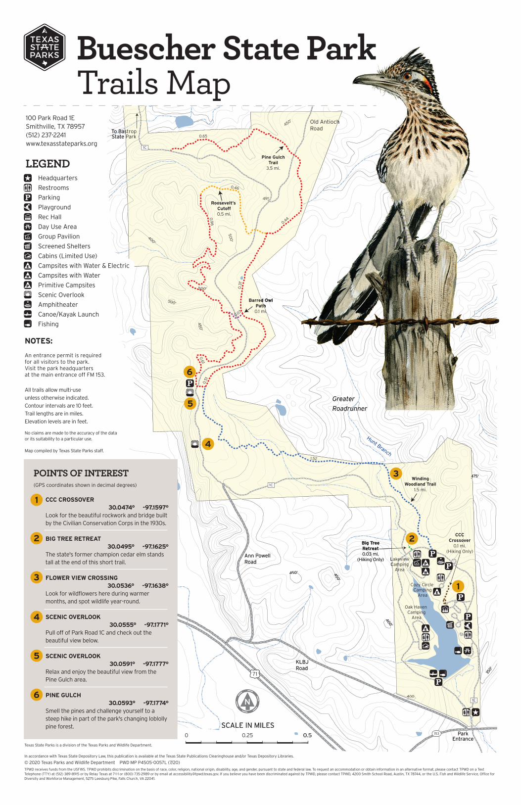
LEGENDHeadquarters
Restrooms
Parking
Playground
Rec Hall
Day Use Area
Group Pavilion
Screened Shelters
Cabins (Limited Use)
Campsites with Water & Electric
Campsites with Water
Primitive Campsites
Scenic Overlook
Amphitheater
Canoe/Kayak Launch
Fishing
CCC CROSSOVER30.0474° -97.1597°
Look for the beautiful rockwork and bridge built by the Civilian Conservation Corps in the 1930s.
BIG TREE RETREAT30.0495° -97.1625°
The state's former champion cedar elm stands tall at the end of this short trail.
FLOWER VIEW CROSSING30.0536° -97.1638°
Look for wildflowers here during warmer months, and spot wildlife year-round.
SCENIC OVERLOOK30.0555° -97.1771°
Pull off of Park Road 1C and check out the beautiful view below.
SCENIC OVERLOOK30.0591° -97.1777°
Relax and enjoy the beautiful view from the Pine Gulch area.
PINE GULCH 30.0593° -97.1774°
Smell the pines and challenge yourself to a steep hike in part of the park's changing loblolly pine forest.
1
2
3
4
5
6
POINTS OF INTEREST(GPS coordinates shown in decimal degrees)
100 Park Road 1ESmithville, TX 78957(512) 237-2241www.texasstateparks.org
TPWD receives funds from the USFWS. TPWD prohibits discrimination on the basis of race, color, religion, national origin, disability, age, and gender, pursuant to state and federal law. To request an accommodation or obtain information in an alternative format, please contact TPWD on a Text Telephone (TTY) at (512) 389-8915 or by Relay Texas at 7-1-1 or (800) 735-2989 or by email at [email protected]. If you believe you have been discriminated against by TPWD, please contact TPWD, 4200 Smith School Road, Austin, TX 78744, or the U.S. Fish and Wildlife Service, Office for Diversity and Workforce Management, 5275 Leesburg Pike, Falls Church, VA 22041.
In accordance with Texas State Depository Law, this publication is available at the Texas State Publications Clearinghouse and/or Texas Depository Libraries.
© 2020 Texas Parks and Wildlife Department PWD MP P4505-0057L (7/20)
NOTES:
An entrance permit is required for all visitors to the park. Visit the park headquarters at the main entrance off FM 153.
All trails allow multi-use
unless otherwise indicated.
Contour intervals are 10 feet.
Trail lengths are in miles.
Elevation levels are in feet.
No claims are made to the accuracy of the data or its suitability to a particular use. Map compiled by Texas State Parks staff.
Texas State Parks is a division of the Texas Parks and Wildlife Department.
Buescher State ParkTrails Map
For information on Texas State Parks, visit www.texasstateparks.org Sign up today for free email updates: texasstateparks.org/email /texasparksandwildlife @TPWDparks #TxStateParks Sponsor: Whole Earth Provision Co.
Buescher State ParkEnjoy a quiet retreat in these pine-oak woodlands.Discover the plants and animals that call this park home, and explore miles
of winding hike and bike trails. Look closely for the structures built by the
Civilian Conservation Corps as their legacy still surrounds us today.
TRAIL ETIQUETTETrash your trash. Keep the park natural. Pack out all of your trash and Leave No Trace.
Leave feeding to nature. Feeding wild animals will make them sick and more likely to cause harm to people.
Take only memories and pictures. Please don’t disturb or remove any of the park’s plants, animals or artifacts.
We need to know about your caches. Please check with park HQ before placing geocaches within the park.
Share the trail. Watch for others. Mountain bikers should yield to hikers.
Keep pets on leashes to keep them safe while protecting wildlife.
TRAIL
WINDING WOODLAND TRAIL
DISTANCE
1.5 mi.(one-way)
TIME
1.5 hrs.
DIFFICULTY
Moderate
DESCRIPTION
Meander through the forest, and enjoy the shade of the oak and cedar trees along this trail.
PINE GULCHTRAIL
3.5 mi.(one-way)
2 hrs. Challenging Travel the steep hills of Pine Gulch beneath a forest of towering loblolly pines. You’ll also see the remnants of 2015’s Hidden Pines wildfire.
ROOSEVELT’S CUTOFF
0.5 mi.(one-way)
30 min. Moderate Named for the president who created the Civilian Conservation Corps, this trail travels along a shaded creek bed.
BARRED OWLPATH
0.1 mi. 10 min. Easy This short jaunt connects two sides of the Pine Gulch Trail. Use it to shorten or lengthen your time on the trails.
CCCCROSSOVER
0.1 mi. 10 min. Easy Discover hidden treasures on this short walk! You’ll find a historic bridge and impeccable rock walls and staircases built by the Civilian Conservation Corps.
BIG TREERETREAT
0.03 mi. 5 min. Easy Take a rest and reflect under the majestic cedar elm tree.
STAYING SAFEKNOW YOUR LIMITS. Prepare for sun and heat. Wear sunscreen, insect repellent
and appropriate clothing/hiking shoes.
DRINK PLENTY OF WATER. Your body quickly loses fluids when you’re
on the trail. Bring a quart (32 oz.) of water per hour of activity.
TELL OTHERS WHERE YOU’LL BE. If possible, avoid exploring alone.
Tell someone where you are going and when you plan to return.
WEAR A HELMET. When biking, check with park HQ to match the
ride to your skill level. Wear a helmet to protect yourself in case of a crash.
CHECK FOR TRAIL CLOSURES. Certain trails may be closed during wet
conditions or for other resource management work.
POTENTIALLY HARMFUL PLANTS AND ANIMALS LIVE HERE. You’ll see
them more easily if you stay on trails.
LOOK UP, DOWN, AND ALL AROUND FOR HAZARDS.
Beware of falling trees and limbs above you, especially during
high winds! Don’t stand under dead trees. Watch out for
stump holes at your feet.
FOR EMERGENCIES, PLEASE CALL 9-1-1.
Raccoon
For assistance using this map, contact the park. For a web version of the map text, visit our Trails Information page.