Embed Size (px)
Citation preview
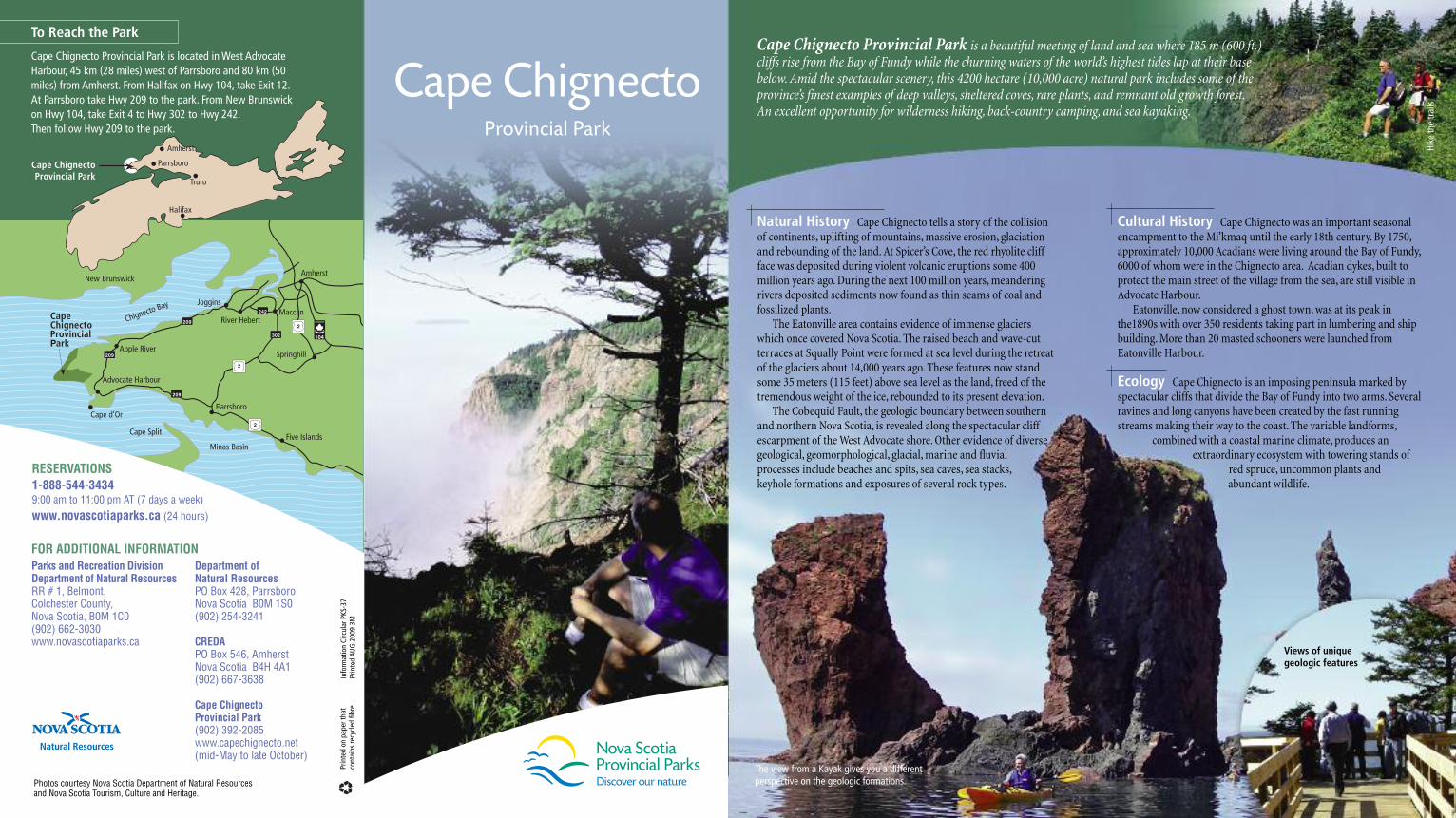
Natural History Cape Chignecto tells a story of the collision of continents, uplifting of mountains, massive erosion, glaciationand rebounding of the land. At Spicer’s Cove, the red rhyolite cliffface was deposited during violent volcanic eruptions some 400million years ago. During the next 100 million years, meanderingrivers deposited sediments now found as thin seams of coal andfossilized plants. The Eatonville area contains evidence of immense glaciers
which once covered Nova Scotia. The raised beach and wave-cutterraces at Squally Point were formed at sea level during the retreatof the glaciers about 14,000 years ago. These features now standsome 35 meters (115 feet) above sea level as the land, freed of thetremendous weight of the ice, rebounded to its present elevation. The Cobequid Fault, the geologic boundary between southern
and northern Nova Scotia, is revealed along the spectacular cliffescarpment of the West Advocate shore. Other evidence of diversegeological, geomorphological, glacial, marine and fluvial processes include beaches and spits, sea caves, sea stacks, keyhole formations and exposures of several rock types.
242
209
302
New Brunswick
2
2
209
2092
104
Minas Basin
Chignecto Bay Joggins
Five Islands
River HebertMaccan
Cape Split
Cape d’Or
Advocate Harbour
Apple River
CapeChignectoProvincialPark
Parrsboro
Springhill
Amherst
Cultural History Cape Chignecto was an important seasonalencampment to the Mi’kmaq until the early 18th century. By 1750,approximately 10,000 Acadians were living around the Bay of Fundy,6000 of whom were in the Chignecto area. Acadian dykes, built toprotect the main street of the village from the sea, are still visible inAdvocate Harbour. Eatonville, now considered a ghost town, was at its peak in
the1890s with over 350 residents taking part in lumbering and shipbuilding. More than 20 masted schooners were launched fromEatonville Harbour.
Ecology Cape Chignecto is an imposing peninsula marked byspectacular cliffs that divide the Bay of Fundy into two arms. Severalravines and long canyons have been created by the fast runningstreams making their way to the coast. The variable landforms,
combined with a coastal marine climate, produces anextraordinary ecosystem with towering stands of
red spruce, uncommon plants andabundant wildlife.
To Reach the Park
Cape Chignecto Provincial Park is located in West AdvocateHarbour, 45 km (28 miles) west of Parrsboro and 80 km (50miles) from Amherst. From Halifax on Hwy 104, take Exit 12.At Parrsboro take Hwy 209 to the park. From New Brunswickon Hwy 104, take Exit 4 to Hwy 302 to Hwy 242. Then follow Hwy 209 to the park.
Cape Chignecto Provincial Park is a beautiful meeting of land and sea where 185 m (600 ft.)cliffs rise from the Bay of Fundy while the churning waters of the world’s highest tides lap at their basebelow. Amid the spectacular scenery, this 4200 hectare (10,000 acre) natural park includes some of theprovince’s finest examples of deep valleys, sheltered coves, rare plants, and remnant old growth forest. An excellent opportunity for wilderness hiking, back-country camping, and sea kayaking.
Cape ChignectoProvincial Park
Truro•
•Halifax
Amherst
Parrsboro
••
The view from a Kayak gives you a different perspective on the geologic formations.
Hike th
e trails
Views of unique geologic features
Provincial Park
Photos courtesy Nova Scotia Department of Natural Resources and Nova Scotia Tourism, Culture and Heritage.
RESERVATIONS1-888-544-34349:00 am to 11:00 pm AT (7 days a week)www.novascotiaparks.ca (24 hours)
Cape Chignecto
Parks and Recreation DivisionDepartment of Natural ResourcesRR # 1, Belmont,Colchester County, Nova Scotia, B0M 1C0(902) 662-3030www.novascotiaparks.ca
Department of Natural ResourcesPO Box 428, ParrsboroNova Scotia B0M 1S0(902) 254-3241
CREDAPO Box 546, AmherstNova Scotia B4H 4A1(902) 667-3638
Cape Chignecto Provincial Park(902) 392-2085www.capechignecto.net(mid-May to late October)
FOR ADDITIONAL INFORMATION
Inform
ation Circular PKS
-37
Printed AU
G 200
9 3M
Printed on
pap
er th
at
contains re
cycled
fibre
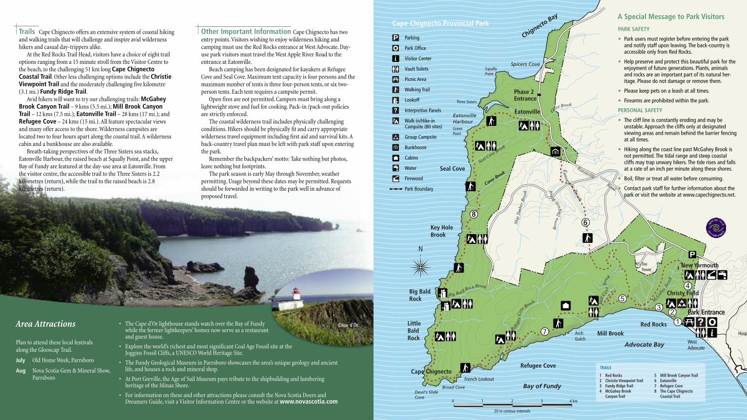
Trails Cape Chignecto offers an extensive system of coastal hikingand walking trails that will challenge and inspire avid wildernesshikers and casual day-trippers alike.At the Red Rocks Trail Head, visitors have a choice of eight trail
options ranging from a 15 minute stroll from the Visitor Centre tothe beach, to the challenging 51 km long Cape ChignectoCoastal Trail. Other less challenging options include the ChristieViewpoint Trail and the moderately challenging five kilometre(3.1 mi.) Fundy Ridge Trail. Avid hikers will want to try our challenging trails: McGahey
Brook Canyon Trail – 9 kms (5.5 mi.); Mill Brook CanyonTrail – 12 kms (7.5 mi.); Eatonville Trail – 28 kms (17 mi.); andRefugee Cove – 24 kms (15 mi.). All feature spectacular viewsand many offer access to the shore. Wilderness campsites arelocated two to four hours apart along the coastal trail. A wildernesscabin and a bunkhouse are also available. Breath-taking perspectives of the Three Sisters sea stacks,
Eatonville Harbour, the raised beach at Squally Point, and the upperBay of Fundy are featured at the day-use area at Eatonville. From the visitor centre, the accessible trail to the Three Sisters is 2.2kilometres (return), while the trail to the raised beach is 2.8kilometres (return).
Other Important Information Cape Chignecto has twoentry points. Visitors wishing to enjoy wilderness hiking andcamping must use the Red Rocks entrance at West Advocate. Day-use park visitors must travel the West Apple River Road to theentrance at Eatonville. Beach camping has been designated for kayakers at Refugee
Cove and Seal Cove. Maximum tent capacity is four persons and themaximum number of tents is three four-person tents, or six two-person tents. Each tent requires a campsite permit.Open fires are not permitted. Campers must bring along a
lightweight stove and fuel for cooking. Pack-in /pack-out policiesare strictly enforced.The coastal wilderness trail includes physically challenging
conditions. Hikers should be physically fit and carry appropriatewilderness travel equipment including first aid and survival kits. Aback-country travel plan must be left with park staff upon enteringthe park.Remember the backpackers’ motto: Take nothing but photos,
leave nothing but footprints.The park season is early May through November, weather
permitting. Usage beyond these dates may be permitted. Requestsshould be forwarded in writing to the park well in advance ofproposed travel.
0
M 0
5
N
EatonvilleHarbourGreen Point
Spicers Cove
Seal Cove
Key Hole Brook
Big Bald Rock
Cape Chignecto
LittleBald Rock
Refugee Cove
ArchGulch
Mill Brook
French Lookout
CareyBrook
Refugee
Cov
e Broo k
Seal Cove Brook
Ship
Tim
ber
Bro
ok
Bro
wn
Du
gw
ayBro
ok
Eatonville
Elliot Brook
Road
Red Rocks
Ea
ton
villeB
rook
Chignecto Bay
Bay of Fundy
Squally Point
Three Sisters
Devil's SlideCove
Broad Cove
0 1 2 3 4 km
20 m contour intervals
Advocate Bay WestAdvocate
A
Park Entrance
B ig BaldRo k Brookc
M
cGah
eyB
rook
Mil
l Co
ve
Bro
ok
Fire Tower
Hospit
New Yarmouth
Eatonville
Phase 2 Entrance
8
B
7
86
1 Red Rocks2 Christie Viewpoint Trail3 Fundy Ridge Trail4 McGahey Brook Canyon Trail
5 Mill Brook Canyon Trail6 Eatonville7 Refugee Cove8 The Cape Chignecto Coastal Trail
Christy Field
TRAILS
Cape Chignecto Provincial Park
Parking
Park Office
Visitor Center
Vault Toilets
Picnic Area
Walking Trail
Lookoff
Interpretive Panels
Walk-in/Hike-in Campsite (80 sites)
Group Campsite
Bunkhouse
Cabins
Water
Firewood
Park Boundary
PARK SAFETY
• Park users must register before entering the parkand notify staff upon leaving. The back-country isaccessible only from Red Rocks.
• Help preserve and protect this beautiful park for theenjoyment of future generations. Plants, animalsand rocks are an important part of its natural her-itage. Please do not damage or remove them.
• Please keep pets on a leash at all times.
• Firearms are prohibited within the park.
PERSONAL SAFETY
• The cliff line is constantly eroding and may beunstable. Approach the cliffs only at designatedviewing areas and remain behind the barrier fencingat all times.
• Hiking along the coast line past McGahey Brook isnot permitted. The tidal range and steep coastalcliffs may trap unwary hikers. The tide rises and fallsat a rate of an inch per minute along these shores.
• Boil, filter or treat all water before consuming.
• Contact park staff for further information about thepark or visit the website at www.capechignecto.net.
• The Cape d’Or lighthouse stands watch over the Bay of Fundy while the former lightkeepers’ homes now serve as a restaurant and guest house.
• Explore the world’s richest and most significant Coal Age Fossil site at the Joggins Fossil Cliffs, a UNESCO World Heritage Site.
• The Fundy Geological Museum in Parrsboro showcases the area’s unique geology and ancientlife, and houses a rock and mineral shop.
• At Port Greville, the Age of Sail Museum pays tribute to the shipbuilding and lumbering heritage of the Minas Shore.
• For information on these and other attractions please consult the Nova Scotia Doers andDreamers Guide, visit a Visitor Information Centre or the website at www.novascotia.com
Cape d’Or
Plan to attend these local festivals along the Glooscap Trail.
July Old Home Week, Parrsboro
Aug Nova Scotia Gem & Mineral Show, Parrsboro
Area Attractions
A Special Message to Park Visitors