Embed Size (px)
Citation preview
`
Carmichael Coal Mine Advice on Groundwater Management and Monitoring and Groundwater Dependent Ecosystem Management plans to the Department of the Environment and Energy
FEBRUARY 2019
`
Executive Summary
The Department of the Environment and Energy requested CSIRO and Geoscience Australia to assess draft research and management plans submitted by Adani Pty Ltd for the Carmichael Coal Project under Environment Protection and Biodiversity Conservation Act (1999) approval conditions (EPBC ref: 2010/5736). This advice addresses questions for the Groundwater Dependent Ecosystem Management Plan (version 10a) and the Groundwater Management and Monitoring Plan (version 5).
Modelling underpins the approaches in the management and monitoring plans. The review found that the modelling used is not suitable to ensure the outcomes sought by the EPBC Act conditions are met. A number of limitations were also identified in the proposed monitoring and management approaches indicating they are not sufficiently robust to monitor and minimise impacts to protected environments.
Q2a. How appropriate is the numerical model scenario selected by the approval holder to inform the Groundwater Management and Monitoring Plan and Rewan Formation Connectivity Research Plan and for incorporation into the Groundwater Dependent Ecosystem Management Plan as required by the conditions of approval?
The SEIS model used by the GMMP is the most conservative of the model scenarios as it predicts the greatest impacts from the mine development in all aquifers. However, being the best choice of available model runs does not mean that this model run is considered to be fit-for-purpose. The rationale to support this statement is provided in Section 2 Numerical modelling scenarios.
Q2b. Are there any other model scenarios put forward by the approval holder that are more appropriate to ensure the outcomes sought by the conditions of approval are met?
The review of the available model scenarios did not identify any other model scenarios put forward by the approval holder that are considered more appropriate. However, this review has identified a number of limitations, which mean that the model is not suitable to ensure the outcomes sought by the conditions of approval are met. These limitations are detailed in Section 2.3 Limitations of modelling.
Q3. Are the monitoring and management approaches proposed in the GMMP and GDEMP consistent with the most plausible conceptualisation and sufficiently robust to ensure the outcomes above are met?
The proposed monitoring and management approaches described are consistent with the most plausible conceptualisation of groundwater source to the Doongmabulla Springs complex. However, limitations identified mean that the proposed monitoring and management approaches are not sufficiently robust to ensure the outcomes set out in 2b are met. These limitations are described in Section 3 Monitoring and management approaches.
If the Proponent implements the recommendations in this advice they will be able to refine the conceptualisation and improve the robustness of the modelling, monitoring and management approaches to address the intended outcomes of the approval conditions.
Carmichael Coal Mine: Advice on Groundwater Management and Monitoring and Groundwater Dependent Ecosystem Management plans to the Department of the Environment and Energy D2019-19528 1
1 Introduction
On 24 January 2019, the Department of the Environment and Energy (DoEE) requested Geoscience Australia and CSIRO to provide groundwater-related advice on draft management plans provided by Adani Mining Pty Ltd (the Proponent) in accordance with Environment Protection and Biodiversity Conservation Act 1999 (EPBC Act) approval conditions for the Carmichael Coal Mine. These plans include the draft Groundwater Management and Monitoring Plan revision 5 dated January 22, 2019 (GMMP) and the draft Groundwater Dependent Ecosystem Management Plan version 10a dated January 21, 2019 (GDEMP). This advice follows earlier advice provided on draft research plans (CSIRO and Geoscience Australia, 2018).
DoEE sought advice specifically on an additional three questions relating to these draft management plans, set out below:
Q2a. How appropriate is the numerical model scenario selected by the approval holder to inform the GMMP and RFCRP and for incorporation into the GDEMP as required by the conditions of approval?
Q2b. Are there any other model scenarios put forward by the approval holder that are more appropriate to ensure the outcomes sought by the conditions of approval are met?
The relevant outcomes sought by the conditions are to:
• monitor and minimise impacts to water resources of the Great Artesian Basin;
• ensure groundwater drawdown at Doongmabulla Springs Complex does not exceed 0.2m and that there is no ecological impact at the springs; and
• monitor and minimise impacts to other groundwater-dependent ecosystems.
Note: The conditions require that results of the groundwater flow model re-run inform the GMMP and RFCRP and be incorporated into the GDEMP. The focus of question 2 is on the selection of a numerical modelling scenario from those available, i.e. the options around the general head boundary considered as part of the groundwater model re-run, and previous scenarios, i.e. the SEIS and EIS models.

Carmichael Coal Mine: Advice on Groundwater Management and Monitoring and Groundwater Dependent Ecosystem Management plans to the Department of the Environment and Energy D2019-19528 2
Q3. Are the monitoring and management approaches proposed in the GMMP and GDEMP consistent with the most plausible conceptualisation and sufficiently robust to ensure the outcomes above are met?
This advice provides an assessment of how these draft plans address the three questions. This assessment relied on the draft plans, and additional information, including studies undertaken since the time of approval and provided by the Proponent. Other references are included as in-text citations and in the reference list provided. Appendix B is that initial advice on some matters raised prior to undertaking this review, Appendix A provides a review of the Proponent’s responses to Appendix B. CSIRO and Geoscience Australia (2018), an assessment on draft research plans, is provided for completeness, as Appendix C.
Carmichael Coal Mine: Advice on Groundwater Management and Monitoring and Groundwater Dependent Ecosystem Management plans to the Department of the Environment and Energy D2019-19528 3
2 Numerical modelling scenarios
2.1 Summary Q2a. How appropriate is the numerical model scenario selected by the approval holder to inform the GMMP and RFCRP and for incorporation into the GDEMP as required by the conditions of approval?
Of the available numerical modelling scenarios selected by the approval holder to inform the GMMP and RFCRP and for incorporation into the GDEMP as required by the conditions of approval, the Supplementary Environmental Impact Statement (SEIS) model (GHD, 2013) is considered to be the most appropriate. There are still issues with the model scenario including:
1. Comparison of the SEIS model and the two alternate re-run models shows that the location of the western model boundary has little impact on drawdown predictions (refer Section 2.2).
2. The SEIS model includes the most recent calibrated parameter set developed for the Carmichael Coal Mine in 2013. Although, it must be noted that model errors increased from 4.5% RMS error reported for the SEIS model to 7.2% when compared to updated data following resurveying bore locations. This degradation in calibration statistic is equivalent to 0.8 m of groundwater level (refer Section 2.3.2).
Q2b. Are there any other model scenarios put forward by the approval holder that are more appropriate to ensure the outcomes sought by the conditions of approval are met?
The review of the available model scenarios did not identify any other model scenarios put forward by the approval holder that are considered more appropriate to ensure the outcomes sought by the conditions of approval are met. However, this review has identified a number of limitations, which mean that the SEIS model is not suitable to ensure the outcomes sought by the conditions of approval are met. In particular, the SEIS model under-predicts groundwater drawdown arising from mine development for the following reasons:
1. Representation in the model of surface water flows for the Carmichael River over-predicts flows from the river into the groundwater. As a result the groundwater drawdown in the alluvium (Carmichael River GDEs) will be greater than the predicted model (refer Section 2.3.1).
2. Reduced confidence in the ability of the calibrated model parameters to accurately predict groundwater drawdown arising from mine development due to revision of some bore elevations. When model predictions are compared with corrected bore heights scaled RMS error increases from 4.5% to 7.2% (refer Section 2.3.3).
3. Combined effect of revised bore heights and evapotranspiration, in the unconfined parts of the Clematis Sandstone model layer, on the accuracy of the 0.19 m predicted drawdown at the Doongmabulla Springs complex (DSC) by the SEIS model (refer Section 2.3.3).
4. Parameterisation of the Rewan Formation and Clematis Sandstone by the SEIS model. Calibrated hydraulic conductivity values for the Rewan Formation are very low compared with measured values, which minimises vertical water movement, and hydraulic conductivity values for the Clematis Sandstone are high, which increases the lateral transfer of water. In combination these hydraulic conductivity values minimise predicted drawdown at the DSC (refer Section 2.3.4).
Carmichael Coal Mine: Advice on Groundwater Management and Monitoring and Groundwater Dependent Ecosystem Management plans to the Department of the Environment and Energy D2019-19528 4
2.2 Selection of available numerical model scenarios The GMMP uses the calibrated SEIS model run as the basis for the calculation of groundwater level thresholds. This model run has been accepted as part of the assessment, conditioning and approval of the proposed action. The report states that the model re-runs have informed the GMMP by adding confidence to the predictions made using the SEIS model. Previous comments on the suitability of numerical models are provided by CSIRO and Geoscience Australia (2018)
The model re-runs differ from the SEIS model in the location of the General Head Boundaries (GHB) on the western edge of the model domain and in the magnitude of the conductance for all GHBs in the model. These changes were made following discussions with DoEE and the Independent Expert Scientific Committee on Coal Seam Gas and Large Coal Mining Development (IESC), reflected in Condition 23 of the EPBC Act approval conditions. This results in three model run choices being available. There is little difference in the drawdown predictions between the SEIS model and the two alternate re-run models. The groundwater flow direction is mostly along the western boundary from the north and south rather than across the boundary from east to west, this is why the location of the boundary has little influence on the predictions. The flow directions predicted by the SEIS model are consistent with the generated piezometric surfaces from field observations. The boundary in the SEIS model on the topographic divide seems appropriate for the predictions being made.
Issue: The re-run models were not calibrated as this was not required by Condition 23, they used the existing parameterisation from the SEIS model. Not having a specific calibration for each of the re-run models has reduced the confidence in the predictions that they make. The re-run models predict less drawdown at the Doongmabulla Springs Complex (DSC) and more baseflow depletion in the Carmichael River than the SEIS model, although these variations are not significant. Comparison of predicted maximum impact for different models shows similar extent and magnitude overall (GMMP Section 2.3.3.1).
Recommendation: A re-calibration is warranted to improve confidence in model predictions.
The SEIS model used by the GMMP is considered to be the most conservative of the available model scenarios as it predicts the greatest impacts from the mine development in all aquifers. However, being the best choice of available model runs for use in the GMMP does not mean that this model run is considered to be fit-for-purpose, as outlined in the following sections.
2.3 Limitations of modelling Issue: The approach used to model potential impacts to the groundwater system due to mining indicates that the model will under-estimate the amount of drawdown predicted at the DSC and the Carmichael River GDE as a result of model representation of:
• the unrealistically high modelled flow in the Carmichael River,
• error in the bore heights used to calibrate the model, and
• hydraulic conductivity in the Clematis Sandstone and Rewan Formation model layers.
If the predicted drawdown has been underestimated as a result of these factors, then issues with predicted drawdowns are propagated into the GMMP. It is unclear what impact these limitations will
Carmichael Coal Mine: Advice on Groundwater Management and Monitoring and Groundwater Dependent Ecosystem Management plans to the Department of the Environment and Energy D2019-19528 5
have on the timing of impacts on the DSC. The implication is that the thresholds and triggers will be reached sooner than anticipated based on this modelling, which means that relying on the model in its current form may not be an appropriate approach to deriving monitoring and management regimes. Each of the three factors are discussed in more detail below.
2.3.1 Impact of Carmichael River flow on predictions
Issue: The model under predicts drawdown in the Alluvium along the Carmichael River corridor because of the way the model provides a source of water to offset drawdown. The SEIS report (Table 10) shows observed dry season stream-flow percentiles, the 90th percentile is 460 m3/d at the gauge upstream of the proposed mining area on the western edge of the mine lease and 0 m3/d at the gauge on the eastern edge of the mine lease, downstream of proposed mining. In contrast, the SEIS model steady-state run shows baseflow in Carmichael River above 4000 m3/d at the upstream gauge and above 3000 m3/d at downstream gauge (SEIS Figure 33). Simulated baseflow is an order of magnitude too high and is perennial at the downstream gauge rather than ephemeral, this has the effect of mitigating the drawdown in the alluvium (the Carmichael River GDE). The predicted stream depletion due to mining is ~1000 m3/d at the downstream gauge (SEIS Figure 39) which is physically impossible from the river (as the river only flows for short periods each year) and will subsequently deplete groundwater, contributing to drawdown.
The observed baseflow in the river was not used as a constraint in model calibration and therefore the baseflow predictions are physically impossible (i.e. too high). This means that predictions in drawdown to the Alluvium along the Carmichael River are unrealistically small.
Recommendation: Carmichael River flow and under-estimated drawdown can be addressed in subsequent model updates. Future updates of the model should also use stream flow as one of the calibration parameters. To facilitate this, ongoing stream flow gauging should be undertaken.
2.3.2 Impact of revised bore heights on calibration
Issue: The revision of the bore heights, resulting from resurveying of collar locations undertaken by the Proponent, has degraded the calibration of the SEIS model. The SEIS report uses the scaled RMS error between 88 observation bores and model predictions as the calibration statistic. This report says that the scaled RMS error is 4.5% for all bores and 5.9% for the 39 Proponent bores and therefore below the threshold for an acceptable model from the MDBC guidelines (Middlemis, 2000) (<5% is acceptable) which is used by the Proponent to justify the model performance. The revision of the bore heights and longer time series of groundwater level data available has degraded the scaled RMS to 7.2% for all bores and 12.2% for the 41 Proponent bores (no explanation is given for the discrepancy in the number of bores). These revised calibration statistics are outside of the nominated threshold from the SEIS report of 5%.
Recommendation: The updated Australian Groundwater Modelling Guidelines (Barnett et al., 2012), and the IESC Explanatory Note Uncertainty analysis—Guidance for groundwater modelling within a risk management framework (Middlemis and Peeters, 2018) provide more refined expectations of using uncertainty analysis in modelling, and how this may affect management and monitoring decisions. These should be considered in future model updates.
Issue: The Carmichael Coal Mine - Groundwater level review (Adani, 2019) adopts a value of +/- 7 m as an indication of significant variation in mismatch between calibrated and observed groundwater level. This value is justified as being close to the average RMS error of 6.8 m from the SEIS calibration
Carmichael Coal Mine: Advice on Groundwater Management and Monitoring and Groundwater Dependent Ecosystem Management plans to the Department of the Environment and Energy D2019-19528 6
and the 7.6 m average RMS error calculated from the revised bore heights. There is no analysis given for what this error means for the predicted drawdown. The revised bore heights have degraded the average RMS error of the simulated groundwater levels by 0.8 m. The interim threshold drawdown at the DSC is 0.2 m (EPBC Act approval condition 3.d), and represents a quarter of the degradation in model performance due to the revised bore heights.
As a conclusion from the revision to the bore heights, the Carmichael Coal Mine - Groundwater level review (Adani, 2019) states:
“The changes in calibration statistics are not material from a modelling perspective.” (page 1)
This statement is at odds with the clearly degraded model performance of the updated calibration dataset using the whole dataset and in particular, the nominated subset of the Proponent’s bores. The 40 bores drilled since the SEIS model calibration could provide an independent validation dataset for the calibrated model but have not been assessed.
The GMMP states there is a continuous improvement to the model as new information becomes available:
“Continuous refinement of the models with new data as it becomes available ensures they are robust and defensible for use to accurately predict potential impacts because of the CCP” (page34)
“The numerical model has been refined over time as additional information has become available.” (page 81)
The model run used in the GMMP is from the SEIS report. This has not been updated since 2013. The revised bore heights and the new bores drilled since that time are clearly new information that could improve the model but these have not been part of the continuous refinement process claimed in the GMMP.
Recommendation: The Proponent has committed to updating the groundwater model two years after mining commences. This commitment includes the collection, analysis and use of additional groundwater data to refine conceptualisations (GMMP Section 2.2.9), as well as incorporating groundwater monitoring information and response to dewatering (GMMP Section 6.2 and Section 7.1.1). Model updates should include recalibration, and clearly define bore reference levels, how they have changed over time and how these changes affect model prediction and performance.
2.3.3 Impact of revised bore heights on predictions
Issue: Confined groundwater systems act in a linear fashion so the offset errors associated with the revised bore heights will have little effect on drawdown predictions in the confined aquifers. This is not the case with unconfined groundwater systems which do not act linearly. Bore HD02 is in the unconfined part of the Clematis Sandstone and is the closest bore to the DSC, it has had its elevation revised downward by 4 m. This means that the groundwater level is deeper than the GW model was trying to calibrate to (in the SEIS model); the model is over-predicting the elevation of the groundwater
Carmichael Coal Mine: Advice on Groundwater Management and Monitoring and Groundwater Dependent Ecosystem Management plans to the Department of the Environment and Energy D2019-19528 7
level at this location. In areas with shallow water tables the model is simulating evapotranspiration from the watertable, any predicted drawdown in these areas will capture some of this evapotranspiration. If the simulated water table is too high in the baseline model run then there is potentially more evapotranspiration available to capture and this will result in less drawdown than would otherwise be predicted. With the predicted drawdown from the SEIS model at the DSC being 0.19 m (1 cm less than the acceptable threshold set out in EPBC Act Approval Condition 3.d), a correction to the overestimate of the captured evapotranspiration could be enough to increase the drawdown to greater than 0.2 m.
Recommendation: Future groundwater model updates should incorporate recalibration to the revised bore heights to provide confidence that captured evapotranspiration is not limiting drawdown to the DSC and the Carmichael River GDE.
2.3.4 Impact of model parameterisation on predictions of groundwater drawdown at the Doongmabulla Springs Complex
Issue: Previous reviews have described the hydraulic conductivity used in the modelling for the Rewan Formation as lower than the field measurements on site (this is discussed in more detail in CSIRO and Geoscience Australia, 2018). A previously unidentified issue is that the calibrated hydraulic conductivity of the Clematis Sandstone in the model is too high when compared to field measurement data. The calibrated hydraulic conductivity of the Clematis Sandstone is 1.55 m/d. There is one field measurement of 15 m/d from a shallow bore in the weathered zone and two measurements, from areas where the Clematis Sandstone is confined, of 0.01 m/d (Table 6, GMMP). Data for the China Stone project, immediately to the north of Carmichael, yield hydraulic conductivities of 0.005 m/d and 0.09 m/d (Australasian Groundwater and Environmental Consultants Pty Ltd (AGES), 2015). The Clematis Sandstone is confined by the Moolayember Formation in the vicinity of the DSC.
The calibration undertaken for the SEIS model was a deterministic calibration, i.e. there is only one value of each parameter for the entire model domain. A parameterisation which recognises the spatial heterogeneity in K values and reports confidence intervals of predicted parameters, and importantly, confidence intervals (based on the probability distribution function, pdf) of drawdowns is more robust and in line with international best practice.
Recommendation: Future model updates should use locally appropriate parameterisations.
Issue: The sensitivity analysis undertaken for the groundwater model shows that the high hydraulic conductivity of the Clematis Sandstone acts to limit drawdown at the DSC (SEIS addendum Figure 12). The sensitivity analysis shows that the drawdown is equally sensitive to the hydraulic conductivity of the Clematis Sandstone as it is to the hydraulic conductivity of the Rewan Formation. The SEIS and SEIS addendum are incorrect when discussing the sensitivity of predictions to the hydraulic conductivity of the Clematis Sandstone (e.g. SEIS addendum Section 3.5.1); high conductivity allows the lateral transfer of water and minimises the drawdown, hence the high value adopted in the calibration being a concern.
The sensitivity analysis was of a one-at-a-time type, which does not allow for parameter interaction. One-at-a-time analysis does not enable assessment of parameter sensitivity to simultaneous changes in parameters. This is in contrast to a global sensitivity analysis, such as that used in Peeters et al. (2018), which accounts for simultaneous parameter variation, and enables analysis of sensitivity to parameter interactions. Individually, an order of magnitude change in the hydraulic conductivity of either the Clematis Sandstone or Rewan Formation can produce a drawdown of greater than 0.3 m.
Carmichael Coal Mine: Advice on Groundwater Management and Monitoring and Groundwater Dependent Ecosystem Management plans to the Department of the Environment and Energy D2019-19528 8
The cumulative effect on drawdown prediction of varying both parameters, were they changed at the same time, is untested.
Recommendation: Sensitivity analysis undertaken for future model updates should seek to assess cumulative sensitivity.
Issue: The hydraulic enhancement after the collapse of the goaf in the long wall panels was not included in the sensitivity analysis. In the SEIS model the hydraulic conductivity was increased by a factor of 50 for 75 m above the long wall panel and by a factor of 10 for between 75 m and 150 m above the long wall panel. Poulsen et al. (2018) and Adhikary and Poulsen (2018) have shown that the hydraulic enhancement can be up to 8 orders of magnitude (a factor of 108) immediately above the goaf and decline exponentially with increasing height for up to 500 m (also a smaller hydraulic enhancement below the long wall panels). The recommendations from the SEIS subsidence report for the groundwater modelling include:
“Accordingly the expected height of fracturing at the Carmichael Project, is expected to extend from the AB1 seam to the surface over much of the proposed longwall footprint.”
“Conservatively adopting 160 metres based on Klenowski (ACARP C5016, 2000) would be considered a reasonable height for preliminary modelling of the height of direct hydraulic connection. Above this height, it is anticipated that there will be increase in the strata permeability due to fracturing through beds and bedding plane dilation, however the likelihood of hydraulic connectivity from the surface to the seam is anticipated to be low given the presence of aquiclude and aquitard materials in the overburden.”
The subsidence report shows there is the possibility for the enhancement of hydraulic conductivity from the coal seams to the surface; this includes the full thickness of the Rewan Formation (averaging 250 m) above the longwall panels.
Recommendation: The way the hydraulic enhancement after the collapse of the goaf has been implemented in the modelling is not conservative (i.e. is likely to underestimate impact) and the omission of the associated parameters from the sensitivity analysis means that the impact these assumptions have on drawdown at the DSC is untested. Future model updates should include analysis of the sensitivity of the model to parameter changes due to underground mining.
Carmichael Coal Mine: Advice on Groundwater Management and Monitoring and Groundwater Dependent Ecosystem Management plans to the Department of the Environment and Energy D2019-19528 9
3 Monitoring and management approaches
3.1 Summary Q3. Are the monitoring and management approaches proposed in the GMMP and GDEMP consistent with the most plausible conceptualisation and sufficiently robust to ensure the outcomes above are met?
The proposed monitoring and management approaches described in the GMMP and GDEMP are consistent with a plausible conceptualisation of groundwater source to the Doongmabulla Springs complex (DSC). However, this review has identified a number of limitations, which mean that the proposed monitoring and management approaches are not sufficiently robust to ensure the outcomes sought by the conditions of approval are met:
1. The SEIS model under-predicts groundwater drawdown arising from mine development by up to 0.8 m, which means that the adopted thresholds and triggers will be reached sooner than anticipated and so are not a suitable foundation for the proposed monitoring and management approaches (refer Section 2.2).
2. Available evidence supports the conceptualisation that the Clematis Sandstone is a likely source aquifer for the DSC. However, the proposed monitoring and management approaches do not sufficiently address the uncertainty regarding potential alternative or additional source aquifers (refer Section 3.2 and 3.3).
3. There is a lack of stream flow gauging. Gauging provides critical information on the state of the Carmichael River. This data would assist in and verifying the reliance of Carmichael River GDEs on groundwater along sections with different characteristics (refer Section 3.3). This would also contribute to model calibration.
4. The water level thresholds and triggers chosen are based on predicted drawdown. A large number of bores are predicted to exceed their thresholds as a result of approved mining activities (refer Section 3.4).
5. The chosen definition of thresholds and triggers for hydrogeochemical analytes, as well as definition of contaminant limits, will result in frequent trigger exceedances. No defined workflow for subsequent investigation is provided. In addition, there are different notification mechanisms to DoEE for water level and chemical exceedances, without a rationale as to why this is the case (refer Section 3.5).
6. The GDEMP systematically addresses the management objectives, performance criteria, adaptive management triggers and corrective actions. Monitoring is based on the GDE Toolbox approach, and is considered adequate. The GDEMP relies heavily on the conceptualisations and modelling outlined in the GMMP and other research plans, and as such is subject to any limitations of these plans (refer Section 3.6)
While the Proponent considers comments relating to model updates and refinement out of scope for the GMMP, they are included here to assist DoEE understand the limitations of the GMMP resulting from the model limitations. Issues arising from model performance and predictions is a fundamental
Carmichael Coal Mine: Advice on Groundwater Management and Monitoring and Groundwater Dependent Ecosystem Management plans to the Department of the Environment and Energy D2019-19528 10
underpinning of the approaches set out in the GMMP and GDEMP. They are critical in assessing if measures set out are sufficiently robust to ensure environmental outcomes are met.
3.2 Hydrogeological conceptualisation Issue: It is plausible and reasonable that the Clematis Sandstone is a major source aquifer for the DSC. This is supported by water level and groundwater flow information presented by the proponent, as well as by other studies (Evans et al., 2018; Fensham et al., 2016; JBT Consulting, 2015), and by some aspects of hydrogeochemistry of the springs and the Clematis Sandstone (Fensham et al., 2016; Webb et al., 2015). It is not plausible and reasonable to state unequivocally that the Clematis Sandstone is the sole source aquifer for the DSC, as sufficient uncertainty surrounding hydrogeochemistry, inter-aquifer connectivity and groundwater flow exists (Currell et al., 2017; Lewis et al., 2018; Webb et al., 2015) to necessitate a precautionary approach to the conceptualisation (as ruled by the Land Court of Queensland, 2015).
Documents provided by the Proponent, including the GMMP, support the conceptualisation that the Clematis Sandstone is a source aquifer, but there is enough uncertainty around the information provided, as acknowledged by the Proponent, such as in GDEMP Section 4.3.1, to necessitate a robust assessment of potential alternative or additional source aquifers. The paucity of water level and hydrochemistry data for units other than the Clematis Sandstone in the vicinity of the DSC means that it is not possible to conclusively determine the source aquifer or aquifers for the DSC based on available evidence, and thus the precautionary principle must apply.
As stated in CSIRO and Geoscience Australia (2018), the hydrochemistry information provided does not preclude alternative conceptualisations of the source aquifers for the springs:
1. The GMMP shows only sodium/chloride and chloride/sulfate bivariate plots comparing groundwater in the Permian sediments and Clematis Sandstone with the Joshua Spring vent only.
2. No chemistry data or groundwater pressure data from the Dunda Beds is presented for comparison, nor any data from other spring vents.
3. The bores proposed for groundwater quality monitoring near the DSC are not screened in source aquifers that have been identified in alternative conceptualisations, such as the Dunda Beds.
Consequently, the hydrochemistry data collected to date, and proposed to be collected, will not contribute to the assessment of other or additional potential source aquifers for the DSC below the Clematis Sandstone.
Recommendation: To constrain the source aquifer(s) of the DSC, a more sophisticated statistical analysis of hydrochemistry data is required. This includes assessing a wider variety of groundwater and surface water analytes, as well as appropriate use of isotope hydrochemistry analysis. Further information on potential techniques is provided in (CSIRO and Geoscience Australia, 2018) and other readily available references.
3.3 Water monitoring network design Early warning monitoring bores need to be located sufficiently close to mining operations to experience measurable drawdowns relatively quickly after mining operations commence. Deviation of this drawdown from predictions can provide a prompt indication that greater than predicted impacts will likely occur in the future, and can be predicted to be observed years in advance of the impacts
Carmichael Coal Mine: Advice on Groundwater Management and Monitoring and Groundwater Dependent Ecosystem Management plans to the Department of the Environment and Energy D2019-19528 11
reaching matters of national environmental significance (MNES) to enable implementation of management and mitigation actions. The use of control bores, as required under EPBC Act conditions, can also assist in this assessment.
Issue: To adequately monitor for the impacts of mining, for the plausible groundwater conceptualisations, monitoring bores should be distributed across all potentially impacted formations within the zone of predicted impact. The GMMP includes abundant monitoring locations on-lease, which is adequate to assess impacts across all units. However, most of the on-lease bores are likely to be affected by surface or mining operations. The GMMP does not define the process for replacing such bores as mining operations progress.
Groundwater-dependent MNES lie to the west of the lease boundary (DSC), as well as within the alluvium of mapped drainage features (Carmichael River GDEs). To adequately monitor potential impacts to these MNES, the monitoring network needs to consider all possible source aquifers, and predicted areas of impact, as well as the use of control bores.
The monitoring network set out in the GMMP is designed to monitor potential impacts to the DSC based on the conceptualisation that the springs are sourced solely from the Clematis Sandstone. The distribution of monitoring bores is not adequate if other units provide a direct source to the DSC, or through the Clematis Sandstone to the DSC, either by transmission through interconnectivity of hydrostratigraphic units or via structural pathways (not limited to geological faults). The GMMP monitoring network does not provide adequate spatial or geological unit coverage to monitor for groundwater impacts if aquifers other than the Clematis Sandstone contribute flow to the DSC. This effectively means that the proposed GMMP monitoring network will only be able to identify potential impacts that may affect the DSC where they are evident in a source aquifer in the Clematis Sandstone.
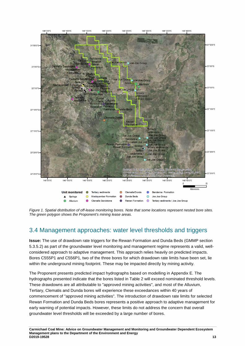
In the GMMP, there are 54 off-lease monitoring bores (Table 1 and Figure 1 below). The off-lease monitoring bores are primarily designed to monitor the Joe Joe Group and the Clematis Sandstone. These are the source aquifers proposed by the proponent for the Mellaluka Springs and DSC respectively. The monitoring network set out in the GMMP for the Mellaluka Springs appears adequate, given that these are sourced from the Joe Joe Group and Tertiary1 sediments.
Recommendation: Installation of bores to monitor the groundwater system in the Dunda Beds and Rewan Formation (upper Rewan and lower Rewan) at existing monitoring points in the west of the central zone would allow an assessment of any dewatering impact propagating through the Rewan Formation (in effect, nested monitoring bores). The current monitoring network does not address any contributions to the springs from the Dunda Beds or Rewan Formation, or from deeper units. These potential spring contributions need to be considered and factored into monitoring design. Monitoring these two units is considered a bare-minimum. Ideally all units from outcrop to sub-Joe Joe coal (Jericho Formation) would be monitored. Co-location with existing points would remove any significant access issues, and would enable at least spatially comparable data to be collected.
Recommendation: It is strongly recommended that the monitoring program includes stream flow gauging upstream and downstream of the mine area. Stream gauging similar to that undertaken for the EIS would address this, provided it is part of ongoing monitoring programmes. Stream flow is a critical calibration parameter for the groundwater model. The current model is based on very limited surface water monitoring data and the status of the gauges installed to acquire this data is unknown. 1 “Tertiary” is a non-standard term used by Adani, and so this use is continued throughout this advice. The standard terms
applied to the Geological Timescale are available from the International Commission on Stratigraphy (http://www.stratigraphy.org/index.php/ics-chart-timescale).

Carmichael Coal Mine: Advice on Groundwater Management and Monitoring and Groundwater Dependent Ecosystem Management plans to the Department of the Environment and Energy D2019-19528 12
Additionally, an improved and re-calibrated flow-discharge relationship for each gauge would improve the accuracy of the data.
Baseflow conditions across the site varies, with the Carmichael River switching from gaining to losing and to gaining again, ongoing. Consequently gauging where the river enters and leaves the lease is necessary to better understand the interactions between surface water and groundwater, and the implications for the Carmichael River GDEs in this area. Gauging data would also address issues with stream flow identified in Section 2.3.1.
Table 1 Number of off-lease monitoring bores by formation.
Formation Number of bores Springs 7 Alluvium 3 Tertiary sediments 1 Moolayember Formation 2 Clematis Sandstone 10 Clematis/Dunda 1 Dunda Beds 3 Rewan Formation 5 Bandanna Formation 3 Joe Joe Group 15 Tertiary sediments / Joe Joe Group 4
Carmichael Coal Mine: Advice on Groundwater Management and Monitoring and Groundwater Dependent Ecosystem Management plans to the Department of the Environment and Energy D2019-19528 13
Figure 1. Spatial distribution of off-lease monitoring bores. Note that some locations represent nested bore sites. The green polygon shows the Proponent’s mining lease areas.
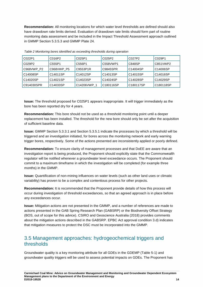
3.4 Management approaches: water level thresholds and triggers Issue: The use of drawdown rate triggers for the Rewan Formation and Dunda Beds (GMMP section 5.3.5.2) as part of the groundwater level monitoring and management regime represents a valid, well-considered approach to adaptive management. This approach relies heavily on predicted impacts. Bores C555P1 and C556P1, two of the three bores for which drawdown rate limits have been set, lie within the underground mining footprint. These may be impacted directly by mining activity.
The Proponent presents predicted impact hydrographs based on modelling in Appendix E. The hydrographs presented indicate that the bores listed in Table 2 will exceed nominated threshold levels. These drawdowns are all attributable to "approved mining activities", and most of the Alluvium, Tertiary, Clematis and Dunda bores will experience these exceedances within 40 years of commencement of "approved mining activities”. The introduction of drawdown rate limits for selected Rewan Formation and Dunda Beds bores represents a positive approach to adaptive management for early warning of potential impacts. However, these limits do not address the concern that overall groundwater level thresholds will be exceeded by a large number of bores.
Carmichael Coal Mine: Advice on Groundwater Management and Monitoring and Groundwater Dependent Ecosystem Management plans to the Department of the Environment and Energy D2019-19528 14
Recommendation: All monitoring locations for which water level thresholds are defined should also have drawdown rate limits derived. Evaluation of drawdown rate limits should form part of routine monitoring data assessment and be included in the Impact Threshold Assessment approach outlined in GMMP Section 5.3.5.3 and GMMP Plate 24.
Table 2 Monitoring bores identified as exceeding thresholds during operation
C022P1 C016P2 C025P1 C025P2 C027P2 C029P1
C029P2 C555P1 C556P1 C558VWP1 C848SP C851VWP2
C968VWP_P2 C968VWP_P5 C9553P1R C9845SPR C14004SP C14006SP
C14008SP C14011SP C14012SP C14013SP C14015SP C14016SP
C14020SP C14021SP C14023SP C14024SP C14028SP C14029SP
C914030SPR C14033SP C14206VWP_1 C180116SP C180117SP C180118SP
Issue: The threshold proposed for C025P1 appears inappropriate. It will trigger immediately as the bore has been reported dry for 4 years.
Recommendation: This bore should not be used as a threshold monitoring point until a deeper replacement has been installed. The threshold for the new bore should only be set after the acquisition of sufficient baseline data.
Issue: GMMP Section 5.3.3.1 and Section 5.3.5.1 indicate the processes by which a threshold will be triggered and an investigation initiated, for bores across the monitoring network and early warning trigger bores, respectively. Some of the actions presented are inconsistently applied or poorly defined.
Recommendation: To ensure clarity of management processes and that DoEE are aware that an investigation report is being produced, the Proponent should explicitly state that the Commonwealth regulator will be notified whenever a groundwater level exceedance occurs. The Proponent should commit to a maximum timeframe in which the investigation will be completed (for example three months) in the GMMP.
Issue: Quantification of non-mining influences on water levels (such as other land uses or climatic variability) has proven to be a complex and contentious process for other projects.
Recommendation: It is recommended that the Proponent provide details of how this process will occur during investigation of threshold exceedances, so that an agreed approach is in place before any exceedances occur.
Issue: Mitigation actions are not presented in the GMMP, and a number of references are made to actions presented in the GAB Spring Research Plan (GABSRP) or the Biodiversity Offset Strategy (BOS, out of scope for this advice). CSIRO and Geoscience Australia (2018) provides comments about the mitigation actions described in the GABSRP. EPBC Act approval condition 3.d) indicates that mitigation measures to protect the DSC must be incorporated into the GMMP.
3.5 Management approaches: hydrogeochemical triggers and thresholds Groundwater quality is a key monitoring attribute for all GDEs in the GDEMP (Table 5-1) and groundwater quality triggers will be used to assess potential impacts on GDEs. The Proponent has
Carmichael Coal Mine: Advice on Groundwater Management and Monitoring and Groundwater Dependent Ecosystem Management plans to the Department of the Environment and Energy D2019-19528 15
established contaminant (groundwater quality) trigger levels and contaminant limits with the Queensland Department of Environment and Science (DES). The trigger levels allow for investigation and implementation of mitigation measures prior to reaching any groundwater quality limits. Contaminant limits (presented in Appendix D of GMMP) will be used to assess the potential for environmental harm, presumably resulting from a trigger exceedance. The GMMP states that triggers and limits may be revised if they are exceeded due to natural conditions.
Issue: As was the case in previous versions of the GMMP, there are trigger levels for up to 38 analytes for bores and hydrostratigraphic units, based on the 85th percentile of background data where more than 12 results are beyond the limit of laboratory detection. This is a sound approach, but does mean trigger levels should be reached 15% of the time for each analyte.
Recommendation: Given the regularity with which exceedances are expected to occur, consideration should be given to:
• the implication of frequent triggering,
• how these exceedances will be investigated,
• how the Proponent will be able to differentiate between a trigger that does not result in environmental harm and one that might,
• ensuring that frequently exceeded triggers do not result in the conclusion that it is always due to natural variability,
• how an investigation into the cause of the exceedance will be undertaken, such as how an exceedance will be evaluated as being due to natural variability or mining activities,
• providing a timeline of how long an investigation will take and what data the Proponent will need to undertake this investigation, such as groundwater use volumes by other users.
There have been some changes to trigger levels compared to previous versions following discussions between the Proponent and the Queensland DES. There is now a “two consecutive exceedances approach” to trigger values, such that an investigation will only be initiated after two consecutive exceedances are detected. This is an appropriate approach. The “two consecutive exceedances approach” results in approximately 6 months passing before an exceedance is identified, based on groundwater monitoring events occurring every 3 months. The GMMP states that DoEE will not be notified when an exceedance occurs; notification will only occur 28 days after completion of the investigation into the cause of the exceedance. Given the length of time this may take (no time frame is provided in the GMMP), DoEE may not be notified of an exceedance until many months after it was first identified.
Recommendation: Consideration should be given to extending the approach to two exceedances within 12 months (~4 sampling events) rather than just consecutive exceedances, to ensure triggers can provide an early warning of potential impacts. The management actions would also be strengthened by providing a maximum time frame for an investigation.
If the investigation finds that the exceedances are due to mining activities, the Proponent commits to undertaking a further investigation to determine if ‘environmental harm’ has occurred. The GMMP states that the contaminant limits are ‘for consideration’ when assessing the potential for environmental harm, however it is not clear how they will be used or if they are enforceable limits. There may also be a time lag between a trigger exceedance and the realisation of ‘environmental harm’.
Carmichael Coal Mine: Advice on Groundwater Management and Monitoring and Groundwater Dependent Ecosystem Management plans to the Department of the Environment and Energy D2019-19528 16
Issue: Table 45 in the GMMP describes the proposed trigger level methodology and step 4 states that ‘all trigger levels derived from the baseline monitoring program (at least eight results greater than LOR) are compared to the ANZECC & ARMCANZ 2000 guideline values per analyte (95th protection and low reliability). In instances where the ANZECC & ARMCANZ 2000 guideline value is higher, this ANZECC value should be adopted as the proposed trigger level.’ In some cases, this results in trigger levels far in excess of baseline conditions (e.g. manganese and boron in bores screened in the Clematis Sandstone). This is contradictory to the principles of the Guidelines, which recommend that the default guideline values are a generic starting point for assessing water quality and specify that there is a distinct advantage in tailoring guideline values to reflect local conditions for the protection of aquatic ecosystems. The triggers and limits appear to be based on data collected in April 2017.
Recommendation: A clear statement regarding whether triggers and limits will be updated when additional pre-operational hydrochemistry data are collected should be included. Some bores may then have the required number of analyses to calculate baseline trigger values at that point, which would be preferable to using generic triggers derived from the ANZECC guidelines.
Issue: The GMMP and GDEMP state that the hydrochemistry triggers are interim for two years. This is generally a good approach for adaptive management, however care will need to be taken to ensure this does not result in triggers creeping up to avoid exceedances that will occur with the triggers set at the 85th percentile of baseline.
Issue: Setting static trigger levels does not account for trends in hydrochemistry that may provide an early indication of impact.
Recommendation: An assessment of trends in the hydrochemistry data following each monitoring event will identify if groundwater quality is changing over time, which may provide an early warning of triggers being approached.
Issue: The GMMP states that monitoring data will be verified and then reviewed on a regular basis and reported to the regulators.
Recommendation: This should include an assessment of hydrochemistry at the site, in addition to presenting raw data.
Issue: Detailed issues with the triggers and limits are as follows:
• The increased number of analytes that have a contaminant limit assigned to them compared to previous versions (including aluminium, cadmium, chromium, lead, molybdenum, selenium, silver, vanadium, mercury and nitrate) is an improvement over previous versions of the GMMP.
• Contaminant limits for "HD03A and C14021SP" and "All other Clematis bores" seem to have been swapped between the current version of the GMMP and previous versions.
• In many cases, the trigger is the same as the contaminant limit or not substantially different (e.g. <5mg/L difference). In these instances, no time is allowed for investigation and required implementation of mitigation measures prior to reaching contaminant limits.
Issue: Previous versions of the GMMP presented contaminant limits recommended by DES for all hydrostratigraphic units. However, Appendix D in the current draft GMMP only presents contaminant limits for bores screened in the Alluvium, Tertiary Sediments and the Clematis Sandstone.
Recommendation: Limits for the Dunda Beds need to be included in Appendix D at a minimum, until alternative conceptualisations for the source aquifer for the DSC has been resolved as the Dunda Beds are likely to be a contributing water source.
Carmichael Coal Mine: Advice on Groundwater Management and Monitoring and Groundwater Dependent Ecosystem Management plans to the Department of the Environment and Energy D2019-19528 17
Issue: There are instances where the trigger level is higher than the contaminant level in bores screened in the Alluvium and Clematis Sandstone. It is not clear how an investigation into an exceedance would progress in this scenario.
In some cases, the contaminant limit is far in excess of the background conditions at the site. In particular, the limits for boron, manganese and iron are consistently higher than baseline data.
Issue: For Clematis Sandstone bores, many dissolved metals have a no value (NV) contaminant limit. This means that there are not contaminant limits defined for the Proponent’s preferred source aquifer for the DSC.
Recommendation: Given that the Proponent considers the Clematis Sandstone as the sole source aquifer for the DSC, contaminant limits for the Clematis Sandstone are required.
3.6 Ecological monitoring The GDEMP sets out how to minimise and manage the environmental impacts of the Project on the four groundwater-dependent ecosystems listed in the approval conditions, through the combination of specific ecological measurements and links with other research and management plans (GMMP, GABSRP, RFCRP, Receiving Environment Management Plan, BOS, Great Artesian Basin Offset Strategy, Offset Area Management Plans, and MNES Plans). Proposed ecosystem measurements are based on relevant research and management guidelines. However, limitations identified for other management plans, in particular the GMMP, RFCRP and GAPSRP, mean that the proposed groundwater monitoring approaches are not sufficiently robust to ensure the outcomes sought by the conditions of approval are met.
The design of the ecological monitoring approach follows the GDE Toolbox approach and relevant research and management plans, which is considered to be adequate for monitoring potential impacts to GDEs. In the event that trigger levels are exceeded, the GDEMP will investigate the cause and notify the administering authority within 28 days. If mining activities are identified as the cause, the plan will revise monitoring and management approaches, including ecological and/or groundwater triggers; relevant operational constraints to manage groundwater drawdown impacts, such as revised mine planning or associated activities; changes to research priorities and additional mitigation and/or offset measures.
The GDEMP systematically addresses the management objectives, performance criteria, adaptive management triggers and corrective actions for each of the four GDEs identified in the approval conditions:
• Waxy Cabbage Palm (Livistona lanuginosa)
• Carmichael River (Carmichael River and its riparian zone between the Doongmabulla springs and the Belyando River)
• The Mellaluka Springs-complex
• Community of native species dependent on discharge from the Great Artesian Basin (Doongmabulla Springs-complex) including the Salt Pipewort Eriocaulon carsonii; and the Blue Devil Eryngium fontanum.
Carmichael Coal Mine: Advice on Groundwater Management and Monitoring and Groundwater Dependent Ecosystem Management plans to the Department of the Environment and Energy D2019-19528 18
References
Adani (2019) Carmichael Coal Mine – Groundwater level review. Adhikary DP and Poulsen BA (2018) Estimating the Height of Mining Induced Connective Fracturing.
52nd U.S. Rock Mechanics/Geomechanics Symposium. American Rock Mechanics Association, ARMA, 7.
Australasian Groundwater and Environmental Consultants Pty Ltd (AGES) (2015) Report on Project China Stone Groudwater Report. Prepared for Hansen Bailey., http://eisdocs.dsdip.qld.gov.au/China%20Stone%20Coal/DEIS/Draft%20EIS%20-%20Volume%204/china-stone-appendix-i-groundwater-report.pdf.
Barnett B, Townley L, Post V, Evans R, Hunt R, Peeters L, Richardson S, Werner A, Knapton A and Boronkay A (2012) Australian groundwater modelling guidelines. . National Water Commission, Canberra.
Comet Ridge Limited (2015) COI 2015 seismic reprcessing project. Carmichael Prospect ATP744 Galilee Basin, Queensland. Reprocessing Rerport., https://www.business.qld.gov.au/industries/mining-energy-water/resources/minerals-coal/online-services/qdex-reports.
CSIRO and Geoscience Australia (2018) Carmichael Coal Mine: Advice on draft research plans to the Department of the Environment and Energy.
Currell MJ, Werner AD, McGrath C, Webb JA and Berkman M (2017) Problems with the application of hydrogeological science to regulation of Australian mining projects: Carmichael Mine and Doongmabulla Springs. Journal of Hydrology 548, 674-682. DOI: https://doi.org/10.1016/j.jhydrol.2017.03.031.
Evans T, Kellett J, Ransley T, Harris-Pascal C, Radke B, Cassel R, Karim F, Hostetler S, Galinec V, Dehelean A, Caruana L and Kilgour P (2018) Observations analysis, statistical analysis and interpolation for the Galilee subregion. Product 2.1-2.2 for the Galilee subregion from the Lake Eyre Basin Bioregional Assessment. Department of the Environment and Energy, Bureau of Meteorology, CSIRO and Geoscience Australia, Australia. http://data.bioregionalassessments.gov.au/product/LEB/GAL/2.1-2.2.
Fensham RJ, Silcock JL, Laffineur B and MacDermott HJ (2016) Lake Eyre Basin Springs Assessment Project: Hydrogeology, cultural history and biological values of springs in the Barcaldine, Springvale and Flinders River supergroups, Galilee Basin springs and Tertiary springs of western Queensland. Queensland Department of Science, Information Technology and Innovation, Brisbane. https://publications.qld.gov.au/dataset/lake-eyre/resource/c5d1813b-73a4-4e05-aa86-39a8ed3045fb.
GHD (2013) Carmichael Coal mine and Rail Project SEIS Report for Mine Hydrogeology Report. 13 November 2013., http://eisdocs.dsdip.qld.gov.au/Carmichael%20Coal%20Mine%20and%20Rail/SEIS/Appendices/Appendix%20K/Appendix-K1-Mine-Hydrogeology-Report.pdf.
Independent Expert Scientific Committee on Coal Seam Gas and Large Coal Mining Development (2013) Advice to decision maker on coal mining project. Proposed Action: Carmichael Coal Mine and Rail Project, Queensland (EPBC 2010/5736) - New Development. http://www.iesc.environment.gov.au/system/files/resources/224fbb59-e5e6-4154-9dd0-8d60d7c87a75/files/iesc-advice-carmichael-2013-034.pdf.
JBT Consulting (2015) Further statement of evidence - geology and hydrogeology. Report dated 6 February 2015. http://envlaw.com.au/wp-content/uploads/carmichael8.pdf.
Land Court of Queensland (2015) Adani Mining Pty Ltd v Land Services of Coast and Country inc & Ors. QLC 48.
Carmichael Coal Mine: Advice on Groundwater Management and Monitoring and Groundwater Dependent Ecosystem Management plans to the Department of the Environment and Energy D2019-19528 19
Lewis S, Evans T, Pavey C, Holland KL, Henderson BL, Kilgour P, Dehelean A, Karim F, Viney NRP, D A, Schmidt RK, Sudholz C, Brandon C, Zhang YQ, Lymburner L, Dunn B, Mount R, Gonzalez D, Peeters LJM, O’ Grady A, Dunne R, Ickowicz A, Hosack G, Hayes KR, Dambacher J and Barry S (2018) Impact and risk analysis for the Galilee subregion. Product 3-4 for the Galilee subregion from the Lake Eyre Basin Bioregional Assessment. Department of the Environment and Energy, Bureau of Meteorology, CSIRO and Geoscience Australia, Australia. http://data.bioregionalassessments.gov.au/product/LEB/GAL/3-4.
Mallants D, Underschultz J and Simmons C (eds) (2018) Integrated analysis of hydrochemical, geophysical, hydraulic and structural geology data to improve characterisation and conceptualisation of faults for use in regional groundwater flow models, prepared by the Commonwealth Scientific and Industrial Research Organisation (CSIRO) in collaboration with University of Queensland (UQ) and Flinders University of South Australia (FUSA). http://www.environment.gov.au/system/files/resources/30995d76-9ad9-4486-8b8c-5d147fdc1d9d/files/integrated-analysis-hydrochemical-geophysical-hydraulic-structural-geology-data.pdf.
Middlemis H (2000) Murray-Darling Basin Commission: Groundwater flow modelling guide. Murray Darling Basin Commission.
Middlemis H and Peeters LJM (2018) Uncertainty analysis—Guidance for groundwater modelling within a risk management framework. A report prepared for the Independent Expert Scientific Committee on Coal Seam Gas and Large Coal Mining Development through the Department of the Environment and Energy, Commonwealth of Australia 2018. . http://www.iesc.environment.gov.au/publications/information-guidelines-explanatory-note-uncertainty-analysis.
Moya CE, Raiber M, Taulis M and Cox ME (2016) Using environmental isotopes and dissolved methane concentrations to constrain hydrochemical processes and inter-aquifer mixing in the Galilee and Eromanga Basins, Great Artesian Basin, Australia. Journal of Hydrology 539, 304-318. DOI: https://doi.org/10.1016/j.jhydrol.2016.05.016.
Peeters L, Ransley T, Turnadge C, Kellett J, Harris-Pascal C, Kilgour P and Evans T (2018) Groundwater numerical modelling for the Galilee subregion. Product 2.6.2 for the Galilee subregion from the Lake Eyre Basin Bioregional Assessment. . Department of the Environment and Energy, Bureau of Meteorology, CSIRO and Geoscience Australia, Australia. http://data.bioregionalassessments.gov.au/product/LEB/GAL/2.6.2.
Poulsen BA, Adhikary D and Guo H (2018) Simulating mining-induced strata permeability changes. Engineering Geology 237, 208-216. DOI: https://doi.org/10.1016/j.enggeo.2018.03.001.
QER Pty Ltd (2013) QERC-2011 2D Seismic survey ATP 984P, ATP 101P and ATP 1032P, Galilee Basin, Queensland, final report. https://www.business.qld.gov.au/industries/mining-energy-water/resources/minerals-coal/online-services/qdex-reports.
URS (2016) Carmichael Coal Project. Geological and groundwater assessement of the Rewan Formation. Report prepared for Adani Mining Pty Ltd.
Velseis Processing Pty Ltd (2010) Data processing report. QER 2010 seismic reprocessing project, Galilee Basin, Queensland. https://www.business.qld.gov.au/industries/mining-energy-water/resources/minerals-coal/online-services/qdex-reports.
Webb J, Werner A, Bradley J and Merrick N (2015) First Groundwater Joint Expert Report to the Land Court of Queensland. Report dated 9 January 2015. http://envlaw.com.au/wp-content/uploads/carmichael7.pdf.
Webb JA (2015) Expert Report on groundwater impacts to the Land Court. Report dated 6 February 2015. http://envlaw.com.au/wp-content/uploads/carmichael9.pdf.
A.1 Initial review of GMMP revision 4 water levels, triggers and thresholds
A.1.1 Revised hydrographs
Specific issues relating to water levels and hydrographs have been compiled and are provided in Table 1. The column “contoured” indicates if a bore has been used to derive groundwater contours or not. The column “hydrogeochemistry” indicates if a bore has been sampled and data provided as part of the chemical characterisation of groundwater. For bores C008P1 and C035P1, no data has been provided, however a geochemical trigger value is provided.
A key point identified in this work is that Appendix C and E of GMMP revision 4 show differences between hydrographs for individual bores. Appendix C shows a shorter time series, whereas Appendix E shows a more complete time series, extending further back and including more recent data. In addition, Appendix E appears to contain hydrographs constructed from data which has been corrected in some part as a result of feedback on previous versions of the GMMP. Groundwater level contour maps provided in Appendix C are described as being derived from the average water level for each bore. It is unclear if this is the average water level for data presented in Appendix C, or if it is for the entire time series. The contour maps for the Alluvium, Tertiary Sediments, Dunda Beds, Rewan Formation, Bandanna Formation (AB Seam), Colinlea Seam (D Seam), and Joe Joe Group are derived from “Average Groundwater Elev (mAHD)” according to the legend and statement on each map (Figures F1, F2, F4, F5, F6, F7, F8a and F8b). The groundwater contour map for the Clematis Sandstone is derived from the “April 2018 water level data” according to the legend to Figure F3, although the Notes for the map state that “SWL (mAHD) data is the average water level based on hydrographs by NRC (on behalf of Adani).” These statements are mutually exclusive. The “Notes” to the groundwater level maps appear to be based on a template, whereas the “Legend” is map-specific.
GMMP revision 4 Appendix C and Appendix E both contain observation hydrographs from monitoring bores. There are however inconsistencies between the two appendices, including but not limited to:
1. Discrepancy in hydrographs from the same bore for the same time period:
HB03B, C027P2, C029P2, C14005SP, C016P2, C555P1
2. Concerns with hydrographs in the alluvium are still not addressed in GMMP revision 4 appendices:
HD02 (05/2013 to 05/2015), C027P2 (11/2012 to 03/2015), C025P2 (entire record)
3. Unexplained offsets in values between bore water levels which are not related to resurveyed reference elevations:
C9180124SPR common reference value of 224.29m
4. Unexplained changes, shifts or deletion of logger data and/or manual data:
C14005SP– removal of manual measurements and changes to hydrograph
C011P1– removal of period between 03/2013 and 09/2013 as well as shift in manual measurements by approximately 2-3 months.
Additional detailed work on understanding issues with water level data from bore HD02 subsequent to provision of the GMMP revision 4 was provided to Geoscience Australia and CSIRO on 5 December 2018. This work rectified issues identified with this bore’s water level data. The new hydrograph accords with the reported hydrogeological setting HD02 is in, and the thorough and detailed explanation put forward for the corrections. The work undertaken shows an appreciation of the importance of robust scientific analysis in this type of work. The new water level work undertaken for HD02 raises further questions:
1. How does this effect the integrated interpretation of data near the springs given there is now a drop of ~0.6m in 4years in GMMP revision 4 as opposed to the 0.2m in the GMMP revision 1 graphs for HD02?
2. Should the trigger values consider this rate of decline (i.e. no increase in rate) as part of the early warning assessment of the 0.2m limit?
3. Why was data only corrected up until 2016?
Rainfall data can be used to help constrain the alluvium and unconfined components of the groundwater system. The same cannot be said for bores screened in confined aquifers. These bores warrant more detailed investigation; however, this diverges from the questions being posed under Tranche 2.
It is unclear why minimum and maximum water levels are calculated from automated logger data for some bores, and from manual water level readings for other bores. Similarly, it is unclear why some bore records have been used to derive water level contours, as opposed to including all bore records available. A significant change between previous versions of the GMMP is the omission in revision 4 of vibrating wire piezometer data. Hydrographs do not report data for 2017 or 2018. Figure F3 from Appendix C states, however, that contours for the Clematis Sandstone are based on April 2018 water level data. As noted in reviews of previous revisions, as well as in peer reviews of the GMMP provided by the Proponent, groundwater contour maps must contain the subcrop or extents of hydrogeological units. For example, Figures F1 through F4 and F8a and 8b do not include mapped extents, whereas Figures F5 through F7 do. Another feature not present on all maps is the location of the interpreted groundwater synform. This feature appears for all units stratigraphically below the Clematis Sandstone, although the axis does not appear to match with the groundwater contours. For example, the synform in Figure F4 trends in a northeasterly direction, whereas the contours would imply such a feature trends in ad easterly direction, coincident with the orientation of the Carmichael River.
A.1.2 Issues relating to revised water level data that relate to modelling and modelled impacts
The numerical groundwater model has not been recalibrated since the SEIS report. When the observation bores were surveyed and the heights updated the model was not recalibrated. The model re-runs changed the western boundary conditions (location, elevation and conductance) but did not recalibrate. There are several issues with the model calibration which makes the drawdown predictions unreliable, including that the model was calibrated to incorrect bore heights; the parameterisation of the Rewan and Clematis are at the extremes of the expected range; and, the river flows were not part of the calibration.
Having the incorrect bore heights in the calibration dataset has forced the model to have the incorrect groundwater levels. Bore HD02 is the closest bore to Doongmabulla Springs and has shifted elevation by 4m. When the springs are potentially sensitive to drawdown of 0.2m an error of 4m is substantial. The drawdown is calculated as the difference between two model runs, if the model behaved in a linear fashion then the 4m offset would not be a problem. However, the model boundary conditions associated with ET and the river are not linear and neither is the flow in the top unconfined layer. We cannot estimate the error in predicted drawdown due to the change in bore elevations without re-calibrating the model.
The hydraulic conductivity of the Rewan formation is extremely low and this minimises the propagation of drawdown into the Clematis. The hydraulic conductivity of the Clematis is at the high end of the expected value which allows the model to draw more water in horizontally and thus minimising the drawdown to Doongmabulla Springs. The sensitivity analysis shows that if either of these parameters were changed to their expected values then the drawdown at the springs would be greater than 0.2m. If both were changed it would be greater again.
The 90th percentile of river flows measured at the upstream gauge was 400 m3/d but the calibrated baseflow in the model was 4000 m3/d. The predicted maximum impact on the flow in the river was 1000 m3/d, which is more than the measured baseflow. In the model the Carmichael River is acting as a source of water that doesn’t exist and so drawdown in the Carmichael River GDE is underestimated. The model needs baseflow in the river to be a calibration target to ensure that the predicted drawdown in the target to ensure that the predicted drawdown in the GDE is accurate.
The status of the interaction between baseline water level data, modelled drawdown predictions, revised hydrographs, and triggers and thresholds is not clear from this initial assessment.
A.1.3 Hydrogeochemistry
As stated in Tranche 1 review, the proposed groundwater quality monitoring bores in the vicinity of the Doongmabulla Springs Complex (DSC) are not screened in alternative spring source aquifers such as the Dunda Beds. Consequently, the groundwater chemistry monitoring data that has been collected to date and is proposed to be collected, will not contribute to the assessment of alternative source aquifers for the DSC.
In some cases, groundwater trigger levels have been set for individual bores. In other cases, the trigger level is set for the hydrostratigraphic unit. The Proponent describes the methodology they used to calculate trigger levels, however the results of this methodology are not presented in the GMMP. For example there are no box and whisker plots; there are no piper diagrams to identify why some bores are considered to have different water quality to other bores in the same hydrostratigraphic unit. No clear evidence is presented for why bore C0227P2 in the Dunda Beds has variable groundwater quality compared to other bores in the Dunda Beds. Time series graphs in Appendix D indicate this bore is not consistently different across a range of groundwater quality indicators from other bores in the Dunda Beds.
Other issues associated with the proposed groundwater quality triggers include:
1. Some trigger levels are set far in excess of baseline concentrations. The trigger levels for boron, manganese and iron seem to be consistently higher than baseline data. The Proponent do not provide an explanation for why their proposed triggers differ from those recommended by Queensland Department of Environment and Science (DES).
2. Setting trigger levels does not account for trends in groundwater chemistry that may provide an early indication of impact. Following the recommendation from DES (DES review August 2018), the Proponent state that two consecutive groundwater chemistry results above the trigger value will prompt an investigation. Some assessment of trends in the groundwater chemistry data following each monitoring event to identify if groundwater quality is changing over time should also form part of the monitoring strategy.
3. Few bores are classified as ‘sentinel’ bores have site-specific groundwater trigger levels set. The trigger levels for these bores defaults to hydrostratigraphic unit-wide trigger levels. Whilst this may be a suitable approach to investigate aquifer-wide changes to groundwater chemistry; the protection of specific receptors requires site-specific triggers to provide early warning of potential impacts to the springs. Individual triggers need to be set for sentinel bores which are “a monitoring point where groundwater level and quality changes can be monitored before changes occur at a receptor (p.32)”.

A.1.4 Recommendation
While Geoscience Australia and CSIRO have assessed water levels and associated information provided, this does not constitute the detailed work necessary to address Tranche 2 of the current work program. That work will commence once a decision has been reached by Geoscience Australia, CSIRO and DoEE taking into consideration the information provided here. Geoscience Australia and CSIRO have previously provided DoEE with time lines for completion of Tranche 2 work, factoring in contingencies relating to provision of appropriate documentation by the Proponent. That documentation has been provided. Based on this initial assessment, Geoscience Australia and CSIRO recommend allowing the proponent to reconsider their submission for Tranche 2. Tranche 2 will include the work undertaken in this initial assessment of water levels for GMMP revision 4.

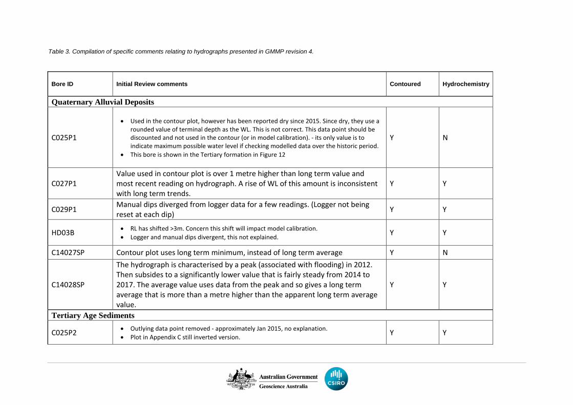
Table 3. Compilation of specific comments relating to hydrographs presented in GMMP revision 4.
Bore ID Initial Review comments Contoured Hydrochemistry
Quaternary Alluvial Deposits
C025P1
• Used in the contour plot, however has been reported dry since 2015. Since dry, they use a rounded value of terminal depth as the WL. This is not correct. This data point should be discounted and not used in the contour (or in model calibration). - its only value is to indicate maximum possible water level if checking modelled data over the historic period.
• This bore is shown in the Tertiary formation in Figure 12
Y N
C027P1 Value used in contour plot is over 1 metre higher than long term value and most recent reading on hydrograph. A rise of WL of this amount is inconsistent with long term trends.
Y Y
C029P1 Manual dips diverged from logger data for a few readings. (Logger not being reset at each dip) Y Y
HD03B • RL has shifted >3m. Concern this shift will impact model calibration. • Logger and manual dips divergent, this not explained. Y Y
C14027SP Contour plot uses long term minimum, instead of long term average Y N
C14028SP
The hydrograph is characterised by a peak (associated with flooding) in 2012. Then subsides to a significantly lower value that is fairly steady from 2014 to 2017. The average value uses data from the peak and so gives a long term average that is more than a metre higher than the apparent long term average value.
Y Y
Tertiary Age Sediments
C025P2 • Outlying data point removed - approximately Jan 2015, no explanation. • Plot in Appendix C still inverted version. Y Y
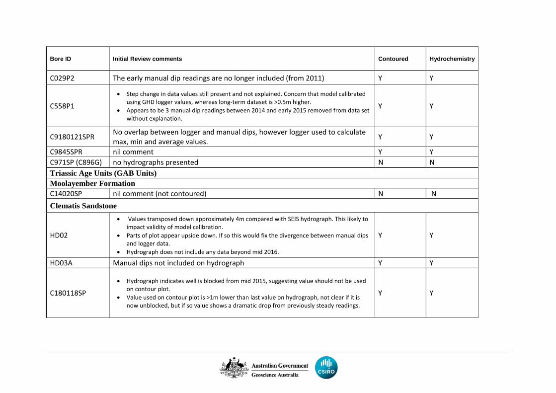
Bore ID Initial Review comments Contoured Hydrochemistry
C029P2 The early manual dip readings are no longer included (from 2011) Y Y
C558P1 • Step change in data values still present and not explained. Concern that model calibrated
using GHD logger values, whereas long-term dataset is >0.5m higher. • Appears to be 3 manual dip readings between 2014 and early 2015 removed from data set
without explanation.
Y Y
C9180121SPR No overlap between logger and manual dips, however logger used to calculate max, min and average values. Y Y
C9845SPR nil comment Y Y C971SP (C896G) no hydrographs presented N N Triassic Age Units (GAB Units) Moolayember Formation C14020SP nil comment (not contoured) N N Clematis Sandstone
HD02
• Values transposed down approximately 4m compared with SEIS hydrograph. This likely to impact validity of model calibration.
• Parts of plot appear upside down. If so this would fix the divergence between manual dips and logger data.
• Hydrograph does not include any data beyond mid 2016.
Y Y
HD03A Manual dips not included on hydrograph Y Y
C180118SP • Hydrograph indicates well is blocked from mid 2015, suggesting value should not be used
on contour plot. • Value used on contour plot is >1m lower than last value on hydrograph, not clear if it is
now unblocked, but if so value shows a dramatic drop from previously steady readings.
Y Y
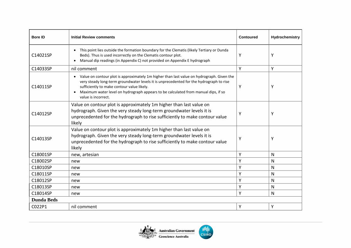
Bore ID Initial Review comments Contoured Hydrochemistry
C14021SP • This point lies outside the formation boundary for the Clematis (likely Tertiary or Dunda
Beds). Thus is used incorrectly on the Clematis contour plot. • Manual dip readings (in Appendix C) not provided on Appendix E hydrograph
Y Y
C14033SP nil comment Y Y
C14011SP
• Value on contour plot is approximately 1m higher than last value on hydrograph. Given the very steady long-term groundwater levels it is unprecedented for the hydrograph to rise sufficiently to make contour value likely.
• Maximum water level on hydrograph appears to be calculated from manual dips, if so value is incorrect.
Y Y
C14012SP
Value on contour plot is approximately 1m higher than last value on hydrograph. Given the very steady long-term groundwater levels it is unprecedented for the hydrograph to rise sufficiently to make contour value likely
Y Y
C14013SP
Value on contour plot is approximately 1m higher than last value on hydrograph. Given the very steady long-term groundwater levels it is unprecedented for the hydrograph to rise sufficiently to make contour value likely
Y Y
C18001SP new, artesian Y N C18002SP new Y N C18010SP new Y N C18011SP new Y N C18012SP new Y N C18013SP new Y N C18014SP new Y N Dunda Beds C022P1 nil comment Y Y
Bore ID Initial Review comments Contoured Hydrochemistry
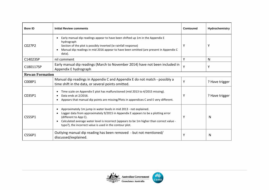
C027P2
• Early manual dip readings appear to have been shifted up 1m in the Appendix E hydrograph Section of the plot is possibly inverted (ie rainfall response)
• Manual dip readings in mid 2016 appear to have been omitted (are present in Appendix C data).
Y Y
C14023SP nil comment Y N
C180117SP Early manual dip readings (March to November 2014) have not been included in Appendix E hydrograph Y Y
Rewan Formation
C008P1 Manual dip readings in Appendix C and Appendix E do not match - possibly a time shift in the data, or several points omitted. Y ? Have trigger
C035P1 • Time scale on Appendix E plot has malfunctioned (mid 2013 to 4/2015 missing). • Data ends at 2/2016. • Appears that manual dip points are missing/Plots in appendices C and E very different.
Y ? Have trigger
C555P1
• Approximately 1m jump in water levels in mid 2013 - not explained. • Logger data from approximately 9/2015 in Appendix E appears to be a plotting error
(different to App C). • Calculated average water level is incorrect (appears to be 1m higher than correct value -
typo?), the incorrect value is used in the contour plot.
Y N
C556P1 Outlying manual dip reading has been removed - but not mentioned/ discussed/explained. Y N
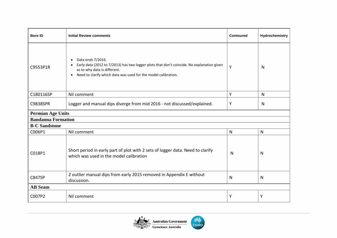
Bore ID Initial Review comments Contoured Hydrochemistry
C9553P1R
• Data ends 7/2016. • Early data (2012 to 7/2013) has two logger plots that don't coincide. No explanation given
as to why data is different. • Need to clarify which data was used for the model calibration.
Y N
C180116SP Nil comment Y N
C9838SPR Logger and manual dips diverge from mid 2016 - not discussed/explained. Y N
Permian Age Units Bandanna Formation B-C Sandstone C006P1 Nil comment N N
C018P1 Short period in early part of plot with 2 sets of logger data. Need to clarify which was used in the model calibration N N
C847SP 2 outlier manual dips from early 2015 removed in Appendix E without discussion. N N
AB Seam
C007P2 Nil comment Y Y
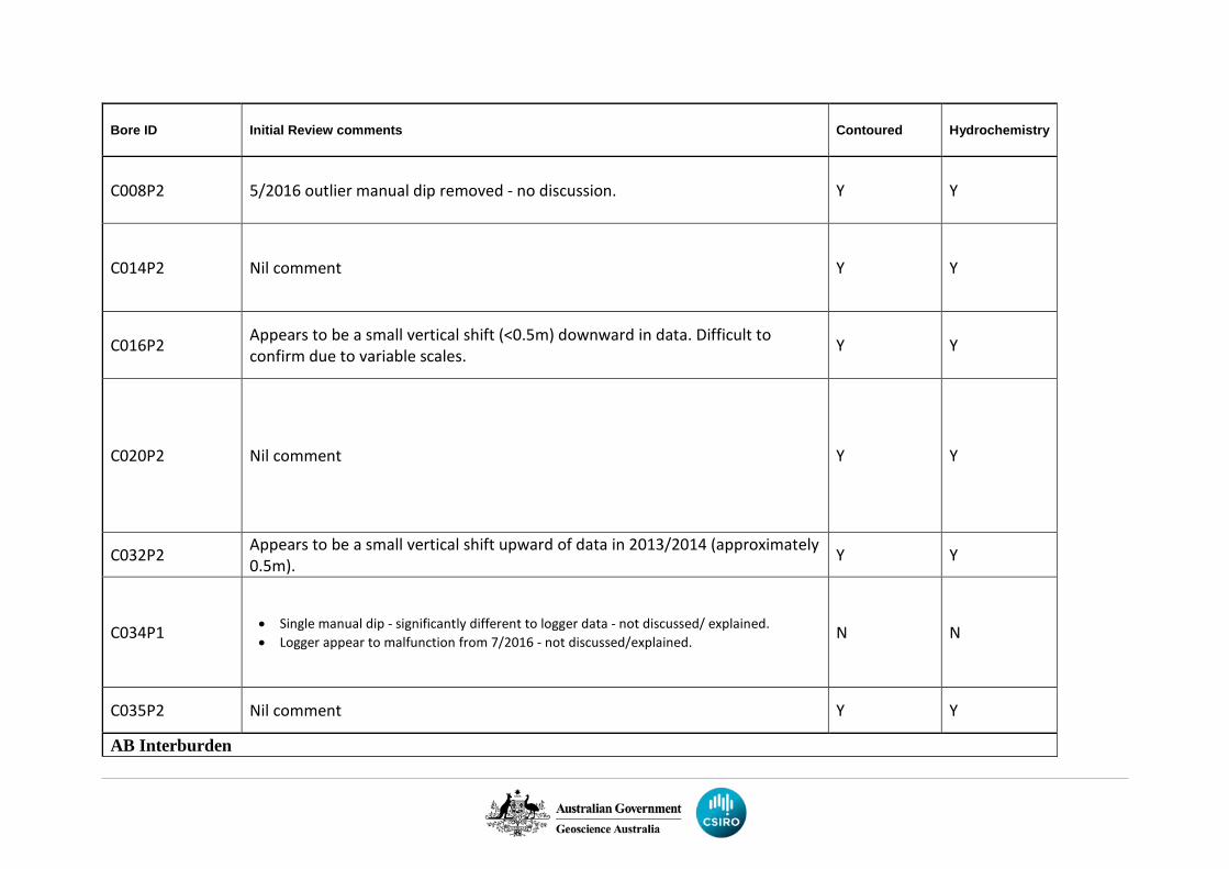
Bore ID Initial Review comments Contoured Hydrochemistry
C008P2 5/2016 outlier manual dip removed - no discussion. Y Y
C014P2 Nil comment Y Y
C016P2 Appears to be a small vertical shift (<0.5m) downward in data. Difficult to confirm due to variable scales. Y Y
C020P2 Nil comment Y Y
C032P2 Appears to be a small vertical shift upward of data in 2013/2014 (approximately 0.5m). Y Y
C034P1 • Single manual dip - significantly different to logger data - not discussed/ explained. • Logger appear to malfunction from 7/2016 - not discussed/explained. N N
C035P2 Nil comment Y Y
AB Interburden
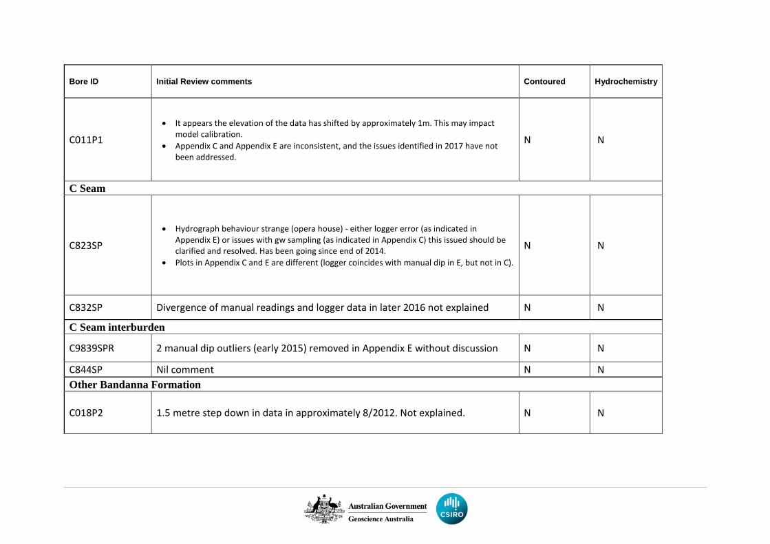
Bore ID Initial Review comments Contoured Hydrochemistry
C011P1 • It appears the elevation of the data has shifted by approximately 1m. This may impact
model calibration. • Appendix C and Appendix E are inconsistent, and the issues identified in 2017 have not
been addressed.
N N
C Seam
C823SP
• Hydrograph behaviour strange (opera house) - either logger error (as indicated in Appendix E) or issues with gw sampling (as indicated in Appendix C) this issued should be clarified and resolved. Has been going since end of 2014.
• Plots in Appendix C and E are different (logger coincides with manual dip in E, but not in C).
N N
C832SP Divergence of manual readings and logger data in later 2016 not explained N N
C Seam interburden
C9839SPR 2 manual dip outliers (early 2015) removed in Appendix E without discussion N N
C844SP Nil comment N N Other Bandanna Formation
C018P2 1.5 metre step down in data in approximately 8/2012. Not explained. N N
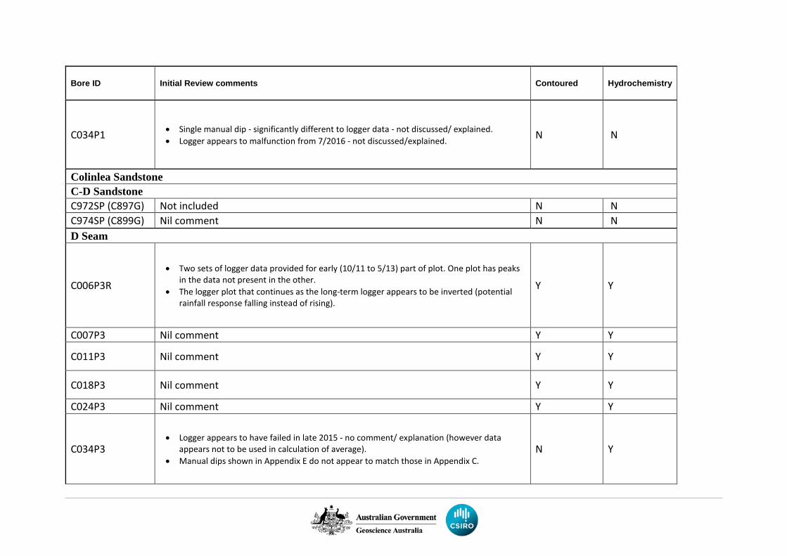
Bore ID Initial Review comments Contoured Hydrochemistry
C034P1 • Single manual dip - significantly different to logger data - not discussed/ explained. • Logger appears to malfunction from 7/2016 - not discussed/explained. N N
Colinlea Sandstone C-D Sandstone C972SP (C897G) Not included N N C974SP (C899G) Nil comment N N D Seam
C006P3R • Two sets of logger data provided for early (10/11 to 5/13) part of plot. One plot has peaks
in the data not present in the other. • The logger plot that continues as the long-term logger appears to be inverted (potential
rainfall response falling instead of rising).
Y Y
C007P3 Nil comment Y Y
C011P3 Nil comment Y Y
C018P3 Nil comment Y Y
C024P3 Nil comment Y Y
C034P3 • Logger appears to have failed in late 2015 - no comment/ explanation (however data
appears not to be used in calculation of average). • Manual dips shown in Appendix E do not appear to match those in Appendix C.
N Y
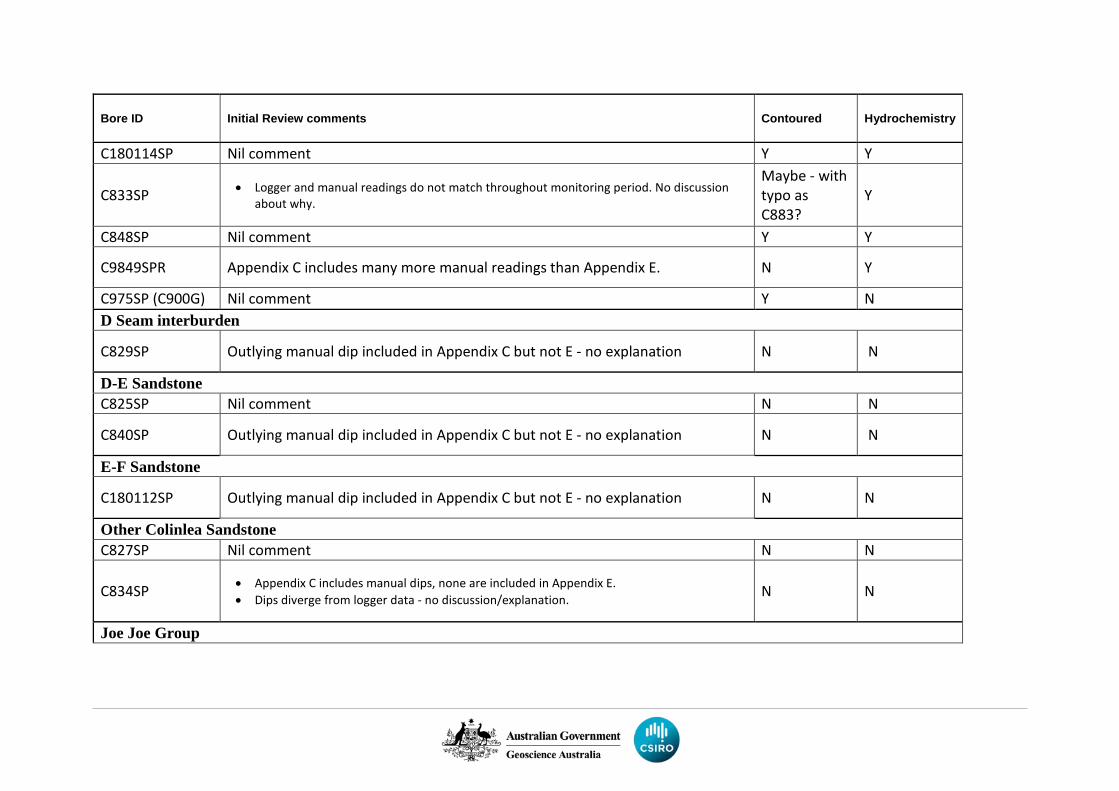
Bore ID Initial Review comments Contoured Hydrochemistry
C180114SP Nil comment Y Y
C833SP • Logger and manual readings do not match throughout monitoring period. No discussion about why.
Maybe - with typo as C883?
Y
C848SP Nil comment Y Y
C9849SPR Appendix C includes many more manual readings than Appendix E. N Y
C975SP (C900G) Nil comment Y N D Seam interburden
C829SP Outlying manual dip included in Appendix C but not E - no explanation N N
D-E Sandstone C825SP Nil comment N N
C840SP Outlying manual dip included in Appendix C but not E - no explanation N N
E-F Sandstone
C180112SP Outlying manual dip included in Appendix C but not E - no explanation N N
Other Colinlea Sandstone C827SP Nil comment N N
C834SP • Appendix C includes manual dips, none are included in Appendix E. • Dips diverge from logger data - no discussion/explanation. N N
Joe Joe Group
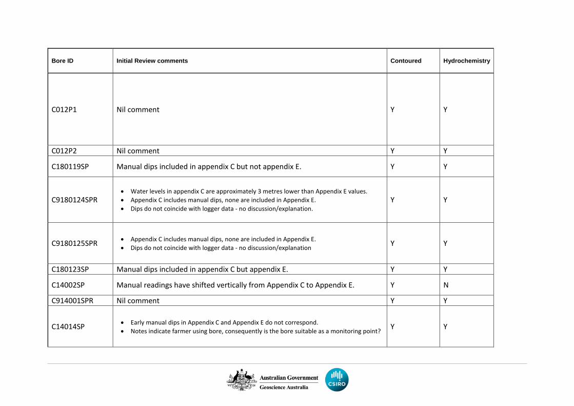
Bore ID Initial Review comments Contoured Hydrochemistry
C012P1 Nil comment Y Y
C012P2 Nil comment Y Y
C180119SP Manual dips included in appendix C but not appendix E. Y Y
C9180124SPR • Water levels in appendix C are approximately 3 metres lower than Appendix E values. • Appendix C includes manual dips, none are included in Appendix E. • Dips do not coincide with logger data - no discussion/explanation.
Y Y
C9180125SPR • Appendix C includes manual dips, none are included in Appendix E. • Dips do not coincide with logger data - no discussion/explanation Y Y
C180123SP Manual dips included in appendix C but appendix E. Y Y
C14002SP Manual readings have shifted vertically from Appendix C to Appendix E. Y N
C914001SPR Nil comment Y Y
C14014SP • Early manual dips in Appendix C and Appendix E do not correspond. • Notes indicate farmer using bore, consequently is the bore suitable as a monitoring point? Y Y
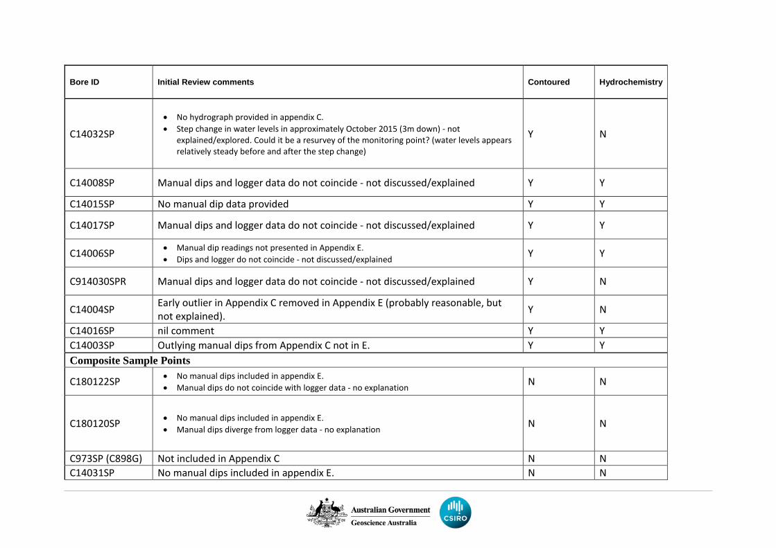
Bore ID Initial Review comments Contoured Hydrochemistry
C14032SP • No hydrograph provided in appendix C. • Step change in water levels in approximately October 2015 (3m down) - not
explained/explored. Could it be a resurvey of the monitoring point? (water levels appears relatively steady before and after the step change)
Y N
C14008SP Manual dips and logger data do not coincide - not discussed/explained Y Y
C14015SP No manual dip data provided Y Y
C14017SP Manual dips and logger data do not coincide - not discussed/explained Y Y
C14006SP • Manual dip readings not presented in Appendix E. • Dips and logger do not coincide - not discussed/explained Y Y
C914030SPR Manual dips and logger data do not coincide - not discussed/explained Y N
C14004SP Early outlier in Appendix C removed in Appendix E (probably reasonable, but not explained). Y N
C14016SP nil comment Y Y C14003SP Outlying manual dips from Appendix C not in E. Y Y Composite Sample Points
C180122SP • No manual dips included in appendix E. • Manual dips do not coincide with logger data - no explanation N N
C180120SP • No manual dips included in appendix E. • Manual dips diverge from logger data - no explanation N N
C973SP (C898G) Not included in Appendix C N N C14031SP No manual dips included in appendix E. N N
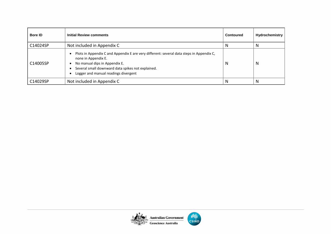
Bore ID Initial Review comments Contoured Hydrochemistry
C14024SP Not included in Appendix C N N
C14005SP
• Plots in Appendix C and Appendix E are very different: several data steps in Appendix C, none in Appendix E.
• No manual dips in Appendix E. • Several small downward data spikes not explained. • Logger and manual readings divergent
N N
C14029SP Not included in Appendix C N N
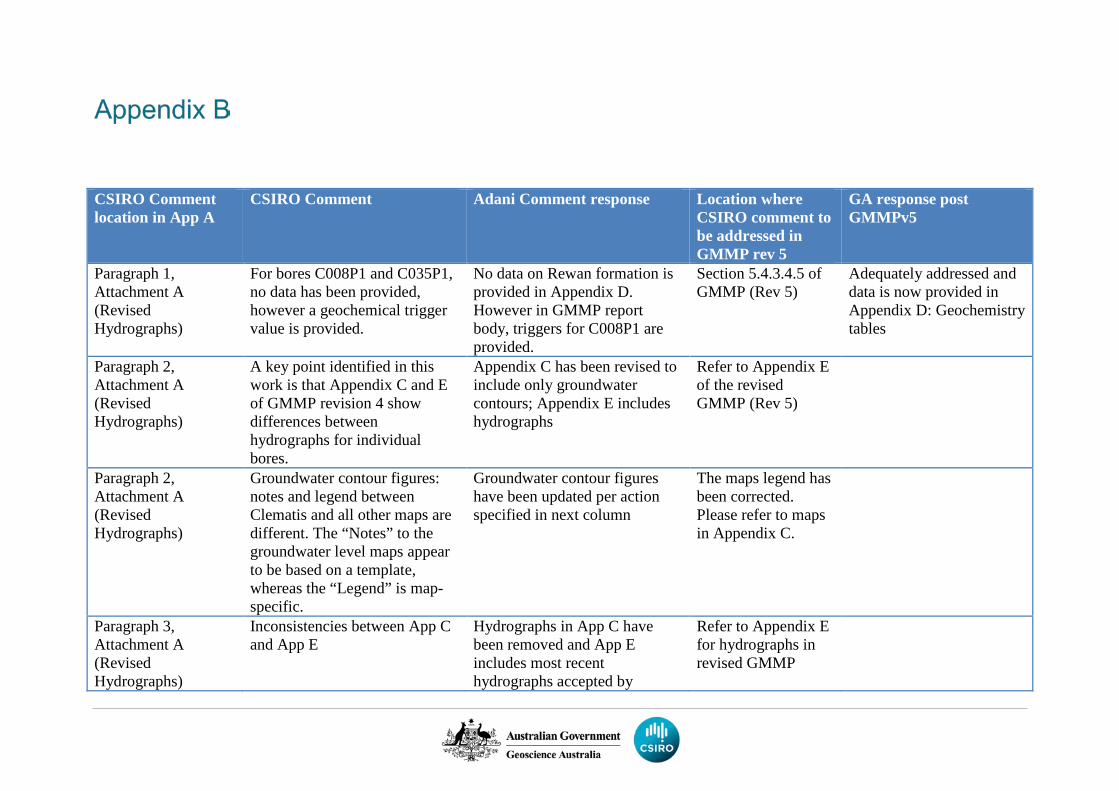
CSIRO Comment location in App A
CSIRO Comment Adani Comment response Location where CSIRO comment to be addressed in GMMP rev 5
GA response post GMMPv5
Paragraph 1, Attachment A (Revised Hydrographs)
For bores C008P1 and C035P1, no data has been provided, however a geochemical trigger value is provided.
No data on Rewan formation is provided in Appendix D. However in GMMP report body, triggers for C008P1 are provided.
Section 5.4.3.4.5 of GMMP (Rev 5)
Adequately addressed and data is now provided in Appendix D: Geochemistry tables
Paragraph 2, Attachment A (Revised Hydrographs)
A key point identified in this work is that Appendix C and E of GMMP revision 4 show differences between hydrographs for individual bores.
Appendix C has been revised to include only groundwater contours; Appendix E includes hydrographs
Refer to Appendix E of the revised GMMP (Rev 5)
Paragraph 2, Attachment A (Revised Hydrographs)
Groundwater contour figures: notes and legend between Clematis and all other maps are different. The “Notes” to the groundwater level maps appear to be based on a template, whereas the “Legend” is map-specific.
Groundwater contour figures have been updated per action specified in next column
The maps legend has been corrected. Please refer to maps in Appendix C.
Paragraph 3, Attachment A (Revised Hydrographs)
Inconsistencies between App C and App E
Hydrographs in App C have been removed and App E includes most recent hydrographs accepted by
Refer to Appendix E for hydrographs in revised GMMP
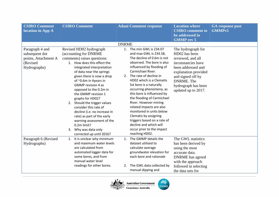
CSIRO Comment location in App A
CSIRO Comment Adani Comment response Location where CSIRO comment to be addressed in GMMP rev 5
GA response post GMMPv5
DNRME Paragraph 4 and subsequent dot points, Attachment A (Revised Hydrographs)
Revised HD02 hydrograph (accounting for DNRME comments) raises questions:
1. How does this effect the integrated interpretation of data near the springs given there is now a drop of ~0.6m in 4years in GMMP revision 4 as opposed to the 0.2m in the GMMP revision 1 graphs for HD02?
2. Should the trigger values consider this rate of decline (i.e. no increase in rate) as part of the early warning assessment of the 0.2m limit?
3. Why was data only corrected up until 2016?
1. The min GWL is 234.07 and max GWL is 234.58, The decline of 0.6m is not observed. The bore is also influenced by flooding of Carmichael River.
2. The rate of decline in HD02 which is a Clematis Sst bore is a naturally occurring phenomena, as this bore is influenced by the flooding of Carmichael River. However mining related impacts are also monitored in units below Clematis by assigning triggers based on a rate of decline and which will occur prior to the impact reaching HD02.
The hydrograph for HD02 has been reviewed, and all inconstancies have been addressed and explanation provided and signed off by DNRME. The hydrograph has been updated up to 2017.
Paragraph 6 (Revised Hydrographs)
1. It is unclear why minimum and maximum water levels are calculated from automated logger data for some bores, and from manual water level readings for other bores.
1. The GMMP details the dataset utilised to calculate average groundwater elevation for each bore and rationale
2. The GWL data collected by
manual dipping and
The GWL statistics has been derived by using the most accurate data. DNRME has agreed with the approach followed in selecting the data sets for
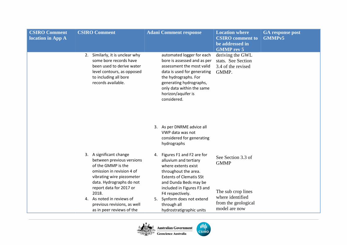
CSIRO Comment location in App A
CSIRO Comment Adani Comment response Location where CSIRO comment to be addressed in GMMP rev 5
GA response post GMMPv5
2. Similarly, it is unclear why some bore records have been used to derive water level contours, as opposed to including all bore records available.
3. A significant change between previous versions of the GMMP is the omission in revision 4 of vibrating wire piezometer data. Hydrographs do not report data for 2017 or 2018.
4. As noted in reviews of previous revisions, as well as in peer reviews of the
automated logger for each bore is assessed and as per assessment the most valid data is used for generating the hydrographs. For generating hydrographs, only data within the same horizon/aquifer is considered.
3. As per DNRME advice all VWP data was not considered for generating hydrographs
4. Figures F1 and F2 are for
alluvium and tertiary where extents exist throughout the area. Extents of Clematis SSt and Dunda Beds may be included in Figures F3 and F4 respectively.
5. Synform does not extend through all hydrostratigraphic units
deriving the GWL stats. See Section 3.4 of the revised GMMP. See Section 3.3 of GMMP The sub crop lines where identified from the geological model are now
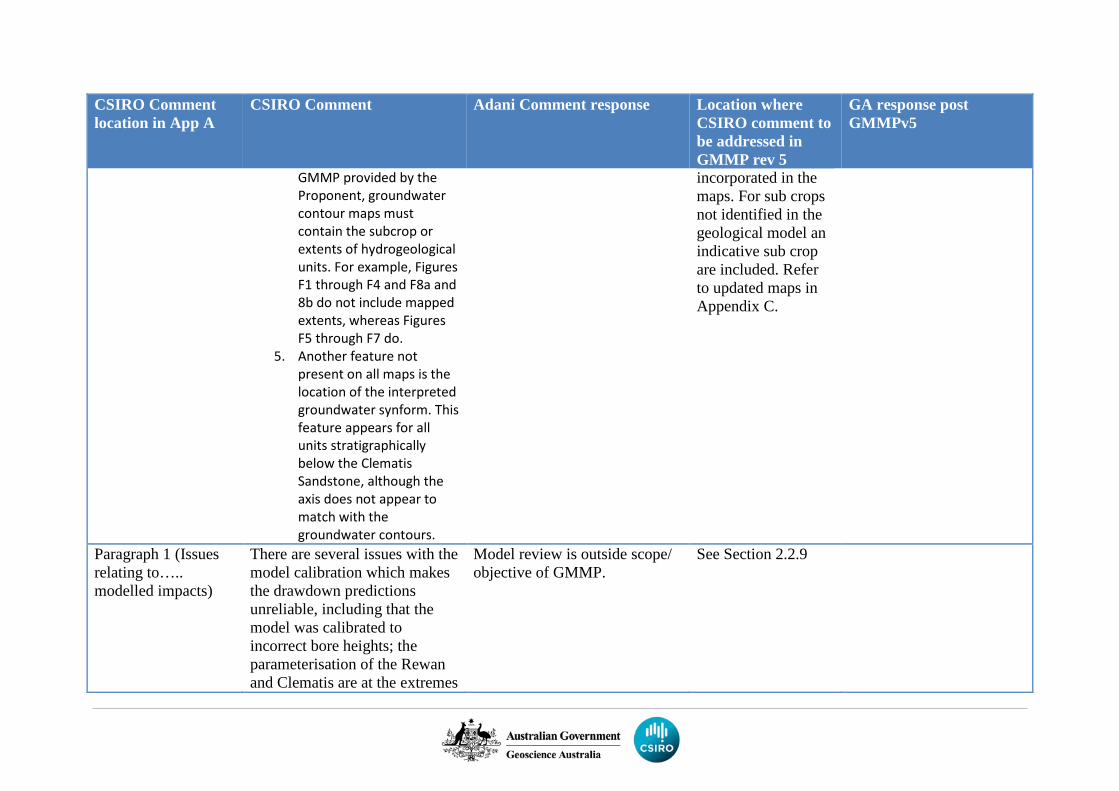
CSIRO Comment location in App A
CSIRO Comment Adani Comment response Location where CSIRO comment to be addressed in GMMP rev 5
GA response post GMMPv5
GMMP provided by the Proponent, groundwater contour maps must contain the subcrop or extents of hydrogeological units. For example, Figures F1 through F4 and F8a and 8b do not include mapped extents, whereas Figures F5 through F7 do.
5. Another feature not present on all maps is the location of the interpreted groundwater synform. This feature appears for all units stratigraphically below the Clematis Sandstone, although the axis does not appear to match with the groundwater contours.
incorporated in the maps. For sub crops not identified in the geological model an indicative sub crop are included. Refer to updated maps in Appendix C.
Paragraph 1 (Issues relating to….. modelled impacts)
There are several issues with the model calibration which makes the drawdown predictions unreliable, including that the model was calibrated to incorrect bore heights; the parameterisation of the Rewan and Clematis are at the extremes
Model review is outside scope/ objective of GMMP.
See Section 2.2.9
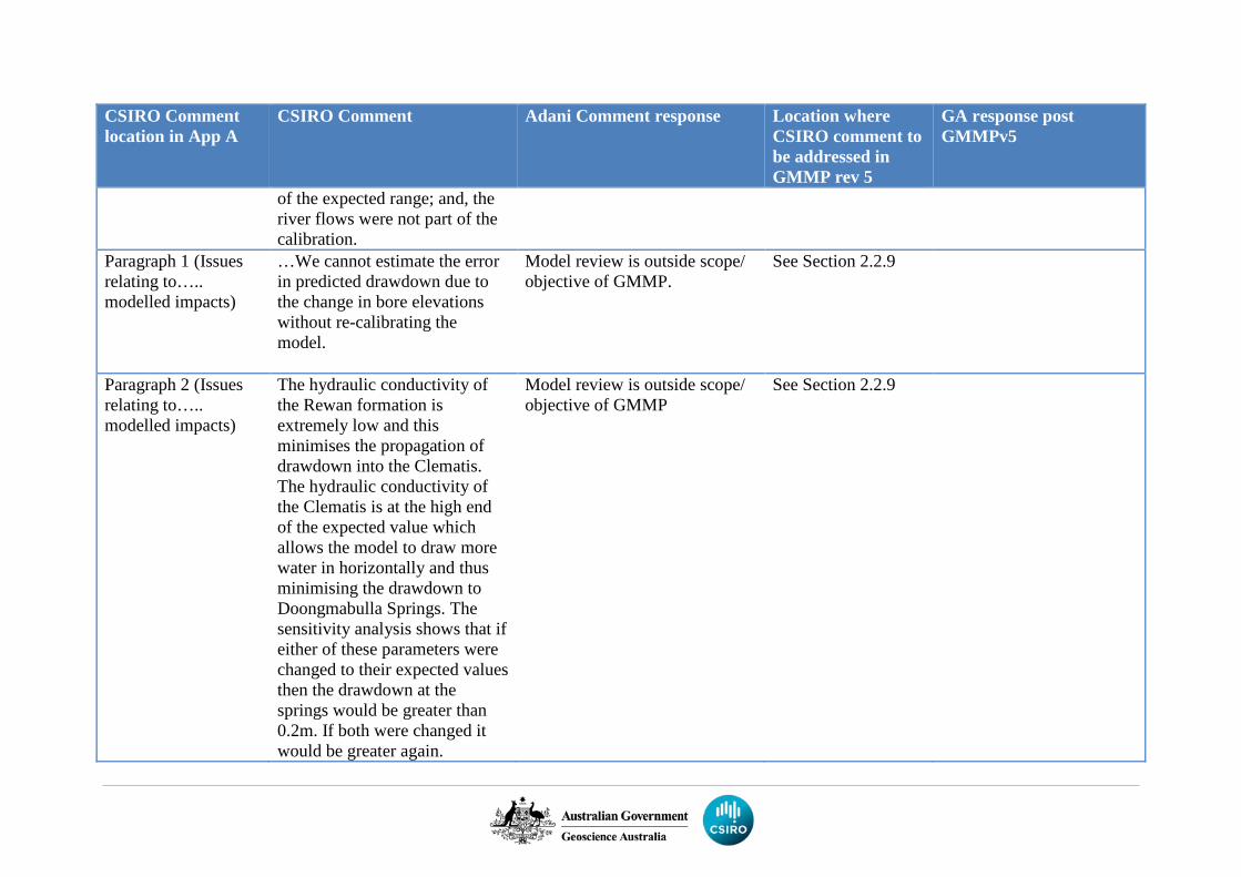
CSIRO Comment location in App A
CSIRO Comment Adani Comment response Location where CSIRO comment to be addressed in GMMP rev 5
GA response post GMMPv5
of the expected range; and, the river flows were not part of the calibration.
Paragraph 1 (Issues relating to….. modelled impacts)
…We cannot estimate the error in predicted drawdown due to the change in bore elevations without re-calibrating the model.
Model review is outside scope/ objective of GMMP.
See Section 2.2.9
Paragraph 2 (Issues relating to….. modelled impacts)
The hydraulic conductivity of the Rewan formation is extremely low and this minimises the propagation of drawdown into the Clematis. The hydraulic conductivity of the Clematis is at the high end of the expected value which allows the model to draw more water in horizontally and thus minimising the drawdown to Doongmabulla Springs. The sensitivity analysis shows that if either of these parameters were changed to their expected values then the drawdown at the springs would be greater than 0.2m. If both were changed it would be greater again.
Model review is outside scope/ objective of GMMP
See Section 2.2.9
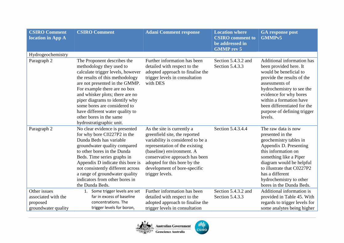
CSIRO Comment location in App A
CSIRO Comment Adani Comment response Location where CSIRO comment to be addressed in GMMP rev 5
GA response post GMMPv5
Hydrogeochemistry Paragraph 2 The Proponent describes the
methodology they used to calculate trigger levels, however the results of this methodology are not presented in the GMMP. For example there are no box and whisker plots; there are no piper diagrams to identify why some bores are considered to have different water quality to other bores in the same hydrostratigraphic unit.
Further information has been detailed with respect to the adopted approach to finalise the trigger levels in consultation with DES
Section 5.4.3.2 and Section 5.4.3.3
Additional information has been provided here. It would be beneficial to provide the results of the assessments of hydrochemistry to see the evidence for why bores within a formation have been differentiated for the purpose of defining trigger levels.
Paragraph 2 No clear evidence is presented for why bore C0227P2 in the Dunda Beds has variable groundwater quality compared to other bores in the Dunda Beds. Time series graphs in Appendix D indicate this bore is not consistently different across a range of groundwater quality indicators from other bores in the Dunda Beds.
As the site is currently a greenfield site, the reported variability is considered to be a representation of the existing (baseline) environment. A conservative approach has been adopted for this bore by the development of bore-specific trigger levels.
Section 5.4.3.4.4 The raw data is now presented in the geochemistry tables in Appendix D. Presenting this information on something like a Piper diagram would be helpful to illustrate that C0227P2 has a different hydrochemistry to other bores in the Dunda Beds.
Other issues associated with the proposed groundwater quality
1. Some trigger levels are set far in excess of baseline concentrations. The trigger levels for boron,
Further information has been detailed with respect to the adopted approach to finalise the trigger levels in consultation
Section 5.4.3.2 and Section 5.4.3.3
Additional information is provided in Table 45. With regards to trigger levels for some analytes being higher
CSIRO Comment location in App A
CSIRO Comment Adani Comment response Location where CSIRO comment to be addressed in GMMP rev 5
GA response post GMMPv5
triggers include: manganese and iron seem to be consistently higher than baseline data. The Proponent do not provide an explanation for why their proposed triggers differ from those recommended by Queensland Department of Environment and Science (DES).
2. Setting trigger levels does not account for trends in groundwater chemistry that may provide an early indication of impact. Following the recommendation from DES (DES review August 2018), the Proponent state that two consecutive groundwater chemistry results above the trigger value will prompt an investigation. Some assessment of trends in the groundwater chemistry data following each monitoring event to
with DES Assignment of site-specific triggers to provide early warning for ‘specific receptors’ is not related to GMMP, or the objective of GMMP as per EA as this will be for GDEMP to prescribe. But EPBC approval require GMMP to assign triggers for MNES. Therefore, the hydrostratigraphic unit
than baseline data, Table 45 states that in Step 4: ‘trigger levels derived from the baseline monitoring program are compared to the ANZECC & ARMCANZ 2000 guideline values per analyte (95th protection and low reliability). In instances where the ANZECC & ARMCANZ 2000 guideline value is higher, this ANZECC value should be adopted as the proposed trigger level.’ GA notes the ANZECC guidelines are only used in preference to the baseline data when they are higher than baseline data, not lower. GA considers that site-specific triggers are preferential to using the ANZECC guideline trigger values.
CSIRO Comment location in App A
CSIRO Comment Adani Comment response Location where CSIRO comment to be addressed in GMMP rev 5
GA response post GMMPv5
identify if groundwater quality is changing over time should also form part of the monitoring strategy.
3. Few bores are classified as ‘sentinel’ bores have site-specific groundwater trigger levels set. The trigger levels for these bores defaults to hydrostratigraphic unit-wide trigger levels. Whilst this may be a suitable approach to investigate aquifer-wide changes to groundwater chemistry; the protection of specific receptors requires site-specific triggers to provide early warning of potential impacts to the springs. Individual triggers need to be set for sentinel bores which are “a monitoring point where groundwater level and quality changes can be monitored before changes occur at a receptor (p.32)”.
which is the source of springs is MNES.

`

`
Carmichael Coal Mine Advice on draft research plans to the Department of the Environment and Energy
NOVEMBER 2018
1
Advice on Carmichael Coal Project draft research plans to the Department of the Environment and Energy D2018-150909
1. Introduction
On 25 October 2018, the Department of the Environment and Energy (DoEE) requested Geoscience Australia and CSIRO to provide groundwater-related advice on draft plans provided by Adani Mining Pty Ltd (the Proponent) in accordance with Environment Protection and Biodiversity Conservation Act 1999 (EPBC Act) approval conditions for the Carmichael Coal Mine. These plans include the draft Great Artesian Basin Springs Research Plan (GABSRP) and the draft Rewan Formation Connectivity Research Plan (RFCRP), required under EPBC Act conditions 25 and 26, and 27 and 28, respectively.
The DoEE sought advice specifically on two questions relating to these draft plans:
Q1a. Based on the information currently available, how plausible and reasonable is it that the Clematis Sandstone is the source aquifer for Doongmabulla Springs Complex?
Q1b. How adequately do the methods and techniques put forward in the research plans address uncertainties about:
1. the source of the springs
2. the capacity of the Rewan Formation to prevent impacts to the springs, and
3. methods to prevent, mitigate and remediate ecological impacts to the springs?
These questions were to be based on available information including:
4. the draft GABSRP (Final draft, dated 21 May 2018)
5. the draft RFCRP (Revision L, dated 6 August 2018)
6. a Statement of claims about the springs source and additional information about the conceptualisation provided by the Proponent to DoEE on 12 October 2018 (Supplementary information)
7. the draft Groundwater Management and Monitoring Plan – Carmichael Coal Project Revision 3, dated August 8, 2018 (GMMP).
8. the draft Groundwater Dependent Ecosystem Management Plan – Carmichael Coal Mine Project, Version 9 dated 5 July, 2018 (GDEMP)
This document provides an assessment of how the methodology and rationale for each draft research plan addresses Q1a and Q1b. This assessment relied on the draft plans, the statement of claims about the springs source and additional information about the conceptualisation, including some studies undertaken since the time of approval. Other references are included as in-text citations and in the reference list provided.
a. Advice on the draft research plans
In general, the draft research plans provide approaches to address some data gaps and areas of uncertainty about the source of the Doongmabulla Springs Complex and the hydrogeological characteristics of the Rewan Formation. However, they will not address the differing hydrogeological conceptualisations or potential uncertainties outlined above in the 12 month work programs specified in the plans. The plans provide a number of techniques and methods to address their aims; however they are poorly referenced, and generic in nature. The draft research plans lack the specificity required to assess if the methods are appropriate given the known geological and hydrogeological characteristics of the Carmichael Coal Project area, and the different components of the
2
Advice on Carmichael Coal Project draft research plans to the Department of the Environment and Energy D2018-150909
conceptualisations being tested. Both plans also set out to confirm the proponent’s preferred conceptualisation, as opposed to seeking to collect data and information with which to develop and evaluate multiple conceptualisations. Some inconsistencies between the documentation also exist, such as differing maps between plans.
2. Based on the information currently available, how plausible and reasonable is it that the Clematis Sandstone is the source aquifer for Doongmabulla Springs Complex?
It is plausible and reasonable that the Clematis Sandstone is a major source aquifer for the Doongmabulla Springs Complex (DSC). This is supported by water level and groundwater flow information presented by the proponent, as well as by other studies (Evans et al., 2018; Fensham et al., 2016; JBT Consulting, 2015), and by some aspects of hydrogeochemistry of the springs and the Clematis Sandstone (Fensham et al., 2016; Webb et al., 2015). It is not plausible and reasonable to state unequivocally that the Clematis Sandstone is the sole source aquifer for the DSC, as sufficient uncertainty surrounding hydrogeochemistry, inter-aquifer connectivity and groundwater flow (Currell et al., 2017; Lewis et al., 2018; Webb et al., 2015) exists to necessitate a precautionary approach to the conceptualisation, as ruled by Land Court of Queensland (2015). Evidence provided in the GABSRP supports the conceptualisation that the Clematis Sandstone is a source aquifer, but there is enough uncertainty around the information provided, as acknowledged by the Proponent, to necessitate a robust assessment of potential alternative or additional source aquifers. In addition, and as summarised below, the body of existing evidence available in the public domain shows that there is ambiguity in the source aquifers of the Doongmabulla Springs Complex (Currell et al., 2017; Evans et al., 2018; Fensham et al., 2016; Land Court of Queensland, 2015; Lewis et al., 2018; Webb et al., 2015; Webb, 2015). Addressing the spring source aquifer question relies mostly on the work proposed under the GABSRP, with locally specific application of the RFCRP also important.
3. How adequately do the methods and techniques put forward in the research plans address uncertainties?
The GABSRP aims to investigate and evaluate the source of water feeding the DSC. The RFCRP aims to evaluate the presence, extent, and influence of various structural and stratigraphic characteristics of Rewan Formation and how these may influence the behaviour of that unit with respect to allowing interconnection between overlying and underlying units. The GABSRP and RFCRP present programs of work that extend over 12 month periods. Some of the data collection has already been undertaken, while some of the work will include collection of new data. The methods and techniques proposed in the GABSRP and the RFCRP include:
9. Geological mapping
10. Geophysical processing and interpretation
11. Reprocessing and reinterpreting historical seismic reflection data
12. Possibly using other existing geophysical data (e.g. regional magnetic data) to inform seismic interpretation
3
Advice on Carmichael Coal Project draft research plans to the Department of the Environment and Energy D2018-150909
13. Geological data analysis
14. Lithofacies analysis including petrophysical analysis
15. Fault modelling
16. Juxtaposition analysis
17. Shale gouge and fault membrane seal analysis
18. Fault leakage analysis
19. Hydrogeological data analysis
20. Hydrogeological parameter testing and analysis
21. Groundwater level and pressure analysis
22. Hydrochemistry
The methods and techniques proposed will provide information and data to allow for evaluation of the potential for hydrological connectivity pathways to transect the Rewan Formation. The main pathways that the geological and geophysical techniques seek to evaluate are direct interconnection of the Upper Permian units and the Clematis Sandstone via fault offsets. Another model by which the Rewan Formation can provide preferential flow pathways is via physically connected zones of higher permeability materials, such as connected sandstone bodies, small offset faults and fractures, or combinations of these. The methods and techniques proposed in the RFCRP will provide additional data and reduce uncertainty in the understanding and conceptualisation of the hydraulic behaviour of this unit. For the GABSRP, some aspects of the general approach, such as water level mapping, geological mapping and hydrogeochemical analysis are sound, however not enough detail on some methods is provided to adequately assess how these will address uncertainty in the springs conceptualisation. There are areas of both plans that will not provide the necessary information to inform GMMP or Groundwater Dependent Ecosystems Management Plan in a timely manner.
In general, the groundwater monitoring network shown in documents supplied is not well suited to monitor potential mining-related effects to the springs or to determine Rewan Formation connectivity. In order to adequately monitor changes that may result from mining, the Clematis Sandstone requires installation of several additional monitoring bores, in particular south of the Carmichael River along the strike of the tenement and to the west of the springs. Land Court of Queensland (2015) specified that monitoring must be undertaken in all units across and adjacent to the mine site to confirm groundwater flow patterns and monitor drawdown. The bore distribution shown in the GMMP does not meet this requirement, most notably to the west of the mine site. Given that groundwater is interpreted to flow from the west (Appendix C, GMMP; Evans et al., 2018), it is important that monitoring bores be located in all units to the west of the mine. Locating monitoring bores to the west will also allow for data collection pertinent to springs source aquifer identification and characterising the ability of the Rewan Formation to prevent impact propagation to springs.
There is limited groundwater monitoring of the hydrostratigraphic units below the Clematis Sandstone (Dunda Beds, Rewan Formation and Permian units) outside of the tenement. These are the units that are modelled to be most affected by mine dewatering which could pose a potential risk to the springs, in the event that these aquifers contribute discharge or are hydraulically connected to the springs (Land Court of Queensland, 2015).
Ideally, the Clematis Sandstone monitoring sites would include nested monitoring wells for other underlying and overlying units. These sites would provide water level and pressure data and stratigraphic and parameter information to help to calibrate the numerical groundwater model and
4
Advice on Carmichael Coal Project draft research plans to the Department of the Environment and Energy D2018-150909
could also be used as early warning sites for the springs, particularly where groundwater pressure reductions at the monitoring bores exceed modelled drawdown predictions.
Additional monitoring bores below the base of Clematis Sandstone would also help to answer the question about the source(s) of the DSC by providing additional hydrochemistry and water level data to compare with springs values. Additional drilling in the Rewan Formation and underlying Permian units could enable collection and analysis of further information on hydraulic conductivity.
a. Spring source
The GABSRP identifies the source aquifer of the DSC (hypothesis 1) as a key uncertainty associated with preventing predicted ecological impacts to the springs from the Project. The Proponent has assessed the potential risks arising from this uncertainty in the following way:
1. The Clematis Sandstone is the source aquifer for the Doongmabulla Springs Complex – Medium risk to the DSC if the source aquifer is below the Rewan Formation under the alternate scenario, which would lead to an increase in impact to the springs (high consequence), but is considered by the Proponent to be unlikely (low likelihood).
The information provided and available in the public domain indicates that it is both plausible and reasonable that units other than the Clematis Sandstone, including below the Rewan Formation may be a source aquifer for the DSC. If these other units are providing flow to the DSC, then this would lead to an increase in impacts to the springs (high consequence) and is considered plausible (medium likelihood) – High risk.
The Proponent’s conceptualisation of the DSC is that all of the springs from the Moses, Joshua and Little Moses groups are likely to be fed by groundwater sourced solely from the Clematis Sandstone aquifer which, in the case of most of the springs, discharges through the overlying Moolayember Formation and/or Quaternary alluvium. Under this model, the springs associated with outcropping sandstone are conceptualised as gravity-fed outcrop springs. These outcrop springs are located on the Dunda Beds and the Clematis Sandstone to the east of the spring groups covered by the GABSRP. The springs the Proponent includes in the DSC are predominantly interpreted as discharge springs. For the discharge springs to remain active, sufficient artesian head (i.e. pressure) in source aquifers such as the Clematis Sandstone is necessary to provide upward flow through the overlying Moolayember Formation or alluvium, which has been eroded where Carmichael Creek and Bimbah Creek converge (Fensham et al., 2016; Lewis et al., 2018).
An alternative spring source conceptualisation is also plausible based on available evidence. Webb (2015) proposed that the springs are sourced in part from the Colinlea Sandstone, via preferential upward leakage through the Rewan Formation and Dunda Beds. The Colinlea Sandstone is one of the units that will be actively dewatered during mining operations at Carmichael.
The main objective of the GABSRP is to confirm the hypothesis that the DSC is sourced from the Clematis Sandstone. However, previous investigations have concluded that there is ambiguity in the source aquifers based on currently available data. These studies agree that for the springs west of Little Moses (i.e. the discharge springs) the Clematis Sandstone is the likely primary source aquifer, based on the geology and groundwater potentiometry at these springs. However, it is unclear if the Clematis Sandstone is the sole source aquifer for these springs (Currell et al., 2017; Fensham et al., 2016; JBT Consulting, 2015; Lewis et al., 2018; Webb, 2015). For the outcrop springs (including Little Moses), based on descriptions in Fensham et al. (2016) it is more likely that the springs are water table fed, and that local geological units are the source aquifer (the outcropping Clematis Sandstone
5
Advice on Carmichael Coal Project draft research plans to the Department of the Environment and Energy D2018-150909
and Dunda Beds). Despite relying in part on descriptions of the DSC provided by Fensham et al. (2016), the Proponent does not include all of the spring vents mapped in that study within their definition of the DSC. This results in a disparity whereby the GABSRP seeks to assess approximately 80 vents, whereas Fensham et al. (2016) mapped 187 vents forming 160 separate wetlands. The reason for this discrepancy may be due to the updated state of knowledge between the approval of the mine and the work of Fensham et al. (2016). The GABSRP does not propose to investigate outcrop springs. In addition, the hydraulic interplay between the underlying hydrogeological units and the alluvium on the springs needs to be considered. To determine potential impacts on the springs and address requirements for mitigation measures, and given that there are a variety of spring types in the DSC, conceptual models for each spring type need to be developed and tested, and a detailed water balance will also need to be prepared.
An integrated analysis of existing and newly acquired geological, hydrodynamic and hydrochemical data would improve the conceptual understanding of the groundwater sources of the DSC.
Regarding geological interpretations, the Proponent states:
“Based on geological mapping, the source aquifer for the DSC is thought to be the Clematis Sandstone and/or the underlying Dunda Beds….Detailed mapping of faults around the area of the springs has not been undertaken.” (GABSRP pg 40)
Regarding hydrodynamic analysis, the Proponent states:
“Although the available data supports the concept of the Clematis Sandstone being the spring source aquifer, there is a lack of groundwater head data in other potential source aquifers beneath the springs, such as the Dunda Beds or even deeper Permian strata, from which to rule other sources out. On the basis of the available head data therefore, it is not possible to categorically rule out other aquifers besides the Clematis Sandstone as potentially contributing to spring discharge at the DSC.” (GABSRP pg 41)
Regarding hydrochemical analysis, the Proponent states:
“The studies associated with the EIS and SEIS did not directly compare the groundwater chemistry of the DSC with that of the Clematis Sandstone or other potential source aquifers. As such, based on the current hydrochemistry data, it is not possible to categorically rule out other aquifers besides the Clematis Sandstone as potentially contributing to spring discharge at the DSC.” (GABSRP, pg 41)
Based on these three statements and until such time as more data is provided in the research and management plans, the conceptualisation whereby the Clematis Sandstone is recognised as the sole source aquifer is not the only reasonable and plausible conclusion.
To that end, the assessment of the draft plans with respect to addressing uncertainty in the source aquifer of the DSC relies on the commitments within the plan to undertake appropriate geological (including structural geology), hydrodynamic and hydrochemical studies.
The GABSRP sets out a timeline and identifies expertise required to undertake the plan, as well as general subjects to be addressed. However, the GABSRP methods lack the required level of specific detail required to adequately assess how they will address the aims of the plan.
Geological and geophysical mapping
The geological mapping approach described in the GABSRP will provide additional information about the regional geology and hydrogeology. The inclusion of geophysical techniques to map distribution
6
Advice on Carmichael Coal Project draft research plans to the Department of the Environment and Energy D2018-150909
and thickness of the main geological units below surface is warranted, and may create linkages with the RFCRP, and better inform the GMMP. Geophysical data including seismic reflection (original and reprocessed), and airborne magnetics, reveal potential geological complexity at depth which will inform the updated geological knowledge.
More information is required on the extent and scale of mapping, the methods proposed, and the availability of the Proponent’s geological models and mapping to inform this work in order to assess how well-suited the approach is to addressing the goals of the research plans. A specific linkage between this work, the GMMP and the RFCRP would provide more assurance that research plans and management plans are based on the same information and conceptualisations. It is unclear what is planned in the “soils survey” mentioned, as there are a variety of types of soil survey. The particular methods and standards, and how they will address knowledge gaps is not provided in the GABSRP, and is an important oversight. In addition, other landscape surveys including high-resolution elevation models and geomorphology, would allow for a better integration between the geology, hydrogeology and springs typology. The plan would benefit by including discussion on the different geological mapping available to demonstrate how the proposed work would address knowledge gaps and discrepancies, such as the disparity between available local (1:100 000 and finer scale), regional (1:250 000), and state wide (1:500 000 and coarser) geological mapping.
Groundwater pressure
The use of groundwater pressures and head to map flow directions is well supported and is a standard method in hydrogeology at all scales.
Any consideration of groundwater pressure in different aquifers, and associated flows, relies on spatially and temporally representative data. Where a multiple aquifer system is envisaged, as is the case for the DSC, this means that relevant hydrostratigraphic units require representative data. Based on the information supplied in the research plans, no data is being collected or analysed for any units below the Dunda Beds outside the Carmichael mining lease. In addition, no measured groundwater pressure data is available, or planned to be collected west of bore HD03 in units below the Clematis Sandstone. This means that the monitoring bore network is insufficient to resolve potentiometric surfaces in these units up-gradient of the lease, or the DSC. This lack of spatially representative groundwater head data limits scope to reduce the uncertainty of the springs source aquifer or the Rewan Formation connectivity outside of the mining lease. Nested or adjacent bores installed to measure pressure in multiple hydrostratigraphic units are required to adequately assess groundwater pressure as it relates to springs, and also to address data gaps identified in the broader hydrogeological conceptualisation. Based on the information provided, the proposed monitoring network will not be able to provide the required data to improve the evaluation of alternative source aquifer conceptualisations (Currell et al., 2017; Land Court of Queensland, 2015).
A high resolution ground surface elevation model is required to properly assess groundwater pressures in relation to groundwater interaction with the land surface and contributions to and from surface water bodies. Similarly, accurate stream gauging data is required. This also extends to a need for representative spring flow measurements. There is no mention in the draft plans of the elevation model or surveying methods to be used, or whether stream gauging or spring flow measurements will be taken. Bioregional Assessment work (Lewis et al., 2018) has shown the value and utility of using time-series remote sensing data to identify stream reaches that form important components of the springs conceptualisation.
7
Advice on Carmichael Coal Project draft research plans to the Department of the Environment and Energy D2018-150909
Hydrochemistry
If undertaken appropriately, hydrochemistry investigations can provide strong supporting evidence of spring source formations. It is 'plausible and reasonable' that the Clematis Sandstone forms the source aquifer for discharge springs in the DSC, but no hydrochemical evidence is presented in the GABSRP to support this conclusion. The GABSRP confirms that it is not currently possible to rule out contributions to DSC flow from other formations. Similarly, hydrochemistry investigations could provide strong supporting evidence of connectivity through the Rewan Formation.
The hydrochemistry investigations described in the Chemical Analysis subsection of Section 5.1.2 of the GABSRP require revision. For example, there are few cited references to existing analytical techniques. There is insufficient information on the analytical suite and research methodology, and the proposed isotope suite may be insufficient to identify spring source formations. Details of sampling and analysis methods (including Quality Assurance and Quality Control components) are also lacking. The GABSRP and RFCRP (and relevant parts of the GMMP) provide limited detail on the methodology of proposed environmental tracer sampling. The RFCRP lists δ18O, δ2H, 3H and 14C as potential tracers to assess connectivity, evaporation, source, recharge conditions, groundwater mixing and mean residence time. These tracers alone do not cover the range of groundwater residence time scales expected in the groundwater systems under investigation, considering that an older formation (the Clematis Sandstone) is currently proposed as the source aquifer of the springs. Processes operating over timeframes beyond those measured by 14C should be considered to aid in determining spring source aquifers and characterising groundwater flow in the Rewan Formation. This needs to consider timescales in the order of 105 to 106 years. Noble gas tracers which are not influenced by geochemical or water-rock interactions would also aid these assessments by providing valuable information on groundwater flow in and through the Rewan Formation.
The proposed radioactive isotopes are useful in detecting and assessing the processes affecting younger groundwater in a mixed system. However, the draft plans do not consider analysing and assessing older components of groundwater by other radiogenic tracers, such as helium. In a setting such as the DSC, where alternative hypotheses may include groundwater contribution from deeper formations flowing through shallower hydrostratigraphic units via faults and discharging at springs, there is a need to assess the potential mixing of older and younger groundwater. Methane has also been used to successfully identify interaquifer mixing across the Rewan Formation in the Eromanga-Galilee Basin system further to the west (Moya et al., 2016), and is not discussed in the draft plans.
The proposed monitoring bores in the area of the DSC do not include several potential spring source formations. As shown in the GMMP, formation water chemistry can vary spatially. The research plan may therefore not provide data suitable for assessing the source aquifers for the DSC without including monitoring wells in all relevant formations near the spring vent locations.
Although the GABSRP acknowledges that various dissolved species are reactive, there is no commitment to undertake reactive transport modelling or testing of solid formation materials to inform such modelling. While this may not prove necessary, it could be usefully considered. The GABSRP briefly outlines a desktop phase of study that will precede field investigations. It would be useful if this phase was included in the proposed GABSRP to refine the hydrochemistry study components (including the analytical suite, field locations and investigation methods). This would enable review of the hydrochemistry components of the research plan prior to their implementation, as well as identification of key knowledge and data gaps.
Appropriate geochemical characterisation for each potential contributor to spring flow is necessary to identify spring source aquifers. This includes aquifer materials, surface water and groundwater. This type of assessment should consider a broad suite of parameters including but not limited to anions,
8
Advice on Carmichael Coal Project draft research plans to the Department of the Environment and Energy D2018-150909
cations, trace metals, and isotopes with analytical detection limits at trace levels, including parameters that are commonly associated with coal. This analysis and assessment should involve chemical and isotopic measurements of aquifer formations and springs, as well as alluvium and surface water. This is because most of the springs are located within the footprint of the alluvium and near to Carmichael River and Bimbah Creek. The distribution of mapped spring vents within the DSC could indicate the influence of near-surface geological structures (Fensham et al., 2016). This highlights the importance of considering synoptic baseline surveys of the streams for parameters including, but not limited to, major ions, trace elements, 222Rn, He and CH4 to determine if there is any influence of geological structures in the vicinity of the springs. Geological influence on streams may be identified by anomalies in the distribution of the proposed variables along the stream course, as observed in the Avon River (e.g. Mallants et al., 2018).
Limited groundwater isotopic data are available to support the conceptual model presented in the GABSRP and the GMMP. Any assessment seeking to understand and conceptualise the springs and their aquifer connectivity needs to encompass a wide range of variables to identify which tracers may be useful for long-term monitoring.
Isotope data from the Galilee and Eromanga basins, including 87Sr/86Sr data from the hydrostratigraphic units relevant to the Carmichael Coal Project are publically available (Moya et al., 2016). However, these data are not discussed in the documents provided by the Proponent.
b. Rewan Formation
The GABSRP identifies that thickness and hydraulic properties of the Rewan Formation (hypothesis 2) as a key uncertainty associated with preventing predicted ecological impacts to the springs from the Project. The Proponent has assessed the risk to springs due to this uncertainty as:
2. The thickness and hydraulic properties of the Rewan Formation will prevent significant groundwater pressure reduction from mine site dewatering propagating to the Clematis Sandstone at the DSC – Medium risk to the DSC if the Rewan vertical hydraulic conductivity is significantly higher than modelled under the alternate scenario, which would lead to an increase in impact to the springs (high consequence), but is considered by the Proponent to be unlikely (low likelihood).
As described below, it is considered plausible that the thickness of the Rewan Formation is more variable and the hydraulic conductivities are higher than modelled, which means that the alternate scenario would lead to an increase in impacts to the springs (high consequence) and is considered plausible (medium likelihood) – High risk.
The characterisation of the Rewan Formation as an aquitard relies mainly on the work proposed under the RFCRP. In addition, work undertaken to inform revisions of the GMMP, including pump testing in 2015 and drilling, downhole geophysical logging, and groundwater level and chemistry monitoring in 2016 are not included in the RFCRP. The structure of the RFCRP is poorly organised and appears focused towards a single conceptualisation of the Rewan Formation as a thick, homogenous aquitard rather than considering a range of conceptualisations. Figure 6 of the RFCRP, presented much later in the plan, provides a well-considered representation of the various potential preferential flow pathways through the Rewan Formation. Information provided by the Proponent shows that the intercepted thickness of the Rewan Formation in drilling varies from 263 m to 337 m, although it is unclear whether the Dunda Beds are considered as part of this unit or not in various documents. At one field location, the Rewan Formation is shown to be 234 m and 306 m thick in two co-located bores (C14206VWP
9
Advice on Carmichael Coal Project draft research plans to the Department of the Environment and Energy D2018-150909
and C14204VWP respectively). This suggests that the Rewan Formation may show significant variations in thickness at a local scale.
Hydraulic conductivity values used to model pressure reductions in the Clematis Sandstone at the DSC (hypothesis 3) is another key uncertainty identified in the GABSRP associated with preventing predicted ecological impacts to the springs from the Project:
3. Pressure reductions in the Clematis Sandstone at the DSC will be small – Medium risk to the DSC if the pressure reduction at the DSC is greater than model predictions under the alternate scenario, which would lead to an increase in impact to the springs (high consequence), but is considered by the Proponent to be unlikely (low likelihood).
This review indicates that it is considered plausible (medium likelihood) that the low vertical hydraulic conductivity values used to model the Rewan Formation and high hydraulic conductivity values used to model the Clematis Sandstone would lead to an increase in impacts to the springs (high consequence) under the alternate scenario – High risk. The proposed uncertainty and sensitivity analysis would improve confidence in the groundwater model parameters.
Previous reviews of the Proponent’s numerical groundwater modelling have raised concerns about the appropriateness of the hydraulic parameters assigned to the Rewan Formation, as they are lower by up to 5 orders of magnitude than field measurements from the Carmichael Coal project area, and adjacent projects (Currell et al., 2017; Independent Expert Scientific Committee on Coal Seam Gas and Large Coal Mining Development, 2013; Webb et al., 2015). In addition, the hydraulic conductivity of the Clematis Sandstone as applied in the groundwater model is potentially too high, based on information provided in the GMMP. The calibrated hydraulic conductivity is 1.55 m/d. The available measured hydraulic conductivities from field tests at two bores where the Clematis Sandstone is confined is 0.01 m/d, and from one field test where the Clematis Sandstone is unconfined is 15 m/d (Table 6, GMMP). The conceptualisation presented in the GABSRP and GMMP for the DSC is that the Clematis Sandstone source aquifer is confined by the Moolayember Formation. Using a higher conductivity in the model than shown by the limited field data allows the lateral transfer of water and minimises the drawdown. The sensitivity analysis of the groundwater modelling by the proponent shows that the high hydraulic conductivity of the Clematis Sandstone limits drawdown at the DSC. This analysis also shows that drawdown is equally sensitive to the conductivity of the Clematis Sandstone as it is to the Rewan Formation. It is unclear how any data or information obtained through the GABSRP or RFCRP will be incorporated into model reviews or updates, despite both plans being linked to the GMMP and GDEMP.
Analysis, interpretation and collation of all existing geological data proposed in the RFCRP are appropriate for this type of study. A good approach to geological analysis includes detailed facies analysis, and explicit commitments to incorporate exploration geological modelling and mapping. The outcome of these work packages is unclear, however a three dimensional geological model, including geological structures and lithofacies variation would provide extremely valuable information to underpin any hydrogeological conceptualisation, including the characteristics of the Rewan Formation. How any detailed site-based geological modelling is extrapolated off site, or incorporated in regional exploration models is not discussed in the RFCRP. The detailed assessment of the material properties and hydraulic behaviour of faults at a localised scale is an appropriate approach, but needs to be further refined to incorporate these findings with the rest of the RFCRP and the GMMP as a whole. Future updates to numerical modelling will include relevant parameters such as updated recharge estimate and hydraulic conductivity values, acquired where not currently available. The specific application of fault seal and shale gouge analysis requires clarification, with reference to relevant applications. Any characterisation of potential connectivity pathways through the Rewan Formation
10
Advice on Carmichael Coal Project draft research plans to the Department of the Environment and Energy D2018-150909
should consider other pathways, such as increased fracturing localised around fold hinges, in addition to pathways via faults. Structural and geological analysis of the kind presented in the draft RFCRP is predicated on the availability of appropriately detailed geological mapping and modelling over the area of interest. It is unclear how the required geological data to do the type of analysis planned is going to be acquired to the west of the mine lease area.
Reprocessing historical seismic reflection data, as proposed, has been previously been undertaken by different parties (Comet Ridge Limited, 2015; QER Pty Ltd, 2013). Both reprocessing efforts reported good outcomes for the target depths, below the Rewan Formation. Reprocessing and reinterpretation was successful for these deeper units, with poor resolution of units above the Permian coal seams. Faulting within the Rewan Formation, and across the Betts Creek Beds was identified on lines 82-23, 25 and 27 (Velseis Processing Pty Ltd, 2010). These lines are proposed to be reprocessed. Velseis Processing Pty Ltd is the nominated geophysical reprocessing company in the RFCRP. Given the difficulties in resolving the early time portion (which equates to the shallower depths) of the historical seismic data, it is unclear how further reprocessing will add value. The orientation of historical seismic lines proposed for reprocessing are optimally oriented to test certain structural geometries, at the expense of testing others. This may bias the structural interpretation due to the potential orientation of some features. The Proponent makes reference to “high quality 2D seismic” data available from within their lease. These data are vital to assessing the facies and structural aspects of the Rewan Formation. Interpretation is limited by the resolution of seismic data used, and it is not apparent what the resolution of the seismic data to be reprocessed will limit this analysis to. Fensham et al. (2016) specifically recommended high resolution seismic reflection surveying adjacent to the Doongmabulla Springs as “…an appropriate technique to reveal structural weakness within the Rewan Formation down to depths of about 500 m”. Figure 3 of Currell et al. (2017) presented part of an interpreted seismic line acquired by the Proponent in 2011, but this is not included in the RFCRP. This line is northeast of the DSC, and on the Carmichael mining lease. It shows a possible fault structure extending from the Colinlea Sandstone upwards through the Rewan Formation into the overlying units. This structure suggests that potential pathways for aquifer connectivity of these hydrogeologic units across the Rewan Formation do exist. Additional seismic data acquisition may be warranted, given the data quality issues that may affect reprocessing historical data outlined above.
There is considerable overlap between the proposed GABSRP and RFCRP approaches to hydrochemical data analysis. More cross-referencing between the two research plans is required. As for the GABSRP, the RFCRP does not include adequate referencing of published material relating to proposed methods. The RFCRP does not stipulate a full analytical suite or fully outline how data will be analysed. Sampling and analysis is not proposed for all formations that may interact with the Rewan Formation. It is unclear why certain formations are not included in the analysis when they may provide useful information on groundwater flows across the Rewan Formation, such as the underlying Permian units in the vicinity of the DSC and off-lease, or the alluvium. The distribution of monitoring bores is particularly important since the GMMP shows that groundwater chemistry can vary spatially within the same hydrostratigraphic unit. The proposed monitoring locations may not supply the required information on connectivity because different formations are monitored in different plan locations. In this instance, assumptions may need to be made on groundwater evolution along flow lines which increases uncertainty. Drilling proposed to test hydraulic connectivity across geological structures needs to be appropriately oriented. If vertical drilling is used, geological structures may not be intersected, or the intersections may not allow adequate testing. Inclined drilling allows structures to be intersected, and hydraulic testing to be undertaken in a more controlled fashion. The draft plans do not specify if any drilling will be non-vertical. Details of sampling and analysis methods (including quality assurance, quality control and field parameter measurements) are lacking.
11
Advice on Carmichael Coal Project draft research plans to the Department of the Environment and Energy D2018-150909
Whereas the GABSRP includes some discussion of work undertaken since initial drafting (e.g. Fensham et al., 2016), the RFCRP does not. Additional drilling planned for 2014-2015 is mentioned, however not discussed in detail. This work forms the basis of the URS (2016) report, and should be included in the summary of existing work.
4. Ecological impact prevention, mitigation and remediation
The GABSRP identifies three key uncertainties (4a, 4b, 4c) associated with preventing predicted ecological impacts to the springs from the Project. For uncertainty related to water pressure variability in the Clematis Sandstone, the Proponent concludes:
4a Natural groundwater pressure fluctuations in the Clematis Sst are greater than the predicted pressure reduction resulting from the Project – Very Low risk to the DSC associated with the natural groundwater pressure fluctuations in the Clematis Sst at the DSC being smaller than the predicted groundwater pressure reduction from the Project, which would lead to a reduction in impact to the springs (low consequence), but is considered by the Proponent to be unlikely (low likelihood).
While this assumption is reasonable in the case of groundwater-dependent terrestrial vegetation that can adapt their rooting depth to accommodate fluctuations in groundwater levels, it is not a reasonable assumption for springs, where the cumulative impacts of natural fluctuations in addition to predicted drawdown may mean that groundwater levels fall below spring vent elevations, leading to springs that stop flowing for extended periods. Therefore, this alternate scenario could lead to an increase in impacts to the springs (medium consequence) that is considered plausible (medium likelihood) – Medium risk.
Inconsistent groundwater levels, fluctuations and broken links in this section of the report make it difficult to assess the veracity of the analysis. Of note, maximum groundwater levels in bore C14012SP assigned to the Clematis Sandstone and located nearest to the Joshua Springs is reported as 249.5 mAHD in the text on page 40 and 242.73 mAHD in Table 4.1 of the GABSRP. In comparison, the ground elevation at Joshua Springs is approximately 246 mAHD (page 40). Maximum natural fluctuations reported in Table 4.1 – Groundwater level monitoring summary of the GMMP are 0.5 m, not 1.01 m as cited on page 43. The magnitude of natural fluctuation that can be tolerated is unclear.
The Proponent assesses the level of risk to the DSC from reduced flow (hypothesis 4b) as:
4b. Small predicted impacts to source aquifer pressure will result in small fluctuations in the spring wetland water balance – Low risk to the DSC associated with the small predicted reductions in aquifer pressure at the DSC resulting in a higher than anticipated effect on the wetland water balance, which could lead to an increase in impact to the springs (medium consequence), but is considered by the Proponent to be unlikely (low likelihood)
Again, the cumulative impacts of natural fluctuations in addition to predicted drawdown may mean that groundwater levels fall below spring vent elevations, leading to springs that stop flowing for extended periods. Therefore, this alternate scenario could lead to an increase in impacts to the springs (medium consequence) and is considered plausible (medium likelihood) – Medium risk.
The proposed wetland water balance approach does not consider the special circumstances associated with springs, where the difference between vent elevation and groundwater pressures drives flow into the springs. No details are provided for how to measure these indicators in the field or
12
Advice on Carmichael Coal Project draft research plans to the Department of the Environment and Energy D2018-150909
how field measurements will reduce uncertainty associated with the predicted impacts. A number of copy and paste errors occur in Table 5.1 of the GABSRP. The critical question of spring vent elevation relative to minimum predicted groundwater levels is not addressed. Further, the proposed actions do not look to test or improve the conceptualisation or magnitude of modelled groundwater discharge described on p 48 of the GABSRP.
With regard to the ability of the ecosystem being able to adapt to changed flow conditions in the event of any impact to the wetland water balance for the DSC (hypothesis 4c), the Proponent assessed that:
4c. The Ecological community of the DSC are already adapted to the small fluctuations in the wetland water balance – Medium risk to the DSC associated with the ecological community not being able to tolerate small fluctuations in the spring wetland water balance, which would lead to an increase in impact to the springs (high consequence), but is considered by the Proponent to be unlikely (low likelihood)
An alternative assessment based on other information (discussed below) is that the ecological community is unable to tolerate small fluctuations in wetland water balance, which would lead to an increased impact at the springs (high consequence), however ecological resilience research indicates that the alternate scenario is unlikely to occur (low likelihood) – Medium risk.
The proposed Baseline springs survey program draws on recent research from Queensland Office of Groundwater Impact Assessment and the Independent Expert Scientific Committee on Coal Seam Gas and Large Coal Mining Development and is considered adequate. The Species specific study does not explain how the leaf water potential and stable isotope of water measurements will characterise the environmental water requirements and the resilience of the two EPBC Act listed threatened species found within the DSC (Eriocaulon carsonii and Eryngium fontanum) with respect to changes in the wetland water balance. Further, it is unclear why the Waxy Cabbage Palm (Livistona lanuginose) that is known to occur at the Little Moses and Joshua Spring Group wetlands (p 33) is not considered in this section.
The GABSRP considers a number of potential measures to mitigate ecological impacts to the springs, including direct recharge – both surface and sub-surface techniques, and indirect techniques developed for the Surat Basin coal seam gas (CSG) operations. This summary is general in nature and favours offsetting potential impacts to groundwater levels by reducing up gradient groundwater use in the Clematis Sandstone, but does not attempt to quantify its effects. No references to the GDEMP or GMMP are provided to support the general qualitative assumptions supporting potential mitigation measures.
The methods and techniques to address uncertainties about the source of the springs and the capacity of the Rewan Formation to prevent impacts to the springs (described above) will strengthen the conceptual understanding, monitoring bore network, hydrochemical and environmental tracer analyses necessary to adequately assess potential mitigation measures. Measures to mitigate or remediate ecological impacts to the springs are not discussed in the RFCRP.
5. Concluding remarks
The GABSRP relies on a risk assessment approach to address uncertainties associated with the springs. A similar approach is not undertaken in the RFCRP; however given the links between the
13
Advice on Carmichael Coal Project draft research plans to the Department of the Environment and Energy D2018-150909
research plans and management plans, it is instructive to address the questions DoEE posed in the context of the GABSRP risk framework.
In their current form, the GABSRP and RFCRP present approaches that will not comprehensively address the uncertainty surrounding the source aquifers of the springs, or the characterisation of the Rewan Formation as an aquitard or leaky aquitard. In order to more fully address these uncertainties, the plans require more comprehensive discussion of the methods proposed, with better reference to other work seeking to address similar questions.
The plans are set out in order to support the assertion that the Clematis Sandstone is the sole source aquifer for the Doongmabulla Springs Complex. The information provided in both plans, as well as in the public domain is clear that uncertainty still exists in this regard. While the Clematis Sandstone may a principal source aquifer for the springs, based on the information currently available, it is not reasonable to assert that it is the sole source aquifer.
The methods and techniques outlined in the draft plans will provide some information to reduce uncertainty in the source of water feeding the DSC. The methods proposed in the RFCRP will provide some information to evaluate the presence, extent, and influence of various structural and stratigraphic characteristics of the Rewan Formation and how these may influence the behaviour of that unit with respect to allowing interconnection between overlying and underlying units
There may not be enough information available from existing bores to evaluate the potential connectivity across the Rewan Formation, in particular at and adjacent to the springs to the west of the mine lease. Nested bores are required in order to provide the best information on potential inter-aquifer connectivity, as well as to provide additional data to inform refinement of springs and hydrogeological conceptualisation in areas where this information is sparse.
Further information on the specific methods and techniques to be applied to chemically assess the springs source and groundwater flow processes is required for a more detailed assessment to be made. This includes the need to define the analytical suite, quality assurance and quality control methods, and use of a broader range of isotopic and environmental tracers as outlined above. Incorporation of these amendments would provide necessary descriptions of proposed approaches, as well as the data necessary to address the aim of identifying spring source aquifers.
The approach to ecological impact mitigation based on a risk assessment is heavily reliant on the conceptualisation of springs and Rewan Formation connectivity. Therefore, changes to the conceptualisation based on the outcomes of the research plans may necessitate a change in the risk assessment. Any change in risk ratings would mean that the mitigation approaches would need to be revised.
14
Advice on Carmichael Coal Project draft research plans to the Department of the Environment and Energy D2018-150909
6. References Comet Ridge Limited (2015) COI 2015 seismic reprcessing project. Carmichael Prospect ATP744
Galilee Basin, Queensland. Reprocessing Rerport., https://www.business.qld.gov.au/industries/mining-energy-water/resources/minerals-coal/online-services/qdex-reports.
Currell MJ, Werner AD, McGrath C, Webb JA and Berkman M (2017) Problems with the application of hydrogeological science to regulation of Australian mining projects: Carmichael Mine and Doongmabulla Springs. Journal of Hydrology 548, 674-682. DOI: https://doi.org/10.1016/j.jhydrol.2017.03.031.
Evans T, Kellett J, Ransley T, Harris-Pascal C, Radke B, Cassel R, Karim F, Hostetler S, Galinec V, Dehelean A, Caruana L and Kilgour P (2018) Observations analysis, statistical analysis and interpolation for the Galilee subregion. Product 2.1-2.2 for the Galilee subregion from the Lake Eyre Basin Bioregional Assessment. Department of the Environment and Energy, Bureau of Meteorology, CSIRO and Geoscience Australia, Australia.
Fensham RJ, Silcock JL, Laffineur B and MacDermott HJ (2016) Lake Eyre Basin Springs Assessment Project: Hydrogeology, cultural history and biological values of springs in the Barcaldine, Springvale and Flinders River supergroups, Galilee Basin springs and Tertiary springs of western Queensland. Queensland Department of Science, Information Technology and Innovation, Brisbane. https://publications.qld.gov.au/dataset/lake-eyre/resource/c5d1813b-73a4-4e05-aa86-39a8ed3045fb.
Independent Expert Scientific Committee on Coal Seam Gas and Large Coal Mining Development (2013) Advice to decision maker on coal mining project. Proposed Action: Carmichael Coal Mine and Rail Project, Queensland (EPBC 2010/5736) - New Development. http://www.iesc.environment.gov.au/system/files/resources/224fbb59-e5e6-4154-9dd0-8d60d7c87a75/files/iesc-advice-carmichael-2013-034.pdf.
JBT Consulting (2015) Further statement of evidence - geology and hydrogeology. Report dated 6 February 2015. http://envlaw.com.au/wp-content/uploads/carmichael8.pdf.
Land Court of Queensland (2015) Adani Mining Pty Ltd v Land Services of Coast and Country inc & Ors. QLC 48.
Lewis S, Evans T, Pavey C, Holland KL, Henderson BL, Kilgour P, Dehelean A, Karim F, Viney NRP, D A, Schmidt RK, Sudholz C, Brandon C, Zhang YQ, Lymburner L, Dunn B, Mount R, Gonzalez D, Peeters LJM, O’ Grady A, Dunne R, Ickowicz A, Hosack G, Hayes KR, Dambacher J and Barry S (2018) Impact and risk analysis for the Galilee subregion. Product 3-4 for the Galilee subregion from the Lake Eyre Basin Bioregional Assessment. Department of the Environment and Energy, Bureau of Meteorology, CSIRO and Geoscience Australia, Australia.
Mallants D, Underschultz J and Simmons C (eds) (2018) Integrated analysis of hydrochemical, geophysical, hydraulic and structural geology data to improve characterisation and conceptualisation of faults for use in regional groundwater flow models, prepared by the Commonwealth Scientific and Industrial Research Organisation (CSIRO) in collaboration with University of Queensland (UQ) and Flinders University of South Australia (FUSA). http://www.environment.gov.au/system/files/resources/30995d76-9ad9-4486-8b8c-5d147fdc1d9d/files/integrated-analysis-hydrochemical-geophysical-hydraulic-structural-geology-data.pdf.
Moya CE, Raiber M, Taulis M and Cox ME (2016) Using environmental isotopes and dissolved methane concentrations to constrain hydrochemical processes and inter-aquifer mixing in the Galilee and Eromanga Basins, Great Artesian Basin, Australia. Journal of Hydrology 539, 304-318. DOI: https://doi.org/10.1016/j.jhydrol.2016.05.016.
QER Pty Ltd (2013) QERC-2011 2D Seismic survey ATP 984P, ATP 101P and ATP 1032P, Galilee Basin, Queensland, final report. https://www.business.qld.gov.au/industries/mining-energy-water/resources/minerals-coal/online-services/qdex-reports.
URS (2016) Carmichael Coal Project. Geological and groundwater assessement of the Rewan Formation. Report prepared for Adani Mining Pty Ltd.

15
Advice on Carmichael Coal Project draft research plans to the Department of the Environment and Energy D2018-150909
Velseis Processing Pty Ltd (2010) Data processing report. QER 2010 seismic reprocessing project, Galilee Basin, Queensland. https://www.business.qld.gov.au/industries/mining-energy-water/resources/minerals-coal/online-services/qdex-reports.
Webb J, Werner A, Bradley J and Merrick N (2015) First Groundwater Joint Expert Report to the Land Court of Queensland. Report dated 9 January 2015. http://envlaw.com.au/wp-content/uploads/carmichael7.pdf.
Webb JA (2015) Expert Report on groundwater impacts to the Land Court. Report dated 6 February 2015. http://envlaw.com.au/wp-content/uploads/carmichael9.pdf.