Embed Size (px)
Citation preview
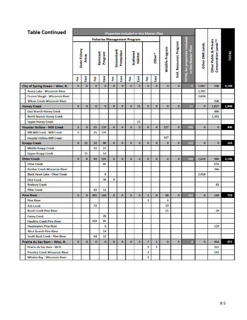
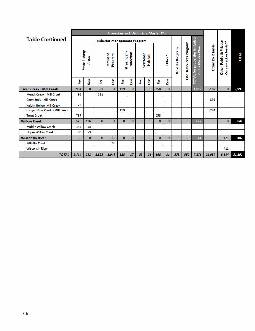
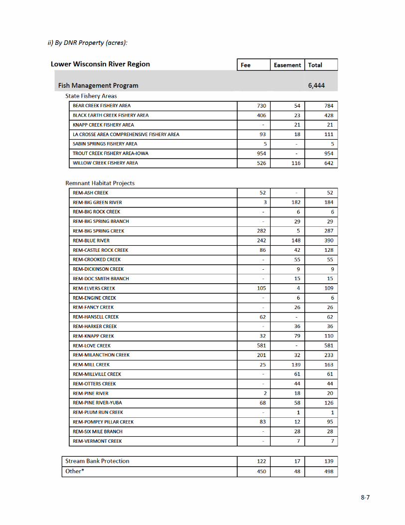
8‐2
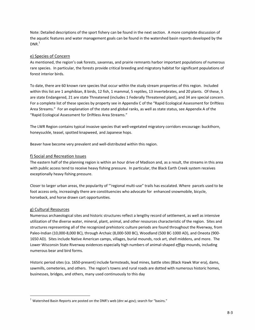
Figure 8.3: Pie chart of land cover in the Lower Wisconsin River Region.
1. OVERVIEW
a) Physical Environment
The Lower Wisconsin River Region (LWR) is characterized by unglaciated topography with steep sided valleys and
ridges, high gradient headwaters streams, and large rivers with extensive, complex floodplains and terraces.
Ancient sand dunes occur on some of the broader terraces along the Wisconsin River. Soils are windblown loess of
varying thickness with alluvium found in the floodplains. Precambrian quartzite occurs in the Baraboo Hills.
b) Land Cover and Use
This region is predominantly a mosaic of active
farmlands and forest lands (Figure 8.3). Dairy farms,
typically a mix of row crops, pasture, and woods,
continue to be prevalent in the Lower Wisconsin
River Region. Although many farms still graze their
cows in pastures, an increasing number are
converting to confined feeding operations.
Wetlands are mostly restricted to the river bottoms.
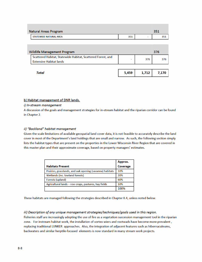
c) Terrestrial Habitats
Oak forests are very abundant here with mesic
maple‐basswood forests also widespread,
particularly in Richland County. Conifer relicts
(pseudo) occur in many places in the region as do
fire‐dependent oak ecosystems including Oak
Openings, Oak Barrens, and Oak Woodland forests.
Some of the Upper Midwest's most extensive
stands of floodplain forest occur here along the
Wisconsin River. Although a minor component, bluff prairies and sand prairies are well represented here. Bedrock
features are important throughout the region and include cliffs, caves, and talus slopes.
Common natural community types found in this region include southern dry, dry‐mesic, and mesic forests,
floodplain forest, emergent marsh, and dry cliff. Less common to rare natural communities include moist cliff,
algific talus slope, shrub‐car, southern sedge meadow, dry prairie, oak opening, and oak barrens. High quality
natural communities of Driftless Area study stream properties can be found in Appendix C of the “Rapid Ecological
Assessment for Driftless Area Streams.”
d) Aquatic habitats
Many of these streams connect directly to the LWR. Migration and movement of fish under high spring flows allow
colonization of habitats to occur and for temporal guilds to develop . Examples would be the presence of burbot ,
northern pike and grass pickerel in Ryan, Dunlop, Halfway Prairie and Wendt creeks. Additionally, several mussel
species have their upstream ranges seasonally increased as fish‐hosting glochidia frequent these habitats.
Another distinguishing feature in the LWR is the presence of some very large groundwater recharge areas that
manifest themselves as significant spring areas.
8‐3
Note: Detailed descriptions of the sport fishery can be found in the next section. A more complete discussion of
the aquatic features and water management goals can be found in the watershed basin reports developed by the
DNR.1
e) Species of Concern
As mentioned, the region’s oak forests, savannas, and prairie remnants harbor important populations of numerous
rare species. In particular, the forests provide critical breeding and migratory habitat for significant populations of
forest interior birds.
To date, there are 60 known rare species that occur within the study stream properties of this region. Included
within this list are 1 amphibian, 8 birds, 12 fish, 1 mammal, 5 reptiles, 13 invertebrates, and 20 plants. Of these, 5
are state Endangered, 21 are state Threatened (includes 1 Federally Threatened plant), and 34 are special concern.
For a complete list of these species by property see in Appendix C of the “Rapid Ecological Assessment for Driftless
Area Streams.” For an explanation of the state and global ranks, as well as state status, see Appendix A of the
“Rapid Ecological Assessment for Driftless Area Streams.”
The LWR Region contains typical invasive species that well‐vegetated migratory corridors encourage: buckthorn,
honeysuckle, teasel, spotted knapweed, and Japanese hops.
Beaver have become very prevalent and well‐distributed within this region.
f) Social and Recreation Issues
The eastern half of the planning region is within an hour drive of Madison and, as a result, the streams in this area
with public access tend to receive heavy fishing pressure. In particular, the Black Earth Creek system receives
exceptionally heavy fishing pressure.
Closer to larger urban areas, the popularity of “‘regional multi‐use” trails has escalated. Where parcels used to be
foot access only, increasingly there are constituencies who advocate for enhanced snowmobile, bicycle,
horseback, and horse drawn cart opportunities.
g) Cultural Resources
Numerous archaeological sites and historic structures reflect a lengthy record of settlement, as well as intensive
utilization of the diverse water, mineral, plant, animal, and other resources characteristic of the region. Sites and
structures representing all of the recognized prehistoric culture periods are found throughout the Riverway, from
Paleo‐Indian (10,000‐8,000 BC), through Archaic (8,000‐500 BC), Woodland (500 BC‐1000 AD), and Oneota (900‐
1650 AD). Sites include Native American camps, villages, burial mounds, rock art, shell middens, and more. The
Lower Wisconsin State Riverway evidences especially high numbers of animal‐shaped effigy mounds, including
numerous bear and bird forms.
Historic period sites (ca. 1650‐present) include farmsteads, lead mines, battle sites (Black Hawk War era), dams,
sawmills, cemeteries, and others. The region’s towns and rural roads are dotted with numerous historic homes,
businesses, bridges, and others, many used continuously to this day
1 Watershed Basin Reports are posted on the DNR’s web (dnr.wi.gov); search for “basins.”
8‐9
iv) Description of areas of special management interest in this region.
Primary Sites – identified in the Rapid Ecological Assessment (see Appendix 3)
Bear Creek Wetlands (Bear Creek Sedge Meadows SNA within Bear Creek Fishery Area)
Bear Creek Wetlands contains two disjunct units of good‐quality Southern Sedge Meadow that are recovering well
from past grazing; Bear Creek flows through the center of both. Emergent Marsh is also present along the creek.
Sedges are dominant and forbs are present in higher than normal densities. Broad‐leaved cat‐tail and bulrushes
(Scirpus spp.) are found in the wettest areas, while the highest ground supports Wet Prairie vegetation such as
blue‐joint grass (Calamagrostis canadensis), sweet Indian‐plantain (Hasteola suaveolens), boneset, and bottle
gentian (Gentiana andrewsii). Clean water flows through the meadows suggesting the possibility of groundwater
seepage. Bear Creek Sedge Meadow was designated a State Natural Area in 2002.
Snow Bottom State Natural Area
This primary site includes all of the State Natural Area (SNA) except for 80 acres on private lands. Snow Bottom
SNA protects a diverse landscape encompassing some of the most significant remaining Pine Relicts in Wisconsin,
as well as many other important and uncommon features including springs, Southern Dry‐mesic Forest, Oak
Woodland, riparian areas, and geological features. Located on scattered sandstone cliffs (up to 300 feet high) are
numerous Pine Relict stands ranging in size from two to 15 acres in size. They are dominated by red and white
pine (18‐24” in diameter breast high), with white and black oak co‐dominant in places. Regeneration varies from
site to site: Some have abundant white pine in the sapling layer, while others, usually the smaller isolated relicts,
are succeeding to oak. Southern Dry Forest dominated by white oak occurs on thin‐soiled flat 'benches' adjacent
to the Pine Relicts and cliffs. This eventually transitions to Southern Dry‐mesic Forest, where 20‐ to 24‐inch dbh
red and white oak are dominant, along with sugar maple, basswood, shagbark hickory, American elm, and red
maple as associates. Springs, seeps, and a feeder stream occur within the primary site and feed into the Blue
River.
The Blue River flows through the middle of the eastern unit, along with a narrow corridor of wetlands. These
riparian wetlands are dominated by reed canary grass, with small pockets of lake sedge and tussock sedge. Large
cottonwoods are scattered along the stream, along with brushy incursions (mostly willows and dogwoods). Snow
Bottom was designated a State Natural Area in 1992.
Other State Natural Areas – Although there are several other State Natural Areas in the Lower Wisconsin River
Region, the only ones included in this Master Plan are listed above.
Trout Creek Uplands (Trout Creek Fishery Area)
This primary site is divided into two disjunct units which occur on rocky, steep‐sided bluffs that rise above Trout
Creek. The south unit harbors a diverse habitat matrix of cliffs, Pine Relicts, Oak Barrens, Oak Woodland, and
Southern Dry and Dry‐mesic Forest. The Pine Relicts here are characterized by red pine and red maple growing
from dolomitic sandstone outcrops and very thin soils on the adjoining bluff top. The Pine Relicts transition to Oak
Barrens as one moves away from the cliff edges. Canopy cover in the Oak Barrens is 50% from white and black
oak, while subcanopy cover is 6‐25% from white and black oak, and shrub cover is 6‐25%. The oaks here have
stunted and twisted growth forms. The flat ridgetop of this site harbors Southern Dry Forest/Oak Woodland, and
is dominated by white and black oak that create 76‐95% cover. As one moves into the west‐facing slopes and
draws, one encounters a more closed canopy forest of Southern Dry‐mesic Forest; similar forest occurs on the
steep east‐facing slopes below the cliffs. The north unit harbors 38 acres of Southern Dry and Dry‐mesic Forest on
a shallow‐soiled, rocky, north‐facing slope with a shallow draw; its structure and composition is comparable to the
same cover types described for the south unit.
8‐10
Milancthon Creek (Remnant‐Milancthon Creek)
This site harbors a good‐quality, uneven‐aged stand of Southern Dry‐mesic to Mesic Forest on steep north‐ and
west‐facing slopes with high canopy cover from timber‐sized red oak and lesser amounts of sugar maple and big‐
toothed aspen. Significant downed woody debris is present. The ground layer is typified by wood anemone,
American cancer root, bloodroot, blue cohosh, wild geranium, and maidenhair fern.
Big Spring Creek (Big Spring Fishery Area)
A small but good‐quality Oak Woodland on south‐ and southwest‐facing slopes is dominated by 24‐28‐inch dbh red
oak, bur oak, white oak, and black oak, often with savanna limb architecture. The subcanopy is composed of red
maple, shagbark hickory, yellowbud hickory, American elm, hop‐hornbeam, and bigtooth aspen. Common ground
layer species include arrow‐leaved aster, wild geranium, eastern star sedge, white avens, and Virginia creeper. A
unique geological feature of the site is Big Spring, aptly named with a flow of hundreds of gallons per minute. The
spring is located mid‐slope on a south‐facing, forested hillside, and feeds the cool‐water Big Spring Branch below.
c) Recreation facilities in this region.
See Appendix 3.
d) Other issues and challenges in this region.
One challenge to providing angling opportunities and protecting critical habitat has been the price of real estate in
the region. Due to the proximity to Madison, real estate values are very high in much of the eastern portion of the
region. This can limit acquisition and easement efforts.
Impoundments and spring ponds (in particular ponds dug on top of spring heads) are a problem on many streams.
They warm water as it is slowed, and prevent aquatic organism passage. Several structures built to provide flood
control were constructed by NRCS including, White Mound Lake on Shanahan Valley Creek, Shanahan Pond on
Honey Creek, and Birch Lake in Trout Creek ‐ Mill Creek. Many other dams exist in this region and impact trout
stream quality. These impoundments may or may not offer recreational fishing in the created lake.
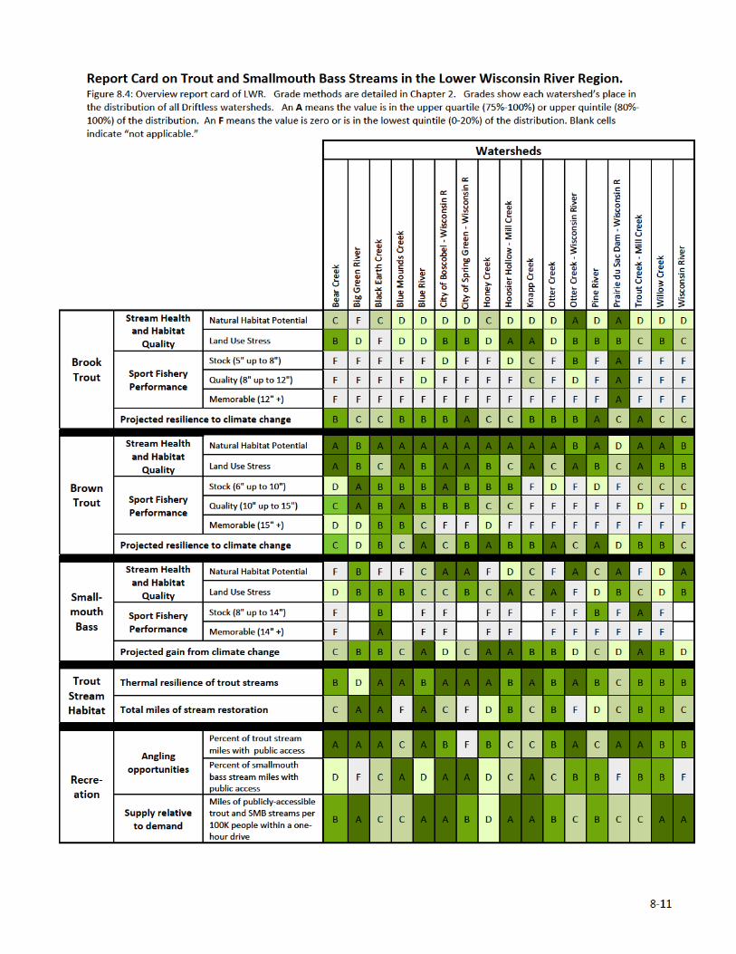
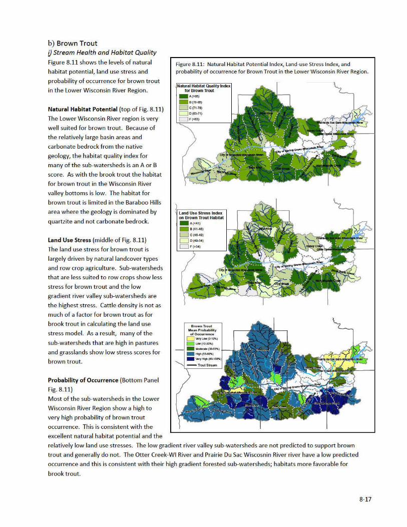
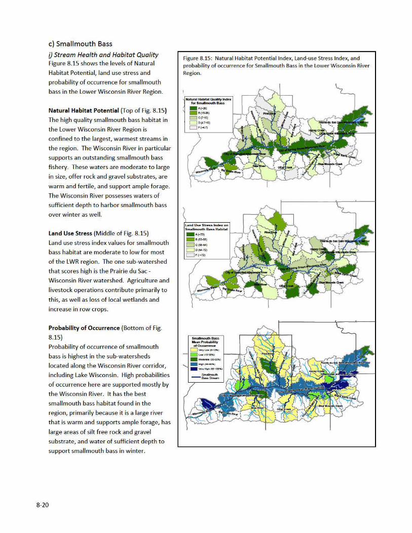
3. Report Card on Trout and Smallmouth Bass Streams in the Lower Wisconsin River Region Report Card Summary (See Figure 8.4)
The Lower Wisconsin River Region has seventeen watersheds represented on the report card in Figure 8.4. The
grades shown in Figure 8.4 are summaries for the entire watershed and may mask some features of their individual
sub‐watersheds The sub‐watersheds are individually shown in the maps contained in the following sections. On
the whole, the Lower Wisconsin Region is poor to fair for brook trout fisheries, and has good to excellent brown
trout fisheries. The small mouth bass performance is misleading because of a lack of data from the Wisconsin
River. The smaller, high gradient watersheds with less development show good brook trout habitat and
performance, specifically the two watersheds that drain the Baraboo Hills: Prairie du Sac Dam Wisconsin‐River and
Otter Creek‐Wisconsin River. The remainder of the watersheds which are larger, have less forest cover, more
pasture and carbonate limestone, which is characteristic of the Driftless Area. All have excellent habitat and good
abundance of brown trout. The region is relatively resilient to climate change. Public access is quite good in this
region. However because of the proximity to large population centers watersheds on the eastern end of the
region score low to moderate relative to demand.
8‐13
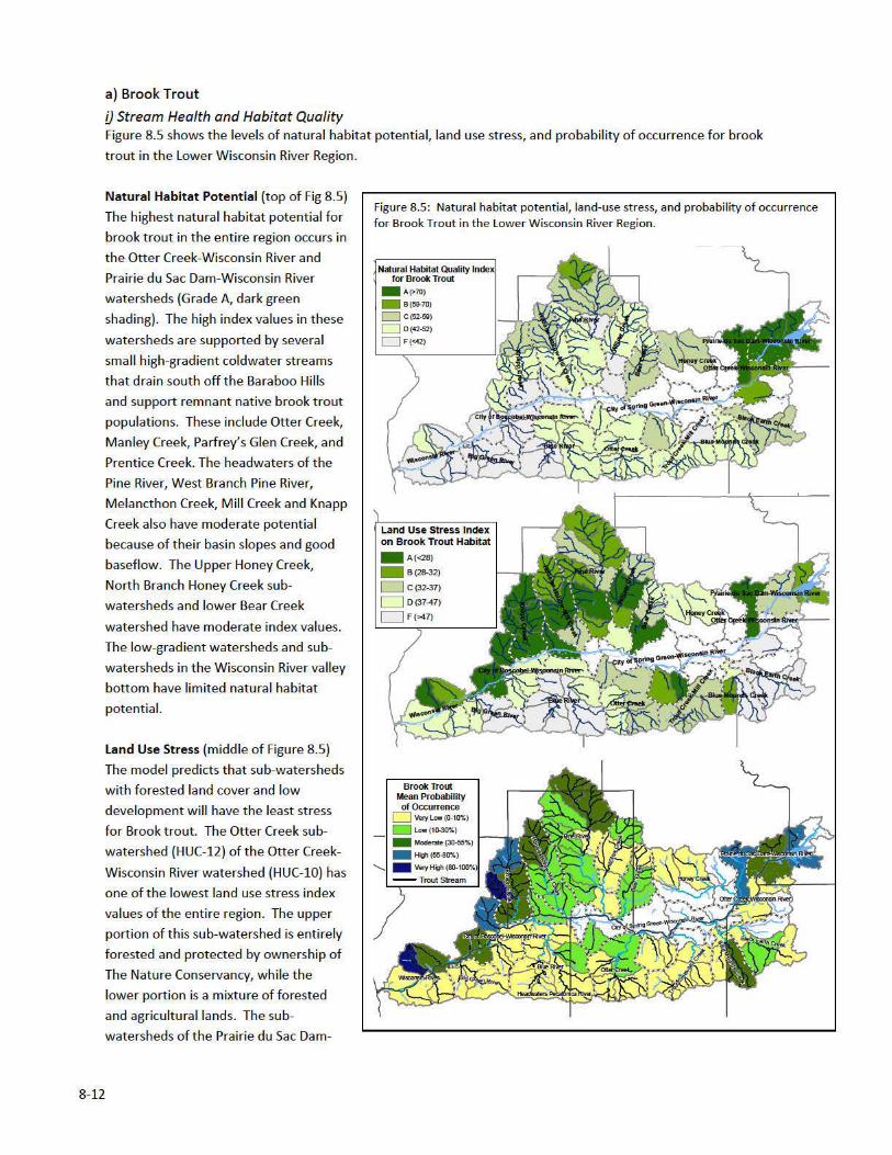
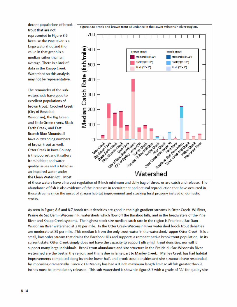
Wisconsin River watershed have good to fair index values (Grade B or C), and the upper portions of these
watersheds are still heavily forested. These also have large areas of protected land either in Devil’s Lake State Park
or owned by Riverland Conservancy. In Richland County the Willow Creek, Pine River, Mill Creek and Knapp Creek
watersheds also have low stress values because of low development and more forested landcover.
The poor stress scores among the sub‐watersheds adjacent to the Wisconsin River are attributable to greater
development and high proportion of row crop agriculture. The valley bottom is rich soil with low slopes making it
well suited to row crop agriculture unlike higher watersheds in the region where forest landcover is more
prevalent. Land use stress index values for the Honey Creek watershed range from poor to very poor (Grade D or
F), and this makes sense, as this watershed is heavily impacted by agriculture and livestock operations. The sub‐
watersheds of the Bear Creek watershed ironically have better index values the lower in the watershed they are
located. Upper Bear Creek has the colder water, but is also the most heavily farmed and one tributary to Bear
Creek has a small impoundment in its upper reaches. Middle Bear Creek has more forested upland and more
protected lowland (wetlands contained in Bear Creek Fishery Area). Lower Bear Creek, while impacted somewhat
by agriculture, retains many wetland areas along the stream corridor. Black Earth Creek being the closest to urban
Madison scores high on stresses because of development associated factors such as runoff from impervious
surfaces as well as livestock.
Probability of Occurrence (lower panel Figure 8.5)
The probability of occurrence model does accurately predict the occurrence of brook trout in the Lower Wisconsin
River Region. The absence of brook trout in some systems where predicted can likely also be explained by
competition with Brown trout. However the sub‐watersheds that have moderate to very high probability do have
brook trout: Otter Creek‐ WI River, Prairie du Sac Dam ‐ Wisconsin R., and the headwaters of Pine River, Mill
Creek, Knapp Creek. These values match up well with the natural habitat quality index values for these
watersheds. They have some of the best habitat, relatively speaking, and as a result some of the highest
probabilities of occurrence of brook trout in the region. This is borne out by the trout streams in these watersheds
which continue to support remnant native brook trout populations. Blue Mounds and Otter Creek (Iowa County)
have low to moderate probabilities of occurrence and, in fact, have few brook trout due to degraded habitat.
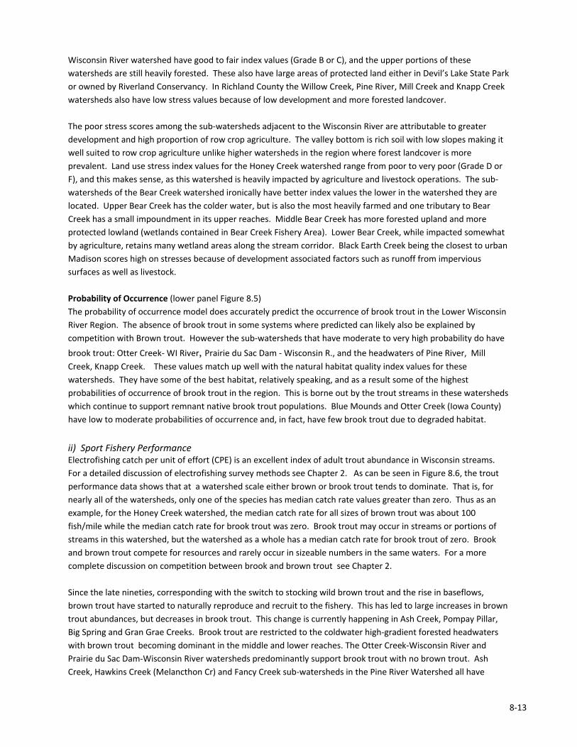
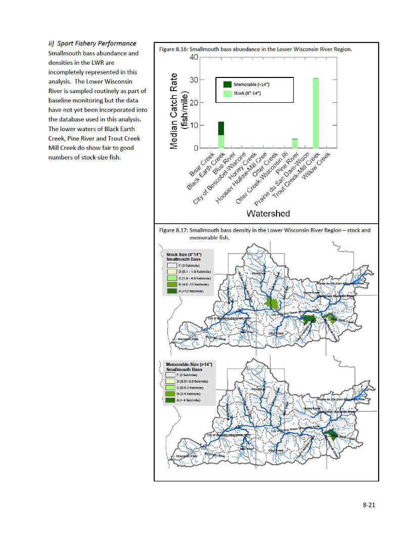
ii) Sport Fishery Performance Electrofishing catch per unit of effort (CPE) is an excellent index of adult trout abundance in Wisconsin streams.
For a detailed discussion of electrofishing survey methods see Chapter 2. As can be seen in Figure 8.6, the trout
performance data shows that at a watershed scale either brown or brook trout tends to dominate. That is, for
nearly all of the watersheds, only one of the species has median catch rate values greater than zero. Thus as an
example, for the Honey Creek watershed, the median catch rate for all sizes of brown trout was about 100
fish/mile while the median catch rate for brook trout was zero. Brook trout may occur in streams or portions of
streams in this watershed, but the watershed as a whole has a median catch rate for brook trout of zero. Brook
and brown trout compete for resources and rarely occur in sizeable numbers in the same waters. For a more
complete discussion on competition between brook and brown trout see Chapter 2.
Since the late nineties, corresponding with the switch to stocking wild brown trout and the rise in baseflows,
brown trout have started to naturally reproduce and recruit to the fishery. This has led to large increases in brown
trout abundances, but decreases in brook trout. This change is currently happening in Ash Creek, Pompay Pillar,
Big Spring and Gran Grae Creeks. Brook trout are restricted to the coldwater high‐gradient forested headwaters
with brown trout becoming dominant in the middle and lower reaches. The Otter Creek‐Wisconsin River and
Prairie du Sac Dam‐Wisconsin River watersheds predominantly support brook trout with no brown trout. Ash
Creek, Hawkins Creek (Melancthon Cr) and Fancy Creek sub‐watersheds in the Pine River Watershed all have


8‐29
4. The Watersheds
a) Bear Creek
The Bear Creek watershed consists of Bear Creek and seven main named tributaries including Croal Creek,
McCarville Creek, Biser Creek, Marble Creek, Pumpkin Hollow Creek, Four Springs Hollow Creek, and Little Bear
Creek. Numerous unnamed perennial and intermittent streams drain the surrounding ridges and feed Bear Creek
as well. Bear Creek Fishery Area (BCFA) provides public access to these streams and includes 730 acres of fee title
property located along middle and lower Bear Creek, as well as 54 acres of easements located along upper and
middle Bear Creek.
Upper Bear Creek is Class II trout water upstream of Croal Creek, supporting a mixed trout fishery composed
mostly of brook trout with few brown trout. Croal Creek is Class II trout water and supports a low density brown
trout population, but is impounded near its origin. This impoundment causes the creek to run several degrees
warmer than Bear Creek. The warming influence it has on Bear Creek contributes to the shift to a brown trout
dominated fishery below the Croal Creek confluence. There is no public fishing access to Croal Creek. Future
acquisition efforts on Croal Creek could focus on the upper end of the watershed with the goal of acquiring and
removing the impoundment.
Public fishing access to Bear Creek begins below its confluence with Croal Creek. Upstream of CTH N, Bear Creek
has over four miles of public fishing access via DNR easements (BCFA). Downstream of CTH N, middle Bear Creek
has approximately 4.3 miles of public fishing access via DNR fee title property (BCFA), and lower Bear Creek has an
additional 0.6 mile of public fishing access, also via fee title land (BCFA). Downstream of where it crosses State
Highway 130 north of CTH B in Richland County, Lower Bear Creek is not classified trout water but does support
low densities of brown trout as far down as CTH JJ, near where Bear Creek enters the Wisconsin River. There is 0.7
mile of DNR fee title property public fishing access via the Lower Wisconsin Riverway near the mouth of Bear
Creek. Lower Bear Creek is classified as coolwater wadeable smallmouth bass habitat; though past surveys
showed a lack of any major fishery on lower Bear Creek. Small populations of smallmouth bass and northern pike
may utilize areas near the mouth of Bear Creek, but the water is still relatively cold and fish habitat is lacking, so
this area is not heavily pressured by anglers.
Starting in 2011, the Aldo Leopold Chapter of Trout Unlimited, in partnership with the WDNR, Sauk County Land
and Water Conservation, and USDA Natural Resources Conservation Service (NRCS) has been implementing trout
habitat improvement measures on over four miles of upper Bear Creek with DNR easement access. These areas
had previously been degraded by farming and livestock grazing practices, but have the potential to produce an
excellent recreational fishery following improvements to habitat. As of late 2012, the first two phases of habitat
improvement have been completed on the upper two miles of stream with the final two phases scheduled to be
completed in 2013 and 2014. Habitat improvement measures being implemented include removal of woody
vegetation from the stream corridor, sloping and armoring the stream banks, and insertion of in‐stream log
structures (cross‐channel logs, half logs, etc.), boulders, rock vortex weirs, and LUNKER structures. The WDNR is
monitoring the fish populations in these areas for positive responses, and expects to see results similar to those on
nearby Honey Creek. In addition to improved habitat, the WDNR continues to work toward providing better
access for anglers by acquiring additional lands for walk‐in easements and parking areas.
McCarville Creek is Class II trout water supporting low density populations of brook and brown trout. There is
approximately 0.2 mile of public fishing access via DNR easement on lower McCarville Creek. Biser Creek is Class I
trout water, supporting a low density trout population dominated by brook trout. There is approximately 0.3 mile
of public fishing access via DNR fee title property on lower Biser Creek. Marble Creek is Class II trout water
8‐30
supporting low density mixed populations of brook and brown trout in its lower stretch, and brook trout in its
upper stretch.
b) Big Green River
Big Green River Sub‐Watershed‐‐‐The Big Green River (BGR) currently is one of the best medium‐sized trout
streams in the State. It is nationally recognized as such and is extremely heavily fished. Up through the 1970’s, the
BGR was a highly productive Class 2 trout Fishery with very little natural reproduction, a tremendous and varied
cool water forage fishery, and outstanding trout growth. There were generally good populations of varied size
trout to start the season including significant numbers of larger trout and pretty good numbers of really large
trout. By the end of the season the population was reduced to low levels. From a thermal standpoint, about ½ of
the stream thread was cold and the other ½ cold to cool. Oddly, the weaker trout water temperatures were the
middle half. Commencing in the early 1980’s, water temperatures throughout the BGR changed to colder water.
Stocking was discontinued and natural reproduction started to dramatically increase. The increase in trout
numbers throughout the stream have continued to the current time. The most recent surveys now indicate trout
populations as high as an estimated 4,000 brown trout (8” and longer) per mile. The average for the entire stream
could well approach 2,000 per mile. The change from domestic fish to wild fish, the significant cooling of the
summer water temperatures, the dramatic change in the number of trout in the stream year round, and the
current limited number of cool water forage fish has resulted in a decrease in the percentage of really large fish in
the stream. While there are a fair number of fish 15” and longer and a few 20” + fish, the vast majority of the
fishery is made up of 8” to 14” fish with a standard bell shaped length frequency for this size range. There are only
2 tributary streams to the BGR that contain trout and for that matter any viable fish population. The Little Green
River which will have its own discussion below and an unnamed tributary which flows along CTH “K” and enters
the BGR just above Werley. This is a very small stream with a permanent flow of less than 1 mile. The lower half
has limited trout potential with the lower most quarter section serving as an natural reproduction area and living
area for young fish.
Little Green River Sub‐watershed‐‐‐From a temperature perspective, the Little Green River (along with Crooked
Creek represents one of the “best” trout water quality in the State for its entire length (i.e. coldest in the summer
and warmest in the winter). This goes back to the 1960’s and possible earlier. On a day in the late 1960’s with the
temperature on the LGR at colder than ‐40F, the LGR was completely ice free from its headwater springs to where
it joined the BGR and its valley was completely fog shrouded. Starting in the 1970’s, the LGR along with Crooked
Creek were the first two trout streams in SW Wisconsin to be considered and managed as Class 1 trout water. It is
currently Class 1 Brown trout water for its entirety and its population densities and size structure mirror the BGR
on a per acre basis. It is not nearly as well know or heavily fished as the BGR as only the very upper end has public
access and the private lands allow basically no public fishing. Trout habitat is somewhat limited as much of this
stream was historically straightened, and has a hard broken limestone bottom with long riffles and shallow runs.
c) Black Earth Creek
Black Earth Creek enjoys a well‐deserved reputation as one of Wisconsin’s classic trout waters. Intensive access
acquisition, in‐stream habitat work, and land use modifications have produced a self‐sustaining fishery known for
producing impressive trout numbers and size structure. The class I and class II stream thread extends
approximately 12 miles between the villages of Cross Plains and Black Earth, connecting nine Department parcels .
Public angling opportunites are also available along two major tributaries, Garfoot Creek and Vermont Creek.
Smallmouth bass angling opportunities exist from the Village of Mazomanie westward, toward the confluence
with the Lower Wisconsin River.
8‐31
d) Blue Mounds Creek
East Branch Blue Mound Creek Sub‐Watershed ‐ Blue Mounds Creek is the cumulative product of Bohn and Moen
creeks which form Elvers Creek. Elvers is joined by Ryan Creek to form the East Branch Blue Mound Creek. The
stream character changes from high gradient and coarse substrate dominated in its upper reaches to a sinuous low
gradient system flowing through wetlands in the lower reaches. It supports low to moderate density brown trout
populations. Fish condition factor is typically high and fish are heavy for their length. Much of the corridor requires
clearing and removal of mature weed tree species and associated bank sloping and instream habitat additions. The
lower end appears habitat limited due to shifting substrates and a lack of forage as the thermal profile appears to
have gotten colder through time.
West Branch Blue Mound Creek Sub‐Watershed‐‐West branch Blue Mound Creek is a fairly long and substantial
stream by water volume. However, it is a fairly low performer for a stream of its size and in this part of the state.
The upper reach of stream is named Walnut Hollow on the USGS maps. The upper reach has significant spring flow
but does not seem to pick up significant volume. There are impoundments on at least the major springhead that
have a deleterious impact on the trout water quality. There are two major tributaries to the upper reach, one
coming from the east and one from the west. The one from the east would appear to have some trout potential at
least for reproduction but would appear to be too small to be a significant fishery. Little is known about the one
from the west is completely beaver impounded and does not appear to have a significant volume of flow. While
water volume and habitat is limited in the upper reaches of the West Branch of Blue Mounds Creek, the bottom
section is good and there are riffles and rock. There are some trout in this upper reach. The lower two‐thirds of
this stream flows through a large, wide valley and does not get near the valley walls. The stream flows through a
large wetland complex and is generally narrow and deep with mud banks and a sand/silt bottom. There is little
instream vegetation. Water temperatures are generally adequate for trout. There are trout throughout this
stretch but the densities are not high.
e) Blue River Watershed
This is one the larger watersheds in the southwestern part of the State and includes some of the most scenic areas
in Wisconsin. The Snow Bottoms Natural Area is included in this watershed. It also includes a number of the larger
stretches of classic Coulee Region trout water. While there are some streams in the watershed that are excellent
Class 1 trout water, a significant amount of the water is high quality Class 2 trout water. The Blue River Watershed
contains the following seven sub‐watersheds: Upper Fennimore Creek, Cass Valley Creek, Middle Fennimore Creek,
Lower Fennimore Creek, Big Rock Branch‐Blue River, Sixmile Branch, and Blue River.
Upper Fennimore Creek Sub‐watershed (Upper Castle Rock Creek)‐‐This is a very large sub‐watershed that is
comprised of two major drainage areas – the upper end of Castle Rock Creek and the Gunderson Valley Creek. The
upper end of Castle Rock is approximately 8 to 9 miles in length. Most of the time this stretch of stream has
limited but permanent flow. Small springs, mostly in the upper end, feed this stream. However, the stream does
not develop any significant base flow. Trout water temperatures tend from cold/cool in the upper end to cool in
the lower end. Habitat for trout is fair. There is a fairly heavy silt load. In periods of drought most of this stretch
of stream goes dry. In very cold winters, it freezes solid. There is a limited trout population at times and no
natural reproduction. There is a varied but limited forage fish population. Gunderson Valley is almost equal in size
to that of upper Castle Rock Valley. The base flow of Gunderson Valley Creek is extremely limited. There are
almost no springs flowing in and it often has an intermittent flow. Most of it has been channelized and has very
little habitat and as a result it has no trout and very few forage fish. It is the major contributor of the excessive silt
being carried into Castle Rock Creek.
8‐32
Cass Valley Creek Sub‐watershed (Doc Smith Branch) ‐ The Cass Valley Creek Sub‐Watershed is similar in size to
the Upper Fennimore Fork Sub‐Watershed. The lower end of this sub‐watershed is the junction of Doc Smith
Branch with Castle Rock Creek. The upper end of this sub‐watershed is 2 to 3 miles upstream of the junction of
Doc Smith Branch with Castle Rock Creek. Doc Smith Branch slowly picks up spring flow but never in any great
quantity. Even though the watersheds of Cass Valley and Upper Fennimore Fork are similar in size, Doc Smith has
only about 1/3 the flow of Castle Rock at the point where the two waters join. The trout water quality of this part
of Doc Smith is only fair, but the trout habitat is generally good. The trout population is fair to good with a good
size structure. There is a very minor amount of natural reproduction. Besides warmer water temperatures being a
problem, the silt load of this stream may be an even bigger problem. There is a moderate forage fish population.
The upper end of Doc Smith Branch is 6 to 7 miles in length and is not trout water.
Middle Fennimore Creek Subwatershed (Middle Castle Rock Creek) ‐‐ The downstream end of the Middle Castle
Rock Creek Sub‐Watershed is its junction with Coon Valley Creek. The upstream end is 50 yards upstream of the
Church Road Bridge. Throughout this stretch Castle Rock is a large stream. The habitat characteristics vary greatly
from the upper end of this stretch of stream to the lower end. The habitat characteristics in the lower half start
with extremely large holes and large rubble riffles. This reach is followed by a large stretch of channelized water
that is wide, moderately deep, and has a rock bottom and a lot of silt. It does have a few riffles and holes but the
habitat is poor compared to its potential. The lower most stretch of this sub‐watershed develops a uniform
shifting sand bottom with little rock. Water quality for trout is good throughout this stretch. This is Class 2 trout
water with no natural reproduction. The trout population is fair with a good size structure tending to the large
size. There is a varied forage fish population with a decent density.
Coon Valley Creek, a small to medium‐sized tributary to Castle Rock, is 2 to 3 miles long. In its upper reaches it is
split into two branches. The north branch has about ½ mile of permanent flow. While very small, it has a gravel
rubble substrate with some small holes. There is decent spring flow into it and it has a limited brook trout
population with natural reproduction. The south branch has limited flow and habitat but it does have brook trout
and natural reproduction. A major spring enters Coon Valley Creek near where the north and south branches
come together creating enough flow to make significant stream. From this point downstream to its junction with
Castle Rock Creek, most of Coon Valley Creek has been historically channelized. While springs aren’t obvious, the
stream continues to gather flow until near its lower end where another major spring enters the stream. For the
most part, the stream has a fairly uniform silt and sand bottom with clay banks. There is very little rock or gravel.
It is deep, narrow and very cold. It has a very heavy growth of instream vegetation. It is class 2 trout water with
some natural reproduction. It has a good trout population with good size distribution tending to the smaller size.
The upper half of Middle Castle Rock is one of the most famous and heavily fished section of trout water in the
State of Wisconsin. As defined above, the upper end of this stretch of stream is a large spring complex just
upstream of the Church Road Bridge. Most of the water from this spring complex enters the stream through its
bed and banks over a wide 15 yard long area. The estimated volume of flow entering the stream in this area is
3,000 gpm. This is the start of permanent trout water of Castle Rock Creek. Approximately ¼ mile downstream,
this flow is joined by the Castle Rock Spring. This spring comes out of the hillside at a defined point with a flow of
4,000 gpm. The stream from this point downstream to the “Castle Rock” is defined by large cobble and gravel
riffles, large deep holes and large long runs. It is by far the largest piece of classic Coulee Region trout water in the
area. Its habitat for trout is outstanding. Its water quality for trout is outstanding from a temperature standpoint
and there is a lot of instream vegetation and a very good benthic community. The forage fish population may be
varied but is limited. However, the stream carries an extremely heavy silt load that limits natural reproduction of
trout. This stretch of stream has an outstanding trout population tending to the large size with a significant
number of large and very large fish.
8‐33
Lower Fennimore Creek Sub‐watershed (Castle Rock Creek) ‐‐ The downstream end of the Lower Castle Rock
Creek Sub‐Watershed is its junction with the Blue River. The upstream end is the junction with Coon Valley Creek.
Throughout this stretch Castle Rock is a large stream. As with the lower end of most of the large trout streams in
the area, this stretch of Castle Rock lacks the classic Coulee Region pool/riffle/run characteristics. However, it joins
the Blue River far enough up in the Blue River Watershed that its stream bed is not a uniform silt bottom. Still, it is
far enough downstream to be narrow and deep with a uniform shifting sand bottom with little to no rock or gravel.
There is little to no in‐stream vegetation. There are a fair number of log jams in this stretch. The trout water
quality is fair being cold in the summer but also quite cold in the winter. This is Class 2 trout water with no natural
reproduction. The area contains a fair population of trout tending to the large size. There is a varied but limited
forage fish population. The benthic population is quite limited. Pleasant Valley Creek is a small stream with a
length of a short two miles. The stream has a couple of good springs that that start its permanent flow. After that,
there is very little spring flow that enters the stream. The upper ¾ mile has decent habitat for a very small stream
with riffles and small pools. It is Class 2 trout water with a limited brook trout population with natural
reproduction. The remainder of the stream has poor trout water quality and is channelized for the most part, and
has a uniform silt/sand bottom with little rock or gravel. There are few trout past the headwater area. The stream
has a somewhat varied forage fish population but this is limited by the generally poor habitat.
Big Rock Branch‐Blue River Sub‐watershed contains Bronson Creek , Mainstem Upper Blue River, Big Rock Branch,
and the Mainstem Middle Blue River. Bronson Creek is the only trout water entering the Upper Blue River Sub‐
Watershed. It is a small stream with only its lower one mile being trout water. It has good water quality and
decent habitat for a small stream. It has a small naturally reproducing brook trout population in its upper end. It
has good natural reproduction of brown trout in the rest of the stream with a decent brown trout population of
smaller size structure. The upper end of the mainstem of the Upper Blue River is a large stream. It is Class 2 trout
water. The water quality ranges from fair to good. For its size and length, there is not adequate spring flow to
have excellent water quality. The lower 1.5 miles of this stretch of stream have only fair water quality somewhat
limiting its trout population. The trout habitat in this stretch is quite good. It has a fair population of trout
including some large trout. It has a fairly decent forage fish population. There is about a 6 miles stretch where
habitat is good and the water quality ranges from fair to good. There is some natural reproduction in the stream
but it appears to be limited by overall water quality and by heavy silt loading. The stretch of stream has a good
trout population with good size structure including large fish and a few very large fish. The upper four miles of this
stretch has very limited flow and poor habitat. In drought periods much of it goes dry and it has frozen solid in the
winter. It has a limited forage fish population and only a few trout. Big Rock Branch is really a weak sister stream
in the area for the size of the watershed. It is a small, medium size stream. While it has a number of springs that
enter it, they never contribute enough water for its length to develop either good trout water quality for any
distance nor any real significant base flow. There are 2 or 3 miles of permanent flow in its upper reaches that is
very limited in volume and cool water at best and no trout. Downstream there are a couple of miles of fair quality
trout water with limited habitat that has a small naturally reproducing population of brook trout. There is then a
mile or so of small to medium size Class 2 brown trout water followed by a couple of miles of small, medium size
water cool to warm water with poor fish habitat. The lowermost mile is small, medium size water with fair trout
water quality but poor habitat as it loses gradient near its junction with the Blue River. The forage fish population
of this stream is limited. The Mainstem Middle Blue River is a large stream for this area. This stretch of stream is
most likely fairly cold in the summer but also quite cold in the winter. It has a uniform shifting sand or silt bottom
with very little rock or gravel. It contains a fair number of trout tending to the larger size. It also contains a varied
but limited density of forage fishes. There are only two trout streams entering this stretch of the Blue River – Six
Mile Branch including Big Spring Creek and the Big Rock Branch.
8‐34
Six Mile Branch Sub‐Watershed contains two trout streams, Six Mile Branch and Big Spring Creek.
Six Mile Branch, from its junction with Big Spring Creek downstream to the Blue River, Six Mile Branch is a medium
size stream about 1.5 miles in length. While the Six Mile Branch drainage area is considerably larger than the Big
Spring Creek drainage area, the base flow of Six Mile Creek at its junction with Big Spring is about ½ of the base
flow of Big Spring. Upstream of its junction with Big Spring Creek, Six Mile Branch is a small medium stream. Its
trout water quality is generally quite good and its habitat is also good. Several significant spring contribute to the
flow throughout the upper 2/3 of the stream. Currently it is most likely Class 1 trout water. The trout population
is moderate in density and the size structure is good but there most likely are not many large fish. There are about
two miles of trout water upstream of the junction with Big Spring Creek. Above that point there is very little flow,
very little fish habitat and the water quality can best be described as cool. The forage fish population of this
stream is very limited. Big Spring Creek is a medium size stream of about 4 miles in length. It has good to excellent
trout water quality and good to excellent trout habitat. The lower 2.5 miles most likely is Class 1 brown trout
water and has an excellent population of trout with good size structure including large fish but most likely few if
any very large fish. The upper 1.5 miles is Class 1 brook trout water and has an excellent population of trout with
good size structure. A number of medium to very large springs contribute to the flow throughout the entire length
of the stream. The trout water starts at the spectacular “Big Spring”. The forage fish population of this stream is
very limited.
Blue River Sub‐watershed‐‐The lower end of this sub‐watershed is the junction with the Lower Wisconsin River.
The upper end is the junction of the Fennimore Fork (Castle Rock Creek) with the Blue River. This is a large stream
for this area. This stretch of stream is most likely fairly cold in the summer but also quite cold in the winter. It has
a uniform shifting sand or silt bottom with very little rock or gravel. It contains some trout tending to the larger
size. It also contains a varied but limited density of forage fishes. There are a few channel catfish and smallmouth
bass in this stretch and possibly a few walleye and northern pike. The only other trout stream entering this stretch
of the Blue River is Sand Branch. This is a fairly long, small medium size stream. It has high trout water quality and
fairly decent trout habitat. It has some natural reproduction of trout and a limited trout population. The trout
population is far below expectations for a stream of this size and quality. The reasons are unclear for the lack of
meeting its trout potential. It is the first tributary upstream of the junction of the Blue River with the Lower
Wisconsin River and it stays open all winter. Staying open all winter and its proximity to the Lower Wisconsin River
may well lead to unmanageable otter and heron predation.
f) City of Boscobel ‐ Wisconsin River Watershed
This large watershed contains the following seven subwatersheds: Byrds Creek; Richland Creek; Indian Creek;
Feather Island, Clear Creek; and Crooked Creek .
Crooked Creek Watershed‐‐As noted above in the description of the Little Green River, from a temperature
perspective, the upper 2/3 of Crooked Creek represents one of the best trout streams in the State (i.e., coldest in
the summer and warmest in the winter). This goes back to the 1960’s and possible earlier. A thermograph
installed in the upper portion of Crooked Creek and recording temperatures every 15 minutes noted the highest
water temperature in 2009 to be 56.5F. Starting in the 1970’s, the Crooked Creek along with the Little Green River were the first two trout streams in SW Wisconsin to be considered and managed as Class 1 trout water.
Crooked Creek has no tributaries with permanent flow. Crooked Creek is a small to medium‐sized stream Class 1
brown trout water. Surveys back into the 1980’s, have noted densities of trout 7” and longer to be estimated in
range of the 2,000 per mile. Recent surveys of the upper ½ have found no fish other than brown trout. The size
structure of the fish in Crooked Creek is somewhat smaller than most other area streams, ranging from 7” to 13”
with a small number of fish over 15” and generally few if any fish 18” and longer. Fishing pressure is moderate and
8‐35
includes locals as well as anglers from around southern Wisconsin. There is access to a fair amount of this stream
but not an adequate amount for the demand.
Sanders Creek Sub‐watershed‐‐Sanders Creek is a medium small stream. It is currently classified as Class 2 but it is
probably currently converting to or already is Class 1 brown trout water. Historically, its water temperature
suitability for trout was somewhat weak but this seems to be improving. Much of this stream was historically
straightened and trout habitat is generally somewhat limited. There is not currently enough survey data on this
stream to change the classification and it continues to be stocked with small fingerling feral brown trout annually.
It receives moderate to light fish pressure basically by locals and there is no public access on the stream except in
the City of Boscobel. There are a couple of small, short tributaries to Sanders Creek that have some natural
reproduction of trout as well as serving as nursery areas.
Richland Creek Subwatershed‐‐ Richland Creek is a medium to medium small stream. It has generally very good
trout water temperatures. It has a very good naturally reproducing population of brown trout. The upper reaches
historically had a good population of brook trout with reproduction as well as stocked fish. In recent years, the
survey indicate that brown trout dominate the entire stream. While currently listed as Class 2, it is most likely now
Class 1 trout water. Richland Creek has a very good density of trout and a pretty good size distribution. There is a
decent amount of public access and fishing pressure is moderate. There is a major unnamed tributary flowing
from the west and entering Richland Creek in its lower middle section. This stream is small but has a very good
population of trout for its size. It should be considered Class 1 trout water.
Byrds Creek Sub‐watershed‐‐Byrds Creek is a small, 2‐mile long stream that historically had a fair population of
stocked brook trout. Byrds Creek’s headwater springs are impounded, which likely limit the natural reproduction
reproductive potential of this stream. Recent surveys indicate that it currently does not have a viable population
of trout.
Indian Creek Sub‐watershed‐‐Indian Creek is a small, 1.5‐mile stream. It has small spring entering its upper ½
mile. It has never been managed for trout because of its small size. It probably could have a limited natural
reproduction reproducing brook trout fishery except that its habitat, and particularily its winter trout habitat, is
quite limited. It does not flow into a trout system so it is unclear at this time as to whether or not it could actually
support a trout fishery.
Clear Creek Sub‐watershed‐‐Boydtown and Clear Creek are both very short streams that start with significant
springheads. However, neither picks up any additional flow on their short trip to the Wisconsin River. If they were
part of a trout system they would contribute natural reproduction to the system but as standalone streams neither
has the volume, length or habitat to develop much if any trout resource.
g) City of Spring Green – Wisconsin River Watershed
City of Spring Green Watershed contains the following seven subwatersheds: Cruson Slough, Wilson Creek, Marsh
Creek, Avoca Lake, Morrey Creek, Rush Creek, and Lowery Creek. Streams with trout potential in this watershed
are limited to Morrey Creek, Rush/Sneed Creek, Wilson Creek, and Lowery Creek Subwatersheds.
Morrey Creek Sub‐watershed‐‐Morrey Creek is fairly long but fairly limited in water volume. It has several pretty
decent springs in its headwaters and scattered along its length but it never really picks up any significant volume
and given its length there is not enough spring inflow to really give it good trout water quality. Habitat is generally
fair at best as most of this stream has been historically channelized. The bed in its upper 2/3 has some rock and
riffles but holes are quite limited. The lower 1/3 has little gradient and basically a shifting sand bottom. The trout
8‐36
population is limited but the size structure is moderate. There is probably some natural reproduction of brown
trout but at this time it should be considered Class 2 trout water.
Rush Creek Sub‐watershed‐‐Rush Creek is quite long but has very limited volume until its lower end. There are a
number of small springs in its upper reaches including its main tributary at its upper end. However, there are
spring ponds on it and its tributary that damage water quality and interrupt trout migration. Historically this
stream had a stocked population of brook trout with good growth and perhaps some natural reproduction.
Howerver, this population no longer exists and the stream currently has a limited brown trout population. Much
of the stream has been channelized and the habitat is limited. The lower 1/3 of this stream has some brown trout
but habitat is generally deep, with vertical mud banks and silt bottom with little rock or riffles and low gradient.
Sneed Creek is a tributary entering the lower end of Rush Creek. This stream has very limited flow and spring
inflow basically only in its upper end. The springs are impounded and the entire stream has been channelized.
There is very little trout habitat and water quality is poor to fair. There are few trout in this stream at this time.
Lowery Creek Sub‐watershed‐‐Lowery is a 3‐mile long, small stream. It has good spring flow and pretty good
habitat. The upper two miles have a good bottom and riffles while the lower 1 mile flattens out but has decent
water quality and a lot of downed timber. The stream has a decent trout population for its size and has natural
reproduction. It is currently unknown if it is Class 1 or Class 2 trout water. There are two impoundments on
important springs to this stream that have a negative impact on its trout potential. One impoundment is on the
headwater springhead of Lowery Creek itself and the other is on a major tributary to Lowery Creek.
Wilson Creek Sub‐watershed ‐ Wilson Creek is a fairly short, small to medium size stream. It has been noted to
have a good trout population with large fish in its lower half. Its reproductive status and potential are unknown at
this time.
Miscellaneous Sub‐watersheds: Avoca Lake, Cruson Slough, and Marsh Creek ‐ There are some other small short
streams flowing into the Wisconsin River in this watershed. These are cold water resources that are completely
spring fed but they have a very limited volume of flow and which, except for their very upper ends, have poor
habitat for trout or other fishes. Because of their small size, limited habitat, and isolation from any other trout
water, no attempt has been made to manage these streams.
h) Honey Creek Watershed
The Honey Creek Watershed includes Honey Creek (upper Honey Creek, also called the main branch of Honey
Creek), Shanahan Valley Creek, Sugar Grove Valley Creek, North Branch Honey Creek, East Branch Honey Creek,
and numerous unnamed intermittent and perennial streams.
Upper Honey Creek flows through Shanahan’s Pond, a small impoundment that is an impediment to fish passage
and has negatively impacted the stream in the past by warming the water. Above Shanahan’s Pond, Honey Creek
is cold, and though not classified trout water, a single brown trout was found on one occasion above Shanahan’s
Pond (2012). The potential also exists to support brook trout (cold water, ample gravel substrate). Shanahan’s
Pond historically functioned as a flood control impoundment, and many similar structures can be found in the
Honey Creek watershed. Shanahan’s Pond held water year round and supported a fishery utilized by local citizens,
but the pond experienced frequent fish kills over the years as the pond filled with sediment and became
increasingly shallow. A valve in the water control structure broke during the annual inspection in September 2009,
though the outlet remained buried in over 4 feet of loose saturated sediment, causing the pond to drain very
slowly and hampering efforts of staff to find the outlet. When the pond would drain completely, the black
sediment would super heat in the sun, causing the water that accumulated in the next rain event to super heat as

8‐37
well, with the resultant discharge threatening the cold water trout fishery downstream. Finally, the outlet was
cleared in late 2011 and the sediments finally began to dewater. The drought of 2012 allowed this process to
continue and the pond bed vegetated naturally while the stream re‐cut a natural channel and scoured down to
gravel in many places.
This presented the opportunity to redesign the water control structure to function permanently as a dry dam,
using a larger discharge pipe to continuously pass base stream flow up to a 2‐5 year rain event. This project began
in late 2012, with completion scheduled for mid‐2013. In the future, water will be impounded only infrequently
and for short durations following major rain events as opposed to the periods of continuous impoundment seen in
the past. Reduced thermal pollution from the impoundment should positively impact the Honey Creek system
below Shanahan’s Pond. The dam is also a barrier to fish passage, which will prevent brown trout from moving
upstream to colonize the area. This will make it possible to attempt to establish a brook trout population above
the dam.
Shanahan Valley Creek is impounded to form White Mound Lake, and joins Honey Creek approximately 1.3 miles
below the lake outlet. White Mound Lake is surrounded by White Mound Park, Sauk County’s largest park and one
of its most utilized public attractions. White Mound Lake offers quality angling opportunities for bass, panfish,
walleye, and northern pike. The water control structure on White Mound Lake is bottom draw, discharging cool
water in the summer and allowing brown trout to live in Shanahan Valley Creek up to the White Mound Dam,
though this stretch is not classified trout water. After joining with Shanahan Valley Creek, Honey Creek is Class II
trout water, and has 1.3 miles of public fishing access through DNR easements before the classified trout water
ends just north of the Village of Plain. Trout habitat improvement projects have been completed on these
easements, greatly increasing brown trout numbers and size structure. Because of these improvements, an
excellent recreational brown trout fishery now exists on upper Honey Creek, and evidence suggests that significant
natural reproduction of brown trout is occurring. Also, there has been a ripple effect; trout populations in areas of
Honey Creek adjacent to areas of habitat improvement have also seen remarkable increases in numbers and size
of brown trout. Additional land acquisition on upper Honey Creek would make it possible to complete more trout
habitat improvement projects, expanding and enhancing the good to excellent fishery that already exists there.
Moving downstream from the habitat projects, brown trout are present in reduced numbers all the way to the
confluence with North Branch Honey Creek. From that point until it enters the Wisconsin River, Honey Creek is not
sufficiently cold to support trout, but portions of the stream are listed as suitable smallmouth bass habitat.
Angling opportunities for smallmouth bass, catfish, walleye, and northern pike exist on lower Honey Creek as these
fish leave the Wisconsin River to utilize the creek. Public access via DNR lands on lower Honey Creek is limited to a
Statewide Natural Area located at the mouth of the creek.
North Branch Honey Creek is Class II trout water from its headwaters downstream to Leland Millpond, and it
supports a low density brown trout population. Below Leland Millpond, North Branch Honey Creek is not
sufficiently cold to support trout, but angling opportunities for northern pike exist in the Leland Millpond tail
water. Smallmouth bass and catfish may also utilize this stream during different times of the year. There is no
public fishing access via DNR fee title or easement lands on North Branch Honey Creek.
East Branch Honey Creek and Sugar Grove Valley Creek are not classified trout water, do not support significant
fisheries for any species, and have no public fishing access via DNR fee title or easement lands.
8‐38
i) Hoosier Hollow ‐ Mill Creek Watershed
The Hoosier Hollow‐Mill Creek watershed contains the following three sub‐watersheds: West Branch Mill Creek,
East Branch Mill Creek, and Hoosier Hollow.
West Branch of Mill Creek Sub‐Watershed‐‐Upper Mainstem Mill Creek itself is a larger stream both by volume
and length. It has a good population of brown trout with a good size distribution including larger trout and a few
very large trout. The lower couple of miles of this stream has been channelized and contains grade stabilization
structures. While this area contains fair numbers of trout, the overall lack of habitat limits the population. Habitat
in the remainder of the stream is generally good. Water quality for trout is good but not excellent. Similar to the
Big Green River up into the 1980s, this stream was Class 2 trout water with very good trout growth, a fair number
of large and very large fish and a dense and varied forage fish population. There was very little if any natural
reproduction, and by the end of the fishing season the number of trout was quite limited. As with most streams in
the area, it appears that the water volume and quantity of spring water has increased in recent years and the
trout numbers have dramatically improved. Natural reproduction appears to have increased significantly and the
stream may now be Class 1, although this is not yet confirmed. A flood control structure on the upper end of Mill
Creek cuts off trout from the stream’s headwater spring and is having a detrimental impact on the habitat of Mill
Creek.
West Branch of Mill Creek is a medium size stream for the area. It has excellent spring flow and decent volume.
The lower ¾ miles has been channelized and has flood stabilization structures severely limiting the trout habitat.
Portions of the middle stretch were historically straightened but trout habitat is decent. Generally the trout
habitat of the upper 1/3 is very good. The stream is Class 1 trout water with good natural reproduction. The
upper 1/3 of this stream was historically one of the best natural reproduction brook trout streams in this part of
the state. In recent years, naturally reproducing brown trout have started to diminish the brook trout population.
the brook trout are currently maintaining a viable population but more than likely, as with other streams, this will
change. There are a number of small tributary trout streams that enter the upper part of Mill Creek. Most of
these tributaries contribute cold water and have some or significant natural reproduction contributing to Mill
Creek’s fishery even though they themselves have only a limited fishery. Tributaries of note are Babb Hollow
Creek, Coulter Hollow Creek, Higgins Creek, Kepler Branch and Pine Valley Creek.
Babb Hollow Creek is only about 1 mile in length but has excellent spring flow. It has moderate natural
reproduction population of smaller brook trout in its upper 2/3 and natural reproduction brown trout in its lower
1/3. Its small size limits its fishery and fishability. Coulter Hollow Creek is only about 1 mile in length but has
excellent spring flow. It has a fairly decent natural reproduction population of smaller Brook trout in its upper 2/3
and natural reproduction brown trout in its lower 1/3. Its small size limits its fishery and fishability. Historically
there were several impoundments on the upper end of this stream. Some of these impoundments are now gone
but there are some that still impound its headwaters and need to be removed. Higgins Creek is approximately 1
mile in length. This stream has a water control structure on its upper end cutting off the rest of the stream from its
headwater springs. The structure is supposed to be a dry dam but has a permanent impoundment that warms the
water and severely damages the trout potential of this stream. It also keeps the stream from contributing good
quality trout water to Mill Creek. Kepler Branch is about 3 miles in length but has excellent spring flow. The upper
1/3 is very small but has a limited brook trout population with natural reproduction. It has a fairly decent naturally
reproducing population of smaller brook trout in its middle 1/3. There may be brown trout natural reproduction
as well. The lower end has a limited brown trout fishery. Its small size limits its fishability. This stream is 1 mile
long and has a large spring at its upper end that should enable natural reproduction of trout. However, habitat of
this stream is very limited because of channelization and intensive agricultural use adjacent to the stream and it’s
unclear if adult trout have enough available habitat to encourage them to reproduce in this stream.
8‐39
East Branch of Mill Creek Sub‐Watershed‐‐ East Branch of Mill Creek is a small, medium size stream. It has good
spring inflow even though its overall volume is somewhat limited. From a habitat standpoint it is probably the
single most degraded potentially good trout stream in all of Richland County. Almost the entire stream has been
channelized. There is a flood control structure on its upper end and the farming practices along its entire length
impact water quality. The stream has some trout and natural reproduction but it is far below its potential given its
spring flow, gradient and stream bed type. Dieter Hollow Creek is 3 miles long or so but only the upper 1 mile is
significant trout water. It has very limited flow and the only decent habitat is located in this upper mile. There is a
limited but stable population of trout in this upper mile. There is some natural reproduction of trout in the upper
reaches. Trout do exist in the lower couple of miles but in very limited numbers. Habitat in the lower couple of
miles is quite limited and water quality for trout is suspect. Core Hollow Creek is about a 3 mile long stream of
small, medium size. It has good trout water quality basically throughout its length. Trout habitat ranges from fair
to good. It has a pretty good population of trout tending to the smaller size range and good natural reproduction.
A flood control structure on the upper end cuts off the headwater springs from the rest of the stream. It silts in
under flood conditions damaging the habitat above the dam and then releases silt laden water under low flow
conditions damaging the area below the dam. It has occasionally plugged up causing an impoundment damaging
the water quality of the entire stream. Fox Hollow Creek is 3 miles or so long and is of small, medium size. Its
upper mile has very good trout water quality, a fair number of trout and pretty good natural reproduction of
brown trout. The size structure of the trout tends to the small size for this part of the state. This is the result of
limited habitat. The trout habitat of the lower 2 miles is poor to fair while the water quality for trout is only fair.
Hoosier Hollow‐Mill Creek Sub‐watershed‐‐Lower Mill Creek is large by water volume. The water is generally
fairly cold in the summer but most likely not very warm in the winter. It is narrow and deep with a monotype
bottom comprised basically of silt and sand and very little if any rock and few if any riffles. There is little to no
aquatic vegetation and benthos is limited. There are numerous log jams in the lower reaches. There is a limited
but notable trout population of low density but good size structure. The area will also have suckers, redhorse, and
common carp. During the warm weather periods of the year, the water is normally turbid. Historically, there was
a mill dam located on the lower portion of this stream. This dam created a 20 acre plus pond filled with mud and
averaging about 1.5 foot depth that warmed the water. The lower couple of miles between the dam and the
Wisconsin River held a variety of cool and warm water fish including some gamefish in particular channel catfish.
This dam was removed a couple of years ago. The stream has pretty well recovered its channel through the old
mill pond. The water through this area is now colder as well as colder on down below the old dam site to the
Wisconsin River. Trout will probably now occupy some of these areas. It may well be that the cool and warm
water fish populations will be decreased. On the other hand, there will be a greater variety of cool water fishes
occupying Mill Creek from the Wisconsin River up to the grade stabilization structures which start in the village of
Boaz and are migration blockages. Hoosier Hollow Creek is quite long but its water volume is quite limited. The
upper 1 mile has decent water quality and has some trout and natural reproduction.
j) Knapp Creek Watershed
Knapp Creek Watershed contains the following four sub‐watersheds: Lower Knapp Creek, Middle Knapp Creek,
West Fork Knapp Creek, and Upper Knapp Creek.
Upper Knapp Creek Sub‐watershed‐‐Upper Knapp Creek is a very high quality stretch of Class 1 trout water. It is
of small to medium size. The habitat ranges from fair to very good. The trout densities range from good to high
and the size structure is good with a number of larger and as well as a few very large trout. In spite of its distance
from population centers, this stretch of stream is well known to angler and fishing pressure is high. There are two
stream systems that enter this stretch of stream. English Run ‐ While made up of 3 streams, English Run and its
8‐40
tributaries Wolf Run and Pigeon Run, the flow of all 3 and the combined flow of all 3 is small. They are Class 1
naturall reproducing trout streams with low to moderate densities of smaller trout. While not major fisheries they
contribute fish to the Mainstem Knapp Creek. Plum Run is a small stream like English Run is Class 1 trout water
with low to moderate densities of smaller trout. While not major fishery, it contributes fish to the Mainstem
Knapp Creek. Jimtown Branch is a small stream with a length of 2.5 miles. It is high quality Class 1 trout water.
The habitat of this stream is somewhat limited and beaver are a problem. There is a fair to moderate density of
trout tending to the small size. This stream contributes fish to the main stem of Knapp Creek.
Middle Knapp Creek Sub‐watershed‐‐The lower end of this sub‐unit is the junction with the West Fork of Knapp
Creek. The upper end is at the junction with English Run. Middle Knapp Creek is a fairly large stream but its trout
water quality and habitat is at best fair. Generally, it has a mono‐type shifting sand bottom with little rock or riffles
or holes. The trout densities are accordingly low. There are only two tributaries of note that enter this stretch of
Knapp Creek. Hall Bottom Creek is a small 2‐mile long stream. Its upper 1 mile is high quality Class 1 with trout
water with natural reproduction brook trout. Because of its small size, the habitat is only fair and the size
structure of the brook trout is small. A significant number of beaver dams are damaging the habitat and fishery.
The lower 1 mile has poor habitat with a monotype shifting sand bottom. This lower reach is almost fishless –
trout or otherwise. This stream contributes fish to the main stem of Knapp Creek. Lower Knapp Creek Sub‐watershed‐‐Lower Knapp Creek is a large cold water stream. It is generally fairly cold in
the summer but most likely not very warm in the winter. It is narrow and deep with a monotype bottom
comprised basically of silt and sand and very little if any rock and few if any riffles. There is little to no aquatic
vegetation and benthos is limited. There are numerous log jams in the lower reaches. There is a limited but
notable trout population of low density but good size structure. The area will also have suckers, redhorse, and
common carp. During the warm weather periods of the year, the water is normally turbid. There are two streams
that feed the very lower end of Knapp Creek just upstream from its junction with the Wisconsin River, Hoover
Hollow and Gobini Hollow. Hoover Hollow Creek is a small spring fed stream with limited volume but adequate
length and water quality to support a small but viable natural reproducing population of trout. The size
distribution of trout is on the small size. The population is pretty well isolated from other trout migrating into this
stream because it is at the far downstream end of Knapp Creek. However most likely trout from this stream drop
down into Knapp Creek and then migrate upstream in upper Knapp Creek. The Gobin Hollow Creek situation is
identical to the above described Hoover Hollow Creek situation. Its tributary Chitwood Hollow Creek is a very
short and small spring fed stream that has natural reproduction of trout and living space for YOY trout but not for
yearling or adult trout. There are several small spring fed tributaries that contribute a limited amount of cold or
cool water to lower Knapp Creek. In their upper reaches, these streams are small spring fed streams. They are
generally too small to support a trout population although it is possible that there could be some natural
reproduction in these streams. Also, small young‐of‐year fish can be planted in these tributaries and then migrate
to Knapp Creek as they get larger. The bottom ends of these small streams flow across a significant part of the
Knapp Creek floodplain and lose their gradient, habitat and cold water quality as they do so.
k) Otter Creek Watershed
The Otter Creek Watershed contains the following five sub‐watersheds: Flint Creek, Black Hawk Lake‐Otter Creek,
Otter Creek, Pillar Creek, and Otter Creek.
Flint Creek Sub‐Watershed‐‐Flint Creek is the only major tributary to Otter Creek. It is a medium size stream. It
has decent trout habitat but probably the poorest water quality of any stream in the area of this size. It really
doesn’t have good spring flow but there are numerous other problems as well. There is a large Dry Dam in the
middle of it with all of its associated problems. There is a large housing development on its actual headwaters
8‐41
including a number of springhead impoundments. There is also a significant amount of beaver activity on its upper
end. There is no natural reproduction and the trout population is poor to fair. There is a fair population of cool
water forage fish in this stream. Harker Creek is a major tributary to the Flint Creek. Harker Creek including its
major tributary Lee Creek constitute a fairly significant basin. This sub‐watershed is different than most of those in
the area. There are good springs entering the upper half of Harker Creek but none in the lower ½. The trout
habitat in the upper half ranges from good in its lower reaches to poor in its upper reaches. It has natural
reproduction of trout but while having a decent population of trout ranging on the small size, the population is
below expected. The lower half of Harker Creek is very poor habitat with a generally shifting sand bottom. Water
quality while not good is suitable for trout. The population of trout in the lower ½ is very limited. Lee Creek is a
significant tributary to Harker Creek. It is a small stream but of adequate size to have a decent trout population. It
contributes about 1/3 of the volume of Harker Creek. It has good spring flow in the upper reaches but only limited
spring flow in the lower reaches. Habitat is limited in the upper reaches by small size and in the lower reaches as it
generally has a uniform, shifting sand bottom. It is Class 1 trout water with a limited fishery of generally small
trout.
Black Hawk Lake‐Otter Creek Sub‐watershed‐‐ An impoundment on the upper part of Otter Creek has buried the
best historic trout water as well as cut off the smaller water above the impoundment from the larger water
downstream of the impoundment. Upstream of the impoundment most of Otter Creek is small. Water quality is
only fair and trout habitat is naturally fair. However, significant beaver activity on most of the upper end has
ruined the habitat. There is most likely no natural reproduction and few trout. After being joined by Cave Hollow
Creek, Otter Creek could be described as a small medium stream for a little more than a mile. At this point, Otter
Creek enters the impoundment. Trout water quality and habitat could best be described as fair. There is no
natural reproduction and the trout population is poor to fair. Of note is that the pool below the Blackhawk Lake
Dam seasonally holds large number of walleye, largemouth bass and panfish as well as some muskies which come
from the lake and provide a heavily used fishery. Downstream of the impoundment, Otter Creek is a medium size
stream. The habitat is fair to good but the water quality if poor to fair. It has a fair trout fishery with decent size
structure. There is no trout natural reproduction. Cave Hollow Creek is a small stream with good spring flow in its
upper third. Its trout habitat is only fair at best as it is high gradient with limited meander. It has a hard bottom
with few holes. There is natural reproduction of trout but the trout population limited. The lower 2/3 of Cave
Hollow is poor trout water. The water quality is only fair and the trout habitat is poor. It does not have springs,
the bottom is generally sand and while there is meander, there are no significant holes.
Otter Creek Sub‐watershed‐‐By the time Otter Creek flows into the lower Wisconsin River, it is a large stream. An
Impoundment on the upper part of Otter Creek has buried the best historic trout water as well as cut off the
smaller water above the impoundment from the larger water downstream of the impoundment. Upstream of the
impoundment most of Otter Creek is small. Water quality is only fair and trout habitat is naturally fair. However,
significant beaver activity on most of the upper end has ruined the habitat. There is most likely no natural
reproduction and few trout. After being joined by Cave Hollow Creek, Otter Creek for a little more than a mile
could be described as a small medium stream. At this point, Otter Creek enters the impoundment. Trout water
quality and habitat could best be described as fair. There is no natural reproduction and the trout population is
poor to fair. Downstream of the impoundment, Otter Creek is a medium size stream. The habitat is fair to good
but the water quality if poor to fair. It has a fair trout fishery with decent size structure. There is no trout natural
reproduction. Otter Creek is joined by Flint Creek a couple miles below the impoundment and from this point,
Otter Creek is a large stream. For a couple of miles, it has decent trout water habitat characteristics of riffles,
pools and runs. The water quality is fair at best. There is a low density of trout with good size structure. Otter
Creek then becomes a stream with a uniform sand and silt bottom and generally lacking in rock and habitat variety.
It does have numerous log jams. Water quality is fair at best for trout. There are some trout including some large
8‐42
trout. The forage fish population is probably varied but not dense. A few channel catfish and smallmouth bass
have been noted in this stretch of Otter Creek. Spring Valley Creek is a small tributary entering the lower end of
Otter. While small, it has good water quality and good habitat for a stream of its small size. It is Class 1 trout
water with a good population of trout for its size. The trout size structure tends to the small size with some
medium fish.
Pompey Pillar Creek Sub‐Watershed‐‐The Pompey Pillar is a long and fairly large stream by the time it joins the
lower reaches of Otter Creek. There is only one significant trout stream that is tributary to it – Smokey Hollow
Creek. Pompey Pillar Creek in its upper reaches has several good size springs and one small spring fed tributary. It
is very high quality trout waters with good natural reproduction. The trout density especially for smaller trout is
good. However, its overall volume puts the upper end in the small to small medium size range and habitat is only
fair especially for larger trout. From its junction with Smokey Hollow Creek, Pompey Pillar Creek becomes a
medium size stream. Water quality for trout is adequate but not good. Habitat is fair to good. In this mid‐stretch,
while there are some holes the stream losses its larger rock as well as riffles becoming limited. It has a fair trout
population with some larger fish. The lower third of this stream is similar to the lower sections of most of the
larger trout streams in the area. It is large with a uniform, shifting silt bottom and mud banks. It has little to no
rock or riffles and a significant number of log jams. The water is cool to cold. It contains some trout tending to the
larger sizes. The forage fish population is probably varied but not dense. A few channel catfish and smallmouth
bass have been noted in this stretch of Otter Creek. Smokey Hollow Creek is large tributary to Pompey Pillar
Creek. In fact, its drainage is probably quite a bit larger than the Pompey Pillar Creek’s. However, unlike Pompey
Pillar it has very few large springs that feed it. Thus by the time it joins Pompey Pillar, it has only about 50% of the
flow that Pompey Pillar has. Because of its long length and infrequent springs, the water quality is generally only
fair. Because of its small size, the trout habitat is generally only fair. As such, its trout population is only fair. It is
Class 2 trout water. There is a very limited amount of natural reproduction in its far upper reaches. While not
abundant, there is a more varied and dense forage fish population than in the better trout waters in the area.
l) Otter Creek ‐ Wisconsin River Watershed
The Otter Creek watershed consists of Otter Creek and several unnamed intermittent and perennial streams that
feed it as it descends from its headwaters high in the Baraboo Hills. Otter Creek is Class I trout water in its upper
reaches supporting low to moderate densities of remnant native brook trout and a modest recreational fishery,
but the trout water ends when the stream leaves the Baraboo Hills. Public access to Otter Creek consists of several
scattered parcels of DNR Statewide Natural Area in its upper reaches, several thousand acres of The Nature
Conservancy land, and the Lower Wisconsin State Riverway near the mouth of Otter Creek.
During 2008, floodwaters moved large amounts of rubble and cobble into a pile on Otter Creek, creating a dam
impassible to fish and fragmenting the native brook trout population. Efforts to remove the dam were initially
hampered by private ownership of the land where the dam existed. The dam is now entirely contained on lands
owned by The Nature Conservancy and a cooperative project to remove the dam and restore connectivity to the
stream should be explored.
Several thousand acres of land that were part of the former Badger Army Ammunition Plant now form the Sauk
Prairie Recreation Area (SPRA). This land drains to Otter Creek and there are opportunities for hydrologic
restoration in the watershed that will be addressed through the SPRA Master Plan.
8‐43
m) Pine River Watershed
The Pine River Watershed contains the following eight sub‐watersheds: Pine River, Brush Creek, Ash Creek,
Headwaters Pine River, Hawkins Creek, West Branch Pine River, Fancy Creek, South Buck Creek.
Headwaters Pine River Sub‐watershed‐‐Champion Valley Creek along with is major tributary Greenwood Valley
Creek are small streams until Greenwood joins Champion Valley at which point, Champion Valley becomes a small,
medium stream for its last ¾ mile before joining the Pine River. Both streams are cool water streams upstream of
their junctions. Downstream of the junction, Champion Valley is a cold/cool water stream. Both streams have
dense and diverse populations of forage fishes. After their junction, Champion Valley also has some trout with
some larger trout as well as having some smallmouth bass. Indian Creek is a small stream with good trout water
quality and fair trout habitat. It is Class 1 trout water with a fair population of trout tending to smaller trout. The
Mainstem Upper Pine River is a medium size stream. Its trout water quality ranges from poor to a little better
than fair. It has generally good habitat throughout for trout and most any other stream fishes. Its far upper end is
basically cool water with few if any trout but a varied and dense forage fish population. There is a short one mile
stretch that is then natural reproduction brown trout water. From there on downstream for quite a distance, it is
basically a cool water stream with a fair number of trout but again a dense and varied population of forage fishes.
The lower reach of this stretch become pretty decent cold water. It’s possible that there is some natural
reproduction of trout in this area but that’s uncertain because of drift of natural reproduction from high quality
tributaries that enter this part of the Pine. Regardless, it has a decent population of trout with a very good size
structure including large and very large fish. Coulee Region smallmouth bass planted into this stretch of the Pine
River in 2000 have developed a small but self‐sustaining population.
West Branch of Pine River Sub‐Watershed ‐‐The West Branch of the Pine is almost big enough to be considered
large but it probably should be considered medium size. The trout water quality is good but not excellent. The
trout habitat is generally good but not excellent. The lower part is cold in the summer but probably not too warm
in the winter. The bottom is generally shifting sand or silt with little rock, gravel or riffles but some pretty good
holes. This stretch of stream has a fair number of trout of good size structure. In its middle reaches, much the
West Branch has been channelized and the habitat is poor. The upper reaches of the stream tend to the classic
pool riffle ratio with good habitat. There is a good population of trout with a good size structure. It is considered
to be Class 2 trout water but it appears that there is natural reproduction, the extent of which is currently
unknown but appears to be tending to Class 1 trout water. The upper end of the West Branch is legally listed as
Basswood Creek. There is a small short tributary, Cherry Valley Creek with joins Basswood Creek to form the
West Branch. Cherry Valley has a limited trout population with natural reproduction. Gault Hollow Creek is a
significant small medium size stream that enters the mid‐section of the West Branch. In its upper reaches Gault
Hollow is joined by Hynek Hollow Creek which contributes about ½ as much flow as Gault Hollow at this point.
Gault Hollow upstream of this point is Class 1 brook trout water. The brook trout population is somewhat limited
but has adequate natural reproduction. Hynek Hollow has some natural reproduction but a very limited trout
population. Downstream of the junction of Hynek Hollow with Gault Hollow, Gault Hollow has an excellent Class 1
brown trout population with decent size structure tending to smaller fish but containing a decent number of nice
fish.
Hawkins Creek Sub‐watershed‐‐ Melancthon Creek is a small medium size stream with very good trout water
quality and habitat. For most of its length it has one of the better naturally reproducing brown trout populations.
While the size structure of the trout is varied, the number of large trout is somewhat limited. However, there is a
significant number of medium size trout along with a few large trout and an occasional very large trout. Towards
its upper end there is a short stretch of stream with poor water quality and few trout. Above this point,
Melanthon Creek is quite small and has a naturally reproducing brook trout population. This brook trout
8‐44
population is considered to be a heritage population and represents the only know population of the historic
Coulee Region brook trout. The brook trout population is of moderate density and of generally smaller size fish.
Grinsell Creek is a very short, small tributary stream to the upper reaches of Melancthon Creek. It is Class 1 brook
trout water and its fish are considered part of the heritage population. It contains a limited number of fish tending
to small fish. Hanzel Creek is a very small tributary stream to the lower reaches of Melancthon Creek. The lower
4/5 has been channelized and is of poor water quality and habitat. There are some trout in this lower stretch. The
very upper part has excellent water quality and decent habitat for such a small stream. It has a Class 1 brook trout
population. The number of fish is low and the fish tend to the small size. It is unknown if these brook trout are
part of the heritage population. Hawkins Creek is a fairly long, small, medium size stream. It has good trout water
quality and fairly good habitat. It is Class 1 trout water with good numbers of trout and decent size structure but
general lacking large fish. There are 3 small tributaries that have a little NR but very little habitat and very limited
trout populations.
Fancy Creek Sub‐Watershed‐‐ Fancy Creek is the only trout stream system that enters into the middle reach of
the Pine River. It currently has two distinctly different sections – lower 2/3 and upper 1/3. The lower 2/3 is a
medium size stream that has been basically channelized. The channelization is so old that trout habitat can be
viewed as at least fair. It is Class 1 brown trout water. It has decent number of trout with a good size structure
including large fish. There are a few very small tributaries to that have very low densities of brook trout with some
natural reproduction. The upper 1/3 is a small stream. The bottom end of this stretch has fair trout water quality
at best. The rest has good to excellent trout water quality. The habitat is generally good for a small stream. It is
Class 1 brook trout water with a good population including some larger brook trout. The Marshall Creek stream
system flows into Fancy Creek at the point where the lower 2/3 starts and the upper 1/3 ends. The three Marshall
streams are small even after the 3 get together just upstream of the junction with Fancy Creek. They are all Class 1
brook trout streams. Marshall and the West Branch of Marshall are large enough and have enough habitat to
have fairly good to excellent Brook trout densities and natural reproduction. The size structure of the population
tends to be on the small size. The South Branch of Marshall Creek is extremely small and serves only as a natural
reproduction and nursery area.
South Buck Creek Sub‐watershed‐‐ Mainstem Middle Pine River is a large stream and is Class 2 trout water. The
water is quite cold in the summer but may not be very warm in the winter. The upper reach generally has a
shifting sand bottom with some gravel riffles and some deep holes. The lower reach generally has a uniform silt
bottom with log jams and some deep holes. While not holding a dense population of trout, it has a fishable
population with a larger size structure and a fair number of very large trout. After the removal of the old mill dam
just upstream of Richland Center as well as the removal of the old mill dam in the south side of Richland Center,
trout now reside in the lower parts of this stretch of the Pine River. Since the removal of the old mill dams, there is
now free movement of fish from the Lower Wisconsin River and the lower stretch of the Pine River up into the
middle and upper stretches of the Pine River and its tributaries. There may well now be a wider variety of cool
water forage fishes in these upstream reaches. However, the water in the middle stretch is generally too cold and
the benthic community too limited to be suitable for any significant population of the forge fish.
Ash Creek Sub‐Watershed‐‐ Ash Creek is a long, small medium size trout stream. The upper mile developed a
Class 1 brook trout fishery starting in the 1970s. By the mid‐1990s, Ash Creek had developed an outstanding
naturally reproducing brook trout population in its upper 1 mile. This upper mile now provides the brood stock
trout for the Coulee Region Feral brook trout program. Starting in the 2000s, wild brown trout started to invade
this upper mile and to reproduce in it. When the brook trout brood fish were collected in the fall each year, brown
trout were removed and transferred from this stretch and kept under control. In the latter 2000s when disease
requirements made transfer of these fish impractical, they were no longer removed. Within a few years, the
8‐45
brown trout outnumbered the brook trout and had a significant negative impact on the number of brook trout in
this stretch of stream. Recently, the removal and transfer of brown trout from this stretch of stream has resumed
in order to return brook trout to their historically dense numbers. Below this headwater 1 mile, Ash Creek has
been historically channelized. Habitat is general poor to fair. There are a few springs that enter the stream and
keep the water quality suitable for trout. There is a decent wild brown trout population with good size structure as
well as some larger brook trout throughout the stream. There are no tributary trout streams to Ash Creek.
Pine River Sub‐watershed‐‐ This lower end of the Lower Pine River is the confluence with the Lower Wisconsin
River. The upper end is the old dam site on the Pine River in the south side of the City of Richland Center. This is
quite a large stream for this part of the State. There are only two trout waters that enter this stretch of the Pine
Rivers. Willow Creek and its watershed are discussed in another section of this document. The Ash Creek
Watershed is discussed below in this section of the document. Up until several years ago there was an old mill
dam and associated pond located in Richland Center. In addition, the large milk processing plant in Richland
Center along with the sewer plant discharged warm to hot water into the mill pond. The Pine River downstream of
the mill pond was cool to warm water with a varied forage fish population along with some walleye, northern pike,
and smallmouth bass and a decent channel catfish population. The current status of the fishery in the Lower Pine
River is unknown. The habitat is generally a shifting sand bottom with very little rock or riffles. There are
numerous log jams and large holes. Most probably, this stretch of stream is now cool water that contains a variety
of cool water fishes along with a limited population of warm water fish and a limited number of trout. Use by
trout is most likely seasonal or limited to areas of spring flow refuges. It is quite possible that this stretch of
stream may contain a fishable population of Smallmouth bass.
n) Prairie du Sac Dam ‐ Wisconsin River
The Prairie du Sac Dam‐Wisconsin River watershed consists of three main streams: Prentice Creek, Parfrey’s Glen
Creek, and Manley Creek. All three streams flow into Lake Wisconsin (Wisconsin River) along its western shore,
and all are classified trout waters providing opportunities for brook trout. Brook trout densities are low on
Parfrey’s Glen Creek, low to moderate on Prentice Creek, and moderate to high on Manley Creek. Lake Wisconsin
offers excellent angling opportunities for walleye, northern pike, musky, black bass, and panfish. Lake Wisconsin
also supports a self‐sustaining population of lake sturgeon.
Manley Creek is Class I trout water for its entire length. The public has fishing access to 2.2 miles of Manley Creek
above Hwy. 113 in Devil’s Lake State Park, and one mile of access below State Hwy. 113 via a large tract of land
owned by the Riverland Conservancy. Trout habitat improvement work was completed on approximately 1.6 miles
of Manley Creek in three phases between 1997 and 2002, stretching from the confluence with Parfrey’s Glen Creek
upstream to 0.6 mile above State Hwy. 113. Habitat improvement measures included removal of woody
vegetation from the stream corridor, sloping and armoring the stream banks, insertion of log structures (cross
revetments, upstream vortex weirs), and LUNKER structures. The habitat measures implemented on Manley Creek
drastically improved remnant native brook trout population numbers and size structure without the aid of
stocking, and Manley Creek now provides an excellent brook trout angling opportunity.
Prentice Creek originates in the Baraboo Hills and is Class I trout water upstream of STH 78, and Class III
downstream. It supports a self‐sustaining brook trout population, but the recreational fishery is possibly under‐
utilized. There is no public fishing access to Prentice Creek so angler access relies largely on getting permission
from private landowners.
Parfrey’s Glen Creek supports a low density native brook trout population in its upper reaches in the Baraboo Hills,
but does not support a recreational fishery. The cold water fishery ceases to exist below County Highway (CTH) DL
8‐46
as the stream flows through a small impoundment and warms significantly before disappearing underground and
then reappearing just upstream of Marsh Rd. From there until it joins with Manley Creek, Parfrey’s Glen Creek
supports a cool‐warm transitional fish assemblage and offers no quality angling opportunities. The public has
access to upper Parfrey’s Glen Creek via the 299 acre Parfrey’s Glen Natural Area (DNR land), and lower Parfrey’s
Glen Creek via 1,122 acres of Riverland Conservancy property, including the confluence with Manley Creek.
o) Trout Creek ‐ Mill Creek
Historically, this watershed contained some of the best trout water in southern Wisconsin. Its main and best
known trout resource is Trout Creek. While land use over the years has improved from an environmentally
friendly perspective, much of the trout water in this system has been degraded or disappeared as the result of a
water control structure.
Canyon Pass Creek Sub‐watershed ‐‐The headwaters of Mill Creek and what would be the classic coulee type trout
water are buried under the two lakes in Governor Dodge State Park. Downstream from the lakes the habitat is
poor to fair at best as the stream can’t cleanse itself and has a generally shifting sand bottom. Further
downstream, it becomes a deep narrow stream with silt bed and banks but does have numerous log jams. The
outflow from the lakes makes the upper reaches water quality unacceptable to support trout. Further
downstream, springs and trout streams entering the stream create areas with water quality suitable to support
trout but habitat is then limited. The stream is basically low level Class 2 trout water. The size of the trout in the
stream is good with some large trout. The stream has a low density of cool and warm water forge fishes. Lack of
benthos and aquatic vegetation limit these populations. Of note is that the pool below the Twin Valley Lake Dam
seasonally holds large number of walleye, largemouth bass and panfish as well as some muskies which come from
the lake and provide a heavily used fishery. Some of the panfish and bass take up short term residence but not in
fishable numbers. Cutler Creek is a small stream with generally high trout water quality. It has natural
reproduction of trout. Its trout population is only fair given the water volume and quality. There is a Dry Dam on
its lower end that negatively impacts or stops upstream fish migration. The stream could be considered small
medium size in its lower reaches after its only tributary Canyon Park Creek enters. However, the habitat in this
area is sediment basin for the Dry Dam and the habitat is generally poor. Canyon Park Creek has a large watershed
with very limited flow far below what is normally expected for a watershed of this size. The stream might be large
enough to have some trout but the water quality is fair at best and the habitat is poor. While a cold to cool water
resource, it really isn’t currently a trout stream. This stream contains few if any forage fish.
Meudt Creek Sub‐watershed‐‐ Love Creek is a small medium size stream until it is joined by its only tributary
stream Strutt Creek at which point it is medium in size. This is the only significant sub‐watershed in the Mill Creek
watershed that does not have water control structures on its headwaters. It has extremely high quality trout
water but habitat is somewhat limited. The stream is high gradient, has limited meander, a very hard bottom and
is somewhat limited in holes. It has a very good naturally reproducing trout population with good size structure.
There is a Dry Dam on its lower end. This structure has a significant detrimental impact of the trout habitat both
upstream and downstream of the structure. About one half of the stream from its junction with Mill Creek
upstream to its junction with Strutt Creek (i.e. Love Creek where it is of larger size) is negatively impacted. Strutt
Creek is a small size stream with very high water quality. It is Class 1 trout water. It has a good trout population
with a generally smaller size structure.
Trout Creek Sub‐Watershed ‐‐ Long recognized as one of the premier trout streams in southwest Wisconsin, Trout
Creek was a Class 1 brown trout stream which received heavy fishing pressure by angler from across southern
Wisconsin. In the early 1960’s, a number of flood control structures were built in this sub‐watershed. Several
large flood control structures which have permanent pools were built on its tributaries as well as one on the
8‐47
headwaters of Trout Creek itself. These structures impound the headwater springs degrading their cold water
contribution to Trout Creek. The structure on the headwaters of Trout Creek itself not only impounds the
headwater spring but also buried a portion of Class 1 Brook trout water, cuts off all trout migration and damaged
the quality of the trout water for a considerable distance downstream. The main portion of Trout Creek remains
Class 1 trout water but its quality is significantly below its former levels. While the water quality remains very
good, the habitat has gone from excellent to fair to OK and certainly not on a par with the better streams in this
part of the State. The stream fails to flush itself because of the upstream dams. Additionally, a large flood control
dry dam was placed on the upper reaches of the stream. Historicly important areas of natural reproduction have
been badly damaged or destroyed. The quality of the habitat has been severely damaged both upstream and
downstream of the dam. The stream remains Class 1 trout waters but its population is below is potential given its
size and water quality. There are no tributaries stream of any significance that flow into Trout Creek from a fishery
standpoint.
Knight Hollow and Coon Rock Creek Sub‐watersheds‐‐ These two sub‐watershed are the lower portions of Mill
Creek and do not contain trout water.
p) Willow Creek
Willow Creek is one of the better known and important trout fisheries in southern Wisconsin. Willow Creek is the
only really significant trout fishery in this watershed. There are a few other good fisheries in this watershed but
their small size prevents them from being really significant. All of Willow Creek is Class 1 trout water.
Upper Willow Creek Sub‐watershed‐‐ Shortly above its junction with Happy Hollow Creek, the water quality of
Willow Creek could best be described as cool water with little trout potential for approximately 1 mile. Above
that, Willow Creek is a small, medium size stream with habitat ranging from fair to good. There are no significant
springs but some small tributaries and springs maintain fair quality trout water. This area contains a low towards
moderate trout density with a fair size structure. There is natural reproduction of trout somewhere in this stretch
and in a couple of the small tributaries that maintain the population. There is a limited amount of natural
reproduction of brook trout but only a very small number of brook trout. Beaver activity on the uppermost mile of
the stream has ruined that area as well as adversely effected the overall trout population of this upper reach.
Smith Hollow Creek enters at the bottom end of this stretch. The lower 1 mile of Smith Hollow Creek while fairly
small is very high quality trout water. It has a pretty dense population of brown trout with some larger fish. It is a
main area of brown trout natural reproduction for Willow Creek. There is a lot of Smith Hollow upstream of this
lower 1 mile but it has limited flow, limited habitat and very limited numbers of trout. Happy Hollow Creek the
second tributary stream, is a couple of miles long and of small, medium size. It has fairly decent habitat for its size.
However its major headwater spring is impounded which has a significant adverse impact of the trout water
quality of this stream. The stream still contains a fair number of trout.
Middle Willow Creek Sub‐watershed‐‐ The downstream boundary of this sub‐watershed is the junction with Little
Willow Creek. The upstream boundary is the junction with Smith Hollow Creek. The middle portion of Willow
Creek is a fairly large stream. Its trout habitat and water quality vary from fair in the lower reaches to very good in
the upper reaches. In the lower reaches, the stream tends to be lacking in rock and substantial riffles with
generally a shifting sand bottom and few large holes. In its upper reaches, the stream tends to the more classic
rock and gravel riffle with accompanying pools and runs. The trout population is mirrors the habitat and water
quality characteristics ranging from moderately low downstream to quite high upstream. The size structure of the
trout population is quite good including larger fish but few really big fish. Oddly enough, during extremely hot
periods of the year the water temperature have been noted to be in the high 70sF for short periods of time in the
8‐48
late afternoons. No mortalities or decreases in the trout populations were noted. Likely this is because of the cold
water inflow in this reach and that the duration was short enough to prevent any real problems. Little Willow
Creek is long but has limited volume for its length. The upper 1 mile or so of this stream has natural reproduction
of brook trout. The middle portion of this stream lacks trout water quality and has few trout but a number of
forages fishes. The town Road at the lower end of the middle stretch has a fish barrier that eliminates most fish
movement from the lower end upstream. The lower end has an increase in water volume and a fairly decent
population of brown trout. The amount of natural reproduction is unknown at this time. Misslich Creek is a small
tributary stream to Little Willow Creek. It has several good springs in its upper reaches and natural reproduction of
trout. Its volume and habitat is limited so that it value is for natural reproduction and living area for small trout
and feeding trout into Little Willow Creek. Jacquish Hollow Creek is a very small 2‐mile long tributary. While the
lower half has basically little to no fish habitat, the upper half has some fish habitat. However, the flow is very
small and seems to really diminish under low water times. Efforts to manage this upper reach for trout have failed.
Wheat Hollow Creek would seem to be a substantial tributary but again has very limited flow. It has a few trout in
it but a significant number of beaver dams have not only damaged it but cut off any movement of trout from
Willow Creek. Lost Hollow Creek is a very small tributary but it has a large spring that basically starts the
permanent flow about ¼ mile upstream of Willow Creek. This stream does not contain a significant fishery but is
an important area of natural reproduction for the Willow Creek.
Lower Willow Creek Sub‐watershed‐‐The downstream boundary of this sub‐unit is the junction of Willow Creek
with the Pine River. The upstream boundary of this sub‐unit should be the junction with Little Willow Creek. The
only trout fishery in the Lower Willow Creek sub‐watershed is Willow Creek itself. This stretch of Willow Creek
might be best described as cold/cool water. There’s a lot of water but habitat is limited. It has mostly a sand
bottom with little rock or riffles. The water temperature is suitable for trout in the summer but not suitable for
reproduction. The forage fish population is probably varied but not dense. A few channel catfish and smallmouth
bass have been noted in this stretch of Willow Creek. None of the tributaries entering this stretch of Willow Creek
are trout water. They are very small cool water stream with very limited forage fisheries.
q) Wisconsin River
All of the streams in this watershed flow directly into the Wisconsin River. The following four sub‐watersheds are
in this watershed: Little Kickapoo, Millville Creek, Gran Grae Creek, and Wisconsin River. In Grant County, the
only other watershed in this unit with any fishery potential is Lane Creek. In Crawford County, the only other
watershed in this unit with any fishery potential is the Little Kickapoo River.
Millville Creek Sub‐watershed‐‐Millville Creek is a medium size stream with good length. It is a little weak on the
temperature regime particularly in its middle stretch. However, there is natural reproduction of brown trout and
the growth rate of trout in this stream is very good. The overall density of trout in this stream is below average but
a couple of stretches have moderate densities with an above average size structure. While the stream contains
larger trout, it does not have the habitat and does not produce really big trout. Millville Creek has only two
significant tributaries – Warner Creek which joins Millville Creek in its lower reaches just below the unincorporated
village of Millville and an unnamed tributary (Canyon Creek) which flows into Millville Creek in its upper reaches.
Warner Creek is very small and very short with its trout water portion being less than ½ mile in length from its
large headwater spring area to its junction with Millville Creek. While too small to be considered a major fishery in
and of itself, Warner Creek is Class 1 trout water and contributes significant natural reproduction of brown trout
to Millville Creek. Canyon Creek is a very small and short tributary to Millville Creek. The stream itself has some
natural reproduction of brown trout and a very limited fishery and very limited fishery potential. Its thermal
regime is adequate at best. However, it does contribute some cold water and natural reproduction brown trout to

8‐49
Millville Creek. In fact, there is a large springhead on Millville Creek adjacent to the junction of Canyon Creek with
Millville Creek and between these two water sources, Millville Creek becomes a trout resource.
Gran Grae Sub‐watershed‐‐While probably a little more limited in total flow, the Gran Grae is sort of an image of
the Little Green River. It is a small medium size stream with great spring inflow and water quality for trout. The
gradient is very high both naturally and because a fair amount of it has been historically straightened. It is Class 1
brown trout water with good trout growth, good size structure including larger trout and good densities for the
available habitat. As mentioned above, the habitat is below what it should be because of the channelization of
significant parts.
Wisconsin River and Little Kickapoo River Sub‐watersheds‐‐ Both Lane Creek and the Little Kickapoo River are
very small streams with limited flow and somewhat marginal water temperatures for trout. While supporting
trout including some natural reproduction, neither of these streams by themselves has the potential to produce
really significant trout populations. If these streams were tributary to larger trout water their potential and value
would be increased but since they flow directly into the Wisconsin River, they don’t have this potential.