Embed Size (px)
Citation preview
Chapter 14 Thunderstorm Fundamentals
Chapter overview:
• Thunderstorm appearance • Thunderstorm cells and evolution • Thunderstorm types and organization
o Single cell thunderstorms o Multicell thunderstorms o Orographic thunderstorms o Severe thunderstorms o Mesoscale convective systems (MCS)
§ Squall line § Bow echo § Mesoscale convective complexes
o Supercell thunderstorms • Thunderstorm formation
o Key altitudes o Humidity o Instability o Triggering vs convective inhibition o Wind shear
• Distribution of thunderstorms • Thunderstorm outlooks, watches, and warnings
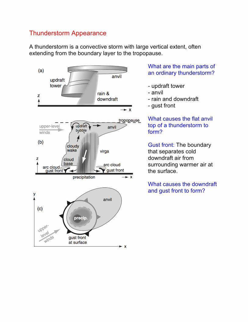
Thunderstorm Appearance A thunderstorm is a convective storm with large vertical extent, often extending from the boundary layer to the tropopause.
What are the main parts of an ordinary thunderstorm? - updraft tower - anvil - rain and downdraft - gust front What causes the flat anvil top of a thunderstorm to form? Gust front: The boundary that separates cold downdraft air from surrounding warmer air at the surface. What causes the downdraft and gust front to form?
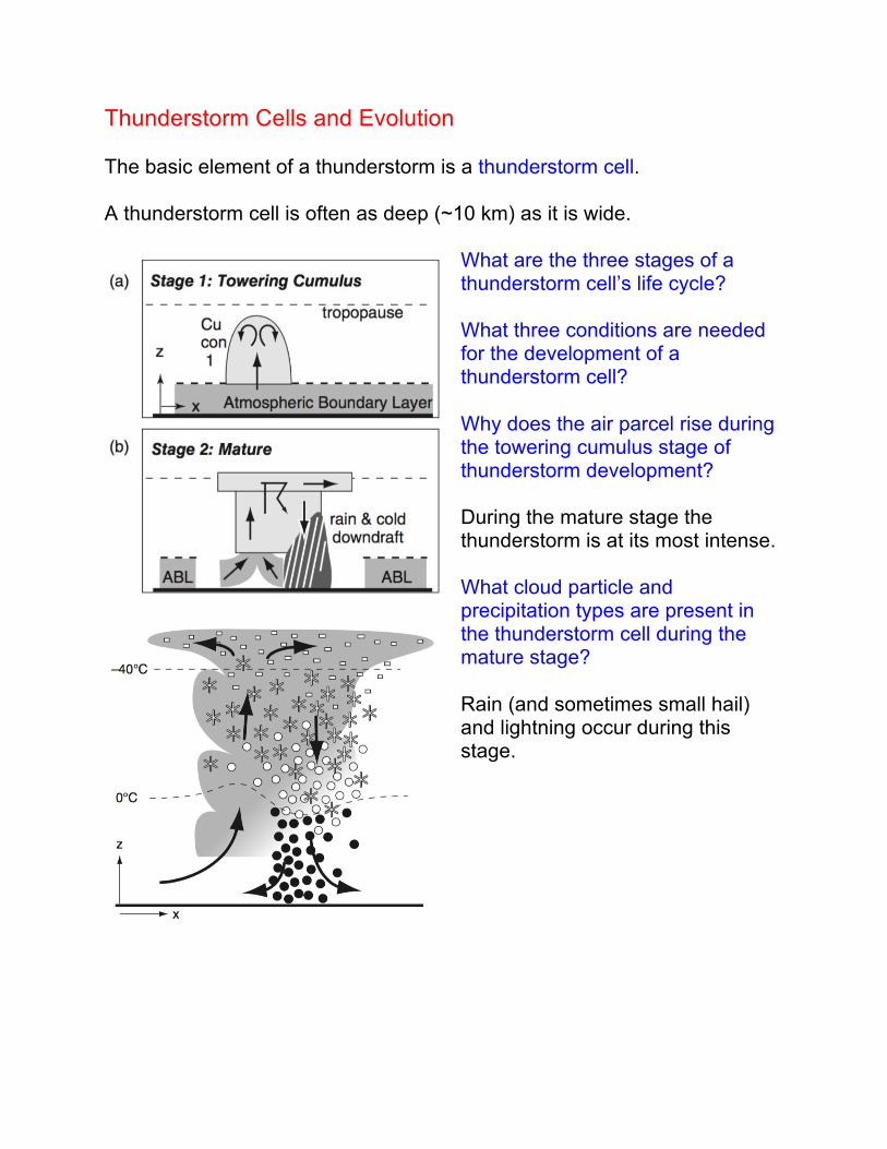
Thunderstorm Cells and Evolution The basic element of a thunderstorm is a thunderstorm cell. A thunderstorm cell is often as deep (~10 km) as it is wide.
What are the three stages of a thunderstorm cell’s life cycle? What three conditions are needed for the development of a thunderstorm cell? Why does the air parcel rise during the towering cumulus stage of thunderstorm development? During the mature stage the thunderstorm is at its most intense. What cloud particle and precipitation types are present in the thunderstorm cell during the mature stage? Rain (and sometimes small hail) and lightning occur during this stage.
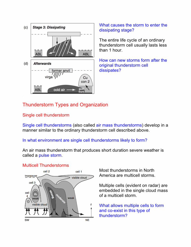
What causes the storm to enter the dissipating stage? The entire life cycle of an ordinary thunderstorm cell usually lasts less than 1 hour. How can new storms form after the original thunderstorm cell dissipates?
Thunderstorm Types and Organization Single cell thunderstorm Single cell thunderstorms (also called air mass thunderstorms) develop in a manner similar to the ordinary thunderstorm cell described above. In what environment are single cell thunderstorms likely to form? An air mass thunderstorm that produces short duration severe weather is called a pulse storm. Multicell Thunderstorms
Most thunderstorms in North America are multicell storms. Multiple cells (evident on radar) are embedded in the single cloud mass of a multicell storm. What allows multiple cells to form and co-exist in this type of thunderstorm?
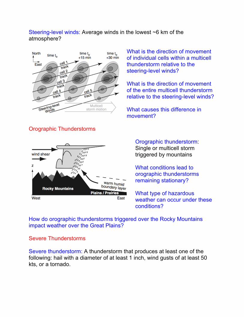
Steering-level winds: Average winds in the lowest ~6 km of the atmosphere?
What is the direction of movement of individual cells within a multicell thunderstorm relative to the steering-level winds? What is the direction of movement of the entire multicell thunderstorm relative to the steering-level winds? What causes this difference in movement?
Orographic Thunderstorms
Orographic thunderstorm: Single or multicell storm triggered by mountains What conditions lead to orographic thunderstorms remaining stationary? What type of hazardous weather can occur under these conditions?
How do orographic thunderstorms triggered over the Rocky Mountains impact weather over the Great Plains? Severe Thunderstorms Severe thunderstorm: A thunderstorm that produces at least one of the following: hail with a diameter of at least 1 inch, wind gusts of at least 50 kts, or a tornado.

Mesoscale Convective Systems (MCS) Mesoscale convective system: A type of multicell storm often organized as a narrow line of thunderstorms with heavy precipitation at its leading edge and a trailing region of lighter precipitation.
How do the environmental conditions that favor MCS development differ from those found for single or other multicell thunderstorms? What can trigger an MCS? How does the cold air pool behind the leading edge of an MCS form?
Meso-high: A mesoscale sized area of high pressure that forms at the surface as a result of the cold air pool. What causes low pressure to form at mid-levels in an MCS?
The rear inflow jet (RIJ) forms as a result of the pressure gradient created by the mid-level area of low pressure. How does precipitation falling from the rear of the MCS impact the RIJ? What impact does this have on severe weather occurring at the surface?
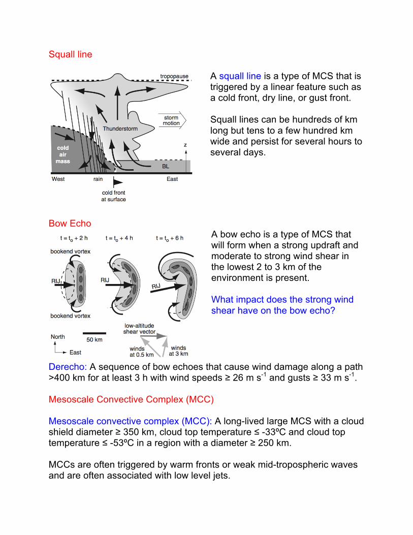
Squall line
A squall line is a type of MCS that is triggered by a linear feature such as a cold front, dry line, or gust front. Squall lines can be hundreds of km long but tens to a few hundred km wide and persist for several hours to several days.
Bow Echo
A bow echo is a type of MCS that will form when a strong updraft and moderate to strong wind shear in the lowest 2 to 3 km of the environment is present. What impact does the strong wind shear have on the bow echo?
Derecho: A sequence of bow echoes that cause wind damage along a path >400 km for at least 3 h with wind speeds ≥ 26 m s-1 and gusts ≥ 33 m s-1. Mesoscale Convective Complex (MCC) Mesoscale convective complex (MCC): A long-lived large MCS with a cloud shield diameter ≥ 350 km, cloud top temperature ≤ -33ºC and cloud top temperature ≤ -53ºC in a region with a diameter ≥ 250 km. MCCs are often triggered by warm fronts or weak mid-tropospheric waves and are often associated with low level jets.
Supercell Thunderstorms
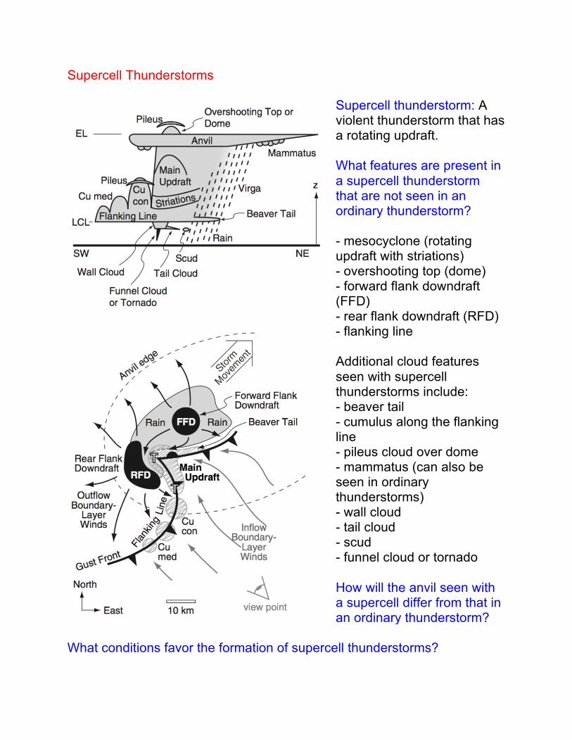
Supercell thunderstorm: A violent thunderstorm that has a rotating updraft. What features are present in a supercell thunderstorm that are not seen in an ordinary thunderstorm? - mesocyclone (rotating updraft with striations) - overshooting top (dome) - forward flank downdraft (FFD) - rear flank downdraft (RFD) - flanking line Additional cloud features seen with supercell thunderstorms include: - beaver tail - cumulus along the flanking line - pileus cloud over dome - mammatus (can also be seen in ordinary thunderstorms) - wall cloud - tail cloud - scud - funnel cloud or tornado How will the anvil seen with a supercell differ from that in an ordinary thunderstorm?
What conditions favor the formation of supercell thunderstorms?
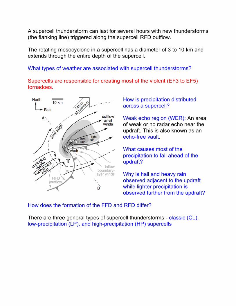
A supercell thunderstorm can last for several hours with new thunderstorms (the flanking line) triggered along the supercell RFD outflow. The rotating mesocyclone in a supercell has a diameter of 3 to 10 km and extends through the entire depth of the supercell. What types of weather are associated with supercell thunderstorms? Supercells are responsible for creating most of the violent (EF3 to EF5) tornadoes.
How is precipitation distributed across a supercell? Weak echo region (WER): An area of weak or no radar echo near the updraft. This is also known as an echo-free vault. What causes most of the precipitation to fall ahead of the updraft? Why is hail and heavy rain observed adjacent to the updraft while lighter precipitation is observed further from the updraft?
How does the formation of the FFD and RFD differ? There are three general types of supercell thunderstorms - classic (CL), low-precipitation (LP), and high-precipitation (HP) supercells
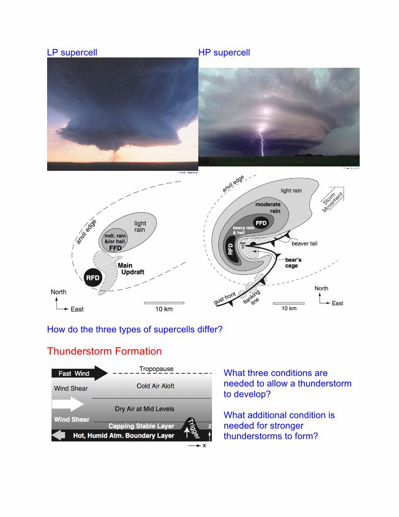
LP supercell
HP supercell
How do the three types of supercells differ? Thunderstorm Formation
What three conditions are needed to allow a thunderstorm to develop? What additional condition is needed for stronger thunderstorms to form?
Key Altitudes
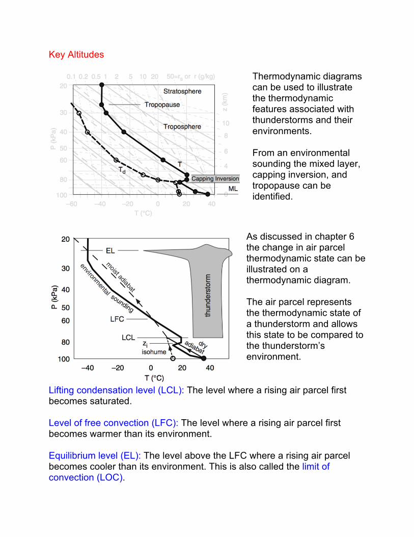
Thermodynamic diagrams can be used to illustrate the thermodynamic features associated with thunderstorms and their environments. From an environmental sounding the mixed layer, capping inversion, and tropopause can be identified.
As discussed in chapter 6 the change in air parcel thermodynamic state can be illustrated on a thermodynamic diagram. The air parcel represents the thermodynamic state of a thunderstorm and allows this state to be compared to the thunderstorm’s environment.
Lifting condensation level (LCL): The level where a rising air parcel first becomes saturated. Level of free convection (LFC): The level where a rising air parcel first becomes warmer than its environment. Equilibrium level (EL): The level above the LFC where a rising air parcel becomes cooler than its environment. This is also called the limit of convection (LOC).
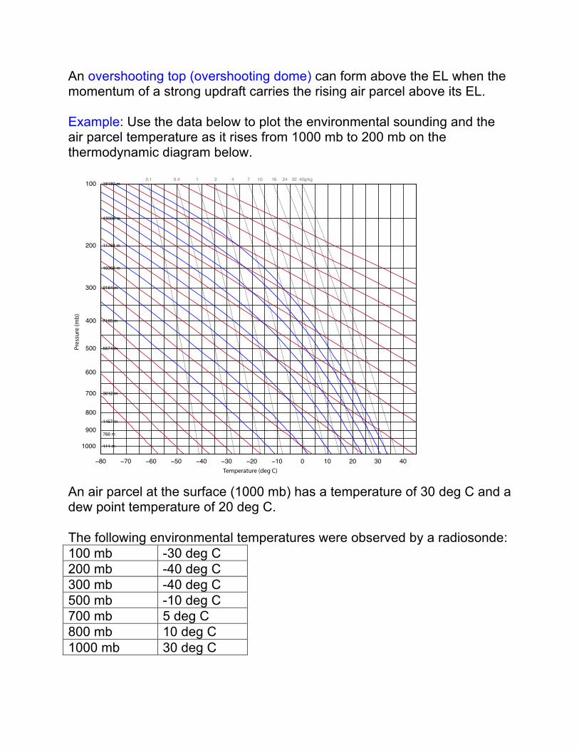
An overshooting top (overshooting dome) can form above the EL when the momentum of a strong updraft carries the rising air parcel above its EL. Example: Use the data below to plot the environmental sounding and the air parcel temperature as it rises from 1000 mb to 200 mb on the thermodynamic diagram below.
An air parcel at the surface (1000 mb) has a temperature of 30 deg C and a dew point temperature of 20 deg C. The following environmental temperatures were observed by a radiosonde: 100 mb -30 deg C 200 mb -40 deg C 300 mb -40 deg C 500 mb -10 deg C 700 mb 5 deg C 800 mb 10 deg C 1000 mb 30 deg C
−80 −70 −60 −50 −40 −30 −20 −10 0 10 20 30 40
100
200
300
400
500
600
700
800
900
1000
0.1 0.4 1 2 4 7 10 16 24 32 40g/kg
111 m
766 m
1457 m
3012 m
5574 m
7185 m
9164 m
10363 m
11784 m
13608 m
16180 m
Temperature (deg C)
Pres
sure
(mb)
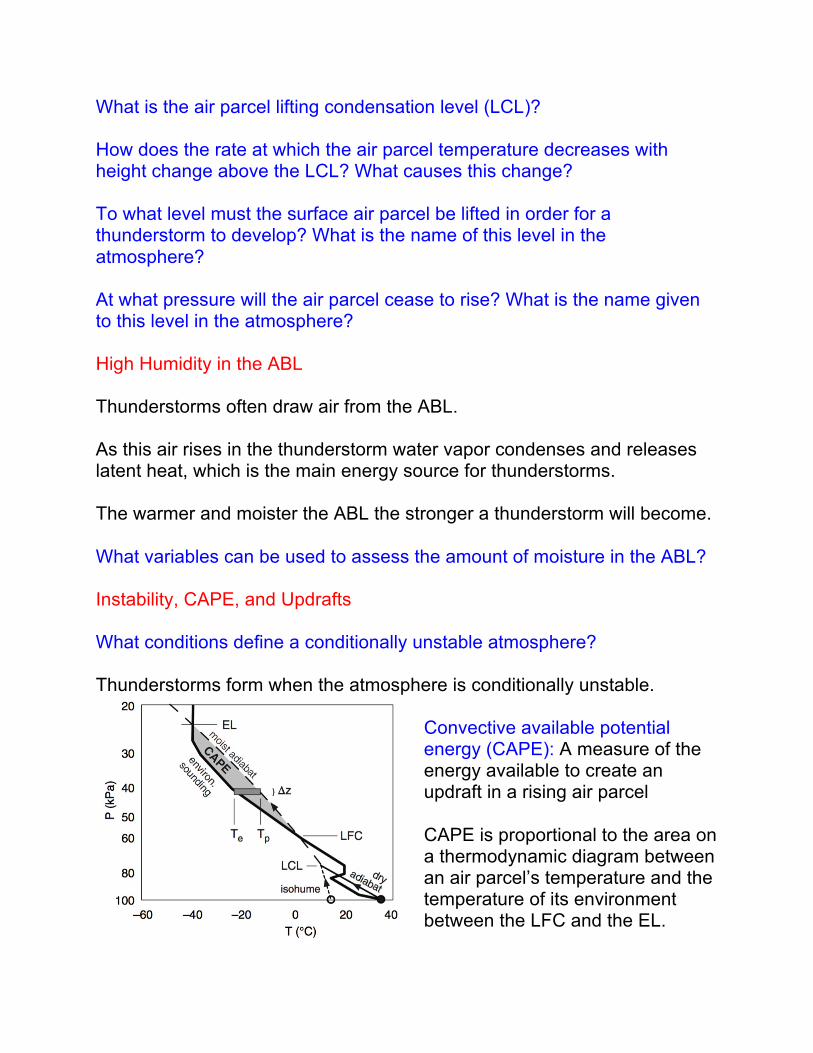
What is the air parcel lifting condensation level (LCL)? How does the rate at which the air parcel temperature decreases with height change above the LCL? What causes this change? To what level must the surface air parcel be lifted in order for a thunderstorm to develop? What is the name of this level in the atmosphere? At what pressure will the air parcel cease to rise? What is the name given to this level in the atmosphere? High Humidity in the ABL Thunderstorms often draw air from the ABL. As this air rises in the thunderstorm water vapor condenses and releases latent heat, which is the main energy source for thunderstorms. The warmer and moister the ABL the stronger a thunderstorm will become. What variables can be used to assess the amount of moisture in the ABL? Instability, CAPE, and Updrafts What conditions define a conditionally unstable atmosphere? Thunderstorms form when the atmosphere is conditionally unstable.
Convective available potential energy (CAPE): A measure of the energy available to create an updraft in a rising air parcel CAPE is proportional to the area on a thermodynamic diagram between an air parcel’s temperature and the temperature of its environment between the LFC and the EL.
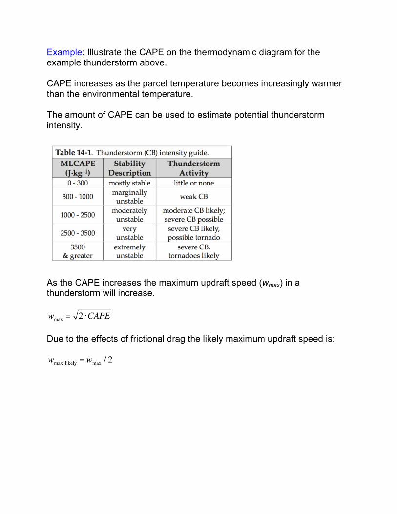
Example: Illustrate the CAPE on the thermodynamic diagram for the example thunderstorm above. CAPE increases as the parcel temperature becomes increasingly warmer than the environmental temperature. The amount of CAPE can be used to estimate potential thunderstorm intensity.
As the CAPE increases the maximum updraft speed (wmax) in a thunderstorm will increase. wmax = 2 ⋅CAPE Due to the effects of frictional drag the likely maximum updraft speed is: wmax likely = wmax / 2
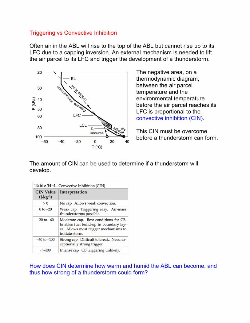
Triggering vs Convective Inhibition Often air in the ABL will rise to the top of the ABL but cannot rise up to its LFC due to a capping inversion. An external mechanism is needed to lift the air parcel to its LFC and trigger the development of a thunderstorm.
The negative area, on a thermodynamic diagram, between the air parcel temperature and the environmental temperature before the air parcel reaches its LFC is proportional to the convective inhibition (CIN). This CIN must be overcome before a thunderstorm can form.
The amount of CIN can be used to determine if a thunderstorm will develop.
How does CIN determine how warm and humid the ABL can become, and thus how strong of a thunderstorm could form?
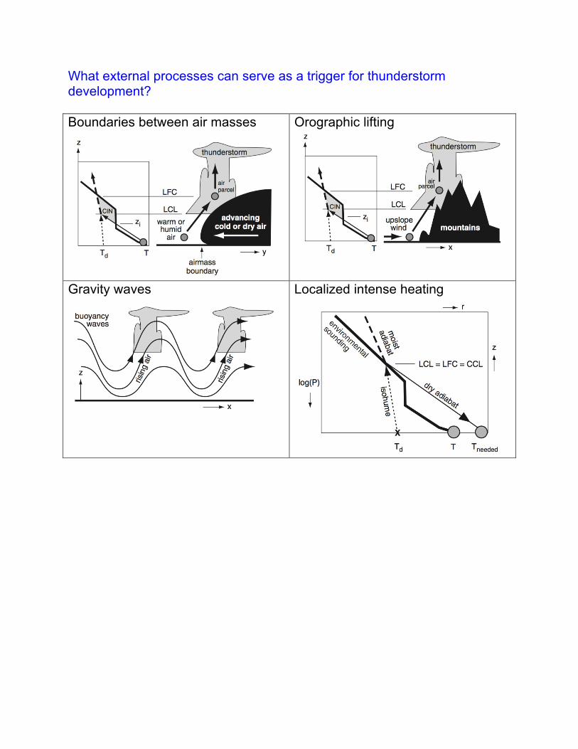
What external processes can serve as a trigger for thunderstorm development? Boundaries between air masses
Orographic lifting
Gravity waves
Localized intense heating
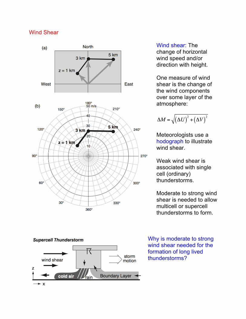
Wind Shear
Wind shear: The change of horizontal wind speed and/or direction with height. One measure of wind shear is the change of the wind components over some layer of the atmosphere: ΔM = ΔU( )2 + ΔV( )2 Meteorologists use a hodograph to illustrate wind shear. Weak wind shear is associated with single cell (ordinary) thunderstorms. Moderate to strong wind shear is needed to allow multicell or supercell thunderstorms to form.
Why is moderate to strong wind shear needed for the formation of long lived thunderstorms?
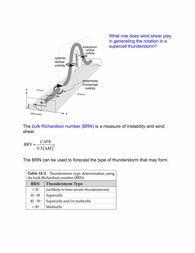
What role does wind shear play in generating the rotation in a supercell thunderstorm?
The bulk Richardson number (BRN) is a measure of instability and wind shear.
BRN =CAPE0.5 ΔM( )2
The BRN can be used to forecast the type of thunderstorm that may form.
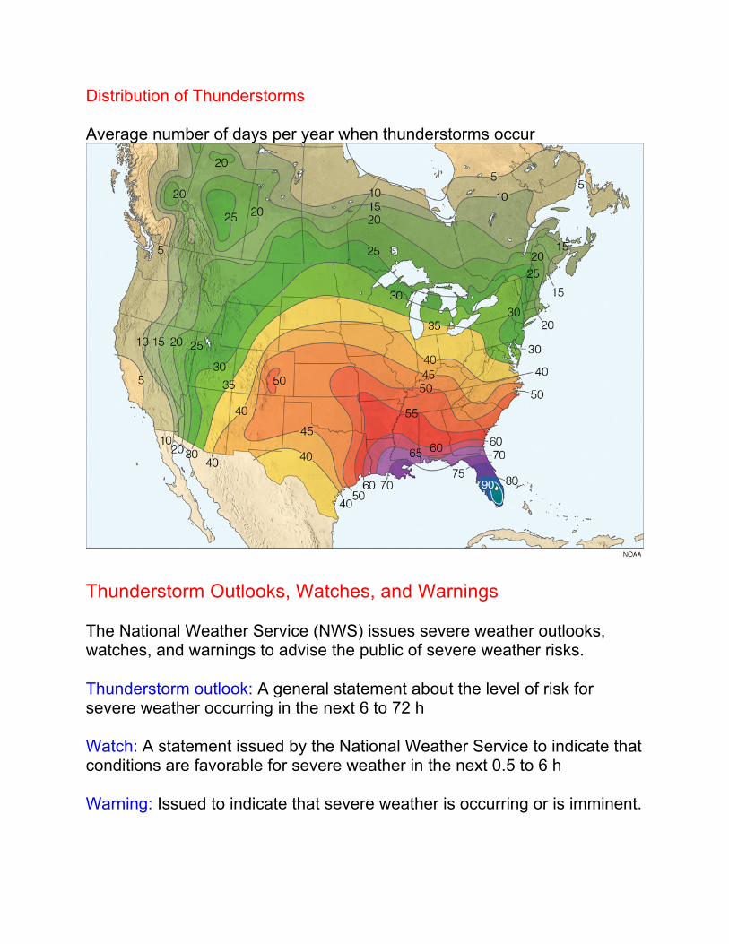
Distribution of Thunderstorms Average number of days per year when thunderstorms occur
Thunderstorm Outlooks, Watches, and Warnings The National Weather Service (NWS) issues severe weather outlooks, watches, and warnings to advise the public of severe weather risks. Thunderstorm outlook: A general statement about the level of risk for severe weather occurring in the next 6 to 72 h Watch: A statement issued by the National Weather Service to indicate that conditions are favorable for severe weather in the next 0.5 to 6 h Warning: Issued to indicate that severe weather is occurring or is imminent.