Embed Size (px)
Citation preview
Chapter 20Remote Sensing of African Lakes: A Review
Thomas J. Ballatore, Shane R. Bradt, Lydia Olaka, Andrés Cózarand Steven A. Loiselle
Abstract The optical complexity and small size of inland waters make the appli-cation of remote sensing more challenging than for the open ocean. However, inAfrica, where in situ monitoring of important water bodies is financially, institu-tionally and spatially constrained, there is strong demand for remote sensing to fillthe critical information gap. Here we review a wide range of applications of bothpassive and active remote sensing to African lakes. The applications fall into fivemain categories: (1) visible, NIR, thermal and microwave sensing of lake area; (2)altimetric and gravimetric sensing of lake level; (3) thermal sensing of lake sur-face temperature; (4) visible, NIR and microwave sensing of macrophytes; and (5)optical sensing of trophic conditions including chlorophyll-a and euphotic depth.Sensors used include Landsat MSS, TM and ETM+, MERIS, MODIS, SeaWiFS,AVHRR, Meteosat, TOPEX/Poseidon, Jason-1, OSTM/Jason-2, ERS-1, ERS-2, En-visat, GFO, ICESat, ALOS-PALSAR and GRACE. The majority of studies havebeen applied to the “great” lakes such as Chad, Malawi, Tanganyika and Victoria;however, there is a growing body of literature on smaller lakes. We examine thepossibilities that remote sensing offers to monitoring and management of Africanlakes as well as the potential limitations of the technology using Lake Victoria as anillustrative case.
T. J. Ballatore (!) · S. R. Bradt · L. OlakaLake Basin Action Network, Moriyama, Japane-mail: [email protected]
S. R. BradtUniversity of New Hampshire, Durham, NH, USA
L. OlakaUniversity of Nairobi, Nairobi, Kenya
A. CózarUniversidad de Cádiz, Puerto Real, Spain
S. A. LoiselleUniversità degli Studi di Siena, Siena, Italy
V. Barale, M. Gade (eds.), Remote Sensing of the African Seas, 403DOI 10.1007/978-94-017-8008-7_20,© Springer Science+Business Media Dordrecht 2014
404 T. J. Ballatore et al.
20.1 Introduction
The idea of remote sensing—the art and science of obtaining information about anobject without being in physical contact with the object (Jensen 2007)—is in manyways the holy grail of lake management. The potential to look wide and often atconditions in a given lake has spurred much interest, resulting in a burgeoning bodyof research and applications including recent work by Gower et al. (2005), Ruiz-Verdú et al. (2008), Chipman et al. (2009), Gitelson et al. (2011), Bradt (2012) andMatthews et al. (2012).
The potential offered by remote sensing is particularly attractive in Africa whereadministrative capacity to carry out field-based monitoring is limited. Lake managersin Africa are confronted with a task of monitoring lakes that would challenge eventhe most well-funded monitoring programs.
Here, we review the applications of remote sensing to African lakes as describedin the scientific literature. The applications are surprisingly broad: spatially, theyinclude 29 lakes that cover all corners of the continent (see Fig. 20.1); thematically,they range from passive to active sensors looking at both water quantity and quality.
Overall, we find it convenient to divide the applications into two broad categories:those that look at the amount of water in a given lake and those that look at theproperties of that water. The former category include studies that measure lake areathrough (1) visible and near-infrared (NIR) sensing of lake extent/shoreline, (2)thermal sensing of inundated areas, and (3) microwave sensing of water under cloudcover. They also include studies that examine lake level through (4) altimetric and(5) gravimetric observations. The latter category includes work on strictly physicalaspects such as (6) thermal sensing for lake surface temperature as well as biologicalaspects such as (7) visible and NIR sensing of macrophytes and (8) microwavesensing of macrophytes and perhaps the most widely known application—(9) opticalsensing of trophic conditions through measurement of chlorophyll-a, euphotic depthand a range of related indicators.
Few of the studies reviewed here fall solely into one of the above nine categories;most papers make use of a combination of techniques. For example, a paper usingaltimetric observations to estimate changes in lake level might also rely on visibleand NIR imagery to confirm lake area (and hence, level) changes.
More importantly, it must be noted that remote sensing does not completely obvi-ate the need for field observations and traditional sampling programs. In fact, mostof the methods described here still require, or greatly benefit from, calibration withactual measurements taken in the field concurrent with the remotely-sensed images.Nevertheless, as the literature demonstrates, and as we explore in the discussion,remote sensing can indeed provide a wealth of information to greatly aid the work ofthose concerned with lake management in local communities, national governmentsand international organizations throughout Africa.
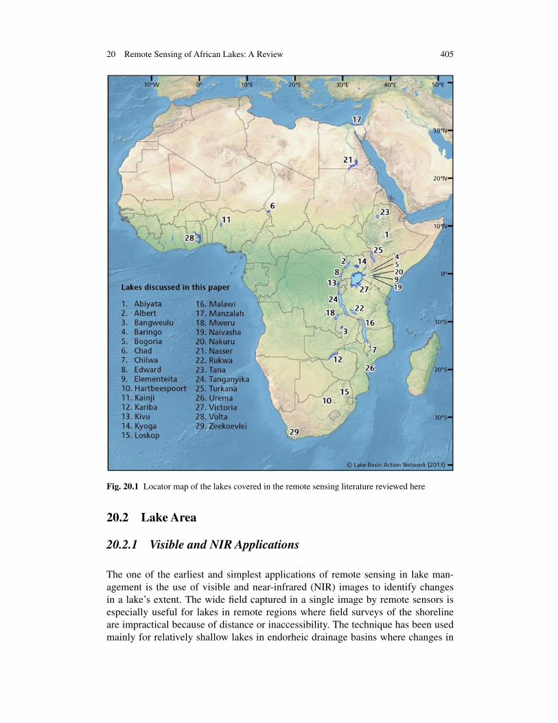
20 Remote Sensing of African Lakes: A Review 405
Fig. 20.1 Locator map of the lakes covered in the remote sensing literature reviewed here
20.2 Lake Area
20.2.1 Visible and NIR Applications
The one of the earliest and simplest applications of remote sensing in lake man-agement is the use of visible and near-infrared (NIR) images to identify changesin a lake’s extent. The wide field captured in a single image by remote sensors isespecially useful for lakes in remote regions where field surveys of the shorelineare impractical because of distance or inaccessibility. The technique has been usedmainly for relatively shallow lakes in endorheic drainage basins where changes in
406 T. J. Ballatore et al.
water balance are strongly reflected in changes in lake extent. The strong contrastbetween light reflected from land vs. water, along with the complete and fine spatialcoverage offered by sensors such as the Multi Spectral Scanner (MSS), ThematicMapper (TM) and Enhanced Thematic Mapper Plus (ETM+), onboard the Land-sat satellite series, mean that this technique is not limited to large lakes and can beapplied, in theory at least, to lakes of 1 km2 or less.
Lake Chad has drawn much attention in the literature given its dramatic decreasein extent. Mohler et al. (1989) digitized photographs taken with onboard, handheldcameras during manned space flights (Gemini, Skylab, and the Space Shuttle) datingfrom 1966 to 1985 to document an approximate 90 % decrease in lake extent. Twomain cameras were used: a 70 mm Hasselblad and a 230–460 mm Large FormatCamera (LFC) and, except for one black-and-white photo and one color-infraredphoto (both taken with the LFC), the images were captured on natural color film.After digitization, spatial resolution was reported as 11 m for LFC and 29 m for theHasselblad. Water and land were classified with a maximum likelihood algorithm.It is important to note that the 1966 Gemini image, which showed an extent of22,772 km2, pre-dated the era of non-manned satellite observing systems whichbegan with Landsat MSS in 1972, a time when the lake had already undergone mostof the areal change. Wald (1990), building on the work of Mohler et al. (1989), usedimages from Meteosat in the visible and NIR range (0.4–1.1 µm) to document thelake’s further shrinkage to 500 km2 in April 1989.
Schneider et al. (1985) used the NIR Band 7 (0.8–1.1 µm) from Landsat MSS(spatial resolution ∼ 80 m) to document the lake area changes from 1972 to 1982.They also used the visible and NIR Channels 1 and 2 (0.55–0.68 and 0.725–1.1 µm)of the Advanced Very High Resolution Radiometer (AVHRR), onboard the NOAA-7 satellite, (spatial resolution 1.1 km2) to develop a simple Normalized DifferenceVegetation Index (NDVI) to detail open water and vegetation along transects of keyportions of the lake from November 1981 to November 1982. Despite its lower spatialresolution, the higher temporal resolution of AVHRR (daily vs. 18 days for MSS)was an advantage in mapping the rapidly changing water area and vegetation.
Birkett (2000) used the AVHRR’s NIR Channel 2 (0.725–1.1 µm) to map lakeextent (inundated area) over a 4-yr period starting in 1995. A simple histogramtechnique of the Digital Number (DN) values allow classification of inundated areaswith an overall relative error of ∼ 5 % (calculated from results of different algorithmsgiven the lack of field data) with lower errors during peak flows and higher errorsduring other times, due in part to the presence of pools smaller than the AVHRRspatial resolution. The paper also made extensive use of satellite altimetry data.
Turada (2008) used a selection of visible and NIR bands from the Medium Reso-lution Imaging Spectrometer (MERIS), onboard the European Space Agency (ESA)satellite Envisat, (300 m spatial resolution) to look at inundation and land coverchange in the Lake Chad basin through Spectral Mixture Analysis (endmembers:soil, vegetation and water). The MERIS-based classification was validated withdata from the Advanced Spaceborne Thermal Emission and Reflection Radiometer(ASTER), a high resolution imaging instrument that is flying on the US NationalAeronautics and Space Administration (NASA) orbital platform named Terra, (15 m
20 Remote Sensing of African Lakes: A Review 407
spatial resolution; visible and NIR) as well as from IKONOS (in the 4 m spatial res-olution version; visible and NIR) and showed that despite the relatively low spatialresolution, MERIS was able to detect changes in lake extent (kappa coefficients, asper Cohen 1960, ranging from 0.92 to 0.95).
Other lakes have also drawn attention. Booth and Oldfield (1988) used LandsatMSS NIR Band 7 to estimate declining Lake Kariba area in five images from 1981to 1985 coincident with a drought in the region. Classification was done by manuallyjudging an appropriate water cut off DN value in each image.
Ouma and Tateishi (2006) used visible and NIR bands from Landsat TM andETM+ images to develop a new Water Index (WI) based on Tasseled Cap Wetness(TCW) and Normalized Difference Water Index (NDWI) to rapidly map shorelinesin five Rift Valley lakes in Kenya (Baringo, Bogoria, Elementaita, Naivasha andNakuru) for images in 1986 and 2001. Ground-based observations showed that theWI had an accuracy of 98.4 % outperforming TCW by ∼ 22 % and NWDI by ∼ 43 %.
Harris (1994) used the NIR band of AVHRR (Channel 2) to detect shorelinechanges at Lake Abiyata (Ethiopia) with a local isoluminance contour (LIC) method.The technique also made use of a re-sampled NIR band from Landsat MSS (band 7).Also for Lake Abiyata, Legesse and Ayenew (2006) used Landsat MSS, TM, ETM+and SPOT data, as well as data from the Moderate Resolution Imaging Spectrometer(MODIS)—which exists in two versions, carried onboard the NASA orbital platformsTerra (MODIS Terra) and Aqua (MODIS Aqua)—to visually display changes in thelake area from 1978 to 2005. The band used is not specified but the very darkappearance of the lake relative to bright land in the figures indicates it was an NIRband.
Finally, Böhme et al. (2006) examined intra- and inter-annual areal changesin Lake Urema (Mozambique) from 1979 to 2000 by a Maximum LikelihoodClassification augmented with NDVI, Principal Component Analysis (PCA) andTasseled-Cap-Transformation (TCT) based on visible and NIR bands from MSS,TM, ETM+, and ASTER.
20.2.2 Thermal Sensing Applications
The spectral differences between lake water and surrounding land in the visible andespecially NIR bands are the basis for shoreline delineation discussed in the previoussection. It is also possible to use the thermal part of the spectrum to do similar work.The main benefit of using thermal imagery is the ability of the technique to work atnight, due to the fact that the electromagnetic radiation being received by the sensoris emitted from the target and not reflected from a source (sun).
Schneider et al. (1985), in addition to the work on visible and NIR bands discussedabove, used two of the AVHRR thermal channels (4 and 5; wavelengths 10.3–11.3and 11.5–12.5 µm, respectively) to differentiate Lake Chad’s open water from floodplains, deltas and surrounding land.
408 T. J. Ballatore et al.
Also for Lake Chad, Leblanc et al. (2011) used Meteosat 30-day Tmax data(10.5–12.5 µm) to thermally sense water under vegetative cover, validated by fieldsurveys and AVHRR data over the period of 1986–2001. While they note that thethermal technique was difficult to apply during the rainy season because the highwater content of non-lake areas produced a signature similar to that of open water,the high-temporal resolution (30 min) of the geosynchronous Meteosat meant thatcloud cover was not a significant handicap.
20.2.3 Microwave Applications
In areas were cloud cover is more persistent, the visible, NIR and thermal techniquesare less useful. Rebelo (2010) describes the application of the Phased Array typeL-band Synthetic Aperture Radar (PALSAR), orbiting on the Advanced Land Ob-serving Satellite (ALOS) of the Japan Aerospace Exploration Agency’s (JAXA), anactive microwave sensor, to identify surface changes in Lake Urema and surround-ing wetlands from December 2006 to February 2008. The ALOS-PALSAR images(∼ 12.5 m spatial resolution) were smoothed with a 5 × 5 pixel median filter andclassified using a PCA method to generate input for a supervised classification.
20.3 Lake Level
20.3.1 Altimetric Sensing (Microwave)
If bathymetry is known, lake level can be inferred from the shoreline changes dis-cussed above; however, this is not always possible. Furthermore, cloud cover cangreatly limit the time series data derived from visible, NIR and thermal products.Active altimetric sensing with microwaves was originally developed for ocean topo-graphic mapping but has been successfully applied to lakes. Under certain conditions,lake level can be estimated to within a few cm of actual values. Additionally, cloudcover is not an issue. Given the important role that lake level plays in human use oflakes, this method has seen wide use. Unfortunately, the nature of the narrow activesignal sent from a given sensor means that only lakes directly in the sensor path canbe covered.
Use of altimetric data has been fostered by the development of online databasesthat process the raw data from various sensors and provide “finished” products. Themain ones referred to in the literature below are (1) ESA’s River and Lake website(ESA 2013), which uses data from Envisat, Jason-1 and Jason-2; (2) the Labora-toire d’Etude en Géophysique et Océanographie Spatiale (LEGOS) Hydroweb, asurface monitoring by satellite altimetry website (LEGOS 2013), which uses datafrom the satellites Envisat, European Remote Sensing 1 and 2 (ERS-1 and ERS-2),Geosat Follow-On (GFO), Jason-1, Jason-2 and TOPEX/Poseidon (Cretaux et al.(2011); and (3) the US Department of Agriculture (USDA) Global Reservoir andLake Monitor (USDA 2013) which uses data from Envisat, GFO, Jason-1, Jason-2and TOPEX/Poseidon.
20 Remote Sensing of African Lakes: A Review 409
Using data from the first 21 months of the TOPEX/Poseidon mission (September1992–May 1994), Birkett (1995) estimated lake levels for climate sensitive lakesincluding the following African lakes: Chad, Kariba, Malawi, Nasser, Tana, Tan-ganyika, Turkana, Victoria and Volta. Field data were used to estimate the accuracyas ∼ 4 cm rms, thereby demonstrating the usefulness of satellite altimetry for lakelevel measurement. Merceir et al. (2002) used TOPEX/Poseidon data from 1993to 1999 to look at the same lakes as Birkett (1995) as well as Kyoga, Mweru andRukwa. They showed links between lake levels and the atmosphere over the IndianOcean.
Ricko (2011) used lake level data from the LEGOS (2013) dataset for lakes Bang-weulu, Chad, Kainji, Malawi, Mweru, Tana, Tanganyika and Turkana as part of abroader study of the effects of climate on tropical lake levels. Munyaneza et al.(2009) used Envisat and ERS-2 from ESA (2013) for water level monitoring of LakeKivu. Velpuri et al. (2012) used TOPEX/Poseidon, Jason-1 and Envisat from USDA(2013) for validation of hydrological models for Lake Turkana.
Lake Chad has also drawn much interest. Birkett (2000) used TOPEX/Poseidonalong with AVHRR to examine variability of basin inundation. Coe and Birkett(2004) used TOPEX/Poseidon along with ground-based information to estimate riverdischarge and lake level. In a review paper, Crétaux and Birkett (2006) noted thatTOPEX/Poseidon data for Lake Chad were reported to have lower accuracy (tensof cm) compared with other lakes such as the Laurentian Great Lakes (a few cm).Turada (2008) used TOPEX/Poseidon derived levels from USDA (2013) to confirmMERIS-based areal extent changes. Lemoalle et al. (2012) used previous altimetricwork as input for a hydrological model to examine management options for LakeChad.
Finally, altimetric sensing has often played a key role in gravimetric approaches.Swenson and Wahr (2009) used lake level data from USDA (2013) for Lake Vic-toria, LEGOS (2013) data for lakes Albert, Edward and Kyoga, and data from Ice,Cloud, and land Elevation Satellite (ICESat), part of NASA’s Earth Observing Sys-tem (EOS), of later periods for Kyoga. They used altimetric data to show that excesswater input to LakeVictoria since mid-2007 has been used for hydropower generationand not stored for future drought relief. Additionally, Lake Kyoga levels were shownto reflect an increase in discharge from Lake Victoria despite a regional drought. Ad-ditionally, Becker et al. (2010) used ESA (2013), LEGOS (2013) and USDA (2013)altimetric data along with data from the Gravity Recovery And Climate Experiment(GRACE), a joint mission of NASA and the German Aerospace Center, and precip-itation data to study the recent hydrological behavior of Lakes Malawi, Tanganyika,Turkana and Victoria.
20.3.2 Gravimetric Sensing
The launch of the twin GRACE sensors in 2002 added gravimetry, a non-electromagnetic radiation based form of remote sensing, to the options available.Differences in mass on earth can be detected by examining small changes in thedistance between the orbiting GRACE sensors as they pass over a given point. With
410 T. J. Ballatore et al.
a repeat time of 15 days, this technique has been applied successfully to determinewater level (volume) changes in some of the larger African lakes.
A number of papers have looked at the water balance of Lake Victoria whosedramatic decline in lake water coinciding with the completion of a second dam onthe outflowing river in 1999 in Uganda. Awange et al. (2008) used changes in geoidalvariation as measured by GRACE to show an annual loss of 1.6 mm/yr in the lakebasin from 2002 to 2006. This information, coupled with Tropical Rainfall MeasuringMission (TRMM) and the Challenging Minisatellite Payload (CHAMP) indicatedthat dam operations were the likely cause in the decline in lake level with respectto precipitation (TRMM) or evaporation (CHAMP). This conclusion was confirmedby Swenson and Wahr (2009) using GRACE, altimetric lake level data remotely-sensed data on precipitation (TRMM) and evaporation, including wind speed fromthe scatterometer SeaWinds, onboard the QuikSCAT satellite; temperature from theMODIS Aqua; and near-surface temperature and humidity from the Advanced Mi-crowave Sounding Unit (AMSU-A), the Special Sensor Microwave Imager (SSM/I)and the Special Sensor Microwave/ Temperature & Humidity Profile (SSM/T2).
Becker et al. (2010) used GRACE measurements of changes in terrestrial waterstorage, altimetrically-sensed changes in lake level, and Global Precipitation Clima-tology Centre (GPCC) data on precipitation to show common modes of variabilityamong the levels of Lakes Malawi, Tanganyika, Turkana and Victoria due to the ef-fect of the Indian Ocean Dipole (IOD) and El Niño-Southern Oscillation from 2003to 2008.
As part of a large-scale study of hydrological variations in Africa, Boy et al.(2012) compared GRACE-based estimates of water level change with altimetricdata for Lakes Malawi, Tanganyika and Victoria. They showed that spherical har-monic solutions, while suitable for Lake Victoria, do not perform as well for lakeswith a narrow east-west extent such as Malawi and Tanganyika. For the latter, theyrecommend localized approaches such as mascons. Work was also done by Boy et al.(2012) and Hinderer et al. (2012) on the Lake Chad basin but the GRACE data werenot linked to lake level, undoubtedly due to the very small volume of water containedin Lake Chad.
20.4 Lake Properties: Physical
20.4.1 Thermal Sensing of Surface Temperature
Schneider et al. (1985), in addition to visible, NIR and thermal work to delineatewater extent discussed above, also produced a surface water temperature map forLake Chad and the surrounding area using daytime observations with Channels 4and 5 of the AVHRR sensor. They applied a two atmospheric window approachfrom McClain (1981) and were able to demonstrate distinct and large temperaturedifferences among the lake regions and surrounding terrain including inflowing riverdeltas.
20 Remote Sensing of African Lakes: A Review 411
Wooster et al. (2001) used Channels 3, 4 and 5 from nighttime AVHRR for LakeMalawi to estimate lake surface temperatures from May 1993 to September 2004.Using nighttime images and including information from Channel 3, they were ableto show that, based on field vertical temperature profiles, the near-surface valueswere indeed representative of the temperature of the mixed epilimnion.
Chavula et al. (2009a) used MODIS images to infer lake circulation patterns fromsurface temperature. MODIS Terra daytime images for the period May to November2006 were downloaded as both Land Surface Temperature (i.e. a data product codedas MOD11a1) and SST. Compared with field observations, SST was a better estimator(r2 = 0.75) of actual lake surface temperature than MOD11a1 (r2 = 0.68). Based onthis agreement, they were able to infer the location of an upwelling zone with potentialfor fisheries.
20.5 Lake Properties: Biological
20.5.1 Visible and NIR Sensing of Macrophytes
Proliferation of invasive aquatic macrophytes has significantly impacted severalAfrican lakes. The rapid expansion of Eichhornia spp. (water hyacinth) and otherplants in Lake Victoria has received much attention. Given the vast spatial dimen-sions of floating plant biomass and their elevated reflectance in visible and infraredbands, there have been numerous uses of remote sensing to monitor macrophyteextent.
Cavalli et al. (2009a) used MERIS and ASTER to map aquatic weed infestationsin Winam Gulf, LakeVictoria, after building a spectral library (350–2500 nm) of ninecommon weed species. Two ETM+ scenes (1999 and 2001) were used to performspatial and temporal mapping of the major invasive aquatic plants (water hyacinth,Nile lily, Nile cabbage). The authors then used 3-band (visible and NIR) ASTERimages to follow the evolution of weed cover from 2002 to 2006 in selected parts ofWinam Gulf. Because of the limited spectral resolution of ASTER compared withETM+, individual species could not be identified but the clear patterns and changesin weed cover were identified.
Cavalli et al. (2009b) used an 18-band (410–1040 nm) image generated by theCompact High Resolution Imaging Spectrometer (CHRIS), onboard the Project forOn-Board Autonomy (PROBA) satellite, (spatial resolution = 17 m) along with acontemporary ETM+ image to identify specific plant species based on the spectrallibrary described in Cavalli et al. (2009a). The much wider swath width of ETM+allowed mapping of macrophyte distribution over the whole gulf.
Fusilli et al. (2011) used MODIS images to map floating vegetation in Winam Gulfat a minimum half-weekly frequency over a 10-year period of 2000–2009. NDVI wascalculated and used to distinguish floating vegetation from water and land. A LandsatTM image with higher spatial resolution was used to help determine the appropriateNDVI cut off value for floating vegetation (> 0.4). Additional information on rainfall,
412 T. J. Ballatore et al.
lake height, and suspended solids among others allowed the authors to tie the causeof the abnormal proliferation from October 2006 to January 2008 to an unusuallyheavy rainy season and the consequent large inflows of nutrients and sediment fromsurrounding land.
Rebelo (2010) used blue, red and NIR bands from Landsat TM to calculate anEnhanced Vegetation Index (EVI) for Lake Chilwa (Malawi, Mozambique) for May2006. This was combined with SAR data to achieve a high classification accuracy.
20.5.2 Microwave Sensing of Macrophytes
Rebelo (2010) used Fine Beam Single, Fine Beam Dual, and polarimetric images (all12.5 m spatial resolution) from the L-band ALOS-PALSAR instrument to classifyvegetative cover in and around lakes Chilwa and Urema to an accuracy of 89 and84 %, respectively, compared with field observations. PALSAR was notably usefulin these two cases because of the ability of L-band SAR to penetrate frequent cloudcover and smoke, especially in Mozambique where visible and NIR images werelimited during the study period (2006–2008).
20.5.3 Optical Sensing of Trophic Conditions
One of the most challenging areas of remote sensing for lake management is theapplication of optical (visible wavelength) images for the determination of trophicconditions. The presence of elevated concentrations of Colored Dissolved OrganicMatter (CDOM) and Total Suspended Matter (TSM) as well as the difficulty ofatmospheric correction over African lakes with a range of elevations makes theprocess inherently more difficult than typical ocean color approaches. Neverthelessnew algorithms and techniques promise to make optical sensing of trophic conditionsa growing application.
Bergamino et al. (2007) used SeaWiFS imagery to assess the changes in chloro-phyll concentration in Lake Tanganyika during a 7-year period using the OC4.v4algorithm. Empirical Orthogonal Function (EOF) analysis was used to define regionsof the lake with the same temporal dynamics of phytoplankton biomass. Three co-varying regions (north, south and central) were identified which displayed differentseasonal and inter-annual dynamics in estimated chlorophyll concentrations.
Sørensen et al. (2008) evaluated the performance of MERIS products processedusing the Case2R and the EUL processors, including signal depth (Z90_max), toestimate chlorophyll-a concentrations and TSM in Lake Victoria. Reference dataconsisted of actual Secchi Disk Depth (SDD) measurements. The Z90_max wasfound to correlate well with measured SDD when using both the Case2R and EULprocessors, but the relationship was different in each case. For the few chlorophyll-adata available, the OC4.v4 algorithm analyzed with the Case2R processor produced
20 Remote Sensing of African Lakes: A Review 413
chlorophyll estimates in the same order of magnitude as those measured. In the caseof the few available TSM values, the MERIS-estimated data were found to be in thesame range as those measured in the field.
Koponen et al. (2008) evaluated the performance of the chlorophyll-a MERISproducts in Lake Manzalah, Egypt, using the EUL processor both with and withoutthe use of the Improve Contrast between Ocean & Land (ICOL) technique.
While the correlation between estimated chlorophyll and measured chlorophyllwas linear, large errors were evident in slope and bias. Based on the observationof the imagery products, it was clear that local water quality variation present inLake Manzalah exceeded the processor capability. Nearly all pixels were flagged“out of scope” for estimated chlorophyll concentration product, largely due to failedatmospheric correction techniques.
Kneubühler et al. (2007) used MERIS imagery to map chlorophyll-a in Lake Kivuduring the dry season over the course of three years. The images were atmospher-ically corrected using both the Atmospheric & Topographic Correction (ATCOR)model, version 2 (Atmospheric Correction for Flat Terrain, ATCOR2), and Simpli-fied Method for Atmospheric Correction (SMAC) processor. The study tested fiveband radio algorithms using MERIS bands at 443, 490, 560, 620, 665, 709 and754 nm, as well as, an algorithm using 443, 560 and 665 nm modified for Landsatbands. Linear regression models were applied to seven MERIS images to investigatespatial and inter-annual variability in the lake, particularly the increased chlorophyllconcentrations in bays and coastal areas. The authors note that CDOM variabilitymight have influenced these estimates.
Chavula et al. (2009b) used MODIS imagery products to estimate chlorophyllin Lake Malawi. Lake water was collected at three lake sampling locations duringnumerous sampling cruises and processed to determine chlorophyll-a concentration(n = 136). Level 1 MODIS Terra imagery for the sampling dates was obtained fromthe NASA Level 1 and Atmospheres Archive and Distribution System (LAADS)system, while Level 2 and Level 3 MODIS Aqua imagery was obtained from theNASA Ocean Color Group. Terra algorithms were found to be of limited use, asituation attributed to the adverse effects of atmospheric effects on reflectance. Themost effective Aqua chlorophyll algorithm was Rrs443/Rrs551.
Majozi (2011) used a combination of field-collected spectral attenuation mea-surements with MERIS products to examine eutrophic depth distribution in LakeNaivasha. Field measurements of downwelling irradiance at 0.1 and 0.6 m were usedto calculate attenuation (Kd) for three wavelength ranges (430–600, 600–800 and800–930 nm). Lake-specific attenuation models were tested against MERIS products[Kd(490), Kd(620)] and found to be fairly accurate [rmse = 0.044 m for Kd(620)].The attenuation model for euphotic depth was applied to MERIS images of the lake,revealing the spatial variety and range of light penetration in Lake Naivasha.
Oberholster and Botha (2010) used Landsat 5 imagery in combination with molec-ular markers to successfully detect cyanobacteria in Lake Hartbeespoort. A red toNIR algorithm was used to determine when cyanobacteria populations were present.Lake sampling to determine the presence and density of cyanobacteria relied ona combination of chlorophyll concentration, PCR analysis and microcystin toxindetection using an Enzyme-Linked Immunosorbent Assay (ELISA).
414 T. J. Ballatore et al.
Horion et al. (2010) used standard and adapted MODIS Aqua Ocean Color prod-ucts to create regionally calibrated products for chlorophyll-a concentration andattenuation coefficients at 490 nm [Kd(490)] for Lake Tanganyika. The examina-tion of known targets using clear sky images revealed the standard atmosphericcorrection method to be inadequate for Lake Tanganyika. An aerosol correctionmodel designed for coastal regions with 90 % humidity proved the most effective ap-proach. When using this atmospheric correction, the regression between the standardOcean Color Group algorithm for chlorophyll-a concentration and in situ chlorophyllconcentration had an offset near 0, a slope near 1, and an rmse around 20 %.
MODIS-derived chlorophyll-a estimations revealed a pattern of higher concentra-tion events compared to field sampling. The high chlorophyll values seemed linkedto increases in cyanobacteria abundance in surface waters, and often occurred nearthe onset of the rainy season. The authors concluded that their MODIS-based esti-mates of chlorophyll-a provided a good approximation of actual concentrations inthe upper water column. Bergamino et al. (2010) relied on the regionally calibratedchlorophyll-a product developed by Horion et al. (2010) to examine the spatio-temporal dynamics of phytoplankton in Lake Tanganyika. The daily phytoplanktonphotosynthesis per unit area of Lake Tanganyika was modeled and the daily primaryproduction of the whole lake was estimated by weighting the averages according tothe relative area of each region.
Based on an EOF analysis, 13 co-varying regions in Lake Tanganyika were iden-tified. These data show that the traditional division of the lake into three lake basins islargely correct, and the observed temporal patterns revealed significant differences inestimated concentrations between the regions. The dry season was found to be moreproductive than the wet season, with the southern section exhibiting two peaks inprimary production and the central and northern sections exhibiting a single, smallerpeak. The observations of these trends indicated the usefulness of satellite-basedanalysis for Lake Tanganyika, providing the possibility to examine long-term andshort-term changes in lake dynamics.
Matthews et al. (2010) used MERIS imagery to assess the suitability of a varietyof algorithms for use in cyanobacteria-rich waters. Empirical algorithms resulted inhigh correlation values, but were found to be of limited use to separate signals fromco-varying in-water constituents. Semi-analytical algorithms were not successful,due to poor atmospheric correction techniques and training ranges of key opticalvariables not being appropriate for a water body of this type. A major conclusion ofthis study was the observation that top of atmosphere satellite data could be used todetect hypereutrophic conditions in inland waters.
Cózar et al. (2012) used water-leaving radiances from the SeaWiFS sensor toestimate chlorophyll-a concentration in Lake Victoria by way of the Maximum BandRatio (MBR) using the OC4.v4 algorithm. Statistical analysis of the relative opticalvariability within the lake provided the means for assessing bio-optical, and thus,limnological variability and lake dynamics. In addition, AVHRR imagery was usedin this study to calculate lake surface temperature to examine the changes in watercolumn stability. Seasonal increases in lake surface temperature in the North Regioncoincided with rises in the estimated chlorophyll concentration, while the South
20 Remote Sensing of African Lakes: A Review 415
Region experienced increases in estimated chlorophyll two months after the onsetof lake surface warming. Differential cooling in the north and south were shown todrive the large-scale convective circulation observed in the lake, a pattern that offersa possible explanation for the observed bio-optical patterns. This study revealed howyear-to-year variability in physical conditions may play a major role in phytoplanktondynamics, irrespective of the influence of nutrient dynamics.
Matthews et al. (2012) developed a novel algorithm for detecting chlorophyll-a,cyanobacterial blooms, surface scum and floating vegetation using MERIS imageryof three diverse African lakes (Loskop dam, Hartbeespoort dam, Zeekoevlei Lake)and coastal ocean (southern Benguela). The Maximum Peak Height (MPH) algorithmuses the top-of-atmosphere MERIS spectral data, not the atmospherically correcteddata commonly used by bio-optical algorithms targeting inland water bodies.
The MPH is designed to provide accurate chlorophyll estimation in three cases:(1) mixed oligotrophic/mesotrophic low-medium biomass waters, (2) high biomasseutrophic/hypereutrophic waters and (3) extremely high biomass waters with surfacescums or floating vegetation. The parameterization of the algorithm for each potentialpeak provided reasonable chlorophyll estimates across a vast range of trophic states(mean absolute percentage error = 59.9 %, r2 = 0.71), providing a promising newtool for remote sensing of lakes throughout Africa and beyond.
20.6 Discussion
Remote sensing offers the potential to provide a rich body of data for lake man-agement. Whether the concern about a lake relates to area, volume, temperature ortrophic state, remote sensing has shown to be appropriate for use in African lakes.In the studies covered here, a large array of sensors (17) have been used to measurefeatures of 29 African lakes, providing technical developments, real application, orboth.
While these 29 lakes represent only a fraction of the more than 17,000 lakesin Africa identified in the Shuttle Radar Topography Mission (SRTM) WaterbodyDataset (SWBD) of NASA (NASA 2013), they cover 76 % (186,192 km2) of the totallake area (245,137 km2) in Africa. In addition, 13 of the largest 15 lakes in terms ofarea are included. These larger lakes are those for which remote sensing can be mostuseful, providing information on a spatial and temporal scale simply not possible withtraditional sampling methods. As physical and biological information becomes moreavailable through remote monitoring and analysis, a better understanding of lakeconditions and lake dynamics will emerge, paving the way for better management ofthese important resources. It should also be noted that many applications of remotesensing are used for internal policy documents and unpublished land cover analysesand do not make it into the literature. These practical, informal uses of remote sensingare often not fully appreciated.
416 T. J. Ballatore et al.
20.6.1 An Illustrative Case: Lake Victoria
The case of Lake Victoria (Fig. 20.2) provides a concrete example of the ability ofremote sensing techniques to contribute to improved lake management and shouldserve as an inspiration to African scientists and policy makers.
The lake’s importance as well as its large areal extent (which makes direct sam-pling particularly difficult) mean that Lake Victoria has seen more applications ofremote sensing than mostAfrican lakes. As discussed above, these applications covera wide spatial range from enclosed areas of the lake to the drainage basin scale; theyalso illustrate the wide variety of sensors and techniques that can be brought to bearon policy-relevant questions.
One of issues attracting much concern over the years has been the infestation bywater hyacinth in shoreline areas along the Ugandan and Kenyan coasts (Williamset al. 2005). Cavalli et al. (2009a, b) and Fusilli et al. (2011) were able to usea range of sensors (MODIS, MERIS, ASTER and CHRIS) to map aquatic weedinfestations in Winam Gulf. The ability of remote sensing to elucidate the evolutionof weed cover, including the abnormal proliferation from October 2006 to January2008 which was attributed to an unusually heavy rainy season and the consequentlarge inflows of nutrients and sediment from surrounding land, has proven importantfor policy makers.
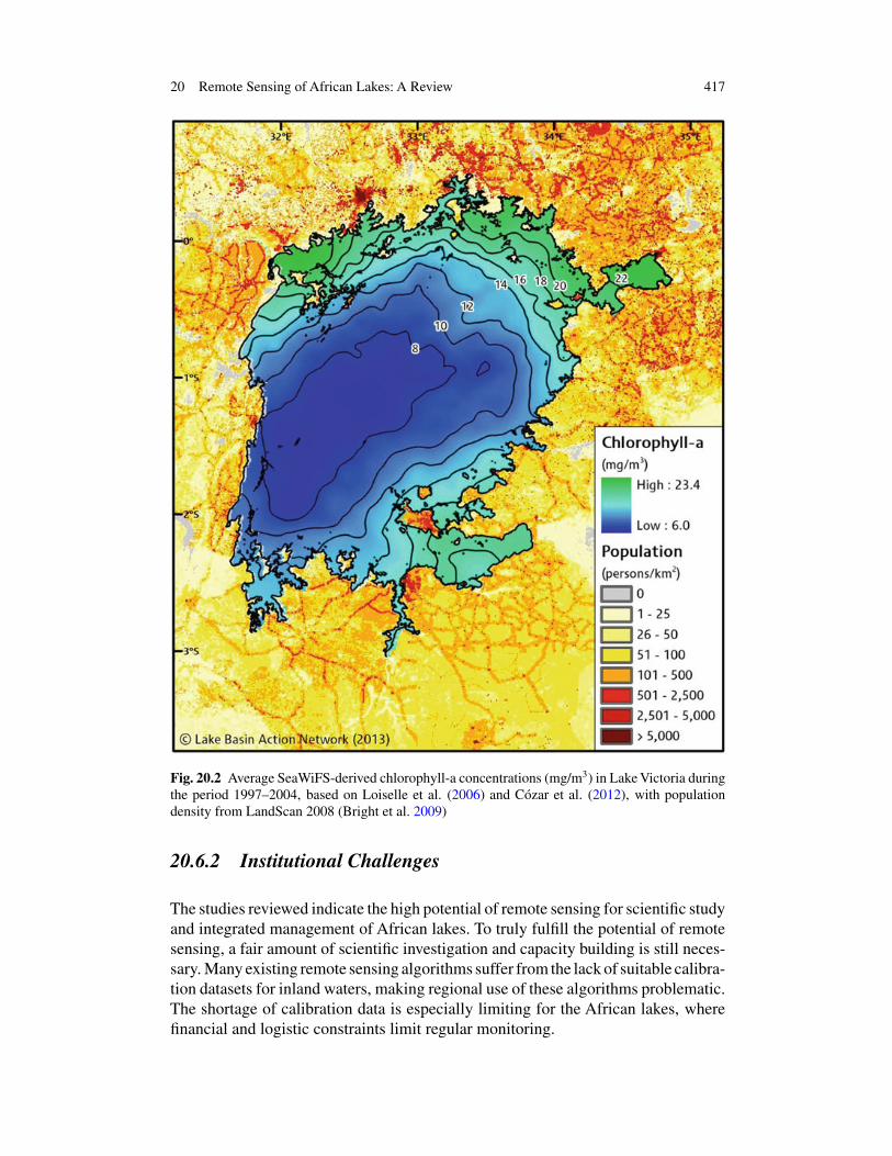
Related to the localized water hyacinth infestation is the lake-wide eutrophicationwhich has been driven by nutrient loadings which began increasing as far backas the 1930s (Verschuren et al. 2002, Hecky et al. 2010). Loiselle et al. (2006)used SeaWiFS-derived chlorophyll-a measurements to show the influence of littoralpopulation on the inshore areas of the lake (see Fig. 20.2). Sørensen et al. (2008)showed the utility of MERIS for lake-wide chlorophyll-a measurements. Cózar et al.(2012) used SeaWIFS for chlorophyll-a andAVHRR for surface temperature to showhow interannual changes in physical conditions can greatly affect phytoplanktondynamics across the lake. The important implication is that policy makers need tolook beyond just phytoplankton biomass as an indicator of eutrophication and expandtheir consideration of climatic effects.
Finally, the water balance of Lake Victoria has been a contentious policy issuewhich altimetric and gravimetric data have been able to impartially elucidate. Inparticular, Swenson and Wahr (2009) used changes in catchment water storage, asmeasured by GRACE, along with altimetric lake level data to show that increased lakedischarge (and not drought alone) contributed to the decline in lake level observedin the early 2000s.
Overall, these examples demonstrate how remote sensing can be applied to policy-relevant questions in an important African lake. They should serve as motivation,along with all the other cases discussed in this review, for those hoping to makesimilar contributions at other lakes.
20 Remote Sensing of African Lakes: A Review 417
Fig. 20.2 Average SeaWiFS-derived chlorophyll-a concentrations (mg/m3) in Lake Victoria duringthe period 1997–2004, based on Loiselle et al. (2006) and Cózar et al. (2012), with populationdensity from LandScan 2008 (Bright et al. 2009)
20.6.2 Institutional Challenges
The studies reviewed indicate the high potential of remote sensing for scientific studyand integrated management of African lakes. To truly fulfill the potential of remotesensing, a fair amount of scientific investigation and capacity building is still neces-sary. Many existing remote sensing algorithms suffer from the lack of suitable calibra-tion datasets for inland waters, making regional use of these algorithms problematic.The shortage of calibration data is especially limiting for the African lakes, wherefinancial and logistic constraints limit regular monitoring.
418 T. J. Ballatore et al.
In addition, the organizations responsible for managing lakes in Africa commonlylack the sufficient expertise and technology (hardware, software and training) todevelop appropriate remote sensing methods. Slow and intermittent Internet connec-tions are a particular problem as the size and availability of remotely-sensed imagesgrow. As a result, the full potential of remote sensing to aid in lake monitoring effortshas not been realized.
To bring the full promise of this technology to bear on African lakes, furthercollaboration between international and local research teams is essential. Relativelyfew African researchers are currently involved in remote sensing research, in spiteof their critical role in advancing this discipline for the African lakes. It is interestingto note that out of the 40 Africa-specific studies in our reference list, 9 (22.5 %)have lead authors with either African affiliations or backgrounds. If we consider allauthors (some counted more than once if more than one publication), then Africansmake up 15 % of the total (26 out of 169). Clearly, the portion of African-led andAfrican-authored papers has room to grow.
For remote sensing to become standard in African lake monitoring and manage-ment, a greater exchange betweenAfrican and non-African researchers and managersmust occur. This exchange could take place through remote scientific collabora-tion (research, grants), gatherings for team building and knowledge dissemination(conferences, meetings) and/or on-the-ground in-country working relationships(trainings, projects). These collaborative activities would act to increase awarenessof the potential of the technology and develop the technical and analytical skillsneeded for deployment in country.
20.6.3 Technological Challenges
The high altitude of many of these lakes requires further development of atmosphericcorrection methodologies developed for oceans and low-altitude lakes, sometimesnecessitating region-specific calibrations (i.e. Horion et al. 2010). The characteristicsof atmospheric aerosols over sub-Sahara Africa are significantly different than thoseconsidered in most ocean-based atmospheric calibration algorithms (Pinker et al.2010).
The application of remote sensing technology is more challenging in opticallycomplex inland waters, where the effects of CDOM and suspended sediments canreduce the utility of standard algorithms. Fortunately, the offshore sections of manyAfrican lakes are fairly well suited for the remote sensing applications as phytoplank-ton abundance generally controls the variability of the optical properties in these areas(Silsbe et al. 2006; Loiselle et al. 2008; Bergamino et al. 2010; Cózar et al. 2012).Further investigations of the optical properties of African lakes are needed to favorthe development of regionally valid algorithms.
20 Remote Sensing of African Lakes: A Review 419
20.6.4 A Field Progressing
The field of remote sensing, in general, and the applications of remote sensing toAfrica specifically, are rapidly progressing. On a practical “access” level, much ofthe imagery discussed here can be downloaded for free. Where Internet connectionsare an issue, the ESA has launched the “TIGER Initiative” to ensure distribution ofimages in addition to other capacity building. Additionally, more undersea cableswill increase bandwidth.
Technically, there are many interesting developments. The statistical analysis ofthe relative variability of remotely-sensed variables (climate, hydrological and bio-logical), has allowed for new insights in lake functioning based on limited calibrationdata (Bergamino et al. 2007; Cózar et al. 2012). Using multiannual optical time serieswith monthly or shorter periodicity, this approach has proven successful for identi-fying important basin-scale features of several of the larger lakes. The analysis ofcommon patterns in lacustrine systems remains still unexplored, but it is apparentlysuitable for the Eastern Africa region, where the spatial density of lakes is rela-tively high. The analysis of the relative optical variability will likely provide furthervaluable information on the processes controlling the dynamics of African lakes.However, the advancement and successful deployment of remote sensing techniquesfor the study and management of African lakes require more accurate estimates ofspecific biogeochemical water properties (e.g. Matthews et al. 2012).
As progress is made, it is interesting to imagine what an ideal future might looklike for remote sensing of African lakes. More sensors would be available, not onlyto replace past and current ones (such as the Landsat Data Continuity Mission) butto expand spatial, spectral, temporal and radiometric capacity for satellite-basedmonitoring. The capacity of African scientists and lake managers would be in-creased through local and international cooperation. The ability to download largefiles would approach current high-income nation standards through more bandwidthand more stable connections (including electricity). The availability of regular stan-dardized field data for algorithm development and validation would be increased.The understanding of the advantages of remote sensing technology for integratedlake-catchment management by national and international decision makers and stake-holders would improve. Finally, links between the remote sensing of lakes and theremote sensing of the land in their drainage basins would be strengthened.
References
Awange JL, Sharifi MA, Ogonda G, Wickert J, Grafarend EW, Omulo MA (2008) The falling lakeVictoria water levels: GRACE, TRIMM and CHAMP satellite analysis of the lake Basin. WaterResour Manage 22:775–796. doi:10.1007/s11269-007-9191-y
Becker M, Llovel W, Cazenave A, Güntner A, Crétaux J-F (2010) Recent hydrological behaviorof the East African great lakes region inferred from GRACE, satellite altimetry and rainfallobservations. C.R. Geosci 342:223–233. doi:10.1016/j.crte.2009.12.010
420 T. J. Ballatore et al.
Bergamino N, Horion S, Stenuite S, Cornet Y, Loiselle S, Plisner P-D, Descy J-P (2010)Spatio-temporal dynamics of phytoplankton and primary production in lake Tanganyikausing a MODIS based bio-optical time series. Remote Sens Environ 114:772–780.doi:10.1016/j.rse.2009.11.013
Bergamino N, Loiselle SA, Cózar A, Dattilo AM, Bracchini L, Rossi C (2007) Examining thedynamics of phytoplankton biomass in lake Tanganyika using Empirical Orthogonal Functions.Ecol Modell 204:156–162. doi:10.1016/j.ecolmodel.2006.12.031
Birkett CM (1995) The contribution of TOPEX/POSEIDON to the global monitoring of climaticallysensitive lakes. J Geophys Res 100(C12):25179–25204
Birkett CM (2000) Synergistic remote sensing of lake Chad: variability of Basin inundation. RemoteSens Environ 72:218–236
Böhme B, Steinbruch F, Gloaguen R, Heilmeier H, Merkel B (2006) Geomorphology, hydrology,and ecology of Lake Urema, central Mozambique, with focus on lake extent changes. PhysChem Earth 31:745–752. doi:10.1016/j.pce.2006.08.010
Booth DJ, Oldfield RB (1988) Estimation of the area of lake Kariba, Zimbabwe, using LandsatMSS imagery. Proceedings of IGRASS ’88 Symposium, Edinburgh, Scotland, 13–16 September1988:1565–1567
Boy J-P, Hinderer J, de Linage C (2012) Retrieval of large-scale hydrological signals in Africa fromGRACE time-variable gravity fields. Pure Appl Geophys 169:1373–1390. doi:10.1007/s00024-011-0416-x
Bradt SR (2012) Development of bio-optical algorithms to estimate chlorophyll in the Great SaltLake and New England lakes using in situ hyperspectral measurements. Dissertation, Universityof New Hampshire
Bright EA, Coleman PR, KingAL, RoseAN, Urban ML (2009) LandScan 2008. Oak Ridge NationalLaboratory, Oak Ridge, TN. http://www.ornl.gov/sci/landscan/. Accessed 19 May 2013
Cavalli RM, Laneve G, Fusilli L, Pignatti S, Santini F (2009a) Remote sensing water obser-vation for supporting lake Victoria weed management. J Environ Manage 90:2199–2211.doi:10.1016/j.jenvman.2007.07.036
Cavalli RM, Fusilli L, Laneve G, Pascucci S, PalomboA, Pignatti S, Santini F (2009b) Lake Victoriaaquatic weeds monitoring by high spatial and spectral resolution satellite imagery. Proceedingsof IGARSS 2009 Symposium, Cape Town, South Africa, 12–17 July 2009:II-1048-II–1051.doi:10.1109/IGARSS.2009.5418284
Chavula G, Brezonik P, Thenkabail P, Johnson T, Bauer M (2009a) Estimating the surface tempera-ture of Lake Malawi usingAVHRR and MODIS satellite imagery. Phys Chem Earth 34:749–754.doi:10.1016/j.pce.2009.08.001
Chavula G, Brezonik P, Thenkabail P, Johnson T, Bauer M (2009b) Estimating chlorophyll con-centration in Lake Malawi from MODIS satelitte imagery. Phys Chem Earth 34:755–760.doi:10.1016/j.pce.2009.07.015f
Chipman JW, Olmanson LG, Gitelson AA (2009) Remote sensing methods for Lake management:a guide of resource managers and decision-makers. Developed by the North American lakemanagement society in collaboration with Dartmouth College, University of Minnesota andUniversity of Nebraska for the United States Environmental Protection Agency
Coe M, Birkett C (2004) Calculation of river discharge and prediction of lake height fromsatellite radar altimetry: Example for the Lake Chad basin. Water Resour Res 40(10). doi:10.1029/2003WR002543
Cohen J (1960) A coefficient of agreement for nominal scales. Educ Psychol Measur 20(1):37–46Cózar A, Bruno M, Bergamino N, Übeda B, Bracchini L, Dattilo AM, Loiselle SA (2012) Basin-
scale control on the Phytoplankton Biomass in lake Victoria, Africa. PLoS ONE 7(1):e29962.doi:10.1371/journal.pone.0029962
Crétaux J-F, Bickett C (2006) Lake studies from satellite radar altimetry. C.R. Geosci 338:1098–1112. doi:10.1016/j.crte.2006.08.002
Crétaux J-F, Jelinski W, Calmant S, Kouraev A, Vuglinski V, Bergé-Nguyen M, Gennero M-C, NinoF, Abarca Del Rio R, Cazenave A, Maisongrande P (2011) SOLS: a lake database to monitor inthe near real time water level and storage variations from remote sensing data. Adv Space Res47:1497–1507. doi:10.1016/j.asr.2011.01.004
20 Remote Sensing of African Lakes: A Review 421
ESA (European Space Agency) (2013) River and lake website http://tethys.eaprs.cse.dmu.ac.uk/RiverLake/shared/main. Accessed 19 May 2013
Fusilli L, Collins MO, Laneve G, Palombo A, Pignatti S, Santini F (2011) Assessment of theabnormal growth of floating macrophytes in Winam Gulf (Kenya) by using MODIS imagerytime series. Int J Appl Earth Obs Geoinf doi:10.1016/j.jag.2011.09.002
Gitelson A, Gurlin D, Moses W,YacobiY (2011) Remote estimation of Chlorophyll-a concentrationin Inland, Estuarine, and Coastal waters. In: Weng Q (ed) Advances in environmental remotesensing: sensors, algorithms, and applications. CRC Press, Boca Raton
Gower J, King S, Borstad G, Brown L (2005) Detection of intense plankton blooms using the709 nm band of the MERIS imaging spectrometer. Int J Remote Sens 26:2005–2012
Harris AR (1994) Time series remote sensing of a climatically sensitive lake. Remote Sens Environ50:83–94
Hecky RE, Mugidde R, Ramlal PS, Talbot MR, Kling GW (2010) Multiple stressors cause rapidecosystem change in lake Victoria. Freshwater Biol. 55(Suppl. 1):19–42. doi:10.1111/j.1365-2427.2009.02374.x
Hinderer J, Pfeffer J, Boucher M, Nahmani S, de Linage C, Boy J-P, Genthon P, Seguis L, FavreauG, Bock O, Descloitres M, GHYRAF Team (2012) Land Water storage changes from ground andspace Geodesy: first results from the GHYRAF (Gravity and Hydrology in Africa) Experiment.Pure Appl Geophys 169:1391–1410. doi:10.1007/s00024-011-0417-9
Horion S, Bergamino N, Stenuite S, Descy J-P, Plisnier P-D, Loiselle SA, Cornet Y (2010) Opti-mized extraction of daily bio-optical time series derived from MODIS/Aqua imagery for LakeTanganyika, Africa. Remote Sens. Environ 114:781–791. doi:10.1016/j.rse.2009.11.012
Jensen JR (2007) Remote sensing of the environment: an earth resource perspective, 2nd edn.Pearson Prentice Hall, Upper Saddle River
Kneubühler M, Frank T, Kellenberger TW, Pasche N, Schmid M (2007) Mapping chlorophyll-a inLake Kivu with remote sensing methods. Proceedings of Envisat Symposium 2007, Montreux,Switzerland, 23–27 April 2007. ESA Publications Division, Noordwijk
Koponen S, Ruiz-Verdú A, Heege T, Heblinski J, Sorensen K, Kallio K, Pyhälahti T, DoerfferR, Brockmann C, Peters M (2008) Development of MERIS lake water algorithms: validationreport. ESRIN contract No. 20436/06/I–LG
Leblanc M, Lemoalle J, Bader J-C, Tweed S, Mofor L (2011) Thermal remote sensing of waterunder flooded vegetation: new observations of inundation patterns for the ‘Small’ lake Chad. JHydrol 404:87–98. doi:10.1016/j.jhydrol.2011.04.023
Legesse D, Ayenew T (2006) Effect of improper water and land resource utilization on the centralmain Ethiopian Rift lakes. Quat. Int 148:8–18. doi:10.1016/j.quaint.2005.11.003
LEGOS (Laboratoire d’Etudes en Géophysique et Océanographie Spatiales) (2013)Hydroweb: surface monitoring by satellite altimetry. http://www.legos.obs-mip.fr/en/soa/hydrologie/hydroweb/. Accessed 19 May 2013
Lemoalle J, Bader J-C, Leblanc M, Sedick A (2012) Recent changes in lake Chad: observa-tions, simulations and management options (1973–2011). Glob Planet Change 80–81:247–254.doi:10.1016/j.gloplacha.2011.07.004
Loiselle SA, Azza N, Cózar A, Bracchini L, Tognazzi A, Dattilo AM, Rossi C (2008) Vari-ability in factors causing light attenuation in lake Victoria. Freshwater Biol 53:535–545.doi:10.1111/j.1365-2427.2007.01918.x
Loiselle S, Cózar A, van Dam A, Kansiime F, Kelderman P, Saunders M, Simonit S (2006) Toolsfor wetland ecosystem resource management in East Africa: focus on the lake Victoria Papyruswetlands. In Verhoeven JTA, Beltman B, Bobbink R, Whigham DF (eds) Wetlands and NaturalResource Management. Ecol Stud 190:97–121. doi:10.1007/978-3-540-33187-2_6
Majozi NP (2011) Remote sensing of euphotic depth in Lake Naivasha. Master’s Thesis, Universityof Twente
Matthews MW, Bernard S, Winter K (2010) Remote sensing of cyanobacteria-dominant algalblooms and water quality parameters in Zeekoevlei, a small hypertrophic lake, using MERIS.Remote Sens Environ 114(9):2070–2087. doi:10.1016/j.rse.2010.04.013
422 T. J. Ballatore et al.
Matthews MW, Bernard S, Robertson L (2012) An algorithm for detecting trophic status(chlorophyll-a) cyanobacterial-dominance, surface scums and floating vegetation in inland andcoastal waters. Remote Sens Environ 124:637–652. doi:10.1016/j.rse.2012.05.032
McClain EP (1981) Multiple atmospheric-window techniques for satellite-derived sea surface tem-peratures. In proceedings of symposium on ocean oceanography from Space, Venice, Italy,26–30 May 1980:73–85
Mercier F, Cazenave A, Maheu C (2002) Interannual lake level fluctuations (1993–1999) in Africafrom Topex/Poseidon: connections with ocean-atmosphere interactions over the Indian Ocean.Glob Planet Change 32:141–163
Mohler RRJ, Helfert MR, Giardino JR (1989) The decrease of lake Chad as documented duringtwenty years of manned space flight. Geocarto Int 1:75–79
Munyaneza O, Wali UG, Uhlenbrook S, Maskey S, Mlotha MJ (2009) Water level monitoringusing radar remote sensing data: application to Lake Kivu, central Africa. Phys Chem Earth34:722–728. doi:10.1016/j.pce.2009.06.008
NASA (National Aeronautics and Space Agency) (2013) SRTM water body dataset (SWBD).http://dds.cr.usgs.gov/srtm/version2_1/SWBD. Accessed 19 May 2013.
Oberholster PJ, Botha AM (2010) Use of remote sensing and molecular markers to detect toxiccyanobacterial hyperscum crust: a case study on lake Hartbeespoort, South Africa. Afr JBiotechnol 9(51):8791–8799. doi:10.5897/ajb10.530
OumaY, Tateishi R (2006)A water index for rapid mapping of shoreline changes of five EastAfricanRift Valley lakes: an empirical analysis using Landsat TM and ETM+ data. Int J Remote Sens27(15):3153–3181. doi:10.1080/01431160500309934
Pinker RT, Liu H, Osborne SR, Akoshile C (2010) Radiative effects of aerosols in sub-Sahel Africa:dust and biomass burning. J Geophys Res 115:D15205. doi:10.1029/2009jd013335
Rebelo L-M (2010) Eco-hydrological characterization of Inland wetlands in Africa using L-BandSAR. IEEE J Sel Topics Appl Earth Obser 3(4):554–559. doi:10.1109/jstars.2010.2070060
Ricko M, Carton JA (2011) Climate effects on lake Basins. Part I: modeling tropical lake levels. JClimate 24:2983–2999. doi:10.1175/2010jcli3602.1
Ruiz-Verdú A, Simis SGH, de Hoyos C, Gons HJ, Pea-Martínez R (2008) An evaluationof algorithms for the remote sensing of cyanobacterial biomass. Remote Sens Environ112:3996–4008
Schneider SR, McGinnis DF Jr, Stephens G (1985) Monitoring Africa’s lake Chad basin withLANDSAT and NOAA satellite data. Int J Remote Sens 6(1):59–73
Silsbe GM, Hecky RE, Guildford SJ, Mugidde R (2006) Variability of chlorophyll a and photosyn-thetic parameters in a nutrient saturated tropical great lake. Limnol Oceanogr 51:2052–2063
Sørensen K, Folkestad A, Stelzer K, Brockmann C, Doerffer R, Okullo W, Schouten L (2008)Performance of MERIS products in Lake Victoria. Proceedings of the 2nd MERIS I (A) ATSRUser Workshop, Frascati, Italy, 22–26 September 2008
Swenson S, Whar J (2009) Monitoring the water balance of Lake Victoria, East Africa, from space.J Hydrol 370:163–176
Turada IA (2008) The use of MERIS data to detect the impact of flood inundation on land coverchanges in the lake Chad basin. Dissertation, The Hong Kong Polytechnic University
USDA (United States Department of Agriculture) (2013) Global reservoir and lake Monitor.http://www.pecad.fas.usda.gov/cropexplorer/global_reservoir. Accessed 19 May 2013
Velpuri NM, Senay GB, Asante KO (2012) A multi-source satellite data approach for modellinglake Turkana water level: calibration and validation using satellite altimetry data. Hydrol EarthSyst Sci 16:1–18. doi:10.5194/hess-16-1-2012
Verschuren D, Johnson TC, Kling HJ, Edgington DN, Leavitt PR, Brown ET, Talbot MR, HeckyRE (2002) History and timing of human impact on Lake Victoria, East Africa. Proc R Soc LondB 269:289–294. doi: 10.1098/rspb.2001.1850
Wald L (1990) Monitoring the decrease of lake Chad from space. Geocarto Int 3:31–36Williams AE, Duthie HC, Hecky RE (2005) Water hyacinth in lake Victoria: why did it vanish so
quickly and will it return? Aquat Bot 81:300–314. doi: 10.1016/j.aquabot.2005.01.003Wooster M, Patterson G, Loftie R, Sear C (2001) Derivation and validation of the seasonal ther-
mal structure of lake Malawi using multi-satellite AVHRR observations. Int J Remote Sens22(15):2953–2972


![[REMOTE SENSING] 3-PM Remote Sensing](https://img.pdfslide.net/doc/110x75/61f2bbb282fa78206228d9e2/remote-sensing-3-pm-remote-sensing.jpg)


