Embed Size (px)
Citation preview
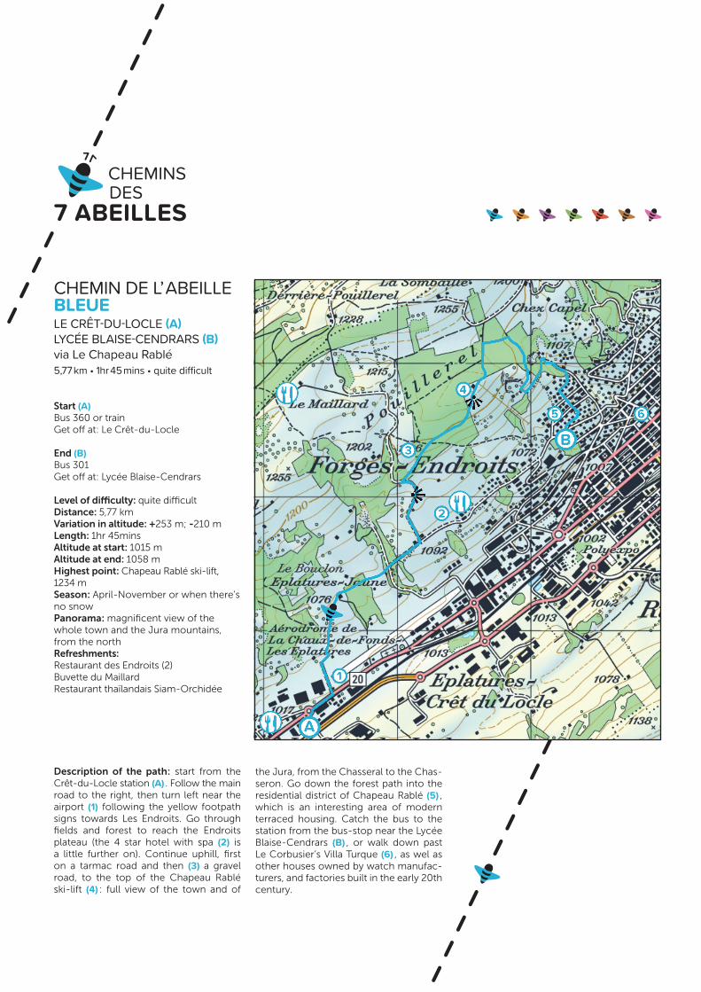
CHEMIN DE L’ ABEILLE BLEUE LE CRÊT-DU-LOCLE (A) LYCÉE BLAISE-CENDRARS (B)via Le Chapeau Rablé5,77 km • 1hr 45 mins • quite difficult
Start (A)Bus 360 or trainGet off at : Le Crêt-du-Locle
End (B)Bus 301 Get off at : Lycée Blaise-Cendrars
Level of difficulty : quite difficult Distance : 5,77 kmVariation in altitude : +253 m; -210 mLength : 1 hr 45 minsAltitude at start : 1015 mAltitude at end : 1058 mHighest point : Chapeau Rablé ski-lift, 1234 m Season : April-November or when there’s no snowPanorama : magnificent view of the whole town and the Jura mountains, from the northRefreshments : Restaurant des Endroits (2)Buvette du MaillardRestaurant thaïlandais Siam-Orchidée
Description of the path : start from the Crêt-du-Locle station (A) . Follow the main road to the right, then turn left near the airport (1) following the yellow footpath signs towards Les Endroits. Go through fields and forest to reach the Endroits plateau (the 4 star hotel with spa (2) is a little further on). Continue uphill, first on a tarmac road and then (3) a gravel road, to the top of the Chapeau Rablé ski-lift (4) : full view of the town and of
the Jura, from the Chasseral to the Chas-seron. Go down the forest path into the residential district of Chapeau Rablé (5) , which is an interesting area of modern terraced housing. Catch the bus to the station from the bus-stop near the Lycée Blaise-Cendrars (B) , or walk down past Le Corbusier’s Villa Turque (6) , as wel as other houses owned by watch manufac-turers, and factories built in the early 20th century.